Embed Size (px)
Citation preview
Sunshine StateSTANDARDSSC.D.1.3.1: The studentknows that mechanicaland chemical activitiesshape and reshape theEarth’s land surface byeroding rock and soilin some areas anddepositing them inother areas, sometimesin seasonal layers.
Chapter 8: Erosion and Deposition 281
VOCABULARYglacier p. 281till p. 284moraine p. 284kettle lake p. 285
KEY CONCEPT
Glaciers carve land andmove sediments.
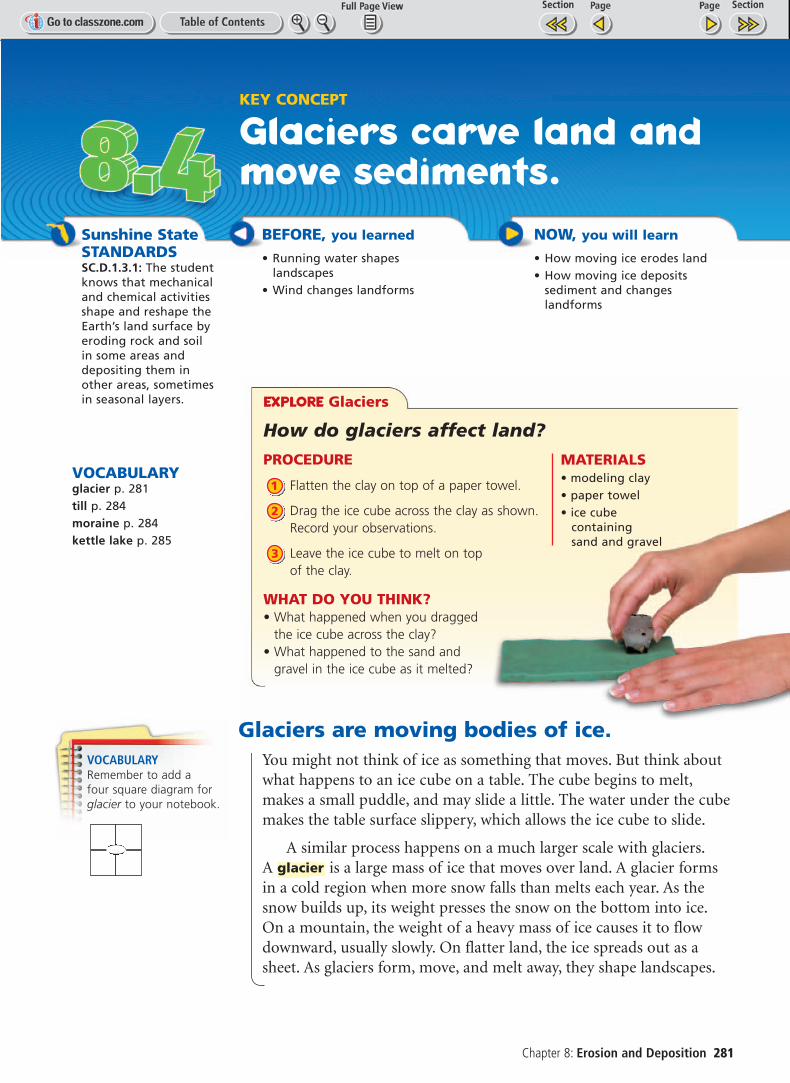
EXPLORE Glaciers
How do glaciers affect land?
PROCEDURE
Flatten the clay on top of a paper towel.
Drag the ice cube across the clay as shown.Record your observations.
Leave the ice cube to melt on top of the clay.
WHAT DO YOU THINK?• What happened when you dragged
the ice cube across the clay?• What happened to the sand and
gravel in the ice cube as it melted?
3
2
1
MATERIALS• modeling clay• paper towel• ice cube
containing sand and gravel
Glaciers are moving bodies of ice.You might not think of ice as something that moves. But think aboutwhat happens to an ice cube on a table. The cube begins to melt,makes a small puddle, and may slide a little. The water under the cubemakes the table surface slippery, which allows the ice cube to slide.
A similar process happens on a much larger scale with glaciers.A is a large mass of ice that moves over land. A glacier formsin a cold region when more snow falls than melts each year. As thesnow builds up, its weight presses the snow on the bottom into ice.On a mountain, the weight of a heavy mass of ice causes it to flowdownward, usually slowly. On flatter land, the ice spreads out as asheet. As glaciers form, move, and melt away, they shape landscapes.
glacier
BEFORE, you learned
• Running water shapes landscapes
• Wind changes landforms
NOW, you will learn
• How moving ice erodes land• How moving ice deposits
sediment and changes landforms
VOCABULARYRemember to add a four square diagram forglacier to your notebook.
282 Unit 2: Earth’s Surface
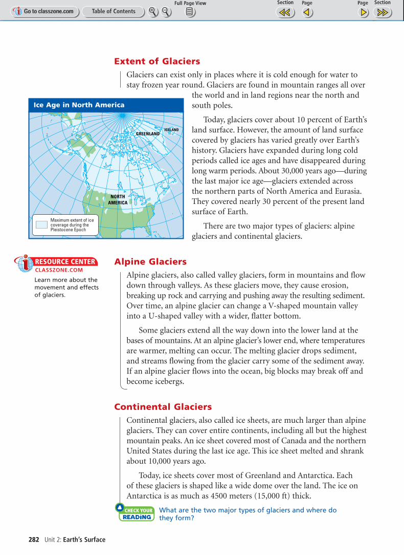
Extent of GlaciersGlaciers can exist only in places where it is cold enough for water tostay frozen year round. Glaciers are found in mountain ranges all over
the world and in land regions near the north andsouth poles.
Today, glaciers cover about 10 percent of Earth’sland surface. However, the amount of land surfacecovered by glaciers has varied greatly over Earth’shistory. Glaciers have expanded during long coldperiods called ice ages and have disappeared duringlong warm periods. About 30,000 years ago—duringthe last major ice age—glaciers extended across the northern parts of North America and Eurasia.They covered nearly 30 percent of the present landsurface of Earth.
There are two major types of glaciers: alpineglaciers and continental glaciers.
Alpine GlaciersAlpine glaciers, also called valley glaciers, form in mountains and flowdown through valleys. As these glaciers move, they cause erosion,breaking up rock and carrying and pushing away the resulting sediment.Over time, an alpine glacier can change a V-shaped mountain valleyinto a U-shaped valley with a wider, flatter bottom.
Some glaciers extend all the way down into the lower land at thebases of mountains. At an alpine glacier’s lower end, where temperaturesare warmer, melting can occur. The melting glacier drops sediment,and streams flowing from the glacier carry some of the sediment away.If an alpine glacier flows into the ocean, big blocks may break off andbecome icebergs.
Continental GlaciersContinental glaciers, also called ice sheets, are much larger than alpineglaciers. They can cover entire continents, including all but the highestmountain peaks. An ice sheet covered most of Canada and the northernUnited States during the last ice age. This ice sheet melted and shrankabout 10,000 years ago.
Today, ice sheets cover most of Greenland and Antarctica. Each of these glaciers is shaped like a wide dome over the land. The ice onAntarctica is as much as 4500 meters (15,000 ft) thick.
Check Your Reading What are the two major types of glaciers and where do they form?
NORTHAMERICA
GREENLANDICELAND
Maximum extent of icecoverage during thePleistocene Epoch
Ice Age in North America
RESOURCE CENTERCLASSZONE.COM
Learn more about themovement and effectsof glaciers.
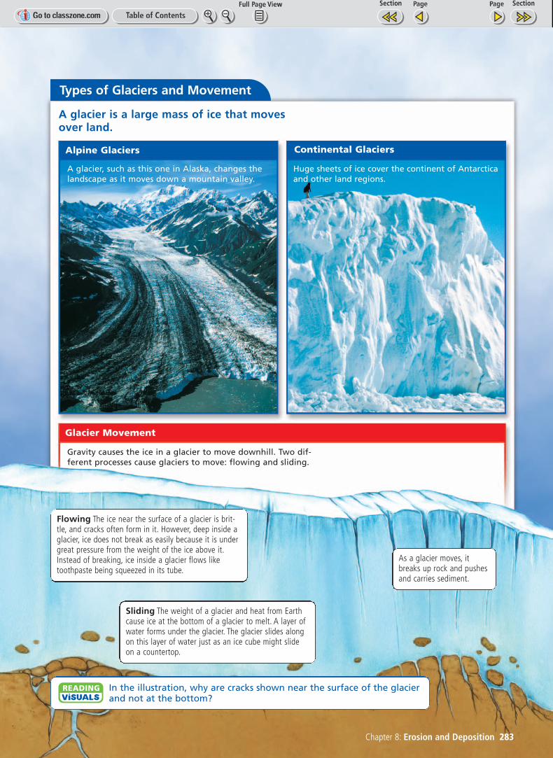
Types of Glaciers and Movement
Alpine Glaciers Continental Glaciers
Glacier Movement
A glacier is a large mass of ice that movesover land.
Chapter 8: Erosion and Deposition 283
A glacier, such as this one in Alaska, changes thelandscape as it moves down a mountain valley.
Gravity causes the ice in a glacier to move downhill. Two dif-ferent processes cause glaciers to move: flowing and sliding.
Huge sheets of ice cover the continent of Antarcticaand other land regions.
Flowing The ice near the surface of a glacier is brit-tle, and cracks often form in it. However, deep inside aglacier, ice does not break as easily because it is undergreat pressure from the weight of the ice above it.Instead of breaking, ice inside a glacier flows liketoothpaste being squeezed in its tube.
Sliding The weight of a glacier and heat from Earthcause ice at the bottom of a glacier to melt. A layer ofwater forms under the glacier. The glacier slides alongon this layer of water just as an ice cube might slideon a countertop.
As a glacier moves, itbreaks up rock and pushesand carries sediment.
In the illustration, why are cracks shown near the surface of the glacierand not at the bottom?
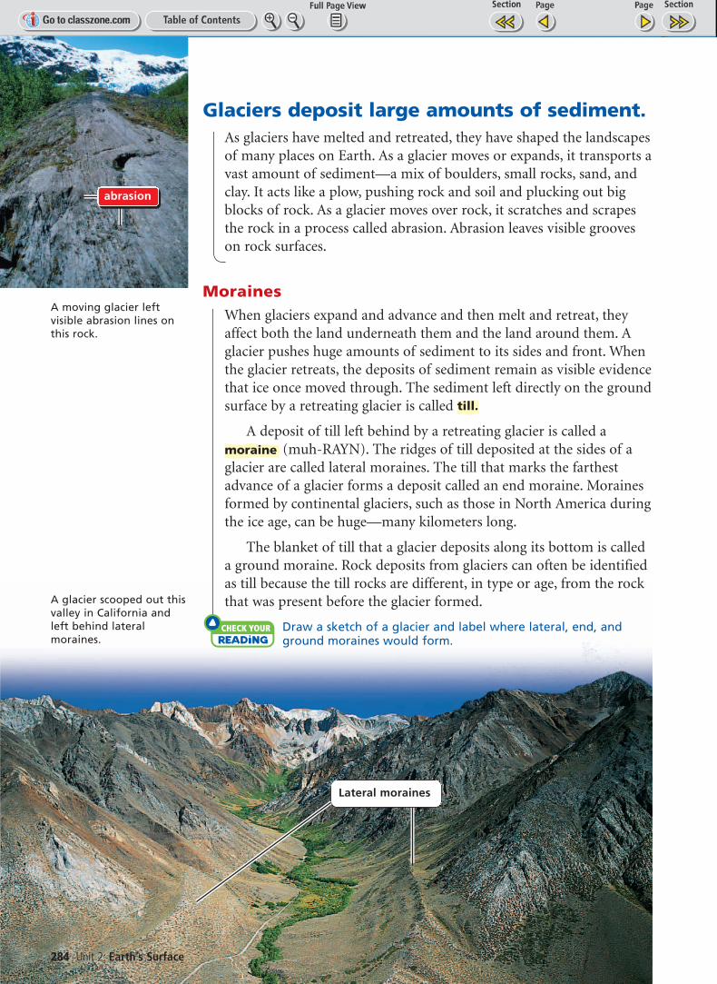
Glaciers deposit large amounts of sediment.As glaciers have melted and retreated, they have shaped the landscapesof many places on Earth. As a glacier moves or expands, it transports avast amount of sediment—a mix of boulders, small rocks, sand, andclay. It acts like a plow, pushing rock and soil and plucking out bigblocks of rock. As a glacier moves over rock, it scratches and scrapesthe rock in a process called abrasion. Abrasion leaves visible grooveson rock surfaces.
MorainesWhen glaciers expand and advance and then melt and retreat, theyaffect both the land underneath them and the land around them. Aglacier pushes huge amounts of sediment to its sides and front. Whenthe glacier retreats, the deposits of sediment remain as visible evidencethat ice once moved through. The sediment left directly on the groundsurface by a retreating glacier is called
A deposit of till left behind by a retreating glacier is called a(muh-RAYN). The ridges of till deposited at the sides of a
glacier are called lateral moraines. The till that marks the farthestadvance of a glacier forms a deposit called an end moraine. Morainesformed by continental glaciers, such as those in North America duringthe ice age, can be huge—many kilometers long.
The blanket of till that a glacier deposits along its bottom is called a ground moraine. Rock deposits from glaciers can often be identifiedas till because the till rocks are different, in type or age, from the rockthat was present before the glacier formed.
Check Your Reading Draw a sketch of a glacier and label where lateral, end, andground moraines would form.
moraine
till.
A moving glacier left visible abrasion lines onthis rock.
A glacier scooped out thisvalley in California andleft behind lateralmoraines.
abrasion
284 Unit 2: Earth’s Surface
Lateral moraines
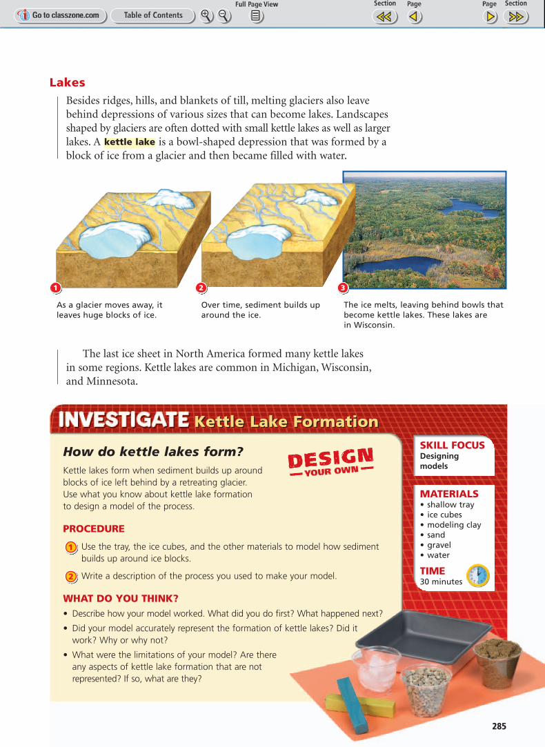
LakesBesides ridges, hills, and blankets of till, melting glaciers also leavebehind depressions of various sizes that can become lakes. Landscapesshaped by glaciers are often dotted with small kettle lakes as well as largerlakes. A is a bowl-shaped depression that was formed by ablock of ice from a glacier and then became filled with water.
The last ice sheet in North America formed many kettle lakes in some regions. Kettle lakes are common in Michigan, Wisconsin,and Minnesota.
kettle lake
1
As a glacier moves away, it leaves huge blocks of ice.
Over time, sediment builds uparound the ice.
The ice melts, leaving behind bowls thatbecome kettle lakes. These lakes are in Wisconsin.
32
How do kettle lakes form?Kettle lakes form when sediment builds up aroundblocks of ice left behind by a retreating glacier. Use what you know about kettle lake formation to design a model of the process.
PROCEDURE
Use the tray, the ice cubes, and the other materials to model how sedimentbuilds up around ice blocks.
Write a description of the process you used to make your model.
WHAT DO YOU THINK?• Describe how your model worked. What did you do first? What happened next?
• Did your model accurately represent the formation of kettle lakes? Did itwork? Why or why not?
• What were the limitations of your model? Are there any aspects of kettle lake formation that are notrepresented? If so, what are they?
2
1
Kettle Lake FormationKettle Lake FormationSKILL FOCUSDesigning models
MATERIALS• shallow tray• ice cubes• modeling clay• sand• gravel• water
TIME30 minutes
285
286 Unit 2: Earth’s Surface
KEY CONCEPTS1. Describe the two processes
that cause glaciers to move.
2. What are the two major typesof glaciers, and where are they found?
3. Describe the land features leftbehind by glaciers that havemelted and shrunk.
CRITICAL THINKING4. Compare and Contrast
Identify two ways in which theerosion effects of glaciers differfrom those of rivers.
5. Predict How would glaciersbe affected by changes in climate, such as global warming and global cooling?
CHALLENGE6. Infer Regions near the equator
are generally the warmest onEarth. However, in one smallarea of Africa, there areglaciers close to the equator.Form a hypothesis to explainwhy these glaciers exist.
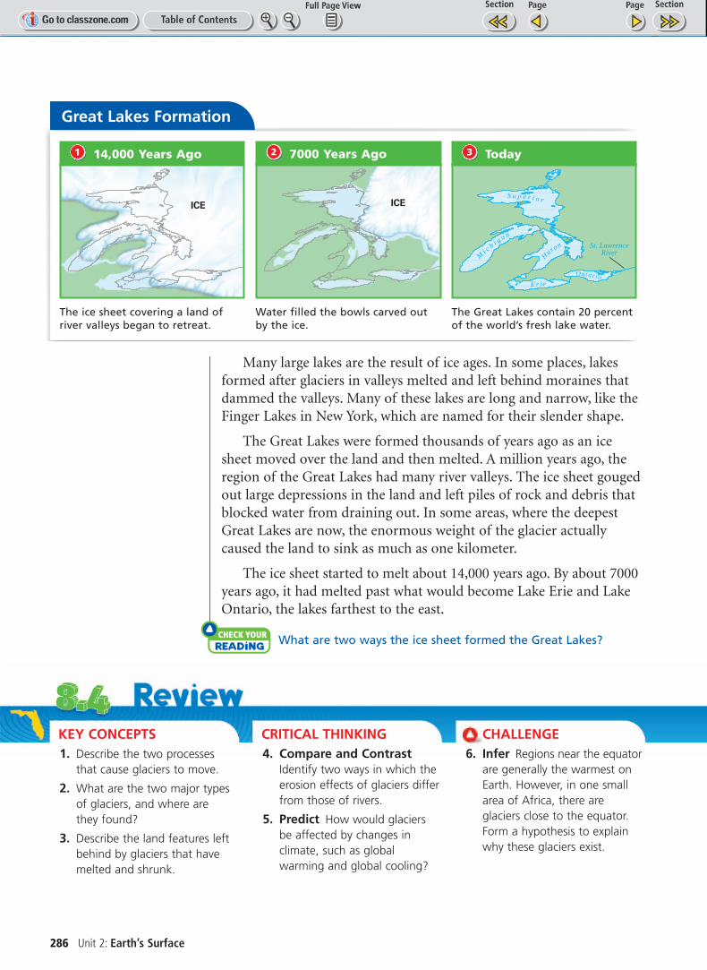
Many large lakes are the result of ice ages. In some places, lakesformed after glaciers in valleys melted and left behind moraines thatdammed the valleys. Many of these lakes are long and narrow, like theFinger Lakes in New York, which are named for their slender shape.
The Great Lakes were formed thousands of years ago as an icesheet moved over the land and then melted. A million years ago, theregion of the Great Lakes had many river valleys. The ice sheet gougedout large depressions in the land and left piles of rock and debris thatblocked water from draining out. In some areas, where the deepestGreat Lakes are now, the enormous weight of the glacier actuallycaused the land to sink as much as one kilometer.
The ice sheet started to melt about 14,000 years ago. By about 7000years ago, it had melted past what would become Lake Erie and LakeOntario, the lakes farthest to the east.
check your reading What are two ways the ice sheet formed the Great Lakes?
Great Lakes Formation
ICE
14,000 Years Ago1
ICE
7000 Years Ago2
St. LawrenceRiver
Mi c h i g a n
S u p e r i o r
H
uron
E r i e
On tar io
Today3
The ice sheet covering a land ofriver valleys began to retreat.
Water filled the bowls carved outby the ice.
The Great Lakes contain 20 percentof the world’s fresh lake water.