Embed Size (px)
Citation preview
KENYATTA UNIVERSITY
2nd Esri Eastern Africa Education GIS User Conference 20th
- 21st November, 2014, University of Dar es Salaam
Esri-EA GIS Education User conference participant in front of Nkrumah Hall University
of Dar es Salaam
Report Prepared by: Anthony Gakobo & Simon Onywere for KU_GIS Team, November 2014

Kenyatta University Representatives
Prof. Simon Onywere VC’s representative, Team Leader and GIS Coordinator at KU
Dr. Peter Chege School of Applied Human Sciences
Esther Munyiri Kagure School of Hospitality and Tourism
Anthony Gakobo ICIPE/Cernvec KU GIS Intern
Peter Mwirigi Research Grant Writing
Nancy Wachiuri Student, Environmental Planning and Management
Carole Akoth Student, Environmental Planning and Management
Kelvin Mwenda Student, Environmental Science
i
Acknowledgments
Kenyatta University GIS team would like to acknowledge the support given by Kenyatta
university management and with special thanks to the VC for supporting the program from its
inception to its actualization. For allowing the GIS team to travel to Dar es Salaam to attend the
2nd Esri –EA Education GIS User Conference.
KU_GIS team especially appreciates the support of Esri-EA in preparation for the conference
and for waiving the conference registration charges to all the KU participants. The School of
Environmental Studies is thanked for supporting the Team Leader to travel to Dar es Salaam and
the ICIPE Cernvec program for supporting the Team Leader and the interns with travel and
accommodation supplementation for the three nights.
The team thanks all KU participants for sacrificing their time and finances to attend the
conference despite the time constraints placed by the academic calendar. Special thanks to Dr.
Peter Chege and Mrs. Esther Kagure two of the academic staff for their love of GIS application
and for accompanying the team.
KU_GIS team is indebted to the University of Dar es Salaam for welcoming KU_GIS team and
other participants to the conference and hosting the two days event. Our heartfelt appreciation
goes to the co-organizers of the 2nd Esri-EA-UC for providing snacks and lunch to all
participants.
Lastly many thanks to KU_ GIS team lead by Prof. Simon Onywere for putting Kenyatta
University on the map of the geospatial universities
ii

Table of Contents
Kenyatta University Representatives ............................................................................................... i
Acknowledgments........................................................................................................................... ii
Table of Contents ........................................................................................................................... iii
Abstract .......................................................................................................................................... iv
Introduction ..................................................................................................................................... 1
Main Objective of the Esri Education User Conference ................................................................. 1
Registration and the opening ceremony .......................................................................................... 2
Esri Keynote Address ..................................................................................................................... 5
Paper Presentations ......................................................................................................................... 8
The Second Day of Conference 21st November, 2014 ................................................................. 16
iii
Abstract
The 2nd Esri Eastern Africa GIS Education User Conference, 2014 was held at the University of Dar es Salaam in Tanzania where Kenyatta University was represented by 8 participants. The main objective of the Education User Conference was to demonstrate how Esri ArcGIS licensed education users are able to use Esri products in imparting spatial knowledge in their institution of higher learning. The conference brought together 21 Universities and geospatial users from the East African Region. This included among others: Kenyatta University, Dedan Kimathi University of Technology, Ardhi University, University of Bagamoyo, University of Dar es Salaam, Makerere University, Southern and Eastern Africa Mineral Centre and the World Vision. The Institutions made presentations on the way they have been able to use Esri ArGIS Products and other tools to impart spatial knowledge in teaching and research or within their work environment. Kenyatta University, one of the beneficiaries of the Esri 100 African University programme, had the highest number of participant outside of the University of Dar es Salaam. The KU presenters were able to demonstrate how in the last six months they have used ArcGIS tools in training and research. Esri The keynote speaker, who was from Esri especially, thanked Kenyatta University Top Management for their dedication and support to geospatial knowledge. The universities now seeking the support of ESRI 100 African Universities programme are borrowing from the experience of Kenyatta University in the implementation process. The first presentation from KU was on “The Impact of Campus-Wide GIS License on Teaching and Research in Kenyatta University” by Anthony Gakobo Macharia. Mr. Gakobo took the participant through the process KU adopted in training on GIS concepts and applications using ArcGIS Tools. The second presentation for Kenyatta University was on “Application of GIS to Hospital Management, Patient Care and Patient Flow Systems” by Mugambi Kelvin Mwenda, a 4th year student from the School of Environmental Studies, Department of Environment and Community Development. Kelvin has been trained to use ArcGIS and has come up with a proposal for his final research project to use ArcGIS campus editing for hospital management. The third KU Presentation and the pick of pick presentation for that day was on “Campus Mapping using GIS to make Informed Decision on Campus” by Prof. Onywere. Prof. Onywere took the participants through the process of mapping various facilities on KU campus that the GIS trainees mapped during their application phases and the consolidated data and map product that now forms the basis for campus mapping. Other Presentations from Kenyatta University were 4 posters by Esther Kagure, Nancy Wachiuri, Caroline Akoth and Simon Onywere. Dr. Michael Gould commended Prof. Onywere; the GIS point persons, for his passion for GIS and for steering the ESRI ArcGIS Enterprise license implementation process. He was recognized by Esri and crowned as a Geospatial Champion in Eastern Africa for 2014 and was dressed in a Esri maroon Polo T-shirt to symbolize leadership in the GIS arena. Kenyatta University Management was also commended for their support to the programme. In the second day of the conference, Prof. Onywere took the Esri GIS educators through a step by step explanation of how KU went through the implementation of Esri 100 Africa Universities license in teaching and research. He emphasized the need of involving the top university management right from the beginning to ensure transparency and financial support and the ICT department which supports the infrastructure where the software sit and run on.
iv
Introduction
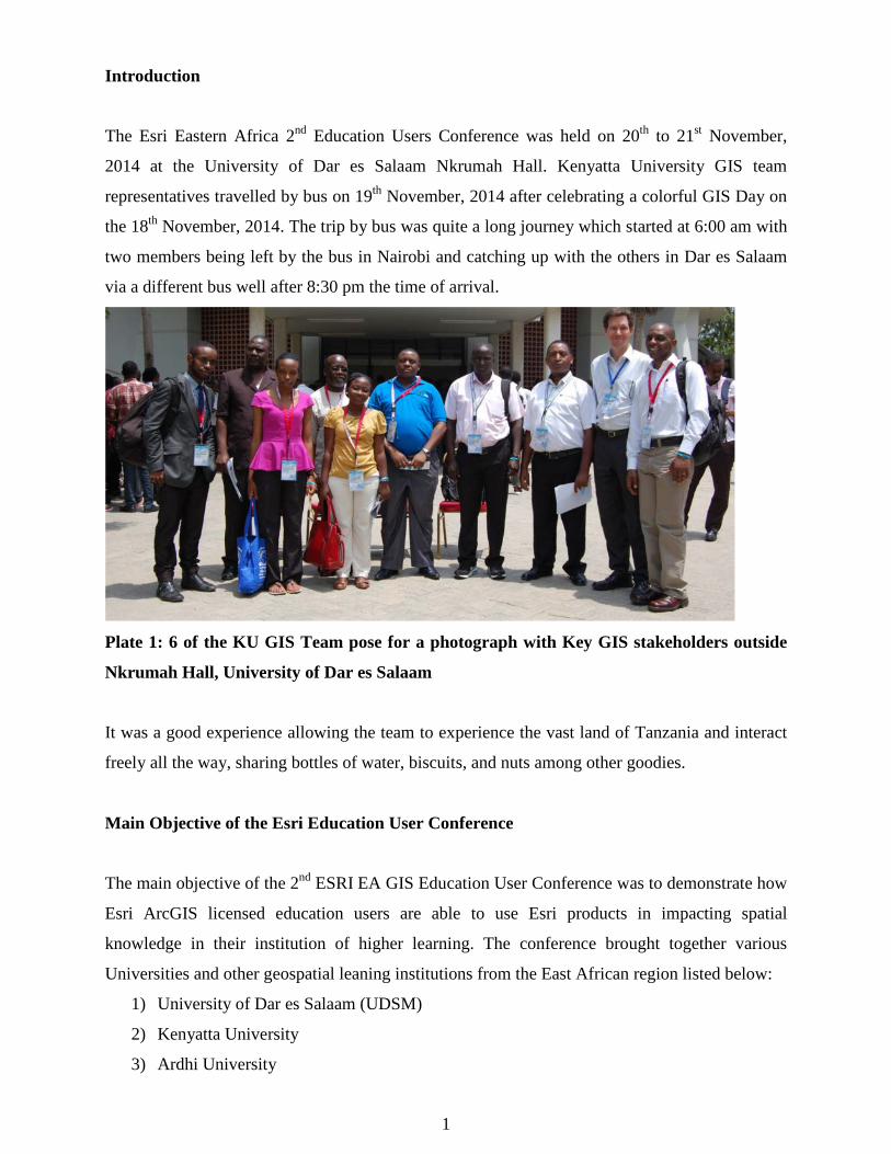
The Esri Eastern Africa 2nd Education Users Conference was held on 20th to 21st November,
2014 at the University of Dar es Salaam Nkrumah Hall. Kenyatta University GIS team
representatives travelled by bus on 19th November, 2014 after celebrating a colorful GIS Day on
the 18th November, 2014. The trip by bus was quite a long journey which started at 6:00 am with
two members being left by the bus in Nairobi and catching up with the others in Dar es Salaam
via a different bus well after 8:30 pm the time of arrival.
Plate 1: 6 of the KU GIS Team pose for a photograph with Key GIS stakeholders outside
Nkrumah Hall, University of Dar es Salaam
It was a good experience allowing the team to experience the vast land of Tanzania and interact
freely all the way, sharing bottles of water, biscuits, and nuts among other goodies.
Main Objective of the Esri Education User Conference
The main objective of the 2nd ESRI EA GIS Education User Conference was to demonstrate how
Esri ArcGIS licensed education users are able to use Esri products in impacting spatial
knowledge in their institution of higher learning. The conference brought together various
Universities and other geospatial leaning institutions from the East African region listed below:
1) University of Dar es Salaam (UDSM)
2) Kenyatta University
3) Ardhi University
1

4) University of Bagamoyo
5) Nelson Mandela Africa Institute of Science and Technology
6) Aga Khan University
7) Mzumbe University
8) World Vision
9) Southern and Eastern African Mineral Centre
10) Mwalimu Nyerere Memorial Academy
11) Tanzania National Parks
12) Dar es Salaam Institute of Technology
13) Institute of Marine Sciences – Zanzibar
14) St. John’s University
15) Open University of Tanzania
16) Tanzania Forestry Research Institute
17) Institute of Rural Development & Planning – Dodoma
18) Dedan Kimathi University of Technology
19) National Electoral Commission
20) Geo-Information Communication – Uganda
21) InfoBridge Consultants Ltd
Esri-EA made a number of presentations showing the power of GIS in Education by
demonstrating how the educators can leverage on Esri online products to customize Esri software
and tailor them for their specific training requirements. The use of online tools to make story
maps for example was an eye catching presentation to all participants.
The participant we given slotted time to showcase how they are using Esri ArcGIS to impart
spatial knowledge in their teaching and research in various disciplines in their curriculum. This
brought forth diversified application of GIS from medicine, energy distribution, hydrology and
minerals to name but a few. The application part of GIS in industries which are using it to map
their resources and monitor their work progress was encouraging to the participants.
Registration and the opening ceremony
The conference started off with registration of participant (Plate 2 and 3). Mr. John Njenga from
Esri-EA was the master of ceremony. He made a brief address and introduced the participant and
strated off the conference by inviting the conference organizers to make their opening remarks.
2
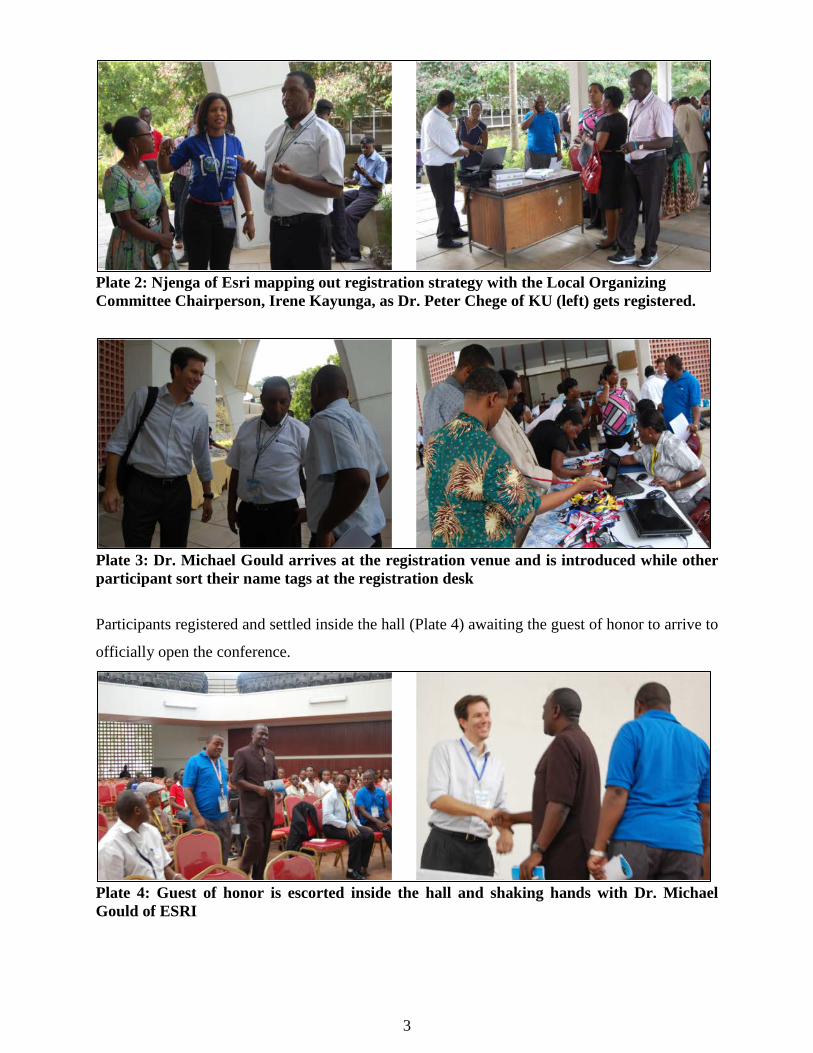
Plate 2: Njenga of Esri mapping out registration strategy with the Local Organizing Committee Chairperson, Irene Kayunga, as Dr. Peter Chege of KU (left) gets registered.
Plate 3: Dr. Michael Gould arrives at the registration venue and is introduced while other participant sort their name tags at the registration desk
Participants registered and settled inside the hall (Plate 4) awaiting the guest of honor to arrive to
officially open the conference.
Plate 4: Guest of honor is escorted inside the hall and shaking hands with Dr. Michael Gould of ESRI
3

Mr. Njenga (Plate 5) welcomed and thanked the guest of honor and all the participants for
finding time to attend the conference and for being patient with the start of the program. He took
the participant through the program of the day, highlighting the key activities and some
adjustment of the timing to recover lost time due to preparation of the hall and the public address
systems.
Plate 5: Njenga Esri-EA welcoming the guests as participant follows the line-up of events on the program
He called upon Dr. Philip Mwanukuzi, the Head of the Department of Geography from the
University of Dar es Salaam to make his opening remarks and invite the Vice Chancellor’s
representative, Dr. Godius Kahyarara, Principal of College of Social Sciences at University of
Dar es Salaam to make his opening remarks and to officially open the forum (Plate 6 and 7).
Plate 6: The Head of the Department of Geography Dr. Philip Mwanukuzi making his remarks and inviting the Guest of Honor Dr. Godius Kahyarara, Principal of College of Social Sciences to officially open the conference
4

Plate 7: The Guest of Honor Dr Godius Kahyarara, Principal, College of Social Sciences at UDSM, welcoming participants during his opening remarks and officially opening the conference
Principal, College of Social Sciences, Dr Godius Kahyarara, opened the conference on behalf of
the Vice Chancellor, University of Dar es Salaam. He officially welcomed all the participants
and opened the conference. He was excited that the University of Dar es Salaam was hosting the
2nd Esri EA Education User Conference after Kenyatta University pioneered by hosting the 1st
Conference. He was optimistic that the University of Dar es Salaam would benefit from the
conference and encouraged the participating students to take the opportunity to network and
learn more from the other university participating in the conference.
Esri Keynote Address
Dr. Michael Gould from Esri was the main speaker during the opening session (Plate 8). He
addressed participants and emphasized the importance of Esri Education Users’ licenses. He
expounded on the Esri Africa 100 Universities programme through the Enterprise Licenses and
showed participants a map of all the university which have so far benefited on the programme.
He named Kenyatta University as the first University in Africa to have been awarded the
enterprise license. Kenyatta University has since showed a lot progress in the use of the ArcGIS
Tools to impart on the way GIS is used as a pedagogical and research tool. Dr. Gould specially
thanked Kenyatta University’s management and especially the Vice Chancellor for seizing the
opportunity and acting on it. He also pointed out the need of a focal person at the benefiting
institution and the role that Prof Simon Onywere had played so effectively as a champion of GIS.
The experience of Kenyatta University was now being used to inform other institutions aaplying
for the 100 Africa Universities programme.
5

Plate 8: Dr. Michael Gould, Esri keynote speaker addressing the participants as KU team
from front right: Prof Onywere (in white shirt), Caroline Otiwa, Nancy Wachiuri, Peter
Mwirigi and Kelvin Mwenda follow keenly.
.
He thanked Prof Onywere for being a true GIS Champion who initiated the process of
acquisition of the ArcGIS Enterprise license and has steered the GIS team at KU to
operationalize its use across campus. He urged all the other Universities with the license to
continue enhancing their GIS teaching programs and in research for its ability to visualize data
and therefor address many of the global problems. For the universities which are still struggling
with drafting the MOU, it is now easier for them to borrow from Kenyatta University and the
like minded institutions which have seen the implementation process through. After Esri key
notes from Dr. Michael Gould, participants were requested to join the guest of honor for a group
photo outside the Nkrumah Hall and thereafter enjoyed a cup of tea snacks (Plate 9, 10, 11 & 12)
Plate 9: Participants in a group photo outside Nkrumah Hall
6
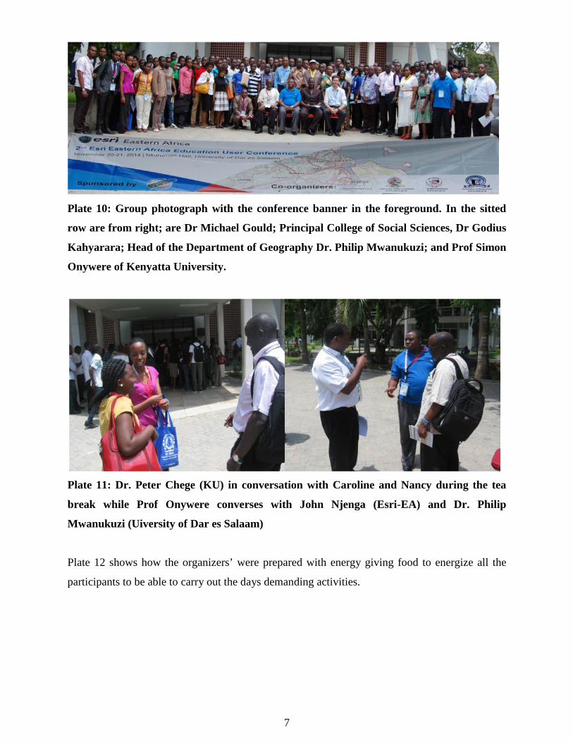
Plate 10: Group photograph with the conference banner in the foreground. In the sitted
row are from right; are Dr Michael Gould; Principal College of Social Sciences, Dr Godius
Kahyarara; Head of the Department of Geography Dr. Philip Mwanukuzi; and Prof Simon
Onywere of Kenyatta University.
Plate 11: Dr. Peter Chege (KU) in conversation with Caroline and Nancy during the tea
break while Prof Onywere converses with John Njenga (Esri-EA) and Dr. Philip
Mwanukuzi (Uiversity of Dar es Salaam)
Plate 12 shows how the organizers’ were prepared with energy giving food to energize all the
participants to be able to carry out the days demanding activities.
7

Plate 12: Carole and Nancy from KU serving themselves with snacks as Prof Onywere
decides what to take as he listen to Dr. Gould explaining a point.
Paper Presentations
This session followed the tea break with various presenters presenting their achievements with
the Esri user license in teaching and in industrial applications. The first presentation was on:
“Geometric Network Analysis on Tanzania Electricity Distribution Utility” by Bayona Kennedy
of Ardhi University (Plate 13). This demonstrated how ArcGIS has been used to integrate the
electrical network distribution and mapping of all the customers in Tanzania. The customer’s
homes are geo-located using GPS and their spatial coordinates fed into the Geodatabase which
has other attribute field detailing the customer information. This information helps in track the
customer’s payments, defaulters and complains whenever they are reported. The field teams are
able to address this to the specific customers with quick response mechanisms.
Plate 13: Geometric Network Analysis on Tanzania Electricity Distribution
Utility by Bayona Kennedy, Ardhi University
8

The second presentation was on: “Impact of Campus-Wide GIS License on Teaching and
Research in Kenyatta University” by Anthony Gakobo Macharia. Mr. Gakobo (Plate 14) took
the participant through the process KU adopted to use GIS in training and the mode of training
using a two phased approach of introduction to the ArcGIS software (3 days) and GIS
Applications (5 days). The impact that the Esri license has generated on campus is significant
with GIS trained participant coming up with projects that are addressing environmental problems
spatially. He presented to the participant maps generated through GIS training in KU which are
addressing different challenges facing the world resource. The training demonstrate ArcGIS as a
tool for GIS across all carder of academia.
Plate 14: Mr. Gakobo giving his presentation on the process KU has adapted in impacting
Spatial Knowledge in teaching and research using Esri campus wide ArcGIS license
Mr Gakobo responded to the questions (Plate 15) that the participant posed and wanted to know
more about how student are using the ArcGIS on their own for research projects.
9

Plate 15: Participants following Gakobo’s presentation (left). One of the participants poses
a question
The 3rd presentation was on: “Application of GIS to Hospital Management, Patient Care and
Patient Flow Systems” by Mugambi Kelvin Mwenda (Plate 16), a 4th year student from the
School of Environmental Studies, Department of Environmental Science, Kenyatta University.
Kelvin had been trained to use ArcGIS and has come up with a proposal for his final year
research project to use ArcGIS campus editing for hospital management. He is targeting to use
this in preparation for the upcoming KU research and referral hospital under construction.
Plate 16: Kelvin Mwenda making his presentation on application of ArcGIS (campus
editing) to Hospital Management, patient care and patient flow system
10

The Campus Editing map can be used to capture the interior bed location of each patients ward
on the proposed university referral hospital and also all the available rooms within the hospital
and the department of service they are attached to for the purpose of management. Some of the
highlighted area of applications includes: Effective bed allocation to patients on admission,
Effective treatment strategies, Correct patients wards allocation, Increased patient data retrieval
among other applications. The attention and keenness of some of the participant (Plate 17) on
this exciting topic was apparent.
Plate 17: Mwenda emphasizing the importance of adopting ArcGIS Campus edit in
hospital management while participant pop out their eyes to see more of the system design.
The third presentation from Kenyatta University and the pick of pick presentation for that day
was: Campus Mapping using GIS to make Informed Decision on Campus by Prof. Onywere.
Prof. Onywere (Plate 18) took the participant through the process of mapping various facilities
on KU campus that GIS trainees mapped during their application phases and the sum total of all
the work produced by groups during the training leading to the development of a KU main
campus map. This map can be used in various ways to locate what facility are where and
therefore make informed spatial decision based on actual position of the facilities (Plate 19).
11
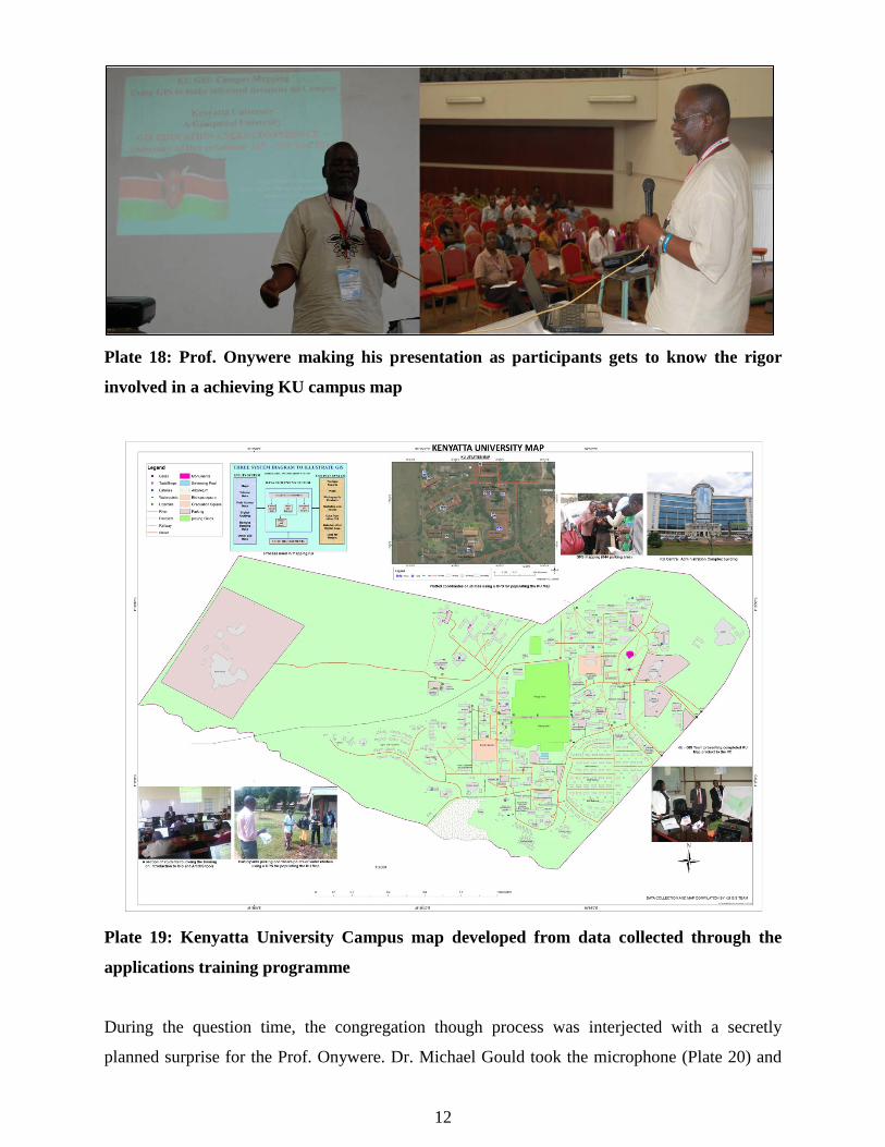
Plate 18: Prof. Onywere making his presentation as participants gets to know the rigor
involved in a achieving KU campus map
Plate 19: Kenyatta University Campus map developed from data collected through the
applications training programme
During the question time, the congregation though process was interjected with a secretly
planned surprise for the Prof. Onywere. Dr. Michael Gould took the microphone (Plate 20) and
12

instead of asking a question, he went straight to commending Prof. Onywere and crowning him
the GIS Champion in East Africa for the 2014 for his passion for GIS and for steering the
implementation of 100 Africa Universities programme at Kenyatta University and for never
giving up even when hope seemed to varnish. Such personalities are recognized by Esri and are
crowned the point persons in an institution. In this regard Prof. Onywere was crowned with an
Esri maroon T-shirt (Plate 21) to symbolize leadership in GIS arena.
Plate 20: Prof. Onywere is waiting for a question as Dr. Gould hiding the T-shirt as he
explain to participants the importance of having a point person for GIS like Prof. Onywere
of Kenyatta University.
Plate 21: Dr. Gould handing the T-shirt to Prof. as he gives out the note book to try it on
13

What followed after this was a professional hand shake (Plate 22) with Prof. Onywere unable to
hide his surprise full of joy from his grinning.
Plate 22: Prof. Onywere is given a professional handshake as he is unable to control his joy
Thereafter professor Onywere introduced the KU_GIS team (Plate 23) which accompanied him
for the conference, some sponsoring themselves to faithfully attend the spatial crusade.
Plate 23: Mrs Esther Kagure, Dr. Peter Chege, Kelvin Mwenda, Peter Mwirigi, Carole
Akoth, Anthony Gakobo and Nancy Wachiuri, the KU_GIS team attending the conference
This gave the other participant some challenging homework to make it happen from their side
come the 3rd Esri Education User Conference. Some quiet moment engulfed the hall as other
institutions stakeholders reflected on the event.
14

Professor Onywere thanked the Esri team (Plate 24) for recognizing him and bestowing him with
such a responsibility which he vowed to soldier own to see KU become a Centre of Excellence in
Geospatial Knowledge.
Plate 24: Prof. Onywere pledging to Esri team and other stakeholders that he will carry the
GIS mantle even higher
Participants admired the new Esri outfit and the role bestowed to him as they shared a joke with
Njenga of Esri-EA (Plate 25).
Plate 25: Prof. Onywere and Njenga of Esri-EA proudly display their Esri Logos on their
shirts as Mr. Gakobo and Dr. Gould pose for a photograph with them
15
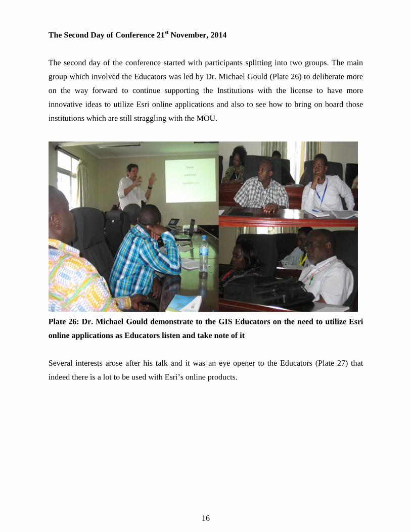
The Second Day of Conference 21st November, 2014
The second day of the conference started with participants splitting into two groups. The main
group which involved the Educators was led by Dr. Michael Gould (Plate 26) to deliberate more
on the way forward to continue supporting the Institutions with the license to have more
innovative ideas to utilize Esri online applications and also to see how to bring on board those
institutions which are still straggling with the MOU.
Plate 26: Dr. Michael Gould demonstrate to the GIS Educators on the need to utilize Esri
online applications as Educators listen and take note of it
Several interests arose after his talk and it was an eye opener to the Educators (Plate 27) that
indeed there is a lot to be used with Esri’s online products.
16

Plate 27: GIS educators following Dr. Gould’s presentation
The second speaker was Prof. Onywere from Kenyatta University. He took the GIS Educators
through a step by step explanation (Plate 28) of how KU has made it to its current heights in the
application of Esri 100 Africa Universities license in teaching and research.
Plate 28: Prof. Onywere taking GIS Educators through the Process used by KU GIS
Platform as they keenly follow the flow chart
Prof. Onywere in his presentation about the journey KU has taken, to get the MOU signed and to
operationalize the Esri 100 African University License (Plate 29) emphasized the role of
University Top Management especially the Vice Chancellor right from the beginning to ensure
transparency and logistical and sometimes financial support. The other major player is the ICT
department as in many institutions they support the infrastructure that the software sits and runs
on.
17

Plate 29: Esri-EA team following the presentation from their laptop as Dr. Chege of KU
and Peter Kimani from Aga Khan University get the key points from the presentation
The third presenter was Dr. Chaula from Ardhi University (Plate 30) who also presented the
achievement Ardhi University has made with the Esri Campus license.
Plate 30: Dr. Chaula from Ardhi University making his presentation
He demonstrated to the GIS Educators the various Departments at Ardhi University that use the
Esri ArcGIS. Such included the Department of Geomatics which has fully integrated GIS in all
its teaching units. This presentation brought to the end the morning session for the second day.
The educators were invited for a photo session (Plate 31 and 32) before joining the other group
for lunch.
18
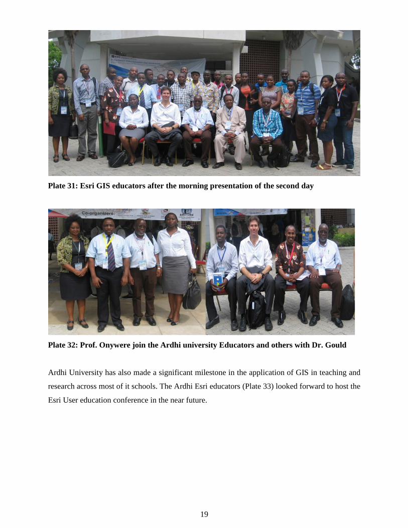
Plate 31: Esri GIS educators after the morning presentation of the second day
Plate 32: Prof. Onywere join the Ardhi university Educators and others with Dr. Gould
Ardhi University has also made a significant milestone in the application of GIS in teaching and
research across most of it schools. The Ardhi Esri educators (Plate 33) looked forward to host the
Esri User education conference in the near future.
19

Plate 33: Ardhi Esri user educators lead by Dr. Chaula (in tie)
The educators enjoyed their lunch before getting back to the hall for the final presentations, prize
giving and closing of the conference.
The demonstration of how to create story maps and the use of ArcGIS web App builder was the
first item after the lunch break. This aimed at exposing the users who want to take ArcGIS
further in their research to perform tasks which are customized to their activities.
The use of ArcGIS ArcScene was demonstrated by Carole Akoth in her urban design studio. Due
to time factor she was not able to present in person but Prof. Onywere requested for five minute
slot to just show the participants (Plate 34) what she has achieved using the Esri License.
20

Plate 34: Prof. Onywere demonstrating what Carole Akoth has been able to do using
ArcScene
There after the conference ended with a prize giving session for all the presenters which included
A to Z GIS book and all those who attended got a present each.
Plate 35: Kelvin Mwenda-KU and Prof. Onywere receiving their presenter’s prizes
There after the conference was officially closed and participant converged outside to exchange
contacts to keep the spatial crusade a life. All the presenter at the conference present at the
closing session also joined for a group photo with Dr. Gould (Plate 36) before dispersing.
21

Plate 36: 2nd Esri user education conference presenters
Dr. Michael Gould (Plate 37) had a busy moment while biding everyone goodbye and
occasionally posing for memorable photo shots with participants
Plate 37: Dr. Michael Gould biding goodbye to presenters and to Carole and Nancy from
KU
The end of the 2nd Esri Eastern Africa Education GIS User Conference
Contact: • The Vice Chancellor, Kenyatta University – [email protected] • Prof Simon M Onywere, Department of Environmental Planning & Management
[email protected] • Mr Anthony Gakobo (ICIPE/Cernvec KU GIS Intern) – [email protected]
22
![Tanzania's Precious Minerals Boom: Issues In Mining …. Haji Semboja [ hsemboja@esrf.or.tz], ... Godius Kahyarara, Economic and Social Research Foundation and Peter C. Keller, The](https://img.pdfslide.us/doc/110x75/5b46a80a7f8b9af5078b9874/tanzanias-precious-minerals-boom-issues-in-mining-haji-semboja-hsembojaesrfortz.jpg)