Embed Size (px)
Citation preview

DEVELOPMENT PARTNERS
THE LEAD CONSULTANT IN THE PREPARATION
OF THIS COUNTY SPATIAL PLAN:
Center for Urban & Regional Planning (CURP),
Bruce House, Standard Street, 15th Floor, Nairobi.
THE CLIENT:
The County Government of Lamu (CGL), P.O. Box 74-
80500, LAMU
IN PARTNERSHIP WITH:
World Wildlife Fund for Nature, Lamu-Kenya Office
THE MAKING OF THIS CSP ALSO BENEFITED FROM
THE INPUT OFFERED BY AUTHORITIES SUCH AS:
The National Land Commission (NLC), Nairobi
The Kenya Wildlife Service (KWS) & The County Wildlife &
Conservation Committee (CWCC), Lamu
The LAPSSET Authority as a flagship project of Vision 2030
being undertaken in Lamu County
Kenya Forest Service (KFS), Lamu
International Center for Research in Agroforestry
National Museums of Kenya, through the World Heritage
Site Office in Lamu Island
Water Resources Management Authority, Kenya
LAMU COUNTY SPATIAL PLAN; VOLUME III (2016 – 2026) ii
FOREWORD
The Constitution of Kenya 2010
bestows the mandate of County
Planning to County Governments.
The Constitution further provides
for the various rights and freedoms
that can be fully realized through
the preparation and
implementation of County Spatial
Plans.
The County Governments Act 2012 in section 110(1)(a) stipulates
that the County Spatial Plans shall give effect to the principles and
objects of county planning and development contained in section
102 and 103 of the same Act. Further, section 110 (2)(c)(iv) of the Act
requires that the County Spatial Plans should set out basic guidelines
for a Land Use management system in the County taking into account
any guidelines, regulations or laws as provided for under Article 67(2)
(h) of the Constitution.
In furtherance to this responsibility, the law obligates each County
Government to prepare a ten-year GIS-based County Spatial
Development Plan in respect of their area of jurisdiction. The plan is
a broad framework for organizing and distributing population and
activities in the county; This is to achieve both national and county
development objectives. It also serves the purpose of enabling the
county government to strengthen the coordination of sectoral
projects, programmes and to mitigate duplication of efforts and
waste of resources.
Lamu County is destined to be one of the new growth frontiers with
a number of large-scale economic development and infrastructure
investments. The Lamu Port, South Sudan and Ethiopia Transport
(LAPSSET) corridor project among other projects that are expected
to change the economic landscape of the County and thus the need
for a spatial framework to provide a basis for planned investments.
The County also experiences a myriad of challenges related to land
based resources such as human-wildlife conflicts, encroachment on
fragile ecosystem, unplanned settlements and depletion of water
sources. These challenges can best be addressed within a planned
framework.
Whilst the expected developments could generate substantial
economic and social benefits, they also pose significant
environmental and social risks. They could lead to irreversible
damage to the County’s most important natural assets such as
forests, mangroves, water sources, beaches, seagrass beds, coral
reefs and fisheries. These natural assets provide a flow of goods and
services that are vital to Lamu’s economy and the wellbeing of the
people). Lamu’s natural environment also holds important cultural
and spiritual values for many communities. However, many of these
assets are already in decline due to human activities, and the losses
would have profound implications for Lamu’s future.
The Lamu County Spatial Plan (2016-2026) addresses the aforesaid
challenges in order to improve the standards of living of the people
through employment creation, reduction of poverty, and creation of
wealth as well guide sustainable development. The plan also
provides comprehensive strategies and policy guidelines to solve the
problems of rural and urban development, industry, infrastructure
and human settlement, ecotourism and sustainable environmental
management. The implementation plan will be a major milestone
towards securing biodiversity hotspots, sustainable management of
natural resources and improvement of the quality of life and
wellbeing of the residents of Lamu County.
Special thanks to our Key Partners World Wide Fund (WWF) led by
Mr. Mohamed Awer (Chief Executive Officer), Mr. Kiunga Kareko
(Coastal Program manager) and the entire WWF team for their
invaluable financial and technical support. The County is also grateful
to the County Assembly for their active role in plan preparation and
approval. Lastly to the County team (National and County
Departments), local community and other stakeholders to the timely
preparation and completion of the plan. We look forward to the
support of every stakeholder in the implementation of the plan.
Hon. Issa A. Timamy
The Governor
County Government of Lamu
LAMU COUNTY SPATIAL PLAN; VOLUME III (2016 – 2026) iii
PREFACE
Lamu County, forms
part of the larger coast
region that include
Kwale, Mombasa, Kilifi,
Tana River and
Taita/Taveta counties.
Except Taita/Taveta
County, all the other
counties front the
Indian Ocean with a coastline extending almost 600 kilometres from
the boundary with Tanzania to the south to the boundary with
Somalia to the North. Lamu County has approximately 130
kilometres of sandy beach coastline which is characterized by some
unique and environmentally sensitive coastal ecosystems which
include the coastal sand dunes, mangrove swamps, coral reefs,
coastal tropical forest and rangelands that are so important for the
pastoral communities in the Coast, North Eastern and Northern
Kenya. These ecosystems are of great interest in view of their
protective role against siltation and sea erosion. The National
Environment Management Authority (NEMA) and the World-Wide
Fund for Nature (WWF) working in collaboration with County
Government of Lamu and other Stakeholders recently completed the
preparation of an Environmental Sensitivity Atlas for Lamu County
which we hope if used together with this Spatial Plan will go a long
way to guiding future development of County.
World Wide Fund for Nature (WWF) has been an active partner in
the preparation of this Spatial Plan and their contribution in logistical
arrangements and expertise is highly appreciated. The preparation
of a County Spatial Plan is legal requirement under the County
Government Act, 2012. Section 110 (1) States that there shall be a
ten-year GIS based database system ‘Spatial Plan’ for the County
which shall be a component part of the County Integrated
Development Plan (CIDP). The preparation of this spatial Plan is
based on a GIS database that has carefully been prepared capturing
property boundaries of all surveyed land parcels in the entire County.
A GIS officer from the County Government of Lamu has been trained
on data capture, entry, retrieval and updating process. WWF has
established a GIS laboratory within Lamu County Government on
which all data collected during the preparation of this Plan will be
entered and archived.
The County Spatial Plan has been developed through a robust and
all-inclusive stakeholder process. The process included integration of
national policies that have relevance to the County Government
Planning and budgeting needs. Stakeholders meetings were held in
all the wards in recognition of the fact that the ward has become an
important Planning unit as far as the County Government Act 2012 is
concerned. In each ward, the participants were able to develop the
vision for their ward which were later merged to form County vision.
The Spatial Plan is strategic and therefore aims at addressing spatial
problems facing the County’s geographical space. Spatial concepts
have been used to better describe and depict the unique land forms
that make up the said geographical space.
This Plan has ensured that pursuit of equity in resource allocation
within the County has been promoted, and that short-term gains are
not favoured above long-term sustainability. The Plan has provided
a platform for unifying Planning, budgeting, financing, programme
implementation and performance review.
The ultimate aim of preparing Lamu County Spatial Plan has been to
strategically guide sustainable development in Lamu County for a
period of 10 years and facilitate the transformation of the lives of the
citizens of the County. This Plan has aimed at providing an overall
spatial framework for the County to guide sustainable development,
providing an agreed land use Plan for the County, which include
clearly designated land use zones, developing a GIS database as
mentioned earlier which has supported the Plan making process. The
Plan has also helped in interpreting and localizing strategic national
and regional policies and strategies, identifying the natural assets
within the County, outlining strategies to protect and where
appropriate improve renewable natural assets, providing a basis for
efficient and cost-effective delivery of infrastructure services
through a long-term programme of investment and providing a
framework for revitalizing industries, trade and commerce for
sustainable economic development.
The Plan has depicted the spatial dimension of the social-economic,
political and environmental development programmes of the County
as articulated in the County Integrated Development Plan. It has also
presented a clear statement of how the spatial Plan is linked to the
Regional, National and the County Plans, clarified on the anticipated
sustainable development outcomes of the Spatial Plan through
controlling the order and nature of activities on land in the County.
The preparation of this Pro-Conservation Spatial Plan has benefited
from the dedication and collaboration of the County Government of
Lamu, National Land commission, Director of Physical Planning,
Ministry of Lands and Physical Planning and the World-Wide Fund for
Nature (WWF), The National Museums of Kenya, The LAPSSET
Authority, the County Residents (Public).
Hon. Amina R. Masoud
County Executive Committee Member
Lands, Physical Planning, Water, Infrastructure & Urban
Development
County Government of Lamu
LAMU COUNTY SPATIAL PLAN; VOLUME III (2016 – 2026) iv
ACKNOWLEDGEMENT
The County Spatial Plan 2016-2026 (CSP) is as a result of a
comprehensive participatory process that lasted for approximately
18 months under the guidance of the Consultant - Centre for Urban
& Regional Planning. The approach was multi-disciplinary and multi-
sectoral approach with the involvement of all the stakeholders
including the community.
The process involved participants from all the ten wards of the
County (Witu, Bahari, Hongwe, Mkunumbi, Hindi, Basuba, Shella-
Manda, Amu, Faza and Kiunga), Planners from the County
Government, Centre for Urban and Regional Planning (CURP) and
Technical Departments of various Ministries within the County.
Other participants involved in the process included: National Land
Commission (Directorate of Planning), Ministry of Lands and Physical
Planning (Department of Physical planning), Ministry of Interior and
Coordination of National Government (Office of County
Commissioner Lamu), Kenya wildlife Society, and Non-State actors
(WWF), World Agroforestry Centre and local conservation groups.
These are acknowledged for participating and supporting the entire
process.
The CSP has been prepared with the institutional and financial
support of the County Government of Lamu and the World Wildlife
Fund (WWF) for Kenya Office. The County is particularly grateful to
H.E. Hon. Issa Timamy - Governor of Lamu, Hon Amina R. Masoud -
County Executive Member in charge of Land and Physical Planning
and Mr. Mohamed Awer Mohamed - Chief Executive Officer, WWF
for their guidance, financial and institutional support in preparation
of this plan. WWF-Kenya has supported the establishment of a fully-
fledged GIS lab as per the threshold set by the National Land
Commission guidelines in preparation of County Spatial Plans. WWF-
Kenya has also supported the CSP development process by
supporting a participatory process where transect surveys, focus
group discussions and validation workshops were conducted.
Capacity building programmes in GIS and M&E have also been
supported to enhance capacity in operation of the GIS laboratory and
effective preparation and implementation of the plan.
We appreciate the Consultant for steering the process in a highly
professional manner. The support and goodwill of both the County
Executive Committee Members, the County Assembly Members and
County Administration is highly appreciated.
The County is also grateful to: Dr. Stephen Holnes - a conservation
specialist from South Africa, courtesy of WWF; Consultants from
World Agro forestry Centre; National Museums of Kenya; Dr. H.
Musoga; Planner R. Kitur; and C. Onyango from National Land
Commission for their insightful contribution to the process of the
County Spatial Planning.
This document could not also have been prepared without the
invaluable input and guidance of the County Planning Team led by
Eric Randu (Director of Lands & Physical Planning), Vincent Osewe
(County Physical Planner) and Swabra B. Mohamed (County GIS
Analyst). The Consultant's Team included: Planners R.K. Mbwagwa,
Osengo Charles, Joakim Nyarangi, Samuel M. Gituara, John Nduru,
and GIS specialist Peter D. Nyamai.
The County Department of Lands further also acknowledges the
support and mobilisation efforts of the WWF Lamu Office
spearheaded by Kiunga Kareko (Coastal Project Manager, WWF) and
Nathan Mutunga (Planner). Finally, we highly appreciate the Lamu
community in all the ten wards for their active participation and
input during the plan preparation process. As it is not possible to list
the names of all the persons in this section of the report, a detailed
list of all these contact persons has been attached as an appendix to
this report.
Eric Randu
County Director of Lands & Physical Planning
LAMU COUNTY SPATIAL PLAN; VOLUME III (2016 – 2026) v
ABBREVIATIONS & ACRONYMS
C.C. – County Commissioner
C.O. – Chief Officer
CBNRM – Community Based Natural Resource Management
CBO – Community Based Organizations
CCS – Comprehensive Community Strategy
CDF – Constituency Development Fund
CEC – County Executive Commissioner
CFA – Community Forest Association
CGL – County Government of Lamu
CGTR – County Government of Tana River
CIDP – County Integrated Development Plan
CIP – Capital Investment Plan
CSO – Civil Society Organization
CSP – County Spatial Plan
CURP – Center for Urban and Regional Planning
CWCC – County Wildlife & Conservation Committee
DNR – Dodori National Reserve
DPS – Development Partners
EEZ – Exclusive Economic Zone
EMCA – Environmental Management and Control Act
ESIA – Environmental and Social Impact Assessment
FBO – Faith Based Organization
FGD – Focused Group Discussion
FGM – Female Genital Mutilation
FPE – Free Primary Education
FSE – Free Secondary Education
FY – Financial Year
GASP – German Assisted Settlement Programmes
GIS – Geographical Information System
GoK – Government of Kenya
GTZ – German Organization for Technical Cooperation
HIMWA – Hindi Magongoni Water Association
IBA – Important Bird Areas
ICT – Information Communication and Technology
ISUDP – Integrated Strategic Urban Development Plan
JKUAT – Jomo Kenyatta University of Agriculture and Technology
K.D.F. – Kenya Defense Forces
K.P.R. – Kenya Police Reservists
KAA – Kenya Airports Authority
KENHA – Kenya National Highway Authority
KENTTEC - Kenya Tsetse fly and Trypanosomiasis Eradication
Council
KeRRA – Kenya Rural Roads Authority
KETRACo - Kenya Electricity Transmission Company
KFS – Kenya Forest Service
KFS – Kenya Forest Service
KIP – Kenya Institute of Planners
KMA – Kenya Maritime Authority
KMNR – Kiunga National Marine Reserve
KNBS – Kenya National Bureau of Statistics
KPL Company
KPLC – Kenya Power and Lighting Company
KPR – Kenya Police Reservist
KU – Kenyatta University
KURA – Kenya Urban Roads Authority
KWS – Kenya Wildlife Service
LAKWA - Lake Kenyatta Water Association
LAPSSET – Lamu Southern Sudan Ethiopia Transport Corridor
LAWASCO - Lamu Water and Sewerage Company
MIPC – Manda Island Port City
MP – Member of Parliament
NCIC – National Cohesion and Integration Commission
NEM – Northeast Monsoon
NEMA- National Environmental Management Authority
NGO – Non-Governmental Organization
NLC – National Land Commission
NMK – National Museums of Kenya
NMT – Non-Motorized Transport
PPPS – Public Private Partnerships
RAP – Resettlement Action Plan
SEM - Southeast Monsoon
SEZ – Special Economic Zone
SoK – Survey of Kenya
TARDA – Tana Athi River Development Authority
TJRC – Truth Justice and Reconciliation Commission
UNESCO – United Nations Educational, Scientific and Cultural
Organization
VCT – Voluntary Counseling and Testing
VIP – Ventilated Improved Pit
WFE – Witu Forest Ecosystem
WRM – Water Resource Management
WRUA – Water Resource Users Association
WWF – World Wildlife Fund
CURP: LAMU COUNTY SPATIAL PLAN; VOLUME III (2016 – 2026) 6
TABLE OF CONTENTS DEVELOPMENT PARTNERS ................................... i
FOREWORD ................................................................ ii
PREFACE ................................................................... iii
ACKNOWLEDGEMENT ........................................... iv
ABBREVIATIONS & ACRONYMS ............................ v
TABLE OF CONTENTS ............................................. 6
THE ACTION PLANS ................................................ 0
PROPOSED LAMU ISLAND ACTION PLAN ZONING AND
PLANNING GUIDELINES ................................................................ 1
Overview ................................................................................... 1
ZONE 1: THE LAMU WORLD HERITAGE SITE (LAMU OLD TOWN)1
Permitted Users in the Lamu World Heritage Site .................... 2
Tenable Projects; and Conditions to safeguard the Heritage
Value of the Old Town ............................................................... 3
Land Demand and Population Projections ................................ 3
ZONE 2: PERI-URBAN ZONES (AREAS OUTSIDE THE GAZETTED
WORLD HERITAGE SITE BOUNDARY FOR HUMAN SETTLEMENT
IN THE ISLAND) ............................................................................. 3
SHELLA .......................................................................................... 4
Permitted Users in Shella .......................................................... 4
Land Demand and Population Projections ................................ 5
General guidelines and standards for the Growth of Shella
Town .......................................................................................... 5
LANGONI ...................................................................................... 5
Permitted Users in Langoni Settlement .................................... 6
Land Demand and Population Projections ................................ 6
MATONDONI ................................................................................ 7
Permitted Users in Matondoni Village ...................................... 7
Land Demand and Population Projections ............................... 7
KIPUNGANI ................................................................................... 8
Permitted Users in Kipungani Village ........................................ 8
Land Demand and Population Projections ............................... 8
ZONE 3: THE TRANSPORTATION LINKAGE ................................... 9
ZONE 4: PROPOSED MIXED USE ZONE ...................................... 11
ZONE 5: AGRICULTURAL ZONE (AG) .......................................... 12
Rezoning of Agricultural Lands ............................................... 12
Rezoning from Larger to Smaller Agriculture Sub-Zones........ 12
ZONE 6: CONSERVATION AREAS ................................................ 12
THE ZONING ACTION PLAN ........................................................ 14
MANDA ISLAND PORT CITY(MIPC) ACTION PLAN DESIGN
GUIDELINES & STANDARDS (Work in Progress) ........................ 15
Overview ................................................................................. 15
Concept behind MIPC Plan ..................................................... 15
CONCEPTUAL Land Use Blocks ................................................ 15
THE MIPC PROPOSED LAND USE BLOCKS .................................. 17
Amusement Centre ................................................................. 17
Airport Land ............................................................................ 17
Industrial Land ........................................................................ 18
RESIDENTIAL AREAS ................................................................ 19
THE COMMERCIAL AREAS (C1; C2; C3; C4; and C5) ................ 20
General Design guidelines on Building siting and orientation 21
Architectural Character ........................................................... 21
THE PORT AREA ACTION PLAN .................................................. 24
kiongwe ‘bawaya’ lake kenyatta water catchment ACTION AREa
plan ............................................................................................ 25
REFERENCES ........................................................... 28

CURP: LAMU COUNTY SPATIAL PLAN; VOLUME III (2016 – 2026) 0
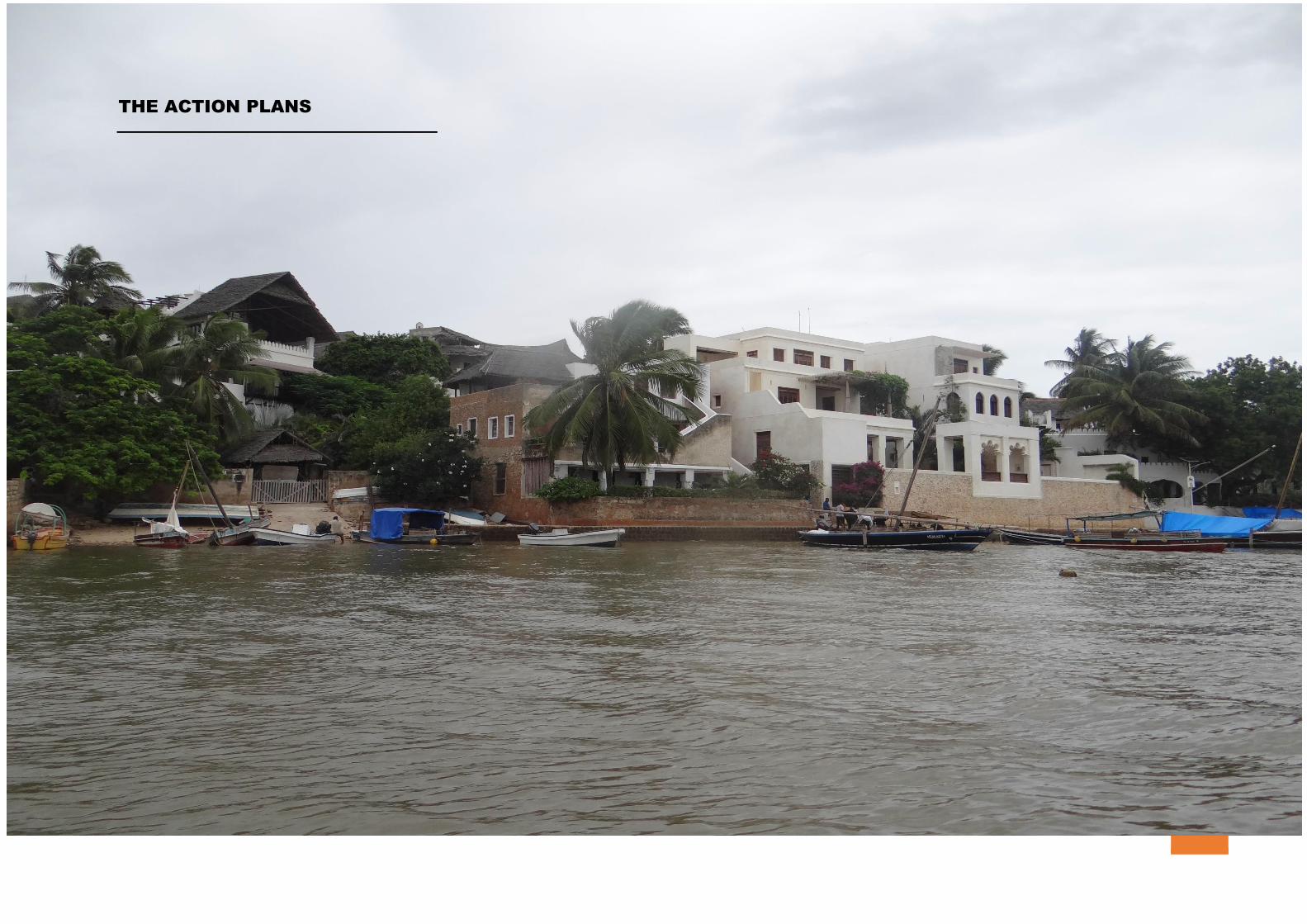
THE ACTION PLANS
LAMU COUNTY SPATIAL PLAN; VOLUME III (2016 – 2026) 1
PROPOSED LAMU ISLAND ACTION PLAN ZONING
AND PLANNING GUIDELINES
OVERVIEW
The relationship between physical space and communities is a
definitive understanding of how to Plan and develop quality
environments in such a way that they both maximize on space gain
and minimize the negative effects on people’s lives on the physical
spaces they inhabit.
The concept behind this Action Plan is aimed at conserving the
environmentally sensitive areas within the Island and to create
infrastructure that intra-links settlements within the island and
enhance better inter-linkage of the island and the mainland.
Additionally, it was noted that there was need to control
development on the outlying areas of the Gazetted UNESCO World
Heritage site and as such, this action Plan aims at proposing
guidelines that promotes sustainable growth of the peripheral
areas as the heritage viability of the Old Town is maintained.
Furthermore, this action Plan recognizes the growing need to have
major service commercial facilities within the island like
supermarkets; hypermarkets; and shopping malls. As such, the Plan
makes relevant proposals towards achieving this endeavor while
still maintaining the environmental sensitivity and heritage factor
of the island. To achieve all this, the Action Plan proposes the
following zones:
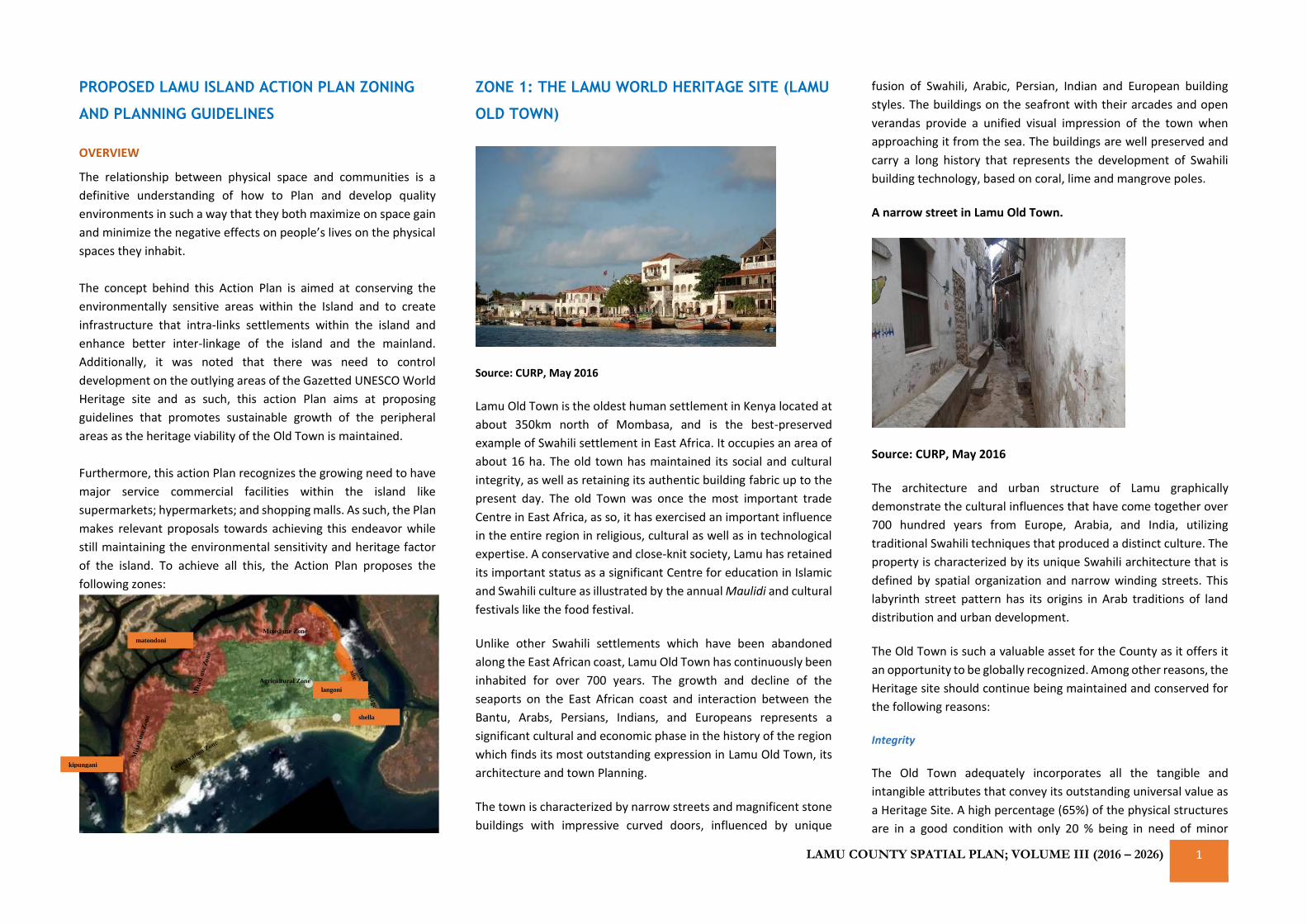
ZONE 1: THE LAMU WORLD HERITAGE SITE (LAMU
OLD TOWN)
Source: CURP, May 2016
Lamu Old Town is the oldest human settlement in Kenya located at
about 350km north of Mombasa, and is the best-preserved
example of Swahili settlement in East Africa. It occupies an area of
about 16 ha. The old town has maintained its social and cultural
integrity, as well as retaining its authentic building fabric up to the
present day. The old Town was once the most important trade
Centre in East Africa, as so, it has exercised an important influence
in the entire region in religious, cultural as well as in technological
expertise. A conservative and close-knit society, Lamu has retained
its important status as a significant Centre for education in Islamic
and Swahili culture as illustrated by the annual Maulidi and cultural
festivals like the food festival.
Unlike other Swahili settlements which have been abandoned
along the East African coast, Lamu Old Town has continuously been
inhabited for over 700 years. The growth and decline of the
seaports on the East African coast and interaction between the
Bantu, Arabs, Persians, Indians, and Europeans represents a
significant cultural and economic phase in the history of the region
which finds its most outstanding expression in Lamu Old Town, its
architecture and town Planning.
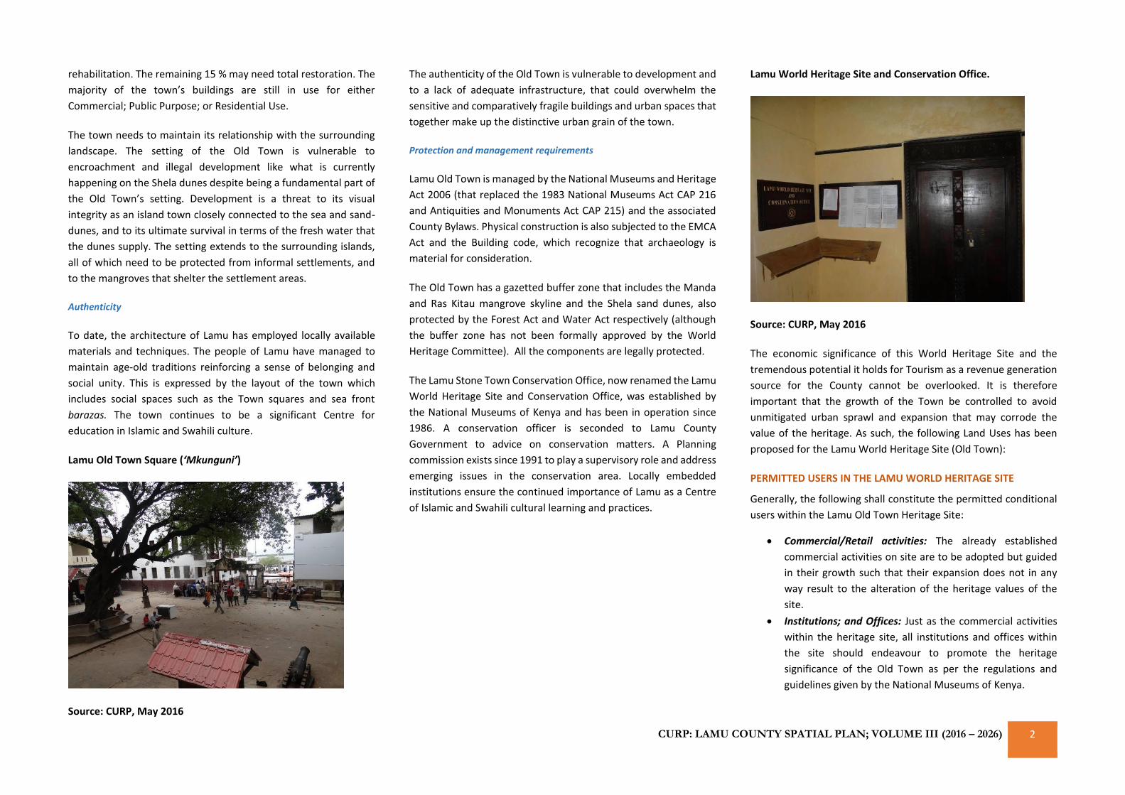
The town is characterized by narrow streets and magnificent stone
buildings with impressive curved doors, influenced by unique
fusion of Swahili, Arabic, Persian, Indian and European building
styles. The buildings on the seafront with their arcades and open
verandas provide a unified visual impression of the town when
approaching it from the sea. The buildings are well preserved and
carry a long history that represents the development of Swahili
building technology, based on coral, lime and mangrove poles.
A narrow street in Lamu Old Town.
Source: CURP, May 2016
The architecture and urban structure of Lamu graphically
demonstrate the cultural influences that have come together over
700 hundred years from Europe, Arabia, and India, utilizing
traditional Swahili techniques that produced a distinct culture. The
property is characterized by its unique Swahili architecture that is
defined by spatial organization and narrow winding streets. This
labyrinth street pattern has its origins in Arab traditions of land
distribution and urban development.
The Old Town is such a valuable asset for the County as it offers it
an opportunity to be globally recognized. Among other reasons, the
Heritage site should continue being maintained and conserved for
the following reasons:
Integrity
The Old Town adequately incorporates all the tangible and
intangible attributes that convey its outstanding universal value as
a Heritage Site. A high percentage (65%) of the physical structures
are in a good condition with only 20 % being in need of minor
Agricultural Zone
Mixed use Zone
shella
kipungani
langoni
matondoni
CURP: LAMU COUNTY SPATIAL PLAN; VOLUME III (2016 – 2026) 2
rehabilitation. The remaining 15 % may need total restoration. The
majority of the town’s buildings are still in use for either
Commercial; Public Purpose; or Residential Use.
The town needs to maintain its relationship with the surrounding
landscape. The setting of the Old Town is vulnerable to
encroachment and illegal development like what is currently
happening on the Shela dunes despite being a fundamental part of
the Old Town’s setting. Development is a threat to its visual
integrity as an island town closely connected to the sea and sand-
dunes, and to its ultimate survival in terms of the fresh water that
the dunes supply. The setting extends to the surrounding islands,
all of which need to be protected from informal settlements, and
to the mangroves that shelter the settlement areas.
Authenticity
To date, the architecture of Lamu has employed locally available
materials and techniques. The people of Lamu have managed to
maintain age-old traditions reinforcing a sense of belonging and
social unity. This is expressed by the layout of the town which
includes social spaces such as the Town squares and sea front
barazas. The town continues to be a significant Centre for
education in Islamic and Swahili culture.
Lamu Old Town Square (‘Mkunguni’)
Source: CURP, May 2016
The authenticity of the Old Town is vulnerable to development and
to a lack of adequate infrastructure, that could overwhelm the
sensitive and comparatively fragile buildings and urban spaces that
together make up the distinctive urban grain of the town.
Protection and management requirements
Lamu Old Town is managed by the National Museums and Heritage
Act 2006 (that replaced the 1983 National Museums Act CAP 216
and Antiquities and Monuments Act CAP 215) and the associated
County Bylaws. Physical construction is also subjected to the EMCA
Act and the Building code, which recognize that archaeology is
material for consideration.
The Old Town has a gazetted buffer zone that includes the Manda
and Ras Kitau mangrove skyline and the Shela sand dunes, also
protected by the Forest Act and Water Act respectively (although
the buffer zone has not been formally approved by the World
Heritage Committee). All the components are legally protected.
The Lamu Stone Town Conservation Office, now renamed the Lamu
World Heritage Site and Conservation Office, was established by
the National Museums of Kenya and has been in operation since
1986. A conservation officer is seconded to Lamu County
Government to advice on conservation matters. A Planning
commission exists since 1991 to play a supervisory role and address
emerging issues in the conservation area. Locally embedded
institutions ensure the continued importance of Lamu as a Centre
of Islamic and Swahili cultural learning and practices.
Lamu World Heritage Site and Conservation Office.
Source: CURP, May 2016
The economic significance of this World Heritage Site and the
tremendous potential it holds for Tourism as a revenue generation
source for the County cannot be overlooked. It is therefore
important that the growth of the Town be controlled to avoid
unmitigated urban sprawl and expansion that may corrode the
value of the heritage. As such, the following Land Uses has been
proposed for the Lamu World Heritage Site (Old Town):
PERMITTED USERS IN THE LAMU WORLD HERITAGE SITE
Generally, the following shall constitute the permitted conditional
users within the Lamu Old Town Heritage Site:
• Commercial/Retail activities: The already established
commercial activities on site are to be adopted but guided
in their growth such that their expansion does not in any
way result to the alteration of the heritage values of the
site.
• Institutions; and Offices: Just as the commercial activities
within the heritage site, all institutions and offices within
the site should endeavour to promote the heritage
significance of the Old Town as per the regulations and
guidelines given by the National Museums of Kenya.
LAMU COUNTY SPATIAL PLAN; VOLUME III (2016 – 2026) 3
• Educational and Religious Uses: As one of the most densely
populated settlements in the Island, it is recommended that
educational facilities and other institutions of Islamic
scholarly excellence be allowed in the zone. Most of these
already exist and should only be checked to ensure that
their continued existence do not corrode the values of the
Heritage site as endeavoured by the NMK and the CGL
• Compact Residential and serviced apartments: The people
living in the heritage site should continue living there on
condition that they maintain and conserve the building
forms; and architecture in their most original form.
• Hotels and public facilities: Any new hotel or public facility
coming up within the Old Town should be constructed
based on the regulations and guidelines given by the
Heritage Conservation office. All existing ones should
continue operating on condition that they maintain and
conserve the building forms; and architecture in their most
original form.
• Non-Motorized means of Transport (NMT): this is in
exception of the specialized motor vehicle use attached to
the Governor’s office; the garbage collection tractor; and
the tuk tuk ambulance(s). All other residents of the Old
Town should be encouraged to walk; use the donkey; or
cycle through the town
TENABLE PROJECTS; AND CONDITIONS TO SAFEGUARD THE
HERITAGE VALUE OF THE OLD TOWN
• The National Museums of Kenya (NMK); and UNESCO in
consultation with the County Government of Lamu (CGL)
should adopt general policies to give the heritage a function
in the life of the community
• The CGL should oversee that all comprehensive Planning
programmes integrate heritage protection into their
proposals; or recommendations by preparing a Planning
Zoning Guide and Regulations for the Heritage site
• The NMK; UNESCO; and the CGL should foster the
establishment or development of National or Regional
Centres for training in the protection, conservation and
presentation of the heritage and encourage scientific
research in these fields
• The NMK; and UNESCO in consultation with the CGL should
develop scientific and technical studies to identify actions
that would counteract the dangers that threaten the
heritage significance of the Old Town. This can be achieved
by proposing appropriate legal, scientific, technical,
administrative and financial measures to protect the
heritage
• The NMK should submit to the World Heritage Committee
an inventory of properties suitable for inscription on the
World Heritage List within the Old Town of Lamu
• The NMK; UNESCO; and the CGL should consider and
encourage the establishment of National; Public; and
Private foundations or associations to facilitate donations
for the protection of World Heritage
• The office responsible for the conservation of heritage
should make regular contributions to the World Heritage
Fund as agreed by the General Assembly of States Parties to
the World Heritage Convention
• The NMK; and the CGL should organize Public sensitization
programmes on the value of the World Heritage Site to the
community to strengthen their view of the value of heritage
in a bid to also create empowerment and employment as
tourist guides
LAND DEMAND AND POPULATION PROJECTIONS
In order to understand the unforeseen land demand, a projection of the
population had to be determined. The projections assumed a constant
growth rate of the population for the period between 2009 and
2025. A generally accepted formula: Pt = Po (1+r) n was used to
determine the projections where Pt is the projected population, Po
is the original population, r is the rate of growth and n is the number
of years being projected. The annual growth rate of Lamu County
as per the 2009 National Housing and Census of Kenya was
estimated at 2.47% and the population of Lamu Old Town was
7,040 (including the population of the now reclaimed settlement
area of Wiyoni). The projections have been computed as follows:
Population
(2009 National
Census)
Projected
Population as
at 2016
Projected
Population as
at 2020
Projected
Population as
at 2025
7,040 8,351 9,435 12,242
Considering a computed estimate of the population density at 440
people per Ha with an available land size of 16 Ha, it is estimated
that by 2020 when the population will be 9,435 there will be need
for 22 Ha of land to sustain the population. By 2025, the population
will have grown by about 4,000 more people and more land of
about 28Ha will be required. This is almost double the size of the
current land size. The County Government need to therefore
strategize on how to provide land to meet this demand without
diminishing the heritage value of the Old Town. This they will
achieve in three ways:
• The County Government may either rezone the Old Town to
increase the Plot Ratios of the land to ensure more verticle
growth land space to cover the deficit; or,
• Prepare an ISUDP that provides land outside the
demarcated boundary of the Old Town that enhances its
suitability and interaction with the Town.
• Develop and promote growth of the adjoining settlement
areas like Wiyoni, Shella, and Langoni as alternative growth
nodes as will be discussed in Zone 2 of this Action Plan.
ZONE 2: PERI-URBAN ZONES (AREAS OUTSIDE THE
GAZETTED WORLD HERITAGE SITE BOUNDARY
FOR HUMAN SETTLEMENT IN THE ISLAND)
These are the areas surrounding the World Heritage Site. They
include the informal settlements of Langoni; Shella; and the
reclaimed land of Wiyoni Settlement. Also, discussed under this
zone are the villages of Matondoni; and Kipungani. This is because
they are all categorized as human settlement areas.
CURP: LAMU COUNTY SPATIAL PLAN; VOLUME III (2016 – 2026) 4
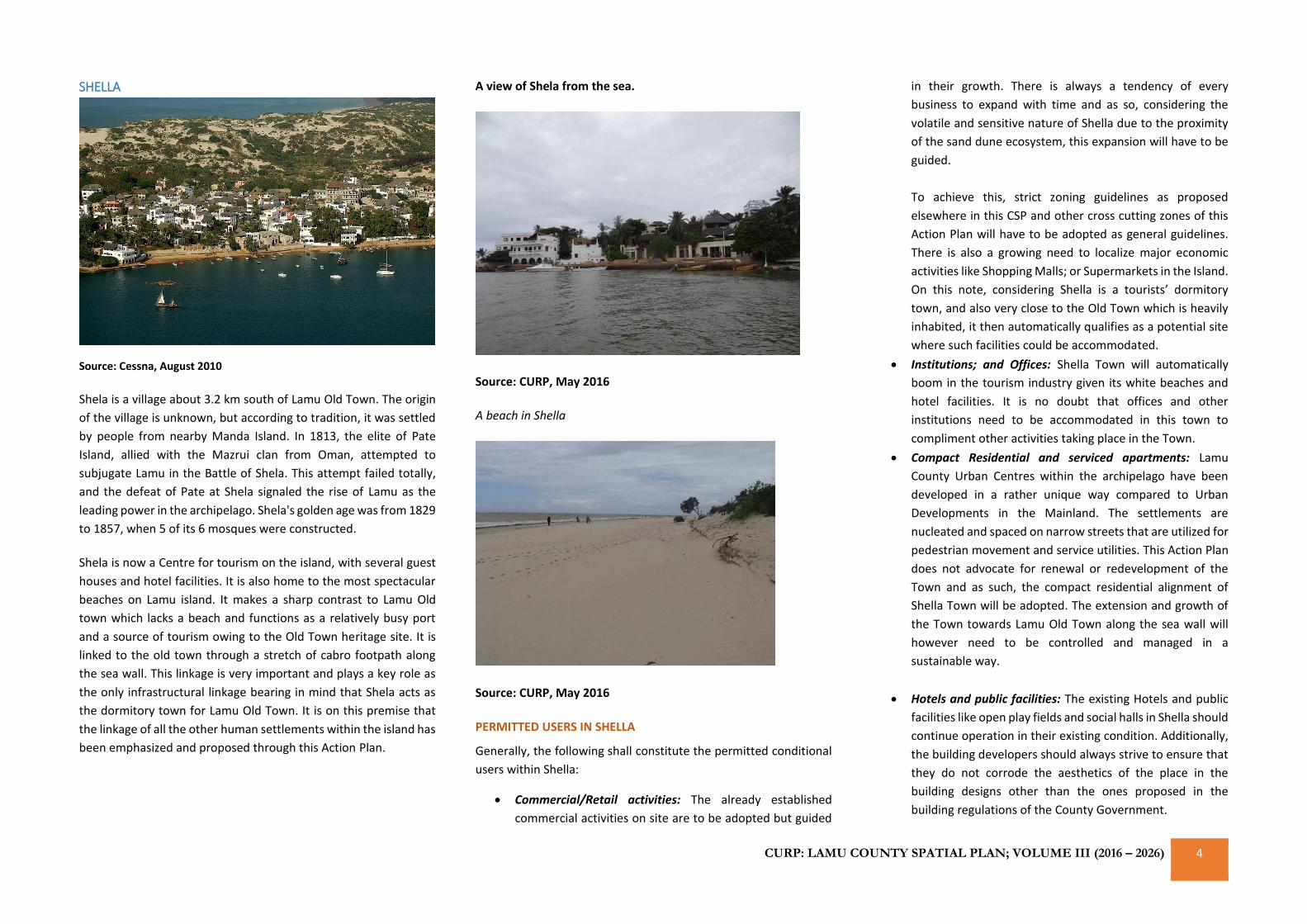
SHELLA
Source: Cessna, August 2010
Shela is a village about 3.2 km south of Lamu Old Town. The origin
of the village is unknown, but according to tradition, it was settled
by people from nearby Manda Island. In 1813, the elite of Pate
Island, allied with the Mazrui clan from Oman, attempted to
subjugate Lamu in the Battle of Shela. This attempt failed totally,
and the defeat of Pate at Shela signaled the rise of Lamu as the
leading power in the archipelago. Shela's golden age was from 1829
to 1857, when 5 of its 6 mosques were constructed.
Shela is now a Centre for tourism on the island, with several guest
houses and hotel facilities. It is also home to the most spectacular
beaches on Lamu island. It makes a sharp contrast to Lamu Old
town which lacks a beach and functions as a relatively busy port
and a source of tourism owing to the Old Town heritage site. It is
linked to the old town through a stretch of cabro footpath along
the sea wall. This linkage is very important and plays a key role as
the only infrastructural linkage bearing in mind that Shela acts as
the dormitory town for Lamu Old Town. It is on this premise that
the linkage of all the other human settlements within the island has
been emphasized and proposed through this Action Plan.
A view of Shela from the sea.
Source: CURP, May 2016
A beach in Shella
Source: CURP, May 2016
PERMITTED USERS IN SHELLA
Generally, the following shall constitute the permitted conditional
users within Shella:
• Commercial/Retail activities: The already established
commercial activities on site are to be adopted but guided
in their growth. There is always a tendency of every
business to expand with time and as so, considering the
volatile and sensitive nature of Shella due to the proximity
of the sand dune ecosystem, this expansion will have to be
guided.
To achieve this, strict zoning guidelines as proposed
elsewhere in this CSP and other cross cutting zones of this
Action Plan will have to be adopted as general guidelines.
There is also a growing need to localize major economic
activities like Shopping Malls; or Supermarkets in the Island.
On this note, considering Shella is a tourists’ dormitory
town, and also very close to the Old Town which is heavily
inhabited, it then automatically qualifies as a potential site
where such facilities could be accommodated.
• Institutions; and Offices: Shella Town will automatically
boom in the tourism industry given its white beaches and
hotel facilities. It is no doubt that offices and other
institutions need to be accommodated in this town to
compliment other activities taking place in the Town.
• Compact Residential and serviced apartments: Lamu
County Urban Centres within the archipelago have been
developed in a rather unique way compared to Urban
Developments in the Mainland. The settlements are
nucleated and spaced on narrow streets that are utilized for
pedestrian movement and service utilities. This Action Plan
does not advocate for renewal or redevelopment of the
Town and as such, the compact residential alignment of
Shella Town will be adopted. The extension and growth of
the Town towards Lamu Old Town along the sea wall will
however need to be controlled and managed in a
sustainable way.
• Hotels and public facilities: The existing Hotels and public
facilities like open play fields and social halls in Shella should
continue operation in their existing condition. Additionally,
the building developers should always strive to ensure that
they do not corrode the aesthetics of the place in the
building designs other than the ones proposed in the
building regulations of the County Government.
LAMU COUNTY SPATIAL PLAN; VOLUME III (2016 – 2026) 5
• Cemetery/Crematorium: These are public utilities that
either currently exist or can be accommodated within the
Town or immediate surroundings of the Town but away
from the sand dunes or the beach.
• Non-Motorized means of Transport (NMT): Just like the Old
Town, there is no use that warrant the use of Motor Vehicle
apart from the ones earlier discussed and as so, residents of
Shella Town will need transport infrastructure that
promotes walking; or cycling.
LAND DEMAND AND POPULATION PROJECTIONS
As previously discussed under zone 1 of the Heritage site, the
projections that follows were computed and determined in the
same way:
Population
(2009
National
Census)
Projected
Population as
at 2016
Projected
Population as
at 2020
Projected
Population as
at 2025
2,182 2,588 2,924 3,304
Based on the projection above, with a current population density
of 144 people per hectare, the demand for land is projected as 21
Ha by 2020 and 23 Ha by 2025. It is on this premise that the County
Government of Lamu should prepare a Plan that allocates and
provides land for the anticipated growth of Shella Town which
should follow the green arrows as in the image below as opposed
to the red arrows. This means that no development should be
allowed towards the sand dunes (direction of red arrows) but all
horizontal developments should grow in the North direction as
indicated by the green arrows:
Proposed growth direction of Shella Town
GENERAL GUIDELINES AND STANDARDS FOR THE GROWTH
OF SHELLA TOWN
• To promote the conservation of the sand dunes as water
catchments, it is proposed that all buildings or properties
allotted land to be revoked and the sand dunes protected
as fragile ecosystems where no development should be
allowed.
• As discussed in other sectors of this action Plan and in the
main CSP report, a proposed buffer zone of 50 meters from
the lowest point of the sand dune to any development is
mandatory. This applies to the south-east side of the island
where the sand dune formation starts.
• As development grows towards the Heritage Town (Old
Town), it is proposed that vibrant economic activities be
provided for including big wholesale and retail outlets to
enhance and increase the trading and business areas of
Lamu Island
• The zone delimited for the growth of the town should have
its Plot Ratios increased and plot coverage(s) reduced to
accommodate a higher population on less space while
having wider streets to ease service provision like drainage
and anticipated fibre optic connection
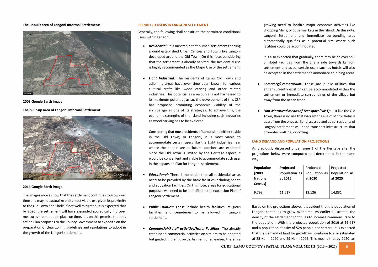
LANGONI
This is an informal settlement located about 1 kilometer south of
Lamu Old Town. It is highly growing and developing as the
immediate settlement and dormitory settlement for most residents
working in the Old Town. It harbours a population of approximately
9,000 people and its growth needs to be controlled as it expands
towards the Heritage Town of Lamu. It is however a very potential
site for a vibrant commercial node given its population and
proximity to the Lamu Old Town.
Additionally, Langoni is not constrained by the heritage aspects of
the Old Town hence its development is not highly constrained. A
good sustainable Plan to enhance its viability as a commercial node
with some light industrial elements can compare and contrast well
with the heritage values of the Old Town.
For better understanding of the settlement’s growth over time, the
illustrations below have been used to show growth of the
settlement over a period of about 10years between 2003 and 2014:
CURP: LAMU COUNTY SPATIAL PLAN; VOLUME III (2016 – 2026) 6
The unbuilt area of Langoni Informal Settlement:
2003 Google Earth image
The built-up area of Langoni Informal Settlement:
2014 Google Earth image
The images above show that the settlement continues to grow over
time and may not actualize on its most viable use given its proximity
to the Old Town and Shella if not well mitigated. It is expected that
by 2020, the settlement will have expanded sporadically if proper
measures are not put in place on time. It is on this premise that this
action Plan proposes to the County Government to expedite on the
preparation of clear zoning guidelines and regulations to adopt in
the growth of the Langoni settlement.
PERMITTED USERS IN LANGONI SETTLEMENT
Generally, the following shall constitute the permitted conditional
users within Langoni:
• Residential: It is inevitable that human settlements sprung
around established Urban Centres and Towns like Langoni
developed around the Old Town. On this note, considering
that the settlement is already habited, the Residential use
is highly recommended as the Major Use of the settlement.
• Light Industrial: The residents of Lamu Old Town and
adjoining areas have over time been known for various
cultural crafts like wood carving and other related
industries. This potential as a resource is not harnessed to
its maximum potential, as so, the development of this CSP
has proposed promoting economic viability of the
archipelago as one of its strategies. To achieve this, the
economic strengths of the Island including such industries
as wood carving has to be explored.
Considering that most residents of Lamu Island either reside
in the Old Town; or Langoni, it is most viable to
accommodate certain users like the Light industries near
where the people are as future locations are explored.
Since the Old Town is limited by the Heritage aspect, it
would be convenient and viable to accommodate such user
in the expansion Plan for Langoni settlement.
• Educational: There is no doubt that all residential areas
need to be provided by the basic facilities including health
and education facilities. On this note, areas for educational
purposes will need to be identified in the expansion Plan of
Langoni Settlement.
• Public Utilities: These include health facilities; religious
facilities; and cemeteries to be allowed in Langoni
settlement.
• Commercial/Retail activities/Hotel Facilities: The already
established commercial activities on site are to be adopted
but guided in their growth. As mentioned earlier, there is a
growing need to localize major economic activities like
Shopping Malls; or Supermarkets in the Island. On this note,
Langoni Settlement and immediate surrounding area
automatically qualifies as a potential site where such
facilities could be accommodated.
It is also expected that gradually, there may be an over spill
of Hotel Facilities from the Shella side towards Langoni
settlement and as so, certain users such as hotels will also
be accepted in the settlement’s immediate adjoining areas.
• Cemetery/Crematorium: These are public utilities that
either currently exist or can be accommodated within the
settlement or immediate surroundings of the village but
away from the ocean front.
• Non-Motorized means of Transport (NMT): Just like the Old
Town, there is no use that warrant the use of Motor Vehicle
apart from the ones earlier discussed and as so, residents of
Langoni settlement will need transport infrastructure that
promotes walking; or cycling.
LAND DEMAND AND POPULATION PROJECTIONS
As previously discussed under zone 1 of the Heritage site, the
projections below were computed and determined in the same
way:
Population
(2009
National
Census)
Projected
Population as
at 2016
Projected
Population as
at 2020
Projected
Population as
at 2025
9,793 11,617 13,126 14,831
Based on the projections above, it is evident that the population of
Langoni continues to grow over time. As earlier illustrated, the
density of the settlement continues to increase commensurate to
the population. With the projected population of 2016 at 11,617
and a population density of 528 people per hectare, it is expected
that the demand of land for growth will continue to rise estimated
at 25 Ha in 2020 and 29 Ha in 2025. This means that by 2020, an
LAMU COUNTY SPATIAL PLAN; VOLUME III (2016 – 2026) 7
extra 3 Ha will be required to accommodate the extra population.
This area does not consider other proposed users such as the light
industrial and commercial spaces that are to be accommodated in
the growth of Langoni settlement.
This therefore means the total land demand anticipated in the
growth of the settlement will be more that 5 Ha approximately by
2020. As a general guideline, it would be viable to channel
development of the settlement towards the Old Town and the
ocean. This aspect considers the value of Agricutural land which
outlies next to the Centre and the Heritage Site (Old Town). This
Action Plan propose the growth of the settlement in the following
manner:
Proposed growth trajectory of the settlement
The proposed growth of the settlement is proposed to follow the
green arrows and the direction of the curves as indicated above.
The red arrows discourage the direction of development towards
the rich agricultural zone. It is therefore proposed that all permitted
users as discussed above be accommodated in the direction of the
green arrows in the growth of the settlement over the next 10
years. This growth should be guided by set guidelines and zoning
regulations by the County Government of Lamu.
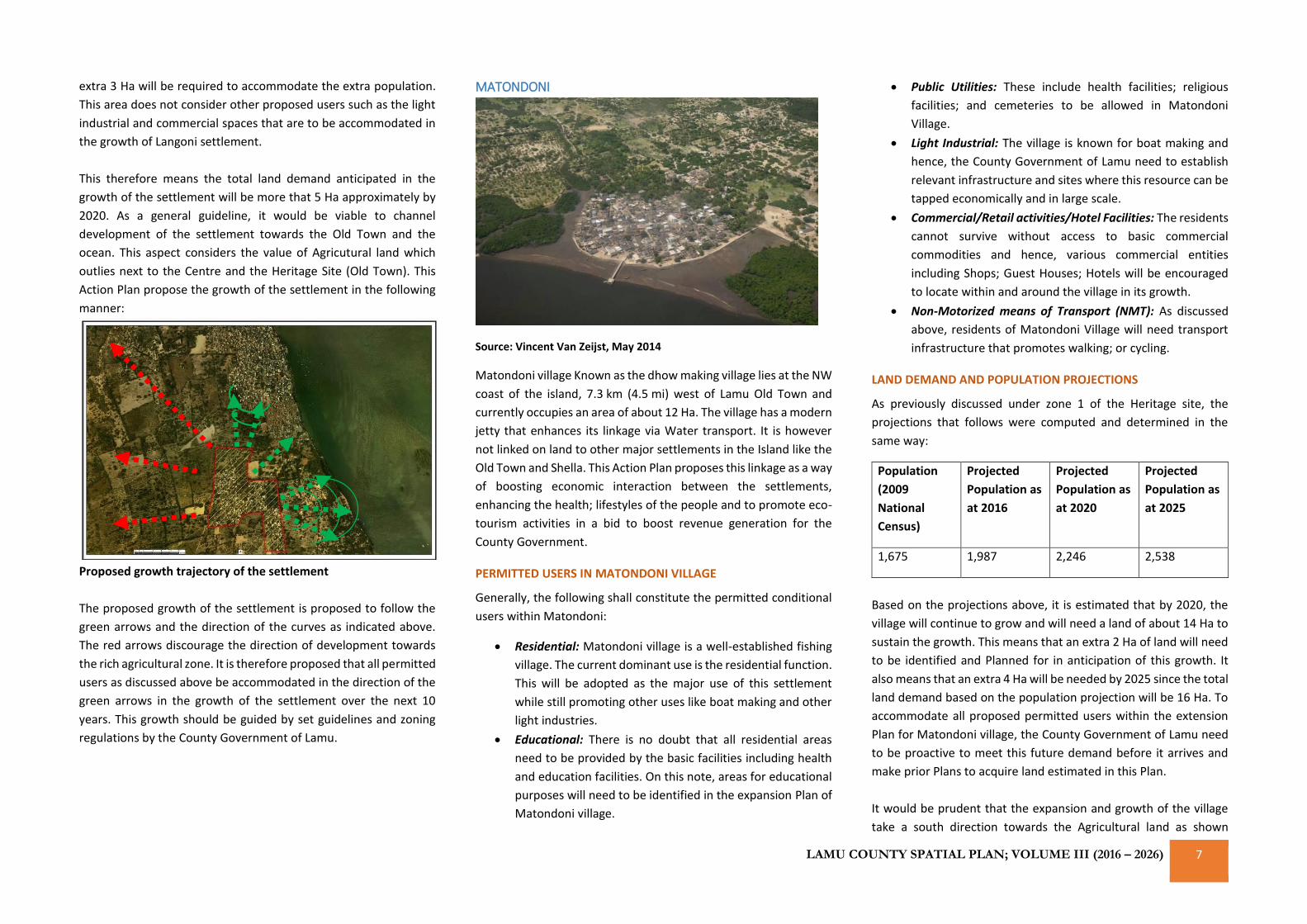
MATONDONI
Source: Vincent Van Zeijst, May 2014
Matondoni village Known as the dhow making village lies at the NW
coast of the island, 7.3 km (4.5 mi) west of Lamu Old Town and
currently occupies an area of about 12 Ha. The village has a modern
jetty that enhances its linkage via Water transport. It is however
not linked on land to other major settlements in the Island like the
Old Town and Shella. This Action Plan proposes this linkage as a way
of boosting economic interaction between the settlements,
enhancing the health; lifestyles of the people and to promote eco-
tourism activities in a bid to boost revenue generation for the
County Government.
PERMITTED USERS IN MATONDONI VILLAGE
Generally, the following shall constitute the permitted conditional
users within Matondoni:
• Residential: Matondoni village is a well-established fishing
village. The current dominant use is the residential function.
This will be adopted as the major use of this settlement
while still promoting other uses like boat making and other
light industries.
• Educational: There is no doubt that all residential areas
need to be provided by the basic facilities including health
and education facilities. On this note, areas for educational
purposes will need to be identified in the expansion Plan of
Matondoni village.
• Public Utilities: These include health facilities; religious
facilities; and cemeteries to be allowed in Matondoni
Village.
• Light Industrial: The village is known for boat making and
hence, the County Government of Lamu need to establish
relevant infrastructure and sites where this resource can be
tapped economically and in large scale.
• Commercial/Retail activities/Hotel Facilities: The residents
cannot survive without access to basic commercial
commodities and hence, various commercial entities
including Shops; Guest Houses; Hotels will be encouraged
to locate within and around the village in its growth.
• Non-Motorized means of Transport (NMT): As discussed
above, residents of Matondoni Village will need transport
infrastructure that promotes walking; or cycling.
LAND DEMAND AND POPULATION PROJECTIONS
As previously discussed under zone 1 of the Heritage site, the
projections that follows were computed and determined in the
same way:
Population
(2009
National
Census)
Projected
Population as
at 2016
Projected
Population as
at 2020
Projected
Population as
at 2025
1,675 1,987 2,246 2,538
Based on the projections above, it is estimated that by 2020, the
village will continue to grow and will need a land of about 14 Ha to
sustain the growth. This means that an extra 2 Ha of land will need
to be identified and Planned for in anticipation of this growth. It
also means that an extra 4 Ha will be needed by 2025 since the total
land demand based on the population projection will be 16 Ha. To
accommodate all proposed permitted users within the extension
Plan for Matondoni village, the County Government of Lamu need
to be proactive to meet this future demand before it arrives and
make prior Plans to acquire land estimated in this Plan.
It would be prudent that the expansion and growth of the village
take a south direction towards the Agricultural land as shown
CURP: LAMU COUNTY SPATIAL PLAN; VOLUME III (2016 – 2026) 8
below (direction of green arrows). This would be to discourage
linear growth of the village in either Easterly or Westerly direction
(indicated by red arrow below) since this land borders the proposed
zone for low density residential areas. The proposed growth
direction is as shown below:
Growth of the settlement should be along the green lines as
opposed to the red line direction.
KIPUNGANI
Source: Vincent Van Zeijst, May 2014
This is a small village on the West coast of the island past
Matondoni on an area of about 4.8 Ha and a population of about
584 residents according to the National Population Census of
Kenya, 2009. This population is however projected and estimated
to be about 693 people in 2016. Just like other settlements within
the Island, the population is projected to continue growing over
time assuming the growth rate remains constant. It has very similar
characteristics with Matondoni village apart from its vast beaches
which are very viable for hotel investments. The permitted Users in
the village are therefore quite similar as those of Matondoni
discussed as follows:
PERMITTED USERS IN KIPUNGANI VILLAGE
Generally, the following shall constitute the permitted conditional
users within Kipungani Village:
• Residential: Kipungani village is a well-established fishing
village. The current dominant use is the residential function.
This will be adopted as the major use of this settlement
while still promoting commercial use ie. Hotel investments.
• Educational: There is no doubt that all residential areas
need to be provided by the basic facilities including
education facilities. On this note, areas for educational
purposes will need to be identified in the expansion Plan of
Kipungani village.
• Public Utilities: These include health facilities; religious
facilities; and cemeteries to be allowed in Kipungani Village.
• Commercial/Retail activities/Hotel Facilities: The residents
cannot survive without access to basic commercial
commodities and hence, various commercial entities
including Shops; Guest Houses; Hotels will be encouraged
to locate within and around the village in its growth. More
so, hotel investments will be highly encouraged in the
neighbouring areas of the village especially along the open
beaches in the zone proposed and discussed elsewhere in
this Action Plan as Block A of the proposed Low Density
Residential Mixed-Use zone.
• Non-Motorized means of Transport (NMT): As discussed
above, residents of Kipungani Village will need transport
infrastructure that promotes walking; or cycling.
LAND DEMAND AND POPULATION PROJECTIONS
As previously discussed under zone 1 of the Heritage site, the
projections that follows were computed and determined in the
same way:
Population
(2009
National
Census)
Projected
Population as
at 2016
Projected
Population as
at 2020
Projected
Population as
at 2025
584 693 783 885
Based on the projections above, it is estimated that by 2020, the
village will continue to grow and will need a land of about 5.5 Ha to
sustain the growth. This means that an extra 1 Ha of land will need
to be identified and Planned for in anticipation of this growth.
Additionally, about 2 Ha will be needed by 2025 since the total land
demand based on the population projection will be about 6.5 Ha.
To accommodate all proposed permitted users within the
extension Plan for Kipungani village, the County Government of
Lamu need to be proactive to meet this future demand before it
arrives and make prior Plans to acquire land estimated in this Plan.
It would be prudent that the expansion and growth of the village
take a south direction towards the Agricultural land as shown
below (direction of green arrows). This would be to discourage
linear growth of the village in either Easterly or Westerly direction
(indicated by red arrow below) since this land borders the proposed
zone for low density residential areas.
LAMU COUNTY SPATIAL PLAN; VOLUME III (2016 – 2026) 9
The proposed growth direction is as shown below:
Growth of the settlement should be along the green lines as
opposed to the red line direction.
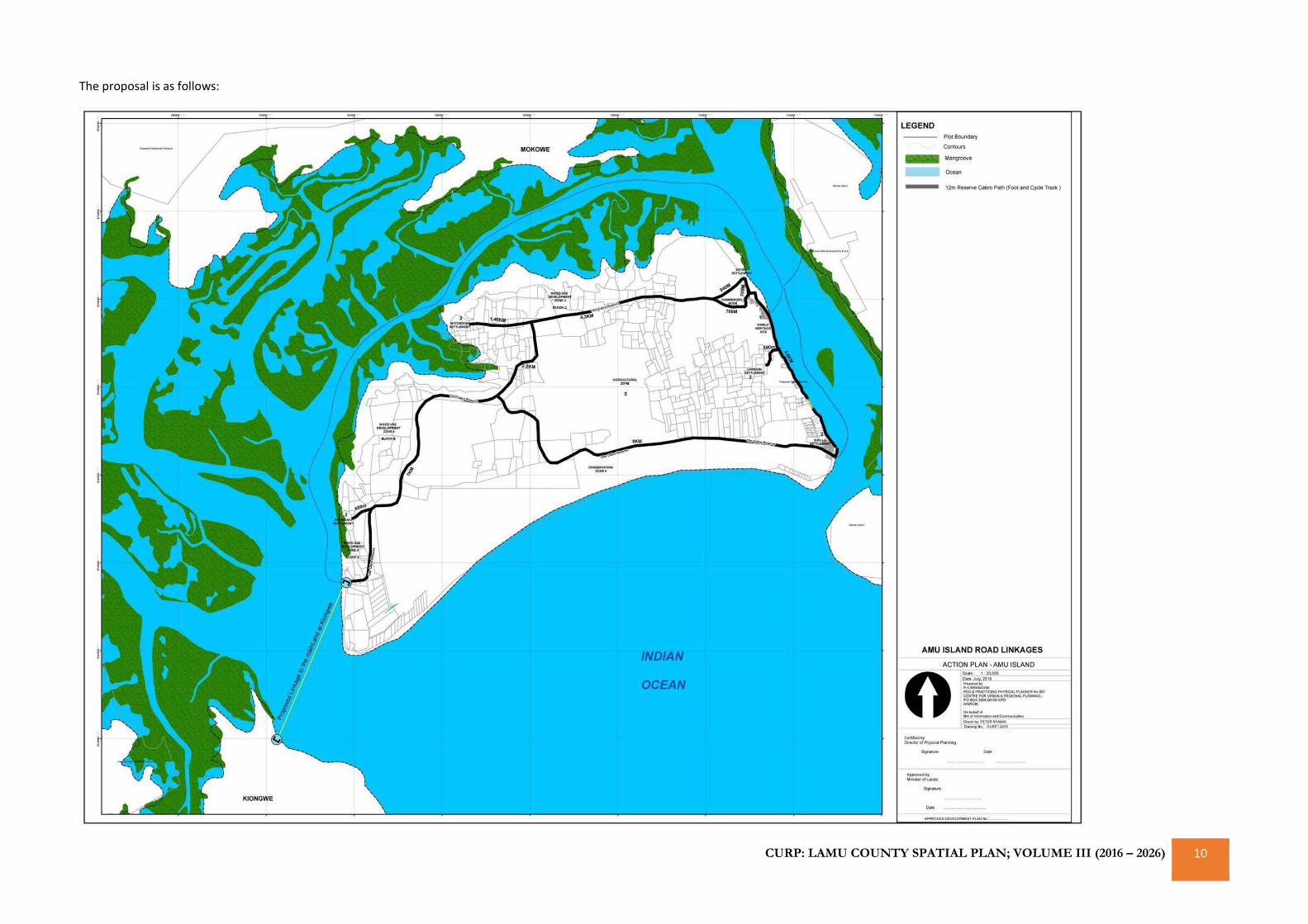
ZONE 3: THE TRANSPORTATION LINKAGE
As stated earlier, there is a current deficit in the infrastructural
linkage between the 6 human settlement areas within the Island.
The existing connection to settlements further away from the Old
Town to settlements like Matondoni; and Kipungani is not formally
established. The only existing linkage is a cabro foot and cycle path
that stretches from the reclaimed Wiyoni settlement through Lamu
Old Town to Shela Town. This footpath is essential both as a public
space and re-creative space for the residents and tourists. It
promotes walkability of the settlement areas as a modern urban
design principle aimed at enhancing healthy lifestyles of urban
residents as they appreciate aesthetics of space.
It is on this premise that a similar 12 meters foot and cycle path is
proposed on the island to link the Lamu Old Town to Matondoni
village, and Kipungani village. Another similar path is proposed on
the lower end of the Island which will form some sort of a ring
within the Island when connected to the other one stretching from
Lamu Old Town to Kipungani Village through Matondoni Village.
From Kipungani Village, the road will continue in a westerly
direction to an identified area on the ocean front where a
jetty/bridge is proposed to connect the Island to the mainland at
Kiongwe.
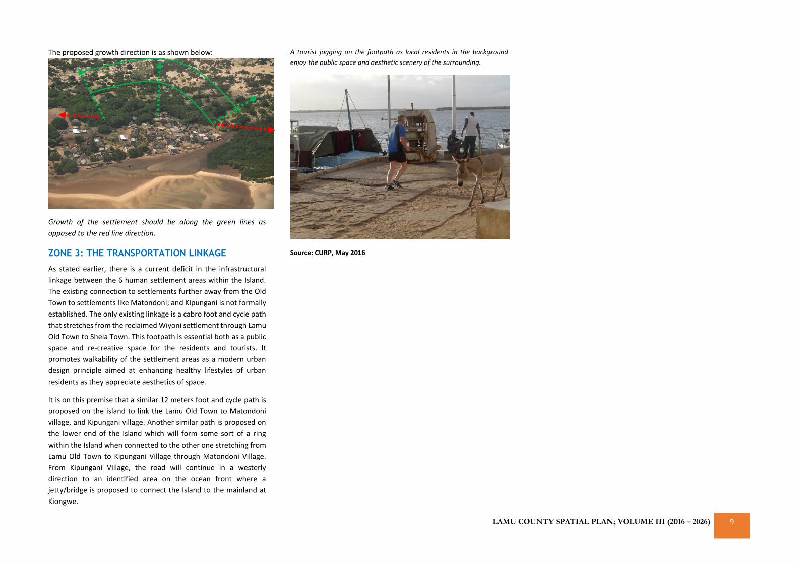
A tourist jogging on the footpath as local residents in the background
enjoy the public space and aesthetic scenery of the surrounding.
Source: CURP, May 2016
CURP: LAMU COUNTY SPATIAL PLAN; VOLUME III (2016 – 2026) 10
The proposal is as follows:
CURP: LAMU COUNTY SPATIAL PLAN; VOLUME III (2016 – 2026) 11
The connection to the mainland at Kiongwe is very important as it
reduces the time travel from the island to the agricultural rich areas
and Urban Centres of vibrant economic activities in Bahari ward. It
will also promote trade between the various Centres and offer
options for travel routes to the residents of Lamu County especially
the Archipelago residents. Consequently, trade will be boosted and
the economic gains to the County will be expanded. This will
improve the living standards of the people and promote sustained
livelihoods. It is expected that the proposed footpath will only serve
as cycle and walk infrastructure with limited motor use as earlier
discussed. The cross section of various activities on the cycle/foot
paths at any instance may look like the image below:
A cross section of the path on the upper part from Amu Town-
Wiyoni to Matondoni village.
A cross section of the path on the lower part from Shella along the
sand dune strip.
Source: CURP 2016
ZONE 4: PROPOSED MIXED USE ZONE
This will be a zone of low density residential area with a mix of other
complementary land uses. It will be developed and promoted as a
viable area for high value land within the County where
development can be highly controlled. It location and proximity to
the ocean will serve as means of restricted access to the rich
mangrove forest rings in a bid to promote their conservation.
The main purposes of the zone are:
• To provide for residential use or development on larger lots
where the infrastructure and environmental constraints
limit development
• To provide for non-residential uses that are compatible with
the proposed residential amenities
• To avoid land use conflict with adjacent Natural Resource
(Mangrove Forest/beach fronts); or Agricultural zoned land
by providing for adequate buffer areas.
• To provide for the non-existent low density residential areas
in the Lamu Island
The desired future character relevant to the low density residential
mixed use zone is contained in the land uses that are to be accepted
and allowed in the zone. The proposed allowable uses are as
follows:
Use Qualification
Residential Single Dwelling
Residential (Multi Dwelling) To be allowed up to 4 floors
including the ground floor
Educational including Child
Care Facilities and
Kindergatens
Child Care and Kindergaten is
mandatory within the
residential blocks. Other
educational uses to be
determined by catchment
population
Hotel Use A mix of hotel facilities to be
allowed on all blocks on the
front row from the mangrove
rings of the proposed blocks.
All hotel facilities should be
multi-storey up to 5 floors to
allow view of the ocean
Commercial Low traffic commercial uses
like convenient stores and
shops
Natural and cultural values
management institutions and
offices
Only if intended for
conservation purposes or
management of the
residential blocks
Passive recreation Use that allow public access to
the beach fronts like cycle
tracks and footpaths or well-
designed open spaces for
public purpose on the
proposed buffer zone
Visitor accommodation Single dwelling with an
extended guest house
Sports; recreation; and
talent nurturing
Public facilities and open
spaces
Religious Use Only if mosque or other
religious facility facility
Public Utilities Land fill sites; fire assembly
points and cemeteries
Prohibited
All other uses
The proposed users aim to serve as the basic anticipated land uses
in the proposed zone for any ensuing Land Use or Block Plan. The
status of any application is to be interpreted and determined by the
Planning staff of the County Government of Lamu upon initial
assessment of the application.
General guidelines and standards
These are the proposed standards set out to guide development
within the zone. In particular, the standards provide guidance on
matters relevant to the Low Density Residential zone and generally
as follows:
CURP: LAMU COUNTY SPATIAL PLAN; VOLUME III (2016 – 2026) 12
Minimum lot size Low Density Residential Area A –
2,000 sqm
Low Density Residential Area B –
2,500 sqm
Low Density Residential Area C –
1,000 sqm
Minimum lot frontage 50 meters from the highest point
of the ocean front row
properties bordering the
mangrove ring
Front setbacks Generally, 10 metres from the
second row from the properties
fronting the ocean
Side setbacks To be contained within specified
building schemes but generally
anything above 6 metres is
acceptable
Rear setbacks 10 metres at least
Height Up to 5 storeys including the
ground floor
Site coverage 25%
If your property is located within a land block defined by a Specific
Block Plan, you should also refer to the standards contained within
that Specific Block Plan as specified by the County Government.
These standards apply generally as the basic guidelines and
standards, however, they prevail over both the specific block Plan
standards and code provisions where there is any conflict.
The proposed conservation area for the mangrove forest from the
mixed-use zone will be as follows:
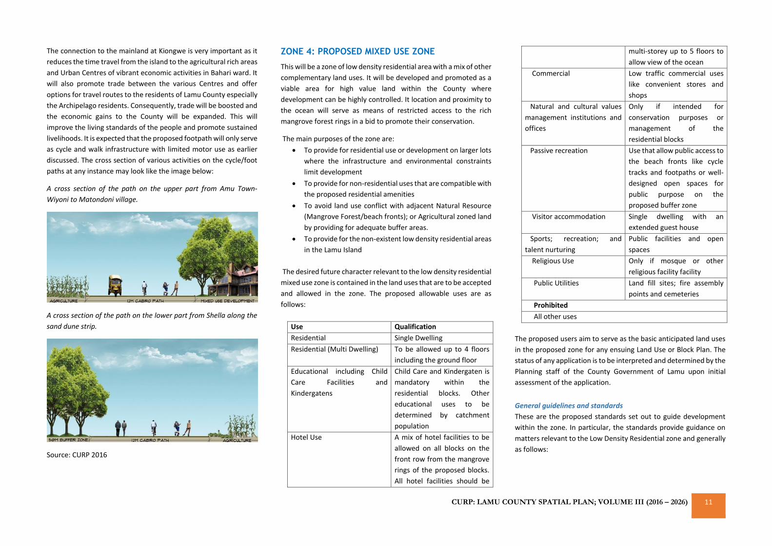
The proposed 50 meters buffer zone will accommodate certain
users such as cycle tracks or foot paths which should not exceed 20
meters from the edge of the buffer bordering the proposed
developments. The buffer zone may also accommodate users like
well-designed public spaces to act as re-creative parks.
ZONE 5: AGRICULTURAL ZONE (AG)
The purpose of the AG zone is to support, protect, and maintain a
viable, long-term agricultural sector in Lamu County specifically
Lamu Island. Standards for the AG zone maintain the vitality of the
agricultural sector by retaining parcel sizes necessary to sustain
viable agricultural operations, protecting agricultural practices and
activities by minimizing land-use conflicts, and protecting
agricultural resources by regulating land uses and development
intensities in agricultural areas. Permitted uses include crop
cultivation, animal grazing, stock ponds, and agricultural
processing.
The generally acceptable standards for the land sizes are as follows:
a) Small scale agriculture: Minimum land subdivision
should be 0.75 Ha; and
b) Large scale agriculture: fruits and other cash crops -
minimum subdivision shall be 2 Ha
This zone will be bounded by the proposed 12 meters cabro
footpath on either side. Based on the agro potential of the area, the
County Government through the Agricultural Extension offices will
be expected to prepare relevant agricultural programmes to guide
the farmers to ensure sustained agricultural production.
REZONING OF AGRICULTURAL LANDS
The rezoning of land zoned as agricultural land to a different zone
shall be allowed only if all of the following criteria are met:
• The parcels for which rezoning is requested (“subject
parcels”) are adjacent to uses other than agriculture or
agricultural support uses.
• The rezoning will not be detrimental to existing agricultural
operations.
• The subject parcels are adjacent to existing development or
infrastructure and conversion will constitute a logical
contiguous extension of a designated user.
• No feasible development alternative exists that is less
detrimental to agriculture.
• The rezoning will not otherwise interfere with the Lamu
County Spatial Plan vision including the by-laws and set land
use policies.
REZONING FROM LARGER TO SMALLER AGRICULTURE SUB-
ZONES.
In order to preserve the viability of agricultural operations in Lamu
Island, special criteria shall be met prior to the rezoning of parcels
from one agricultural sub-zone to another agricultural sub-zone
that allows a smaller minimum parcel size. The Planning board may
approve an application for such a rezoning only in consultation with
the County Director of Agriculture.
ZONE 6: CONSERVATION AREAS
These include the sand dune strip on the lower end of Shella and
the Mangrove ring surrounding the Island on the shore line. These
will be promoted as fragile ecosystems and strict guidelines
towards conserving them proposed. They will be separated by
compatible land uses that enhances their conservation.
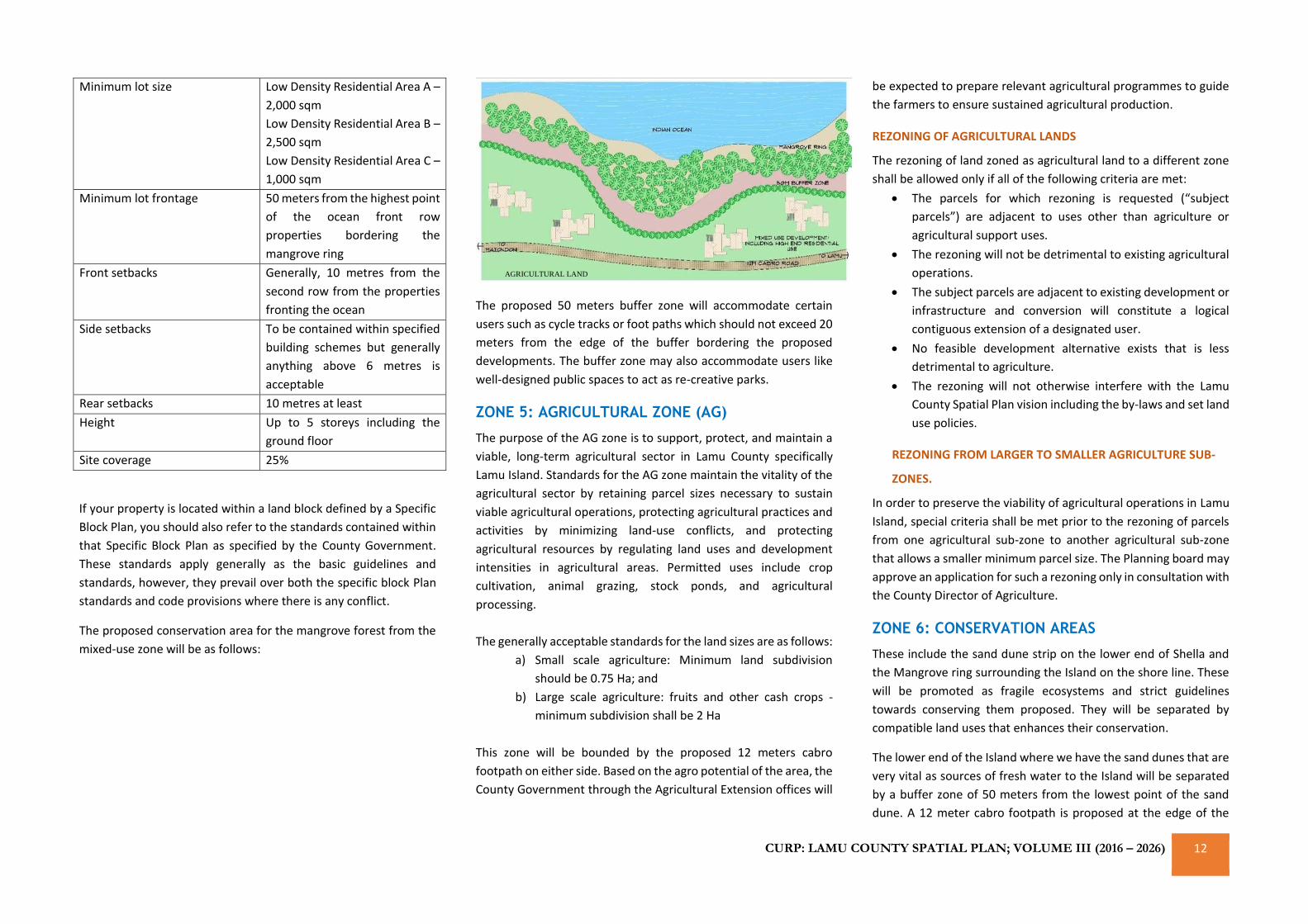
The lower end of the Island where we have the sand dunes that are
very vital as sources of fresh water to the Island will be separated
by a buffer zone of 50 meters from the lowest point of the sand
dune. A 12 meter cabro footpath is proposed at the edge of the
AGRICULTURAL LAND
LAMU COUNTY SPATIAL PLAN; VOLUME III (2016 – 2026) 13
buffer zone to separate the sand dune conservation area including
the buffer zone and the agricultural land. This separation by the
footpath will prevent future encroachment through farming
activities.
A cross sectional view of the anticipated protection area for the
sand dunes in the lower end of the Island is as follows:
Source: CURP Consultants, 2016
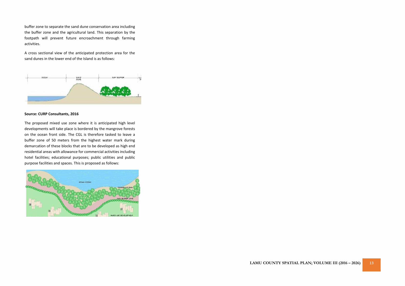
The proposed mixed use zone where it is anticipated high level
developments will take place is bordered by the mangrove forests
on the ocean front side. The CGL is therefore tasked to leave a
buffer zone of 50 meters from the highest water mark during
demarcation of these blocks that are to be developed as high end
residential areas with allowance for commercial activities including
hotel facilities; educational purposes; public utilities and public
purpose facilities and spaces. This is proposed as follows:
CURP: LAMU COUNTY SPATIAL PLAN; VOLUME III (2016 – 2026) 14
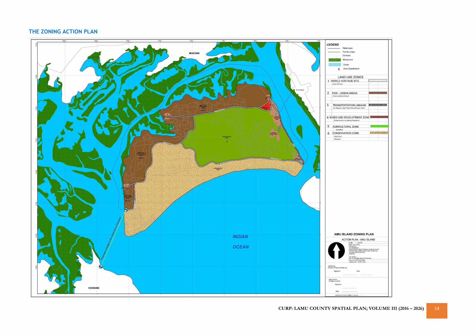
THE ZONING ACTION PLAN
CURP: LAMU COUNTY SPATIAL PLAN; VOLUME III (2016 – 2026) 15
MANDA ISLAND PORT CITY(MIPC) ACTION PLAN
DESIGN GUIDELINES & STANDARDS (WORK IN
PROGRESS)
OVERVIEW
The relationship between physical space and communities is a
definitive understanding of how to Plan and develop quality
environments in such a way that they both maximize on space gain
and minimize the negative effects on people’s lives on the physical
spaces they inhabit.
CONCEPT BEHIND MIPC PLAN
The concept of this MIPC Plan is anchored on Urban Design
Principles on land and land use. Urban design combines a concern
with the visual form and function of development with its fit in its
surroundings and wider context. The subject of the public realm,
achieving a sense of place and the public significance of new
development, is vital within the urban design perspective. Matters
such as community safety, accessibility, sustainability, quality of life
and protecting the heritage legacy, are key concerns and are
significant elements within the urban design agenda anticipated by
this Plan.
Urban design is about creating a ‘place’ in which every land use
recognizes that it is part of a greater whole in which development
either contributes to making the urban fabric coherent or
undermines it. This is for example, low rise buildings proposed
adjacent to higher neighbours should provide attractive roof
patterns. Good places are what will make the MIPC so distinctive
and recognizable. Where there will be no built context, or
comprehensive development is proposed, a ‘coherent’ urban fabric
which will be defined by certain characteristics (Urban Design
Principles) as discussed below.
1. Walkability
Walkability as an urban design concept will be highly encouraged
by the design of the MIPC Plan. This is the measure of ease in which
pedestrians move through a space, rather, spaces designed as
pedestrian friendly environments. It is aimed that this will be
achieved through provisions of clear access network, a coherent
spatial structure through appropriate building spacing and views to
various land marks to help people to orientate themselves.
Walkability has both health, environmental and economic benefits.
The idea behind this is to make the MIPC a complete
walking/cycling city that adopts a healthy living lifestyle and adapts
to the outlying values of Lamu island which is a heritage Island with
no motor vehicles.
2. Frontages, Edges and Boundaries
Building frontages will address or offer informal supervision to the
streets, open spaces, walkways along canals, ocean front etc. The
MIPC Plan proposes a variety of building types that will
accommodate different uses, lifestyles and enhances a sense of
community safety. This is because the pedestrians not only need to
feel safe and comfortable, but they also need to be entertained.
3. Attractive Spaces
Successful urban space of the MIPC will be defined and enclosed by
buildings, structures and landscape. The relationship between the
buildings on the street, and between buildings and the street, are
the key to this. This will be complemented by open spaces that will
be an integral part of the design and not a left over. All these
elements together will culminate as aesthetic and attractive urban
spaces of the MIPC
4. Sustainability
The MIPC Plan has been made proposed in a manner that adopts
sustainability as an urban design principle. Sustainability is the
ability of communities to minimize their impact on the
environment, in order to create neighborhoods that endure. This
understanding will be enhanced in the MIPC Plan by incorporating
the Island’s natural resources as integral features of its design. The
Plan will combine environmental resources and the people to
enhance continuity, uniqueness and place making.
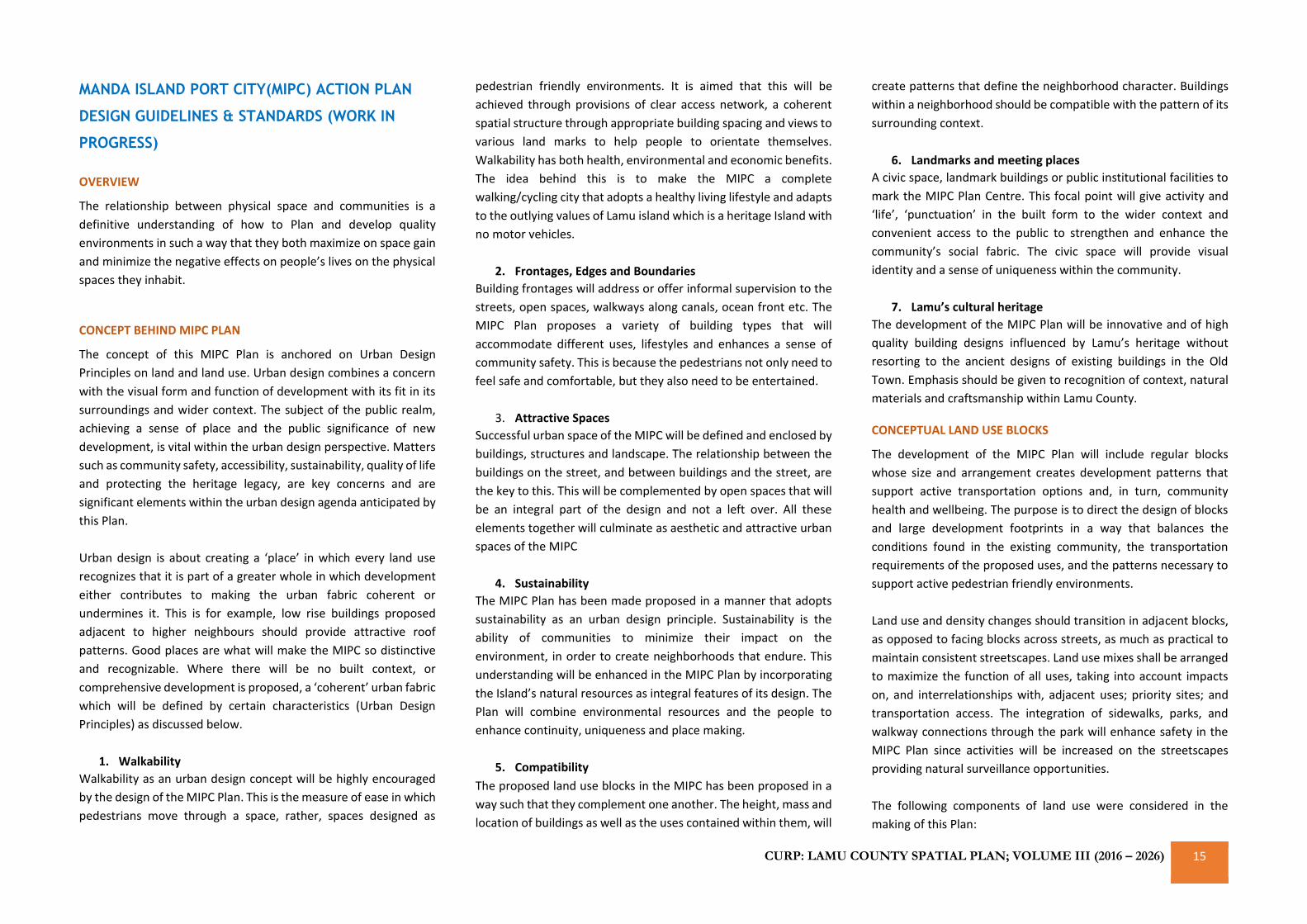
5. Compatibility
The proposed land use blocks in the MIPC has been proposed in a
way such that they complement one another. The height, mass and
location of buildings as well as the uses contained within them, will
create patterns that define the neighborhood character. Buildings
within a neighborhood should be compatible with the pattern of its
surrounding context.
6. Landmarks and meeting places
A civic space, landmark buildings or public institutional facilities to
mark the MIPC Plan Centre. This focal point will give activity and
‘life’, ‘punctuation’ in the built form to the wider context and
convenient access to the public to strengthen and enhance the
community’s social fabric. The civic space will provide visual
identity and a sense of uniqueness within the community.
7. Lamu’s cultural heritage
The development of the MIPC Plan will be innovative and of high
quality building designs influenced by Lamu’s heritage without
resorting to the ancient designs of existing buildings in the Old
Town. Emphasis should be given to recognition of context, natural
materials and craftsmanship within Lamu County.
CONCEPTUAL LAND USE BLOCKS
The development of the MIPC Plan will include regular blocks
whose size and arrangement creates development patterns that
support active transportation options and, in turn, community
health and wellbeing. The purpose is to direct the design of blocks
and large development footprints in a way that balances the
conditions found in the existing community, the transportation
requirements of the proposed uses, and the patterns necessary to
support active pedestrian friendly environments.
Land use and density changes should transition in adjacent blocks,
as opposed to facing blocks across streets, as much as practical to
maintain consistent streetscapes. Land use mixes shall be arranged
to maximize the function of all uses, taking into account impacts
on, and interrelationships with, adjacent uses; priority sites; and
transportation access. The integration of sidewalks, parks, and
walkway connections through the park will enhance safety in the
MIPC Plan since activities will be increased on the streetscapes
providing natural surveillance opportunities.
The following components of land use were considered in the
making of this Plan:
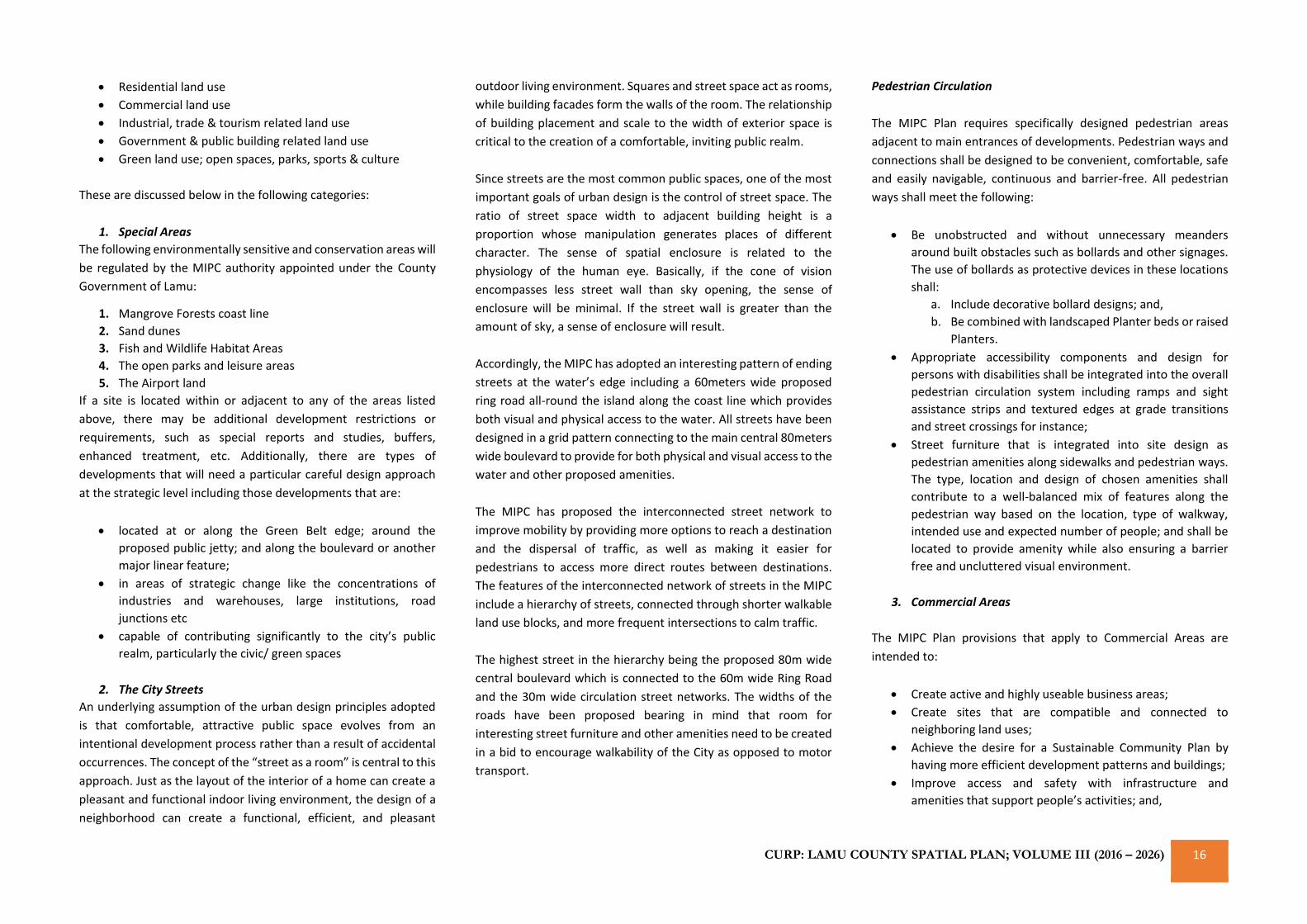
CURP: LAMU COUNTY SPATIAL PLAN; VOLUME III (2016 – 2026) 16
• Residential land use
• Commercial land use
• Industrial, trade & tourism related land use
• Government & public building related land use
• Green land use; open spaces, parks, sports & culture
These are discussed below in the following categories:
1. Special Areas
The following environmentally sensitive and conservation areas will
be regulated by the MIPC authority appointed under the County
Government of Lamu:
1. Mangrove Forests coast line
2. Sand dunes
3. Fish and Wildlife Habitat Areas
4. The open parks and leisure areas
5. The Airport land
If a site is located within or adjacent to any of the areas listed
above, there may be additional development restrictions or
requirements, such as special reports and studies, buffers,
enhanced treatment, etc. Additionally, there are types of
developments that will need a particular careful design approach
at the strategic level including those developments that are:
• located at or along the Green Belt edge; around the
proposed public jetty; and along the boulevard or another
major linear feature;
• in areas of strategic change like the concentrations of
industries and warehouses, large institutions, road
junctions etc
• capable of contributing significantly to the city’s public
realm, particularly the civic/ green spaces
2. The City Streets
An underlying assumption of the urban design principles adopted
is that comfortable, attractive public space evolves from an
intentional development process rather than a result of accidental
occurrences. The concept of the “street as a room” is central to this
approach. Just as the layout of the interior of a home can create a
pleasant and functional indoor living environment, the design of a
neighborhood can create a functional, efficient, and pleasant
outdoor living environment. Squares and street space act as rooms,
while building facades form the walls of the room. The relationship
of building placement and scale to the width of exterior space is
critical to the creation of a comfortable, inviting public realm.
Since streets are the most common public spaces, one of the most
important goals of urban design is the control of street space. The
ratio of street space width to adjacent building height is a
proportion whose manipulation generates places of different
character. The sense of spatial enclosure is related to the
physiology of the human eye. Basically, if the cone of vision
encompasses less street wall than sky opening, the sense of
enclosure will be minimal. If the street wall is greater than the
amount of sky, a sense of enclosure will result.
Accordingly, the MIPC has adopted an interesting pattern of ending
streets at the water’s edge including a 60meters wide proposed
ring road all-round the island along the coast line which provides
both visual and physical access to the water. All streets have been
designed in a grid pattern connecting to the main central 80meters
wide boulevard to provide for both physical and visual access to the
water and other proposed amenities.
The MIPC has proposed the interconnected street network to
improve mobility by providing more options to reach a destination
and the dispersal of traffic, as well as making it easier for
pedestrians to access more direct routes between destinations.
The features of the interconnected network of streets in the MIPC
include a hierarchy of streets, connected through shorter walkable
land use blocks, and more frequent intersections to calm traffic.
The highest street in the hierarchy being the proposed 80m wide
central boulevard which is connected to the 60m wide Ring Road
and the 30m wide circulation street networks. The widths of the
roads have been proposed bearing in mind that room for
interesting street furniture and other amenities need to be created
in a bid to encourage walkability of the City as opposed to motor
transport.
Pedestrian Circulation
The MIPC Plan requires specifically designed pedestrian areas
adjacent to main entrances of developments. Pedestrian ways and
connections shall be designed to be convenient, comfortable, safe
and easily navigable, continuous and barrier-free. All pedestrian
ways shall meet the following:
• Be unobstructed and without unnecessary meanders
around built obstacles such as bollards and other signages.
The use of bollards as protective devices in these locations
shall:
a. Include decorative bollard designs; and,
b. Be combined with landscaped Planter beds or raised
Planters.
• Appropriate accessibility components and design for
persons with disabilities shall be integrated into the overall
pedestrian circulation system including ramps and sight
assistance strips and textured edges at grade transitions
and street crossings for instance;
• Street furniture that is integrated into site design as
pedestrian amenities along sidewalks and pedestrian ways.
The type, location and design of chosen amenities shall
contribute to a well-balanced mix of features along the
pedestrian way based on the location, type of walkway,
intended use and expected number of people; and shall be
located to provide amenity while also ensuring a barrier
free and uncluttered visual environment.
3. Commercial Areas
The MIPC Plan provisions that apply to Commercial Areas are
intended to:
• Create active and highly useable business areas;
• Create sites that are compatible and connected to
neighboring land uses;
• Achieve the desire for a Sustainable Community Plan by
having more efficient development patterns and buildings;
• Improve access and safety with infrastructure and
amenities that support people’s activities; and,
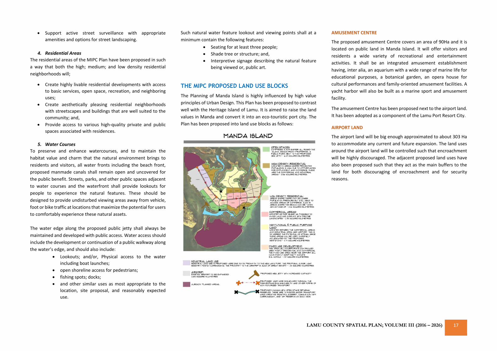
LAMU COUNTY SPATIAL PLAN; VOLUME III (2016 – 2026) 17
• Support active street surveillance with appropriate
amenities and options for street landscaping.
4. Residential Areas
The residential areas of the MIPC Plan have been proposed in such
a way that both the high; medium; and low density residential
neighborhoods will;
• Create highly livable residential developments with access
to basic services, open space, recreation, and neighboring
uses;
• Create aesthetically pleasing residential neighborhoods
with streetscapes and buildings that are well suited to the
community; and,
• Provide access to various high-quality private and public
spaces associated with residences.
5. Water Courses
To preserve and enhance watercourses, and to maintain the
habitat value and charm that the natural environment brings to
residents and visitors, all water fronts including the beach front,
proposed manmade canals shall remain open and uncovered for
the public benefit. Streets, parks, and other public spaces adjacent
to water courses and the waterfront shall provide lookouts for
people to experience the natural features. These should be
designed to provide undisturbed viewing areas away from vehicle,
foot or bike traffic at locations that maximize the potential for users
to comfortably experience these natural assets.
The water edge along the proposed public jetty shall always be
maintained and developed with public access. Water access should
include the development or continuation of a public walkway along
the water’s edge, and should also include:
• Lookouts; and/or, Physical access to the water
including boat launches;
• open shoreline access for pedestrians;
• fishing spots; docks;
• and other similar uses as most appropriate to the
location, site proposal, and reasonably expected
use.
Such natural water feature lookout and viewing points shall at a
minimum contain the following features:
• Seating for at least three people;
• Shade tree or structure; and,
• Interpretive signage describing the natural feature
being viewed or, public art.
THE MIPC PROPOSED LAND USE BLOCKS
The Planning of Manda Island is highly influenced by high value
principles of Urban Design. This Plan has been proposed to contrast
well with the Heritage Island of Lamu. It is aimed to raise the land
values in Manda and convert it into an eco-touristic port city. The
Plan has been proposed into land use blocks as follows:
AMUSEMENT CENTRE
The proposed amusement Centre covers an area of 90Ha and it is
located on public land in Manda Island. It will offer visitors and
residents a wide variety of recreational and entertainment
activities. It shall be an integrated amusement establishment
having, inter alia, an aquarium with a wide range of marine life for
educational purposes, a botanical garden, an opera house for
cultural performances and family-oriented amusement facilities. A
yacht harbor will also be built as a marine sport and amusement
facility.
The amusement Centre has been proposed next to the airport land.
It has been adopted as a component of the Lamu Port Resort City.
AIRPORT LAND
The airport land will be big enough approximated to about 303 Ha
to accommodate any current and future expansion. The land uses
around the airport land will be controlled such that encroachment
will be highly discouraged. The adjacent proposed land uses have
also been proposed such that they act as the main buffers to the
land for both discouraging of encroachment and for security
reasons.
CURP: LAMU COUNTY SPATIAL PLAN; VOLUME III (2016 – 2026) 18
INDUSTRIAL LAND
The Industrial land has been proposed due to its proximity to the
airport and the anticipated Lamu Port through LAPPSET. The
industrial area will comprise light industrial activities which may
include light manufacturing, warehousing, wholesale and
distribution, agricultural and fishing storage and processing, meat
packaging. The County Government may take it upon itself to
develop warehouse and storage facilities as a capital investment
venture which will attract other industries to the space.
Warehouses and go-downs are designed to provide a proper
environment for storage of goods that require protection from the
elements of nature. These must be designed to accommodate the
loads of the materials to be stored, handling equipment and
receiving and shipping operations. These facilities need to be
designed for minimum turnover time.
These storage facilities may come in 2 basic types:
• Heated and unheated general warehouses – These provide
space for bulk rack and bin storage.
• Refrigerated warehouses – These are those designed to
preserve the quality of perishable goods and general supply
materials that require refrigeration. These facilities will be
key in the proposed industrial area because they
complement the agro processing and Fishing industries
that are envisioned to be triggers of Lamu County’s
economy proposed elsewhere in this Planning report. The
potential for improved fishing and beef yield, packaging
and export is high and facilities like these will only serve to
make these aspects key economic drivers of the County’s
economy.
One of the considerations for the industrial area are buffer zones
especially from the adjacent Amusement centre and Institutional
land use. A 50M industrial buffer yard will be located along the
outer perimeter of a property line of these abutting land uses.
Within these buffer yards, will be vegetated with a mix of deciduous
and evergreen trees and shrubs of suitable type, size and spacing
to ensure all year-round screening.
Industrial area buffer zones will not be used for driveways, parking
lots, trash enclosures, paved or building areas. Due to the proximity
of the Industrial zone to Manda Airport, considerations need to be
made concerning the building heights that are acceptable. Building
heights have a huge impact on airPlane flight paths and therefore
on the safety of landing and take-off. For this reason, the building
heights within the Industrial block will reach a maximum height of
10M. If the need to build beyond this height special permission will
have to be sought, and impact assessment performed to
understand the ramifications of higher building heights.
Another consideration to be made within this Industrial zone is how
the land will be utilized as far as minimum plot sizes and floor area
ratios. The ideal lot sizes for this land use will be 1 acre though half
acre lot sizes may also be allowable. These will ensure the
industries that will be located here are not congested. This
specification in conjunction with a Floor area ratio of 0.5 will ensure
a spacious industrial complex.
The Industrial precinct requires some complementary activities and
land uses. The first and most important of these complementary
uses is the function of circulation. Users of the industrial zone need
to access the site and move around within it. For this purpose, 30%
of the 141HA set aside for this use needs to be dedicated to
movement. This function entails motorized (only attached to
airport-cargo Planes or port shipping activities) and non-motorized
transport and terminal facilities.
Apart from circulation there will also be consideration for other
activities like a small commercial district and maybe some staff
housing which will complement the adjacent high density
residential areas. These complementary uses are meant to remain
as such, complementary. And as such they will be capped at 20% of
the industrial area. These may have slightly higher densities with
the minimum lot size capped at a quarter of an acre and a floor area
ratio of 0.75.
The position of these industries is complimentary to the use of the
already proposed Lamu Port and the proximity to the Airport as
shown below:
AIRPORT LAND
BLOCK (303 HA)
AIRPORT LAND
BLOCK (303 HA)
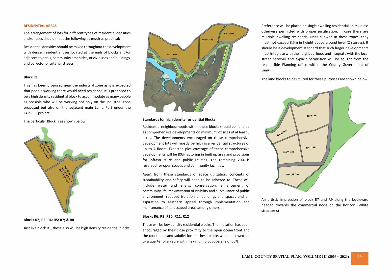
LAMU COUNTY SPATIAL PLAN; VOLUME III (2016 – 2026) 19
RESIDENTIAL AREAS
The arrangement of lots for different types of residential densities
and/or uses should meet the following as much as practical:
Residential densities should be mixed throughout the development
with denser residential uses located at the ends of blocks and/or
adjacent to parks, community amenities, or civic uses and buildings,
and collector or arterial streets;
Block R1
This has been proposed near the industrial zone as it is expected
that people working there would need residence. It is proposed to
be a high density residential block to accommodate as many people
as possible who will be working not only on the industrial zone
proposed but also on the adjacent main Lamu Port under the
LAPSSET project.
The particular Block is as shown below:
Blocks R2; R3; R4; R5; R7; & R8
Just like block R1, these also will be high density residential blocks.
Standards for high density residential Blocks
Residential neighbourhoods within these blocks should be handled
as comprehensive developments on minimum lot sizes of at least 5
acres. The developments encouraged on these comprehensive
development lots will mostly be high rise residential structures of
up to 4 floors. Expected plot coverage of these comprehensive
developments will be 80% factoring in built up area and provisions
for infrastructure and public utilities. The remaining 20% is
reserved for open spaces and community facilities.
Apart from these standards of space utilization, concepts of
sustainability and safety will need to be adhered to. These will
include water and energy conservation, enhancement of
community life, maximization of visibility and surveillance of public
environment, reduced isolation of buildings and spaces and an
aspiration to aesthetic appeal through implementation and
maintenance of landscaped areas among others.
Blocks R6; R9; R10; R11; R12
These will be low density residential blocks. Their location has been
encouraged by their close proximity to the open ocean front and
the coastline. Land subdivision on these blocks will be allowed up
to a quarter of an acre with maximum plot coverage of 60%.
Preference will be placed on single dwelling residential units unless
otherwise permitted with proper justification. In case there are
multiple dwelling residential units allowed in these zones, they
must not exceed 8.5m in height above ground level (2 storeys). It
should be a development standard that such larger developments
must integrate with the neighbourhood and integrate with the local
street network and explicit permission will be sought from the
responsible Planning office within the County Government of
Lamu.
The land blocks to be utilized for these purposes are shown below:
An artistic impression of block R7 and R9 along the boulevard
headed towards the commercial node on the horizon (White
structures)
R5 (70 HA)
R6 (36 HA)
R7 (26 HA)
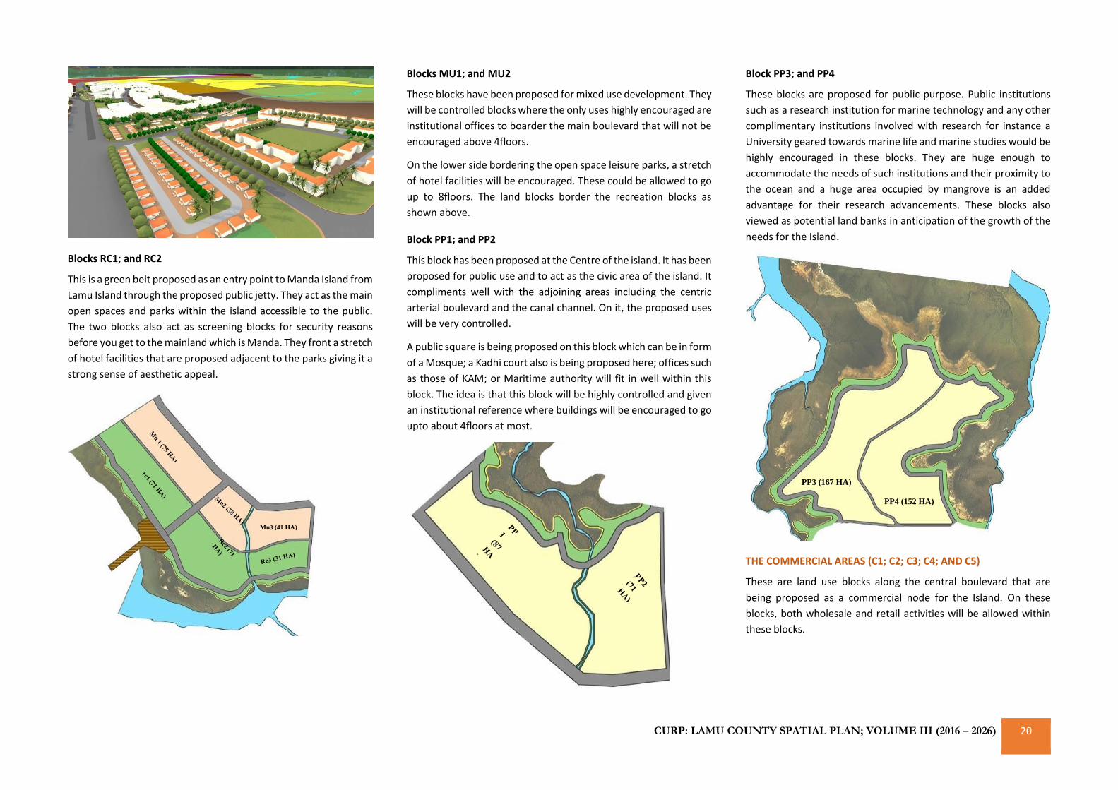
CURP: LAMU COUNTY SPATIAL PLAN; VOLUME III (2016 – 2026) 20
Blocks RC1; and RC2
This is a green belt proposed as an entry point to Manda Island from
Lamu Island through the proposed public jetty. They act as the main
open spaces and parks within the island accessible to the public.
The two blocks also act as screening blocks for security reasons
before you get to the mainland which is Manda. They front a stretch
of hotel facilities that are proposed adjacent to the parks giving it a
strong sense of aesthetic appeal.
Blocks MU1; and MU2
These blocks have been proposed for mixed use development. They
will be controlled blocks where the only uses highly encouraged are
institutional offices to boarder the main boulevard that will not be
encouraged above 4floors.
On the lower side bordering the open space leisure parks, a stretch
of hotel facilities will be encouraged. These could be allowed to go
up to 8floors. The land blocks border the recreation blocks as
shown above.
Block PP1; and PP2
This block has been proposed at the Centre of the island. It has been
proposed for public use and to act as the civic area of the island. It
compliments well with the adjoining areas including the centric
arterial boulevard and the canal channel. On it, the proposed uses
will be very controlled.
A public square is being proposed on this block which can be in form
of a Mosque; a Kadhi court also is being proposed here; offices such
as those of KAM; or Maritime authority will fit in well within this
block. The idea is that this block will be highly controlled and given
an institutional reference where buildings will be encouraged to go
upto about 4floors at most.
Block PP3; and PP4
These blocks are proposed for public purpose. Public institutions
such as a research institution for marine technology and any other
complimentary institutions involved with research for instance a
University geared towards marine life and marine studies would be
highly encouraged in these blocks. They are huge enough to
accommodate the needs of such institutions and their proximity to
the ocean and a huge area occupied by mangrove is an added
advantage for their research advancements. These blocks also
viewed as potential land banks in anticipation of the growth of the
needs for the Island.
THE COMMERCIAL AREAS (C1; C2; C3; C4; AND C5)
These are land use blocks along the central boulevard that are
being proposed as a commercial node for the Island. On these
blocks, both wholesale and retail activities will be allowed within
these blocks.
Mu3 (41 HA)
PP3 (167 HA)
PP4 (152 HA)
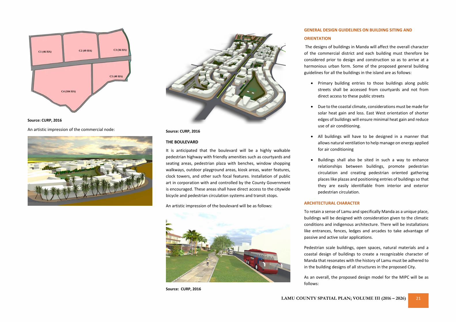
LAMU COUNTY SPATIAL PLAN; VOLUME III (2016 – 2026) 21
Source: CURP, 2016
An artistic impression of the commercial node:
Source: CURP, 2016
THE BOULEVARD
It is anticipated that the boulevard will be a highly walkable
pedestrian highway with friendly amenities such as courtyards and
seating areas, pedestrian plaza with benches, window shopping
walkways, outdoor playground areas, kiosk areas, water features,
clock towers, and other such focal features. Installation of public
art in corporation with and controlled by the County Government
is encouraged. These areas shall have direct access to the citywide
bicycle and pedestrian circulation systems and transit stops.
An artistic impression of the boulevard will be as follows:
Source: CURP, 2016
GENERAL DESIGN GUIDELINES ON BUILDING SITING AND
ORIENTATION
The designs of buildings in Manda will affect the overall character
of the commercial district and each building must therefore be
considered prior to design and construction so as to arrive at a
harmonious urban form. Some of the proposed general building
guidelines for all the buildings in the island are as follows:
• Primary building entries to those buildings along public
streets shall be accessed from courtyards and not from
direct access to these public streets
• Due to the coastal climate, considerations must be made for
solar heat gain and loss. East West orientation of shorter
edges of buildings will ensure minimal heat gain and reduce
use of air conditioning.
• All buildings will have to be designed in a manner that
allows natural ventilation to help manage on energy applied
for air conditioning
• Buildings shall also be sited in such a way to enhance
relationships between buildings, promote pedestrian
circulation and creating pedestrian oriented gathering
places like plazas and positioning entries of buildings so that
they are easily identifiable from interior and exterior
pedestrian circulation.
ARCHITECTURAL CHARACTER
To retain a sense of Lamu and specifically Manda as a unique place,
buildings will be designed with consideration given to the climatic
conditions and indigenous architecture. There will be installations
like entrances, fences, ledges and arcades to take advantage of
passive and active solar applications.
Pedestrian scale buildings, open spaces, natural materials and a
coastal design of buildings to create a recognizable character of
Manda that resonates with the history of Lamu must be adhered to
in the building designs of all structures in the proposed City.
As an overall, the proposed design model for the MIPC will be as
follows:
C1 (46 HA) C2 (49 HA) C3 (36 HA)
C4 (104 HA)
C5 (40 HA)
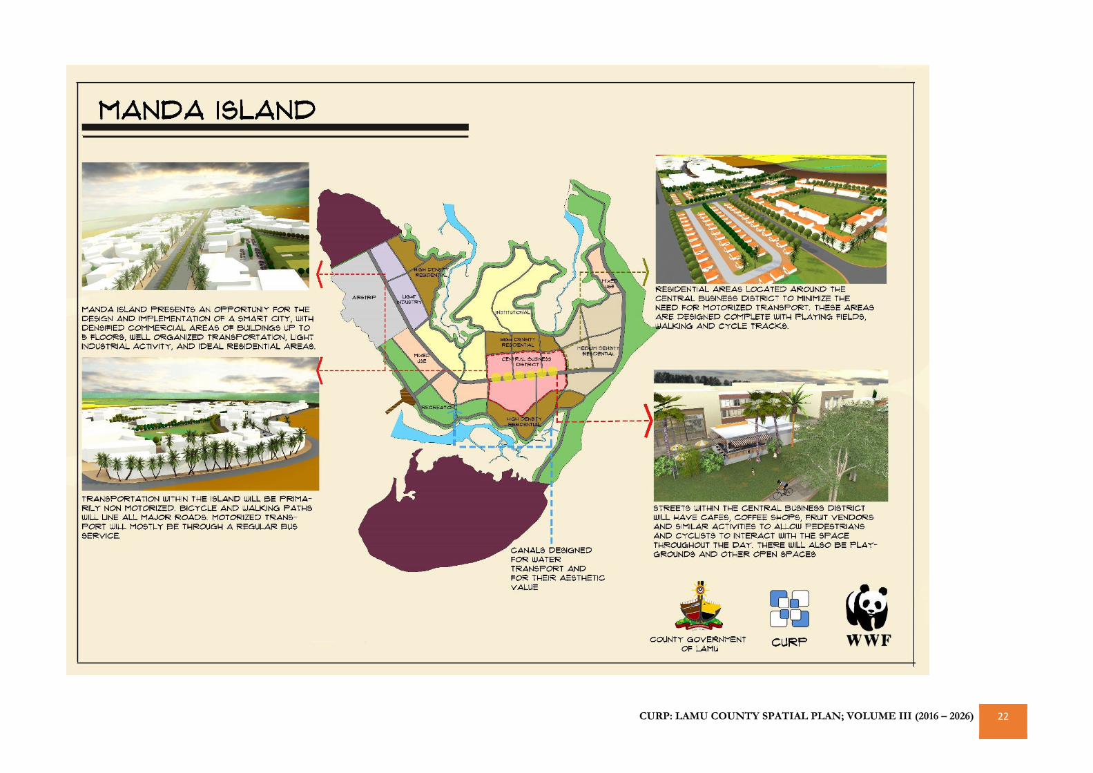
CURP: LAMU COUNTY SPATIAL PLAN; VOLUME III (2016 – 2026) 22
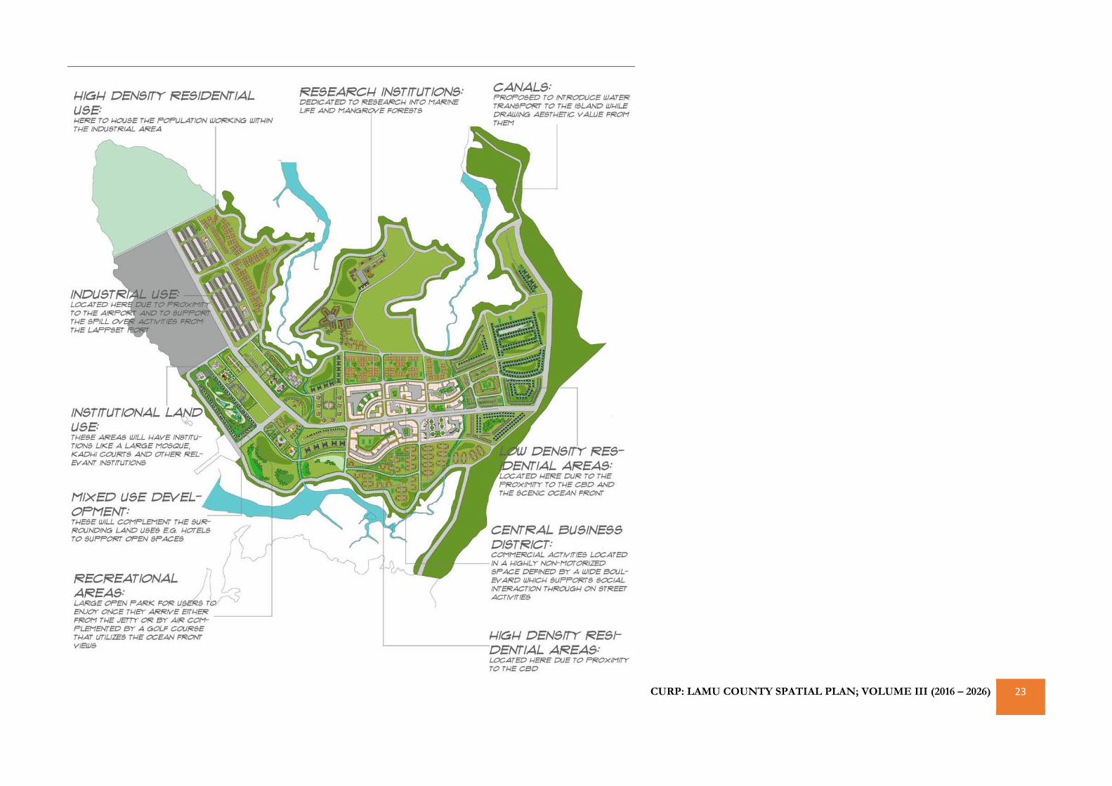
CURP: LAMU COUNTY SPATIAL PLAN; VOLUME III (2016 – 2026) 23
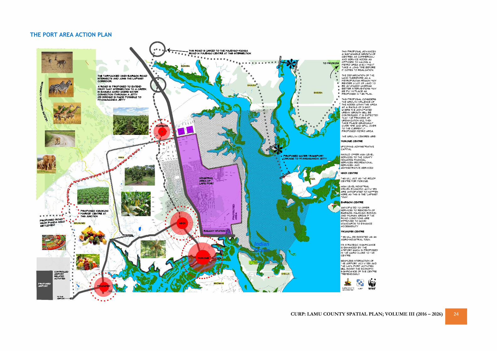
CURP: LAMU COUNTY SPATIAL PLAN; VOLUME III (2016 – 2026) 24
THE PORT AREA ACTION PLAN
CURP: LAMU COUNTY SPATIAL PLAN; VOLUME III (2016 – 2026) 25
KIONGWE ‘BAWAYA’ LAKE KENYATTA WATER
CATCHMENT ACTION AREA PLAN
This Action Area Plan becomes very important as a specific product
for this CSP to emphasize on the conservation needs of the water
catchment reserve area that is now highly endangered as a result
of unmitigated human activities around the catchment systems.
This includes the rampant farming activities happening on the
‘Bawaya’ sand dunes and the uncontrolled farming and pastoralism
activities around Lake Kenyatta ecosystem which recently have
been reported to be drying up. This Action Plan therefore details
out some of the land use guidelines that the County Government,
together with the National Government dockets like the National
Land Commission, Survey of Kenya, and private institutions like the
WWF may put in place to salvage and save the water catchment
system.
Other factors leading to the same include:
• Degradation and encroachment on the water catchment
system & wetlands in Pangani, Mukuru river, river banks,
and the Lake itself
• Over abstraction of water for both human (consumption
and irrigation Agriculture) and animal use
• Climate Change & Deforestation
• Lack of awareness on the part of the people on the effects
of their actions on the water catchment system
• Poor Governance & Institutional framework
• Overgrazing
• Poor water infrastructure development in the area and the
County as a whole
• Increased population around the catchment system
• Uncontrolled sand harvesting around the catchment system
The main objective of this Action Plan therefore is to protect and
conserve the stretch of the water catchment system to ensure
sustainable source of fresh water supply and sustained livelihoods
to the more than 50,000 residents of the County who depend on
the lake and the catchment system in general.
Some of the immediate actions advanced by this Plan will be action
oriented and multi-institutional support required. They include:
• Revocation of titles that fall within the 100-meter radius
proposed by this CSP from the highest watermark of any
water point, wetland channels, swamp, lake, sand dune or
any other highly ecologically sensitive ecosystem
highlighted in this Plan
• Preparation of Resettlement Action Plans (RAPs) for the
legally affected people within the demarcated buffer zones
• Survey and legally protect wetlands like Pangani, Majiglass,
Witho, Lake Amu and Lake Kenyatta through gazettement.
• Enhance public education to intensify awareness on the
proposed actions and to increase community participation
as well as compliance to agreed restrictions.
• Conduct underground water survey to establish the actual
level of extraction of water resource as well as the demand
so as to inform development of a water allocation plan. The
growing population requires equitable allocation and
distribution of water. Therefore, an assessment of water
resources; both surface water and groundwater to establish
the potential of the entire catchment area.
• Updating of the Lake Kenyatta Sub Catchment Management
Plan and subsequent implementation of the same to start
as soon as possible. There should be political will and
support. The rehabilitation efforts should not be politicized
but rather upheld for the greater public good.
• Enactment of laws and land policies regulating the sinking
of shallow wells to mitigate on the over abstraction of water
as well as ensuring sustained water quality for the users
• Regulation of sand harvesting activities around the
catchment system
• Routine monitoring of shallow wells and other water
sources with a view to enforcing pollution control
measures. The public should be educated to accept and
own such regulations.
• Promote diversification of water harvesting techniques
including the tapping of rain water for storage
• Enhancement of public awareness programmes on
conservation and rehabilitation of riparian land and the
catchment areas. This will enhance acceptance and
cooperation of communities in rehabilitation efforts.
• Enhance adoption of new farming methods to reduce water
wastage through overhead irrigation
• Alternative sources of energy like biogas, LPG, solar and
Jatropha need to be explored to reduce pressure on the use
of charcoal and firewood.
Overall, the following action Plan is being advanced by this CSP as
a measure to some of the physical actions proposed. The Plan
proposes a buffer of 100 meters from the highest water mark of all
the wetland ecosystems deemed as part of the catchment system.
Within the buffer zone, there are properties that fall within the
zone to which the Plan propose for their revocation. Most of these
properties were not legally allocated and hence their instant
revocation is being advanced. The County Government however
has the mandate to identify the land parcels that were legally
acquired and consequently prepare RAPs for them. Additionally,
the Action Plan proposes an outer buffer area with a setback of
about 500 meters which the County Government may wish to
adopt to enhance the long-term sustainability of the lake.
Consequently, in the event that they wish to adopt the 500-meter
buffer zone, then they will be required to prepare a RAP for all the
PAP falling within that buffer area (area shaded in red in the second
map below).
Reference is made to the map below:
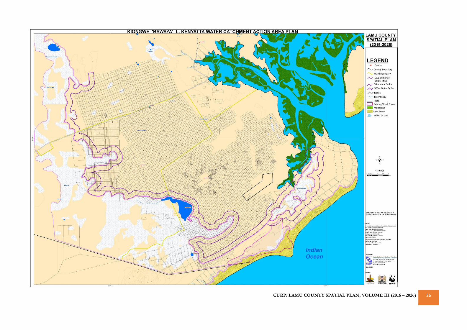
CURP: LAMU COUNTY SPATIAL PLAN; VOLUME III (2016 – 2026) 26
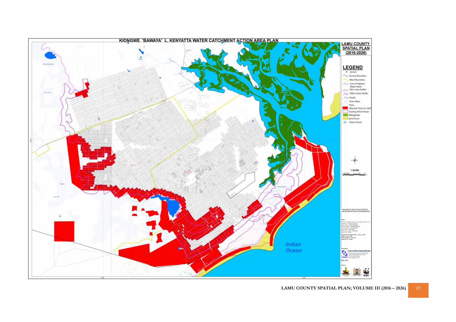
LAMU COUNTY SPATIAL PLAN; VOLUME III (2016 – 2026) 27
CURP: LAMU COUNTY SPATIAL PLAN; VOLUME III (2016 – 2026) 28
REFERENCES
1. CGL, 2013: First County Integrated Development Plan 2013-
2017: Lamu County. County Government of Lamu, Lamu,
Kenya.
2. Church, J. E. And Obura, D. O., 2004: Management
Recommendations for The Kiunga Marine National Reserve,
Based on Coral Reef and Fisheries Catch Surveys, 1998–2003.
CORDIO/WWF KMNR, Lamu, Kenya, 1-57
3. Daniels M., Skillman B., A guide for Local Land Use Planning for
Agricultural Operations.
4. Duineveld, G. C. A., P. A. W. J. De Wilde, E. M. Berghuis, A. Kok,
T. Tahey, and J. Kromkamp. 1997: Benthic Respiration and
Standing Stock on Two Contrasting Continental Margins in The
Western Indian Ocean: The Yemen-Somali Upwelling Region
and The Margin Off Kenya. Deep-Sea Research II 44: 1293-
1317.
5. ERC, 2011: STUDY PERIOD 2011 – 2031: Updated Least Cost
Power Development Plan. Energy Regulatory Commission,
Nairoi, Kenya
6. Ghaidan U.,1976: Lamu, a study in Conservation, 1976, Nairobi.
7. Gok, 1985: Lamu District Environmental Assessment Report.
National Environment Secretariat, Ministry of Environment
and Natural Resources, Nairobi, Kenya.
8. Gok, 2013: Integrated Coastal Zone Management (Iczm) Policy:
Draft. Ministry of Environment, Water and Natural Resources,
Nairobi, Kenya
9. Jame A., 2009: Creating the Community you want, Municipal
Options for Land Use Control, Albany, Newyork.
10. KFS, 2015: Witu Forest Ecosystem Management Plan 2015-
2025. Kenya Forest Service, Nairobi, Kenya
11. Kuria, Z N., 2008: Groundwater Resources Assessment of Lamu
Island along Coastal Kenya. 2008, Nairobi, Kenya.
12. KWS, 2013: Kiunga-Boni-Dodori Conservation Area
Management Plan, 2013-2023. Kenya Wildlife Service, Nairobi,
Kenya
13. Ministry of Environment and Mineral Resources, 2012: Master
Plan for the Conservation and Sustainable Management of
Water Catchment areas in Kenya, Nairobi, Kenya

CURP: LAMU COUNTY SPATIAL PLAN; VOLUME III (2016 – 2026) 29