Embed Size (px)
Citation preview
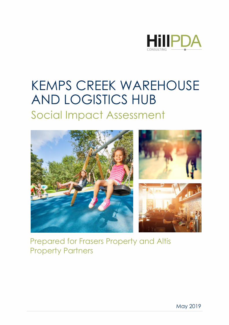
Prepared for Frasers Property and Altis
Property Partners
KEMPS CREEK WAREHOUSE AND LOGISTICS HUB Social Impact Assessment
May 2019
Contents
1.0 Introduction ................................................................................................ 6
Secretary’s Environmental Assessment Requirements................................................... 6 1.1
Defining social impacts ................................................................................................... 7 1.2
Assessment methodology ............................................................................................... 7 1.3
Impact assessment framework ....................................................................................... 8 1.4
2.0 The Proposal ............................................................................................. 12
The Subject Site ............................................................................................................. 12 2.1
Proposal ........................................................................................................................ 12 2.2
3.0 The Surrounds ........................................................................................... 16
The Surrounds ............................................................................................................... 16 3.1
Access ............................................................................................................................ 16 3.2
Planned infrastructure development ............................................................................ 17 3.3
4.0 Strategic Policy Context ............................................................................. 19
Western Sydney City Deal ............................................................................................. 19 4.1
Greater Sydney Region Plan .......................................................................................... 19 4.2
Western City District Plan ............................................................................................. 20 4.3
Broader Western Sydney Employment Area ................................................................ 20 4.4
The Western Sydney Aerotropolis ................................................................................ 22 4.5
5.0 Community Profile .................................................................................... 24
Study Area ..................................................................................................................... 24 5.1
Demographic snapshot ................................................................................................. 24 5.2
Social Advantage and Disadvantage ............................................................................. 27 5.3
Employment .................................................................................................................. 28 5.4
Business Statistics ......................................................................................................... 29 5.5
Crime ‘hot spots’ ........................................................................................................... 30 5.6
Summary of key findings ............................................................................................... 31 5.7
6.0 Existing Social Infrastructure ..................................................................... 33
What is social infrastructure? ....................................................................................... 33 6.1
A catchment approach .................................................................................................. 33 6.2
7.0 Stakeholder views ..................................................................................... 40
Stakeholder Identification ............................................................................................. 40 7.1
Key Consultation Outcomes .......................................................................................... 42 7.2
Future Consultation ...................................................................................................... 42 7.3
8.0 Social Impact Assessment .......................................................................... 45
Scoping .......................................................................................................................... 45 8.1
Area of influence ........................................................................................................... 45 8.2
Amenity impacts ........................................................................................................... 46 8.3
Access ............................................................................................................................ 50 8.4
Built Environment ......................................................................................................... 51 8.5
Heritage ......................................................................................................................... 52 8.6
Community .................................................................................................................... 52 8.7
Economic ....................................................................................................................... 54 8.8
Natural Environment ..................................................................................................... 55 8.9
Mitigation Measures and Monitoring ........................................................................... 55 8.10
9.0 Conclusion ................................................................................................. 60
: Scoping tool ...................................................................................... 61 Appendix A
: Light Spill Maps ................................................................................. 63 Appendix B
P19027 Kemps Creek Warehouse and Logistics Hub Social Impact Assessment 4 of 71
Quality Assurance
Report Contacts
Alex Peck
Consultant
B Sci, B SocSci, M Plan, PIA (Assoc.)
Supervisor
Elizabeth Griffin
Principal
B A (Geography) M Urb. Pl. MPIA
Quality Control
This document is for discussion purposes only unless signed and dated by a Principal of HillPDA.
Reviewer
Signature Dated
10/05/19
Report Details
Job Number P19027
Version 7.0
File Name P19027-Kemps Creek Warehouse and Logistics Hub SIA
Date Printed 15 May 2019
P19027 Kemps Creek Warehouse and Logistics Hub Social Impact Assessment 5 of 71
INTRODUCTION
P19027 Kemps Creek Warehouse and Logistics Hub Social Impact Assessment
6 of 71 6 of 71
1.0 INTRODUCTION
HillPDA has been engaged by Frasers Property and Altis Property Partners to prepare a Social Impact
Assessment (SIA) to accompany an Environmental Impact Statement for consideration by NSW Department of
Planning and Environment. The proposed development comprises subdivision of a 118 hectare site at 657-769
Mamre Road, Kemps Creek NSW 2178 and construction of a 163,671 sq m warehousing and logistics hub,
associated parking, an internal access road and related road works.
The SIA has been developed to align with the Planning Secretary’s Environmental Assessment Requirements
and aims to identify both potential positive and negative social impacts associated with the proposed
development. This report also suggests mitigation measures which will help to maximise social benefits and
minimise negative impacts, to the community.
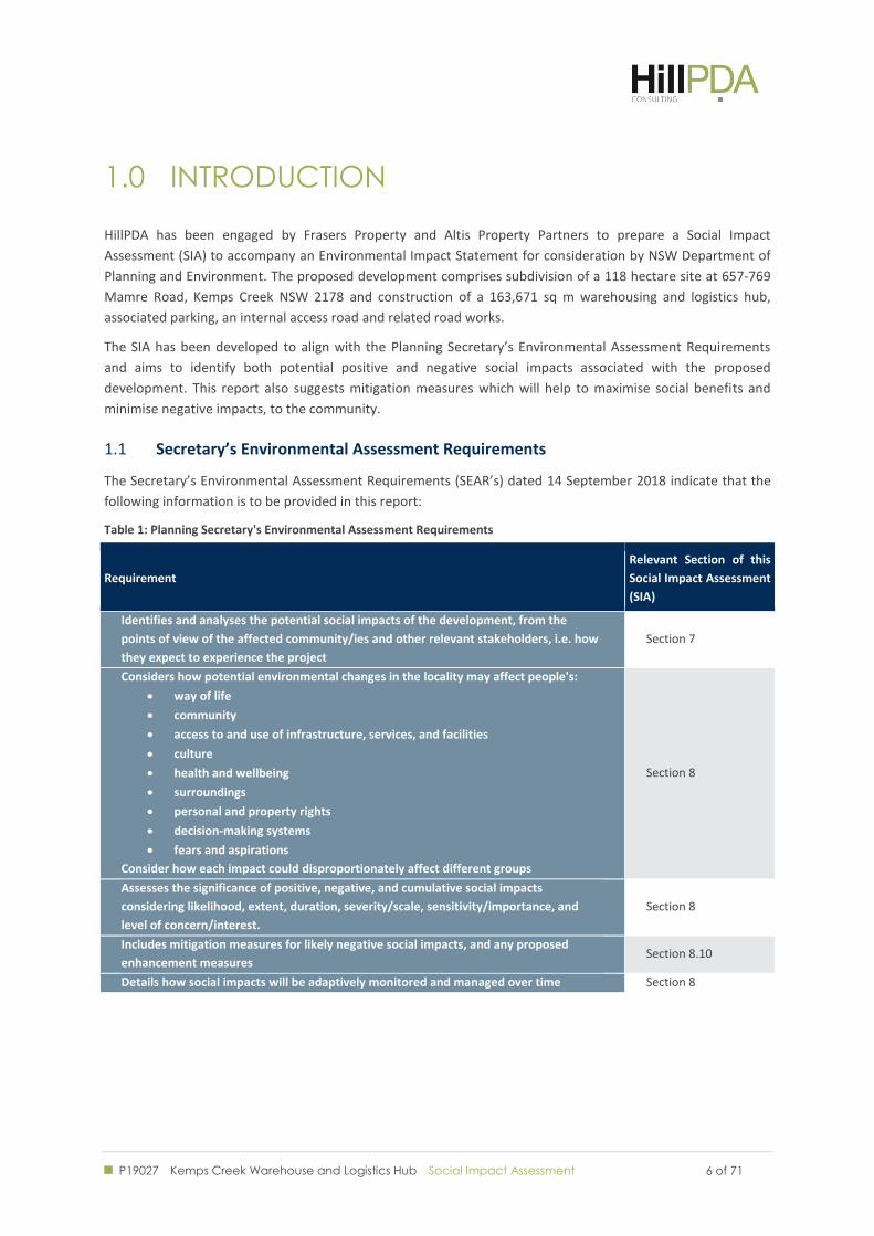
Secretary’s Environmental Assessment Requirements 1.1
The Secretary’s Environmental Assessment Requirements (SEAR’s) dated 14 September 2018 indicate that the
following information is to be provided in this report:
Table 1: Planning Secretary's Environmental Assessment Requirements
Requirement
Relevant Section of this
Social Impact Assessment
(SIA)
Identifies and analyses the potential social impacts of the development, from the
points of view of the affected community/ies and other relevant stakeholders, i.e. how
they expect to experience the project
Section 7
Considers how potential environmental changes in the locality may affect people's:
way of life
community
access to and use of infrastructure, services, and facilities
culture
health and wellbeing
surroundings
personal and property rights
decision-making systems
fears and aspirations
Consider how each impact could disproportionately affect different groups
Section 8
Assesses the significance of positive, negative, and cumulative social impacts
considering likelihood, extent, duration, severity/scale, sensitivity/importance, and
level of concern/interest.
Section 8
Includes mitigation measures for likely negative social impacts, and any proposed
enhancement measures Section 8.10
Details how social impacts will be adaptively monitored and managed over time Section 8
P19027 Kemps Creek Warehouse and Logistics Hub Social Impact Assessment
7 of 71 7 of 71
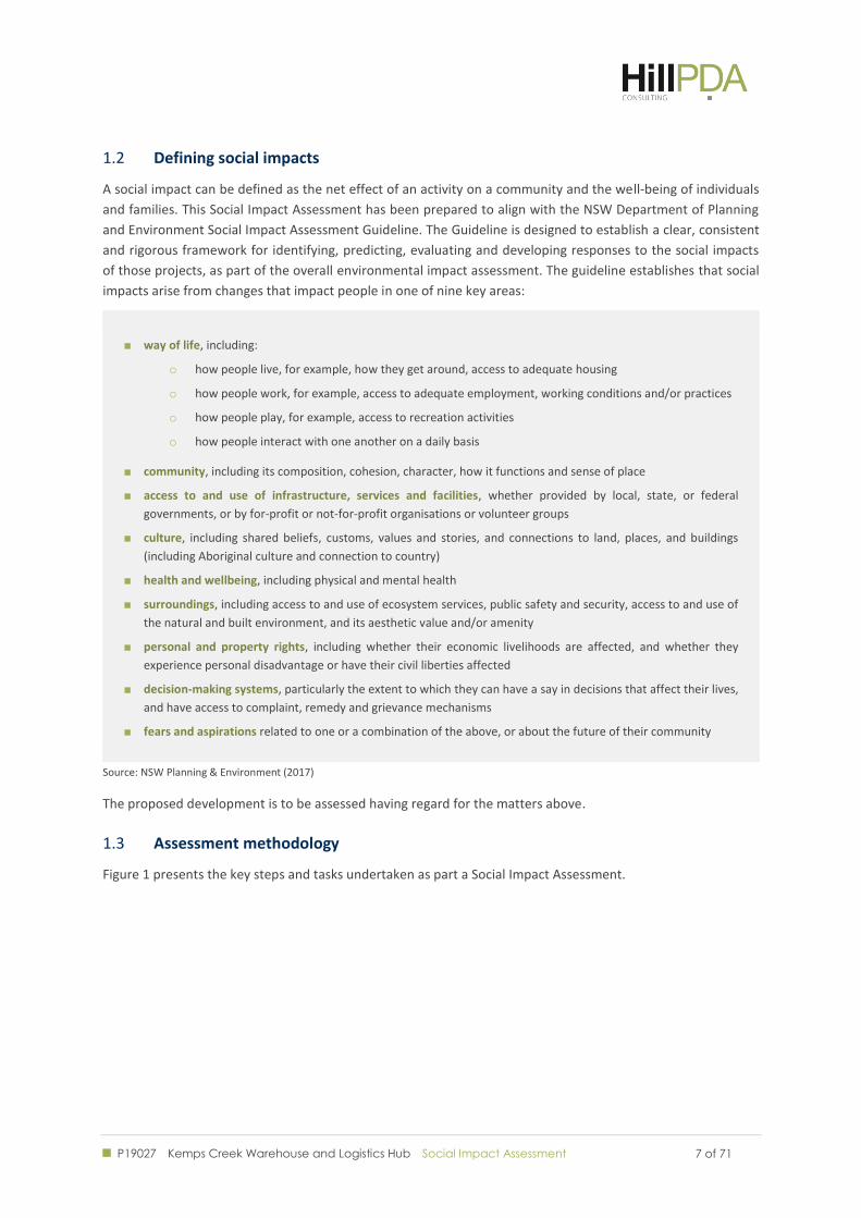
Defining social impacts 1.2
A social impact can be defined as the net effect of an activity on a community and the well-being of individuals
and families. This Social Impact Assessment has been prepared to align with the NSW Department of Planning
and Environment Social Impact Assessment Guideline. The Guideline is designed to establish a clear, consistent
and rigorous framework for identifying, predicting, evaluating and developing responses to the social impacts
of those projects, as part of the overall environmental impact assessment. The guideline establishes that social
impacts arise from changes that impact people in one of nine key areas:
way of life, including:
o how people live, for example, how they get around, access to adequate housing
o how people work, for example, access to adequate employment, working conditions and/or practices
o how people play, for example, access to recreation activities
o how people interact with one another on a daily basis
community, including its composition, cohesion, character, how it functions and sense of place
access to and use of infrastructure, services and facilities, whether provided by local, state, or federal
governments, or by for-profit or not-for-profit organisations or volunteer groups
culture, including shared beliefs, customs, values and stories, and connections to land, places, and buildings
(including Aboriginal culture and connection to country)
health and wellbeing, including physical and mental health
surroundings, including access to and use of ecosystem services, public safety and security, access to and use of
the natural and built environment, and its aesthetic value and/or amenity
personal and property rights, including whether their economic livelihoods are affected, and whether they
experience personal disadvantage or have their civil liberties affected
decision-making systems, particularly the extent to which they can have a say in decisions that affect their lives,
and have access to complaint, remedy and grievance mechanisms
fears and aspirations related to one or a combination of the above, or about the future of their community
Source: NSW Planning & Environment (2017)
The proposed development is to be assessed having regard for the matters above.
Assessment methodology 1.3
Figure 1 presents the key steps and tasks undertaken as part a Social Impact Assessment.
P19027 Kemps Creek Warehouse and Logistics Hub Social Impact Assessment
8 of 71 8 of 71
Figure 1: Assessment methodology
Adapted from Vanclay, F., et al. (2015): p. 7
Impact assessment framework 1.4
The impact assessment presented in this report identifies and evaluates changes to existing social conditions
due to the project. This includes the assessment of direct and indirect benefits and effects/impacts, as well as
consideration of any cumulative impacts.
These changes can be positive or negative; tangible or intangible; qualitative or quantitative; direct, indirect
or cumulative; and subjectively experienced.
The likelihood of social impacts arising from each social and environmental matter assessed as part of the
scoping process.
Figure 2 reflects the scoping process that was undertaken to estimate the overall significance of impacts prior
to performing more detailed assessment. The following sections outline the criteria that underpin each of the
assessment components that contribute to the assessment framework. Professional judgement and experience
is applied on a case-by-case basis to identify the significance of impact on the social environment.
•Understand proposed project
•Establish social area of influence
•Community profiling
•Scope issues
•Assemble baseline data
1. Understand the issues
•Social changes and impacts
•Indirect impacts
•Cumulative impacts
•Affected stakeholders
•Significance of changes
•Project alternatives
2. Predict, analyse and assess the likely impacts
•Address negative impacts
•Enhance benefits & opportunities
•Devise strategies to support communities with change
3. Develop mitigation strategies
•Determine indicators to monitor change
•Participatory monitoring plan
•Implement adaptive management
•Evaluation & periodic review
4. Monitoring
P19027 Kemps Creek Warehouse and Logistics Hub Social Impact Assessment
9 of 71 9 of 71
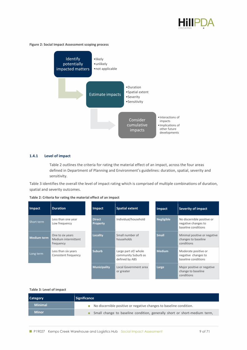
Figure 2: Social Impact Assessment scoping process
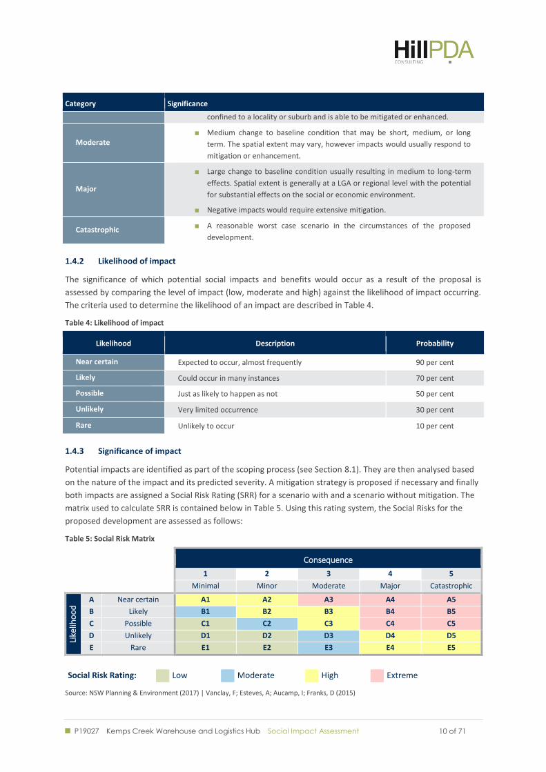
1.4.1 Level of impact
Table 2 outlines the criteria for rating the material effect of an impact, across the four areas
defined in Department of Planning and Environment’s guidelines: duration, spatial, severity and
sensitivity.
Table 3 identifies the overall the level of impact rating which is comprised of multiple combinations of duration,
spatial and severity outcomes.
Table 2: Criteria for rating the material effect of an impact
Impact Duration Impact Spatial extent Impact Severity of impact
Short term Less than one year Low frequency
Direct Property
Individual/household Negligible No discernible positive or negative changes to baseline conditions
Medium term One to six years Medium intermittent frequency
Locality Small number of households
Small Minimal positive or negative changes to baseline conditions
Long term Less than six years Consistent frequency
Suburb Large part of/ whole community Suburb as defined by ABS
Medium Moderate positive or negative changes to baseline conditions
Municipality Local Government area
or greater Large Major positive or negative
change to baseline conditions
Table 3: Level of impact
Category Significance
Minimal No discernible positive or negative changes to baseline condition.
Minor Small change to baseline condition, generally short or short-medium term,
Identify potentially
impacted matters
•likely
•unlikely
•not applicable
Estimate impacts
•Duration
•Spatial extent
•Severity
•Sensitivity
Consider cumulative
impacts
•Interactions of impacts
•Implications of other future developments
P19027 Kemps Creek Warehouse and Logistics Hub Social Impact Assessment
10 of 71 10 of 71
Category Significance
confined to a locality or suburb and is able to be mitigated or enhanced.
Moderate Medium change to baseline condition that may be short, medium, or long
term. The spatial extent may vary, however impacts would usually respond to
mitigation or enhancement.
Major
Large change to baseline condition usually resulting in medium to long-term
effects. Spatial extent is generally at a LGA or regional level with the potential
for substantial effects on the social or economic environment.
Negative impacts would require extensive mitigation.
Catastrophic A reasonable worst case scenario in the circumstances of the proposed
development.
1.4.2 Likelihood of impact
The significance of which potential social impacts and benefits would occur as a result of the proposal is
assessed by comparing the level of impact (low, moderate and high) against the likelihood of impact occurring.
The criteria used to determine the likelihood of an impact are described in Table 4.
Table 4: Likelihood of impact
Likelihood Description Probability
Near certain Expected to occur, almost frequently 90 per cent
Likely Could occur in many instances 70 per cent
Possible Just as likely to happen as not 50 per cent
Unlikely Very limited occurrence 30 per cent
Rare Unlikely to occur 10 per cent
1.4.3 Significance of impact
Potential impacts are identified as part of the scoping process (see Section 8.1). They are then analysed based
on the nature of the impact and its predicted severity. A mitigation strategy is proposed if necessary and finally
both impacts are assigned a Social Risk Rating (SRR) for a scenario with and a scenario without mitigation. The
matrix used to calculate SRR is contained below in Table 5. Using this rating system, the Social Risks for the
proposed development are assessed as follows:
Table 5: Social Risk Matrix
Consequence
1 2 3 4 5
Minimal Minor Moderate Major Catastrophic
Like
liho
od
A Near certain A1 A2 A3 A4 A5
B Likely B1 B2 B3 B4 B5
C Possible C1 C2 C3 C4 C5
D Unlikely D1 D2 D3 D4 D5
E Rare E1 E2 E3 E4 E5
Social Risk Rating: Low Moderate High Extreme
Source: NSW Planning & Environment (2017) | Vanclay, F; Esteves, A; Aucamp, I; Franks, D (2015)
P19027 Kemps Creek Warehouse and Logistics Hub Social Impact Assessment
11 of 71 11 of 71
THE PROPOSAL
P19027 Kemps Creek Warehouse and Logistics Hub Social Impact Assessment
12 of 71 12 of 71
2.0 THE PROPOSAL
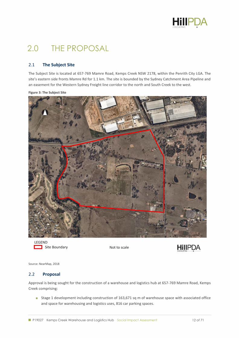
The Subject Site 2.1
The Subject Site is located at 657-769 Mamre Road, Kemps Creek NSW 2178, within the Penrith City LGA. The
site’s eastern side fronts Mamre Rd for 1.1 km. The site is bounded by the Sydney Catchment Area Pipeline and
an easement for the Western Sydney Freight line corridor to the north and South Creek to the west.
Figure 3: The Subject Site
Source: NearMap, 2018
Proposal 2.2
Approval is being sought for the construction of a warehouse and logistics hub at 657-769 Mamre Road, Kemps
Creek comprising:
Stage 1 development including construction of 163,671 sq m of warehouse space with associated office
and space for warehousing and logistics uses, 816 car parking spaces.
P19027 Kemps Creek Warehouse and Logistics Hub Social Impact Assessment
13 of 71 13 of 71
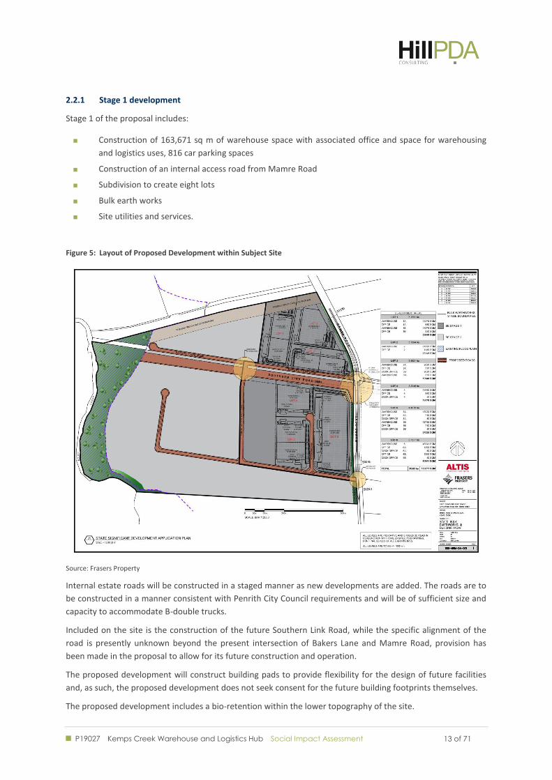
2.2.1 Stage 1 development
Stage 1 of the proposal includes:
Construction of 163,671 sq m of warehouse space with associated office and space for warehousing
and logistics uses, 816 car parking spaces
Construction of an internal access road from Mamre Road
Subdivision to create eight lots
Bulk earth works
Site utilities and services.
Figure 5: Layout of Proposed Development within Subject Site
Source: Frasers Property
Internal estate roads will be constructed in a staged manner as new developments are added. The roads are to
be constructed in a manner consistent with Penrith City Council requirements and will be of sufficient size and
capacity to accommodate B-double trucks.
Included on the site is the construction of the future Southern Link Road, while the specific alignment of the
road is presently unknown beyond the present intersection of Bakers Lane and Mamre Road, provision has
been made in the proposal to allow for its future construction and operation.
The proposed development will construct building pads to provide flexibility for the design of future facilities
and, as such, the proposed development does not seek consent for the future building footprints themselves.
The proposed development includes a bio-retention within the lower topography of the site.
P19027 Kemps Creek Warehouse and Logistics Hub Social Impact Assessment
14 of 71 14 of 71
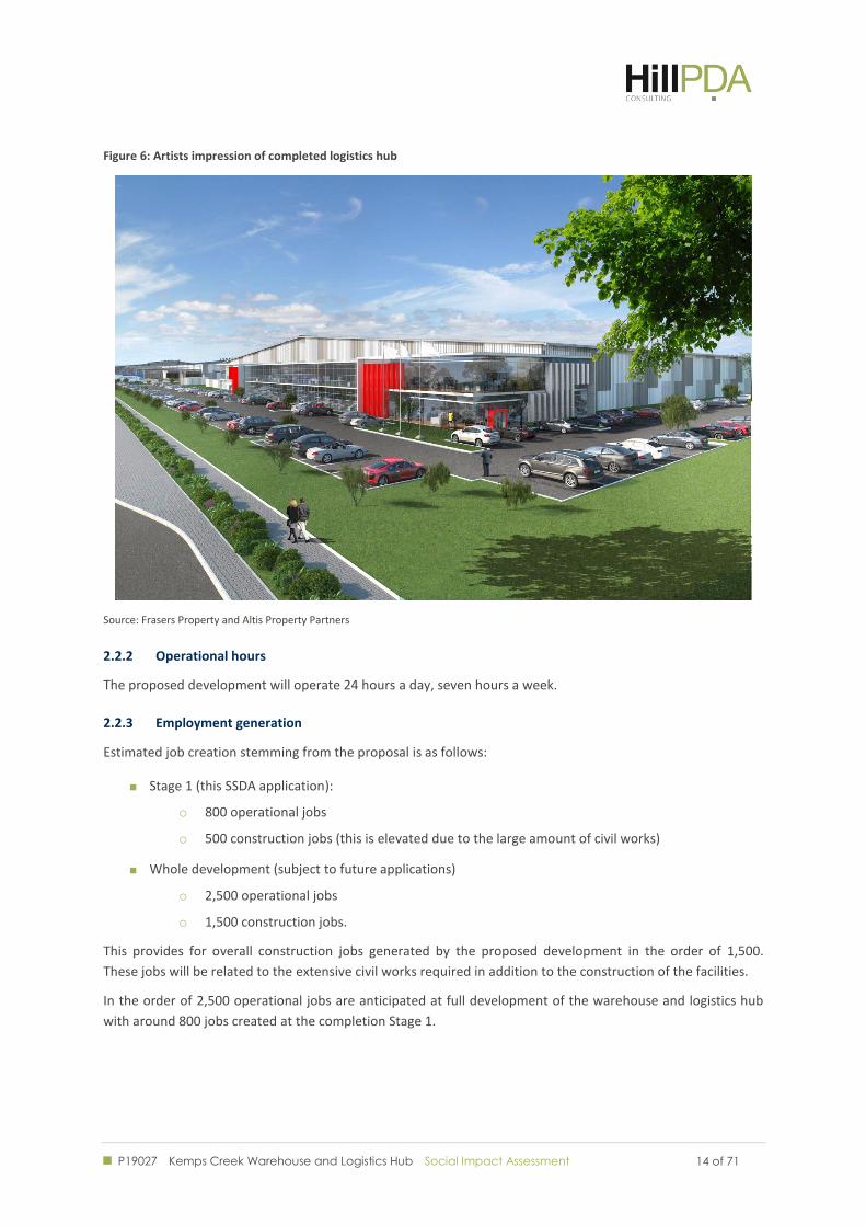
Figure 6: Artists impression of completed logistics hub
Source: Frasers Property and Altis Property Partners
2.2.2 Operational hours
The proposed development will operate 24 hours a day, seven hours a week.
2.2.3 Employment generation
Estimated job creation stemming from the proposal is as follows:
Stage 1 (this SSDA application):
o 800 operational jobs
o 500 construction jobs (this is elevated due to the large amount of civil works)
Whole development (subject to future applications)
o 2,500 operational jobs
o 1,500 construction jobs.
This provides for overall construction jobs generated by the proposed development in the order of 1,500.
These jobs will be related to the extensive civil works required in addition to the construction of the facilities.
In the order of 2,500 operational jobs are anticipated at full development of the warehouse and logistics hub
with around 800 jobs created at the completion Stage 1.
P19027 Kemps Creek Warehouse and Logistics Hub Social Impact Assessment
15 of 71 15 of 71
THE SURROUNDS
P19027 Kemps Creek Warehouse and Logistics Hub Social Impact Assessment
16 of 71 16 of 71
3.0 THE SURROUNDS
The Surrounds 3.1
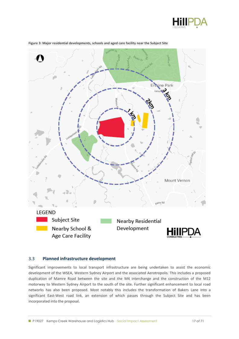
The region surrounding the site is historically rural in usage, but is in an ongoing state of development relating
to Western Sydney Airport and the surrounding Aerotropolis. The Western Sydney Employment Area (WSEA)
has the primary aim of integrating state and local planning inputs in the area to promote the provision of
industrial lands and economic growth. As a result, the area immediately surrounding the site is a mix of
remanent rural and residential land use, interspersed with more recent industrial development.
To the north of the site, beyond the SCA pipeline is the Mamre West Precinct, which was rezoned in 2016, with
new planning controls introduced to enable industrial development within the Western Sydney Employment
Area. The site is currently being developed by Altis into a warehousing and logistics hub, as part of the First
Estate development, which includes three warehouse buildings between 9,400 m2 and 41,500 m2 in size and
357 car parking spaces. Notably, the First Estate development is largely consistent with the profile and
objectives of the proposal for the Subject Site.
Diagonally opposite the site to the north on Mamre Road is Erskine Business Park, which includes a variety of
logistical and industrial businesses operating on a 24/7 basis, including CEVA logistics, CSR, Woolworths and
Alvaro Transport. Rural and residential land holdings lie to the west of South Creek, with the nearest
substantial residential development lying 2 km north at Erskine Park (Figure 3).
Mamre Anglican School is located 500 metres east on Bakers Lane. Trinity Primary School, Emmaus Catholic
College and Emmaus Retirement Village are closely located further along the same road.
To the west of South Creek are Twin Creeks Golf and Country Club and an attached residential estate of the
same name. The next closest major residential area is Erskine Park, which lies over 1.7 km north on Mamre
Road.
Access 3.2
The site is in an accessible location for the purposes of the proposed development, with appropriate parking
and road access in place. As it stands, the site is currently accessible via Mamre Road, which links directly to the
M4 in the north and the M7 via Elizabeth Drive in the south.
Currently there are no public transport links nearby, with the nearest bus route, the 779, serving warehouses 1
kilometre to the north along James Erskine Drive.
P19027 Kemps Creek Warehouse and Logistics Hub Social Impact Assessment
17 of 71 17 of 71
Figure 3: Major residential developments, schools and aged care facility near the Subject Site
Planned infrastructure development 3.3
Significant improvements to local transport infrastructure are being undertaken to assist the economic
development of the WSEA, Western Sydney Airport and the associated Aerotropolis. This includes a proposed
duplication of Mamre Road between the site and the M4 interchange and the construction of the M12
motorway to Western Sydney Airport to the south of the site. Further significant enhancement to local road
networks has also been proposed. Most notably this includes the transformation of Bakers Lane into a
significant East-West road link, an extension of which passes through the Subject Site and has been
incorporated into the proposal.
P19027 Kemps Creek Warehouse and Logistics Hub Social Impact Assessment
18 of 71 18 of 71
STRATEGIC POLICY
CONTEXT
P19027 Kemps Creek Warehouse and Logistics Hub Social Impact Assessment
19 of 71 19 of 71
4.0 STRATEGIC POLICY CONTEXT
This section reviews the planning and legislative context for the Proposed Development based on State and
local government planning guidelines. The following strategic policy documents have been reviewed.
Western Sydney City Deal 4.1
The Western Sydney City Deal was signed between the NSW and Australian Governments in March 2018. It
outlined a tri-level partnership between Federal, State and Local Governments to deliver an agreed set of
commitments across the Greater Western Sydney region. The agreement has been articulated to support the
objectives of the Western Sydney District Plan and the Greater Sydney Region Plan, most notably the vision of
people of Greater Sydney living within 30 minutes of their jobs, education and health facilities, services and
great places.
The priorities of the City Deal as relevant to this study include:
A commitment to construct the northern segment of the North South Rail Link between Western
Sydney Airport and Penrith by the time the airport becomes operational. The rail link will pass through
region west of the Subject Site
A commitment to establish rapid bus links from the Aerotropolis and Liverpool, Penrith and
Campbelltown
A commitment to support the development of a world-class employment sector for jobs in aviation,
aerospace, defence industries and advanced manufacturing. This includes the establishment of a
Development Authority to commence delivery of 200,000 jobs, over 20 years.
Greater Sydney Region Plan 4.2
The Greater Sydney Region plan identifies the Subject Site as being part of the Western City District. The plan
outlines priorities for this region as centring on achieving quicker and easier access to a wider range of jobs,
housing types and activities for residents. The plan hinges on encouraging significant economic development in
the context of Western Sydney Airport and the Aerotropolis. These objectives are to be supported through the
delivery of commitments made in the Western Sydney City Deal and through the prioritisation of
enhancements to the District’s lifestyle and environmental assets.
Central to this is the identification of the Western Economic Corridor, which aims to maximise development
opportunities arising from the construction of the North-South rail. This is particularly relevant to the subject
site because of its proximity to Stage 1 - St Marys to the Western Sydney Airport.
Objective/ Strategy Extracts from the Plan
Objective 20 – Western Sydney Airport and
Badgerys Creek Aerotropolis are economic
catalysts for Western Parkland City
The emerging new city will be driven by economic opportunities created by the Western Sydney Airport and Badgerys Creek Aerotropolis and significant population growth, which will bring city-scale infrastructure and new advanced manufacturing, logistics and research industries providing hundreds of thousands of jobs over the long term.
Objective 22 - Investment and business
activity in centres
The Western Parkland City is an emerging city with a north-south geography extending for 54 kilometres. The presence of three long established centres provides the opportunity for a
P19027 Kemps Creek Warehouse and Logistics Hub Social Impact Assessment
20 of 71 20 of 71
Objective/ Strategy Extracts from the Plan
polycentric urban structure. Here, a cluster of four centres will deliver the metropolitan functions of providing concentrations of higher order jobs and a wide range of goods and services.
Objective 24 – Economic sectors are targeted for success
Australian, NSW and local governments are working together to drive key industry and economic developments that will create a highly skilled workforce able to access high quality local jobs, with a variety of industry and cross-sectoral initiatives are being implemented to encourage development.
Particular focus is given to initiatives encouraging growth and economic development around key precincts, like the Western Sydney Aerospace Precinct.
Western City District Plan 4.3
The Western City District Plan was updated in March 2018 with the signing of the Western Sydney City deal to
better align the strategic priorities for that District, with the commitments outlined in the City Deal. Key
planning priorities relevant to this study include:
Providing housing supply, choice and affordability, with access to jobs, services and public transport
Economic sectors are targeted for success
Investment and business activity in centres
Maximising freight and logistics opportunities and planning and managing industrial and urban services
land
Growing investment, business opportunities and jobs in strategic centres
Broader Western Sydney Employment Area 4.4
The Subject Site is located within the Penrith City Council LGA. It is subject to the Western Sydney Employment
Area SEPP, defined as part of the Broader Western Sydney Employment Area. As Stage 1 of the development
exceeds the $50 million threshold in Schedule 1 of State Environmental Planning Policy (State and Regional
Development) 2011, the development is considered State Significant. Although the WSEA SEPP identifies the
Subject Site as being subject to the instrument it remains unzoned.
P19027 Kemps Creek Warehouse and Logistics Hub Social Impact Assessment
21 of 71 21 of 71
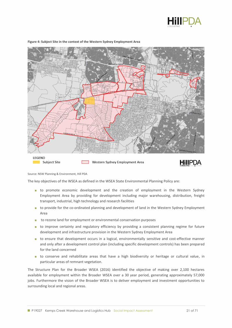
Figure 4: Subject Site in the context of the Western Sydney Employment Area
Source: NSW Planning & Environment, Hill PDA
The key objectives of the WSEA as defined in the WSEA State Environmental Planning Policy are:
to promote economic development and the creation of employment in the Western Sydney
Employment Area by providing for development including major warehousing, distribution, freight
transport, industrial, high technology and research facilities
to provide for the co-ordinated planning and development of land in the Western Sydney Employment
Area
to rezone land for employment or environmental conservation purposes
to improve certainty and regulatory efficiency by providing a consistent planning regime for future
development and infrastructure provision in the Western Sydney Employment Area
to ensure that development occurs in a logical, environmentally sensitive and cost-effective manner
and only after a development control plan (including specific development controls) has been prepared
for the land concerned
to conserve and rehabilitate areas that have a high biodiversity or heritage or cultural value, in
particular areas of remnant vegetation.
The Structure Plan for the Broader WSEA (2016) identified the objective of making over 2,100 hectares
available for employment within the Broader WSEA over a 30 year period, generating approximately 57,000
jobs. Furthermore the vision of the Broader WSEA is to deliver employment and investment opportunities to
surrounding local and regional areas.
P19027 Kemps Creek Warehouse and Logistics Hub Social Impact Assessment
22 of 71 22 of 71
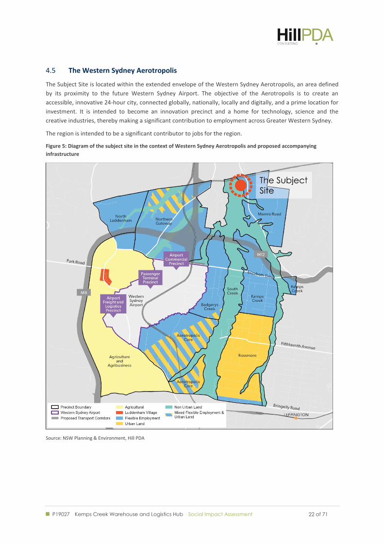
The Western Sydney Aerotropolis 4.5
The Subject Site is located within the extended envelope of the Western Sydney Aerotropolis, an area defined
by its proximity to the future Western Sydney Airport. The objective of the Aerotropolis is to create an
accessible, innovative 24-hour city, connected globally, nationally, locally and digitally, and a prime location for
investment. It is intended to become an innovation precinct and a home for technology, science and the
creative industries, thereby making a significant contribution to employment across Greater Western Sydney.
The region is intended to be a significant contributor to jobs for the region.
Figure 5: Diagram of the subject site in the context of Western Sydney Aerotropolis and proposed accompanying
infrastructure
Source: NSW Planning & Environment, Hill PDA
P19027 Kemps Creek Warehouse and Logistics Hub Social Impact Assessment
23 of 71 23 of 71
COMMUNITY PROFILE
P19027 Kemps Creek Warehouse and Logistics Hub Social Impact Assessment
24 of 71 24 of 71
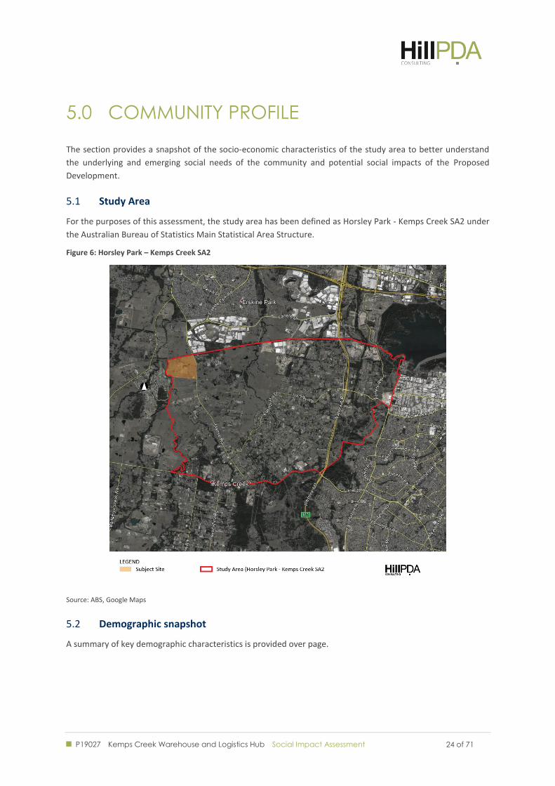
5.0 COMMUNITY PROFILE
The section provides a snapshot of the socio-economic characteristics of the study area to better understand
the underlying and emerging social needs of the community and potential social impacts of the Proposed
Development.
Study Area 5.1
For the purposes of this assessment, the study area has been defined as Horsley Park - Kemps Creek SA2 under
the Australian Bureau of Statistics Main Statistical Area Structure.
Figure 6: Horsley Park – Kemps Creek SA2
Source: ABS, Google Maps
Demographic snapshot 5.2
A summary of key demographic characteristics is provided over page.
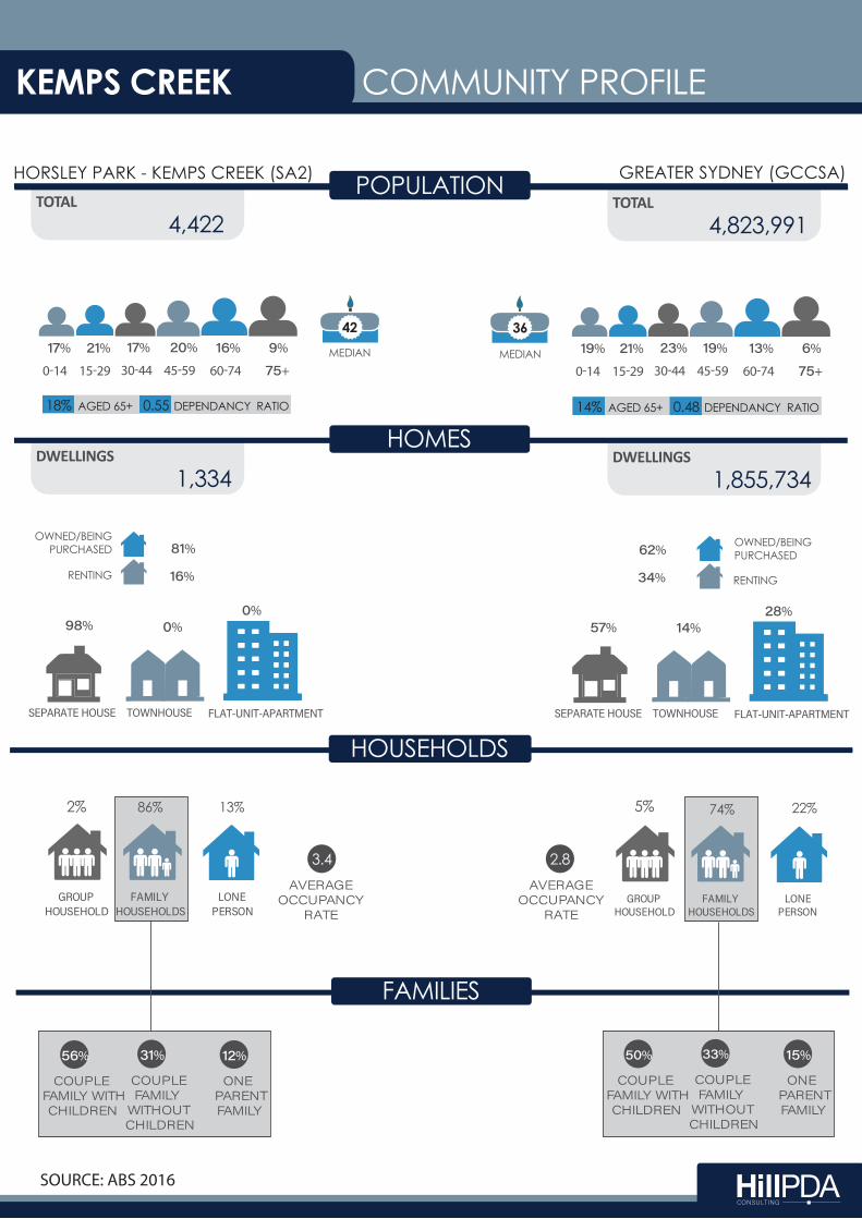
TOTAL 4,422
HOMESTOTAL
4,823,991
DWELLINGS 1,334
POPULATION
42
HORSLEY PARK - KEMPS CREEK (SA2) GREATER SYDNEY (GCCSA)
HOUSEHOLDS
FAMILIES
HOMES
DWELLINGS1,855,734
OWNED/BEING PURCHASED
RENTING
��%� �
��% RENTING
OWNED/BEING PURCHASED��%
��%
�������������� ��������� ������������������� �������������� ��������� �������������������
�����%� � �����%� �����%� �
����%� � ��%��%
����%36
�
����%� ����%� ����%� ����%� ���%
��+
����%
�
����%� ����%� ����% ����%� ���%�
��+ MEDIAN MEDIAN
��������������� �
������������
��������������
��������������� �
������������
��������������
2% 86% �13% � 5% 74% � 22% �
������������������
�����
� 3.4 �
������������������
�����
�2.8 �
����������������� �� ������
��% �
��������������
��� ����� ������
��% �
�����������������
��%� �
����������������� �� ������
���% �
��������������
��� ����� ������
��%� �
�����������������
��% �
AGED 65+ DEPENDANCY RATIO18% 0.55 AGED 65+ DEPENDANCY RATIO14% 0.48
����������
KEMPS CREEK COMMUNITY PROFILE
SOURCE: ABS 2016
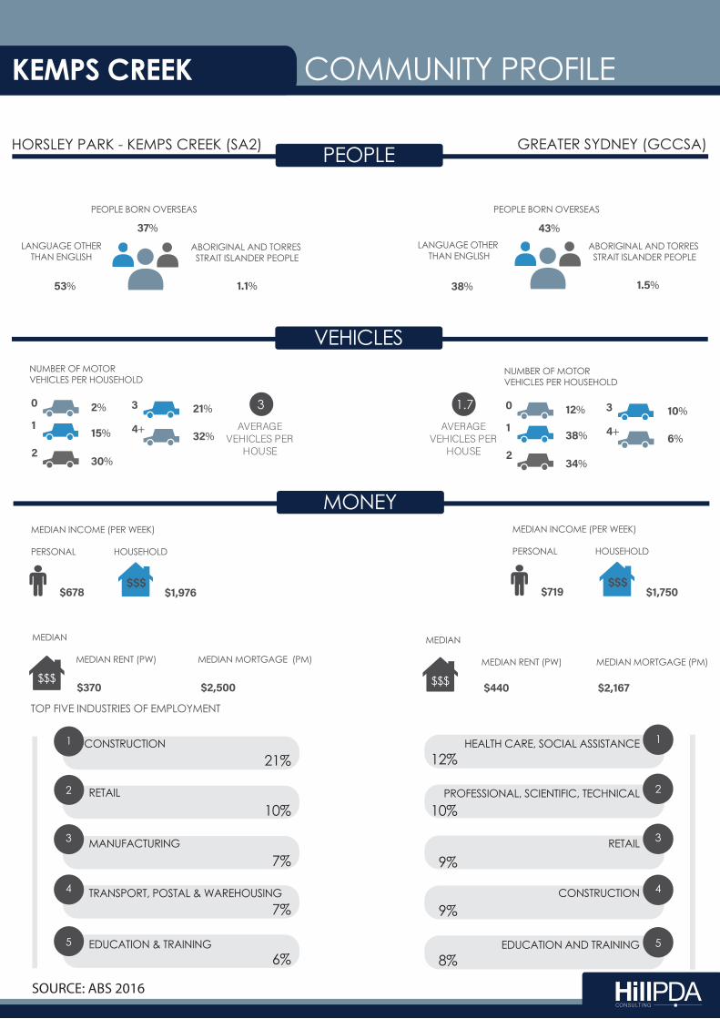
PEOPLEHORSLEY PARK - KEMPS CREEK (SA2) GREATER SYDNEY (GCCSA)
MONEY
VEHICLESNUMBER OF MOTORVEHICLES PER HOUSEHOLD
����������
���%� �
ABORIGINAL AND TORRES STRAIT ISLANDER PEOPLE
�����%� �
PEOPLE BORN OVERSEAS
����%� �
LANGUAGE OTHERTHAN ENGLISH
���%� �
ABORIGINAL AND TORRES STRAIT ISLANDER PEOPLE
�����%� �
PEOPLE BORN OVERSEAS
��%� �
LANGUAGE OTHER THAN ENGLISH
�� �
�� �
�� �
�+� �
�� � �%� �
��%� �
��%� �
��%� �
��%� �
NUMBER OF MOTORVEHICLES PER HOUSEHOLD
�� �
�� �
�� �
�+� �
�� � ��%� �
��%� �
��%� �
��%� �
�%� ���������
�������������������
� 3 �
���������������������
������
����1.7�
���
MEDIAN INCOME (PER WEEK)
PERSONAL HOUSEHOLD
���� ������
1
2
3
4
5
MEDIAN
MEDIAN RENT (PW) MEDIAN MORTGAGE (PM)
$$$���� ����� ��������
MEDIAN
MEDIAN RENT (PW) MEDIAN MORTGAGE (PM)
$$$ ���� �����������
TOP FIVE INDUSTRIES OF EMPLOYMENT
1
2
3
4
5
���
MEDIAN INCOME (PER WEEK)
PERSONAL HOUSEHOLD
���� ������
HEALTH CARE, SOCIAL ASSISTANCE
PROFESSIONAL, SCIENTIFIC, TECHNICAL
RETAIL
CONSTRUCTION
EDUCATION AND TRAINING
12%
10%
9%
9%
8%
21%
RETAIL
10%
MANUFACTURING
7%
TRANSPORT, POSTAL & WAREHOUSING 7%
EDUCATION & TRAINING6%
COMMUNITY PROFILE
CONSTRUCTION
KEMPS CREEK
SOURCE: ABS 2016
P19027 Kemps Creek Warehouse and Logistics Hub Social Impact Assessment
27 of 71 27 of 71
Social Advantage and Disadvantage 5.3
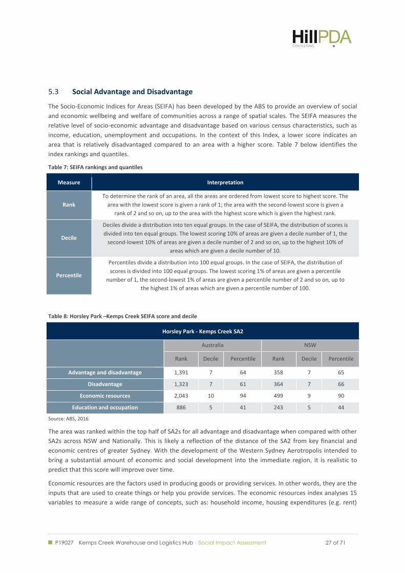
The Socio-Economic Indices for Areas (SEIFA) has been developed by the ABS to provide an overview of social
and economic wellbeing and welfare of communities across a range of spatial scales. The SEIFA measures the
relative level of socio-economic advantage and disadvantage based on various census characteristics, such as
income, education, unemployment and occupations. In the context of this Index, a lower score indicates an
area that is relatively disadvantaged compared to an area with a higher score. Table 7 below identifies the
index rankings and quantiles.
Table 7: SEIFA rankings and quantiles
Measure Interpretation
Rank
To determine the rank of an area, all the areas are ordered from lowest score to highest score. The
area with the lowest score is given a rank of 1; the area with the second-lowest score is given a
rank of 2 and so on, up to the area with the highest score which is given the highest rank.
Decile
Deciles divide a distribution into ten equal groups. In the case of SEIFA, the distribution of scores is
divided into ten equal groups. The lowest scoring 10% of areas are given a decile number of 1, the
second-lowest 10% of areas are given a decile number of 2 and so on, up to the highest 10% of
areas which are given a decile number of 10.
Percentile
Percentiles divide a distribution into 100 equal groups. In the case of SEIFA, the distribution of
scores is divided into 100 equal groups. The lowest scoring 1% of areas are given a percentile
number of 1, the second-lowest 1% of areas are given a percentile number of 2 and so on, up to
the highest 1% of areas which are given a percentile number of 100.
Table 8: Horsley Park –Kemps Creek SEIFA score and decile
Horsley Park - Kemps Creek SA2
Australia NSW
Rank Decile Percentile Rank Decile Percentile
Advantage and disadvantage 1,391 7 64 358 7 65
Disadvantage 1,323 7 61 364 7 66
Economic resources 2,043 10 94 499 9 90
Education and occupation 886 5 41 243 5 44
Source: ABS, 2016
The area was ranked within the top half of SA2s for all advantage and disadvantage when compared with other
SA2s across NSW and Nationally. This is likely a reflection of the distance of the SA2 from key financial and
economic centres of greater Sydney. With the development of the Western Sydney Aerotropolis intended to
bring a substantial amount of economic and social development into the immediate region, it is realistic to
predict that this score will improve over time.
Economic resources are the factors used in producing goods or providing services. In other words, they are the
inputs that are used to create things or help you provide services. The economic resources index analyses 15
variables to measure a wide range of concepts, such as: household income, housing expenditures (e.g. rent)
P19027 Kemps Creek Warehouse and Logistics Hub Social Impact Assessment
28 of 71 28 of 71
and wealth (e.g. home ownership). At 90 per cent, Horsley Park - Kemps Creek ‘economic resources’ when
compared with other statistical areas across NSW.
Employment 5.4
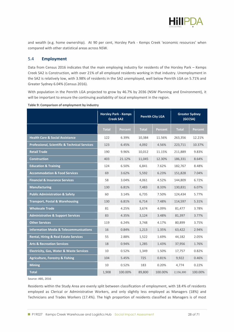
Data from Census 2016 indicates that the main employing industry for residents of the Horsley Park – Kemps
Creek SA2 is Construction, with over 21% of all employed residents working in that industry. Unemployment in
the SA2 is relatively low, with 3.98% of residents in the SA2 unemployed, well below Penrith LGA on 5.71% and
Greater Sydney 6.04% (Census 2016).
With population in the Penrith LGA projected to grow by 46.7% by 2036 (NSW Planning and Environment), it
will be important to ensure the continuing availability of local employment in the region.
Table 9: Comparison of employment by industry
Horsley Park - Kemps
Creek SA2 Penrith City LGA
Greater Sydney
(GCCSA)
Total Percent Total Percent Total Percent
Health Care & Social Assistance 122 6.39% 10,384 11.56% 263,356 12.21%
Professional, Scientific & Technical Services 123 6.45% 4,092 4.56% 223,711 10.37%
Retail Trade 190 9.96% 10,012 11.15% 211,889 9.83%
Construction 403 21.12% 11,045 12.30% 186,331 8.64%
Education & Training 124 6.50% 6,841 7.62% 182,767 8.48%
Accommodation & Food Services 69 3.62% 5,592 6.23% 151,828 7.04%
Financial & Insurance Services 58 3.04% 4,061 4.52% 144,809 6.72%
Manufacturing 130 6.81% 7,483 8.33% 130,831 6.07%
Public Administration & Safety 60 3.14% 6,735 7.50% 124,434 5.77%
Transport, Postal & Warehousing 130 6.81% 6,714 7.48% 114,597 5.31%
Wholesale Trade 81 4.25% 3,674 4.09% 81,477 3.78%
Administrative & Support Services 83 4.35% 3,124 3.48% 81,397 3.77%
Other Services 119 6.24% 3,748 4.17% 80,899 3.75%
Information Media & Telecommunications 16 0.84% 1,213 1.35% 63,422 2.94%
Rental, Hiring & Real Estate Services 55 2.88% 1,522 1.69% 44,182 2.05%
Arts & Recreation Services 18 0.94% 1,285 1.43% 37,956 1.76%
Electricity, Gas, Water & Waste Services 10 0.52% 1,349 1.50% 17,757 0.82%
Agriculture, Forestry & Fishing 104 5.45% 725 0.81% 9,922 0.46%
Mining 10 0.52% 183 0.20% 4,774 0.22%
Total 1,908 100.00% 89,800 100.00% 2,156,300 100.00%
Source: ABS, 2016
Residents within the Study Area are evenly split between classification of employment, with 18.4% of residents
employed as Clerical or Administrative Workers, and only slightly less employed as Managers (18%) and
Technicians and Trades Workers (17.4%). The high proportion of residents classified as Managers is of most
P19027 Kemps Creek Warehouse and Logistics Hub Social Impact Assessment
29 of 71 29 of 71
significance compared to the wider Penrith LGA and Greater Sydney region, which both have a substantially
lower proportion.
Table 10: Comparison of employment by classification of occupation
Horsley Park - Kemps Creek SA2
Penrith City LGA Greater Sydney
Total Percent Total Percent Total Percent
Managers 360 17.98% 9,604 10.32% 311,765 13.99%
Professionals 265 13.24% 14,073 15.12% 597,804 26.83%
Technicians & Trades Workers 349 17.43% 14,052 15.10% 265,056 11.89%
Community & Personal Service Workers 133 6.64% 9,947 10.69% 218,209 9.79%
Clerical & Administrative Workers 370 18.48% 16,843 18.10% 331,136 14.86%
Sales Workers 175 8.74% 9,079 9.76% 205,054 9.20%
Machinery Operators & Drivers 162 8.09% 10,285 11.05% 128,021 5.74%
Labourers 176 8.79% 9,162 9.85% 171,450 7.69%
Total 2,002 100.00% 93,049 100.00% 2,228,483 100.00%
Source: ABS, 2016
The 2016 Census showed that residents within the study area tended to travel less for work, which may be
evidence of existing jobs in the area. Residents in the wider Penrith City LGA travelled comparatively further to
their place of work, with over 62% of the residents of working age commuting at least 10 km to their place of
work and 28% travelling at least 30 km (Census 2016).
Table 11: Comparison of distance to from usual place of residence to place of work via road
Horsley Park - Kemps Creek
SA2 Penrith LGA Greater Sydney GCCSA
Road distance from residence to
place of work Total Percent Total Percent Total Percent
Nil distance 277 14.62% 4,483 4.97% 131,505 5.96%
Over 0 km to less than 2.5 km 96 5.07% 5,477 6.07% 219,956 9.97%
2.5 km to less than 10 km 373 19.68% 23,586 26.16% 688,643 31.22%
10 km to less than 30 km 880 46.44% 31,336 34.75% 851,928 38.62%
30 km to less than 50 km 249 13.14% 18,063 20.03% 197,615 8.96%
50 km to less than 250 km 18 0.95% 6,782 7.52% 99,303 4.50%
250 km and over 7 0.37% 433 0.48% 16,816 0.76%
Total 1,895 100.00% 90,164 100.00% 2,205,765 100.00%
Source: ABS, 2016
Business Statistics 5.5
As at 30 June 2017, the Horsley Park – Kemps Creek SA2 contained 963 registered businesses, of which 98 had
5 or more employees. Of the industries operating in the area, approximately 27.4% were in Construction,
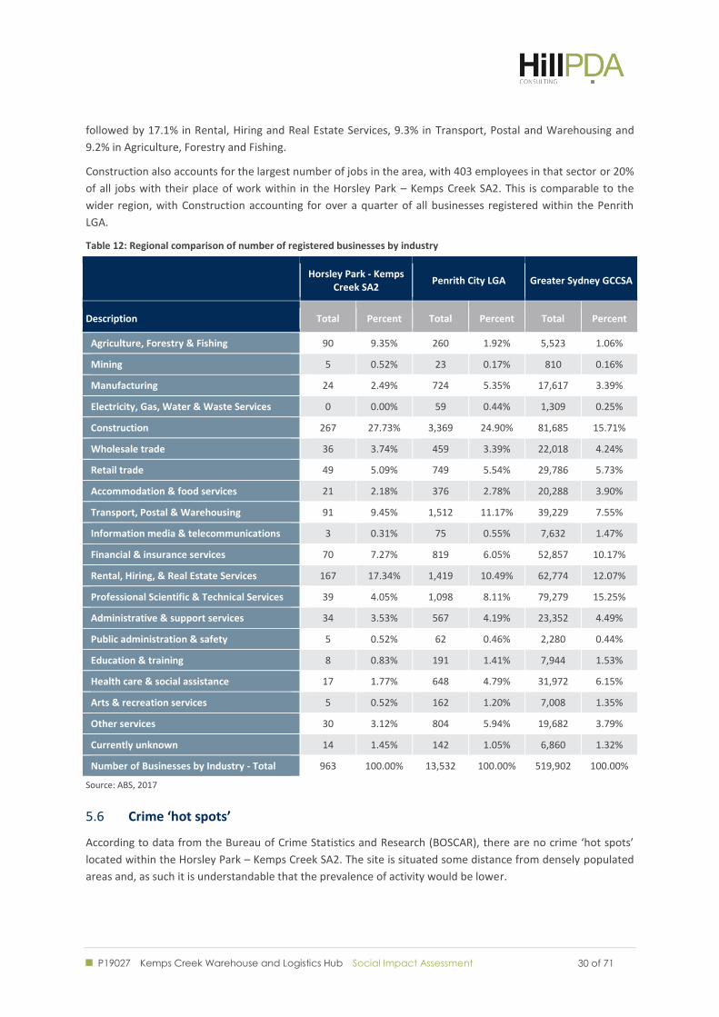
P19027 Kemps Creek Warehouse and Logistics Hub Social Impact Assessment
30 of 71 30 of 71
followed by 17.1% in Rental, Hiring and Real Estate Services, 9.3% in Transport, Postal and Warehousing and
9.2% in Agriculture, Forestry and Fishing.
Construction also accounts for the largest number of jobs in the area, with 403 employees in that sector or 20%
of all jobs with their place of work within in the Horsley Park – Kemps Creek SA2. This is comparable to the
wider region, with Construction accounting for over a quarter of all businesses registered within the Penrith
LGA.
Table 12: Regional comparison of number of registered businesses by industry
Horsley Park - Kemps Creek SA2
Penrith City LGA Greater Sydney GCCSA
Description Total Percent Total Percent Total Percent
Agriculture, Forestry & Fishing 90 9.35% 260 1.92% 5,523 1.06%
Mining 5 0.52% 23 0.17% 810 0.16%
Manufacturing 24 2.49% 724 5.35% 17,617 3.39%
Electricity, Gas, Water & Waste Services 0 0.00% 59 0.44% 1,309 0.25%
Construction 267 27.73% 3,369 24.90% 81,685 15.71%
Wholesale trade 36 3.74% 459 3.39% 22,018 4.24%
Retail trade 49 5.09% 749 5.54% 29,786 5.73%
Accommodation & food services 21 2.18% 376 2.78% 20,288 3.90%
Transport, Postal & Warehousing 91 9.45% 1,512 11.17% 39,229 7.55%
Information media & telecommunications 3 0.31% 75 0.55% 7,632 1.47%
Financial & insurance services 70 7.27% 819 6.05% 52,857 10.17%
Rental, Hiring, & Real Estate Services 167 17.34% 1,419 10.49% 62,774 12.07%
Professional Scientific & Technical Services 39 4.05% 1,098 8.11% 79,279 15.25%
Administrative & support services 34 3.53% 567 4.19% 23,352 4.49%
Public administration & safety 5 0.52% 62 0.46% 2,280 0.44%
Education & training 8 0.83% 191 1.41% 7,944 1.53%
Health care & social assistance 17 1.77% 648 4.79% 31,972 6.15%
Arts & recreation services 5 0.52% 162 1.20% 7,008 1.35%
Other services 30 3.12% 804 5.94% 19,682 3.79%
Currently unknown 14 1.45% 142 1.05% 6,860 1.32%
Number of Businesses by Industry - Total 963 100.00% 13,532 100.00% 519,902 100.00%
Source: ABS, 2017
Crime ‘hot spots’ 5.6
According to data from the Bureau of Crime Statistics and Research (BOSCAR), there are no crime ‘hot spots’
located within the Horsley Park – Kemps Creek SA2. The site is situated some distance from densely populated
areas and, as such it is understandable that the prevalence of activity would be lower.
P19027 Kemps Creek Warehouse and Logistics Hub Social Impact Assessment
31 of 71 31 of 71
Summary of key findings 5.7
The Horsley Park - Kemps Creek SA2 had a population of 4,637 (Census 2016)
37.9% of the population in Horsley Park – Kemps Creek SA2 speak a language other than English at
home (Census 2016)
The most represented industry amongst businesses in the Horsley Park – Kemps Creek SA2 is
Construction, which is also the industry employing the greatest proportion of individuals whose place
of work in that SA2
Local residents across the Penrith Local Government Area generally travelled greater distances to work,
with 28% of the population travelling over 30 km, indicating that less employment is less available
locally.

P19027 Kemps Creek Warehouse and Logistics Hub Social Impact Assessment
32 of 71 32 of 71
SOCIAL
INFRASTRUCTURE
P19027 Kemps Creek Warehouse and Logistics Hub Social Impact Assessment
33 of 71 33 of 71
6.0 EXISTING SOCIAL INFRASTRUCTURE
The following section provides an overview of the social infrastructure and open space located within the study
area. This audit has been informed by a desktop analysis of geographical data and resources, including:
Penrith City Council Website
Penrith City Council Draft Open Space Masterplan
mychild.gov.au
careforkids.com.au
ArcGIS Online.
The audit is indicative and based on the data available at the time of preparing this report. The purpose of the
social infrastructure audit is to understand strengths and weaknesses of existing social infrastructure and to
determine what has potential to accommodate future population growth.
What is social infrastructure? 6.1
Social infrastructure is an asset that accommodates social services or facilities. Social infrastructure is an
important aspect of society as it provides the community with tangible or perceived benefits linked to the
safety, health and wellbeing of that community. It also links to the economic growth and the sustainability of
the community, therefore playing a critical role in society.
Specifically, this report has been produced to address the needs of particular baseline infrastructure types,
which include the following:
Childcare
Active and passive recreation – such as parks, sporting ovals and social clubs, halls etc.
Community and culture – libraries and community centres.
For the purposes of clarity, this report excludes businesses such as retail or commercial services. While these
facilities provide a valuable social function, the future provision of these businesses in any area is typically
market-led and access to these services may involve a cost which can prevent some from accessing the services
provided.
A catchment approach 6.2
Social infrastructure facilities generally operate at three levels of provision. These are local, regional and
district. The different scales of infrastructure service different sized catchments. Catchments refer to both
geographical areas and the size of the population serviced. For example, a primary school is intended to serve
the local population, usually within walking distance. However, a university will cater for a much wider
population.
In conducting the audit of social infrastructure, local and district facilities have been identified. Table 13
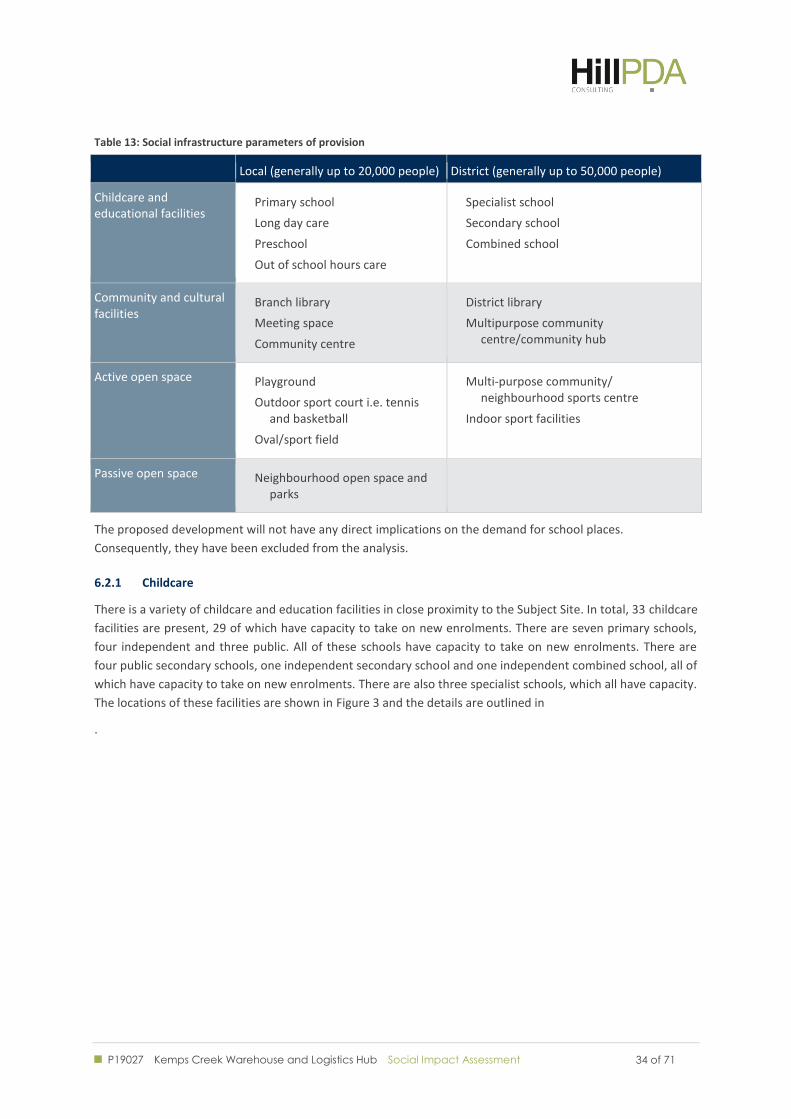
identifies the facilities included in the audit and the catchments that they serve.
P19027 Kemps Creek Warehouse and Logistics Hub Social Impact Assessment
34 of 71 34 of 71
Table 13: Social infrastructure parameters of provision
Local (generally up to 20,000 people) District (generally up to 50,000 people)
Childcare and educational facilities
Primary school
Long day care
Preschool
Out of school hours care
Specialist school
Secondary school
Combined school
Community and cultural facilities
Branch library
Meeting space
Community centre
District library
Multipurpose community centre/community hub
Active open space Playground
Outdoor sport court i.e. tennis and basketball
Oval/sport field
Multi-purpose community/ neighbourhood sports centre
Indoor sport facilities
Passive open space Neighbourhood open space and parks
The proposed development will not have any direct implications on the demand for school places.
Consequently, they have been excluded from the analysis.
6.2.1 Childcare
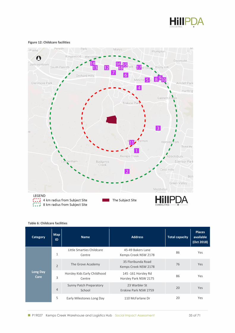
There is a variety of childcare and education facilities in close proximity to the Subject Site. In total, 33 childcare
facilities are present, 29 of which have capacity to take on new enrolments. There are seven primary schools,
four independent and three public. All of these schools have capacity to take on new enrolments. There are
four public secondary schools, one independent secondary school and one independent combined school, all of
which have capacity to take on new enrolments. There are also three specialist schools, which all have capacity.
The locations of these facilities are shown in Figure 3 and the details are outlined in
.
P19027 Kemps Creek Warehouse and Logistics Hub Social Impact Assessment
35 of 71 35 of 71
Figure 12: Childcare facilities
Table 6: Childcare facilities
Category Map
ID Name Address Total capacity
Places
available
(Oct 2018)
Long Day
Care
1 Little Smarties Childcare
Centre
45-49 Bakers Lane
Kemps Creek NSW 2178 86 Yes
2 The Grove Academy 35 Floribunda Road
Kemps Creek NSW 2178 76 Yes
3 Horsley Kids Early Childhood
Centre
145 -161 Horsley Rd
Horsley Park NSW 2175 86 Yes
4 Sunny Patch Preparatory
School
23 Warbler St
Erskine Park NSW 2759 20 Yes
5 Early Milestones Long Day 110 McFarlane Dr 20 Yes
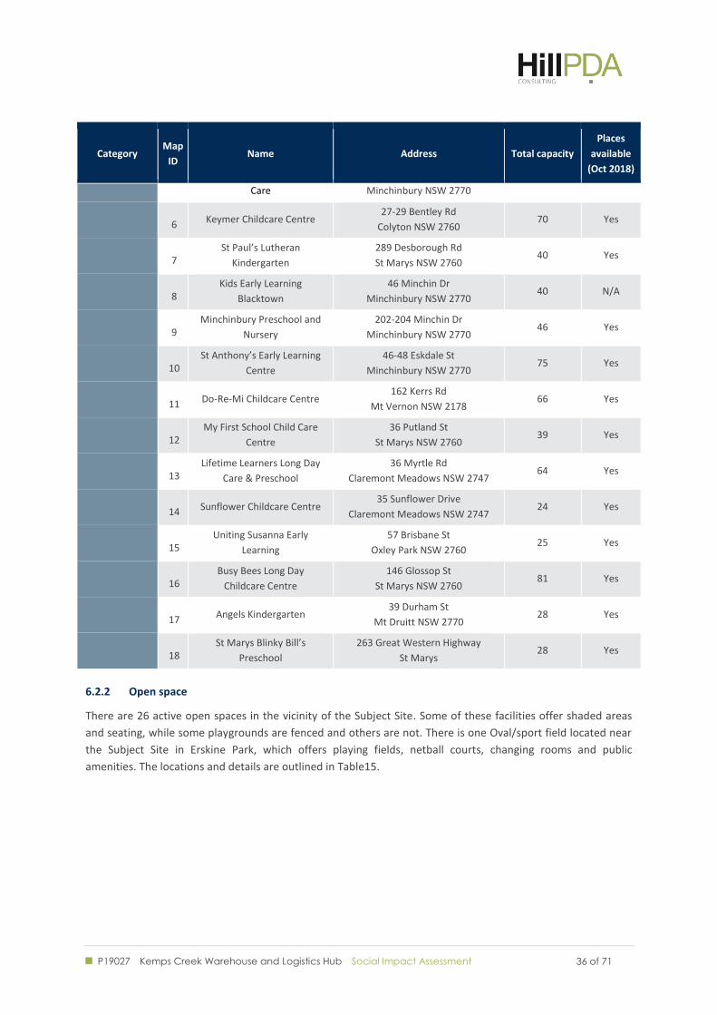
P19027 Kemps Creek Warehouse and Logistics Hub Social Impact Assessment
36 of 71 36 of 71
Category Map
ID Name Address Total capacity
Places
available
(Oct 2018)
Care Minchinbury NSW 2770
6 Keymer Childcare Centre 27-29 Bentley Rd
Colyton NSW 2760 70 Yes
7 St Paul’s Lutheran
Kindergarten
289 Desborough Rd
St Marys NSW 2760 40 Yes
8 Kids Early Learning
Blacktown
46 Minchin Dr
Minchinbury NSW 2770 40 N/A
9 Minchinbury Preschool and
Nursery
202-204 Minchin Dr
Minchinbury NSW 2770 46 Yes
10 St Anthony’s Early Learning
Centre
46-48 Eskdale St
Minchinbury NSW 2770 75 Yes
11 Do-Re-Mi Childcare Centre 162 Kerrs Rd
Mt Vernon NSW 2178 66 Yes
12 My First School Child Care
Centre
36 Putland St
St Marys NSW 2760 39 Yes
13 Lifetime Learners Long Day
Care & Preschool
36 Myrtle Rd
Claremont Meadows NSW 2747 64 Yes
14 Sunflower Childcare Centre 35 Sunflower Drive
Claremont Meadows NSW 2747 24 Yes
15 Uniting Susanna Early
Learning
57 Brisbane St
Oxley Park NSW 2760 25 Yes
16 Busy Bees Long Day
Childcare Centre
146 Glossop St
St Marys NSW 2760 81 Yes
17 Angels Kindergarten 39 Durham St
Mt Druitt NSW 2770 28 Yes
18 St Marys Blinky Bill’s
Preschool
263 Great Western Highway
St Marys 28 Yes
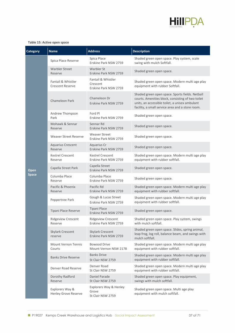
6.2.2 Open space
There are 26 active open spaces in the vicinity of the Subject Site. Some of these facilities offer shaded areas
and seating, while some playgrounds are fenced and others are not. There is one Oval/sport field located near
the Subject Site in Erskine Park, which offers playing fields, netball courts, changing rooms and public
amenities. The locations and details are outlined in Table15.
P19027 Kemps Creek Warehouse and Logistics Hub Social Impact Assessment
37 of 71 37 of 71
Table 15: Active open space
Category Name Address Description
Open Space
Spica Place Reserve Spica Place Erskine Park NSW 2759
Shaded green open space. Play system, scale swing with mulch Softfall.
Warbler Street Reserve
Warbler St Erskine Park NSW 2759
Shaded green open space.
Fantail & Whistler Crescent Reserve
Fantail & Whistler Crescent Erskine Park NSW 2759
Shaded green open space. Modern multi age play equipment with rubber Softfall.
Chameleon Park Chameleon Dr
Erskine Park NSW 2759
Shaded green open space. Sports fields. Netball courts. Amenities block, consisting of two toilet units, an accessible toilet, a unisex ambulant facility, a small service area and a store room.
Andrew Thompson Park
Ford Pl Erskine Park NSW 2759
Shaded green open space.
Mohawk & Sennar Reserve
Sennar Rd Erskine Park NSW 2759
Shaded green open space.
Weaver Street Reserve Weaver Street Erskine Park NSW 2759
Shaded green open space.
Aquarius Crescent Reserve
Aquarius Cr Erskine Park NSW 2759
Shaded green open space.
Kestrel Crescent Reserve
Kestrel Crescent Erskine Park NSW 2759
Shaded green open space. Modern multi age play equipment with rubber softfall.
Capella Street Park Capella Street Erskine Park NSW 2759
Shaded green open space.
Columba Place Reserve
Columba Place Erskine Park NSW 2759
Shaded green open space.
Pacific & Phoenix Reserve
Pacific Rd Erskine Park NSW 2759
Shaded green open space. Modern multi age play equipment with rubber softfall.
Peppertree Park Gough & Lucas Street
Erskine Park NSW 2759
Shaded green open space. Modern multi age play equipment with rubber softfall.
Tipani Place Reserve Tipani Place Erskine Park NSW 2759
Shaded green open space.
Ridgeview Crescent Reserve
Ridgeview Crescent Erskine Park NSW 2759
Shaded green open space. Play system, swings with mulch softfall.
Skylark Crescent reserve
Skylark Crescent Erskine Park NSW 2759
Shaded green open space. Slides, spring animal, leap frog, log roll, balance beam, and swings with mulch softfall.
Mount Vernon Tennis Courts
Bowood Drive Mount Vernon NSW 2178
Shaded green open space. Modern multi age play equipment with rubber softfall.
Banks Drive Reserve Banks Drive
St Clair NSW 2759
Shaded green open space. Modern multi age play equipment with rubber softfall.
Denver Road Reserve Denver Road St Clair NSW 2759
Shaded green open space. Modern multi age play equipment with rubber softfall.
Dorothy Radford Reserve
Daniel Parade St Clair NSW 2759
Shaded green open space. Play equipment, swings with mulch softfall.
Explorers Way & Henley Grove Reserve
Explorers Way & Henley Grove St Clair NSW 2759
Shaded green open space. Multi age play equipment with mulch softfall.
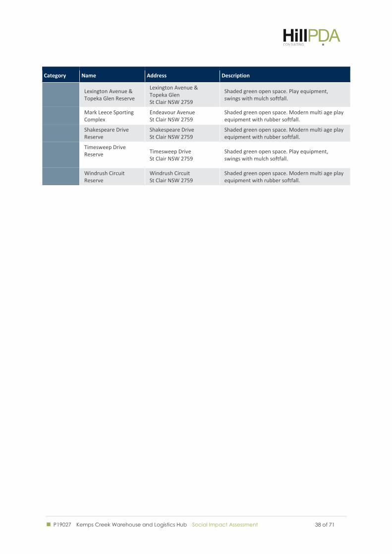
P19027 Kemps Creek Warehouse and Logistics Hub Social Impact Assessment
38 of 71 38 of 71
Category Name Address Description
Lexington Avenue & Topeka Glen Reserve
Lexington Avenue & Topeka Glen St Clair NSW 2759
Shaded green open space. Play equipment, swings with mulch softfall.
Mark Leece Sporting Complex
Endeavour Avenue St Clair NSW 2759
Shaded green open space. Modern multi age play equipment with rubber softfall.
Shakespeare Drive Reserve
Shakespeare Drive St Clair NSW 2759
Shaded green open space. Modern multi age play equipment with rubber softfall.
Timesweep Drive Reserve
Timesweep Drive St Clair NSW 2759
Shaded green open space. Play equipment, swings with mulch softfall.
Windrush Circuit Reserve
Windrush Circuit St Clair NSW 2759
Shaded green open space. Modern multi age play equipment with rubber softfall.
P19027 Kemps Creek Warehouse and Logistics Hub Social Impact Assessment
39 of 71 39 of 71
STAKEHOLDER VIEWS
P19027 Kemps Creek Warehouse and Logistics Hub Social Impact Assessment
40 of 71 40 of 71
7.0 STAKEHOLDER VIEWS
Willowtree Planning have undertaken a consultation process with government and community stakeholders.
Under the SEARs, a detailed community and stakeholder engagement strategy is required for the Proposed
Development. The consultation strategy was formulated in three key steps: stakeholder identification,
consultation, addressing issues raised and reporting on consultation strategy outcomes and an outline for
future consultation to be undertaken.
The key plank of the consultation strategy is providing information on the Proposed Development through
various communication tools and activities. The intent of the consultation strategy is to outline the way in
which open, transparent and ongoing (key stakeholder and community) engagement will continue to occur as
the Proposed Development motions through its progressive stages.
Stakeholder Identification 7.1
The consultation undertaken with community groups, individuals and Government agencies focused on
providing general project information with regard to the proposed development. The following stakeholders
were identified:
Local Government
o Penrith City Council
State Government
o Greater Sydney Commission
o Roads and Maritime Services
o Transport for NSW
o Office of Environment and Heritage
o Environment Protection Authority
o Fire and Rescue NSW
o NSW Rural Fire Service
o Department of Industry – Crown Lands and Water
o WaterNSW
o Sydney Water
Local Community Members
o See 7.1.3 Local Community Members.
All interactions throughout the process were recorded, with records included with the consultation strategy.
7.1.1 Local Government
Penrith City Council, as only LGA covering the Subject Site, was contacted as part of the consultation strategy.
An initial Pre-DA meeting was arranged in March 2018 to inform Council of the Proposed Development, with
two subsequent meetings following in August.
P19027 Kemps Creek Warehouse and Logistics Hub Social Impact Assessment
41 of 71 41 of 71
7.1.2 State Government Agencies
A formalised briefing was arranged with each of the following State Government Agencies: NSW Department of
Planning and Environment, Greater Sydney Commission, NSW Roads and Maritime Services, NSW Department
of Transport and Sydney Water. These briefings were primarily informational in nature, with any concerns
arising being incorporated as part of the ongoing development of the proposal.
7.1.3 Local Community Members
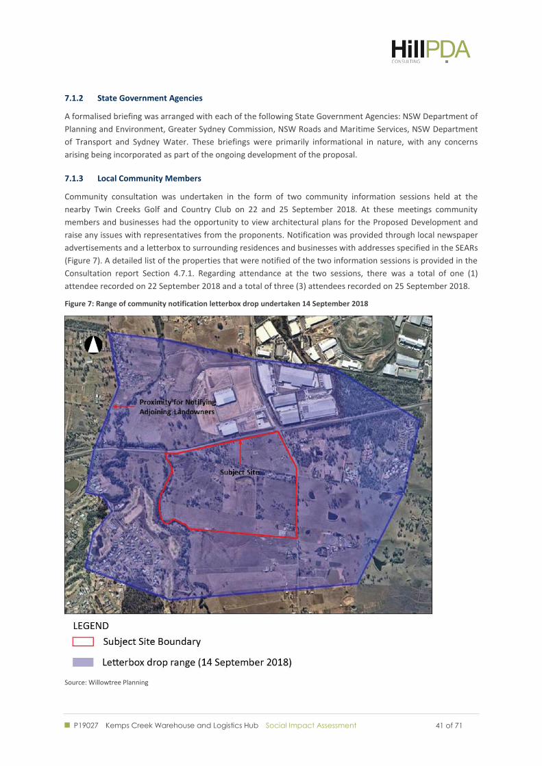
Community consultation was undertaken in the form of two community information sessions held at the
nearby Twin Creeks Golf and Country Club on 22 and 25 September 2018. At these meetings community
members and businesses had the opportunity to view architectural plans for the Proposed Development and
raise any issues with representatives from the proponents. Notification was provided through local newspaper
advertisements and a letterbox to surrounding residences and businesses with addresses specified in the SEARs
(Figure 7). A detailed list of the properties that were notified of the two information sessions is provided in the
Consultation report Section 4.7.1. Regarding attendance at the two sessions, there was a total of one (1)
attendee recorded on 22 September 2018 and a total of three (3) attendees recorded on 25 September 2018.
Figure 7: Range of community notification letterbox drop undertaken 14 September 2018
Source: Willowtree Planning
P19027 Kemps Creek Warehouse and Logistics Hub Social Impact Assessment
42 of 71 42 of 71
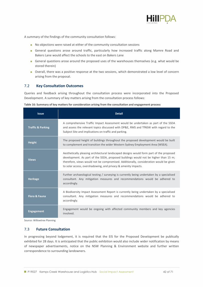
A summary of the findings of the community consultation follows:
No objections were raised at either of the community consultation sessions
General questions arose around traffic, particularly how increased traffic along Mamre Road and
Bakers Lane would affect the schools to the east on Bakers Lane
General questions arose around the proposed uses of the warehouses themselves (e.g. what would be
stored therein)
Overall, there was a positive response at the two sessions, which demonstrated a low level of concern
arising from the proposal.
Key Consultation Outcomes 7.2
Queries and feedback arising throughout the consultation process were incorporated into the Proposed
Development. A summary of key matters arising from the consultation process follows:
Table 16: Summary of key matters for consideration arising from the consultation and engagement process
Issue Detail
Traffic & Parking
A comprehensive Traffic Impact Assessment would be undertaken as part of the SSDA
and assess the relevant topics discussed with DP&E, RMS and TfNSW with regard to the
Subject Site and implications on traffic and parking.
Height The proposed height of buildings throughout the proposed development would be built
to complement and transition the wider Western Sydney Employment Area (WSEA).
Views
Aesthetically pleasing architectural landscaped designs would form part of the proposed
development. As part of the SSDA, proposed buildings would not be higher than 15 m;
therefore, views would not be compromised. Additionally, consideration would be given
to solar access, overshadowing, and privacy & amenity impacts.
Heritage
Further archaeological testing / surveying is currently being undertaken by a specialised
consultant. Any mitigation measures and recommendations would be adhered to
accordingly.
Flora & Fauna
A Biodiversity Impact Assessment Report is currently being undertaken by a specialised
consultant. Any mitigation measures and recommendations would be adhered to
accordingly.
Engagement Engagement would be ongoing with affected community members and key agencies
involved.
Source: Willowtree Planning
Future Consultation 7.3
In progressing beyond lodgement, it is required that the EIS for the Proposed Development be publically
exhibited for 28 days. It is anticipated that the public exhibition would also include wider notification by means
of newspaper advertisements, notice on the NSW Planning & Environment website and further written
correspondence to surrounding landowners.
P19027 Kemps Creek Warehouse and Logistics Hub Social Impact Assessment
43 of 71 43 of 71
In addition to this, in the event of approval, the proponents have stated their intent to continue with ongoing
community consultation in the interest of transparency, aligning with the wider aspiration for the Proposed
Development. This would entail a range of future communication activities taking place.
P19027 Kemps Creek Warehouse and Logistics Hub Social Impact Assessment
44 of 71 44 of 71
SOCIAL IMPACT
ASSESSMENT
P19027 Kemps Creek Warehouse and Logistics Hub Social Impact Assessment
45 of 71 45 of 71
8.0 SOCIAL IMPACT ASSESSMENT
This section details the potential social impacts to arise from the proposed development. The assessment is
informed by the analysis from the previous chapters and scoping of potential impacts using the Department of
Planning and Environment’s scoping template.
The assessment of social impacts uses the methodology described in section 1.4. Each potential impact is
assessed having regard for the level of impact (section 1.4.1), the likelihood of impact (section 1.4.2) and the
significance of impact (section 1.4.3).
Scoping 8.1
The social impacts to arise from the proposed development will be influenced by the existing situation, the
eventual consequences of the proposed development and measures put in place to mitigate against any
negative impacts and enhance positive impacts.
Social issues already in existence are relevant only as context, within which, the impacts of the proposed
subdivision must be examined.
Issues have been assessed based on their impact during the construction and operational period of the
development.
Social impacts can involve changes to:
Way of life
Community
Access to and use of infrastructure, services and facilities
Culture
Health and wellbeing
Surroundings
Personal and property rights
Decision making systems
Fears and aspirations.
The Department of planning and Environment’s Social Impact Assessment Guidelines contains a scoping tool
which has been applied to the proposed development. The completed scoping tool is included in Appendix A.
Area of influence 8.2
Social impacts of the proposed development may extend beyond the immediate surrounds.
Table 17: Area of influence of potential impacts
Impact type Local Community Broader Community
Amenity
Noise
Lighting
Odours
Increased truck movements on road network
Access New local roads Increased access to goods
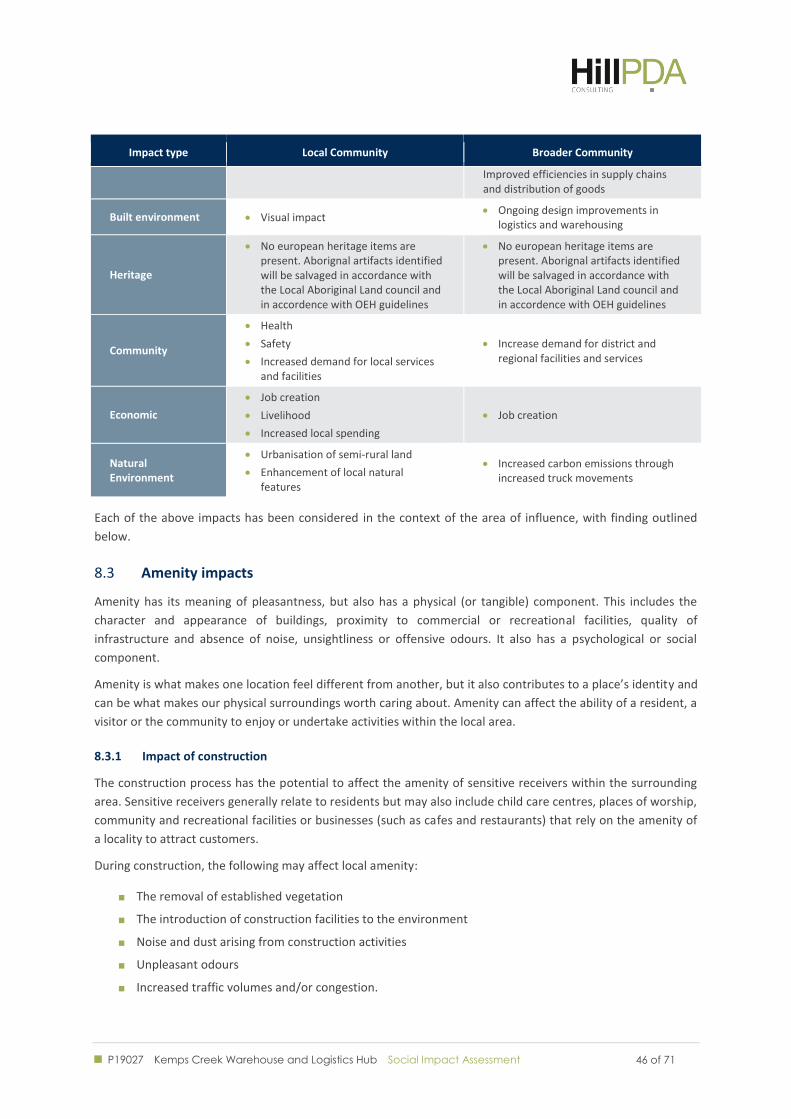
P19027 Kemps Creek Warehouse and Logistics Hub Social Impact Assessment
46 of 71 46 of 71
Impact type Local Community Broader Community
Improved efficiencies in supply chains and distribution of goods
Built environment Visual impact Ongoing design improvements in
logistics and warehousing
Heritage
No european heritage items are present. Aborignal artifacts identified will be salvaged in accordance with the Local Aboriginal Land council and in accordence with OEH guidelines
No european heritage items are present. Aborignal artifacts identified will be salvaged in accordance with the Local Aboriginal Land council and in accordence with OEH guidelines
Community
Health
Safety
Increased demand for local services and facilities
Increase demand for district and regional facilities and services
Economic
Job creation
Livelihood
Increased local spending
Job creation
Natural Environment
Urbanisation of semi-rural land
Enhancement of local natural features
Increased carbon emissions through increased truck movements
Each of the above impacts has been considered in the context of the area of influence, with finding outlined
below.
Amenity impacts 8.3
Amenity has its meaning of pleasantness, but also has a physical (or tangible) component. This includes the
character and appearance of buildings, proximity to commercial or recreational facilities, quality of
infrastructure and absence of noise, unsightliness or offensive odours. It also has a psychological or social
component.
Amenity is what makes one location feel different from another, but it also contributes to a place’s identity and
can be what makes our physical surroundings worth caring about. Amenity can affect the ability of a resident, a
visitor or the community to enjoy or undertake activities within the local area.
8.3.1 Impact of construction
The construction process has the potential to affect the amenity of sensitive receivers within the surrounding
area. Sensitive receivers generally relate to residents but may also include child care centres, places of worship,
community and recreational facilities or businesses (such as cafes and restaurants) that rely on the amenity of
a locality to attract customers.
During construction, the following may affect local amenity:
The removal of established vegetation
The introduction of construction facilities to the environment
Noise and dust arising from construction activities
Unpleasant odours
Increased traffic volumes and/or congestion.
P19027 Kemps Creek Warehouse and Logistics Hub Social Impact Assessment
47 of 71 47 of 71
Short term reduction in amenity may impact the existing residential properties within the immediate vicinity of
the site, however due to the distance of nearby properties disruption is likely to be minimised. Construction
impacts on local amenity are generally contained within close proximity to construction sites. Best practice for
construction in established residential areas is to include consultation with neighbouring residents to outline
expectations and standards.
A range of mechanisms can be applied to minimise any potential construction impacts on amenity. Such
mechanisms are typically required as a condition of development consent and are employed by most building
contractors and implemented through a Construction Management Plan. Such plans tend to focus on issues
such as demolition and construction staging, noise, air and water quality, construction traffic management,
pedestrian safety and site management. They include simple but effective measures such as screening, noise
mitigation at source and varying work hours.
These mechanisms can be as simple as avoiding noisy or disruptive construction activities during the hours
when residents are likely to want to enjoy surrounding open space or rest, for example on evenings and
weekends. Overall, the social impacts arising from construction are considered to be “minor” in the
circumstances.
With these mechanisms in place, it is deemed that the impacts would be minor and “unlikely” to affect those
nearby, presenting “low” social risk, with mitigation according to the social risk matrix (section 1.4.3).
8.3.2 Noise
Exposure to environmental noise may also affect the function of social and business services (both positively
and negatively), especially those that are dependent on a quiet environment. Noise impacts may also affect the
way people use space, their ability to communicate and the way individuals undertake daily activities. This
includes heightened annoyance, stress and sleep disturbance.
An acoustic assessment undertaken by Acoustic Works, dated November 2018 provides an assessment of the
noise impacts to arise from the Proposed Development. The surrounding area is primarily affected by road
traffic from Mamre Road and noise from existing nearby commercial/industrial activities.
The report considered existing ambient noise levels with readings taken at key sensitive locations surrounding
the Subject Site.
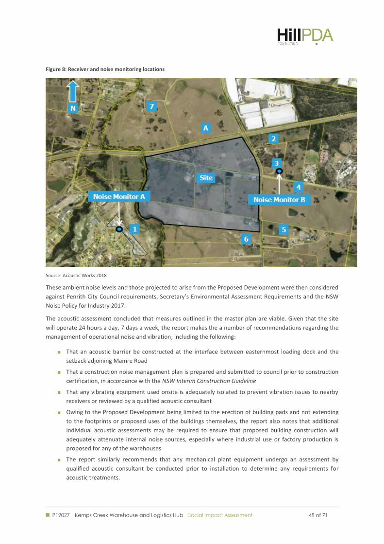
P19027 Kemps Creek Warehouse and Logistics Hub Social Impact Assessment
48 of 71 48 of 71
Figure 8: Receiver and noise monitoring locations
Source: Acoustic Works 2018
These ambient noise levels and those projected to arise from the Proposed Development were then considered
against Penrith City Council requirements, Secretary’s Environmental Assessment Requirements and the NSW
Noise Policy for Industry 2017.
The acoustic assessment concluded that measures outlined in the master plan are viable. Given that the site
will operate 24 hours a day, 7 days a week, the report makes the a number of recommendations regarding the
management of operational noise and vibration, including the following:
That an acoustic barrier be constructed at the interface between easternmost loading dock and the
setback adjoining Mamre Road
That a construction noise management plan is prepared and submitted to council prior to construction
certification, in accordance with the NSW Interim Construction Guideline
That any vibrating equipment used onsite is adequately isolated to prevent vibration issues to nearby
receivers or reviewed by a qualified acoustic consultant
Owing to the Proposed Development being limited to the erection of building pads and not extending
to the footprints or proposed uses of the buildings themselves, the report also notes that additional
individual acoustic assessments may be required to ensure that proposed building construction will
adequately attenuate internal noise sources, especially where industrial use or factory production is
proposed for any of the warehouses
The report similarly recommends that any mechanical plant equipment undergo an assessment by
qualified acoustic consultant be conducted prior to installation to determine any requirements for
acoustic treatments.
P19027 Kemps Creek Warehouse and Logistics Hub Social Impact Assessment
49 of 71 49 of 71
On the basis of the findings of the acoustic assessment, HillPDA identifies noise as an “unlikely” and “minor”
negative impact. Adoption of the measures identified in the acoustic assessment will help mitigate any
potential negative social impacts stemming from noise in the immediate area. As such, noise is deemed to
present “low” social risk on the social risk matrix (section 1.4.3).
8.3.3 Noise Arising from Additional Traffic
The properties most likely to be affected by increased vehicle noise are identified as those to the north and
south of the Proposed Development on Mamre Road. Businesses along Mamre Road are largely industrial in
nature. Housing along Mamre Road to the north of the Proposed Development is set back from the road and as
such less susceptible to vehicle noise.
An acoustic assessment of the Proposed Development has been undertaken by Acoustic Works dated
November 2018. It identifies that the Proposed Development is predicted to produce an additional 14,000
vehicle movements per day. The existing annual average daily traffic volume for Mamre Road is approximately
20,000 vehicles per day. The acoustic assessment carried out an evaluation using the methodology outlined in
RMS Guide to Traffic Generating Developments. The assessment concludes that:
The existing annual average daily traffic volume for Mamre Road is approximately 20,000 vehicles
per day. In accordance with the RTA Guide to Traffic Generating Developments, the proposed
warehouse development is predicted to produce an additional 14,000 vehicle movements per day.
Therefore, based on the available information, the predicted increase in daily LAeq(15hr) for
receivers near Mamre Road is calculated to be 3dB(A) due to traffic generation by the proposed
development, which complies with the criterion of +12dB(A). (our emphasis)
The Proposed Development will result in a significant increase in road movements compared to the current
situation, such that there is likely to be a noticeable increase in traffic noise. However, based on the results of
the acoustic assessment, the noise impacts arising from additional traffic are not likely to have an unacceptable
impact to neighbouring businesses and residents. Consequently, the potential impact of the Proposed
Development is rated as “moderate” using the criteria outlined in Section 1.4.
As the predicted noise arising from the increase in traffic is within acceptable limits, the traffic noise arising
from the proposed development presents an “unlikely” social risk using the criteria outlined in section 4. This is
based on the findings of Acoustic Works which indicates that at the sensitive receivers, including residences,
traffic noise will be below the criteria for acceptable noise limits.
Overall, the significance of potential impacts arising from traffic noise associated with the proposed
development is considered to be “moderate” using the social risk matrix in section 1.4.3.
Monitoring of the impacts on surrounding residences could be undertaken to ensure that noise is not
impacting on residents way of life and if so that effective management steps be undertaken (e.g. imposing
curfews on vehicle movements or the introduction of physical noise breaks). Future development of the site
will be subject to further development applications, providing an opportunity for further assessment and
monitoring of traffic noise impacts. In the longer term, planning for noise mitigation devices will also be
considered by RMS as part of its proposed expansion of Mamre Road.
8.3.4 Light
Light spill maps have been produced and are provided at Appendix B. The maps demonstrate that the
proposed development complies with the relevant Australian Standards. On this basis, it is considered unlikely
that the Proposed Development would produce any impacts to amenity through light spill. Further, the
proposed development will not impact on surrounding properties or residents through obtrusive light glare or
P19027 Kemps Creek Warehouse and Logistics Hub Social Impact Assessment
50 of 71 50 of 71
spill. Based on feedback received through the consultation process, neither community nor government
stakeholders raised any issues with proposed lighting.
Based on light spill maps, light is assessed to of “minimal” consequence and an “unlikely” impact, presenting a
“low” social risk using the social risk mix in section 1.4.3.
The Proponent has committed to managing light spill through the strategic location and direction of outdoor
lighting. With consideration to the distance of surrounding neighbours, the proponent is considered to be able
manage any potential light spill through sensitive design.
8.3.5 Odour
It is unlikely that the Proposed Development will impact amenity in the surrounding area through odour. No
impacts from odours have been identified from the operations of the Proposed Development and no concerns
in this regard have been raised as part of the consultation process.
An Air Quality assessment has been prepared by North Star Air Quality, dated October 2018, which concluded
that:
There was a low risk of health or nuisance impacts during construction works
The operation of the Proposal does not cause any exceedances of the air quality criteria, even with the
addition of background air pollutant concentrations representative of the area.
Further, the air quality report suggests that the application should not be refused on the grounds of air quality.
As air quality is expected to remain within acceptable standards, the Proposed Development is unlikely to
adversely impact on people’s way of life, health or wellbeing. The potential for impacts to arise from odours is
considered to be “minimal” and “unlikely”. Overall, odour presents a “low” social risk on the social risk matrix
at section 1.4.2.
As this application concerns the establishment of building pads within the Warehousing and Logistics Hub, the
proposed individual uses on site will be subject to future development assessments, providing a future
opportunity to consider potential impacts to amenity from odour.
Access 8.4
8.4.1 Access to Property
The Proposed Development is likely to positively impact upon access to public or private property.
Regarding vehicular traffic, the warehouses and offices in Proposed Development will only be accessed via the
internal estate roads, meaning there will be no obstruction on existing roads. During the community
consultation, the Proposed Development’s impact on access to the nearby schools on Bakers Lane to the east
was queried.
For vehicles, the short term improvements to the intersection of Bakers Road and Mamre Road will be positive.
At present, the intersection is signalised in only three directions, with a stop sign facing the western approach.
The addition of a fourth traffic signal will improve the functioning and safety of this intersection.
Pedestrian access will also be positively impacted by the Proposed Development. Presently the intersection of
Mamre Road and Bakers Lane has no signalised pedestrian crossing facility. Works included as part of the
Proposed Development will result in the upgrade of this intersection and the addition of a signalised pedestrian
crossing, thereby improving pedestrian access, which is particularly important given the presences of the
schools and college on Bakers Lane.
P19027 Kemps Creek Warehouse and Logistics Hub Social Impact Assessment
51 of 71 51 of 71
As such, the proposal is deemed to present a “low” social risk, with some positive impacts on access.
8.4.2 Utilities
The Proposed Development is unlikely to negatively impact access to utilities. Utilities are available from
Mamre Road, including water, sewer, electricity and communications. The Proposed Development also
includes rainwater tanks on site to collect run-off from the roof areas for re-use on site and thereby minimise
the amount of potable water consumed. The proponent is consulting with Sydney Water and NSW Water.
Overall, the potential impact is negligible. The proposal presents “low” social risk.
8.4.3 Road, Rail and Public Transport
A Traffic Impact Assessment has been prepared by Ason Group in relation to the Proposed Development. The
report details modelling undertaken to assess the impact of the proposal on the performance of the road
network in the proximity of the Subject Site and, where required, identify necessary upgrades to mitigate any
adverse impacts.
The report concluded:
That the proposed traffic volumes arising from Stage 1 of the Proposed Development will not have a
material impact on the surrounding road network
That parking provided for each land parcel will generally provide more than sufficient car parking
spaces to satisfy RMS parking requirements
That future development in the area may require the acceleration of planned road upgrades by RMS, to
accommodate additional road traffic, particularly proposed upgrades to Mamre Road.
An assessment of impacts on access to rail or public transport access is not applicable as neither is present near
the Subject Site.
With consideration of these points, the potential impacts to transport are “minor.” The likelihood of transport
impacts is considered “possible” pending road upgrades in the area. The overall social risk to transport is
considered to be “moderate”. It will be important for authorities to monitor development of the surrounds so
that improvements to the road network are appropriately scheduled to minimise the potential for impacts.
Built Environment 8.5
8.5.1 Public Domain
The audit of existing social infrastructure found that there are no parks or public spaces with proximity to the
subject site that would be materially affected by the activities proposed in the Proposal. Any potential impacts
to the public domain will be confined to roadways and the amenity of the domain immediately surrounding
them (eg footpaths).
The traffic management and acoustic reports cited above indicate that any amenity impacts are likely to be
minimal on these areas which are not presently used by pedestrians, and traffic impacts have been effectively
managed in the Traffic Impact Assessment. As such, the impact on the public domain is assessed as being
“minor” with an “unlikely” likelihood and is deemed to present “low” social risk.
Landscaping proposed as part of the street works along the Mamre Road frontage could yield some
improvement to the public domain. The addition of the estate roads will extend the public domain within the
Subject Site, where there is presently little existing.
P19027 Kemps Creek Warehouse and Logistics Hub Social Impact Assessment
52 of 71 52 of 71
The impact of the proposed development to public domain is considered to be “unlikely” and with a “minor”
level of consequence. Overall the Proposed Development presents a “low” social risk to the public domain on
the social risk matrix.
8.5.2 Public infrastructure
The proposed development is likely to positively impact on public infrastructure. The proposed enhancements
to the local road network with landscaping along Mamre Road and improvements to the traffic lights at the
intersection of Mamre Road and Bakers Lane offer substantial improvements to those existing pieces of
infrastructure. Further improvements accompanying later stages of the development further add to these
potential positive impacts. The possible impacts in this regard are largely positive, with low social risks.
Heritage 8.6
There are no known heritage items or artefacts on site and therefore the Proposed Development is unlikely to
negatively impact upon heritage.
The SEARs require an Aboriginal Cultural Heritage Assessment Report to be considered as part of the EIS.
The SEARs also require the proponent is required to carry undertake an assessment of European Heritage
including potential impacts on the surrounding site and surrounding area, including any built landscape items,
conservation areas, views and settings.
The conclusion of this segment is contingent upon the findings of those reports.
Community 8.7
8.7.1 Health
The potential for increased risk to health has been considered including risk arising from disposal of waste,
increased traffic emissions and dust during construction. There are no waste activities associated with the
Proposed Development that will impact on surrounding properties. Traffic movements could potentially
generate additional emissions, which could impact on the health of communities surrounding Mamre Road to
the north and south, however this presents a low level of risk due to the minimal number of pedestrianised
areas that front this road and the relative isolation along the length that would be impacted by additional
traffic. In relation to dust during constructions, the air quality report by Northstar Air Quality reports that:
The assessment showed there to be a low risk of health or nuisance impacts during construction
works.
And further:
The sensitivity of the surrounding area to health effects and dust soiling may be identified as
being low.
Overall, the potential health impacts to arise from the Proposed Development are considered to present an
“unlikely” risk to the community of “minimal” level impacts using the criteria in section 1.4. Overall, the
Proposal presents a “low” social risk to the health and wellbeing of the wider community (section 1.4.3). It will
be important for waste management procedures and operational practices to ensure that the potential for
health impacts to workers is minimised.
8.7.2 Safety
Developments can increase or decrease perceived and actual safety. The earlier investigation of the community
identified no crime in the immediate area, which was a likely outcome of the relative remoteness of the region
P19027 Kemps Creek Warehouse and Logistics Hub Social Impact Assessment
53 of 71 53 of 71
and its semi-rural character. The Proposed Development is unlikely to change this, with the proposed
warehouses being secure and illuminated. The activation of the area as an industrial and logistics precinct may
also restrict the development of negative perceptions of safety in the area.
The Traffic Impact Assessment (Appendix 8) prepared as part of the EIS confirms that the design conforms to
standards required for emergency vehicle access, confirming that “the design includes consideration for
emergency vehicles, in particular the provision of a fire trail (where required) around the perimeter of each
warehouse building.”
Potential flood impacts have been analysed as part of the Overland Flow Report by Costin Roe Consulting dated
December 2018. This report includes modelling of flooding events with 5 per cent, 2 per cent, 1 per cent and
0.5 per cent annual exceedance probability (AEP), advice on the conformity of the flood planning level in
accordance with Penrith Council guidelines, and confirmation of the probable maximum flood (PMF) storm
event with discussion around evacuation in that scenario.
The Overland Flow Report states that there is sufficient capacity and time for either safe egress of occupants
offsite or to an onsite refuge during a major flood event. The levels over the site are proposed at greater than
500mm above the 1% AEP storm event which allows several hours of flood warning response time. Also, at
least 80% of the developed site will be above the PMF flood event. Given there is less than 1 kilometre from
the flood affected zone to a PMF free area of the site, occupants could move to flood free land in only minutes.
On the basis of the above, the potential risks to safety of the proposed development are considered to be
“unlikely” with “minimal” level of impact. The Proposed Development presents a “low” social risk in terms of
safety on the social risk matrix (section 1.4.3).
8.7.3 Services and Facilities
The Proposed Development concerns the construction of warehousing and logistics facilities being a place of
employment. Given the limited social infrastructure offer in the immediate area, it is anticipated that
employees would accessing some social infrastructure at their area of residence.
The long day care and preschool facilities in the wider area have capacity of cater for the potential extra
demand from before and after work pickup and drop-off. Consequently the impact of the additional workers
would be minimal. It is also feasible that with the staged nature of the Proposed Development, and the
warehouses and offices themselves being constructed on an individual basis, the increase in demand for
relevant services and facilities will be gradual.
Overall, the proposed development is likely to result in a modest increase to the demand for social
infrastructure in the local community. A slight mismatch between demand and supply could occur in the short
term, however, plans to provide social infrastructure on-site would remedy this. The existing social
infrastructure in the surrounds has capacity to accommodate short term needs. On this basis, the proposed
development is considered to have an “unlikely” and “minor” level of impact. On the social risk matrix, the
proposed development presents a “low” risk in terms of social infrastructure.
8.7.4 Cohesion, capital and resilience
Community cohesion refers to the connections and relationships between individuals and their
neighbourhoods. A socially cohesive society is one which works towards the wellbeing of all its members, fights
exclusion and marginalisation, creates a sense of belonging, promotes trust and offers its members the
opportunity of upward mobility.
The Proposed Development concerns the construction of a warehouse and logistics hub in a sparsely populated
semi-rural area undergoing a rapid process of industrialisation. The Subject Site is identified as part of the
P19027 Kemps Creek Warehouse and Logistics Hub Social Impact Assessment
54 of 71 54 of 71
Broader Western Sydney Employment Area and the Western Sydney Aerotropolis, both regions earmarked for
substantial growth and economic development. As such, the Proposed Development is in line with broader
changes throughout the region, as well as in keeping with the growing logistics and warehousing developments
to the north and north-east of the Subject Site.
Based on feedback gathered through the community and stakeholder engagement process, the Proposed
Development is seen as encouraging for the local and wider regional community, who stand to benefit from the
extra employment. In creating additional employment opportunities, the Proposed Development will positively
impact on cohesion by adding to opportunities for meaningful engagement in the workforce. The proposed
development also creates more opportunities for residents in the area to work closer to home, thereby adding
to time that they can spend in their families and communities.
Overall, the Proposed Development is considered “likely” to have “major” positive impacts on the wider
community. Consequently, the proposed development has an “extreme” but positive social risk on the social
risk matrix (section 1.4.3).
8.7.5 Housing
The community survey revealed that residents in the Penrith LGA tend to commute further to their place of
work. The Proposed Development creates employment opportunities in that region, closer to workers’ homes.
Moreover Western Sydney has an expanding population and the Subject Site is strategically located in a region
intended to supply employment for that housing expansion.
The Proposed development is not anticipated to negatively impact on housing and therefore presents a “rare”
and “minimal” level of impact for housing. The Proposed Development presents a “low” social risk on the
social risk matrix (section 1.4.3).
Economic 8.8
The proposal would affect the local and regional economy both during construction and operation. The extents
of economic effects are discussed in the following sections.
8.8.1 Natural Resource Use
No significant natural resources have been identified on the Subject Site with the exception of South Creek
along its western border. The Proposed Development includes measures to mitigate the developments impact
on South Creek including the construction of a storm water detention and bio-retention basin, planting
throughout the site and revegetation of areas along the creek bank, thereby providing natural filtration and
enhancing the ecological value of the waterway. The proposed rainwater tanks will also assist with the volume
of unfiltered runoff into the creek.
Overall, the Proposed Development may positively impact natural resources by preserving South Creek and
enhancing its ecological value. The proposed development is considered to present a “likely” and “moderate –
positive impact. It is assessed to have “high” but positive social impact on the social risk matrix (section 1.4.3).
8.8.2 Livelihood
Livelihood is defined as a person's ability to make a living. In the context of the proposed development it is
useful to consider these impacts as generated during the construction phase and then during operation.
The construction of the development is expected to have short and long-term benefits with respect to
construction employment and the purchase of materials. During construction, the proposed development
P19027 Kemps Creek Warehouse and Logistics Hub Social Impact Assessment
55 of 71 55 of 71
would generate additional construction jobs. Local centres are also likely to benefit from increased
construction related trade.
The construction industry is a significant component of the economy, accounting for 6.7% of Gross Domestic
Product (GDP) and employing almost one million workers across Australia. The industry has strong linkages
with other sectors, so its impact on the economy goes further than the direct contribution of construction. It is
also the largest employer of residents in the Horsley Park – Kemps Creek SA2.
It is projected that the construction of Stage 1 of the Proposed Development will generate in the order of 500
full time jobs, with a further 1,000 construction jobs to be generated by subsequent stages (subject to future
applications).
With regard to the operation of the Proposed Development, Stage 1 of the proposed warehouse and logistics
hub is projected to generate in the order of 800 jobs when completed with the potential for around 2,500 at
full development.
The secondary benefits of this new employment will be money invested into businesses and services across the
region. This new expenditure will benefit and grow local economies, generating further employment in service
industries.
The Proposed Development stands to make a very positive contribution to the livelihood of residents across
the wider region, creating new employment opportunities closer to residents’ homes. The proposed
development is considered “likely” to have a “moderate” level of impact and as such, presents a “high” and
positive social impact for livelihood (section 1.4.3).
8.8.3 Opportunity cost
Opportunity cost is defined as the real marginal cost of a resource or action, or the value forgone by using the
resource or by acting in one way rather than another. The Subject Site has historically been used for
rural/residential purposes. The low intensity of this usage means that virtually all economic and employment
opportunities are foregone by not acting. In the context of Western Sydney’s current rapid expansion and the
opportunities that arise from the establishment of Western Sydney Airport, the opportunity cost of not acting
would be substantial.
Natural Environment 8.9
For the purposes of Social Impact Assessment, impacts to the natural environment are considered in the way
that peoples’ surroundings are affected, including access to and use of ecosystem services, public safety and
security, access to and use of the natural and built environment and their aesthetic value and/or amenity.
The Environmental Impact Statement includes a plan of management for the site that effectively addresses
potential impact arising from air, biodiversity, land and water on site.
Mitigation Measures and Monitoring 8.10
As part of the preparation of an EIS for the Proposed Development, comprehensive reporting has been
undertaken in a variety of possible short and long term impacts by construction and operation. Owing to the
Subject Site’s relative isolation and the Proposed Development not concerning the usage of the warehouses
themselves, the need for ongoing monitoring is minimal until subsequent development is undertaken on the
constituent blocks.
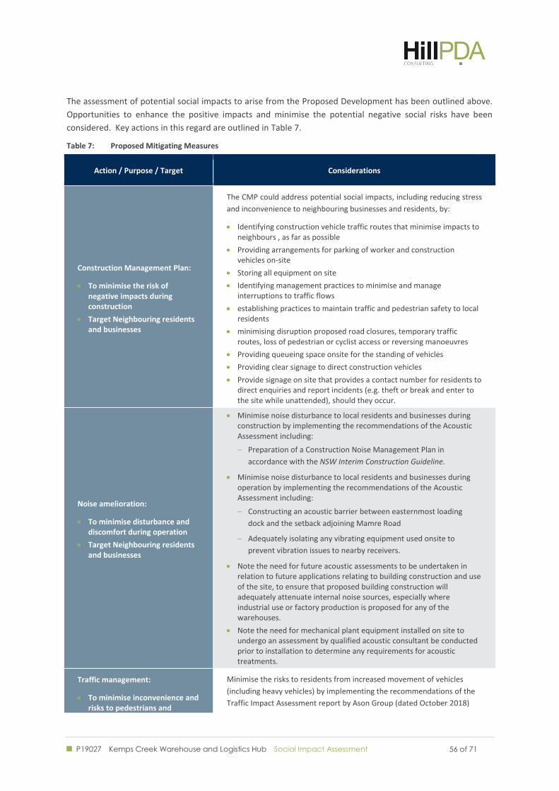
P19027 Kemps Creek Warehouse and Logistics Hub Social Impact Assessment
56 of 71 56 of 71
The assessment of potential social impacts to arise from the Proposed Development has been outlined above.
Opportunities to enhance the positive impacts and minimise the potential negative social risks have been
considered. Key actions in this regard are outlined in Table 7.
Table 7: Proposed Mitigating Measures
Action / Purpose / Target Considerations
Construction Management Plan:
To minimise the risk of negative impacts during construction
Target Neighbouring residents and businesses
The CMP could address potential social impacts, including reducing stress
and inconvenience to neighbouring businesses and residents, by:
Identifying construction vehicle traffic routes that minimise impacts to neighbours , as far as possible
Providing arrangements for parking of worker and construction vehicles on-site
Storing all equipment on site
Identifying management practices to minimise and manage interruptions to traffic flows
establishing practices to maintain traffic and pedestrian safety to local residents
minimising disruption proposed road closures, temporary traffic routes, loss of pedestrian or cyclist access or reversing manoeuvres
Providing queueing space onsite for the standing of vehicles
Providing clear signage to direct construction vehicles
Provide signage on site that provides a contact number for residents to direct enquiries and report incidents (e.g. theft or break and enter to the site while unattended), should they occur.
Noise amelioration:
To minimise disturbance and discomfort during operation
Target Neighbouring residents and businesses
Minimise noise disturbance to local residents and businesses during construction by implementing the recommendations of the Acoustic Assessment including:
– Preparation of a Construction Noise Management Plan in
accordance with the NSW Interim Construction Guideline.
Minimise noise disturbance to local residents and businesses during operation by implementing the recommendations of the Acoustic Assessment including:
– Constructing an acoustic barrier between easternmost loading
dock and the setback adjoining Mamre Road
– Adequately isolating any vibrating equipment used onsite to
prevent vibration issues to nearby receivers.
Note the need for future acoustic assessments to be undertaken in relation to future applications relating to building construction and use of the site, to ensure that proposed building construction will adequately attenuate internal noise sources, especially where industrial use or factory production is proposed for any of the warehouses.
Note the need for mechanical plant equipment installed on site to undergo an assessment by qualified acoustic consultant be conducted prior to installation to determine any requirements for acoustic treatments.
Traffic management:
To minimise inconvenience and risks to pedestrians and
Minimise the risks to residents from increased movement of vehicles
(including heavy vehicles) by implementing the recommendations of the
Traffic Impact Assessment report by Ason Group (dated October 2018)
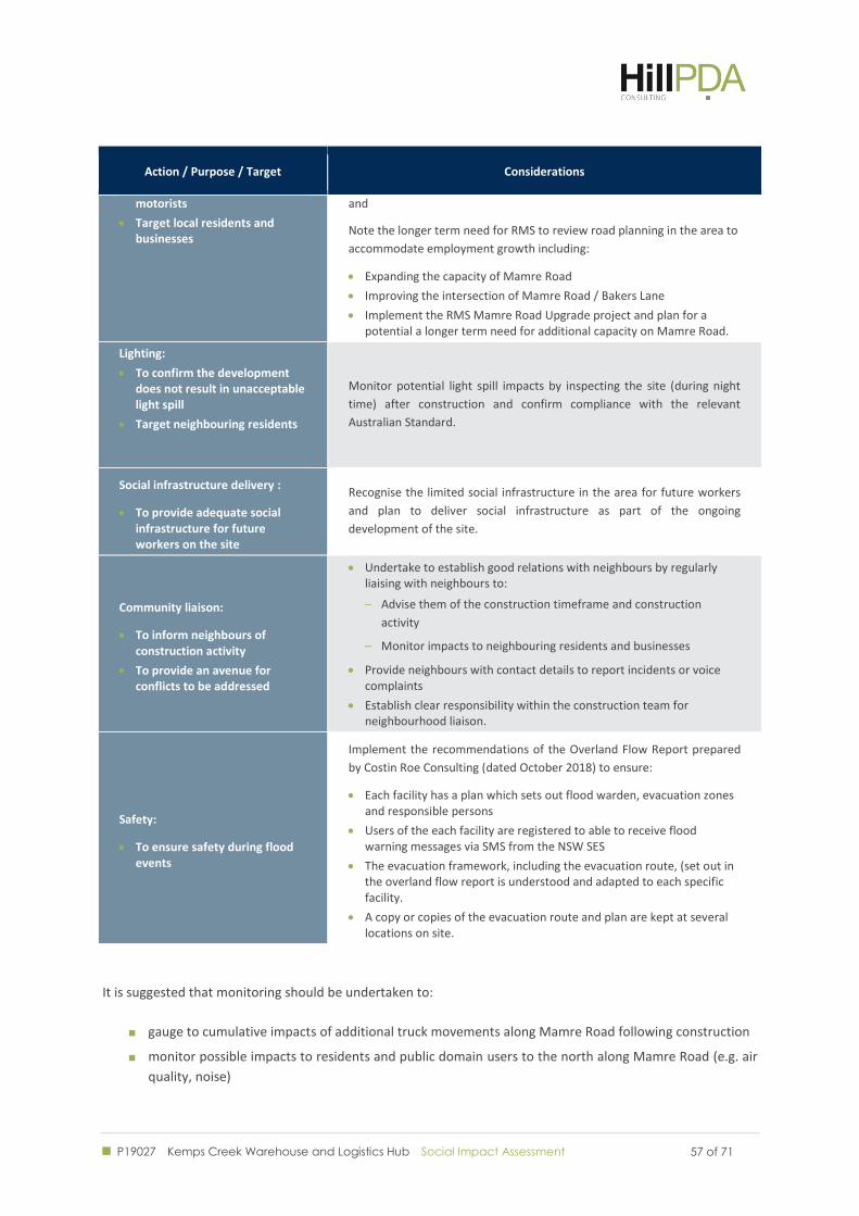
P19027 Kemps Creek Warehouse and Logistics Hub Social Impact Assessment
57 of 71 57 of 71
Action / Purpose / Target Considerations
motorists
Target local residents and businesses
and
Note the longer term need for RMS to review road planning in the area to
accommodate employment growth including:
Expanding the capacity of Mamre Road
Improving the intersection of Mamre Road / Bakers Lane
Implement the RMS Mamre Road Upgrade project and plan for a potential a longer term need for additional capacity on Mamre Road.
Lighting:
To confirm the development does not result in unacceptable light spill
Target neighbouring residents
Monitor potential light spill impacts by inspecting the site (during night
time) after construction and confirm compliance with the relevant
Australian Standard.
Social infrastructure delivery :
To provide adequate social infrastructure for future workers on the site
Recognise the limited social infrastructure in the area for future workers
and plan to deliver social infrastructure as part of the ongoing
development of the site.
Community liaison:
To inform neighbours of construction activity
To provide an avenue for conflicts to be addressed
Undertake to establish good relations with neighbours by regularly liaising with neighbours to:
– Advise them of the construction timeframe and construction
activity
– Monitor impacts to neighbouring residents and businesses
Provide neighbours with contact details to report incidents or voice complaints
Establish clear responsibility within the construction team for neighbourhood liaison.
Safety:
To ensure safety during flood events
Implement the recommendations of the Overland Flow Report prepared
by Costin Roe Consulting (dated October 2018) to ensure:
Each facility has a plan which sets out flood warden, evacuation zones and responsible persons
Users of the each facility are registered to able to receive flood warning messages via SMS from the NSW SES
The evacuation framework, including the evacuation route, (set out in the overland flow report is understood and adapted to each specific facility.
A copy or copies of the evacuation route and plan are kept at several locations on site.
It is suggested that monitoring should be undertaken to:
gauge to cumulative impacts of additional truck movements along Mamre Road following construction
monitor possible impacts to residents and public domain users to the north along Mamre Road (e.g. air
quality, noise)

P19027 Kemps Creek Warehouse and Logistics Hub Social Impact Assessment
58 of 71 58 of 71
Monitor traffic levels to ensure that the efficiency of the road network is maintained ahead of any
planned further enhancement
Monitor the need for road maintenance in the surrounds.
Ongoing responsive community engagement will assist in determining if existing mitigation measures are
sufficient for those communities upstream.
Ongoing monitoring should be considered as part of any future additions to the Proposed Development,
particularly for any future uses that might negatively impact upon the surrounding area.
P19027 Kemps Creek Warehouse and Logistics Hub Social Impact Assessment
59 of 71 59 of 71
CONCLUSIONS
P19027 Kemps Creek Warehouse and Logistics Hub Social Impact Assessment
60 of 71 60 of 71
9.0 CONCLUSION
Approval is being sought for the construction of a warehouse and logistics hub at 657-769 Mamre Road, Kemps
Creek. Stage 1 development including construction of 163,671 sqm of warehouse space with associated office
and space for warehousing and logistics uses, 816 car parking spaces.
The proposal has been assessed having regard for the requirements of the Department of Planning and
Environment’s Social Impact Assessment Guidelines, local demography and the community’s views. The
potential for negative impacts to arise from construction, noise an increased traffic has been identified.
However, these impacts are able to be appropriately managed and mitigated. Mitigation measures have been
proposed.
Potential benefits arising from the development include:
Job creation, with a projected 500 jobs created during construction and a further 800 when
operational
Improved work-life balance for residents in the region where commutes are typically longer through
the creation of local employment opportunities.
Overall, the proposal is supported.
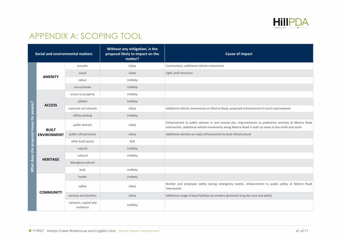
P19027 Kemps Creek Warehouse and Logistics Hub Social Impact Assessment 61 of 71
: SCOPING TOOL APPENDIX A
Social and environmental matters Without any mitigation, is the
proposal likely to impact on the matter?
Cause of impact
Wh
at d
oe
s th
e p
rop
osa
l me
an f
or
pe
op
le?
AMENITY
acoustic Likely Construction, additional vehicle movements
visual Likely Light, built structure
odour Unlikely
microclimate Unlikely
ACCESS
access to property Unlikely
utilities Unlikely
road and rail network Likely Additional vehicle movements on Mamre Road, proposed enhancement to local road network
offsite parking Unlikely
BUILT ENVIRONMENT
public domain Likely Enhancement to public domain in and around site, improvements to pedestrian amenity at Mamre Road
intersection, additional vehicle movements along Mamre Road in built up areas to the north and south
public infrastructure Likely Additional vehicles on road, enhancement to local infrastructure
other built assets N/A
HERITAGE
natural Unlikely
cultural Unlikely
Aboriginal cultural
built Unlikely
COMMUNITY
health Unlikely
safety Likely Worker and employee safety during emergency events, enhancement to public safety at Mamre Road
intersection
services and facilities Likely Additional usage of local facilities by workers (primarily long day care and parks)
cohesion, capital and
resilience Unlikely
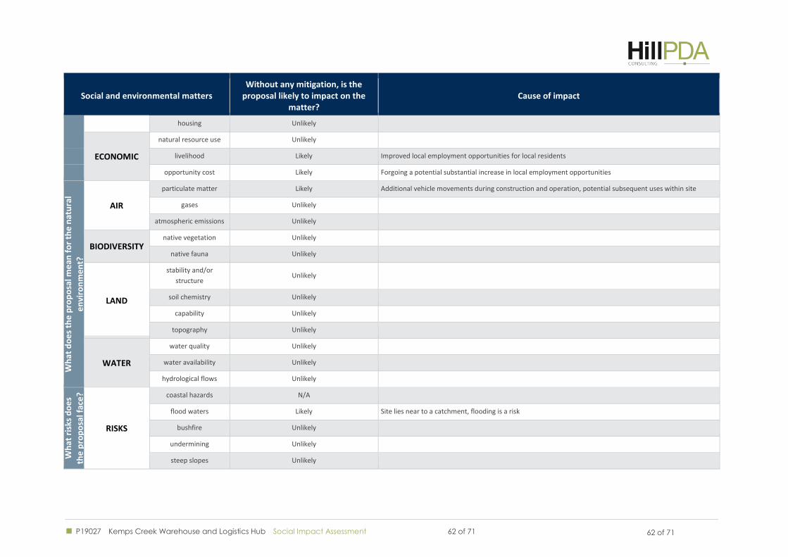
P19027 Kemps Creek Warehouse and Logistics Hub Social Impact Assessment 62 of 71 62 of 71
Social and environmental matters Without any mitigation, is the
proposal likely to impact on the matter?
Cause of impact
housing Unlikely
ECONOMIC
natural resource use Unlikely
livelihood Likely Improved local employment opportunities for local residents
opportunity cost Likely Forgoing a potential substantial increase in local employment opportunities
Wh
at d
oe
s th
e p
rop
osa
l me
an f
or
the
nat
ura
l
en
viro
nm
en
t?
AIR
particulate matter Likely Additional vehicle movements during construction and operation, potential subsequent uses within site
gases Unlikely
atmospheric emissions Unlikely
BIODIVERSITY native vegetation Unlikely
native fauna Unlikely
LAND
stability and/or
structure Unlikely
soil chemistry Unlikely
capability Unlikely
topography Unlikely
WATER
water quality Unlikely
water availability Unlikely
hydrological flows Unlikely
Wh
at r
isks
do
es
the
pro
po
sal f
ace
?
RISKS
coastal hazards N/A
flood waters Likely Site lies near to a catchment, flooding is a risk
bushfire Unlikely
undermining Unlikely
steep slopes Unlikely
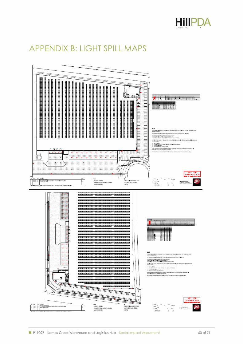
P19027 Kemps Creek Warehouse and Logistics Hub Social Impact Assessment 63 of 71
: LIGHT SPILL MAPS APPENDIX B
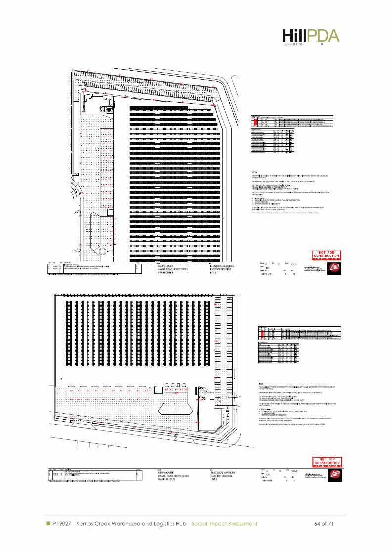
P19027 Kemps Creek Warehouse and Logistics Hub Social Impact Assessment
64 of 71 64 of 71
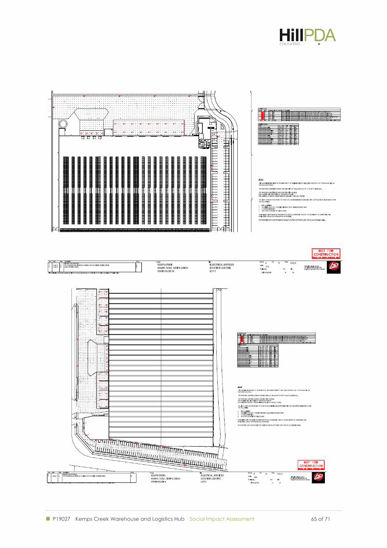
P19027 Kemps Creek Warehouse and Logistics Hub Social Impact Assessment
65 of 71 65 of 71
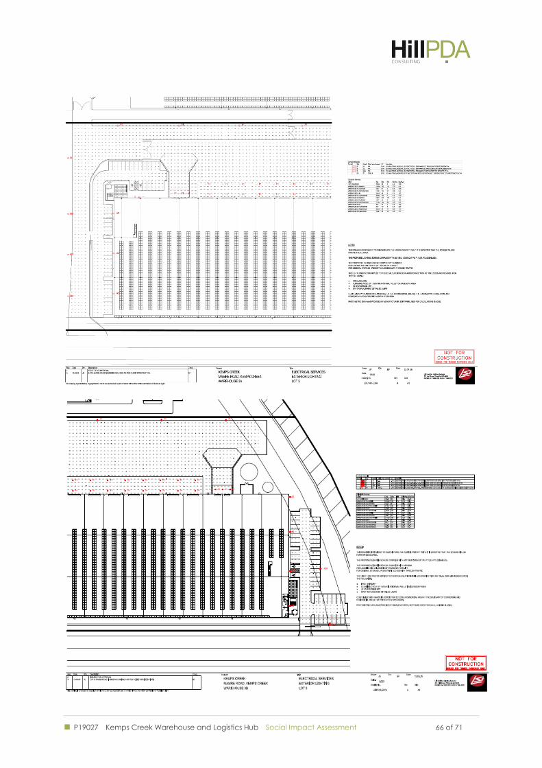
P19027 Kemps Creek Warehouse and Logistics Hub Social Impact Assessment
66 of 71 66 of 71
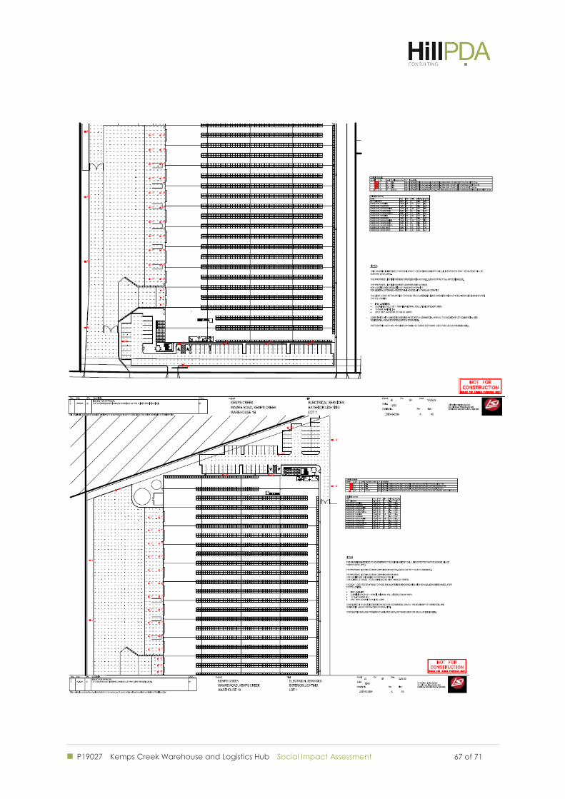
P19027 Kemps Creek Warehouse and Logistics Hub Social Impact Assessment
67 of 71 67 of 71
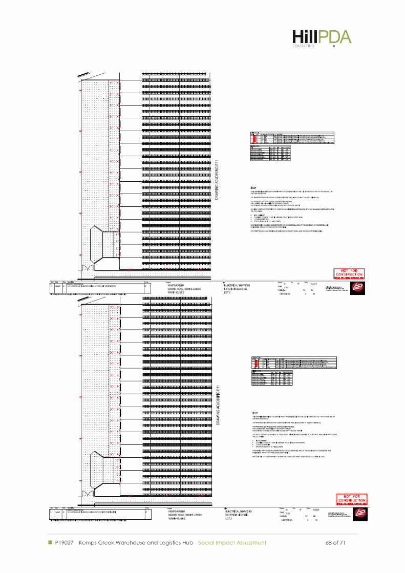
P19027 Kemps Creek Warehouse and Logistics Hub Social Impact Assessment
68 of 71 68 of 71
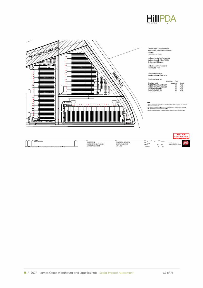
P19027 Kemps Creek Warehouse and Logistics Hub Social Impact Assessment
69 of 71 69 of 71
P19027 Kemps Creek Warehouse and Logistics Hub Social Impact Assessment 70 of 71
Disclaimer
1. This report is for the confidential use only of the party to whom it is addressed ("Client") for the specific purposes to which it refers
and has been based on, and takes into account, the Client’s specific instructions. It is not intended to be relied on by any third party
who, subject to paragraph 3, must make their own enquiries in relation to the issues with which this report deals.
2. HillPDA makes no representations as to the appropriateness, accuracy or completeness of this report for the purpose of any party
other than the Client ("Recipient"). HillPDA disclaims all liability to any Recipient for any loss, error or other consequence which may
arise as a result of the Recipient acting, relying upon or using the whole or part of this report's contents.
3. This report must not be disclosed to any Recipient or reproduced in whole or in part, for any purpose not directly connected to the
project for which HillPDA was engaged to prepare the report, without the prior written approval of HillPDA. In the event that a
Recipient wishes to rely upon this report, the Recipient must inform HillPDA who may, in its sole discretion and on specified terms,
provide its consent.
4. This report and its attached appendices are based on estimates, assumptions and information provided by the Client or sourced and
referenced from external sources by HillPDA. While we endeavour to check these estimates, assumptions and information, no
warranty is given in relation to their reliability, feasibility, accuracy or reasonableness. HillPDA presents these estimates and
assumptions as a basis for the Client’s interpretation and analysis. With respect to forecasts, HillPDA does not present them as results
that will actually be achieved. HillPDA relies upon the interpretation of the Client to judge for itself the likelihood of whether these
projections can be achieved or not.
5. Due care has been taken to prepare the attached financial models from available information at the time of writing, however no
responsibility can be or is accepted for errors or inaccuracies that may have occurred either with the programming or the resultant
financial projections and their assumptions.
6. This report does not constitute a valuation of any property or interest in property. In preparing this report HillPDA has relied upon
information concerning the subject property and/or Proposed Development provided by the Client and HillPDA has not
independently verified this information except where noted in this report.
7. In relation to any valuation which is undertaken for a Managed Investment Scheme (as defined by the Managed Investments Act
1998) or for any lender that is subject to the provisions of the Managed Investments Act, the following clause applies:
This valuation is prepared on the assumption that the lender or addressee as referred to in this valuation report (and no other) may
rely on the valuation for mortgage finance purposes and the lender has complied with its own lending guidelines as well as prudent
finance industry lending practices, and has considered all prudent aspects of credit risk for any potential borrower, including the
borrower’s ability to service and repay any mortgage loan. Further, the valuation is prepared on the assumption that the lender is
providing mortgage financing at a conservative and prudent loan to value ratio.
8. HillPDA makes no representations or warranties of any kind, about the accuracy, reliability, completeness, suitability or fitness in
relation to maps generated by HillPDA or contained within this report.
Liability limited by a scheme approved under the Professional Standards Legislation
P19027 Kemps Creek Warehouse and Logistics Hub Social Impact Assessment 71 of 71
SYDNEY
Level 3, 234 George Street
Sydney NSW 2000
GPO Box 2748 Sydney NSW 2001
t: +61 2 9252 8777
f: +61 2 9252 6077
MELBOURNE
Suite 114, 838 Collins Street
Docklands VIC 3008
t: +61 3 9629 1842
f: +61 3 9629 6315
WWW.HILLPDA.COM