Embed Size (px)
Citation preview

K&C Phase 3 – Brief project essentials
Aboveground Biomass and Carbon Stock Mapping and Changes Monitoring in the Forest of Peninsular Malaysia Using L-Band
ALOS Palsar and JERS-1
Khali Aziz Hamzah & Hamdan Omar Forest Research Institute Malaysia (FRIM)
Science Team meeting #16 – Phase 3 Kick-off JAXA TKSC/RESTEC HQ, Tsukuba/Tokyo, October 17-21, 2011

Region Landarea
(milha)
NaturalForestTypes Plantationforest
TotalForestedland
%oftotallandArea
Dryinland
Swampforest
Mangroveforest
Pen.Malaysia
13.16 5.40 0.30 0.10 0.08 5.88 44.7
Sabah 7.37 3.83 0.12 0.34 0.11 4.40 59.7
Sarawak 12.30 7.92 1.12 0.14 0.06 9.24 75.1
Total(Malaysia)
32.83 17.15 1.54 0.58 0.25 19.52 59.5

MALAYSIA – STUDY AREA
Peninsular Malaysia
Sarawak
Sabah
Location of Peninsular Malaysia: Upper left Latitude/Longitude 6o 30’ 00” / 100o 00’ 00”
Lower right Latitude/Longitude 1o 00’ 00”/ 105o 00’ 00”

FOREST TYPES • Inland Forest • Peat Swamp forest • Mangrove Forest

Objectives: (i) to establish empirical relationship between aboveground biomass and L-
Band signals for tropical forest ecosystem, (ii) to determine aboveground biomass by using L-band SAR data, and (iii) to map the current status and identify changes of aboveground biomass
and carbon stocks in the forest in Peninsular Malaysia.
Project objectives and schedule
Deliverables: (i) Current status of forest cover in the study area (Peninsular Malaysia) (ii) Current pattern of spatial distribution of above ground biomass & carbon
stocks in the forest (iii) Changes of biomass and carbon stocks from 1995 to 2010.

No. Key-milestone Date of completion
i Forest inventory data March 2012
ii Map of current forest cover in the study area September 2012
iii Spatial distribution map of biomass and carbon stock (2010)
February 2013
iv Spatial distribution map of biomass and carbon stock (1995)
February 2014
v Spatial distribution map of biomass and carbon stock changes over 15 years (1995 - 2010)
March 2014
vi Project report March 2014
Project milestones

Project Activities 2011/12 2012/13 2013/14 2014/15 A M J J A S O N D J F M A M J J A S O N D J F M A M J J A S O N D J F M A M J J A S O N D J F M
Agreement signing & ALOS Palsar Data collection X X X
Secondary data collection X X X Ground data collection/Plot Sampling X X X X X X Ground data analysis X X O
ALOS Palsar Image pre-processing: - Topographic normalization - DN to NRCS (dB) Conversion X X X X X
ALOS Palsar Image processing: - Forest classification - Biomass modeling
X X X X X X X X X O X X X X O
Mapping of Current AGB & Carbon Stocks (2010 ) X O
JERS-1 Image pre-processing: - Image Mosaic - Topographic normalization - DN to NRCS (dB) Conversion
X X X X X
JERS-1Image processing: - Forest classification X X X X X X
Mapping of AGB & Carbon Stocks in 1995 x x x x O Mapping of AGB & Carbon Stocks Changes (1995-2010) X X X X x O
Validation and verification x x O Project completion report X O
Project Schedule Japanese Fiscal Year 2011 (April) – 2014 (March)
X : Activities O : Planned milestone

Support to JAXA’s global forest mapping effort
Tropical rainforest of Malaysia is one of the oldest and most complex ecosystems in the world. Although generally taken to mean the species rich lowland forests, other forest types include mangroves, peat swamps and montane forests are also rich with diverse species.
Forest Research Institute Malaysia (FRIM) will be responsible to verify and validate these forest cover in Peninsular Malaysia, and assess the response of SAR data on these forests. By using ground truth samples and experts knowledge, the algorithm that will be developed for forest cover mapping by using both ALOS Palsar and JERS-1 SAR products will be validated, specifically for the corresponding region in the study area.

Growth levels, health status, density and quality of each type of the forest will be taken into considerations in sampling processes.
Data will be inventoried on the ground and will be stored in digital shapefile (.shp) for analysis and image pixel sampling. This ground data will be shared together with JAXA scientist on conditions as specified in the project agreement.

Field Inventory Data
Field survey will be carried out on plots of 50 x 50m size within the study area.
Types of forest
Natural Forest Plantation forest
Total samples Dry inland Swamp
forest Mangrove
forest No. of
Sampling Points
150 (5.40 mil.
ha)
35 0.30 (mil.
ha)
20 0.10 (mil.
ha)
15 0.08 (mil.
ha)
220
Number of sampling points according to the forest types

Plots Design

Ground data collection

High biomass & carbon concentration Medium biomass &
carbon concentration Low biomass & carbon concentration
Typical tropical forest biomass in
Malaysia

Biomass equations to calculate AGB based on Kato et al. (1978). The allometric function of trees applied in the calculation of standing biomass can be expressed as
1/H = 1/(2.0*D)+1/61
From the values of D and H, the dry mass values of stem, branches and leaves of the tree are estimated.
Ms = 0.0313*(D2H)0.9733 Mb = 0.136*Ms1.070 1/Ml = 1/(0.124Ms0.794)+1/125
where; H = total tree height D = stem diameter at breast height (dbh) Ms, Mb and Ml denote the dry mass of stem, branches and leaves respectively.
Biomass Allometry (dry inland forest)

BIOMASS – MANGROVE FOREST (MALAYSIA)
Developed by Komiyama et. al (2007)
Wt = 0.251pD²˙⁴⁶
Wr = 0.199p⁰˙⁸⁹⁹D²˙²²
where ; Wt = above ground biomass Wr = below ground/root biomass D = dbh
Biomass – Peat swamp forest Developed in Indonesia

Forest Category Biomass (t ha-1)
Carbon Stocks (t ha-1)
Small, growing stands 26 - 116 13-58
Mixed small & mature stands 130 - 155 65 – 77.5
Mature, dense stands 168 - 414 84 – 207
Mature & very dense stands 427 - 569 213.5 – 284.5

Carbon Stocks – Various reports
Forest Carbon stocks (t/ha)
Reference
P. Malaysia Lowland dipterocarp Pasoh FR
155 (Primary forest) 138 (Secondary forest)
Okuda, et al (2003)
Inland Air Hitam FR
104-111 Ismriah & Ahmad Fadli (2007)
Sarawak Mixed dipterocarp 140-202 Brown (1997) Secondary forest- 10-14 yrs
16 Chai (1997)
Lambir, FR 245-250 Feeley et al(2007) Sabah Lowland
dipterocarp 32-324 Foody et al (2001)

Weak signal Small stands
Strong signal Dense stands High Biomass
Relationship between biomass and L-Band ALOS PALSAR signal

Project Summary
TITLE: Aboveground Biomass and Carbon Stock Mapping and Changes Monitoring in the Forest of Peninsular Malaysia Using L-Band ALOS Palsar and JERS-1
DURATION: Four years (2011 – 2014)
EXEC. AGENCY: Malaysian Forestry Research and Development Board, Forest Research Institute Malaysia (FRIM)
COLLABORATIVE Forestry Department AGENCIES: Remote Sensing Agency Malaysia
LOCATION: Peninsular Malaysia
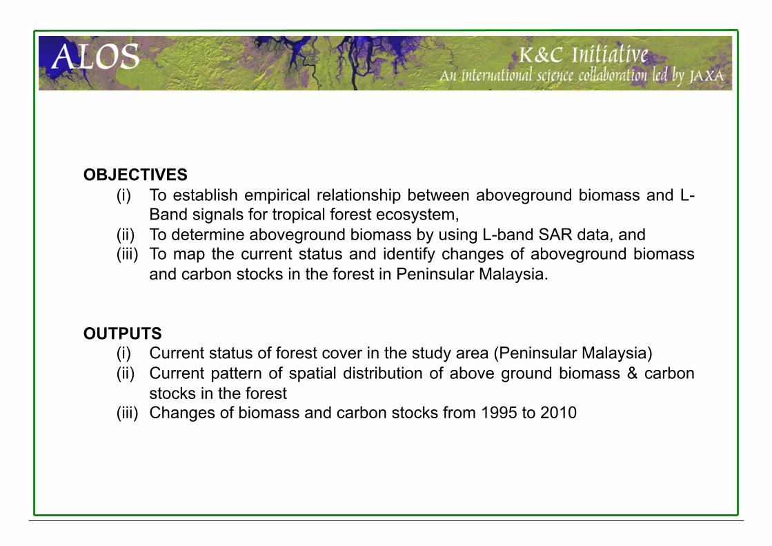
OBJECTIVES (i) To establish empirical relationship between aboveground biomass and L-
Band signals for tropical forest ecosystem, (ii) To determine aboveground biomass by using L-band SAR data, and (iii) To map the current status and identify changes of aboveground biomass
and carbon stocks in the forest in Peninsular Malaysia.
OUTPUTS (i) Current status of forest cover in the study area (Peninsular Malaysia) (ii) Current pattern of spatial distribution of above ground biomass & carbon
stocks in the forest (iii) Changes of biomass and carbon stocks from 1995 to 2010
THANK YOU