Embed Size (px)
Citation preview

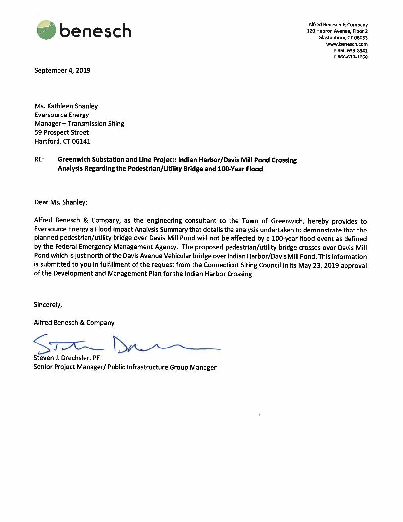
September 5, 2019 Ms. Melanie Bachman, Executive Director Connecticut Siting Council Ten Franklin Square New Britain, CT 06051 RE: Docket No. 461A: Greenwich Substation and Line Project, Indian Harbor Crossing Development
and Management Plan Submission of the Final Pedestrian/Utility Bridge Design and Provision of Information Regarding the Bridge Design and 100-Year Flood
Dear Ms. Bachman: Pursuant to the condition in the Connecticut Siting Council’s (Council’s) May 23, 2019 approval of the above-referenced Development and Management (D&M) Plan, the Connecticut Light and Power Company doing business as Eversource Energy (Eversource) submits the enclosed information regarding the following:
1. Final design details and drawings for the pedestrian/utility bridge over Indian Harbor1 (Attachment A); and
2. Information from the Town of Greenwich’s engineering consultant demonstrating that the bridge
will not be affected by a 100-year flood. (Attachment B). Attached to this original are two copies of this information. Should you have any questions, please do not hesitate to contact me at via e-mail at [email protected] or telephone at (860) 728-4527. Sincerely,
Kathleen M. Shanley
1 Note: The bridge will technically span Davis Mill Pond, which is the impounded area between the Interstate 95 and Davis Avenue bridges. Indian Harbor is to the south of the Davis Avenue bridge. However, for the purposes of the D&M Plan, the bridge is referred to generically as crossing “Indian Harbor”.
56 Prospect Street P.O. Box 270 Hartford, CT 06141-0270 Kathleen M. Shanley Manager – Transmission Siting Tel: 860-728-4527

ATTACHMENT A
FINAL DESIGN PEDESTRIAN/UTILITY BRIDGE OVER DAVIS MILL POND
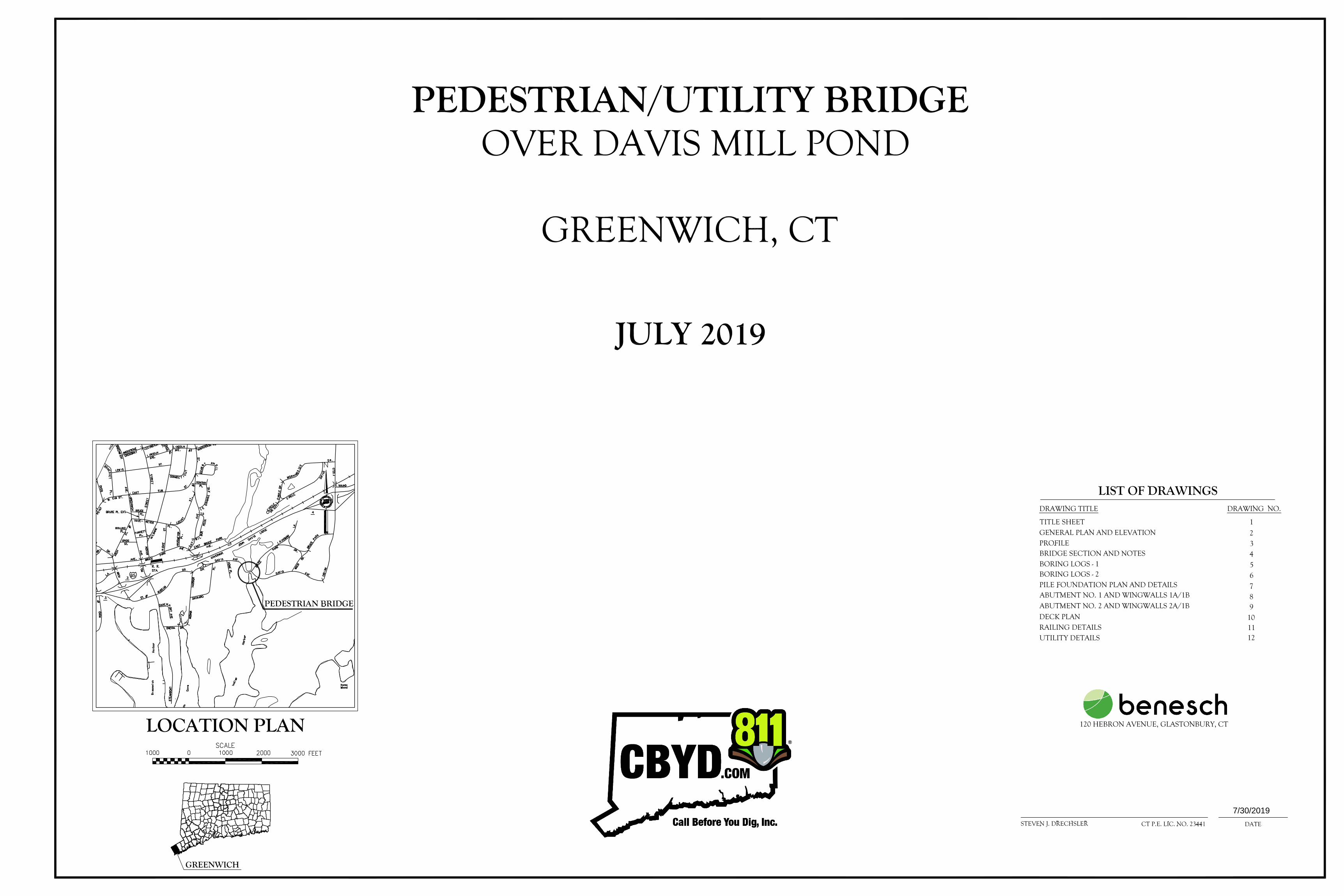
7/30/2019


ATTACHMENT B
SUMMARY OF FLOOD IMPACT ANALYLSES: PEDESTRIAN/UTILITY BRIDGE OVER DAVIS MILL POND
(Correspondence from Town of Greenwich’s Engineering Consultant)

FLOOD IMPACT ANALYSIS SUMMARY
PEDESTRIAN/UTILITY BRIDGE OVER DAVIS MILL POND
TOWN OF GREENWICH
The pedestrian/utility bridge that will be constructed over the tidally-influenced Davis Mill Pond within
Bruce Park in the Town of Greenwich, Fairfield County (referred to in the Greenwich Substation and Line
Project [GSLP] as the Indian Harbor crossing) have incorporated design loads to withstand riverine and
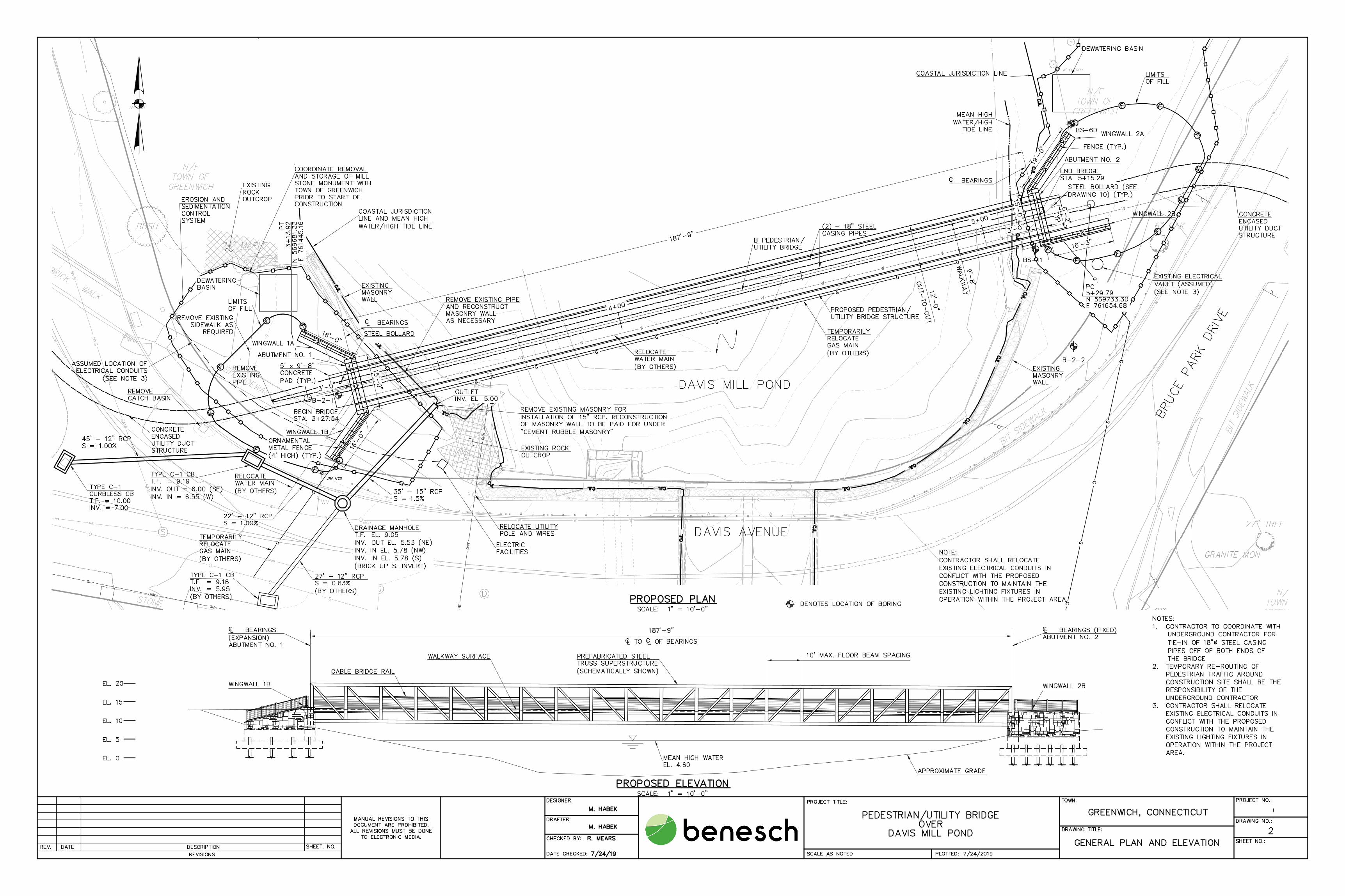
coastal flood events into the contract construction documents. The planned bridge will connect
pedestrian paths within Bruce Park (the current sidewalk connecting the two parts of the Park extends
adjacent to the Davis Avenue bridge) and, in addition to an approximately 9-foot-wide pedestrian
walkway, will support Eversource Energy’s two new 115-kilovolt (kV) transmission cables (being
constructed as part of the GSLP) and an 8-inch diameter Aquarion Water Company water main.
As described below, the bridge design incorporates the consideration of the latest Federal Emergency
Management Agency (FEMA) flood mapping and the results of hydraulic modeling studies, which were
performed to assess the potential effects of flooding (including storm surge from Long Island Sound) and
the critical surge velocity that the bridge would have to be constructed to withstand.
As illustrated on the attached Figure 1, the planned pedestrian/utility bridge will be located between two
existing highway bridges: specifically, it will be situated 50 feet upstream of the Davis Avenue vehicular
bridge and 700 feet downstream of the I-95 bridge. Davis Mill Pond is fed from the north by Greenwich
Creek and is an impoundment of the creek; the pond is tidally influenced and is connected to Indian
Harbor via a dam/weir structure at the Davis Avenue bridge. Thus, the pedestrian/utility bridge will be
situated at the upper end of tidal influence from Long Island Sound; Indian Harbor, an embayment that
connects directly to the Sound, is located south of the Davis Avenue bridge.
In 2013, FEMA issued revised base flood elevation maps for Fairfield County, including the Town of
Greenwich. The 2013 FEMA mapping identifies the area of the proposed location of the pedestrian/utility
bridge (as well as adjacent areas within Bruce Park) as entirely within Special Flood Hazard Area Zone AE.
FEMA Zone AE denotes an area expected to be subject to inundation by the 1% annual chance flood (100-
year flood event), or base flood. The FEMA-designated base flood elevation (BFE) for the
pedestrian/utility bridge area is 13 feet NAVD88. (Refer to Figure 2, excerpt from the FEMA Flood
Insurance Rate Map dated July 8, 2013 from the Fairfield County Flood Insurance Study.) The bridge will
not be within either a floodway or a FEMA Zone VE – that is, a coastal flood zone with a velocity hazard
(wave action).
FEMA’s hydraulic modeling of flood elevations at Davis Mill Pond (i.e., the 13 feet NAVD88) reflects the
consideration of influences from both tidal backwater from Long Island Sound and upstream flows from
Greenwich Creek. The flood elevation is the result of a storm surge of Long Island Sound which will
inundate Bruce Park. The Davis Avenue Bridge acts as a buffer to reduce the impacts of a storm surge
from the Long Island Sound.
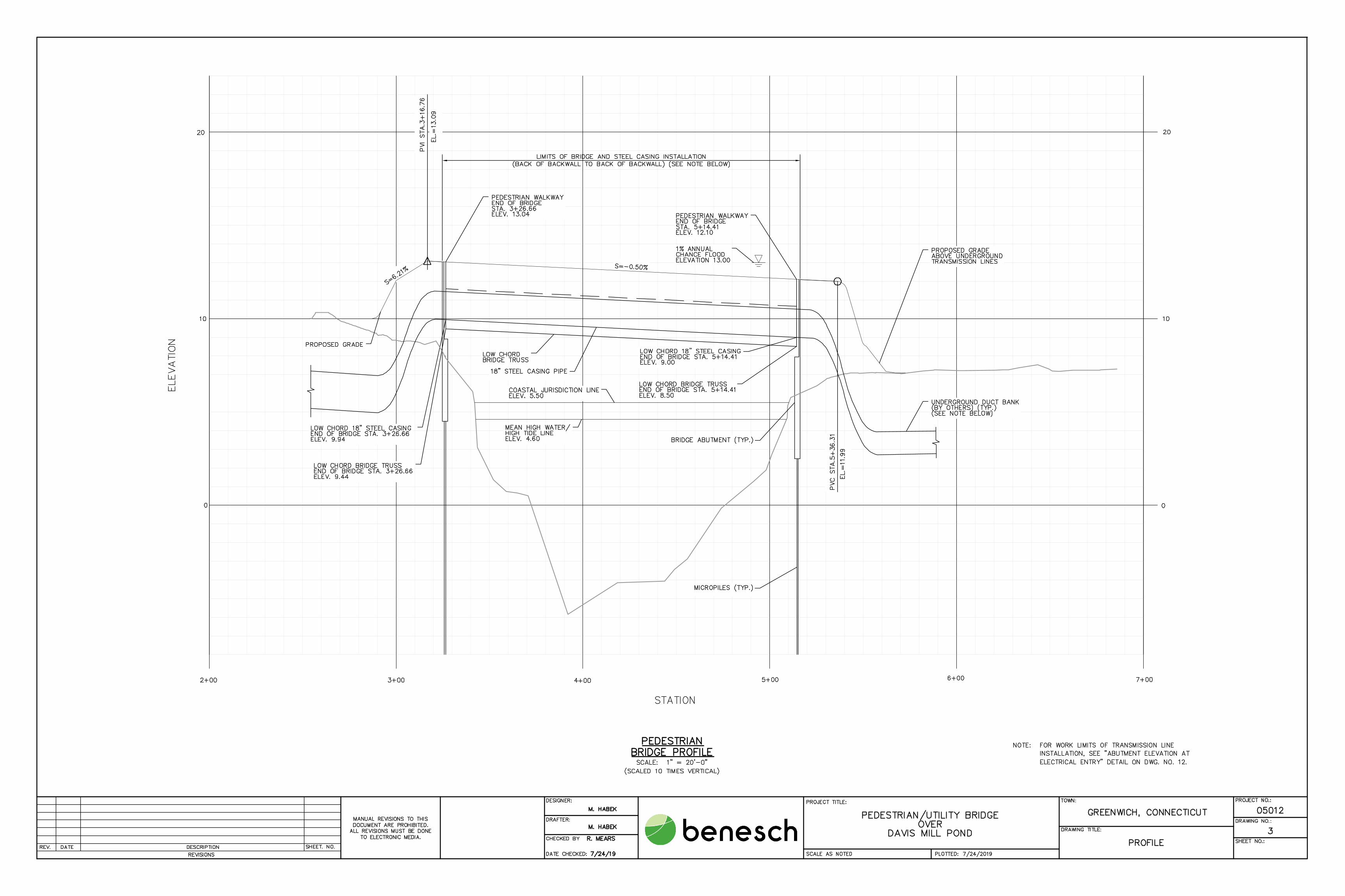
The pedestrian/utility bridge, which will be a single 187.75-foot steel truss span with a concrete walkway,
will cross the limits of the Davis Mill Pond water surface at the Connecticut Coastal Jurisdiction Line (CJL)
elevation of 5.5 feet. The tidal range is about 7.5 feet; the estimated mean high-water elevation at the
planned bridge is 4.6 feet. The pedestrian walkway elevation will vary between elevation 13.04 feet at
1

the west abutment and 12.10 feet at the east abutment. The low chord1 of the bridge will range from
9.44 feet at the west abutment and 8.5 feet at the east abutment. Both abutments will be above the
mean high water and CJL.
Eversource’s 115-kV electric transmission cables will be placed within two 18-inch diameter steel casing
pipes that will be supported under the pedestrian walkway. The steel casing pipes, and their support
hangers will not project below the low chord2 of the bridge span. The bridge will project approximately
4.5 feet below the FEMA 1% annual chance flood elevation of 13. feet.
To determine the critical flow velocity that would impact the bridge structure, a hydraulic analysis was
performed utilizing various tide and riverine conditions. The critical flow velocity calculated at the
upstream face of the bridge was 1.22 feet per second. The resultant force on the bridge structure
projecting below the flood water surface is 9.3 pounds per linear foot of bridge span. A resultant force
on the 18-inch diameter steel pipes that will be below the flood elevation was calculated to be 4.5 pounds
per linear foot of exposed pipe.
Taking into account the results of the hydraulic modeling, the utility supports for the electric transmission
cable casings were specified to be capable of resisting the lateral load of 4.5 pounds per linear foot (as
noted above) and the proposed bridge truss was specified to be capable of withstanding the calculated
9.3 pounds per linear foot (as also noted above).
The contract documents for the construction of the bridge contain a performance specification for the
pedestrian/utility truss bridge and associated utility support systems. This specification calls for the
submittal of design calculations incorporating all loads imposed onto the bridge and utility support
structures, including those from the 100-year storm event. The calculations shall be performed by a
structural engineer licensed in the State of Connecticut and shall be submitted for review and approval
by Eversource prior to fabrication and installation.
In summary, the impacts of the 100-year flood event at the location of the proposed utility/pedestrian
bridge and associated utility supports crossing have been analyzed and the results of this analysis have
been incorporated into the contract documents for the construction of this bridge. In accordance with
these requirements, the proposed bridge would not be adversely impacted by the 100-year storm event.
1 Low chord” refers to the lowest structural element of the bridge; see the engineering drawings in Attachment A.
2

GZA GeoEnvironmental, Inc.Engineers and Scientists
www.gza.com
TRANSFER, REUSE, OR MODIFICATION TO THE DRAWING BY THE CLIENT OR OTHERS, WITHOUT THE PRIOR WRITTEN
UNLESS SPECIFICALLY STATED BY WRITTEN AGREEMENT, THIS DRAWING IS THE SOLE PROPERTY OF GZAGEOENVIRONMENTAL, INC. (GZA). THE INFORMATION SHOWN ON THE DRAWING IS SOLELY FOR THE USE BY GZA'SCLIENT OR THE CLIENT'S DESIGNATED REPRESENTATIVE FOR THE SPECIFIC PROJECT AND LOCATION IDENTIFIED ONTHE DRAWING. THE DRAWING SHALL NOT BE TRANSFERRED, REUSED, COPIED, OR ALTERED IN ANY MANNER FORUSE AT ANY OTHER LOCATION OR FOR ANY OTHER PURPOSE WITHOUT THE PRIOR WRITTEN CONSENT OF GZA, ANYEXPRESS CONSENT OF GZA, WILL BE AT THE USER'S SOLE RISK AND WITHOUT ANY RISK OR LIABILITY TO GZA.
Project Location
PEDESTRIAN/UTILITY BRIDGE OVER INDIAN HARBORDAVIS AVENUE
GREENWICH, CT
NOVEMBER 2018
SLLSRT
05.0046254.01
SLLSRT
SLL1 in = 2,000 ft
ALFRED BENESCH & COMPANY120 HEBRON AVE, 2ND FLGLASTONBURY, CT 06033
N/A1
0 2,000 4,0001,000
SCALE IN FEET
© 20
18 - G
ZA G
eoEn
viron
menta
l, Inc
. J:\0
GZA
INTE
RCOM
PANY
PROJ
ECTS
\05.00
4625
4.01 P
ermitti
ng Se
rvice
s-Gree
nwich
, CT\G
IS\Mx
d\Dav
is Av
enue
Pede
strian
Bridg
e.mxd
LOCUS MAPFIG/DWG
Service Layer Credits: Copyright:© 2013 National Geographic Society, i-cubed
DESIGNED BY:PROJ MGR:
DATE:
REVIEWED BY:DRAWN BY:PROJECT NO:
SCALE:CHECKED BY:
PREPARED FOR:
REVISION NO:
PREPARED BY:
4
³
3

GZA GeoEnvironmental, Inc.Engineers and Scientists
www.gza.com
TRANSFER, REUSE, OR MODIFICATION TO THE DRAWING BY THE CLIENT OR OTHERS, WITHOUT THE PRIOR WRITTEN
UNLESS SPECIFICALLY STATED BY WRITTEN AGREEMENT, THIS DRAWING IS THE SOLE PROPERTY OF GZAGEOENVIRONMENTAL, INC. (GZA). THE INFORMATION SHOWN ON THE DRAWING IS SOLELY FOR THE USE BY GZA'SCLIENT OR THE CLIENT'S DESIGNATED REPRESENTATIVE FOR THE SPECIFIC PROJECT AND LOCATION IDENTIFIED ONTHE DRAWING. THE DRAWING SHALL NOT BE TRANSFERRED, REUSED, COPIED, OR ALTERED IN ANY MANNER FORUSE AT ANY OTHER LOCATION OR FOR ANY OTHER PURPOSE WITHOUT THE PRIOR WRITTEN CONSENT OF GZA, ANYEXPRESS CONSENT OF GZA, WILL BE AT THE USER'S SOLE RISK AND WITHOUT ANY RISK OR LIABILITY TO GZA.
Project Location
PEDESTRIAN BRIDGE OVER INDIAN HARBORDAVIS AVENUE
GREENWICH, CT
September 2019
SLLSRT
05.0046254.01
SLLSRT
SLL1 in = 500 ft
ALFRED BENESCH & COMPANY120 HEBRON AVE, 2ND FLGLASTONBURY, CT 06033
N/A2
0 500 1,000250
SCALE IN FEET
© 20
19 - G
ZA G
eoEn
viron
menta
l, Inc
. J:\0
GZA
INTE
RCOM
PANY
PROJ
ECTS
\05.00
4625
4.01 P
ermitti
ng Se
rvice
s-Gree
nwich
, CT\G
IS\Mx
d\Dav
is Av
enue
Pede
strian
Bridg
e.mxd
FEMA MAPFIG/DWG
Service Layer Credits: Source: Esri, DigitalGlobe, GeoEye, Earthstar Geographics, CNES/Airbus DS, USDA,USGS, AeroGRID, IGN, and the GIS User Community
DESIGNED BY:PROJ MGR:
DATE:
REVIEWED BY:DRAWN BY:PROJECT NO:
SCALE:CHECKED BY:
PREPARED FOR:
REVISION NO:
PREPARED BY:
4
³
LegendFlood Hazard Zones
1% Annual Chance Flood Hazard (AE)
Regulatory FloodwayCoastal Hazard (VE)
0.2% Annual Chance Flood Hazard (X)
4

GZA GeoEnvironmental, Inc.Engineers and Scientists
www.gza.com
TRANSFER, REUSE, OR MODIFICATION TO THE DRAWING BY THE CLIENT OR OTHERS, WITHOUT THE PRIOR WRITTEN
UNLESS SPECIFICALLY STATED BY WRITTEN AGREEMENT, THIS DRAWING IS THE SOLE PROPERTY OF GZAGEOENVIRONMENTAL, INC. (GZA). THE INFORMATION SHOWN ON THE DRAWING IS SOLELY FOR THE USE BY GZA'SCLIENT OR THE CLIENT'S DESIGNATED REPRESENTATIVE FOR THE SPECIFIC PROJECT AND LOCATION IDENTIFIED ONTHE DRAWING. THE DRAWING SHALL NOT BE TRANSFERRED, REUSED, COPIED, OR ALTERED IN ANY MANNER FORUSE AT ANY OTHER LOCATION OR FOR ANY OTHER PURPOSE WITHOUT THE PRIOR WRITTEN CONSENT OF GZA, ANYEXPRESS CONSENT OF GZA, WILL BE AT THE USER'S SOLE RISK AND WITHOUT ANY RISK OR LIABILITY TO GZA.
Project Location
PEDESTRIAN/UTILITY BRIDGE OVER INDIAN HARBORDAVIS AVENUE
GREENWICH, CT
NOVEMBER, 2018
SLLSRT
05.0046254.01
SLLSRT
SLL1 in = 250 ft
ALFRED BENESCH & COMPANY120 HEBRON AVE, 2ND FLGLASTONBURY, CT 06033
N/A3
0 250 500125
SCALE IN FEET
© 20
18 - G
ZA G
eoEn
viron
menta
l, Inc
. J:\0
GZA
INTE
RCOM
PANY
PROJ
ECTS
\05.00
4625
4.01 P
ermitti
ng Se
rvice
s-Gree
nwich
, CT\G
IS\Mx
d\Dav
is Av
enue
Pede
strian
Bridg
e.mxd
AERIAL MAPFIG/DWG
Service Layer Credits: © 2018 Microsoft Corporation © 2018 DigitalGlobe ©CNES (2018) Distribution Airbus DS
DESIGNED BY:PROJ MGR:
DATE:
REVIEWED BY:DRAWN BY:PROJECT NO:
SCALE:CHECKED BY:
PREPARED FOR:
REVISION NO:
PREPARED BY:
4
³
5