Embed Size (px)
Citation preview

Redstone Res60 Havelock St
15 June 201 The ManageCompany AAustralian SLevel 4, Exc20 Bridge StSYDNEY NS Electronic L
HIGHLIGHT
Initthe
Tollhas
Inclexppro
In psignranandinsuexp
Therecedes
Thetim
Foresti
Sevcomsign
ources Limitedtreet, West Per
16
er AnnouncemeStock Exchanhange Centrtreet SW 2000
Lodgement
S
ial JORC 201 Tollu Projec
lu is one of s been confin
ludes 7,000 pedited deveospects.
parallel, the Cnificant increge of 0.8 tod grade of tufficient expploration will
e Forio Prospent drilling ispite the Fori
e Forio Prospes supporte
io is yet toimated medi
ven additionambined withnificantly exp
d ABN 42 090 16rth WA 6005 Te
nts Office nge Limited re
MAIDE
WES
12 resource ct.
6 projects oned to less th
tonnes of celopment p
Conceptual Eease in its si 1.3% Cu, cothis target isloration to e result in the
pect has seendentifying a io Prospect
pect target td by early st
o be effectivian target to
al new Forioh the increapand the Min
69 154 el: 08 9328 255
EN COPPER
ST MUSGRA
of 3.8 millio
on the Tollu han 2% of ten
copper oxideath as part
Exploration Tize to 31 to ontaining 25s conceptuaestimate a Me estimation
n a significanmineraliseddisplaying lim
onnes now eage limited d
vely drilled nnage.
o analogues aased Conceneral Resour
2 Fax: 08 9328
R RESOURCE
AVE, WESTE
on tonnes at
tenement. Snement area
e, which prt of the bro
Target for th47 million t
59,000 to 62al in nature.Mineral Resoof a Minera
nt upgrade ad strike over mited surfac
exceed the pdrilling.
below 50m
and three prptual Explorce, including
2660
E, TOLLU PR
ERN AUSTR
t 1% Cu, con
Significant exa.
ovides scopoader devel
he Tollu Projtonnes of m6,000 tonne. It is impoource for thel Resource fo
and highlight250m and wce expression
previously e
however h
reviously ideration Targeg oxide copp
Email:
ROJECT
ALIA
ntaining 38,0
xploration u
e for the evlopment of
ect has beenmineralisationes of copperrtant to not Target and or the Target
ts the potenwhich remainn.
stimated tar
has already
entified “Foriet, provide er material,
www.reds: contact@reds
000 tonnes o
upside as dri
valuation ofhigher gra
n reviewed rn at a concer. The potente that therit is uncertat.
tial for the Pns open in a
rget tonnage
achieved its
io look‐alikea solid fouwith further
stone.com.au stone.com.au
of copper at
lling to date
f a low costde sulphide
resulting in aeptual gradetial quantityre has beenain if further
Project, withll directions,
e by circa 10
s previously
e” prospects,undation tor drilling.
t
e
t e
a e y n r
h ,
0
y
, o F
or p
erso
nal u
se o
nly

Redstone Res60 Havelock St
Maiden Min Redstone RMineral ResProject (“To The initial Mcontained cBM Geologiin line withand Ore Res
ources Limitedtreet, West Per
neral Resour
Resources Limsource estimollu” or the “
Mineral Resocopper (the ical Services the guidelinserves 2012
Ch
Fo
M
H
Ea
To
ResourcClassificat
Indicate
Inferre
Total Indicate+ Inferre
Total Indicat
d ABN 42 090 16rth WA 6005 Te
rce Estimate
mited (ASX: mate, report“Project”) in
ource estima“Mineral RePty Ltd, a Kanes of the Aedition (JOR
M
Prospect
hatsworth
orio
Main Reef
amptons
astern Reef
otal Ta
ce tion
ed Cha
For
Sub
d Cha
For
Ma
Ham
Eas
Sub
ed ed
Cha
For
Ma
Ham
Eas
ted and InfeTable 2 Indica
69 154 el: 08 9328 255
e
RDS) (“Reded in accordthe West M
te at Tollu isesource”) (Taalgoorlie basAustralian CoRC 2012).
TMineral Reso
Ton
798
671
850
266
1,30
3,89able 1 Mineral
Min
Prospect
atsworth
io
b‐Total
atsworth
io
in Reef
mptons
tern Reef
b‐Total
atsworth
io
in Reef
mptons
tern Reef
rred ated and Inferr
2 Fax: 08 9328
stone” or “tdance with tusgrave, We
s 3.8Mt @ 1ables 1 and sed, indepenode for Repo
Tollu Projecurce Estimatnnes
8,308
1,898
0,210
6,576
09,138
96,130 Resource Estim
Toneral Resour
Tonn
394,6
69,2
463,8
403,7
602,6
850,2
266,5
1,309,
3,432,
798,3
671,8
850,2
266,5
1,309,
3,896,red Mineral Re
2660
the Companthe 2012 JOestern Austra
.0% copper,2). The Tolludent geologiorting of Exp
t te – June 20Cu%
1.6%
1.1%
0.7%
0.9%
0.8%
1.0% mate by Prospe
ollu Projectrce Estimatenes Cu
607 1.
68 1.
875 1.
701 1.
630 1.
210 0.
576 0.
,138 0.
,255 0.
308 1.
898 1.
210 0.
576 0.
,138 0.
,130 1.source Estimat
Email:
ny”) is pleaseRC Code, foalia.
which equau Mineral Reical consultinploration Res
16 Contained Copper
12,780
7,233
5,633
2,436
10,047
38,129 ect
– June 2016u% C
6%
1%
5%
6%
1%
7%
9%
8%
9%
6%
1%
7%
9%
8%
0% te by Prospect
ASX: RDS
www.reds: contact@reds
ed to annouor its 100% o
ates to 38,00esource was ng group andsults, Minera
6 Contained Copper
6,323
759
7,081
6,458
6,474
5,633
2,436
10,047
31,048
12,780
7,233
5,633
2,436
10,047
38,129
stone.com.au stone.com.au
unce its firstowned Tollu
00 tonnes ofprepared byd is reportedal Resources
t u
f y d s
For
per
sona
l use
onl
y

Redstone Res60 Havelock St
Commentin
“Ththe prohosothsho Thethe curbelodisc Theto tundbottarg Theviabsurfsign
It is significNi‐Cu sulphoxide resousignificant m
Importantlywith additiofuture prosgiven drillinendowment
Tollu Projec Redstone htonnes of mtonnes of carea at Tolbeneath corepresents Mineral Res Given the dout of six, th The Tollu dstress dilatmineralisati
ources Limitedtreet, West Per
ng on the res
he definition advancemeospects, espesting near suer veins of sows significan
e mineralisat Tollu Faultrent strike leow 50m. Thcovered at th
e identificatiothe maiden Jdoubtedly exth to extendgeting exten
e Board is cbility of the nface copper nificantly low
ant to also nide mineraliurce. The Cmaiden resou
y, beyond thonal drilling,spects, can dng activities t is not cons
ct – Increase
as defined amineralisatioopper. This lu, coupled over to the a substantiasource is incl
rilling data ishe upside to
deposit is loctational jog ion appears
d ABN 42 090 16rth WA 6005 Te
sults Redston
of a maidenent of the Pecially at Fourface coppesimilarly minntly longer st
tion at Forio , which is inength remaie most recehis depth to
on of additioJORC complixcellent poted the minersions of the
confident thnear surfaceoxide may p
wer up front
note that prisation at TolCompany is vurce in accor
he current M other prospdefine furthehave been trained.
ed Conceptu
an increasedon at a concTarget is bawith geophnorth and
al 41% increaluded).
s constrainedo the Mineral
cated in a lapositions ato be constr
69 154 el: 08 9328 255
ne’s Chairma
n resource aroject. The rio, highligher mineralisanimal surfacetrike length t
is very signifn a differenns open in aent drill resudate at Tollu
onal “Forio loant mineral ential to signralisation in higher grade
hat after fur copper minpresent shortcapital expe
ior to 2015, llu and was nvery pleasedrdance with
Mineral Resopects will beer copper mlimited to c
al Exploratio
Conceptualceptual gradsed on the chysical evidesouth. Tabase to the u
d to less thal Resource re
arge, reversealong a norained to late
2 Fax: 08 9328
an, Mr Homs
at Tollu repr success of ts the signifation and vae expressionthan both th
ficant as it isnt location tall directionslts disclose tu.
ook‐alike” prresource acnificantly exthe near‐s
e sections of
rther drillingneralisation at term develnditure.”
drilling focunot optimallyd that the 2the 2012 JO
ource estimae identified, mineralisationcertain areas
on Target
l Explorationde range of current geoloence to suggble 3 descrpper range o
n 2% of the temains unlim
e fault systerth‐south ste stage veini
2660
any said:
resents a mathe shallowficant upsidealidates then. With onlyhe Chatswort
s located in ao the previos and as yet the widest a
rospects is sechieved by thpand the Murface, opef mineralisati
g, evaluationat Tollu. If stlopment opt
used on the dy designed fo2015 drillingRC Code.
te, it validatand that futn. There is ss of the Proj
n Target for t0.8 ‐ 1.3%ogical undergest that theibes the Taof the previo
tenement armited.
m where Cuructural corng within the
Email:
ajor milestonw drilling at te potential te opportunityy limited drilth and Easte
a dilational zoously discovhas not beeand stronges
een as a signhe recent driineral Resoun pittable eion.
n can commtudies proveions generat
discovery of or the definicampaign w
tes the Comture drilling significant pject. The Pro
the Tollu ProCu, containstanding of te mineraliserget breakdously existin
rea and only
u mineralisatrridor (Figure dilatationa
ASX: RDS
www.reds: contact@reds
ne for Redstthe previousto identify fty for repeatlling, the Forn Reef Pros
one to the nvered mineraen effectivelyst copper m
ificant bonuilling campaurce with futenvironment
mence of the it to be viabting early ca
f deep seatedition of a shawas able to
mpany’s confat Tollu on
potential upsoject’s pote
oject of 31 ting 259,000the mineralied environmdown by Prong target (49
on one proj
tion is focusre 2). Higal positions w
stone.com.au stone.com.au
tone and forsly undrilledurther veinst success onrio Prospectspects.
orth west ofalisation. Itsy drilled outineralisation
s in additionign. There isture drilling,t as well as
e economicble, the nearsh flow with
d, magmaticallow copperdelineate a
fidence that,existing andside at Tolluntial copper
to 47 million to 626,000ised outcropent extendsospect. This% when the
ect (Tollu)
sed into lowh grade Cuwhich results
r d s n t
f s t n
n s , s
c r h
c r a
, d u r
n 0 p s s e
w u s
For
per
sona
l use
onl
y
Redstone Res60 Havelock St
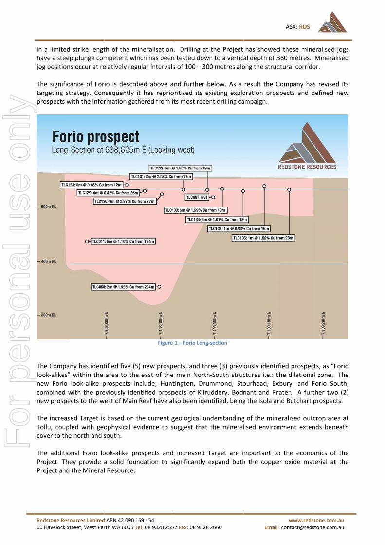
in a limitedhave a steejog position The significtargeting stprospects w
The Compalook‐alikes”new Forio combined wnew prospe The increasTollu, coupcover to the The additioProject. TheProject and
ources Limitedtreet, West Per
d strike lengtp plunge comns occur at re
cance of Fortrategy. Conwith the infor
ny has ident” within the look‐alike pwith the preects to the w
sed Target isled with geoe north and s
onal Forio loey provide a the Mineral
d ABN 42 090 16rth WA 6005 Te
th of the mimpetent whielatively regu
io is describnsequently itrmation gath
tified five (5)area to the prospects ineviously idenwest of Main
s based on thophysical evsouth.
ook‐alike proa solid founl Resource.
69 154 el: 08 9328 255
neralisation.ich has beenular intervals
bed above at has repriohered from it
Figure
) new prospeeast of the clude; Huntntified prospReef have al
he current gvidence to su
ospects and ndation to si
2 Fax: 08 9328
. Drilling at n tested dows of 100 – 30
nd further boritised its ets most rece
1 – Forio Long‐
ects, and thrmain North
tington, Drupects of Kilruso been iden
geological unuggest that
increased Tignificantly e
2660
the Projectwn to a vertic00 metres alo
below. As a xisting explont drilling ca
‐section
ree (3) previh‐South strucmmond, Stouddery, Bodntified, being
nderstandingthe mineral
Target are iexpand both
Email:
has showedal depth of 3ong the struc
result the Coration prosampaign.
ously identifctures i.e.: tourhead, Exnant and Prg the Isola an
g of the minelised environ
mportant toh the coppe
ASX: RDS
www.reds: contact@reds
d these mine360 metres. ctural corrido
Company haspects and d
fied prospecthe dilationaxbury, and Frater. A furtnd Butchart
eralised outnment exten
o the econoer oxide mat
stone.com.au stone.com.au
eralised jogsMineralisedor.
s revised itsdefined new
cts, as “Foriol zone. TheForio South,ther two (2)prospects.
crop area atnds beneath
omics of theterial at the
s d
s w
o e , )
t h
e e
For
per
sona
l use
onl
y

Redstone Res60 Havelock St
The Compaidentified pThe new pro
Pros
Huntingt
Drummo
Stourhea
Exbury
Butchart
Main Ree
Isola
Kilrudder
Bodnant
Sanssouc
Forio
Forio Dee
Forio Sou
Eastern R
Dawyck
Hampton
Boboli
Tiergarte
ources Limitedtreet, West Per
ny has identprospects witospects inclu
spect
ton
ond
ad
t
ef South
ry
ci
eps
uth
Reef
n
en
d ABN 42 090 16rth WA 6005 Te
tified a furththin the Tollude; Hunting
Tonnes Lower
1,872,000
1,248,000
2,028,000
520,000
1,664,000
4,784,000
936,000
780,000
520,000
1,456,000
1,976,000
1,393,000
416,000
11,667,000
204,000
175,000
94,000
42,000
31,775,000 Table
69 154 el: 08 9328 255
her seven (7u Project. Tgton, Drumm
TonnesUpper
2,808,000
1,872,000
3042000
780,000
2,496,000
7,176,000
1,404,000
11,70,000
780,000
2,184,000
2,964,000
2,090,000
624,000
17,500,00
306,000
262,000
140,000
62,000
47,660,00e 3 ‐ Tollu Proje
2 Fax: 08 9328
7) new “ForioThere are nomond, Stourh
GradeLowerCu%
0 0.9%
0 0.9%
0 0.9%
0 0.9%
0 0.9%
0 0.8%
0 0.9%
0 0.9%
0 0.9%
0 0.9%
0 1.2%
0 1.2%
0 1.2%
00 0.6%
0 2.0%
0 0.8%
0 1.2%
1.2%
00 0.8%ect ‐ Target – P
2660
o look‐alike”w 24 Prospehead, Exbury
er
GradeUpperCu%
1.5%
1.5%
1.5%
1.5%
1.5%
1.2%
1.5%
1.5%
1.5%
1.5%
1.8%
1.8%
1.8%
1.0%
3.0%
1.2%
1.8%
1.8%
1.3%Prospect Breakd
Email:
” prospects aects in total w, Butchart, Is
er
ContaCoppLow
16,8
11,2
18,2
4,6
14,9
38,2
8,4
7,0
4,6
13,1
23,7
16,7
4,9
70,0
4,0
1,3
1,1
40
259,down
ASX: RDS
www.reds: contact@reds
and three (3within the Tsola and Fori
ained per wer
C
800
200
200
00
900
200
400
00
00
100
700
700
00
000 1
00
00
00
00
100 6
stone.com.au stone.com.au
3) previouslyTollu Project.io South.
ontained Copper Upper
42,100
28,000
45,600
11,700
37,400
86,100
21,000
17,500
11,700
32,700
53,300
37,600
11,200
175,000
9,100
3,100
2,500
1,100
626,700
y .
For
per
sona
l use
onl
y

Redstone Res60 Havelock St
ources Limitedtreet, West Per
d ABN 42 090 16rth WA 6005 Te
69 154 el: 08 9328 255
Figure 2
2 Fax: 08 9328
Prospect Loca
2660
tion Map
Email:
ASX: RDS
www.reds: contact@reds
stone.com.au stone.com.au
For
per
sona
l use
onl
y

Redstone Res60 Havelock St
Additional P
The Compaprospects wprospects ipreviously iProspects t(Figure 2). These prospForio Prosp
Kilruddery
The Kilrudd
prospect fo
Bodnant Pr
The Bodnan
forms part o
Forio South
The Forio
geophysics
Huntington
The Huntin
prospect fo
Drummond
The Drumm
prospect fo
Stourhead P
The Stourh
identified a
Exbury Pros
The Exbury
data as a pr
ources Limitedtreet, West Per
Prospects Id
ny has identwithin the ainclude; Huidentified prto the west
pects have bect with the
Prospect
dery Prospec
rms part of t
rospect
nt Prospect i
of the dilatio
h Prospect
South Prosp
data. This p
n Prospect
gton Prospe
rms part of t
d Prospect
mond Prospe
rms part of t
Prospect
head Prospe
s a priority E
spect
Prospect is
riority EM Ta
d ABN 42 090 16rth WA 6005 Te
dentified – Fo
tified a furthearea to the ntington, Dospects of Kof Main Re
been identifiKilruddery a
ct is a serie
the dilation s
s a series of
on system ru
pect is a se
prospect form
ect is a seri
the dilation s
ect is a seri
the dilation s
ct is a seri
EM Target. T
a series of
arget. This p
69 154 el: 08 9328 255
orio Analogu
er five (5) “Feast of therummond, SKilruddery, Beef have als
ed after a fuand Bodnant
es of sub ve
system runn
sub vertical
nning paralle
eries of sub
ms part of th
es of sub ve
system runn
es of sub ve
system runn
es of sub v
This prospect
sub vertical
rospect form
2 Fax: 08 9328
ues
Forio look‐alie main NortStourhead, odnant and o been iden
ull data reviet Prospects b
ertical hydro
ing parallel t
hydrotherm
el to Forio.
b vertical h
e dilation sy
ertical hydro
ing parallel t
ertical hydro
ing parallel t
vertical hydr
t forms part
hydrotherm
ms part of the
2660
ke” prospectth‐South struExbury, andPrater Prospntified, being
ew from the being reprior
othermal bo
to Forio.
mal bodies ex
ydrotherma
stem runnin
othermal bo
to Forio.
othermal bo
to Forio.
rothermal b
of the dilatio
mal bodies id
e dilation sys
Email:
ts and three uctures. Thd Forio Soupects (Figureg the Isola
success of titised for fur
dies expose
xposed at the
l bodies ide
g south of Fo
odies expose
odies expose
odies expos
on system ru
dentified fro
stem running
ASX: RDS
www.reds: contact@reds
(3) previoushe new Foriuth combinee 3). A furthand Butcha
the recent drther drilling
ed at the su
e surface. T
entified from
orio.
ed at the su
ed at the su
sed at the
unning parall
om Redstone
g parallel to
stone.com.au stone.com.au
sly identifiedio look‐alikeed with theher two newrt Prospects
rilling at the.
urface. This
This prospect
m Redstone
urface. This
urface. This
surface and
lel to Forio.
e geophysics
Forio.
d e e w s
e
s
t
e
s
s
d
s For
per
sona
l use
onl
y

Redstone Res60 Havelock St
ources Limitedtreet, West Per
d ABN 42 090 16rth WA 6005 Te
Figure 3 Tollu
69 154 el: 08 9328 255
u Prospects to t
2 Fax: 08 9328
the east of East
2660
tern Reef (“For
Email:
rio look alike”)
ASX: RDS
www.reds: contact@reds
stone.com.au stone.com.au
For
per
sona
l use
onl
y

Redstone Res60 Havelock St
Tollu Projec
Redstone’s Western Auon the Com The Projectcovering ansurface and
Mineral Res The initial Mtonnes of cbased, indeAustralian C(JORC 2012
ources Limitedtreet, West Per
ct (Redstone
100% owneustralia (Figumpany’s 100%
t consists ofn area at lead form part o
Figure 4 – W
source and C
Mineral Resocopper. The ependent geCode for Re). The Miner
d ABN 42 090 16rth WA 6005 Te
e 100%)
ed Tollu Projure 4). The P% owned ten
f a large swaast 5km2. Mof a dilatation
West Musgrave
Conceptual E
ource estimaTollu Minerological coneporting of Eral Resource
69 154 el: 08 9328 255
ect is locateProject is apement E69/2
arm of hydrMalachite ricnal system b
‐ Location Map
Exploration T
ate at the Toral Resourcesulting grouExploration Restimate is r
2 Fax: 08 9328
ed in the soupproximately2450 (Figure
othermal coh gossans aetween two
p
Target Estim
ollu Project ise was prepaup and is repResults, Minreported at a
2660
utheast portiy 20km southe 5).
opper rich qssociated wmajor struct
Figure 5– To
mate
s 3.8 million red by BMGported in acneral Resoura cut‐off grad
Email:
ion of the Wh east of the
uartz veins iith quartz vetures within
ollu Project – Lo
tonnes at 1%GS Consultancordance wices and Orede of 0.2% C
ASX: RDS
www.reds: contact@reds
West Musgrae Blackstone
in a mineraleins are expthe Tollu Fa
Location Map
% Cu, contants Pty Ltd, ith the prince Reserves 2Cu.
stone.com.au stone.com.au
ve region ofCommunity
lised systemposed at theult Zone.
ining 38,000a Kalgoorlieciples of the2012 edition
f y
m e
0 e e n
For
per
sona
l use
onl
y

Redstone Res60 Havelock St
Project Geo Multiple fiepurpose of with empha Field obserdilatational Fault has beZone situate An early, unfaulting) aninterpretedcreated dilaphases hav(Table 4). T
Struc
Early Late
R
The dilatatigenerally atto interpret The mineraelevated cochalcopyrite
ources Limitedtreet, West Per
ology
eld visits weconstructingasis placed o
rvations idenjogs causedeen interpreted to the no
niform, phasd is characte to represenatational joge intruded dThe mineralis
ctural Phase
Reverse Fault?
Reverse FaultReactivation initial fault phacreating lowpressure
dilatational jo
Table 1 ‐ T
ional jog pot intervals ofted mineralis
alisation comoncentrationse and bornit
d ABN 42 090 16rth WA 6005 Te
re completeg the Targetn paragenes
ntified that by the reactted as a deerth (Figure 6
se of veiningerised by unnt the primarg positions wduring this rsed vein pha
Veining
Banded
t – of ase w
ogs
Very cointerstit(‘Hound
Fine gramalachi
Faultedmalachi
Massive
Tollu Vein Para
sitions occuf 100‐300m.sed positions
mprises sub‐s of cobalt ae at depth a
69 154 el: 08 9328 255
ed by BM Get. Outcroppsis of minera
phases of tivation of a p‐seated tra6).
g appears tomineralised,ry structuralwhich have eactivation aases are lenti
g Type
, ferruginous q
arse grained, tial quartz crystds Tooth”)
ained buck quaite
quartz + clay +ite
e buck quartz
agenesis identif
r randomly This observs under cove
economic tond minor cond malachite
2 Fax: 08 9328
eological Serping vein geolisation.
mineralised regional sca
ansform struc
o be related , banded, fe architecturebeen exploiand at leasticular in shap
Min
uartz Unm
tals Unm
rtz + Low
+ Hig
Unm
fied during the
along the stvation was uer.
o ore‐grade oncentrates oe within the
2660
rvices (BMGometries we
quartz veinale reverse facture of the
to an initialrruginous que. Subsequeited by mine two of thespe which lim
neralisation
mineralised
mineralised
w grade Cu
gh grade Cu
mineralised
e March 2014 fi
trike extent used as a pa
copper minof tungsten aregolith.
Email:
S) to gatherere mapped
ning are locaault (Tollu FaNW‐SE striki
l structural puartz (Table ent reactivateralised fluidse phases apits their strik
Veining size
Uniformed veseveral kms
Small scale len
Small, lenticu20m long at s
Small, lenticu20m long at s
Large quartz b30m wide
eld mapping pr
of the Easterameter to a
neralisation, and silver. T
ASX: RDS
www.reds: contact@reds
r additional and measur
ated within ault) (Table 4ing Tjuni Pur
phase (prob4). This inittion of this sds. Several ppear to be ke width and
ein widths outc
nses over tens
lar; 0.5‐2m widsurface
lar; 0.5‐2m widsurface
blows up to 100
rogramme
ern and Maiassign tonne
occasionallyThe copper m
stone.com.au stone.com.au
data for thered in detail
low stress,4). The Tollurlka Tectonic
ably reverseial veining istructure hasquartz veinmineralised
d length.
ropping for
of meters
de and up to
de and up to
0m long and
in Reefs butes and grade
y containingmineralogy is
e l
, u c
e s s n d
t e
g s
For
per
sona
l use
onl
y
Redstone Res60 Havelock St
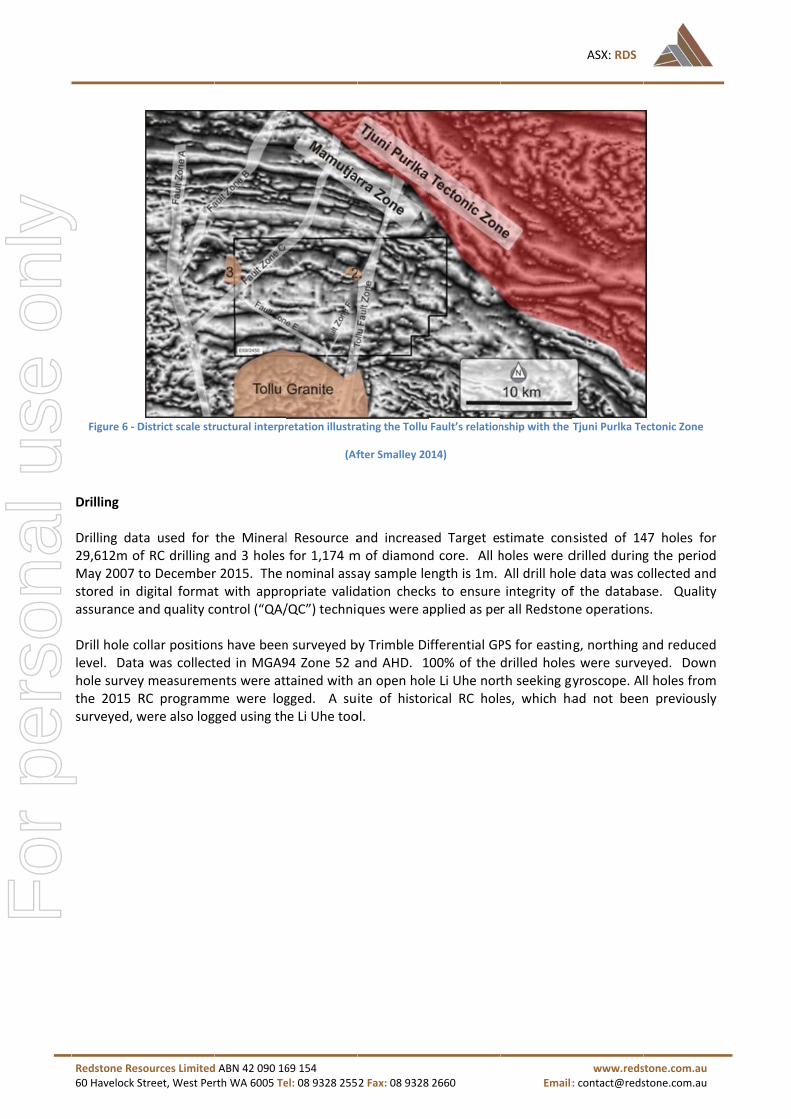
Figure 6 ‐ D
Drilling Drilling dat29,612m ofMay 2007 tstored in dassurance a Drill hole colevel. Datahole surveythe 2015 Rsurveyed, w
ources Limitedtreet, West Per
District scale str
ta used for f RC drilling o Decemberigital formatand quality c
ollar positiona was collecty measuremeRC programmwere also log
d ABN 42 090 16rth WA 6005 Te
ructural interpr
the Mineraland 3 holes r 2015. The t with approontrol (“QA/
ns have beented in MGA9ents were atme were logged using th
69 154 el: 08 9328 255
retation illustra
(Af
l Resource afor 1,174 mnominal assaopriate valid/QC”) techniq
n surveyed b94 Zone 52 atained with gged. A sue Li Uhe too
2 Fax: 08 9328
ating the Tollu
fter Smalley 20
and increasem of diamonday sample ledation checkques were a
by Trimble Diand AHD. 1an open holite of historol.
2660
Fault’s relation
014)
ed Target ed core. All hength is 1m. ks to ensurepplied as pe
ifferential GP00% of the e Li Uhe norrical RC hole
Email:
nship with the T
stimate conholes were dAll drill holeintegrity ofr all Redston
PS for eastindrilled holesth seeking gyes, which ha
ASX: RDS
www.reds: contact@reds
Tjuni Purlka Te
nsisted of 14drilled duringe data was cf the databane operation
g, northing as were survegyroscope. Alad not been
stone.com.au stone.com.au
ectonic Zone
47 holes forg the periodollected andase. Qualitys.
and reducedeyed. Downll holes fromn previously
r d d y
d n m y
For
per
sona
l use
onl
y

Redstone Res60 Havelock St
Geological i The confidemapping, degeological cis considereestimation a
(1)
(2)
The geologhave a matinterpretatiparticular liWhilst the gvariable. Thhigh throug
ources Limitedtreet, West Per
interpretatio
ence of the etailed geoloconfidence ined acceptablare:
where cross the interpreasonable drill spacing ical interpreterial effect ion is continuthological bgeological fehis issue is mgh the use of
d ABN 42 090 16rth WA 6005 Te
on
geological inogical DDH/ n each modee for determ
s cutting rela
retation of distance cog).
etation is coon the Minually being uoundaries, geatures are inmitigated by f QAQC proce
69 154 el: 08 9328 255
Figure 7 – Red
nterpretatioRC logging ael is high. Thmining a geol
ationships w
the mineransidering ge
nsidered roneral Resourupdated. Thegeological strnterpreted toclose‐spacedesses.
2 Fax: 08 9328
dstone Resourc
n is based ond assay dathe dataset (glogical mode
ere not obse
alisation froeological & g
bust and altrce. As addite geological iructures, asso be continud drilling/sam
2660
es Drilling Map
on geologicata. No alterngeological mael. Key interp
erved;
om past knograde contin
ternative inttional geologinterpretatiosociated alteuous, the copmpling and e
Email:
p
al knowledgenate interpreapping, RC/Dpretation ass
own drilling uity – not m
terpretationsgical data is on is specificaeration, veinipper distribuensuring sam
ASX: RDS
www.reds: contact@reds
e acquired fetations are DDH logging,sumptions m
limits (extmore than th
s are consids collated thally based oning and copution within tmple analytic
stone.com.au stone.com.au
rom surfaceproposed as, assays etc.)made for this
rapolated ahe maximum
dered not toe geologicaln identifyingper content.them can becal quality is
e s ) s
a m
o l g . e s
For
per
sona
l use
onl
y

Redstone Res60 Havelock St
Estimation Mineralisedcreated by uncertaintyinterval of generated b The statistieach. No tousing Surpaa linear estiPower 2 (ID Composite Sample seasamples wewere basedprogressive No assumptestimation between sablocking tovariables wtopographicbased on th Model validkey geology Metallurgic No metallumineralisatiimpurities oof the poten Bulk Densit No bulk denfor the majo
ComTraFres
An over‐denbased on tmaterial.
ources Limitedtreet, West Per
& modelling
d domains w20m spaci
y, domain bo1m is appliebased on dat
cs for each op‐cuts wereac software vimation techD2) was empl
average grarch ellipses were set for ed on sampleely relaxed se
tions were mof deleterioample spacino honour vawas necessacal files werehese volumes
dation has bey staff.
cal Assumpti
rgical assumion is easily or contaminantial ores.
ty Assumptio
nsity measuror regolith u
mpletely Oxidnsitional sh
nsity value ohe majority
d ABN 42 090 16rth WA 6005 Te
g techniques
were based ong sectionaoundaries wed. Domaintabase codin
domain were applied basversion 6.6.4hnique for loloyed for gra
ades were uwere set baseach sample e spacing &earch criteria
made regardus elementsng & orientatriably lode ary. The 3e used to cos/surfaces by
een complete
ions
mptions haverecovered tates. Future
ons
rements havnits and are
dised 1.8 2.5 2.7
of 2.6t/m3 waof the targ
69 154 el: 08 9328 255
s
on the geolol interpretatere modellen boundariesng from drillin
re viewed ansed on miner4, utilising thodes that hadade interpret
sed to applysed on data search base spatial cona to accomm
ing recoverys was not cotion of minershape 1.25mDM/DTM wnstrain the ry either bloc
ed using visu
e been madehrough dense test work is
e been compconsistent w
t/m3 t/m3 t/m3
as used for tget zone bei
2 Fax: 08 9328
ogical interprtion of the ed at a noms were treatng hole inter
nd key statisralisation type block modd in excess otation.
y to mineraspacing, lodeed on acceptntinuity. A tmodate the da
y of by‐produnsidered maralisation i.em(X) by 1.2wireframes fresource estck centroid in
ual and nume
e for this Msity separatis required to
pleted at Towith values u
the Tollu Minng in fresh
2660
retation & mdrilling dat
minal 0.2% Cted as hard rcepts inside
stical indicatpe and geo‐sdelling moduof 20 compo
lised lode we orientationted levels oftotal of 3 seata density.
ucts during taterial. Bloc. Parent bloc5m(Y) by 1.for the minimate. Blockn/out of 3DM
erical metho
ineral Resouon, after cruo better und
llu to date. used through
neral Resourrock and a
Email:
mineralised ttaset. Whereu lower cut.boundaries
e domain 3DM
tors used tostatistics. Estle. Estimatiosite sample
with less than and extentf grade contearch passes
the Mineral k sizes werecks 20m(X) b.25m (Z). Nneralisation ks from the bM or above/b
ods & formal
urce and Tarushing and gerstand the
Bulk density hout the East
ce and Targesmall upper
ASX: RDS
www.reds: contact@reds
trends. 3DMe there wa. A minimums. 1m compMs.
o describe thtimation waon was compoints. Inve
an 20 compot. Minimum tinuity. Searcs were cond
Resource ese chosen to cby 20m(Y) byNo correlatiodomains, rblock model below a DTM
peer review
rget. It is asgrinding; witmetallurgica
y assumptiontern Goldfiel
et, which war portion in
stone.com.au stone.com.au
wireframess geologicalm downholeposites were
he nature ofs completedpleted usingrse Distance
osite points.& maximumch distancesducted with
timate. Thecompromisey 5m (Z), subon betweenregolith andwere coded
M surface.
w sessions by
ssumed thatth no knownal properties
ns were usedds.
as calculatedtransitional
s l e e
f d g e
. m s h
e e b n d d
y
t n s
d
d l
For
per
sona
l use
onl
y

Redstone Res60 Havelock St
Competent
The informResources wGeological Mapleson iexperience as a compExplorationreport of th ABOUT RED Redstone Rexploration Redstone’s Western AuTollu tenem
For further Richard HomChairman Redstone R+61 8 9328 contact@re
ources Limitedtreet, West Per
t Persons Sta
mation in thwas authorisServices, ws a Fellow owhich is releetent perso Results, Mihe matters ba
DSTONE RESO
Resources Lim properties i
100% owneustralia. Thement (E69/24
information msany
esources Lim2552 edstone.com
d ABN 42 090 16rth WA 6005 Te
atement
is report thsed by Mr Dho are engaof the Austraevant to theon as defineneral Resourased on his i
OURCES
mited (ASX: n the West M
d Tollu Projee Company h450) in additi
please cont
mited
m.au
AWCa+6ar
69 154 el: 08 9328 255
hat relates tarryl Maplesaged as conalian Institut style of mined in the 20rces and Orenformation i
RDS) is a PeMusgrave re
ect is locatedhas also idenion to the To
act: ndrew Rowe
Warrick Hazelannings Purp61 8 6314 63rowell@cann
2 Fax: 08 9328
to exploratison, a Princinsultant geote of Miningneralisation a012 edition e Reserves”. in the form a
erth‐based coegion of Wes
d in the soutntified the poollu Project.
ell / ldine ple 304 ningspurple.
2660
on results, ipal Geologisologists to Rg and Metalland type of of the “AuMr Maplesoand context
ompany focutern Australi
theast portiootential for a
com.au
ASX
Email:
Exploration st and a full Redstone Reurgy. Mr Mdeposit undeustralasian Con consents in which it a
used on highia.
on of the Wea number of
X: RDS
www.reds: contact@reds
Targets antime emplo
esources LimMapleson haser consideraCode for Reto the incluppears.
hly prospect
est Musgravef other proje
stone.com.au stone.com.au
nd Mineral oyee of BM mited. Mr s sufficient ation to act eporting of sion in the
ive copper
e region of ects on the
For
per
sona
l use
onl
y

1
JORC Code, 2012 Edition – Table 1 report Tollu Project June 2016 Section 1 Sampling Techniques & Data (Criteria in this section apply to all succeeding sections.)
Criteria JORC Code explanation Commentary
Sampling techniques
Nature & quality of sampling (e.g. cut channels, random chips, or specific specialised industry standard measurement tools appropriate to the minerals under investigation, such as down hole gamma sondes, or handheld XRF instruments, etc.). These examples should not be taken as limiting the broad meaning of sampling.
Include reference to measures taken to ensure sample representivity & the appropriate calibration of any measurement tools or systems used.
Aspects of the determination of mineralisation that are Material to the Public Report.
In cases where ‘industry standard’ work has been done this would be relatively simple (e.g. ‘reverse circulation drilling was used to obtain 1 m samples from which 3 kg was pulverised to produce a 30 g charge for fire assay’). In other cases more explanation may be required, such as where there is coarse gold that has inherent sampling problems. Unusual commodities or mineralisation types (e.g. submarine nodules) may warrant disclosure of detailed information.
The assayed drill hole intervals reported were selected for assaying on the basis of either elevated copper values determined by handheld XRF analysis and/or mineralogical observation in drill chips. The samples sent for laboratory analysis were representative splits chips returned from RC drilling. Sampling on the rig was conducted by cone splitter attached to the drill rig.
All RC-recovered samples were passed through a splitting device (cone splitter) at 1m intervals to obtain a sample for assay. Target RC calico sample weights range from 2 to 3kg across all RC drilling campaigns (2007-2016). The bulk reject sample was also collected into a plastic bag on a metre interval.
Samples were submitted to the commercial laboratory Bureau Veritas Canning Vale for analysis. Sample preparation for all drilling campaigns between 2007 and 2012 included all or part of: oven drying between 85°C & 105°C, jaw-crushing (nominal 10mm) & splitting to 3kg as required, pulverize sample to >90% passing 75um. Samples were digested by a 4 acid digest and analysed by Inductively Coupled Plasma Optical Emission Spectrometry (ICP-OES) or Inductively Coupled Plasma Mass Spectrometry (ICP-MS). Some samples were analysed for gold. These were analysed by 40g charge Fire Assay with an Atomic Absorption Spectrometry finish.
Drilling techniques
Drill type (eg core, reverse circulation, open-hole hammer, rotary air blast, auger, Bangka, sonic, etc.) & details (e.g. core diameter, triple or standard tube, depth of diamond tails, face-sampling bit or other type, whether core is oriented & if so, by what method, etc.).
Reverse Circulation drilling was used to obtain 1m samples.
RC sampling completed using a 5.5” diameter drill bit with a face sampling hammer. RC drilling rigs were equipped with a booster compressor.
Drill sample recovery
Method of recording & assessing core & chip sample recoveries & results assessed.
Measures taken to maximise sample recovery & ensure representative nature of the samples.
RC Drillers were advised by geologists of the ground conditions expected for each hole and instructed to adopt an RC drilling strategy to maximize sample recovery, minimize contamination maintain required spatial position.
All RC 1m samples are collected into a UV resistant bag and are
For
per
sona
l use
onl
y

2
Criteria JORC Code explanation Commentary
Whether a relationship exists between sample recovery & grade & whether sample bias may have occurred due to preferential loss/gain of fine/coarse material.
visually logged for moisture content, estimated sample recovery & contamination.
No work to date has been completed to determine if there is a relationship between sample grade and recovery.
Logging Whether core & chip samples have been geologically & geotechnically logged to a level of detail to support appropriate Mineral Resource estimation, mining studies & metallurgical studies.
Whether logging is qualitative or quantitative in nature. Core (or costean, channel, etc.) photography.
The total length & percentage of the relevant intersections logged.
Washed RC chips were geologically logged at a 1m interval to support the process of geological interpretation. Scope remains to substantially improve the quality of the current dataset.
Geological logging is qualitative and quantitative in nature.
RC holes are logged on a 1m interval basis. Where no sample is returned due to voids or lost sample, it is logged and recorded as such.
Sub-sampling techniques & sample preparation
If core, whether cut or sawn & whether quarter, half or all core taken.
If non-core, whether riffled, tube sampled, rotary split, etc.& whether sampled wet or dry.
For all sample types, the nature, quality & appropriateness of the sample preparation technique.
Quality control procedures adopted for all sub-sampling stages to maximise representivity of samples.
Measures taken to ensure that the sampling is representative of the in situ material collected, including for instance results for field duplicate/second-half sampling.
Whether sample sizes are appropriate to the grain size of the material being sampled.
All RC sub - samples were split by a cone splitter at an approximate 8:1ratio and collected into a sequenced calico bag.
The sample preparation was conducted by the commercial laboratory.
RC samples were submitted to commercial laboratories for assay. Sample preparation, summarised for all drilling campaigns, included all or part of: oven dry between 85°C and 105°C, jaw-crushing (nominal 10mm) & splitting to 3kg as required, pulverize sample to >90% passing 75um.
All sub-sampling & laboratory preparations practices are certified by the laboratory and measured throughout the process.
Samples submitted to the laboratory are sorted and reconciled against the submission documents. The commercial laboratories complete their own internal QC check.
RC field duplicate data was collected routinely (4 duplicates every 100 samples). Field duplicate samples were taken at the time of cone/riffle splitting the bulk sample at the drill rig to maintain sample support. The field duplicates are submitted for assay using the same process mentioned above, with the laboratory unaware of the duplicate nature. No DC duplicates have been collected.
Sample sizes are considered appropriate to the grain size of the material being sampled on the basis of satisfactory duplicate
For
per
sona
l use
onl
y

3
Criteria JORC Code explanation Commentary
correlations at all stages of the sample collection process.
Quality of assay data & laboratory tests
The nature, quality & appropriateness of the assaying & laboratory procedures used & whether the technique is considered partial or total.
For geophysical tools, spectrometers, handheld XRF instruments, etc., the parameters used in determining the analysis including instrument make & model, reading times, calibrations factors applied & their derivation, etc.
Nature of quality control procedures adopted (e.g. standards, blanks, duplicates, external laboratory checks) & whether acceptable levels of accuracy (i.e. lack of bias)&precision have been established.
The assaying & laboratory procedures are designed to measure total copper and other key elements in the sample. The laboratory procedures are considered appropriate for the testing of copper at this deposit.
Samples were digested by a 4 acid digest and analysed by Inductively Coupled Plasma Optical Emission Spectrometry (ICP-OES) or Inductively Coupled Plasma Mass Spectrometry (ICP-MS).
Some samples were analysed for gold. These were analysed by 50g charge Fire Assay with an Atomic Absorption Spectrometry finish. The fire assay technique involved using a 40g sample charge with a lead flux, which is decomposed in a furnace, with the resulting prill being totally digested by 2 acids (HCI&HNO3) before measurement of the gold content by an ICP-OES or AAS machine.
A Handheld NITON Xli700 XRF instrument was used to define areas of anomalous copper mineralisation. The instrument had a calibration test every 50 samples.
Samples submitted to the laboratory are sorted & reconciled against the submission documents. Certified Reference Material (CRM) (standards & blanks) were routinely inserted into the sampling sequence at a rate of 1:50. Recent re-assaying programmes have had CRM’s inserted at a ratio of 1:35.
The commercial laboratories undertake internal QC checks. No barren quartz flushes were undertaken between expected mineralised sample interval(s) while pulverizing.
It is unknown what procedure was used for any erroneous QC results.
Verification of sampling & assaying
The verification of significant intersections by either independent or alternative company personnel.
The use of twinned holes.
Documentation of primary data, data entry procedures, data verification, data storage (physical & electronic) protocols.
Discuss any adjustment to assay data.
Independent verification of significant intersections has been conducted by an independent geological group.
Primary logging & sampling data was collated at the completion of the drilling program. However, there was a significant time lapse and personnel change before this information was centralised into a single database.
No adjustments or calibrations were made to any assay data used in
For
per
sona
l use
onl
y

4
Criteria JORC Code explanation Commentary
this report.
Dedicated ‘twinned holes’ have not been drilled at this project.
Location of data points
Accuracy & quality of surveys used to locate drill holes (collar & down-hole surveys), trenches, mine workings & other locations used in Mineral Resource estimation.
Specification of the grid system used.
Quality & adequacy of topographic control.
All drill holes have been surveyed for easting, northing & reduced level. Data was collected in MGA94 Zone 52& AHD.
Drill hole collar positions have been surveyed by Trimble Differential GPS for 100% of the drilled holes.
Down hole survey measurements were attained with an open hole Li Uhe north seeking gyroscope. All holes from the 2015 RC programme were logged. A suite of historical RC holes which had not been surveyed previously were also logged using the Li Uhe tool. Topographic control was generated from a mixture of Trimble GPS and GPS.
Data spacing & distribution
Data spacing for reporting of Exploration Results.
Whether the data spacing & distribution is sufficient to establish the degree of geological & grade continuity appropriate for the Mineral Resource & Ore Reserve estimation procedure(s)&classifications applied.
Whether sample compositing has been applied.
A number of the mineralised zones have received a very low density of drilling (scout drilling exploration programs).
In areas where a zone of mineralisation has been repeatedly targeted, the drill spacing is 45m x 30m.
Orientation of data in relation to geological structure
Whether the orientation of sampling achieves unbiased sampling of possible structures & the extent to which this is known, considering the deposit type.
If the relationship between the drilling orientation & the orientation of key mineralised structures is considered to have introduced a sampling bias, this should be assessed & reported if material.
Optimal drill intersection angles were not achieved due to drilling platform limitations. These limitations were caused by the high topographic relief in the project area.
Target geometries were not well understood at the time of drilling which resulted in several drill holes having very low intersection angles with the ore zone and therefore grossly inflating the mineralisation width.
Sample security
The measures taken to ensure sample security. Historic samples are assumed to have been under the security of the respective tenement holders/operators until delivered to the commercial laboratory where samples would be expected to have been under restricted access.
Audits or reviews
The results of any audits or reviews of sampling techniques & data. There has been no completed audit of the sampling techniques and data. A process of centralising data sets has recently been completed and this activity has identified a number of issues which are being addressed during Stage 1activities.
For
per
sona
l use
onl
y

5
Section 2 Reporting of Exploration Results (Criteria listed in the preceding section also apply to this section.)
Criteria JORC Code explanation Commentary
Mineral tenement&land tenure status
Type, reference name/number, location & ownership including agreements or material issues with third parties such as joint ventures, partnerships, overriding royalties, native title interests, historical sites, wilderness or national park & environmental settings.
The security of the tenure held at the time of reporting along with any known impediments to obtaining a licence to operate in the area.
The Tollu project is located within E69/2450 (Western Australia). This exploration license is held by Redstone Resources.
The tenements are in good standing & no known impediments exist.
Exploration done by other parties
Acknowledgment & appraisal of exploration by other parties. There has been limited recent exploration undertaken by other parties.
Geology Deposit type, geological setting & style of mineralisation. The genetic origin is currently under review.
Drill hole Information
A summary of all information material to the understanding of the exploration results including a tabulation of the following information for all Material drill holes:
o Easting & northing of the drill hole collar
o elevation or RL (Reduced Level – elevation above sea level in metres) of the drill hole collar
o dip & azimuth of the hole
o down hole length & interception depth
o hole length.
If the exclusion of this information is justified on the basis that the information is not Material & this exclusion does not detract from the understanding of the report, the Competent Person should clearly explain why this is the case.
See Appendix 1
Data aggregation methods
In reporting Exploration Results, weighting averaging techniques, maximum and/or minimum grade truncations (e.g. cutting of high grades)&cut-off grades are usually Material & should be stated.
Where aggregate intercepts incorporate short lengths of high grade results & longer lengths of low grade results, the procedure used for such aggregation should be stated & some typical examples of such
All reported mineral intercepts were calculated using length of intercept weighted averages. There were no maximum or minimum truncations applied.
Mineral intercepts were defined as samples exceeding 0.3% Cu.
Where intercepts were on a short length, internal dilution did not
For
per
sona
l use
onl
y

6
Criteria JORC Code explanation Commentary
aggregations should be shown in detail.
The assumptions used for any reporting of metal equivalent values should be clearly stated.
exceed 2 metres. Where intercepts were in the order of 10’s metres, internal dilution could be extended to 4 metres, but only if the mineralisation observed in drill chips or drill core suggested the two zones were part of the same mineralising event (i.e. separated by a large clast of country rock within a breccia system).
Relationship between mineralisation widths & intercept lengths
These relationships are particularly important in the reporting of Exploration Results.
If the geometry of the mineralisation with respect to the drill hole angle is known, its nature should be reported.
If it is not known & only the down hole lengths are reported, there should be a clear statement to this effect (e.g. ‘down hole length, true width not known’).
In many instances the 3D spatial position of intercepts together with mapped surface occurrences; enable modelling of sufficient confidence to report true widths of intercepts. Where possible this has been provided.
Diagrams Appropriate maps & sections (with scales)&tabulations of intercepts should be included for any significant discovery being reported These should include, but not be limited to a plan view of drill hole collar locations & appropriate sectional views.
See Appendix 1.
Balanced reporting
Where comprehensive reporting of all Exploration Results is not practicable, representative reporting of both low & high grades and/or widths should be practiced to avoid misleading reporting of Exploration Results.
All Exploration Results exceeding 0.3%Cu have been reported. Drill holes with results that have not met this threshold have been represented in long section and described as having No Significant Intersection (NSI).
Other substantive exploration data
Other exploration data, if meaningful & material, should be reported including (but not limited to): geological observations; geophysical survey results; geochemical survey results; bulk samples – size&method of treatment; metallurgical test results; bulk density, groundwater, geotechnical & rock characteristics; potential deleterious or contaminating substances.
No other exploration data collected is considered material to this announcement.
Further work The nature & scale of planned further work (e.g. tests for lateral extensions or depth extensions or large-scale step-out drilling).
Diagrams clearly highlighting the areas of possible extensions, including the main geological interpretations & future drilling areas, provided this information is not commercially sensitive.
A detailed geological and geophysical study is recommended to identify adjacent areas of prospectivity.
Creating a detailed 3D geological modelling of the project area
For
per
sona
l use
onl
y

7
Section 3 Estimation & Reporting of Mineral Resources (Criteria listed in section 1 and where relevant in section 2, also apply to this section.)
Criteria Commentary Database integrity RDS utilises a Microsoft Access database for the central data storage system. Validation checks and relational integrity are built into
the database to ensure data remains valid. New data generated from drilling, logging and sampling is exported by excel spreadsheets and validated by existing database
protocols. The database is centrally managed by a Database Manager who is responsible for all aspects of data entry, validation, development,
quality control & specialist queries. There is a standard suite of vigorous validation checks for all data.
Site visits The Competent Person for this resource estimate is a full time employee of BMGS. BMGS senior staff completed field mapping and supervision of recent drilling programs at site (December 2015). The competent person is confident that the processes from sampling through to the final block model estimation for the Mineral Resource, meet or exceed industry standards.
Geological interpretation
The confidence of the geological interpretation is based on geological knowledge acquired from surface mapping, detailed geological DDH/ RC logging and assay data. No alternate interpretations are proposed as geological confidence in each model is high.
The dataset (geological mapping, RC/DDH logging, assays etc.) is considered acceptable for determining a geological model. Key interpretation assumptions made for this estimation are: (1) where cross cutting relationships were not observed; & (2) the interpretation of the mineralisation past known drilling limits (extrapolated a reasonable distance considering geological & grade continuity – not more than the maximum drill spacing).
The geological interpretation is considered robust and alternative interpretations are considered not to have a material effect on the Mineral Resource. As additional geological data is collated the geological interpretation is continually being updated.
The geological interpretation is specifically based on identifying particular lithological boundaries, geological structures, associated alteration, veining and copper content.
Whilst the geological features are interpreted to be continuous, the copper distribution within them can be variable. This issue is mitigated by close-spaced drilling/sampling and ensuring sample analytical quality is high through the use of QAQC processes.
Dimensions The Tollu resource area is spatially located between 437,400mE & 438,960mE & 7,107,300mN to 7,109,300mN (MGA94 Zone51). Mineralisation is observed to extend at least to 300m below the natural surface.
Copper mineralisation was modelled in various orientations (335 deg – 010 deg) and dips ranging from vertical to minus 70. Mineralisation appears to be controlled by regional structures, and is coincident with quartz veining. Mineralised lodes vary in strike length from 10’s of meters to in excess of 300m. Lode thicknesses range from 0.5m – 4m in true thickness.
Estimation & modelling techniques
Mineralised domains were based on the geological interpretation & mineralised trends. 3DM wireframes created by 20m spacing sectional interpretation of the drilling dataset. Where there was geological uncertainty, domain boundaries were modelled at a nominal 0.2% Cu lower cut. A minimum downhole interval of 1m is applied. Domain boundaries were treated as hard boundaries.
For
per
sona
l use
onl
y

8
Criteria Commentary 1m composites were generated based on database coding from drilling hole intercepts inside domain 3DMs. The statistics for each domain were viewed and key statistical indicators used to describe the nature of each. No top-cuts were applied
based on mineralisation type and geo-statistics. Estimation was completed using Surpac software version 6.6.4, utilising the block modelling module. Estimation was completed using a linear estimation technique for lodes that had in excess of 20 composite sample points. Inverse
Distance Power 2 (ID2) was employed for grade interpretation. Composite average grades were used to apply to mineralised lode with less than 20 composite points
Sample search ellipses were set based on data spacing, lode orientation and extent. Minimum & maximum samples were set for each sample search based on accepted levels of grade continuity. Search distances were based on sample spacing & spatial continuity. A total of 3 search passes were conducted with progressively relaxed search criteria to accommodate the data density.
No assumptions were made regarding recovery of by-products during the Mineral Resource estimate. The estimation of deleterious elements was not considered material. Block sizes were chosen to compromise between sample spacing & orientation of mineralisation i.e. Parent blocks 20m(X) by 20m(Y)
by 5m (Z), sub blocking to honour variably lode shape 1.25m(X) by 1.25m(Y) by 1.25m (Z). No correlation between variables was necessary. The 3DM/DTM wireframes for the mineralisation domains, regolith and topographical files were used to constrain the resource
estimate. Blocks from the block model were coded based on these volumes/surfaces by either block centroid in/out of 3DM or above/below a DTM surface.
Model validation has been completed using visual and numerical methods & formal peer review sessions by key geology staff.
Moisture Tonnages are estimated on a dry basis.
Cut-off parameters Cut-off reporting grades are nominally based on the 0.2% Cu criteria for mineralisation interpretation. Tonnes and grades were reported inside mineralised domains.
Mining factors or assumptions
The resources are likely to be mined utilising open pit mining methods. The minimum ore width of 1m is assumed to be a minimum mining width.
Metallurgical factors or assumptions
No assumption or factors have been applied to the resource estimate regarding the metallurgical amenability.
Environmental factors or assumptions
No assumption or factors have been applied to the resource estimate regarding environmental factors.
Bulk density Insitu-bulk densities (ISBD) applied to the resource estimate were based on typical values applied to applicable lithologies and weathering profiles apparent in goldfields region of Western Australia.
Classification The classification of the resource takes into account the following factors: o Drill spacing and orientation; o Classification of surrounding blocks; o Confidence of certain parts of the geological model; and
For
per
sona
l use
onl
y

9
Criteria Commentary o Portions of the deposit likely to be viably mined.
The classification result reflects the view of the Competent Person.
Audits or reviews The Mineral Resource has not been externally audited.
Discussion of relative accuracy/ confidence
The Mineral Resources have been reported in accordance with the guidelines of the 2012 edition of the Australasian Code for Reporting of Exploration Results, Mineral Resources & Ore Reserves & reflects the relative accuracy of the Mineral Resources estimate. The Competent Person deems the process to be in line with industry standards for resource estimation & therefore within acceptable statistical error limits.
For
per
sona
l use
onl
y

10
Appendix 1: A drill hole summary table and a plan section showing the collar locations of the relevant drill holes.
Hole_ID Prospect
MGA94 (Zone 52)
RL (m)
Dip (degree)
Azim (degree)
Depth (m)
From (m)
Intersection Width (m)
Cu (%)
Easting Northing Down hole (m)
True Width (m)
TLC001 Prater 438520 7108401 567 ‐60 266 49 IFA
TLC002 Prater 438539 7108401 567 ‐60 266 79 IFA
TLC003 Prater 438580 7108401 563 ‐60 266 88 IFA
TLC004 Sanssouci 438195 7108801 581 ‐60 266 79 NSI
TLC005 Chatsworth 438017 7108642 596 ‐60 246 52 IFA
TLC006 Forio 438712 7108998 556 ‐60 266 27 NSI
TLC007 Forio 438692 7108998 556 ‐60 266 100 IFA
TLC008 Killruddery 438833 7109213 561 ‐60 86 162 IFA
TLC009 Killruddery 438840 7109002 563 ‐60 95 186 96 2 N/C 3.11
TLC010 Unnamed 439519 7107793 562 ‐60 315 306 NSI
TLC011 Forio 438522 7108776 571 ‐60 100 174 134 5 N/C 1.10
TLC012 Chatsworth 438058 7108637 591 ‐60 240 168 126 14 3.50
TLC013 Chatsworth 437970 7108757 589 ‐60 85 47 NSI
TLC013B Chatsworth 437969 7108759 575 ‐60 80 168 NSI
TLC014 Unnamed 439585 7107072 561 ‐60 266 132 NSI
TLC015 Chatsworth 438087 7108554 585 ‐60 266 246 178 20 2.46
TLC016 Chatsworth 438031 7108681 598 ‐60 245 222 NSI
TLC017 Chatsworth 438044 7108659 595 ‐60 245 186 NSI
TLC018 Chatsworth 438066 7108641 591 ‐62 238 198 142 18 2.08
TLC019 Prater 438461 7108250 578 ‐60 240 240 99 6 0.94
TLC020 Chatsworth 438109 7108556 583 ‐60 266 235 96 1 1.33
TLC020 Chatsworth 438109 7108556 583 ‐60 266 235 187 12 2.75
TLC021 Chatsworth 438132 7108555 580 ‐60 266 271 248 6 1.80
TLC022 Chatsworth 438100 7108657 587 ‐60 240 13 NSI
TLC022a Chatsworth 438102 7108657 575 ‐60 240 235 201 5 2.6 1.51
TLC023 Chatsworth 438110 7108600 586 ‐60 236 259 209 11 1.57
TLC024 Chatsworth 438120 7108515 582 ‐60 260 247 193 11 1.36
TLC025 Boboli 438150 7108518 579 ‐60 260 286 IFA
TLC026 Killruddery 438700 7108400 566 ‐90 0 252 74 1 N/C 1.4
TLC027 Eastern Reef 438210 7107600 580 ‐90 0 226 IFA
TLC028 Unnamed 438800 7107400 564 ‐90 0 150 IFA
TLC029 Unnamed 438565 7107400 567 ‐60 266 253 187 5 0.75
TLC030 Chatsworth 438070 7108510 584 ‐60 266 127 87 8 1.44
TLC031 Chatsworth 438090 7108510 583 ‐60 266 157 126 9 2.82
TLC032 Chatsworth 438075 7108550 586 ‐60 260 121 55 9 3.08
TLC032 Chatsworth 438075 7108550 586 ‐60 260 121 100 7 2.45
TLC033 Chatsworth 438060 7108600 592 ‐60 266 139 100 5 2.21
TLC034 Chatsworth 438080 7108600 590 ‐60 266 175 136 14 1.49
TLC035 Chatsworth 438090 7108470 581 ‐60 266 139 90 4 2.8 0.92
TLC036 Chatsworth 438120 7108470 579 ‐60 266 199 NSI
TLC037 Hampton 438220 7108400 570 ‐60 266 247 NSI
TLC038 Chatsworth 438105 7108435 580 ‐60 260 200 70 6 2.26
TLC039 Prater 438135 7108430 580 ‐60 260 250 43 4 1.73
TLC039 Prater 438135 7108430 580 ‐60 260 250 181 3 0.67
TLC040 Sanssouci 438260 7108750 580 ‐60 260 301 IFA
TLC041 Eastern Reef 438460 7108400 577 ‐60 274 247 NSI
TLC042 Eastern Reef 438470 7108300 575 ‐60 274 250 247 3 4.98
TLC043 Chatsworth 438040 7108675 598 ‐60 240 223 NSI
TLC044 Hampton 438230 7108405 570 ‐60 86 250 92 2 0.51
TLC044 Eastern Reef 438230 7108405 570 ‐60 86 250 167 1 N/C 0.76
TLC044 Eastern Reef 438230 7108405 570 ‐60 86 250 190 1 N/C 0.30
TLC045 Eastern Reef 438461 7108297 575 ‐60 266 401 232 27 9.9 1.45
TLC046 Eastern Reef 438308 7108300 585 ‐60 86 163 IFA
For
per
sona
l use
onl
y

11
Hole_ID Prospect
MGA94 (Zone 52)
RL (m)
Dip (degree)
Azim (degree)
Depth (m)
From (m)
Intersection Width (m)
Cu (%)
Easting Northing Down hole (m)
True Width (m)
TLC047 Eastern Reef 438288 7108300 582 ‐60 90 181 IFA
TLC048 Hampton 438251 7108300 578 ‐60 90 319 IFA
TLC049 Eastern Reef 438200 7108298 575 ‐60 86 355 284 6 0.85
TLC050 Eastern Reef 438230 7108000 575 ‐60 90 247 NSI
TLC051 Hampton 438105 7108290 576 ‐60 86 235 72 4 1.69
TLC052 Prater 438465 7108280 577 ‐60 270 319 192 3 1.23
TLC052 Prater 438465 7108280 577 ‐60 270 319 200 1 0.29
TLC052 Eastern Reef 438465 7108280 577 ‐60 270 319 271 22 8.3 1.31
TLC052 Eastern Reef 438465 7108280 577 ‐60 270 319 301 3 1.1 0.36
TLC053 Chatsworth 438172 7108280 574 ‐60 90 403 299 8 0.81
TLC054 Eastern Reef 438438 7108260 577 ‐60 269 325 199 5 2.3 0.62
TLC054 Eastern Reef 438438 7108260 577 ‐60 269 325 276 23 10.6 0.81
TLC055 Prater 438475 7108295 573 ‐60 266 355 158 3 0.76
TLC055 Prater 438475 7108295 573 ‐60 266 355 244 1 N/C 0.32
TLC055 Prater 438475 7108295 573 ‐60 266 355 266 4 N/C 0.22
TLC055 Prater 438475 7108295 573 ‐60 266 355 280 5 N/C 0.28
TLC056 Prater 438469 7108323 576 ‐60 266 319 244 1 0.32
TLC057 Unnamed 438370 7107405 568 ‐60 90 217 IFA
TLC058 Bodnant 439860 7109860 558 ‐60 270 247 IFA
TLC059 Unknown 438150 7107400 572 ‐60 90 295 247 2 0.96
TLC060 Prater 438479 7108276 576 ‐60 266 331 IFA
TLC061 Eastern Reef 438130 7107700 577 ‐60 90 379 306 6 N/C 0.43
TLC061 Eastern Reef 438130 7107700 577 ‐60 90 379 333 2 N/C 0.41
TLC061 Eastern Reef 438130 7107700 577 ‐60 90 379 340 2 N/C 0.49
TLC062 Hampton 438172 7108280 575 ‐60 270 280 NSI
TLC063 Unnamed 439295 7109140 562 ‐60 220 241 NSI
TLC064 Hampton 438120 7108255 576 ‐60 86 265 217 2 1.00
TLC065 Chatsworth 437930 7108665 582 ‐60 86 223 89 6 0.82
TLC066 Chatsworth 438750 7108702 566 ‐60 270 295 IFA
TLC067 Forio 438635 7108700 567 ‐60 270 283 151 8 0.98
TLC068 Forio 438551 7108899 569 ‐60 90 295 IFA
TLC069 Chelsea 437740 7107900 599 ‐60 264 193 140 3 1.79
TLC070 Hampton 438201 7108261 576 ‐60 270 271 IFA
TLC071 Hampton 438200 7108300 575 ‐60 270 241 IFA
TLC072 Hampton 438100 7108340 573 ‐60 90 247 162 3 2.66
TLC072 Hampton 438100 7108340 573 ‐60 90 247 47 5 1.17
TLC072 Hampton 438100 7108340 573 ‐60 90 247 186 1 0.86
TLC072 Hampton 438100 7108340 573 ‐60 90 247 204 6 0.63
TLC073 Hampton 438060 7108340 574 ‐60 90 295 191 2 2.90
TLC073 Hampton 438060 7108340 574 ‐60 90 295 254 4 0.78
TLC075 Hampton 438140 7108340 572 ‐60 90 428 308 1 1.33
TLC075 Hampton 438140 7108340 572 ‐60 90 428 151 2 1.74
TLC076 Eastern Reef 438185 7108340 572 ‐60 86 402 238 1 1.29
TLC076 Eastern Reef 438185 7108340 572 ‐60 86 402 267 23 1.45
TLC076 Eastern Reef 438185 7108340 572 ‐60 86 402 131 1 1.70
TLC077 Eastern Reef 438225 7108340 572 ‐60 86 265 227 12 1.65
TLC077 Hampton 438225 7108340 572 ‐60 86 265 160 1 1.25
TLC078 Eastern Reef 438180 7108380 571 ‐60 86 325 287 11 2.03
TLC079 Eastern Reef 438060 7108380 573 ‐60 86 625 407 1 1.28
TLC079 Hampton 438060 7108380 573 ‐60 86 625 269 1 0.83
TLC079 Hampton 438060 7108380 573 ‐60 86 625 299 6 0.80
TLC079 Hampton 438060 7108380 573 ‐60 86 625 358 1 1.31
TLC080 Chatsworth 437773 7108555 604 ‐60 86 499 424 13 2.95
TLC081 Chatsworth 437799 7108646 605 ‐60 86 499 340 2 1.6 1.47
TLC081 Dawyck 437799 7108646 605 ‐60 86 499 81 1 0.33
TLC082 Dawyck 437850 7108645 603 ‐60 86 325 31 2 0.81
TLC083 Dawyck 437935 7108460 589 ‐60 86 301 28 1 0.59
TLC083 Chatsworth 437935 7108460 589 ‐60 86 301 136 1 0.8 1.14
For
per
sona
l use
onl
y

12
Hole_ID Prospect
MGA94 (Zone 52)
RL (m)
Dip (degree)
Azim (degree)
Depth (m)
From (m)
Intersection Width (m)
Cu (%)
Easting Northing Down hole (m)
True Width (m)
TLC083 Chatsworth 437935 7108460 589 ‐60 86 301 146 1 0.8 0.94
TLC083 Chatsworth 437935 7108460 589 ‐60 86 301 175 1 0.68
TLC084 Eastern Reef 438220 7108380 571 ‐60 86 277 66 1 N/C 1.25
TLC084 Eastern Reef 438220 7108380 571 ‐60 86 277 83 1 N/C 1.43
TLC084 Eastern Reef 438220 7108380 571 ‐60 86 277 92 1 N/C 4.02
TLC084 Eastern Reef 438220 7108380 571 ‐60 86 277 186 1 N/C 0.40
TLC084 Eastern Reef 438220 7108380 571 ‐60 86 277 194 8 N/C 0.34
TLC084 Eastern Reef 438220 7108380 571 ‐60 86 277 207 1 N/C 0.39
TLC085 Chatsworth 437773 7108537 603 ‐60 86 499 408 10 N/C 1.63
TLC085 Dawyck 437773 7108537 603 ‐60 86 499 139 10 N/C 1.38
TLC086 Chatsworth 437772 7108520 602 ‐60 86 500 400 6 N/C 1.19
TLC086 Dawyck 437772 7108520 602 ‐60 86 500 179 1 N/C 0.55
TLC087 Chatsworth 437900 7108598 587 ‐60 90 300 178 12 1.45
TLC088 Chatsworth 438026 7108625 596 ‐50 199 155 30 7 N/C 1.75
TLC089 Chatsworth 438029 7108629 597 ‐60 248 118 NSI
TLC090 Chatsworth 437996 7108654 595 ‐60 302 96 20 31 N/C 1.18
TLC090 Chatsworth 437996 7108654 595 ‐60 302 96 6 7 N/C 1.05
TLC091 Chatsworth 438003 7108647 604 ‐60 320 60 13 4 N/C 1.22
TLC092 Chatsworth 438048 7108536 588 ‐60 70 24 NSI
TLC093 Chatsworth 438045 7108531 588 ‐60 247 84 NSI
TLC094 Chatsworth 438010 7108416 578 ‐60 96 84 NSI
TLC095 Chatsworth 437990 7108415 578 ‐60 96 200 195 1 N/C 0.66
TLC096 Chelsea 437635 7107970 602 ‐60 60 84 NSI
TLC097 Chelsea 437619 7107945 603 ‐60 125 107 70 4 1.23
TLC098 Chelsea 437617 7108006 595 ‐60 60 24 NSI
TLC099 Main Reef 437597 7108012 598 ‐50 273 173 142 3 1.15
TLC100 Main Reef 437600 7107957 603 ‐50 270 181 NSI
TLC101 Main Reef 437477 7107910 615 ‐60 90 216 54 5 N/C 2.13
TLC101 Main Reef 437477 7107910 615 ‐60 90 216 61 1 N/C 0.65
TLC101 Main Reef 437477 7107910 615 ‐60 90 216 63 2 N/C 0.35
TLC101 Main Reef 437477 7107910 615 ‐60 90 216 72 1 N/C 0.34
TLC101 Main Reef 437477 7107910 615 ‐60 90 216 52 1 N/C 0.32
TLC101 Main Reef 437477 7107910 615 ‐60 90 216 49 1 N/C 0.32
TLC102 Main Reef 437453 7107887 614 ‐60 75 102 79 1 N/C 1.26
TLC102 Main Reef 437453 7107887 614 ‐60 75 102 82 6 N/C 0.49
TLC102 Main Reef 437453 7107887 614 ‐60 75 102 89 1 N/C 0.41
TLC103 Main Reef 437346 7108000 575 ‐60 90 258 250 1 N/C 0.30
TLC104 Main Reef 437476 7108129 602 ‐60 90 198 80 2 N/C 1.47
TLC104 Main Reef 437476 7108129 602 ‐60 90 198 99 2 N/C 0.67
TLC105 Main Reef 437554 7108239 594 ‐60 90 80 17 3 N/C 0.37
TLC105 Main Reef 437554 7108239 594 ‐60 90 80 12 1 N/C 0.34
TLC106 Main Reef 437522 7108236 593 ‐60 90 150 54 10 N/C 1.15
TLC107 Main Reef 437525 7108322 590 ‐60 90 84 65 1 N/C 0.34
TLC108 Main Reef 437493 7108322 590 ‐60 90 162 131 1 N/C 0.37
TLC109 Main Reef 437527 7108395 562 ‐60 90 114 NSI
TLC110 Main Reef 437452 7108398 554 ‐60 90 258 NSI
TLC111 Chatsworth 437915 7108697 579 ‐60 90 216 95 1 N/C 0.31
TLC112 Chatsworth 437916 7108732 577 ‐60 90 180 NSI
TLC113 Chatsworth 437918 7108773 579 ‐60 90 150 NSI
TLC114 Chatsworth 437950 7108773 580 ‐60 90 126 NSI
TLC115 Chatsworth 437858 7108772 580 ‐60 90 300 107 1 N/C 0.34
TLC116 Chatsworth 437789 7108817 581 ‐60 60 192 NSI
TLC117 Chatsworth 437742 7108783 580 ‐60 60 186 46 1 N/C 0.61
TLC118 Chatsworth 437777 7108922 576 ‐60 60 150 45 2 N/C 0.67
TLC118 Chatsworth 437777 7108922 576 ‐60 60 150 40 1 N/C 0.37
TLC119 Chatsworth 437744 7108900 576 ‐60 60 120 NSI
TLC120 Chatsworth 437723 7109004 574 ‐60 60 104 NSI
TLC121 Chatsworth 437700 7108995 574 ‐60 60 114 94 1 N/C 0.63
For
per
sona
l use
onl
y

13
Hole_ID Prospect
MGA94 (Zone 52)
RL (m)
Dip (degree)
Azim (degree)
Depth (m)
From (m)
Intersection Width (m)
Cu (%)
Easting Northing Down hole (m)
True Width (m)
TLC122 Main Reef 437627 7108637 578 ‐60 90 78 35 5 N/C 0.79
TLC122 Main Reef 437627 7108637 578 ‐60 90 78 40 2 N/C 0.67
TLC122 Main Reef 437627 7108637 578 ‐60 90 78 20 2 N/C 0.41
TLC122 Main Reef 437627 7108637 578 ‐60 90 78 33 1 N/C 0.33
TLC123 Main Reef 437566 7108640 578 ‐60 90 150 105 2 N/C 0.85
TLC124 Main Reef 437583 7108558 579 ‐60 90 120 NSI
TLC125 Chatsworth 438017 7108449 574 ‐60 90 156 93 5 N/C 1.54
TLC126 Chatsworth 437959 7108338 577 ‐60 90 252 NSI
TLC127 Eastern Reef 438429 7108984 580 ‐60 90 108 NSI
TLC128 Forio 438599 7108834 568 ‐60 90 32 15 2 N/C 0.51
TLC128 Forio 438599 7108834 568 ‐60 90 32 12 2 N/C 0.49
TLC129 Forio 438621 7108871 567 ‐60 90 35 28 2 N/C 0.48
TLC129 Forio 438621 7108871 567 ‐60 90 35 26 1 N/C 0.44
TLC130 Forio 438645 7108904 570 ‐60 90 42 27 9 N/C 2.27
TLC130 Forio 438645 7108904 570 ‐60 90 42 15 2 N/C 0.51
TLC130 Forio 438645 7108904 570 ‐60 90 42 11 1 N/C 0.36
TLC131 Forio 438647 7108944 567 ‐60 90 32 17 8 N/C 2.08
TLC131 Forio 438647 7108944 567 ‐60 90 32 26 2 N/C 1.19
TLC132 Forio 438659 7108984 568 ‐60 90 30 19 5 N/C 1.50
TLC133 Forio 438665 7109015 568 ‐60 90 29 12 6 N/C 1.38
TLC133 Forio 438665 7109015 568 ‐60 90 29 20 3 N/C 0.81
TLC134 Forio 438671 7109053 567 ‐60 90 34 18 5 N/C 1.34
TLC134 Forio 438671 7109053 567 ‐60 90 34 25 2 N/C 1.05
TLC135 Forio 438680 7109092 568 ‐60 90 30 6 1 N/C 0.34
TLC135 Forio 438680 7109092 568 ‐60 90 30 8 1 N/C 0.33
TLC136 Forio 438678 7109140 567 ‐60 90 38 23 1 N/C 1.66
TLC137 Eastern Reef 438364 7108987 610 ‐60 90 240 147 4 N/C 1.45
TLC137 Eastern Reef 438364 7108987 610 ‐60 90 240 112 1 N/C 0.37
TLC138 Main Reef 437434 7108234 598 ‐60 90 180 NSI
TLC139 Chatsworth 437897 7108436 592 ‐60 90 300 NSI
TLC140 Main Reef 437612 7109096 576 ‐60 90 200 NSI
TLC141 Main Reef 437566 7109085 595 ‐60 90 160 NSI
TLC142 Chatsworth 437671 7109090 589 ‐60 60 100 74 1 N/C 0.38
TLC142 Chatsworth 437671 7109090 589 ‐60 60 100 76 1 N/C 0.31
TLC143 Main Reef 437633 7109193 600 ‐60 90 210 205 1 N/C 0.95
TLC144 Main Reef 437574 7109194 595 ‐60 90 120 NSI
TLC145 Main Reef 437618 7108790 579 ‐60 90 120 90 2 N/C 0.37
TLC145 Main Reef 437618 7108790 579 ‐60 90 120 94 1 N/C 0.33
TLC146 Main Reef 437547 7108797 576 ‐60 90 200 NSI
TLD001 Eastern Reef 438463 7108291 575 ‐60 266 311.1 273.75 9.53 2.67
TLD001 Eastern Reef 438463 7108291 575 ‐60 266 311.1 287.15 1.35 0.35
TLD001 Eastern Reef 438463 7108291 575 ‐60 266 311.1 289.03 0.50 0.52
TLD001 Eastern Reef 438463 7108291 575 ‐60 266 311.1 293.07 1.88 1.00
TLD001 Eastern Reef 438463 7108291 575 ‐60 266 311.1 296.54 0.36 0.87
TLD001 Prater 438463 7108291 575 ‐60 266 311.1 143 1 0.56
TLD001 Prater 438463 7108291 575 ‐60 266 311.1 157 2 0.84
TLD001 Prater 438463 7108291 575 ‐60 266 311.1 166 1 0.99
TLD002 Chatsworth 438061 7108635 591 ‐60 240 147.4 126.9 6.08 4.83
TLD002 Chatsworth 438061 7108635 591 ‐60 240 147.4 135.4 1.12 2.70
TLD003 Hampton 438020 7108340 575 ‐60 90 658.9 155 4 0.87
TLD003 Hampton 438020 7108340 575 ‐60 90 658.9 175 1 0.54
TLD003 Hampton 438020 7108340 575 ‐60 90 658.9 219 2 1.45
TLD003 Hampton 438020 7108340 575 ‐60 90 658.9 184 2 0.99
TLD003 Hampton 438020 7108340 575 ‐60 90 658.9 370 2 1.35
NSI – No significant intersection; N/C – Not calculated IFA – Sample identified for future assaying program AWR – Awaiting assay result
For
per
sona
l use
onl
y

!?
!?
!?
!? !? !?
!?
!?
!?!?
!?
!?
!?
!?
!?
!?!?
!?
!?
!?
!?!?
!?
!? !?
!?!?
!?
!? !?
!?
!?
!?!?
!? !?
!?
!? !?
!? !?
!?
!? !?
!?
!?
!?
!?
!?
!?!?!?!?!?
!?
!?!?!?
!?
!?
!?
!?!?
!?
!?
!?
!?
!?
!?
!?!?
!?
!?
!?
!?
!?!? !? !? !?
!?!?
!?
!? !?
!?
!?
!?!?
!?
!?
!?
!?
!?!?!?!?!?!?!?!?!?
!?!?!?!?!?!?!?!?!?!?!?!?!?!?
!?!?!?!?!?!?!?!?!?!?!?!?
!?!?!?!?!?!?!?
!?
!?!?
!?!?
!?!?
!?!?
!?
!?
!?!?
!?
!?
!?
!?
!?
!?!?
!?!?
!?!?
!?
!?
!? !?!?
!?
!?
!?
!?
!?!?
!?!?
!?
!?
!?
!?
!?
!?
!?
!?
!?
!?
!?
!?
!?
!?
!?
!?
!?!? !?
!?!?
!?!?
A101
A102
A108
TLC004
TLC006TLC007
TLC008
TLC009
TLC010
TLC011
TLC013TLC013B
TLC014
TLC019
TLC021
TLC022A
TLC023
TLC024
TLC026
TLC027
TLC028TLC029
TLC034
TLC036TLC039
TLC040
TLC043
TLC047
TLC050
TLC051TLC054
TLC057
TLC059
TLC061
TLC063
TLC064
TLC065
TLC066TLC067
TLC068
TLC069
TLC070
TLC076TLC077
TLC078
TLC080
TLC081TLC082
TLC083
TLC085TLC086
TLD001
TLD003
TOB011TOB012
TOB015TOB016
TOB017TOB018TOB019
TOB020TOB022
TOB023TOB028
TOB029
TOB032
TOB033
TOB034TOB035TOB037
TOB038TOB041
TOB043TOB044TOB045
TOB046TOB047TOB049
TOB050TOB051
TOB052
TLC087
TLC091
TLC092TLC093
TLC095
TLC096
TLC097
TLC098TLC099
TLC100
TLC101
TLC102
TLC103
TLC104
TLC105TLC106
TLC107TLC108
TLC109TLC110
TLC111TLC112
TLC113 TLC114TLC115
TLC116TLC117
TLC118TLC119
TLC120
TLC121
TLC122
TLC123
TLC124
TLC125
TLC126
TLC127
TLC128TLC129
TLC130TLC131TLC132TLC133TLC134
TLC135
TLC136
TLC137
TLC138
TLC139
TLC140TLC141TLC142
TLC143TLC144
TLC145
TLC146
440000
!
!
!
!
W e s t e r nW e s t e r n
A u s t r a l i aA u s t r a l i a
PERTH
NEWMAN
LAVERTON
WARBURTON
LegendRedstone Resources Tenement
0 0.08 0.16 0.24 0.32 0.40.04
Kilometers
´Tollu ProjectE69/24502015 Drilling Program
Datum: Geocentric Datum of Australia 1994Projection: Map Grid Australia, Zone 52
Drawn by: Brett HodginsChecked by: Brett Hodgins
Date: 09/01/2016
File:110_Tollu_P1_RevA_tollu_2015_Drilling.mxd
1:10,000Scale (A3):
60 Havelock StreetWest PerthWestern Australia 6005
Ph: +61 8 9328 2552Fax: +61 8 9328 2660
RedstoneResources
For
per
sona
l use
onl
y