Embed Size (px)
Citation preview

TRANSFORMING THE URBAN LANDSCAPE:AN ANALYSIS OF PATTERNS, PROBLEMS, AND PROSPECTS
OF METRO MANILA
by
Maria Luisa I. Eusebio
Bachelor of Science in ArchitectureUniversity of the Philippines
Submitted to the Department of Urban Studies and Planningin Partial Fulfillment of the Requirements for the Degree of
MASTER IN CITY PLANNINGAT THE
MASSACHUSETTS INSTITUTE OF TECHNOLOGY
June 1997
@) 1997 Maria Luisa I. EusebioAll rights reserved.
The author hereby grants to MIT permission to reproduceand to distribute publicly paper and electronic copies
of this thesis document in whole or in part.
Signature of A uthor .................... .................................................Department of Urban Studies & Planning
May 1997
Certified by ..................John de Monchaux
Professor of Architecture and Urban PlanningDepjment of Urban Studies & Planning
hesis Supervisor
A ccepted by ......................J. Mark Schuster
sociate Professor of Urban Studies & PlanningChairman of the MCP Program
JUN 2 5 1997

TRANSFORMING THE URBAN LANDSCAPE:AN ANALYSIS OF PATTERNS, PROBLEMS, AND PROSPECTS
OF METRO MANILA
by
Maria Luisa I. Eusebio
Submitted to the Department of Urban Studies and Planningon May 1997 in Partial Fulfillment of the Requirements for the
Degree of Master of City Planning
ABSTRACT
After the revival of Philippine democracy in 1986, Metropolitan Manila hasexperienced dramatic physical changes in its urban landscape brought about by thecountry's accelerated economic growth. These changes, however, have led to theworsening conditions in the metropolis. The problems of congestion, pollution and theinadequacy of urban services are approaching intolerable levels.
This study traces the evolution of Manila from a colonial capital to a modemmetropolitan area in order to comprehend the nature of its contemporary urban problems.Numerous attempts by government to plan the growth of the area have not been verysuccessful. Metro Manila's present physical landscape is a reflection of itsuncoordinated and unplanned urban development. Without the deliberate efforts atplanning and managing its growth, the conditions in the metropolitan area will continueto worsen and lead to urban decay.

TABLE OF CONTENTS
Title PageAbstractTable of ContentsMap of Metro Manila and Other Philippine RegionsIntroduction
Chapter 1.
Chapter II.
Chapter III.
Urbanization in Developing Countries
Development of the Philippine Metropolis
11.1 Pre-Colonial Philippines11.2 Spanish Colonization1.3 The American Regime11.4 The Period of Reconstruction11.5 Movement towards Metropolitan Reform
Evolving Trends of Urban Development
111.1
111.211.31I.4III.5
Chapter VI.Chapter V.ConclusionAppendixBibliography
The Cycle of MigrationThe Crisis of Urban GrowthMobility within the MetropolisA City of EnclavesThe Environmental Dilemma
A Vision for the Future of the MetropolisRedirecting the Growth of the Metropolitan Landscape
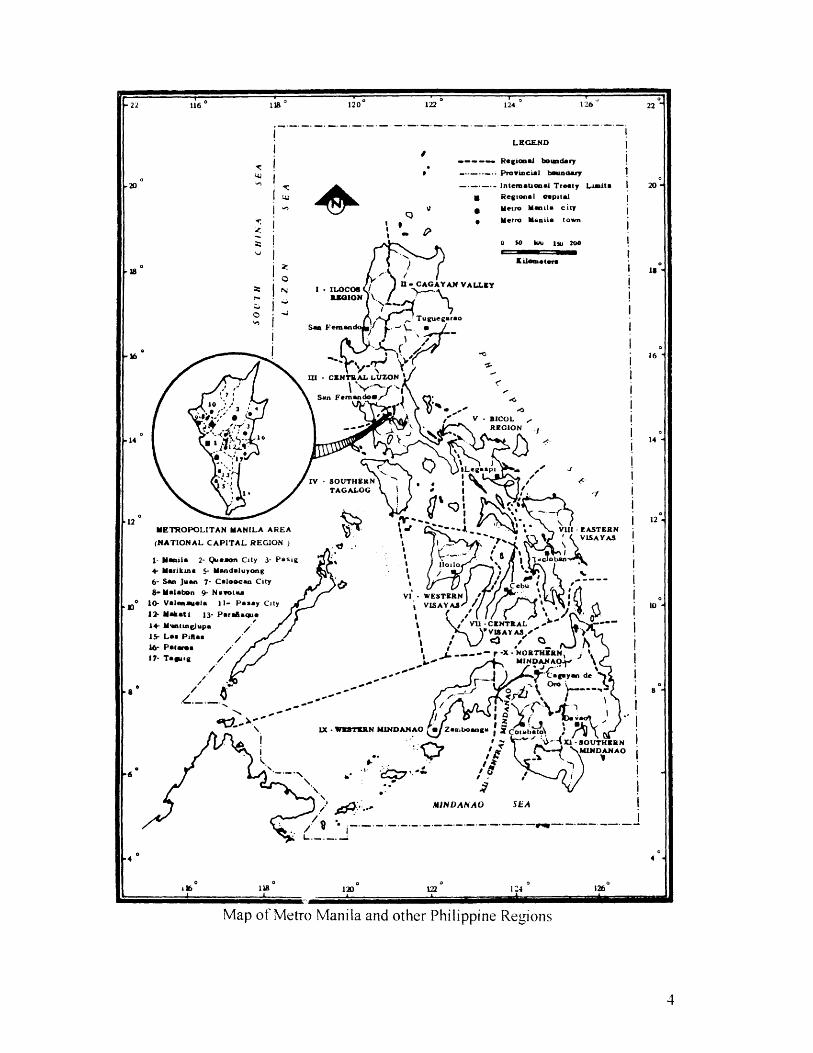
METROPOLITA
(NATIONAL CA
1- Manula 2- Qu+ Marikina 5- M6- San Juan 7- C8-Malabon 9- Ni
* 10- Valenauela 112- Makati 13- P1+ Mintinglupa15- La Pinles16- Pac aeI7- Taguig
LRGEND
------ Regional boundary
- Provincial boundary
--.----- Intemational Treaty Limita
a Regional capital
g Metro Manila city
Metro Manila town
0 50 kuu IS 200
Kileiineter,
N -n.OcOS 1- CAGAYAN VALLEYe RIIONO
Tuguegaro-Sa Fernan -
III - CENTRAL LUZON
San Faemandoa
V -CBICOL3 .--- -REGION .
16
nLegaspdIV -SOTHERN Aa
5 TAGALOG
N MANILA AREA * -EASPITAL REGION )
soon City 3- Pasig ieoandaluyong-
aloocan City evota
-i WESTIERNI- Pasay City VISAYAS
arafiaque Of
11V12CENTRA L
--ar -x -NORTHERNMINDANAO;
-'Cagayan de
LX - WESTERN MINDANAO aZanaboangauiobbt
- xi - aOUTHERN
MINDANAO SEA
Map of Metro Manila and other Philippine Regions

INTRODUCTION
Metro Manila, the capital region of the Philippines, has long felt the growing
pains of a disorderly and unhealthy urban environment that accompanies the
"developing" economy of the country. Its physical configuration has evolved in a more
or less laissez-faire manner reacting predominantly to market demand forces.
Over the last decade, accelerated economic growth brought about by the recent
restoration of democracy in the country has triggered a major influx of capital
investments into the nation's economy. This has resulted to dramatic changes in Metro
Manila's physical urban landscape characterized by the expansion of development
beyond metropolitan boundaries, the conversion of more agricultural lands to urban uses,
and the construction of numerous large scale projects.
Yet, all these developments have been achieved in an urban environment that is
steadily deteriorating, raising the possibility that the economic progress attained during
the last few years may not be sustained. Urban problems such as congestion and
pollution are approaching intolerable levels. Persistent neglect in dealing with these
burgeoning issues will only serve to compound their effects over time. But what can be
done to improve the urban conditions in Metro Manila?
I embarked on this study in search of a fuller understanding of the nature of the
urban development problems in the Philippine metropolis. I believe that before viable
solutions to current metropolitan problems could be formulated, a deeper awareness of
the urbanization forces that have influenced and continue to shape its growth and
development is required. I sought to address the following questions:
(1) What are the reasons behind Metro Manila's seemingly unplanned and
haphazard urban form?
(2) How can urban planning be used as a tool to alleviate the worsening
conditions in the metropolis?
Chapter One is a brief analysis of how the general experience of urbanization in
colonized countries like the Philippines differ from that of Western industrialized
countries.
Chapter Two provides a historical background of how the nature of Spanish and
American colonial rule led to the evolution of Manila as a primate city and how it
eventually became the dominant metropolitan area of the country.
Chapter Three analyzes the nature of the development trends and the magnitude
of the urban problems in Metro Manila.
Chapter Four describes the current urban developments and the initiative of
government to improve the conditions in the metropolis through physical urban planning.
Chapter Five suggests a conceptual planning approach towards achieving
preferred patterns of development.
I. URBANIZATION IN DEVELOPING COUNTRIES
Urban growth in many developing nations has followed a different path from that
in Western countries. In the Western World, the pattern of modem urbanization was
largely determined by the Industrial Revolution. That revolution accelerated the
urbanization process. It led to the progressive expansion and growth of many urban
areas that were spatially and economically integrated. The existence of multiple
urbanized areas tended to offset the economic dominance of one particular city or
metropolis. Especially since the end of World War II, the populations in most of the
large metropolitan areas in the West have ceased to grow and even declined. As the
industrialization process accelerated, improvements in transportation, mass
communication and the increased mobility of the people eventually led to the diffusion of
urbanism or the culture of the city. Therefore, urbanism is no longer confined to the city
but has spread to the countryside and has become part of the national culture.
In contrast, the main city in many Third World countries was largely a colonial
creation, imposed from without rather than a product of indigenous socio-economic
evolution. A common characteristic in these colonized countries is the dominance of one
primate city and the existence of a number of much smaller urban entities.' The
dominance of the main city developed from the multiple roles it performed as the
colonial capital and economic center linking it to the external colonial power. These
functions determined its spatial growth and development as well as shaped its pattern of
socio-economic relations with the other areas. The functional imbalance is manifested
by the evident physical contrast between the primate city and the rest of the cities and
regions in the country. The colonial capital eventually evolved into the national capital
and over a period of time, expanded beyond its boundaries and became a metropolis.
Within its territory is concentrated the majority of the country's urban population, the
bulk of the country's industries and economic activities, the location of most of its
1McGee, T. G. The Urbanization Process in the Third World, p. 3 1.
governmental, educational, and cultural institutions as well as the major communication
and transportation facilities. While the primate city continued to urbanize, development
in the rest of the country lagged behind, remaining basically agricultural and rural.
Although the urban problems of most Third World metropolitan areas appear to
be similar to those of Western industrialized countries, i.e., congestion, urban decay, and
inadequate services, they are actually very different and have more serious implications
in terms of overall national development. 2 The interdependent relationship of the
primate city and the rest of the developing country's regions is inherent to its national
economic structure. Physical urban problems do not only require solutions of a technical
nature but necessitate national economic growth and the political will to enforce basic
changes in its environment.3 Urban planning and land use, ecological maintenance,
provision of services, and planning for economic growth are ultimately political
processes. Development decisions and outcomes are much more a reflection of power
struggles rather than of rational planning.
It is within this developmental and historical context that the Philippine
experience in urbanization, focusing on the evolution of Manila into the country's
dominant primate city, will be examined.
II. DEVELOPMENT OF THE PHILIPPINE METROPOLIS
In order to comprehend the urban issues that confront Metropolitan Manila, an
understanding of its evolutionary colonial development over four centuries is required.
2 Laquian, Aprodicio. The Asian City and the Political Process, p. 19.3 Ibid-, p 23
A. Pre-Colonial Philippines
The Philippines is an archipelago consisting of over seven thousand islands.
Because of this geography, the pre-colonial population was not politically integrated.
The people lived in small, isolated communities known as barangays4 and had
subsistence economies. Agricultural production was geared mainly to the needs of the
communities and these needs determined the pattern of landholding within the
barangays. Land use was based on usufruct rights.
B. Spanish Colonization
The Spaniards came to the islands in 1521 for three main reasons: (1) to secure a
share in the spice trade then under Portuguese monopoly, (2) to establish direct contacts
with China and Japan, and (3) to convert more people to Christianity.5 Spanish
domination was initially established by force but continued control was secured by the
evangelistic works of religious missionaries. The formation, planning and administration
of towns for the new "converts" were left almost entirely in the hand of the friars.6 The
typical spatial pattern of urban settlements reflected the "under the bell" concept where
everyone had to be within earshot of the church bells.' One could determine the size of
the town by the size of the bell. Town planning followed the Graeco-Roman pattern
where the church, bell tower, convent and municipal hall occupied prominent locations
around the town plaza. These groups of civic structures were surrounded by streets that
followed a grid layout.
4 A harangay is essentially a group of extended families or a kinship group that formed a community. Thename was derived from the name of the boat that brought the original immigrants from Malaysia andIndonesia.5 Phelan, John L. The Hispanization of th Philippines, p. 6-7.6 Fernandez, Antonio. History of Philippine Planning: Pre-Colonial Era to 1946, p. 30.7 ibid.

Towards the end of the 16th Century, Intramuros, the Walled City of Manila, was
built. It linked the Philippines to Spain and served as a seat of the higher Spanish
bureaucracy and the ecclesiastical hierarchy and as a military outpost and center for
trade and commerce.8 The creation of the capital city of Manila facilitated the
unification of the Philippines under a centralized government structure under Spanish
administration.
Figure 11.1 Embryonic Manila was confined within the walls of Intramuros with anrea of approximately 1.2 square kilometers.
Source: 3erote, Ernesto. The Socio-Spatial Structure of the Colonial Third WorldCity, p. 7.
8 Serote, Emesto. The Socio-Spacial Structure of the Colonial Third World City, p. 6.

Spanish colonial rule introduced the concept of land as private property,
evidenced by the possession of a title and retained as a form of wealth. This profoundly
altered the pre-conquest economy and from then on, determined the nature and pace of
Philippine socio-economic development for almost three and a half centuries (1564-
1898). Ignorance of the imposed laws governing private land ownership and the
traditional deference to the ruling principalia9 paved the way for the alienation of much
of the natives' hereditary landholdings and their eventual concentration in private hands.
By the eighteenth century, the religious orders soon became the biggest landowners
around Manila. 0
The conversion of land to private property and the rise of large friar estates
exposed the native population to further economic exploitation and changed the structure
of the indigenous society. As the natives lost their properties through taxation and legal
confiscation by political leaders, they became tenants, share croppers, paid and unpaid
laborers in their own ancestral lands."
Colonial development policies fostered a dependent economy encouraging
agricultural production in rural areas and stimulating commercial and industrial activities
in urban areas. Through the tribute tax, compulsory labor, and forced government
purchase of agricultural products, resources from the countryside were extracted to
support the colonial bureaucracy and religious establishments in the islands, provide
income for the Spanish Crown, maintain the defense of the colony, and finance the
building of a colonial capital.' 2 Manila's central location in the biggest island of the
archipelago, Luzon, and its natural harbor made it the logical choice for the site of the
new city. The resource extractions, however, left little surplus and incentive for
economic development in the rural areas, thus, economic progress was generally
confined to Manila and its surrounding suburbs for many years.
9 The principalia was the class of native notables who served as local official during the Spanish periodacting as a link between the colonial authorities and the population; usually coopted from the pre-Spanishnobility. This group included the earliest collaborators of the Americans during their occupation.10 Constantino, Renato. A Past Revisited, p. 15.
Serote, Ernesto. The Socio-Spatial Structure of the Colonial Third World City, p. 9.'Ibid, p. 11.
In the latter half of the 18th Century, the temporary British occupation of Manila
broke down the country's isolation from the rest of the world and triggered numerous
revolts against the exploitations by Spanish colonial officials and friars. Consequently,
Spanish colonial policy began to focus on economic reconstruction and domestic
development.
In 1814, the country was officially opened to world commerce and this
tremendously increased demand for agricultural exports. This demand encouraged the
concentration of ownership of extraordinarily large parcels of agricultural land in the
hands of fewer and fewer individuals. A consequence of this was the growing number of
landless laborers. By the last quarter of the nineteenth century, Manila, as the port city,
was gradually becoming a cosmopolitan center with modem urban amenities such as
steam tramways, water supply lines, gas lamp streets, bull rings, theaters, etc.1
The organization of Manila's social and cultural life distinctly reflected the
"chain of surplus extraction" which was Philippine development. Within the confines of
the Walled City of Intramuros were European-born Spaniards, Creoles and Spanish14mestizos who tried to make life in the colony resemble that of Spain as much as
possible. The structures within this self-contained enclave reflected European
architectural styles and the residents were involved in numerous religious processions
and civic activities. Living outside the walls were foreign merchants, Chinese
businessmen and native principalias. The rest of the population lived in bamboo houses
in the surrounding suburbs. There were few social interactions between residents of
Intramuros and the suburbs. 15
Continued economic prosperity during the 19th Century enabled wealthy
Filipinos to obtain higher levels of education in Manila, and eventually Europe.16 It was
this illustrado 7 class that later articulated popular resentment of Spanish oppression,
13Fernandez, Antonio. History of Philippine Planning: Pre-Colonial Era to 1946, p. 35." Mestizos are the descendants of mixed marriages between a Filipino and a Spaniard or a Filipino and aChinese.15 Fernandez, Antonio. History of Philippine Planning: Pre-Colonial Era to 1946., p. 37.16 Ibid.,40.17 The illustrados were the educated class among Filipinos during the latter half of the nineteenth century,consisting of natives, mestizos, and creoles, which articulated the beginning of Philippine nationalism. Theycame from the middle and upper class or the principalia class.

fostered nationalistic sentiments and agitated for political and economic emancipation.
With the support of the exploited agricultural laborers, a revolution was staged in Manila
in 1896. Around this time, the Americans, who were also engaged in a war against Spain
in Cuba, aided the Filipinos and fought the Spaniards to gain control over the rest of the
archipelago. The unified Philippines was proclaimed a republic.
The Filipinos were on the threshold of self-rule when they realized that the
Americans had used the revolution to install themselves in place of the Spaniards. The
Filipino-American War of 1899 took place in Manila, but superior arms and military
organization assured eventual American victory.
C. The American Regime
As with Spanish rule, the country under the Americans continued to have an
agricultural export economy, its rich natural resources developed to support foreign
commercial and industrial interests -- this time for the United States.
The vast friar lands were purchased by Gov. Howard Taft in 1903 ostensibly to be
subdivided and sold to tenants of the estates but there was no accompanying program for
financial assistance.' 8 Consequently, much of the vast landholdings ended up in the
hands of American individuals and corporations as well as in the hands of the Filipino
landed elite.
Manila remained the capital city under American rule. The influx of more
Americans into the city led to the reconstruction and improvement of its urban
infrastructure. To increase the efficiency in the delivery of cash crops from the
countryside, the Americans built railways. New roads and bridges were constructed and
Manila's harbor was upgraded to international standards. This paved the way for
18 Cortez, Alejandro. The Philippine Primate City , p. 23.

American and European multi-national companies to establish office in Manila. Thus,
the Americans introduced the country into an era of monopoly capitalism.
The urban landscape was rapidly changing in character with the construction of
parks, public recreation areas, social clubs, bars and government structures. In rural
towns, the public primary school became an added feature of the plaza complex.
The Americans also introduced the ideals and institutions of democracy and
modem amenities for urban living. 19 By encouraging public education of the masses,
they changed the rules of social mobility from one based on property ownership to one
based on educational attainment and technical knowledge. Demand for higher education
led to the proliferation of private schools, colleges and universities in Manila.
All throughout the American regime, rural migrants flowed into the capital city
either to take jobs in the foreign firms or to enroll in schools for higher education. This
rapid and unhampered in-migration resulted to many urban problems such as congestion,
the emergence of slums and squatter settlements, and the shortage of basic services.
The increasing demand for housing led to another change in land disposition --
urban land development. The Americans reinforced the Spanish institution of private
property ownership and introduced the business of real estate development.2 0 The large
estates they had purchased from the Spanish religious orders were subdivided and sold to
individual homeowners. The native elite with extensive landholdings likewise converted
their agricultural lands to urban housing developments.
By the first decade of the 20th Century, Manila had grown by leaps and bounds.
It leapt out of the walls of Intranuros and became an extramural city. In 1903, the City
of Manila formally incorporated twelve of the fast-growing suburban towns and the
Walled City became just one of its thirteen local districts.21
The biggest influence that the Americans would have made on the physical
structure of Manila was the deliberate attempt to control its growth through a master
plan. In 1905, the prominent Chicago city planner and proponent of the "City Beautiful
'9 Ibid, p. 39.20 Ibid, p. 48.2 Fernandez, Antonio. History of Philippine Planning: Pre-Colonial Era to 1946, p. 44.

Movement," Daniel H. Burnham, was commissioned by Gov. Taft to design Manila.
The Burnham plan was similar in many respects to San Francisco and Washington, DC.
' :AIILA P.!.PLAN OF PROPOSED IMPRZVZMENTS
Figure 11.1(Source:
Burnham's Plan for the Capital City of Manila, 1905Silao, Federico. Burnham's Planfor Manila, p. 10)
2 Moore, Charles. Daniel Burnham: Architect, Planer of Cities, p.13.
His five major interrelated proposals were: (1) the development of the waterfront
and the location of parks and parkways in areas that would give adequate opportunities
for recreation to every quarter of the city, (2) the establishment of a street system that
would secure direct and easy communication from every part of the city to every other
district, (3) the location of building sites for various activities, (4) the development of
the interior riverways for transportation, and (5) the provision of summer resorts.
Initially, the prospects of having the Manila Plan faithfully executed were bright.
The Philippines, as a colonial possession of the United States, was entitled to colonial
government funds for public improvements towards the realization of the objectives of
the plan. Burnham advised the government to start laying out the initial purchasing lands
to ensure the proper implementation of the plan but, unfortunately, his advice was not
heeded. Manila, consequently, lost the chance to reserve land for its future needs for
urban development.
A decision was made by President Quezon to transfer the capital city to a new and
larger site. In 1936, Quezon City was planned as the permanent seat of the national
government and as an outlet for the congested city of Manila. It was to be developed by
public and private enterprises. However, the implementation of the urban plans was
overtaken by the outbreak of World War II. The Japanese occupied Manila in 1942.
More than two-thirds of Manila's facilities were destroyed and many structures were
leveled to the ground in the battles fought to liberate the city from the Japanese forces.
D. The Period of Reconstruction
After World War II, the United States granted political independence to the
Philippines but retained twenty-three military bases in the archipelago. Economic and
23 Silao, Federico. Burhman's Planfor Manila, p. 13.24 Ibid., p. 14.2 Fernandez, Antonio. History of Philippine Planning: Pre-Colonial Era to 1946, p. 62.

political power became concentrated in a small traditional landowning class whose
interest lay in the continuation of the country's dependent economy. The newly
established government supported local government autonomy laws and opposed26comprehensive national development programs.
The destruction of Manila after the war did not interrupt the flow of rural
migrants into the city. Economic policies emphasized industrialization at the expense of
agricultural productivity. The dependence of new industries on imported machines and
raw materials meant that the rural economy did not participate fully in the nation's
growth as it might have done if industrialization had been linked to a domestic raw
material base. This import dependence led to the concentration of manufacturing
industries around Manila as the country's principal port, thus, perpetuating continued
rural underdevelopment and the further concentration of wealth and economic activities
in Manila and its surrounding areas.
The shift towards industrialization altered the pattern of urban development.
Migrant families boldly occupied vacant and deserted lands, whether public or private.
Squatters moved into the ruins of Intranuros, thus, transforming the once proud center of
Spanish authority into a veritable slum.
Because of the growing demand for urban land for commercial and other
speculative ventures, land values had rapidly gone up. Lack of effective land
development controls led to the undirected spatial expansion, the arbitrary location of
homes and factories, the growing inadequacy of services, and the development of private
enclaves. The continuous movement of people from one part of the city to another
resulted to changing land use patterns.
Manila's further growth proceeded in this manner, a haphazard process based on
political expediency, immediate needs and short-term decisions. 28 Government planning
efforts focused mainly on the expansion of land areas to accommodate the growing
26 Cortez, Alejandro. The Philippine Primate City, p. 56.27 Ibid., p.60.28 Ibid., p. 61.
population and the expansion of various socio-economic activities. These activities
determined the kinds of land used and the infrastructure and utilities to be constructed.
Over the years, urban blight had steadily eaten into the old core of the city and
this led to the building of settlements beyond city boundaries. Middle and higher income
families relocated to the suburbs following the transfer of schools, government offices
and new industries. This trend of rural-urban and urban-suburban migration shaped the
pattern of the emerging urban landscape.
During the 1950s, redevelopment efforts adapted a different form of movement,
from the "City Beautiful" to the "City Efficient" concept29. There was rapid construction
of all forms of structures taking cue from Western standards and models. The physical
landscape projected a new look with numerous modern buildings, factories, roads and
vehicles. Several exclusive residential subdivisions and posh commercial complexes
were mushrooming in scattered locations within the rapidly urbanizing area.
The accelerated pace of physical development and the intensification of
industrialization were indications of the recovering economy but there were still those
nagging issues about the quality of the resulting urban environment. There was no
strategic consideration for an overall, comprehensive vision in relation to the growing
needs and future demands of the ever-increasing urban population. The problems of
rapid urbanization such as chaotic land uses, growing slums, increasing traffic
congestion, pollution and environmental degradation continued unabated.
Government attempts at long-range physical planning through the creation of a
number of centralized planning agencies were ineffective in controlling the growth of the
rapidly urbanizing area.: (see Appendix A) This was not only because of their weak
organizations and lack of financial and technical resources, but more importantly, their
lack of political support. During that time, the concepts and consequences of urban
development, city planning and urban rehabilitation were not fully appreciated by either
government or private enterprise. Physical urban development needs were not
29 The City Efficient concept pertains to the emphasis on economic efficiency in building. It is also viewed interms of being attuned with the international industrial built-up as influenced by the war-time surplus and thetrend towards modernization.30 Oreta, Prospero. Urban Management in Megacities: The Case of Metro Manila, p. 2.
incorporated in long-term economic plans. Planning was voluntary, at the discretion of
individual local governments, and since local funds and technical personnel were
unavailable, in most areas, physical planning was not done at all. 31 The national
government concentrated the bulk of its resources in economic planning while physical
urban planning remained a low priority-issue in policy-making. Its efforts to cope with
the increasing demands of urbanization continued in a piecemeal, uncoordinated and
ineffective fashion, addressing mainly the symptoms of the worsening problems rather
than the causes.
Manila's run-away urbanization resulted in imbalanced development, prematurely
converted prime agricultural lands into urban uses, irrationally mixed the uses of land,
and tolerated the proliferation of slums and squatter settlements. The cumulative
effects of government's neglect in dealing with these mounting urban problems
eventually spread to adjoining regions.
All these issues came to a dramatic head in 1972 when a series of typhoons
brought heavy rains for some forty days, inundating Manila and its surrounding areas,
paralyzing transportation and communications and bringing the economy to a standstill.
The flooding was caused by a number of interrelated factors: the area's flat and marshy
terrain, the inadequate drainage aggravated by silting of creeks and rivers and the
disappearance of many esteros (canals that serve as storm drainage) due to illegal
squatting, the denuded forest lands, the increasing urban population in coastal areas, and
the inadequate drainage facilities.: The disaster so severely strained government
resources that even after the flood waters had subsided, the country was in a state of
economic crisis. President Marcos, thus, proceeded with the fateful decision to impose
Martial Law over the entire country.
3' Aragoncillo, Erlinda. History of Planning: 1946-1972. p.14.32 Ibid., p. 23.3 Cortez, Alejandro. The Philippine Primate City, p. 148
E. The Movements Towards Metropolitan Reform
The government under Martial Law aimed at ushering in the beginning of
progressive reconstruction by creating a "New Society" that demanded radical reduction
of the economic gap between the rich and the poor. It hoped to give stability to the
country's development that had so far been traumatic because of the many disruptive
periods in its history. The President considered the old governing system as oligarchic --
where the elite exercised their political authority over the masses and perpetuated an
individualistic form of politics. Thus, the initial decisions of the Martial Law government
was to weaken the power base of the traditional landed elite by the abolition of the
democratic Congress and the closure of private media networks.
The President became the sole law-making authority, concentrating in that office
both executive and legislative powers. In taking up the task of nation rebuilding, the
President relied on the support of a strengthened military force and a select group of
civilian technocrats who assisted him in the formulation of long-term "grandiose" plans,
drafting presidential decrees and executing policies.
President Marcos commissioned multiple studies aimed at determining the most
appropriate organization to manage the burgeoning urban problems of Manila and its
expanding geographical domain. Manila's reform became an integral part of the strategy
for national economic development.
In 1975, preceded by almost a dozen organizational proposals, President Marcos
issued a presidential decree which integrated the four cities and thirteen municipalities
into a unified territorial and administrative entity known as Metropolitan Manila or the
National Capital Region of the Philippines. It created the Metro Manila Commission
(MMC) as its single governing body to replace the existing seventeen local government
units. 3 The MMC was the first organization legally mandated to plan, manage, and
implement a metropolitan blueprint for the planned physical development of Metro
3 Santiago, Asteya. Urban and Regional Planning in the Philippines, p. 459.
Manila. The First Lady, Imelda Marcos, was appointed by the President as the governor
of the MMC."
The drive to make Metro Manila attractive as a base for foreign investments in
Southeast Asia and to promote the tourism industry led to massive government
investments in urban infrastructure. High priority was given to the repair of roads, flood
control projects, highway expansion to outlying regions, creation of high-profile
architectural structures, etc. Ironically, these reforms appeared to reinforce Manila's
historic role as the colonial center of capital accumulation and surplus extraction.
The MMC was vested with strong planning, implementation and taxing powers.
It took over most of the executive powers of the seventeen local governments in the
metropolis and all of their legislative powers.
Considering that it was the first metropolitan organization in the country, the
MMC did not have the benefit of precedence and had to develop its own programs for
metropolitan governance. Specialized national government agencies were created to
deal separately with development issues such as housing, environment, land use,
transportation, soils, etc. These agencies became responsible for the systematic gathering
and organization of data for development purposes. This information approach laid the
foundation for more rationalized planning in the Philippines.
The major accomplishment of the MMC was the creation of a Structure Plan for
Metro Manila which laid out proposals for major infrastructure investments.36 (see Figure
11.3) The Structure Plan aimed at deconcentrating development outside Metro Manila
through several legislations such as the fifty-kilometer industrial ban, the setting up of
new town developments, and the identification of priority industrial and export
processing zones nationwide. MMC also initiated land use and zoning surveys for each
of its seventeen local districts but these were more of indicative documentations of the
existing built-up uses rather than implementable plans.
3 Datuin, Arnel. Martial Law in the Philippines, p. 48.36 Santiago, Asteya. Urban and RegionalPlanning in the Philippines, p. 459.

LEGEND:
(Q t1GH INTENSITY DEVELOPMENT
Q LOW INTENSITY DEVELOPMENT
G INSTITUTIONAL
MMlI MAJOR OPEN SPACE/AGRICULTURAL.AREAS
Figure 11.3Source:
The Structure Plan of Metro ManilaFaithfull, Walter. Manila Bay Metropolitan Region, Philippine Planning
Journal, Vol. III, No. 2, April 1972.
MMC's limited accomplishments, especially considered against the vast
resources it had at its disposal and the wide range of both legislative and executive
powers it had, have been attribute to many reasons.37 The over-centralization of power
and decision-making in the MMC reduced the local governments to weak participants in
the metropolitan administration system. Local governments were unable to make
significant contributions to guide the direction of growth within their jurisdictions.
Legislative power was in the hands of a single person -- the governor -- and the executive
and the local government officials had no powers or discretion on their own. These
officials were also, concurrently, officers in other national agencies and could only
devote part time to their metropolitan duties. This disjointed and fragmented structure of
decision-making did not benefit from organization-wide consultation. Its vertical
structure of approvals significantly lengthened the implementation process of
development proposals. Numerous infrastructure projects were bogged down in red tape
while priority projects that had strong political connections had better chances of getting
approved.: Corruption in government was rampant during the Marcos administration
because of the tremendous concentration of power and resources and the unchecked
hierarchical structure of government.
Another main problem of the Martial Law government was that its long-term and
ambitious development programs relied heavily on foreign capital invested by multi-
national corporations or in the form of foreign loans. Many affluent Filipinos, during that
time, had invested their capital outside the country. Although the multi-national
corporations and foreign loans had substantially contributed to the overall economic
growth of the country, the benefits had gone mainly to the few. Increases in national
income had not trickled down to the populace as had been optimistically assumed, and
the country was gravely in debt to foreign banks.
37 Einsiedel, Nathaniel von. Managing Metro Manila: Lessonsfrom the Past. A published report writtenby the Commissioner of the MMC.38 Datuin, Arnel. Martial Law in the Philippines, p. 64.

Martial Law was officially lifted in 1981 but the Marcos administration continued
to govern the country until it was overthrown in 1986 by a peaceful revolution led by
Corazon Aquino. A new democratic government was set in place.
Beset by the enormous tasks of political and economic restructuring, physical
urban planning did not receive much attention in the Aquino administration but it did lay
the foundation for finn democratic governance through the creation of the 1987
Constitution. Most of the projects of the Structure Plan were either left in limbo or
discontinued and no clear urban policy had been pursued.:9
A sequel to the continuing experimentation for more efficient and effective
management of urban development in Metro Manila was the creation of the Metro
Manila Authority (MMA) in 1990.*0 The MMA tried to reconcile local autonomy with
metropolitan governance by ensuring that local governments retained their respective
executive and legislative powers. This was in direct contrast to the actions of its
predecessor, the MMC. The MIMA underscored the fact that the local government units
should be primarily responsible for the administration of their respective political
jurisdictions. The MMA, in strict adherence to the new Constitutional mandate, was
granted only coordinating powers over the delivery of metropolitan services. This
resulted in a highly emasculated organization which had limited capacity for long-range
physical planning.
Another MNA innovation to the MMC set-up was the decentralized and
participative system of governance set up through the collective responsibility of the
local government units whose mayors were all members of the Council. The
chairmanship was rotated among the Council members in six-month intervals to express
shared and equitable leadership for all its members regardless of whether they were cities
or municipalities and regardless of their financial position. The absence of a fixed tenure
for the chairman inhibited long-term planning and implementation of programs and
caused discontinuity in policy-fonrination. This highly decentralized approach led to
39National Urban Development and Housing Framework, 1993-1998, Housing and Urban DevelopmentCoordination Council, p.1.40 Santiago, Asteya. Urban and Regional Planning in the Philippines, p. 461.

numerous short-term projects that were initiated but eventually discontinued. In 1995,
after four years of uneventful existence and plagued with a wide range of financial
constraints, the MMA was replaced by another metropolitan governing body, the Metro
Manila Development Authority (MMDA). In the past two decades, the management
of the metropolis has, therefore, changed hands three times.
It is, indeed, ironic that all throughout Metro Manila's tumultuous history, the
perpetual experimentation by different forms of government to create a more effective
planning structure for directing metropolitan growth and providing basic services has
been at the expense of its rational and planned development.
41 Oreta, Prospero. Urban Management in Megacities: The Case of Metro Manila, p.2.

11. THE EVOLVING TRENDS OF URBAN DEVELOPMENT
Manila's growth and dominance was shaped by the convergence of geographic,
economic, social and political factors in Philippine colonial history. Its eventual
expansion into a modem metropolitan area is an outcome of consequences that
influenced its urbanization process. This section will analyze in more detail the
cumulative problems and development trends that continue to affect Metro Manila's
contemporary urban landscape.
A. The Cycle of Migration
The origins of Metro Manila's current urban problems can be traced to the
concentration of activities in Manila and the heavy migration to the city of the people
from depressed areas. As indicated in the previous chapter, Spanish, and later, American
colonial policies fostered the dependent development of the Philippine economy and
shaped the structure of its social class and politics. These policies nurtured Manila's
primacy by perpetuating rural underdevelopment and the concentration of wealth and
economic activities in Manila and its surrounding areas.1
As the colonial capital of the country, Manila was the center of trade, education,
culture and socio-economic activities. 2 It served as a point of capital accumulation, its
growth sustained at the expense of the rest of the country. As a result, continuous
streams of migrants were "pushed" from the rural areas by the exploitative practices of
the colonialists and the lack of economic opportunities in the countryside and were
"pulled" to the city by the perceived prospects of jobs, education and improved living
conditions. Continued imbalanced development even after the Second World War
' Serote, Ernesto. The Socio-Spatial Structure of the Colonial Third World Country, p. 9.2 Ocampo, Romeo. Planning and Management of Metro Manila: Focus on Development and Conservationof the Inner City Area, p. 1.

prompted the more ambitious and better-educated manpower of the rural areas to
gravitate to Manila, thus, contributing substantially to its population growth.
In 1975, for instance, during Martial Law, the density of Metro Manila was over
7,500 persons/square kilometer while the average density of the country was 140
persons/square kilometer.
As of May 1, 1975(Persons/sq. km.)
REGION III-
REGION IVMETRO MANILA-7646.2
A A f'AA 4
SOUTHERN 'IAGALOG-IIO.4 .
88.8/
A 1/
REGION VIII-120.6
REGION X- 81.3
REGION XI-85.6
A
Figure 111.1Source:
Population Density By Region, Philippines (As of May 1, 1975)Republic of the Philippines, National Economic Development Authority,1977 Philippine Statistics Yearbook, p. 34.

This unceasing rural-urban migration trend has persisted over the years and has
very serious long-term repercussions in the overall development of the country.
Table I1I.A
Level of Urbanization, Urban Population, Share in Total Urban Population, andAverage Annual Growth Rate for Metro Manila, 1903-1990
Census Year Level of Urban Per Cent of Per CentUrbanization* Population (in Total Urban Change
(o) thousands) Population
1903 76.9 256.7 25.7 -
1918 87.1 371.1 28.7 2.41939 90.3 903.3 26.2 4.61948 97.1 1,526.1 29.4 5.51960 98.1 2,426.5 30.0 4.21970 100.0 3,952.6 33.0 4.91980 100.0 5,927.1 31.9 4.01990 100.0 7,948.8 31.2 2.9
Source: The Impact of Migration of Rural Areas in the Philippines,National Urban Development and Housing Framework, 1993-1998.
* Level of urbanization is the proportion (percentage) of the population living in theurban places.
As the rural areas continue to lose their better educated population, the area's
prospects for economic advancement remain relatively low. Migrants from these rural
areas tend to have lower educational and technical skills compared with residents from
the urban areas Migrants to Metro Manila are generally not able to compete with the
resident population in the metropolis' highly competitive job market for specialized
services and technical skills. Consequently, they are often forced to reside in low-income
neighborhoods and squatter settlements where the cost of living is within their meager
means. 4 Despite harsh conditions, people continue to trek to the big city. Their swelling
number strains existing public services, intensifying the host of urban problems such as
inadequate housing, public transport, traffic congestion, increased crime rates, etc.
A significant contributor to this enduring migration trend is the concentration of
the best and most prestigious colleges and universities in Metro Manila. In 1990, 38% of
the nation's universities were located within the metropolis5 . This geographic
centralization of higher educational institutions encourages the profusion of employment
opportunities within the metropolitan area for professional, technical, and related work.
In 1993, Metro Manila's labor force accounts for 58% of the nation's employable
population and almost 71% of this engage in the service sector.7
In terms of industrial investments, Metro Manila has been greatly favored while
the rest of the country's regions have not benefited accordingly. In 1993, 70% of all
industries in the country are located within the metropolitan region.8 It accounts for over
half of the country's total manufacturing and commercial output. It similarly dominates
the country's cultural and communications industries.9
Metro Manila's dominance can also be measured by its contribution to the
Philippine economy. In 1993 , Metro Manila generated more than a third of the national
3 Ocampo, Romeo. Planning and Management of Metro Manila: Focus on Development andConservation of the Inner City Area, p. 6.4 Shelter and Human Settlements. Philippine Report, p. 23.5 Data are from the Republic of the Philippines, Department of Education and Culture, Planning Service,Project Development and Evaluation Division.6 Refers to the percent of the population that are aged 15 years and over.
Oreta, Prospero. Urban Management in Megacilies: The Case of Metropolitan Manila. p 8.* Ibid.9 Ibid., p.7.
Gross Domestic Product (GDP).10 It is the only one of the country's fourteen regions
considered to be fully urbanized. This means that it does not rely on the agricultural
sector for its income but on the service and industrial sector. As the capital region drains
manpower from both developed and underdeveloped regions, these manpower resources
contribute to furthering Metro Manila's dominance in the national economy. Therefore,
its economic dominance reinforces its growth. This pattern of urbanization reflects a
vicious circle of uneven development in the Philippines.
At present, Metro Manila continues to be the fastest growing agglomeration in the
country. It is geographically defined by eight cities and nine municipalities. It is one of
the largest and most crowded metropolis in the Asia-Pacific Region and the 18th largest
in the world." Its current resident population is 8.6 million, 13% of the total population
of the country and about 1/3 of the total urban population. Its land area is about 636
square kilometers which accounts for only 0.2% of the country's total land area (slightly
larger than Singapore). It has a population density of over 13,400 persons per square
kilometer, almost 60 times the national average. The Philippines' second largest city,
Metro Cebu, has a population of only 1 million.
Within the next 20 years, it is forecasted that 5 million more people will reside in
Metro Manila.'2 As the population grows, so will the pressures on the existing limited
resources -- social and human services, finance, infrastructure, and the environment.
10 Ranjo, Mary Grace. NCR Regional Development Plan, 1993-1998, Ch. 1." Oreta, Prospero. Urban Management in Megacities: The Case of Metropolitan Manila, p.7.12 Development Framework Plan for Metro Manila:1996-2016, Metro Manila Development Authority, p. 5.
B. The Crisis of Urban Growth
Control over urban land and its uses has been a major determining factor in the
physical development of Metro Manila. Urban growth has largely been conducted by the
private sector. Private ownership of large tracts of land all over country is not a rare
phenomenon. This situation finds historical precedent in the land tenure system during
the Spanish time and was continued by the Americans. The Americans did try to
redistribute urban lands, but it was strictly a business proposition. Land was a
commodity of trade subject to price speculation and indiscriminate use.
The problems of land utilization became increasingly apparent after the Second
World War when Manila was rapidly becoming industrialized. The newly established
government was still at its formative stage and was ill-equipped to deal with the
burgeoning urban problems created by the waves of rural migrants. Technical, financial
and political obstacles had deprived it of the opportunity to undertaking land use
planning and implementation within the context of a comprehensive urban plan. Thus,Manila's postwar growth was characterized by bargaining and compromises resulting in
an organic and arbitrary pattern of urban land development.13 Manila's transformation
into a metropolitan area proceeded in this haphazard and random manner, expanding in
all directions to surrounding areas.
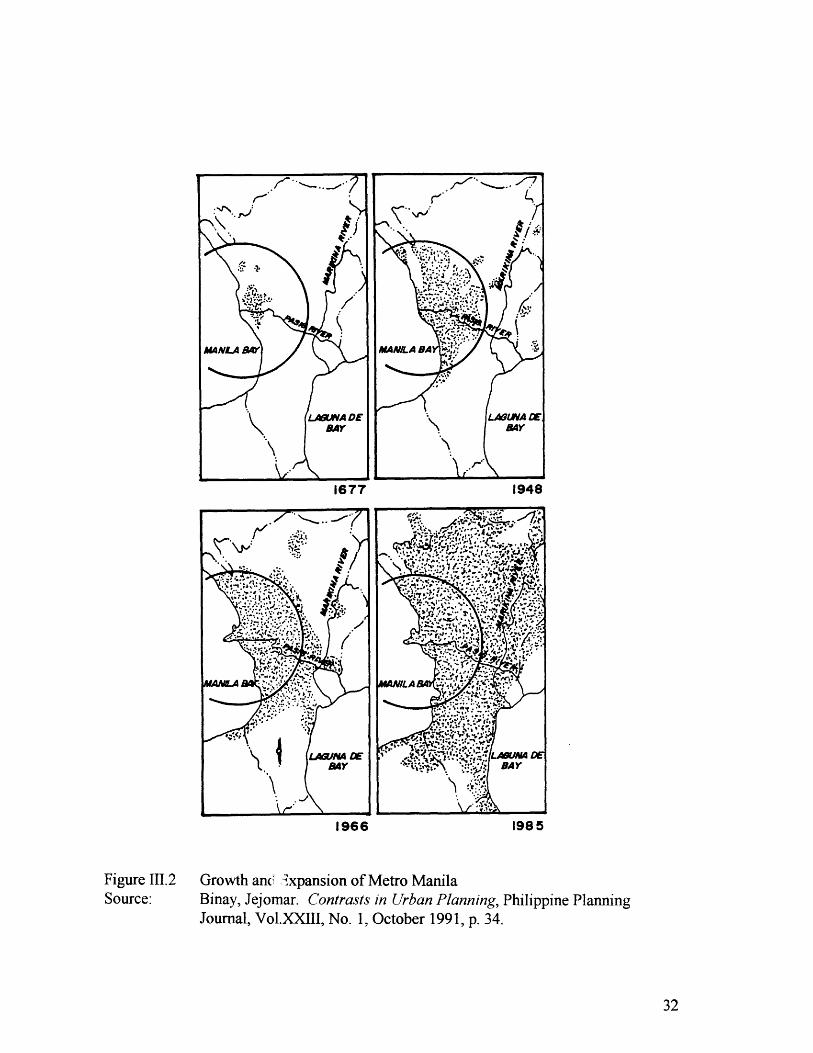
An outstanding characteristic of Manila is that, throughout its history, it has not
stopped evolving. Its geographic spread has expanded from an eight-kilometer radius
from the mouth of the Pasig River in the immediate post-war period to fourteen
kilometers radius in 1985.14 In the 1990s, this spread has expanded to twenty
kilometers. 15
13 Ocampo, Romeo. Planning and Management of Metro Manila: Focus on Development andConservation of the Inner City Area, p. 9.14 Binay, Jejomar. Contrast in Urban Planning, p. 33." Oreta, Prospero. Urban Management in Megacities: The Case of Metro Manila, p. 11.
1677 1948
1966 1985
Figure 111.2Source:
Growth an' Ixpansion of Metro ManilaBinay, Jejomar. Contrasts in Urban Planning, Philippine PlanningJournal, Vol.XXIII, No. 1, October 1991, p. 34.

During the Martial Law Administration, the government sought to rationalize the
physical growth of the metropolis by establishing the pattern for its road expansion. The
metropolitan road network is composed on ten radial roads and six circumferential roads,but many of the road segments have not yet been constructed. 6
LEGENDEXISTING MAJO"
+ ThOROUWP4. .-- PROPOSED MAJOl
*"fl4oRu.NFma
Present and Proposed Road Network of Metro ManilaMetro Manila Urban Transportation Plan, 1993.Department of Transportation and Comm nication.
16 Development Framework Planfor Metro Mani/a, 1996-2016, Metro Manila Development Authority,p. 12.
Figure 111.3Source:
The metropolitan area can be subdivided into an inner core and an intermediate
core. The developed inner core is heavily built up with a jumble of incompatible land
uses. It is bounded by a circumferencial road known as C-4 or EDSA (Epifanio delos
Santos Avenue). The intermediate core, on the other hand, is a physical transition from
the developed inner core to the moderately urbanized area. It consists of predominantly
uniform density residential development and other supporting uses. The intermediate
core is bounded between C-4 and the projected C-6. Outside of C-6 is a directionless
sprawl of communities, industrial and agricultural areas.17
A typical trend of metropolitan expansion is that it runs in a linear or ribbon
pattern where development follows major roadways.' 8 Land uses along roadways have
been changing over time in accordance with market demand and private sector decisions.
However, these multiple, uncoordinated and piecemeal private decisions in the
development of urban land have not necessarily consider the broader physical setting and
the functional efficiency of metropolitan systems. The leniency of government in
controlling urban development is clearly manifested in the poor location of many traffic
generating developments.
EDSA, the main thoroughfare that cuts across the center of the metropolis is a
prime example of the linear development pattern. This 12-lane highway serves as the
most major link from the northern to the southern portions of the metropolis. It receives
the bulk of the vehicular traffic from the radial roads. Residential, commercial and
institutional uses of moderate density used to abut this highway.
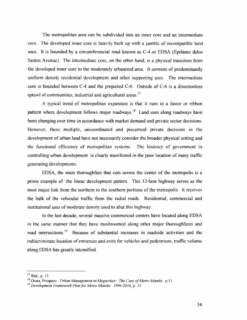
In the last decade, several massive commercial centers have located along EDSA
in the same manner that they have mushroomed along other major thoroughfares and
road intersections. 19 Because of substantial increases in roadside activities and the
indiscriminate location of entrances and exits for vehicles and pedestrians, traffic volume
along EDSA has greatly intensified.
1 Ibid., p. 13.G8Oreta, Prospero. Urban Management in Megacities The Case of Metro Manila. p.11.
19 Development Framework Plan for Metro Manila: 1996-2016, p. 13.
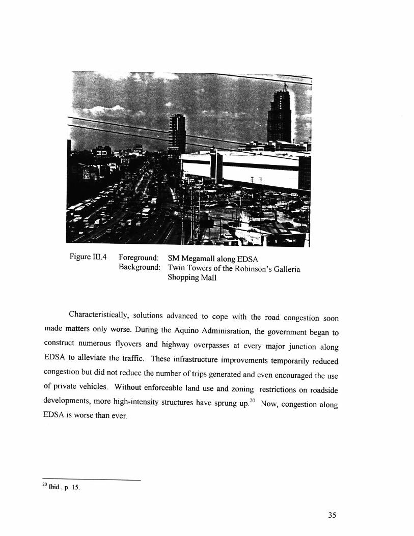
Figure AI4 Foreground: SM Megamall along EDSABackground: Twin Towers of the Robinson's Galleria
Shopping Mall
Characteristically, solutions advanced to cope with the road congestion soon
made matters only worse. During the Aquino Adminisration, the government began to
construct numerous flyovers and highway overpasses at every major junction along
EDSA to alleviate the traffic. These infrastructure improvements temporarily reduced
congestion but did not reduce the number of trips generated and even encouraged the use
of private vehicles. Without enforceable land use and zoning restrictions on roadside
developments, more high-intensity structures have sprung up.20 Now, congestion along
EDSA is worse than ever.
20 Ibid., p. 15.

Figure 111.5 Highway Overpasses along EDSA
In the last two years, metropolitan traffic jams have reached such paralyzing
proportions that the government has had to implement drastic measures to limit the
number of private vehicles on the roadways (only cars with license plates ending in 1 or
2 can use the public roads on Monday, 3 or 4 on Tuesday, etc. during designated peak
hours). Average vehicle speeds in the metropolitan area have gone down to about 15
kilometers per hour.
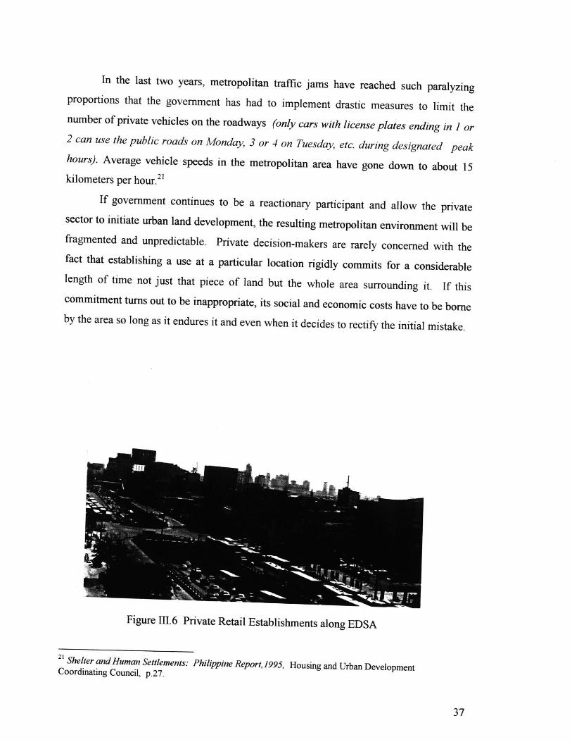
If government continues to be a reactionary participant and allow the private
sector to initiate urban land development, the resulting metropolitan environment will be
fragmented and unpredictable. Private decision-makers are rarely concerned with the
fact that establishing a use at a particular location rigidly commits for a considerable
length of time not just that piece of land but the whole area surrounding it. If this
commitment turns out to be inappropriate, its social and economic costs have to be borne
by the area so long as it endures it and even when it decides to rectify the initial mistake.
Figure 111.6 Private Retail Establishments along EDSA
21 Shelter and Human Settlements: Philippine Report, 1995, Housing and Urban DevelopmentCoordinating Council, p.27.
Land uses being highly interrelated in themselves and in relation to urban
activities need to be allocated in right proportions and arranged and juxtaposed bearing in
mind their multiple inter-linkages. Ad hoc land use decisions ignore this vital aspect and
thus cause serious troubles and imbalances. Metro Manila's current urban landscape
clearly reflects the accumulation of parochial market-driven decisions and compromises
that have been made without the forward-looking tradition of city planning.
Another trend in Metro Manila's urban development is its rapid unguided
expansion to outlying areas. During the postwar period, negative and low growth rates
were occurring in the old inner core of the metropolis as it was approaching its capacity.
The intermediate area, on the other hand, was experiencing increased population growth
as more suburban residential communities for middle to high income markets were being22developed by private real estate companies.
This pattern of private sector-initiated sprawl results to the irrational distribution
of population vis-A-vis employment and other supporting land use activities. Suburban
communities remain primarily "dormitory towns" with residents depending on the
metropolitan core for jobs. A consequence of this population-employment imbalance is
the worsening pattern of heavy and long cross movements between homes and
workplaces.
Over the years, the intermediate core has become increasingly built up and the
residential sprawl has now extended beyond the metropolitan boundaries. Low-cost24housing projects have sprung up in the adjacent provinces outside Metro Manila.
Private developers have been purchasing large tracts of agricultural lands along regional
roadways and developing them as exclusive gated communities.
22 Ocampo, Romeo. Planning and Management of Metro Manila: Focus on Development andConservation of the Inner City Area, p. 8.23 Shelter and Human Settlements: Philippine Report, 1995, Housing and Urban DevelopmentCoordinating Council, p.43.24 Ibid.
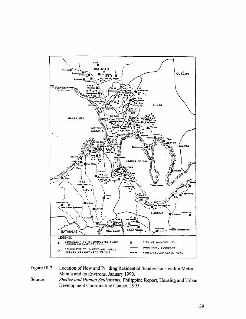
Location of New and P. ding Residential Subdivisions within MetroManila and its Environs, January 1990.Shelter and Human Settlements, Philippine Report, Housing and UrbanDevelopment Coordinating Counci, 1995.
Figure 1.7
Source:
On-going developments such as these have unwanted consequences. First, they
contribute further to inefficient land use patterns in the absence of enforceable land use
and zoning plans. Second, this "leap-frog" expansion trend brings about development in
outer regions that are not yet prepared to accommodate substantial increases in density.
For instance, it can easily be predicted that traffic conditions along these narrow regional
roads will worsen in the coming years as provincial development intensifies.
Simultaneously with the outward expansion in all directions, Metro Manila
continues to experience in-filling and land use changes in its main urban areas. The
unrestrained construction of high-rise condominiums, commercial and office buildings
on previously low to moderate density sites without the adequate adjustments in
supporting infrastructure causes strains in existing services. Open spaces, already
inadequate both in quantity and distribution, are fast giving way to more intensive uses.
Metro Manila's land development practices are far from being conducive to the
creation of better physical environments. Without a longer term vision within which
better planning and stricter enforcement of development policies could take place, future
growth and expansion will continue as in the past, with only limited control over the
nature and extent of development. Market forces and the availability of developable
lands will remain the main determining forces for future growth. Existing developed
urban areas will generally display increases in population densities. Adjoining provincial
areas and outlying areas will continue to experience the effects of urban sprawl with new
residential, commercial, and industrial development continuing to mushroom in areas
previously devoted to low intensity agricultural land uses. Serious environment stress,
intractable one-way traffic congestion, loss of irreplaceable open space, and long
commutes will continue to degenerate the living conditions in the suburbs. The need for
comprehensive and effective policies on urban land is dictated not only by the
burgeoning urban problems but also by the physical and socio-economic benefits that
arise from proper planning policies affecting the use, management and disposal of land.
fd" % -! _ k -- % / ,- -iU - 1!k-. AV10Ullity Wittiill tile AIitplis
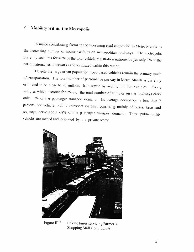
A major contributing factor in the worsening road congestion in Metro Manila is
the increasing number of motor vehicles on metropolitan roadways. The metropolis
currently accounts for 48% of the total vehicle registration nationwide yet only 2% of the
entire national road network is concentrated within this region.
Despite the large urban population, road-based vehicles remain the primary mode
of transportation. The total number of person-trips per day in Metro Manila is currently
estimated to be close to 20 million. It is served by over 1.1 million vehicles. Private
vehicles which account for 75% of the total number of vehicles on the roadways carry
only 30% of the passenger transport demand. Its average occupancy is less than 2
persons per vehicle. Public transport systems, consisting mainly of buses, taxis and
jeepnevs, serve about 68% of the passenger transport demand. These public utility
vehicles are owned and operated by the private sector.
Figure 111.8 Private buses servicing Fanner'sShopping Mall along EDSA

BUS m -~muJEEPNEY
30.000 10o.000 (VER-/DAY)
Fig-are 111.9 Bus ad jeepy Veiclari TriiK low iII IIJor Roaus, 1990
Source: UpuUted Dru-jjwG and, Ttlanspu IviAaaflgemews Plan, J"993
Deamnin fTanprto anda Conu-ct

The light rail transit (LRT) system serves only 20' of the commuting population.
Immediate and long-term plans are being made to remedy the shortage and inefficiency
of the current public transport services. Major investments are planned for more rail-
based mass transport systems. notably the LRT within the metropolis and commuter rail
to outer regions.
Although the majority of the population rely on public transit for mobility.
support services for pedestrians and commuters are extremely inadequate. In the
gyovemment's analysis for traffic olanning and manauement. it is interestinga to note that
the function of the roads is the sole determinant of their operational classification.
Other determinants such as land uses abuttingIi the road and pedestrian activity are not
beinu considered. Needless to say. the pedestrian facilities are generally poor. There has
not been a comprehensive effort to coordinate pedestrian movements between private
developments. Transit passengers. pedestrians. vendors and hawkers encroaching the
roadways are a common siuht. This can be traced to the fact that sidewalks are non-
existent. too narrow or impassable. The heavy mixture of vehicles and pedestrians on the
roads leads to other related issues associated with traffic conuestion such as traffic safety.
diminished vehicular speed. and the resulting urban environment.
VF
Figure I1 10 Lack of Pedestrian Amenities along EDSA
Oreta. Prospero. 1/rhan Mc. gement in Aegacities: I he ( ase of lMetro Manila. p. 28.Ibid. p.30.
- Camarillo, Ernesto. Seminiar oi /rban iran.sport hItegration, Department of Transportation andCommunication. November 1993.

Figure 1I.11
Source:
Multiple boarding and alighting points of public utility vehicles alongroadways result to the slow pace of vehicular traffic, 1990.Updated Traffic and Transport Management Plan, 1993Department of Transportation and Communication.
NO. OF BOARDING & ALIGHTING PASSENGERS/16HRS.
a000&10.EJEEPNEY50000-10.000
Bus.-7 .) -n nr
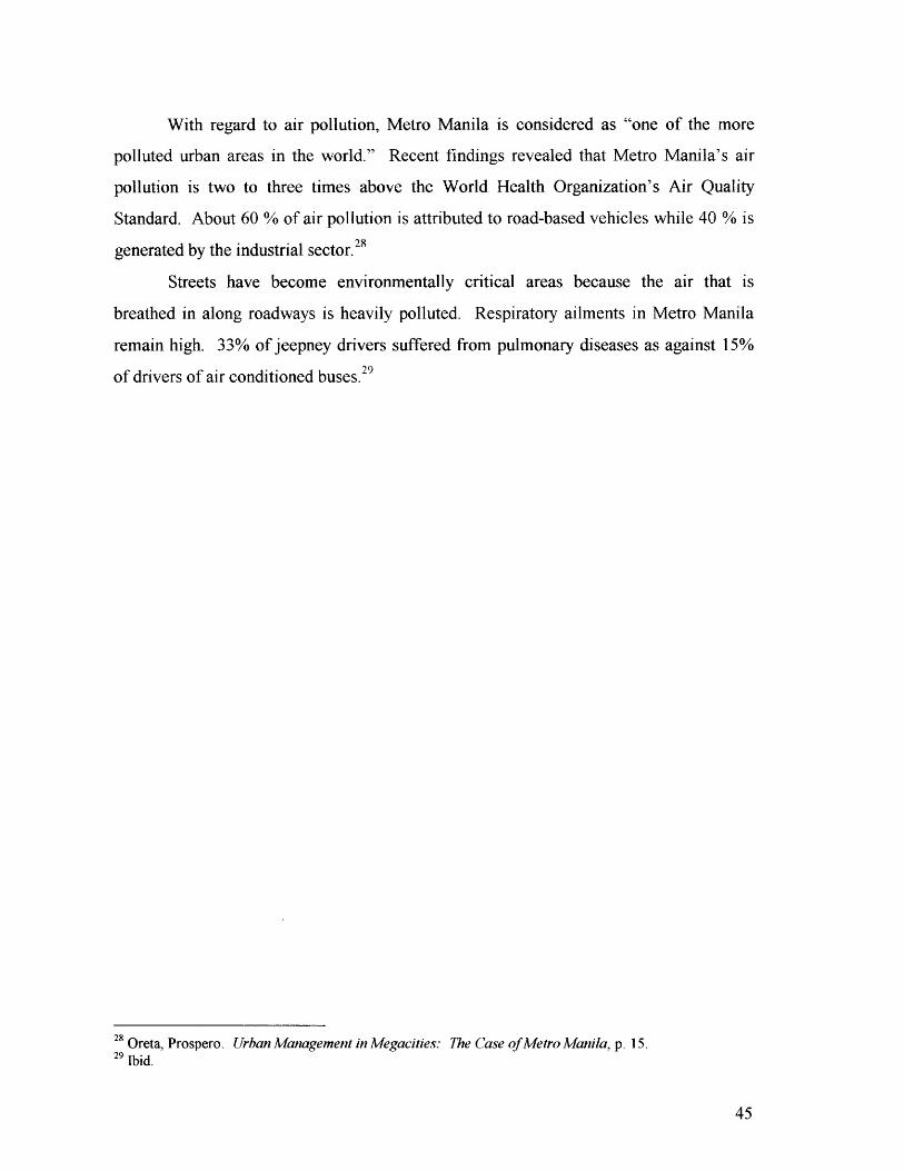
With regard to air pollution, Metro Manila is considered as "one of the more
polluted urban areas in the world." Recent findings revealed that Metro Manila's air
pollution is two to three times above the World Health Organization's Air Quality
Standard. About 60 % of air pollution is attributed to road-based vehicles while 40 % is28generated by the industrial sector.
Streets have become environmentally critical areas because the air that is
breathed in along roadways is heavily polluted. Respiratory ailments in Metro Manila
remain high. 33% of jeepney drivers suffered from pulmonary diseases as against 15%
of drivers of air conditioned buses.29
28 Oreta, Prospero. Urban Management in Megacities: The Case of Metro Manila, p. 15.29 Ibid.
D. A City of Enclaves
An evident outcome of the urbanization process under colonial rule was the
emergence of a dual society. The economic base of the traditional elite was
landownership. The bulk of the population were laborers. The dominance of the landed
elite in postwar government positions prevented the implementation of serious land
reform or redistribution measures that could have restructured the imbalanced land
ownership system. Thus, land properties remained in the hands of a minority of the
population. Urban settlement patterns that developed after the Second World War
reflected the extreme variations in the quality of life between the different income
groups.
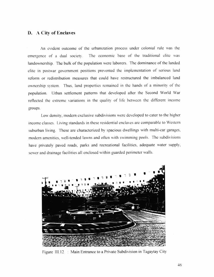
Low density, modern exclusive subdivisions were developed to cater to the higher
income classes. Living standards in these residential enclaves are comparable to Western
suburban living. These are characterized by spacious dwellings with multi-car garages,
modern amenities, well-tended lawns and often with swimming pools. The subdivisions
have privately paved roads, parks and recreational facilities, adequate water supply,
sewer and drainage facilities all enclosed within guarded perimeter walls.
_' Le-&. S:
Figure 111.12 . Main Entrance to a Private Subdivision in Tagaytay City
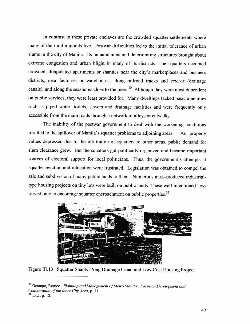
In contrast to these private enclaves are the crowded squatter settlements where
many of the rural migrants live. Postwar difficulties led to the initial tolerance of urban
slums in the city of Manila. Its unmaintained and deteriorating structures brought about
extreme congestion and urban blight in many of its districts. The squatters occupied
crowded, dilapidated apartments or shanties near the city's marketplaces and business
districts, near factories or warehouses, along railroad tracks and esteros (drainage
canals), and along the seashores close to the piers.3 0 Although they were most dependent
on public services, they were least provided for. Many dwellings lacked basic amenities
such as piped water, toilets, sewers and drainage facilities and were frequently only
accessible from the main roads through a network of alleys or catwalks.
The inability of the postwar government to deal with the worsening conditions
resulted to the spillover of Manila's squatter problems to adjoining areas. As property
values depressed due to the infiltration of squatters to other areas, public demand for
slum clearance grew. But the squatters got politically organized and became important
sources of electoral support for local politicians. Thus, the government's attempts at
squatter eviction and relocation were frustrated. Legislation was obtained to compel the
sale and subdivision of many public lands to them. Numerous mass-produced industrial-
type housing projects on tiny lots were built on public lands. These well-intentioned laws
served only to encourage squatter encroachment on public properties.
Figure 111.13 Squatter Shanty 7'ong Drainage Canal and Low-Cost Housing Project
3 0 Ocampo, Romeo. Planning and Management of Metro Manila: Focus on Development andConservation of the Inner City Area, p. 11.31 Ibid., p. 12.
These highly visible differences in the forms of urban land development within
the metropolis are not only limited to residential uses. There are numerous examples of
independent projects large enough (450 het/ares or more) to be considered new towns or
cities. many of them developed by private capital and initiative. In fact, real estate
development continues to be the most speculative and opportunistic industry in the
Philippine economy.
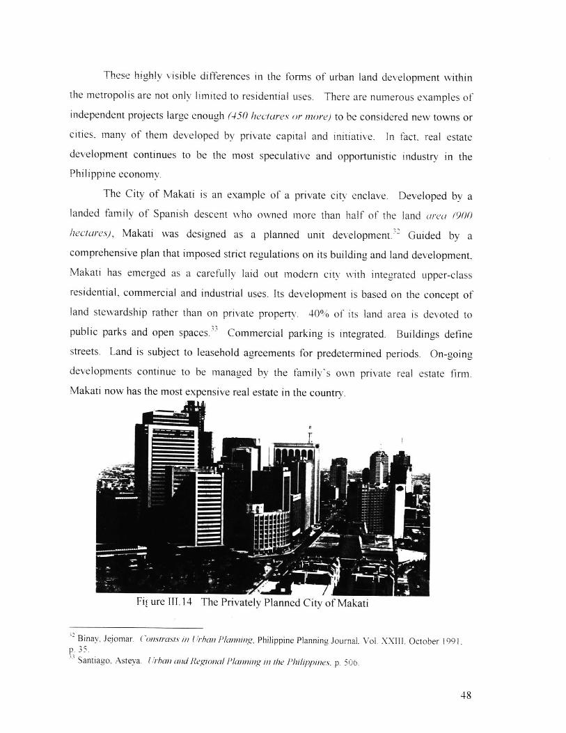
The City of Makati is an example of a private city enclave. Developed by a
landed family of Spanish descent who owned more than half of the land area (900
heciares), Makati was designed as a planned unit development.' Guided by a
comprehensive plan that imposed strict regulations on its building and land development,
Makati has emerged as a carefully laid out modem city with integrated upper-class
residential, commercial and industrial uses. Its development is based on the concept of
land stewardship rather than on private property. 40% of its land area is devoted to
public parks and open spaces." Commercial parking is integrated. Buildings define
streets. Land is subject to leasehold agreements for predetermined periods. On-going
developments continue to be managed by the family's own private real estate firm.
Makati now has the most expensive real estate in the country.
Fil ure III.14 The Privately Planned City of Makati
? Binay, Jejomar. ( onstrasts in Urban Planning, Philippine Planning Journal. Vol. XXIII. October 199 1.p. 35.B Santiago. Asteya. U irban and Regional lanning in the Philippinies. p. 506.
It is rather unfortunate that places like Makati are more the exception rather than
the rule. The lack of government leadership in regulating urban land development has
left it to the private sector and market-demand forces to determine the nature and quality
of the metropolitan landscape. Independent private land use decisions do not often
consider the social consequences of piecemeal development. The resulting urban
environment is an agglomeration of isolated pods with very little physical and
psychological connectivity with each other.
The whole practice of architecture in the Philippines has been based on the design
of individual structures or complexes for private clients. Projects are site specific, with
little regard for the overall functional or aesthetic quality of the broader social setting.
E. The Environmental Dilemma
Residential land uses are unique in that they tend to be the most vulnerable to
ecological degradation yet they oftentimes are directly and indirectly responsible for
generating most of its causes. Proximity to facilities and sources of livelihood and easy
access to transportation remain the vital criteria for determining locations for the
expanding needs of the metropolis for residential and supporting land uses. These
locational parameters, by themselves, without regard to environmental concerns, produce
irrational patterns of growth. The typical linear pattern of development along
transportation routes is extremely inefficient because it result in higher costs in terms of
operating and maintaining utilities that are introduced to service the emerging
communities. They unnecessarily extend the areas to be serviced and put strong pressure
on the government to provide more access roads than would be required for more
compact and concentrated developments.
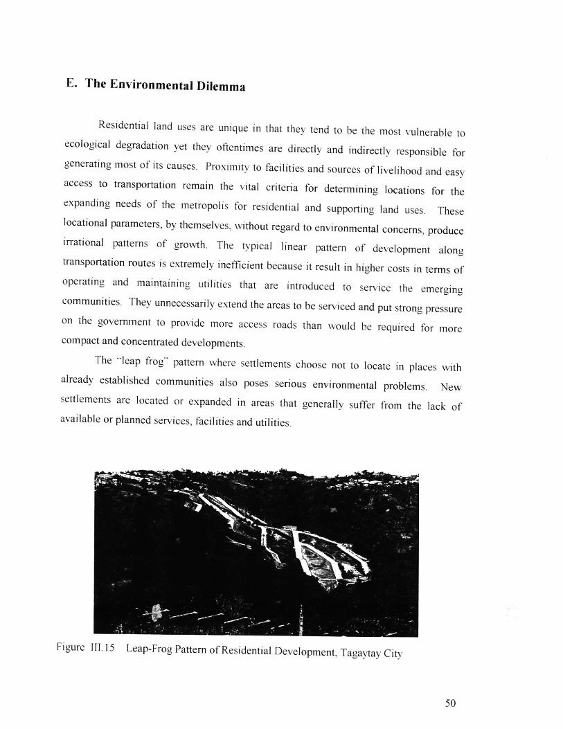
The 'leap frog" pattern where settlements choose not to locate in places with
already established communities also poses serious environmental problems. New
settlements are located or expanded in areas that generally suffer from the lack of
available or planned services, facilities and utilities.
Figure III.15 Leap-Frog Pattern of Residential Development, Tagaytay City
Environmental problems can inevitably arise including health and sanitation
problems due to inadequate or untreated water supply, poor drainage, improper garbage
disposal, and chaotic and incompatible mix of land uses. There is also an increase risk of
land, air, and water pollution in these areas.
Another consequence of undirected urban sprawl is the indiscriminate
development of valuable lands suitable for agriculture, for preservation or conservation
which are prematurely converted to urban uses. This causes the permanent loss of
precious land resources which are part of the environmental ecosystem.
These uncontrolled expansion trends pose potential damage to natural ecological
systems. An example of the serious environmental impacts of unplanned growth is the
rapid depletion of the water supply in suburban communities along the metropolitan
periphery. The water supply of residents in Metro Manila is sourced from two major
sources, piped surface water and ground water. The government presently delivers only
55% of the needed metropolitan supply. In areas that are not yet reached by the
pipelines, e.g., in peripheral suburban housing subdivisions, deep wells are the main
source of water supply.
Fifteen years ago, the water table from which ground water was extracted was at
five meters below the sea level. Due to over-extraction, it has been lowered to more than
one hundred meters down, resulting in salt water intrusion. Pollution from saline
intrusion has rendered non-potable the ground water in many areas along the periphery.
It is feared that the problems of diminishing ground water resources and saline intrusion
will further worsen in the immediate future as urban development intensifies.
Another related environmental problem in Metro Manila is water pollution. This
stems from the fact that over 80% of the metropolis remains unserved by a sewerage
system." Although 85% of solid wastes are effectively collected daily, the remaining
15% ends up in major waterways. Moreover, only 15% of Metro Manila's households
are connected to domestic sewerage systems. The rest, including private suburban
developments, rely on the use of septic tanks.
3 Oreta, Prospero. Urban Management in Megacities: The Case of Metro Manila, p.15.35 Ibid.. p. 17.
As more intense urbanization occurs in the metropolitan area, the inevitable
environmental-related problems such as pollution and waste management, water
depletion, traffic congestion, and the rapid loss of agricultural lands become more
intractable. Unless sooner addressed, these physical conditions will encroach and
intensify in those potentially disaster-prone and environmentally constrained areas. High
pollution levels may deter further growth by making the metropolitan area an unattractive
place to live and do business in.
IV. A VISION FOR THE FUTURE OF THE METROPOLIS
Recent events in Philippine history have created startling changes in the country's
territorial development. Propelled by the accelerated economic growth within the Asia-
Pacific Region, there has been a tremendous surge of foreign and local capital into the
nation's economy. These economic gains are attributed to the present government's
success in achieving political stability and in executing sweeping economic reforms such
as trade liberalization, deregulation, privatization and demonopolization.
The continuous flow of investments has triggered a massive construction boom in
Metro Manila as the capital region which is significantly altering much of the existing
urban landscape. Undeveloped urban lands are being in-filled. Residential communities,
commercial establishments and industries are rapidly developing in outlying areas.
Urban land values have soared causing development to go on an upward trend. The
construction of skyscrapers (In 1995, over a hundred 20+ story buildings being built at
one time) has drastically transformed the skylines of many business districts and
significantly increased densities in these areas. After decades of political instability and
economic hardships, this private sector driven "urban renewal" phenomenon serves as a
welcome indication that the country is, indeed, on the road towards national recovery.
However, accelerated economic development and phenomenal urbanization rates
have been leading to a rapid transformation of urban land, pushing the metropolis into
infrastructure bottlenecks. Problems such as population concentration, road congestion,
air pollution, shortage of basic services, environmental degradation and depletion of open
spaces have been hounding the metropolis for quite a while but never as severe as now.
Without enforceable government development controls in place, failure to manage this
growth and the accompanying pressures on the limited resources would only lead to
urban chaos and decay and inevitably eat away the foundations of economic and political
stability.
In the coming years, the country is likely to face further accelerated development
as it seeks to join the newly industrialized countries at the turn of the century. As Metro
Manila's population grows and its urban face changes, there is that common perception

that growth may not be entirely desirable if the ills it creates are not effectively
addressed. It is not in the public nor private sectors' interests to see the urban
environment deteriorated beyond tolerable levels. But with so many people and so little
planning, the resounding question is -- what does the future hold Metro Manila?
In 1995, the concern of the national government over the direction of urban
growth and development in the capital region brought about the creation of the
Metropolitan Manila Development Authority (MMDA). It is tasked not only to
manage metro-wide operations but also to provide a concrete vision that would guide the
future physical development of the metropolis. Its goal is the creation of a long-term
(1996-2016) Physical Development Framework Plan for Metro Manila in accordance
with the theme, "Towards a Humane World-Class Metropolis." This draws inspiration
from the challenge by President Ramos to envision Metro Manila beyond its role as the
national capital but also as a premier hub and international gateway to Asia and the
Pacific.
Enacted in Congress, MMDA has been vested with broader and more
comprehensive powers than its predecessors. It has been granted implementation
functions and not just coordinating powers. Other structural innovations include the
granting of a more or less permanent term for its Chairman (rather than having the
Chairmanship rotate among the members on six-month intervals). The officials of the
MMDA are the various mayors of the local government units.
The MMDA has moved to institutionalize development planning as a primary
function in order to make regulations more effective and to support future planned
developments. This bold approach by government aims to strengthen the role of physical
planning and growth management in shaping the future of the metropolis.
It is the MMDA's mandate to ensure that the development of Metro Manila, now
and in the future, is prudently and efficiently managed. Planning will be used as a tool
for development management. Such management is focused on issues at the broader
metropolitan level over and above the constituency-oriented priorities of the local
governments. This formidable task can only be achieved if political will and
commitment to cooperative planning at all levels of governance in Metro Manila is
realized. The usual temptations to resort to expediency or short-term solutions which
inevitably compound long-term problems has to be avoided. All these issues present a
unique challenge to all sectors who stand to gain from a well-planned and well-managed
humane, livable and economically vibrant metropolis.
Viewed from the long history of ineffectual urban planning practices in the
Philippines, The MMDA's success over previous planning agencies can only be
determined in time. The vision to evolve the National Capital Region as a globally-
competitive, sustainable and planned community where urban residents enjoy a better
quality of life through access to essential services and facilities and economic
opportunities opportunities has been established. The challenge now is in trying to
translate this vision into development strategies and policies.
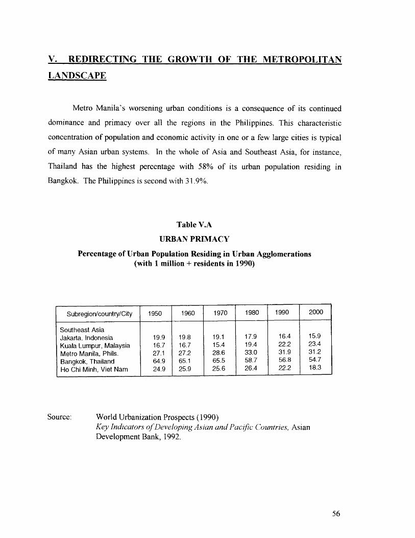
V. REDIRECTING THE GROWTH OF THE METROPOLITAN
LANDSCAPE
Metro Manila's worsening urban conditions is a consequence of its continued
dominance and primacy over all the regions in the Philippines. This characteristic
concentration of population and economic activity in one or a few large cities is typical
of many Asian urban systems. In the whole of Asia and Southeast Asia, for instance,
Thailand has the highest percentage with 58% of its urban population residing in
Bangkok. The Philippines is second with 31.9%.
Table V.A
URBAN PRIMACY
Percentage of Urban Population Residing in Urban Agglomerations(with 1 million + residents in 1990)
Source: World Urbanization Prospects (1990)Key Indicators of Developing Asian and Pacific Countries, AsianDevelopment Bank, 1992.
Subregion/country/City 1950 1960 1970 1980 1990 2000
Southeast AsiaJakarta, Indonesia 19.9 19.8 19.1 17.9 16.4 15.9Kuala Lumpur, Malaysia 16.7 16.7 15.4 19.4 22.2 23.4Metro Manila, Phils. 27.1 27.2 28.6 33.0 31.9 31.2Bangkok, Thailand 64.9 65.1 65.5 58.7 56.8 54.7
Ho Chi Minh, Viet Nam 24.9 25.9 25.6 26.4 22.2 18.3
Various governments have come up with spatial policy goals aimed at slowing or
reversing the tendency towards urban concentration or primacy. Programs have been
formulated to spur development of alternate urban growth centers as well as rural
development programs to discourage rural out-migration. Korea has Saenmaul Undong
to control the growth of Seoul, Indonesia adapts a transmigration program to lessen the
imbalance between Java and the other islands, Malaysia intends to equalize regional
development through their Bumiputra policy and Thailand's employs such measures as
industrial dispersal, promotion of regional growth centers and development of the eastern
seaboard to limit the growth of Bangkok.
Regional Context
Until recently, urban development in the Philippines has largely progressed
without a unifying focus. Urban centers developed independently, with little regard to
national development. However, the increasing emphasis on global-competitiveness in
the world economy has created a need for more integration and cooperation between
regions in the country.
Metro Manila's dominance over other regions, however, remains unchallenged.
It has a vast pool of highly developed and skilled urban labor force and a huge share of
the financial, educational, commercial and industrial infrastructure of the country. But
its growth has to be properly managed in order to derive the benefits from its dominant
economic role and prevent the further deterioration of its metropolitan landscape. A
controlled development scheme for the metropolis should be accompanied with a
program for dispersing development to other regions of the country. Therefore, long-
range development plans should view the Philippines beyond Metro Manila.
The concept of regional growth centers and medium-size cities are currently
being explored to stem the economic dominance of Metro Manila. Within the island of
Luzon, national economic development studies have already identified potential

secondary economic enclaves that could serve to decongest activities from the capital
region. Subic Bay and Clark Air Base (US military bases located north of Metro Manila)
are promising developmental opportunities that could open up areas outside the
metropolis to urban-related activities. But economic plans have to be accompanied by
physical framework plans so as not to repeat the mistakes of unplanned urbanization in
Metro Manila. Economic growth should also be encouraged in other urban areas in the
country such as Metro Cebu in the Visayas, Metro Davao in Mindanao and Metro Baguio
in Northern Luzon.
Metropolitan Context
In the last decade, projects have been carried out independent of one another
without an integrated framework for urban growth. The absence of long-range planning
resulted to the implementation of urban and infrastructure projects that were mere
remedies to existing deficiences. The failure of government to anticipate and plan for the
needs of Metro Manila is exemplified in the inadequacy of transportation networks,
water supply and other basis services.
Role of the MMDA
In creating a Physical Framework Plan for Metro Manila, the MMDA should
strive to achieve a more rational metro-wide development. This plan should indicate
long-range general land uses and major transportation networks that will encourage a
more balanced distribution of the population. This plan would serve as a guide for public
and private investments and for the provision of future infrastructure services.
The magnitude of the problems of Metro Manila necessitate not just the creation
of regulatory measures such as zoning and land use but deliberate action strategies to
effectuate rational development. . Government regulations should be more promotive
rather than restrictive. This means purposely directing development towards areas that
will be able to sustain them based on their carrying capacities.
Specialized policies can be implemented in specific target zones so as to bring
about preferred patterns of urban development according to the principles of
sustainability and balanced development. An analysis of existing resources and the
probable opportunities and constraints for growth in certain areas is needed in order to
identify areas for growth ahd prepare a strategic physical framework plan
The objectives of the plan are to enhance and even-up development concentration
in areas that are highly congested and in areas that are lacking in development, to initiate
development in underdeveloped areas which are feasible for urban development, to
ensure that urban developments are properly founded on appropriate infrastructure
facilities and basic services, and to ensure environmentally conscious urban development
especially in fragile areas.
For instance, in highly built-up areas where physical developments vis-i-vis
population density have reached maximum levels and that additional land uses will result
in negative effects, further development should be deterred in order not to put additional
pressures on existing amenities and infrastructure support facilities. These areas, mainly
in the inner core, tend to be the old, deteriorating structures and facilities. They should
either undergo regeneration, redevelopment or preservation.
Regenerative activities are those which modify existing structures in such a way
that they are better used. Examples are buildings that could be architecturally changed or
remodeled without having to destroy their basic foundations. The objective of
regeneration is to maximize the use of existing structures. Redevelopmental activities
call for total change in existing structures which may result in corresponding changes in
their uses. This involves building more appropriate or conforming structures in specific
areas. The preservative activities are meant to highlight the cultural or historic
significance of unique structures or places. The walled city of Intramuros, for instance,
and old Roman Catholic churches are historically valuable and should be preserved.
There is an urgent need to diffuse business activity from central locations by
strengthening secondary business and commercial, especially in suburban areas within
the intermediate core. This would minimize the travel distance between residences and
workplaces and commercial establishments. A metropolitan population of almost nine
million would easily be able to support multiple growth centers.
In ecologically sensitive areas, special types of development are needed to ensure
sustainability and prevent adverse effects of pollution.
Short term actions programs to target the immediate urban conditions should have
long-term focus towards balanced development. They should allow for consistent testing
at different stages and controlled by performance standards to ensure that they are in
accordance with the overall guiding Physical Framework Plan for metro-wide
development.
Within the metropolis, there is a need to explore the possibilities of utilizing mass
transits systems as the more efficient mode of transport over road-based systems. With
less reliance on road-based vehicles, air pollution will also be reduced. Investments in
mass transit systems should be prioritized over and above more highway projects.
Effectively planning for transit infrastructure could serve to rectify the imbalanced
urbanization within the metropolis by supporting the development of intermediate-size
and secondary cities to ease the pressures from the central areas. The goal is to
rationalize these transport systems to support more balance population/employment
relationships. The ideal outcome is a network of carefully planned transport
infrastructure as well as mass transport utilities integrated with proper land use patterns
to ensure unhampered movement of people and goods within and outside the metropolis.
Standards for pedestrian amenities should also be improved.
The most important policy for Metro Manila at the present stage is the acquisition
of the right-of-way for the future railway networks and enough space for the transfer
between transport modes and the control and coordination of land use considering future
transportation systems and demand. Therefore, the long-term transportation master plan
and the strict control of land use are essential.
Role of the Local Government Units
Under the Marcos administration, The MMC had prepared land use surveys to
document the distribution of the land uses for each local government but since then, these
plans have not been updated. The local government units should take upon the task of
updating these plans as a basis for development plans.
The local government units should be responsible for the creation of long-range
land use and development plans for their specific jurisdictions in accordance with the
broader plan for metropolitan-wide land uses of the MMDA. This direct participation of
the local government units in planning should be encouraged to strengthen public interest
in the plans and to ensure that these would generate the necessary degree of commitment
needed for their implementation. The preparation of action strategies to implement these
local plans should also be the responsibility of the local government units as they are
directy involved with the development issues.
Private Sector Participation
In the last decade, the private sector's continued dominance in urban
development is clearly visible in the numerous planned unit developments, industrial
estates, residential subdivisions, shopping centers, etc. that are being constructed.
However, such projects have been undertaken independently without explicitly linking
them to urban development objectives. Government has not provided a venue for the
integration of the private sector in the overall development process of the metropolis.
The private sector's involvement and initiative in planning and development
activities should be encouraged by institutionalizing them as participants in the planning
process.
There is also a need for more studies on citizen participation in the government
decision-making process by improving citizen access to policy-making and providing
popular feedback on the implementation of urban plans and policies. The public should
be consulted in the formulation of programs and policies that directly affect them.
CONCLUSION
To summarize, this study has shown that Metro Manila's continued primacy and
its attendant problems are the cumulative consequences of colonial development.
Manila's historic role as the national capital encouraged its economic dominance as
trade, education and cultural center. Manila's creation and growth was externally
determined rather than the result of an evolution of socio-economic and political forces.
Spanish, and later, American colonial policies nurtured Manila's urbanization, shaped
Philippine economic development, social class formation and politics. The dependent
economy developed as a reflection of the country's role as supplier of agricultural
products and raw materials for European and American markets, which were exported
mainly from the port of Manila. The relationship of Manila with the rest of the regions of
the country was established. Social class formation was determined by the land tenure
system which gave rise to a dual society of landlords and landless laborers. Economic
and political power became concentrated in the traditional landed elite whose interest lay
in the continuation of the country's dependent conditions even after political
independence had been gained. The emphasis on local autonomy in legislation prevented
economic and development reforms for Metro Manila and the country as a whole. Rapid
urbanization was, to a large extent, due to in-migration from the rural areas which
remained relatively stagnant while the city of Manila prospered. Rural to urban
migration accelerated following the Second World War due to import-based
industrialization. The rapid population growth taxed the capacity of local governments
to provide basic services. Physical land use planning was not given priority in policy-
making due to financial and technical constaints, public indifference, political apathy and
the adherence to the concept of private property. Market forces and independent private
sector decisions determined the form of the urban landscape which resulted to haphazard,
scatter and sprawl patterns of land development. This led to many urban problems such
as congestion, chaotic land uses and environmental degradation. Solutions to Metro
Manila's problems were piecemeal and uncoordinated. As the urban conditions

deteriorated and transcended local boundaries, it was evident that an integrated solution
to Metro Manila's problems required intervention by the national government.
The Martial Law government provided the opportunity for national reform and
reorganization. The creation of the Metro Manila Commission (MMC) represented an
attempt by government to provide metro-wide services as well as to plan for the growth
of the metropolis. Its initiatives, particularly on structural planning, collection of data
and land use surveys, were clear demonstrations of the government's serious intent to
rationalize the development of the country. However, inadequacies in the administration
thwarted efforts at implementing planned urban growth. Subsequent changes in the
government structure did not allow for much long-range physical planning.
The establishment of democracy during the last decade has brought about
tremendous economic and physical growth to the metropolis but the sustainability of
such growth has become questionable given the many problems associated with it such as
urban congestion, poor infrastructure and utilities, pollution, etc. The worsening urban
condition despite economic growth is due to the lack of an overall development policy
and framework to guide and gear public and private sector investments towards a more
focused and rational urban development. The vision to evolve the metropolis into a
humane and international metropolis is an attempt to remedy the lack of a forward-
looking tradition in the Philippines. By having this concrete physical vision, efforts can
now be channeled towards the attainment of national and local goals towards more
planned and sustainable development. The challenge lies in exploring possible prospects
for urban development towards the attainment of the metropolitan vision grounded on a
firm understanding of the urbanization process.

Appendix A
GOVERNMENT ATTEMPTS AT CENTRALIZED REFORM
(This section explains why the government structure was unable to plan andmanage the orderly growth of postwar Manila.)
In 1946, the National Urban Planning Commission (NUPC), the first postwarcentralized planning body, was created by the newly inaugurated democratic governmentfor the reconstruction of cities and towns destroyed during the Second World War. Itwas tasked to formulate general plans, zoning and subdivision regulations that focused onlong term urban development.
A specific planning body, the Capital City Planning Commission (CCPC), wasalso formed to resume the master planning of Quezon City and which was interrupted bythe war. Beset by other pressing issues and problems during the postwar era such as theeconomic growth and population pressures, the national government did not give priorityto planned urban development and thus, many of the recommendations of the planningcommissions remained unheeded.
In 1950, the national government abolished the NUPC and the CCPC andreplaced them with the National Planning Commission (NPC). This act integrated allregional and urban planning activities into one single government agency. Four yearsafter its establishment, the NPC produced the Master Plan for the City of Manila whichwas more of a descriptive documentation of the situation of the city rather than animplementable plan.' By this time, much of the city had already been resettled underprivate auspices. The Manila Plan was never implemented. Manila's growth continuedto proceed in a laissez-faire manner, based on market-driven and uncoordinated, privatedecisions.
In its 25 years of existence, the NPC had little to show except for someinsignificant plans of a few Philippine cities, many of which were either unimplementedor unimplementable. Most of these plans were little more than sketches for mainthoroughfares and proposed land uses and they were not formally approved by cityauthorities and therefore only treated as guides rather than binding documents. 2
The NPC could not entirely be faulted for their shortcomings. It received onlynominal support from the government and thus, was unsuccessful in its operations.Because of this, the government found no justification to grant it bigger appropriations.Without adequate financial supports, its programs could hardly take off There werealso, then, very few professional planners that the Commission could tap. (In the early1960s, with a national population of 35 million, there were only a dozen or soprofessional planners, all of them products of foreign schools. The country had no
'Santiago, Asteya. Urban and Regional Planning in the Philippines, p.458.2 Aragoncillo, Erlinda. History ofPlanning in the Philippines: 1946-1972, p. 13 .
planning school.)3 Thus, the NPC was ineffective in guiding urban growth and physicaldevelopment in the country.
Even with an enabling act such as the Local Autonomy Act of 1959 whichempowered the local governments to take responsibility for the planning for theirrespective areas by voluntarily pass zoning and subdivision regulations independent ofthe NPC, the problems of rapid urbanization such as chaotic land uses, mushroomingslums and squatter settlements, and traffic congestion continued unabated. During thattime, the concepts and consequences of urban development, city planning and urbanrehabilitation were not fully appreciated by either government or private enterprise. TheNPC served only as a planning consultant to the various local government units.Planning was voluntary, at the discretion of individual local governments and since theydid not have the necessary funds and administrative capability to take upon the task ofurban planning, in most areas, planning was not done at all.4 As late as 1963, Manila stilldid not have a City Local Planning Board. Independent attempts to form planning boardsin several other cities were generally unsuccessful due to the lack of financial, technicaland administrative capabilities. The mayors merely relied upon their respective CityEngineer's Office to perform planning functions.5 Proposals drafted in these officestended to concentrate on public works projects and not on land use planning or otherregulatory programs.
The indifference towards planning was clearly manifested by the failure of manysucceeding presidents to implement any of the recommendations of the urban plans. Theconcept of long-range comprehensive planning was in direct conflict with the idea of theordinary populace who sought only immediate and limited-scope improvements. To thepeople, planning represented a remote and time-wasting period of inaction and non-accomplishment. The national government concentrated all its efforts in economicdevelopment planning while urban physical planning remained a low-priority issue in
6policy-making. The government efforts to cope with the increasing demands andproblems of rapid urbanization in Metro Manila continued in a piecemeal anduncoordinated fashion.
Government planning focused mainly on the expansion of land areas toaccommodate the growing population and the provision of public services. It allowed theprivate sector to initiate urban growth and physical development.
National government agencies were directly involved in road building, watersupply, education and health care services. At the same time, local governments wereresponsible for similar services as well as law enforcement, fire protection, garbagecollection and traffic management within their respective jurisdictions. The need forgreater coordination between the national and local governments in the provision ofcertain services became evident, for instance, in road building. Streets in local areaswere classified into national and local roads with the corresponding levels of governmentassuming responsibility for their construction and maintenance. Officials of the more
3 Santiago, Asteya. Urban and Regional Planning in the Philippines, p.460.4 Aragoncillo, Erlinda. History of Planning in the Philippines: 1946-1972, p.14.* Laquin, Aprodicio. "Manila's Urban Renewal Program," Philippine Journal of Public Administration,Vol. X, No.2, p. 178.6 Velasquez, Edgardo. The Politics ofPhilippine Reform, p.127.

affluent government units were often frustrated by the fact that while they already hadpaved roads, national roads in their areas remained poorly maintained. Situations such asthese were prevalent and they adversely affected the attempts at more organized urbandevelopment and traffic management.
As the urban population grew, local officials became more aware of theirinterdependent needs in the provision of urban services and solutions to commonproblems. Various approaches were tried to meet the mounting problems. Voluntary adhoc arrangements were entered into by local officials. An example of these specificservice organizations is the Association of Public Service Department which providedgarbage collection and disposal.7 However, the absence of a clear definition ofinterrelationships among the local units and the inherent disparities in their financialcapabilities hampered the effective functioning of these joint arrangements.
In the early 1970s, numerous proposals were made to replace the disjointed localunits into a single government organization. But attempts to superimpose a metropolitanauthority were strongly opposed by many local politicians as it meant the loss of theirautonomy and control.8 The proposal to integrate Metro Manila cities and municipalitiesalso failed to get constitutional support in Congress because of the traditional partisanand vested interests of politicians.
To sum up, the various government planning efforts were not very successful inmanaging Metro Manila's postwar growth for many reasons namely, the lack of aforward looking tradition in city planning, the lack of political support and the lowpriority given by the government to urban development, the lack of coordination betweenlocal and national governments, the lack of technical capability, uneven financialresources, and the fragmented authority and traditional jurisdictional conflicts.
7 Ibid., p. 136-137.8Ibid.
BIBLIOGRAPHY
Aragoncillo, Erlinda. History of Planning: 1946-1972. Quezon City, Philippines:University of the Philippines, 1991.
Banerjee, Tridib and Southworth, Michael. City Sense and City Design: Writings andProjects of Kevin Lynch. Cambridge, Massachusetts: The MIT Press, 1990.
Binay, Jejomar. Contrast in Urban Planning. Quezon City, Philippines: PhilippinePlanning Journal, Vol. XXIII, No. 1, October 1991.
Calthorpe, Peter. The Next American Metropolis: Ecology, Community and theAmerican Dream. New York: Princeton Architectural Press, 1993.
Camarillo, Ernesto. Seminar on Urban Transport Integration. Makati, Philippines:Department of Transportation and Communications, November 1993.
Constantino, Renato. The Philippines: A Past Revisited. Quezon City, Philippines:Tala Publishing Corp., 1975.
Cortez, Alejandro. The Philippine Primate City. Quezon City, Philippines: HeritagePublishers, 1989.
Datuin, Arnel. Martial Law in the Philippines. Manila, Philippines: Filipiniana BookGuide, 1983.
Duany, Andres and Plater-Zyberk, Elizabeth. Town and Town-Making Principles.Cambridge, Massachusetts: Harvard University Graduate School of Design, 1991.
Encarnacion, Theodore. Prospects for Planned Growth in Metropolitan Manila. QuezonCity, Philippines: Philippines Planning Journal, Vol. I, No. 1, October 1969.
Faithfull, Walter. Manila Bay Metropolitan Region: Some Tentative Principles forStrategic Planning. Quezon City, Philippines: Philippine Planning Journal, Vol. III, No.2, April 1972.
Fernandez, Antonio. History of Philippine Planning: Pre-Colonial Era to 1946. QuezonCity, Philippines: University of the Philippines, 1991.
Jacobs, Jane. The Death and Life of Great American Cities. New York: Vintage Books,1961.
Josef, Delia. National Urban Development and Housing Framework 1993-1998.Quezon City, Philippines: Housing and Land Use Regulatory Board, 1993.
Katz, Peter. The New Urbanism: Toward an Architecture of Community. New York:Mc-Graw Hill, Inc., 1994.
Langdon, Philip. A Better Place to Live: Reshaping the American Suburb. Amherst,Massachusetts: University of Massachusetts Press, 1994.
Laquian, Aprodicio. The Asian City and the Political Processes. Quezon City,Philippines: Philippine Journal of Public Administration, Vol. XIV, No. 1, January 1970.
Laquian, Aprodicio. Manila's Urban Renewal Program. Quezon City, Philippines:Philippine Journal of Public Administration, Vol. X, No. 2, April 1966.
Laquian, Aprodicio. The Need for a National Urban Strategy in the Philippines. QuezonCity, Philippines: Philippine Planning Journal, Vol. III, April 1972.
Leven, Charles. The Mature Metropolis. Lexington, Massachusetts: D.C. Heath andCo., 1978.
Lynch, Kevin. The Image of the City. Cambridge, Massachusetts: The MIT Press, 1960.
Mayor, Grace. Land Use Planning for Metro Manila. Manila, Philippines: UrbanDevelopment and Transport Planning, February 1995.
McGee, T. G. The Southeast Asian City: A Social Geography of the Primate Cities ofSoutheast Asia. London: G. Bell and Sons Ltd., 1967.
McGee, T. G. The Urbanization Process in the Third World. London: G. Bell and Sons,Ltd., 1971.
Moore, Charles. Daniel Burnham: Architect, Planner of Cities. Boston and New York:Houghton Mifflin Co., Vol. 1, 1921.
No author. 1977 Philippine Statistical Yearbook. Manila, Philippines: NationalEconomic Development Authority, 1977.
No author. 1990 Census of Population and Housing in the National Capital Region.Manila, Philippines: National Statistics Office, August 1992.
No author. Development Framework Plan for Metropolitan Manila, 1996-2016. Makati,Philippines: Metropolitan Manila Development Authority, March 1996.
No author. Final Report: Housing and Urban Development. Quezon City, Philippines:Human Settlements Regulatory Commission, 1986.
No author. Human Settlements: The Vision of a New Society. Quezon City,Philippines: Development Academy of the Philippines, September 1975.
No author. Land Use Forecasts 1990-2000-20 10 Main Report. Quezon City, Philippines:Metro Manila Urban Transportation Development Plan Project, Sept. 1991.
No author. National Urban Development and Housing Framework, 1993-1998. Makati,Philippines: Housing and Urban Development Coordinating Council, 1994.
No author. Shelter and Human Settlements: Philippine Report. Makati, Philippines:Housing and Urban Development Coordinating Council, 1995.
No author. Updated Traffic and Transport Management, 1993. Makati, Philippines:Department of Transportation and Communications, 1993.
No author. World Urbanization Prospects, 1990. Key Indicators of Developing Asianand Pacific Countries, Asian Development Bank, 1992.
Ocampo, Romeo. Planning and Management of Metro Manila: Focus on Developmentand Conservation of the Inner City Area. Manila, Philippines: Local GovernmentCenter, U.P. College of Public Administration, 1985.
Oreta, Prospero. Urban Management in Megacities: The Case of Metropolitan Manila.Makati, Philippines: Metropolitan Manila Development Authority, October 1995.
Phelan, John L. The Hispanization of the Philippines: Spanish Aims and FilipinoResponses, 1565-1700. Madison: The University of Wisconsin Press, 1959.
Ranjo, Mary Grace. National Capital Region Regional Development Plan 1993-1998.Makati, Philippines: Metropolitan Manila Authority, March 1993.
Sah, Jagdish. Control and Planned Development of Urban Land: Urban Land UseControl Measures. Philippine Planning Journal, Vol. III, No. 2, April 1972.
Santiago, Asteya. Urban and Regional Planning in the Philippines. Quezon City,Philippines: University of the Philippines, July 1992.
Serote, Ernesto. The Socio-Spatial Structure of the Colonial Third World City. QuezonCity, Philippines: Philippine Planning Journal, Vol. XXIII, No. 1, October 1991.
Silao, Federico. Burnham's Plan for Manila. Philippine Planning Journal, Vol. I, No. 1,October 1969.
Velasquez, Edgardo. The Politics of Philippine Reform. Quezon City, Philippines:Heritage Publishers, 1993.


![Gazette - Memorial University of Newfoundlandcollections.mun.ca/PDFs/mun_gazette/MUNGaz_V29N19.pdf · 2 Gazette •Jun~5, 1997 []3 OBITUARIES ~NOTABLE Gazette Givingcreditwherecredit](https://img.pdfslide.us/doc/110x75/5f88d0827dba065d3a2eda6f/gazette-memorial-university-of-ne-2-gazette-ajun5-1997-3-obituaries-notable.jpg)

![arXiv:math/9706228v1 [math.AT] 3 Jun 1997 · arXiv:math/9706228v1 [math.AT] 3 Jun 1997 CHAPTER Topological Transformation Groups AlejandroAdemandJamesF.Davis Department of Mathematics,](https://img.pdfslide.us/doc/110x75/5f70063120721b01455a451d/arxivmath9706228v1-mathat-3-jun-1997-arxivmath9706228v1-mathat-3-jun-1997.jpg)