Embed Size (px)
Citation preview
7/23/2019 Judy m. Olson
http://slidepdf.com/reader/full/judy-m-olson 1/7
ARTHUR H. R OBINSON AND THE FABRIC OF CARTOGRAPHY
Judy M. Olson
Michigan State University
ABSTRACT
Arthur H. Robinson, 1915-2004, was doyen of cartography, former President of ICA, and author of the most widely-read English-language textbook in the field. But who influenced him? And what are some measures of his influence onothers?
References in his papers and references to his work are useful in shedding light on these matters, and so areacknowledgements in his writings. One of the key influences on him is revealed in the very first sentence in the firstedition of Elements of Cartography (1953): "Cartography, according to the late Max Eckert,… " Others named are
Finch, (Guy-Harold) Smith, Tissot, Zöppritz, Raisz, Wright, Adams, and Barnes. His wife, Mary Elizabeth Robinson,is acknowledged as reader and editor in several books.
An indicator of his influence on the field is his lengthy publication list and the extensive references to his works foundin the ISI Web of Science. He also advised a large number of cartography Master ’s and Phd students. He influenced
cartography in the federal government and at the state level, and he founded the journal that is now Cartography andGeographic Information Science. His name is most widely known because of the widely-used map projection hedevised.
This paper is a tribute to Prof. Robinson and his role in our cartographic heritage.
INTRODUCTION
Professor Arthur H. Robinson, who passed away at the age of 89 in October of 2004, is among the best knowncartographers in the world. In the United States, he is widely known among non-cartographic circles as well as within
the profession because his map projection has been widely distributed by two major entities that are household names:Rand McNally and National Geographic Society. Prof. Robinson was a modest man and not a flamboyant figure.Rather, he was and still is--and will long be--known for his intellectual contributions.
As a key figure in the fabric of cartography, it is interesting to step back and see how he fit in. Rather than simplyreview his vitae or give a history of his life, I will look at influences upon him and a few of the measures of his impactin the discipline. The evidence for influence on him is taken primarily from his own works and his own words. Theevidence of his influence on the discipline is reflected in his publications and citations to them, his progeny, the journalhe founded, and the map projection that bears his name.
INFLUENCES UPON R OBINSON
Probably the most common pieces of evidence of who influenced whom among authors of scientific writings are thelists of citations that appear in those writings. If author A cites author B, author A is obviously aware of author B and
drew upon that person’s mater ial. The number of citations in Robinson’s works must number in the thousands. The
first edition of his textbook Elements of Cartography (1953) (hereafter Elements) had a mere 67 references to worksother than his own, the second (the last single-authored edition, 1960) over 100, and the last (with several additional
authors) about 450. Early Thematic Mapping (1982) had well over 300, most of which would not have appeared in Elements; and Cartographical Innovations, for which he was co-editor with Helen Wallis (1987), listed close to 600different authors, some with multiple citations. The last was a product of the ICA Commission on the History ofCartography, and many people contributed to it. But Wallis writes in the acknowledgements “In so far as possible we
checked every original work and reference cited” (p. IX). Undoubtedly Prof. Robinson was familiar with many of these
sources.

7/23/2019 Judy m. Olson
http://slidepdf.com/reader/full/judy-m-olson 2/7
It is especially interesting to look closely at the 67 references in the first edition of Elements. They reflect the roots of
what was to become the most widely-used cartographic text for decades (Tyner 2005). They are categorized into“General,” “Historical Background,” “Coordinate Systems and Projections,” “Techniques and Design,” “Lettering and
Type,” “Kinds of Maps and Distribution Mapping,” “Representing the Terrain,” and “Government Publications,” although the last is a general statement about the agencies that were publishing helpful material rather than a list of
specific items available at the time. Many of the articles referenced had been published in the Annals of the Association
of American Geographers and in Geographical Review. The only general cartography text referenced was the one withthat title, General Cartography, by Erwin Raisz (1948), the only American text of its kind at the time. The sections on“Techniques and Design” and “Lettering and Type” were largely non-cartographic in origin, which is not surprising
given that cartography was not well developed as an academic enterprise in the early 1950s.
All references in the first edition of Elements were in the English language, which is surprising, given that his earlier
book, The Look of Maps (1952), in which there is much thinking that underlies the Elements textbook, has severalimportant German and French references. Presumably the references as well as the text in Elements were intended to bemore accessible and pedagogical; students taking a first course in cartography were highly unlikely to consult foreign-language materials. There is only one reference to his own major professor, Guy-Harold Smith, which is not surprising
since it was Smith’s “liberal attitude” (Robinson, 1952, p. viii) and interest in cartography, rather than a well-developedcartographic publication list on his part, that facilitated Robinson’s graduate research under his direction.
Anyone wanting to understand the underpinnings of Robinson’s cartography would do well to read the ratherinconspicuous but highly influential piece by Max Eckert “On the Nature of Maps and Map Logic” (1908) that is
referenced on p. 244 of the first edition. Eckert’s entire 2-volume work Die Kartenwissenschaft (1921, 1925) and his Kartographie (written under the name Eckert-Greifendorff, 1939) were referenced in The Look of Maps, but Eckert’sbrief 1908 article, appearing in English translation in the Bulletin of the American Geographical Society (laterGeographical Review), speaks volumes about the origins of modern cartography. Many of us will find our work eventoday echoing Eckert’s words because his ideas were richly reflected in Robinson’s text and in his research. Here are
some samples from it:
“…maps [occupy] a higher position than that usually occupied by illustrative material in other sciences. They
are no longer merely considered as aids that require the addition of descriptive text to portray adequatelygeographic phenomena, but as products of scientific research which, being complete in themselves, conveytheir message by means of their own signs and symbols and through these furnish the basis for further
geographic deduction.” Eckert goes on to say “Emil von Sydow expressed this thought fifty year ago; its truth,however, is…not yet sufficiently realized.” (Eckert 1908, p. 344)
The extent to which that truth was realized in later decades is what is attributable in very large part to Arthur Robinson.
“[O]ne of the main duties of cartography is to investigate the nature of maps…” (Eckert 1908, p. 345)
The co-author of the book entitled The Nature of Maps was, of course, Arthur Robinson. The title may have come fromEckert, but it is also easy to see the similarities (and differences — it was not called The Nature of Cartography) with themuch-read American book The Nature of Geography (Hartshorne 1939). The central notion of the map as more than atechnical device was, I suspect, almost certainly traceable to Eckert’s influence.
“To test the quality of a map is to determine how well it has solved the geometric problem imposed upon it of
reproducing constructively the distribution in space of geographic objects. Due allowance should be made,however for the actual state of geographic knowledge and for the scale and purpose of the map…” (Eckert
1908, p. 354)
“Just as…a good portrait of a person gives us a clue to his past life, so maps should…give an insight into the…history of our earth. But this alone is not sufficient… To reproduce the traces which organic life and,
particularly, man leave upon it should form one of the main aims of map-making. One might almost say thatmaps showing the economic and commercial phenomena of any given region constitute a graphic epitome ofour geographic knowledge concerning that region.” (Eckert 1908, p. 345)
Here is clear recognition of the importance of thematic mapping, one of the hallmarks of the Robinsonian era incartography and the subject of a considerable writing by Robinson, his students, and the students of his students.
7/23/2019 Judy m. Olson
http://slidepdf.com/reader/full/judy-m-olson 3/7
“…[I]t is especially necessary to call attention to the fact that the Mercator map, which is, par exc ellence, the
map of the navigator, is in most cases unsuited to the purpose of the geographer, [who is] mainly interested inthe comparison of areas and for that reason requires an equivalent projection.” (Eckert 1908, p. 346)
That is an observation Robinson understood well, as echoed in his critique of the Peters projection (Robinson 1985) as
well as in the straightforward lessons in his text.
“It is evident that cartography is not merely a technical art. It is for the greater part an applied art, an artgoverned and determined by scientific laws. But how can cartography avoid the rigid rules of mathematical
precision? The decisive turning-point…lies in the transition from the topographic to the general map. As long
as the scale allows the objects in nature to be represented in their true proportion on the map, technical skillalone is necessary. Where this possibility ends the art of the cartographer begins. With generalization art
enters into the making of maps.” (Eckert 1908, p. 346-7)
Robinson would develop a much more sophisticated and defensible view of cartography as an applied art, but it isdifficult to believe that the stimulus for his thinking had nothing to do with Eckert’s views.
Eckert goes on to talk about the effects of maps on users and has a fairly long commentary on the sensible use of colorson maps. He then states explicitly:
“[O]ne of the most important topics that scientific cartography has to deal with [is] ‘map logic.’ Map logic
treats of the laws which underlie the creation of maps and which govern cartographic perception.” (Eckert1908, p. 348)
How prescient of cartography in the last half of the 20th
century!
It was not chance that led me to this crucial Eckert reference over all others, nor did I read all 67 of the items in the firstedition to find it. I was a graduate student of Arthur Robinson, and the name was a familiar one. Eckert’s influence is
also revealed in the very first sentence of the Preface to the first edition of Elements: “Cartography, according to thelate Max Eckert, the great German cartographer, is a mixture of science and art. ” (Robinson 1953, p. v) It is an
appropriate opening not only in setting the tone for the text but in linking it to this revered intellectual ancestor.
Prefaces and acknowledgements are, in fact, a rich source of information about how and from whom a scholar receivedthe seeds that take hold and germinate in the work. How many know, for example, from whom Arthur Robinson tookhis first cartography course or at least the first course that piqued his interest in the subject? In his own words from his
Preface:
“I should particularly like to acknowledge my debt to Professor Vernor C. Finch, of the University ofWisconsin, in whose class I first became interested in cartography as an art and science, and learned that there
was something more to it than mere manual dexterity. [His] cartographic skill, his analytical attitude towardthis and other subjects, and his subsequent personal encouragement are largely responsible for my havinginitially chosen to work in the field of cartography.” (Robinson 1953, p. vi)
In addition to acknowledging Finch and (G-H) Smith, he states clearly
“My debt to such cartographic stalwarts as M. Eckert, M. A. Tissot, K. Zöppritz, E. Raisz, J.K. Wright, O.S.Adams, and others will be readily recognized by the professional reader.”
What I find particularly interesting about that statement is that his protégés would easily recognize these names and
would associate “famous German cartographer,” “Indicatrix,” “ projections,” etc. with them. We were never led to
believe that Robinson invented cartography, but he was obviously a perceptive and keen thinker who could put the ideasof his intellectual ancestors into clearer focus, organizing and integrating them, and bringing them forward within thetechnological and intellectual milieu of his time.
Another person Robinson acknowledges in this first edition of Elements is Jim Barnes at the University of Georgia, who
would, almost 2 decades later be my colleague at that institution. Barnes was a contemporary of Arthur Robinson in thegraduate program at the University of Wisconsin where Robinson did his master’s degree. The first article Robinsonpublished, in fact, was co-authored with Jim Barnes (Barnes and Robinson 1940). Barnes did not finish his PhD and
did not develop the extensive publication record that Arthur Robinson did. He was a good thinker, however, for whom“map logic” seemed to come naturally, even on one of the very few concepts for which a less-than-sound conception
7/23/2019 Judy m. Olson
http://slidepdf.com/reader/full/judy-m-olson 4/7
was perpetuated in the Elements text over the years
(contrast Barnes 1978 with p. 510 in the 6th
edition of Elements). In the first edition, Robinsonacknowledges help from Jim Barnes on the material onprojections, a subject in which he had considerable
strength. Barnes used an approach in his teaching of
projections, in fact, that I drew upon for many years.
Robinson also acknowledges his students who “have,
perhaps unwittingly, contributed heavily toward thisundertaking…” and specifically James Flannery forhis constructive role, an acknowledgement that
heralded various acknowledgements over the years ofstudents who contributed in some way to his work.
It is traditional for authors to recognize the
encouragement and patience of a spouse in theirpublications, but Arthur Robinson goes further thanthat, indicating that Mary Elizabeth Robinson “read
much of the manuscript in draft, and all of it in finalform, and made many worthwhile editorial proposals”
(Robinson 1953, p. viii). There are similar statementsin The Look of Maps and in other editions of Elements.In Early Thematic Mapping he states flatly that
“without her help this research would not be as far
along, nor would this book have been possible” (1982
p. xiii). She was, by all indications, a strong influenceon the straightforward and clear writing, containing
few if any extraneous words, that was a hallmark ofhis publications. I clearly remember his commentingto us as graduate students that “You cannot edit yourown work.” His acknowledgements indicate who
edited his.
Arthur Robinson wrote over 60 articles and
monographs as well as cartography and othertextbooks. All of these would have drawn influencefrom a vast variety of sources. The span of his graspon the subject matter and literature of the field was
nothing short of remarkable.
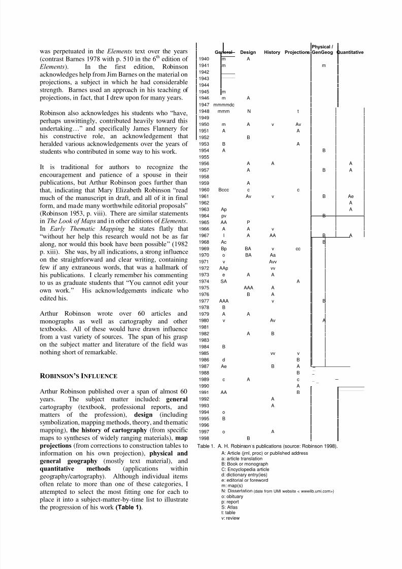
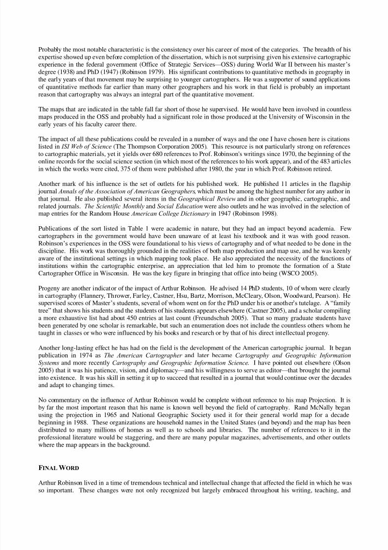
R OBINSON’S INFLUENCE
Arthur Robinson published over a span of almost 60
years. The subject matter included: general cartography (textbook, professional reports, andmatters of the profession), design (includingsymbolization, mapping methods, theory, and thematicmapping), the history of cartography (from specific
maps to syntheses of widely ranging materials), map
projections (from corrections to construction tables toinformation on his own projection), physical and
general geography (mostly text material), andquantitative methods (applications withingeography/cartography). Although individual itemsoften relate to more than one of these categories, I
attempted to select the most fitting one for each to
place it into a subject-matter-by-time list to illustratethe progression of his work (Table 1).
General Design History ProjectionsPhysical /GenGeog Quantitative
1940 m A
1941 m m
1942
1943
1944
1945 m
1946 m A1947 mmmmdc
1948 mmm N t
1949
1950 m A v Av
1951 A A
1952 B
1953 B A
1954 A B
1955
1956 A A A
1957 A B A
1958
1959 A
1960 Bccc c c
1961 Av v B Ae
1962 A
1963 Ap A
1964 pv B
1965 AA P
1966 A A v
1967 I A AA B A
1968 Ac B
1969 Bp BA v cc
1970 o BA Aa
1971 v Avv
1972 AAp vv
1973 e A A
1974 SA A
1975 AAA A
1976 B A
1977 AAA v B
1978 B
1979 A A
1980 v Av A
1981
1982 A B
1983
1984 B
1985 vv v
1986 d B
1987 Ae B A
1988 B
1989 c A c
1990 A
1991 AA B
1992 A1993 A
1994 o
1995 B
1996
1997 o A
1998 B
Table 1. A. H. Robinson’s publications (source: Robinson 1998).
A: Article (jrnl, proc) or published addressa: article translationB: Book or monographC: Encyclopedia articled: dictionary entry(ies)e: editorial or forewordm: map(s)N: Dissertation (date from UMI website < wwwlib.umi.com>)
o: obituaryp: reportS: Atlast: tablev: review
7/23/2019 Judy m. Olson
http://slidepdf.com/reader/full/judy-m-olson 5/7
Probably the most notable characteristic is the consistency over his career of most of the categories. The breadth of his
expertise showed up even before completion of the dissertation, which is not surprising given his extensive cartographicexperience in the federal government (Office of Strategic Services — OSS) during World War II between his master’s
degree (1938) and PhD (1947) (Robinson 1979). His significant contributions to quantitative methods in geography inthe early years of that movement may be surprising to younger cartographers. He was a supporter of sound applications
of quantitative methods far earlier than many other geographers and his work in that field is probably an important
reason that cartography was always an integral part of the quantitative movement.
The maps that are indicated in the table fall far short of those he supervised. He would have been involved in countless
maps produced in the OSS and probably had a significant role in those produced at the University of Wisconsin in theearly years of his faculty career there.
The impact of all these publications could be revealed in a number of ways and the one I have chosen here is citationslisted in ISI Web of Science (The Thompson Corporation 2005). This resource is not particularly strong on referencesto cartographic materials, yet it yields over 680 references to Prof. Robinson's writings since 1970, the beginning of theonline records for the social science section (in which most of the references to his work appear), and of the 483 articles
in which the works were cited, 375 of them were published after 1980, the year in which Prof. Robinson retired.
Another mark of his influence is the set of outlets for his published work. He published 11 articles in the flagship
journal Annals of the Association of American Geographers, which must be among the highest number for any author inthat journal. He also published several items in the Geographical Review and in other geographic, cartographic, andrelated journals. The Scientific Monthly and Social Education were also outlets and he was involved in the selection ofmap entries for the Random House American College Dictionary in 1947 (Robinson 1998).
Publications of the sort listed in Table 1 were academic in nature, but they had an impact beyond academia. Fewcartographers in the government would have been unaware of at least his textbook and it was with good reason.Robinson’s experiences in the OSS were foundational to his views of cartography and of what needed to be done in thediscipline. His work was thoroughly grounded in the realities of both map production and map use, and he was keenly
aware of the institutional settings in which mapping took place. He also appreciated the necessity of the functions ofinstitutions within the cartographic enterprise, an appreciation that led him to promote the formation of a StateCartographer Office in Wisconsin. He was the key figure in bringing that office into being (WSCO 2005).
Progeny are another indicator of the impact of Arthur Robinson. He advised 14 PhD students, 10 of whom were clearlyin cartography (Flannery, Thrower, Farley, Castner, Hsu, Bartz, Morrison, McCleary, Olson, Woodward, Pearson). Hesupervised scores of Master’s students, several of whom went on for the PhD under his or another ’s tutelage. A “family
tree” that shows his students and the students of his students appears elsewhere (Castner 2005), and a scholar compilinga more exhaustive list had about 450 entries at last count (Freundschuh 2005). That so many graduate students havebeen generated by one scholar is remarkable, but such an enumeration does not include the countless others whom hetaught in classes or who were influenced by his books and research or by that of his direct intellectual progeny.
Another long-lasting effect he has had on the field is the development of the American cartographic journal. It beganpublication in 1974 as The American Cartographer and later became Cartography and Geographic InformationSystems and more recently Cartography and Geographic Information Science. I have pointed out elsewhere (Olson
2005) that it was his patience, vision, and diplomacy — and his willingness to serve as editor — that brought the journalinto existence. It was his skill in setting it up to succeed that resulted in a journal that would continue over the decades
and adapt to changing times.
No commentary on the influence of Arthur Robinson would be complete without reference to his map Projection. It isby far the most important reason that his name is known well beyond the field of cartography. Rand McNally beganusing the projection in 1965 and National Geographic Society used it for their general world map for a decade
beginning in 1988. These organizations are household names in the United States (and beyond) and the map has beendistributed to many millions of homes as well as to schools and libraries. The number of references to it in theprofessional literature would be staggering, and there are many popular magazines, advertisements, and other outletswhere the map appears in the background.
FINAL WORD
Arthur Robinson lived in a time of tremendous technical and intellectual change that affected the field in which he wasso important. These changes were not only recognized but largely embraced throughout his writing, teaching, and
7/23/2019 Judy m. Olson
http://slidepdf.com/reader/full/judy-m-olson 6/7
research. I will end here with an anecdote that captures his cognizance of change and his ability to foresee it as well as
observe it. As I wrote this paper, my department was in the midst of moving to a different building and large containersoccupied the hall near my office, heaped with awkwardly large and cumbersome maps, outdated and dusty ones, objectsno longer needed with the up-to-date versions of the information that can be accessed as data or graphics on theInternet. Computers would occupy prime space in our new facility but map storage would be virtually non-existent. It
was in this setting that I reread Arthur Robinson’s “Cartography to the Year 2000,” written for a symposium in 1976:
“The user of 2000 may neither desire nor be willing to pay the cost of a flat paper map. Not only might it beconsidered ecologically wasteful to produce maps on paper or plastic, the user may simply not want to have
them lying around requiring storage.”
Robinson goes on to predict that animation would be “more commonplace,” time would be more commonly
incorporated into mapping, there would be “(i)ntegrated systems of automated data acquisition and mapping,” and
“continuous mapping” (to wit The National Map, USGS 2005). The cartography of 2000 would be very different from
1975 and
“In all likelihood, computer output will have replaced manual mapmaking for well over 90% of all maps
produced by 2000 A.D.”
Well over, indeed! And one has to remember that in the mid-1970s it was still controversial as to how useful computerswould be!
Robinson acknowledges Joel Morrison and Phillip Muehrcke in this paper, and his forecasting abilities wereundoubtedly enhanced by the input of his young colleagues. Had he not believed what he was saying, however, it
would not have been in the paper. He did not, of course, forecast the development of GIS and all its implications. Hewas, after all, a human being, albeit a remarkable one!
R EFERENCES
Barnes, James A. 1978. Control Areas and Control Points in Isopleth Mapping, The American Cartographer , Vol. 5,No. 1 (April), pp. 65-69.
Barnes, James A. and Arthur H. Robinson. 1940. A New Method for the Representation of Dispersed RuralPopulation, Geographical Review, Vol. 30, No. 1. (Jan. 1940), pp. 134-137.
Castner, Henry. 2005. (Graphic representation of Arthur Howard Robinson’s students and their students),Cartographic Perspectives, in press.
Eckert, Max. 1921, 1925. Die Kartenwissenschaft , 2 Vols. Berlin and Leipzig.
Eckert, Max. 1908. On the Nature of Maps and Map Logic, Bulletin of the American Geographical Society, Vol. 40,No. 6 (1908), pp. 344-351, translated by W. Joerg.
Eckert-Greifendorff, Max. 1939. Kartographie. Berlin.
Freundschuh, Scott. 2005. Personal communication.
Hartshorne, Richard. 1939. The Nature of Geography: A Critical Survey of Current Thought in the Light of the Past .
Lancaster, PA: Association of American Geographers, 504 pp. ISI Web of Science
Olson, Judy. A tribute to our founding editor: Arthur H. Robinson, 1925-2004, Cartography and Geographic Information Science, Vol. 32, No. 2 (April), p. 133.
Raisz, Erwin. 1948. General Cartography, 2nd ed. New York: McGraw-Hill Book Co.
Robinson, Arthur H. 1952. The Look of Maps. Madison: The University of Wisconsin Press.
Robinson, Arthur H. 1953. Elements of Cartography. New York: John Wiley & Sons, Inc., 254 pp.
Robinson, Arthur H. 1960. Elements of Cartography, 2nd
edition. New York: John Wiley & Sons, Inc, 343 pp.
Robinson, Arthur H. and Randall D. Sale. 1969. Elements of Cartography, 3rd
edition. New York: John Wiley &Sons, Inc., 415 pp.
Robinson, Arthur, Randall Sale, and Joel Morrison. 1978. Elements of Cartography, 4th edition. New York: JohnWiley & Sons, Inc., 448 pp.
7/23/2019 Judy m. Olson
http://slidepdf.com/reader/full/judy-m-olson 7/7
Robinson, Arthur, Randall Sale, Joel Morrison, and Phillip C. Muehrcke. 1984. Elements of Cartography, 5th
edition. New York: John Wiley & Sons, Inc., 544 pp.
Robinson, Arthur, Joel Morrison, Phillip C. Muehrcke, A. Jon Kimerling, and Steven C. Guptill. 1995. Elementsof Cartography, 6th edition. New York: John Wiley and Sons, Inc., 674 pp.
Robinson, Arthur H. 1976. Cartography to the Year 2000, in U. A. Uotila (ed.), The Changing World of Geodetic
Science, Report No. 250, Dept of Geodetic Science, The Ohio State Univ., Columbus, Ohio, pp. 255-269.Robinson, Arthur H. 1979. Cartography Then and Now, Annals of the Association of American Geographers, 69, pp.
97-102.
Robinson, Arthur H. 1982. Early Thematic Mapping in the History of Cartography. Chicago: The University of
Chicago Press.
Robinson, Arthur H. 1985 Arno Peters and His New Cartography, The American Cartographer , Vol. 12, No. 2(October), pp. 103-111.
Robinson, Arthur H. 1998. Curriculum Vitae, manuscript (January), 14 pp. (includes published works but not oralpresentations).
Arthur H. Robinson and Barbara Bartz Petchenik. 1976. The Nature of Maps: Essays Toward an Understanding of Maps and Mapping . Chicago: The University of Chicago Press.
The Thompson Corporation. 2005. ISI Web of Science. <www.thompson.com>.
Tyner, Judith. 2005. Elements of Cartography: Tracing Fifty Years of Academic Cartography, Cartographic Perspectives, in press.
USGS (U.S. Geological Survey). 2005. The National Map. <nationalmap.gov/>
WSCO (Wisconsin State Cartographer’s Office). 2003. About SCO. <www.geography.wisc.edu/sco/about/history.php>.
Wallis, Helen M. and Arthur H. Robinson (eds.). 1987. Cartographical Innovations: An International Handbook of Mapping Terms to 1900. Map Collectors Publications (1982) Ltd. in association with the International CartographicAssociation.
Author contact information: Judy M. Olson, Department of Geography, Michigan State University, East Lansing, MI48824-1117. E-mail: [email protected]. Phone: 517-353-8757. Fax: 517-432-1671.