Embed Size (px)
Citation preview
Journal of the Geological Society
doi: 10.1144/0016-764903-098 2004; v. 161; p. 555-572Journal of the Geological Society
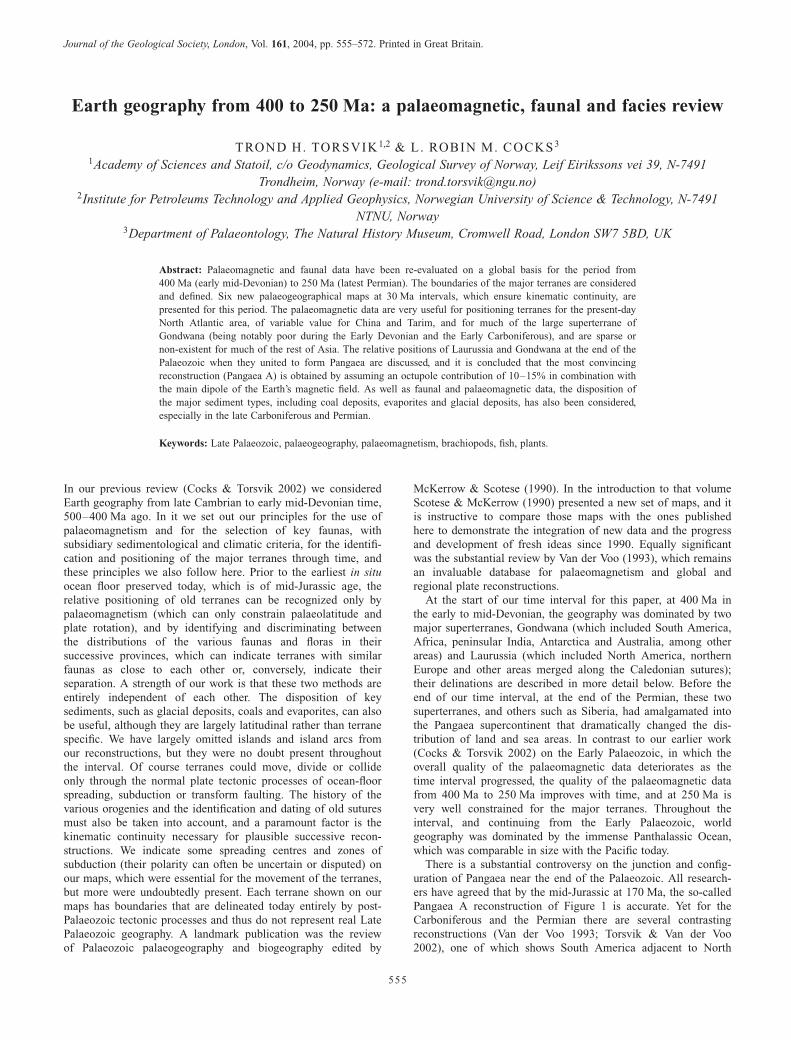
Trond H. Torsvik and L. Robin M. Cocks reviewEarth geography from 400 to 250 Ma: a palaeomagnetic, faunal and facies
serviceEmail alerting to receive free e-mail alerts when new articles cite this articlehereclick
requestPermission to seek permission to re-use all or part of this articlehereclick
SubscribeCollection
to subscribe to Journal of the Geological Society or the Lyellhereclick
Notes
on January 24, 2012Downloaded by
Copyright © 2004 Geological Society of London
Journal of the Geological Society, London, Vol. 161, 2004, pp. 555–572. Printed in Great Britain.
555
Earth geography from 400 to 250 Ma: a palaeomagnetic, faunal and facies review
TROND H. TORSVIK1,2 & L. ROBIN M. COCKS3
1Academy of Sciences and Statoil, c/o Geodynamics, Geological Survey of Norway, Leif Eirikssons vei 39, N-7491
Trondheim, Norway (e-mail: [email protected])2Institute for Petroleums Technology and Applied Geophysics, Norwegian University of Science & Technology, N-7491
NTNU, Norway3Department of Palaeontology, The Natural History Museum, Cromwell Road, London SW7 5BD, UK
Abstract: Palaeomagnetic and faunal data have been re-evaluated on a global basis for the period from
400 Ma (early mid-Devonian) to 250 Ma (latest Permian). The boundaries of the major terranes are considered
and defined. Six new palaeogeographical maps at 30 Ma intervals, which ensure kinematic continuity, are
presented for this period. The palaeomagnetic data are very useful for positioning terranes for the present-day
North Atlantic area, of variable value for China and Tarim, and for much of the large superterrane of
Gondwana (being notably poor during the Early Devonian and the Early Carboniferous), and are sparse or
non-existent for much of the rest of Asia. The relative positions of Laurussia and Gondwana at the end of the
Palaeozoic when they united to form Pangaea are discussed, and it is concluded that the most convincing
reconstruction (Pangaea A) is obtained by assuming an octupole contribution of 10–15% in combination with
the main dipole of the Earth’s magnetic field. As well as faunal and palaeomagnetic data, the disposition of
the major sediment types, including coal deposits, evaporites and glacial deposits, has also been considered,
especially in the late Carboniferous and Permian.
Keywords: Late Palaeozoic, palaeogeography, palaeomagnetism, brachiopods, fish, plants.
In our previous review (Cocks & Torsvik 2002) we consideredEarth geography from late Cambrian to early mid-Devonian time,500–400 Ma ago. In it we set out our principles for the use ofpalaeomagnetism and for the selection of key faunas, withsubsidiary sedimentological and climatic criteria, for the identifi-cation and positioning of the major terranes through time, andthese principles we also follow here. Prior to the earliest in situocean floor preserved today, which is of mid-Jurassic age, therelative positioning of old terranes can be recognized only bypalaeomagnetism (which can only constrain palaeolatitude andplate rotation), and by identifying and discriminating betweenthe distributions of the various faunas and floras in theirsuccessive provinces, which can indicate terranes with similarfaunas as close to each other or, conversely, indicate theirseparation. A strength of our work is that these two methods areentirely independent of each other. The disposition of keysediments, such as glacial deposits, coals and evaporites, can alsobe useful, although they are largely latitudinal rather than terranespecific. We have largely omitted islands and island arcs fromour reconstructions, but they were no doubt present throughoutthe interval. Of course terranes could move, divide or collideonly through the normal plate tectonic processes of ocean-floorspreading, subduction or transform faulting. The history of thevarious orogenies and the identification and dating of old suturesmust also be taken into account, and a paramount factor is thekinematic continuity necessary for plausible successive recon-structions. We indicate some spreading centres and zones ofsubduction (their polarity can often be uncertain or disputed) onour maps, which were essential for the movement of the terranes,but more were undoubtedly present. Each terrane shown on ourmaps has boundaries that are delineated today entirely by post-Palaeozoic tectonic processes and thus do not represent real LatePalaeozoic geography. A landmark publication was the reviewof Palaeozoic palaeogeography and biogeography edited by
McKerrow & Scotese (1990). In the introduction to that volumeScotese & McKerrow (1990) presented a new set of maps, and itis instructive to compare those maps with the ones publishedhere to demonstrate the integration of new data and the progressand development of fresh ideas since 1990. Equally significantwas the substantial review by Van der Voo (1993), which remainsan invaluable database for palaeomagnetism and global andregional plate reconstructions.At the start of our time interval for this paper, at 400 Ma in
the early to mid-Devonian, the geography was dominated by twomajor superterranes, Gondwana (which included South America,Africa, peninsular India, Antarctica and Australia, among otherareas) and Laurussia (which included North America, northernEurope and other areas merged along the Caledonian sutures);their delinations are described in more detail below. Before theend of our time interval, at the end of the Permian, these twosuperterranes, and others such as Siberia, had amalgamated intothe Pangaea supercontinent that dramatically changed the dis-tribution of land and sea areas. In contrast to our earlier work(Cocks & Torsvik 2002) on the Early Palaeozoic, in which theoverall quality of the palaeomagnetic data deteriorates as thetime interval progressed, the quality of the palaeomagnetic datafrom 400 Ma to 250 Ma improves with time, and at 250 Ma isvery well constrained for the major terranes. Throughout theinterval, and continuing from the Early Palaeozoic, worldgeography was dominated by the immense Panthalassic Ocean,which was comparable in size with the Pacific today.There is a substantial controversy on the junction and config-
uration of Pangaea near the end of the Palaeozoic. All research-ers have agreed that by the mid-Jurassic at 170 Ma, the so-calledPangaea A reconstruction of Figure 1 is accurate. Yet for theCarboniferous and the Permian there are several contrastingreconstructions (Van der Voo 1993; Torsvik & Van der Voo2002), one of which shows South America adjacent to North
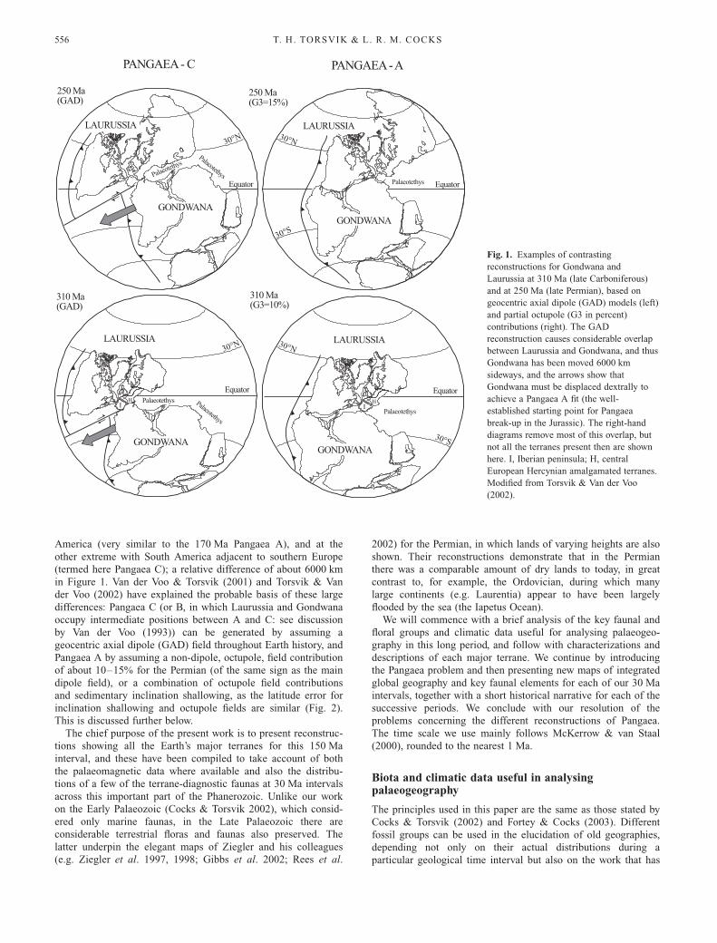
America (very similar to the 170 Ma Pangaea A), and at theother extreme with South America adjacent to southern Europe(termed here Pangaea C); a relative difference of about 6000 kmin Figure 1. Van der Voo & Torsvik (2001) and Torsvik & Vander Voo (2002) have explained the probable basis of these largedifferences: Pangaea C (or B, in which Laurussia and Gondwanaoccupy intermediate positions between A and C: see discussionby Van der Voo (1993)) can be generated by assuming ageocentric axial dipole (GAD) field throughout Earth history, andPangaea A by assuming a non-dipole, octupole, field contributionof about 10–15% for the Permian (of the same sign as the maindipole field), or a combination of octupole field contributionsand sedimentary inclination shallowing, as the latitude error forinclination shallowing and octupole fields are similar (Fig. 2).This is discussed further below.The chief purpose of the present work is to present reconstruc-
tions showing all the Earth’s major terranes for this 150 Mainterval, and these have been compiled to take account of boththe palaeomagnetic data where available and also the distribu-tions of a few of the terrane-diagnostic faunas at 30 Ma intervalsacross this important part of the Phanerozoic. Unlike our workon the Early Palaeozoic (Cocks & Torsvik 2002), which consid-ered only marine faunas, in the Late Palaeozoic there areconsiderable terrestrial floras and faunas also preserved. Thelatter underpin the elegant maps of Ziegler and his colleagues(e.g. Ziegler et al. 1997, 1998; Gibbs et al. 2002; Rees et al.
2002) for the Permian, in which lands of varying heights are alsoshown. Their reconstructions demonstrate that in the Permianthere was a comparable amount of dry lands to today, in greatcontrast to, for example, the Ordovician, during which manylarge continents (e.g. Laurentia) appear to have been largelyflooded by the sea (the Iapetus Ocean).We will commence with a brief analysis of the key faunal and
floral groups and climatic data useful for analysing palaeogeo-graphy in this long period, and follow with characterizations anddescriptions of each major terrane. We continue by introducingthe Pangaea problem and then presenting new maps of integratedglobal geography and key faunal elements for each of our 30 Maintervals, together with a short historical narrative for each of thesuccessive periods. We conclude with our resolution of theproblems concerning the different reconstructions of Pangaea.The time scale we use mainly follows McKerrow & van Staal(2000), rounded to the nearest 1 Ma.
Biota and climatic data useful in analysingpalaeogeography
The principles used in this paper are the same as those stated byCocks & Torsvik (2002) and Fortey & Cocks (2003). Differentfossil groups can be used in the elucidation of old geographies,depending not only on their actual distributions during aparticular geological time interval but also on the work that has
250 Ma(G3=15%)
250 Ma(GAD)
Equator
310 Ma(GAD)
310 Ma(G3=10%)
Equator
LAURUSSIA
GONDWANA
GONDWANA
LAURUSSIA
LAURUSSIA
GONDWANAGONDWANA
IH
IH
Palaeoteth
ys
Palaeotethys
Palaeotethys
Palaeotethys Palaeotethys
Palaeotethys
PANGAEA - C PANGAEA - A
LAURUSSIA
30°N 30°N
30°N 30°N
30°S
30°S
Equator
Equator
Fig. 1. Examples of contrasting
reconstructions for Gondwana and
Laurussia at 310 Ma (late Carboniferous)
and at 250 Ma (late Permian), based on
geocentric axial dipole (GAD) models (left)
and partial octupole (G3 in percent)
contributions (right). The GAD
reconstruction causes considerable overlap
between Laurussia and Gondwana, and thus
Gondwana has been moved 6000 km
sideways, and the arrows show that
Gondwana must be displaced dextrally to
achieve a Pangaea A fit (the well-
established starting point for Pangaea
break-up in the Jurassic). The right-hand
diagrams remove most of this overlap, but
not all the terranes present then are shown
here. I, Iberian peninsula; H, central
European Hercynian amalgamated terranes.
Modified from Torsvik & Van der Voo
(2002).
T. H. TORSVIK & L. R. M. COCKS556
currently been achieved on each group; climatic and sedimento-logical data can also help. Those fossils and sediments we haveused to help determine Late Palaeozoic palaeogeography in thispaper are now reviewed briefly in turn, but the individualsignificance of the papers cited is developed in the historicalnarrative later in this paper.
Brachiopods
Articulated brachiopods are important parts of the terrane-dependent benthos throughout our period, and the faunal pro-vinces defined by Boucot & Blodgett (2001) and others for theDevonian and Shi & Archbold (1998) and Angiolini (2001) forthe late Permian are used here. Inarticulated brachiopods have along larval life and are less useful than articulates in identifyingterranes.
Molluscs
Cephalopods, particularly nautiloids, are vital for dating, butbecause of their swift dispersal and ability to cross oceans, havenot been used here. Bivalves and gastropods are part of thebenthos when adult and can be useful; for example, Eager (1984)demonstrated that the distribution of the non-marine bivalves
indicates that all the Variscan sutures in Europe had closed bythe late Carboniferous (Westphalian).
Benthic Foraminifera
There are no planktonic Foraminifera until the Mesozoic: thebenthic Foraminifera are known from the Cambrian, but only inthe late Palaeozoic do they become important indicators. Thefusulines, in particular, were highly provincial in the laterCarboniferous and Permian: their perforate schwagerinid outerwalls were probably symbiotic with algae and they were thusconfined to the photic zone.
Other invertebrates
Trilobites became progressively less abundant and diverse withtime, in contrast to their great importance in the Early Palaeozoic(e.g. the early Ordovician). Although a minority were nektonic,most were part of the benthos, but we have not used them. Otherarthropods were evolving during this time, some within terrestrialenvironments, but their global distribution is not yet knownexhaustively enough to be considered relevant here. The distribu-tion of corals, bryozoans and stromatoporoids can be importantin showing provinciality (e.g. the corals used by Smith (1988) inthe Carboniferous of SE Asia). Although each of the last threegroups occur to some extent at most latitudes, carbonate buildupsand great diversities in all three are present only in tropical areas.We use some of the bryozoan distributions of Ross (1981) in ourearly Carboniferous reconstruction (see Fig. 8). Enough is notyet known for any distribution of the other phyla, such asechinoderms and worms, to be useful in assessing the relativeposition of terranes; however, various animals were temperaturedependent and could provide a useful check on the palaeogeo-graphy.
Vertebrates
Fish, both marine and non-marine, are important in distinguish-ing between ancient terranes (e.g. Young 1990, 1993; Ahlbergcited by McKerrow et al. 2000), and we show some of them onour late Devonian (370 Ma) map (see Fig. 7). Although this wasan important time for the vertebrates, including the initialcolonization of the land, groups other than fish were notdistributed widely enough to be useful; apart from the conodonts,which, although important for dating, dispersed too quickly toleave terrane-specific signatures. However, the various conodontprovinces do reflect palaeolatitudes, and these have been shownin the Permian by Mei & Henderson (2001).
Plants and their microfossils
The distribution of early trees is important in distinguishingbetween some terranes during the Carboniferous and Permian(e.g. Rees et al. 2002); the main floral provinces have beenknown for many years and are shown on our Early Permianreconstruction (see Fig. 10). However, the other plant groups,including the abundant planktonic microfossils such as acri-tarchs, chitinozoans and spores, although they are often usefulfor dating and can also reflect ambient temperatures and thuspalaeolatitudes, are not usually linked to any particular terrane,and thus have not been used in this paper.
250
260270
340
250
320
390
180°E
Equator
N<3
Global APW Path (NAM)Pangaea A - G3 optimized
330
120°E 240°E
30°N
30° S
30°N
400
390
360,350
330
320
Laurussia(NAM)
350,340
400
380
360370
330
310270
260
Gondwana(SAF)
320
250260270280300310
a)
b)120°E
250
260
270
280
300
310
330
Gondwana (NAM)
60°N
60°N
N>=3
Fig. 2. (a) Apparent polar wander (APW) paths for Laurussia (NAM, in
North American coordinates) and Gondwana (SAF, in South African
coordinates). Both APW paths are GAD running mean paths (20 Ma
window lengths from 400 to 250 Ma) and shown with A95 confidence
circles. s, Mean poles are of high quality; d, mean poles are of poor
quality. We also show the GAD-based Gondwana APW path rotated into
NAM coordinates, but shown without A95 cones for diagram simplicity.
(b) A combined APW for Laurussia and Gondwana, but with all mean
poles recalculated with non-dipole octupole contributions (10–15%) to
maintain a Pangaea A configuration. Galls projection. Mean north poles
and relative continental fits after Torsvik & Van der Voo (2002).
EARTH GEOGRAPHY FROM 400 TO 250 Ma 557
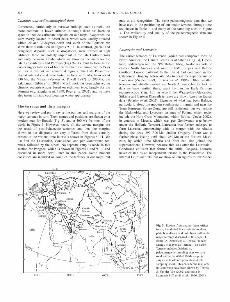
Climates and sedimentological data
Carbonates, particularly in massive buildups such as reefs, aremore common in lower latitudes, although there has been nospace to include carbonate deposits on our maps. Evaporites toowere mostly located in desert belts, which were usually situatedwithin 20 and 30 degrees north and south of the Equator; weshow their distribution in Figures 9–11. In contrast, glacial andperiglacial deposits, such as dropstones, were formed at highlatitudes; these are notably important in the late Carboniferousand early Permian. Coals, which we show on the maps for thelate Carboniferous and Permian (Figs 9–11), tend to form in thecooler higher latitudes of both hemispheres in humid wet belts aswell as in the hot wet equatorial regions. The Late Palaeozoicglacial interval could have lasted as long as 50 Ma, from about330 Ma, the Visean (Veevers & Powell 1987) to 280 Ma, theSakmarian (Gibbs et al. 2002). Much work has been achieved onclimatic reconstructions based on sediment type, largely for thePermian (e.g. Ziegler et al. 1998; Rees et al. 2002), and we havealso taken this into consideration where appropriate.
The terranes and their margins
Here we review and partly revise the outlines and margins of themajor terranes in turn. Their names and positions are shown on amodern map for Eurasia (Fig. 3), and at 400 Ma for most of theworld in Figure 5. However, nearly all the terrane margins arethe result of post-Palaeozoic tectonics and thus the marginsshown in our diagrams are very different from those actuallypresent at the various time intervals shown in Figures 5–11. Welist first the Laurussian, Gondwanan and peri-Gondwanan ter-ranes, followed by the others. No separate entry is made in thissection for Pangaea, which is shown in Figures 1 and 9–11 anddiscussed in more detail later in this paper. Some moderncoastlines are included on some of the terranes in our maps, but
only to aid recognition. The basic palaeomagnetic data that wehave used in the positioning of our major terranes through timeare shown in Table 1, and many of the sampling sites in Figure3. The availability and quality of the palaeomagnetic data areshown in Figure 4.
Laurussia and Laurasia
The earlier terranes of Laurentia (which had comprised most ofNorth America, the Chukot Peninsula of Siberia (Fig. 3), Green-land, Spitsbergen and the NW British Isles), Avalonia (parts ofeastern North America and some of NW Europe), and Baltica(northern Europe eastward to the Urals) had combined in theCaledonide Orogeny before 400 Ma to form the superterrane ofLaurussia (Ziegler 1989; Torsvik et al. 1996). Other smallerterranes undoubtedly existed near North America, but for lack ofdata we have omitted these, apart from in our Early Permianreconstruction (Fig. 10), in which the Wrangellia–Alexander,Stikinia and Eastern Klamath terranes are shown based on faunaldata (Belasky et al. 2002). Elements of what had been Baltica,particularly along the modern southwestern margin and near theTrans-European Suture Zone, are still in dispute, but we includethe Malopolska and Lysogory terranes of Poland, which todayinclude the Holy Cross Mountains, within Baltica (Cocks 2002),in contrast to Moesia, which was peri-Gondwanan (see belowunder the Hellenic Terrane). Laurussia was further enlarged toform Laurasia, commencing with its merger with the Altaidsduring the peak 290–300 Ma Uralian Orogeny. There was afurther phase lasting until about 250 Ma or the Earliest Meso-zoic, by which time Siberia and Kara had also joined thesupercontinent. However, because this was after the Laurussia–Gondwana collision that formed the initial Pangaea, Laurasianever existed as an independent terrane in the Palaeozoic. Theinternal Laurussian fits that we show on our figures follow Model
Baltica
Siberia
KazakhTerranes
Tarim
SouthChina
India
Kara
30˚N
090˚E030˚E
LutSanand
Hellenic
Apulia
Taurides
Pontides
Annamia
Sibumasu
Africa
Avalonia
Qiangtang
Lhasa
Himalayan
Laurentia
Afghan
PerunicaArmoricaI
A
C
Chukot
North China
West Siberian Basin
Mang.Alborz
ManchuridesMoesia
Equator
60˚N
060˚E 120˚E
Karakum
Adria
Fig. 3. Europe, Asia and northern Africa
today; fine dotted lines indicate modern
plate boundaries, and bold lines outline the
major terranes discussed in this paper. I,
Iberia; A, Armorica; C, Central France;
Mang., Mangyshlak Terrane. The Tarim
Terrane includes Qaidam. s,
palaeomagnetic sampling sites we have
used within the 400–250 Ma range (a
single circle often represents multiple
sampling sites). Sites outside the map area
in Gondwana have been shown by Torsvik
& Van der Voo (2002) and those in
Laurentia byTorsvik et al. (1996, 2001).
T. H. TORSVIK & L. R. M. COCKS558
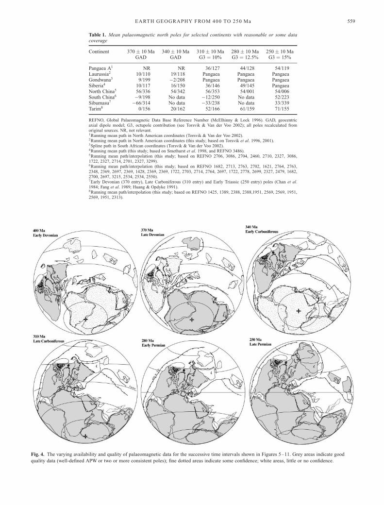
Table 1. Mean palaeomagnetic north poles for selected continents with reasonable or some datacoverage
Continent 370 ! 10 Ma 340 ! 10 Ma 310 ! 10 Ma 280 ! 10 Ma 250 ! 10 MaGAD GAD G3 ¼ 10% G3 ¼ 12:5% G3 ¼ 15%
Pangaea A1 NR NR 36/127 44/128 54/119Laurussia2 10/110 19/118 Pangaea Pangaea PangaeaGondwana3 9/199 #2/208 Pangaea Pangaea PangaeaSiberia4 10/117 16/150 36/146 49/145 PangaeaNorth China5 56/336 54/342 56/353 54/001 54/006South China6 #9/198 No data #12/250 No data 52/223Sibumasu7 #66/314 No data #33/238 No data 33/339Tarim8 0/156 20/162 52/166 61/159 71/155
REFNO, Global Palaeomagnetic Data Base Reference Number (McElhinny & Lock 1996). GAD, geocentricaxial dipole model; G3, octupole contribution (see Torsvik & Van der Voo 2002); all poles recalculated fromoriginal sources. NR, not relevant.1Running mean path in North American coordinates (Torsvik & Van der Voo 2002).2Running mean path in North American coordinates (this study; based on Torsvik et al. 1996, 2001).3Spline path in South African coordinates (Torsvik & Van der Voo 2002).4Running mean path (this study; based on Smethurst et al. 1998, and REFNO 3486).5Running mean path/interpolation (this study; based on REFNO 2706, 3086, 2704, 2460, 2710, 2327, 3086,1722, 2327, 2714, 2701, 2327, 3299).6Running mean path/interpolation (this study; based on REFNO 1682, 2713, 2763, 2702, 1621, 2764, 2763,2348, 2369, 2697, 2369, 1428, 2369, 2369, 1722, 2703, 2714, 2764, 2697, 1722, 2778, 2699, 2327, 2479, 1682,2700, 2697, 3215, 2534, 2534, 2550).7Early Devonian (370 entry), Late Carboniferous (310 entry) and Early Triassic (250 entry) poles (Chan et al.1984; Fang et al. 1989; Huang & Opdyke 1991).8Running mean path/interpolation (this study; based on REFNO 1425, 1389, 2388, 2388,1951, 2569, 2569, 1951,2569, 1951, 2313).
Fig. 4. The varying availability and quality of palaeomagnetic data for the successive time intervals shown in Figures 5–11. Grey areas indicate good
quality data (well-defined APW or two or more consistent poles); fine dotted areas indicate some confidence; white areas, little or no confidence.
EARTH GEOGRAPHY FROM 400 TO 250 Ma 559
I of Torsvik et al. (2001), except Figure 1, which follows ModelII of Torsvik et al. (2001).
Gondwana
The Gondwanan core, whose perimeter is shown by the bolddot–dashed lines in Figures 5, 6 and 8, consisted of Africa, mostof Sicily, Arabia, Madagascar, peninsular India, most of Antarc-tica, most of Australia, New Guinea, and most of South America.Our outline and internal fits follow various workers and havebeen summarized and modified by Torsvik & Van der Voo(2002). New Zealand was divided into North and South. Timorwas a Late Palaeozoic extension of Australia (Charlton et al.2002). Florida was also an integral part of Gondwana and isincluded using the fit of Lawver & Scotese (1987). Gondwanaformed at about 550 Ma, but several terranes had already leftGondwana between 500 and 400 Ma (Cocks & Torsvik 2002),including Avalonia and Perunica; however, the superterrane hadgained by the accretion of the Argentinian Precordillera Terraneduring the Silurian. During the period between 400 and 250 Ma,Armorica and various other terranes in southern Europe and theMiddle and Far East also left Gondwana (see below). Gondwanamerged with Laurussia to form Pangaea at about 330 Ma (Figs9–11).
Armorica
This is often termed the Armorican Terrane Assemblage, as itincludes not only the classic Armorican area of NW France butalso the Massif Central and the Iberian Peninsula (apart from thewesternmost South Portuguese Zone; Cocks 2000) with whichwe associate Sardinia and Corsica. We exclude Perunica (seebelow). The relative positions of NW Armorica and Iberia arecorrected for the Bay of Biscay movements during Cretaceoustime, and there are also corrections that reflect the late Tertiaryopening of the western Mediterranean Balearic Basin betweenIberia on the one hand and Corsica, Calabria and part of Sicilyon the other. Workers have agreed that Armorica was originallypart of core Gondwana, but have differed substantially on itstime of departure from Gondwana, which has been shown asranging from the Cambrian onwards. We have modified ourearlier positioning of Armorica (Cocks & Torsvik 2002) for bothpalaeomagnetic and faunal reasons (Robardet et al. 1990): weagain show it as separate from Gondwana before 400 Ma, but notto have progressed so far across the Palaeotethys Ocean (see the400 Ma section below).
The Rheno-Hercynian Terrane
All the margins of the Rheno-Hercynian Belt of north–centralEurope are tectonically deformed, but for a short period withinthe Devonian this formed a separate terrane, after the RheicOcean had closed between Avalonia and parts of Armorica(within the Northern Phyllite Zone) and then reopened as theRheno-Hercynian Ocean along a different suture. The latter isseen today between the Northern Phyllite Zone and the Mid-German Crystalline High (Franke 2000).
Perunica
Often termed Bohemia and sometimes the Tepla–Barrandianterrane. We have arbitrarily included the area north of theBohemian basin so as to coincide with the SE boundary ofLaurussia, with which it collided in the Hercynian Orogeny in
the early Carboniferous. Originally undoubtedly part of Gondwa-na, but opinions differ on whether or not it formed part ofArmorica; we treat it as a separate terrane for the faunal andpalaeomagnetic reasons stated by Cocks & Torsvik (2002).
Apulia, Adria, Hellenic and Moesia terranes
We follow Stampfli et al. (1998) in the outlines and integrity ofApulia (southern Italy apart from Calabria and most of Sicily),Adria (Adriatic and adjacent area) and the Hellenic Terrane(Greece and adjacent areas) as separate terranes, although thereare no useful palaeomagnetic data for the Late Palaeozoic(except Permian data from Adria summarized by Muttoni et al.(2001)), and terrane-contingent fossils have not been identifiedon any of the three terranes for our periods. However, we havegrouped Moesia with the Hellenic Terrane and placed all theseterranes in the peri-Gondwana area, as the data from Bulgariasummarized by Yanev (2000), although sparse, suggest thatMoesia carried peri-Gondwanan rather than Baltic trilobites andalso relatively high-latitude acritarchs during the Ordovician.Adria, the Hellenic Terrane and Moesia, together with thePontides and Armorica, separated from core Gondwana perhapsin the latest Silurian, but Apulia probably did not leaveGondwana until the Neotethys Ocean opened in the mid- to latePermian.
Pontides and Taurides
These two terranes, both of which are largely in modern Turkey,are separated today by Mesozoic and later rocks and tectoniczones. They were separate parts of peri-Gondwana, as discussedby Fortey & Cocks (2003), with the Pontides of northern Turkeyat a higher palaeolatitude than the Taurides of southern Turkeyin the Early Palaeozoic, and they were still apparently separate atthe end of our period. From the contained late Ordovician andearly Silurian fossils, we include the Istanbul area within thePontides, rather than as a separate terrane adjacent to Baltica(like Moesia) as shown by Stampfli et al. (1998); and considerthe Pontides as having been adjacent to the Adria and Hellenicterranes in the Late Palaeozoic. Again, there are no usefulPalaeozoic palaeomagnetic data, and terrane-contingent fossilsare sparse, but we can postulate fewer subduction zones andtectonic events if the Pontides were linked with Armorica, Adria,the Hellenic Terrane and Moesia in leaving Gondwana togetherduring the Silurian (with the opening Palaeotethys), and theTaurides, Apulia and the Middle Eastern terranes were amongstthose leaving Gondwana during the Permian with the opening ofthe Neotethys.
Mangyshlak and Karakum terranes
As there are no rocks older than mid-Devonian known fromwithin the Mangyshlak Terrane, it was not identified anddifferentiated on our Early Palaeozoic maps (Cocks & Torsvik2002). Today its northern boundary is the SE of Baltica to thewest and the Karakum Terrane to the east (Fig. 3), and itssouthern boundary is adjacent to the Mesozoic and later SouthCaspian Terrane (Cocks 2000), which we do not show separatelyon our maps. Its Late Palaeozoic terrane movements are obscure,but the Permian brachiopods indicate Gondwanan affinity. Theboundaries of the Karakum (variously known as Karaku orKarakorum) Terrane, which lies to the north of the MangyshlakTerrane, follow Yakubchuk (2002); once again, there are fewdistinctive faunal or palaeomagnetic data from that terrane, apart
T. H. TORSVIK & L. R. M. COCKS560
from the Permian brachiopods documented by Angiolini (2001),which indicate Gondwanan affinity.
Middle Eastern Peri-Gondwana
The Lut, Alborz and Sanand terranes, mostly today in Iran, andalso the Afghan Terrane to the east of them, were separatetectonic units. However, we follow Millson et al. (1996) ingrouping them together for the purpose of our evolving recon-structions. Von Raumer et al. (2002) showed a PalaeotethysOcean and a spreading centre between these terranes andGondwana in their earliest Ordovician map (490 Ma), and theyalso showed the same ocean (but no wider) in their Silurian(420 Ma) map. However, we know of no evidence for any suchopening of the Palaeotethys in that area until the Carboniferousor Permian, and we have also found no compelling faunal ortectonic evidence to link the Middle East terranes directly withthe Taurides, Pontides, Apulia and the Hellenic terranes. We thusdisagree with the reconstructions of Stampfli & Borel (2002),which show a so-called Hun Superterrane uniting the two terranegroups.
Himalayan terranes
The Lhasa Terrane of south Tibet and the Qiangtang Terrane ofnorth Tibet were eventually independent. However, althoughthere is an absence of palaeomagnetic data, they are treated aspart of Gondwana on our maps in view of the Gondwanan biotapresent there during the Carboniferous and Permian (Smith1988); that is, until our Late Permian reconstruction (Fig. 11), bywhich time the Qiangtang Terrane appears to have left Gondwa-na: the evidence has been reviewed by Metcalfe (2002), who incontrast also concluded that the Lhasa Terrane left Gondwanaonly in the Late Triassic.
Mexican terranes
Several separate terranes between the southern margin ofLaurussia (the Ouachita Front of the USA) and NW SouthAmerica were present as independent entities. They were appar-ently peri-Gondwanan in the Early Palaeozoic, apart from therelatively small Caborca Terrane of NW Mexico (not shown onour maps), which was part of Laurentia. In our 400–340 Mareconstructions we show the Mexican terranes diagrammaticallyas a single entity attached to South America, but as threeseparate terranes from 310 Ma onwards. These three, termed theChortis, Oaxaquia and Yucatan terranes, are positioned followingKeppie & Ramos (1999), and all three had apparently joinedLaurussia by 310 Ma.
Siberia
This is restricted to include the old Angaran craton of modernpolitical Siberia, and also the Baikalides, which accreted toAngara in the late Precambrian. We follow the outline ofRundqvist & Mitrofanov (1993), which includes most of theBaikalides, and treat also the central and southern parts of theTaimyr Peninsula as integral parts of the terrane. The terranemerged with the Laurussian part of Pangaea at around 260–250 Ma, well after the peak of the Uralian Orogeny, which wasat 300–290 Ma: by comparing our Figs 9–11 it can be seen thatthe convergence was very oblique and this resulted in therelatively straight lineament of the Urals today. Our later date forthe convergence of Siberia is substantially different from all
other published reconstructions (e.g. Scotese & McKerrow1990). To the west of Siberia is the very large early Mesozoicand later Western Siberian Basin, which covers the Palaeozoicrocks and their sutures (Nikishin et al. 1996). The LatePalaeozoic palaeomagnetic database for Siberia is poor apartfrom Late Permian times.
Kara
This terrane, consisting of northern Taimyr, Severnaya Zemlyaand the surrounding shelf seas, was independent in the EarlyPalaeozoic (references in Cocks & Torsvik 2002). It merged withSiberia in late Carboniferous–Permian times (Torsvik & Ander-sen 2002), although folding along the northern Siberian margincontinued well into the Mesozoic (Late Triassic–Early Jurassic).
North China
The terrane includes most of the Korean Peninsula, but not all ofnorthern China today, and is termed by some workers the Sino-Korean Terrane. We follow the outline of Rong et al. (1995) andvarious other workers in the divisions of China, with NorthChina’s southern boundary at the Qinling Line, and the westernmargin at the western boundary of the Huanghe Region. Itincludes the North Tarim Terrane of Yin & Nie (1996).
South China
Sometimes termed the Yangtze Terrane, the outline also followsRong et al. (1995) and previous workers. The terrane amalga-mated with Annamia before the late Carboniferous (Hutchison1989; Metcalfe 2002). On geological grounds, the terrane can bejudged to have collided with North China in the late Triassic,although palaeomagnetic data indicate differential movements(rotation) between North and South China until the mid- to lateJurassic (Enkin et al. 1992).
Tarim and Qaidam
We follow the boundaries of Tarim shown by Zhou & Chen(1992), with the northern boundary at the Tien-Shan fold belt.Although tectonically separate from Tarim, the Qaidam Terraneappears to have been closely connected to the south of it, and wecombine the two in our reconstructions. The North Tarim area ofYin & Nie (1996) is included within our definition of the NorthChina Terrane. Tarim appears to have collided with the Kazakh-stania Terrane in the Permian (Sengor & Natalin 1996): this iscorroborated by palaeomagnetic data.
Other Asian terranes
There are a variety of other terranes in Asia that we do not showon our maps (e.g. Fig. 3), partly through lack of helpful faunasand palaeomagnetism and partly because of lack of consensusamongst other workers. One is the Baoshan Terrane of Wanget al. (2001) in SW China and Burma (Myanmar) at around 998Eand 248N, which includes Lower Permian (Artinskian) basalts.This occupies some of the same ground as the Simao Terrane,which Metcalfe (1998) originally showed as a possible north-wards extension of Sibumasu, but later (Metcalfe 2002) consid-ered as adjacent to or part of the South China Terrane. Metcalfe(1998) also showed a separate Kunlun Terrane between theQiantang Terrane and Tarim–Qaidam; and a West Burma Terranewest of Sibumasu, which may be an eastwards extension of the
EARTH GEOGRAPHY FROM 400 TO 250 Ma 561
Lhasa Terrane, but it probably did not form until the Mesozoic(Metcalfe 2002).
Sibumasu
Sometimes termed Shan-Thai or Sinoburmalaya, this terranestretched from eastern Burma (Myanmar) and SW China (easternYunnan Province) through western Thailand and NW Malaysia toSumatra. Its boundaries are as shown by Cocks (2001). Itseastern boundary is plotted in this paper as congruent with thewestern boundary of Annamia, with which it collided in thelatest Triassic or early Jurassic (Hutchison 1989). Its latePalaeozoic positions are controversial and not yet completelyresolved. In the Early Palaeozoic its facies and faunas reveal itas close to South China (Cocks & Torsvik 2002; Fortey & Cocks2003), and a comparable peri-Gondwanan position west of theAustralian part of Gondwana is indicated by the distribution ofPermian brachiopods (Angiolini 2001). This is also the position-ing preferred by Ziegler et al. (1997) and Metcalfe (1998, 2002).However, palaeomagnetic data for the terrane indicate an earlyDevonian palaeolatitude (for the northern part of the terrane) of43(þ8/#7)8S (Fang et al. 1989), and a late Carboniferouspalaeolatitude (Huang & Opdyke 1991) of 45(þ11/#9)8S (GAD-based calculations). If these palaeomagnetic results are correct,and if our placing of Gondwana is also correct, the only spaceavailable in which to place Sibumasu on palaeomagnetic criteriawould be to the east, rather than to the west, of the Australianpart of Gondwana (or alternatively in the northern hemisphere;Cocks & Torsvik 2002). However, following Metcalfe (2002) andothers, we have decided to position Sibumasu west of Australia;but to do so we have had to adjust the position of Sibumasu2000 km farther northwards than the existing palaeomagneticdata suggest, to avoid overlap with India and the Himalayanterranes. Our 250 Ma reconstruction (Fig. 11) uses the earlyTriassic pole of Chan et al. (1984), which suggests that Sibumasihad departed by then from the Australian margin, perhapstogether with the Qiangtang Terrane during the opening of theNeotethys Ocean. It should be noted that the palaeomagneticdata suggest that Sibumasu had geographically rotated before theend of the Permian (compare Fig. 9 with Fig. 11), although thetectonic processes responsible for the rotation are uncertain.
Annamia
Often known as Indo-China or Indosinia, this terrane includespart of eastern China today, as well as Laos, Vietnam, Cambodiaand eastern Thailand. Its northern boundary is emended here tobe congruent with the eastern boundary of South China, withwhich it amalgamated before the late Carboniferous (Hutchison1989; Metcalfe 2002). The eastern part of the west Malaysianpeninsula, in which the earliest known rocks are of earlyCarboniferous (Visean) age, is included within Annamia here,although Hutchison (1989) recognized three separate terranes inthat area.
Kazakh and adjacent terranes
On structural criteria Sengor & Natalin (1996) identified asubstantial number of separate Palaeozoic terranes in the largearea of central Asia to the east of the Urals, south of the SiberianTerrane (as defined above), east of North China, and north of themain peri-Gondwanan collage. The area includes the Altaids.From independent Ordovician and Silurian faunal data, and byconsidering the structural divisions within Kazakhstan today,
Fortey & Cocks (2003) have confirmed the separate integrity offour of these Kazakh terranes and suggested their positioningrelative to each other and to Baltica, Siberia and the neighbour-ing peri-Gondwanan terranes in the Early Palaeozoic. These arethe Chu-Ili, Tien-Shan, Chingiz and Altai-Sayan terranes. Fewreliable palaeomagnetic data are yet published from this substan-tial area, except North Tien-Shan, which was located at c. 158Nand 308N in the Carboniferous and Permian, respectively(Bazhenov et al. 2003). Most of the Kazakh terranes hadamalgamated with each other and with Baltica to their west toform part of Laurussia during the Uralian Orogeny from 290 to300 Ma, but tectonic interaction continued between them untilafter the close of our period (Sengor & Natalin 1996). In our400 Ma and 370 Ma reconstructions we show three arbitraryrelatively small ‘Kazakh’ terranes as separate, and a so-calledKazakhstania Terrane in our reconstructions from 340 Ma to250 Ma: its size is smaller in the 340 Ma map than in the laterones. From 370 Ma onwards the outline of Kazakhstania and thesubduction zones around it follow Sengor & Natalin (1996). Themargins of the Kazakhstania Terrane are likely to be morecorrect in our 280 Ma and 250 Ma reconstructions, as theirpositions are delimited by the sutures at the edges of Baltica andSiberia today.
Island arcs
As today, there were several strings of island arcs present duringthe Mid- to Late Palaeozoic, notably those off SE Australia,northern Laurussia (the Bennett–Barrovia Arc), and elsewhere.In the Mid-Palaeozoic there were certainly arcs to the east of theUrals, as is convincingly demonstrated by the Silurian andDevonian ocean vent faunas now preserved in sulphide oresdescribed by Little et al. (1997). Although Late Palaeozoicfaunas are known from many microplates within the various arcs,there are no reliable palaeomagnetic data and these small,although undoubtedly in some cases important, areas are omittedfrom our reconstructions.
Palaeomagnetic data and a lead into the Pangaeaproblem
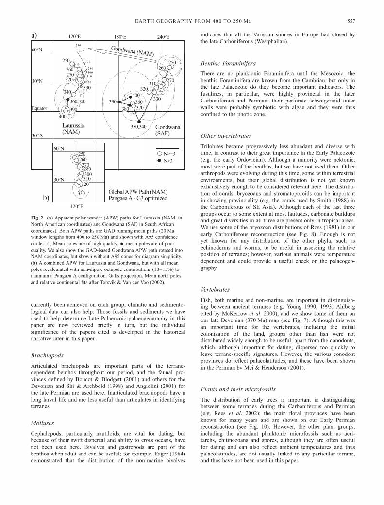
Figure 1, which is taken from Torsvik & Van der Voo (2002),shows two different reconstructions of the relative positions ofGondwana and Laurussia at two separate periods (310 Ma and250 Ma) as they combined to form Pangaea. One reconstructionassumes that the Earth had a GAD field, and the other that themagnetic field was more complex, with a partial non-dipole(octuple) component of the same sign as the dipole field. Mostworkers have in practice ignored the influence of non-dipolecomponents, and thus the published palaeopoles for Gondwanaand Laurussia, if strictly interpreted, have positioned the twochief parts of Pangaea into a reconstruction such as Pangaea C(Fig. 1). The difference between the two assumptions results incontrasting reconstructions that involve relative lateral displace-ment to each other of about 6000 km or more in the Gondwana–Laurussia docking area (Fig. 1).Figure 2a shows running mean apparent polar wander (APW)
paths for both Laurussia (NAM in North American coordinates)and Gondwana (SAF in South African coordinates) from 400 Mato 250 Ma at 10 Ma intervals (Torsvik & Van der Voo 2002). Ingeneral the quality of data is good for the whole time interval(open circles in Fig. 2a), although there are a few time intervals(filled circles), particularly in the first half of our period (i.e.400–340 Ma for Gondwana), when the quality of the data is
T. H. TORSVIK & L. R. M. COCKS562
poor. When adjusting for sea-floor spreading and pre-driftextension in the Central Atlantic, it is evident that the APWpaths for Laurussia and Gondwana cannot be fully accommo-dated in a Pangaea A type fit (Fig. 2a). As most other categoriesof geological data, including those from structural geology andpalaeontology, have in practice indicated and favoured recon-structions such as the Pangaea A of our Figure 1, we have optedto recalculate all palaeomagnetic poles to include an octupolefield contribution, thus reconciling the palaeomagnetic with theother geological data and conclusions. After incorporating octu-pole contributions, Gondwana poles were transferred into aLaurussia (North America) frame and a joint APW path is shownfor the 330–250 Ma interval (Fig. 2b; Table 1). Palaeomagneticpoles from all the continents for 310–250 Ma were recalculatedwith time-dependent G3 contributions (10–15%) as concludedby Torsvik & Van der Voo (2002). For older time intervals (340and 370 Ma) we did not recalculate the palaeomagnetic poles, aswe have no precise knowledge of the Earth’s magnetic field then.The 400 Ma reconstruction (Fig. 5) is also a GAD-basedreconstruction, slightly modified from Cocks & Torsvik (2002),and serves as a template for terrane identification. Reconstructionpoles for the major terranes from 370 to 250 Ma are listed inTable 1.
Earth geography from 400 to 250 Ma
In the following sections a narrative and maps (Figs 5–11) arepresented for 30 Ma intervals from 400 Ma (the early Devonian)to 250 Ma (the latest Permian: the Permo-Triassic boundary isnow placed at 248 Ma). The palaeomagnetic data from the wholeof each interval have been used to construct these maps, but onlyselected faunal and climatically sensitive data have been plottedon each of them. However, those fossils shown are much moretime-restricted than the palaeomagnetic data (!10 Ma), optimallyto periods of about 2 Ma. Because of space constraints on ourdiagrams, a single data point represents many localities in mostinstances.
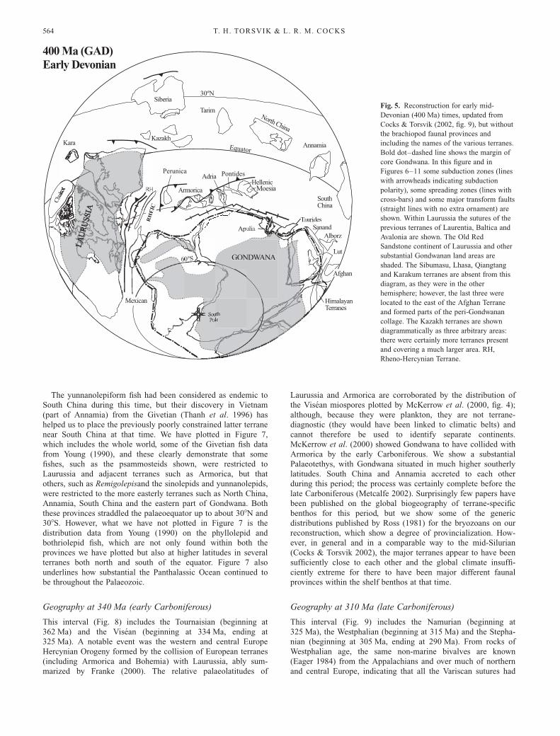
Geography at 400 Ma (early and mid-Devonian)
This interval (Fig. 5) includes the Emsian (beginning at 410 Ma)and the Eifelian (beginning at 394 Ma, ending at 388 Ma). Thedistribution of the brachiopods in the Emsian on largely the samereconstruction was shown in our previous paper (Cocks &Torsvik 2002, fig. 9), on which was plotted the various faunalprovinces from Boucot & Blodgett (2001), and these distribu-tions showed differentiation between the Rhenish–Bohemian (orOld World) Realm, the Appalachian Realm and the high-latitudeMalvinokaffric Realm: this geography is well supported by goodpalaeomagnetic data, particularly from the present-day NorthAtlantic area. However, in the present paper we have modifiedthe positions of Armorica and the Adria, Pontides and Hellenicterranes: in our previously published map we showed Armoricaas having left Gondwana prior to 400 Ma, with a wideningPalaeotethys Ocean between Armorica and Gondwana, but withAdria, the Pontides and the Hellenic Terrane still attached toGondwana. Despite the cogent arguments of Robardet et al.(1990), and other workers, that there are no persuasive structuralor palaeontological reasons to suppose that Armorica becamedetached from Gondwana before the late Devonian, we havenevertheless preferred the alternative arguments of Stampfli &Borel (2002) and therefore show a widening Palaeotethys Oceanbetween these terranes and Gondwana. Whether or not the four
terranes were amalgamated to form part of what Stampfli &Borel (2002) termed the Hun Superterrane is, however, doubtful.We have also changed the positions of North and South China
in our reconstruction. Both blocks have been updated with newpalaeomagnetic information and we have also inverted thepolarity of North China poles; in Figure 4 we show North Chinalow in the northern hemisphere, whereas in our earlier paper(Cocks & Torsvik 2002) we showed it in low southerly latitudes.The South Tien-Shan (Kazakh) brachiopods in the Emsian andEifelian include Megastrophia uralensis and Zdimir pseodobash-kiricus, which provide direct faunal links with the Urals, andthese are not known from Tarim. The true location of Annamiais unknown, and the position for Sibumasu is also uncertain;there are contemporary faunas known from both terranes, butthese are not helpful in deciding where the terranes were then(see also discussion under the Sibumasu Terrane above). Forexample, the brachiopods described from the Devonian of south-ern Thailand (part of Sibumasu) by Boucot et al. (1999) are froma deeper-shelf community, and, despite an endemic genus, consistlargely of widespread and cosmopolitan forms.
Geography at 370 Ma (mid- and late Devonian)
This interval (Figs 6 and 7) includes the Givetian (beginning at388 Ma), Frasnian (beginning at 383 Ma) and Famennian (begin-ning at 377 Ma, ending at 362 Ma). McKerrow et al. (2000) havesummarized the evidence to show that the Rheic Ocean betweenGondwana and Laurussia was not wide enough to prevent themigration of key faunas in the late Devonian. For example, thefish Holoptychius was widespead in Laurussia during the Fras-nian and Famennian and reached Australia (in Gondwana) duringthe Famennian, and the Famennian lungfish Soederberghia isrepresented by the same species occurring in Greenland, theUSA and Australia. However, we differ from McKerrow et al.(2000) in placing the Rheic Ocean to the north of Armorica (Figs5 and 6), rather than to the south (where we place the incipientPalaeotethys Ocean), and also in placing the palaeoequator20 degrees farther north (based on the substantial palaeomagneticdata available).Figure 6 shows the distribution of late Mid-Devonian (Give-
tian) brachiopod realms and provinces, the definition of whichlargely follows Boucot & Blodgett (2001), but the locality pointsare taken from many sources. This is the final period in whichthe cold-water Antarctic Malvinokaffric Realm, so important inthe Silurian and Early Devonian, can be differentiated: its faunabecame combined with the other realms by the end of theGivetian. The period is also near the end of the distinctionbetween the two substantial Old World and Eastern AmericanRealms, although relict faunas representing both are found in afew areas in the succeeding Frasnian. In contrast to the sevenprovinces or subprovinces that Boucot & Blodgett (2001)recognized in the Early Devonian, only two are definable in theOld World Realm in the Givetian: the Cordilleran Subprovince ofwestern and Arctic North America (apart from Nevada, whichyields a provincial mix of brachiopods); and the RBU Province,the latter a combination of the Rhenish–Bohemian and theUralian Subprovinces, both of which were clearly distinguishablein the Emsian and Eifelian. As well as Europe, the RBU Provinceencompassed much of the world, including Siberia, North andSouth China, Annamia and the Australian part of Gondwana;however, the few Givetian brachiopods known from the Sibuma-su terrane are too deep-water to betoken provincial affinity. Thefaunas of the Frasnian had an even lower level of globalprovinciality than those of the preceding Givetian.
EARTH GEOGRAPHY FROM 400 TO 250 Ma 563
The yunnanolepiform fish had been considered as endemic toSouth China during this time, but their discovery in Vietnam(part of Annamia) from the Givetian (Thanh et al. 1996) hashelped us to place the previously poorly constrained latter terranenear South China at that time. We have plotted in Figure 7,which includes the whole world, some of the Givetian fish datafrom Young (1990), and these clearly demonstrate that somefishes, such as the psammosteids shown, were restricted toLaurussia and adjacent terranes such as Armorica, but thatothers, such as Remigolepisand the sinolepids and yunnanolepids,were restricted to the more easterly terranes such as North China,Annamia, South China and the eastern part of Gondwana. Boththese provinces straddled the palaeoequator up to about 308N and308S. However, what we have not plotted in Figure 7 is thedistribution data from Young (1990) on the phyllolepid andbothriolepid fish, which are not only found within both theprovinces we have plotted but also at higher latitudes in severalterranes both north and south of the equator. Figure 7 alsounderlines how substantial the Panthalassic Ocean continued tobe throughout the Palaeozoic.
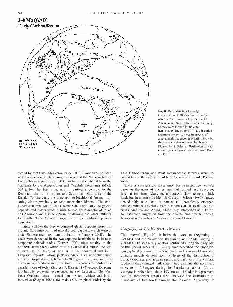
Geography at 340 Ma (early Carboniferous)
This interval (Fig. 8) includes the Tournaisian (beginning at362 Ma) and the Visean (beginning at 334 Ma, ending at325 Ma). A notable event was the western and central EuropeHercynian Orogeny formed by the collision of European terranes(including Armorica and Bohemia) with Laurussia, ably sum-marized by Franke (2000). The relative palaeolatitudes of
Laurussia and Armorica are corroborated by the distribution ofthe Visean miospores plotted by McKerrow et al. (2000, fig. 4);although, because they were plankton, they are not terrane-diagnostic (they would have been linked to climatic belts) andcannot therefore be used to identify separate continents.McKerrow et al. (2000) showed Gondwana to have collided withArmorica by the early Carboniferous. We show a substantialPalaeotethys, with Gondwana situated in much higher southerlylatitudes. South China and Annamia accreted to each otherduring this period; the process was certainly complete before thelate Carboniferous (Metcalfe 2002). Surprisingly few papers havebeen published on the global biogeography of terrane-specificbenthos for this period, but we show some of the genericdistributions published by Ross (1981) for the bryozoans on ourreconstruction, which show a degree of provincialization. How-ever, in general and in a comparable way to the mid-Silurian(Cocks & Torsvik 2002), the major terranes appear to have beensufficiently close to each other and the global climate insuffi-ciently extreme for there to have been major different faunalprovinces within the shelf benthos at that time.
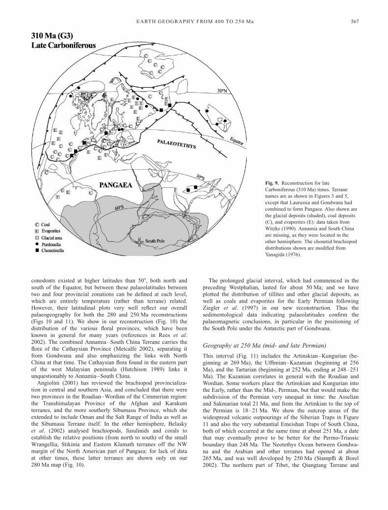
Geography at 310 Ma (late Carboniferous)
This interval (Fig. 9) includes the Namurian (beginning at325 Ma), the Westphalian (beginning at 315 Ma) and the Stepha-nian (beginning at 305 Ma, ending at 290 Ma). From rocks ofWestphalian age, the same non-marine bivalves are known(Eager 1984) from the Appalachians and over much of northernand central Europe, indicating that all the Variscan sutures had
uthle
Siberia
North China
Tarim
South China
AnnamiaKara
Armorica
Kazakh
GONDWANA
Adria
Apu
Hellenic
uridesSanand
Alborz
Lut
Afghan
HimalayanTerranes
Equator
Perunica
30ºN
400 Ma (GAD)Early Devonian
Mexicanexiexi
H
RH
EH
EEIC
EH
EI
Pontides
Moesia
Fig. 5. Reconstruction for early mid-
Devonian (400 Ma) times, updated from
Cocks & Torsvik (2002, fig. 9), but without
the brachiopod faunal provinces and
including the names of the various terranes.
Bold dot–dashed line shows the margin of
core Gondwana. In this figure and in
Figures 6–11 some subduction zones (lines
with arrowheads indicating subduction
polarity), some spreading zones (lines with
cross-bars) and some major transform faults
(straight lines with no extra ornament) are
shown. Within Laurussia the sutures of the
previous terranes of Laurentia, Baltica and
Avalonia are shown. The Old Red
Sandstone continent of Laurussia and other
substantial Gondwanan land areas are
shaded. The Sibumasu, Lhasa, Qiangtang
and Karakum terranes are absent from this
diagram, as they were in the other
hemisphere; however, the last three were
located to the east of the Afghan Terrane
and formed parts of the peri-Gondwanan
collage. The Kazakh terranes are shown
diagrammatically as three arbitrary areas:
there were certainly more terranes present
and covering a much larger area. RH,
Rheno-Hercynian Terrane.
T. H. TORSVIK & L. R. M. COCKS564
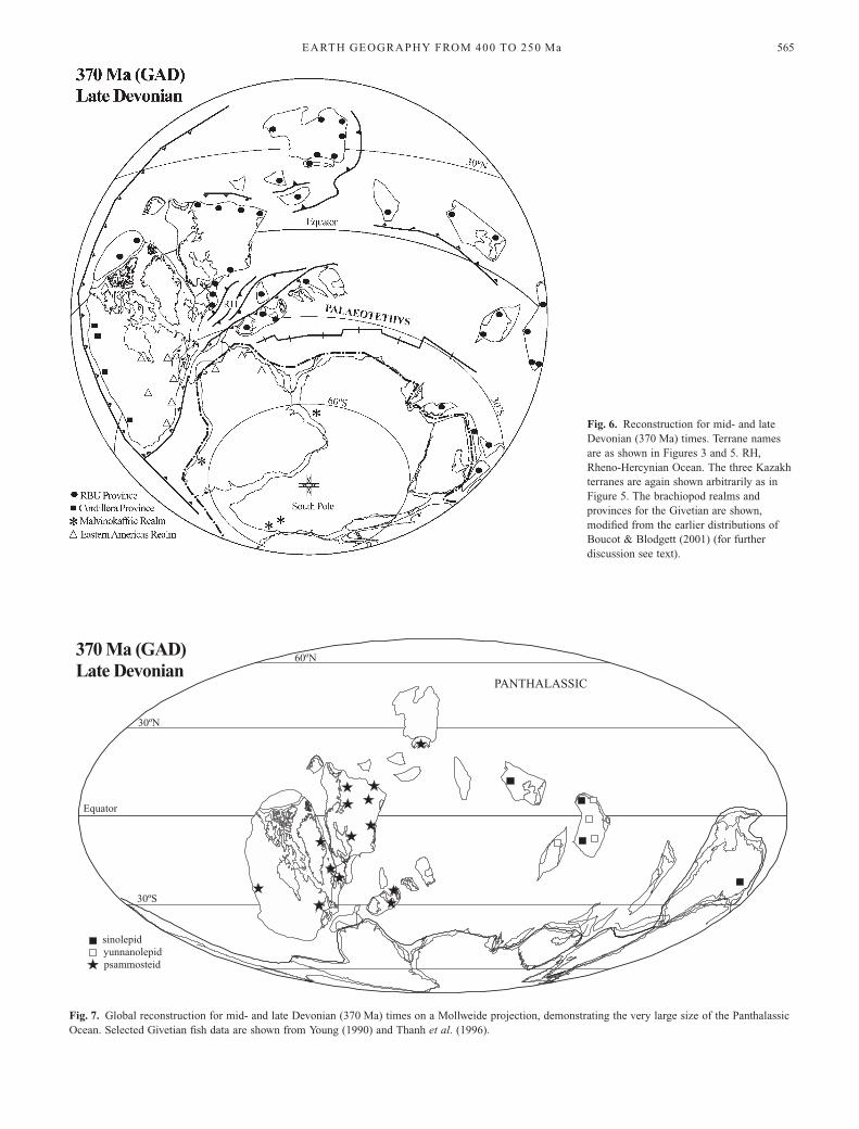
Fig. 6. Reconstruction for mid- and late
Devonian (370 Ma) times. Terrane names
are as shown in Figures 3 and 5. RH,
Rheno-Hercynian Ocean. The three Kazakh
terranes are again shown arbitrarily as in
Figure 5. The brachiopod realms and
provinces for the Givetian are shown,
modified from the earlier distributions of
Boucot & Blodgett (2001) (for further
discussion see text).
Equator
30ºN
60ºN
30ºS
370 Ma (GAD)Late Devonian
sinolepidyunnanolepidpsammosteid
PANTHALASSIC
Fig. 7. Global reconstruction for mid- and late Devonian (370 Ma) times on a Mollweide projection, demonstrating the very large size of the Panthalassic
Ocean. Selected Givetian fish data are shown from Young (1990) and Thanh et al. (1996).
EARTH GEOGRAPHY FROM 400 TO 250 Ma 565
closed by that time (McKerrow et al. 2000). Gondwana collidedwith Laurussia and intervening terranes, and the Variscan belt ofEurope became part of a c. 8000 km belt that stretched from theCaucasus to the Appalachian and Quachita mountains (Matte2001). For the first time, and in particular contrast to theDevonian, the Tarim Terrane and South Tien-Shan area of theKazakh Terrane carry the same marine brachiopod faunas, indi-cating closer proximity to each other than hitherto. The con-joined Annamia–South China Terrane does not carry the glacialdeposits and colder-water marine faunas characteristic of muchof Gondwana and also Sibumasu, confirming the lower latitudesfor South China–Annamia suggested by the published palaeo-magnetism.Figure 9 shows the very widespread glacial deposits present in
the late Carboniferous, and also the coal deposits, which were attheir Phanerozoic maximum at that time (Trappe 2000). Thecoals were deposited in the two separate hemispheres in belts attemperate palaeolatitudes (Witzke 1990), most notably in thenorthern hemisphere, which must also have had humid and wetclimates at the time, as well as in the equatorial wet belt.Evaporite deposits, whose peak abundances are normally foundin the subtropical arid belts at 20–30 degrees north and south ofthe Equator, are also shown, and their Carboniferous distributionsparallel those of today (Scotese & Barrett 1990) except for somelow-latitude evaporite occurrences in SW Laurentia. The Var-iscan Orogeny caused crustal loading and widespread basinformation (Ziegler 1989); the main collision phase ended by the
Late Carboniferous and most metamorphic terranes were un-roofed before the deposition of late Carboniferous–early Permianstrata.There is considerable uncertainty; for example, few workers
agree on the areas of the terranes that formed land above sealevel at this time. Many reconstructions show relatively littleland; but in contrast Lethiers & Crasquin-Soleau (1995) showedconsiderably more, and in particular a completely emergentpalaeocontinent stretching from northern Canada to the south ofSouth America and Africa, which they interpreted as a barrierfor ostracode migration from the diverse and prolific tropicalfaunas of western North America to central Europe.
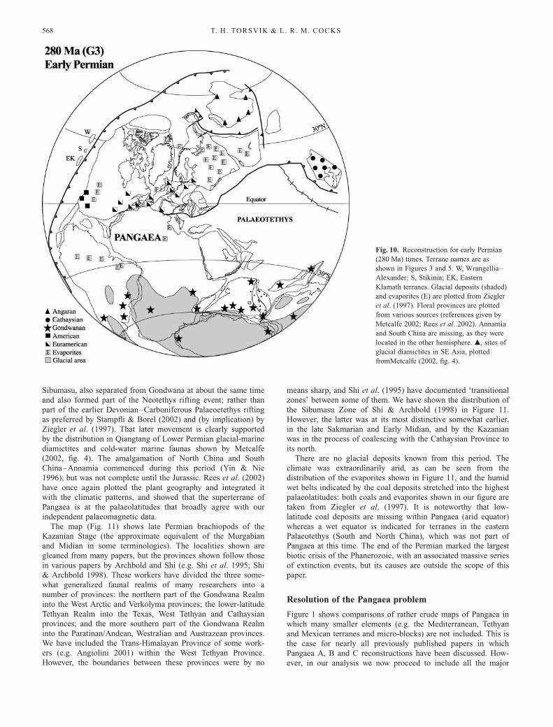
Geography at 280 Ma (early Permian)
This interval (Fig. 10) includes the Asselian (beginning at290 Ma) and the Sakmarian (beginning at 282 Ma, ending at269 Ma). The southern glaciation continued during the early partof this period. Rees et al. (2002) have described the phytogeo-geographical patterns of the Sakmarian and compared them withclimatic models derived from synthesis of the distribution ofcoals, evaporites and aeolian sands, and have identified climaticgradients that changed with time. They estimate the northwardmovement of Pangaea during the Permian as about 158; ourestimate is rather less, about 108, but still broadly in agreement.Mei & Henderson (2001) have analysed the distribution ofconodonts at five levels through the Permian. Apparently no
Fig. 8. Reconstruction for early
Carboniferous (340 Ma) times. Terrane
names are as shown in Figures 3 and 5.
Annamia and South China and are missing,
as they were located in the other
hemisphere. The outline of Kazakhstania is
arbitrary: the collage was in process of
amalgamation (Sengor & Natalin 1996), but
the terrane is shown as smaller than in
Figures 9–11. Selected distribution data for
some bryozoan genera are taken from Ross
(1981).
T. H. TORSVIK & L. R. M. COCKS566
conodonts existed at higher latitudes than 508, both north andsouth of the Equator, but between these palaeolatitudes betweentwo and four provincial zonations can be defined at each level,which are entirely temperature (rather than terrane) related.However, their latitudinal plots very well reflect our overallpalaeogeography for both the 280 and 250 Ma reconstructions(Figs 10 and 11). We show in our reconstruction (Fig. 10) thedistribution of the various floral provinces, which have beenknown in general for many years (references in Rees et al.2002). The combined Annamia–South China Terrane carries theflora of the Cathaysian Province (Metcalfe 2002), separating itfrom Gondwana and also emphasizing the links with NorthChina at that time. The Cathaysian flora found in the eastern partof the west Malaysian peninsula (Hutchison 1989) links itunquestionably to Annamia–South China.Angiolini (2001) has reviewed the brachiopod provincializa-
tion in central and southern Asia, and concluded that there weretwo provinces in the Roadian–Wordian of the Cimmerian region:the Transhimalayan Province of the Afghan and Karakumterranes, and the more southerly Sibumasu Province, which sheextended to include Oman and the Salt Range of India as well asthe Sibumasu Terrane itself. In the other hemisphere, Belaskyet al. (2002) analysed brachiopods, fusulinids and corals toestablish the relative positions (from north to south) of the smallWrangellia, Stikinia and Eastern Klamath terranes off the NWmargin of the North American part of Pangaea: for lack of dataat other times, these latter terranes are shown only on our280 Ma map (Fig. 10).
The prolonged glacial interval, which had commenced in thepreceding Westphalian, lasted for about 50 Ma; and we haveplotted the distribution of tillites and other glacial deposits, aswell as coals and evaporites for the Early Permian followingZiegler et al. (1997) in our new reconstruction. Thus thesedimentological data indicating palaeolatitudes confirm thepalaeomagnetic conclusions, in particular in the positioning ofthe South Pole under the Antarctic part of Gondwana.
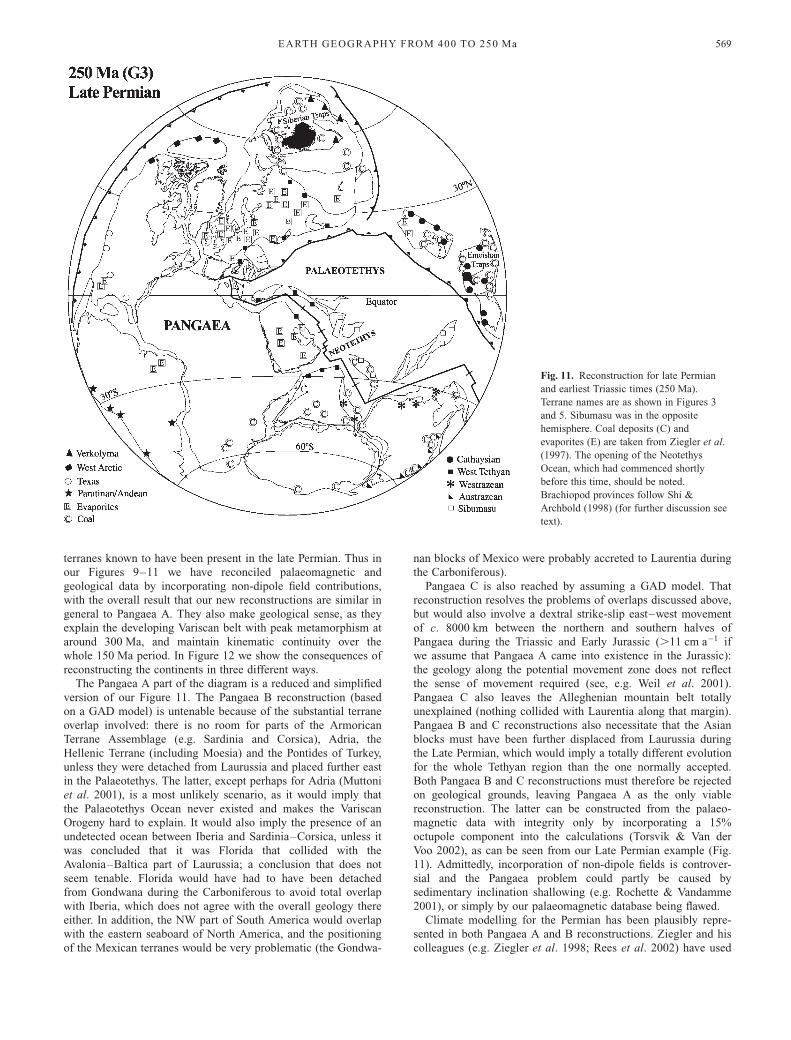
Geography at 250 Ma (mid- and late Permian)
This interval (Fig. 11) includes the Artinskian–Kungurian (be-ginning at 269 Ma), the Uffimian–Kazanian (beginning at 256Ma), and the Tartarian (beginning at 252 Ma, ending at 248–251Ma). The Kazanian correlates in general with the Roadian andWordian. Some workers place the Artinskian and Kungurian intothe Early, rather than the Mid-, Permian, but that would make thesubdivision of the Permian very unequal in time: the Asselianand Sakmarian total 21 Ma, and from the Artinkian to the top ofthe Permian is 18–21 Ma. We show the outcrop areas of thewidespread volcanic outpourings of the Siberian Traps in Figure11 and also the very substantial Emeishan Traps of South China,both of which occurred at the same time at about 251 Ma, a datethat may eventually prove to be better for the Permo-Triassicboundary than 248 Ma. The Neotethys Ocean between Gondwa-na and the Arabian and other terranes had opened at about265 Ma, and was well developed by 250 Ma (Stampfli & Borel2002). The northern part of Tibet, the Qiangtang Terrane and
Fig. 9. Reconstruction for late
Carboniferous (310 Ma) times. Terrane
names are as shown in Figures 3 and 5,
except that Laurussia and Gondwana had
combined to form Pangaea. Also shown are
the glacial deposits (shaded), coal deposits
(C), and evaporites (E): data taken from
Witzke (1990). Annamia and South China
are missing, as they were located in the
other hemisphere. The chonetid brachiopod
distributions shown are modified from
Yanagida (1976).
EARTH GEOGRAPHY FROM 400 TO 250 Ma 567
Sibumasu, also separated from Gondwana at about the same timeand also formed part of the Neotethys rifting event; rather thanpart of the earlier Devonian–Carboniferous Palaeoetethys riftingas preferred by Stampfli & Borel (2002) and (by implication) byZiegler et al. (1997). That later movement is clearly supportedby the distribution in Qiangtang of Lower Permian glacial-marinediamictites and cold-water marine faunas shown by Metcalfe(2002, fig. 4). The amalgamation of North China and SouthChina–Annamia commenced during this period (Yin & Nie1996), but was not complete until the Jurassic. Rees et al. (2002)have once again plotted the plant geography and integrated itwith the climatic patterns, and showed that the superterrane ofPangaea is at the palaeolatitudes that broadly agree with ourindependent palaeomagnetic data.The map (Fig. 11) shows late Permian brachiopods of the
Kazanian Stage (the approximate equivalent of the Murgabianand Midian in some terminologies). The localities shown aregleaned from many papers, but the provinces shown follow thosein various papers by Archbold and Shi (e.g. Shi et al. 1995; Shi& Archbold 1998). These workers have divided the three some-what generalized faunal realms of many researchers into anumber of provinces: the northern part of the Gondwana Realminto the West Arctic and Verkolyma provinces; the lower-latitudeTethyan Realm into the Texas, West Tethyan and Cathaysianprovinces; and the more southern part of the Gondwana Realminto the Paratinan/Andean, Westralian and Austrazean provinces.We have included the Trans-Himalayan Province of some work-ers (e.g. Angiolini 2001) within the West Tethyan Province.However, the boundaries between these provinces were by no
means sharp, and Shi et al. (1995) have documented ‘transitionalzones’ between some of them. We have shown the distribution ofthe Sibumasu Zone of Shi & Archbold (1998) in Figure 11.However, the latter was at its most distinctive somewhat earlier,in the late Sakmarian and Early Midian, and by the Kazanianwas in the process of coalescing with the Cathaysian Province toits north.There are no glacial deposits known from this period. The
climate was extraordinarily arid, as can be seen from thedistribution of the evaporites shown in Figure 11, and the humidwet belts indicated by the coal deposits stretched into the highestpalaeolatitudes: both coals and evaporites shown in our figure aretaken from Ziegler et al. (1997). It is noteworthy that low-latitude coal deposits are missing within Pangaea (arid equator)whereas a wet equator is indicated for terranes in the easternPalaeotethys (South and North China), which was not part ofPangaea at this time. The end of the Permian marked the largestbiotic crisis of the Phanerozoic, with an associated massive seriesof extinction events, but its causes are outside the scope of thispaper.
Resolution of the Pangaea problem
Figure 1 shows comparisons of rather crude maps of Pangaea inwhich many smaller elements (e.g. the Mediterranean, Tethyanand Mexican terranes and micro-blocks) are not included. This isthe case for nearly all previously published papers in whichPangaea A, B and C reconstructions have been discussed. How-ever, in our analysis we now proceed to include all the major
Fig. 10. Reconstruction for early Permian
(280 Ma) times. Terrane names are as
shown in Figures 3 and 5. W, Wrangellia–
Alexander; S, Stikinia; EK, Eastern
Klamath terranes. Glacial deposits (shaded)
and evaporites (E) are plotted from Ziegler
et al. (1997). Floral provinces are plotted
from various sources (references given by
Metcalfe 2002; Rees et al. 2002). Annamia
and South China are missing, as they were
located in the other hemisphere. m, sites of
glacial diamictites in SE Asia, plotted
fromMetcalfe (2002, fig. 4).
T. H. TORSVIK & L. R. M. COCKS568
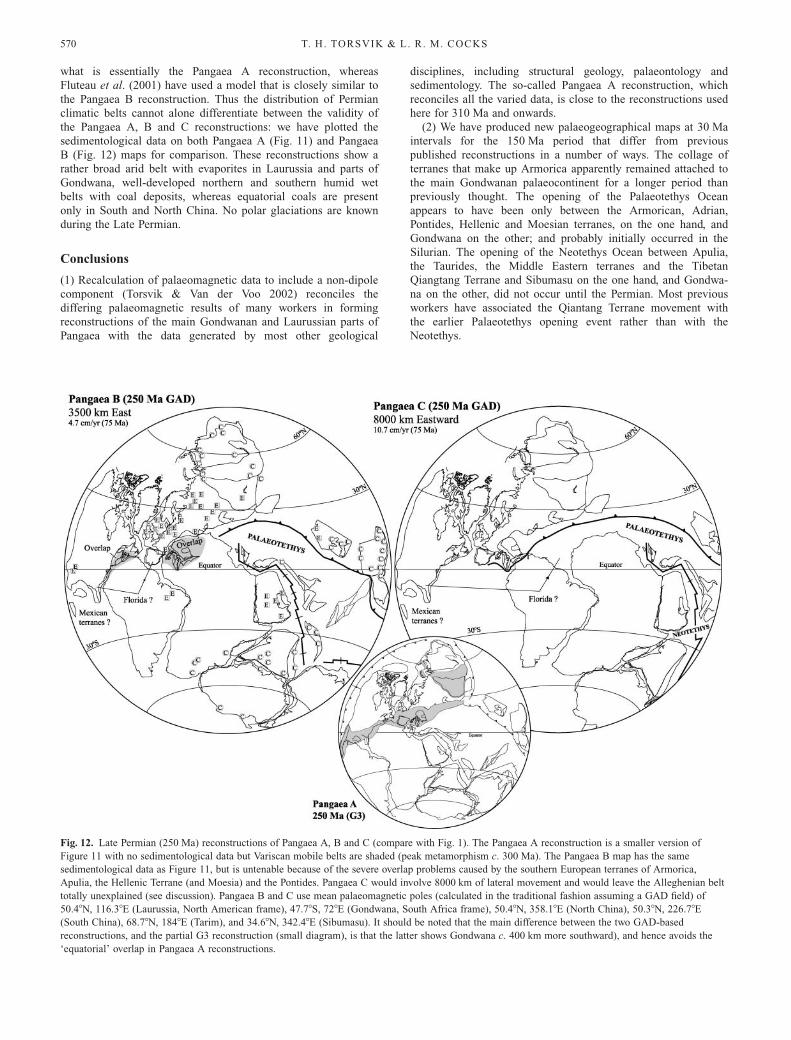
terranes known to have been present in the late Permian. Thus inour Figures 9–11 we have reconciled palaeomagnetic andgeological data by incorporating non-dipole field contributions,with the overall result that our new reconstructions are similar ingeneral to Pangaea A. They also make geological sense, as theyexplain the developing Variscan belt with peak metamorphism ataround 300 Ma, and maintain kinematic continuity over thewhole 150 Ma period. In Figure 12 we show the consequences ofreconstructing the continents in three different ways.The Pangaea A part of the diagram is a reduced and simplified
version of our Figure 11. The Pangaea B reconstruction (basedon a GAD model) is untenable because of the substantial terraneoverlap involved: there is no room for parts of the ArmoricanTerrane Assemblage (e.g. Sardinia and Corsica), Adria, theHellenic Terrane (including Moesia) and the Pontides of Turkey,unless they were detached from Laurussia and placed further eastin the Palaeotethys. The latter, except perhaps for Adria (Muttoniet al. 2001), is a most unlikely scenario, as it would imply thatthe Palaeotethys Ocean never existed and makes the VariscanOrogeny hard to explain. It would also imply the presence of anundetected ocean between Iberia and Sardinia–Corsica, unless itwas concluded that it was Florida that collided with theAvalonia–Baltica part of Laurussia; a conclusion that does notseem tenable. Florida would have had to have been detachedfrom Gondwana during the Carboniferous to avoid total overlapwith Iberia, which does not agree with the overall geology thereeither. In addition, the NW part of South America would overlapwith the eastern seaboard of North America, and the positioningof the Mexican terranes would be very problematic (the Gondwa-
nan blocks of Mexico were probably accreted to Laurentia duringthe Carboniferous).Pangaea C is also reached by assuming a GAD model. That
reconstruction resolves the problems of overlaps discussed above,but would also involve a dextral strike-slip east–west movementof c. 8000 km between the northern and southern halves ofPangaea during the Triassic and Early Jurassic (.11 cm a#1 ifwe assume that Pangaea A came into existence in the Jurassic):the geology along the potential movement zone does not reflectthe sense of movement required (see, e.g. Weil et al. 2001).Pangaea C also leaves the Alleghenian mountain belt totallyunexplained (nothing collided with Laurentia along that margin).Pangaea B and C reconstructions also necessitate that the Asianblocks must have been further displaced from Laurussia duringthe Late Permian, which would imply a totally different evolutionfor the whole Tethyan region than the one normally accepted.Both Pangaea B and C reconstructions must therefore be rejectedon geological grounds, leaving Pangaea A as the only viablereconstruction. The latter can be constructed from the palaeo-magnetic data with integrity only by incorporating a 15%octupole component into the calculations (Torsvik & Van derVoo 2002), as can be seen from our Late Permian example (Fig.11). Admittedly, incorporation of non-dipole fields is controver-sial and the Pangaea problem could partly be caused bysedimentary inclination shallowing (e.g. Rochette & Vandamme2001), or simply by our palaeomagnetic database being flawed.Climate modelling for the Permian has been plausibly repre-
sented in both Pangaea A and B reconstructions. Ziegler and hiscolleagues (e.g. Ziegler et al. 1998; Rees et al. 2002) have used
Fig. 11. Reconstruction for late Permian
and earliest Triassic times (250 Ma).
Terrane names are as shown in Figures 3
and 5. Sibumasu was in the opposite
hemisphere. Coal deposits (C) and
evaporites (E) are taken from Ziegler et al.
(1997). The opening of the Neotethys
Ocean, which had commenced shortly
before this time, should be noted.
Brachiopod provinces follow Shi &
Archbold (1998) (for further discussion see
text).
EARTH GEOGRAPHY FROM 400 TO 250 Ma 569
what is essentially the Pangaea A reconstruction, whereasFluteau et al. (2001) have used a model that is closely similar tothe Pangaea B reconstruction. Thus the distribution of Permianclimatic belts cannot alone differentiate between the validity ofthe Pangaea A, B and C reconstructions: we have plotted thesedimentological data on both Pangaea A (Fig. 11) and PangaeaB (Fig. 12) maps for comparison. These reconstructions show arather broad arid belt with evaporites in Laurussia and parts ofGondwana, well-developed northern and southern humid wetbelts with coal deposits, whereas equatorial coals are presentonly in South and North China. No polar glaciations are knownduring the Late Permian.
Conclusions
(1) Recalculation of palaeomagnetic data to include a non-dipolecomponent (Torsvik & Van der Voo 2002) reconciles thediffering palaeomagnetic results of many workers in formingreconstructions of the main Gondwanan and Laurussian parts ofPangaea with the data generated by most other geological
disciplines, including structural geology, palaeontology andsedimentology. The so-called Pangaea A reconstruction, whichreconciles all the varied data, is close to the reconstructions usedhere for 310 Ma and onwards.(2) We have produced new palaeogeographical maps at 30 Ma
intervals for the 150 Ma period that differ from previouspublished reconstructions in a number of ways. The collage ofterranes that make up Armorica apparently remained attached tothe main Gondwanan palaeocontinent for a longer period thanpreviously thought. The opening of the Palaeotethys Oceanappears to have been only between the Armorican, Adrian,Pontides, Hellenic and Moesian terranes, on the one hand, andGondwana on the other; and probably initially occurred in theSilurian. The opening of the Neotethys Ocean between Apulia,the Taurides, the Middle Eastern terranes and the TibetanQiangtang Terrane and Sibumasu on the one hand, and Gondwa-na on the other, did not occur until the Permian. Most previousworkers have associated the Qiantang Terrane movement withthe earlier Palaeotethys opening event rather than with theNeotethys.
Fig. 12. Late Permian (250 Ma) reconstructions of Pangaea A, B and C (compare with Fig. 1). The Pangaea A reconstruction is a smaller version of
Figure 11 with no sedimentological data but Variscan mobile belts are shaded (peak metamorphism c. 300 Ma). The Pangaea B map has the same
sedimentological data as Figure 11, but is untenable because of the severe overlap problems caused by the southern European terranes of Armorica,
Apulia, the Hellenic Terrane (and Moesia) and the Pontides. Pangaea C would involve 8000 km of lateral movement and would leave the Alleghenian belt
totally unexplained (see discussion). Pangaea B and C use mean palaeomagnetic poles (calculated in the traditional fashion assuming a GAD field) of
50.48N, 116.38E (Laurussia, North American frame), 47.78S, 728E (Gondwana, South Africa frame), 50.48N, 358.18E (North China), 50.38N, 226.78E(South China), 68.78N, 1848E (Tarim), and 34.68N, 342.48E (Sibumasu). It should be noted that the main difference between the two GAD-based
reconstructions, and the partial G3 reconstruction (small diagram), is that the latter shows Gondwana c. 400 km more southward), and hence avoids the
‘equatorial’ overlap in Pangaea A reconstructions.
T. H. TORSVIK & L. R. M. COCKS570
(3) Faunas and floras have again supplemented the palaeomag-netic data at many levels to determine terrane placing. Forexample, the late mid-Devonian fishes emphasize the longitudi-nal separation of Laurussia, the Kazakh terranes and Siberia atthat time from North China, Annamia, South China and easternGondwana. The long-known distributions of the floral provincesin the Late Carboniferous and Permian also fit in very well withour reconstructions.(4) The distribution of coals, evaporites and glacial deposits in
the later Carboniferous and Permian is also very well documen-ted by earlier workers, and, when plotted on our new reconstruc-tions, reinforces the data from palaeomagnetism and fossils.(5) In our time interval Pangaea reached its largest size in the
latest Permian (250 Ma). The main growth occurred during theCarboniferous (Laurussia–Gondwana collision); some continentswere subsequently added along the Pangaea margins (e.g. Siberia)whereas others rifted off during the supercontinent cycle. Theformation of Pangaea had spectacular effects on both surficialand deep Earth processes: it radically changed the distribution ofland and sea areas, widespread magmatic activity occurred, andone or several of these factors led to unusual climatic andbiological conditions that culminated in the largest knownextinction event ever known, at the Permo-Triassic boundary.
We have benefited from stimulating discussions with many colleagues,
particularly J. Mosar, W. S. McKerrow and the late M. R. House. We
thank the Academy of Sciences and Statoil, the Geological Survey of
Norway and the Norwegian Research Council for financial support, and
The Natural History Museum for the provision of facilities.
References
Angiolini, L. 2001. Lower and Middle Permian brachiopods from Oman and Peri-Gondwanan palaeogeographical reconstructions. In: Brunton, C.H.C.,Cocks, L.R.M. & Long, S.L. (eds) Brachiopods Past and Present. Taylor &Francis, London, 352–362.
Bazhenov, M.L., Collins, A.Q., Degtyarev, K.E., Levashova, N.M., Mikolai-chuk, A.V., Pavlov, V.E. & Van der Voo, R. 2003. Paleozoic northwarddrift of the North Tien Shan (Central Asia) as revealed by Ordovician andCarboniferous palaeomagnetism. Tectonophysics, 366, 113–141.
Belasky, P., Stevens, C.H. & Hanger, R.A. 2002. Early Permian location ofwestern North American terranes based on brachiopod, fusulinid, and coralbiogeography. Palaeogeography, Palaeoclimatology, Palaeoecology, 179,245–266.
Boucot, A.J. & Blodgett, R.B. 2001. Silurian–Devonian biogeography. In:
Brunton, C.H.C., Cocks, L.R.M. & Long, S.L. (eds) Brachiopods Past andPresent. Taylor & Francis, London, 335–344.
Boucot, A.J., Cocks, L.R.M. & Racheboeuf, P.R. 1999. Early Devonianbrachiopods from Satun Province, southern Thailand. Journal of Paleontol-ogy, 73, 850–859.
Chan, L.S., Wang, C.Y. & Wu, X.Y. 1984. Paleomagnetic results from somePermian–Triassic rocks from Southwestern China. Geophysical Research
Letters, 11, 1157–1160.Charlton, T.R., Barber, A.J. & Harris, R.A. et al. 2002. The Permian of
Timor: stratigraphy, palaeontology and palaeogeography. Journal of Asian
Earth Sciences, 20, 719–774.Cocks, L.R.M. 2000. The Early Palaeozoic geography of Europe. Journal of the
Geological Society, London, 157, 1–10.Cocks, L.R.M. 2001. Ordovician and Silurian global geography. Journal of the
Geological Society, London, 158, 197–210.Cocks, L.R.M. 2002. Key Lower Palaeozoic faunas from near the Trans-European
Suture Zone. In: Winchester, J.A., Pharaoh, T.C. & Verniers, J. (eds)Palaeozoic Amalgamation of Central Europe. Geological Society, London,Special Publications, 201, 37–46.
Cocks, L.R.M. & Torsvik, T.H. 2002. Earth geography from 500 to 400 millionyears ago: a faunal and palaeomagnetic review. Journal of the Geological
Society, London, 159, 631–644.Eager, R.M.C. 1984. Late Carboniferous–Early Permian non-marine bivalve
faunas of northern Europe and eastern North America. Neuvieme Congres
International de Stratigraphie et de Geologie du Carbonifere (Urbana 1979),2, 559–576.
Enkin, R.J., Yang, Z., Chen, Y. & Courtillot, V. 1992. Palaeomagneticconstraints on the geodynamic history of the major blocks of China from thePermian to the Present. Journal of Geophysical Research, 97, 13953–13989.
Fang, W., Van der Voo, R. & Liang, Q. 1989. Devonian paleomagnetism ofYunnan Province across the Shan Thai–South China suture. Tectonics, 8,939–952.
Fluteau, F., Besse, J., Broutin, J. & Ramstein, G. 2001. The Late Permianclimate. What can be inferred from climate modelling concerning Pangeascenarios and Hercynian range altitude? Palaeogeography, Palaeoclimatology,
Palaeoecology, 167, 39–71.Fortey, R.A. & Cocks, L.R.M. 2003. Faunal evidence bearing on global
Ordovician–Silurian continental reconstructions. Earth-Science Reviews, 61,245–307.
Franke, W. 2000. The mid-European segment of the Variscides: tectonostrati-graphic units, terrane boundaries and plate tectonic evolution. In: Franke,W., Haak, V., Oncken, O. & Tanner, D. (eds) Orogenic Processes:
Quantification and Modelling in the Variscan Belt. Geological Society,London, Special Publications, 179, 35–61.
Gibbs, M.T., Rees, P.M., Kutzbach, J.E., Ziegler, A.M., Behling, P.J. &Rowley, D.B. 2002. Simulations of Permian climate and comparisons withclimate-sensitive sediments. Journal of Geology, 110, 33–55.
Huang, K. & Opdyke, N.D. 1991. Paleomagnetic results from the UpperCarboniferous of the Shan–Thai–Malay block of western Yunnan, China.Tectonophysics, 192, 333–344.
Hutchison, C.S. 1989. Geological Evolution of South-east Asia. Clarendon Press,Oxford.
Keppie, J.D. & Ramos, V.A. 1999. Odyssey of terranes in the Iapetus and Rheicoceans during the Paleozoic. In: Ramos, V.A. & Keppie, J.D. (eds)Laurentia–Gondwana connections before Pangea. Geological Society ofAmerica, Special Papers, 336, 267–276.
Lawver, L.A. & Scotese, C.R. 1987. A revised reconstruction of Gondwanaland.In: McKenzie, G.D. (ed.) Gondwana Six; structure, tectonics, and geophy-
sics. American Geophysical Union Monograph, 40, 17–23.Lethiers, F. & Crasquin-Soleau, S. 1995. Distribution des ostracodes et
paleocourantologie au Carbonifere terminal-Permien. Geobios, 18, 257–272.Little, C.T.S., Herrington, R.J., Maslennikov, V.V., Morris, N.J. & Zaykov,
V.V. 1997. Silurian hydrothermal-vent community from the southern Urals,Russia. Nature, 385, 146–148.
Matte, P. 2001. The Variscan collage and orogeny (480–290 Ma) and the tectonicdefinition of the Armorica microplate: a review. Terra Nova, 13, 122–128.
McElhinny, M.W. & Lock, J. 1996. IAGA paleomagnetic databases with Access.Survey of Geophysics, 17, 575–591.
McKerrow, W.S. & Scotese, C.R. (eds) 1990. Palaeozoic Palaeogeography and
Biogeography. Geological Society, London, Memoirs, 12.McKerrow, W.S. & van Staal, C.R. 2000. The Palaeozoic time scale revised.
In: Franke, W., Haak, V., Oncken, O. & Tanner, D. (eds) Orogenic
Processes: Quantification and Modelling in the Variscan Belt. GeologicalSociety, London, Special Publications, 179, 5–8.
McKerrow, W.S., Mac Niocaill, C., Ahlberg, P.E., Clayton, G., Cleal, C.J.& Eager, R.M.C. 2000. The Late Palaeozoic relations between Gondwanaand Laurussia. In: Franke, W., Haak, V., Oncken, O. & Tanner, D. (eds)Orogenic Processes: Quantification and Modelling in the Variscan Belt.Geological Society, London, Special Publications, 179, 9–20.
Mei, S. & Henderson, C.M. 2001. Evolution of Permian conodont provincialismand its significance in global correlation and paleoclimate implication.Palaeogeography, Palaeoclimatology, Palaeoecology, 170, 237–260.
Metcalfe, I. 1998. Palaeozoic and Mesozoic geological evolution of the SE Asiaregion: multidisciplinary constraints and implications for biogeography. In:Hall, R. & Holloway, J.D. (eds) Biogeography and Geology of SE Asia.Backhuys, Leiden, 25–41.
Metcalfe, I. 2002. Permian tectonic framework and palaeogeography of SE Asia.Journal of Asian Earth Sciences, 20, 551–566.
Millson, J.A., Mercadier, C.G.L., Livera, S.E. & Peters, J.M. 1996. The LowerPalaeozoic of Oman and its context in the evolution of a Gondwanancontinental margin. Journal of the Geological Society, London, 153, 213–230.
Muttoni, G., Garzanti, E., Alfonsi, L., Cirilli, S., Germani, D. & Lowrie,W. 2001. Motion of Africa and Adria since the Permian: paleomagnetic andpaleoclimatic constraints from northern Libya. Earth and Planetary Science
Letters, 192, 159–174.Nikishin, A.M., Ziegler, P.A., Stephenson, R.A. et al. 1996. Late Precambrian
to Triassic history of the East European craton: dynamics of sedimentarybasin evolution. Tectonophysics, 268, 23–63.
Rees, P.M., Ziegler, A.M., Gibbs, M.T., Kutzbach, J.E., Behling, P.J. &Rowley, D.B. 2002. Permian phytogeogeographic patterns and climate data/model comparisons. Journal of Geology, 110, 1–31.
Robardet, M., Paris, F. & Racheboeuf, P.R. 1990. Palaeogeographic evolutionof southwestern Europe during Early Palaeozoic times. In: McKerrow, W.S.& Scotese, C.R. (eds) Palaeozoic Palaeogeography and Biogeography.
EARTH GEOGRAPHY FROM 400 TO 250 Ma 571
Geological Society, London, Memoirs, 12, 411–419.Rochette, P. & Vandamme, D. 2001. Pangea B: an artefact of incorrect
paleomagnetic assumptions? Annales di Geofisica, 44, 649–658.Rong, J.-Y., Boucot, A.J., Su, Y.-Z. & Strusz, D.L. 1995. Biogeographical
analysis of late Silurian brachiopod faunas, chiefly from Asia and Australia.Lethaia, 28, 39–60.
Ross, J.R.P. 1981. Biogeography of Carboniferous ectoproct bryozoa. Palaeontol-ogy, 24, 313–341.
Rundqvist, D.V. & Mitrofanov, F.P. (eds) 1993. Precambrian Geology of the
USSR. Elsevier, Amsterdam.Scotese, C.R. & Barrett, S.F. 1990. Gondwana’s movement over the South Pole
during the Palaeozoic: evidence from lithological indicators of climate. In:McKerrow, W.S. & Scotese, C.R. (eds) Palaeozoic Palaeogeography and
Biogeography. Geological Society, London, Memoirs, 12, 75–85.Scotese, C.R. & McKerrow, W.S. 1990. Revised world maps and introduction.
In: McKerrow, W.S. & Scotese, C.R. (eds) Palaeozoic Palaeogeography
and Biogeography. Geological Society, London, Memoirs, 12, 1–21.Sengor, A.M.C. & Natalin, B.A. 1996. Paleotectonics of Asia: fragments of a
synthesis. In: Yin, A. & Harrison, M. (eds) The Tectonic Evolution of Asia.Cambridge University Press, Cambridge, 486–640.
Shi, G.R. & Archbold, N.A. 1998. Permian marine biogeography of SE Asia. In:Hall, R. & Holloway, J.D. (eds) Biogeography and Geological Evolution
of SE Asia. Backhuys, Leiden, 57–72.Shi, G.R., Archbold, N.A. & Zhan, L.P. 1995. Distribution and characteristics of
mixed (transitional) mid-Permian (Late Artinskian–Ufimian) marine faunasin Asia and their palaeogeographical implications. Palaeogeography, Palaeo-climatology, Palaeoecology, 114, 241–271.
Smethurst, M.A., Khramov, A.N. & Torsvik, T.H. 1998. The Neoproterozoicand Palaeozoic palaeomagnetic data for the Siberian Platform: from Rodiniato Pangea. Earth-Science Reviews, 43, 1–24.
Smith, A.B. 1988. Late Palaeozoic biogeography of East Asia and palaeontologicalconstraints on plate tectonic reconstructions. Philosophical Transactions of
the Royal Society of London, Series A, 326, 189–227.Stampfli, G.M. & Borel, G.D. 2002. A plate tectonic model for the Paleozoic
and Mesozoic constrained by dynamic plate boundaries and restored syntheticoceanic isochrons. Earth and Planetary Science Letters, 196, 17–33.
Stampfli, G.M., Mosar, J., Marquer, D., Marchant, R., Baudin, T. & Borel,G. 1998. Subduction and obduction processes in the Swiss Alps. Tectonophy-sics, 296, 159–204.
Thanh, T.D., Janvier, P. & Phuong, T.H. 1996. Fish suggest continentalconnections between the Indochina and South China blocks in MiddleDevonian time. Geology, 24, 571–574.
Torsvik, T.H. & Andersen, T.B. 2002. The Taimyr fold belt, Arctic Siberia:timing of pre-fold remagnetisation and regional tectonics. Tectonophysics,352, 335–348.
Torsvik, T.H. & Van der Voo, R. 2002. Refining Gondwana and Pangeapalaeogeography: estimates of Phanerozoic non-dipole (octupole) fields.Geophysical Journal International, 151, 771–794.
Torsvik, T.H., Smethurst, M.A., Meert, J.G. et al. 1996. Continental break-upand collision in the Neoproterozoic and Palaeozoic—a tale of Baltica andLaurentia. Earth-Science Reviews, 40, 229–258.
Torsvik, T.H., Van der Voo, R., Meert, J.G., Mosar, J. & Walderhaug, H.J.2001. Reconstructions of the continents around the North Atlantic at aboutthe 60th parallel. Earth and Planetary Science Letters, 187, 55–69.
Trappe, J. 2000. Pangea: extravagant sedimentary resource formation duringsupercontinent configuration, an overview. Palaeogeography, Palaeoclimatol-
ogy, Palaeoecology, 161, 35–48.Van der Voo, R. 1993. Paleomagnetism of the Atlantic, Tethys and Iapetus
Oceans. Cambridge University Press, Cambridge.Van der Voo, R. & Torsvik, T.H. 2001. Evidence for late Paleozoic and
Mesozoic non-dipole fields provides an explanation for the Pangea recon-struction problem. Earth and Planetary Science Letters, 187, 71–81.
Veevers, J.J. & Powell, C.M. 1987. Late Paleozoic glacial episodes inGondwanaland reflected in transgressive–regressive depositional sequences inEuramerica. Geological Society of America Bulletin, 98, 475–487.
von Raumer, J.F., Stampfli, G.M., Borel, G. & Bussy, F. 2002. Organisation ofpre-Variscan basement areas at the north-Gondwanan margin. InternationalJournal of Earth Sciences (Geologische Rundschau), 91, 35–52.
Wang, X.-D., Ueno, K., Mizuno, Y. & Sugiyama, T. 2001. Late Paleozoicfaunal, climatic, and geographic changes in the Baoshan block as aGondwana-derived continental fragment in southwest China. Palaeogeogra-phy, Palaeoclimatology, Palaeoecology, 170, 197–218.
Weil, A.B., Van der Voo, R. & van der Pluijm, B.A. 2001. Oroclinal bendingand evidence against the Pangea magashear: the Cantabria–Asturias arc(northern Spain). Geology, 29, 991–994.
Witzke, B.J. 1990. Palaeoclimatic constraints for Palaeozoic palaeolatitudes ofLaurentia and Euramerica. In: McKerrow, W.S. & Scotese, C.R. (eds)Palaeozoic Palaeogeography and Biogeography. Geological Society, London,Memoirs, 12, 57–73.
Yakubchuk, A. 2002. The Baikalide–Altaid, Transbaikal–Mongolian and NorthPacific orogenic collages: similarity and diversity of structural patternsand metallogenic zoning. In: Blundell, D.J., Neubauer, F. & vonQuadt, A. (eds) The Timing and Location of Major Ore Deposits in an
Evolving Orogen. Geological Society, London, Special Publications, 204,273–297.
Yanagida, J. 1976. Palaeobiogeographical consideration on the Late Carboniferousand Early Permian brachiopods of central north Thailand. Geology and
Palaeontology of Southeast Asia, 17, 173–189.Yanev, S. 2000. Palaeozoic terranes of the Balkan Peninsula in the framework of
Pangea assembly. Palaeogeography, Palaeoclimatology, Palaeoecology, 161,151–177.
Yin, A. & Nie, S. 1996. A Phanerozoic palinspastic reconstruction of China and itsneighboring regions. In: Yin, A. & Harrison, M. (eds) The Tectonic
Evolution of Asia. Cambridge University Press, Cambridge, 442–485.Young, G.C. 1990. Devonian vertebrate distribution patterns and cladistic analysis
of palaeogeographic hypotheses. In: McKerrow, W.S. & Scotese, C.R.(eds) Palaeozoic Palaeogeography and Biogeography. Geological Society,London, Memoirs, 12, 243–255.
Young, G.C. 1993. Middle Devonian macrovertebrate biostratigraphy of easternGondwana. In: Long, J.A. (ed.) Palaeozoic Vertebrate Biostratigraphy and
Biogeography. Belhaven, London, 208–251.Zhou, Z.-Y. & Chen, P.-J. (eds) 1992. Biostratigraphy and Geological Evolution
of Tarim. Science Press, Science Press, Beijing.Ziegler, A.M., Hulver, M.L. & Rowley, D.B. 1997. Permian world topography
and climate. In: Martini, I.P. (ed.) Late Glacial and Postglacial Environ-
mental Changes: Quaternary, Carboniferous–Permian and Proterozoic.Oxford University Press, Oxford, 111–146.
Ziegler, A.M., Gibbs, M.T. & Hulver, M.L. 1998. A mini-atlas of oceanic watermasses in the Permian period. Proceedings of the Royal Society of Victoria,110, 323–343.
Ziegler, P.A. 1989. Evolution of Laurussia—a Study in Late Palaeozoic Plate
Tectonics. Kluwer, Dordrecht.
Received 20 March 2003; revised typescript accepted 12 December 2003.Scientific editing by Jane Francis
T. H. TORSVIK & L. R. M. COCKS572


![New THE QUARTERLY JOURNAL · 2019. 10. 22. · THE QUARTERLY JOURNAL OF THE GEOLOGICAL SOCIETY OF LONDON ]~DZ~D" BY THE ASSISTANT-SECRETARY OF THE GEOLOGICAL SOCIETY. Quod si eui](https://img.pdfslide.us/doc/110x75/606c550ff9cb1320281f3684/new-the-quarterly-journal-2019-10-22-the-quarterly-journal-of-the-geological.jpg)