Embed Size (px)
Citation preview
Journal of Integrated Coastal Zone Management / Revista de Gestão Costeira Integrada, 16(1):95-104 (2016)
http://www.aprh.pt/rgci/pdf/rgci-646_Morea.pdf | DOI: 10.5894/rgci646
Morea, J.P. & Garcia, M.C. (2016) - Geohistorical analysis of uses and activities on the waterfront of the “Parque Atlántico Mar Chiquito” Reserve, Argentina. Journal of Integrated Coastal Zone Management / Revista de Gestão Costeira Integrada,
16(1):95-104. DOI: 10.5894/rgci646 Supporting Information
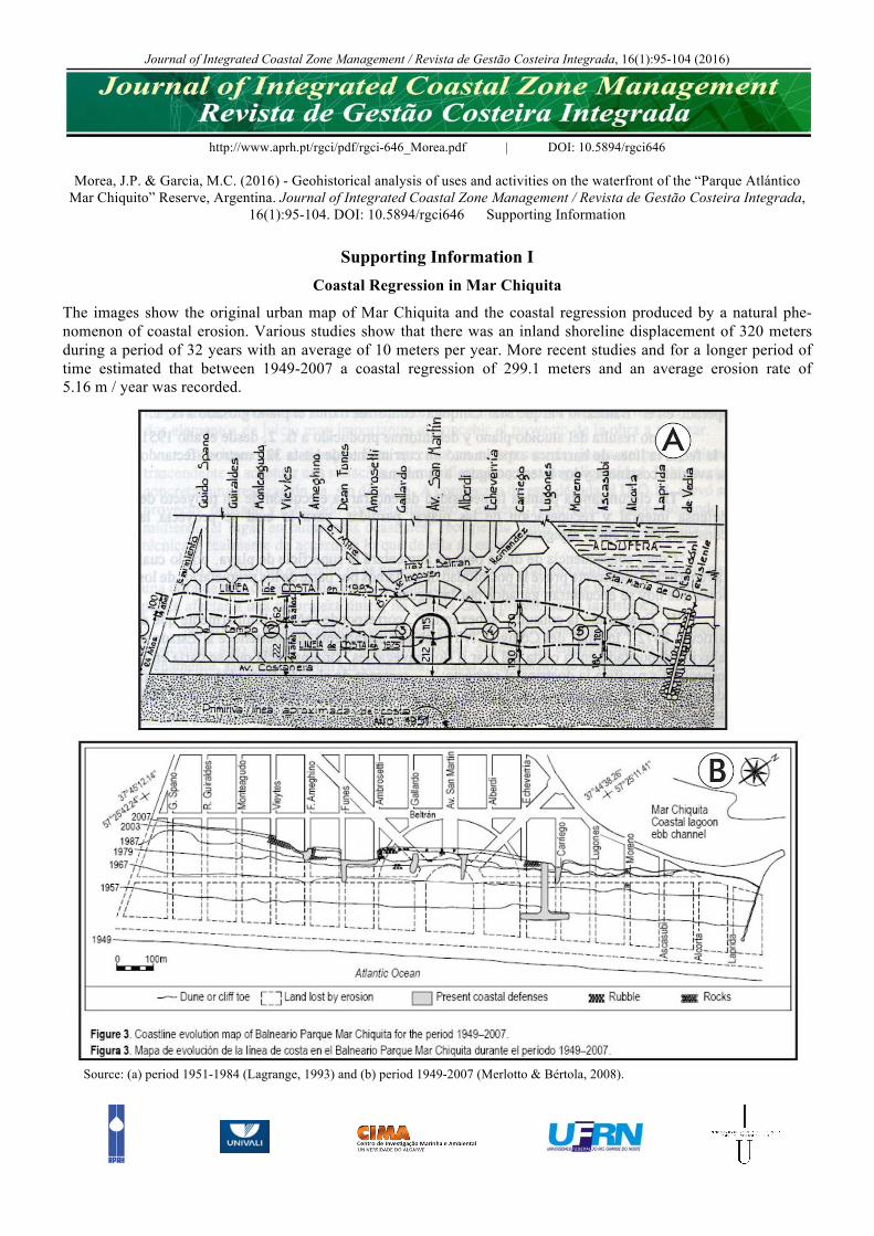
Supporting Information I Coastal Regression in Mar Chiquita
The images show the original urban map of Mar Chiquita and the coastal regression produced by a natural phe-nomenon of coastal erosion. Various studies show that there was an inland shoreline displacement of 320 meters during a period of 32 years with an average of 10 meters per year. More recent studies and for a longer period of time estimated that between 1949-2007 a coastal regression of 299.1 meters and an average erosion rate of 5.16 m / year was recorded.
Source: (a) period 1951-1984 (Lagrange, 1993) and (b) period 1949-2007 (Merlotto & Bértola, 2008).
Morea, J.P. & Garcia, M.C. (2016) - Geohistorical analysis of uses and activities on the waterfront of the “Parque Atlántico Mar Chiquito” Reserve, Argentina. Journal of Integrated Coastal Zone Management / Revista de Gestão Costeira Integrada, 16(1):95-104.
DOI: 10.5894/rgci646 Supporting Information
References Lagrange, A.A. (1993) - Desde Mar del Plata una visión diferente: Mar, Playas y Puerto. 556p., Ediciones Fundación Bolsa de Comercio de
Mar de Plata, Mar del Plata, Argentina. ISBN: 987-9927109 Merlotto, A.; Bértola, G.R. (2008) - Evolución urbana y su influencia en la erosión costera en el balneario Parque Mar Chiquita, Argentina.
Papeles de geografia (ISSN: 1989-4627), 47:143-158, Universidad de Murcia, Murcia, Spain. Available on-line at http://revistas.um.es/geografia/article/view/41271

Morea, J.P. & Garcia, M.C. (2016) - Geohistorical analysis of uses and activities on the waterfront of the “Parque Atlántico Mar Chiquito” Reserve, Argentina. Journal of Integrated Coastal Zone Management / Revista de Gestão Costeira Integrada, 16(1):95-104.
DOI: 10.5894/rgci646 Supporting Information
Supporting Information II
The lagoon in 1931
A natural phenomenon that occurred over the years was the displacement of lagoon mouth, whose fluctuations were around 5000 m and have changed its original conformation from north to south The following picture shows the conformation of the lagoon mouth in 1931. It is visible how the channel trend to go to north. Its current configuration goes to the south. Due to the lagoon mouth natural instability and severe ero-sion problems a series of coastal protections were performed by the public sector. The first intervention was in 1973 when a breakwater was built in the southern sector of the mouth of the lagoon which allowed its current con-figuration.
Figure SI-II-1 – Photography of the lagoon mouth in 1931. Source: Lagrange, 1993.
Reference Lagrange, A.A. (1993) - Desde Mar del Plata una visión diferente: Mar, Playas y Puerto. 556p., Ediciones Fundación Bolsa de Comercio de
Mar de Plata, Mar del Plata, Argentina. ISBN: 987-9927109
Morea, J.P. & Garcia, M.C. (2016) - Geohistorical analysis of uses and activities on the waterfront of the “Parque Atlántico Mar Chiquito” Reserve, Argentina. Journal of Integrated Coastal Zone Management / Revista de Gestão Costeira Integrada, 16(1):95-104.
DOI: 10.5894/rgci646 Supporting Information
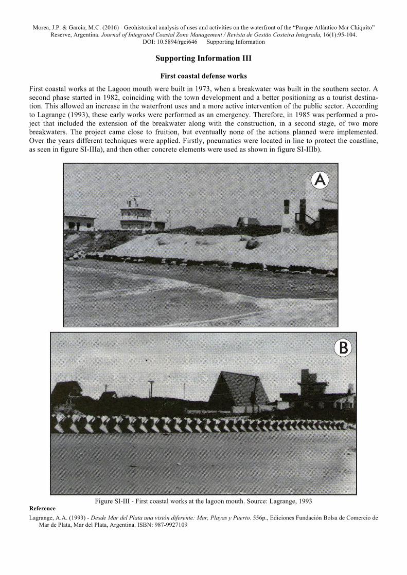
Supporting Information III
First coastal defense works
First coastal works at the Lagoon mouth were built in 1973, when a breakwater was built in the southern sector. A second phase started in 1982, coinciding with the town development and a better positioning as a tourist destina-tion. This allowed an increase in the waterfront uses and a more active intervention of the public sector. According to Lagrange (1993), these early works were performed as an emergency. Therefore, in 1985 was performed a pro-ject that included the extension of the breakwater along with the construction, in a second stage, of two more breakwaters. The project came close to fruition, but eventually none of the actions planned were implemented. Over the years different techniques were applied. Firstly, pneumatics were located in line to protect the coastline, as seen in figure SI-IIIa), and then other concrete elements were used as shown in figure SI-IIIb).
Figure SI-III - First coastal works at the lagoon mouth. Source: Lagrange, 1993
Reference Lagrange, A.A. (1993) - Desde Mar del Plata una visión diferente: Mar, Playas y Puerto. 556p., Ediciones Fundación Bolsa de Comercio de
Mar de Plata, Mar del Plata, Argentina. ISBN: 987-9927109
Morea, J.P. & Garcia, M.C. (2016) - Geohistorical analysis of uses and activities on the waterfront of the “Parque Atlántico Mar Chiquito” Reserve, Argentina. Journal of Integrated Coastal Zone Management / Revista de Gestão Costeira Integrada, 16(1):95-104.
DOI: 10.5894/rgci646 Supporting Information
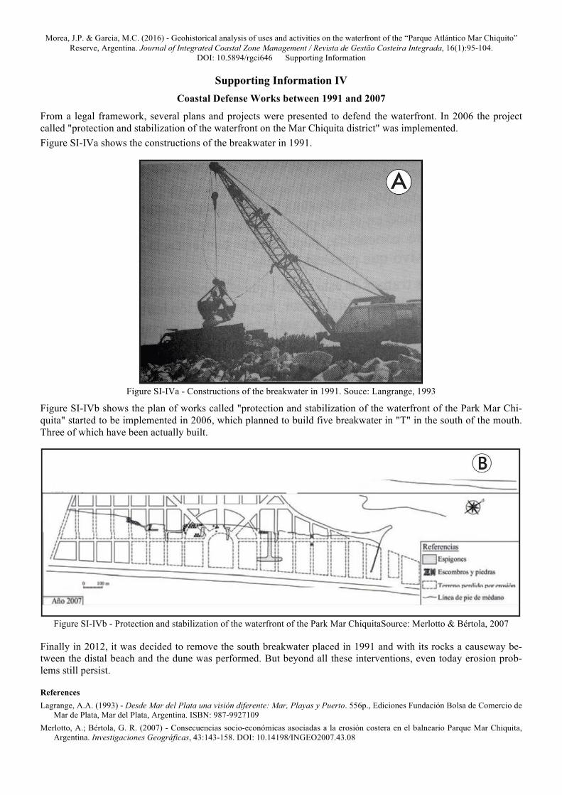
Supporting Information IV Coastal Defense Works between 1991 and 2007
From a legal framework, several plans and projects were presented to defend the waterfront. In 2006 the project called "protection and stabilization of the waterfront on the Mar Chiquita district" was implemented. Figure SI-IVa shows the constructions of the breakwater in 1991.
Figure SI-IVa - Constructions of the breakwater in 1991. Souce: Langrange, 1993
Figure SI-IVb shows the plan of works called "protection and stabilization of the waterfront of the Park Mar Chi-quita" started to be implemented in 2006, which planned to build five breakwater in "T" in the south of the mouth. Three of which have been actually built.
Figure SI-IVb - Protection and stabilization of the waterfront of the Park Mar ChiquitaSource: Merlotto & Bértola, 2007
Finally in 2012, it was decided to remove the south breakwater placed in 1991 and with its rocks a causeway be-tween the distal beach and the dune was performed. But beyond all these interventions, even today erosion prob-lems still persist. References Lagrange, A.A. (1993) - Desde Mar del Plata una visión diferente: Mar, Playas y Puerto. 556p., Ediciones Fundación Bolsa de Comercio de
Mar de Plata, Mar del Plata, Argentina. ISBN: 987-9927109 Merlotto, A.; Bértola, G. R. (2007) - Consecuencias socio-económicas asociadas a la erosión costera en el balneario Parque Mar Chiquita,
Argentina. Investigaciones Geográficas, 43:143-158. DOI: 10.14198/INGEO2007.43.08

Morea, J.P. & Garcia, M.C. (2016) - Geohistorical analysis of uses and activities on the waterfront of the “Parque Atlántico Mar Chiquito” Reserve, Argentina. Journal of Integrated Coastal Zone Management / Revista de Gestão Costeira Integrada, 16(1):95-104.
DOI: 10.5894/rgci646 Supporting Information
Supporting Information V
Legal aspect of coastal delimitation in the study area
In those years there were discrepancies concerning the delimitation of the coastline, the extent of the public domain and the limitations for the construction of housing and urban development in general. Since 1977 with Decree-Law No. 8,912 until today, various laws have changed the criteria for establishing the public domain. The distance that should separate the waterfront with the first developments has changed according the laws have done, but the fact is that in neither case have been respected. The last antecedent of the legal framework in this area established a distance of 250 m for expansion of urban centers and up to 300 m in the case of creation of new nuclei. However, this standard is voluntary adoption to the municipalities of the province of Buenos Aires, which has generated that has a very low application.

Morea, J.P. & Garcia, M.C. (2016) - Geohistorical analysis of uses and activities on the waterfront of the “Parque Atlántico Mar Chiquito” Reserve, Argentina. Journal of Integrated Coastal Zone Management / Revista de Gestão Costeira Integrada, 16(1):95-104.
DOI: 10.5894/rgci646 Supporting Information
Supporting Information VI
Impacts of the lack of treatment of solid waste and sewage
Treatment of municipal solid waste and sewage has historically been very poor and there are currently large gaps. Since rainwater drains have not been built, streets perpendicular to the shore sloping towards it act as such. In vari-ous sectors of the urbanized waterfront gullies in the beach can be seen that function as rainwater drains. Often, they are dragging sand into the sea. These phenomena are observed only in some streets, mainly in the Av. San Martin that is the only paved road. Figure SI-VI a) and b) show this situation respectively in January and April 2997.
Figure SI-VI - Gullies on the beach. Source: Merlotto, 2008
Reference Merlotto, A.; Bértola, G.R. (2008) - Evolución urbana y su influencia en la erosión costera en el balneario Parque Mar Chiquita, Argentina.
Papeles de geografia (ISSN: 1989-4627), 47:143-158, Universidad de Murcia, Murcia, Spain. Available on-line at http://revistas.um.es/geografia/article/view/41271

Morea, J.P. & Garcia, M.C. (2016) - Geohistorical analysis of uses and activities on the waterfront of the “Parque Atlántico Mar Chiquito” Reserve, Argentina. Journal of Integrated Coastal Zone Management / Revista de Gestão Costeira Integrada, 16(1):95-104.
DOI: 10.5894/rgci646 Supporting Information
Supporting Information VII
Mar Chiquita recreational activities in previous years
During the 30’s to the 50’s many people was attracted to Mar Chiquita area because of the abundance and variety of fishes. The area of the mouth and its surroundings was the sector chosen by fishermen, who carried out this ac-tivity recreationally. Dimension of this activity in those years is difficult to estimate, but given the almost no pres-ence of permanent residents and the few buildings that was recorded is understood that it was of low impact. For many years it was considered as a spot near the city of Mar del Plata. It is also important to mention that, in those years, the current Route 11 was no more than a dirty road, difficult to travel when the weather was not favor-able. Even after the town foundation the process of urbanization was slowly developed and has never grown into a large urban center. Despite this, it has always attracted interest on leisure and recreation. Changes at the lagoon mouth and the receding of coastline have changed the areas of interest of fishermen. While this activity may currently have a presence on the waterfront, mostly it develops into the inner lagoon.
Morea, J.P. & Garcia, M.C. (2016) - Geohistorical analysis of uses and activities on the waterfront of the “Parque Atlántico Mar Chiquito” Reserve, Argentina. Journal of Integrated Coastal Zone Management / Revista de Gestão Costeira Integrada, 16(1):95-104.
DOI: 10.5894/rgci646 Supporting Information
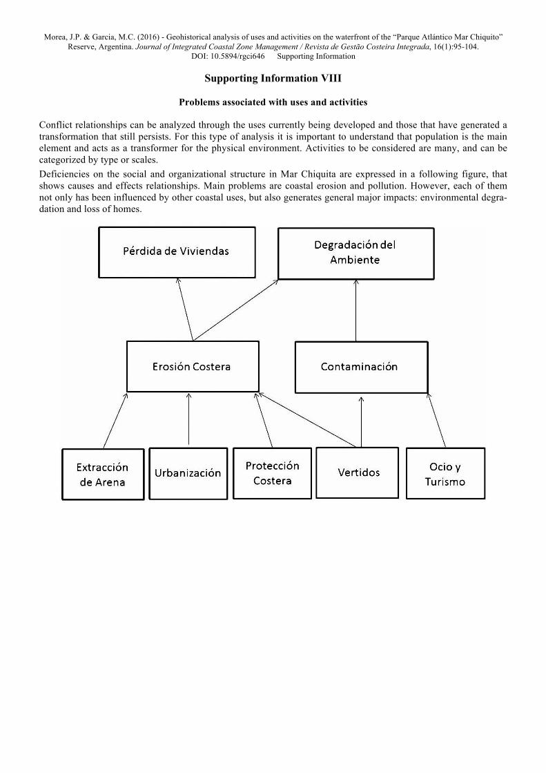
Supporting Information VIII
Problems associated with uses and activities
Conflict relationships can be analyzed through the uses currently being developed and those that have generated a transformation that still persists. For this type of analysis it is important to understand that population is the main element and acts as a transformer for the physical environment. Activities to be considered are many, and can be categorized by type or scales. Deficiencies on the social and organizational structure in Mar Chiquita are expressed in a following figure, that shows causes and effects relationships. Main problems are coastal erosion and pollution. However, each of them not only has been influenced by other coastal uses, but also generates general major impacts: environmental degra-dation and loss of homes.
Morea, J.P. & Garcia, M.C. (2016) - Geohistorical analysis of uses and activities on the waterfront of the “Parque Atlántico Mar Chiquito” Reserve, Argentina. Journal of Integrated Coastal Zone Management / Revista de Gestão Costeira Integrada, 16(1):95-104.
DOI: 10.5894/rgci646 Supporting Information
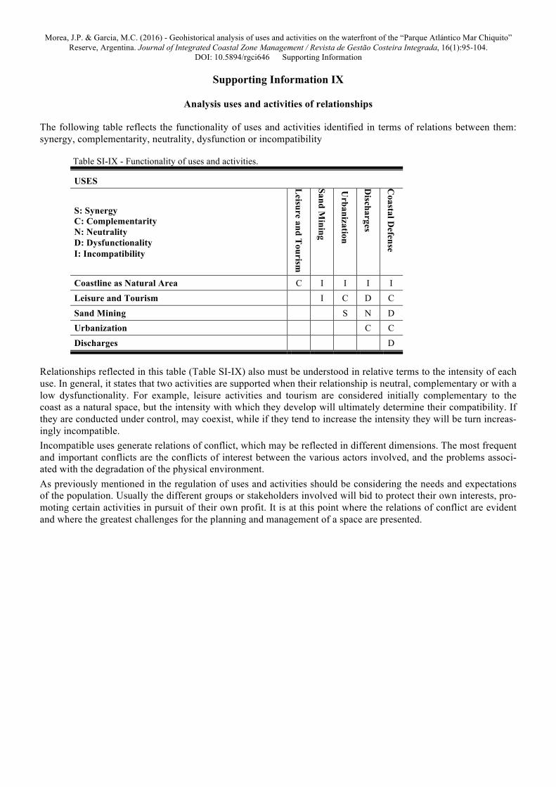
Supporting Information IX
Analysis uses and activities of relationships
The following table reflects the functionality of uses and activities identified in terms of relations between them: synergy, complementarity, neutrality, dysfunction or incompatibility
Table SI-IX - Functionality of uses and activities.
USES
S: Synergy C: Complementarity N: Neutrality D: Dysfunctionality I: Incompatibility
Leisure and T
ourism
Sand Mining
Urbanization
Discharges
Coastal D
efense
Coastline as Natural Area C I I I I Leisure and Tourism I C D C Sand Mining S N D Urbanization C C Discharges D
Relationships reflected in this table (Table SI-IX) also must be understood in relative terms to the intensity of each use. In general, it states that two activities are supported when their relationship is neutral, complementary or with a low dysfunctionality. For example, leisure activities and tourism are considered initially complementary to the coast as a natural space, but the intensity with which they develop will ultimately determine their compatibility. If they are conducted under control, may coexist, while if they tend to increase the intensity they will be turn increas-ingly incompatible. Incompatible uses generate relations of conflict, which may be reflected in different dimensions. The most frequent and important conflicts are the conflicts of interest between the various actors involved, and the problems associ-ated with the degradation of the physical environment. As previously mentioned in the regulation of uses and activities should be considering the needs and expectations of the population. Usually the different groups or stakeholders involved will bid to protect their own interests, pro-moting certain activities in pursuit of their own profit. It is at this point where the relations of conflict are evident and where the greatest challenges for the planning and management of a space are presented.


![Coastal zone [autosaved]](https://img.pdfslide.us/doc/110x75/58ab9f8c1a28abdf3c8b46b5/coastal-zone-autosaved.jpg)