Embed Size (px)
Citation preview

at SciVerse ScienceDirect
Journal of Arid Environments 95 (2013) 1e13
Contents lists available
Journal of Arid Environments
journal homepage: www.elsevier .com/locate/ jar idenv
Scientific documentation of crop land changes in the Sahel: A half empty box ofknowledge to support policy?
Nathalie van Vliet, Anette Reenberg, Laura Vang Rasmussen*
Department of Geography and Geology, University of Copenhagen, Øster Voldgade 10, DK-1350, Copenhagen K, Denmark
a r t i c l e i n f o
Article history:Received 29 June 2012Received in revised form6 March 2013Accepted 16 March 2013Available online
Keywords:Meta-studyCrop land changeDriversImpactsSahel
* Corresponding author. Tel.: þ45 32322517.E-mail addresses: [email protected] (N. van Vliet), ar@
geo.ku.dk (L.V. Rasmussen).
0140-1963/$ e see front matter � 2013 Elsevier Ltd.http://dx.doi.org/10.1016/j.jaridenv.2013.03.010
a b s t r a c t
The Sahel has been subject of considerable environmental research and development efforts, specificallysince the droughts of the 1970s and 1980s. This article uses a meta-study approach to summarizeknowledge of crop land change, the documented driving forces, and the perceived impacts. The analysisof case studies shows that crop land has increased in the majority of cases mainly due to populationincrease. However, despite population increase, crop land has been stable in some areas, particularlywhere land availability is a limiting factor or where farmers are able to intensify their farmers fromexpanding their plots or because households have diversified their activities. The study shows the hugegap in the scientific literature concerning actual measurements of crop land change in the Sahel, which isin contrast to the attention given to crop land changes in theoretical and policy discourses. On the basisof the poor documentation available on crop land change and the contrasting results observed, we pointout the need to exercise caution with regard to simple narratives about crop land change.
� 2013 Elsevier Ltd. All rights reserved.
1. Introduction
Land use and land cover changes are closely interconnected inmultiple and bidirectional ways to changes in local livelihoods andthe provision of ecosystem services (carbon, biodiversity, water,etc.). As such, they have become recognized over the last 15 years asimportant global environmental changes in their own right (TurnerII, 2002). Since the Rio summit in 1992, the conceptual perspectivesof land use and land cover transitions have been increasingly dealtwith by land change science (DeFries et al., 2004; Foley et al., 2005;Turner et al., 2007), and the notion of proximate and underlyingdriving forces has been broadly accepted as a useful way of framingthe analysis of land use and land cover change processes (Geist andLambin, 2002; Lambin and Geist, 2006). In the course of the lastthree to four decades a range of environmental policies has beenconcerned with sustainable land use and natural resource man-agement systems, e.g. in the Sahel. Significant, internationallyinitiated policy documents, such as the National EnvironmentalAction Plans (from the 1980s), National Adaptation Plan of Action(from the 2000s) or the Great GreenWall Initiative (signed in 2010),are prominent examples. The most recent efforts have accentuated
geo.ku.dk (A. Reenberg), lr@
All rights reserved.
the action needed in response to expected climatic changes, theemerging global food shortage, and the accelerated competition forglobal land resources. They consider, among other issues, land usechanges and their relation to multiple driving forces (Reenberg,2012). With the increased awareness of the accelerating expo-sures of changes in climate, population pressure, and globalizationprocesses affecting local livelihoods in the Sahel, research on landuse and land cover change has becomemore prominent, not least inregard to regions characterized by economic poverty and lowagricultural productivity.
The Sahel region, a salient dryland region, has been the subjectof considerable policy efforts. Especially, the severe droughts in the1970s and 1980s drew much attention to this specific region andgave impetus to policy action. Sahelian and Sudano/Saheliancountries created the Comité permanent Inter-Etats de Lutte contrela Sécheresse dans le Sahel (CILSS) to improve food security andreduce the impacts of desertification through a range of activities,such as development and harmonization of national strategies andpolicies to reduce desertification, scientific and technical coopera-tion, collection and distribution of information, capacity enhance-ment, and guidance for policy formulation.
The urgent need to provide recommendations for policy makersalso boosted research projects aimed at identifying the possiblecauses and consequences of land use change and desertification. Ithas, however, been noted that scientific knowledge was producedand communicated to the policy domain in such a way that the
N. van Vliet et al. / Journal of Arid Environments 95 (2013) 1e132
salience of knowledge (i.e. the relevance to the stakeholders) wasgiven priority over legitimacy (i.e. unbiased with respect to values)and credibility (i.e. based on adequate scientific evidence)(Grainger, 2009). A closer look at the environmental policy initia-tives is rather disappointing with regard to how the most recentscientific knowledge has, in general, been communicated to thepolicy domain (Reenberg, 2012). More specifically, the environ-mental policy discourse at the regional level is fuelled by well-established field expansion and land degradation narratives.These include, for example, the image of vicious circles of crop landencroachment and land degradation, prompted by populationpressure and low rainfall, leading to excessive expansion of fieldsonto marginal land, which in turn leads to irreversible degradationof the natural resource base, lower productivity, and the need forlarger areas to sustain the population. Such narratives about fieldexpansion and land degradation have become established truthsbeyond need for further documentation (Reenberg, 2012). Scat-tered empirical evidence from recent rapid assessments (Bolwiget al., 2008; Rasmussen and Reenberg, 2012; Reenberg, 2009)suggests that land use and land cover change in the drier part of theSahel may not correspond well to the simplistic notion of morepeople/less rain indisputably leading to vicious circles of fieldexpansion and soil degradation. Our theoretical understanding ofland use changes in the Sahel seems thus to be based on frag-mented and poorly coordinated empirical knowledge. Several au-thors have suggested that the prevailing droughts during thesecond half of the twentieth century were at least partly caused byland use and land cover changes in tropical and subtropical Africa(Pielke, 2005; Zeng et al., 2001); hence the question, ‘Do humanscause deserts?’ (Reynolds et al., 2007). Recent literature, however,also urges caution and advises critical examination of receivedwisdom in order to avoid misinterpretations of the processes ofchange and the likely future directions (Mortimore and Turner,2005; Rasmussen et al., 2012).
Empirical evidence of the significance of various factors ofchange seems to be sparse and not synthesized in any systematicmanner. Thorough insight into trends and dynamics of land use andland cover trajectories is an important knowledge basis for theformulation of future sustainable land use strategies and policies(Pare et al., 2008). Yet there may be a need to highlight the possible“black boxes” in our understanding of land use and land coverchanges. On the same token, environmental policies should beinformed by accurate knowledge of the different drivers of changeand their impacts on environment, agriculture and food security.This article uses a meta-analysis approach to scrutinize the totalpool of peer-reviewed articles on crop land dynamics in the Sahel.The cumulative knowledge that emerges from the scientific liter-ature is explored through the following guiding questions: 1. Whatdo empirical case studies document about crop land expansion andcontraction in the Sahel since the 1950s?; 2. What seminal vari-ables do scientific papers propose as drivers of crop land changes?;and 3. What are the impacts associated with crop land change? Thepaper is organized as follows: First, we provide a brief overview ofthe dynamic patterns that characterize livelihoods in the Sahel. Thisis followed by a description of the methods employed for thecollection of published data and of the statistical analysis used tosynthesize the causal explanations. The results section provides anoverview of the accumulated insight into crop land change in theSahel, the suggested important drivers, as well as observed impactsthat can be drawn from the case studies.
2. Background: changing patterns in the Sahel region
The Sahelian regions span a large territory, 500 km deep and300 km wide (Raynaut, 1997), and any generalizations will not
suffice to adequately describe environmental, economic, socio-cultural, and political conditions that enable and constrain thecontemporary land use practices. As a background, this sectionwill,nevertheless, briefly mention some of the most prominent traits ofthe development of change, which have had a bearing on theSahelian land use strategies in the past decades. We do not aim toprovide a full elaboration, but rather to give some examples of thecomplex causal relations that need to be considered in order to fullyexplore the changes in the land system. Issues related to the ex-posures of population pressure, climate change and economicintegration as well as land rights and conflicts are briefly described.
2.1. Population increase
The Sahel region experienced one of the world’s highest de-mographic growths from about 1.5% yr�1 in the 1950s to about3% yr�1 in the 1990s, which has resulted in a three-fold increase inthe population in the second part of the 20th century (Raynaut,2001). In Burkina Faso alone, the total population increased from5.6 million inhabitants in 1975 to 13.7 million inhabitants in 2006(INSD, 2007); it is estimated that 90% of the population practicerain-fed subsistence agriculture. Population pressure has oftenbeen suggested as the root cause of land degradation (e.g. Geist andLambin, 2004) althoughmore nuanced explanations have also beenput forward (e.g. Mazzucato and Niemeijer, 2002). The strong de-mographic growth has been supported by an increase in the surfacearea of rain-fed cultivated lands at the expense of the naturalwoody savannah (Raynaut, 2001; Ringrose and Matheson, 1994).The sometimes rapid increases in the size of local human pop-ulations are often linked to the in-migration of cultivators intorangelands or regions with large-scale irrigation schemes, or ofherders into marginal sites, and not only to the intrinsic populationgrowth (Geist and Lambin, 2004). Repeated droughts and low soilproductivity have often been cited as major factors pushing peopleto leave their villages (Cordell et al., 1994; Marchal, 1977). A linkbetween environmental conditions and migration was indeeddocumented in several settings in rural Africa (Ethiopia (Ezra,2001); Mali (Findley, 1990)).
2.2. Climate variability
There is increasing evidence that climate change is stronglyaffecting the African continent and will be a challenging issue infuture development, particularly in the drier regions (Adger et al.,2007; Haile, 2005; Huq et al., 2004). The likely impacts of climatechange on ecosystem services, agricultural production, and liveli-hoods will represent a challenge to the adaptation strategies in aregion dominated by economic poverty, subsistence food produc-tion, and a low and highly variable natural production potential.Climate variability in the Sahel was characterized by negativeanomalies from 1910 to 1916, positive anomalies from 1950 to 1967,negative from 1970 to 1974, and finally, another period of negativeanomalies lasting from 1976 to 1993, the longest and most intenseof the century (L’Hôte et al., 2002). Although Sahelian populationsare accustomed to drought, as historical accounts and oral historiesreveal (Rains, 1983; Watts, 1983), the droughts of the 1970s and1980s were significant because of their severity, but also becausethey prompted profound economic and political reforms andextensive international assistance. Recent “rainy years” such as1994, 1999, 2003, and 2005 could be seen as a comeback of goodrainfall years, but models projecting future rainfall trends haveprovided unclear answers as to whether the climate will becomemore arid or more humid (Christensen et al., 2007). What charac-terizes the region is moreover not an average total annual rainfallbut a high degree of spatial and temporal variability in

N. van Vliet et al. / Journal of Arid Environments 95 (2013) 1e13 3
precipitation. Rainfall trends and variability affect e directly orindirectly e various other variables, such as rain-fed crop produc-tivity, vegetation and soil degradation processes, reduction in thequality and quantity of ecosystem services, human livelihoods etc.(Boko et al., 2007).
2.3. Market orientation
During the colonial period, a shift from subsistence to cash cropproduction was observed in many Sahelian countries. For example,the decision by the colonial government in Senegal to introducegroundnut in the 1840s was a significant landmark for environ-mental change. The expansion of agriculture, dominated bygroundnuts, resulted in the reduction of fallow land and savannavegetation in this part of Senegal. Another example is the “newcotton basin” in Mali, an area where the government pushed forexpanded production related in part to declining yields in the oldcotton basin (Koutiala and Sikassou Districts). Since the creation ofthe CMDT (Compagnie Malienne pour le Dévelopement du Textile)in 1974, cotton production has increased markedly with policiesthat guaranteed purchase, a fixed floor price, and credit for agri-cultural inputs. Despite the oftenmentioned “cash crop revolution”,the so-called “Peanut Basin” of Senegal and the “New cotton basin”in Mali provide telling illustrations of partial intensification pathsand farmers’ possible soil mining. Indeed, Sahelian farmers’ use ofimproved inputs and equipment (such as fertilizers, fungicides,improved seeds, and animal traction) stagnated or declined duringthe 1980s and 1990s, when the process of structural adjustmenttriggered a thrust towards liberalization and privatization of theagricultural sector, including the removal of price controls, thelifting of restrictions on input markets, the disengagement of thestate from providing services, and the devaluation of the West Af-rican franc. However, locally prominent examples in West Africaprovide evidence of environmental improvement and agriculturalintensification with traditional inputs (shorter fallows, increasinglevels of labour, organic fertilizer andmanure use, soil conservationmeasures, crop residue management practices). Studies in the KanoClose-Settled Zone and nearby areas of Nigeria and Niger suggestthat farmer investments in the land have led to agriculturalintensificationwith positive consequences for the environment andeconomy (Adams and Mortimore, 1997). Reij et al. (2005) alsofound that faced with drought and declining yields in the 1980s,farmers from the Central Plateau in Burkina Faso began to experi-ment with various soil and water management practices (SWM).Their major objective was rehabilitation of the productive capacityof the land through better control of rainfall and runoff, as well asthrough improved soil fertility management and reforestation. By2000, thousands of hectares of farmland had been treated withSWM, leading to reclamation of barren land, a crop yield increase of50e60%, better water availability, and larger tree cover in the fields.
2.4. Diversification of local economies
The role of agriculture for people’s livelihoods in the Sahel ischanging due to increased livelihood diversification, particularlyoutside of agriculture (Ashley, 2000). Rural livelihood diversifica-tion can imply a change from agricultural to non-agricultural ac-tivities or it can be defined as “.the process by which ruralhouseholds construct an increasingly diverse portfolio of activitiesand assets in order to survive and to improve their standard ofliving” (Ellis, 2000). In recent years, a number of studies on liveli-hood diversification have been published (Ellis, 2000; Ellis andMdoe, 2003). Non-agricultural income forms a significant part ofdiversification and it has been reported by some to have increasedin importance in many parts of sub-Saharan Africa (Bryceson, 1996;
Savadogo et al., 1998). In the Sahel, most non-agricultural livelihooddiversification is restricted to the dry season. According toMortimore (1998), on-farm diversification strategies are oftensparse, unlike off-farm strategies, such as working in major cities oron agricultural schemes, and self-employment in small enterprises.In central Sudan, non-agricultural diversification and off-farm ac-tivities have increased over the last 30 years through labourmigration, development projects, horticulture, small-scale com-merce e especially by the women e and livestock sales (Elmquistand Olsson, 2005). In northern Burkina Faso, temporary migrationis also one of the diversification strategies observed (Nielsen andReenberg, 2010).
2.5. Land use conflicts
During the last few years, violent land use conflicts in the Sahelhave become themost popular example of the alleged link betweenglobal climate change and conflict. It is often argued that the ideathat climate change leads to violent conflict in general can beregarded as a continuation or revised version of the Malthusianconcept of resource scarcity as a cause of environmental degrada-tion, poverty, and an escalating struggle for resources (Homer-Dixon, 1994). The juxtaposition of communities with differentlifestyles and economic activities and the ongoing agrarian changes(modernization) in Sahelian societies are mentioned as possiblesources of conflict (Benjaminsen and Ba, 2009). There is a body ofcase study literature that focuses on the relationship betweenfarmers and herders in Africa (e.g. Bassett, 1988; Benjaminsen andBa, 2009; Moritz, 2008; Turner, 2004). Strategies of agrarianmodernization and of converting mobile people into ‘productive’sedentary farmers have been criticized by these scholars pointingout that the causes of conflicts often have a political origin. Policiesthat underestimate the pastoral productivity and pastoral contri-bution to the national economy (Hesse and Cotula, 2006) andoverestimate the negative impacts of grazing on the ecology(Behnke and Scoones, 1993; Ellis, 1988; Turner, 1999) contribute tothe ongoing process of pastoral marginalization.
3. Cropping decisions: theoretical perspectives
Land use practices are known to be closely linked to especiallythe population (Turner et al., 2007), and the use of land has beendealt with in length in the literature about agrarian change (e.g.Bilsborrow and Ogendo, 1992; Boserup, 1965; Netting, 1993). Thetheoretical scholarship on the populationeagricultural changenexus has notably been anchored in two seminal works. One isThomas Malthus’s (1798) essay on the intrinsic imbalance betweenpopulation growth rates and food production. The other is the bookby Esther Boserup (1965) that suggests that farmers in ‘primitive’agricultural systems tend to produce below the maximum becausethis allows for the optimal inputeoutput efficiency. The conceptualframeworks suggested by Malthus and Boserup have had a hugeimpact on various scholars who have addressed the issue of howand why agricultural change and land use intensification occur.Although the models are contestable simplifications of real worldsituations, they have nevertheless provided a constructive startingpoint from which to discuss the complexity of agricultural changeand land use trajectories. A number of classic studies (e.g. Adamsand Mortimore, 1997; Netting, 1993; Turner et al., 1977, 1993;Wiggins, 1995) have provided empirical documentation, whichsupports the perception that Boserup’s model fits fairly well forland use systems that rely on land and labour extensive methodswhen land is abundant. More recent research emphasizes a numberof economic, social or political factors that shape land use changebeyond what is implicitly assumed in Boserup’s simple model
1 Definitions of woodland, shrubland and bare soil were not necessarily exactlythe same in all case studies. Here we use woodland and shrubland as defined by theauthors of the papers.
N. van Vliet et al. / Journal of Arid Environments 95 (2013) 1e134
(Stone, 2001). The possible effect of population factors may beovershadowed by other factors; market access may, for example,play a significant role in the change trajectories when the land usesystem becomes part of a larger, spatial setting (Netting, 1993).Political ecologists, like Blaikie and Brookfield (1987), specificallynote that even under seemingly similar ecological and socio-economic conditions, population pressure may prompt verydifferent patterns of agricultural change because of differences infarmers’ ability to invest, withstand risk and attract subsidies.Hence, there is substantive support for the view that populationpressure does not work in an unmediated fashion (Keys andMcConnell, 2005). The internal demographic growth becomespart of a larger picture that encompasses seasonal, generational andpermanent flows of labour and consumers, as well as of knowledge,skills and priorities of immigrants. This can give the occasion ofchange in cropping choice in space and time (Reenberg, 1999).Intensification policies, conflicts, and diversification opportunitiesmay also influence crop land changes regardless of the populationchanges.
4. Methods
Our methodology is based on a meta-analysis of case studiesused to collect data on land cover changes (particularly crop land),drivers of change, and impacts on livelihoods and the environment.The data was used to compute a cluster analysis to group casestudies according the main drivers of crop land change and a ca-nonical variate analysis to determine the drivers that best explainthe increase, decrease, or stability of crop land change. Finally, weused a qualitative comparative analysis to determine the combi-nation of impacts observed when crop land increases, decreases, orremains stable.
4.1. The meta-analysis
Our meta-analysis follows what Lambin and Geist (2006) call aposteriori comparison of already published case studies. In accor-dance with Rudel (2008) we use the term ‘meta-analysis’ loosely torefer to any systematic attempt to investigate patterns across a setof studies (as opposed to others that see meta-analysis as involvinga direct pooling of data). Using ameta-analytical approach implies aset of important decisions. First, an operational definition of whichstudies (cases) should be included in the analysis must be decidedupon; second, coding procedures must be selected; and finally,which variables to include must be determined.
As the operational definition of the phenomenon under studywe selected ‘peer-reviewed journal papers from the Sahel region,specifically utilizing a longitudinal approach to study trends in cropland change, but also describing drivers and impacts of thesechanges on the environment, agricultural practices and local live-lihoods’. All case studies considered were published from 1990 to2010, representing changes occurring between 1950 and 2010. Inorder to identify publications relevant for this specific study weused the ISI Web of Knowledge database searching for ‘Sahel’ withthe word ‘land use’. We then searched for additional papers usingthe combinations ‘Sahel’ þ ‘crop land’ or ‘Sahel’ þ ‘land cover’.Subsequently, we used the same words in combination with thenames of each of the Sahelian countries and added any paper thatwas not already included in the list obtained using ‘Sahel’. A detailedscreening of the texts allowed us to remove papers that were notassociated with crop land change processes in the Sahel. This se-lection process allowed us to focus on the identification of thecausality links between drivers of change and crop land change. Toavoid the potential draw back of leaving aside important informa-tion on specific themes (e.g. methodological aspects of remote
sensing techniques, hydrological or carbon related themes, changesin woodland extent, and land degradation) we used the content ofthese papers for the background section and for the interpretationand discussion of results. In this fashion, we have tried to adopt aniterative routine in which we cycle back and forth between therigorous material and the more qualitative material in the casestudies (as advised by Rudel, 2008). In addition, and to acknowledgethe contribution of francophone authors, we searched for scientificjournal articles using two main French databases: “Agritrop”(developed by CIRAD) and “Horizons Pleins Textes” (with publica-tions from IRD). The same geographical key words were used incombination with “utilisation des sols” or “utilisation des terres”.
The coding procedurewas based on the case study, defined as ageographical site where the changes in the extent of crop land weredescribed. In all the cases presented, changes in crop land proved tobe studied by combining information from aerial photographs andsatellite imagery, often complemented with information obtainedthrough group discussions or interviews with farmers. Most of thearticles presented only one case study, but when a publicationdescribedmore than one site, each sitewas entered as an individualcase study in our database and treated as such in the subsequentanalyses. Case studies were geo-referenced and results were map-ped using ARCGIS10 for a better geographic visualization of results.
The variable selection procedure for the case studies wasdeveloped in an iterative process. After an initial pre-screening, aset of reasonable common denominators of variables to describeour three main themes was decided upon. Changes in the extent ofcrop land were qualified as: “increase”, “decrease”, or “stable orfluctuates”. Changes in woodland,1 shrubland, grassland, and baresoil were also qualified in the same way when the information wasavailable. The list of drivers was based on the typology used by vanVliet et al. (2012) and adapted on the basis of information describedin the case studies. Drivers of change in crop land included de-mographic, economic, agro-technical, institutional, and climaticdrivers (Table 1).
Some of the drivers initially identified were never mentioned inthe case studies and were therefore removed from the analysis.Other drivers were mentioned in less than three case studies andwere only retained for the descriptive analysis. Impacts of crop landchange included impacts on livelihoods, on agricultural practicesand on the environment (Table 2).
Because the causality links are often reciprocal, the initial list ofimpacts included the variables used as drivers. The list was thenadapted according to the impacts mentioned in the case studies.
4.2. Analysis of data
The analysis of data is based on three main approaches: 1) asimple description of changes in crop land; 2) a cluster analysis toidentify the combination of drivers that best explain changes incrop land, complemented by a canonical variate analysis to identifythe best predictors of crop land change, and 3) a qualitativecomparative analysis to understandwhich combinations of impactsresulted from the increase, decrease, or stability of crop land.
4.2.1. Description of crop land changeChanges in crop land were mapped to show the geographic
location of case studies and the respective trends in crop landchange. Changes in crop land were also described in relation tochanges in other land cover types.

Table 1Variables used to describe drivers of crop land change in our case studies.
Abbreviation ofvariable name
Variable name
DemographicPopden Population densityMig In-migrationoutMig Permanent out-migrationa
EconomicRoad Road accessa
Preecon Presence of economic structures(credit, inputs, projects)
Natmark Access to national marketsIntmark Access to international marketsPrice Price changesa
Divers Increased opportunities fordiversification in off-farm jobs
Agro-technicalNewvar New varietiesa
Graz Overgrazinga
Soildeg Soil degradationa
Plough Introduction of ploughFert Increased use of fertilizersSWMP Presence of soil and water
management practicesIrrig Irrigation systemsa
Labor Lack of labour forcea
Land Land scarcitya
InstitutionalPreenv Presence of environmental
policiesa
Agripol Presence of land tenure oragricultural policies
Absagripol Absence of land tenure oragricultural policies
ClimaticRain Rain availability and distributionFire Firesa
a Variables that were mentioned in less than three case studies and thereforenot included in the multivariate analysis.
N. van Vliet et al. / Journal of Arid Environments 95 (2013) 1e13 5
4.2.2. Cluster analysis and canonical variate analysis of drivers ofcrop land change
In order to identify the combinations of drivers that best explainthe changes observed in crop land extent, we computed a
Table 2Variables used to describe the impacts of crop land changes as described in the casestudies.
Variables
Impacts on livelihoodsPermanent out-migrationIncreased conflictsIncreased yieldsDecreased yieldsa
Increased labour forceDecreased labour forcea
Increased involvement of womenImpacts on agricultural practicesIntroduction of the plougha
Increased use of fertilizerDecrease in fallow periodb
Increase soil and water management practicesb
Impacts on the environmentDecreased number of trees in farming plotsb
No sign of land degradationa
Land degradationb
Decreased biodiversitya
Increased biodiversityDecreased water availabilityDecreased carbon stocksa
a Impacts never mentioned in our case studies.b Impacts mentioned in more than one case and included in the QCA.
hierarchical cluster analysis (Euclidean distance) of case studies(N ¼ 40), with ‘drivers of crop land change’ as the explanatoryvariable, using Xlstat 2010�. Cluster analysis is the task of assigninga set of cases to clusters. In our analysis, the cases are groupedaccording to the main drivers of change in crop land extent, and thedistance between groups (assessed using Ward’s method) repre-sents the likelihood that a similar combination of drivers applies tothe cases. The different clusters are represented using a dendro-gram, a tree diagram frequently used to illustrate the arrangementof the clusters produced by the hierarchical clustering. In additionto the cluster analysis and in order to investigate which driverswere the best predictors of crop land change, a canonical variateanalyses (CVA), also known as discriminant factor analysis, wascomputed using Xlstat 2010�. CVA can accommodate any metricvariable without the strict assumption of normality and is a widelyused method for analysing group structure in multivariate data(Hair et al., 1999). CVA makes it possible to identify the variablesthat differentiate the most between the groups of individuals(based on crop land change, in this case) previously constituted onthe basis of an exogenous variable (in this case, drivers of crop landchange), thereby minimizing intra-group variance and maximizingthe between class variance ratio. Wilks’ lambda test is used to testwhether there are significant differences between the increase,decrease, or stability in crop land extent based on the drivers ofchange.
4.2.3. Qualitative comparative analysis of the impacts of crop landchange
Because of the low number of case studies describing the im-pacts of crop land change, it was not possible to compute anymultivariate analysis to test whether the impacts were significantlydifferent between cases that showed an increase, decrease, orstability of crop land. Qualitative comparative analysis (QCA),computed using FsQCA2008�, was used as a way to understandwhich combinations of impacts resulted from the increase,decrease, or stability of crop land. Only those impacts that werementioned in more than one case study were retained for theanalysis (e.g. land degradation, increased soil and water manage-ment practices, decreased numbers of trees in farming plots,decreased fallows). QCA is normally suited to case-oriented work toanalyse complex causations, involving different combinations ofcausal conditions capable of generating the same outcome. How-ever, the same approach may apply to understand the differentcombinations of outcomes that are generated by the differentcausal conditions (crop land increase, decrease, or stability). QCA isparticularly useful for research designs involving small andintermediate-size Ns (e.g., 5e50). It uses Boolean algebra toimplement principles of comparison used by scholars engaged inthe qualitative study of macro social phenomena. These combina-tions can be comparedwith each other and then logically simplifiedthrough a bottom-up process of paired comparison (Ragin, 2000).
5. Results
5.1. Data availability and information gaps
Despite the high number of pre-selected papers found asdescribed above, only 25 papers were finally selected for theanalysis (Table 3). Indeed, many papers from the original pool wereirrelevant to the present meta-study either because their focus wason methodological aspects of remote sensing techniques, hydro-logical or carbon related themes, changes in woodland extent, andland degradation or because they lacked the longitudinal analysisof crop land change that we were looking for.

Table 3Combination of key words that yielded publications with information on crop landchange in specific case studies.
Keywords used for the search Total number ofpapers found onthe Isi Web
Number of papersfinally selected forthe study
Land use Sahel 62 20Land cover Sahel 27 1a
Land use Burkina Faso 38 4a
a Only publications that were not already listed from the search using‘sahel’ þ ‘land use’ were added here.
N. van Vliet et al. / Journal of Arid Environments 95 (2013) 1e136
In total, the 25 publications provided crop land change infor-mation for 50 case studies in eight Sahelian countries, particularlyin Senegal and Burkina Faso (Table 4 and Fig. 1). Only 40 out the 50case studies reported drivers of crop land change and 17 reportedimpacts of crop land change.
Table 4List of case studies in different countries, type of data provided in the publication and tiseveral case studies when crop land trends are described in different geographic locatio
Country First author and publication year Publication provid
Crop land change
Burkina Faso Ouedraogo et al., 2009 YesPare et al., 2008 YesPare et al., 2008 YesPare et al., 2008 YesWardell et al., 2003 YesReij et al., 2005 YesReij et al., 2005 YesReij et al., 2005 YesWittig et al., 2007 YesMazzucato and Niemeijer, 2002 YesReenberg et al., 1998 YesGray, 1999 YesGray, 1999 YesBarbier et al., 2009 Yes
Ghana Wardell et al., 2003 YesMali Tappan and McGahuey, 2007 Yes
Tappan and McGahuey, 2007 YesRuelland et al., 2010 YesRuelland et al., 2010 YesRuelland et al., 2010 YesRuelland et al., 2011 YesBégué et al., 2011 Yes
Niger Mortimore and Turner, 2005 YesWezel and Haigis, 2002 YesLeblanc et al., 2008 YesSéguis et al., 2004 YesMoussa et al., 2011 Yes
Nigeria Mortimore and Turner, 2005 YesMortimore and Turner, 2005 YesMortimore and Turner, 2005 YesMortimore and Turner, 2005 YesMortimore et al., 1999 YesMortimore et al., 1999 Yes
Senegal Mbow et al., 2008 YesWoomer et al., 2004 YesWood et al., 2004 YesTappan et al., 2004 YesTappan et al., 2004 YesTappan et al., 2004 YesTappan et al., 2004 YesTappan et al., 2004 YesTappan et al., 2004 YesTappan et al., 2004 YesTappan et al., 2004 YesTappan et al., 2004 YesTappan et al., 2004 YesTappan et al., 2004 YesMortimore and Turner, 2005 Yes
Sudan Elmqvist and Khatir, 2007 YesIvory Coast Goetze et al., 2006 Yes
The fact that 22 (out of the 25 publications) were published after2000 suggests that there has been an increased attention to landcover change over the last 10 years as compared to the 1990e2000period. Of the case studies, 40% look at changes happening at thevillage scale, 40% look at the provincial scale, and 10% look at thelandscape level. The majority of our case studies describe slowprocesses of change over several decades, particularly from 1965 to2000 (Table 4). Only one study in Mali (Ruelland et al., 2010) andone study in Burkina Faso (Ouedraogo et al., 2009) describe changesuntil 2005 and 2010 respectively. As a result, changes in land use/cover that have occurred in the last ten years are very poorlydocumented.
5.2. Intimate links between crop land change and population trends
Since the 1960s, crop land has slowly increased in 73% of thecase studies, decreased in 6%, and remained stable in 21% of the
me span of the study. Each line represents a case study. Some publications describens.
es information on: Time span
Drivers of change Impacts of change
Yes Yes 1975e2010Yes No 1985e2000Yes No 1985e2000No No 1985e2000Yes No 1985e2000Yes No 1970e2000Yes No 1970e2000Yes No 1970e2000No No 1960e2000Yes Yes 1960e2000Yes Yes 1960e1990Yes No 1980e1990Yes No 1980e1990Yes Yes 1975e2000Yes No 1985e2000Yes Yes 1965e2000Yes No 1965e2000Yes Yes 1965e2005Yes Yes 1965e2005Yes No 1965e2005Yes No 1980e2005No No 1960e2000No No 1975e1995Yes Yes 1980e2000Yes Yes 1960e1990No Yes 1960e2000No Yes 1980e1990Yes No 1975e1995Yes No 1975e1995No No 1975e1995Yes No 1975e1995No No 1960e1990No No 1960e1990Yes Yes 1960e2000Yes No 1965e2000Yes No 1975e2000Yes No 1985e2000Yes Yes 1985e2000Yes No 1985e2000Yes Yes 1985e2000No No 1985e2000Yes No 1985e2000Yes No 1985e2000Yes Yes 1985e2000Yes Yes 1985e2000Yes Yes 1985e2000Yes Yes 1985e2000Yes Yes 1975e1995Yes No 1960e2000Yes No 1960e1995

Fig. 1. Geographic location of the 50 case studies used in our analysis and changes in crop land observed.
N. van Vliet et al. / Journal of Arid Environments 95 (2013) 1e13 7
cases (Fig. 2). Although net changes of each land use type can’t beassessed through the available studies, it is possible to assess therelative changes between land use types as fallows: crop land hasincreased at the expense of shrubland and woodland whereasshrubland has increased at the expense of woodland through forestdegradation (Leblanc et al., 2008; Ouedraogo et al., 2009; Ruellandet al., 2010; Tappan et al., 2004; Wardell et al., 2003; Wood et al.,2004).
Crop land increase is observed at sites with a population densityincrease (Gray, 1999; Leblanc et al., 2008; Mbow et al., 2008;Mortimore and Turner, 2005; Ouedraogo et al., 2009; Pare et al.,2008; Reenberg et al., 1998; Ruelland et al., 2010; Tappan et al.,2004) or where in-migration is observed (Gray, 1999; Mortimoreand Turner, 2005; Ouedraogo et al., 2009; Pare et al., 2008;Tappan et al., 2004; Wardell et al., 2003; Wood et al., 2004) (Fig. 3).In southern Burkina Faso, migration started in the 1980s when thesevere drought affected the northern and central regions of thecountry, inflicting significant losses in terms of crops and livestockto farmers (Gray, 1999; Ouedraogo et al., 2009; Pare et al., 2008;Reenberg and Lund, 1998). From that period onwards, migrating to
Fig. 2. Changes in crop land and other land cover types.
less drought affected areas (in the south, east, and west of thecountry) has become an important livelihood diversificationstrategy. In southern Burkina Faso, the size of crop land increased atan annualized rate higher than 1% during 1986e2002, driven,presumably, by migrant population size and distribution(Ouedraogo et al., 2009; Pare et al., 2008). In Eastern Saloum,Sénégal, rural population grew considerably in many villages be-tween 1958 and 1988, partly due to in-migration for groundnutproduction launched by the Société Terres Neuves (Mbow et al.,2008). In Maradi, Niger, rapid in-migration and populationgrowth have been identified among the main drivers of land use/cover change, linked to a boom in the production of groundnuts foran export market (Mortimore and Adams, 2001). In southwestNiger, the need to cultivate more millet for the growing populationbetween 1950 and 1992 led to land clearance, firstly on the mostfavourable terrains on sandy slopes and in clayey valley bottoms,and secondly on more peripheral lands at the expense of the nat-ural vegetation cover (Leblanc et al., 2008). On the land of SararyaMakawi, Sudan, the population density increased from 3 to 20persons per km2 between 1969 and 2002, and while cultivated areaincreased, the cultivated area per capita declined from 7.4 to 1.9 hacapita�1 during this period of time. In Kouonbaka, Mali, the growthof the area’s population has increased the pressure on arable land(population density rose linearly from 18 to 34 persons per km2
between 1967 and 2003), mainly related to the increased demandfor millet and sorghum production (Ruelland et al., 2010).
Stable crop land despite increased population density is mainlyobserved in cases where farmers were able to intensify productionfor international markets (particularly where the plough was suc-cessfully introduced) and farmers were able to diversify, or elsewhere arable land had already been saturated. In Southern Mali, anumber of agricultural communities have shown a clear indication
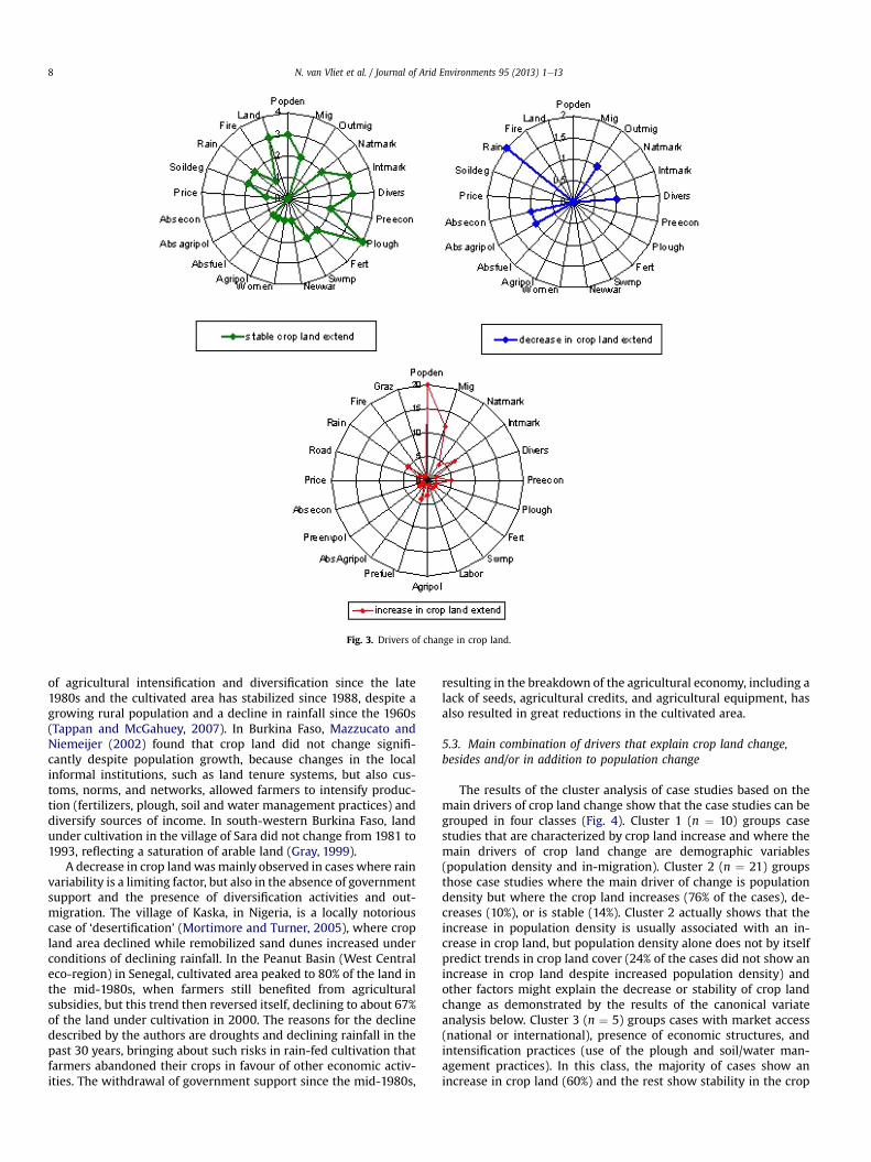
Fig. 3. Drivers of change in crop land.
N. van Vliet et al. / Journal of Arid Environments 95 (2013) 1e138
of agricultural intensification and diversification since the late1980s and the cultivated area has stabilized since 1988, despite agrowing rural population and a decline in rainfall since the 1960s(Tappan and McGahuey, 2007). In Burkina Faso, Mazzucato andNiemeijer (2002) found that crop land did not change signifi-cantly despite population growth, because changes in the localinformal institutions, such as land tenure systems, but also cus-toms, norms, and networks, allowed farmers to intensify produc-tion (fertilizers, plough, soil and water management practices) anddiversify sources of income. In south-western Burkina Faso, landunder cultivation in the village of Sara did not change from 1981 to1993, reflecting a saturation of arable land (Gray, 1999).
A decrease in crop landwasmainly observed in cases where rainvariability is a limiting factor, but also in the absence of governmentsupport and the presence of diversification activities and out-migration. The village of Kaska, in Nigeria, is a locally notoriouscase of ‘desertification’ (Mortimore and Turner, 2005), where cropland area declined while remobilized sand dunes increased underconditions of declining rainfall. In the Peanut Basin (West Centraleco-region) in Senegal, cultivated area peaked to 80% of the land inthe mid-1980s, when farmers still benefited from agriculturalsubsidies, but this trend then reversed itself, declining to about 67%of the land under cultivation in 2000. The reasons for the declinedescribed by the authors are droughts and declining rainfall in thepast 30 years, bringing about such risks in rain-fed cultivation thatfarmers abandoned their crops in favour of other economic activ-ities. The withdrawal of government support since the mid-1980s,
resulting in the breakdown of the agricultural economy, including alack of seeds, agricultural credits, and agricultural equipment, hasalso resulted in great reductions in the cultivated area.
5.3. Main combination of drivers that explain crop land change,besides and/or in addition to population change
The results of the cluster analysis of case studies based on themain drivers of crop land change show that the case studies can begrouped in four classes (Fig. 4). Cluster 1 (n ¼ 10) groups casestudies that are characterized by crop land increase and where themain drivers of crop land change are demographic variables(population density and in-migration). Cluster 2 (n ¼ 21) groupsthose case studies where the main driver of change is populationdensity but where the crop land increases (76% of the cases), de-creases (10%), or is stable (14%). Cluster 2 actually shows that theincrease in population density is usually associated with an in-crease in crop land, but population density alone does not by itselfpredict trends in crop land cover (24% of the cases did not show anincrease in crop land despite increased population density) andother factors might explain the decrease or stability of crop landchange as demonstrated by the results of the canonical variateanalysis below. Cluster 3 (n ¼ 5) groups cases with market access(national or international), presence of economic structures, andintensification practices (use of the plough and soil/water man-agement practices). In this class, the majority of cases show anincrease in crop land (60%) and the rest show stability in the crop

Fig. 4. Results of the hierarchical cluster analysis of case studies based on the drivers that influence crop land change.
N. van Vliet et al. / Journal of Arid Environments 95 (2013) 1e13 9
land extent (40%). This cluster shows that intensification and accessto markets are not necessarily associated with land sparing. Cluster4 (n ¼ 4) groups cases with multiple driving forces such as de-mographic drivers (population density and in migration), togetherwith economic drivers (presence of economic structures, diversi-fication, access to international markets, agricultural policies),intensification practices (plough and fertilizers), and a natural limitto the expansion of crop land, which translates into land scarcity.Three of the cases in Cluster 4 are characterized by stability in cropland and one by an increase in crop land.
The results of the canonical variate analysis show that there aresignificant differences in the drivers that mostly affect crop landincrease, decrease, or stability (Lambda de Wilks Test, p ¼ 0.04)(Fig. 5). The main drivers that best explain crop land increase arepopulation density and in-migration. A decrease in crop land isassociated with cases where households have diversified theirsources of income or where rain has been unpredictable enough todiscourage farmers from expanding their crop land despite popu-lation density. Crop land extent has been stabilized in contexts
where farmers have intensified their production practices (plough,fertilizers, soil/water management practices) and where they havehad access to international or national markets.
5.4. Impacts of crop land change on livelihoods, agriculturalpractices and the environment
The impacts of crop land change were dealt with in 16 casestudies in total. Impacts were described for 11 cases where cropland increased and for five cases where crop landwas stable (Fig. 6).None of the three case studies where crop land decreased describedthe impacts.
The qualitative comparative analysis suggests that among thecase studies where crop land increased, the main impact was landdegradation (mentioned in 53% of the cases) (Table 5). In SaloumSenegal, with the increase of cultivated land and shortening offallow cycles, soils have become less fertile close to the villages,although fallow land away from the settlement gained in size,mainly due to out-migration (Mbow et al., 2008). In Kano, northern

Fig. 5. Results of the canonical variate analysis.
N. van Vliet et al. / Journal of Arid Environments 95 (2013) 1e1310
Nigeria, where traditional agriculture had already been eliminatedby the 1980s, the highly intensive agricultural system led to anincrease in degraded land (Mortimore and Turner, 2005). Insouthern Mali, Tappan and McGahuey (2007) showed that therewere very few signs of severe erosion in cultivated fields, but smallpatches of severely eroded soils had begun to appear throughoutthe study area. In a small Sahelian catchment in Niger, the increasein cultivated land from 1950 to 1998 was associated with an in-crease in the extent of eroded land (from 7 to 16%) at the expense ofthe savanna (Séguis et al., 2004). In Kouonbaka village, Mali, a 40-year trend indicates a steady increase in crop land and erodedbare soils and a correspondingly drastic reduction in woody covers(Ruelland et al., 2010).
The stability of crop land has translated into an increase in soiland water management practices and a decrease in fallow periods.In southern and central Niger, where crop lands have remainedstable and the cropping area left fallow has decreased, farmers have
Fig. 6. Impacts of crop land inc
started to employ different fertilization techniques aimed atmaintaining or restoring the soil nutrient pool of the fields whileproviding physical protection against wind and water erosion (e.g.animal manure, mulch, mineral fertilizer, or planting pits) (Wezeland Haigis, 2002). In south-western Burkina Faso, where cropland extension has stabilized, agricultural practices illustrate howsome farmers have responded to the lack of fallow land by inten-sifying their production system (e.g. trees on agricultural fields, useof more inputs, and construction of anti-erosion barriers on slopedfields to prevent erosion) (Gray, 1999).
6. Discussion and conclusions
This study, based on a meta-analysis of local case studies, hasbeen useful in making qualitative assessments of published docu-mentation of crop land changes in the Sahel. However, given thebiases inherent in meta-analysis used for generating regional
rease and stable crop land.

Table 5Results of the qualitative comparative analysis. The sign * means “AND”; the signwmeans that the variable named just after is absent from the combination. As such,the impact of crop land increase is land degradation; the impact of the stability ofcrop land is the development of soil and water management practices AND reducedfallow length.
Intermediate solution of the QCA Solutioncoverage ¼ 0.77
Consistencycut off ¼ 0.85
Solutioncut off
Impacts of crop land increaselanddeg*wtrees*wfallow*wswmp 0.77 0.85 1Impacts of crop land stabilitywtrees*swmp*fallow 0.4 1 1
N. van Vliet et al. / Journal of Arid Environments 95 (2013) 1e13 11
knowledge from local case studies, the results should be consideredwith caution (Messerli et al., 2009; Rudel, 2008). We recognizeseveral caveats to generating regional knowledge from local casestudies (Messerli et al., 2009). Most importantly, the case studiesthemselves may very likely be biased towards the following: (a)interesting issues or hot spots; (b) publications in English leavingout insights from French research institutions that could possiblyrepresent additional insightwith a longer time-depth; (c) outcomesthat lend themselves to publication; or (d) a particular discipline(Rudel, 2008). Obviously, studies that have been planned andimplemented as individual endeavours in their own right do notnecessarily share a common conceptual framework or data collec-tion practices that allow for easy common treatment and interpre-tation of the individual findings. Besides, conclusions based on thisapproach for a region constrained by the limited availability of casestudies, are necessarily tentative. Nevertheless, this approach is theonly expedient way to extract a tentative sketch of regional patternsof trends, drivers, and potential impacts of crop land change.
Available knowledge in the recent scientific literature shows thatcrop land has increased in the majority of cases explored (mostly atthe expense of woodland), and population increase and in-migration have been found to provide the most prominent expla-nation. The main impact of crop land expansion identified anddescribed in the literature is land degradation (through soil erosionand loss of soil fertility), or increased weed pressure. This causalrelationship corresponds well to the conventional notion of morepeople indisputably leading to vicious circles of field expansion andsoil degradation. However, increased population density has notnecessarily systematically led to crop land increase in all cases.Indeed, some case studies document situations where, despitepopulation increase, crop land has remained remarkably stable.Such trends seem to be found where land has become a limitingfactor to expansion of agricultural production and where farmershave been able to intensify their agricultural practices (through theuse of plough, fertilizers, soil and water management practices).This trend occurs particularly in places where farmers have hadaccess to national or international markets and to supportive agri-cultural policies. However, it should be noted that intensification isoften described in the studies as both a driver and an impact of cropland stability. If we explore the land use change trends through theclassic theoretical lenses of Ester Boserup (1965), we can expectintensification measures to stabilize field expansion despite apopulation increase. This trend is seen in some of the case siteswhere the necessary conditions were present (i.e. supportive pol-icies, markets, available resources (e.g. water)). Other areas haveexperienced a decrease in crop land despite a population increase.This is mainly explained by rainfall variability, which has discour-aged farmers from expanding their plots or by situations wherehouseholds have diversified their income through non-farm incomegenerating activities, thereby reducing livelihoods vulnerability.
Perhaps most importantly, the meta-analysis exposes the sur-prisingly huge gap in the scientific literature when it comes toactual measurements of crop land change in the Sahel, which are in
sharp contrast to the number of scientific papers and policy dis-courses that refer to important past and ongoing changes in landuse/cover and desertification. Promoters of the development ofNEAPs, for example, anticipated them to be a holistic process,focussing on the underlying causes of degradation and environ-mental problems, which include a range of social, cultural andeconomic factors. In reality, many of the plans boiled down toconservative shopping lists of projects to be presented to the donorcommunity (Speirs and Marcussen, 1999: 87). They did not recog-nize new theories about natural resource management issuesemerging during the 1990s. Marcussen (1999) mentions, as ex-amples, that project documents often postulate that many hectareshave been degraded over the past few decades and that populationpressure more or less automatically leads to the extension of landunder cultivation, without having a valid set of data on which tobase such assessments. As regard the more recent generation ofpolicy documents, Kalame et al. (2011) conclude from their surveyof the NAPA for Burkina Faso that “the proposed priority projectswere limited to the institutional and specialized fields of the ex-perts who conducted the NAPA process”, and insight into changeprocesses is lacking.
Lately, the GGW plan (GEF, 2011) was launched with the explicitambition to promote sustainable management of land, water andvegetation on up to 2 million hectares of crop lands, rangelands,and dryland forest ecosystems per country. Although this initiativeis still in the planning stage, and hence difficult to assess, it seemsthat the concerns discussed above are relevant to mention again inthis context. Assessed from the prioritized project proposals(Reenberg, 2012), the mindset which frames the intervention hasnot changed much since the 1980s.
This leads us to caution against replications of poorly supportedcharacterizations of land use changes in theoretical conceptuali-zations or important policy documents. Wise use of scarce landresources, globally as well as more specifically in the Sahel, isbecoming a prominent challenge for sustainable development andfood provision for growing populations. It seems, however, thatreliable knowledge to understand the contexts in which crop landincreases, decreases, or remains stable, is in shorter supply thanwhat is normally perceived by important policy agents.
Acknowledgements
The work presented in this paper is financed by LaSyRe (LandSystem resilience and climate robustness in the agricultural front-line of Sahel), a DANIDA-FFU project, 09-001KU (www.lasyresahel.ku.dk). It contributes in addition to the Global Land Project (www.globallandproject.org) andWaterworlds (www.waterworlds.ku.dk).
We thank the reviewers for constructive comments.
References
Adams, W.M., Mortimore, M., 1997. Agricultural intensification and flexibility in theNigerian Sahel. The Geographical Journal 163, 150e160.
Adger, N., Agrawala, S., Mirza, M.M.Q., Conde, C., O’Brien, K., Pulhin, J., Pulwarty, R.,Smit, B., Takahashi, T., 2007. Assessment of adaptation practices, options, con-straints and capacity. In: Parry, M.L., Canziani, O.F., Palutikof, J.P., van derLinden, P.J., Hanson, C.E. (Eds.), Climate Change 2007: Impacts, Adaptation andVulnerability. Contribution of Working Group II to the Fourth AssessmentReport of the Intergovernmental Panel on Climate Change. Cambridge Univer-sity Press, Cambridge, pp. 717e743.
Ashley, C., 2000. Applying livelihood approaches to natural resource managementinitiatives: experiences in Namibia and Kenya. ODI Working Paper 134, 1e30.
Barbier, B., Yacouba, H., Karambiri, H., Zoromé, M., Somé, B., 2009. Human vulner-ability to climate variability in the Sahel: farmers’ adaptation strategies innorthern Burkina Faso. Environmental Management 43 (5), 790e803.
Bassett, T.J., 1988. The political ecology of peasant-herder conflicts in the NorthernIvory Coast. Annals of the Association of American Geographers 78, 453e472.
Bégué, A., Vintrou, E., Ruelland, D., Claden, M., Dessay, N., 2011. Can a 25-year trendin Soudano-Sahelian vegetation dynamics be interpreted in terms of land use
N. van Vliet et al. / Journal of Arid Environments 95 (2013) 1e1312
change? A remote sensing approach. Global Environmental Change 21, 413e420.
Behnke, R.H., Scoones, I., 1993. Rethinking range ecology: implications for range-land management in Africa. In: Behnke, R.H., Scoones, I., Kerven, C. (Eds.), RangeEcology at Disequilibrium. Overseas Development Institute, London, pp. 1e30.
Benjaminsen, T.A., Ba, B., 2009. Farmer-herder conflicts, pastoral marginalisationand corruption: a case study from the inland Niger delta of Mali. GeographicalJournal 175, 71e81.
Bilsborrow, R.E., Ogendo, H.W.O.O., 1992. Population-driven changes in land use indeveloping countries. Ambio 21 (1), 37e45.
Blaikie, P., Brookfield, H.C., 1987. Land Degradation and Society. Methuen, London.Boko, A., Niang, I., Nyong, A., Vogel, C., Githeko, A., Medany, M., Osman Elasha, B.,
Tabo, R., Yanda, P., 2007. Africa. In: Parry, M.L., Canziani, O.F., Palutikof, J.P., vander Linden, P.J., Hanson, C.E. (Eds.), Climate Change 2007: Impacts, Adaptationand Vulnerability. Contribution of Working Group II to the Fourth AssessmentReport of the Intergovernmental Panel on Climate Change. Cambridge Univer-sity Press, Cambridge, pp. 433e467.
Bolwig, S., Rasmussen, K., Hansen, M.K., 2008. New Perspectives on NaturalResource Management in the Sahel. Second Draft. Department of Geographyand Geology, University of Copenhagen, Copenhagen.
Boserup, E., 1965. The Conditions of Agricultural Growth. Earthscan PublicationsLtd, London.
Bryceson, D.F., 1996. Deagrarianization and rural employment in sub-Saharan Af-rica: a sectoral perspective. World Development 1996, 97e111.
Christensen, J.H., Hewitson, B., Busuioc, A., Chen, A., Gao, X., Held, I., Jones, R.,Kolli, R.K., Kwon, W.-T., Laprise, R., Magaña Rueda, V., Mearns, L.,Menéndez, C.G., Räisänen, J., Rinke, A., Sarr, A., Whetton, P., 2007. Regionalclimate projections. In: Solomon, S., Qin, D., Manning, M., Chen, Z., Marquis, M.,Averyt, K.B., Tignor, M., Miller, H.L. (Eds.), Climate Change 2007: the PhysicalScience Basis. Contribution of Working Group I to the Fourth Assessment Reportof the Intergovernmental Panel on Climate Change. Cambridge University Press,Cambridge, UK, pp. 847e940.
Cordell, D.D., Gregory, J.W., Piché, V., 1994. African historical demography. A searchfor a theoretical framework. In: Cordell, D.D., Gregory, J.W. (Eds.), AfricanPopulation and Capitalism. Historical Perspectives. The University of WisconsinPress, Madison, Wisconsin, pp. 14e32.
DeFries, R., Asner, G.P., Houghton, R.A. (Eds.), 2004. Ecosystems and Land UseChange. American Geophysical Union, Washington, DC.
Ellis, F., 1988. Peasant Economics. Farm Households and Agrarian Development.Cambridge University Press, Cambridge.
Ellis, F., 2000. Rural Livelihoods and Diversity in Developing Countries. OxfordUniversity Press.
Ellis, F., Mdoe, N., 2003. Livelihoods and rural poverty reduction in Tanzania. WorldDevelopment 31, 1367e1384.
Elmquist, B., Olsson, L., 2005. Livelihood diversification: continuity and change inthe Sahel. GeoJournal 67, 167e180.
Elmqvist, Khatir, 2007. The possibilities of bush fallows with changing roles ofagriculturedan analysis combining remote sensing and interview data fromSudanese drylands. Journal of Arid Environments 70, 329e343.
Ezra, M., 2001. Ecological Degradation, Rural Poverty, and Migration in Ethiopia: aContextual Analysis. No. 149.
Findley, S.E., 1990. Does drought increase migration? A study of migration fromrural Mali during the 1983e1985 drought. International Migration Review 28,539e553.
Foley, J.A., DeFries, R., Asner, G.P., Barford, C., Bonan, G., Carpenter, S.R., Chapin, F.S.,Coe, M.T., Daily, G.C., Gibbs, H.K., Helkowski, J.H., Holloway, T., Howard, E.A.,Kucharik, C.J., Monfreda, C., Patz, J.A., Prentice, I.C., Ramankutty, N., Snyder, P.K.,2005. Global consequences of land use. Science 309, 570e574.
GEF, 2011. Six Questions to Monique Barbut, CEO of GEF, on the Green Wall. http://www.thegef.org/gef/pubs/6_question_Great_Green_Wall.
Geist, H.J., Lambin, E.F., 2002. Proximate causes and underlying driving forces oftropical deforestation. BioScience 52, 143e150.
Geist, H.J., Lambin, E.F., 2004. Dynamic causal patterns of desertification. BioScience54, 817e829.
Goetze, D., Horsch, B., Porembski, S., 2006. Dynamics of forest-savanna mosaics innorth-eastern Ivory Coast from 1954 to 2002. Journal of Biogeography 33, 653e664.
Grainger, A., 2009. The role of science in implementing international environmentalagreements: the case of desertification. Land Degradation and Development 20,410e430.
Gray, L.C., 1999. Is land being degraded? A multi-scale investigation of landscapechange in southwestern Burkina Faso. Land Degradation and Development 10,329e343.
Haile, M., 2005. Weather patterns, food security and humanitarian response in sub-Saharan Africa. Philosophical Transactions of the Royal Society B: BiologicalSciences 360, 2169e2182.
Hair, J.F., Anderson, R.E., Tatham, R.L., Black, W.C., 1999. Multivariate Data Analysis,fifth ed. Prentice-Hall, International, Inc..
Hesse, C., Cotula, L., 2006. Climate Change and Pastoralists: Investing in People toRespond to Adversity. IED Sustainable Development Opinion Series.
Homer-Dixon, T., 1994. Environmental scarcities and violent conflict: evidence fromCases. International Security 19, 5e40.
Huq, S., Reid, H., Konate, M., Rahman, A., Sokona, Y., Crick, F., 2004. Mainstreamingadaptation to climate change in Least Developed Countries (LDCs). ClimatePolicy 4, 25e43.
INSD, 2007. Institut national de la statistique et de la démographie. Burkina Faso.Kalame, F.B., Kudejira, D., Nkem, J., 2011. Assessing the process an options for
implementing National Adaptation Programmes of Action (NAPA): a case studyfrom Burkina. Mitigation and Adaptation Strategies for Global Change 16 (5),535e553.
Keys, E., McConnell, W.J., 2005. Global change and the intensification of agriculturein the tropics. Global Environmental Change 15, 320e337.
L’Hôte, Y., Mahé, G., Somé, B., Triboulet, J.P., 2002. Analysis of a Sahelian annualrainfall index from 1896 to 2000: the drought continues. Hydrological SciencesJournal e Journal Des Sciences Hydrologiques 47, 563e572.
Lambin, E.F., Geist, H.J., 2006. Land-use and Land-cover Change. Local Processes andGlobal Impacts. Springer, Berlin.
Leblanc, M.J., Favreau, G., Massuel, S., Tweed, S.O., Loireau, M., Cappelaere, B., 2008.Land clearance and hydrological change in the Sahel: SW Niger. Global andPlanetary Change 61, 135e150.
Malthus, T., 1798. An Essay on the Principle of Population. Printed for J. Johnson.Marchal, J.-Y., 1977. The evolution of agrarian systems in Yatenga. African Envi-
ronment 3, 73e85.Marcussen, H.S., 1999. Environmental paradigms, knowledge systems and policy.
The case of Burkina Faso. Geografisk Tidsskrift-Danish Journal of GeographySpecial Issue 2, 93e103.
Mazzucato, V., Niemeijer, D., 2002. Population growth and the environment in Africa:local informal institutions, the missing link. Economic Geography 78, 171e193.
Mbow, C., Mertz, O., Diouf, A., Rasmussen, K., Reenberg, A., 2008. The history ofenvironmental change and adaptation in eastern Saloum-Senegal-drivingforces and perceptions. Global and Planetary Change 64, 210e221.
Messerli, P., Heinimann, A., Epprecht, M., 2009. Finding homogeneity in heteroge-neity e a new approach to quantifying landscape mosaics developed for the LaoPDR. Human Ecology 37, 291e304.
Moritz, M., 2008. Competing paradigms in pastoral development? A perspectivefrom the far North of Cameroon. World Development 36, 2243e2254.
Mortimore, M., 1998. Roots in the African Dust. Cambridge University Press,Cambridge.
Mortimore, M.J., Adams, W.M., 2001. Farmer adaptation, change and ‘crisis’ in theSahel. Global Environmental Change 11, 49e57.
Mortimore, M., Turner, B., 2005. Does the Sahelian smallholder’s management ofwoodland, farm trees, rangeland support the hypothesis of human-induceddesertification? Journal of Arid Environments 63, 567e595.
Mortimore, M., Francis, M., Harris, A., Turner, B., 1999. Implications of land usechange for the production of plant biomass in densely populated Sahelo-Sudanian shrubgrasslands in north-east Nigeria. Global Ecology and Biogeog-raphy 8, 243e256.
Moussa, B., Sissoko, K., Zougmoré, R., Dieye, K., Amadou, M., Moussa, A.S., Forch, W.,Garlick, C., Ochieng, S., Kristjanson, P., Thornton, P.K., 2011. Summary ofHousehold Baseline Survey Results e Fakara, Niger. CGIAR Research Program onClimate Change.
Netting, R.M., 1993. Smallholders, Householders: Farm Families and the Ecology ofIntensive, Sustainable Agriculture. Stanford University Press, Palo Alto.
Nielsen, J.O., Reenberg, A., 2010. Temporality and the problem with singling outclimate as a current driver of change in a small West African village. Journal ofArid Environments 74, 464e474.
Ouedraogo, I., Savadogo, P., Tigabu, M., Cole, R., Oden, P.C., Ouadba, J.M., 2009. Isrural migration a threat to environmental sustainability in Southern BurkinaFaso? Land Degradation and Development 20, 217e230.
Pare, S., Soderberg, U., Sandewall, M., Ouadba, J.M., 2008. Land use analysis fromspatial and field data capture in southern Burkina Faso, West Africa. AgricultureEcosystems & Environment 127, 277e285.
Pielke, J., 2005. Misdefining “climate change”: consequences for science and action.Environmental Science & Policy 8, 548e561.
Ragin, C.C., 2000. Fuzzy Set Social Science. The University of Chicago Press.Rains, A.B., 1983. La productivité des paturages sahéliens: Une étude des sols des
végétations et de l’exploitation de cette ressource naturelle. In: Penning deVries, F.W.T., Djiteye, M.A. (Eds.), Numerous Figures and Tables. English Sum-mary, 547 pp.. Agricultural Systems, vol.11 Centre for Agricultural Publishing andDocumentation,Wageningen, The Netherlands, pp.188e189. Price: Dfl.100-À00.
Rasmussen, L.V., Reenberg, A., 2012. Land use rationales in desert fringe agriculture.Applied Geography 34, 595e605.
Rasmussen, L.V., Rasmussen, K., Reenberg, A., Proud, S., 2012. A system dynamicsapproach to land use changes in agro-pastoral systems on the desert margins ofSahel. Agricultural Systems 107, 56e64.
Raynaut, C., 1997. Societies and Nature in the Sahel. Routledge/Stockholm Envi-ronment Institute, London.
Raynaut, C., 2001. Societies and nature in the Sahel: ecological diversity and socialdynamics.Global Environmental Change-HumanandPolicyDimensions11, 9e18.
Reenberg, A., 1999. Agricultural systems in space and time e the dynamic mosaic ofland use. Geografisk Tidsskrift-Danish Journal of Geography si01, 181e190.
Reenberg, A., 2009. Embedded flexibility in coupled human-environmental systemsin the Sahel: talking about resilience. In: Hastrup, K. (Ed.), The Question ofResilience. Social Response to Climate Change, pp. 132e158.
Reenberg, A., 2012. Insistent dryland narratives: portraits of knowledge abouthuman-environmental interactions in Sahelian environment policy documents.West African Journal of Applied Ecology 1 (20), 97e101.
Reenberg, A., Lund, C., 1998. Land use and land right dynamics e determinants forresource management options in eastern Burkina Faso. Human Ecology 26,599e620.

N. van Vliet et al. / Journal of Arid Environments 95 (2013) 1e13 13
Reenberg, A., Nielsen, T.L., Rasmussen, K., 1998. Field expansion and reallocation inthe Sahel e land use pattern dynamics in a fluctuating biophysical and socio-economic environment. Global Environmental Change 8, 309e327.
Reij, C., Tappan, G., Belemvire, A., 2005. Changing land management practices andvegetation on the Central Plateau of Burkina Faso (1968e2002). Journal of AridEnvironments 63, 642e659.
Reynolds, J.F., Smith, D.M.S., Lambin, E.F., Turner II, B.L., Mortimore, M.,Batterbury, S.P.J., Downing, T.E., Dowlatabadi, H., Fernandez, R.J., Herrick, J.E.,Huber-Sannwald, E., Jiang, H., Leemans, R., Lynam, T., Maestre, F.T., Ayarza, M.,Walker, B., 2007. Global desertification: building a science for dryland devel-opment. Science 316, 847e851.
Ringrose, S., Matheson, W., 1994. Assessment of degradation features and theirdevelopment into the post-drought period in the west-central Sahel usingLandsat MSS. Journal of Arid Environments 26, 181e199.
Rudel, T.K., 2008. Meta-analyses of case studies: a method for studying regional andglobal environmental change. Global Environmental Change 18, 18e25.
Ruelland, D., Levavasseur, F., Tribotté, A., 2010. Patterns and dynamics of land-cover changes since the 1960s over three experimental areas in Mali. Inter-national Journal of Applied Earth Observation and Geoinformation 12 (Suppl.1), S11eS17.
Ruelland, D., Tribotte, A., Puech, C., Dieulin, C., 2011. Comparison of methods forLUCCmonitoring over 50 years from aerial photographs and satellite images in aSahelian catchment. International Journal of Remote Sensing 32 (6), 1747e1777.
Savadogo, K., Reardon, T., Pietola, K., 1998. Adoption of improved land use tech-nologies to increase food security in Burkina Faso: relating animal traction,productivity, and non-farm income. Agricultural Systems 58, 441e464.
Séguis, L., Cappelaere, B., Milési, G., Peugeot, C., Mssuel, S., Favreau, G., 2004.Simulated impacts of climate change and land-clearing on runoff from a smallSahelian catchment. Hydrological Processes 18, 3401e3413.
Speirs, M., Marcussen, H.S., 1999. Environmental planning in Africa e action orwords? Geografisk Tidsskrift-Danish Journal of Geography Special Issue 2, 81e91.
Stone, G.D., 2001. Theory of the square chicken: advances in agricultural intensifi-cation theory. Asia Pacific Viewpoint 42, 163e180.
Tappan, G., McGahuey, M., 2007. Tracking environmental dynamics and agriculturalintensification in southern Mali. Agricultural Systems 94, 38e51.
Tappan, G.G., Sall, M., Wood, E.C., Cushing, M., 2004. Ecoregions and land covertrends in Senegal. Journal of Arid Environments 59, 427e462.
Turner, M.D., 1999. No space for participation: pastoralist narratives and the etiol-ogy of park-herder conflict in southeastern Niger. Land Degradation andDevelopment 10, 345e363.
Turner II, B.L., 2002. Contested identities: human-environment geography anddisciplinary implications in a restructuring academy. Annals of the Associationof American Geographers 92, 52e74.
Turner, M.D., 2004. Political ecology and the moral dimensions of resource conflicts:the case of farmer-herder conflicts in the Sahel. Political Geography 23, 863e889.
Turner, B.L., Hanham, R., Portararo, A., 1977. Population pressure and agriculturalintensity. Annals of the Association of American Geographers 67, 384e396.
Turner, B.L., Hyden, G., Kates, R. (Eds.), 1993. Population Growth and AgriculturalChange in Africa. University of Florida Press, Gainesville.
Turner, B.L., Lambin, E.F., Reenberg, A., 2007. Land change science special feature:the emergence of land change science for global environmental change andsustainability (vol. 104, p. 20666, 2007). Proceedings of the National Academyof Sciences of the United States of America 105, 2751.
van Vliet, N., Mertz, O., Heinimann, A., Langanke, T., Pascual, U., Schmook, B.,Adams, C., Schmidt-Vogt, D., Messerli, P., Leisz, S., Castella, J.C., Jørgensen, L.,Birch-Thomsen, T., Hett, C., Bech-Bruun, T., Ickowitz, A., Vu, K.C., Yasuyuki, K.,Fox, J., Padoch, C., Dressler, W., Ziegler, A.D., 2012. Trends, drivers and impacts ofchanges in swidden cultivation in tropical forest-agriculture frontiers: a globalassessment. Global Environmental Change 22, 418e429.
Wardell, D.A., Reenberg, A., Tøttrup, C., 2003. Historical footprints in contemporaryland use systems: forest cover changes in savannah woodlands in the Sudano-Sahelian zone. Global Environmental Change-Human and Policy Dimensions13, 235e254.
Watts, M.J., 1983. Silent Violence. Food, Famine and Peasantry in Northern Nigeria.University of California Press, Berkeley.
Wezel, A., Haigis, J., 2002. Fallow cultivation system and farmers’ resource man-agement in Niger, West Africa. Land Degradation and Development 13, 221e231.
Wiggins, S., 1995. Change in African farming systems between the mid-1970s andthe mid-1980s. Journal of International Development 7, 807e848.
Wittig, R., Konig, K., Schmidt, M., Szarzynski, J., 2007. A study of climate change andanthropogenic impacts in West Africa. Environmental Science and PollutionResearch 14, 182e189.
Wood, E.C., Tappan,G.G., Hadj, A., 2004. Understanding thedrivers of agricultural landuse change in south-central Senegal. Journal of Arid Environments 59, 565e582.
Woomer, P.L., Tieszen, L.L., Tappan, G., Toure, A., Sall, M., 2004. Land use change andterrestrial carbon stocks in Senegal. Journal of Arid Environments 59, 625e642.
Zeng, N., Neelin, J.D., Chou, C., Wei-Bing Lin, J., Su, H., 2001. Climate and variabilityin the first quasi-equilibrium tropical circulation model (Chapter 15). In:David, A.R. (Ed.), International Geophysics Circulation Model Development.Academic Press, pp. 457e488.