Embed Size (px)
Citation preview
Journal of Anthropological Archaeology 29 (2010) 137–154
Contents lists available at ScienceDirect
Journal of Anthropological Archaeology
journal homepage: www.elsevier .com/ locate/ jaa
The archaeological study of neighborhoods and districts in ancient cities
Michael E. Smith *
School of Human Evolution and Social Change, Box 872402, Arizona State University, Tempe, AZ 85287, United States
a r t i c l e i n f o
Article history:Received 4 November 2009Revision received 5 January 2010
Keywords:CitiesUrbanismNeighborhoodsDistrictsCommunitiesComparative analysis
0278-4165/$ - see front matter � 2010 Elsevier Inc. Adoi:10.1016/j.jaa.2010.01.001
* Fax: +1 480 965 7671.E-mail address: [email protected]
a b s t r a c t
The spatial division of cities into residential zones is a universal feature of urban life from the earliest cit-ies to the present. I propose a two-level classification of such zones that archaeologists can use to analyzepreindustrial cities. Neighborhoods are small areas of intensive face-to-face social interaction, whereasdistricts are larger areas that serve as administrative units within cities. I review comparative historicaldata on neighborhoods and districts and outline archaeological methods for their identification and anal-ysis. Illustrative cases are drawn from Mesopotamia and Mesoamerica, and I conclude with a review ofthe major top-down and bottom-up social forces that generate and shape neighborhoods and districtsin preindustrial cities.
� 2010 Elsevier Inc. All rights reserved.
Introduction
The spatial division of cities into districts or neighborhoods isone of the few universals of urban life from the earliest cities tothe present. Neighborhoods are even found in some large villagesettlements, and they seem to appear quickly in ‘‘spontaneous”informal settlements (shantytowns). In the past, urban residentstypically lived their lives within an area much smaller than theentire city. Although modern urban neighborhoods have been tar-gets of considerable scholarly attention for decades (Hoyt, 1939;Sampson, 2003; Suttles, 1972), only recently have historians andarchaeologists begun to appreciate the widespread occurrenceand social importance of these social units in the past (Garriochand Peel, 2006; Keith, 2003; Stone, 1987).
Neighborhoods are units with both social and spatial signifi-cance. Their importance in urban life and organization comes fromtheir social roles and composition. Some of the major social fea-tures of neighborhoods are their status as communities with socialties among members (‘‘neighbors”), and the diverse functionalroles they play within a city. Archaeologists, like historians andother social scientists, are interested in the social characteristicsof neighborhoods as communities and their roles within cities.Archaeological research, however, is distinctive in that it typicallymust begin with spatial organization and work toward socialinterpretations. If archaeologists can isolate spatial zones thatcould represent residential areas (as opposed to zones of public
ll rights reserved.
architecture, for example), the next step is to investigate whethersuch zones might in fact be interpreted as neighborhoods. Thesimplest analytical procedure is to infer—on the basis of compara-tive data—that spatial clusters of residences were probablyneighborhoods. A more complex and illuminating procedure is touse such spatial zones as a starting point to investigate whetherthey exhibit one or more traits that neighborhoods typically have.
In this paper, I present a conceptual framework for the archae-ological analysis of residential zones and their social characteristicsin ancient cities. On the basis of comparative data from modernand historical cities, I argue for the importance of two levels ofresidential zone: the neighborhood—a small area of frequentface-to-face interaction—and the district—a larger zone withadministrative or social significance within the city. I reviewarchaeological methods for the identification and analysis of thesesocio-spatial units, with examples from Mesopotamia and Meso-america. I conclude with a review of comparative data on someof the major social characteristics and processes of preindustrialneighborhoods and districts.
This paper is concerned with ancient and preindustrial cities,and most of my examples are drawn from these contexts. The con-ceptual literature on such cities (Sjoberg, 1960), however, isinadequate for rigorous comparative analysis, and I therefore relyon models and definitions derived largely from studies of modernurban neighborhoods by sociologists and planners. There are largebodies of literature in these and other fields on modern neighbor-hoods. While many of the contextual variables and specific socialdynamics differ greatly between preindustrial cities and those ofthe contemporary western world, the basic facts of the existence
138 M.E. Smith / Journal of Anthropological Archaeology 29 (2010) 137–154
and social importance of neighborhoods seem similar across mostcities, ancient and modern.1
I tend to favor a functional definition of ‘‘city” and ‘‘urban”: urbansettlements are places that serve as the setting for institutions andpractices that affect a larger, regional hinterland (Smith, 1989,2008:chapter 1). This is a broader definition than the more commondemographic definition of urban settlements that focuses on popu-lation size, density, and social complexity (Wirth, 1938). The func-tional definition permits the inclusion of extensive low-densitysettlements with monumental architecture—such as the ClassicMaya or Khmer political capitals—within the category of urban(Fletcher, 2009). As I show below, these cities and towns also hadneighborhoods, but they differ spatially from neighborhoods inhigh-density cities. But for the analysis of neighborhoods, the urbanstatus of a community seems to be of less importance than the pres-ence of a large number of people within the settlement. That is, largevillage settlements that lack urban functions may also show neigh-borhood organization, a pattern I discuss below for Neolithic sitesin Anatolia and large pueblo sites of the US Southwest.
Spatial zones within cities
The archaeological study of urban neighborhoods almost bynecessity begins with the isolation of spatial zones. As such, thearchaeological analysis of neighborhoods is a subset of the studyof urban spatial organization. Because it may be easy to isolatespatial zones in ancient cities but difficult to interpret them con-clusively as neighborhoods, it is helpful to employ a conservativeterminology that reflects the epistemological status of our units.I use the concept of ‘‘zone” to designate an identifiable spatial unitwithin a city or other large settlement. I begin with a considerationof spatial organization and zones before tackling neighborhood andrelated concepts.
A number of types of urban zone in preindustrial cities can beidentified from their function and scale. Civic-ceremonial zones,districts, and neighborhoods are probably the most common typescross-culturally. Other kinds of zones in preindustrial cities includecommercial zones (e.g., suqs in Islamic cities), agricultural zones,and other areas of low intensity use. The periurban zone, a transi-tional area at the edge of a city (Simon, 2008; Webster and Muller,2004) is another type of zone with relevance for ancient cities(Goodman, 2007).
A civic-ceremonial zone is an area with concentrated publicarchitecture. It typically consists of a number of public or monumen-tal buildings and formal open spaces. A civic-ceremonial zone may ormay not contain residences; if it does, the residential area is smallerthan the area devoted to public buildings. An urban epicenter is a ci-vic-ceremonial zone that served as the seat of administration, ritual,and display for a polity. In some urban traditions (e.g., Aztec city-state capitals, Smith, 2008), the epicenter is the sole civic-ceremo-nial zone in a city, whereas in others (e.g., many Classic period Mayacities, Andrews, 1975) the epicenter is the largest or most complex ofa series of civic-ceremonial zones within a city.
Gideon Sjoberg’s book The Preindustrial City (Sjoberg, 1960) wasan extended argument against the universality of the social andspatial patterns of western industrial cities, particularly asdescribed by the sociologists of the University of Chicago (e.g.,Hawley and Duncan, 1957; Wirth, 1938). Although much debatedand criticized (see the concise summary of this literature inHerbert and Thomas, 1997), Sjoberg did succeed in establishing aseries of important differences between preindustrial and indus-
1 The comparability of ancient and modern urban neighborhoods is one target of anongoing transdisciplinary research project in which I am a participant (York et al., inpreparation). A second theme of that project—urban open spaces—is not covered inthe present paper.
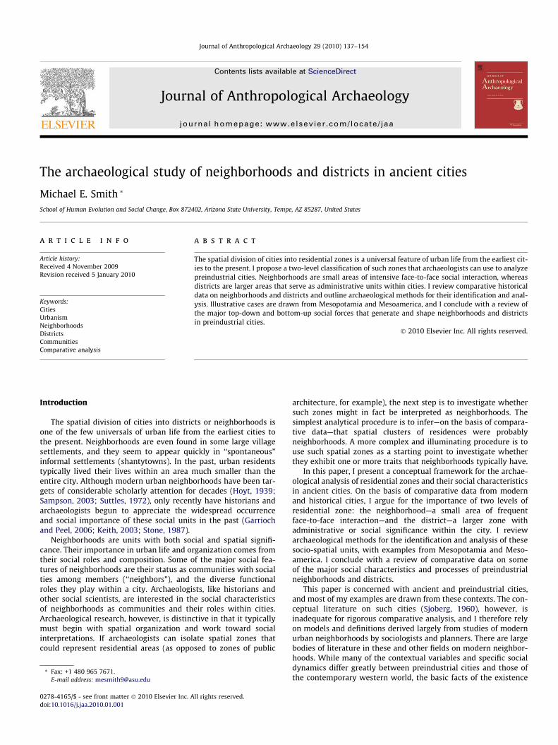
trial cities. He presented a simplified concentric spatial model witha central elite district (the urban epicenter), a large surroundingarea of commoner residence, and a peripheral (peri-urban in to-day’s nomenclature) zone of ‘‘outcaste” housing and farming. Inthe latter two zones, ‘‘subdivisions along ethnic and/or occupa-tional lines are manifested in the preindustrial city in the numer-ous wards or quarters, well-defined neighborhoods withrelatively homogeneous populations that develop special formsof social organization” (Sjoberg, 1960:100).
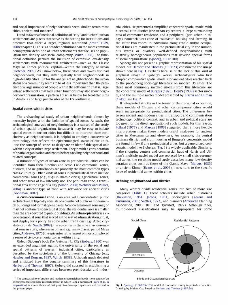
Sjoberg did not present a graphic representation of his spatialmodel, but Herbert and Thomas (1997:23) constructed the imageshown here in Fig. 1. Perhaps because of the lack of this kind ofgraphical image in Sjoberg’s works, archaeologists who firstadopted comparative spatial models for ancient cities reached backto the pre-Sjoberg sociology literature on modern US cities. Thethree most commonly invoked models from this literature arethe concentric model of Burgess (1923), Hoyt’s (1939) sector mod-el, and the multiple nuclei model presented by Harris and Ullman(1945); see Fig. 2.
If interpreted strictly in the terms of their original exposition,these models of Chicago and other contemporary cities wouldseem inappropriate for preindustrial cities. The differences be-tween ancient and modern cities in transport and communicationtechnology, political context, and in urban and political scale aretoo great for the direct application of such models. For this reason,Pollard (1977) and Marcus (1983) suggested that a more flexibleinterpretation makes these models useful analogues for ancientcities in Mesoamerica and elsewhere. For example, the centralbusiness district and slum housing of Burgess’s concentric modelare found in few if any preindustrial cities, but a generalized con-centric model like Sjoberg’s (Fig. 1) is widely applicable. Similarly,if the shopping centers and commercial hubs of Harris and Ull-man’s multiple nuclei model are replaced by small civic-ceremo-nial zones, the resulting model aptly describes many low-densityagrarian cities such as those of the Classic Maya (Marcus, 1983)or ancient Khmer (Evans et al., 2007). I now turn to the specificissue of residential zones within cities.
Defining neighborhood and district
Many writers divide residential zones into two or more sizecategories (Table 1). These scholars include urban historians(Dickinson, 1961; Jacobs, 1961), sociologists (Kearns andParkinson, 2001; Suttles, 1972), and planners (American PlanningAssociation, 2006; Bell and Tyrwhitt, 1972). Although finer,multiple-level classifications may be appropriate for some
Fig. 1. Sjoberg’s (1960:95–103) model of concentric zoning in preindustrial cities.Drawing by Miriam Cox, based on Herbert and Thomas (1997:24).
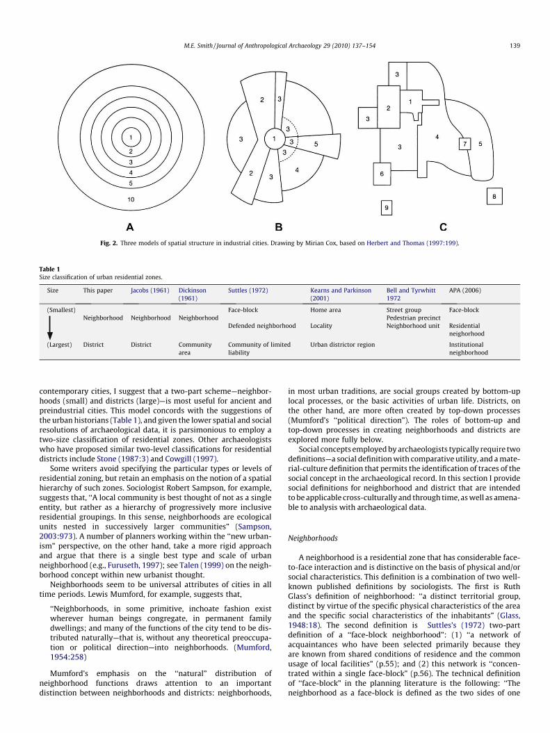
Fig. 2. Three models of spatial structure in industrial cities. Drawing by Mirian Cox, based on Herbert and Thomas (1997:199).
Table 1Size classification of urban residential zones.
Size This paper Jacobs (1961) Dickinson(1961)
Suttles (1972) Kearns and Parkinson(2001)
Bell and Tyrwhitt1972
APA (2006)
(Smallest) Face-block Home area Street group Face-blockNeighborhood Neighborhood Neighborhood Pedestrian precinct
Defended neighborhood Locality Neighborhood unit Residentialneighorhood
(Largest) District District Communityarea
Community of limitedliability
Urban districtor region Institutionalneighborhood
M.E. Smith / Journal of Anthropological Archaeology 29 (2010) 137–154 139
contemporary cities, I suggest that a two-part scheme—neighbor-hoods (small) and districts (large)—is most useful for ancient andpreindustrial cities. This model concords with the suggestions ofthe urban historians (Table 1), and given the lower spatial and socialresolutions of archaeological data, it is parsimonious to employ atwo-size classification of residential zones. Other archaeologistswho have proposed similar two-level classifications for residentialdistricts include Stone (1987:3) and Cowgill (1997).
Some writers avoid specifying the particular types or levels ofresidential zoning, but retain an emphasis on the notion of a spatialhierarchy of such zones. Sociologist Robert Sampson, for example,suggests that, ‘‘A local community is best thought of not as a singleentity, but rather as a hierarchy of progressively more inclusiveresidential groupings. In this sense, neighborhoods are ecologicalunits nested in successively larger communities” (Sampson,2003:973). A number of planners working within the ‘‘new urban-ism” perspective, on the other hand, take a more rigid approachand argue that there is a single best type and scale of urbanneighborhood (e.g., Furuseth, 1997); see Talen (1999) on the neigh-borhood concept within new urbanist thought.
Neighborhoods seem to be universal attributes of cities in alltime periods. Lewis Mumford, for example, suggests that,
‘‘Neighborhoods, in some primitive, inchoate fashion existwherever human beings congregate, in permanent familydwellings; and many of the functions of the city tend to be dis-tributed naturally—that is, without any theoretical preoccupa-tion or political direction—into neighborhoods. (Mumford,1954:258)
Mumford’s emphasis on the ‘‘natural” distribution ofneighborhood functions draws attention to an importantdistinction between neighborhoods and districts: neighborhoods,
in most urban traditions, are social groups created by bottom-uplocal processes, or the basic activities of urban life. Districts, onthe other hand, are more often created by top-down processes(Mumford’s ‘‘political direction”). The roles of bottom-up andtop-down processes in creating neighborhoods and districts areexplored more fully below.
Social concepts employed by archaeologists typically require twodefinitions—a social definition with comparative utility, and a mate-rial-culture definition that permits the identification of traces of thesocial concept in the archaeological record. In this section I providesocial definitions for neighborhood and district that are intendedto be applicable cross-culturally and through time, as well as amena-ble to analysis with archaeological data.
Neighborhoods
A neighborhood is a residential zone that has considerable face-to-face interaction and is distinctive on the basis of physical and/orsocial characteristics. This definition is a combination of two well-known published definitions by sociologists. The first is RuthGlass’s definition of neighborhood: ‘‘a distinct territorial group,distinct by virtue of the specific physical characteristics of the areaand the specific social characteristics of the inhabitants” (Glass,1948:18). The second definition is Suttles’s (1972) two-partdefinition of a ‘‘face-block neighborhood”: (1) ‘‘a network ofacquaintances who have been selected primarily because theyare known from shared conditions of residence and the commonusage of local facilities” (p.55); and (2) this network is ‘‘concen-trated within a single face-block” (p.56). The technical definitionof ‘‘face-block” in the planning literature is the following: ‘‘Theneighborhood as a face-block is defined as the two sides of one
140 M.E. Smith / Journal of Anthropological Archaeology 29 (2010) 137–154
street between intersecting streets” (American Planning Associa-tion, 2006:409).
This definition of neighborhood is meant to be applicable todiverse geographical settings and time periods and amenable toanalysis with historical and archaeological data (as well as contem-porary social science data). Many definitions of neighborhoodemphasize values of neighborliness and friendship that areimportant norms in modern western society but may or may notbe important in preindustrial cities or in neighborhoods of concen-trated poverty in industrialized nations today. Here are twoexamples of this tendency. (1) In a book on European historical cities,Dickinson (1961:528) defined neighborhood as ‘‘the smallest socialgroup outside of the family, a group characterized by the feeling of‘‘neighborliness” or friendship with one’s neighbors. It is an intimateface-to-face group of several hundred people.” (2) More recently,Carmon (2001:10488) states the following:
The term neighborhood is rooted in the verb neighbor. ‘Toneighbor’ has a double meaning: (a) to live in vicinity, one oranother; (b) to be friendly, to render mutual favors or assistance(Webster’s dictionary). This double meaning expresses theessence of the neighborhood: continuous physical proximityamong people, together with some special attitudes, such asfriendliness, and/or special behaviors, such as mutualassistance.
In a discussion of early Mesopotamian urban neighborhoodsbased primarily on historical documents, Keith (2003:58) claimsthat the following definition of neighborhood is applicable cross-culturally:
the neighborhood is considered a level of sociospatial pattern-ing and is defined as the area within which local residentsconducted most of their daily activities. Such as area may ormay not correspond to ‘‘the neighborhood” as identified byeither the local inhabitants or the ancient administrativebureaucracy.
Although this definition may have greater applicability to prein-dustrial cities than the definitions of Dickinson and Carmon, it isbased too heavily on characteristics of ancient Mesopotamian cities.It is not at all clear whether neighborhoods (or districts; Keith doesnot distinguish these levels) in other urban traditions are placeswhere ‘‘residents conducted most of their daily activities.” This char-acteristic should be a topic of investigation, not a definitional attri-bute of neighborhoods. In some preindustrial cities residents mayhave traveled outside their immediate residential vicinity to reachtheir place of work or to purchase goods at a marketplace, but thisshould not imply that neighborhoods were lacking simply becauseof the frequency of such trips.
Suttles’s concept of face-block (see above) is important for itsemphasis on a feature that is only implicit in many definitions ofneighborhood (e.g., those of Dickinson, Carmon, and Keith quotedabove): face-to-face interaction among the residents of a neighbor-hood. This interaction, however, need not involve friendship (Dick-inson and Carmon) or the conduct of the majority of typical dailyactivities (Keith). In fact, sociologists and planners have identifiedproblems with traditional notions that neighborhood social tiestypically consist of ‘‘dense, intimate social bonds” (Sampson,2004a:108); see also Briggs (2008). This is clearly not the case inmany poor, crime-ridden inner-city neighborhoods today. It isthe fact of interaction rather than its content that is important increating and maintaining a neighborhood as a social unit.
The role of face-to-face interaction is probably stronger instructuring neighborhoods in preindustrial cities than in manycontemporary cities. One historical example with particularlyrich documentation is 14th-century Marseille, where Smail
(2000) has analyzed data on place of residence, occupation,and other factors:
This evidence shows that among tradesmen and commoners,sociability was constructed around relations that were literallyface to face; identity was built up from public spaces, that is tosay the spaces in which people came into frequent contact withneighbors and colleagues (Smail, 2000:183).
The identification of neighborhood boundaries is often difficultbecause the various spatial and interactional patterns that charac-terize a neighborhood—such as social networks and interaction, orthe distribution of social characteristics—may not have a single,clearly delimited boundary (Sampson, 2004b). Processes overlapin space, and the social world of a neighborhood is typically anopen system with varying degrees of homogeneity and externalconnectivity. In her analysis of Middlesbrough, planner Glass(1948) found that the various localized social systems were nodalnetworks. In the words of architect Christopher Alexander, ‘‘thedifferent units do not coincide. Yet neither are they disjoint. Theyoverlap” (Alexander, 1972:414).
Districts
A district is a residential zone that has some kind of administra-tive or social identity within a city. In most cases, districts are lar-ger than neighborhoods. There may be public architecture andspaces within a district, but housing predominates. Districts aretypically composed of multiple neighborhoods. Two types ofdistricts are common in cities: administrative districts and socialdistricts. Administrative districts are large residential zones thatserve as administrative units within cities. In some cases, adminis-trative districts contain civic buildings used in administration,whereas in other cases there may be no clear architectural signalof district administration. Social districts are large residentialzones, identifiable from patterns of interaction or social character-istics, which do not serve as administrative units.
Suttles (1972) uses the term ‘‘community of limited liability”for the district. In the words of Robert Chaskin:
The community of limited liability is a larger area, geographi-cally defined but composed of several neighborhoods, and hasan ‘official’ identity—that is, it is recognized internally byresidents and organizations and externally by municipal gov-ernment and other extra local institutions. Attachment to thisunit is contingent, voluntary, and based on instrumental valuestied to investment, function, and use as opposed to the affectiveties that interpersonal neighbor relations that characterize thenatural area, or urban village (Chaskin, 1997:528).
Planners today use the term ‘‘institutional neighborhood” forthe district: ‘‘The institutional neighborhood is a larger unit thathas some official status as a subarea of the city. The institutionalneighborhood provides the opportunity to focus on organizationand institutional collaboration” (American Planning Association,2006:409). For modern cities, Jacobs (1961:117) observes,
Looking at city neighborhoods as organs of self-government, Ican see evidence that only three kinds of neighborhoods areuseful: (1) the city as a whole; (2) street neighborhoods; (3) dis-tricts of large, subcity size, composed of 100,000 people or morein the case of the largest cities.
Kearns and Parkinson (2001) discuss urban districts as land-scapes of social and economic opportunities where importantsocial forces include employment, leisure interests, and socialnetworks.
For historical cities in Europe, Dickinson (1961:529) suggeststhat, ‘‘There is, beyond the neighborhood, a social–geographical
M.E. Smith / Journal of Anthropological Archaeology 29 (2010) 137–154 141
grouping which is based on some kind of association through themedium of common institutions; it is organized in some degreeas a community, but no face-to-face relationship of all its membersis involved.” He calls this unit the ‘‘community area.”
Neighborhoods without cities?
Neighborhoods, as defined here, are not limited to urban settle-ments. Large villages, whether part of an urban settlement systemor not, may have definable residential zones characterized by con-siderable face-to-face interaction and physical or social distinctive-ness. Indeed, such units have been proposed for at least twoarchaeological examples of non-urban, non-state, settlement sys-tems. Düring and Marciniak (2006), for example, identify spatialdivisions within several Neolithic Anatolian villages, includingÇatalhöyük,2 which they call neighborhoods:
One feature so far unique to the central Anatoloian Neolithic isthe phenomenon of the clustered neighborhood settlements(Özbasaran, 2000:135). In these settlements individual build-ings are typically constructed directly adjacent to one anotherin neighbourhood clusters of approximately 30–40 buildings.These will normally be separated from one another by streets,alleys and midden areas, and additional midden areas may belocated within the neighbourhood clusters.” (p.170).
If one makes the reasonable assumption that high levels ofsocial interaction took place within these zones, their physicaldemarcation allows them to be classified as neighborhoods asdefined here.
Another example is provided by large Pueblo III-period pueblosites in the US Southwest (Adler, 1996). Many of these sites aredivided spatially into two or more residential zones consisting ofroom blocks or clusters of rooms and blocks. Southwestern archae-ologists generally use the term ‘‘moiety” in cases where there aretwo major zones at a site. Traditional interpretations (e.g., Lowell,1996) stress the role of these units in promoting social integrationat large sites. More recently Fowles (2005) has interpreted suchunits at Pot Creek Pueblo in another manner: ‘‘moieties wereinitially established there as a means of formalizing the social rela-tionships between a local population and a recently arrived groupof immigrants” (Fowles, 2005:25). These Southwestern divisions(moieties) fit my definition of neighborhood, and both social inter-pretations are entirely consistent with the roles of neighborhoodsin well documented urban settings. These non-state cases, on theother hand, do not exhibit spatial units corresponding to districts.
The fact that neighborhoods tend to arise quickly in large, rap-idly-settled residential zones is another indication of their ubiquityin large human settlements. Many contemporary spontaneous set-tlements (also known as squatter’s settlements or informal settle-ments) develop neighborhoods as they grow (Fisher, 1984). Thebest documented of these settlements is an area in Lusaka, Zambia,known as George, where Schlyter and Schlyter (1979) mappedhouses and social interactions over a period of a decade. Theyfound that residents quickly established ‘‘neighborly” relationshipswith those living nearby, leading to house clusters that served assmall neighborhood units within the larger settlement (Schlyterand Schlyter, 1979:50–53, 89–91). Even the temporary, artificialsettlement of ‘‘Black Rock City,” the setting for the annual BurningMan Festival (Chen, 2009), developed neighborhoods as the festivalgrew larger over the years. In the words of festival organizer RodGarrett:
2 Although some non-archaeological writers have claimed that Çatalhöyük was anurban settlement (Reader, 2005:16–24; Soja, 2000:27–36), Hodder (2006:95–99)shows that its small size and lack of urban functions do not permit such aclassification.
We are redefining our zoning to break the city down into smal-ler, more humanly scaled neighbourhoods. This becomesincreasingly necessary as our population continues to growwhile still using the old camp centric model. Populations, intheir desire for that human scale, are driven to choose divisiveways to break the population into smaller units, resulting ingrouping through the exclusion of others. By visually suggestingsmaller areas, we can create divisions of a size the mind canwrap itself around. (Zancan, 2006:2).
In the terms discussed below, this is an example of a top-down(centrally planned) approach to neighborhood development, albeitin the context of an event with strongly communitarian and anti-hierarchical values.
Neighborhoods and districts: five historical examples
The spatial and social configurations of neighborhoods and dis-tricts in individual cities can vary considerably. Four relatively welldocumented historical examples—late medieval Marseille,20th-century Bhaktapur, Sui-Tang period Chang’an, and the 19th-century Yoruba city Ilesha—and one poorly documented case—Ad-dis Ababa in the late 19th-century—illustrate some of this varia-tion. In these and other cases, historical documents typicallyprovide much fuller information on administrative districts thanon neighborhoods. There are fewer districts and they were usuallyadministrative units of concern to the state, which led to theirinclusion in administrative documents far more often than neigh-borhoods. Administrative districts are much easier to map thanneighborhoods, both because the latter tend to be amorphousand because historical documents have less information aboutthem.
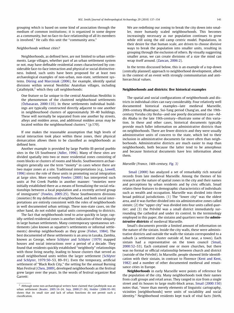
Marseille (France, 14th-century, Fig. 3)
Smail (2000) has analyzed a set of remarkably rich notarialrecords from late medieval Marseille. Among the themes of hisresearch are the nature of spatial zones in the city and their namesand perceptions by urban residents and by civic officials. Smailrelates these features to demographic characteristics of individualssuch as wealth and occupation. Marseille was divided into threebroad political jurisdictions. (1) The ‘‘lower city” was the oldestarea, and it was further divided into six administrative zones calledsixtain; (2) the ‘‘upper city” was divided into four units called quar-tier; and (3) the Prévôté was a small district immediately sur-rounding the cathedral and under its control. In the terminologyemployed in this paper, the sixtains and quartiers were the admin-istrative districts of medieval Marseille.
Smail’s documents provide a limited amount of information onthe nature of the sixtain. Inside the city walls, these were adminis-trative districts and outside the walls the sixtain corresponded to asuburb (a settlement cluster outside of, but near, a town). Eachsixtain had a representative on the town council (Smail,2000:52–53). Each contained one or more churches, but therewas no formal or official relationship between church and district(outside of the Prévôté). In Marseille, people showed little identifi-cation with their sixtain, in contrast to Florence (Kent and Kent,1982) and a number of other documented medieval and renais-sance cities in Europe.
Neighborhoods in early Marseille were points of reference forthe population of the city. Many neighborhoods took their namesfrom craft groups and retail areas. They ranged in size from a singlestreet and its houses to large multi-block areas. Smail (2000:150)notes that, ‘‘more than merely elements of linguistic cartography,vicinities [neighborhoods] were units of sociability and socialidentity.” Neighborhood residents kept track of vital facts (birth,
142 M.E. Smith / Journal of Anthropological Archaeology 29 (2010) 137–154
death, property title) before the state took over this task. Due to thenature of the surviving documents studied by Smail, the docu-mented neighborhoods do not cover the entire city. His map(Fig. 3) thus shows only a portion of the neighborhoods ofMarseille.
In Marseille crafts were often concentrated in neighborhoods,some exclusively and others less so. Many neighborhoods werenamed for crafts, leading Smail (2000:171) to conclude that ‘‘craftgroup quarters [neighborhoods] were a conspicuous feature ofMarseille’s social topography.” He notes that ‘‘close to 70% of allcraftsmen whose residences are known lived in the quarter associ-ated with their craft” (Smail, 2000:201).
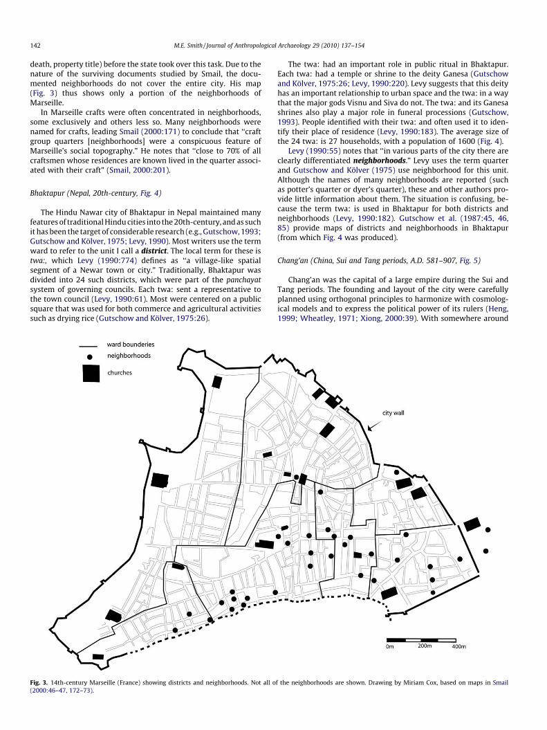
Bhaktapur (Nepal, 20th-century, Fig. 4)
The Hindu Nawar city of Bhaktapur in Nepal maintained manyfeatures of traditional Hindu cities into the 20th-century, and as suchit has been the target of considerable research (e.g., Gutschow, 1993;Gutschow and Kölver, 1975; Levy, 1990). Most writers use the termward to refer to the unit I call a district. The local term for these istwa:, which Levy (1990:774) defines as ‘‘a village-like spatialsegment of a Newar town or city.” Traditionally, Bhaktapur wasdivided into 24 such districts, which were part of the panchayatsystem of governing councils. Each twa: sent a representative tothe town council (Levy, 1990:61). Most were centered on a publicsquare that was used for both commerce and agricultural activitiessuch as drying rice (Gutschow and Kölver, 1975:26).
Fig. 3. 14th-century Marseille (France) showing districts and neighborhoods. Not all o(2000:46–47, 172–73).
The twa: had an important role in public ritual in Bhaktapur.Each twa: had a temple or shrine to the deity Ganesa (Gutschowand Kölver, 1975:26; Levy, 1990:220). Levy suggests that this deityhas an important relationship to urban space and the twa: in a waythat the major gods Visnu and Siva do not. The twa: and its Ganesashrines also play a major role in funeral processions (Gutschow,1993). People identified with their twa: and often used it to iden-tify their place of residence (Levy, 1990:183). The average size ofthe 24 twa: is 27 households, with a population of 1600 (Fig. 4).
Levy (1990:55) notes that ‘‘in various parts of the city there areclearly differentiated neighborhoods.” Levy uses the term quarterand Gutschow and Kölver (1975) use neighborhood for this unit.Although the names of many neighborhoods are reported (suchas potter’s quarter or dyer’s quarter), these and other authors pro-vide little information about them. The situation is confusing, be-cause the term twa: is used in Bhaktapur for both districts andneighborhoods (Levy, 1990:182). Gutschow et al. (1987:45, 46,85) provide maps of districts and neighborhoods in Bhaktapur(from which Fig. 4 was produced).
Chang’an (China, Sui and Tang periods, A.D. 581–907, Fig. 5)
Chang’an was the capital of a large empire during the Sui andTang periods. The founding and layout of the city were carefullyplanned using orthogonal principles to harmonize with cosmolog-ical models and to express the political power of its rulers (Heng,1999; Wheatley, 1971; Xiong, 2000:39). With somewhere around
f the neighborhoods are shown. Drawing by Miriam Cox, based on maps in Smail
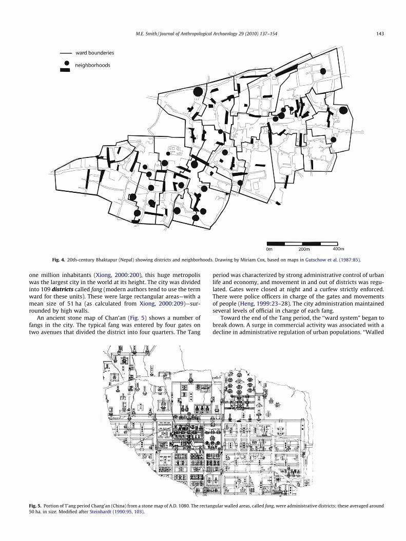
Fig. 4. 20th-century Bhaktapur (Nepal) showing districts and neighborhoods. Drawing by Miriam Cox, based on maps in Gutschow et al. (1987:85).
M.E. Smith / Journal of Anthropological Archaeology 29 (2010) 137–154 143
one million inhabitants (Xiong, 2000:200), this huge metropoliswas the largest city in the world at its height. The city was dividedinto 109 districts called fang (modern authors tend to use the termward for these units). These were large rectangular areas—with amean size of 51 ha (as calculated from Xiong, 2000:209)—sur-rounded by high walls.
An ancient stone map of Chan’an (Fig. 5) shows a number offangs in the city. The typical fang was entered by four gates ontwo avenues that divided the district into four quarters. The Tang
Fig. 5. Portion of T’ang period Chang’an (China) from a stone map of A.D. 1080. The rectan50 ha. in size. Modified after Steinhardt (1990:95, 103).
period was characterized by strong administrative control of urbanlife and economy, and movement in and out of districts was regu-lated. Gates were closed at night and a curfew strictly enforced.There were police officers in charge of the gates and movementsof people (Heng, 1999:23–28). The city administration maintainedseveral levels of official in charge of each fang.
Toward the end of the Tang period, the ‘‘ward system” began tobreak down. A surge in commercial activity was associated with adecline in administrative regulation of urban populations. ‘‘Walled
gular walled areas, called fang, were administrative districts; these averaged around
144 M.E. Smith / Journal of Anthropological Archaeology 29 (2010) 137–154
boundaries, critical to the ward system, lost their significance sincethe bustling market street became a connector. Shops and houses,instead of walls, were strung together along the street or canalfront.” (Heng, 1999:80). Imperial capitals like Kaifeng in the fol-lowing Song period (A.D. 960–1279) maintained an orthogonal lay-out and walled districts, but without curfews and closed gates(Heng, 1999:117–182; Kracke, 1975). The fang continued in useas an administrative unit, but with fewer restrictions on the livesof inhabitants than in Tang times.
Neighborhoods are difficult to identify at Chang’an. Documentsspeak of subdivisions of the fang, and one or more of these unitsmay correspond to the neighborhood as a face-to-face social group.A li was an administrative unit consisting of 100 households, underthe direction of a headman who administered households, land,taxes, and corvée. A li was divided into five bao, each with a head-man, and a bao was divided into five lin, each consisting of fourhouseholds (Heng, 1999:26). The spatial contours of these sub-fang units is not at all clear. If the households comprising a li werelocalized (in one of the fang quarters, for example), then as anadministrative unit a li can be considered a second level of district.But the li also seems the most likely unit to correspond to a neigh-borhood. So Chang’an may present an unusual case where both thedistrict and the neighborhood had important administrative func-tions. This only seems possible in a city with strong and pervasiveadministrative control of its population.
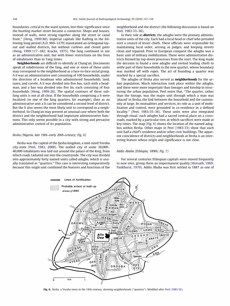
Ilesha (Nigeria, late 19th–early 20th-century; Fig. 6)
Ilesha was the capital of the Ijesha kingdom, a mid-sized Yorubacity-state (Peel, 1983, 2000). The walled city of some 30,000–40,000 inhabitants was laid out around the palace of the king, fromwhich roads radiated out into the countryside. The city was dividedinto approximately forty named units called adugbo, which is usu-ally translated as ‘‘quarters.” This case is interesting comparativelybecause this single unit combined the features and functions of the
Fig. 6. Ilesha, a Yoruba town in the 19th-century, showing ne
neighborhood and the district (the following discussion is based onPeel, 1983:33–36).
In their role as districts, the adugbo were the primary adminis-trative units of the city. Each had a local head or chief who presidedover a council of lesser chiefs. These officials were responsible formaintaining local order, serving as judges, and keeping streetsclean and repaired. Prior to European conquest the adugbo was abasic unit of military mobilization. These were administrative dis-tricts formed by top-down processes from the start. The king madethe decision to found a new adugbo and invited leading chiefs tosettle part of their households in the new quarter, whose boundarywas marked off with ropes. The act of founding a quarter wasmarked by a special sacrifice.
The adugbo of Ilesha also served as neighborhoods for the ur-ban population. Much interaction took place within the adugbo,and these were more important than lineages and kinship in struc-turing the urban population. Peel notes that, ‘‘The quarter, ratherthan the lineage, was the major unit through which a man was‘placed’ in Ilesha, the link between the household and the commu-nity at large. Its mutualities and services, its role as a unit of mobi-lization and control, were grounded in co-residence in a definedlocality.” (Peel, 1983:35–36). These units were also integratedthrough ritual; each adugbo had a sacred central place on a cross-roads, marked by a particular tree, at which sacrifices were made atkey times. The map (Fig. 6) shows the location of the named adug-bos within Ilesha. Other maps in Peel (1983:33) show that eachunit had a chief’s residence and/or other civic buildings. The appar-ent coincidence of districts and neighborhoods at Ilesha is an inter-esting feature whose origin and significance is not clear.
Addis Ababa (Ethiopia, 1890s; Fig. 7)
For several centuries Ethiopian capitals were moved frequentlyto new sites, giving them an impermanent quality (Horvath, 1969;Pankhurst, 1979). Addis Ababa was first settled in 1887 as one of
ighborhoods (‘‘quarters”). Modified after Peel (1983:32).
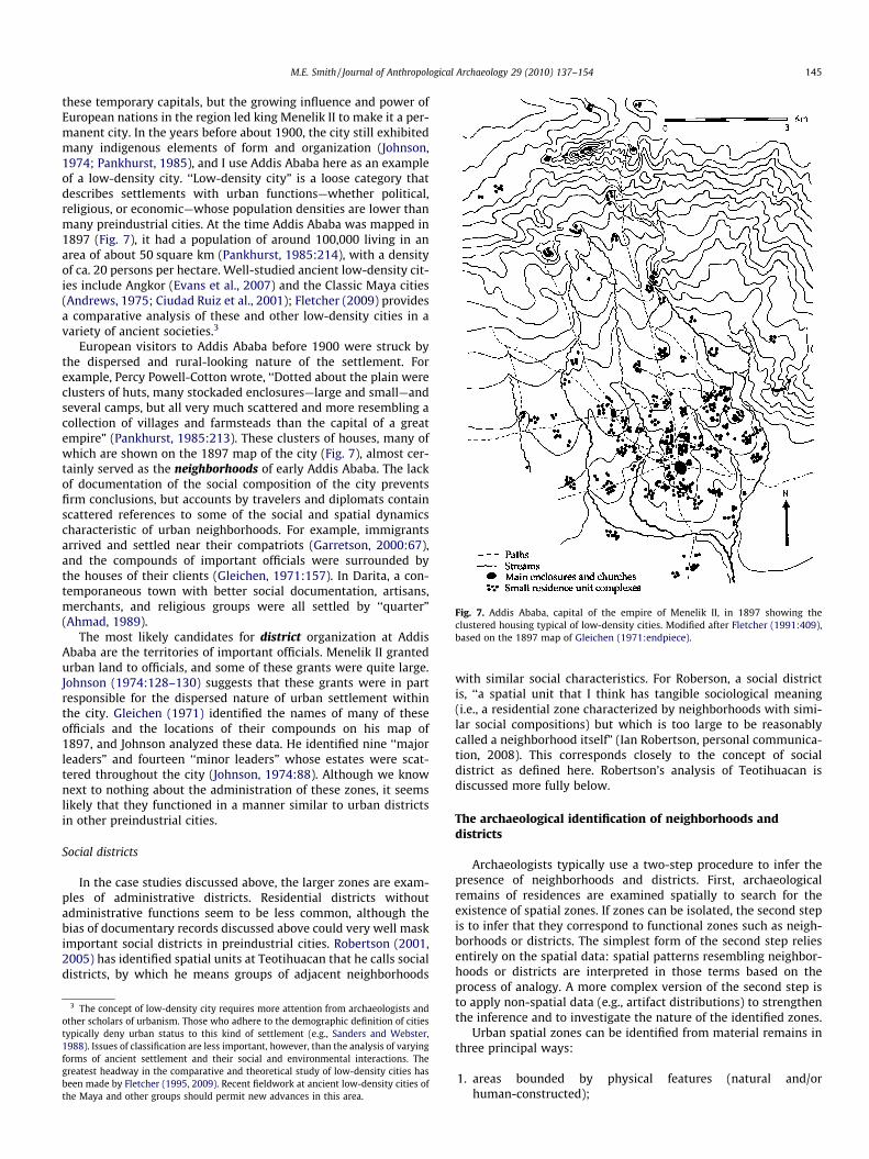
Fig. 7. Addis Ababa, capital of the empire of Menelik II, in 1897 showing theclustered housing typical of low-density cities. Modified after Fletcher (1991:409),based on the 1897 map of Gleichen (1971:endpiece).
M.E. Smith / Journal of Anthropological Archaeology 29 (2010) 137–154 145
these temporary capitals, but the growing influence and power ofEuropean nations in the region led king Menelik II to make it a per-manent city. In the years before about 1900, the city still exhibitedmany indigenous elements of form and organization (Johnson,1974; Pankhurst, 1985), and I use Addis Ababa here as an exampleof a low-density city. ‘‘Low-density city” is a loose category thatdescribes settlements with urban functions—whether political,religious, or economic—whose population densities are lower thanmany preindustrial cities. At the time Addis Ababa was mapped in1897 (Fig. 7), it had a population of around 100,000 living in anarea of about 50 square km (Pankhurst, 1985:214), with a densityof ca. 20 persons per hectare. Well-studied ancient low-density cit-ies include Angkor (Evans et al., 2007) and the Classic Maya cities(Andrews, 1975; Ciudad Ruiz et al., 2001); Fletcher (2009) providesa comparative analysis of these and other low-density cities in avariety of ancient societies.3
European visitors to Addis Ababa before 1900 were struck bythe dispersed and rural-looking nature of the settlement. Forexample, Percy Powell-Cotton wrote, ‘‘Dotted about the plain wereclusters of huts, many stockaded enclosures—large and small—andseveral camps, but all very much scattered and more resembling acollection of villages and farmsteads than the capital of a greatempire” (Pankhurst, 1985:213). These clusters of houses, many ofwhich are shown on the 1897 map of the city (Fig. 7), almost cer-tainly served as the neighborhoods of early Addis Ababa. The lackof documentation of the social composition of the city preventsfirm conclusions, but accounts by travelers and diplomats containscattered references to some of the social and spatial dynamicscharacteristic of urban neighborhoods. For example, immigrantsarrived and settled near their compatriots (Garretson, 2000:67),and the compounds of important officials were surrounded bythe houses of their clients (Gleichen, 1971:157). In Darita, a con-temporaneous town with better social documentation, artisans,merchants, and religious groups were all settled by ‘‘quarter”(Ahmad, 1989).
The most likely candidates for district organization at AddisAbaba are the territories of important officials. Menelik II grantedurban land to officials, and some of these grants were quite large.Johnson (1974:128–130) suggests that these grants were in partresponsible for the dispersed nature of urban settlement withinthe city. Gleichen (1971) identified the names of many of theseofficials and the locations of their compounds on his map of1897, and Johnson analyzed these data. He identified nine ‘‘majorleaders” and fourteen ‘‘minor leaders” whose estates were scat-tered throughout the city (Johnson, 1974:88). Although we knownext to nothing about the administration of these zones, it seemslikely that they functioned in a manner similar to urban districtsin other preindustrial cities.
Social districts
In the case studies discussed above, the larger zones are exam-ples of administrative districts. Residential districts withoutadministrative functions seem to be less common, although thebias of documentary records discussed above could very well maskimportant social districts in preindustrial cities. Robertson (2001,2005) has identified spatial units at Teotihuacan that he calls socialdistricts, by which he means groups of adjacent neighborhoods
3 The concept of low-density city requires more attention from archaeologists andother scholars of urbanism. Those who adhere to the demographic definition of citiestypically deny urban status to this kind of settlement (e.g., Sanders and Webster,1988). Issues of classification are less important, however, than the analysis of varyingforms of ancient settlement and their social and environmental interactions. Thegreatest headway in the comparative and theoretical study of low-density cities hasbeen made by Fletcher (1995, 2009). Recent fieldwork at ancient low-density cities ofthe Maya and other groups should permit new advances in this area.
with similar social characteristics. For Roberson, a social districtis, ‘‘a spatial unit that I think has tangible sociological meaning(i.e., a residential zone characterized by neighborhoods with simi-lar social compositions) but which is too large to be reasonablycalled a neighborhood itself” (Ian Robertson, personal communica-tion, 2008). This corresponds closely to the concept of socialdistrict as defined here. Robertson’s analysis of Teotihuacan isdiscussed more fully below.
The archaeological identification of neighborhoods anddistricts
Archaeologists typically use a two-step procedure to infer thepresence of neighborhoods and districts. First, archaeologicalremains of residences are examined spatially to search for theexistence of spatial zones. If zones can be isolated, the second stepis to infer that they correspond to functional zones such as neigh-borhoods or districts. The simplest form of the second step reliesentirely on the spatial data: spatial patterns resembling neighbor-hoods or districts are interpreted in those terms based on theprocess of analogy. A more complex version of the second step isto apply non-spatial data (e.g., artifact distributions) to strengthenthe inference and to investigate the nature of the identified zones.
Urban spatial zones can be identified from material remains inthree principal ways:
1. areas bounded by physical features (natural and/orhuman-constructed);
146 M.E. Smith / Journal of Anthropological Archaeology 29 (2010) 137–154
2. areas of social distinctiveness;3. spatial clusters of buildings or spaces.
In addition, a common archaeological procedure is to discussneighborhoods without actually isolating them on the ground:
4. assuming the existence of neighborhoods of districts.
In practice, archaeologists often use a combination of thesemethods to identify and study social zones in ancient cities. I firstreview historical and ethnographic data on these methods, andthen I mention some cases in which archaeologists have used thesemethods for the study of ancient urban neighborhoods anddistricts.
Areas bounded by physical barriers
Two types of physical barriers can serve to delimit neighbor-hoods and districts within cities: constructed components of theurban built environment—such as walls, avenues, or canals—andattributes of natural physiography such as rivers or ravines. Thelatter category will be discussed in the following section on spatialclusters. Physical barriers are common in Chinese imperial capitalsand Islamic cities in the Ottoman and recent periods. As notedabove, in Tang Chang’an it appears that districts were walledadministrative units, with movement and activities controlled bygates and guards.
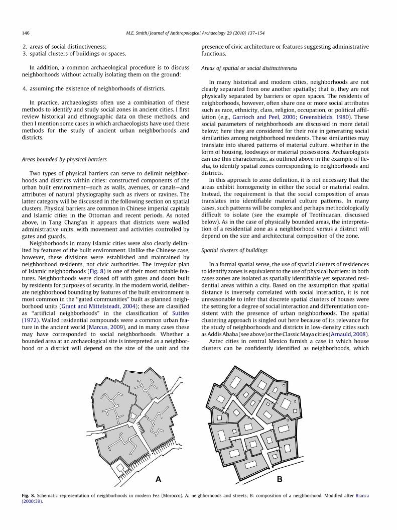
Neighborhoods in many Islamic cities were also clearly delim-ited by features of the built environment. Unlike the Chinese case,however, these divisions were established and maintained byneighborhood residents, not civic authorities. The irregular planof Islamic neighborhoods (Fig. 8) is one of their most notable fea-tures. Neighborhoods were closed off with gates and doors builtby residents for purposes of security. In the modern world, deliber-ate neighborhood bounding by features of the built environment ismost common in the ‘‘gated communities” built as planned neigh-borhood units (Grant and Mittelsteadt, 2004); these are classifiedas ‘‘artificial neighborhoods” in the classification of Suttles(1972). Walled residential compounds were a common urban fea-ture in the ancient world (Marcus, 2009), and in many cases thesemay have corresponded to social neighborhoods. Whether abounded area at an archaeological site is interpreted as a neighbor-hood or a district will depend on the size of the unit and the
Fig. 8. Schematic representation of neighborhoods in modern Fez (Morocco). A: neig(2000:39).
presence of civic architecture or features suggesting administrativefunctions.
Areas of spatial or social distinctiveness
In many historical and modern cities, neighborhoods are notclearly separated from one another spatially; that is, they are notphysically separated by barriers or open spaces. The residents ofneighborhoods, however, often share one or more social attributessuch as race, ethnicity, class, religion, occupation, or political affil-iation (e.g., Garrioch and Peel, 2006; Greenshields, 1980). Thesesocial parameters of neighborhoods are discussed in more detailbelow; here they are considered for their role in generating socialsimilarities among neighborhood residents. These similarities maytranslate into shared patterns of material culture, whether in theform of housing, foodways or material possessions. Archaeologistscan use this characteristic, as outlined above in the example of Ile-sha, to identify spatial zones corresponding to neighborhoods anddistricts.
In this approach to zone definition, it is not necessary that theareas exhibit homogeneity in either the social or material realm.Instead, the requirement is that the social composition of areastranslates into identifiable material culture patterns. In manycases, such patterns will be complex and perhaps methodologicallydifficult to isolate (see the example of Teotihuacan, discussedbelow). As in the case of physically bounded areas, the interpreta-tion of a residential zone as a neighborhood versus a district willdepend on the size and architectural composition of the zone.
Spatial clusters of buildings
In a formal spatial sense, the use of spatial clusters of residencesto identify zones is equivalent to the use of physical barriers: in bothcases zones are isolated as spatially identifiable yet separated resi-dential areas within a city. Based on the assumption that spatialdistance is inversely correlated with social interaction, it is notunreasonable to infer that discrete spatial clusters of houses werethe setting for a degree of social interaction and differentiation con-sistent with the presence of urban neighborhoods. The spatialclustering approach is singled out here because of its relevance forthe study of neighborhoods and districts in low-density cities suchas Addis Ababa (see above) or the Classic Maya cities (Arnauld, 2008).
Aztec cities in central Mexico furnish a case in which houseclusters can be confidently identified as neighborhoods, which
hborhoods and streets; B: composition of a neighborhood. Modified after Bianca
M.E. Smith / Journal of Anthropological Archaeology 29 (2010) 137–154 147
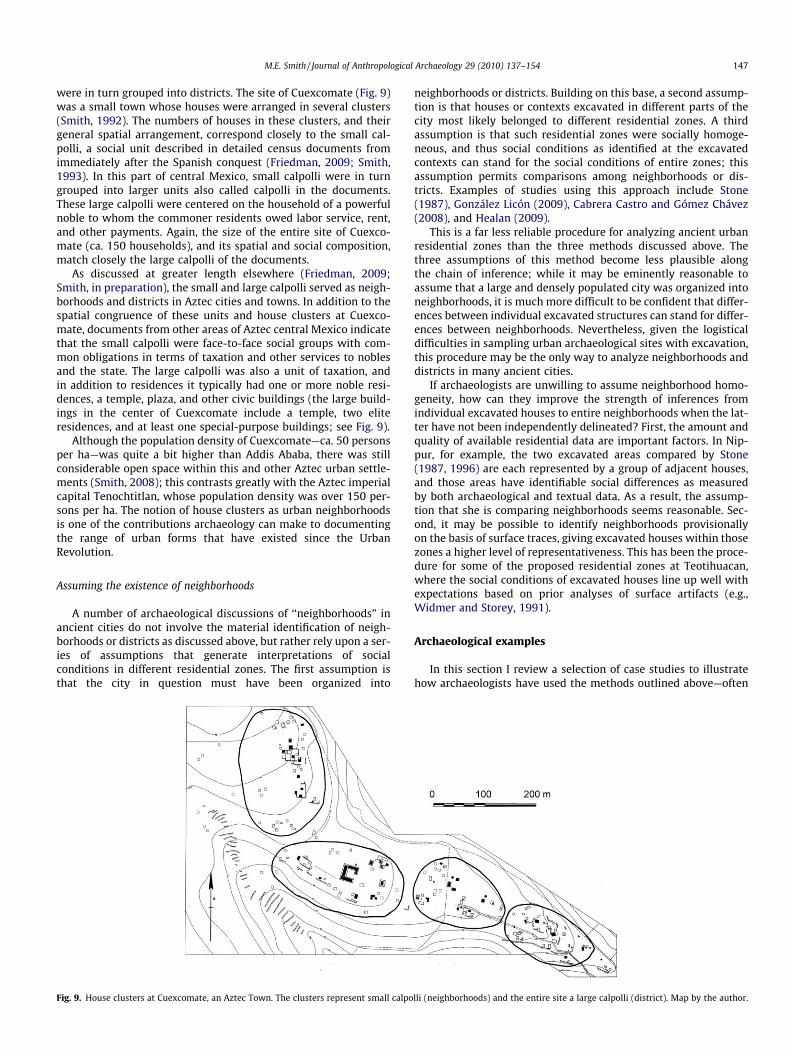
were in turn grouped into districts. The site of Cuexcomate (Fig. 9)was a small town whose houses were arranged in several clusters(Smith, 1992). The numbers of houses in these clusters, and theirgeneral spatial arrangement, correspond closely to the small cal-polli, a social unit described in detailed census documents fromimmediately after the Spanish conquest (Friedman, 2009; Smith,1993). In this part of central Mexico, small calpolli were in turngrouped into larger units also called calpolli in the documents.These large calpolli were centered on the household of a powerfulnoble to whom the commoner residents owed labor service, rent,and other payments. Again, the size of the entire site of Cuexco-mate (ca. 150 households), and its spatial and social composition,match closely the large calpolli of the documents.
As discussed at greater length elsewhere (Friedman, 2009;Smith, in preparation), the small and large calpolli served as neigh-borhoods and districts in Aztec cities and towns. In addition to thespatial congruence of these units and house clusters at Cuexco-mate, documents from other areas of Aztec central Mexico indicatethat the small calpolli were face-to-face social groups with com-mon obligations in terms of taxation and other services to noblesand the state. The large calpolli was also a unit of taxation, andin addition to residences it typically had one or more noble resi-dences, a temple, plaza, and other civic buildings (the large build-ings in the center of Cuexcomate include a temple, two eliteresidences, and at least one special-purpose buildings; see Fig. 9).
Although the population density of Cuexcomate—ca. 50 personsper ha—was quite a bit higher than Addis Ababa, there was stillconsiderable open space within this and other Aztec urban settle-ments (Smith, 2008); this contrasts greatly with the Aztec imperialcapital Tenochtitlan, whose population density was over 150 per-sons per ha. The notion of house clusters as urban neighborhoodsis one of the contributions archaeology can make to documentingthe range of urban forms that have existed since the UrbanRevolution.
Assuming the existence of neighborhoods
A number of archaeological discussions of ‘‘neighborhoods” inancient cities do not involve the material identification of neigh-borhoods or districts as discussed above, but rather rely upon a ser-ies of assumptions that generate interpretations of socialconditions in different residential zones. The first assumption isthat the city in question must have been organized into
Fig. 9. House clusters at Cuexcomate, an Aztec Town. The clusters represent small calpo
neighborhoods or districts. Building on this base, a second assump-tion is that houses or contexts excavated in different parts of thecity most likely belonged to different residential zones. A thirdassumption is that such residential zones were socially homoge-neous, and thus social conditions as identified at the excavatedcontexts can stand for the social conditions of entire zones; thisassumption permits comparisons among neighborhoods or dis-tricts. Examples of studies using this approach include Stone(1987), González Licón (2009), Cabrera Castro and Gómez Chávez(2008), and Healan (2009).
This is a far less reliable procedure for analyzing ancient urbanresidential zones than the three methods discussed above. Thethree assumptions of this method become less plausible alongthe chain of inference; while it may be eminently reasonable toassume that a large and densely populated city was organized intoneighborhoods, it is much more difficult to be confident that differ-ences between individual excavated structures can stand for differ-ences between neighborhoods. Nevertheless, given the logisticaldifficulties in sampling urban archaeological sites with excavation,this procedure may be the only way to analyze neighborhoods anddistricts in many ancient cities.
If archaeologists are unwilling to assume neighborhood homo-geneity, how can they improve the strength of inferences fromindividual excavated houses to entire neighborhoods when the lat-ter have not been independently delineated? First, the amount andquality of available residential data are important factors. In Nip-pur, for example, the two excavated areas compared by Stone(1987, 1996) are each represented by a group of adjacent houses,and those areas have identifiable social differences as measuredby both archaeological and textual data. As a result, the assump-tion that she is comparing neighborhoods seems reasonable. Sec-ond, it may be possible to identify neighborhoods provisionallyon the basis of surface traces, giving excavated houses within thosezones a higher level of representativeness. This has been the proce-dure for some of the proposed residential zones at Teotihuacan,where the social conditions of excavated houses line up well withexpectations based on prior analyses of surface artifacts (e.g.,Widmer and Storey, 1991).
Archaeological examples
In this section I review a selection of case studies to illustratehow archaeologists have used the methods outlined above—often
lli (neighborhoods) and the entire site a large calpolli (district). Map by the author.
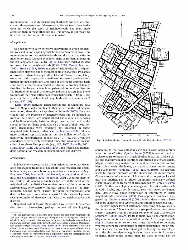
Fig. 10. Old Babylonian residential zone at Ur. Modified after Keith (2003:67).
148 M.E. Smith / Journal of Anthropological Archaeology 29 (2010) 137–154
in combination—to study ancient neighborhoods and districts. I fo-cus on Mesopotamia and Mesoamerica, the ancient urban tradi-tions in which the topic of neighborhoods has seen moreattention than in most other regions. This review is not meant tobe exhaustive, but rather illustrative in nature.
Mesopotamia
As a region with early extensive excavations of urban residen-tial zones, it is not surprising that Mesopotamian cities have seenmore attention to their neighborhoods and districts than cities inmost other areas. Leonard Woolley’s plans of residential zones inthe Old Babylonian levels of Ur (Fig. 10) have been much discussedin terms of urban neighborhoods (Keith, 2003; Van De Mieroop,1992). Stone’s (1987, 1996) analysis of neighborhoods at Nippur(mentioned above) is one of the most complete analyses. Two areasof crowded urban housing—called TA and TB—were completelyexcavated and mapped, and cuneiform documents provide infor-mation on their inhabitants and some of their legal dealings. Eachzone seems centered on a central institution: a prominent familythat lived in TA and a temple or palace whose workers lived inTB. Subtle differences in architecture and social factors lead Stoneto conclude that, ‘‘The differences which distinguish TA from TB areprecisely those which defined neighborhoods in Islamic cities”(Stone, 1987:126).
Keith (1999) analyzed archaeological and documentary datafrom Ur, Nippur, and a number of other cities from the Old Babylo-nian period; these data are synthesized in Keith (2003). She con-cludes that the presence of neighborhoods can be inferred atmost of these cities. Each neighborhood had a variety of servicesand facilities (chapels, bakeries, shops, taverns, and craft work-shops) so that residents could take care of most of their needs lo-cally. Occupations were evidently not clustered in theseneighborhoods, however. Marc Van de Mieroop (1992) takes amore cautious approach, pointing out the difficulties of clearlyidentifying neighborhoods or districts at Ur (Fig. 10). Given theabundance of extensively excavated residential areas in the ancientcities of southern Mesopotamia (e.g., Hill, 1967; Rainville, 2001;Stone, 2009; Stone and Zimansky, 2004), this region has tremen-dous potential for research on neighborhoods and districts.
Mesoamerica
In Mesoamerica, research on urban residential zones has devel-oped out of a long tradition of household-level research, and neigh-borhood analysis is now becoming an active area of research (e.g.,Friedman, 2009; Manzanilla and Arnauld, in preparation; Manza-nilla and Chapdelaine, 2009; Robertson, 2001). Whereas most ofthe work in Mesopotamia has been focused at the level of theneighborhood, the district has received much of the attention inMesoamerica. Unfortunately, the near-universal use of the inap-propriate Spanish term ‘‘barrio” for both neighborhoods anddistricts hampers comparative analysis.4 In this section I presentseveral examples of Mesoamerican research on neighborhoods anddistricts.
Neighborhoods at Classic Maya cities have received little atten-tion from archaeologists, perhaps because of the lingering
4 The conquering Spaniards used the term ‘‘barrio” for both urban neighborhoodsand rural villages. Because this usage corresponds to the indigenous concept ofcalpolli, it might be considered an apt term for ancient neighborhoods. Nevertheless, amuch more common usage of the term ‘‘barrio” today refers to modern Mesoamer-ican peasant villages (Mulhare, 1996; Thomas, 1979). Several centuries of state andurban domination have made Mesoamerican peasant barrios quite different fromPrehispanic urban neighborhoods (or rural villages, for that matter), and thus the useof the term ‘‘barrio” for Prehispanic units is imprecise at best, and inappropriate andmisleading at worst. For discussion, see Smith (in preparation).
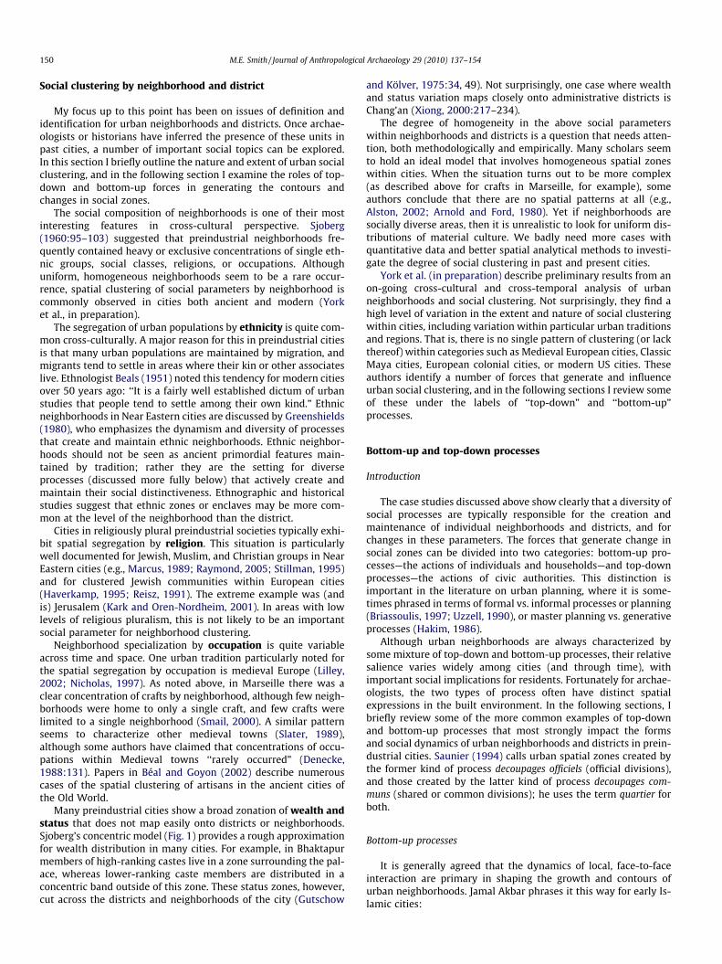
adherence to the now-outdated view that Classic Maya centerswere not ‘‘real” cities. Cynthia Robin (2003) is one of the firstarchaeologists to propose that neighborhoods existed at Maya cit-ies, and that they could be identified and studied by archaeologists.Mayanists have long analyzed settlement patterns in terms of fivehierarchical levels: the house, patio group, cluster, minor center,and major center (Ashmore, 1981a; Bullard, 1960). The relevantlevels for present purposes are the cluster and the minor center.Clusters consist of a number of houses and patio groups locatednear one another. Fig. 11 shows an impressionistically-definedcluster in one of the transects at Tikal mapped by Dennis Puleston(1983). On the basis of general analogy with historical cities suchas Addis Ababa, and specific comparisons with Aztec settlementdata, Classic Maya house clusters can be interpreted as urbanneighborhoods (Friedman, 2009). This approach has been sug-gested by Charlotte Arnauld (2008:13–14). Maya clusters haveyet to be subjected to a systematic and comprehensive analysis.
The next higher level of settlement patterning at Maya sites isthe ‘‘minor center.” Minor centers are groups of one or more houseclusters centered around a modest complex of civic architecture(Ashmore, 1981b; Bullard, 1960). In their layout and composition,Maya minor centers are equivalent to the Aztec large calpolli(Fig. 9). Some minor centers constitute individual settlements,whereas others are components of larger settlements (major cen-ters, or cities in current terminology). Following the same logicas in the cluster–calpolli–neighborhood association for Aztec set-tlements, those minor centers that are parts of cities can be
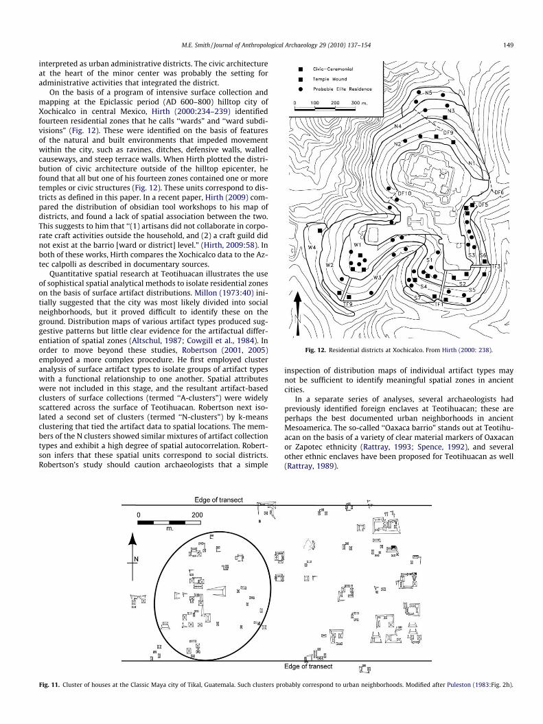
Fig. 12. Residential districts at Xochicalco. From Hirth (2000: 238).
M.E. Smith / Journal of Anthropological Archaeology 29 (2010) 137–154 149
interpreted as urban administrative districts. The civic architectureat the heart of the minor center was probably the setting foradministrative activities that integrated the district.
On the basis of a program of intensive surface collection andmapping at the Epiclassic period (AD 600–800) hilltop city ofXochicalco in central Mexico, Hirth (2000:234–239) identifiedfourteen residential zones that he calls ‘‘wards” and ‘‘ward subdi-visions” (Fig. 12). These were identified on the basis of featuresof the natural and built environments that impeded movementwithin the city, such as ravines, ditches, defensive walls, walledcauseways, and steep terrace walls. When Hirth plotted the distri-bution of civic architecture outside of the hilltop epicenter, hefound that all but one of his fourteen zones contained one or moretemples or civic structures (Fig. 12). These units correspond to dis-tricts as defined in this paper. In a recent paper, Hirth (2009) com-pared the distribution of obsidian tool workshops to his map ofdistricts, and found a lack of spatial association between the two.This suggests to him that ‘‘(1) artisans did not collaborate in corpo-rate craft activities outside the household, and (2) a craft guild didnot exist at the barrio [ward or district] level.” (Hirth, 2009:58). Inboth of these works, Hirth compares the Xochicalco data to the Az-tec calpolli as described in documentary sources.
Quantitative spatial research at Teotihuacan illustrates the useof sophistical spatial analytical methods to isolate residential zoneson the basis of surface artifact distributions. Millon (1973:40) ini-tially suggested that the city was most likely divided into socialneighborhoods, but it proved difficult to identify these on theground. Distribution maps of various artifact types produced sug-gestive patterns but little clear evidence for the artifactual differ-entiation of spatial zones (Altschul, 1987; Cowgill et al., 1984). Inorder to move beyond these studies, Robertson (2001, 2005)employed a more complex procedure. He first employed clusteranalysis of surface artifact types to isolate groups of artifact typeswith a functional relationship to one another. Spatial attributeswere not included in this stage, and the resultant artifact-basedclusters of surface collections (termed ‘‘A-clusters”) were widelyscattered across the surface of Teotihuacan. Robertson next iso-lated a second set of clusters (termed ‘‘N-clusters”) by k-meansclustering that tied the artifact data to spatial locations. The mem-bers of the N clusters showed similar mixtures of artifact collectiontypes and exhibit a high degree of spatial autocorrelation. Robert-son infers that these spatial units correspond to social districts.Robertson’s study should caution archaeologists that a simple
Fig. 11. Cluster of houses at the Classic Maya city of Tikal, Guatemala. Such clusters pro
inspection of distribution maps of individual artifact types maynot be sufficient to identify meaningful spatial zones in ancientcities.
In a separate series of analyses, several archaeologists hadpreviously identified foreign enclaves at Teotihuacan; these areperhaps the best documented urban neighborhoods in ancientMesoamerica. The so-called ‘‘Oaxaca barrio” stands out at Teotihu-acan on the basis of a variety of clear material markers of Oaxacanor Zapotec ethnicity (Rattray, 1993; Spence, 1992), and severalother ethnic enclaves have been proposed for Teotihuacan as well(Rattray, 1989).
bably correspond to urban neighborhoods. Modified after Puleston (1983:Fig. 2h).
150 M.E. Smith / Journal of Anthropological Archaeology 29 (2010) 137–154
Social clustering by neighborhood and district
My focus up to this point has been on issues of definition andidentification for urban neighborhoods and districts. Once archae-ologists or historians have inferred the presence of these units inpast cities, a number of important social topics can be explored.In this section I briefly outline the nature and extent of urban socialclustering, and in the following section I examine the roles of top-down and bottom-up forces in generating the contours andchanges in social zones.
The social composition of neighborhoods is one of their mostinteresting features in cross-cultural perspective. Sjoberg(1960:95–103) suggested that preindustrial neighborhoods fre-quently contained heavy or exclusive concentrations of single eth-nic groups, social classes, religions, or occupations. Althoughuniform, homogeneous neighborhoods seem to be a rare occur-rence, spatial clustering of social parameters by neighborhood iscommonly observed in cities both ancient and modern (Yorket al., in preparation).
The segregation of urban populations by ethnicity is quite com-mon cross-culturally. A major reason for this in preindustrial citiesis that many urban populations are maintained by migration, andmigrants tend to settle in areas where their kin or other associateslive. Ethnologist Beals (1951) noted this tendency for modern citiesover 50 years ago: ‘‘It is a fairly well established dictum of urbanstudies that people tend to settle among their own kind.” Ethnicneighborhoods in Near Eastern cities are discussed by Greenshields(1980), who emphasizes the dynamism and diversity of processesthat create and maintain ethnic neighborhoods. Ethnic neighbor-hoods should not be seen as ancient primordial features main-tained by tradition; rather they are the setting for diverseprocesses (discussed more fully below) that actively create andmaintain their social distinctiveness. Ethnographic and historicalstudies suggest that ethnic zones or enclaves may be more com-mon at the level of the neighborhood than the district.
Cities in religiously plural preindustrial societies typically exhi-bit spatial segregation by religion. This situation is particularlywell documented for Jewish, Muslim, and Christian groups in NearEastern cities (e.g., Marcus, 1989; Raymond, 2005; Stillman, 1995)and for clustered Jewish communities within European cities(Haverkamp, 1995; Reisz, 1991). The extreme example was (andis) Jerusalem (Kark and Oren-Nordheim, 2001). In areas with lowlevels of religious pluralism, this is not likely to be an importantsocial parameter for neighborhood clustering.
Neighborhood specialization by occupation is quite variableacross time and space. One urban tradition particularly noted forthe spatial segregation by occupation is medieval Europe (Lilley,2002; Nicholas, 1997). As noted above, in Marseille there was aclear concentration of crafts by neighborhood, although few neigh-borhoods were home to only a single craft, and few crafts werelimited to a single neighborhood (Smail, 2000). A similar patternseems to characterize other medieval towns (Slater, 1989),although some authors have claimed that concentrations of occu-pations within Medieval towns ‘‘rarely occurred” (Denecke,1988:131). Papers in Béal and Goyon (2002) describe numerouscases of the spatial clustering of artisans in the ancient cities ofthe Old World.
Many preindustrial cities show a broad zonation of wealth andstatus that does not map easily onto districts or neighborhoods.Sjoberg’s concentric model (Fig. 1) provides a rough approximationfor wealth distribution in many cities. For example, in Bhaktapurmembers of high-ranking castes live in a zone surrounding the pal-ace, whereas lower-ranking caste members are distributed in aconcentric band outside of this zone. These status zones, however,cut across the districts and neighborhoods of the city (Gutschow
and Kölver, 1975:34, 49). Not surprisingly, one case where wealthand status variation maps closely onto administrative districts isChang’an (Xiong, 2000:217–234).
The degree of homogeneity in the above social parameterswithin neighborhoods and districts is a question that needs atten-tion, both methodologically and empirically. Many scholars seemto hold an ideal model that involves homogeneous spatial zoneswithin cities. When the situation turns out to be more complex(as described above for crafts in Marseille, for example), someauthors conclude that there are no spatial patterns at all (e.g.,Alston, 2002; Arnold and Ford, 1980). Yet if neighborhoods aresocially diverse areas, then it is unrealistic to look for uniform dis-tributions of material culture. We badly need more cases withquantitative data and better spatial analytical methods to investi-gate the degree of social clustering in past and present cities.
York et al. (in preparation) describe preliminary results from anon-going cross-cultural and cross-temporal analysis of urbanneighborhoods and social clustering. Not surprisingly, they find ahigh level of variation in the extent and nature of social clusteringwithin cities, including variation within particular urban traditionsand regions. That is, there is no single pattern of clustering (or lackthereof) within categories such as Medieval European cities, ClassicMaya cities, European colonial cities, or modern US cities. Theseauthors identify a number of forces that generate and influenceurban social clustering, and in the following sections I review someof these under the labels of ‘‘top-down” and ‘‘bottom-up”processes.
Bottom-up and top-down processes
Introduction
The case studies discussed above show clearly that a diversity ofsocial processes are typically responsible for the creation andmaintenance of individual neighborhoods and districts, and forchanges in these parameters. The forces that generate change insocial zones can be divided into two categories: bottom-up pro-cesses—the actions of individuals and households—and top-downprocesses—the actions of civic authorities. This distinction isimportant in the literature on urban planning, where it is some-times phrased in terms of formal vs. informal processes or planning(Briassoulis, 1997; Uzzell, 1990), or master planning vs. generativeprocesses (Hakim, 1986).
Although urban neighborhoods are always characterized bysome mixture of top-down and bottom-up processes, their relativesalience varies widely among cities (and through time), withimportant social implications for residents. Fortunately for archae-ologists, the two types of process often have distinct spatialexpressions in the built environment. In the following sections, Ibriefly review some of the more common examples of top-downand bottom-up processes that most strongly impact the formsand social dynamics of urban neighborhoods and districts in prein-dustrial cities. Saunier (1994) calls urban spatial zones created bythe former kind of process decoupages officiels (official divisions),and those created by the latter kind of process decoupages com-muns (shared or common divisions); he uses the term quartier forboth.
Bottom-up processes
It is generally agreed that the dynamics of local, face-to-faceinteraction are primary in shaping the growth and contours ofurban neighborhoods. Jamal Akbar phrases it this way for early Is-lamic cities:
M.E. Smith / Journal of Anthropological Archaeology 29 (2010) 137–154 151
Putting all these pieces together we may conclude that all thedecisions in these towns were made by the inhabitants, withno intervention from the central authority. Shared places suchas forecourts, squares, streets, and culs-de-sac within the khitta[a new settlement area] were collectively owned and con-trolled. The town thereby became a series of adjacent propertiescontrolled by its users, suggesting that the morphology of thesetowns came about as the result of the many small decisionsmade by the settlers themselves.” (Akbar, 1989:29)
But why did neighborhoods form as they did, and how are theymaintained over time? A possible answer is given by Greenshieldsin his isolation of two forces that create and maintain ethnicneighborhoods:
1. Help given by established migrants in finding homes and jobsfor immigrant relatives and friends near their own dwellings.2. Maintenance of ethnic solidarity as a form of migrant adjust-ment to urban life (Greenshields, 1980:133).
Migration is a key force in the creation and maintenance ofurban neighborhoods. Preindustrial cities had a poor balancebetween mortality and fertility, and could not maintain their pop-ulations without continual migration from the countryside (McNe-ill, 1976; Storey, 2006). In many documented cases, migrants tendto cluster in specific neighborhoods (e.g., Abu-Lughod, 1969; Sut-ton, 1983), as suggested above by Greenshields. The fact that urbanmigrants often maintain strong social ties to their rural village oforigin (Lewis, 1952; Simic, 1973) contributes to the continuingmaintenance of neighborhoods with distinctive social attributes.
Another relevant bottom-up process is a sense of communityand personal identification with one’s neighborhood. Comparativedata suggest that the notion of neighborhood identity (or therelated concept, ‘‘neighborhood attachment”) is a common, per-haps universal, attribute of neighborhoods cross-culturally. Neigh-borhood identity is reported in ethnographic studies ofnonwestern cities (Mills, 2004), in documentary analyses of prein-dustrial cities (Marcus, 1989; Smail, 2000), and in sociologicalresearch on modern industrial cities (Greif, 2009). The topic ofidentification with one’s district may be more variable. As notedabove, Smail’s data make it clear that the residents of Marseilleshowed little identification with their sixtain, in contrast to othermedieval and renaissance towns, where such identification hasbeen identified (Kent and Kent, 1982). Residents of Bhaktapur sim-ilarly show a sense of allegiance and identification with their twa:(this is the district level of twa: Levy, 1990).
In many urban neighborhoods, people design and build theirown houses. When this pattern is combined with the foundingand expansion of neighborhoods outside of the domain of centralplanners, the result is another example of bottom-up neighbor-hood processes that can be documented archaeologically (Figs.8–10). In the contemporary world, this process is most visible inthe informal, spontaneous settlements that surround many cities(Neuwirth, 2004; UNCHS/Habitat, 2003). According to some schol-ars (Hardoy, 1982; Kellett and Napier, 1995), such informal hous-ing was also prevalent in ancient cities, a theme I exploreelsewhere (Smith, in press). For present purposes, the importantobservation is that unplanned urban residential zones provideclear spatial evidence for the operation of bottom-up processeson the neighborhood level.
Top-down processes
Some planners have argued that social clustering in cities isalways the result of state policies. Peter Marcuse, for exampleargues that ‘‘The state has been decisive in creating, maintaining,
or destroying partitions in all periods, but the state has been itselfthe decisive power in earlier periods” (Marcuse, 2002:31). His col-league, Ronald Van Kempen provides a similar perspective: ‘‘Citiesare not ‘naturally’ divided: they are actively partitioned. There arethose that do the partitioning, and those that are subject to it” (VanKempen, 2002:50). This interpretation, however, ignores ratherabundant evidence for bottom-up forces in generating social clus-tering and urban social divisions (see above).
By definition, administrative districts arise and are maintainedthrough (top-down) processes of administration. Sometimes theseforces are secular in nature (e.g., Marseille and Addis Ababa), andsometimes religion plays a major role together with secularadministration (e.g., Chang’an, Bhaktapur, and Ilesha). The weightof top-down forces were particularly great in Chang’an, wherethe whole city was designed and built to a common cosmologi-cal-administrative plan. Once built, the hand of administrationcontinued to rest heavily on urban residents with the system ofclosed and regulated districts. In other areas, cities like Marseilleor Bhaktapur were founded and grew with much less politicaldirection, and when administrative boundaries were drawn, theytended to follow the street layout of the city. As noted above, thepresence of a consistent type of civic building or complex is oftenthe best archaeological evidence for the presence of administrativedistricts in ancient cities.
Janet Abu-Lughod discusses how the relationship of Islamicneighborhoods to the outside world changes with the waxingand waning of external political power:
Historically, in Arabo-Islamic cities, the neighborhood has beenin dialectical process with the external society. When centralpower was strong and when the city-wide hierarchical struc-ture was working smoothly, agents of the central administra-tion operated within the neighborhoods to provideinformation to the center and ensure conformance with centraldirectives . . . Sometimes, the neighborhood was an administra-tive subset of the state.
More often, however, the quarter played the opposite role, thatof a defended neighborhood, particularly when chaos reigned.One reads, in the historical accounts, of civil strife/invasions/street battles, the recurring phrase, ‘‘and people closed the gatesto their harat” [neighborhood]. Alternatively, to gain controlover the city, conquerors always had to destroy the gates tothe harat, as Napoleon’s forces did when they invaded Cairo.(Abu-Lughod, 1987:171)
Stability and change in neighborhoods and districts are alwaysbalanced between external, top-down, forces and internal, bottom-up dynamics. Just as the relative importance of these processes canvary over time within individual cities or urban traditions, so toocan their balance vary synchronically among cities and urbantraditions.
Conclusions
Neighborhoods and districts have always important compo-nents of cities, from Uruk to Brasilia, and their analysis can shedlight on a wide range of urban issues, from demography to ethnic-ity to crime. The comparative literature on modern and historicalurban residential zones provides a conceptual framework thatcan guide archaeological research. As more attention is given toneighborhoods and districts by archaeologists, our methods andinterpretations will improve, leading to a richer understanding ofthe nature of past urban processes.
The arguments for an increased attention to ancientneighborhoods and districts go beyond archaeology and history,
152 M.E. Smith / Journal of Anthropological Archaeology 29 (2010) 137–154
however. These concepts play prominent roles in research on con-temporary urban issues. For example, neighborhoods havemeasurable effects on crime, poverty, segregation, and other urbanprocesses (Sampson et al., 2002). Neighborhoods also contribute tothe creation, maintenance, and expression of cultural and socialdiversity within cities, and some scholars are now turning to pre-modern and nonwestern cities and their neighborhoods to helpunderstand the modern, western situation (Briggs, 2004; Grillo,2000; York, et al., in preparation). The concept of neighborhood-as-community, which plays a prominent role in current planningtheory (Chaskin, 1998; Congress for the New Urbanism, 1996;Talen, 2006), is based in part on untested assumptions about thesocial composition and processes of premodern neighborhoods.An improved archaeological understanding of ancient urban neigh-borhoods has the potential not only to illuminate past urbanprocesses, but also to contribute data and concepts to scholarshipon comparative urbanism and the roles of cities in modern life.
Acknowledgments
This paper was written as part of the transdisciplinary researchproject, ‘‘Urban Organization Through the Ages: Neighborhoods,Open Spaces, and Urban Life” (http://latelessons.asu.edu/urban); Ithank my co-participants in that project for their ideas and com-ments, particularly the PIs (Christopher Boone, George Cowgill,Sharon Harlan, Barbara Stark, and Abigail York) and students Mari-cha Friedman, Juliana Novic, and Benjamin Stanley. Some of theideas presented here were first assembled for a symposium atthe 2008 meeting of the Society for American Archaeology; I thankCharlotte Arnauld and Linda Manzanilla for the opportunity to par-ticipate in their session. Several colleagues kindly provideddetailed comments on earlier drafts of this paper, and I thankGeorge Cowgill, Juliana Novic, Helen Pollard, Ian Robertson, Cyn-thia Robin, and Barbara Stark. Two anonymous reviewers madeastute suggestions that resulted in several improvements in theargument. Juliana Novic and Kristin Campbell helped with datagathering in 2008 and 2009.
References
Abu-Lughod, J.L., 1969. Migrant adjustment to city life: the Egyptian case. In:Breese, G. (Ed.), The City in Newly Developing Countries. Prentice-Hall,Englewood Cliffs, pp. 376–388.
Abu-Lughod, J.L., 1987. The Islamic city: historic myth, Islamic essence, andcontemporary relevance. International Journal of Middle Eastern Studies 19,155–176.
Adler, M.A. (Ed.), 1996. The Prehistoric Pueblo World, A.D. 1150–1350. University ofArizona Press, Tucson.
Ahmad, A.H., 1989. Darita, Bagemdir: an historic town and its muslim population,1830–1889. International Journal of African Historical Studies 22, 439–451.
Akbar, J., 1989. Khatta and the territorial structure of early muslim towns.Muqarnas 6, 22–32.
Alexander, C., 1972. A city is not a tree. In: Bell, G., Tyrwhitt, J. (Eds.), HumanIdentity in the Urban Environment. Penguin, Harmondworth, pp. 401–428 (orig.pub. 1965).
Alston, R., 2002. The City in Roman and Byzantine Egypt. Routledge, London.Altschul, J.H., 1987. Social districts of Teotihuacan. In: McClung de Tapia, E., Rattray,
E.C. (Eds.), Teotihuacán: nuevos datos, nuevas síntesis, nuevos problemas.Universidad Nacional Autónoma de México, Mexico City, pp. 191–207.
American Planning Association, 2006. Neighborhoods, Planning and Urban DesignStandards. John Wiley and Sons, New York, pp. 409–411.
Andrews, G.F., 1975. Maya Cities: Placemaking and Urbanization. University ofOklahoma Press, Norman.
Arnauld, M.C., 2008. Maya Urbanization: Agrarian cities in a preindustrial world. In:Mastache, A.G., Cobean, R.H., García Cook, Á., Hirth, K.G. (Eds.), El urbanismo enmesoamérica/Urbanism in Mesoamerica. Pennsylvania State University andInstituto Nacional de Antropología e Historia, University Park and Mexico City,pp. 1–36.
Arnold, J.E., Ford, A., 1980. A statistical examination of settlement patterns at Tikal,Guatemala. American Antiquity 45, 713–726.
Ashmore, W. (Ed.), 1981a. Lowland Maya Settlement Patterns. University of NewMexico Press, Albuquerque.
Ashmore, W., 1981b. Some issues of method and theory in lowland Mayasettlement archaeology. In: Ashmore, W. (Ed.), Lowland Maya SettlementPatterns. University of New Mexico Press, Albuquerque, pp. 37–69.
Béal, J.-C., Goyon, J.-C. (Eds.), 2002. Les Artisans dans la Ville Antique. UniversitéLumière-Lyon 2, Lyon.
Beals, R.L., 1951. Urbanism, urbanization and acculturation. AmericanAnthropologist 53, 1–10.
Bell, G., Tyrwhitt, J., 1972. Introduction to society: the human community. In: Bell,G., Tyrwhitt, J. (Eds.), Human Identity in the Urban Environment. Penguin,Harmondworth, pp. 231–239.
Bianca, S., 2000. Urban form in the Arab world. Thames and Hudson, New York.Briassoulis, H., 1997. How the others plan: exploring the shape and forms of
informal planning. Journal of Planning Education and Research 17, 105–117.Briggs, X.d.S., 2004. Civilization in color: the multicultural city in three millennia.
City and Community 3, 311–342.Briggs, X.d.S., 2008. On half-blind men and elephants: understanding greater ethnic
diversity and responding to ‘‘good-enough” evidence. Housing Policy Debate 19,218–229.
Bullard Jr., W.R., 1960. Maya settlement pattern in northeastern peten, Guatemalaa.American Antiquity 25, 355–372.
Burgess, E., 1923. The growth of the city: an introduction to a research project.Proceedings of the American Sociological Society 18, 85–97.
Cabrera Castro, R., Gómez Chávez, S., 2008. La Ventilla: a model for a barrio in theurban structure of Teotihuacan. In: Mastache, A.G., Cobean, R.H., García Cook, Á.,Hirth, K.G. (Eds.), El urbanismo en mesoamérica/Urbanism in Mesoamerica.Pennsylvania State University and Instituto Nacional de Antropología e Historia,University Park and Mexico City, pp. 37–84.
Carmon, N., 2001. Neighborhood: general. In: Smelser, N.J., Baltes, P.B. (Eds.),International Encyclopedia of the Social and Behavioral Sciences. Pergamon,Oxford, pp. 10488–10494.
Chaskin, R.J., 1997. Perspectives on neighborhood and community: a review of theliterature. Social Service Review 71, 521–547.
Chaskin, R.J., 1998. Neighborhood as a unit of planning and action: a Heuristicapproach. Journal of Planning Literature 13, 11–30.
Chen, K.C., 2009. Enabling Creative Chaos: The Organization Behind the BurningMan Event. University of Chicago Press, Chicago.
Ciudad Ruiz, A., Iglesias Ponce de León, M.J., Martínez Martínez, M.d.C. (Eds.), 2001.Reconstruyendo la ciudad maya: el urbanismo en las sociedades antiguas.Sociedad Española de Estudios Mayas, Madrid.
Congress for the New Urbanism, 1996. Charter of the New Urbanism. Congress forthe New Urbanism.
Cowgill, G.L., 1997. State and society at Teotihuacan, Mexico. Annual Review ofAnthropology 26, 129–161.
Cowgill, G.L., Altshul, J.H., Slaod, R.S., 1984. Spatial analysis of Teotihuacan, aMesoamerican Metropolis. In: Hietala, H.J. (Ed.), Intrasite Spatial Analysis inArchaeology. Cambridge University Press, New York, pp. 154–195.
Denecke, D., 1988. Social status and place of residence in pre-industrial Germantowns: recent studies in social topography. In: Denecke, D., Shaw, G. (Eds.),Urban Historical Geography: Recent Progress in Britain and Germany.Cambridge University Press, New York, pp. 125–140.
Dickinson, R.E., 1961. The West European City: A Geographical Interpretation.Routledge & Paul, London.
Düring, B.S., Marciniak, A., 2006. Households and Communities in the CentralAnatolian Neolithic. Archaeological Dialogues 12, 165–187.
Evans, D., Pottier, C., Fletcher, R., Hensley, S., Tapley, I., Milne, A., Barbetti, M., 2007.A comprehensive archaeological map of the world’s largest preindustrialsettlement complex at Angkor, Cambodia. Proceedings of the NationalAcademy of Sciences 104, 14277–14282.
Fisher, J., 1984. Development from below: neighborhood improvement associationsin the Latin American squatter settlements. Studies in ComparativeInternational Development 19, 61–84.
Fletcher, R., 1991. Very large mobile communities: interaction stress and residentialdispersal. In: Gamble, C., Boismer, B. (Eds.), Ethnoarchaeological Approaches toMobile Campsites: Hunter–Gatherer and Pastoralist Case Studies. PrehistoryPress, Ann Arbor, pp. 395–420.
Fletcher, R., 1995. The Limits of Settlement Growth: A Theoretical Outline.Cambridge University Press, New York.
Fletcher, R., 2009. Low-Density, Agrarian-Based Urbanism: A Comparative View.Insights (University of Durham) 2, Article 4.
Fowles, S.M., 2005. Historical contingency and the prehistoric foundations of moietyorganization among the eastern Pueblos. Journal of Anthropological Research61, 25–52.
Friedman, M., 2009. Urban Neighborhoods in Ancient Mesoamerica (Senior HonorsThesis), Arizona State University.
Furuseth, O.J., 1997. Neotraditional planning: a new strategy for buildingneighborhoods? Land Use Policy 14, 201–213.
Garretson, P.P., 2000. A History of Addis Ababa from its Foundation in 1886 to 1910.Harrassowitz Verlag, Wiesbaden.
Garrioch, D., Peel, M., 2006. Introduction: the social history of urban neighborhoods.Journal of Urban History 32, 663–676.
Glass, R., 1948. The Social Background of a Plan: A Study of Middlesbrough.Routledge and Kegan Paul, London.
Gleichen, E., 1971. With the Mission to Menelik, 1897. Gregg InternationalPublishers, Farnborough, England.
González Licón, E., 2009. Ritual and social stratification at Monte Albán, Oaxaca:strategies from a household perspective. In: Manzanilla, L., Chapdelaine, C.
M.E. Smith / Journal of Anthropological Archaeology 29 (2010) 137–154 153
(Eds.), Domestic Life in Prehispanic Capitals: A Study of Specialization,Hierarchy, and Ethnicity. University of Michigan, Museum of Anthropology,Ann Arbor, pp. 7–20.
Goodman, P.J., 2007. The Roman City and its Periphery: From Rome to Gaul.Routledge, New York.
Grant, J., Mittelsteadt, L., 2004. Types of gated communities. Environment andPlanning B: Planning and Design 31, 913–930.
Greenshields, T.H., 1980. ‘‘Quarters” and ethnicity. In: Blake, G.H., Lawless, R.I.(Eds.), The Changing Middle Eastern City. Croom Helm, London, pp. 120–140.
Greif, M.J., 2009. Neighborhood attachment in the multiethnic metropolis. City andCommunity 8, 27–45.
Grillo, R.D., 2000. Plural cities in comparative perspective. Ethnic and Racial Studies23, 957–981.
Gutschow, N., 1993. Bhaktapur: sacred patterns of a living urban tradition. In:Spodek, H., Srinivasan, D.M. (Eds.), Urban Form and Meaning in South Asia: TheShaping of Cities from Prehistoric to Precolonial Times. National Gallery of Art,Washington, DC, pp. 163–183.
Gutschow, N., Kölver, B., 1975. Ordered Space Concepts and Functions in a Town ofNepal. Steiner, Wiesbaden.
Gutschow, N., Kölver, B., Shresthacarya, I., 1987. Newar Towns and Buildings: AnIllustrated Dictionary, Newari-English. VGH Wissenschaftsverlag, SanktAugustin.
Hakim, B.S., 1986. Arab-Islamic Cities: Building and Planning Principles. Routledge,London.
Hardoy, J.E., 1982. The building of Latin American cities. In: Gilbert, A.G. (Ed.),Urbanisation in Contemporary Latin America: Critical Approaches to theAnalysis of Urban Issues. Wiley, London, pp. 19–34.
Harris, C.D., Ullman, E.L., 1945. The nature of cities. Annals of the AmericanAcademy of Political and Social Sciences 242, 7–17.
Haverkamp, A., 1995. The Jewish Quarters in German Towns during the Late MiddleAges. In: Po-chia Hsia, R., Lehmann, H. (Eds.), In and Out of the Ghetto: Jewish-German Relations in Late Medieval and Early Modern Germany. CambridgeUniversity Press, New York, pp. 13–28.
Hawley, A.H., Duncan, O.D., 1957. Social area analysis: a critical appraisal. LandEconomics 33, 337–345.
Healan, D.M., 2009. Household, neighborhood, and urban structure in an ‘‘AdobeCity”: Tula, Hidalgo, Mexico. In: Manzanilla, L., Chapdelaine, C. (Eds.), DomesticLife in Prehispanic Capitals: A Study of Specialization, Hierarchy, and Ethnicity.University of Michigan, Museum of Anthropology, Ann Arbor, pp. 67–88.
Heng, C.K., 1999. Cities of Aristocrats and Bureaucrats: The Development ofMedieval Chinese Cityscapes. University of Hawai’i Press, Honolulu.
Herbert, D.T., Thomas, C.J., 1997. Cities in Space. City as Place. David Fulton, London.Hill, H.P., 1967. Tell Asmar: the private home area. In: Delougaz, P., Hill, H.P., Lloyd,
S. (Eds.), Private Houses and Graves in the Diyala Region. University of ChicagoPress, Chicago, pp. 143–181.
Hirth, K.G., 2000. Archaeological Research at Xochicalco, Volume 1, AncientUrbanism at Xochicalco: The Evolution and Organization of a Pre-HispanicSociety. University of Utah Press, Salt Lake City.
Hirth, K.G., 2009. Household, workshop, guild, and barrio: the organization ofobsidian craft production in a prehispanic urban center. In: Manzanilla, L.,Chapdelaine, C. (Eds.), Domestic Life in Prehispanic Capitals: A Study ofSpecialization, Hierarchy, and Ethnicity. University of Michigan, Museum ofAnthropology, Ann Arbor, pp. 43–66.
Hodder, I., 2006. The Leopard’s Tale: Revealing the Mysteries of Çatalhöyük. Thamesand Hudson, New York.
Horvath, R.J., 1969. The wandering capitals of Ethiopia. Journal of African History 10,205–219.
Hoyt, H., 1939. The Structure and Growth of Residential Neighborhoods in AmericanCities. Government Printing Office, Washington, DC.
Jacobs, J., 1961. The Death and Life of Great American Cities. Random House, NewYork.
Johnson, M.E., 1974. The Evolution of the Morphology of Addis Ababa, Ethiopia(Ph.D. dissertation), University of California, Los Angeles, Los Angeles.
Kark, R., Oren-Nordheim, M., 2001. Jerusalem and its Environs: Quarters,Neighborhoods, Villages 1800–1948. Wayne State University Press, Detroit.
Kearns, A., Parkinson, M., 2001. The significance of neighborhood. Urban Studies 38,2103–2110.
Keith, K., 1999. Cities, Neighborhoods, and Houses: Urban Spatial Organization inOld Babylonian Mesopotamia (Ph.D. dissertation), University of Michigan, AnnArbor.
Keith, K., 2003. The spatial patterns of everyday life in Old Babylonianneighborhoods. In: Smith, M.L. (Ed.), The Social Construction of Ancient Cities.Smithsonian Institution Press, Washington, DC, pp. 56–80.
Kellett, P., Napier, M., 1995. Squatter architecture? a critical examination ofvernacular theory and spontaneous settlement with reference to South Americaand South Africa. Traditional Dwellings and Settlements Review 6, 7–24.
Kent, D.V., Kent, F.W., 1982. Neighbours and neighbourhood in renaissance florence.the district of the red lion in the fifteenth century. J.J. Augustin, Locust Valley,NY.
Kracke Jr., E.A., 1975. Sung K’ai-feng: pragmatic metropolis and formalistic capital.In: Haeger, J.W. (Ed.), Crisis and Prosperity in Sung China. University of ArizonaPress, Tucson, pp. 49–77.
Levy, R.I., 1990. Mesocosm: Hinduism and the Organization of a Traditional NewarCity in Nepal. University of California Press, Berkeley.
Lewis, O., 1952. Urbanization without breakdown: a case study. Scientific Monthly75, 31–41.
Lilley, K.D., 2002. Urban Life in the Middle Ages, 1000–1450. Palgrave, New York.Lowell, J.C., 1996. Moieties in Prehistory: A Case Study from the Pueblo Southwest
Journal of Field Archaeology 23, pp. 77–90.Manzanilla, L., Arnauld, C. (Eds.), in preparation. Neighborhoods in Mesoamerican
Cities: The Assessment of Intermediate Units of Spatial and Social Analysis(tentative title).
Manzanilla, L., Chapdelaine, C. (Eds.), 2009. Domestic Life in Prehispanic Capitals: AStudy of Specialization, Hierarchy, and Ethnicity. University of Michigan,Museum of Anthropology, Ann Arbor.
Marcus, A., 1989. The Middle East on the Eve of Modernity: Aleppo in theEighteenth Century. Columbia University Press, New York.
Marcus, J., 1983. On the nature of the Mesoamerican city. In: Vogt, E.Z., Leventhal,R.M. (Eds.), Prehistoric Settlement Patterns: Essays in Honor of Gordon R.Willey. University of New Mexico Press, Albuquerque, pp. 195–242.
Marcus, J., 2009. Understanding houses, compounds, and neighborhoods. In:Manzanilla, L., Chapdelaine, C. (Eds.), Domestic Life in Prehispanic Capitals: AStudy of Specialization, Hierarchy, and Ethnicity. University of Michigan,Museum of Anthropology, Ann Arbor, pp. 255–266.
Marcuse, P., 2002. The partitioned city in history. In: Marcuse, P., van Kempen, R.(Eds.), Of States and Cities: The Partitioning of Urban Space. Oxford UniversityPress, New York, pp. 11–34.
McNeill, W.H., 1976. Plagues and Peoples. Academic Press, New York.Millon, R., 1973. Urbanization at Teotihuacan, Mexico, vol. 1: The Teotihuacan Map,
Part 1: Text. University of Texas Press, Austin.Mills, A., 2004. Streets of Memory: The Kuzguncuk Mahalle in Cultural Practice and
Imagination (Ph.D. dissertation), University of Texas, Austin.Mulhare, E.M., 1996. Barrio matters: toward an ethnology of Mesoamerican
customary social units. Ethnology 35, 93–106.Mumford, L., 1954. The neighborhood and the neighborhood unit. Town Planning
Review 24, 256–270.Neuwirth, R., 2004. Shadow Cities: A Billion Squatters, a New Urban World.
Routledge, New York.Nicholas, D., 1997. The Growth of the Medieval City: From Antiquity to the Early
Fourteenth Century. Addison Wesley, New York.Özbasaran, M., 2000. The Neolithic Site of Musular, Central Anatolia. Anatolica 26,
129–151.Pankhurst, R., 1985. History of Ethiopian Towns From the Mid-Nineteenth Century
to 1935. Franz Steinter Verlag, Stuttgart.Pankhurst, R.K., 1979. Ethiopian medieval and post medieval capitals: their
development and principal features. Azania 14, 2–29.Peel, J.D.Y., 1983. Ijeshas and Nigerians: The Incorporation of a Yoruba Kingdom,
1890s–1970s. Cambridge University Press, New York.Peel, J.D.Y., 2000. Yoruba as a city-state culture. In: Hansen, M.H. (Ed.), A
Comparative Study of Thirty City-State Cultures. The Royal Danish Academyof Sciences and Letters, Copenhagen, pp. 507–518.
Pollard, H.P., 1977. An analysis of urban zoning and planning in prehispanicTzintzuntzan. Proceedings of the American Philosophical Society 121,46–69.
Puleston, D.E., 1983. The Settlement Survey of Tikal. University of Pennsylvania,University Museum, Pennsylvania.
Rainville, L., 2001. The Organization of Domestic Activities in Upper MesopotamianHouseholds and Neighborhoods During the Early Bronze Age: A Micro-Archaeological and Architectural Approach (Ph.D. dissertation), University ofMichigan, Ann Orbor.
Rattray, E.C., 1989. El barrio de los comerciantes y el conjunto Tlamimilolpa: unestudio comparativo. Arqueología 5, 105–129.
Rattray, E.C., 1993. The Oaxaca Barrio at Teotihuacan. Instituto de EstudiosAvanzados, Universidad de las Américas, Puebla.
Raymond, A., 2005. Urban life and middle eastern cities: the traditional Arab city.In: Choueiri, Y.M. (Ed.), A Companion to the History of the Middle East.Blackwell, Oxford, pp. 207–226.
Reader, J., 2005. Cities. Vintage, New York.Reisz, M., 1991. Europe’s Jewish Quarters. Simon and Schuster, New York.Robertson, I.G., 2001. Mapping the Social Landscape of an Early Urban Center:
Socio-Spatial Variation in Teotihuacan (Ph. D. dissertation), Arizona StateUniversity, Tempe.
Robertson, I.G., 2005. Patrones diacrónicos en la constitución social de losvecindarios Teotihuacanos. In: Ruiz Gallut, M.E., Torres Peralta, J. (Eds.),Arquitectura y urbanismo: pasado y presente de los espacios en Teotihuacan.Instituto Nacional de Antropología e Historia, Mexico City, pp. 277–294.
Robin, C., 2003. New directions in classic Maya household archaeology. Journal ofArchaeological Research 11, 307–356.
Sampson, R.J., 2003. Neighborhoods. In: Christensen, K., Levinson, D. (Eds.),Encyclopedia of Community: From the Village to the Virtual World. Sage,Thousand Oaks, CA, pp. 143–147.
Sampson, R.J., 2004a. Neighborhood and community: collective efficacy andcommunity safety. New Economy 11, 106–113.
Sampson, R.J., 2004b. Networks and neighbourhoods: the implications ofconnectivity for thinking about crime in the modern city. In: McCarthy, H.,Miller, P., Skidmore, P. (Eds.), Network Logic: Who Governs in an InterconnectedWorld? Demos. London, pp, pp. 157–166.
Sampson, R.J., Morenoff, J.D., Gannon-Rowley, T., 2002. Assessing neighborhoodeffects: social processes and new directions in research. Annual Review ofSociology 28, 443–478.
Sanders, W.T., Webster, D., 1988. The Mesoamerican urban tradition. AmericanAnthropologist 90, 521–546.
154 M.E. Smith / Journal of Anthropological Archaeology 29 (2010) 137–154
Saunier, P.-Y., 1994. La ville en quartiers: découpages de la ville en histoire urbaine.Genèses 15, 103–114.
Schlyter, A., Schlyter, T., 1979. George: The Development of a SquatterSettlement in Lusaka, Zambia. Swedish National Institute for BuildingResearch, Lund.
Simic, A., 1973. The Peasant Urbanites: A Study of Rural–Urban Mobility in Serbia.Seminar Press, New York.
Simon, D., 2008. Urban environments: Periurban issues. Annual Review ofEnvironment and Resources 33, 167–185.
Sjoberg, G., 1960. The Preindustrial City: Past and Present. The Free Press, New York.Slater, T.R., 1989. Medieval and Renaissance Urban Morphogenesis in Eastern
Poland Journal of Historical Geography 15, 239–259.Smail, D.L., 2000. Imaginary Cartographies: Possession and Identity in Late Medieval
Marseille. Cornell University Press, Ithaca.Smith, M.E., 1989. Cities, towns, and urbanism: comment on sanders and webster.
American Anthropologist 91, 454–461.Smith, M.E., 1992. Archaeological Research at Aztec-Period Rural Sites in Morelos,
Mexico. Excavations and Architecture/Investigaciones Arqueológicas en SitiosRurales de la Época Azteca en Morelos, Tomo 1, Excavaciones y Arquitectura,vol. 1. University of Pittsburgh, Pittsburgh.
Smith, M.E., 1993. Houses and the settlement hierarchy in late postclassic Morelos:a comparison of archaeology and ethnohistory. In: Santley, R.S., Hirth, K.G.(Eds.), Prehispanic Domestic Units in Western Mesoamerica: Studies of theHousehold, Compound, and Residence. CRC Press, Boca Raton, pp. 191–206.
Smith, M.E., 2008. Aztec City-State Capitals. University Press of Florida, Gainesville.Smith, M.E., in press. Sprawl, squatters, and sustainable cities: can archaeological
data shed light on modern urban issues? Cambridge Archaeological Journal.Smith, M.E., in preparation. Neighborhoods and districts in ancient Mesoamerica.
In: Manzanilla, L., Arnauld, C., (Eds.), Neighborhoods in Mesoamerican Cities:The Assessment of Intermediate Units of Spatial and Social Analysis.
Soja, E.W., 2000. Postmetropolis: Critical Studies of Cities and Regions. Blackwell,Oxford.
Spence, M.W., 1992. Tlailotlacan, a Zapotec Enclave in Teotihuacan. In: Berlo, J.C.(Ed.), Art, Ideology and the City of Teotihuacan. Dumbarton Oaks, Washington,DC, pp. 59–88.
Steinhardt, N.S., 1990. Chinese Imperial City Planning. University of Hawaii Press,Honolulu.
Stillman, N.A., 1995. The Jew in the medieval Islamic City. In: Frank, D. (Ed.), TheJews of Medieval Islam: Community, Society, and Identity. Brill, Leiden, pp. 3–13.
Stone, E.C., 1987. Nippur Neighborhoods. Oriental Institute, University of Chicago,Chicago.
Stone, E.C., 1996. Houses, households and neighborhoods in the old BabylonianPeriod: the role of extended families. In: Veenhof, K.R. (Ed.), Houses andHouseholds in Ancient Mesopotamia. Nederlands Historisch-ArchaeologischInstitoot Voor Het Nabije Oosten, Istanbul, pp. 229–235.
Stone, E.C., 2009. Mesopotamian Settlement Structure: The View from Space, 2009Annual Conference, Society for American Archaeology, Atlanta, GA.
Stone, E.C., Zimansky, P. (Eds.), 2004. The Anatomy of a Mesopotamian City: Surveyand Soundings at Mashkan-shapir. Eisenbrauns, Winona Lake, Indiana.
Storey, R., 2006. Mortality through time in an impoverished residence of theprecolumbian city of Teotihuacan: a Paleodemographic view. In: Storey, G.(Ed.), Urbanism in the Preindustrial World: Cross-Cultural Approaches.University of Alabama Press, Tuscaloosa, pp. 277–294.
Suttles, G.D., 1972. The Social Construction of Communities. University of ChicagoPress, Chicago.
Sutton, S.B., 1983. Rural–urban migration in Greece. In: Kenny, M., Kertzer, D.I.(Eds.), Urban Life and Mediterranean Europe. University of Illinois Press,Urbana, pp. 225–249.
Talen, E., 1999. Sense of community and neighbourhood form: an assessment of thesocial doctrine of new Urbanism. Urban Studies 36, 1361–1379.
Talen, E., 2006. Design that enables diversity: the complications of a planning ideal.Journal of Planning Literature 20, 233–249.
Thomas, N.D., 1979. The Mesoamerican Barrio: A Reciprocity Model for CommunityOrganization. In: Clark, M., Kemper, R.V., Nelson, C. (Eds.), From Tzintzuntzan tothe ‘‘Image of Limited Good:” Essays in Honor of George M. Foster. KroeberAnthropological Society, Berkeley, pp. 45–58.
UNCHS/Habitat, 2003. The Challenge of Slums: Global Report on HumanSettlements, 2003. Earthscan, London.
Uzzell, D., 1990. Dissonance of formal and informal planning styles, or can formalplanners do bricolage? City and Society 4, 114–130.
Van De Mieroop, M., 1992. Old Babylonian Ur: portrait of an ancient Mesopotamiancity. Journal of the Ancient Near Eastern Society 21, 119–130.
Van Kempen, R., 2002. The academic formulations: explanations for the partitionedcity. In: Marcuse, P., van Kempen, R. (Eds.), Of States and Cities: The Partitioningof Urban Space. Oxford University Press, New York, pp. 35–56.
Webster, D., Muller, L., 2004. Peri-urbanization: zones of rural–urban transition. In:Sassen, S. (Ed.), Human Settlement Development. UNESCO.
Wheatley, P., 1971. The Pivot of the Four Quarters: A Preliminary Enquiry into theOrigins and the Character of the Ancient Chinese City. Aldine, Chicago.
Widmer, R.J., Storey, R., 1991. Social organization and household structure of aTeotihuacan apartment compound: S3W1:33 of the Tlajingo Barrio. In: Santley,R.S., Hirth, K.G. (Eds.), Prehispanic Domestic Units in Western Mesoamerica.CRC Press, Boca Raton, pp. 87–104.
Wirth, L., 1938. Urbanism as a way of life. American Journal of Sociology 44, 1–24.Xiong, V.C., 2000. Sui-Tang Chang’an: A Study in the Urban History of Medieval
China. Center for Chinese Studies, University of Michigan, Ann Arbor.York, A., Boone, C., Cowgill, G.L., Harlan, S.L., Novic, J., Smith, M.E., Stanley, B., Stark,
B.L., in preparation. Ethnic and Class-Based Clustering Through the Ages: ATransdisciplinary Approach to Urban Social Patterns.
Zancan, R., 2006. Interviews with Matt Wray, Benjamin Grant and Rod Garrett.Available from: <http://architettura.supereva.com/files/20060905/index.htm>.