Embed Size (px)
Citation preview

1
Joint Center for Satellite Data Assimilation
Who we are… What we do…Why it matters…
Tom Auligné, Director, JCSDAPresented by Jim Yoe, Chief Administrative Officer, JCSDATo the National Academy of SciencesCommittee on Earth Sciences and Applications from Space (CESAS)March 29, 2017

JCSDA Members Locations of various partners
Legend
JCSDA Members
1300 mi
NNData LDEO-Columbia, NSF, NOAAData LDEO-Columbia, NSF, NOAA
Data SIO, NOAA, U.S. Navy, NGA, GEBCOData SIO, NOAA, U.S. Navy, NGA, GEBCO
Image LandsatImage Landsat
Description of the JCSDA
NASAGSFC
NOAANWS
NOAAOAR
U.S. Navy
Mission:…to accelerate and improvethe quantitative use of research and operational satellite data in weather, ocean, climate and environmental analysis and prediction models.
Vision:An interagency partnership working to become a world leader in applying satellite data and research to operational goals in environmental analysis and prediction
Science priorities: Radiative Transfer Modeling (CRTM), new instruments, clouds and precipitation, land surface, ocean, atmospheric composition.
NOAANESDIS
U.S. Air Force
2
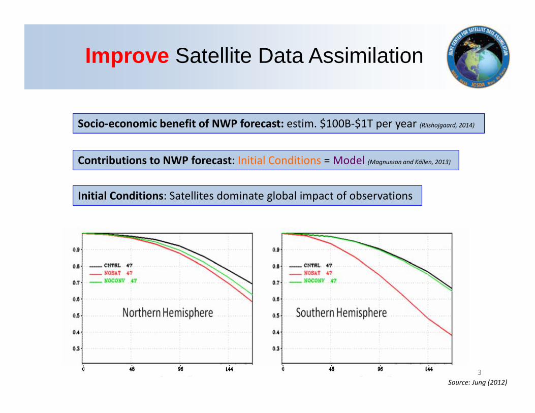
Contributions to NWP forecast: Initial Conditions = Model (Magnusson and Källen, 2013)
Socio‐economic benefit of NWP forecast: estim. $100B‐$1T per year (Riishojgaard, 2014)
Initial Conditions: Satellites dominate global impact of observations
Source: Jung (2012)
Improve Satellite Data Assimilation
3

Depreciation
Back‐of‐the‐envelop EstimationCost = $11BDesign life = 20 years Use for NWP = estim. 50%
Depreciation = $275M/year
Accelerate Satellite Data Assimilation
4
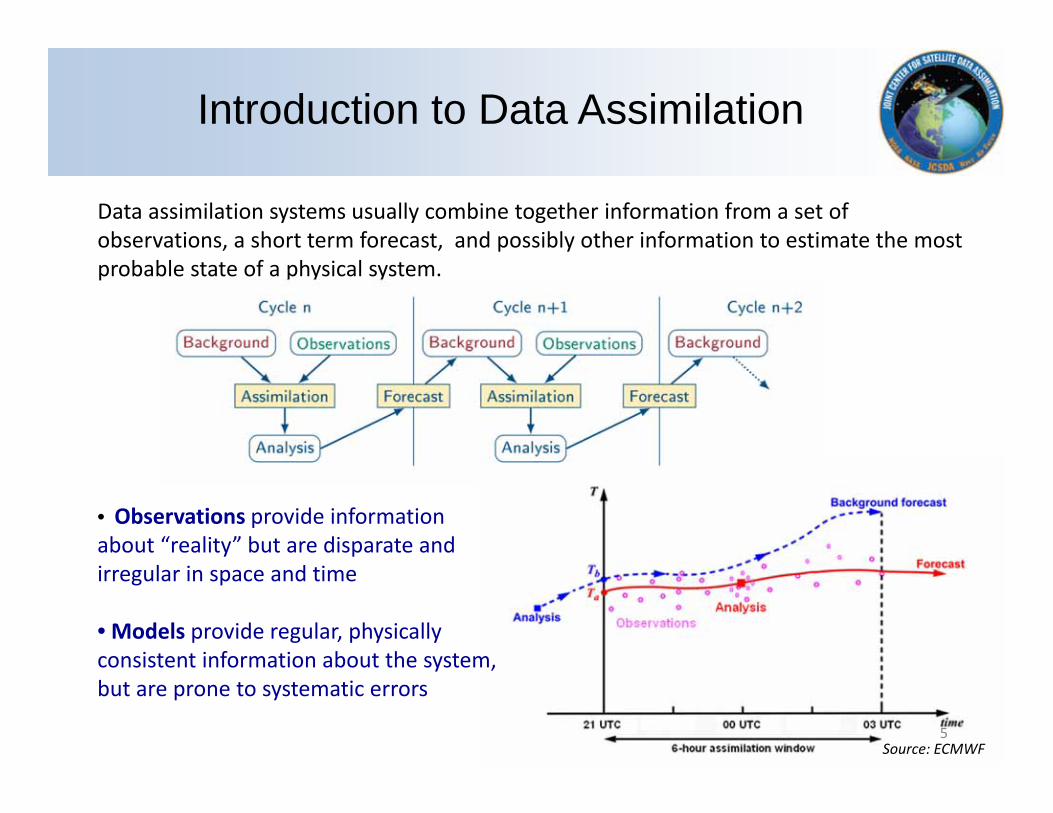
• Observations provide information about “reality” but are disparate and irregular in space and time
• Models provide regular, physically consistent information about the system, but are prone to systematic errors
Source: ECMWF
Introduction
Data assimilation systems usually combine together information from a set of observations, a short term forecast, and possibly other information to estimate the most probable state of a physical system.
Introduction to Data Assimilation
5
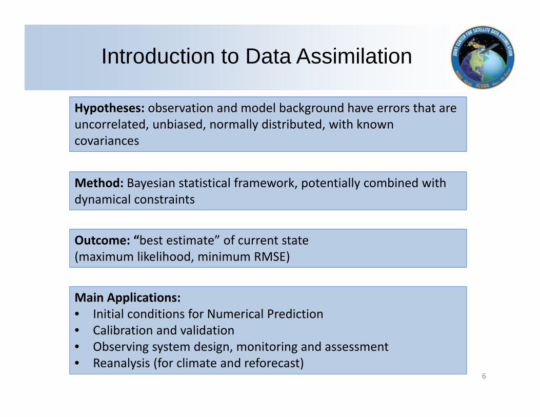
Hypotheses: observation and model background have errors that are uncorrelated, unbiased, normally distributed, with known covariances
Method: Bayesian statistical framework, potentially combined with dynamical constraints
Outcome: “best estimate” of current state (maximum likelihood, minimum RMSE)
Main Applications:• Initial conditions for Numerical Prediction• Calibration and validation• Observing system design, monitoring and assessment • Reanalysis (for climate and reforecast)
Introduction to Data Assimilation
6

• History– 2001: creation (NOAA, NASA)– 2005: DoD joining (Air Force, Navy)– 2008: Charter (signed by Agency Executives) and Terms of Reference
• JCSDA has enabled (multi‐agency) partners to share efforts and results to accelerate, enhance, and expand use of satellite data in operational prediction systems
• Keys to Success– Development and adoption of common tools (e.g. CRTM)– R2O supported by O2R infrastructure – Effective communication b/w Research and Operation communities
• New: UCAR CPAESS providing structure and mechanism for JCSDA government agencies to accomplish planning and execution of common mission more effectively.
Description of the JCSDA
7

JCSDA Management Structure
Executive TeamDirector (Auligné) *
Partner Associate Directors(Baker, Gelaro, Cetola Benjamin, Derber, Weng)
Chief Administrative Officer (Yoe)
Management Oversight BoardNOAA / NWS / NCEP (Lapenta (Chair))
NASA/GSFC/Earth Sciences Division (Pawson)NOAA / NESDIS / STAR (Cikanek)
NOAA / OAR (Atlas)Dept. of the Air Force / Air Force Director of Weather (Col. Gremillion)
Dept.of the Navy / N84 and NRL (McCarren and Hansen)
Agency ExecutivesNASA, NOAA, Department of the Navy, and Department of the Air Force
Advisory Panel
Science Steering Committee
8
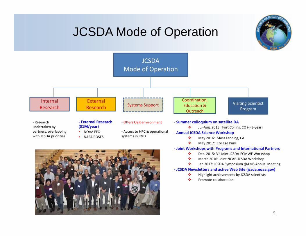
JCSDA Mode of Operation
Internal Research
Visiting Scientist Program
Coordination,Education & Outreach
‐ Research undertaken by partners, overlapping with JCSDA priorities
JCSDA Mode of Operation
‐ Summer colloquium on satellite DA Jul‐Aug. 2015: Fort Collins, CO (‐>3‐year)
‐ Annual JCSDA Science Workshop May 2016: Moss Landing, CA May 2017: College Park
‐ Joint Workshops with Programs and International Partners Dec. 2015: 3rd Joint JCSDA‐ECMWF Workshop March 2016: Joint NCAR‐JCSDA Workshop Jan 2017: JCSDA Symposium @AMS Annual Meeting
‐ JCSDA Newsletters and active Web Site (jcsda.noaa.gov) Highlight achievements by JCSDA scientists Promote collaboration
Systems Support
‐ Offers O2R environment
‐ Access to HPC & operational systems in R&D
External Research
‐ External Research ($1M/year)• NOAA FFO• NASA ROSES
9
1. Expand capabilities in assimilating satellite sensors
2. Spearhead a community data assimilation initiative
3. Address scientific frontiers to optimize the use of satellite data
4. Deliver new and improved tools to support observing system impact assessments
5. Foster improved organizational management, interagency coordination and outreach strategies
Strategic Goals
10

1. Expand capabilities in assimilating satellite sensors
2. Spearhead a community data assimilation initiative
3. Address scientific frontiers to optimize the use of satellite data
4. Deliver new and improved tools to support observing system impact assessments
5. Foster improved organizational management, interagency coordination and outreach strategies
Strategic Goals
11

Satellites~268 Earth observation satellites ~413 instrumentsTens of millions of observations daily
(not all of them are currently used)
Processing satellite data requires an army of specialized scientists
‐> incentive to mutualize efforts
12

New Sensors Data Assimilation:(new QC, error optimization, impact assessment on NOAA forecast systems)• GOES‐R – ABI (AMV winds and radiances) (Launched in Dec 2016)• JPSS1 – ATMS and CrIS (Launch date Q4 FY17)• COSMIC 2 (Launch date Q2 FY17) HIMAWARI‐8 AHI (Dry run for GOES‐R ABI) GPM /GMI Megha‐Tropiques SAPHIR (WV Sounder) ISS‐RAPIDSCAT (Scatterometer) GCOMW AMSR2 SMAP JASON 3
Existing Sensors optimization:
(QC, Surface‐sensitive channels assimilation, pre‐processing, dynamic emissivity, etc)
ATMS, SSMIS, AMSU, MHS
Prioritized New Satellites and Sensors
13

1. Expand capabilities in assimilating satellite sensors
2. Spearhead a community data assimilation initiative
3. Address scientific frontiers to optimize the use of satellite data
4. Deliver new and improved tools to support observing system impact assessments
5. Foster improved organizational management, interagency coordination and outreach strategies
Strategic Goals
14

Nation Unified Next‐generation Data Assimilation
OBJECTIVES1. Facilitate innovative developments to address DA grand challenges2. Increase R2O transition rate from community3. Increase science productivity and code performance
STRATEGY1. Collective path toward unification, allowing multiple levels of engagement2. Modular, Object‐Oriented code for flexibility, robustness and optimization3. Mutualize model‐agnostic components across
• Applications(atmosphere, ocean, land, aerosols, strongly coupled, etc.)• Models & Grids (operational/research, regional/global models)• Observations (past, current and future)
Joint Effort for Data assimilation Integration (JEDI)
15

DART GSI
D
D
D
E
EE
C
A
A
B
B
C
A
B
A
BCA
B
C
MULTI‐LEVELCOMMUNITY REPOSITORY
NCODA
A
Research
Community
Oper
C
…
C
C
C
B
Operations
Scientific efforts in academia
Scientific efforts in OAR
Scientific efforts in research community
Scientific efforts in satellite DA in Navy
JCSDA’s own DA Activities
Ope
ratio
nal
Res
earc
h
1
Com
mun
ity
2
3
(TRL 1‐4)
(TRL 7‐9)
(TRL 4‐7)
Cod
e S
tand
ards
& C
onst
rain
ts
16

1. Expand capabilities in assimilating satellite sensors
2. Spearhead a community data assimilation initiative
3. Address scientific frontiers to optimize the use of satellite data
4. Deliver new and improved tools to support observing system impact assessments
5. Foster improved organizational management, interagency coordination and outreach strategies
Strategic Goals
17
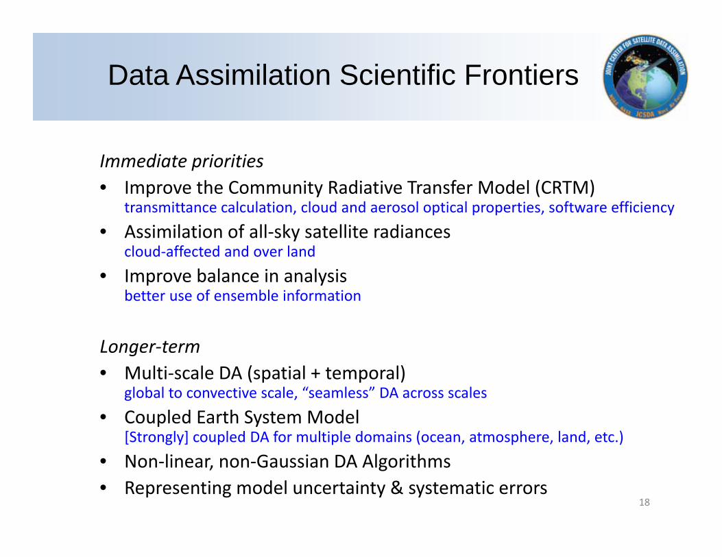
Immediate priorities• Improve the Community Radiative Transfer Model (CRTM)
transmittance calculation, cloud and aerosol optical properties, software efficiency• Assimilation of all‐sky satellite radiances
cloud‐affected and over land• Improve balance in analysis
better use of ensemble information
Longer‐term • Multi‐scale DA (spatial + temporal)
global to convective scale, “seamless” DA across scales• Coupled Earth System Model
[Strongly] coupled DA for multiple domains (ocean, atmosphere, land, etc.)• Non‐linear, non‐Gaussian DA Algorithms • Representing model uncertainty & systematic errors
Data Assimilation Scientific Frontiers
18

1. Expand capabilities in assimilating satellite sensors
2. Spearhead a community data assimilation initiative
3. Address scientific frontiers to optimize the use of satellite data
4. Deliver new and improved tools to support observing system impact assessments
5. Foster improved organizational management, interagency coordination and outreach strategies
Strategic Goals
19
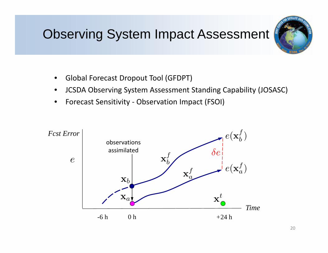
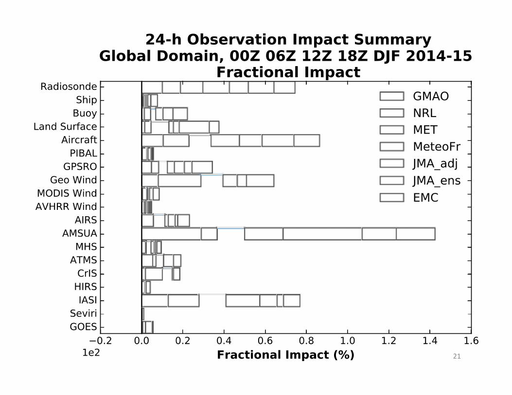
• Global Forecast Dropout Tool (GFDPT)• JCSDA Observing System Assessment Standing Capability (JOSASC)• Forecast Sensitivity ‐ Observation Impact (FSOI)
observations assimilated
0 h-6 h +24 hTime
Fcst Error
Observing System Impact Assessment
20
21

1. Expand capabilities in assimilating satellite sensors
2. Spearhead a community data assimilation initiative
3. Address scientific frontiers to optimize the use of satellite data
4. Deliver new and improved tools to support observing system impact assessments
5. Foster improved organizational management, interagency coordination and outreach strategies
Strategic Goals
22

External Research ($1M/year) NOAA FFO NASA ROSES
Visiting Scientist Program Jun‐Aug 2016: Sayed Bateni (U. Hawaii)
Summer colloquium on satellite DA Jul‐Aug. 2015: Fort Collins, CO (‐>3‐year)
Annual JCSDA Science Workshop May 2016: Moss Landing, CA May 2017: College Park
Joint Workshops with Programs and International Partners Dec. 2015: 3rd Joint JCSDA‐ECMWF Workshop: “Cloud&Precip Radiance DA” March 2016: Joint NCAR‐JCSDA Workshop: “Blueprints for Next‐Gen DA” Jan 2017: JCSDA Symposium Joint Session @AMS Annual Meeting
JCSDA Newsletters and active Web Site (jcsda.noaa.gov) Highlight achievements by JCSDA scientists, and promote collaboration Open positions at JCSDA, Visiting Scientist Program, projects, etc
Supporting External Research
23
24
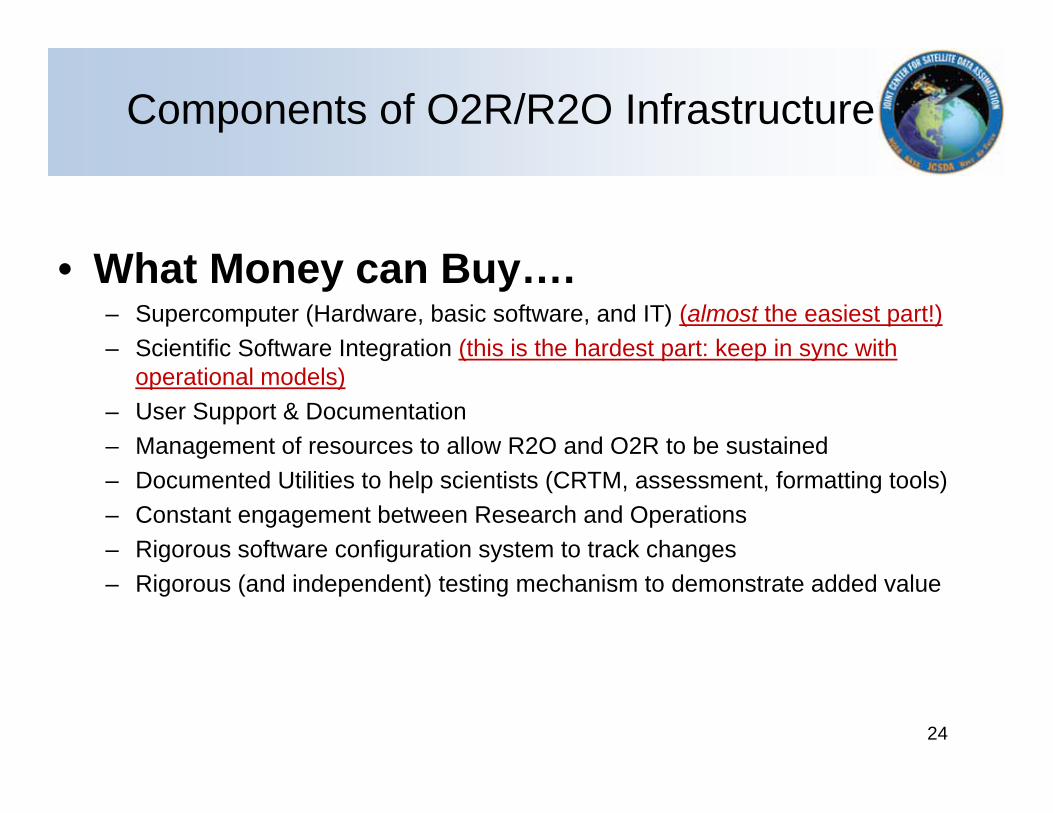
Components of O2R/R2O Infrastructure
• What Money can Buy….– Supercomputer (Hardware, basic software, and IT) (almost the easiest part!)– Scientific Software Integration (this is the hardest part: keep in sync with
operational models)– User Support & Documentation– Management of resources to allow R2O and O2R to be sustained– Documented Utilities to help scientists (CRTM, assessment, formatting tools)– Constant engagement between Research and Operations– Rigorous software configuration system to track changes– Rigorous (and independent) testing mechanism to demonstrate added value

• What Money can NOT Buy….– And perhaps more importantly: the right culture.
• Transparency of R2O protocols and willingness to accept research performed by researchers & work collaboratively (on the operational partner)
• Willingness to work/start with operational system and follow protocols and accept constructive feedback (on the research partner)
• Sense of Mutual respect between Researchers and Operational partners: respect for innovation in research and pragmatism in the operational implementation
25
Accept that R2O is not for everyone: careful choice of research and operations partners is important
Components of O2R/R2O Infrastructure
• JCSDA = multi‐agency, distributed center enabling partners to share efforts and results to accelerate, enhance, and expand use of satellite data in operational prediction systems
• Keys to success include– Identify community of partners with overlapping interests– Nurture communication and incentives b/w Research and Operational Communities
– R2O supported by O2R infrastructure– Development and adoption of Common Tools (e.g. CRTM)
• Future Outlook– Exploring means to be more collaborative in planning and execution
26
Summary
26

27
Discussion…