Embed Size (px)
Citation preview
John Betts School Crossing Review
Paddenswick Road
London Borough of Hammersmith & Fulham
August 2015

© Project Centre 2015 LBHF – John Betts School crossing review i
DOCUMENT CONTROL
Project Centre has prepared this report in accordance with the instructions from the London Borough
of Hammersmith and Fulham. Project Centre shall not be liable for the use of any information
contained herein for any purpose other than the sole and specific use for which it was prepared.
Report
Reference Issue Description Originator Checked Authorised
1000002446 –
John Betts
01 DRAFT Cynthia Ajeigbe
07.08.2015
xx.08.15 xx.08.15
CONTACT
Tim Mantle
Head of Traffic & Transportation
020 7203 8401
1st Floor Holborn Gate
330 High Holborn
London
WC1V 7QT

© Project Centre 2015 LBHF – John Betts School crossing review ii
CONTENTS PAGE PAGE NO.
1. INTRODUCTION 1
2. CLIENTS REQUIREMENTS 2
3. METHODOLOGY 3
4. TECHNICAL ASSESSMENT 4
5. SITE ASSESSMENT RECORD 6
6. ASSESSMENT FRAMEWORK 10
7. OPTION ASSESSMENT 12
8. SUMMARY OF SURVEY RESULTS AND DISCUSSION 13
9. DISCUSSION AND RECOMMENDATION 15
10. QUALITY 16
APPENDIX A –SURVEY DATA ANALYSIS DETAILS B
APPENDIX B –ATC AND CAMERA SITES D

© Project Centre 2015 LBHF – John Betts School crossing review 1
1. INTRODUCTION
1.1 This report outlines the results of a review of pedestrian crossing facilities in Paddenswick
Road, specifically in the vicinity of the John Betts Primary School in the London Borough of
Hammersmith and Fulham.
1.2 The aim of the review is to assess the existing crossing facilities for the school to evaluate
whether the existing facilities meet the needs of pedestrians with particular emphasis on the
crossing needs of pupils and parents/guardians going to and from the school.
1.3 The review included a collision analysis of the section of Paddenswick Road surrounding the
school and included the sections 73m and 125m north and south of the school respectively.
1.4 The review also included analysis of pedestrian surveys undertaken by cameras over two days
immediately outside the entrance to the school and also at the existing zebra crossing
located 80m south of that entrance.
1.5 In April 2015, Automatic Traffic Counts were taken along Paddenswick Road over a seven
day period to provide data on traffic speeds and volume along the road. As part of this
review a further seven day count was taken in June 2015 to enable an assessment of traffic
speeds and volumes taken within the same time frame as the pedestrian counts.

© Project Centre 2015 LBHF – John Betts School crossing review 2
2. CLIENTS REQUIREMENTS
2.1 London Borough of Hammersmith and Fulham commissioned Project Centre to
undertake a localised review of pedestrian crossing facilities along Paddenswick
Road, West London to assess pedestrian crossing needs in the vicinity of the John
Betts primary school.
2.2 The assessment was required to apply national methodology to determine whether
the existing facilities address the needs of people crossing or whether changes are
recommended. The assessment was also required to include pedestrian counts,
traffic speeds and traffic volumes outside the school, at an existing zebra crossing
approximately 80m south of the school and any crossing movements in between.
2.3 An assessment of the collision records for the section of Paddenswick Road between
Atwood Road (to the south) and Ravenscourt Road (to the north) was also required.
2.4 An evaluation of the latest School Travel Plan from John Betts School was to be
undertaken as part of the review to provide additional information on crossing needs
for pupils, staff and parents.
2.5 The assessment was to include an appraisal of the impact of any recommended
designs on the transport network, future collisions and current waiting, loading and
parking restrictions in Paddenswick Road.

© Project Centre 2015 LBHF – John Betts School crossing review 3
3. METHODOLOGY
3.1 Site visits were undertaken in June 2015 within the same time frame as the pedestrian
and traffic and speed data was being collected to provide a consistent frame of
reference for the assessment and evaluation of data on which to base any conclusions
and recommendations of the crossing review.
3.2 Observation surveys were carried out along Paddenswick Road and observations of the
crossing activities immediately outside the school entrance, where a School Crossing
Patrol operates, was carried out to enable an assessment of the existing situation and
any latent crossing needs that may exist.
3.3 To determine whether the existing crossing facilities adequately addressed the crossing
needs of people crossing in the vicinity of John Betts School, the national methodology
recommended for the assessment of pedestrian crossings was applied, as outlined in
APPENDIX A, APPENDIX B AND APPENDIX C of Local Transport Note 1/95.
3.4 Analysis of the pedestrian, traffic speed and volume and accident data was carried out
to obtain the necessary data to complete the check lists and record sheets for each of
the appendices listed above.
3.5 A comparison of the speed and volume counts undertaken in April and June 2015 was
carried out to assess if there were any significant changes between the two sets of data
which could unduly affect the outcome of the review.
3.6 A letter outlining the difficulties experienced when trying to cross Paddenswick Road at
the start and end of school by parents and pupils of John Betts was provided as part of
the scheme brief. This was evaluated and used as a basis for the review.

© Project Centre 2015 LBHF – John Betts School crossing review 4
4. TECHNICAL ASSESSMENT
Location: John Betts Primary School
Route reference: Paddenswick Road between its junctions with Ravenscourt Road and Dalling Road
Desired Outcome for Location:
Review pedestrian crossing facilities including informal crossings and assess the need for additional
crossing facilities at the section of the road outside John Betts Primary School.
Existing situation:
Characteristics:
Paddenswick Road is 437m long with a speed limit of 30m.p.h. It is a two way single carriageway
with two formal crossings and two informal crossings over its entire length. It is a borough maintained
road which runs in a north-south direction between Goldhawk Road to the north and Dalling Road to
the south. The land use is mainly residential with one primary school, a creative centre and one park
located to the west of the road. The kerb to kerb width of the road is approximately 10m except at
its junction with Goldhawk Road where it flares out to approximately 28m and forms a three arm
junction at the Goldhawk Road roundabout. The road is a bus route for a double-decker bus with
two bus stops in each direction.
Existing crossing and parking facilities:
There are two zebra crossings situated approximately 280m apart to the north and south of John Betts
Primary School, a pedestrian refuge island near the junction with Goldhawk Road and a School
Crossing Patrol located at the Paddenswick Road entrance/access for John Betts School to the west
and a nursery located to the east, opposite the school.
There are parking and loading restrictions in force along the road between 9am and 5pm with
maximum stay parking for eight hours.
Site Observations:
Period: Morning Day & Date: Wed. - 24.06.2015 Time: 06:45 – 08:30
The existing zebra crossing on Paddenswick Road at its junction with Dalling Road was heavily utilised
in both directions with the majority of crossing movements to the John Betts school and other nearby
schools taking place at the zebra crossing. The existing kerb extensions in Paddenswick Road outside
the school gate had very few crossing activities taking place. Entry into the school from 8 am was

© Project Centre 2015 LBHF – John Betts School crossing review 5
via the Paddenswick Road access where several parents and pupils arrived at 8am for the start of
school activities.
Period: afternoon Day & Date: Wed. - 24.06.2015 Time: 14:45 – 16:00
The existing zebra crossing on Paddenswick Road at its junction with Dalling Road was well utilised in
both directions with the majority of crossing movements to the school and other nearby schools
taking place at the zebra crossing. The existing kerb extensions in Paddenswick Road outside the
school gate had very few crossing activities taking place. Exit from the school from 15:20 was via
the Ravenscourt Road access. After 15:30 the Paddenswick Road access was used.
School Crossing Patrol (SCP):
Very few crossing activities were taking place but there were frequent interruptions to traffic as the
SCP often crossed pedestrians in small numbers of between 1 and 5 people with the exception of
one occasion when a group of approximately 12 parents/guardians and children crossed at the
same time. Also, when the SCP stopped traffic for pedestrians to cross, other pedestrians were
streaming through so that vehicular traffic was kept waiting until the stream of pedestrians had
ceased. This led to traffic hold-ups for longer periods of time than was necessary. Discussion with the
SCP confirmed that generally, between 0830hrs and 0900hrs in the mornings crossing activities take
place but not many pedestrians cross and also that after 1600hrs the flow of traffic is low and people
were able to cross without difficulty.
Risks to Pedestrians
There are risks for westbound pedestrians trying to cross this section of the road because of the
position of the parking bays south of the junction with Dorville Crescent. The parking place is located
on approach to the kerb build-out and during the site visits it was observed that visibility of pedestrians
waiting to cross the road was poor when the parking place was at capacity; the situation was made
worse when high vehicles such as 4x4s were parked in the two spaces closest to the build-out.
Accident data analysis summary
Analysis of accident records for the previous sixty months to 31 December 2014 was carried out for
the section of Paddenswick Road between it’s junctions with Ravenscourt Road and Dalling Road
and Dalling Road between its junctions with Paddenswick Road and Atwood Road, inclusive. There
were a total of eight collisions resulting in nine casualties, all classified as “slight” in severity. The
collisions involved two pedestrians (one child), two pedal cycles and three motor cycles. Full details
of the collisions are shown in Appendix A.

© Project Centre 2015 LBHF – John Betts School crossing review 6
5. SITE ASSESSMENT RECORD
The check list and record sheet below is recommended for use when assessing the need for an at-grade pedestrian crossing or changing an existing pedestrian crossing for another type as per Appendix B of Local Transport Note 1/95 – The Assessment of Pedestrian Crossings.
SITE CHARACTERISTICS
1.1 Site Location Paddenswick Road / John Betts Primary School site
1.2 Carriageway Type Single lane two way
1.3 Carriageway Width Kerb to Kerb = 10metres
1.3.1 Crossing width at Zebras =8.0m and 8.3m
1.3.2 Crossing width at kerb build-outs =6.0m
1.4 Footway Width Side 1 =2.0m
Side 2 =2.0m
1.5 Refuge Island No
1.6 Road Lighting Standard
BS5489 classification Category
Is lighting to above standard? Assessment required.
Any re-arrangement necessary? No
Better lighting standard needed? No
Supplementary lighting needed? No

© Project Centre 2015 LBHF – John Betts School crossing review 7
1.7 Minimum Visibility
Pedestrian to Vehicle Direction 1 (N): 12m
Direction 2 (S): 65m
Vehicle to crossing Direction 1 (N): 65m
Direction 2 (S): 12m
1.8 Waiting/Loading/Stopping Restrictions
At prospective site Yes
Within 50 metres of the site Yes
1.9 Public Transport Stopping Points
At prospective site No
Within 50 metres of the site Yes
Relationship to crossing
[in direction of travel] Direction 1(N): approach
Direction 2 (S): exit
1.10 Nearby Junctions
Distance to nearest significant Direction 1(N): 28m
traffic junction Direction 2(S): 80m
1.11 Other Pedestrian Crossings
Distance to next crossing Direction 1(N): 200m
Direction 2(S): 80m
Type of crossing Zebra
1.12 School Crossing
Patrol Distance if less than 100 metres 0m

© Project Centre 2015 LBHF – John Betts School crossing review 8
1.13 Skid Risk
Does surface meet skid resistance requirements Yes
1.14 Surroundings (entrances within 100 metres)
Hospital/Sheltered housing/Workshop No
for disabled people
School Yes
Post Office No
Railway/Bus Station No
Pedestrian leisure/shopping area No
Sports stadia/entertainment venue No
Junction with cycle route No
Equestrian centre or junction with Bridle Path No
Others (for example a Fire Station) No
CROSSING TRAFFIC INFORMATION
2.1 Flow and Composition
Pedestrian count 423 per 12 hours
Prams/pushchairs (6) 1.2%
Percent elderly 0%
Unaccompanied young children 0%
Severe mobility difficulties 0 per day
Visually impaired 0 per day
Crossing cyclists 10 per day
Equestrians 0 per day
Others 0 per day
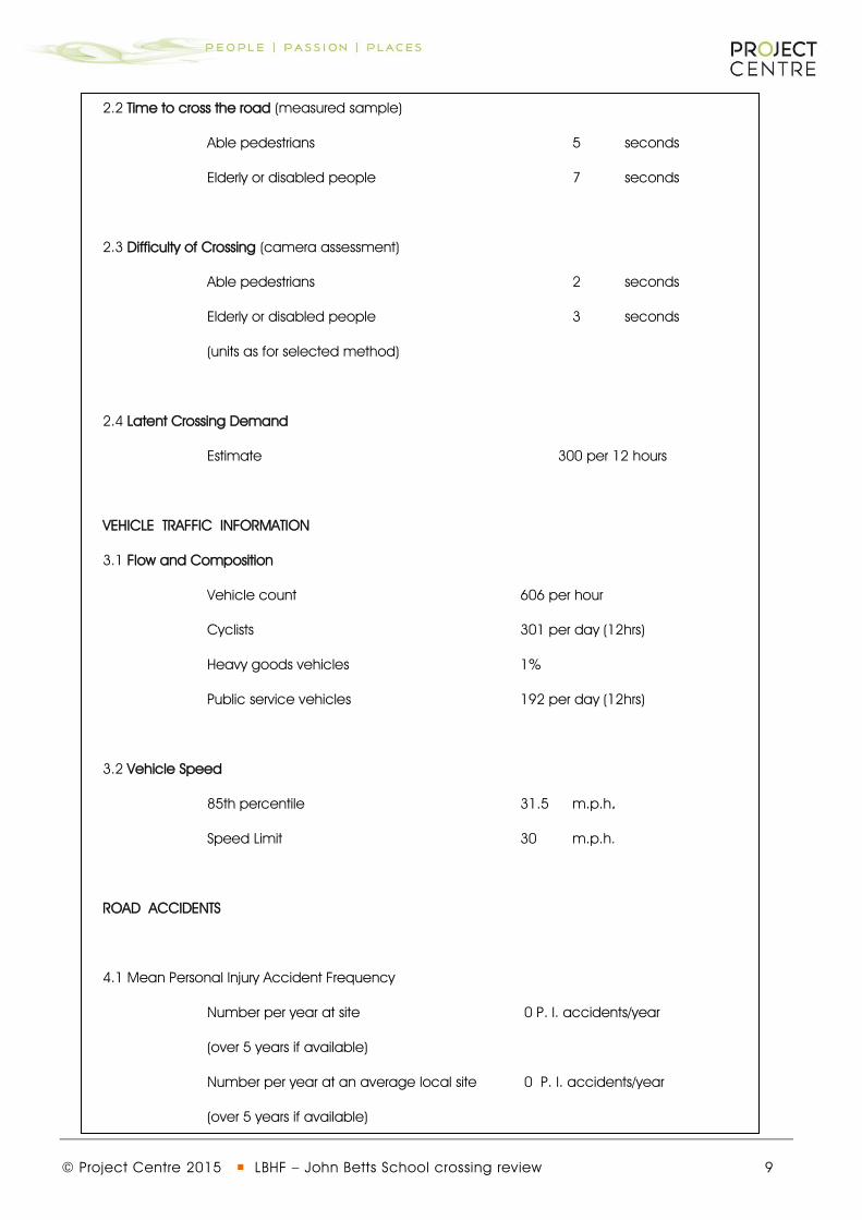
© Project Centre 2015 LBHF – John Betts School crossing review 9
2.2 Time to cross the road (measured sample)
Able pedestrians 5 seconds
Elderly or disabled people 7 seconds
2.3 Difficulty of Crossing (camera assessment)
Able pedestrians 2 seconds
Elderly or disabled people 3 seconds
(units as for selected method)
2.4 Latent Crossing Demand
Estimate 300 per 12 hours
VEHICLE TRAFFIC INFORMATION
3.1 Flow and Composition
Vehicle count 606 per hour
Cyclists 301 per day (12hrs)
Heavy goods vehicles 1%
Public service vehicles 192 per day (12hrs)
3.2 Vehicle Speed
85th percentile 31.5 m.p.h.
Speed Limit 30 m.p.h.
ROAD ACCIDENTS
4.1 Mean Personal Injury Accident Frequency
Number per year at site 0 P. l. accidents/year
(over 5 years if available)
Number per year at an average local site 0 P. I. accidents/year
(over 5 years if available)

© Project Centre 2015 LBHF – John Betts School crossing review 10
6. ASSESSMENT FRAMEWORK
The check list and record sheet below is recommended for use when assessing the need for an at-grade pedestrian crossing or changing an existing pedestrian crossing for another type as per Appendix C of Local Transport Note 1/95 – The Assessment of Pedestrian Crossings.
SITE ASSESSMENT
Characteristic Data and comments at 15 July 2015
Location The site at John Betts Primary School is a single lane two way,
Carriageway total width 10 metres with 2 metre footways. However, crossing
points are 6.0m at the School Crossing Patrol site and 8.3m at the 2 Zebra
crossings north and south of the site.
Highway facilities Road lighting is recent to a traffic route standard and no re-arrangement is
needed. The road surface appears to give adequate skid Resistance.
Visibility Desirable visibility standards cannot be met. There is need to further restrict
parking on the eastern side of the site, on visibility grounds, and
the road is a bus route.
Complexity There are three road junctions, two formal pedestrian crossings, public areas
and
buildings as well as the local primary school and a nursery within 280 metres
of the site.
Crossing traffic Between 1399 and 1475 people cross the road daily with an average
breakdown into 4 groups. Crossing time and difficulty of crossing
are typical for roads of this character in this area.
Vehicles 11,490 vehicles a day with 16% of heavy goods (all class 4-10 vehicles).
Highest two way peak
hour flow 1046. Highest 85 percentile in peak periods is 30 m.p.h.

© Project Centre 2015 LBHF – John Betts School crossing review 11
The road has a 30 m.p.h. speed limit.
Road accidents There were 8 P.I. accidents in the 60 months to 31 December 2014 within
200m of the site.
There were no P.I. accidents recorded during the periods when the school was
in operation.
© Project Centre 2015 LBHF – John Betts School crossing review 12
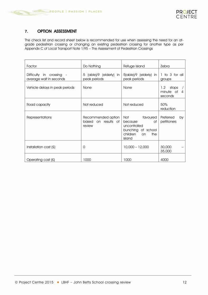
7. OPTION ASSESSMENT
The check list and record sheet below is recommended for use when assessing the need for an at-grade pedestrian crossing or changing an existing pedestrian crossing for another type as per Appendix C of Local Transport Note 1/95 – The Assessment of Pedestrian Crossings
Factor Do Nothing Refuge Island Zebra
Difficulty in crossing - average wait in seconds
5 (able)/9 (elderly) in peak periods
5(able)/9 (elderly) in peak periods
1 to 3 for all groups
Vehicle delays in peak periods None None 1.2 stops / minute of 4 seconds
Road capacity Not reduced Not reduced 50% reduction
Representations Recommended option based on results of review
Not favoured because of uncontrolled bunching of school children on the island
Preferred by petitioners
Installation cost (£) 0 10,000 – 12,000 30,000 – 35,000
Operating cost (£) 1000 1000 4000
© Project Centre 2015 LBHF – John Betts School crossing review 13
8. SUMMARY OF SURVEY RESULTS AND DISCUSSION
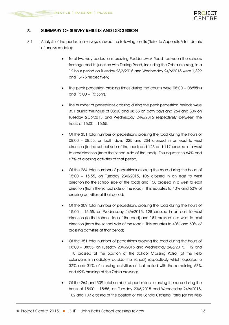
8.1 Analysis of the pedestrian surveys showed the following results (Refer to Appendix A for details
of analysed data):
Total two-way pedestrians crossing Paddenswick Road between the schools
frontage and its junction with Dalling Road, including the Zebra crossing, in a
12 hour period on Tuesday 23/6/2015 and Wednesday 24/6/2015 were 1,399
and 1,475 respectively;
The peak pedestrian crossing times during the counts were 08:00 – 08:55hrs
and 15:00 – 15:55hrs;
The number of pedestrians crossing during the peak pedestrian periods were
351 during the hours of 08:00 and 08:55 on both days and 264 and 309 on
Tuesday 23/6/2015 and Wednesday 24/6/2015 respectively between the
hours of 15:00 – 15:55;
Of the 351 total number of pedestrians crossing the road during the hours of
08:00 – 08:55, on both days, 225 and 234 crossed in an east to west
direction (to the school side of the road) and 126 and 117 crossed in a west
to east direction (from the school side of the road). This equates to 64% and
67% of crossing activities at that period;
Of the 264 total number of pedestrians crossing the road during the hours of
15:00 – 15:55, on Tuesday 23/6/2015, 106 crossed in an east to west
direction (to the school side of the road) and 158 crossed in a west to east
direction (from the school side of the road). This equates to 40% and 60% of
crossing activities at that period;
Of the 309 total number of pedestrians crossing the road during the hours of
15:00 – 15:55, on Wednesday 24/6/2015, 128 crossed in an east to west
direction (to the school side of the road) and 181 crossed in a west to east
direction (from the school side of the road). This equates to 40% and 60% of
crossing activities at that period;
Of the 351 total number of pedestrians crossing the road during the hours of
08:00 – 08:55, on Tuesday 23/6/2015 and Wednesday 24/6/2015, 112 and
110 crossed at the position of the School Crossing Patrol (at the kerb
extensions immediately outside the school) respectively which equates to
32% and 31% of crossing activities at that period with the remaining 68%
and 69% crossing at the Zebra crossing;
Of the 264 and 309 total number of pedestrians crossing the road during the
hours of 15:00 – 15:55, on Tuesday 23/6/2015 and Wednesday 24/6/2015,
102 and 133 crossed at the position of the School Crossing Patrol (at the kerb

© Project Centre 2015 LBHF – John Betts School crossing review 14
extensions immediately outside the school) respectively which equates to
39% and 50% of crossing activities at those periods with the remaining 61%
and 50% crossing at the Zebra crossing respectively;
Outside of the peak pedestrian crossing periods, 129 and 137 pedestrians
crossed at the kerb extensions over ten hours on Tuesday 23/6/2015 and
Wednesday 24/6/2015 respectively and correspondingly 512 and 504
pedestrians crossed at the Zebra crossing on each of those days reflecting
that between 79% and 80% of crossing activities outside of the peak
pedestrian crossing periods takes place at the Zebra crossing.

© Project Centre 2015 LBHF – John Betts School crossing review 15
9. DISCUSSION AND RECOMMENDATION
9.1 Based on the above results and the summary findings shown on the check lists and
record sheets in APPENDIX A,B AND C it is clear that the section of Paddenswick Road
outside the John Betts School is on the pedestrian desire-line for a two hour period on
weekdays and during term-time. However, with the exception of the start and end of
the school period, few crossing activities take place at the informal crossing point.
9.2 Analysis of the speeds of traffic at the informal crossing point shows that the mean
speeds recorded during the peak pedestrian periods of 08:00 – 08:55 and 15:00 –
15:55 were 19.3mph and 19.9mph on Tuesday 23/6/2015 and 19.9mph and 19mph on
Wednesday 24/6/2015.
9.3 The combination of the above indicates that some form of crossing facility is required at
the section of Paddenswick Road immediately outside the school. However it is
considered than a formal crossing would not benefit pedestrians generally in the long
term as the crossing would effectively be abandoned for long periods of the day and
would fall into disrepute.
9.4 The results obtained from the surveys indicate that the number of people that cross at
the existing Zebra crossing genuinely do so because it is the most convenient crossing
point for their desired destination.
9.5 Three crossing options have been considered for the section of the road immediately
outside the school at section 7 above. The Do Nothing option is effectively a
recommendation to maintain the Status Quo and therefore maintain the presence of
the School crossing Patrol at the site.
9.6 The request for a formal crossing at the site should be revisited if a decision is made
sometime in the future to remove the School Crossing Patrol.

© Project Centre 2015 LBHF – John Betts School crossing review 16
10. QUALITY
It is the policy of Project Centre to supply Services that meet or exceed our clients’
expectations of Quality and Service. To this end, the Company's Quality Management
System (QMS) has been structured to encompass all aspects of the Company's activities
including such areas as Sales, Design and Client Service.
By adopting our QMS on all aspects of the Company, Project Centre aims to achieve the
following objectives:
Ensure a clear understanding of customer requirements;
Ensure projects are completed to programme and within budget;
Improve productivity by having consistent procedures;
Increase flexibility of staff and systems through the adoption of a common approach
to staff appraisal and training;
Continually improve the standard of service we provide internally and externally;
Achieve continuous and appropriate improvement in all aspects of the company;
Our Quality Management Manual is supported by detailed operational documentation.
These relate to codes of practice, technical specifications, work instructions, Key
Performance Indicators, and other relevant documentation to form a working set of
documents governing the required work practices throughout the Company.
All employees are trained to understand and discharge their individual responsibilities to
ensure the effective operation of the Quality Management System.

© Project Centre 2015 LBHF - John Betts School Crossing Review
APPENDIX A –SURVEY DATA ANALYSIS DETAILS

© Project Centre 2015 LBHF - John Betts School Crossing Review

© Project Centre 2015 LBHF - John Betts School Crossing Review
APPENDIX B –ATC AND CAMERA SITES

© Project Centre 2015 LBHF - John Betts School Crossing Review