Embed Size (px)
Citation preview

A 16-foot concrete bat roost at Chimneytop Mountain in northern Pickens County may provide habitat for Rafinesque’s big-eared bat. This roost and three others in the state may provide important habitat for other bat species as well. (DNR photo by Mary Bunch)
Spring/Summer 2012 Volume 13, Number 1
Jocassee Journalwww.dnr.sc.govInformation and News about the Jocassee Gorges
Roost to helpendangeredJocassee bats
State Wildlife Grant funds concrete towers A 16-foot-tall concrete bat roost erected in Jocassee Gorges using a State Wildlife Grant is designed to help the state-endangered Rafinesque’s big-eared bat. Three other roosts around the state may also provide habitat for some other uncommon bats as well as chimney swifts. Rafinesque’s big-eared bats require large open structures for roosts, and natural roosts tend to be massive hollow trees now in short supply, according to Mary Bunch, biologist with the S.C. Department of Natural Resources (DNR) based in Clemson. Input for the design of the concrete tower was received from the Southeastern Bat Diversity Network and Bat Conservation International. The cylindrical concrete roost is 4 feet in diameter and about 16 feet tall. A roughened interior helps improve roosting ability, and the middle section of the roost has a triangular entrance hole with a maximum width of 24 inches. In addition to the roost near Chimneytop Mountain in Jocassee Gorges, additional concrete roosts have been placed at Silver Bluff Audubon Center & Sanctuary in Aiken County; at Hamilton Ridge Wildlife Management Area in Hampton County; and at Ashmore Heritage Preserve in Greenville County. The two mountain roosts, at Chimneytop Mountain and Ashmore Heritage Preserve, were modified to include wooden crevices that will appeal to other colonial cavity roosting bats, such as Northern long-eared, little brown, tri-colored and big-brown bats. MST Concrete of Central built and delivered three of the bat roosts. “MST Concrete’s enthusiasm to work with us on the design really helped us get the project going,” Bunch said. Funding for the roosts was provided by the State
Wildlife Grants Program, which provides federal dollars to every state and territory to support cost-effective conservation aimed at preventing wildlife from becoming endangered. Congress created the program in 2000. Funds appropriated under the State Wildlife Grants Program are allocated to every state according to a formula based on each state’s size and population. The source of funds for this program is offshore oil leases. For more information on State Wildlife Grants, visit http://www.teaming.com/pdf/swg_overview.pdf.
2
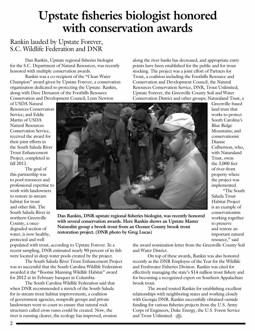
Dan Rankin, DNR upstate regional fisheries biologist, was recently honored with several conservation awards. Here Rankin shows an Upstate Master Naturalist group a brook trout from an Oconee County brook trout restoration project. (DNR photo by Greg Lucas)
Upstate fisheries biologist honored with conservation awards
Rankin lauded by Upstate Forever, S.C. Wildlife Federation and DNR
Dan Rankin, Upstate regional fisheries biologist for the S.C. Department of Natural Resources, was recently honored with multiple conservation awards. Rankin was a co-recipient of the “Clean Water Champion” award given by Upstate Forever, a conservation organization dedicated to protecting the Upstate. Rankin, along with Dave Demarest of the Foothills Resource Conservation and Development Council; Lynn Newton of USDA Natural Resources Conservation Service; and Eddie Martin of USDA Natural Resources Conservation Service, received the award for their joint efforts in the South Saluda River Trout Enhancement Project, completed in fall 2011. The goal of this partnership was to pool resources and professional expertise to work with landowners to restore in-stream habitat for trout and other fish. The South Saluda River in northern Greenville County, a once-degraded section of water, is now healthy, protected and well populated with trout, according to Upstate Forever. In a recent sampling, DNR estimated nearly 90 percent of its fish were located in deep-water pools created by the project. The South Saluda River Trout Enhancement Project was so successful that the South Carolina Wildlife Federation awarded it the “Bootsie Manning Wildlife Habitat” award for 2012 at its February banquet in Columbia. The South Carolina Wildlife Federation said that when DNR recommended a stretch of the South Saluda for in-stream trout habitat improvements, a coalition of government agencies, nonprofit groups and private landowners went to court to ensure that natural rock structures called cross vanes could be created. Now, the river is running clearer, the ecology has improved, erosion
along the river banks has decreased, and appropriate entry points have been established for the public and for trout stocking. The project was a joint effort of Partners for Trout, a coalition including the Foothills Resource and Conservation and Development Council, the Natural Resources Conservation Service, DNR, Trout Unlimited, Upstate Forever, the Greenville County Soil and Water Conservation District and other groups; Naturaland Trust, a
Greenville-based land trust that works to protect South Carolina’s Blue Ridge Mountains; and conservationist Dianne Culbertson, who, with Naturaland Trust, owns the 3,000 feet of river-front property where the project was implemented. “The South Saluda Trout Habitat Project is an example of conservationists working together to preserve and restore an important natural resource,” said
the award nomination letter from the Greenville County Soil and Water District. On top of these awards, Rankin was also honored recently as the DNR Employee of the Year for the Wildlife and Freshwater Fisheries Division. Rankin was cited for effectively managing the state’s $14 million trout fishery and for becoming a recognized expert on Southern Appalachian brook trout. The award touted Rankin for establishing excellent relationships with neighboring states and working closely with Georgia DNR. Rankin successfully obtained outside funding for various fisheries projects from the U.S. Army Corps of Engineers, Duke Energy, the U.S. Forest Service and Trout Unlimited.

3
Just as the excitement of fall leaves fades, holidays come and go and we start to long for spring, for a sign of life…you might hear a distorted croak, quack while walking in the woods. These sounds are the chorus of wood frogs.The first rains of the New Year cue the frogs to congregate
en masse at their breeding pools for a brief breeding frenzy and then they disappear for another year, the only trace of their existence is the presence of the egg masses
left behind. These breeding events are generally in small, temporary or predator free pools of water that make it necessary for the frogs to breed with the first good rains of the year above freezing. This allows the eggs and tadpoles time to develop and the froglets to disperse before the drying heat of late spring and summer.
Cora and her new field assistant, Sophia, check for wood frogs at a breeding site.
An adult wood frog is caught leaving a breeding pool. (Photo by Cora Allard-Keese)
A true harbinger of spring?The life and breeding times of the wood frog, Lithobates sylvatica, in the southeastern portion of its distributionBy Cora Allard-Keese
This romantic tale is the story of these “harbingers” of spring throughout most of their range (up through Maine into Canada and westward to Alaska). Here in the southeastern-most portion of its distribution, in the Blue Ridge Escarpment and surrounding Piedmont, this story might be a little different. The dissected landscape (steep drops in elevation, protected coves) in the Escarpment, sparse naturally-occurring temporary, wetlands and a mild winter climate in the Piedmont with impending climate change and variability in the weather patterns add obstacles to this frogs' story. (Cora Allard-Keese, lecturer for the SC Life Project and Ph.D. student in wildlife biology at Clemson University, is investigating how these variables potentially affect the breeding phenology of wood frogs in the southeastern portion of its range. Some of the breeding populations used in her study are found in the Jocassee Gorges. Any questions or comments can be sent to Cora at [email protected].)
State Parks interpretive ranger Tim Lee recently won the S.C. Wildlife Federation’s Outdoor Ethics Award. Lee’s outdoor “office” at the Mountain Bridge Wilderness Area includes both Caesars Head State Park and Jones Gap State Park. His job is to help others learn about the natural history of South Carolina while also inventorying and monitoring the diverse and often rare flora and fauna of the region. For more than 11 years, Lee has developed, marketed and presented outstanding educational programs, exhibits and materials for South Carolina.
Naturalist Tim Lee wins Outdoor Ethics Award
Mountain Bridge Wilderness Area ranger honored by S.C. Wildlife Federation
He reaches 1,500 K-12 students annually through the “Discover Carolina” program and also provides educational experiences for undergraduate and graduate students, teachers and seniors. Lee is a very popular leader for the Upstate South Carolina Master Naturalist program. In addition, he serves as an Educational Leadership Partner for the South Carolina Aquarium, as a volunteer for the Environmental Education Association of South Carolina, and as an instructor at the YMCA Camp Thunderbird Environmental Education Center.
Tim Lee

4
Lake Jocassee loons have endeared themselves to winter birders with their beauty and haunting songs. (Photo by Peter Biddle)
Lake Jocassee loons fascinate winter birdersGreat Northern Divers spend the cold months around Carolina mountain lakeBy Brooks Wade Gavia immer. The Common Loon. No, really. That’s what they are called. I can’t help conjuring up this image of some lonely ornithologist, probably in the 1700s, probably of Calvinist upbringing, whose mother forbid joy to enter the house. How else can you explain this awful name? What happened to the bird man who named the Resplendent Quetzal, or the Magnificent Frigatebird? That is what G immers deserved. Now, quite typical of committees everywhere, a compromise with poetry and light has been reached. The common loon is presently also addressed as the Great Northern Loon, as well as the Great Northern Diver. I choose the Great Northern Diver, never to utter the word common again, at least when speaking of this bird, this bird which is the sight and sound of winter on Lake Jocassee. Closely related to penguins, they are clearly northern. G. immer spends its summers breeding in Canada, the northern U.S., Greenland, Iceland, and Alaska. Now that’s northern. They can dive to over 200 feet and stay submerged for up to 5 minutes. That’s diving, by most anybody’s definition. In fact, there is no other diving bird family who can match this. But they are called loons for a reason. It derives from the Scandinavian, and refers to their “loony” efforts to walk on land. The truth is, they just about can’t. Their feet, webbed of course, are placed well back on the posterior of their long, chubby body. Perfect for deep dives in cold lakes, but just terrible for taking a stroll. If you are lucky enough to see them prepare to leave Lake Jocassee in the spring, it’s just a hoot to watch them take up nearly half the lake getting airborne. And they must fly into the wind to get aloft. It’s no wonder, once airborne and heading our way, or heading to their summer abodes, they will fly 200 to 300 miles a day, and at speeds of up to 75 miles an hour! So go ahead. Try to address them as “common” now. Not in the summer you won’t, when they are abiding their nest and protecting their young. They are
likely to charge you and simply impale you with their beak, right through the abdomen, or perhaps through the neck or the back of the head. If I came upon a nest while paddling in my quiet canoe, I believe I would just whisper, “Nice little Great Northern Diver. Nice bird,” and paddle on, rather quickly I suppose. But not here. Not on Lake Jocassee. They begin arriving in the late fall, just a little bit cranky and hesitant from their summer activities and long flight south, and clearly pooped. They just want to catch a fish, and rest.
They don’t fly away at the presence of humans. In fact, I doubt they can. They won’t even try it again until spring, at that sad time when they leave us. They become more and more approachable as the winter progresses, seemingly ignoring you as they go about their daily business of catching fish, and protecting them from seagulls. Do you remember that Gimmer can dive over 200 feet deep to gather dinner? Well, guess who’s waiting when said loon pops up to the surface. 200 seagulls, that’s who! The gulls and the loons live in an argumentative relationship to each other on Lake Jocassee all winter. When everybody seems full, they will just float around together, but if just one loon pops up with a fish in his beak, well, chaos can ensue, to be polite. The Great Northern Diver winters mostly in the Gulf of Mexico, but also, blessedly, on
large, cold, clear lakes from the Carolinas south. The fact is there are not so many lakes of this description in the south, so Lake Jocassee is a favored wintering ground. Their arrival, their ethereal yodel, announces the beginning of winter, our season of solitude. When they leave, their awkward departure may give us the first laughter of the new spring. And far to the north, where the loon’s breeding lakes await them in frozen silence, surely people are starting to crack their windows, letting in that still cold winter air, just to hear that wondrous, mysterious first sound of spring, the sound of nature’s rebirth. What a bird. Common, indeed. (Brooks Wade, an Upstate Master Naturalist, and his wife, Kay, are the owners of Jocassee Lake Tours, a company which offers tours and shuttle service for both Lake Jocassee and the Jocassee Gorges. They can be reached by phone or e-mail: [email protected], (864) 280-5501, or JocasseeLakeTours.com.)
5
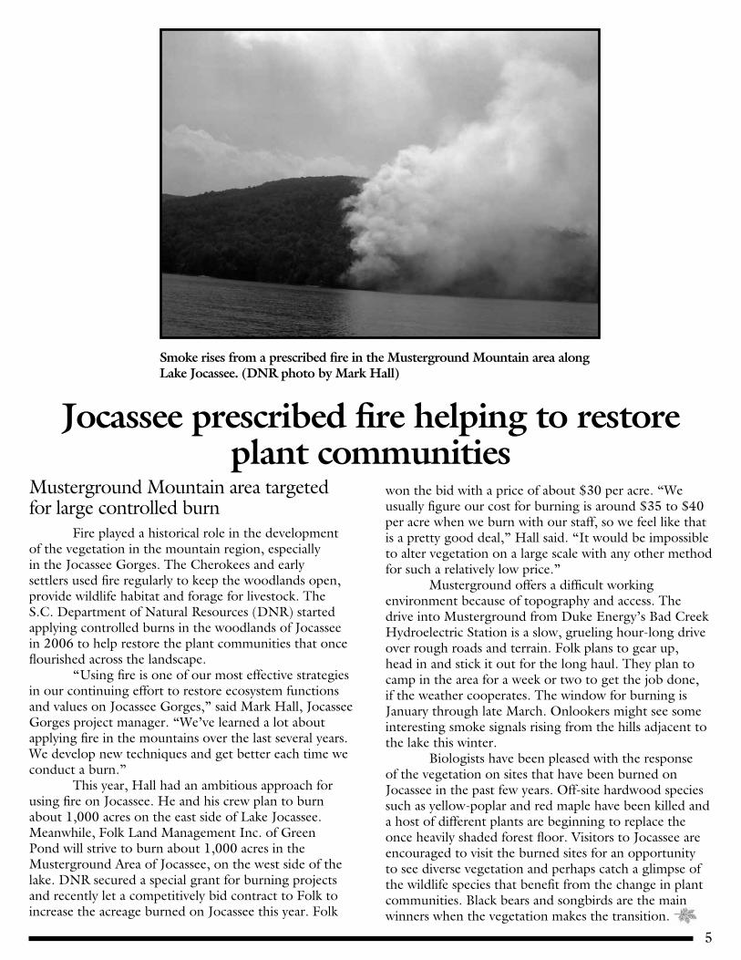
Smoke rises from a prescribed fire in the Musterground Mountain area along Lake Jocassee. (DNR photo by Mark Hall)
Jocassee prescribed fire helping to restore plant communities
Musterground Mountain area targeted for large controlled burn Fire played a historical role in the development of the vegetation in the mountain region, especially in the Jocassee Gorges. The Cherokees and early settlers used fire regularly to keep the woodlands open, provide wildlife habitat and forage for livestock. The S.C. Department of Natural Resources (DNR) started applying controlled burns in the woodlands of Jocassee in 2006 to help restore the plant communities that once flourished across the landscape. “Using fire is one of our most effective strategies in our continuing effort to restore ecosystem functions and values on Jocassee Gorges,” said Mark Hall, Jocassee Gorges project manager. “We’ve learned a lot about applying fire in the mountains over the last several years. We develop new techniques and get better each time we conduct a burn.” This year, Hall had an ambitious approach for using fire on Jocassee. He and his crew plan to burn about 1,000 acres on the east side of Lake Jocassee. Meanwhile, Folk Land Management Inc. of Green Pond will strive to burn about 1,000 acres in the Musterground Area of Jocassee, on the west side of the lake. DNR secured a special grant for burning projects and recently let a competitively bid contract to Folk to increase the acreage burned on Jocassee this year. Folk
won the bid with a price of about $30 per acre. “We usually figure our cost for burning is around $35 to $40 per acre when we burn with our staff, so we feel like that is a pretty good deal,” Hall said. “It would be impossible to alter vegetation on a large scale with any other method for such a relatively low price.” Musterground offers a difficult working environment because of topography and access. The drive into Musterground from Duke Energy’s Bad Creek Hydroelectric Station is a slow, grueling hour-long drive over rough roads and terrain. Folk plans to gear up, head in and stick it out for the long haul. They plan to camp in the area for a week or two to get the job done, if the weather cooperates. The window for burning is January through late March. Onlookers might see some interesting smoke signals rising from the hills adjacent to the lake this winter. Biologists have been pleased with the response of the vegetation on sites that have been burned on Jocassee in the past few years. Off-site hardwood species such as yellow-poplar and red maple have been killed and a host of different plants are beginning to replace the once heavily shaded forest floor. Visitors to Jocassee are encouraged to visit the burned sites for an opportunity to see diverse vegetation and perhaps catch a glimpse of the wildlife species that benefit from the change in plant communities. Black bears and songbirds are the main winners when the vegetation makes the transition.

6
Retired Clemson forestry professor Dr. Dave Van Lear, noted for his research detailing the importance of fire in forest ecosystems, has captured a lifetime of fishing in his new book.
Fishing book details the art of angling, the art of living
Retired Clemson forestry professor pens poignant memoir Retired Clemson professor Dr. David Van Lear has written a book describing his fishing adventures and how they’ve enriched his life in many ways, titled “Memories Made and Lessons Learned During a Lifetime of Angling.” “Memories Made and Lessons Learned” is available from Amazon.com and BarnesandNoble.com. Van Lear first experienced fishing with his father, on the beautiful Cowpasture River in Virginia, and these memorable outings began a lifelong fascination—a way of life aligned with the rhythms of rivers and streams, and an outlook sensitive to the wonders of America’s wilderness.From his local river in Virginia to Yellowstone Park to Canada and many points in between, Van Lear embraced the fishing lifestyle and all it had to offer. With adventures ranging from the hilarious to the hair-raising, Van Lear shares in his book decades of uncomfortable camping, unexpected bear encounters, risking life and limb in unsafe terrain, and the frustration of fish that refuse to be caught. But the heart of this book is the deep, life-enriching experience that fishing—especially fly fishing—brings: the luminous solitude of the wilderness; the appreciation of ecosystems and how humans contribute to their preservation or downfall; the excitement of mastering new waters; the reminders that persistence, patience, and ingenuity restore and redefine themselves with every new opportunity. Appealing to a wide variety of readers, Van Lear’s friendly voice and unique perspective, balancing wisdom and humor, will keep readers engaged even after turning the final page. Van Lear retired from Clemson University as a forestry professor after a 35-year career teaching courses
in silviculture, ecology and forest soils. He has published more than 130 articles about the effects of forest practices on forest growth, water quality, wildlife habitat and soil productivity. Carolyn, his wife of 33 years, has been his faithful companion and support throughout this lifetime fishing adventure. They live in Clemson and have two grown children, Christopher and Melanie, and a son-in-law, Charlie.
2011 was successful bear season for mountain hunters
Oconee County tops harvest with 45
Hunters killed 80 bears during the two-week Up-state bear season in the latter half of October in Greenville, Oconee and Pickens counties. Oconee County had the most bears harvested at 45, followed by Pickens County with 26 bears and Greenville County with nine. A total of 54 bears were taken during the party hunt, the last week of October; and 26 bears were
killed during the still hunt, the third week in October. The largest bear bagged during the season was from the Chauga area of Oconee County and weighed 557 pounds, harvested by Tommy Chandler of Waynesville, N.C. The largest bear harvested in Pickens County, taken by Benji Mosley of Pickens, was 502 pounds. Meantime, the Upstate’s bear population—now estimated at well over 1,000 animals—continues to thrive, according to DNR.

7
Volunteers offload litter and debris that they collected during the 2011 cleanup day along the Lake Jocassee shoreline.
Jocassee V.I.P. Day set for Sept. 15Devils Fork State Park event seeks to Volunteer, Improve and Preserve This year the event has a new name, but the focus remains the same. The Jocassee V.I.P. Day is scheduled for Sept. 15 at Devils Fork State Park. The V.I.P. stands for Volunteer, Improve and Preserve, and also distinguishes the Very Important People involved in planning and contributing to the event. The Jocassee V.I.P. day coincides with statewide Beach Sweep/River Sweep efforts held at locations throughout South Carolina and other states. This year’s event will be an even larger scale clean-up and reach even more locations around the shores of Lake Jocassee, and this event will become an annual event to contribute to the Jocassee Gorges region.There will also be opportunities to improve facilities at Devils Fork State Park, trail work on the Foothills Trail, fly fishing demonstrations, and learn about the interactions between man and the environment from hands-on educational booths and programs throughout the day. Anyone interested in volunteering or participating in the Sept. 15 Jocassee V.I.P. Day may contact Devils Fork State Park at (864) 944-2639. For diving information, contact Brandon Landmark at (864) 903-4563. The first ever Lake Jocassee Clean Up event, the precursor to Jocassee V.I.P. Day, was held July 30, 2011. This volunteer clean-up day featured enthusiastic individuals from many local agencies, businesses, clubs and organizations, as well as people concerned about the health of Lake Jocassee and their local environment.
The cooperation and teamwork involved many different agencies such as Duke Energy, S.C. Department of Natural Resources, S.C. Department of Parks, Recreation & Tourism, Oconee County Emergency Management Services, several local fire, police and rescue teams, as well as many private companies who helped sponsor, manage, and host the event within Devils Fork State Park. With a fleet of boats shuttling volunteers to various points on Lake Jocassee, clean-up crews cleaned areas where trash had accumulated, both above and below the water’s surface. Many divers helped remove unsightly debris and potentially dangerous items from the depths of Lake Jocassee, not only to improve the water quality and conditions of Lake Jocassee, but also enhance the beauty and enjoyment for the large diving community that utilize Lake Jocassee. Trail heads, picnic spots and popular boat landing locations were also cleared of items not properly discarded. Coves and shorelines where debris has accumulated over the years by wind and currents were also cleaned. Boy Scout and Cub Scout troops built and placed blue bird boxes to promote bird habitat throughout Devils Fork State Park, and they also helped perform trail maintenance on a one-mile stretch of the Bear Cove Trail. The event was a tremendous success held on a very hot summer day, and in conjunction with a busy weekend of lake activity. The amount of trash and debris removed from above and below Lake Jocassee filled a large industrial trash container.

8
Timber rattlesnakes are beautiful and fascinating creatures, says Jeffrey Mohr, who studied them at Table Rock State Park for his doctoral thesis at Clemson University.
Research Jeffrey Mohr tracks timber rattlesnakes at Table Rock State Park.
‘Amazing’ predators studied at Table Rock State Park
By Dr. Jeffrey R. Mohr
The South Carolina foothills are home to many magnificent vistas and have a plethora of unique critters. One of the truly amazing predators that slithers among the forest floor is the timber rattlesnake. Although “amazing” may not be the word some folks would choose to label such a creature, this serpent nonetheless demands respect, and forest-going humans should be wary of the buzztail if they catch a glimpse or hear the resounding characteristic buzz. Chances are, however, they will not encounter either. Timber rattlesnakes are found throughout the mountainous regions of South Carolina. They are the most common rattlesnake in the midwestern and eastern United States, and in the southern and coastal part of its range the timber rattlesnake is referred to as the canebrake rattlesnake. The color of the snake is typically tan or gray with black, rectangular crossbands and it is the only rattlesnake found in the foothills. Even though folklore includes stories about individuals crossing roads with the head off one side and tail still in the woods on the other, the maximum record is just barely 6 feet. In fact, 5-foot individuals are extremely rare and in hundreds of encounters with timber rattlesnakes, I have only seen a handful over 4 feet. I must admit, I am different. I like rattlesnakes. I think they are one of the most glorious creatures to crawl in the forest and I have enjoyed these serpents so much that I have spent the last 10 years studying their basic ecology. Both my master’s degree from Oklahoma State University and my Ph.D. from Clemson University were spent following these
creatures through the woods. For my research, I surgically implanted radio transmitters into the body cavity of the timber rattlesnake—and yes, they were anesthetized; even I do not want to get that close to an angry, awake rattlesnake! Upon completion of the surgery, I would now be able to use a radio receiver to track their every movement. The battery life on the transmitters is generally two to three years and reception is usually around 300-500 yards but can quickly go to 50 yards or 2 miles depending on whether you are in a heavily wooded valley or on an open mountain top. Unlike Hollywood, my receiver was not a digital image of a glowing red dot overlaying a pretty map of my terrain. Instead, my receiver only gave off a beep and as I edged closer to the rattlesnake, the beep would become louder. Eventually, the volume would be turned as low as possible but sound would still remain loud and clear and then it was time to really start looking where I stepped! My primary field site was Table Rock State Park, and since 2006 I radio-tracked more than a dozen timber rattlesnakes and discovered some very interesting aspects of
Clemson doctoral program focuses on timber rattlesnakes around South Carolina’s most famous mountain

9
Timber rattlesnakes are beautiful and fascinating creatures, says Jeffrey Mohr, who studied them at Table Rock State Park for his doctoral thesis at Clemson University.
Bagging and tagging timber rattlesnakes was part of the research conducted by Jeffrey Mohr at Table Rock State Park.
‘Amazing’ predators studied at Table Rock State Park
their biology. First and foremost, I was never attacked by a rattlesnake—nor any snake for that matter. In the South, stories of snakes chasing people would make one believe that to set foot outdoors would surely result in running wildly for your life from pursuing snakes. Reality, however, dictates otherwise. Except for when I disturbed and picked up the rattlesnakes with snake tongs, out of 1,200 unprovoked encounters, I only heard the rattle a half dozen times. In fact, I can remember one occasion during tracking there were four humans that walked within two feet of a coiled rattlesnake and it never buzzed! Results from this study found that timber rattlesnakes in the Upstate appear to den individually. Further north, reports of overwintering dens with dozens of rattlesnakes are not uncommon but almost every rattlesnake in the study found its own winter refuge. Furthermore, these hibernaculum sites varied from creek beds to stumps to rock crevices and the timber rattlesnakes did not always return to their previous wintering site. This type of data along with other information from the study is particularly important for conservation measures as biologists can
utilize this information to build a management plan. Even rattlesnakes have a place in the forest system by eating squirrels, chipmunks and other small rodents. If these rodent populations are left unchecked, the destruction to the plant communities can be devastating. Due to their secretive nature, an encounter with a timber rattlesnake is very uncommon. If you are “lucky” enough to spot one in the woods, be sure to give the rattlesnake plenty of room and healthy doses of awe and respect instead of the often prescribed southern remedy of the shotgun or shovel. These creatures deserve a place in the forest ecosystem, and if you slow life down a little and view the serpent as a majestic animal and not the vile creature of lore, you may just surprise yourself and come to appreciate the beauty of such an organism. (Dr. Jeffrey R. Mohr is assistant professor of biology at Macon State College in Macon, Ga. He can be reached at [email protected].)

10
More picnic areas at Cane Creek access area on Lake Keowee are some of the many improvements put in place around Upstate lakes by Duke Energy.
Lake Jocassee boating enjoyment is around
the corner
Looking forward to a scenic boat ride or an afternoon of fish and sun? Many boating enthusiasts know Lake Jocassee is perfect for both. Getting your boat on the lake will be easier this year thanks to the improvements made to three ramps at Devils Fork State Park as part of Duke Energy’s Recreation Management Plan. “The Round House Point ramp and the Devil’s Spring Ramp were the original ramps built in the ‘60s and ‘70s,” said Scott Jolley, project manager for Duke Energy. “They have served visitors well over the years, but were definitely in need of repair.” Severe cracks in the concrete of both ramps led to a complete demo. New concrete has been installed and the ramps are now restored to new condition. The main ramp was repaired as well. “These repairs have made all three ramps more user-friendly and safer,” said Jolley. Duke Energy’s Recreation Management Plan also
Duke Energy upgrades completed on Lake Jocassee, Lake Keowee and Keowee-Toxaway State Park
includes upgrades to access area amenities on Lake Keowee at Fall Creek main site, Cane Creek and the Keowee-Toxaway State Park. These changes include new paving, additional lighting and parking, courtesy docks for loading boats, picnic areas and new restroom facilities. For the paddlers, a kayak and canoe area was created at the Keowee-Toxaway State Park. All upgrades have been completed with the exception of Fall Creek, which will finish mid-March. It’s not too early to start planning your next boating adventure so pack a picnic or a fishing rod and beat the summer crowds by visiting Lake Jocassee soon.
Recreation surveys begin on Keowee, Jocassee
Boaters and outdoor enthusiasts using public recreation access areas on Lake Keowee and Lake Jocassee may be asked to participate in surveys designed to gather feedback on recreation amenities on the lakes. This recreation study is one of 14 under way as part of Duke Energy’s Keowee-Toxaway Hydroelectric Relicensing effort. Duke Energy has engaged the services of a consultant to survey public recreation access area visitors during the peak recreation season of March 15 to Sept. 30, 2012. In addition to surveying access area visitors, surveys also will be conducted later this year with shoreline property owners, governmental agencies, recreation organizations and a random sample of county residents. “This recreation study is an excellent opportunity for relicensing stakeholders to hear directly from the community about how they experience today’s recreation amenities and what enhancements they’d like to see in the future,” said Scott Jolley, project manager. The survey effort is part of the overall recreation study designed to characterize current public recreation activity and
Visitors to access areas may be asked questions about their experiences
satisfaction levels, while also estimating demand for future facilities. It will estimate current boating density and “carrying capacity”—a measure of how many boats can use the lake safely at once—while assessing boating safety in constricted areas on Lake Keowee. Finally, it will describe the economic value of recreation resulting from the Keowee-Toxaway Hydroelectric Project. The contractors facilitating surveys at the public
recreation access areas will work in morning, afternoon and evening shifts. They will be wearing identification and will rotate among the access areas to gather input. They will conduct exit surveys as visitors are leaving access areas and
may approach visitors to discuss their recreation experience that day. Duke Energy Carolinas owns nuclear, coal-fired, natural gas and hydroelectric generation. That diverse fuel mix provides approximately 19,500 megawatts of owned electric capacity to approximately 2.4 million customers in a 24,000-square-mile service area of North Carolina and South Carolina. Duke Energy is one of the largest electric power holding companies in the United States. Headquartered in Charlotte, N.C., its regulated utility operations serve 4 million electric customers in the Carolinas, Indiana, Ohio and Kentucky, and a half-million natural gas customers in Ohio and Kentucky.

11
The western end of the Foothills Trail at Oconee State Park was the site of a well-deserved celebration for Odell Suttle after he finished the 77-mile trek. (DNR photo by Greg Lucas)
What Foothills Trail adventure would be complete without lightning, rain, and hail?!
By Odell Suttle(Editor’s note: This story about Odell Suttle’s Foothills Trail hike is continued from the Fall/Winter 2011 edition of Jocassee Journal.) I completed the sections from Sassafras Mountain to Laurel Valley and from Upper Whitewater Falls to the Bad Creek Access. Back on the mountain and feeling no pain! Of the 77 miles that comprise the Foothills Trail, the part from Laurel Fork to Bad Creek Access is my favorite. It was also the most difficult. This section would cross the Toxaway, Horsepasture and Thompson rivers, some of the most remote wilderness in the two Carolinas, and parts of the North Carolina Gorges State Park. Storm told me that the section could be broken into three parts—Laurel Fork to Canebrake on the Toxaway; from there to Horsepasture and from there to Bad Creek. History books let me know the area was once saturated with moonshine stills and was once a favorite hangout of Major Lewis Redmond, a moonshiner in the late 1800s and early 1900s. Chastain told me a lot of stories about the region. All this just added to the excitement of going through this section. This 22.2-mile trek would surely finally allow me to realize a long standing goal, to see a bear in the wild. Chastain and Storm had told me stories about seeing them and what to do if ever I had the opportunity to see a bear. I crossed Rock Creek and what a sight! Rock Creek is a beautiful stream with thousands of rocks and clear, sparkling water that empties into Lake Jocassee. As far as I could see to the east and as far as I could see to the west, were beautiful rocks with water splashing over them. If only Sadie could see this. She loves rocks. Leaving Rock Creek was the hardest part of the trip to Canebrake. The Foothills Trail Guide Book said it would be a steady, steep climb and they were right. At the top of the ridge, there was a rest bench and I desperately
needed that. I sat down for several minutes, drank water and rested. There was a 225-foot-long suspension bridge over Toxaway River and this was a problem. It would not be a problem for anyone except me. I don’t like those bridges but I made it across.
I reached Canebrake exactly four hours after getting off the Jocassee Outdoor Center boat at Laurel Fork. I called the Jocassee Outdoor Center, and they said they were on the way to get me. I called Sadie and she said she was at the ramp waiting. On the advice of Storm, and I will be eternally grateful for it, I did the next part of the Foothills Trail from west to east—Horsepasture River to Canebrake. I walked up the west
bank to the Foothills Trail and then across a 115-feet steel bridge, stopped and watched the Jocassee Outdoor Center pontoon drive away. What waited for me on the other side of the river were Crossroads Mountain and 105 steps to the top of the ridge. SIGH!!! Approaching Bear Creek was exciting because with that name perhaps I was about to see my first bear. Once more I would be disappointed. At the North Carolina Gorges State Park, I sat on a stump in the sun and took a long break under a Duke Energy transmission line. The sun felt good on this September day in 2010. Reached Canebrake at 2:40 p.m. and called Jocassee Outdoor Center to come and get me. Sadie was in the cabin at Oconee State Park and I called her. Another day on the mountain and another day with no bear sightings. Do I smell?! Some days have more excitement than a person can handle. That was the case October 12, 2010, when I struck out from Horsepasture River for Bad Creek Access. The day started bad and got worse. The water
Continued on page 12

12
level at Lake Jocassee was very low and the pontoon driver from Jocassee Outdoor Center couldn’t get the boat up to the steel bridge. I got off the boat and attempted to cross the river on the rocks. My foot slipped and I fell in the river, lost my Calvin Stick (hiking stick named for Calvin Wood the man that made it for me) but held onto my lunch bag and water jug. I got to the steel bridge and the man on the boat yelled that he had the Calvin Stick and would leave it at Jocassee Outdoor Center. My shoes were full of water. All this and I had not taken a step on the Foothills Trail. There was evidence of wild hogs and bears on the trail near Bearcamp Creek but no hogs and of course no bears. I crossed Thompson River and looked up and the sky was dark, really dark. Sadie called and said she was at the Bad Creek access parking lot waiting. Then the sky fell on me! Thunder, lightning, wind, rain and hail that pounded through the trees like rocks. No shelter and lightning everywhere. Nothing I could do but keep pushing to Bad Creek. Quickly, the water was two inches deep from the heavy rain and hail. This is not good, I thought. I got to a sign but it was raining so hard, I had to get up real close to read it. I saw the arrow telling me how to get to Bad Creek access. Finally, the storm stopped and I was a happy man. Sadie was waiting and had dry towels for which I was so, so grateful. I removed my shoes and poured water from them, got in the car and Sadie drove me to the cabin at Oconee. My nephew, Clark, hiked with me on the section from Upper Whitewater to Sloan Bridge on SC Highway 107. That was the only time I had a hiking partner on the Foothills Trail. Next was the section from Sloan’s to Burrell’s access and that was easy and enjoyable. The downer was a bear walked up to the car where Sadie was sitting and stood for some time letting her get a good look. All the while, I am on the side of a mountain still looking for my first bear! One last hard part to do on the Foothills Trail and that was the Chattooga River section that would start at Cheohee Road and go to Burrell’s Ford access.
I got lost for the second time on the Foothills Trail. I got myself out of that mess and made it to Sadie at the Burrell’s access but two hours late. I reported the lack of markings on trees and underbrush on the trail to Storm. He checked into it and agreed that work needed to be done. Storm later told me that a crew had gone through with a chain saw and cleared it and painted lots of trees. June 17, 2011, and the day I would complete the
Foothills Trail. Sadie let me off at 10 a.m. at Cheohee Road access and I began the hike to Oconee State Park. Everything went really well until I was two miles from the finish. That is where the worrying started. What if something happened and I couldn’t complete the trail? What if I got hurt, had a heart attack or stroke? I was really worried and would walk around roots and rocks rather than go over them because I could trip myself. I would be extra careful on wet spots trying not to slide.
Then I looked below and saw the road that runs through Oconee Park. Closer and closer, then the Foothills Trail sign and at 12:43 p.m. I stepped off the Foothills Trail and it was over! There was a little sign telling me it was 76.2 miles to Table Rock and I had walked every step.
11 days hiking the Foothills TrailOne broken legOne severely sprained ankleOne fall in the riverGetting caught in hail, rain, wind, thunder and lightning stormPhysical therapy=$2,500Cabin fees=$800Boat rental fees=$500Lost on trail twiceNever saw a bearDays with sore legsCompleting the Foothills Trail: P-R-I-C-E-L-E-S-S!
(Odell Suttle was born, raised and still lives near Fountain Inn. A Vietnam veteran, he says hiking in the mountains takes the Nam memories away. Suttle is a sports reporter for the Greenville News and Tribune-Times and writes feature articles for Late Model Racer, a Virginia magazine. Of his wife Sadie, he says, “Without her none of this would have been possible.”)
‘Priceless’ Foothills Trail saga continues
‘Then the sky fell on me! No shelter and lightning everywhere. Quickly, the water was two inches deep from the heavy rain and hail. This is not good, I thought.’
Continued from page 11

13
Dennis Chastain is shown with the mammoth black bear that he harvested during the 2011 bear season on Pinnacle Mountain in northern Pickens County.
A bear to rememberPickens County naturalist, hunter describes close encounter with bruinBy Dennis Chastain Hunting bears during the short, six-day still-hunt season requires that you focus totally on what you are doing. Few things will get you focused like climbing a mountain in the dark of night. This is especially true when you know for a fact that there is at least one bear walking around up there somewhere, and that if things go well, in thirty minutes or so you will be standing face-to-face with that bear. I usually hunt alone, but in the pre-dawn darkness of this October morning I am accompanied by my long-time friend and hunting buddy, Gene Kodama. We make our way through the dark woods following the narrow beams of our LED headlamps. This is what I mean about total focus—our entire world is contained within the narrow corridor of light. It is very much like driving down a dark country road with nothing more than the car’s headlights to show the way. Everything outside the beam of light is a somewhat unnerving abyss of total darkness. I have already schooled Gene in the fact that the bear we are hunting could be anywhere, including right out in front of us, just outside the illuminated path we are following. Over the years, I have had it happen a number of times.
A bear will sometimes hear you coming and just lay up and wait until you get there, mostly out of curiosity, I suppose. Maybe they just get a kick out of scaring the bee-jeepers out of hunters who go walking through the woods in the night. Once, on this very mountain where we are hunting, I had a sow and multiple cubs lay up and wait on the side of a logging road until I until I got to within about thirty feet. With no warning whatsoever, the sow came charging out of the darkness to within twenty feet or so. She was obviously upset. The angry sow bear snarled and stomped her front feet, and snapped her teeth, and generally pitched a little hissy fit, as my mama used to say. I shined the flashlight on her and she retreated a few yards back into the woods, just outside the small circle of light that defined my comfort zone. She then began breaking dead saplings and branches on nearby shrubs and generally making a ruckus. The overall effect of all this is greatly exaggerated in the dark. The whole performance is designed to let you know that you have gotten way too close and that she means business. There really is nothing to do in a situation like this except to stand your ground and wait until the bear calms down, which I did. She and her brood eventually ambled off into the darkness and I went on my way, in the opposite direction. All that notwithstanding, we slowly and quietly
Continued on page 14

14
The 485-pound bear taken by Dennis Chastain was so large that it would not fit within the bucket of this Kubota tractor and had to be strapped down.
made our way up a particularly steep slope to the Big Bottom Road, an old logging road that bisects the area we were going to be hunting. I whispered to Gene that we were now in the heart of the bear’s territory and this was the point where we would split up and go our separate ways. It was the next to the last day of the season and I had already told Gene that unfortunately the sign we were going to be hunting was really not that good, just a little bit of sign here and there. But the good news, I reassured him, is that it’s a big bear. Possibly a real big bear. It was still dark down at ground level but breaking light up above. In a low whisper I gave him directions to the spot where he was supposed to go. We wished each other good luck, and parted ways. I still had a good fifteen minutes more of climbing to get to a place that I call “The Pretty Place.” It is the only relatively flat place on the mountain and everything that lives on the mountain eventually comes through there. It is an open stand of older age-class hardwoods, punctuated by a scattering of huge car-sized granite boulders. It really is a beautiful patch of woods and I have hunted up there for thirty years. My great-grandfather used to hunt up there. It was full light when I finally reached the spot I had in mind. The morning was bright and clear, chilly but not cold, and there was a stiff breeze blowing right to left. It really doesn’t get any better than that, a beautiful fall morning full of promise—the kind of morning that makes a bear hunter glad to be alive and doing what he is doing. I had been there maybe three minutes and I was standing there just sort of soaking it all in, when without any warning whatsoever, a huge black bear came slipping up out of the hollow about forty or fifty feet to my right. One minute there was nothing but open woods in front of me, and in two seconds flat there was a big bear standing broadside right in front of me. Things went from zero to sixty in about nine seconds. I still had my rifle slung over my shoulder and had to do a little dance to shake it off my
shoulder and get it up and into position. The big bulky black bear clearly had seen me and was walking slowly across my field of view. He was only about forty yards away, but in the time it took me to get the rifle up, he had positioned himself behind some pole-sized trees and was standing still. I could not see
his head, but I braced the rifle against a tree and found a spot, an eight-inch gap in the trees, that gave me a shot at his vital area. I squeezed the trigger and the bear started walking. He showed no reaction whatsoever to having been shot. He just started walking, still broadside and calmly moving right to left. I shucked another shell in, tried to steady myself, and took a
hurried but steady off-hand shot. This second shot was also right where it needed to be, but again the bear showed no reaction except to keep walking as if nothing had happened and he was just out taking a leisurely stroll in the woods. It was as though I was shooting blanks. My mind raced wildly—did I somehow bump the scope and knock it out of whack? Had I possibly been so shaken
‘I have killed a huge bear and I’m going to need some help’Continued from page 13
‘No matter how many times you have seen a bear in the woods, it never fails to shock you a bit. A black bear is like nothing else you will ever seen in the woods. They’re just so big, and black, and bold.’
Continued on page 15

15
by being caught off-guard that I had missed the big bear completely? Or was this some kind of bad dream playing itself out in real life? One way or another, if I did not do something fast the bear was going to walk right out of sight, down a steep slope into a rough and rugged section where I knew I would have little chance of ever seeing him again. I raised the gun, took a deep slow breath and squeezed the trigger for a third time. The bear just kept walking like he didn’t have a care in this world. He didn’t even look my way. Then, much to my relief, he walked another thirty feet and finally went down. Just plopped down right there, never quivered, never moved, just fell stone dead. I stood there for a moment doing nothing more than thanking my lucky stars for my good fortune and basking in the afterglow. Several times in rapid succession I hit the cognitive rewind button and replayed the scene when the bear had first appeared. No matter how many times you have seen a bear in the woods, it never fails to shock you a bit. A black bear is like nothing else you will ever seen in the woods. They’re just so big, and black, and bold. A deer, for example, is extremely well camouflaged, they blend in with the background to the point that you sometimes you have to really strain to even see them, even though they might be quite close. But a black bear stands out like the proverbial sore thumb. They seem so very out of place, standing there against the brown and gray background of the autumn woods. What a beautiful, perfectly wonderful scene, the kind of thing you know you will remember for the rest of your life. What a truly “pretty place,” and what a special thing that I am standing here a few yards away from a once-in-a-lifetime magnificent trophy bear that is not going to get up and go anywhere. I have done what I came here to do.
‘I have killed a huge bear and I’m going to need some help’ I walked up to the bear and was absolutely taken aback by his sheer bulk. I have seen more bears in the woods than I can count, but I had never seen anything like this. He was absolutely huge. My best guess based on his sheer bulk was that he weighed somewhere in the range of 500 pounds, a quarter of a ton. Turns out he in fact weighed 485 pounds, pretty close. The bear was so fat that he didn’t even appear to have a neck. His massive head looked as though it was attached directly to his shoulders. Harold Patterson, the processor who later butchered the bear and cut up the meat for the freezer, kept all the fat that he cut off between the hide and the meat. The pure bear fat alone weighed 127 pounds. I pulled out my cell phone and called Gene. His
phone was turned off and I left the simple message—“Gene, I have killed a huge bear and I’m going to need some help.” I called my cousin, Evan Chastain, who lives nearby and knows the mountain well enough to find his way up there. Evan answered and without hesitation agreed to help get the bear out of the woods. He also said that he would call his neighbor, Kenneth Carter, to see if he could come along too. Long story, short—it took the four of us several hours to drag the bear off the mountain and to the
spot where I had parked my four-wheeler. From there I drug him with the four-wheeler to a point where we thought we could get Evan’s tractor, with the plan of putting the bear in the bucket of the tractor. Evan went home and got his tractor and we discovered the bear wouldn’t even fit in the bucket and we had to chain him to it. We all agreed, “Yep, that’s one heckuva a bear, a bear to remember.” (Dennis Chastain is a Pickens County naturalist and outdoors writer who has been hunting, hiking and fishing in Jocassee Gorges for more than 30 years.)
‘What a beautiful, perfectly wonderful scene, the kind of thing you know you will remember for the rest of your life. What a special thing that I am standing here a few yards away from a once-in-a-lifetime magnificent trophy bear that is not going to get up and go anywhere. I have done what I came here to do.’
Continued from page 14
16
Harry Hampton Memorial Wildlife FundP.O. Box 2641Columbia, SC 29202
Jocassee Project Partners
THE CONSERVATION FUND
NONPROFIT ORG.US POSTAGE
PAIDSPARTANBURG SCPERMIT #529
Printed on Recycled Paper
12-8062
Jocassee Journal Information and News about
the Jocassee Gorges
S.C. Department of Natural ResourcesAlvin A. Taylor, Director
Editor: Greg Lucas Funding for this publication provided by:
Harry Hampton Memorial Wildlife Fund
For information on subscribing to the Jocassee Journal contact:
Greg Lucas, DNR 311 Natural Resources DriveClemson, SC 29631-3253
Phone: (864) 654-1671, ext. 22 Fax: (864) 654-9168
e-mail: [email protected]
website: www.dnr.sc.gov/managed/wild/jocassee/index.htm
The South Carolina Department of Natural Resources prohibits discrimination on the basis of race, color, gender, national origin, disability, religion or age.
Direct all inquiries to the Office of Human Resources, PO Box 167, Columbia, SC 29202.
Total cost: $1,425.00Total copies: 3,000Cost per copy: $0.48
Harry Hampton funds Jocassee Gorges map, driving tour reprint
Popular publication being revised with better map, updated information An upcoming reprint of the popular Jocassee Gorges map and driving tour publication has been funded by the Harry Hampton Memorial Wildlife Fund. The 38-inch-by-27-inch map and driving tour is the most comprehensive publication available for the 33,500-acre Jim Timmerman Natural Resources Area at Jocassee Gorges in northern Pickens and Oconee counties. Two years ago, the Hampton Fund funded printing of 20,000 copies of the map and driving tour, almost all of which have been distributed. The Hampton Fund recently contributed $5,500 to printing another 20,000 copies later this year, and the S.C. Department of Natural Resources (DNR) is currently working on a revised edition, which will include a better and easier-to-read map. The Harry Hampton Memorial Wildlife fund is a private, non-profit corporation that partners with DNR for the promotion of natural resources and natural resources education. It has contributed a total of almost $3 million to DNR conservation projects.
The Hampton Fund provided funding for exhibits at the Jocassee Gorges Visitor Center at Keowee-Toxaway State Park, as well as publication and mailing of the Jocassee Journal newsletter for the past 13 years. For more information on the Hampton Fund, visit www.
hamptonfund.org. Other projects supported and funded by the Harry Hampton Memorial Wildlife Fund include: * Bruce Rush Artificial Reef* Hampton Fund Scholarship programs* South Carolina Wildlife magazine Outdoor Communicator competition awards* Camp Wildwood
* Operation Game Thief rewards program for reporting fish and game violations* Riverbanks Zoo Veterinary Internship Program* Striped bass research* Fish stocking and tagging programs* Marine Resources programs* Marine educational guides and posters* Venomous snakes’ poster* Habitat enhancement and protection* Beaver and furbearer management* Teacher grants and educational projects* DNR Envirothon competition