Embed Size (px)
Citation preview
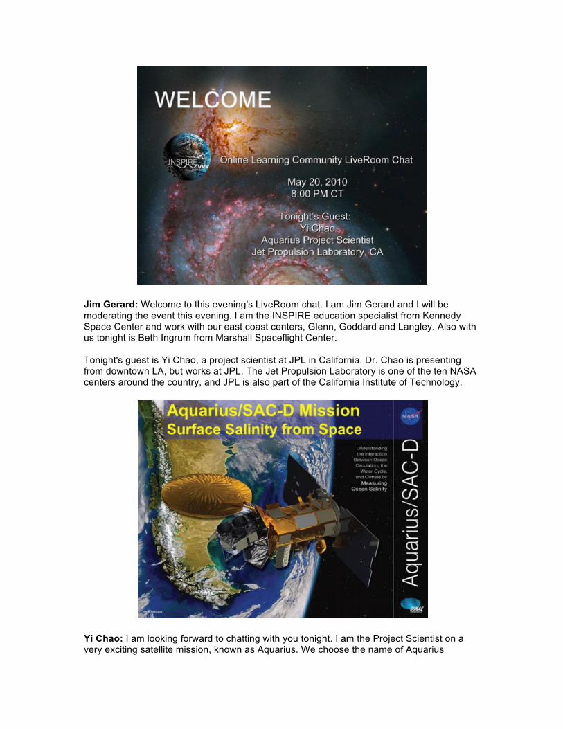
Jim Gerard: Welcome to this evening's LiveRoom chat. I am Jim Gerard and I will be moderating the event this evening. I am the INSPIRE education specialist from Kennedy Space Center and work with our east coast centers, Glenn, Goddard and Langley. Also with us tonight is Beth Ingrum from Marshall Spaceflight Center. Tonight's guest is Yi Chao, a project scientist at JPL in California. Dr. Chao is presenting from downtown LA, but works at JPL. The Jet Propulsion Laboratory is one of the ten NASA centers around the country, and JPL is also part of the California Institute of Technology.
Yi Chao: I am looking forward to chatting with you tonight. I am the Project Scientist on a very exciting satellite mission, known as Aquarius. We choose the name of Aquarius
because it is related to water. The Aquarius satellite is scheduled to launch in about a year from now on April 1, 2011. Today I will share some information about the Aquarius satellite mission. After my talk, I hope you will be able to answer the following questions:
§ What can Aquarius measure? § Why it is important to launch Aquarius satellite? § Why do you care about Aquarius as a high school student?
Are you ready to start? Let's go, next slide!
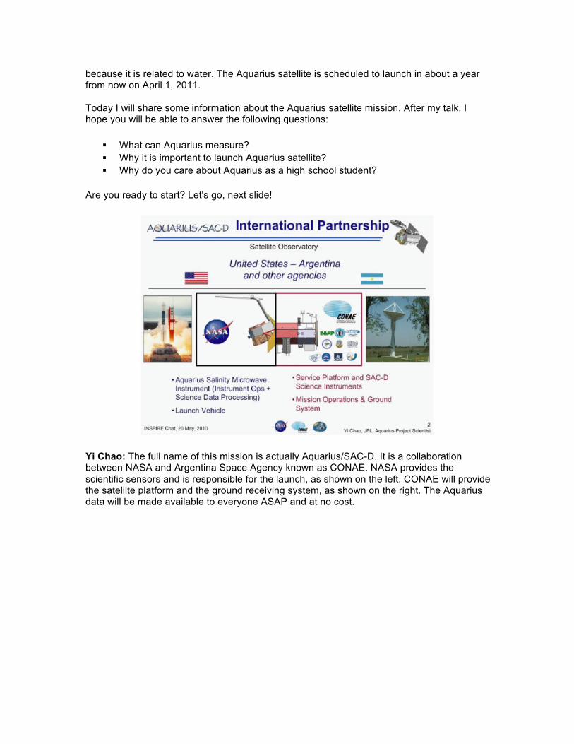
Yi Chao: The full name of this mission is actually Aquarius/SAC-D. It is a collaboration between NASA and Argentina Space Agency known as CONAE. NASA provides the scientific sensors and is responsible for the launch, as shown on the left. CONAE will provide the satellite platform and the ground receiving system, as shown on the right. The Aquarius data will be made available to everyone ASAP and at no cost.
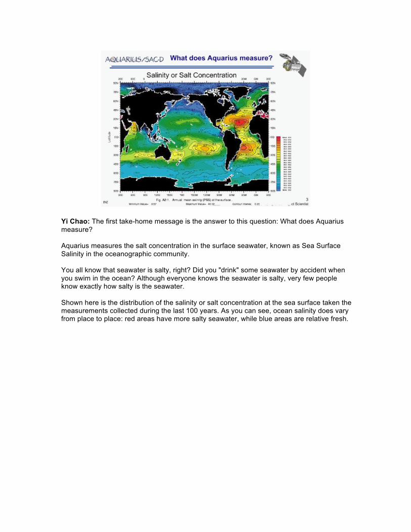
Yi Chao: The first take-home message is the answer to this question: What does Aquarius measure? Aquarius measures the salt concentration in the surface seawater, known as Sea Surface Salinity in the oceanographic community. You all know that seawater is salty, right? Did you "drink" some seawater by accident when you swim in the ocean? Although everyone knows the seawater is salty, very few people know exactly how salty is the seawater. Shown here is the distribution of the salinity or salt concentration at the sea surface taken the measurements collected during the last 100 years. As you can see, ocean salinity does vary from place to place: red areas have more salty seawater, while blue areas are relative fresh.
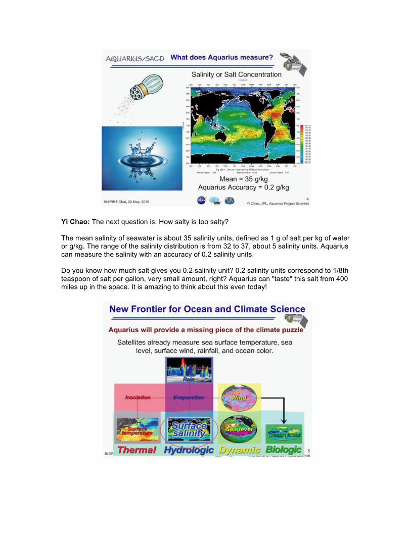
Yi Chao: The next question is: How salty is too salty? The mean salinity of seawater is about 35 salinity units, defined as 1 g of salt per kg of water or g/kg. The range of the salinity distribution is from 32 to 37, about 5 salinity units. Aquarius can measure the salinity with an accuracy of 0.2 salinity units. Do you know how much salt gives you 0.2 salinity unit? 0.2 salinity units correspond to 1/8th teaspoon of salt per gallon, very small amount, right? Aquarius can "taste" this salt from 400 miles up in the space. It is amazing to think about this even today!
Yi Chao: Why is it important to launch Aquarius? The short answer is that Aquarius will provide a missing piece of the ocean and climate puzzle. Many ocean variables are already measured from space. We can measure temperature, rainfall, sea level, wind, and ocean color representing the productivity in the ocean or how green the ocean is. To understand and predict the ocean and climate requires the measurement of salinity, and Aquarius will do just that.
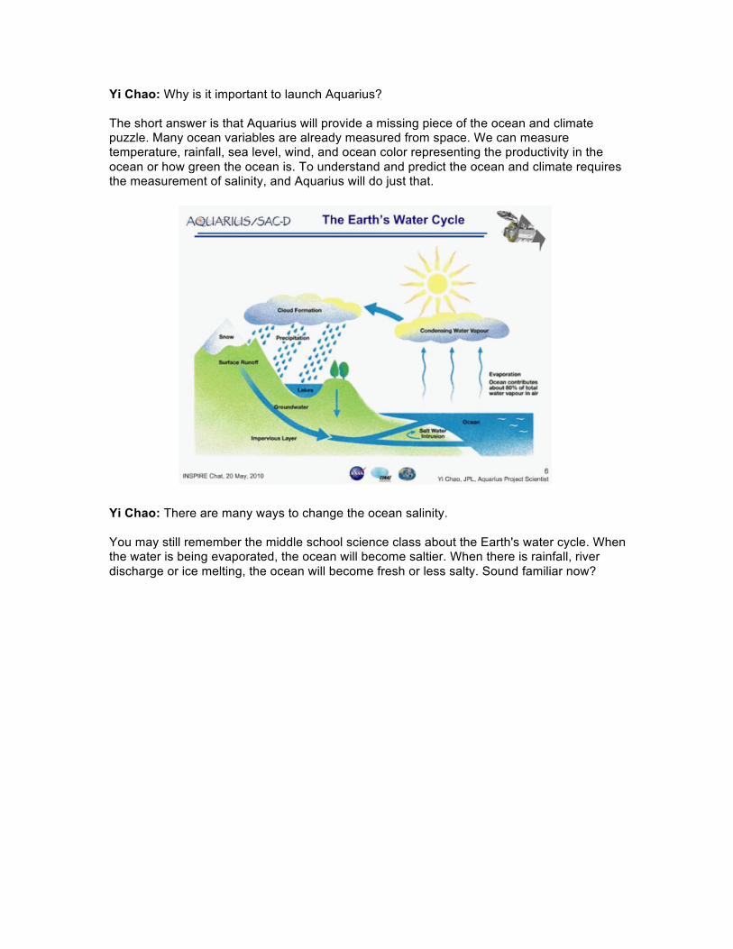
Yi Chao: There are many ways to change the ocean salinity. You may still remember the middle school science class about the Earth's water cycle. When the water is being evaporated, the ocean will become saltier. When there is rainfall, river discharge or ice melting, the ocean will become fresh or less salty. Sound familiar now?
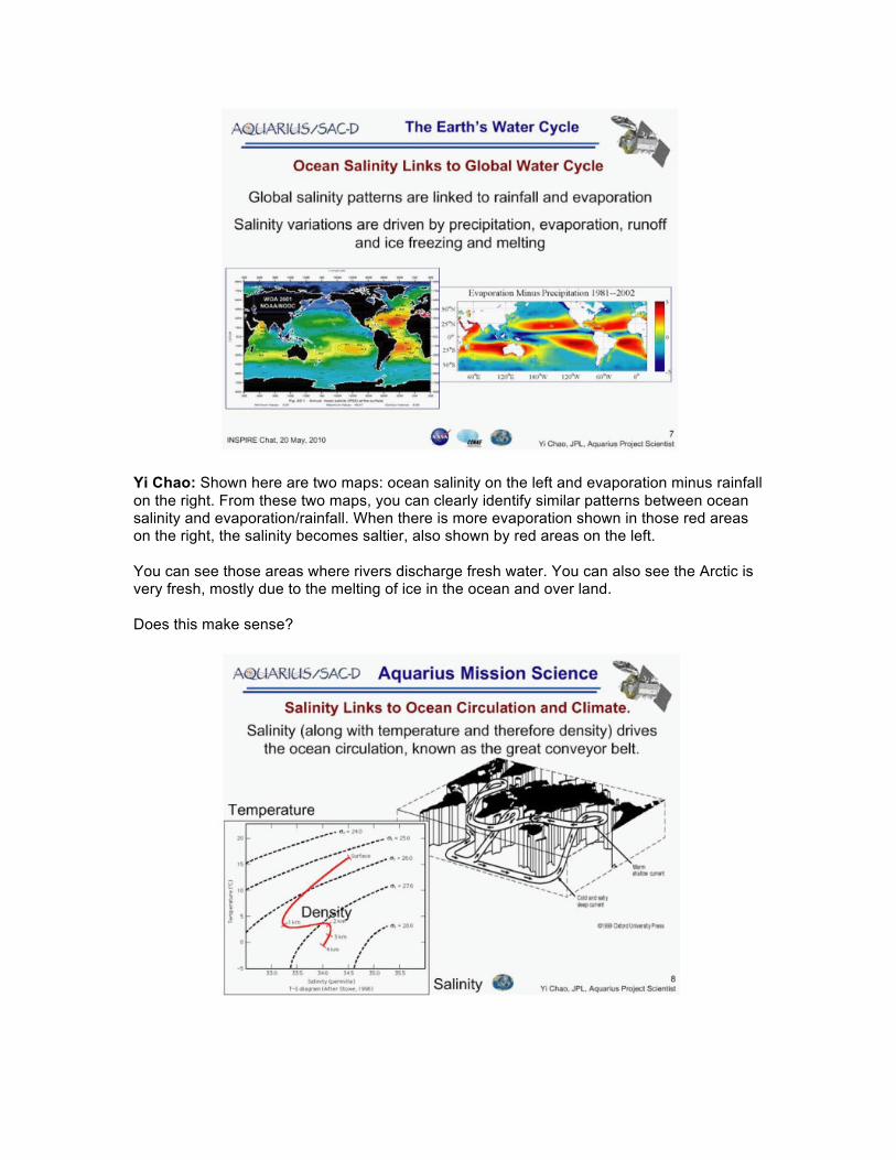
Yi Chao: Shown here are two maps: ocean salinity on the left and evaporation minus rainfall on the right. From these two maps, you can clearly identify similar patterns between ocean salinity and evaporation/rainfall. When there is more evaporation shown in those red areas on the right, the salinity becomes saltier, also shown by red areas on the left. You can see those areas where rivers discharge fresh water. You can also see the Arctic is very fresh, mostly due to the melting of ice in the ocean and over land. Does this make sense?
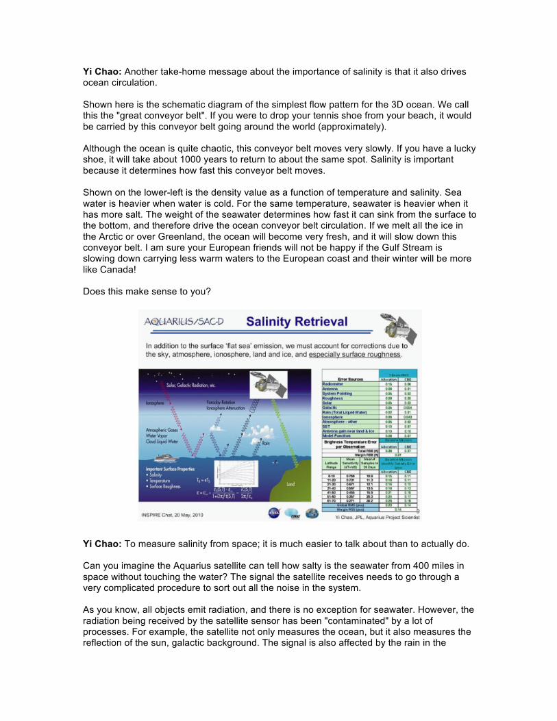
Yi Chao: Another take-home message about the importance of salinity is that it also drives ocean circulation. Shown here is the schematic diagram of the simplest flow pattern for the 3D ocean. We call this the "great conveyor belt". If you were to drop your tennis shoe from your beach, it would be carried by this conveyor belt going around the world (approximately). Although the ocean is quite chaotic, this conveyor belt moves very slowly. If you have a lucky shoe, it will take about 1000 years to return to about the same spot. Salinity is important because it determines how fast this conveyor belt moves. Shown on the lower-left is the density value as a function of temperature and salinity. Sea water is heavier when water is cold. For the same temperature, seawater is heavier when it has more salt. The weight of the seawater determines how fast it can sink from the surface to the bottom, and therefore drive the ocean conveyor belt circulation. If we melt all the ice in the Arctic or over Greenland, the ocean will become very fresh, and it will slow down this conveyor belt. I am sure your European friends will not be happy if the Gulf Stream is slowing down carrying less warm waters to the European coast and their winter will be more like Canada! Does this make sense to you?
Yi Chao: To measure salinity from space; it is much easier to talk about than to actually do. Can you imagine the Aquarius satellite can tell how salty is the seawater from 400 miles in space without touching the water? The signal the satellite receives needs to go through a very complicated procedure to sort out all the noise in the system. As you know, all objects emit radiation, and there is no exception for seawater. However, the radiation being received by the satellite sensor has been "contaminated" by a lot of processes. For example, the satellite not only measures the ocean, but it also measures the reflection of the sun, galactic background. The signal is also affected by the rain in the
atmosphere, by the particles in Ionosphere, etc. For each process, we have identified several subject matter experts who will try to "remove" those noises from the salinity measurement. We can document all these processes in a spreadsheet shown on the right. If we carefully estimate the uncertainty for each noise source, we can then estimate the accuracy of the Aquarius salinity measurements. Do you remember how salty can Aquarius "taste" the seawater? 0.2 salinity units or 0.2g of salt in one kg of water corresponds to 1/8th teaspoon of salt in one gallon of water. Amazing!
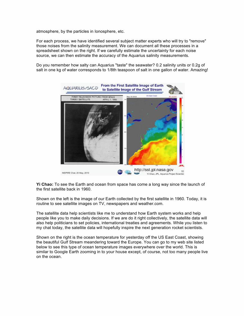
Yi Chao: To see the Earth and ocean from space has come a long way since the launch of the first satellite back in 1960. Shown on the left is the image of our Earth collected by the first satellite in 1960. Today, it is routine to see satellite images on TV, newspapers and weather.com. The satellite data help scientists like me to understand how Earth system works and help people like you to make daily decisions. If we are do it right collectively, the satellite data will also help politicians to set policies, international treaties and agreements. While you listen to my chat today, the satellite data will hopefully inspire the next generation rocket scientists. Shown on the right is the ocean temperature for yesterday off the US East Coast, showing the beautiful Gulf Stream meandering toward the Europe. You can go to my web site listed below to see this type of ocean temperature images everywhere over the world. This is similar to Google Earth zooming in to your house except, of course, not too many people live on the ocean.
Yi Chao: As we launch the Aquarius satellite next year, it will be the first US satellite to be able to measure ocean salinity from space. We all look forward to this new era when we will measure ocean salinity from space. Within a few weeks after the Aquarius launch, we will collect more data about the ocean salinity than what we have done over the past 100 years using ships analyzing water samples. With the Aquarius salinity data, we hope to better understand the Earth's water cycle, ocean circulation and climate change. Think about the day you can ask Aquarius how salty is the seawater at your beach or your next vacation spot. The final take-home message is that it takes a lot of people in a team effort to design, develop and launch a satellite. At the peak, there are more than 100 scientists and engineers working on the Aquarius mission. Some of you will be working at NASA some days to build your own satellite and launch them into space... it is cool! This is what I have prepared as a background introduction. I want to thank the INSPIRE team for this opportunity to chat. Now I am ready to answer questions you might have and make clarifications if my slides are difficult to follow. Jim Gerard: Thanks, Dr. Chao! We'll open for questions in just a moment. Student Questions: Erin: Did your team originally expect to obtain such an accurate ability to detect salinity? Yi Chao: Yes, that is part of the design requirement; we did do a lot of lab and field test to make sure that we can achieve that accuracy.
Matthew: How much does ocean salinity vary with depth? Can Aquarius measure salinity at different depths? Yi Chao: Salinity changes a lot as you go deeper into the ocean. The satellite can only "see" the ocean surface, a very thin layer around a few centimeters. Neil: What kind of spacecraft will the Aquarius fly in; in order to get into space and what is going to be the name of the mission? Yi Chao: The name of the mission called Aquarius/SAC-D. It will be launched in a Delta-2 rocket, from California. Abhiram: You discussed how there are errors in detecting the radiation emitted from the ocean used to determine ocean salinity. How do the radiation signatures from the ocean differ from those of the galactic background and other error sources? Yi Chao: Good question. We model the sun and galactic radiation very accurately, and remove them from the signal the satellite receives. We develop a complete error model for every source. Rithwik: Does the salinity of the seawater have any correlation to global warming? Yi Chao: In the changing climate as the temperature increases, there will be a lot of ice melting, so the salinity will decrease, in other words become fresher. Over the past 50 years, we already see a dramatic freshening of North Atlantic water; so global warming will have a signature in ocean salinity, which is why we want to measure it from space. Erin: Do you work on the hardware or science side of the team? How did you become interested in where you are working now? Yi Chao: I am working on the science side. I am trained as an oceanographer, got my Ph.D. from Princeton in atmospheric and oceanic sciences. I like Earth science. Dalton: Why do you think that the Atlantic Ocean has a higher salinity content than the Pacific Ocean (I'm basing this on the photograph I saw in one of your slides)? Yi Chao: The Atlantic experiences a higher amount of evaporation; the same is true for the Mediterranean Sea, where salinity is as high as 37-39 PSUs. Peter: I think it's amazing how it is possible to determine the salinity of water all over the world accurately with all the other "errors" that can affect it. How difficult was it to develop this method to determine the salinity of water in the ocean? Yi Chao: The theory was developed more than 20 years ago. Because this is such a challenging measurement, it took more than a decade to demonstrate that we can do this. We did the lab test first, then build a water pool outside, and fly the aircraft to measure salinity in the coastal ocean, Now we believe that we are ready and can do it. Erin: What was the biggest challenge that your team overcame during development? Yi Chao: Confidence in what you are doing, continue to work on even during times of setbacks. It takes a team of people sharing the same goal. Emily: Why does the Atlantic have more evaporation? Yi Chao: Mostly due to the land-sea contrast, it is also smaller than the Pacific, in between two major continents. Matthew: What parts of the light spectrum do you look at to determine the salinity? Yi Chao: I forgot to mention the sensor is a microwave radiometer, with a frequency of 1.4 GHz.
Abhiram: I understand that this is exciting new technology and that suppose the salinity could be measured over a great depth of water or even ice, the consequences would be phenomenal. Do you see the technology getting better in the near future? Yi Chao: Yes, Aquarius is the first US satellite to measure salinity from space. Erin: Are there any specific theories or predictions that the science community would like to prove about salinity, or is this more of a fact-finding mission? Yi Chao: There are two types of objectives for the Aquarius mission. The first objective is about discovery. As you said, this will be a fact-finding mission. In those places where ocean salinity was never measured, Aquarius will find something new and interesting. The second objective is about salinity science, including the global water cycle, the ocean's circulation and its role in climate. Jonathan: What kind of equipment is placed in the oceans to take readings, which can work together with the data to be collected by the satellite? What about animals and tracking mechanisms, which travel long distances in the ocean waters? Yi Chao: There are a number of ways of measuring the salinity in the water, including tagging marine animals as you mentioned. The TOPP project is just one such example of tagging animals in the ocean. One can also measure salinity from ships, moored and drifting buoys, and profiling floats. There are 3000+ floats that measure sea surface salinity every 10 days, see the project web site to learn more. We need these in-situ measurements to calibrate the satellite observations, and verify the proposed 0.2 salinity units accuracy. Dalton: Do you think the recent oil spill in the Atlantic will affect this great belt current you were speaking of? Yi Chao: No, the impact of this oil spill in the Gulf of Mexico on the overall circulation is very small. However, the ocean circulation in the Gulf of Mexico, known as the Loop Current, which is part of the Gulf Stream and the great conveyor belt will have a major impact on the spreading patterns of the oil. To have a good understanding of the 3D ocean circulation is essential in order to predict where the oil will go and how long does it take to reach to the surface.