Embed Size (px)
Citation preview
REPORT ON
JAPAN TSUNAMI AND EARTHQUAKE
TSUNAMI
What is a tsunami?
A tsunami is a series of ocean waves with very long wavelengths (typically hundreds of kilometres) caused by large-scale disturbances of the ocean, such as:
earthquakes landslide volcanic eruptions explosions meteorites
These disturbances can either be from below (e.g. underwater earthquakes with large vertical displacements, submarine landslides) or from above (e.g. meteorite impacts).
Tsunami is a Japanese word with the English translation: "harbour wave". In the past, tsunamis have been referred to as "tidal waves" or "seismic sea waves". The term "tidal wave" is misleading; even though a tsunami's impact upon a coastline is dependent upon the tidal level at the time a tsunami strikes, tsunamis are unrelated to the tides. (Tides result from the gravitational influences of the moon, sun, and planets.) The term "seismic sea wave" is also misleading. "Seismic" implies an earthquake-related generation mechanism, but a tsunami can also be caused by a non-seismic event, such as a landslide or meteorite impact.
Tsunamis are also often confused with storm surges, even though they are quite different phenomena. A storm surge is a rapid rise in coastal sea-level caused by a significant meteorological event - these are often associated with tropical cyclones.
The physics of a tsunami
Tsunamis can have wavelengths ranging from 10 to 500 km and wave periods of up to an hour. As a result of their long wavelengths, tsunamis act as shallow-water waves. A wave becomes a shallow-water wave when the wavelength is very large compared to the water depth. Shallow-water waves move at a speed, c, that is dependent upon the water depth and is given by the formula:
where g is the acceleration due to gravity (= 9.8 m/s2) and H is the depth of water.
In the deep ocean, the typical water depth is around 4000 m, so a tsunami will therefore travel at around 200 m/s, or more than 700 km/h.
For tsunamis that are generated by underwater earthquakes, the amplitude of the tsunami is determined by the amount by which the sea-floor is displaced. Similarly, the wavelength and period of the tsunami are determined by the size and shape of the underwater disturbance.
As well as travelling at high speeds, tsunamis can also travel large distances with limited energy losses. As the tsunami propagates across the ocean, the wave crests can undergo refraction (bending), which is caused by segments of the wave moving at different speeds as the water depth along the wave crest varies.
What happens to a tsunami as it approaches land?
As a tsunami leaves the deep water of the open-ocean and travels into the shallower water near the coast, it transforms. If you read the "The physics of a tsunami" section, you will know that a tsunami travels at a speed that is related to the water depth - hence, as the water depth decreases, the tsunami slows. The tsunami's energy flux, which is dependent on both its wave speed and wave height, remains nearly constant. Consequently, as the tsunami's speed diminishes, its height grows. This is called shoaling. Because of this shoaling effect, a tsunami that is unnoticeable at sea, may grow to be several metres or more in height near the coast.
The increase of the tsunami's waveheight as it enters shallow water is given by:

where hs and hd are waveheights in shallow and deep water and Hs and Hd are the depths of the shallow and deep water. So a tsunami with a height of 1 m in the open ocean where the water depth is 4000m would have a waveheight of 4 to 5 m in water of depth 10 m.
Just like other water waves, tsunamis begin to lose energy as they rush onshore - part of the wave energy is reflected offshore, while the shoreward-propagating wave energy is dissipated through bottom friction and turbulence. Despite these losses, tsunamis still reach the coast with tremendous amounts of energy. Depending on whether the first part of the tsunami to reach the shore is a crest or a trough, it may appear as a rapidly rising or falling tide. Local bathymetry may also cause the tsunami to appear as a series of breaking waves.
Tsunamis have great erosion potential, stripping beaches of sand that may have taken years to accumulate and undermining trees and other coastal vegetation. Capable of inundating, or flooding, hundreds of metres inland past the typical high-water level, the fast-moving water associated with the inundating tsunami can crush homes and other coastal structures. Tsunamis may reach a maximum vertical height onshore above sea level, often called a run-up height, of tens of metres.
How are tsunamis measured or observed?
In the deep ocean, a tsunami has a small amplitude (less than 1 metre) but very long wavelength (hundreds of kilometres). This means that the slope, or steepness of the wave is very small, so it is practically undetectable to the human eye. However, there are ocean observing instruments that are able to detect tsunamis.
Tide Gauges

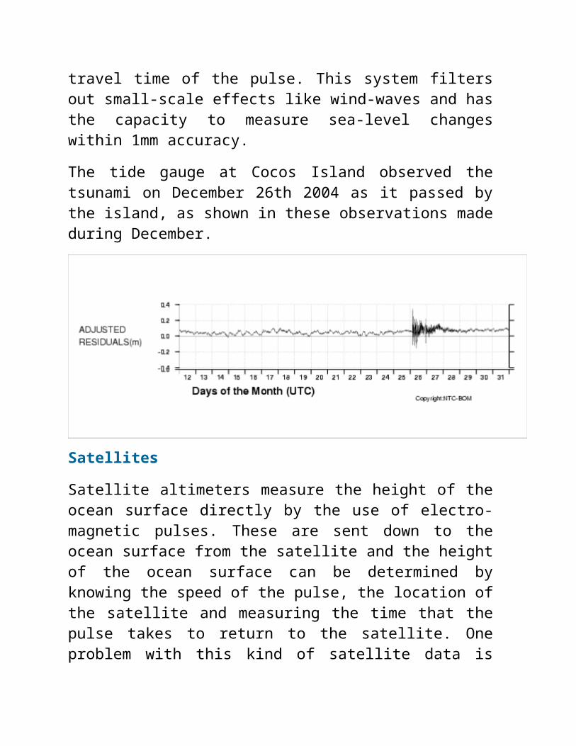
Tide gauges measure the height of the sea-surface and are primarily used for measuring tide levels. Most of the tide gauges operated by the Bureau of Meteorology's National Tidal Centre are SEAFRAME stations (Sea Level Fine Resolution Acoustic Measuring Equipment). These consist of an acoustic sensor connected to a vertical tube open at the lower end which is in the water. The acoustic sensor emits a sound pulse which travels from the top of the tube down to the water surface, and is then reflected back up the tube. The distance to the water level can then be calculated using the travel time of the pulse. This system filters out small-scale effects like wind-waves and has the capacity to measure sea-level changes within 1mm accuracy.
The tide gauge at Cocos Island observed the tsunami on December 26th 2004 as it passed by the island, as shown in these observations made during December.
Satellites
Satellite altimeters measure the height of the ocean surface directly by the use of electro-magnetic pulses. These are sent down to the ocean surface from the satellite and the height of the ocean surface can be determined by knowing the speed of the pulse, the location of the satellite and measuring the time that the pulse takes to return
to the satellite. One problem with this kind of satellite data is that it can be very sparse - some satellites only pass over a particular location about once a month, so you would be lucky to spot a tsunami since they travel so quickly. However, during the Indian Ocean tsunami of December 26th 2004, the Jason satellite altimeter happened to be in the right place at the right time.
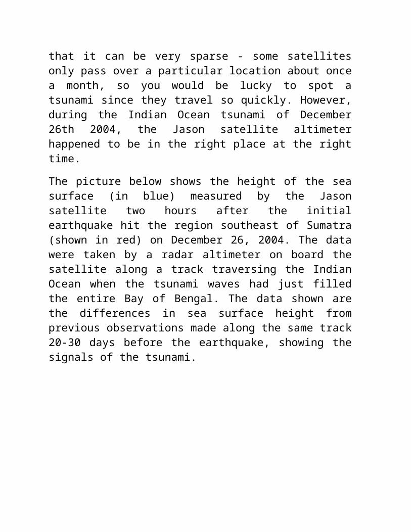
The picture below shows the height of the sea surface (in blue) measured by the Jason satellite two hours after the initial earthquake hit the region southeast of Sumatra (shown in red) on December 26, 2004. The data were taken by a radar altimeter on board the satellite along a track traversing the Indian Ocean when the tsunami waves had just filled the entire Bay of Bengal. The data shown are the differences in sea surface height from previous observations made along the same track 20-30 days before the earthquake, showing the signals of the tsunami.
Picture courtesy of NASA/JPL-Caltech
The DART System
In 1995 the National Oceanic and Atmospheric Administration (NOAA) began developing the Deep-ocean Assessment and Reporting of Tsunamis (DART) system. An array of stations is currently deployed in the Pacific Ocean. These stations give detailed information about tsunamis while they are still far off shore. Each station consists of a sea-bed bottom pressure recorder which detects the passage of a tsunami. (The pressure of the water column is related to the height of the sea-surface) . The data is then transmitted to a surface buoy via sonar. The surface buoy then radios the information to the Pacific Tsunami Warning Center (PTWC) via satellite. The bottom pressure recorder lasts for two years while the surface buoy is replaced every year. The system has considerably improved the forecasting and warning of tsunamis in the Pacific.
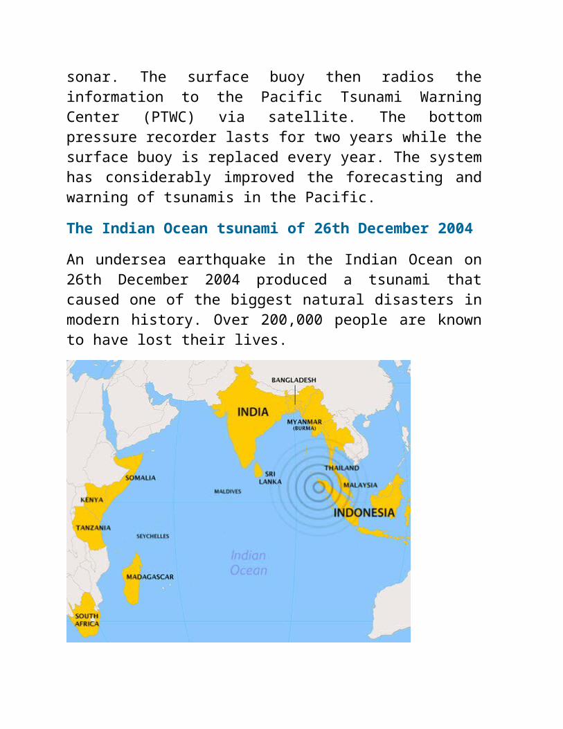
The Indian Ocean tsunami of 26th December 2004
An undersea earthquake in the Indian Ocean on 26th December 2004 produced a tsunami that caused one of the biggest natural disasters in modern history. Over 200,000 people are known to have lost their lives.
The waves devastated the shores of parts of Indonesia, Sri Lanka, India, Thailand and other countries with waves reported up to 15 m high, reaching as far as Somalia on the east coast of Africa, 4500 km west of the epicentre. Refraction and diffraction of the waves meant that the impact of the tsunami was noticed around the world and sea-level monitoring stations in places such as Brazil and Queensland also felt the effect of the tsunami.
This animation (10.4Mb) was produced by scientists in the Bureau of Meteorology's National Tidal Centre. A numerical model was used to replicate the generation and propagation of the tsunami and it shows how the waves propagated around the world's ocean basins.
The earthquake took place at about 1am UTC (8am local time) in the Indian Ocean off the western coast of northern Sumatra. With a magnitude of 9.0 on the Richter scale, it was the largest since the

1964 earthquake off Alaska and equal fourth largest since 1900, when accurate global seismographic record-keeping began.
The epicentre of the earthquake was located about 250 km south-southeast of the Indonesian city of Banda Aceh. It was a rare megathrust earthquake and occurred on the interface of the India and Burma tectonic plates. This was caused by the release of stresses that develop as the India plate subducts beneath the overriding Burma plate. A megathrust earthquake is where one tectonic plate slips beneath another, causing vertical motion of the plates. This large vertical displacement of the sea-floor generated the devastating tsunami, which caused damage over such a large area around the Indian Ocean.
The earthquake was also unusually large in geographical extent. An estimated 1200 km of faultline slipped about 15 m along the subduction zone over a period of several minutes. Because the 1,200 km of faultline affected by the quake was in a nearly north-south orientation, the greatest strength of the waves was in an east-west direction. Bangladesh, which lies at the northern end of the Bay of Bengal, had very few casualties despite being a populous low-lying country.
Due to the distances involved, the tsunami took anywhere from fifteen minutes to seven hours (for Somalia) to reach the various coastlines. (See this travel time map). The northern regions of the Indonesian island of Sumatra were hit very quickly, while Sri Lanka and the east coast of India were hit roughly two hours later. Thailand was also struck about two hours later, despite being closer to the epicentre, because the tsunami travelled more slowly in the shallow Andaman Sea off its western coast.
On its arrival on shore, the height of the tsunami varied greatly, depending on its distance and direction from the epicentre and other
factors such as the local bathymetry. Reports have the height ranging form 2-3 m at the African coast (Kenya) up to 10-15 m at Sumatra, the region closest to the epicentre.
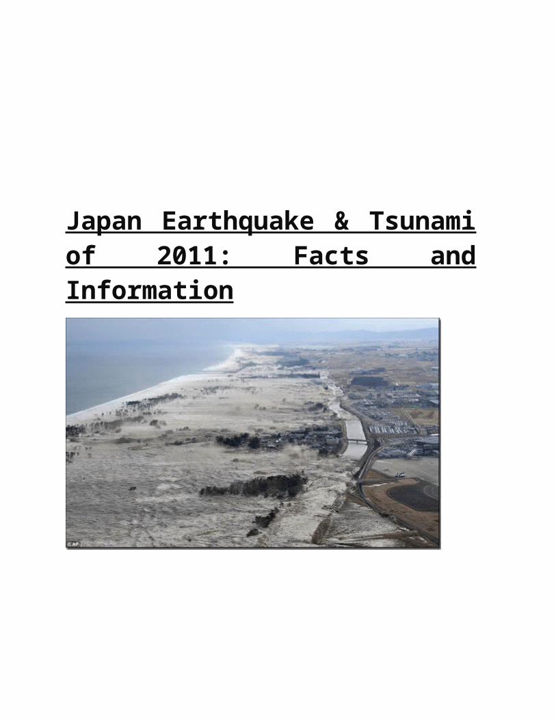
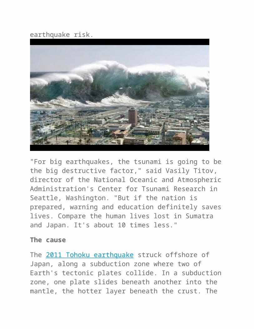
Japan Earthquake & Tsunami of 2011: Facts and Information
On March 11, 2011, a magnitude-9 earthquake shook northeastern Japan, unleashing a savage tsunami.
The effects of the great earthquake were felt around the world, from Norway's fjords to Antarctica's ice sheet. Tsunami debris continues to wash up on North American beaches two years later.
Japan still recovering
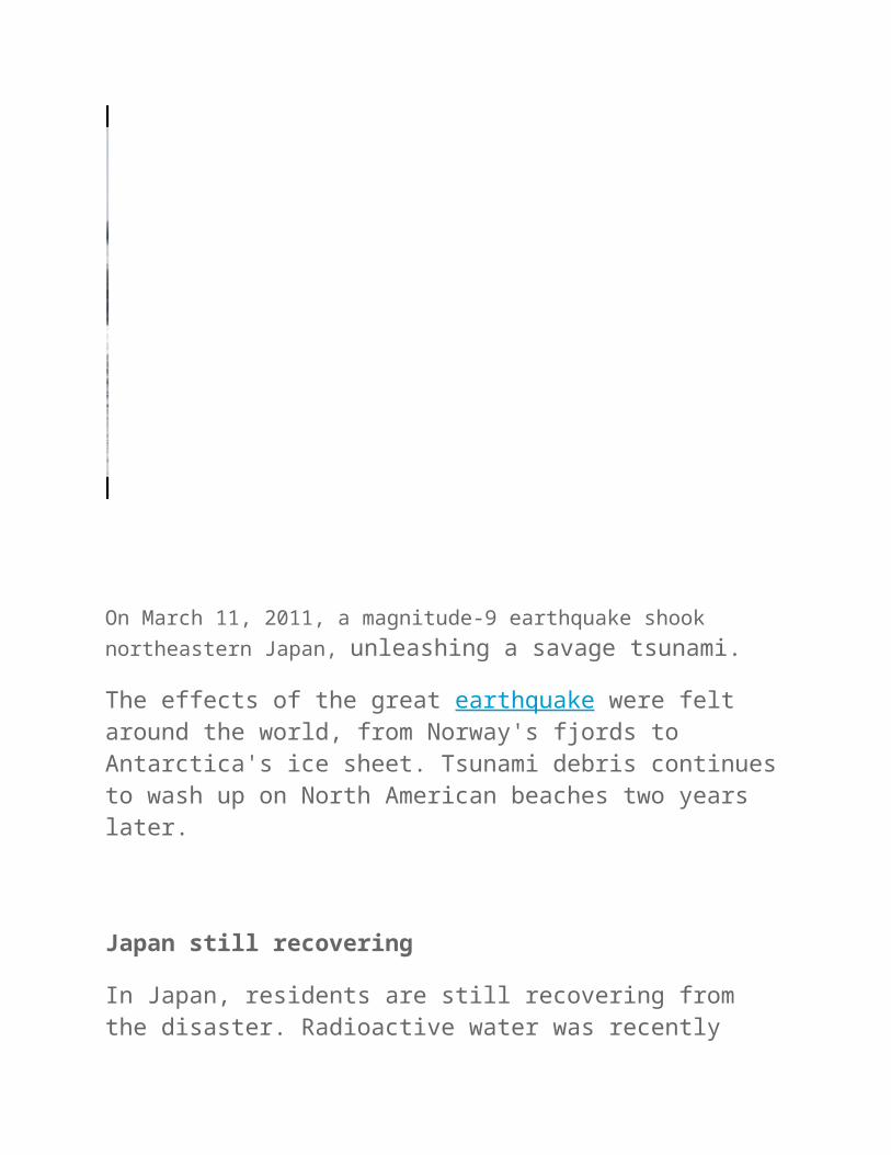
In Japan, residents are still recovering from the disaster. Radioactive water was recently discovered leaking from the Fukushima Daiichi Nuclear Power Plant, which suffered a level 7 nuclear meltdown after the tsunami. Japan relies on nuclear power, and many of the country's nuclear reactors remain closed because of stricter seismic safety standards since the earthquake. Four years after the quake, about 230,000 people who lost their homes were still living in temporary housing, Japan's Reconstruction Agency said.
The total damages from the earthquake and tsunami are estimated at $300 billion dollars (about 25 trillion yen), according to the Japanese government.
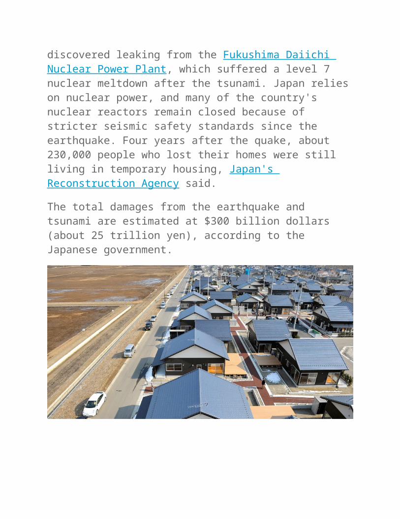
Earthquake a surprise
The unexpected disaster was neither the largest nor the deadliest earthquake and tsunami to strike this century. That record goes to the 2004 Banda Aceh earthquake and tsunami in Sumatra, a magnitude-9.1, which killed more than 230,000 people. But Japan's one-two punch proved especially devastating for the earthquake-savvy country, because few scientists had predicted the country would experience such a large earthquake and tsunami.
Japan's scientists had forecast a smaller earthquake would strike the northern region of Honshu, the country's main island. Nor did they
expect such a large tsunami. But there had been hints of the disaster to come. The areas flooded in 2011 closely matched those of a tsunami that hit Sendai in 869. In the decade before the 2011 Tohoku earthquake, a handful of Japanese geologists had begun to recognize that a large earthquake and tsunami had struck the northern Honshu region in 869. However, their warnings went unheeded by officials responsible for the country's earthquake hazard assessments. Now, tsunami experts from around the world have been asked to assess the history of past tsunamis in Japan, to better predict the country's future earthquake risk.
"For big earthquakes, the tsunami is going to be the big destructive factor," said Vasily Titov, director of the National Oceanic and Atmospheric Administration's Center for Tsunami Research in Seattle, Washington. "But if the nation is prepared, warning and education definitely saves lives. Compare the human lives lost in Sumatra and Japan. It's about 10 times less."
The cause
The 2011 Tohoku earthquake struck offshore of Japan, along a subduction zone where two of Earth's tectonic plates collide. In a subduction zone, one plate slides beneath another into the mantle, the hotter layer beneath the crust. The great plates are rough and stick together, building up energy that is released as earthquakes. East of Japan, the Pacific plate dives beneath the overriding Eurasian plate. The temblor completely released centuries of built up stress between the two tectonic plates, a recent study found.
The March 11 earthquake started on a Friday at 2:46 p.m. local time (5:46 a.m. UTC). It was centered on the seafloor 45 miles (72 kilometers) east of Tohoku, at a depth of 15 miles (24 km) below the surface. The shaking lasted about six minutes. [Infographic: How Japan's 2011 Earthquake Happened]
Scientists drilled into the subduction zone soon after the earthquake and discovered a thin, slippery clay layer lining the fault. The researchers think that this clay layer allowed the two plates to slide an incredible distance, some 164 feet (50 meters), facilitating the enormous earthquake and tsunami.
Early warning
Residents of Tokyo received a minute of warning before the strong shaking hit the city, thanks to Japan's earthquake early warning system. The country's stringent seismic building codes and early warning system prevented many deaths from the earthquake, by stopping high-speed trains and factory assembly lines. People in Japan also received texted alerts of the earthquake and tsunami warnings on their cellphones.
Deaths
The number of confirmed deaths is 15,891 as of April 10, 2015, according to Japan's National Police Agency. Most people died by drowning. More than 2,500 people are still reported missing.
Less than an hour after the earthquake, the first of many tsunami waves hit Japan's coastline. The tsunami waves reached run-up heights (how far the wave surges inland above sea level) of up to 128 feet (39 meters) at Miyako city and traveled inland as far as 6 miles (10 km) in Sendai. The tsunami flooded an estimated area of approximately 217 square miles (561 square kilometers) in Japan.
The waves overtopped and destroyed protective tsunami seawalls at several locations. The massive surge destroyed three-story buildings where people had gathered for safety. Near Oarai, the tsunami generated a huge whirlpool offshore, captured on video.
Nuclear meltdown
The tsunami caused a cooling system failure at the Fukushima Daiichi Nuclear Power Plant, which resulted in a level-7 nuclear meltdown and release of radioactive materials. The electrical power and backup generators were overwhelmed by the tsunami, and the plant lost its cooling capabilities. In July 2013, TEPCO, the Tokyo Electric Power Company, admitted that about 300 tons of radioactive water continues to leak from the plant every day into the Pacific Ocean.
"Fukushima was created by the tsunami. The earthquake was not a factor," Titov said. "Fukushima was designed for a tsunami smaller than the one we saw."
Very low levels of radioactive chemicals that leaked from Fukushima have been detected along the North American coast offshore Canada and California. Trace amounts of cesium-134 and cesium-137 (radioactive isotopes) were found in seawater collected in 2014 and 2015.

The response
In the tsunami's aftermath, Japan's Meteorological Agency was criticized for issuing an initial tsunami warning that underestimated the size of the wave. The country recently unveiled a newly installed, upgraded tsunami warning system. In some regions, such as Miyagi and Fukushima, only 58 percent of people headed for higher ground immediately after the earthquake, according to a Japanese government study published in August 2011. Many people also underestimated their personal risk, or assumed the tsunami would be as small as ones they had previously experienced, the study found.
Scientists from around the world descended on Japan following the earthquake and tsunami. Researchers sailed offshore and dropped sensors along the fault line to measure the forces that caused the earthquake. Teams studied the tsunami deposits to better understand ancient sediment records of the deadly waves. Earthquake engineers examined the damage, looking for ways to build buildings more resistant to quakes and tsunamis. Studies are ongoing today.
"The tsunami itself died out a long time ago, but the effects in Japan will be there for decades," Titov told Live Science.
Worldwide effects
The tsunami waves also traveled across the Pacific, reaching Alaska, Hawaii and Chile. In Chile, some 11,000 miles (17,000 km) distant, the tsunami was 6.6 feet (2 meters) high when they reached the shore, according to the Pacific Tsunami Warning Center. [Related: Weird Earth Movement After Japan Earthquake Finally Explained]
The surge of water carried an estimated five million tons of debris out to sea, the National Oceanic and Atmospheric Agency has reported.
Japanese docks and ships, and countless household items, have arrived on U.S. and Canadian shores in the ensuing years. The U.S. Coast Guard fired on and sank the derelict boat 164-foot Ryou-Un Maru in 2012 in the Gulf of Alaska. The ship started its journey in Hokkaido.
Amazing facts
Here are some of the amazing facts about the Japan earthquake and tsunami.
The earthquake shifted Earth on its axis of rotation by redistributing mass, like putting a dent in a spinning top. The temblor also shortened the length of a day by about a microsecond.
More than 5,000 aftershocks hit Japan in the year after the earthquake, the largest a magnitude 7.9.
About 250 miles (400 km) of Japan's northern Honshu coastline dropped by 2 feet (0.6 meters), according to the U.S. Geological Survey.
The jolt moved Japan's main island of Honshu eastward by 8 feet (2.4 meters).
The Pacific Plate slid westward near the epicenter by 79 feet (24 m).
In Antarctica, the seismic waves from the earthquake sped up the Whillans Ice Stream, jolting it by about 1.5 feet (0.5 meters).
The tsunami broke icebergs off the Sulzberger Ice Shelf in Antarctica.
As the tsunami crossed the Pacific Ocean, a 5-foot high (1.5 m) high wave killed more than 110,000 nesting seabirds at the Midway Atoll National Wildlife Refuge.
In Norway, water in fjords pointing toward Japan sloshed back and forth as seismic waves from the earthquake raced through.
The earthquake produced a low-frequency rumble called infrasound, which traveled into space and was detected by the Goce satellite.
Buildings destroyed by the tsunami released thousands of tons of ozone-destroying chemicals and greenhouse gases into the air.