Embed Size (px)
Citation preview

ii
Historic Resource Study
JAMAICA BAY: A HISTORY
Gateway National Recreation AreaNew York, New Jersey
Cultural Resource Management Study No. 3
Frederick R. BlackAssociate Professor of History
C. W. Post Center, Long Island Universityfor the
Division of Cultural ResourcesNorth Atlantic Regional Office
National Park ServiceU.S. Department of Interior
Washington, D.C., 1981
Electronic TranscriptionFormatting and Editing
James L. BrownGateway National Recreation Area
2001

iii
FORWARD
Cultural Resources and Natural Areas
Jamaica Bay is a place well known for its flora and fauna. This study adds another dimension to JamaicaBay - -its use by humans, especially during the Historic period. Understanding the human use of the Bayand its shore is both timely and historically interesting. Historically it is often entertaining, as well asInformative, to learn how our ancestors, and the Native Americans who lived here before them, madetheir livings in an environment that is at once the same and different from the one we know - - the same inthat much of the geography is similar; different in that the recent past has witnessed massive alterationsto the natural environment of the Bay.
This study helps place the substantial modern changes in perspective. In doing that, it is timely.Increasingly we are made aware of the relatedness of cultural and natural phenomena. Jamaica Bay isno more a strictly natural resource than Manhattan Island. The history of human land use is an essentialguide to comprehending the Bay’s natural environment currently and in the near future.
The goals of Dr. Black’s research were primarily managerial. We sought sufficient information to evaluatecultural resources, that is, historic and prehistoric archeological sites and historic structures within theJamaica Bay Unit of Gateway National Recreation Area. Happily, the study provides much more than afine management aid. It has a large potential to inform interested persons about the area and assist theGateway staff in interpreting it. For these reasons the Park Service has funded the printing anddistribution of the study.
Francis P. McManamonChief, Division of Cultural Resources
2 March 1981

iv
TABLE OF CONTENTS
INTRODUCTION: Scope, Problems, Methods, Sources...............................................................1I. JAMAICA BAY, 1600-1865...........................................................................................................4
Early Seventeenth-Century Indian Life........................................................................................4Flatlands .......................................................................................................................................9Bergen and Mill Islands............................................................................................................. 11Barren Island ............................................................................................................................. 14Flatbush, New Lots and Jamaica.............................................................................................. 17Agriculture ................................................................................................................................. 19Jamaica Bay Fisheries .............................................................................................................. 21Shipping..................................................................................................................................... 22
II JAMAICA BAY AFTER 1865: ISLANDS, LANDINGS, AND MAINLAND................................ 25Barren Island ............................................................................................................................. 25Canarsie .................................................................................................................................... 43New Lots.................................................................................................................................... 48Howard and Hamilton Beaches ................................................................................................ 51The Islands................................................................................................................................ 56
III JAMAICA BAY AFTER 1865: FISHING, SHIPPING, TRANSPORTATION,TOPOGRAPHICAL CHANGE ...................................................................................................... 61
Fishing ....................................................................................................................................... 61Shipping..................................................................................................................................... 65Transportation ........................................................................................................................... 68Topographical Changes............................................................................................................ 71
CONCLUSIONS AND RECOMMENDATIONS............................................................................ 80FOOTNOTES................................................................................................................................ 83
Chapter I. Jamaica Bay, 1600-1865 ........................................................................................ 83Chapter II. Jamaica Bay After 1865: Islands, Landings, and Mainland ................................. 87Chapter III. Jamaica Bay After 1865: Fishing, Transportation, Topographical Change ........ 91
ANNOTATED BIBLIOGRAPHY.................................................................................................... 95I. Published Historical Sources ................................................................................................ 95II. Census Reports ................................................................................................................... 96III. Town and Municipal Records and Reports ....................................................................... 96IV. New York State Reports and Publications ......................................................................... 97V. Cartographic Sources.......................................................................................................... 98VI. Newspapers ........................................................................................................................ 99VII. Secondary.......................................................................................................................... 99VIII. Directories....................................................................................................................... 102IX. Miscellaneous ................................................................................................................... 103

v
LISTS OF FIGURES and TABLES
Figure 1 Jamaica Bay: General Reference ................................................................................3Figure 2 Indian Sites......................................................................................................................5Figure 3 Flatlands and New Lots, 1700 .................................................................................... 13Figure 4 Barren Island, 1850-1911 ............................................................................................ 16Figure 5 Flatlands and New Lots, 1873 .................................................................................... 28Figure 6 Barren Island and Flatlands Bay, 1911 ..................................................................... 34Figure 7 Barren Island and Flatlands Bay, 1926 ..................................................................... 35Figure 8 Barren Island and Flatlands Bay, 1940 ..................................................................... 36Figure 9 Mill Island and Bergen Island, 1911........................................................................... 40Figure 10 Mill Basin and Bergen Beach, 1926......................................................................... 41Figure 11 Mill Basin and Bergen Beach, 1940......................................................................... 42Figure 12 Canarsie Shoreline, 1911-1940 ................................................................................ 46Figure 13 North Shore, 1911...................................................................................................... 53Figure 14 North Shore, 1926...................................................................................................... 54Figure 15 North Shore, 1940...................................................................................................... 55Figure 16 Central Islands, 1911................................................................................................. 76Figure 17 Central Islands, 1926................................................................................................. 77Figure 18 Central Islands, 1940................................................................................................. 78Figure 19 Central Islands, 1977................................................................................................. 79
Table 1 Flatlands Agriculture 1865 and 1875 ............................................................................. 20Table 2 Barren Island Industries.................................................................................................. 29Table 3 Flatlands Occupations: Agriculturists And Bay Related Workers................................. 62Table 4 Powered Oyster Boats Five Tons or Over Active in Jamaica Bay ................................ 63Table 5 Ferry Service, Jamaica Bay ........................................................................................... 66

INTRODUCTION: Scope, Problems, Methods, Sources
This history covers that portion of Jamaica Bay within the confines of the Jamaica Bay Unit of theGateway National Recreation Area. That unit includes essentially the shore front east and south of theBelt or Shore Parkway from Plum Beach to Spring Creek Park, the waters of the bay itself, and theislands and marshes therein. Not within the Jamaica Bay Unit are the communities of Broad Channel,nearly all of the mainland on the Queens side of the bay, or any part of Rockaway peninsula.Chronologically, the study begins with the arrival of the Dutch in the seventeenth century and ends withthe middle of the twentieth century. Topically, the focus falls on the historic “uses” of the bay and itsperiphery. Generally, those uses consist of residential settlement; agriculture, industry, fishing, shipping,other forms of transportation, and recreation. Some of these activities required alteration in thetopography of the bay, and a description of the major alterations is contained in this study.
Although the foregoing paragraph defines the broad perimeters of this history, they have not been rigidlyobserved. A number of considerations has dictated departures from strict boundaries in time, space andtopic. For example, more than likely, before the early nineteenth century, no one actual resided in anypart of the area now within the Jamaica Bay Unit. And yet during that time, inhabitants of the largervicinity used the bay. To understand that usage requires investigation into the communities within thevicinity. On the other hand, certain activities clearly within the formal boundaries of the Jamaica Bay Unitare poorly covered in the surviving record. For almost three hundred years, Jamaica Bay constituted afisherman’s paradise. Yet little can be determined about fishing in the bay prior to the middle of thenineteenth century.
Other topics have been adequately covered in the existing secondary works, including those produced forthe National Park Service. The history of Floyd Bennett Field is well enough known, yet for a longer timethan that field was an active airport, there had existed almost in the same area a strange industrialcomplex, the Barren Island fish oil and fertilizer factories about which little has been written. Thus logic,the availability of sources the existing secondary literature, and the preferences and competence of thewriter have occasioned flexibility in the scope of the present study.
Some of the problems encountered in the preparation of this history have been already hinted at, such asthe failure of early sources to comment at length about commonplace matters. For example, what kinds ofboats eighteenth-century fishermen used is far from clear. Reflections upon the inadequacies of sourcesis doubtless all too common among historians. However Jamaica Bay presents special problems.Primary is the wide dispersal of the record of the bay. Until the twentieth century, few regarded JamaicaBay as a whole unit. Politically, its waters and adjacent lands fell with numerous jurisdictions—the townsof Gravesend, Flatlands, Flatbush, New Lots, Jamaica and Hempstead; the counties of Kings andQueens; and later the municipalities of Brooklyn and of Greater New York. This means that extantrecords are scattered among numerous depositories. Some apparently have been lost, such as thepapers of the Canarsie Chamber of Commerce.

2
Methodologically, this history is conventional, and the chief effort has been to piece together informationfrom primary sources where possible and from secondary authorities where need be so as to achieve anunderstanding of Jamaica Bay’s past. Some simple quantification analyses have been employedrequiring no prefatory elaboration.
Among the more rewarding primary sources used in this study are nineteenth-century federal and statecensuses for the Town of Flatlands. Beginning with the year 1850, those reports list occupations and thusprovide important information about economic activities in the vicinity of the bay. The records of the towngovernment of Flatlands have also been explored. Especially the annual assessment rolls provedinvaluable in identifying the companies engaged in manufacturing at Barren Island. When Flatlandsceased existence as an independent town and joined Greater New York, its common lands, includingmost of the marshlands along the western side of the bay, became the property of New York City,administered for over three decades by the Department of Docks and Ferries. The annual reports of thatdepartment are infuriatingly general with respect to many matters, but the rent rolls they contain list allleases of land under water and of other sites in Jamaica Bay. Such lists are an index to use of the bay forpurposes of vacation-type buildings. A variety of maps have been consulted. Most accurate and usefulare the maps of the United States Coast and Geodetic Survey, now known as the National Oceanic andAtmospheric Administration. Comparison of the Jamaica Bay charts for the years 1878, 1911, 1926,1940, and 1977 provides a means of tracing the changes in the bay’s topography. In the bibliography ofthis study, particular sources will receive further comment.

3
Figure 1 Jamaica Bay: General Reference
SOURCE: Park Association, NYC, Jamaica Bay, (1968)

4
I. JAMAICA BAY, 1600-1865
The waters of Jamaica Bay did not serve as an avenue for settlement of the southwestern segment ofLong Island. European settlers arrived in the seventeenth and eighteenth centuries by way of landroutes. Those settlers were not the first human inhabitants of the area, since several important villages ofthe Canarsie Indians were in the general vicinity of the bay. From 1624 to 1664, western Long Island,Manhattan and other parts of the Hudson Valley were included in the province of New Netherlands,administered by the Dutch West India Company.
Settlement or other permanent use of Long Island was delayed until 1636, when the Dutch began activityin what became Kings County. They negotiated for land and started settlements at Amesfort or Flatlandsand at Gowanus Bay. Soon the Dutch West India Company secured from the Indians title to virtually allof the land in Kings County.
Conquest of New Netherlands by the English in 1664 was followed by a smooth transition of LongIsland’s Dutch inhabitants into their new status as subjects of the crown of England. A century later,American colonists embarked on a movement that climaxed in independence from England. During theRevolutionary War, towns in the vicinity of Jamaica Bay, along with the rest of western Long Island, hadan experience different from others in America since following their victory in the battle of Brooklyn in1776; British Forces established an occupation that persisted until 1783 and the end of the war.
Early Seventeenth-Century Indian Life
Historical and archaeological literature refers to numerous Indian sites in the Jamaica Bay vicinity.According to 1934 work by Reginald Bolton thirteen sites existed within two or three miles of the bay.Those in what became Kings County were Narriock(Sheepshead Bay), Massabarkem (Gravesend),Ryders Pond(Gerritsen Creek), Keskaechqueren (Flatlands), Winnipague (Bergen Beach), Canarsie, andMuskyttehool, on the upper reaches of Bedford Creek. The Queens County sites consisted of Jamaica,Aqueduct, and locations on Hawtree, Bergen, Cornell, and Hassock Creek 1 Several entries on Bolton’slist, such as Muskyttehool and Massabarkem, are merely places assigned Indian names in historicaldocuments and suspected of having importance in Indian activities.
Subsequent scholarship tends to limit sites to places known to have contained artifacts, namely RydersPond, Bergen Beach and Aqueduct. 2 All of the sites, both historic and archaeological, have beendestroyed by filling and construction, and, prior to that destruction, none was the location of professionalarchaeological field work.
1 Reginald Pelham Bolton, Indian Life Long Ago in the City of New York (Port Washington, N.Y.:
Ira J. Friedman, 1971; originally published 1934), 144-51.2 Carlyle Shreeve Smith, The Archaeology of Coastal New York (vol. 45, part 2, Anthropological
Papers of the Museum of Natural History (New York: American Museum of Natural History, 1950); LynnCeci, "The Effect of European Contact and Trade on the Settlement Patterns of Indians in Coastal NewYork, 1524-1665: The Archaeological and Documentary Evidence," diss. City University of New York,1977.

5
Figure 2 Indian Sites
SOURCE: Bolton, Indian Life, pp. 144 . 51

6
The best information comes from a collection of Ryders Pond artifacts, originally assembled in the late1890s without field notes or stratigraphic data and systematically analyzed in 1961.3
Generally speaking, specific archaeological information about aboriginal cultures at Jamaica Bay duringthe early historic period is slim. Documentary evidence, although frequently lacking in particulars andoften uncertain respecting exact locations, provides some insights. Moreover, on the basis of findings forarchaeological sites elsewhere in coastal New York, scholars have produced a model of Indian culture atthe time of contact. The cultural pattern of Indians of western Long Island at the end of the sixteenthcentury is classified by archaeologists as Late Woodland, East River Aspect, Clasons Point Phase.Important elements in that cultural pattern include permanent settlements, occupying approximately oneacre and located on tidal streams and bays. Profuse remains of marine shellfish and smaller amounts ofmammal, bird, amphibian, and fish bones indicate an economy emphasizing fishing and hunting. Fishwere captured by nets weighted with stones and by single-piece barbless bone hooks. Shellfishingequipment consisted of dug-out canoes and wooden rakes.4
Recently Lynn Ceci has questioned the role of maize cultivation among late pre-contact coastal peoples.Others admit that the evidence for such cultivation is slight, but nevertheless conclude the practice waswell established. Clasons Point artifacts include stone hoes, stone pestles, shallow mortars, and woodengrinding gears, all of which suggest the raising of corn. Ceci’s claim is that the production of maizebecame extensive after and as a result of contact with Europeans.5
No indications have been discovered that native peoples in the vicinity of Jamaica Bay did not conform tothe general culture associated with Clasons Point. Those people, along with others of coastal New York,spoke Algonkian languages. Politically, they were part of the Metoac confederacy, a loose affiliation ofthe thirteen ethnic groups on Long Island. Among the western Metoac were two closely related groups,the Canarsie and the Rockaway. Lands of the Canarsie included all of modern Kings County and part ofthe town of Jamaica. The bulk of Queens County, including the remainder of Jamaica, and the southernpart of the town of Hempstead were occupied by the Rockaway.6 Thus, the western and northern shoresof Jamaica Bay fell within the territory of the Canarsie, and the eastern belonged to the Rockaway.
The Canarsie had four important sites near the bay. Earlier authorities and those relying on them assertthat the main village of the Canarsie was located in the Canarsie section of the Dutch town originallyknown as Amesfort and later as Flatlands. Archaeologically, the site is said to have been conspicuousbecause of “immense shell heaps.” Bolton describes Canarsie as “a village site,” with “extensive plantingfields, extended back from Canarsie Beach Park as far as Avenue J, centered on East 92nd Street.”7Documentary evidence substantiates the existence at Canarsie of Indian maize fields.
Another Canarsie site was Winnipague, later known as Bergen Island or Bergen Beach. Bolton, who
3. Julius Lopez and Stanley Wisniewski, "The Ryders Pond Site, Kings County, New York," The
Coastal Archaeological Reader: Selections from the New York State Archaeological Bulletin, 1954-1977:Readings in Long Island Archaeology and Ethnic History, vol. II (Stony Brook, N.Y.: Suffolk CountyArcheological Association, 1978), 206-27, 233-47.
4 William A. Ritchie, The Archaeology of New York State (Garden City, N.Y.: The NaturalHistory Press, 1965), 269-71; Smith, 101, 158.
5 William A. Ritchie and Robert F. Funk, Aboriginal Settlement Patterns in the Northeast (Memoir20, New York State Museum and Science Service; Albany: University of the State of New York, 1973),178; Ritchie, 270; Ceci, 1-3, 191.
6. Allen W. Trelease, Indian Affairs in Colonial New York (Port Washington, N.Y.: Ira J.Friedman, 1977; originally published 1960), 7-9.
7 F. M. Ruttenber, History of the Indian Tribes of Hudson's River (Port Washington, N.Y.: Ira J.Friedman, 1971; originally published 1872), 73; William Wallace Tooker, The Indian Place-Names of LongIsland and Islands Adjacent (Port Washington, N.Y.: Ira J. Friedman, 1962; originally published 1911),31-33; John O’Halloran, "Canarsie Indian Sites," Long Island Forum, vol. XIII, number 4 (April 1950), 63-64, 66, 75; Arthur C. Parker, The Archeological History of New York (Albany: University of the State ofNew York, 1920), 582; Bolton, 148.

7
categorizes the site as an “important station,” writes of “the extensive shell beds on this island, and stoneimplements.” In 1949, another writer actually retrieved prepared conch whorls and a broken arrowhead atBergen Beach. What kind of activity Indians engaged in at Winnipague is by no means clear, oneconjecture being that the island was a large wampum-making center.8
Unlike the Canarsie and Winnipague sites, Ryders Pond produced a substantial quantity of artifacturalspecimens. Those specimens are attributed to the Clasons Point focus, East River aspect. The site waslocated on Strome Kill, subsequently known as Gerritsen Creek or Gerritsen Basin, and later fell withinthe confines of Avenue R, East 32nd Street, Avenue W, and Stuart Street. Today the site is part ofBrooklyn Marine Park. Bolton designates the village as Shanscomacoke, a name used in the Indianconveyance of Equendito or Barren Island in 1664.9
In 1939, the Flushing Historical Society investigated the Aqueduct site, near the head of Hawtree Creek.Shortly thereafter, the location was buried by construction of the Shore Parkway. The chief findings wereseveral bowl-shaped pits containing refuse and one burial pit. Pottery artifacts discovered belong to theEast River tradition. Bolton states: "A site of native occupancy was found at Aqueduct Station. . . . Manyfragments of pottery indicated that the clay which existed in the vicinity was utilized to make pottery."10
Canarsie, Bergen Beach, Ryders Pond, and Aqueduct were probably the only sites of significant activityor habitation by the Canarsie Indians within close proximity of Jamaica Bay. Other sites listed by Boltonseem to have produced no verifiable artifactual specimens and enter the historical record because ofmention in conveyances from the Indians to Europeans.
Between 1636 and 1667, the Indian title to practically all land in Kings and Queens counties, including theshores of Jamaica Bay, was terminated. In three separate deeds, all dated June 16, 1636; CanarsieIndians assigned to the Butch a tract called Keskateuw. That tract encompassed almost the entirety ofthe western side of the bay and came to constitute the land of the Dutch town of Amesfort.11
Canarsie Indians remained in the area, however, not regarding the land transactions as extinguishing allof their rights. Nevertheless, their numbers declined, Native occupancy at Jamaica Bay may havepersisted longest in the Canarsie section of Amesfort. Dutch residents in the village of Amesfort rentedIndian fields at Canarsie until the mid-1660s.
Then the lands at Canarsie were sold outright to the Dutch, with the condition:
...that the purchasers once for always a fence shall set at Canarissen for the protection ofthe Indian cultivation..., and the land which becomes inclosed in fence shall by the Indianowners above mentioned all their lives to be used, to wit, by Wametappack, the Sachem,with his two brothers... 12
8 Bolton, 146; O'Halloran, 63; Frederick Van Wyck, Keshachague or the First White Settlement
on Long Island (New York: G. P. Putnams Sons 1924) 108.9 Lopez and Wisniewski, 209; Bolton, 146; Indian Deed, May 13, 1664, to John Tilton and
Samuel Spicer, in Abstract of the Title of the Southern part of Barren Island. . . . (unpublished typescript,no date), Long Island Room, Queensborough Public Library (hereafter cited as QPL).
10 Smith, 170-71; Bolton, 151.11 Indian Deed for Land on Long Island, Called Sewanhacky (for the middle "flat"); Indian Deed
for Land on Long Island (western "flat"); Indian Deed for Land on Long Island (eastern "flat"), in EdmundB. O'Callaghan (ed.), Documents Relating to the Colonial History of the State of New York (15 vols.,AIbany: Weed, Parsons and Company, 1856-87), vol. XIV, 2-4
12 Indian Deed, April 23, 1665, quoted in Anson DuBois, "History of the Town of Flatlands," inHenry R. Stiles (ed.), The Civil, Political, Professional and Ecclesiastical History and Commercial andIndustrial Record of the County of Kings and City of Brooklyn, N. Y. from 1683 to 1884 (3 vols., New York:W. W. Munsell & Co., 1884),vol. I, 71.

8
That only three Indian families remained suggests that by the 1660s Native Americans were nolonger a significant part of activity at Jamaica Bay. According to the model of late Woodlandculture prevalent in western long Island, Canarsie and Rockaway Indians living adjacent toJamaica Bay practiced an economy that doubtless involved exploitation of the bay and its shores.Planting fields existed at Canarsie and perhaps at Bergen Island. The model as well as reports oflarge shell deposits point to the importance of shellfishing. Ryders Pond contained remnants ofhard clam, soft clam, oysters, scallops, whelk, and periwinkle.13 Shellfish may have beengathered by hand, but canoes were also employed.
Two historical accounts provide information about Indian canoes in the general region of Jamaica Bay. In1679, two visitors from the Netherlands went to Najack, now Fort Hamilton, where seven or eight Indianfamilies lingered on. Included in the journal of the visitors is an account of Najack methods of fishing:
For fishing, a canoe without mast or sail, and without a nail in any part of it, though it issometimes full forty feet in length, fishhooks and lines, and scoops to paddle with in placeof oars.14
Najack Indians were a sub-unit of the Canarsie, and there is no reason to suspect that such canoes werenot also in use at Jamaica Bay. An earlier account describes a 1643 diplomatic mission by DavidDeVries from Manhattan to Long Island to meet with Indian chiefs. That meeting took place at “RechquaAkie,” described as being seven miles from Manhattan and “on the seacoast.” Of the return trip, DeVrieswrites:
We went to the canoes for the purpose of going, and to make the journey shorter than wecame. . . . When we reached the canoes, we found that the tide had not yet begun tomake and that we must wait some time before it would be flood. . . . Finally, twenty of uswent in a canoe or hollow tree, which is their boat, and the edge was not more than ahand’s breadth above the water.
“Rechqua Akie” is believed to be a version of “Rockaway,” and the name of the main village of theRockaway Indians, located near today’s East Rockaway.15 Again we find use of large dug-out canoesby Indians of western Long Island. Moreover, on this occasion they were employed for transportationpurposes including passage from the south shore to Manhattan.
Whether from canoe or otherwise, shell fishing served two purposes during the contact period, being asource of food and also providing material for the production of wampum beads. Wampum makingamong New York coastal Indians developed after the arrival of white traders and settlers. Ritchie states:“It seems clear that, properly speaking, wampum was a European trade-inspired commodity, developed. .. after metal tools had become available and when for currency arose through extensive traderelationships with white men and other Indian groups.”
Ceci argues that early land purchases in coastal New York by the Dutch aimed, not at the acquisition offarmland, but were efforts to control wampum producing areas. She offers the 1636 Keskateuwpurchases and a 1646 grant of Winnipague as examples of that practice. 16
In addition to shellfishing, fin fishing and agriculture, New York coastal Indians of the contact periodobtained food through hunting. The Ryders Pond site included remains of elk, bear, deer, beaver,
13 Ceci, 36-44,14 Jaspar Dankers and Peter Sluyter, Journal of a Voyage to New York and a Tour in Several
American Colonies in 1679-80. Translated and edited by Henry C. Murphy. (Brooklyn: Long IslandHistorical Society, 1867; reprinted by University Microfilms, Ann Arbor, 1966), 124-26.
15 David P. DeVries, Voyages from Holland to America, A.D. 1632 to 1644, in Cornell Jaray(ed.), Historic Chronicles of New Amsterdam, Colonial New York and Early Long Island. First Series (PortWashington, N.Y.; Ira J. Friedman, no date), 117-19; Ruttenber, 73.'
16 Ritchie, 270; Ceci, 230, 242.

9
raccoon, and woodchuck. It seems probable that Canarsie and Rockaway Indians hunted the shores ofJamaica Bay for animals and also birds. There is no reference to participation by western Long Islandtribes in the fur trade with the Dutch. Beaver reportedly inhabited the area, being particularly associatedwith a pond near the English settlement of Jamaica.
By 1638, the traffic in furs in the general neighborhood of New Amsterdam had diminished to smallproportions. 17 Thus it would seem that if Jamaica Bay Indians did engage in the fur trade, thatcommerce was short-lived. Indeed, all types of exploitation of the Jamaica Bay area by native peopleshad only a brief duration following the arrival of Dutch settlers.
Thirty years after the first sale by the Canarsie to the Dutch, there was little room left in western LongIsland for the Indians to live the life of their ancestors. Whatever rights of occupancy or use they retainedhad scant meaning as farmhouses, fields and fences hemmed them in. At Canarsie where once stoodthe most important and largest village of the Canarsie Indians, only a handful of survivors remained.Writing in 1670, Daniel Denton, one of the founders of the town of Jamaica in the 1650s, noted the rapiddecline of the Indians:
It is to be admired how strangely they have decreast by the Hand of God...; for since mytime, when there were six towns, they are reduced to two small villages...18
Quite obviously, after the mid-seventeenth century, the future of Jamaica Bay rested in the hands ofEuropean settlers and their descendants.
Flatlands
Much of Jamaica Bay’s western shore as well as adjacent islands fell within the jurisdiction of the towngenerally known after the English conquest in 1664 as Flatlands. The Dutch, who first called their villageAchtervelt and then Amesfort originally founded one of the oldest communities in Long Island, Flatlands.The Dutch also referred to the settlement simply as “de Baye.”
Several local historians claim Flatlands began as early as 1624, but its origins more accurately should bedated as of 1636, when Andries Huddie and Wolfert Gerretse made a purchase from the CanarsieIndians.19 A small settlement developed at a point near the later intersection of Flatbush and Flatlandsavenues. The records of the 1636 purchase, a patent in the following year from the governor of NewNetherlands, and other documents produced during the Dutch period fail to delineate the boundaries ofthe town in a manner intelligible to the modern reader. A clearer description of Flatlands, at leastrespecting its bay front, appears in a confirmation granted by the English governor, Dongan, in 1685. Thatdocument essentially asserted the town’s title to the land between Strome Kill and Creek, now Gerritsen’sCreek, on the southwest and Fresh Kill in the northeast.20
The bulk of the contents of the Flatlands patent lay inland, the location of most of the farms and homes.However, parts of the bay front received the residents’ early and continued attention. The most importantof these, between Bestovers or Befords Creek and Fresh Kill, was generally known as Canarsie, but alsocalled Flatlands Neck, Vischers Hook, and Great Neck. Names were given to specific parcels of landwithin this area: Canarsie Point; New Utrecht Meadows, located south of Indian Creek; and VarkensHook Meadows, between Irish and Bedford creeks. South of Canarsie were the Great Meadows, onBedford Creek; Bergen Island; and the other islands extending to and including Barren Island.
17 Ceci, 36-44; Bolton, 149; Trelease, 44.18 Daniel Denton, A Brief Description of New York, Formerly Called the New Netherlands, in
Cornell Jaray(ed.), Historic Chronicles of New Amsterdam, Colonial New York and Early Long Island.Second Series (Port Washington N. Y.: Ira J. Friedman, no date; originally published 1670), 7.
19 Dubois, 65; Van Wyck, xiii.20 Confirmation of Governor Dongan, March 11, 1685, in Abstract of Title. . . of Barren Island. . .

10
Both the towns of Flatlands and Flatbush claimed an area of salt meadow at Canarsie and immediatelywest of Fresh Kill. Known as Flatbush Meadows at Canarsie, it appears not to have been included inGovernor Dongan’s confirmation to Flatlands of 1685. Indeed that official in the same year recognizedthe meadow in question in a patent issued New Lots, a sub-unit within the town of Flatbush. New Lots’most recent history assigns the meadows to the new settlement.21 Maps of 1797 and 1873 draw theboundary of Flatlands so as to exclude the western side of Fresh Creek.22 The controversy over thisrather small parcel demonstrates the value attached to the bay’s meadowlands.
Like Flatbush Meadows, much of Flatlands adjacent to the bay consisted of low-lying marshlands. Thisincluded all the areas designated as “meadows” and all or parts of the islands south of Bedford’s Creek.Only at Canarsie was there any sizable stretch of upland adjacent to the bay. Smaller parcels of solidground existed at Bergen Island and the southern and eastern shore of Barren Island. Minute patches ofuplands were in the northwest corner and in the center of Mill Island.
A visitor to Flatlands describes both uplands and meadows in October of 1679:
We . . . found the land, in general, not so good as that at Najack (fort Hamilton). There istoward the sea (the bay), a large piece of low flat which is overflown at every tide, like theschoor (marsh) with us, mirry at the bottom, and which produces a species of hard saltgrass or reed grass. Such a place they call valey and mow it for hay, which cattle wouldrather eat than fresh hay or grass. . . . Their adjoining corn lands are dry and barren forthe most part. Behind the village, inland are their meadows, but they also were now arid.All the land from the bay to ‘t Vlacke Bos (Flatbush) is low and level without the leastelevation. There is also a tract that is somewhat large, of a kind of heath, on whichsheep could graze, though we saw none upon it. This meadow (schoor), like all theothers, is well provided with good creeks which are naviagable and very serviceable forfisheries.23
This writer makes a distinction between upland meadows, such as those “behind the village, inland” andthe meadows or schoor along the bay. Both had value, the salt meadows as a source of fodder forlivestock. Flatlands’ population grew slowly but steadily, and in 1698 the town had 256 residents.24 Bythat time all lands but those at Canarsie and the marshes and meadows of the bay had been assigned toindividual owners. Prior to the English conquest, title to Canarsie remained with the Indians, who rentedportions to Dutch farmers. A deed in 1665 extinguished the Indian claim, except for a small area. Withinfifty years, increasing population led to the partition of the lands at Canarsie into individual holdings.25Each of those participating in the division received lots in three separate areas. Subsequently, atCanarsie and elsewhere, some consolidation of landholding apparently occurred, producing farms withcontiguous fields.
In 1790, the Flatlands population stood at 997.26 A list of inhabitants and their property made four yearsearlier shows that only a few residents held land lying on the bay. Johanes H. Lott had a housemeasuring thirty feet by twenty-eight feet, a forty by fifty foot barn and 133 acres located adjacent to thebay. Hendrick J. Lott owned similar property, also situated on the bay. David Stoothoof and Joseph
21 R. G. Strong, "History of the Town of Flatbush," in Stiles, vol. 1, 216-17; Alter F. Landesman,
A History of New Lots, Brooklyn to 1887 Including, the Villages of East New York, Cyprus Hills, andBrownsville (Port Washington, N.Y.: Kennikat Press, 1977), 14-15.
22 Map of the Town of Flatbush, November 10, 1797, by Jeremiah Lott, in Landesman, 42; Mapof New Lots, in F. W. Beers, Atlas of Long Island (New York: F. W. Beers, 1873).
23 Dankers, 130-31.24 Census of Kings County about 1698, in E. B. O'Callaghan (ed.), The Documentary History of
the State of New York. (4 vols., Albany: Weed, Parsons & Co., 1850), vol. III, 88.25 Dubois, p. 71.26 Bureau of the Census, A Century of Population Growth: From the First Census of the United
States to the Twelfth, 1790-1900 (Washington, D. C.: Government Printing Office, 1909), 194-95.

11
White had 6_ acre and three-quarter acre plots near the bay and marsh.27 All of these men werefarmers, as were the vast majority of Flatlands’ residents whose lands were elsewhere in the town.
That Flatlands retained its agricultural character into the nineteenth century is suggested by Dripps’ mapof 1852. Fields, woodlands and meadows dominate the area. Roads are few and far between, especiallyas compared to the dense street pattern found in “New Brooklyn” and East New York. Only at Canarsiewas there a road, the future Rockaway Parkway, leading to Jamaica Bay. The two landowners atCanarsie Point, Jeremiah Schenck and James Schenck, both had fifty-acre farms. The only otherFlatlands farmer with land close to Jamaica Bay was Cornelius Bergen on Bergen Island.28
Bergen and Mill Islands
Among the numerous islands on the western side of Jamaica Bay and within the jurisdiction of Flatlands,three were inhabited or utilized by Europeans during the colonial period. One of these was Barren Island,the other two being Bergen and Mill Islands. All three of these islands at one time or another belonged toElbert Elbertse, an early settler at Flatlands. Sixty acres of upland and ample meadows constituted theattraction of Bergen Island, and a mill site and a small parcel of arable land were the chief assets of MillIsland.
Bergen Island remained known into the eighteenth century by its Indian name of Winnipague. Europeanstook title to the island in 1646, when Governor Keift granted “Meuters” or Bergen Island to John Underhill.Underhill shortly relinquished the property to others, and in 1665 Elbert Elbertse purchased the island.Probably Elbertse made actual use of the island; however, seventeenth-century records make no mentionof a house or dwelling located there. In his will, made in 1686, Elbertse assigned to his son GerritStoothoff “my island . . . under the jurisdiction of Amesfort.” Gerrit also was bequeathed his father’shouse and lot “in the town of Amesfort.” The testator left to a son-in-law sixty acres on the mainland. 29
What became known as the Bergen House was erected well before 1800, the approximate year in whichadditions were made to the structure. By that time a complicated, drawn-out legal contest had beenresolved concerning rival claims to Bergen Island advanced by two lines of Elbertse’s descendants. Thereis record of an ejectment suit in 1784. At least three men held meadowlands at Bergen Island in themid-1780s, Wilhemus Stoothoof, Johannis Stoothoof, and Elias Hubbard.30
Two bits of misinformation have circulated about the experience of the Bergen Island vicinity during theAmerican Revolution. One asserts that the Bergen House was hit several times by cannon balls duringthe Battle of Long Island.31 British troops did march from Gravesend to Flatlands and thence toJamaica Bay on August 26 and 27, using the Kings Highway. That route brought the troops withinseveral miles of Bergen Island. But that the British bombarded the Bergen House finds no documentationand, moreover, defies reason. A recent newspaper account asserts that the patriot spy, Nathan Hale,was executed by hanging in modern Bergen Beach, near Ave. “V” and East 72 Street.32 Legitimatequestions do exist as to when and where the British captured and executed Hale. However, no evidence
27 A List of Inhabitants, October 1, 1796, as reprinted in Dubois, 69-70.28 M. Dripps, Map of Kings County and Part of Queens County, Long Island, New York. (n.d.,
1852-3), in QPL.29 Will of Wilhelmus Stoothoff, February 1, 1781, in William S. Pelletreau (compiler), Abstracts of
Wills on File in the Surrogate's Office, City of New York, 1665-1801, in Collections of the New YorkHistorical Society (17 vols., New York: New York Historical Society, 1893-1909), vol. XII, 44-45; Will ofElbert Elbertse, December 18, 1686, in Abstract of Title . . . Barren Island.
30 Will of Wilhelmus Stoothoff, February 1, 1787.31 Harold Donaldson Eberlein, Manor Houses and Historic Homes of Long Island and Staten
Island (Port Washington, N.Y.: Ira J. Friedman, Inc., 1956; originally published in 1928), 198.32 Long Island Press, May 10, 1970, in Clipping File ("Bergen Beach"), QPL.

12
can be located to link any part of Jamaica Bay with Hale, his exploits or death. And the best guess is thathe was hanged in New York near Third Avenue and 66 Street.33
The name “Mill Island” may not have been in formal use until the late nineteenth century and is not foundin colonial records. Since a gristmill appeared quite early, the location seems to have been designatedsimply as “the mill.” Sources conflict as to the beginnings of the mill. One asserts that Stephen Schenckbuilt a tide mill and house on the island in 1660.34 More likely, the first European involved with theisland was Elbert Elbertse. A mill had been constructed by 1675, when Elbertse sold a half share in thatstructure and in the island to Jan Martense Schenck.35 In 1676, Schenck paid taxes on five cows, threehorses and twenty acres of land.
33 George Dudley Seymour, Documentary Life of Nathan Hale (New Haven: privately published,
1941), pp. 437, 452.34 Article from unknown newspaper, October 16, 1905, in Clipping File, Jamaica Bay Unit,
Gateway National Recreation Area (hereafter cited as JBU).35 Teunis G. Bergen, Register in Alphabetical Order of the Early Settlers of Kings County, Long
Island, N. Y. From Its First Settlement by Europeans to 1790 (New York: S. W. Green, 1881), 250. Atypographical error in Bergen’s text results in the date erroneously reading "1657."

13
Figure 3 Flatlands and New Lots, 1700
SOURCE: Van Wyck, 1934, Frontpiece

14
Schenck’s operation enlarged within the next seven years, and in 1683 his taxable property included aNegro, three horses, eleven cows, and fifty-six acres.36 The increased acreage probably consisted ofholdings on the mainland at Canarsie. Apparently after his acquisition of the property in 1675, Schenckbuilt a home on the island. When making his will in 1688, he bequeathed the mill, the small island andthe “old house.”37 In addition to his milling and farming activities, Schenck allegedly had a ship whichhe commanded on voyages from Jamaica Bay to New York and other ports.
Following the death of Jan Martense Schenck, the mill passed to Martin Johnson and then to NicholasSchenck. In 1784, Joris Martense of Flatbush purchased the mill, sixty-six acres of uplands, six ofwoodlands, and a piece of salt meadow. A 1794 listing of Flatlands property holders assigns to JohnSchenck a house measuring forty-one by twenty-two feet, in good condition; a forty-four by forty-two footmill; and 121 acres, the value of the land and mill being $5,600. John Schenck apparently rented theproperty from Jane Martense, widow of Joris, who is given as the owner.38 Accordingly, in the 1790s,the mill was known as “the mill of Martensen.” Subsequently, it was called Crooke’s Mill, since its ownerbetween 1818 and 1870 was the wife of General Philip S. Crooke.
Barren Island
One of the largest of the islands in Jamaica Bay was Barren Island. Throughout its history, it has beencalled by other names: Equendito (the Indian name), Broken lands, Bearn Island, Barn Island, and Bear’sIsland.39 Whatever called, the island received greater attention during the period before 1865 thanothers in the Bay. It contained approximately thirty acres of upland as well as seventy of salt meadow.40Since at low tide only shallow streams separated it from the mainland, Men and livestock could approachit on foot. Small craft had access to its northern shore, and larger vessels could come near its southernedge. These considerations perhaps explain why Barren Island was one of the first of the bay’s islands tobe utilized and inhabited by Europeans and why during the eighteenth and early nineteenth century it wasthe subject of mild speculative interest.
In 1679, Elbert Elbertse, who apparently leased the island from its then owners, complained that otherstrespassed on the property for the purposes of grazing horses.41 Possibly during the remainder of theseventeenth century and in the century following, providing pasturage and salt hay proved the island’smain function. In 1762, William Moore described Barren Island as vacant and unoccupied. Moore’sactivity there since the mid- 1740s had been digging sand from a nearby beach, which he shipped to NewYork. At that time Pelican Beach was attached to Barren Island, and this may have been the source ofMoore’s sand.42
The island remained uninhabited until the end of the eighteenth century. During the next sixty years, itacquired a minuscule permanent population, consisting of three or four families, an ordinary, and its firstfactories. According to an 1884 source, the earliest Barren Island resident was a man by the name ofDooley, who around 1800 built a house on the east end which he kept open for the entertainment ofsportsmen and fishermen. That establishment seems to have enjoyed a continuous existence. JohnJohnson and family took up residence on the northwest shore, and in 1830 Johnson reportedly becamethe operator of the Dooley house. Ruffle Bar, an island approximately one mile northeast of BarrenIsland, was the first home of Jacob Skidmore. In 1842, Skidmore is said to have taken down his houseand moved it and his family to Barren Island. A man whose last name was Cherry reputedly lived in a
36 Amesfort Rate Lists for 1676 and 1683, in Documentary History. . . New York, vol. 11, 283-
286, 288-89.37 Will of John Martense Schenck, January 28, 1689, in Abstract of Wills, vol. 11, 239.'38 List of Inhabitants of Flatlands, 1796, in Dubois, 69.39 Deed from Indians to Samuel Spicer and John Tilton, Senior, May 13, 1664, in Abstract of
Title . . . of Barren Island. . . ; Dankers, 119.40 Van Wyck, 207-8.41 Van Wyck, 711.42 Van Wyck, 207-8.

15
dugout on the western end of the island and at some time before 1860 succeeded Johnson in themaintenance of the ordinary. Dripps’ map of 1852 designates that establishment as a hotel. No otherstructure is indicated on Barren Island.43
Census reports before the Civil War list numerous Flatlands residents bearing the names of Johnson,Dooley, and Skidmore. However, entries in the census do not indicate specific locations in thecommunity. One family listed in 1850 was headed by a John Johnson and included his wife; six children;an elderly woman, Catherine Anderson; Cornelius F. Dooley and wife, both thirty-six; and two Dooleychildren. Both John Johnson and Cornelius Dooley engaged in the occupation of fishermen. Thisthirteen-person group might well be the household of the Barren Island “hotel.” The census specificallylists only one hotelkeeper in Flatlands and that was doubtless on the mainland.44
In the late 1850s, Barren Island became the site of two fertilizer plants. One, built in 1859 by Lefferts R.Cornell, processed dead horses and other animals shipped from New York. A second plant, possibly builtby William B. Reynolds, appeared at about the same time. Both plants sent their products to Europe.The Cornell works was destroyed by fire, and the Reynolds operation did not long remain.45Nevertheless, the existence of the two factories on Barren Island in 1859 suggests a somewhat largerpopulation than three or four families.
43 Dubois, 78; Map, Dripps, 1852-3.44 Federal Census 1850, Flatlands.45 L. B. Brockett, "The Manufacturing Interests of Kings County," in Stiles, II, 756-57.

16
Figure 4 Barren Island, 1850-1911
SOURCE: M. Dripps, 1852; USCS, Chart 540, 1878; USC & GS, Chart 542, 1911

17
Who owned Barren Island at any given time, especially in the eighteenth and the nineteenth centuries, isdifficult to determine. And such an effort would not shed much light on its uses. The island constitutedthe southernmost part of the town of Flatlands, and it was with Flatlands that William Moore, the sanddealer, negotiated a lease. However, in 1762 Moore’s counsel advised him that town had no right to theisland. As early as 1664, individuals laid claim to Barren Island or parts thereof. An effort to construct anabstract tracing individual ownership of the southern portion of the island to 1839 was made by anunknown party at some unknown time, probably in the early twentieth century. That effort shows that inthe eighteenth century ownership became private and passed in common to various hands; that in the1770s Rutgert Van Brunt, variously described as from New Utrecht and Gravesend, acquired threehitherto separate shares at a total cost of £56; and that in 1835 there were five owners who at that timedivided the property into five particular and individual parcels.
No suggestion is found that any of these owners lived on the island. None of the patents, conveyances orwills included in the abstract alludes to any specific buildings, fences or other structures or to cultivatedfields.46 The thrust of the documents in the abstract is that beginning in the 1770s; Barren Island wasregarded as of sufficient potential value to merit modest investment by some and recognition in the willsof others.
Flatbush, New Lots and Jamaica
Northeast of Amesfort emerged another Dutch town, Midwout or Flatbush. Flatbush, founded in 1652,appeared to include the shore of Jamaica Bay between Flatbush Meadows and Spring Creek. Some ofthe doubts existing about Flatbush’s title to this area were removed by a deed with the Rockaway Indiansin 1670.
Seven years later, the Fresh Creek-Spring Creek region and the adjacent uplands to the north becamepartitioned from Flatbush proper by a patent from Governor Andross, thus creating a subordinatecommunity, called New Lots, within the town of Flatbush. That grant permanently separated settlers inoriginal Flatbush from Jamaica Bay.47
Like their neighbors in Flatbush, Flatlands and other communities in the vicinity, the New Lots inhabitantsengaged in farming. The thirty odd original settlers located their homes approximately one and a halfmiles north of Jamaica Bay. At the same time as the uplands were assigned to individuals, the saltmeadow was partitioned. To protect the meadow against the livestock of others, a later generation of NewLots farmers built a fence between Fresh and Betts creeks.
The only structures in the meadows were two mills, one on Fresh Creek and the other near Spring Creek.The Dutch inhabitants of colonial New Lots and their descendants of the early nineteenth centuryremained agriculturalists, not directly participating in the industrial and commercial expansion of theUnited States.
In 1835, however, a newcomer, John R. Pitkin, conceived the creation at New Lots of a manufacturingand commercial center, rivaling Manhattan. According to a New Lots historian:
Looking over the section of New Lots he had named East New York, Pitkin saw greatvisions. Instead of farms and quiet villages, he saw a vast transportation center along theshore of Jamaica Bay.48
Pitkin purchased land in the northwestern part of New Lots and aggressively promoted his enterprise, buthis dreams had little impact. Certainly Jamaica Bay remained unaffected by his speculative efforts. Untilthe end of the nineteenth century, the town of Jamaica claimed title to roughly two-thirds of Jamaica Bay,
46 Abstract of Title . . . of Barren Island. . . .47 Strong, "History of the Town of Flatbush," 215-16.48 Landesman, 92.

18
its waters, islands, and the mainland shore between Spring Creek on the west and Hook Creek, whichflowed into the Hook or the Head of the Bay. East and south of Hook Creek lay land included in the townof Hempstead, established by English settlers in 1644.
Ten years after the founding of Hempstead, a number of residents made successful efforts to form a newcommunity. They negotiated a purchase from the Indians in September of 1655, and in March of thefollowing year they received authorization from the West India Company to organize a town half waybetween Canarsie and the village of Hempstead.49 A settlement began near a beaver pond commonlycalled “Jemico”. During the remainder of the Dutch period, the new town’s official name was Rusdorp.
The first village as well as settlements that followed was located well north and east of the bay, and soonthe nomenclature “Jamaica South” came to be used for the area bordering the bay. That area included awide stretch of meadow on the perimeter of the bay. Initially, these meadows appear to have been heldin common.
In March 1659, a town meeting decided to continue the practice of previous years of organizing thetownsmen into teams or “squadrons”. The men were appointed to a particular squadron by lot, and eachsquadron assigned the task of mowing one of the four meadows. Three of these communal meadowsbordered Jamaica Bay and were known as East Neck, Long Neck, and Haw Trees Neck. Later, themeadows fell into private hands. Among owners of bayfront property during the eighteenth century wereWilliam Whitehead, Hawtree Neck; John Hagaman, Old Town Neck; Samuel Smith, Old Town Neck; andEzekiel Everit, Far East Neck.50
A twentieth-century map depicting property ownership at approximately 1800 indicates four tracts on thebay, ranging from thirty to 475 acres and belonging to Amos Denton, John Duryea, Rensaleer Fleet, andAbraham Ditmas. Dripps’ 1852 map shows no property owners directly on the bay. A considerable widthof marsh and meadow separated the bay from the uplands, except for an area between Otter and Bergencreeks. However, that area appears as unowned and unoccupied.51
The creeks emptying into Jamaica Bay became the sites of numerous mills. Unlike the mills of the Dutch,which were all used to grind grains, those of the English included saw and fulling mills as well as gristmills. The first mill was probably one in the Plunderer’s Neck area, adjacent to New Lots, and built in 1670to grind flour. Five years later, a saw and gristmill was authorized by the town meeting to be located“where the old mill stood.” The town government gave permission for two fulling mills, one in 1685 onFoster’s River and another in 1704, probably at Thurston’s Creek. There were seven other mills, all ofwhich were located well away from the bay.52
None of the islands in the bay and within the limits of the town of Jamaica appear to have been inhabited,during the period before the Civil War. Like other farmers in the area, those of the town of Jamaica wereconcerned with the bay because of the meadowlands on its borders. Also, however, the town of Jamaicasought to assert its claim to the waters of the bay because of the shell and fin fish contained therein.
49 Petition of Robert Jackson, Daniel Denton and Others of Hempstead, March 10, 1656, in
Documents Relating . . . New York, vol. XIV, 339-40.50 History of Queens County, New York, with Illustrations, Portraits, and Sketches of Prominent
Families and Individuals (New York: W. W. Munsell & Co., 1882), 196; Leland Fiedler (copier), Recordsof the Town of Jamaica 1749-1897 (4 volume typescript; WPA, 1939), vol. IV, 59-62, 93-95. The WPAvolumes are in QPL and are a continuation of the publication of the earlier records, Josephine Frost (ed.),Records of the Town of Jamaica, LongIsland, 1658-1751 (3 vols., Brooklyn: Long Island HistoricalSociety, 1914).
51 Map of the Borough of Queens, City of New York, Office of the President, TopographicalBureau, Showing Ownership as of the Year 1800, dated August 19, 1935 (QPL); Map, Dripps, 1852-3.
52 History of Queens, 201; Map, Dripps, 1852-3.
19
Agriculture
Prior to 1865, nearly all those living in the communities surrounding Jamaica Bay pursued farming. Adiversity of crops and livestock was raised on small farms for subsistence and for sale. Farmersfrequently had secondary skills, and each town had a small number of merchants and craftsmen. Butbefore the Civil War, the land and its products dominated life in the vicinity of Jamaica Bay.
A 1650 Dutch observer commented on the attractions of the general area for farmers—level land of goodquality, suitable for grains and livestock, and numerous “valleys” along the rivers containing fresh and saltmeadows. Dankers, visiting Flatlands in October of 1679, found the land inferior to that at Fort Hamiltonand Flatbush, but spoke well of its meadows.53
The Dutch practiced small farming. Rate lists for the years 1675, 1676 and 1683 indicate that thetwenty-five fathers of Flatlands held on the average of forty-five acres of “land and valley.” Despite theemergence of a slave population constituting fifteen percent of all people in Flatlands in 1698, farmingremained throughout the period on a small scale. No farmer had more than three slaves. In 1796, theaverage size of the fifty farms in Flatlands was sixty-nine acres.54
Given the small acreage and limited labor, agriculture did not create great personal wealth. The aim wasto produce food for one’s family and a surplus for sale elsewhere. During Danker’s visit to Flatlands in1679, an acquaintance of his living in that town made two trips to Manhattan within a matter of days. Auseful source of information on early nineteenth-century Flatlands is the diary of John Baxter. Thatjournal indicates a continuation of the basic marketing pattern.
His diary reads:
10/1806--The farmers took their produce to various markets, especially in New York. . . .4/9/1826--Went to New York market with 556 eggs and a calf. . . . 12/14/1826--Went toBrooklyn with a load of salt hay. . . . 8/7/1828--Went to New York with potatoes andbutter. . . . 5/15/1829--Went to New York . . . 435 eggs and 2 quarter veal. . . .12/2/1829--Went to Brooklyn with 35 bushels of oats and two cowhides. . . .55
Early farmers in the area did not specialize, but practiced a general type of agriculture, producing adiversity of foodstuffs. One writer has conjectured that tobacco was cultivated during the Dutch period.56If true, the tobacco culture did not persist nor did it ever become the major agricultural activity. Extantrecords as well as the presence of gristmills in the area indicate the early cultivation of grains. Orchardfruit and garden vegetables were also grown. Baxter, owner of a ninety-one acre farm located on theroad to Mill Island, mentions wheat, rye, barley, oats, and corn; beans and potatoes; apples and pears.He also refers to butter, eggs, milk, and flax.57
That journal and earlier writings indicate the importance of livestock in the activities of Jamaica Bayfarmers. Rate lists of the last quarter of the seventeenth century inform us that the Dutch raised sheep,hogs, oxen, horses, and cattle. Those lists also provide a means of determining the proportion of eachkind of livestock held. Dankers noted, during his 1679 visit, suitable grazing land for sheep, although he
53 Cornelis Van Tienhoven, "Information Relative to Taking up Land in New Netherlands . . . ,
1650," in Documentary History . . . New York, vol. IV, 31; Dankers, 130, 133.54 Amesfort Rate Lists for 1675, 1676, 1683, in Documentary History . . . New York, vol. IV,
100-2; vol. II, 283-86, 288-89; Census of Kings County about 1698, in Documentary History . . . NewYork, vol. III, 87-88.
55 As quoted in Landesman, 79.56 Thomas M. Strong, The History of Flatbush in Kings County, Long Island (New York: Thomas
R. Merceen, Jr., 1842), p. 17.57 Landesman, 79.

20
saw none. Indeed, in 1675 Flatlands taxpayers reported a total of only six sheep and eight in 1683.Neighboring Flatbush had only seven in 1676. Other Dutch towns, such as Bushwick, and Englishcommunities, such as Jamaica, Flushing and those at the eastern end of Long Island, had much largerherds of sheep than the Dutch settlements of the bay. In Flatlands, swine were almost as equally scarce,there being twenty-one in 1676; Flatbush at that time had fifty-two. Eleven oxen were to be found atFlatlands in 1676 and twenty-five at Flatbush. The main draft animals were horses, both Flatlands andFlatbush having each approximately one hundred horses in 1676. The most important livestock werecattle. Flatlands reported 209 cows in 1676, and Flatbush 275.58
It would appear that Jamaica Bay farmers were as much dairy farmers as growers of crops. This givesspecial importance to the meadows bordering the bay, since it provided forage for numerous cattle aswell as horses. Dankers informs us that the Dutch mowed the salt meadows and moved the haypresumably to their barns. In the same year as the Danker’s visit, 1679, horses were grazing on BarrenIsland. That salt hay was mowed and sold in Brooklyn in 1826 is reported in Baxter’s journal.59 Thus thebay’s meadows for two hundred years provided grazing for livestock and cut hay for use at farms in thearea and also for sale to others.
It would appear that the pattern of agriculture established in the colonial period persisted. In the 1860sand 1870, Flatlands farmers produced foodstuffs of the same general character as earlier—grains,vegetables, dairy goods. However, comparison of statistics for Flatlands farming for the years 1865 and1875 indicate that agriculture had entered into a decline.60 In several important areas, activity andproductivity decreased between these years. Less and less land was being used for farming purposes,and more for residential and industrial purposes. Although parts of Flatlands continued to have ruralcharacteristics, agriculture no longer dominated as it had in the past.
Table 1 Flatlands Agriculture 1865 and 1875
1865 1875
Acres Improved 3,034_ 2,146Acres Unimproved 2,971Acres Mowed 323Hay Produced, Tons 414Winter Wheat, Bushels 3,719 573Oats, Bushels 2,055Winter Rye, Bushels 1,043 320Potatoes, Bushels 112,890 110,925Indian Corn, Bushels 11,156 10,510Peas, Bushels 1,108 00Turnips, Bushels 21,880Butter, Pounds 5,720Pork, Pounds Made 44,120 33,000Eggs Sold, Value $ 1,448 $ 50Horses, 3 years & older 364 266
Source: Census of the State of New York for 1865 (Albany: Charles Van Benthuysen & Sons,1867), p. 322; Census of the State of New York for 1875 (Albany: Weed, Paison & Co.,1877), p. 325.
58 Dankers, 131; Amesfort Rate Lists for 1675, 1676, 1683; Midwout Rate List for 1676, in
Documentary History . . . New York, vol. IV, 100-2; vol. II, 269-72, 283-86, 288-89, 293-94.59 Dankers, 130-31; Van Wyck, 711; Landesman, 79.60 See Table No. 1.

21
Jamaica Bay Fisheries
For almost three centuries, Jamaica Bay was renown for the abundance, variety and quality of its fin andshellfish. Although primary sources consulted establish that there were some men who can be describedas following the livelihood of fishermen, the number or proportion of such individuals is difficult to estimateprior to the mid-nineteenth century. The conclusion seems warranted, however, that before 1865 the bulkof the population on or near the shores of the bay engaged primarily in farming and fished onlyoccasionally and as recreation or for the purpose of supplementing the food supply of their families.
Seventeenth-century documents report the diversity and quantity of fish in the waters of the bay or itstributaries.61 And as early as 1660, what later became known as Canarsie Point was designated asVischers (fishers) Hook, after a Dutch fisherman by the name of Hoorn, who built a home there.62 In theearly eighteenth century, the town of Jamaica began to assert its title to the bay and to take action againstoutsiders who trespassed for the purpose of fishing. In May 1704 three “fishermen of Flatlands” werearrested and brought as prisoners to Jamaica for fishing with nets and without authorization. Sixty yearslater, in July 1763, the Jamaica town government decided that:
Whereas divers persons, without any right or license so to do, have of late, with sloops, boats and othercraft, presumed to come into Jamaica Bay and taken, destroyed and carried away quantities of clams,mussels and other fish to the great damage of the said town, this is to give warning to all persons whohave no right or liberty that they do forbear to limit any such trespass in the bay for the future. . . .63
This notice and the threat of prosecution that accompanied it apparently produced a challenge toJamaica’s claim of title to the bay, and the following month a special town meeting took up the matter oftrespassers into “the Bay belonging to this town.” Several men were designated to prepare a legaldefense of the town’s title.64 By the end of the century, Jamaica was giving special attention toshellfishing and in 1791 resolved “that all persons be precluded from coming with boats and pettiaugers inthe bay of this town for the purpose of getting clams or oysters without paying the sum of one shilling forevery thousand so taken. . . .”65 On several occasions in the years following, the town reenacted thisprovision.
An account in the New York Mercury of January 27, 1754, furnishes additional insight into the colonialuses of the bay for fishing. Because of unusually warm and pleasant weather one morning earlier thatmonth, “many people were induced to go into Jamaica Bay for oysters, clams, etc. . . .” Oystering andclamming thus appear as year-round activities, not restricted to the warmer months, as some of theearlier cited evidence might seem to suggest. A sudden storm brought freezing temperatures, and thehigh winds forced “all the small craft” to seek shore. Some of these were “canoes and pettyaugers.” Thecrews of two canoes were from Newtown, indicating the inability of Jamaica to keep non-townsmen offthe bay and also revealing that parties from communities not immediately adjacent to the bay fished thebay. The Newtown men received attention in the Mercury, article because they failed to reach shoresafely and were discovered several days later frozen to death.66
A survey of seventeenth and eighteenth-century wills of men in communities near the bay provides someinformation about shell and fin fishing. William Van Dyn of Newtown, making a will in 1769, referred to hisproperty and other possessions at “Jamaica South” and mentioned two canoes, one large and one small.The smaller craft was bequeathed “with all rigging and fish car,” perhaps “fish gear.” The estates of two
61 Van Tienhoven, "Information Relative to Taking up Land in New Netherlands . . . , 1650."62 Nicasius de Sille, "Description of the Founding or the Beginning of New Utrecht, for the
Information of Our Successors . . . 1657, 1658, 1659, 1660, in Documentary History . . . New York, vol. I,413-25.
63 As quoted in History of Queens, 199.64 Records of . . . Jamaica, vol. IV, 8.65 As quoted in History of Queens, 199.66 The Mercury article is reprinted in History of Queens, 199.

22
Gravesend testators of the 1770s, Daniel Lake and Abraham Emans, included fishing nets, and, in thecase of Emans, a canoe. 67 Of the 221 wills in the survey, only these three mentioned any possessionsconnected with fishing. Moreover, all three of these men, according to explicit or implicit information intheir wills, were essentially farmers. Early American wills frequently give the occupation of the testators,and none of the wills consulted indicate anyone in the period before 1801 living in Gravesend, Flatlands,Flatbush, New Lots, or Jamaica whose occupation was fishing.
That fishing constituted only an occasional and recreational activity is the thrust of a Flatlands diaristwriting in the early national period. John Baxter recorded:
7/16/1792--Went a Drum fishing. . . . 8/4/1792--Went for eels had 150 very large. . . . 9/9/1792--I fishedalong the meadows at the Island got 9 bars and one Drum Fish. Went to Rockaway along with R.Voorhees and Peter Voorhees had 900 eels and 200 large snipes. . . . 4/13/1801--Went out afishing withPeter G. Wyckoff and Joseph White—Garret Wychoff and Elias Hubbard—got 36 shad . . . the same daywas caught 613 shads in Lots Creek. . .. 9/11/1821--Garret went a sein fishing with John Voorhees. . . .68
Hunting received similar treatment by the same writer. Earlier visitors to the bay described large numbersof geese and snipe.69 But, even more so than fishing, hunting did not have a full-time or commercialcharacter. One establishment in the early nineteenth-century catered to the bay’s hunters and fishermen.A man by the name of Dooley, one of the few known residents of bay proper in 1800, ran his home onBarren Island as an ordinary and open to sportsmen. The appearance of numerous businesses servingthe needs of both commercial and occasional fishermen came with the general development of theJamaica Bay fisheries. In 1840, sixty men engaged in occupations centering on the bay, its waters andfish life. That number steadily mounted, and fishing emerges as an important industry after the CivilWar.70
ShippingSeveral secondary works assert that in approximately 1675 Jan Martense Schenck constructed a largehome on Mill Island as well as a dock at which his ship loaded and unloaded cargoes destined for NewAmsterdam or the Netherlands. Such assertions have produced the conclusion that in the colonial perioda lively trade was conducted between Jamaica Bay and other ports in the New and Old Worlds.71 Thisconclusion appears dubious and, moreover, no documentation has been discovered to support thestatements concerning Schenck. Indeed, few indications can be found of significant inward oroutward-bound ship traffic.
During the colonial period, royal governors were required by authorities in London to prepare lengthydescriptions of conditions within their provinces, including such matters as commerce and shipping. In1678, Governor Andross reported on the waterways of New York, but made no mention of Jamaica Bay.Nine years later a successor stated that there were no harbors on any part of the south shore of LongIsland. Governor Tryon, writing in 1774, catalogued the navigable rivers and harbors in the provencewithout including Jamaica Bay.72 These gubernatorial surveys implicitly or explicitly deny shipping of anyconsequence to and from Jamaica Bay.
67 Abstract of Wills, vol. VII, 257-59; vol. IX, 19, I04-5.68 As quoted in Landesman, 87.69 Dankers, .131.70 Federal Census 1850, Flatlands.71 Eberlein, 247; Rosalie Fellows Bailey, Pre-Revolutionary Dutch Houses and Families in
Northern New Jersey and Southern New York (New York: William Morrow and Company, 1936), 66-67;Charles J. Werner, Historical Miscellanies Relating to Long Island (Huntington, N.Y.: Privately published,1917), 12.
72 "Answers of Gov. Andross to Enquiries About New York, 1678"; Governor Dongan, "To theCommittee of Trade on the Province of New York," 22 February 1687; William Tryon, "Report of HisExcellency William Tryon . . . 11 June 1774,” all in Documentary History . . . New York, vol. 1, 60-62, 102,509-10.

23
This is not to claim that goods from Jamaica Bay were not sent to New York or elsewhere or that novessels plied the waters of the bay Literary evidence as well as cartographic sources indicate the meansof transportation between Jamaica Bay and Manhattan consisted of overland routes to Brooklyn ferry andthence by water to Manhattan. In 1679 and 1680, Jaspar Dankers and Peter Sluyter made a tour of partsof North America. During the voyage from the Netherlands to New York, they made the acquaintance ofJan Theunissen, a resident of “the baye” or Flatlands, who invited them to visit him at his home.Admittedly, Dankers and Sluyter were tourists but their route to Flatlands is instructive. They crossed atthe ferry to Long Island and proceeded by road to Brooklyn Village, Gowanus, Najack (Fort Hamilton) andthen to Flatlands. Their return to New York was through Flatbush, over the heights to Brooklyn Village,and thence to the ferry.
During the several days encompassed by their jaunt, Theunissen twice went to Manhattan both times byway of road and the ferry near Brooklyn. One of these occasions is described as his having “driven to thecity to bring his goods “ Six months after Dankers and Sluyter traveled a second time from Manhattan toFlatlands and again used the ferry and road route, both coming and going.73
Maps of the eighteenth century enforce the conclusion that transportation between New York andJamaica Bay was ordinarily not by vessel. A nautical chart of the Revolutionary period gives soundingsfor New York Bay, the East and Hudson rivers, and Raritan Bay, but not for Jamaica Bay. Moreover,maps of that era depict no roads running to a landing on the bay or roads even near the bay. Suchroadways would have been necessary for the movement of sufficient goods to constitute ship cargoes. Alarge highly detailed map of the 1850s shows no docks at Jamaica Bay, no ship landings, and no roads tothe bay except for a small one stretching to Canarsie Point.74
Many of the vessels navigating within Jamaica Bay in the colonial period were employed in oysteringand fishing. Town records refer to canoes, pettiaguers, and sloops. A 1639 inventory of an estate atearly Flatlands includes a “yawl with all appurtences.”75 All of these kinds of vessels have shallow draftsand thus were suitable for the meager waters of the bay. Whether some larger ones also had thecapacity and crews sufficiently skilled to negotiate Rockaway Inlet is far from certain.
One apparently regular voyage from Jamaica Bay to New York was made in connection with the activitiesof William Moore, who leased Barren Island from Flatlands. For sixteen years prior to 1762, Moore hadmined sand from a beach near Barren Island and transported it, apparently by water to New York, beingthat city’s only supplier of sand. A century later, two fertilizer plants were constructed on Barren Island.One of them used dead horses and other animals collected from the streets of Manhattan and Brooklyn,and both exported their products to Europe.76 Given the bulk of materials received by and sent fromthese two factories of the late 1850s, it is probably that they made use of ship transportation.
However, the rest of the bay relied on wagons, not shipping, for conveyance of even bulk materials. JohnBaxter of Flatlands, described hauling manure from Brooklyn ferry: “May 3, 1827--Unloaded theschooner Leader Cape Lonely. . . 50 cart loads of manure. . . . 8/11/1828--Unloaded the schooner FloridaCaptain Butler . . . 81 cart loads street manure . . . a tedious job.”77
Local historians and those relying on such writers report incidents in Jamaica Bay during the AmericanRevolution. Two authors describe a raid in July 1779 upon the bay made by five or six patriot whaleboatsfitted but in Saybrook, Connecticut. According to one source, the rebel boats entered the bay, “seizing,burning and capturing every vessel in sight.” According to the other, the Hempstead militia captured the
73 Dankers, 120-33, 333-36.74 Claude Sauthier, "A Chronological Map of the Province of New York . . . 1779," in
Documentary History . . . New York, vol. 1, 526; George Taylor and Andrew Skinner, "Map of New Yorkand Staten Island and Part of Long Island . . . 1781," in Van Wyck, 120; Dripps, 1852.
75 "Inventory of the Effects and Goods at Achtervelt belonging to Andries Hudde and WolfertGerritsen," in Documents Relating . . . New York, vol. XIV, 10.
76 Brockett, 756-57; DuBois, 78.77 As quoted in Landesman, 78.

24
raiders.78 Patriot whaleboaters, operating from the American held Connecticut shore, did conduct raidsagainst Long Island’s north shore, which was within the British area of occupation. Withoutdocumentation, however, and none has been found, the assertion cannot be easily accepted that five orsix crews rowed east on the Sound, around Montauk Point, and then west to Jamaica Bay. A portageacross Long Island also strains credulity. Moreover, the purpose of such a raid is unclear, since it isprobable that the bay’s volume of ship traffic was too inconsequential to merit such a risky and strenuouseffort.
Somewhat more credible is a report in the Hartford Courant of April 25, 1776, that “the James pilot boat,one of the piratical tenders that infest the coast,” made its way into Rockaway Inlet. Carrying only fourguns, the vessel still proved too large for the bay and went aground. The approach of the local militiacauses the crew to flee in the long boat.79
78 Jeanette Edwards Rattray, Perils of the Port of New York: Maritime Disasters from Sandy
Hook to Execution Rocks (New York: Dodd, Mead & Company, 1973) p. 242; Alfred H. Bellot, History ofthe Rockaways from the Year 1685 1917 (Far Rockaway, N. Y.: Bellot's Histories, Inc., 1917), 30.
79 The Courant article is reprinted in History of Queens, 197-98.
25
II JAMAICA BAY AFTER 1865: ISLANDS, LANDINGS, AND MAINLAND
By several standards, Jamaica Bay experienced no great changes in the two centuries after arrival of thefirst European settlers. Doubtless had a visitation been made in the middle of the nineteenth century bythe ghost of Elbert Elbertse, Jan Martense Schenck or another of the earliest residents, that spirit mighthave been impressed, if not startled by such alterations as the increased population to be found inland,especially northwest of the bay, and by the elimination of Dutch as a common language. However, thebay itself would have been familiar geography, except for the further westward migration of Rockawaypeninsula. No bridges spanned the inlet or any of the channels. The depth of the bay's waters remainedessentially the same. No piers or bulkheads had yet appeared, and meadows and marshes stillconstituted the bay front. No railroads or significant thoroughfares ran along the shores of the bay orconnected it with inland areas. Low-lying islands within the bay continued unused and undisturbed.
The late nineteenth century and first half of the twentieth century did not completely transform JamaicaBay, but, as to be expected in an era of industrialization and modernization, changes came much morerapidly than in the first 200 years. The present chapter and that which follows look at some of thosechanges. Chapter II studies the important sections of the bay, starting with Barren Island and movingclockwise around the bay to the Queens shore and then to the islands in the center of the bay. ChapterIII investigates topics important to the general area.
Barren Island
From the middle of the nineteenth century to the early decades of the twentieth, Barren Island was thelocation of a succession of manufacturing establishments. Prior to dredging operations in Jamaica Bay,the island had the shape of a crude triangle, its base to the north. The industries fronted on RockawayInlet and clustered near the eastern and southern points of the island. Between 1959 and 1934, perhapsas many as twenty-six companies had facilities on the island, although no more than seven or eight atany one time. Fertilizers and fish oil constituted the main products during the island's industrial heyday.Later, the disposition of refuse from New York became the principal activity. Ships from the menhadenfishing fleet, barges, scows, and schooners transported goods to and from the island. As factoriesappeared, so did a group of residents, who gradually came to form a community, which at its heightincluded 1500 people. Barren Island's industrial economy reached a peak shortly after the turn of thecentury. Thereafter a decline set in, and by 1920 only two refuse processing plants remained. In 1934,the last of these survivors terminated its operations.
The first plants on the island and roughly half of those which followed manufactured fertilizers, using avariety of raw material, particularly dead animals from New York and Brooklyn, the waste from sugarmanufacturing, and bunker fish scraps. Fish oil factories appeared shortly after the fertilizer works.Menhaden or bunker fishing developed into a large industry on Long Island in the 1860s. Bunker fishmigrated in huge schools up and down the Atlantic coast and were taken by fishermen using large seines.Initially sailing vessels were employed and later steamers. At the menhaden factories, the fish wereboiled and pressed to produce oil used in tanning leather, in the mixing of paints as a substitute forlinseed oil, and in the making of ship cordage. The remaining scraps of fish were dried and sold asfertilizer or to fertilizer factories for further processing. 1
Prior to the late l850s, the town of Flatlands, which had jurisdiction over Barren Island, imposed no realestate taxes on any holding on the island except for meadows and unimproved uplands. However, in1859 an assessment was imposed on two factories, the "east factory" of Lefferts Cornell and a "west endfactory." 2 The Cornell works converted dead horses and other animals from New York into a fertilizer
1 Brooklyn Daily Eagle, August 6, 1905, Clipping File ("Fishing Industry," Folder No. 2), QPL; Dubois, 78-79; Clarence Ashton Woods, "Try Pots and Fish Factories," in Long Island Forum (February 1946), 23-24,37; (March 1946), 49, 52-53.2 Flatlands Town Records, Assessment Rolls, 1849-1872, 62.

26
component that was shipped to a nitro-phosphate works in London. Perhaps the "west end factory"belonged to William B. Reynolds, who, according to an 1884 source, opened a plant similar to Cornell'sand shipped his product to Europe for use by Rhine valley grape rowers. Neither company long remainedon the island. The Cornell factory was burned in 1859 and the operations moved to Flatbush.
Supposedly, the Reynolds property passed to Francis or Frank Swift. Swift did acquire a tract of land onBarren Island in 1861, but for the time being did not develop it. 3 No industrial facilities receive mention inthe Flatlands records for the years 1861 to 1868.
The seven-year hiatus was broken with the construction and operation several fish oil and fertilizerfactories. During 1869, 1870 and possibly 1871, Smith & Co. processed bunker fish in a factory locatedon a forty-five acre tract, the whole facility being assessed at $8710. Somewhat smaller, being valued at$1260, but more durable was the factory of Steinfield and Company, in operation from 1869 to 1873.What Steinfield manufactured cannot be determined. 4 Francis Swift teamed up with P. White to start afertilizer factory in 1870. The White interests in Barren Island, eventually expanded to include severalparcels of land, lasted until the 193Os. A manufacturer with a briefer stay was the Simpson factory,started in 1870 and remaining for only one or two years.
The 1870 census for Flatlands lists four workers at an unnamed bone-boiling establishment somewherein the town. It also gives the occupation for one Flatland’s resident as guano factory worker. Twenty-fourothers, all living in the same residence and without wives or children, labored in an oil works, more thanlikely the Smith factory on Barren Island. Of these twenty-four laborers, all but five had been born inGermany, the rest in Switzerland, England and Ireland.5
The employment of immigrants who were without families and housing them in a single residence is astriking feature of Barren Island's industries. By 1872, the Simpson works and the large Smith factoryhad closed, but Goodkind Brothers, Jones & Co., Valentine Koon, and Hawkins Brothers opened newmenhaden factories. All four as well as the older Swift and White plant and the Steinfield works wereeach assessed at $1260. 6 Hawkins Brothers fish Oil and Guano Company was the largest bunker fishfirm on Long Island, with several factories in Suffolk County as well as its plant on Barren Island. Duringthe remainder of the 1870s, several additional factories were open: Barren Island Manufacturing;Thomas A. Shae, a small operation; Read & Co.; and E. F. Coe, a large fish oil processor. 7Discontinued were the activities of Steinfield and Co., Valentine Koon, and Goodkind Brothers. Swift andWhite apparently experienced intermittent close downs.
The census of 1880 as well as contemporary descriptions written in 1883 affords insights into BarrenIsland's industrial activity. According to the census, six "households” on the island consisted entirely oralmost entirely of large groups of single men. Apparently these were dormitory facilities or some othersort of company housing for the laborers of each of the island's factories. Two plants were specificallyidentified in the census. Under "Coe's Fertilizer Company" were listed thirty-one white male laborers,nineteen born in Germany, five in Ireland and seven in New York. At John E. Jones' factory, a fish oilworks, there resided forty-five laborers, all male, single, black and born in Virginia. Also at Jones' wereten white engineers, foremen, bookkeepers and cooks. Another household was a “fish and guanofactory," with forty black laborers, half born in Delaware and half in Virginia, plus eight white men born inNew York. For the three remaining large households, the census contains no explicit information as tothe names of the factories or their operations. One of these residences included twenty-five laborers bornin Germany, Ireland or New York. Another was composed of thirty-three white laborers, mainly born inGermany, plus an engineer and foreman, both from Prussia, and William Wimpfheimer, the twenty-nineyear old superintendent, also born in Prussia and the only one with a family. The sixth large household
3 DuBois, 78.4 Flatlands Town Records, Assessment Rolls, 1849-1872, 270.5 Federal Census 1870, Flatlands, M-593, Roll 963.6 Flatlands Town Records, Assessment Rolls, 1849-1872, 270.7 Flatlands Town Records, Assessment Rolls, 1873-1879, 100-101, 172, 251, 350-51.

27
was composed of twenty-two black Virginians. In addition to these six large households of laborers, therewere seventeen family-size units.8
The census report essentially conforms to information in the Flatlands tax records, which indicate sevenfactories on Barren Island, one of which, the Shae plant, was quite small, being assessed at half thevalue of the others. 9 Conceivably, the Shae workers may have lived in the smaller, family-sizedresidences. A pattern reinforced by information for subsequent years seems apparent in 1880, namelythat white workers provided the labor for the fertilizer works and black Americans were employed in thefish oil factories. E. F. Coe is stipulated as a fertilizer company in the census. According to information fora later period, Wimpfheimer, the superintendent of an unnamed plant, using white labor, was involved inthe manufacture of fertilizers. Jones and Company processed bunker fish. Probably in 1880 there werethree fish oil factories, Jones, Hawkins, and one other, and four fertilizer works, Swift & White, Coe, Shae,and one other. The two establishments whose operations cannot be identified were the Barren IslandManufacturing Company and Read & Co.
Two contributors to Stiles 1884 history of Kings County mention Barren Island. According to one of them,the factory of P. White and Company was destroyed by fire in 1878. When rebuilt the plant included fivebuildings and several docks, all located on four acres. The factory daily received thirty dead animals andannually produced about 2,000 tons of fertilizers. Coe's fertilizer factory consisted of a single largebuilding measuring 360 by 224 feet, work yards, docks, and a 160-horse power engine. Eighty men wereallegedly employed at Coe's making fertilizers from Peruvian guano, bone dust, Charleston stone, andmenhaden scraps. Forty to fifty tons of phosphates were produced daily. The Barren Island MenhadenCompany included three buildings, each 1OO by 70 feet in size, and employed a forty horsepower steamengine, three steamers, and fifty men. Collectively the fish oil plants in operation in 1883 employed 350men and a fleet of ten steamers. 10
During the last two decades of the nineteenth century there continued a turnover in Barren Islandindustries, as some plants shut down or sold out to others. Hawkins Brothers Fish Oil and GuanoCompany closed its Barren Island works in 1888. Barren Island Manufacturing also operated until 1888,when it was taken over by P. White and Co. The small Shae establishment lasted from 1875 to no laterthan 1883; Read and Co. from 1879 to 1883; and the Menhaden Company from 1881 to 1883. Anunnamed factory existed for two or three years in the mid-1880s on land belonging to John Robinson. In1895 the last year of the Flatlands assessment records, there existed at Barren Island five industrialestablishments: Barren Island Oil and 8one, valued at $2500; White and Sons, $18,000; Barren IslandFertilizer and Oil, formerly Barren Island Bone, $2500; E. F. Coe, $20,000; and a new facility, AndrewWessell, $4,000.11
All of the factories were located on long plots, fronting on the south shore of the Island. For example, theSwift-White and later the P. White Co. fertilizer works was located on a plot, known as lot number one,western division, which stretched north from Rockaway Inlet to an extent of 1825 feet on the east sideand 1940 feet on the west, being 495 feet wide and containing 21.6 acres. E. F. Coe occupied lotnumber five, western division, containing l0,857 acres, and the Wessel works the 1.45 acre number onelot of the eastern division.
8 Federal Census 1880, Flatlands, T-9, Roll 917.9 Flatlands Town Records, Assessment Roll, 1880, 46.10 Dubois, 79.11 Flatlands Town Records, Assessment Roll, 1880, 46, 110-11; Assessment Roll 1881, 55-56, 122-23;Assessment Roll, 1884, 75, 136, 140; Assessment Roll, 1886, 30-32; Assessment, 1887, 30-32;Assessment Roll, 1888, 36-37; Assessment Roll, 1889, 34; Assessment Roll, 1890, 36; Assessment Roll,1894, 32; Assessment Roll, 1895, 34, 37.

28
Figure 5 Flatlands and New Lots, 1873
SOURCE: F.W. Beers, 1873

29
Table 2 Barren Island Industries
Name Activity Dates Location Comments
Cornell East Fertilizer 1859 (unknown Destroyed by fire; moved to FlatbushWest Factory Fertilizer 1859-60 (unknown Owner may have been William ReynoldsSmith & Company Menhaden 1868-71 (unknown)Steinfeld & Company (unknown) 1869-73 (unknown)Simpson (unknown) 1869 (unknown)
Goodkind Brothers Menhaden 1872-77 (unknown)Swift & White Fertilizer 1870-81 (unknown) Closed 1873-74; taken over by P. WhiteHawkins Brothers Menhaden 1872-88 Lot #4,West.DivJones & Company Menhaden 1872-81 (unknown)Valentine Koon Menhaden 1872-74 (unknown)
Barren Island Manufacturing Fertilizer 1875-88 Lot #4,West.Div Taken over by White and then by BarrenThomas A. Shae Fertilizer 1875-81 (unknown) Island Oil and BoneE. F. Cole Fertilizer 1878-95 Lot #5,West.DivBarren Island Bone Fertilizer 1884-93 Lot #4,West.Div.P. White & Sons Fertilizer 1884- South Shore
Robinson (unknown) 1886-87 (unknown)Barren Island Fertilizer & Oil (unknown) 1890-95 Lot #4,West.Div.Andrew Wessel (unknown) 1895 Lot #1,West.Div.Read & Company (unknown) 1879-83 (unknown)Wimpfeimer Fertilizer -90 East Shore Destroyed in land slide
R. Recknagle (unknown) unknown (unknown)Louis C. De Homage (unknown) unknown (unknown)Barren Island Oil & Bone (unknown) 1889- (unknown)Menhaden Company Menhaden 1881- (unknown)N.Y. Sanitary Utilization Co. Disposal 1905-19 East Shore
Products Manufacturing Disposal 1934 (unknown)Vaniderstine & Sons Hides 1910 South ShoreCove Chemical (unknown) 1911 South ShoreSources: Flatlands Town Records; Dubois; Brockett; Department of Docks and Ferries.
By the end of the nineteenth century, several changes had occurred in Barren Island's industrial activity.Between 1890 and 1894, menhaden became very scarce. That and the nation-wide economicdepression forced the Barren Island fish oil factories to close.12
Two fertilizer and rendering factories came to constitute the island's major industries, Thomas F. Whiteand Company on the south end and the New York Sanitary Utilization Company at the east, near the siteof the plant associated with William Wimpfheimer. Two other firms receive brief mention in the records forthe early twentieth century of the New York City Department of Docks and Ferries. These wereVaniderstine & Sons, a horsehide firm, and Cove Chemical Company, both located on the south side ofthe island.13 Although still producing fertilizers and other products, the main function of the island'sindustries now was providing a means for disposing of New York's dead animals and garbage. A 1912
12 Woods, "Try Pots and Fish Factories"; "Landed Catches of Principal Species by Region, 1876 to1970, Middle Atlantic States," in Bureau of Census, Historical Statistics of the United States: ColonialTimes to 1970 (Washington, D. C.: Government Printing Office, 1975), 556-57.13 Department of Docks and Ferries, New York City, Thirty-Ninth Annual Report of the Department ofDocks and Ferries for the Year Ending December 31, 1910. (New York: n.p., 1911), 152, 334, 339, 344,380, 477; 493, 676, 764. The docks department published an annual accounting of its activities. In yearsbefore 1910, frequently two reports were issued, the Annual Report and another volume entitled Minutes,Transactions, or Proceedings. Starting in 1910, only the Annual Report was published. In subsequentcitation of these documents, a shorter form has been used.

30
newspaper article refers to three refuse disposal plants on the island, describing them as among thelargest of their kind in the world.14
In the early twentieth century, despite the demise of the fish oil industry, Barren Island seems to havebeen a place of considerable activity. During the busiest seasons, seven or eight compactly packedgarbage scows, carrying refuse totaling between 500 and 1,000 tons, arrived daily. Brought along sidethe disposal plants, the refuse was lifted by endless chain elevators from the scows into receiving rooms.Five hundred men labored in the garbage works. Also arriving at 10:00 each weekday morning was thehorse boat from the city, sometimes carrying as many as fifty dead horses, not to mention cows, cats anddogs. The "horse factories" were regarded as the island's pride; the work required being more skilled andthus better paid.15
During the heyday of the fish oil, fertilizer and refuse disposal industries, a modest volume of ship trafficfocused on Barren Island. The garbage and horse rendering establishments depended on the dailyarrivals of scows from New York. From early May to mid-November, the menhaden season, thirtysteamers moved back and forth between the bunker fish schools in the Atlantic and the fish oil plants onthe island. Other vessels carried away fertilizers, fish oil and other products. Beginning in 1906, theisland was a stop on two ferry routes, one originating at Canarsie and terminating at Rockaway Beachand the other running from Sheepshead Bay to Rockaway Point.16 The difficult passage throughRockaway Inlet took its toll on Barren Island shipping. In August 1897, the Franklin, one of severalscows bound for the Island from New York City, was completely wrecked in the Inlet. The same body ofwater was the site of another wreck two years later, when the schooner Robert A. Snow, carrying acargo of fertilizer, was totally destroyed. 17
In 1906, some commercial statistics were presented to Congress as part of an effort to win federal fundsfor the economic development of Jamaica Bay. Because of the political purpose, these statistics may beinflated. However; they are useful in showing that Barren Island was the only industrially productive partof the area, with the exception of Mill Creek. Moreover, they indicate the nature of the activity at BarrenIsland. Annually the island produced goods valued at over seven and a half million dollars. The bulk ofthese goods consisted of a million tons of fertilizers, worth four million dollars, and 50,000 tons of oils,worth two and a half million. Other products included grease, bone black, hides, iron, and tin. Annuallythe island received over $I00, 000 worth of ice, lumber, brick, lime, cement, and coal.18
One view of the economic history of Barren Island is afforded through a study of maps for the area. Theonly structure on the island in 1852 was the Dooley-Johnson-Skidmore house or "hotel" near the easternextremity. By 1878, six large structures had appeared, the fertilizer and fish oil factories, three clusteredabout one fourth of a mile east of the southernmost tip and the others stretching along the eastern end.All six had piers reaching into Rockaway Inlet. Smaller buildings, doubtless residences, were in theupland areas adjacent to the plants. A 1900 map shows five large structures with piers on the east endand one large and several smaller buildings on the south shore. During the next decade, the plantsincreased in size. The largest was the westernmost of the two on the south side, probably the ThomasWhite factory. Immediately to the north was another industrial building. The shore near the southernpoint appears bulkheaded and a breakwater ran west-northwest from that point. On the eastern shorewere two manufacturing complexes; one consisting of a single large structure and the other of six closelyclustered buildings. The years 1911 to 1926 saw little change in the number and location of the plants,although the extension of Flatbush Avenue across the island to the bay eliminated the structure north ofthe large White plant. Of course, by 1926 Barren Island was on its last legs as an industrial site and as aresidential community, a fact borne out by a 1940 map, which shows traces of the piers and pilings and
14 Brooklyn Daily Eagle, November 10, 1921, Clipping File, JBU.15 Article, unknown newspaper, December 7, 1904, Clipping File ("Barren Island"), QPL.16 See Table No. 5, 70; Department of Docks, Annual Report, 1906, 145 46, 155.17 Rattray, 262.18 Charles B. Law, Speech of Hon. Charles B. Law of New York in the House of Representatives, June29, 1906 (Washington, D. C.: 1906), 7.

31
indicates the site of the plants on the southern shore with the word "ruins."19 Alterations in the numberand location of Barren Island industrial facilities resulted from general economic, political and socialforces, but also from some local mishaps. Fire damaged or destroyed three plants: the Cornell works in1859; the White factory in 1878; and the New York Sanitary Utilization Company in 1904. In the early1860s, high winds leveled the Swift facility.20 During the decades before and after the turn of thecentury, the island's shore fronting Rockaway Inlet proved unstable, and perhaps as many as five landfalls occurred. Around 1890, the land occupied by the Wimpfheimer fertilizer plant on the eastern tip ofthe island broke off and disappeared into the inlet taking the buildings with it. Another landfall came in1902, although the damage caused is unknown. Nineteen hundred and five saw two incidents. In thesummer, land along the shore suddenly sank five feet. And then in late November and early December,the New York Sanitary Utilization Company, on the east shore, lost an acre of land and a number ofbuildings. First three structures went and then several days later the office and pump house. Thecompany started rebuilding, a process not yet completed in April 1907, when the eastern corner of theisland sank into Jamaica Bay, together with buildings and piers.21
The explanation given in the press for the 1905 and 1907 incidents centered on increasingly strong tidalaction. As Rockaway Point extended further westward, the inlet became narrower, making currents of"fearful force," especially during unusually high tides. Such conditions in 1907 caused strong eddieswhich undermined the concrete foundations on which the new factory was being built. Whatever theircause, the landfalls did not cause abandonment of the Barren Island operations. Indeed as evident in the1911 map and other documents, the Thomas F. White Company and the New York Sanitary UtilizationCompany rebuilt or enlarged their plants.22
More important than the currents of Rockaway Inlet, the tides of economic and social change operatedagainst the continuation of the garbage and horse rendering plants on Barren Island. The island'sindustries always had a peculiarly noisome quality. A writer in the sedate Harpers Monthly of October1878 mentioned the "'disgusting fish oil factories." That odors emanating from Barren Island constituted anuisance was even acknowledged by writers boosting the commercial and industrial accomplishments oflate nineteenth-century Kings County.23 Complaints became more numerous and shrill as communitiesaround the bay increased in population. In 1899, both the state legislature and the city government madeefforts to eliminate the Barren Island nuisance. These efforts failed because of the opposition of thegovernor and the mayor and because of the inability to devise some other means for disposing of thecity's refuse. In addition to complaints arising from the stench, the horse factories had to contend with adecline in the number of animal carcasses. During the year 1918, the island received 600 dead horses,certainly no inconsiderable number, but a far cry from-the heyday when fifty animals arrived every day.24
In the late years of the second decade of the twentieth century, municipal authorities faced a dilemma inthe mounting-protest by groups and citizens of the Rockaway peninsula and the mainland and theabsence of some alternative method to dispose of the city's refuse. The Barren Island garbage plants
19 Map, Dripps, 1852; U.S. Coast Survey, Chart 540, "Rockaway Inlet and Western Park of JamaicaBay," 1878; U.S. Geological Survey, Brooklyn Quad, 1900; U.S. Coast and Geodetic Survey (USC&GS),Chart 542, "Jamaica Bay and Rockaway Inlet," 1911; 1926; 1940.20 DuBois, 78; Brooklyn Daily Eagle, April 29, 1907, Clipping File ("Barren Island"), QPL.21 Brooklyn Daily Eagle, December 3, 1905; December 12, 1905; April 29, 1907, all in Clipping File("Barren Island"), QPL; Article, Unknown newspaper, December ?, 1905, Clipping File, JBU.22 Brooklyn Daily Eagle, December 12, 1905; April 29, 1907; USC&GS, Chart-No. 542, 1911;Department of Docks, Annual Report, 1910, 334, 477, 676.23 "Around the Peconics," Harpers New Monthly Magazine (October 1878), excerpts in John Beard (ed.),Blue Water Views of Old New York; Including Long Island and the Jersey Shore (Barre, Mass.:Scrimshaw Press, 1970), 83; Dubois, 78.24 Article, unknown newspaper, April 28, 1899, Clipping File, JBU; Brooklyn Daily Eagle, May 8, 1899;May 26, 1899, Clipping File ("Barren Island"), QPL; Brooklyn Daily Eagle, January 16, 1919, Clipping File,JBU.

32
were periodically closed down, usually in the summer, only to be opened later.25 It would appear that in1919 authorities substantially reduced the volume of refuse being sent to Barren Island. This coupledwith the decline in the horse rendering business to produce an exodus of the island's population. In 1933,the garbage plant, now known as the Products Manufacturing Company, surrendered its facility to thecity, which ran the operation for a year and a half. In July 1935 the plant was closed permanently, andrelief workers shortly began to dismantle that factory and one other still standing.26
In the early twentieth century, Barren Island had a residential community of 1500 people. Thatcommunity originated with the work force required by the fertilizer and fish oil factories. The 1855 censusdescribes Barren Island as consisting of 1000 unimproved acres and gives no indication that the islandwas inhabited. That census and those of the state and federal governments before 1880 do notdesignate Barren Island or any other particular place in the town of Flatlands. However, it is clear fromthe 1870 census that Barren Island was acquiring permanent residents. Four men, between the ages ofthirty and thirty-five, three from Germany and one from Switzerland, lived at the same residence withoutany families. All four worked in a bone-boiling establishment. Twenty-four others, also single males bornin Europe, most frequently Germany, worked in an oil works, doubtless on Barren Island. 27
In 1880, the island had a population of 309, living in twenty-three residences. As already mentioned, sixof these residences appear as factory dormitories, barracks or some sort of congregate companyhousing. Whatever the specific nature of these dwellings, they housed between twenty-two and fifty-fiveworkers. All six groups were ethnic enclaves, being either composed of European immigrants, mainlyfrom Germany, or black Americans from the upper South. The black unskilled labor was employed in thethree fish oil factories. In two of these works, whites born in New York, lived in the same residence andperformed the supervisory and skilled tasks, such as those of foreman, engineer, fireman, carpenter,bookkeeper, and cook. In the third, the residence consisted entirely of twenty-two black laborers, all fromVirginia. Preceding this residence in the census listing was a household with four white men, one fromVirginia, whose occupation was superintendent of a fish factory. The three men he lived with were anengineer, from, Virginia, and foreman and fireman, both born in New York. 28
European immigrants provided the unskilled labor for the fertilizer factories. The Coe Company employedthirty-one laborers, thirteen from Prussia, six from other parts of Germany, five from Ireland, and sevenborn in New York. The two other fertilizer factories had work forces of similar ethnic composition. Inaddition to the six large units, the 1880 census lists seventeen other households. Thirteen of these werethe residences of single families, the head of the house most frequently being employed as a laborer.Two, however, gave their occupation as hotelkeeper. The four remaining households were small groupsof single adult men, one being four Irish laborers; another five white laborers from Germany, England orNew York; the third a father and son, both laborers and born in Wurtenburg; and the last consisted of thewhite supervisory staff for one of the fish oil plants.
The 1892 state census does not specifically set the Barren Island returns apart from the rest of Flatlands,but that section of the census dealing with the Island is conspicuous because of the clustering of largegroups of laborers in the same households. Four such clusters appear consisting of from forty-eight tosixty-five names. Race was not stipulated but each of the four clusters included men born in Germany,Poland, England, Ireland, and the United States. Since it is unlikely that 'Barren Island industrialistsexperimented with desegregation it seems likely that the collapse of the bunker fish industry had
25 Article, unknown newspaper, April 28, 1899, Clipping File, JBU; Brooklyn Daily Eagle, May 8, 1899;May 26, 1899, Clipping File ("Barren Island"), QPL; Brooklyn Daily Eagle, January 16, 1919, Clipping File,JBU.26 World Telegram, September 17, 1935, Clipping File, JBU.27 New York State Census, 1855, "Flatlands," in Office of County Clerk, Kings County Supreme Court;Federal Census, 1870, Flatlands.28 Federal Census, 1870, Flatlands.

33
eliminated black workers, at least temporarily, from the payrolls of the island’s factories. Interspersedamong the four large clusters were smaller units, in many cases bona fide families.29
Sociologically, Barren Island experienced a revolution in the 1890s. By 1900, at which time thepopulation was 520, the large households of single men had completely disappeared. Now the island'sresidents occupied 103 households, frequently consisting of parents, children and a small number ofboarders. Also, there was greater occupational diversity. Half of the island's inhabitants were daylaborers the main force in the fertilizer and refuse factories. Also employed in these works were smallnumbers of skinners, engineers, coopers, blacksmiths, machinists, pipefitters and bricklayers. However,some men had occupations unconnected to the island's industries. There were a number of barbersbutchers, grocers, dry goods merchants, and bartenders. Five men managed hotels, and fifteen persons,some of them women ran boarding houses. The island's population also demonstrated increased ethnicheterogeneity. Whatever their whereabouts in 1892, black Americans now constituted one fifth of theinhabitants Included in their numbers were women and children. The so-called "new immigrants" madetheir appearance at Barren Island in the form of sixty-eight Poles and forty-five Italians.30
During the early twentieth century, two churches served Barren Island’s residential community, a publicschool (PS 120) with as many as six teachers, a police force, four saloons, and drug, butcher, bakery andgrocery stores. Ferry service was available to Rockaway, Sheepshead Bay and Canarsie.31 As theoperations of the horse rendering plants contracted and as the city of New York devised other means fordisposal of its refuse, the community on Barrens Island began to suffer an exodus. After 1919 the declinebecame pronounced and by 1930, the population had been reduced to 400. Doubtless some of those stillon the island remained because the great depression left them unable to move elsewhere. In 1936, theParks Department, which had obtained jurisdiction over city property at Jamaica Bay, gave notice tovacate. Some left, and others moved to a fifty-one acre tract on the southern shore still in private hands,namely Thomas White. These bitter-enders finally departed in 1942, when the federal governmentpurchased the White tract. 32
29 New York State Census, 1892, "Flatlands," in Office of County Clerk, Kings County Supreme Court.The manuscript returns for the 1890 federal census for Kings and Queens Counties were destroyed byfire.30 Federal Census 1900, Flatlands, T-623, Roll 1069.31 Brooklyn Daily Eagle, November 3,1912, Clipping File ("Barren Island"), QPL; Article, unknownnewspaper, December ??, 1904, Clipping File ("Barren Island"), QPL.32 New York Sunday News, March 3, 1957; Article, unknown newspaper, February 19, 1939; Article,unknown newspaper, 1936: New York Times, January 18, 1942; Brooklyn Daily Eagle, March 13, 1936;New York Daily News, November 7, 1940, all in Clipping File ("Barren Island")),QPL.

34
Figure 6 Barren Island and Flatlands Bay, 1911
Source: USC & GS, Chart 542,1911

35
Figure 7 Barren Island and Flatlands Bay, 1926
SOURCE: USC & GS, Chart 542, 1926
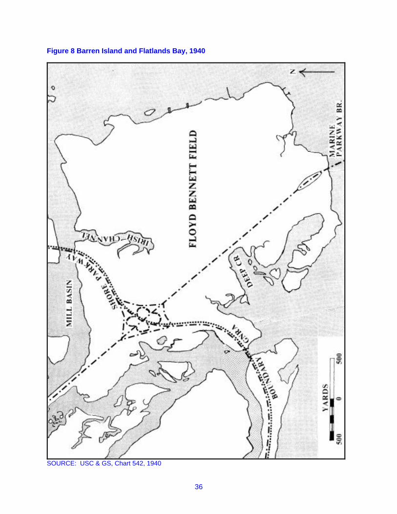
36
Figure 8 Barren Island and Flatlands Bay, 1940
SOURCE: USC & GS, Chart 542, 1940

37
Mill Island, Bergen Island, and Flatlands Bay
As a separate and distinct landform in Jamaica Bay, Barren Island disappeared during dredging and fillingoperations of the 1920s and 1930s. Second only to the creation of an airfield on the eastern reaches ofthe bay, the southwest portion experienced great topographical alteration. Today's bay front fromRockaway Inlet to Paerdegat Basin in only certain basic respects resembles that area as it existed in thenineteenth century. During the years the Department of Docks had jurisdiction, 1897-1936, plansemerged for industrial development. Indeed a number of firms did locate in the vicinity of Mill Basin andFlatbush Avenue. Although industrialization constituted the long-range goal, the department allowed thatpart known as Flatlands Bay to become popular among fishermen, boaters, and summer cottagers.Originally, Flatlands Bay, located between Barren Island in the south and Bergen and Mill Islands in thenorth, consisted of a number of marshes and creeks. Ultimately all of the marshes were filled and thestreams eliminated, except Shellbank Creek, Gerritsen Creek, and parts of the Mill Creek system. Andthese surviving waterways experienced significant alteration. A number of related projects account forthe changes in the southwest section of Jamaica Bay: the dredging of the inlet and of channels to MillBasin and Canarsie, the extension of Flatbush Avenue to the inlet and the construction of Floyd BennettField.
Among the transformations was the conversion of Mill Island and vicinity into an industrial site. Until thelast decade of the nineteenth century, the island retained a rural quality. Its four buildings in 1890consisted of a residence and three structures labeled as:”stables."33 In that year, however, the propertypassed into the hands of Robert L. Crooke, who erected on part of the island a large lead smelting plant.Subsequently, National Lead Company bought out Crooke Smelting Company. In 1906, Mill Islandreportedly received annually 4,000 tons of ore and produced 3,800 tons of solder, tin and lead, worth$1,250,000. Access to the island was by way of Rockaway Inlet, Dead Horse Inlet, Gerritsen Creek, andMill Creek. Crooke-sold the remainder of the island to McNulty and Fitzgerald, who made plans to erectbulkheads and fill the island's marshes. Those plans were executed by the Atlantic, Gulf and PacificCompany and resulted in the creation of 332 acres of uplands. Atlantic, Gulf and Pacific received. title topart of the area as payment for its work.34
Later changes at Mill Island resulted from activities of municipal authorities. In 1915, a channel 100 feetwide and fifteen feet deep was dredged from the main Jamaica Bay channel into what was now known asMill Basin, a distance of 5400 feet. The department also undertook the construction of a 1400 footbulkhead and 400 foot warfage platform on the mainland side of Mill Creek. That dredging was requiredbecause of the plan to extend Flatbush Avenue to the south shore of Barren Island. That project, whencompleted, cut off Mill Island from access to Rockaway Inlet via Mill Creek.35
A 1919 account describes Mill Island as the location of five or six manufacturing establishments andcommercial concerns. One of these was the Atlantic, Pacific and Gulf Company, the dredging contractor,which was then building three dry docks. At that time the company had a contract with the US Navy forthe construction of seven large barges. Some of the fill being used at Mill Basin consisted of materialsoriginating in Europe. Carried as ballast in vessels sailing from France to New York, it was deposited atStaten Island and then brought by barge to the Mill Basin pier.36
In 1913, the municipal government, for the extension of Flatbush Avenue from its then southern terminus,near Avenue “V,” to Rockaway Inlet, appropriated moneys. The project included construction of abulkhead and a concrete city dock as well as the strip of land across the marshes for the roadway. Whencompleted in 1923, 2700 feet was added to the bulkhead and pier facilities in the Mill Basin area. Duringthe remainder of the decade and during the 1930s, the docks department rented space in the basin to a
33 E. Robinson, E. Robinson's Atlas of Kings County, New York (New York: E. Robinson, 1890), plate31.34 Bailey, 68; Law, 9.35 Department of Docks, Annual Report, 1912, 3; Annual Report, 1915, 10, 158.36 Article, unknown newspaper, February 16, 1919, Pamphlet File ("Jamaica Bay"), Brooklyn Collection,Brooklyn Public Library.

38
number of firms, such as Briggs Engineering; Mills Brothers (as berths for four steamers); MontroseConstruction; Anniston Salvaging; Brooklyn Alcatraz Asphalt; City Sand and Gravel; Valvoline Oil; F. J.Kerner Coal; Knickerbocker Ice; and Locust Building Supply.37 Most of these firms conducted smalloperations and did not engage in extensive industrial activity. That the Mill Basin-Flatbush Avenue areanever flourished as an important metropolitan industrial center resulted from the failure of plans for theestablishment of rail service between the area and the rest of Brooklyn.
Until the 1890s, Bergen Beach essentially resembled Mill Island. Maps of the 1870s show two buildingson Bergen Island, with an unimproved road running southeast to Jamaica Bay, the entire property beingowned by John C. Bergen. Extensive changes came in the 1890s, but unlike the alterations at Mill Island,those at Bergen Island consisted of residential and recreational developments. In 1892 the GermaniaReal Estate and Improvement Company purchased the entire island, and rapid development followed.Streets were constructed from Avenue "T" to Avenue "Z" and from East 70th to the Grand Esplanadealong the bay front, building lots laid out, and an amusement park opened. During the decade, trolleyservice was instituted, connecting Bergen Island with the mainland. By 1899, the term "Bergen Beach"was being used to designate the island's shore.38
Since Bergen Island was private property and not part of the common lands of Flatlands, its growthcannot be traced through the records of the New York City Department of Docks, except respecting theuse of land under water and ferry franchises. However, other sources provide an insight into thecircumstances of the area during the early twentieth century. In 1905, Bergen Beach was a small resort,a lesser Canarsie as it were. Its facilities included a commercial bathing establishment, three boatliveries, and such places of amusement as the Bergen Beach Casino, the Trocadero Theatre, andsomething known as "Automation." Seven years later, three other amusement places had appeared, onebeing a scenic railroad.39 Two boat builders were located at Bergen Beach. Buildings were strung alongbulkheads on the bay side of the island. Not listed at Bergen Beach in the directories of the period wereany hotels.
Several piers were constructed during the first decade of the century, and several of these at one time oranother doubtless accommodated ferries. From 1905 to 1921, ferry service linked Bergen Beach withCanarsie, utilizing a pier at the foot of Avenue "V" and later one at Avenue "X." For a brief period, a ferryalso ran between Bergen Beach and Rockaway Beach. The ferry business at Bergen Beach neverdeveloped into a prosperous enterprise. Receipts were small and navigational problems existed becauseof the extremely shallow waters and the absence of a reliable channel. Even the dredging of the mainchannel from Barren Island to Canarsie proved of little direct value to Bergen Beach, since 460 yardsseparated the new channel from the shoreline.40 That dredging, however, may have produced somenew uplands suitable for vacationers and businesses catering to a summer trade Beginning in 1927, theDepartment of Docks began carrying on its rent rolls yearly leases for lots and bungalow sites at Bergen
37 Other firms renting space at Mill Basin-Flatbush Avenue were N. Ryan Company, Wholesale andRetail Sand, Gravel, and Broken Stone; J. P. Duffy Building Materials; Burns Brothers, apparently ashipping company with a main office in Manhattan; Mahoney and Busch; and J. J. Kehoe. They are listedin the rent rolls of the various annual reports of the Department of Docks. The nature of the businessactivity of some of them has been identified through city directories, such as The Brooklyn City Directory,vol. (1913) (Brooklyn: Brooklyn Directory Co., 1913) and Polk's Brooklyn (NY) City Directory 1933-4 (vol.90, Brooklyn: R. L. Polk & Co., 1933).38 Bailey, 77.39 Trow Business Directory of Greater New, York ,,(Five Boroughs Combined) 1905 (vol. VIII, New York:Trow Directory, Printing and Bookbinding Co., 1905), 34, 39, 381-82; Trow Business Directory of GreaterNew York (five Boroughs Combined) 1912 (vol. XV, New York: Trow Directory, Printing and BookbindingCo., 1912), 27, 28, 273.40 See various annual reports of the Department of Docks. Holders of ferry franchises were to pay tothe Department of Docks five percent of gross receipts. For 1906, one Bergen Beach ferry operator paid$25.00 to the department, indicative of only $500.00 in gross receipts. In 1911, two companies made nopayments. Department of Docks, Annual Report, 1906, 156; Annual Report, 1911, 197-98. USC&GS,Chart 542, 1926.

39
Beach. In 1930, twenty-six lots were leased at annual rates of between $10.00 and $240.00. Lesseeswere individuals, except for the Paul S. Gesswein Boat Company, the Bergen Beach Gun Club, andPowell Welding Company.41
In the years before World War 1, Flatlands Bay acquired numerous small vacation structures, such asboathouses and bungalows. Their owners and occupants gained permission to use space from theDepartment of Docks, and the records of that department constitute the basic source for this aspect ofJamaica Bay's history. Unfortunately, those records are rarely specific as to the location of sites coveredby the department's leases and permits. From 1909 to 1915, no more precise term than "Flatlands Bay"appears in the records. Thereafter, sections within the bay are named, but lists of those sectionssometimes include such places as Jo Co's Marsh and Hell Gate Marsh, located on the other side ofJamaica Bay. Despite these difficulties, it can be said that Flatlands Bay consisted of marshes, meadowsand creeks in the area between the original Barren Island in the south and Bergen Beach and Mill islandson the north, Mill Creek and Gerritsen's Creek on the west, and Jamaica Bay on the east. Within thatarea were Riches Meadows, northwest of Barren Island; Bushes Meadow, north of Barren Island; OralossMeadows, near Oraloss Creek; and John's Point Marsh, between Jamaica Bay and Little Bay. Uncertainare the location of Hemlock Meadows and Grainors Hook.
41 Department of Docks, Annual Report, 1930, 62-66.

40
Figure 9 Mill Island and Bergen Island, 1911
SOURCE: USC & GS, Chart 542, 1911

41
Figure 10 Mill Basin and Bergen Beach, 1926
SOURCE: USC & GS, Chart 542, 1926

42
Figure 11 Mill Basin and Bergen Beach, 1940
SOURCE: USC & GS, Chart 542, 1940

43
No record exists of any kind of use of Flatlands Bay before 1909. Doubtless, however, fishermen, huntersand others frequented the area, and it is conceivable that some fishing shacks or other kinds of structureshad been erected there. In 1909, the Department of Docks issued five permits to occupy space inFlatlands Bay, all as sites for "boathouses" and all apparently at Mill Creek. A "boathouse" could be morethan one story and thus were not simply shelters for boats. The number of boathouse permits rose totwenty-eight in 1913. During that year, the causeway was started across Flatlands Bay to RockawayInlet. Although Flatbush Avenue-had not yet been extended over that causeway, it gave the area greateraccessibility. Moreover some of the structures may have been on or near the causeway. In 1917, onehundred and fifty parties had permits in Flatlands Bay to maintain boathouses shacks, bungalows, andhomes. The occupants were all private individuals, except for several yacht clubs, a fishing club, and aclubhouse for members of a military unit.42
As a location for boathouses, bungalows and the like, Flatlands Bay was affected by improvements, suchas the completion of Flatbush Avenue Extension, the filling in of meadows, and the building of FloydBennett Field. In the 1920s, the number of permit holders declined somewhat, but a concentration ofstructures emerged on the north-east bank of Mill Creek, in an area extending northwest from a point 200yards northwest of the present Belt Parkway bridge across the mouth of Gerritsen Creek. Cottagers andothers persisted at Flatlands Bay into the 1930s, but became fewer and fewer. By 1940, except for a fewsmall boat docks, the Mill Creek cluster had disappeared, as had structures elsewhere.43 Flatlands Bayitself vanished, as all of the meadows, marshes, creeks, and waterways, including Little Bay, were filled tobecome Floyd Bennett Field.
Canarsie
Throughout the nineteenth century, the town of Flatlands continued as an agricultural community,following the two hundred year-old pattern of small farming and production of food stuffs for the urbancenters on the Hudson and East rivers. One part of the town, however, had a different experience.Canarsie Landing, approximately one mile east of the village of Canarsie, was affected by the mountingpopularity among New Yorkers and Brooklynites of the beaches at Rockaway; by the growth of asignificant comical fishery in Jamaica Bay; and by its own natural and man-made attractions, whichturned it into something of a summer resort.
Prior to the Civil War, the usual means of transportation from Brooklyn to Rockaway peninsula was bytrain to Jamaica and then by a long and uncomfortable ride in hired stage over the Jamaica Turnpike.That roadway negotiated the meadows and swamps of the bay's eastern perimeter. In October 1865, animportant change occurred with the opening of a small, three and a half mile long Brooklyn andRockaway Beach Railroad, commonly nicknamed the Canarsie Railroad or Canarsie line. That line linkedCanarsie landing with East New York and, via other lines, with Brooklyn. In the summer of 1866, therailroad initiated ferry service from the landing to Rockaway peninsula, and Canarsie landing embarkedon a career of catering to the summer throngs bound for a day's outing at the ocean. Previously Canarsielanding featured a few establishments serving the needs of fishermen. Now there occurred a modestproliferation of hotels, restaurants and saloons. In July 1'867, A. D. Farling opened his large hotel, theBay View House. Four others soon followed, including the Oceanus House and King's Hotel. Mealscould be obtained in the hotels, in restaurants such as that of William Van Amen, or in more rusticeateries, such as Uncle Sam's Cabin, famous for its chowder. Elbert Abrahams was running a saloon atthe landing in 1868 or one could patronize Patrick Kavanaugh, listed in a 1878 directory simply as"liquors."44
42 Department of Docks, Annual Report, 1909, 176; Annual Report, 1913, 154; Annual Reports, 1917,67.43 USC&GS, Chart 542, 1926, 1940.44 The best authority on the Canarsie Line and its impact on the landing is William W. Fausser, "TheBrooklyn and Rockaway Beach Railroad: The Canarsie Railroad" (typescript with no pagination, 1976,QPL): George T. Lain, Lain's Directory of Long Island Including a Business Directory of Brooklyn, LongIsland City, and the Towns of Kings County . . . for 1878-79 New York Lain and Co., 1878).

44
Travelers to Rockaway by the railroad-ferry route frequently spent some time at Canarsie, because trainsarrived more frequently than did the steamers. During the first summer of operations, train serviceconsisted of ten round trips between 7:30 am and 7:30 pm. However, the ferry Rockaway met trains atCanarsie only at 10:00 am, 2:00 pm and 6:00 pm. In 1867 the train schedule was increased to hourlyservice during weekdays and half-hourly service on Sunday. Since but one more trip could be squeezedout of the Rockaway, the bottleneck got worse. Still Canarsie Landing was becoming an attractive placeto bide one's time till the next ferry arrived. In the 1867 season, the Canarsie Line brought 122,567passengers to the landing.
The managers of the railroad recognized the existence of the bottleneck and sought to provide reliefthrough such measures as acquiring additional -vessels. In 1878, the company proposed to build atrestle from the landing one-mile out into the bay. This would eliminate the costly dredging required tokeep open a channel between Canarsie and the main or so-called Big Channel of Jamaica Bay.Furthermore, it would reduce the time needed for ferries to proceed to Rockaway and back. Anotherproposal made in the same year was to construct a narrow gauge railroad all the way across the bay toBroad Channel. Nothing came of these two schemes, and the Canarsie Line had no effective way tomeet a competitor. 45
In 1880, the New York, Woodhaven and Rockaway Railroad started regular service from Brooklyn to theLong Island Railroad Junction at Glendale and thence over a newly built line directly south to Hamels,using a 4.8 mile long trestle across Jamaica Bay. Two years later, both railroads faced a new competitorin the form of White's Iron Steamboats, sailing directly from New York to Rockaway peninsula. For thetime being, so great was the rush to the beaches that there was enough business for all carriers. On thelast Sunday in August 1883, for example, the Canarsie Railroad carried 30,000 people. Despite its smallsize, the Canarsie Line persisted, and Canarsie Landing prospered.46
That prosperity in part resulted from the landing's own resort facilities. Bathers, timid before the crashingsurf of the Atlantic, found enjoyment in the calm, shallow waters of Jamaica Bay, especially at the sandybeach near Canarsie Point. Moreover, Canarsie developed as an amateur fisherman's mecca. Shortlyafter the Canarsie Line opened, a boat rental station appeared with twenty rowboats. By 1880, therewere ten such boat liveries, each with an average of fifty boats. Also forty charter fishing boats and theircaptains were available for hire by the day at rates between $5.00 and $7.00 for week days and between$7.00 and $10.00 for Sunday. Later in the same decade, a Canarsie Yacht club was established, E. .Linton commodore and prestigious enough for inclusion in Lain's Elite Directory.47
The railroad further contributed to the growth of Canarsie Landing as a pleasure spot when, in 1883, itpermanently anchored a large barge in the shallows near the edge of Big Channel. The barge's lowerdeck was equipped with changing rooms for bathers and the upper deck converted into a dance pavilion.A floating stage extended fifty feet from the barge for the use of swimmers. The launch Edith Peckjourneyed between the landing and the floating pavilion.
Probably by the end of the nineteenth century, a few summer bungalows had been erected at CanarsieShore, as it was now being called, especially in an area east of the landing known as Sand Bay. Similarto other parts of Jamaica Bay, Sand Bay was barely below water at low tide. Houses, built on stilts andaccessible by boat or systems of wooden walkways, became increasingly common.
A significant commercial fishing industry emerged at Jamaica Bay after the Civil War, and CanarsieLanding became the center of that industry In 1850, seventy-five fishermen lived in the town of flatlandsand were outnumbered by the 191 farmers and farm laborers. In the decades following the Civil War,fishermen, baymen and oystermen increased, and a large majority of them resided at Canarsie. forexample, almost ninety percent of Flatlands’ two hundred fishermen in 1880 made their homes atCanarsie. Of course other fishermen lived elsewhere in the bay, such as Hawtree Creek and Inwood, but
45 Fausser.46 Fausser.47 Fausser; George T. Lain, Lain's Elite Directory of Brooklyn (New York: Lain and Co., 1888), 344.

45
Canarsie was the focal point of a good part of the bay's fishing activity. Quoting from a 1904 report,Congressman Law assigned all of the bay's yield of shellfish to Canarsie.48
48 Federal Census 1850 Flatlands; Federal Census 1880 Flatlands; Law, 7.
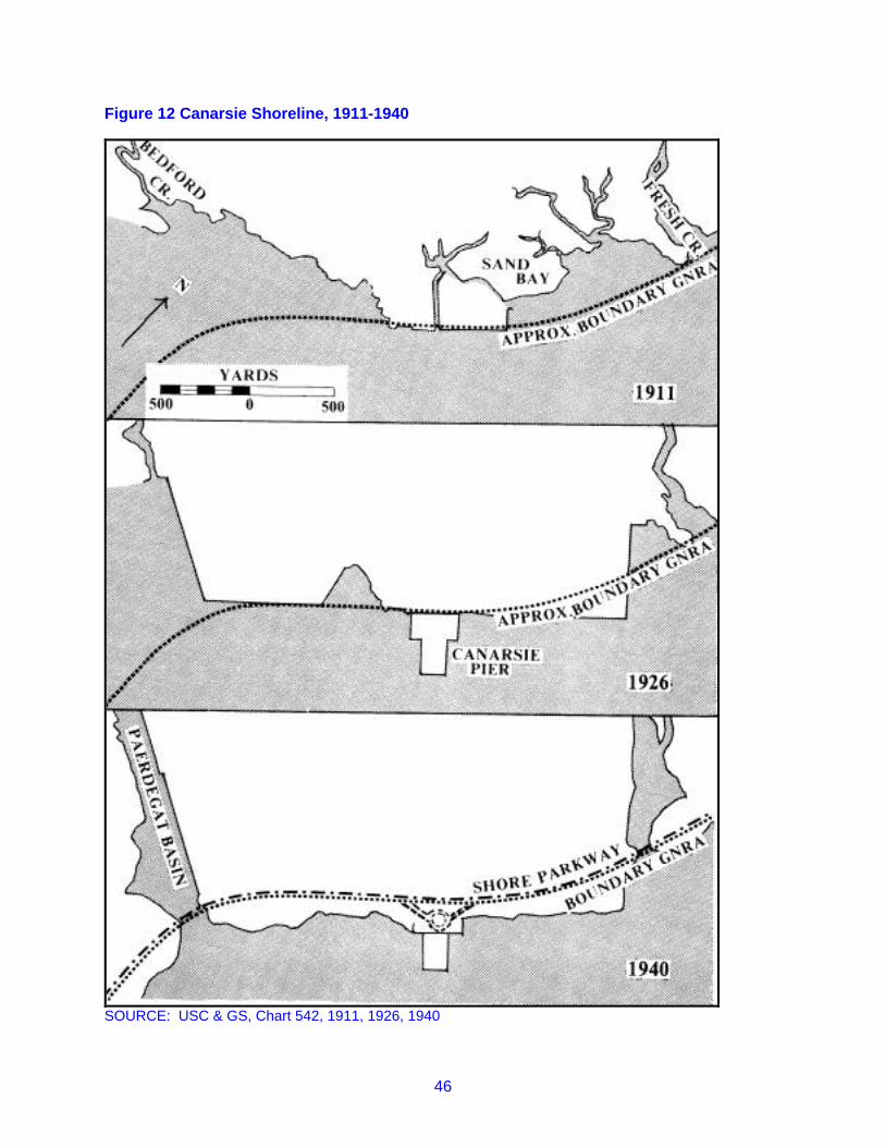
46
Figure 12 Canarsie Shoreline, 1911-1940
SOURCE: USC & GS, Chart 542, 1911, 1926, 1940

47
Because of the activity in the bay of sports and commercial fishermen, boat building developed atCanarsie Shore. In 1868, Patrick Cavanaugh may have been the only boat builder, but by 1889, at leasteight such craftsmen could be found. Probably, many of the boats constructed at Canarsie were fairlysmall. However, some were more sizable than mere rowboats. For example, in 1880, the thirty-one footsloop Mist was built at Canarsie.49
In the early twentieth century, Canarsie landing in the summer must have been a lively and an attractiveplace. Near the bay clustered at least fifty buildings, eighteen of which were hotels. Those seeking food,beverage or entertainment could frequent Boegel's Oriental Bar and Dance Hall, the Casino, or any of ascore of other such establishments. In May 1907, near Seaview Avenue, opened the Golden CityAmusement Park, built to rival Coney Island and eventually including a roller coaster, miniature railroad,skating rink, and dance hall. Fishermen rented rowboats and sought blue fish at Ruffle Bar or othervarieties at a number of locally famous fishing holes. More affluent fishermen hired sloops at MaxCasey's float and set out for the Atlantic. The less ambitious purchased Jamaica Bay's famous oysters,steamers or finfish from Casey's "Wholesale-Retail Seafood Market" or from any of at least-seven otherfish dealers. Since 1892, Canarsie Landing had been equipped with electric lighting, and the approach ofevening did not diminish activity. In 1905, the Canarsie Line gave up the struggle and closed down, butthe Brooklyn Rapid Transit system brought folks to the landing, and two and later three ferry systemsconnected Canarsie with Rockaway Beach, Barren Island, Bergen Beach, and other parts of the Bay.50
Prior to the twentieth century, changes in the topography of the Canarsie area were not substantial. Inthe first year of its operation, the Canarsie Railroad constructed a dock, subsequently rebuilt andenlarged, at the tip of Canarsie Point to handle coal and lumber. By 1878 a small rectangular peninsula,bulkheaded on three sides, extended into Jamaica Bay. More difficult for the company than providingdock and shore facilities was maintenance of a channel between Canarsie Landing and Big Channel, onemile to the southeast in Jamaica Bay. The channel from Canarsie was between five and a half and sevenfeet deep at low tide in 1878, the waters on either side having a depth as little as three inches. It isknown that the company dredged the channel from Canarsie in 1880 and doubtless had done so onprevious occasions.51
After 1900, the bay front at Canarsie underwent significant alterations. Over one mile of the shorelinewas filled in and bulkheaded with the pier at mid-point. This was accomplished in part by private partieswith rights to the bay front and by municipal authorities. In 1926, the city built a municipal dock, stillknown today as Canarsie Pier. Originally the pier was three hundred yards wide at its base and 250yards long.52
By the 1920's significant changes had occurred in the activities centering on Canarsie Landing. Theresort and entertainment aspects persisted after World War 1, but suffered from the pollution of the bayand the plans of the Department of Docks to realize the industrial development of Jamaica Bay. As earlyas 1904, the waters of the bay had become sufficiently contaminated so as to infect shellfish and causeserious illnesses to those eating Canarsie oysters or clams. In 1921, the shellfishing industry was closedthroughout the bay.
Prior to the completion of the municipal dock in 1926, the Department of Docks had leased city propertyat Canarsie to private parties as sites for cottages, boathouses, fishing clubs, boardwalks, marinerailways, and other uses. One particularly popular area of Canarsie after World War I was Sand Bay, andin 1925 the Docks Department leased space there to over seventy tenants, including six boat clubs.
49 Lain's Directory . . . 1878-79; George T. Lain, Lain's Business Directory of Brooklyn, Kings County,Long Island City, Jamaica for 1889-90 (New York: Lain and Co., 1889), 352-54; John M. Kochiss,Oystering from New York to Boston (Middletown, Conn.: Wesleyan University Press, 1974), 215.50 Fausser. Department of Docks, Annual Report, 1906, 155-56. In the picture file, JBU, arephotographs of Canarsie in the early twentieth century, including Max Casey's several establishments,fishing boats, and Boegel's Oriental Bar and Dance Hall.51 Fausser; U.S. Coast Survey, Chart 540, 1878.52 USC&GS, Chart 542, 1911, 1926.

48
Other occupants of city property included Golden City amusement park, boat yards and boat builders. AsSand Bay became filled in and more and more cut off from Jamaica Bay, the number of tenantsdeclined.53
New tenants and new types of businesses were appearing on the Canarsie shore front. In the late 1920s,two hundred feet of the bulkhead west of the pier was rented to the Borough Asphalt Company and 6000feet to the Turecamo Construction Company. In 1933, five hundred tons of scrap metal were loaded fromthe pier onto a vessel and thus became the pier's first industrial cargo. Coupled with the increaseindustrial activity went a decline in entertainment facilities. The Golden City Amusement Park hadexperienced a severe fire in 1909, but had survived and was rebuilt. In 1934, a second fire entirelydestroyed the amusement center. This time no rebuilding followed, and the Golden City companyfinished its days by renting its part of the bulkhead as mooring for boats.54
Canarsie continued to be attractive to the growing residential population in the area. One Sunday in July1937, an estimated 20,000 bathers were at Canarsie Beach. In 1941, the WPA and the city's dock andparks departments constructed a 100-foot recreation building on the pier. However, the area hadacquired a run-down and forlorn look. Perhaps the Federal Writers Project description in 1939 is toogrim. But it does offer a striking contrast with the image the landing must have projected thirty-five yearsearlier:
A sparsely settled community laid out on dispiriting flat lands, smoked over by theperpetual reek of fires in the vast refuse dump at its western end. Its residential sectionof one- and two-family houses and shacks (most of which resemble those in CharlesBurchfield's paintings) is broken by weedy lots and small truck farms cultivated byItalians. Along the uninviting waters of the bay is a forlorn beach resort--an amusementpark called Golden City, a fishing boat center, a beach backed by a dump and beerydance halls--with an outlandish quality that made Canarsie the butt of many vaudevillejokes.55
New Lots
Unlike Canarsie, the town of New Lots was separated from Jamaica Bay by a broad expanse of meadowand marshes in places a mile wide. Consequently the people of New Lots, especially after the Civil War,had no intimate association with the bay. The absence of natural uplands near the bay afforded nolanding for ferries or other vessels. Moreover, perhaps because the shallow waters, Fresh Creek, Old MillCreek or the tributaries of Old Mill Creek (Ralph, Spring and Betts Creeks)- did not prove attractive as asite of a community on stilts, such as emerged at Hawtree Creek to the east or in Sand Bay to the west.The Old Mill Creek region was involved in a cross bay transportation project, which did include someman-made topographic changes. However, that project never saw completion.
New Lots, including its western section known as East New York, experienced a rapid populationincrease after the middle of the nineteenth century. Its 1845 population of 777 rose during the next twodecades to over 5000, owing in part to an influx of Germans, the first of several immigrant groups toarrive. By 1890, New Lots contained 30,000 people. Whatever their origins, new comers and nativescongregated in the northern parts of the town. There residential neighborhoods replaced farms, andthere also began industries, such as ready-made clothing.56
53 Department of Docks, Annual Report, 1925, 60-62,54 Department of Docks, Annual Report, 1928, 57; Annual Report, 1929, 69; Annual Report, 1936, 105;Leonard Levine, "Canarsie," (unpublished typescript, 1972 , Long Island Historical Society.55 As quoted in Levine,56 Landesman, 99, 217.

49
Until the 1880s, New Lots retained a rural character, but the number of farms and farmers declined, and alarger portion of the population took up non-agricultural pursuits. Those pursuits, except in a fewinstances, did not include occupations associated with the bay. The state census of 1855 listed nofishermen in the town and only five boatmen.
The town may have had a boat-building establishment, since the census reports one boat builder, threeship carpenters, one ship smith, and a caulker. However, if such an establishment did exist, it was clearlyexceptional, and the vast bulk of the population gave little attention to Jamaica Bay. Subsequentcensuses and other documentation indicate no growth of interest in the bay by significant numbers atNew Lots. For example, Curtin's Directory for 1866-9 lists only one fisherman in the community. 57
The marshlands prevented residential or industrial development of the New Lots-East New York bayfront, and thus any substantial alterations in topography. Maps for the period 1873 to 1900 show onlymodest changes. According to Beers map of 1873, there were no buildings, homes, or farms south ofNew Lots Avenue, except near a road from that Avenue to the Van Wicklen gristmill on Spring Creek. Noroadway or structures were in the vicinity of the Van Derveer Mill on Fresh Creek. Both mills wereapproximately one quarter of a mile from the Bay. Van Derveer's mill was destroyed by fire in 1879 andapparently was not rebuilt. Maps for the remainder of the nineteenth century show little change.58At the very end of the century, work was begun on a cross bay roadway to connect Jamaica Bay's northshore with the Rockaway peninsula. The northern terminus of that roadway was the east bank of Old MillCreek. Technically that area was not in New lots, but in Jamaica. However, its closer proximity to NewLots suggests it be discussed at this point.
As true of other developments at this time in the history of Jamaica Bay, the stimulus for the cross bayproject was the ever-increasing attraction of the Rockaways. At the end of the century, the Long IslandRailroad's trestle gave it a monopoly on cross bay traffic. However, an enterprising trolley carentrepreneur, Patrick H. Flynn, planned to build a roadway across the bay, eighty feet wide andcontaining a double track trolley line, a bicycle: path, and a carriage way.
After considering other routes, Flynn decided to run his line more or less parallel to the LIRR trestle andabout 500 yards west of it. The northern end of the Flynn roadway would be a trestle from Black Marsh toa small promontory, known as Long Point, east of the mouth of Old Mill Creek. At Long Point, anembankment was to be built north to liberty Avenue.
Work began on the project in the summer of 1899, but ii was not until the following oil that the Long Pointarea saw activity. A large dredge lifted fill from the bottom of the bay and pumped it onto the marshes.By early 1901, a plateau had been created from Liberty Avenue south to Long Point and 1500 feet intothe bay. Thereafter legal complications were encountered which ultimately ended the entire project. 59
The abortive Flynn project explains some features in the Old Mill Creek area in maps of 1911 and 1926.A 1911 map shows the east bank of the mouth of Old Mill Creek with a bulkhead or pier. Behind thatstructure was an area of upland, and projecting southeast is what appears as an unopened roadway.Those features also appear in the 1926 map, but by 1940 only traces remained. When the present Cross
57 New York State Census 1855, "New Lots," in office of County Clerk Kings County Supreme Court;Curtin’s Directory of Long Island . . . 1868-69 (Brooklyn: Curtin Directory Co., 1868).'58 Beers, Atlas of Long Island; William C. Dripps, Atlas of the Townships of New Utrecht, Gravesend,Flatbush, Flatlands and New Lots, Kings County, New York (New York: W.C. Dripps, 1878); J. B. Beers,“New Map of Kings and Queens Counties,” (New York: J. B. Beers & Co., 1886); Robinson, Atlas ofKings County, plate 32; “Guide Map of the Borough of Brooklyn, Kings County, New York Compiled fromthe Latest Official Maps and Other Sources” (Brooklyn: Eagle Almanac, 1898).59 Vincent F. Seyfried, The Long Island Rail Road: A Comprehensive History (six parts, Garden City, N.Y.: V. F. Seyfried, 1961-1975) part V, 98-105. Only one map has been found showing the route of the“proposed” road; “Map of Jamaica Bay,” (Jamaica Bay Improvement Commission, 1907).

50
Bay Boulevard was built, much of the Flynn roadway was used, but the new highway connected with themainland at a point east of Flynn's route.60
The bulkhead at the mouth of Old Mill Creek gave the area an advantageous feature, and in 1926 therewere structures, possibly fishermen's cabins or summer homes on both sides of the mouth of the creek aswell as on the south bank of Spring Creek. Most of those structures had disappeared by, 1940. Onlybrief mention is made of the New Lots area in the records of the city's department of docks. Thatdepartment received an inquiry in 1906 concerning a dock at the foot of Crescent Street, described as a"town dock." At that time the department stated it had no plans to rebuild the dock because of the lack ofwater in the creek. In 1936, the department gave its approval for the maintenance and use of three piersin the Pleasant Point section of Old Mill Creek.61
60 USC&GS, Chart 542, 1911, 1926, 1940.61 Department of Docks, Annual Report, 1906, 930; Annual Report, 1936, 117, 204.

51
The most striking changes in the topography of the New Lots-East New York bay front came in the mid-twentieth century with the appearance of two man-made land forms, the Fountain Avenue landfill and thePennsylvania Avenue landfill. Both are south of the Shore Parkway. The Fountain Avenue project is agarbage disposal facility, located between Old Mill Creek and Hendrix Creek. When completed, the siteis expected to be 110 acres in size and to reach a height of seventy feet.
Between Fresh Creek and Hendrix Creek lies the Pennsylvania Avenue project. It was started in 1959and within three years 3,000,000 cubic yards of refuse had been deposited to create a peninsula of over100 acres jutting into Jamaica Bay, its center being thirty feet high. During the next ten years, sludgefrom the Twenty-Sixth Ward sewage treatment plant was transported by boat to the peninsula, where itwas dumped and air-dried. The air-drying of sludge was later discontinued in favor of ocean disposal.
A new pier and access road were built at the southeast end of the Pennsylvania landfill site and a pipelineconnected the Twenty-Sixth Ward plant with the pier so that sludge could be pumped directly to the pierand onto sludge boats. This minimized noise and odor. In the summer of 1971 the city resumed landfilloperation at the Pennsylvania Avenue location, restricting the fill to construction waste. As soon as thewaste arrived it was buried, compacted, covered, graded, and seeded. The ultimate objective is a parkon the peninsula, which, like the Fountain Avenue project, will reach a height of eighty feet. 62
Howard and Hamilton Beaches
The earliest permanent inhabitants of the area between Old Mill Creek and the later Bergen Basin werefishermen, who, perhaps shortly after the Civil War, constructed homes on stilts on either bank of thewinding Hawtree Creek. This small settlement was known as Ramblersville. Because of the relativeisolation of the area, a few fishermen may have long continued to be the main residents had it not beenfor the construction in the late 1870s of the New York, Woodhaven and Rockaway Railroad. That railroadwas built more or less on a straight line south from Glendale in Jamaica to Remsen's Landing on HawtreeCreek and then traversing Jamaica Bay by a trestle. When trains started running in 1880, they stopped atRamblersville and, as a consequence of its new accessibility, the Hawtree Creek vicinity began to attractnew inhabitants. Also contributing to this growth were the activities of William Howard, whose effortsproduced a minuscule resort. Thus south of Ramblersville appeared a settlement successively known asHoward's Landing, Howard's Pier, Howard Estates, and finally Howard Beach.63
Twenty years after the railroad arrived, Ramblersville remained a tiny cluster of approximately ten houses,built over the water and linked by boardwalks. Almost all belonged to fishermen, clam diggers andoystermen.
62 Department of City Planning, From Landfill to Park: An Experiment in Construction WasteManagement at the Pennsylvania Avenue Landfill Site (New York: Department of City Planning, 1974).5-11.63 New York Herald Tribune, December 6, 1964, Clipping File ("Howard Beach: GeneralMiscellaneous"), QPL.

52
In the meantime, William Howard built a hotel out in Jamaica Bay on stilts and about one third of a milewest of the trestle. Connected with the trestle by a boardwalk, the hotel and other buildings becameknown as Howard's Landing. In 1899,-the railroad, now the Long Island Railroad, established a stop forthe Howard complex. That stop was near 160th Street and one mile south of the Ramblersville station.Howard's Landing soon included, in addition to the hotel, a dancing pavilion, casino, and eighteencottages. A fire destroyed Howard's Landing in 1907.64 Undismayed, Howard launched a new project.
A 1907 map designates the area west of Hawtree Creek as "Marcella Park," which consisted of small,twenty or forty foot by eighty foot lots. Whether this was Howard's doing or not is undetermined, but in1909 he obtained permission from the docks department for the use of land under water at HawtreeCreek. Subsequently he created three hundred acres of landfill. Also he dredged a canal 150 feet wide,thirty feet deep and one mile long. Model homes opened and in 1913 the Long Island Railroad moved itsstop to Howard Estates. Until the mid-1920s, the Howard Estates Development Company seams to havemanaged the project. By 1925, it had been replaced by the Howard Beach Association.65
In 1923, advertisements appeared promoting a settlement called Hamilton Beach, which featuredsummer bungalows and year-round homes. Located east of Howard Estates, the development was built,according to one account, on land recently filled. In 1920, Shellbank Basin was dredged in connectionwith plans briefly entertained by the US Navy to construct a submarine base. Whatever thecircumstances of the filling, lots were leased in the development from the city docks department. In 1924,there were five tenants and in 1929, over one hundred. Thereafter, with the onset of the depression, thenumber of legal tenants declined. Early in the history of Hamilton Bay, a system of canals had beenconstructed. First two and then three parallel waterways ran from Jamaica Bay northward forapproximately three hundred yards. A fourth canal, parallel both to the other canals to the east and therailway to the west ran northward for about one half mile before looping eastward and southward to rejoinitself. Subsequently, with the construction of Bergen Basin and the air field at Idlewild, the canal all butdisappeared.66
When the municipal subway took ever and rebuilt the Long Island Railroad's cross bay operation in the1950s, it included a stop at Howard Beach. This led to a housing boom. By 1972, the area had apopulation of approximately 30,000. The origins of the settlement continued to assert themselves.Boating and fishing remained as popular activities, with the fishermen heading their boats for Rockawayinlet.
64 Department of Docks, Annual Report, 1899, 198; Annual Report, 1902, 287; Seyfried, part V, p. 124.65 E. Belcher Hyde, Atlas of Borough of Queens (New York: Hyde & Co., 1907). Department of Docks,Annual Report, 1923 & 1924, 70-72; 146-48; Annual Report, 1926, 69; Seyfried, part VI, 169-70.66 Long Island Railroad, Long Island: Sunrise Homeland (1923), in Clipping File ("Hamilton Beach:General, Miscellaneous"), QPL; New York Daily News, March 8, 1979, in Clipping File ("Hamilton Beach:General, Miscellaneous"), QPL: Department of Docks, Annual Report, 1923 & 1924, 146-48; AnnualReport, 1929, 69-80. USC&GS, Chart 542, 1926, 1933, 1977.
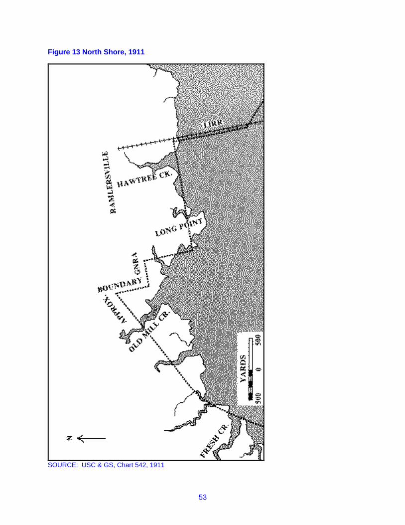
53
Figure 13 North Shore, 1911
SOURCE: USC & GS, Chart 542, 1911

54
Figure 14 North Shore, 1926
SOURCE: USC & GS, Chart 542, 1926

55
Figure 15 North Shore, 1940
SOURCE: USC & GS, Chart 542, 1940

56
Another aspect of the past also has been encountered in recent years During the mid-1910s, fourhouses fell off their stilts, causing concern to the occupants of two hundred residences having similarfoundations.67
South of Howard Beach is Charles Memorial Park, names after a resident killed in World War I. Thepark's flagpole is said to be near the site of William L. Howard's Casino of the 1890s.68
The Islands
Prior to the Civil War, the islands in Jamaica Bay east of Barren and Bergen Islands remaineduninhabited, with the possible exception of Ruffle Bar. After 1865, as the-bay's fisheries developed, a fewstructures began to appear. In the late l870s, the town government of Jamaica noted the presence in theislands of buildings, for which the town had given no permission. The town records do not indicate thelocation of these illegal structures. However, probably they were located on the edges of Broad Channeland Raunt Channel. The construction of a railroad across the bay in 1880 stimulated the creation atcertain points along the trestle of small clusters of fishing shacks, boathouses, summer residences, andeven some commercial establishments. Still later, the Cross Bay Boulevard increased accessibility tothese settlements, one of which at Broad Channel, had already acquired a permanent population.
In the building and maintenance of the cross bay railroad and the boulevard as well as the abortive Flynnproject, some of the channels and waterways separating the islands were filled. Islands and marshes inthe eastern part of the bay were dramatically affected by the creation of the airfield, first known as Idlewildand later John F. Kennedy. The dredging of ship channels eliminated some smaller islands and added tothe uplands of others. The net result was a great reduction of the number of islands in Jamaica Bay.
Originally all of the islands in the bay, except Barren, Bergen, Mill Islands, and Ruffle Bar, consistedalmost entirely of meadows and marsh with no uplands. They varied greatly in size from no more than afew square yards of marsh to large areas, such as Jo Co's Marsh, which measured one and a half milesacross its greatest length with a width of three quarters of a mile. Through Jo Co's Marsh, Duck PointMarshes, Stony Creek Marsh, Ruffle Bar, and many others ran creeks and channels, frequently havingtortuous courses. All of the large marshes and a surprising number of small ones bore names, doubtlessassigned to them by fishermen, baymen, oystermen, and others who frequented the bay. To these men,the marshes had only secondary importance, and the nomenclature suggests their main interest was inthe waters around the marshes. For example, Broad Channel, now the name of a community originallydesignated a channel within the bay.
Prior to the end of the nineteenth century, political jurisdiction over the bay, its marshes and islandsrested with the towns of Flatlands and Jamaica, the division being the boundary, still existing, betweenKings and Queens counties. That boundary ran from the east side of Old Mill Creek on the northernshore to Black Bank Marsh, then south to Black Wall marsh, southwest to Beach Channel, and down thecenter of Rockaway Inlet.
The Flatlands area of the bay belonged to the town in common, except for Ruffle Bar, parts of which weresold into private hands in the early 1890s. When Kings County merged with Queens, Manhattan, and theBronx to form Greater New York, a consolidation that became effective on January 1, 1898, the title to thecommon lands of Flatlands passed to the city of New York.
At the time of the consolidation, the Town of Jamaica had sold or leased all of its common property toprivate hands. This occurred in two series of transactions. In 1877, the Jamaica board of supervisorsgranted to the New York, Woodhaven and Rockaway Beach Railroad a ninety-nine year lease on a thirtyfoot right of way across Jamaica Bay for the purpose of building and operating a railroad. The terms of
67 Long Island Press, July 10, 1973, Clipping File ("Hamilton Beach: General, Miscellaneous"), QPL.68 New York Herald Tribune, December 6, 1964.

57
that lease were altered in 1880, when the right of way was widened to 150 feet and the railroad companypurchased the property outright.69
The remainder of Jamaica's common land passed into private hands through the dubious activities ofFrederick W. Dunton, one of the supervisors At Dunton's urging, the town board decided to lease all ofJamaica's common lands. Bids were solicited in an advertisement that appeared only in the villagenewspaper. Two bids were received, and in August 1892, the board leased for fifty years all of the landsand meadows to Alonzo E. Smith, a business associate of Dunton. On December 29, 1897, a few daysbefore the merger of Jamaica and the rest of Queens with the other boroughs, the board, with Duntonpresiding, leased the entire tract for an additional fifty years, that is from 1942 to 1992, to a clerk inDunton's employ.70
These proceedings subsequently received judicial scrutiny and were invalidated. The matter came to theattention of the court mainly because of the activities of Patrick Flynn, promoter of the cross bay roadway.Dunton's plan was to fill and develop some of the marshes for sale as home sites. To further this schemehe established several companies, one of which, the Cooperative Society of New Jersey, was assignedthe original leases. That company subleased plots to individuals. It also leased, for a payment of$150,000, a strip 150 feet wide from Long Point to Seaside on Rockaway peninsula to Patrick Flynn.Dunton would gain from Flynn's cross bay project since its construction would involve filling in some of themarshes and would also make them more accessible. Flynn set about building his roadway, which wasvigorously opposed by the Long Island Railroad, then the owner and operator of the sole cross baytransportation system.
The Long Island Railroad probed into the origins of the Dunton title and sponsored legal action to haltconstruction of the Flynn project. Such action ultimately met success, and in June of 1902, the New YorkCourt of Appeals invalidated the 1892 lease to Smith. In the following October, the city of New Yorkinstituted suit against the Cooperative Society of New Jersey, seeking to have all of the leases fromJamaica declared fraudulent, in this way assuring the city of undisputed claim to the town's lands in thebay. Before those legal proceedings reached completion, Dunton voluntarily surrendered the leases inquestion.71
When the City of New York, through its Department of Docks and Ferries, started administering itsproperty in Jamaica Bay, there already were, and in certain cases had been for twenty years, a number offishing clubs, shacks and other structures built at locations in the bay. Some of these got started with theopening of rail service across the trestle in 1880. Parties who had obtained leases from the New JerseySociety built others. And doubtless, a good many squatters could be found as well. The city decided tohonor the leases to private parties and to grant permits to occupy space in Jamaica Bay. Furthermore,the Department of Docks granted such permission to newcomers. By 1907, three hundred and fiftypermits had been issued, and by 1912 there were over 600. In 1916, the department adopted as the ratefor use of space in the bay one and two-tenths cents per square foot per year. The leases were carriedon the department's rent rolls.72 Thus the structures erected belonged to the lessees and the space ofmarsh, upland, or water beneath those structures remained with the city.
With respect to three parts of the bay, the city entered into long-term leases with particular parties, whocollected rents, developed the areas, and paid a yearly fee to the city. In 1914, all of Big Egg Marsh wasleased to Pierre Noel for a term of ten years at the rate of $15,000 for the first three years, $17,500 for thenext three and $20,000 for the remaining four. Noel gained the right to renew the lease for two ten-yearterms. A similar arrangement was made with Noel for Goose Creek and with the Buffle Bar Associationfor the island of that name. Subsequently, Noel sublet his holding to the Broad Channel Corporation.The Broad Channel Corporation exercised the right to renew for two ten-year terms. However, during the
69 Records of the Town of Jamaica, vol. V, 288-94, 429-30; Seyfried, part V, 7-10.70 Records of the Town of Jamaica, vol. VI, 494-95, 487; vol. VII, 284; Seyfried, part V, 106-7.71 Seyfried, part V, 109-11.72 Department of Docks, Annual Report, 1905, 135, 257; Annual Report, 1907, 241; Annual Report,1912, 209; Annual Report, 1916, 106.

58
depression, the corporation suffered financial difficulties and in 1939 its lease with the city was canceled.The city then dealt directly with the individual owners of structures at 8road Channel.73
This convoluted tracing of the political and legal title to the bay demonstrates that since 1880 the islandsof the bay were developed and managed by a variety of parties--the railroad, Dunton and the New JerseySociety, Patrick Flynn, Pierre Noel and the Broad Channel Corporation, the city of New York, andhundreds individual lessees.
The railroad trestle of the New York, Woodhaven and Rockaway line and, after 1887, the Long IslandRailroad, was the initial catalyst in the erection of buildings in the bay. The result was a string of fishingstations near the trestle, namely at Goose Creek, The Raunt, Broad Channel, and Beach Channel.Goose Creek, a waterway on the south side of the northern-most marsh crossed by the trestle, became astop in the summer of 1888. On the creek's north shore a small cluster of buildings had been created, allbuilt over water. In 1899 the Goose Creek site, noted for its weakfishing, included six fishing clubs, twosaloons, a hotel, and a large number of boats for hire. By 1914, the city dock department listed twentyleases on its rent rolls for Goose Creek, ranging from $14.00 to $105.84 a year. Pierre Noel entered intoa lease with the city for all of Goose Creek in 1915 and sublet to the Broad Channel Corporation in 1919.Maps of 1926 and 1933 depict buildings and small boat docks on both sides of the railroad. Buildingsalso appear on the south side of the creek. All of these structures were eliminated by 1940 owing to thefilling in of the creek.74
Three locations in the middle portion of Jamaica Bay have been known as "The Raunt." One of thesewas a channel north of Goose Pond Marsh.75 It was at this location that the railroad established astation in July 1888. In 1897 six structures were to be found at The Raunt. The Cooperative Society ofNew Jersey issued at least fourteen leases, later acknowledged and continued by the city's department ofdocks. Fishermen also used Raunt station and vacationers bound for Swift Creek, located somewhat tothe west. The area continued to gain popularity and, by 1913, over 100 leases had been issued. RauntChannel and Swift Creek were only moderately disturbed by the building of Cross Bay Boulevard.Fishing shacks and cottages remained and in fact increased, especially along Swift Creek. However, inthe 1930s, the settlement declined. By 1954, there were roughly fifteen structures on the northern bankof The Raunt. Filling eliminated Swift Creek and The Raunt itself has become part of Rulers BarHassock. 76
The largest conglomeration of buildings anywhere in Jamaica Bay developed at Broad Channel. BroadChannel originally was the main channel in the center of the bay, running south from Grassy Bay to joinwith Beach Channel. The original Broad Channel station, which opened in 1881, was three quarters of amile south of The Raunt and located on the shore of Big Egg Marsh. At the time trains began stopping atBroad Channel, it had already acquired a hotel. Subsequent growth was no more rapid than elsewhere inthe bay until the early twentieth century. In 1900, six buildings existed at the site. However, by 1910there were hundreds. Moreover, an important conversion occurred, and the seasonal fishing stationbecame a permanent residential community with a population of 3000. The Department of Docks names382 lessors in its 1914 rent roll, including twenty-seven fishing clubs. Annual rents ranged from $12.00 ayear to $88.00 for a single lot. 77 In 1914, the city leased all of Big Egg Marsh to Pierre Noel, whosubsequently conveyed the lease to the Broad Channel Corporation.
73 Department of Docks, Annual Report, 1914, 92, 94; Annual Report, 1918, 76; Annual Report, 1919,106.74 Seyfried, part VI, 170; Department of Docks, Annual Report, 1914, 93-123; Annual Report, 1915, 94;Annual Report, 1919, 106; USC&GS, Chart 542, 1926, 1933, 1940.75 Two other channels were also called the Raunt. One was off the east edge of the northern end ofRulers Bar Hassock; the second ran southeast of Ruffle Bar. USC&GS, Chart 542, 1911.76 Seyfried, part VI, 170; Department of Docks 1913, 100: USC&GS, Chart 542, 1911, 1926, 1940.77. Seyfried, part VI, 170-71; US Geological Survey, Brooklyn Quad, 1900; Department of Docks, AnnualReport, 1914, 92-123. The Wave of Long Island, July 24, 1909, Clipping File ("Broad Channel"), QPL.

59
Under the corporation, Broad Channel continued to flourish, especially with the construction of the CrossBay Boulevard in 1923. That construction was accompanied by the filling in of Big Egg Marsh as well asmarshes and islands to the north. Streets were laid out and a series of eight slips was built west of theBoulevard. Subsequent filling connected Big Egg Marsh, Goose Pond Marsh, Rulers Bar Hassock, andGoose Creek Marsh, creating one contiguous island where previously there had been four separatemarshes. Building, however, remained south of Goose Pond. In 1946, Broad Channel had a populationof 5,200, served by two churches and two schools, one public and the other parochial.78
One other fishing station developed in the late nineteenth century along the railroad trestle. This wasBeach Channel, located just north of the drawbridge and a half-mile north of Hammels Station, the firststop on Rockaway peninsula. On an over-water site leased from the railroad, two hotels were built, oneon each side of the track, with a clubhouse also on the west side. Between 1886 and 1903, the complexprovided fishermen with rooms, meals, tackle, and boats. In June of 1903 a fire destroyed the hotel onthe east side, as well as 300 feet of trestle. Shortly thereafter, the railroad discontinued service, and thetwo remaining buildings were moved to the mainland.79
In addition to Goose Creek, The Raunt, Swift Creek, Broad Channel, and Beach Channel, all sites alongor near the trestle, fishing huts and vacation cottages appeared elsewhere in the bay during the latenineteenth and early twentieth centuries. These were accessible only by boat. Some were single shacksin remote parts of the bay, such as Straight Creek Marsh, Duck Creek, Stony Creek Marsh, and BroadCreek Marsh. Jo Co's Marsh, East High Meadow, Old Swale Marsh, Yellow Bar Hassock, and Great BarMarsh had two to five structures. In 1926, there were approximately nine buildings on Duck PointMarshes.80
Ruffle Bar, located west of Big Egg Marsh, had been inhabited, if only temporarily prior to the Civil War.Along its southern shore was a natural parcel of upland that provided footing for early buildings. Afterferry service began from Canarsie to Rockaway Beach in 1866, steamers occasionally stopped at RuffleBar. The island fell within the limits of the town of Flatlands and until the 1890s constituted part of thattown's common land. During the years 1891 to 1893, the town sold lots at Ruffle Bar to twenty-fourpurchasers.81 In 1914, the Department of Docks entered into a ten-year lease for the city-owned parts ofRuffle Bar with the Ruffle Bar Association at an annual rent of $500.00 for the first year, $2,000 for thesecond and $10,000 for each subsequent year. Apparently the Association met its obligation, whichtestifies to the readiness of a number of parties to pay for the use of property at Ruffle Bar. A commercialfirm, the Certified Oyster Company, rented space on the eastern side of the island for the erection oftanks and other structures. In 1926, there were over forty buildings on the island, most closely groupedalong the southern shore. Fill from time to time was deposited along the northern shore and in the centerof the island. A map of 1940 indicates the number of structures was declining, there being approximately
78 USC&GS, Chart 542, 1926, 1940; Rockaway Review, June 1946, Clipping File ("Broad Channel"),QPL.79 Seyfried, part VI, 171.80 Leases for some of these sites were issued by the Department of Docks. For example, see AnnualReport, 1909, 126-52. At others, structures are indicated on maps. US Coast and Geodetic Survey,Chart 542, 1926, 1933, 1940.81 Fausser; Flatlands Town Records, Oyster Board License Board Minutes, 1891-1894, 48-59.

60
twenty-five. Some of these may have been abandoned. At least one fisherman continued to reside onRuffle Bar in 1944.82
82 Department of Docks, Annual Report, 1914, p. 92; Annual Report, 1917, 55; USC&GS, Chart 542,1926, 1940. Picture File, JBU.

61
III JAMAICA BAY AFTER 1865: FISHING, SHIPPING,TRANSPORTATION, TOPOGRAPHICAL CHANGE
After the Civil War, the perceptions entertained of Jamaica Bay became more varied and complex. Nolonger did the bay appear mainly as a waterway whose borders provided farmers with food for theirlivestock. Agriculture declined in importance, and increasingly larger numbers in the communities of thearea turned to non-agrarian callings. Some of them looked to the bay for their livelihoods and undertookcommercial utilization of the shellfish that abounded or could be made to abound in the shallow waters.
For others the bay had significance only as an obstacle in the approach to Rockaway peninsula.Whereas previously the beaches had been the resort of the fashionable few, the post-war era saw thedemocratization of the peninsula as a pleasure spot. Ocean bathing achieved sudden popularity, and inthe summers tens of thousands of residents of the congested cities of New York and Brooklyn sought aday's relaxation at the ocean. Jamaica Bay, then, constituted a transportation problem.
Finally, twentieth-century promoters revived the image of the bay first held by John R. Pitkin in the 1830s.The bay could be transformed into a large ocean port and industrial center, rivaling New York for thecommerce of the word. To become reality, that image required substantial alterations in the bay,especially digging out its channels and bringing the new deep water into clone proximity with solid landsuitable for industrial sites. Dredging was undertaken and, together with transportation developments,accounts for much of the significant changes in the bay's topography.
This chapter deals with some of these matters, namely fishing, shipping and other forms of transportation,and topographical change.
Fishing
With the improvements in transportation to its shores and across its waters, Jamaica Bay became ahighly popular fishing area. Fishermen were served by boat liveries and other facilities at Canarsie,Bergen Beach and the various stations that grew along the railroad trestle from the mainland toRockaway. On the bay’s periphery and islands, hundreds of bungalows, boathouses, and other vacationstructures appeared, many of whose occupants and owners came to the bay because of its fish. In 1892it was estimated that a summer Sunday would find fishermen in over one thousand small boats anchoredbetween Canarsie and Rockaway, especially at Broad Channel. The more venturesome and affluentsportsmen could hire larger vessels and their captains for a days fishing in the Atlantic. Numerousoystermen and other commercial fishermen made their boats available for a day's rental, particularly inpoor seasons and slack times. All of this activity centered on the fin fish of the bay or the Atlantic.

62
Table 3 Flatlands Occupations: Agriculturists And Bay Related Workers
Year 1840 1850 1855 1860 1870 1880 1892 1900
TOTAL Population 810 1155 1603 1652 2287 3127 3951 *Farmers 190 92 67 149 110 88 242 *Farm Laborers * 99 106 162 184 257 *TOTAL Agriculturists 190 191 173 311 294 345 242 *
Unspecified Laborers * * * * * * 491 *
Fishermen * 75 56 115 196 207 16 55Baymen * * * * * * 121 90Oystermen * * * * 2 * 73 121Boatmen * 3 3 * 4 * 4 *
Other Bay Related 60 * * * 9 * 24 *
TOTAL Bay Related 60 78 59 115 211 207 238 266
* Data unfurnished in reports.
Sources: Federal Census 1840, 1850, 1860, 1870, 1880, 1900;New York State Census 1855 and 1892.
Although ideal for sports fishermen, conditions within Jamaica Bay have never been inviting to substantialcommercial fin fishing. Doubtless, some fishermen did sell catches to local restaurants, hotels orwholesale and retail fish dealers, such as Max Casey of Canarsie Landing. Available sources aregenerally silent on this aspect of Jamaica Bay fishing. And they are not any more informative respectingcommercial fishing in the Atlantic by fishermen working out of the bay. With the creation of commodiouspiers and improvements in the channels, large fishing vessels could use Jamaica Bay as a home port. In1956, seven trawlers daily left the municipal dock at Mill Basin for the ocean. The largest of these, thePhyllis J ., was a 110 foot converted submarine. Catches were delivered to a fish packing company atFlatbush Avenue, which trucked the fish to the Fulton market.1 The best known of Jamaica Bay'scommercial fishing activity centered not on fin fish, but shellfish.
During much of its history, Jamaica Bay gained fame because of the number and quality of its oystersand clams. However, not until after the mid-nineteenth century did oystering and clamming provideemployment for significant numbers of men or did they constitute major industries. Commercial oysteringbecame feasible after the introduction of techniques of planting seed oysters.2 Those techniquesappeared in the 1860s. Thereafter, oystering expanded rapidly. The industry is said to have increasedbetween ten and twenty-fold during the ten years before 1882. Probably it reached a peak in the firstdecade of the twentieth century. The industry continued to employ large numbers for a while longer,before disappearing in the 1920s, owing to the mounting pollution of the bay.
Reinforced by legislation passed by the state government in 1868 and 1871, the towns of Flatlands andJamaica leased underwater lands in their parts of the bay to town residents. In Jamaica, the board ofsupervisors itself granted leases for oystering, whereas Flatlands established a special oyster board.3 1 New York Daily News, April 1, 1956, Clipping File ("Fishing"), QPL.2 One authority suggests that Jamaica Bay may never have had beds of natural oysters. However,abundant references in seventeenth and eighteenth century documents refute that conclusion. Kochiss,29-30.3 Report of the Commissioner of Fisheries of the State of New York in Charge of the Oyster Investigation(Assembly Document No. 85, February 26, 1885), 29-30. Flatlands Town Records, Oyster Board LicenseBoard Minutes, 1891-1894.

63
After the consolidation of Greater New York in 1898, oyster beds in Jamaica Bay were managed by thestate commissioner of fisheries and briefly by the New York City Department of Docks.
The town of Jamaica's first lease was issued in 1863 and authorized use of 100 square yards at Hell GateMarsh for a fee of six cents. Subsequently the town decided on a rate of $5.00 per year per acre, andleases were granted for beds ranging from one half to three acres. At times, only a few residents appliedfor oyster rights. The largest number granted was forty-three, issued in 1897.4 Although the town ofFlatlands had a special unit within its government to administer its oyster regulations, its practices closelyresembled those of Jamaica. Leases were issued at the rate of $5.00 an acre, and oyster beds were twoacres in size. According to the state Commissioner of Fisheries in 1885, Flatlands leased 656 acres.Apparently much activity was located at Big Channel and at Pumpkin Patch Channel.5
In conjunction with the state forest, fish and game department, the New York City Department of Docksbriefly handled leasing of Jamaica Bay oyster beds. Although it continued the basic system earlierfollowed by the independent towns, the-docks department issued leases for terms up to ten years and forbeds up to twenty-seven acres in size. Most oystermen took shorter leases and for smaller beds.However, that sizable beds could be obtained invited planting on a larger scale by those who could affordthe necessary equipment. Both the state and the docks department charged a rent of 25¢ per acre peryear, a drastic reduction from the $5.00 rate of the former towns.6
Rental of beds did not constitute a major expenditure for Jamaica Bay oystermen. Other costs involvedmore substantial funds. Seed oysters varied considerably in price from one season to the next. Prior to1899, the price was generally 40¢ a bushel. For at least five years thereafter, the price ranged between80¢ and $1.00. Seed oyster was generally obtained from the Great South Bay, Long Island's north shore,or Connecticut. Small quantities were produced in Jamaica Bay. The larger oystermen had aconsiderable investment in equipment, which might include a scow-type planting boat, floats for "drinking”oysters, a skiff or tow, and a gasoline or steam-powered boat, furnished with a dredge. During the firstdecade of he twentieth century, sailing sloops continued to be more common than powered oyster boats.With the availability of large beds and the emergence of powered vessels, dredging appeared as amethod of harvesting among larger planters. Other baymen continued the nineteenth-century practice oftonging.7
A recent study of oystering in the New York-New England region identified a few of the powered boatsused in the Jamaica Bay oyster industry around 1900. That work lists the following vessels: In his reportof 1904, the state superintendent of shellfisheries stated that twelve gas and steam vessels wereemployed in the bay, having a total tonnage of 294 and a total value of $58,000. The average size andvalue of these twelve boats works out to be 24.3 tons and $4,833.00. Also used on the bay wereeighteen sail vessels, whose average tonnage was 11.4 and average value was $733.00. In addition,forty-four "other boats" engaged in oystering.8
Table 4 Powered Oyster Boats Five Tons or Over Active in Jamaica Bay
Name GrossTons
NetTons
LengthFeet
BeamFeet
DepthFeet
WhenBuilt
Where Built
Mist 6 5 31.3 11.1 3.3 1880 Canarsie 4 Records of the Town of Jamaica, vol. VI, 40 348, 438, 442; vol. VII, 204-5, 207.5 Flatlands Town Records, Oyster Board License Board Minutes, 1891-1894, 2-4, 29-30, 33, 35-36;Commissioner of Fisheries (1885), 29.6 Department of Docks, Annual Report, 1905, 186, 539-40, 766-68; B Frank Wood, New York StateShellfisheries Superintendent, "Shellfish Culture in New York State," in Annual Reports of the Forest, Fishand Game Commissioners of the State of New York for 1904-1905-1906 (Albany: J. B. Lyon Company,1907), 119.7 Wood, 115, 127, 131-33; Jenny L. Hopkins, "An Oyster Village," Cosmopolitan, (October 1891), 720.8 Wood, 131-33.

64
Oysterette 12 10 42.0 12.0 2.5 1910 InwoodSadie M. 15 12 44.3 15.2 4.2 1894 PatchogueMabel & Ray 26 18 44.4 15.9 5.7 1899 Conn.Columbia 9 8 42.4 13.0 3.0 1902 Amityville
Source: John M. Kochiss, Oystering from New York to Boston (Middletown, Conn.; WesleyanUniversity Press, 1974), pp. 195-222,
Writing about the state's oyster industry at large, the superintendent observed that there were essentiallytwo types of oyster planters--the poor bayman with little capital, who relied on his own labor and perhapsthat of a relative or partner; and the larger oysterman with sufficient funds for a steam dredge and anumber of hands. The less well-equipped oystermen seemed to be on the increase. These typesdoubtless were to be found at Jamaica Bay. In 1905, the department of docks made leases to someoystermen for beds as small as one or two acres, whereas a few rented between twenty and twenty-seven acres.9
The best season for planting oysters was from the middle of March to the middle of April, althoughplanting could be extended until June. Harvesting began in September and lasted until December.During those months, oystermen with their own sloops made weekly trips to New York, carrying theirharvested mature oysters. According to an 1891 source, those weekly jaunts were highlights in the life ofJamaica Bay oystermen. 10
Informative and reliable statistics on the Jamaica Bay oyster industry are scarce. Those that do existseem to conflict one with another, although this might result from the significant variations in activity andproductivity from one season to the next. In 1882, it was reported that the "Rockaway district," made upof both Jamaica and Hempstead bays, harvested 100,000 bushels annually. That harvest had a saleprice of $400,000. Eight hundred planters and shippers and 400 other men were employed in theindustry as were 120 vessels.11 The @904 state report indicates that 27,500 bushels of seed oysterproduced 350,000 bushels of market oysters, having a value of $301,800 and sold mainly in New York.One hundred and fifty-one men were engaged in oystering in the bay. Congressman Law estimated thatin 1906 the combined oyster and clam fisheries in Jamaica Bay produced 450,000 tons of shell fish,having a value of $2,000,000. A report a decade later states that from 750,000 to 1,000,000 bushels ofseed oysters were planted annually, representing an investment of a half million dollars. A total of 1500persons were employed in oystering and clamming in the bay.12
Clamming in Jamaica Bay was apparently a somewhat smaller industry than oystering. Soft shell clamsor steamers grew naturally in the bay, and hard shells were produced through planting techniques. In1917, it was estimated that baymen invested $1,000,000 in 300,000 bushels of hard clam seed, and that350 men engaged in the clam fishery. The typical clam boat resembled in its basic design the flat bottomcraft still in use in parts of Long Island today.13 Doubtless many of the baymen in Jamaica Bay mixedclamming and oystering.
Nature endowed Jamaica Bay shellfisheries with a mixture of advantageous and disadvantageousconditions. In the 1880s, the beds were described as whimsical. Areas of clean ocean sand suitable foroysters one year might be covered by six inches of mud in the next. The bay's shallow watersexperienced a wide range of temperatures. Oysters had to be harvested from beds only slightly coveredby water lest they freeze during the winter. On the other hand, the warmer waters of summer enabledoysters to mature quite rapidly. Starfish and drill, the bane of oystermen, generally were rare in Jamaica
9 Wood, 118; Department of Docks, Annual Report, 1915, 539-40.10 Hopkins, 720.11 S. M. Ostrander, "Long Island Fisheries, Past and Present," Brooklyn Advance (August 1882), 238, inClipping File ("Fishing"), QPL.12 Wood, 131-33; Law, 7; New York City, Board of Estimate and Apportionment, Report on the MainDrainage and Sewage Disposal of the Area Tributary to Jamaica Bay (New York: Parsons, 1917), 14-15.'13 Report on the Main Drainage, 14-15; photograph of clam fishing boats in Picture File, JBU.'
65
Bay. Favorable conditions outweighed adverse features, and one authority described shellfishing inJamaica Bay as the best in New York state, if not in the nation as a whole.14 Whatever its relative merits,Jamaica Bay lost its fisheries in the 1920s.
The collapse of oystering and clamming had local causes, but also was consistent with a regional declinein shellfish production. The peak year in the history of oyster yields in the middle Atlantic states was1887, when 9,000,000 pounds were produced. After a precipitous drop in 1889, harvests during the nextfourteen years were generally near the 30,000,000 pounds. In 1904, a twentieth-century high of33,000,000 pounds was realized. Production decreased by 10,000,000 pounds in 1908. A slightrecovery took place thereafter, but harvests steadily dropped following 1929, so that in 1939 only12,000,000 pounds of oysters were harvested.15 Jamaica Bay's yields of shellfish essentially followedthese trends, except for the years after 1921.
The end of the bay's shellfishing industry did not result from a disappearance of oysters and clams, butfrom the mounting contamination of the water. In 1904 oysters from Inwood caused twenty-one cases oftyphoid. Seven years later, twenty-seven cases of typhoid and almost 100 of gastroenteritis resulted fromthe consumption of Canarsie shellfish. By 1917, 50,000,000 gallons of sewage were being dailydischarged into the bay from Rockaway, Jamaica, the Twenty-Sixth Ward, and Paerdegat. This pollutedan estimated twenty-seven square miles of the bay and led to the closing of the shellfishing beds in 1921by health officials.16
Shipping
In addition to boats engaged in fishing, other vessels have navigated the waters of Jamaica Bay. Thelargest numbers have been privately owned recreational craft. The remainder, for the years following theCivil War, can be grouped in three categories: ferries and excursion boats; cargo carriers; and vesselstemporarily inactive and being anchored, docked or otherwise stored.
Ferries and excursion boats navigated Jamaica Bay between the l860s and 1930s, primarily to carrypassengers to Rockaway peninsula from Hudson and East River piers, from Sheepshead Bay, and fromother points in Jamaica Bay, especially Canarsie. The history of Jamaica Bay ferries began in 1866, thenthe Brooklyn and Rockaway Beach Railroad initiated steamer service from Canarsie Landing to SeasidePark, on the north side of Rockaway peninsula. The railroad's first vessel, the Rockaway requiredroughly two hours to make a round trip. Many of the ferries used by the Canarsie Line were steamlaunches and of sufficiently light draft to permit navigation of the bay's shallow waters, especially betweenCanarsie and the main channel. This meant the vessels carried relatively small numbers of passengers.The Hazel Kirke , for example, had a capacity of 250 people. Other vessels, especially those employedin later years, had greater size. The Peter Crary, brought into service in 1878, carried 600 passengers,and the Golden Star , placed in operation in 1890, carried one thousand. At least ten different vesselswere employed at various times by the Canarsie Line before it closed in 1905.17
When the Canarsie Line stopped its rail and steamer service, several different parties obtained franchisesfor ferry service from Canarsie. Arthur McAvoy continued runs from Canarsie to Rockaway, adding a stop
14 Commissioner of Fisheries(1885), 26-27.15 "Landed Catches of Principal Species by Region 1876 to 1970, Middle Atlantic States," in Bureau ofCensus, Historical Statistics of the United States: Colonial Times to 1970 (Washington, D.C.:Government Printing Office, 1975), 556-57.16 Report on the Main Drainage, 14-15; Long Island Daily Press, November 14, 1954, in Clipping File(Shellfish Industry"), QPL.17 Fausser.

66
at Barren Island, before proceeding to the Roxbury Hotel. Later, he added another Rockaway stop to hisroute. Except for the years 1921-1923, McAvoy ferries remained in operation into the 1930s.18
Table 5 Ferry Service, Jamaica Bay
Operator/Owner From To With Stops At Years in Service
Brooklyn & RockawayBeach Railroad
Canarsie Rockaway 1866-1905
McAvoy, Arthur Canarsie Landing Roxbury Hotel,Rockaway Point
Barren Island 1905-1930s
Warner, William Canarsie Landing Bergen Beach, Ave. X 1905-1915Boegle, Frederrick Canarsie Landing,
Rockaway Ave.Bergen Beach 1911-1921
Bergeson, John Bergen Beach Rockaway, Lewis Dock 1905-1907Reid, P. Howard Sheepshead Bay Rockaway, various
pointsPlum Beach, BarrenIsland, points inJamaica Bay
1906-1916
Steinhaus, Archie Sheepshead Bay Rockaway Point Various Places 1914-1918Steinhaus,Archie Sheepshead Bay Rockaway Beach Plum Island, Barren
Island1915
Langston, Frederick Canarsie, RockawayAvenue
Rockaway Park Barren Island 1915-1918
New York City Flatbush Avenue Beach 169th St. Barren Island 1927-1937Steele, William F. Sheepshead Bay Points in Jamaica Bay 1909Riparrian Land &Improvement Company
Rockaway Beach,various points
Barren Island 1906
Sources: Department of Docks and Ferries; Brooklyn Eagle Almanac
Several other lines with terminals at Canarsie had briefer careers. Frederick Langston operated a ferryfrom Canarsie to Rockaway Park, via Barren Island and Ruffle Bar, between 1915 and 1918. Two ferriesconnected Canarsie and Bergen Beach, one owned by William Warner and the other by FrederickBoegle. Both encountered financial difficulties and were out of business by 1921, by which time servicehad been restricted to Sundays and only in the summer. Briefly, a ferry connected Bergen Beach withLewis Dock, Rockaway Point. The only other private ferry solely within Jamaica Bay was that of theRiparian land and Improvement Company, which in 1906 obtained a franchise for a line between BarrenIsland and Rockaway Beach.19 This line may never have been placed in operation.
For a dozen years during the first and second decades of the twentieth century, there was ferry servicefrom Sheepshead Bay, through the inlet, to various points on Rockaway Beach. That service began in1906, when P. Howard Reid received a franchise for a ferry from Ocean Avenue, Sheepshead Bay to anumber of Rockaway locations. The Reid ferries stopped at Plum Beach, Barren Island, and severalunspecified places in Jamaica Bay, one of which was probably Ruffle Bar. Between 1914 and 1918, Reidfaced competition in the form of Archie Steinhaus, whose line also connected Sheepshead Bay with theRockaway peninsula. In 1915, Steinhaus had two franchises, both stopping at Plum Beach and BarrenIsland or "various places" in Jamaica Bay An earlier Sheepshead Bay-Jamaica Bay ferry lasted only oneyear,20
The first and only municipal ferry in Jamaica Bay began in 1927 and ran from the now extended FlatbushAvenue to Beach l69th Street, somewhat west of the later Marine Parkway Bridge.21 The opening of that
18 Department of Docks, Annual Report, 1906, 156. The years in which the various ferries operatedhave been traced in subsequent reports of the docks department and in the Brooklyn Daily EagleAlmanac for the years 1914 to 1928.19 Department of Docks, Annual Report, 1915, 99; Annual Report, 1906, 156; Department of Docks,Transactions, 1906, 1001; Department of Docks, Transactions, 1905, 412.20 Department of Docks, Annual Report, 1906, 156; Annual Report, 1914, 128; Annual Report, 1915, 98-99; Annual Report, 1909, 158-59.21 Brooklyn Eagle Almanac 1927, 63.

67
bridge in 1937 removed the necessity for the ferry. Indeed by that time access by road to many parts ofthe bay had eliminated all ferry service.
Between the mid-1870s and World War l, summer excursion steamers, originating in Manhattan andBrooklyn, brought to the Rockaway beaches large numbers of city residents on one-day outings at theseashore. In the last two decades of the nineteenth century, the bulk of the excursion business seems tohave been in the hands of R. Cornell White's Iron Steamboat Company, which began operations in thebay around 1882. White’s steamers took on passengers in Manhattan at West 23rd Street and at theBattery and then proceeded down New York harbor into the Atlantic, past Coney Island, and cautiouslythrough Rockaway Inlet to one of three piers on the north side of the peninsula.22
Compared to the Canarsie Line’s steamers, White's excursion boats were huge. The Grand Republic,with a capacity of 3700, could carry as many passengers as the railroad's largest ferry in four trips. Atvarious times, as many as eight different White ships engaged in the traffic to Rockaway. At least one ofthem also made its way around the bay to the Idlewild Park Hotel, located on the eastern side, oppositeHell Gate Marsh. In the mid-1890s, the Knickerbocker Steamship Company, which acquired the GrandRepublic, entered the Rockaway excursion business, either as a competitor to White or a successor.23
In 1906, Congressman Law, when arguing on behalf of federal funds for the development of Jamaica Baylisted thirteen passenger excursion vessels as then active in the bay.24
In the early twentieth century, those intent on development of Jamaica Bay as a port argued that the piersand facilities at Manhattan were overcrowded. And it does appear that dock space was at a premium.Those seeking to avoid expensive dock fees for vessels temporarily idle turned to Jamaica Bay. Duringthe 1920s and 1930s, Mills Brothers berthed four of its steamers at Mill Basin in the off-season. In 1932,twenty-six deck scows and twenty-nine scows were moored temporarily in Johnson Creek, located inFlatlands Bay.25
The most impressive flotilla ever seen in Jamaica Bay essentially was an inactive fleet. After the UnitedStates intervened into World War 1, the federal government created the Emergency Fleet Corporation toacquire through purchase, rental, construction, or other means a large number of merchant ships totransport men and materiel to Europe. Ultimately the government came into possession of 2,000 vessels.Following the armistice, the disposition of this fleet became a political issue. In June 1920 Congressestablished a system whereby private shippers could purchase these vessels, and eventually the fleetwas liquidated.26 In the meantime, a practical problem existed as to the mooring of the ships untilpurchased. Beginning in March 1921, Jamaica Bay served as anchorage for 156 of these vessels, thelargest being the SS. Kearney, 9786 tons.27 Apparently, the flotilla did not remain long, but while there itmust have affected normal traffic in the bay. Perhaps this explains the interruption in the McAvoy ferryService between Canarsie and Rockaway during the years 1921-1923.
Because of Jamaica Bay's generally shallow waters; vessels of slight draft have been the most commoncargo carriers. Natural channels reached into a few areas of the bay. Beach Channel, for example, couldaccommodate White's excursion steamers. Dredging opened the way in areas poorly served by natural
22 Seyfried, part V; 5-6. When steamer service from New York to Jamaica Bay began is uncertain.Reference to a scheduled run is found in an 1875 publication: James Miller, New York as It Is or aStranger's Guide-Book to the Cities of New York, Brooklyn and Adjacent Places (New York: JamesMiller, 1875), 103-4.23 Seyfried, part V, 5-6; Law, 6; Long Island Press, September 1947, in Clipping File, JBU; Departmentof Docks, Minutes 1895, 438; Department of Docks, Annual Report, 1899, 252.24 Law, 6.25 Department of Docks, Annual Report, 1923-24, 70-72; Annual Report, 1932, 115.26 Carl Degler, Between the Wars: America, 1919-1941 (2nd ed., Dallas: Houghton Mifflin, 1979), 25-26.27 Henry A. Meyer, Looking Through Life's Window: Personal Reminiscences (New York: Coward-McCann, Inc., 1930), 208.

68
channels. However, only sloops, lighters, scows, and barges were able to move in any general sensearound the various sections of the bay.
No comprehensive listing of Jamaica Bay shipping has been located, but it appears that prior to the turnof the century, sailing sloops were in common use within the bay, and sloops as well as schooners cameinto the bay from the Atlantic. Schooners may not have proceeded any further than Barren Island. Forexample, in 1879, two schooners from Florida laden with yellow pine timbers for the construction of therailroad trestle anchored at Barren Island. Steam-powered towboats and lighters were numerous by1906, and one list for that year includes twenty-nine such vessels then operating in the bay.28
Barren Island's industries were responsible for some of the ship traffic in Jamaica Bay. Towboatsconducted scows to the island, bearing substances for its fertilizer and rendering factories. The factories'products were also transported by water. The Barren Island firm of E. F. Coe Fertilizer, had at least onevessel of its own. Accounts of wrecks provide some information about shipping in that part of the bay.The J. R. Brown, a sloop, sank at Barren Island in 1881; the scow Franklin, bound from New York to theisland, was wrecked in the inlet in 1887; and in 1899 the schooner Robert A. Snow, carrying fertilizers,was also destroyed in the inlet.29
In 1886, the United States Engineering Department studied the channel into Jamaica Bay with an eye todeepening it and decided that the volume of commerce did not warrant the expense of dredging.30Twenty years later, an effort began to reverse that decision, and in 1910 and 1911 the federalgovernment and the city of New York undertook the dredging of the inlet and of a main channel within thebay. These developments were part of a larger project that involved the development of the bay as acommercial port and an industrial center.
The role of ship traffic in the decision to improve the bay is not clear. However, it would appear from thearguments of Jamaica Bay improvement promoters that the impetus came not from an enlargement of theactual shipping entering the bay, but the anticipation that as a result of dredging, pier construction andother developments traffic would increase. That anticipation never achieved actuality. To be sure, onlypart of the grand plan for improvement of the bay was realized, but that part included considerabledredging. However, even with deeper channels, large cargo carriers never became common in the bay.Because of that, it was a matter of some interest when, in 1933, a cargo of 500 tons of scrap was loadedon a freighter at Canarsie Pier. Numerous references to barges and tugs suggest that during thetwentieth century, the cargo carriers in the bay continued to be craft of slight draft.31
Transportation
One post-Civil War perception of Jamaica Bay was as a transportation problem, that is as spaceseparating the mainland from the area's most important attraction, the beaches of Rockaway. Thus, thebay was a place that one went around or crossed over as rapidly as possible. The longest route from thewestern end of Long Island to the beaches was by land around the eastern side of the bay. This was theway of the pre-Civil War Jamaica turnpike. After the war, more expeditious routes were followed. Thefirst was the Brooklyn and Rockaway Beach or Canarsie Railroad, which carried passengers by rail fromEast New York to Canarsie Landing and then by steamer across the bay. Fifteen years later, a rivalrailroad, ultimately absorbed by the Long Island Railroad, built a trestle from Hawtree Creek across themeadows and channels to Hammels. The twentieth century saw the construction of the Cross BayBoulevard, the Marine Parkway Bridge, and the Shore or Belt Parkway. The bay's transportation historyalso includes waterborne traffic, discussed in another section, and airborne centering on Floyd Bennettfield and Idlewild, later John F. Kennedy, International Airport.
28 Seyfried, part V, 13; Law, 6.29 Law, 6; Rattray, 275, 262,30 Levine, 20.31 Law, 6; Rattray, 266, 268.

69
Since mention has already been made of the Canarsie Line, only a brief summary is needed here. TheBrooklyn and Rockaway Railroad, chartered on December 1863, resulted from the efforts of JamesRemsen, owner of a large tract of land at Rockaway Beach. Remsen sold part of his property to Dr.Richard H. Thompson with the understanding that Thompson would build a railroad linking Brooklyn tothe bay and would operate a ferry service to Seaside Park on the peninsula. The three and a half milelong double track railroad opened in October 1865 between East New York and Canarsie Landing, andsteamer service began the next season. In 1867, the line carried 122,567 passengers and 4,242 tons offreight. Despite mounting competition in the 1880s, the Canarsie Railroad survived, Canarsie Landingprospered, and the growth of Rockaway further stimulated. However, despite continual improvements inits rolling stock, steamer service, and terminal and station facilities, the railroad's business began todecline at the end of the century. Other railroads as well as White's steamboats offered alternative routesto the beaches. Traffic bound no further than the Landing plus a small share of Rockaway passengerskept the Canarsie Line going. After 1895, patronage declined significantly because of expansion ofelectric trolley service with its nickel fare to Coney Island. In 1905, the Canarsie Line ceased operatingand the Brooklyn Rapid Transit system took over the railroad's property.32'
Fierce competition existed among railroads for the Rockaway trade, and it is surprising that the smallCanarsie Line remained as long as it did. On the east side of the bay and on Rockaway Peninsula, theSouth Side and Long Island railroads engaged in stiff battle. The South Side opened service fromBrooklyn to Far Rockaway in 1869 and by 1872 had extended out on to the peninsula. Following thesame route was the Long Island Railroad, Law suits however, prevented that company from buildingdown the peninsula.33
Prior to 1880, White's Iron Steamboats brought more people to Rockaway than did the various railroads.Trains could cover any given distance in less time than an excursion vessel, but a train required ninetyminutes for a run from Long Island City, around the eastern side of the bay to the beaches. In the 1870s,James M. Oakley conceived of the idea of a railroad over Jamaica Bay, a route reducing the running timeto thirty minutes. In April 1877, the supervisors of the Town of Jamaica granted Oakley and his NewYork, Woodhaven and Rockaway Railroad a ninety-nine year lease for a right of way at an annual rent of$250.34 The Jamaica supervisors and the railroad selected the route and the location of drawbridgesover channels jointly. That route started at Remsen's Landing at Hawtree Creek and proceeded duesouth more or less in a straight line to Hammel. The New York, Woodhaven and Rockaway was uniqueamong railroads in the area, since the larger part of its trackage was carried by a trestle over the bayalmost five miles long. Work began on the trestle in August 1878, when the construction firm, Swift andAiken of Brooklyn, drove the first of thousands of piles. By March 1880 the trestle was completed andsome of the track laid. Baymen protested at various stages of construction, arguing that the road was animpediment to navigation and that five drawbridges were required not the three planned by the railroad.In May 1880 the last of the three draws was installed and service began on August 26, 1880,35
The trestle carried a double track, resting on ties twenty-two feet long. Beneath the ties were caps, eachone foot square and thirty feet in length. The understructure of the trestle consisted of 1719 pile bents,located every twelve to seventeen feet along the route. With the top of the road about nine feet abovemean high water, the trestle left the mainland at Hawtree Creek and proceeded 4200 feet across GrassyBay to Goose Creek station. Immediately south of that station was the first and smallest draw, being asingle span. Two hummocks sustained the trestle until near Raunt Station. Below The Raunt, the trestlecrossed over Goose Pond to the station at Broad Channel. Broad Channel draw was a fifty-foot ironstructure, described as a "two pivot, double opening" bridge. The last station along the trestle was atBeach Channel. Beach Channel had a drawbridge identical to that at Broad Channel. Beyond BeachChannel lay Beach 90th Street on Rockaway peninsula.
32 Fausser.33 Seyfried, part 111, 64-68.34 Seyfried, part V, 7-8; Records of Town of Jamaica; vol. V, 288-89, 294.35 Seyfried, part V, 8-18; Records of Town of Jamaica, vol. V, 404.

70
On August 26, 1880, the opening day of operations, seventeen trains ran each way, and 65,000passengers used the New York, Woodhaven and Rockaway during the first week. Initially, tickets cost35¢ for a one-way trip and 50¢ for the round-trip excursion. Passengers found the long overwater routeattractive and patronage increased year after year. However, the company discovered that maintenanceof the trestle required constant attention and great expense. In winters, ice jammed against the piles,forcing them out of alignment. In summers, shipworms honeycombed and weakened the piles. Early in1883, the supervisors of the Town of Jamaica heard renewed complaints from boat captains, whocharged that the draws at Goose Creek and Broad Channel had been so poorly maintained that theycould not be opened. This required vessels to go great distances so as to pass through the onedrawbridge still serviceable. Repair of bridges cost the railroad $8,000. Heavy seasonable patronageenabled the company to meet the continued expenses, but the line's financial circumstances were shaky.For example, on Sunday, August 24, 1884, eighty-seven trains were required for the beach traffic.Oakley, however, had had enough and in 1886 sold his controlling interest to the Long Island Railroad.
The new owners found themselves continuously replacing piles and other timbers. Fire appeared as anew problem. In August 1887, a twenty-five foot section of the trestle was destroyed by fire, and anotherblaze in 1892 devastated the Sea Side Station. On the other hand, the number of riders continued tomount. On July 29, 1894, 75,000 people were reported at Rockaway, the bulk of them having beencarried by the LlRR's sixty-eight trains. In 1895, the railroad transported a total of 1,514,000 passengersover the trestle.
Probably the height of the beach traffic was achieved in 1902, when ridership was almost three and a halfmillion persons. Thereafter a decline set it. The little fishing stations from Howard's Landing to BeachChannel had already experienced difficulties. Pollution of Jamaica Bay ruined the attractions of the areafor fishermen and bathers. Finally the opening of the Cross Bay Boulevard in 1923 seriously cut into theremaining patronage.
The Long Island Railroad continued its cross bay line until a disastrous fire on the trestle in May 1950.Damage was so extensive that the company, then bankrupt, decided against reconstruction. For threeyears the trestle remained idle and then was purchased by the city of New York for inclusion in its rapidtransit system.
Certainly during the first forty years of its history, the trestle carried a rail line essentially seasonal in itsoperations. During winter months the number of daily trains dropped to one or two. Also, both the NewYork, Woodhaven and Rockaway and the Long Island Railroad used the trestle almost exclusively forpassenger service. Other divisions of the Long Island handled freight, but most of that business was withlocales well east of Jamaica Bay.
The absence of rail freight service at Jamaica Bay, especially on its western side contributed to the failureof the general scheme for commercial and industrial development. In the early 1930s, the Department ofDocks recognized rail connections as the key to development and optimistically anticipated a line fromBrooklyn to the head of Paerdegat Basin.36 That line never materialized, nor did any others which wouldhave provided a rail freight link for the bay's industrial and commercial firms.
During the period the Department of Docks had authority over Jamaica Bay, the major developments forautomobile traffic included construction of the Cross Bay Boulevard and the extension of FlatbushAvenue to Rockaway Inlet, both projects being completed in 1923. Shortly thereafter, Robert Moses,later the Park Commissioner, began to influence management of the city lands in and around JamaicaBay. If the docks department still hoped for railroads and shipping, Moses' thoughts centered on parksand parkways. On February 25, 1930, Moses unveiled his general plan for parkway and bridgeconstruction in New York. That plan included a marginal boulevard along the Brooklyn shore fromBrooklyn Bridge south and then east to Jamaica Bay. From the southwest corner of the bay, theboulevard would proceed north and then east to connect with a projected cross island parkway. Moses
36 Department of Docks, Annual Report, 1931, 10: Annual Report, 1932, 8.

71
also recommended the creation of Jamaica Bay of a large city park, and thereafter he was publicly criticalof the scheme, still officially on-the books of the city, for the commercial and development of the bay.37
Moses' tenure in power proved a long one, during which he secured authority over Jamaica Bay andrealized his proposals for parkways and bridges. Construction of the Shore or Belt Parkway as far eastas Fort Hamilton was completed in 1936. During the next four years, work progressed on the road fromboth the east and the west, and on June 29, 1940, the new parkway was formally opened. Originallyconsisting of four lanes, the road was widened to six after World War 11. Another Moses project of the1930s was the construction of the Marine Parkway Bridge, completed in 1937 and connecting the westerntip of Rockaway peninsula with Flatbush Avenue and the Belt Parkway. One of Moses' lastaccomplishments consisted of replacing the old Cross Island Boulevard drawbridge at Beach Channelwith a modern fixed structure, the work being completed in 1970.38
Topographical Changes
In the twentieth century, the topography of Jamaica Bay has experienced significant man-made alteration.Generally, these changes have consisted of the dredging of channels and filling the marshes in the bayand along its periphery. Natural streams flowing into the bay have either disappeared or been turned intobulkheaded basins. Deepening of the channels has increased the volume of water in the bay, while fillinghas reduced the area of the bay's surface. Islands have been consolidated, and many small onesremoved, so that the number of islands has greatly decreased.
Private companies, especially transportation and real estate firms, and hundreds of individualscontributed to the reshaping of Jamaica Bay. Governmental agencies, however, brought about thegreater proportion of alterations. Until the 1930s, many of those agencies received general guidancefrom a plan for the development of Jamaica Bay into an ocean port and a commercial and industrialcenter. Had that plan been fully implemented, the bay would have seen greater changes than actually didtake place.
Essentially, the Jamaica Bay improvement scheme called for elimination of all marshes and meadowswithin the bay and the creation of two large and entirely bulkheaded islands, West Island and East Island.The low lands on the bay's periphery would also be filled and bulkheaded. Running inland from the baywould be fifteen basins, and West Island would itself have three basins. A series of sixteen or eighteenpiers were to be constructed between Shellbank Basin and Paerdegat Basin, and another series betweenMill Basin and Barren Island. The bay's waters would be essentially a circular canal between themainland and the two islands. The existing Rockaway Division of the Long Island Railroad would beretained, running across what was to become West Island. New rail lines would serve the western part ofthe bay. One was to run from the LIRR Bay Ridge line, starting at Ralph Avenue and branching downboth sides of Paerdegat Basin. The eastern branch would extend to the foot of Rockaway Parkway atCanarsie and the western branch would proceed into Mill Basin and further south to the shipping terminaland industrial area. In the southwest section would also be a municipal airport. Another rail line wouldconnect the eastern side of West Island with the mainland near Fresh- Creek Basin.39
Embellishments upon this general scheme appeared from time to time. For example, consideration wasgiven to linking Flushing Bay and Jamaica Bay by a canal, perhaps beginning at Cornell Basin. Such a
37 Robert A. Caro, The Power Broker: Robert Moses and the Fall of New York (New York: VintageBooks, 1974), 341-43; Robert Moses, The Future of Jamaica Bay (New York: Department of Parks,1938), n.p.38 Robert Moses, Statement with Reference to the Proposed Parkway Construction Program in theMetropolitan Area, (New York: Department of Parks, 1938); Robert Moses, Commissioners Report:Twenty Years of Progress, 1934-1954 (New York: Department of Parks, 1954), 15; Caro, 1156-57.39 "Map of Jamaica Bay Showing New York Municipal Airport" (H. V. Penn, February 23, 1928);"Jamaica Bay Improvement Showing Bay Frontage Owned by City of New York in Relation to Mill Basin"(New York: Robert A. Weicke, 1927).

72
canal would require a tunnel under the highlands in the center of Long Island. Another proposed canalwould link Jamaica Bay and the Great South Bay.40 Neither of these canal projects was instituted, andby the 1930s it seemed clear that the general scheme itself would not achieve actuality. However,Jamaica Bay improvement promoters persisted. In the years before World War II hopes prevailed thatFloyd Bennett Field, by then replaced by LaGuardia as the city's air terminal, would become animmigration reception center or that the site of the 1939 world's fair would be the northern shore ofJamaica Bay.41
The New York City Department of Docks became committed to the Jamaica Bay improvement scheme in1910, and its subsequent annual reports frequently described the progress being made. Although onlyparts of the plan were implemented, its comprehensive scope guided the department's decision. Materialproduced by dredging was to be used in the marshes of the southwest corner for the municipal airportand the shipping and industrial center. Fill from the middle of the bay went to Rulers Bar Hassock andadjacent marshes which the department determinedly called "West Island." In 1918 the departmentapproved construction of fourteen piers between Barren Island and Mill Basin, each 1,000 feet long and200 feet in breadth, with slips 300 feet wide between the piers. As an immediate step it was decided toconstruct a platform at Barren Island at which scows of the Street Cleaning Department could unloadashes and other refuse for filling the marshlands. That platform would ultimately become part of the first1000-foot pier. A concrete pier was in fact built just north of Barren Island, jutting into Jamaica Bay froma new stretch of upland, but the first 1000 foot pier and the other thirteen remained blueprints.42
The parts of the scheme for developing Jamaica Bay that were in fact carried out consisted of dredgingthe inlet and a main ship channel, creation of Floyd Bennett Field as the municipal airport, andimprovements at Mill Island, including the construction of Mill Basin. In the nineteenth century, privatefirms had undertaken dredging of channels in Jamaica Bay. The Canarsie Railroad faced a persistentproblem in the silting of the mile long steamboat channel from the landing to Big Channel. A map of theearly 1870s indicates a channel had been "dug out" between Big Channel and Canarsie and also shows aproposed channel, the "Ludlow Drain," which ran more southerly that the channel then in use.43 Noevidence exists that Ludlow Drain was ever developed. It seems likely that prior to 1873 the CanarsieLine had "dug-out" the channel in use and it is known that the company did dredge in 1880. Furtherdredging occurred in 1892, including a 300 foot canal in the Landing area, with the dredgings used toreclamate three acres of marsh. Dikes were built on either side of the steam boat channel where it joinedBig Channel in an effort to slow the silting process. White's Iron Steamboat Company maintained achannel to Idelwild Park, and apparently the Knickerbocker Steamship Company did some dredging ofBeach Channel, which ran off the north shore of Rockaway peninsula.44
40 State of New York, Report of State Engineer and Surveyor J. A. Bensel on Surveys of Black RiverCanal Extension, Chemung Canal Reconstruction, Glen Falls Feeder Conversion, Flushing River andJamaica Bay Canal Construction, and Newton Creek-Flushing Bay Construction, as Directed by Chapter220, Laws of 1913. (Albany: J. B. Lyon Co., 1914); 9-10; State of New York, Supplemental Report of theJamaica Bay-Peconic Canal Board Relating to the Construction of the Proposed Canal and the EffectUpon the Present Source of Water furnished to Residents of the Town of Hempstead and the Borough ofQueens (Albany: J. B. Lyon, 1920).41 In 1936, Mayor La Guardia predicted that docks would be built in Jamaica Bay to accommodate largeocean liners. After the outbreak of war in Europe, some hoped the federal government would develop thebay as a defense base. Brooklyn Daily Eagle, May 6, 1936, Clipping File, JBU; Griffith D. Bertholf,"Jamaica Bay as a Defense Base," in Rockaway Review (June 1940), in Clipping File ("Jamaica Bay"),QPL; Article, unknown newspaper, ? , 26, 1936, in Clipping File ("Barren Island"), QPL; Long IslandPress, November 9, 1935, in Clipping File ("Jamaica Bay"), QPL.42 Department of Docks, Annual Report, 1919, 23; Annual Report, 1921, 7.43 Beers, Atlas of Long Island, 1873.44 Fausser; USC&GS, Chart 542, 1911; "Jamaica Bay Map Showing Channel and Fishing Holes forFishermen and Yachtsmen" (Brooklyn: Knowlson & Muller, ca. 1895 ; Long Island Press, September ? ,1947, in Clipping File, JBU.

73
Public agencies, not private companies, have been responsible for most of the dredging in Jamaica Bay.In 1912, financed by Congressional funds, the city started work on the main ship channel along thewesterly and northerly sides of the bay. Since the purpose was to promote the industrial and commercialdevelopment of the mainland adjacent to the bay, the ship channel paralleled the shore line rather thanfollowing Big Channel. Thus dredging began at Island Channel, just east of the Flatlands Bay area andthen created an entirely new channel running northwest from Mill Basin before turning northeast. Thework was done in sections and in stages. In 1912 and 1913, a channel 500 feet wide and eighteen deepwas dredged from the inlet to Oraloss Creek. Legal complications obstructed further progress until theearly 1920s. During the interim, the city financed the dredging from the north end of the new ship channelinto Mill Island. This created Mill Basin, 1000 feet wide and fifteen deep. In 1923, work resumed on themain channel, which was extended from Mill Basin to Paerdegat Basin and then from Paerdegat Basin toa point 550 feet southeast of Fresh Creek.45
The second stage consisted of redredging the same channel but to a depth of thirty feet and a width of1000 feet. After a temporary delay owing to a shortage of funds, this stage was completed in the late1930s. Some dredging was done east of Fresh Creek, but this was not part of the main ship channel.46
As a result of the dredging of the ship channel, several island marshes disappeared, such as those atLong Pol Bar. On the other hand, Canarsie Pol was transformed from a tiny marsh to a sizable island ofuplands, completely blocking the old Steamboat and Big channels. The pilings still visible on the westside of Canarsie Pol and directly opposite the pier are remnants of the dikes built to keep the channelopen.47
Filling the meadows adjacent to the mainland accompanied dredging of the ship channel. The firstsection of the channel produced 1,733,785 cubic yards of material for the creation of a strip of new landapproximately 700 feet wide fronting Jamaica Bay and stretching from 8arren Island to Oraloss Creek.Fill excavated in the section from Mill Basin to Paerdegat Basin was placed on Bushes Meadows,resulting in 200 acres of uplands. Prior to the construction of Floyd Bennett field, itself involving fourteenmillion cubic feet of fill, a considerable portion of Flatlands Bay had already been filled in.48
The earliest dredging and filling in the Mill Island region resulted from activities of private parties. In 1905,for example, the Department of Docks granted permission to John R. Corbin to dredge and fill at MillCreek between East 52nd Street and East 56th Street and to T. Curley to construct a bulkhead and to fillbehind it at Flatbush Avenue. Shortly thereafter the Atlantic, Gulf and Pacific Company bulkheaded MillIsland, producing 322 acres of upland.49 Thereafter, changes came at the hands of the city of New York.An excavation in the Oraloss Creek area between Jamaica Bay and Mill Island produced Mill Basin in1915, and Flatbush Avenue was extended across Flatlands Bay to Barren Island by 1923.550 East MillBasin appeared in the 1930s and Old Dam Creek and Crooked Creek eliminated.
Topographical changes at Bergen Beach began in the late 1890s, when real estate developersbulkheaded the shore line.51 Dredging of the main channel left Bergen Beach generally undisturbed.However, fill was deposited in an area immediately to the southeast, and the creek separating it fromBergen Beach filled so as to make a continuous stretch of upland from Paerdegat Basin to Mill Basin.With the construction of the Belt Parkway, the Bergen Beach bay front was filled to accommodate thenew roadway.
45 Progress of dredging to 1915 is reviewed in Department of Docks, Annual Report, 1915, 10. See alsoAnnual Report, 1923-24, 6; Annual Report, 1925, 76.46 Department of Docks, Annual Report, 1915, 10.47 Compare USC&GS Chart 542, 1911 and 1926.48 Department of Docks, Annual Report, 1913, 7; Annual Report, 1923-24, 7; Annual Report, 1932, 8.49 Department of Docks, Annual Report, 1905,, 412-13; Bailey, 68.50 Department of Docks, Annual Report, 1923-24, 7.51 Baily, 77.

74
Canarsie, one of the oldest residential areas of Jamaica Bay, experienced some slight changes in its bayfront with the activities of the Canarsie Railroad after 1865. A pier from the landing was constructed intothe bay, extending no further than the present Belt Parkway.52 In the first decade of the twentiethcentury, the area southwest of the pier was filled and similar work started on the northeast side, giving thelanding approximately 700 yards of pier front. In 1923, the city built a new pier roughly 600 feet into thebay to the edge of the main ship channel.53 Also the entire area from the mouth of Bedford Creek to apoint just west of the mouth of Fresh Creek was bulkheaded and filled. Further dredging of the channel-produced fill deposited in the marshes behind the bulkhead, creating 100 acres of uplands.54 Thebuilding of the Belt Parkway slightly moved the Canarsie bay front further into the bay. Filling meadowsnorth of the Parkway came in the 1950s in connection with such housing developments as SeaviewVillage.
Until after World War ll, the area least affected by man-made topographical changes was the north shorefrom Fresh Creek eastward into Queens. The ship channel extended no further than Fresh Creek, andthe area was relatively remote from other dredging operations. Fill was required to construct a road bedthrough the meadows for the Belt Parkway. The most dramatic changes in this area consisted of thepost-World War II landfill projects at Spring Creek and Pennsylvania Avenues.
The islands in the center of the bay and the mainland shore immediately to the north of those islandswere altered by three transportation projects -- the New York, Woodhaven, and Rockaway Railroad; theabortive Flynn turnpike; and the Cross Bay Boulevard. Fire above water and rot below mademaintenance of the railroad trestle costly for the LIRR, and the company at least as early as 1888 begandepositing fill under its tracks, especially at Hawtrees and Broad Channel. In 1906, rubble from theconstruction of the Pennsylvania tunnel in Manhattan was used as fill at the trestle at Broad Channel,Goose Creek, and The Raunt. The railroad's efforts were necessarily localized and limited.
More substantial changes in the central area of the bay resulted from the activities of Frederick Dutton,Patrick Flynn and others connected with the projected turnpike from Long Point to Far Rockaway. In1896, Dutton filled in two or three meadows along the route with an eye to providing home sites for sale.In 1900 and 1901, construction of the causeway for the proposed road included the most extensivedredging and filling ever seen to that time in Jamaica Bay. Flynn acquired a huge dredging machine, 150feet long and thirty-four wide that required sixteen flat cars to transport it from Boston. Its 460horsepower steam engine could dredge 20,000 cubic yards a day. In the spring of 1900 ten acres ofmeadows on the north shore in the vicinity of Old Mill Creek were elevated eight feet, and by the summerof 1901 a plateau had been produced 350 feet in width from Liberty Avenue to Long Point. At the southend of the plateau was a marine section projecting 1500 feet into the bay. Subsequently the dredge filledmeadows at Broad Channel and The Raunt, and between three and four miles of solid roadbed for theturnpike was formed.55 Successful legal challenges brought a halt to further work and finally caused theproject to be abandoned.
Twenty years after the abandonment of the Flynn turnpike project, the city of New York beganconstruction of the Cross Bay Boulevard. The mainland section of the new road was located east of theearlier undertaking, but otherwise the route remained the same, and the Flynn causeway in the islandsbecame part of the new thoroughfare. By 1925, an embankment 11,000 feet long and 550 wide had beencreated with an elevation in the center of twenty feet above mean low water. The docks departmentreported that the project had produced 2000 building lots on "West Island." What the department meantby West Island was essentially Rulers Bar Hassock. Raunt Channel had been filled in so as to connectRulers Bar Hassock with Goose Bay Marsh. Goose Bay Marsh was separated from Big Egg Marsh onlyby a narrow stream. Subsequent dredging in the 1930s produced 300 additional acres in the area and
52 Fausser.53 Department of Docks, Annual Report, 1923-24, 5; USC&GS, Chart 542, 1911.54 Department of Docks, Annual Report, 1932, 8.55 Seyfried, part V, 98-108.

75
made for a contiguous stretch of upland, which included the formerly separate marshes of Black Bank,Goose Creek, Rulers Bar Hassock, Goose Pond, and Big Egg.56
In the 1950s, at the urging of Robert Moses, whose Park Development then had authority over JamaicaBay, a final change occurred at "West Island." In connection with the takeover by the TransportationAuthority of the Long Island Railroad line two fresh water-ponds, East Pond and West Pond, werecreated. Both East Pond, located between the Cross Bay Boulevard and the subway line, and WestPond, to the west of the Boulevard, are within the confines of the wildlife refuge established at Rulers BarHassock.57
56 Department of Docks, Annual Report, 1923-24, 5, 89; Annual Report, 1925, 72; Annual Report, 1932,8.57 Michael Harwood, "The 'Black Mayonnaise' at the Bottom of Jamaica Bay," New York TimesMagazine, February 7, 1971, in Clipping File, JBU.

76
Figure 16 Central Islands, 1911
SOURCE: USC & GS, Chart 542, 1911

77
Figure 17 Central Islands, 1926
SOURCE: USC & GS, Chart 542, 1926

78
Figure 18 Central Islands, 1940
SOURCE: USC & GS, Chart 542, 1940

79
Figure 19 Central Islands, 1977
SOURCE: NOAA 12350, 1977

80
CONCLUSIONS AND RECOMMENDATIONS
The history of any geographic area of the United States, especially one located in one of the thirteencolonies, will to a greater or lesser degree reflect the history of America as a whole. A view of JamaicaBay's past affords a panorama of three hundred and fifty years of the American experience. During thattime, successive generations perceived the bay, its marshlands and shoreline in different and conflictingways.
From the very beginning of European settlement near Jamaica Bay in the 1630s, the area has reflectedthe image of the United States as a nation of nations. The Dutch founders shared the bay with theindigenous Canarsie Indians and with the English who arrived somewhat later. During the first twocenturies, agriculture conditioned perceptions of the bay, its borders valued as a source of salt hay forlivestock. Secondarily, the bay's fin and shellfish provided food for human consumption. Probably therelationship between the bay and early Americans was the most satisfying. Doubtless this resulted fromthe agriculturists' limited expectations and restricted technology. Dutch and English farmers wanted littlefrom and did little to the bay.
At some time prior to the Civil War, Jamaica Bay became important to men who abandoned or neverfollowed the life of farmers, but who turned to commercial exploitation of the abundant shellfish. Thatindustry came into its prime in the second half of the nineteenth century. Involved in the bay's'continuation as a fishery was the use of seed oysters and hard clams. This marked the first perception ofthe bay as inadequate in its natural state and led to artificial endeavors to make it more serviceable. Still,even with the preparation of oyster beds and increased use of dredges in harvesting, shellfishing did notgreatly alter the bay. What remains conspicuous about the oyster and clam industry is its relative briefexistence. Termination of commercial fishing resulted from other uses of the bay.
With the development of Rockaway peninsula as a place popular among the urban population for a day'souting at the seashore, Jamaica Bay was perceived as a transportation problem, as an obstructionbetween the inviting ocean beach and the city throng: This created something of an adversaryrelationship. That relationship included minor tinkering with the bay by the Canarsie Railroad to keep achannel open for the line's small ferries. More substantial changes, still hardly matching later alterations,came with the construction of the trestle for the New York, Woodhaven and Rockaway Railroad. If thebay was an obstruction to the railroad, the railroad became an obstruction in the bay, at least according tooyster boat captains and others seeing the bay in a different light. That ice and shipworm ravaged thetrestle pilings led to the earliest filling of the bay's marshes. The Flynn cross-bay trolley, bicycle andcarriage roadway occasioned more filling, so much so as to eliminate some of the creeks and waterwaysand to produce further protests by baymen.
The Canarsie Line and the trestle encouraged another, subordinate perception, that is the bay itself as arecreational site and a place to enjoy. Canarsie developed as a small resort, and a number of fishingstations sprang up along the trestle from Hawtree Creek to Beach Channel. That on a summer Sunday athousand fishermen could be found in boats and numerous other anglers fishing from the trestle suggeststhat the bay might have been overfished. However, the mounting pollution more significantly contributedto the decline of sport fishing and to the deterioration of Canarsie Landing as a pleasure spot. Anothermanifestation of the bay as a recreation site was the hundreds of fishing shacks, club houses,boathouses, bungalows and cottages that dotted streams flowing into the bay from flatlands Bay toHawtree Creek and that appeared on several of the marshes in the bay's center.
The pollution caused from sewage indicates the perception of Jamaica Bay as a place to dispose of theunwanted. That use is evident in the appearance at Barren Island of fertilizer and fish oil industries.Fertilizer factories were found on the mainland, but only at Jamaica Bay was there a concentration ofsuch plants. No denial can be registered against the necessity to rid heavily populated areas of deadhorses and other animals, but the point remains that it was to the bay that the carcasses were sent. Theaccessibility of Barren Island to ocean traffic in part explains the presence of both fertilizer and fish oil

81
plants. These industries, however, gave off obnoxious odors, and their location at Jamaica Bay suggeststhat the bay was held in low esteem. The ethnic composition of the Barren Island factories reinforces theimage of the bay as appropriate for society's least desirable elements, black Americans and firstgeneration immigrants. The twentieth century continued to regard the bay as a site for dumping of refusefrom the city and sewage from the communities adjacent to-the bay.
Of course the perception of the bay as a dump site conflicted with its view as a fishing ground andpleasure spot. Another expectation that seemed to write off the bay as a fishery and recreational areacame in the early twentieth century. Shortly after Jamaica Bay became part of Greater New York, animage arose of the bay as an international port and as a commercial and industrial center. That imagegained sufficient political backing to secure funds. Those funds were needed since the shallow watersand the absence of uplands bordering on the bay required substantial changes in topography. If the bayin its natural state offered a poor setting for modern commercial and industrial activity, that state could bealtered. Alterations were initiated in the form of dredging of channels, the creation of Floyd Bennett field,and the development of Mill Basin. Perhaps the real dynamic behind this perception of the bay neverinvolved an actual port and industrial complex, but was merely a pork barrel proceeding, combined withefforts of real estate speculators. Had shipping and manufacturing interests strenuously supported theproject, it might have been less of a failure.
One who appreciated the failure of that image and offered an alternative in 1930 was Robert Moses. Yetthe realization of Moses' perception of the bay as a park eluded his powerful grasp in the years following,except for the construction of the Shore Parkway and the development of a wildlife refuge north of BroadChannel. However, the idea of the bay as a park endured and constitutes the current guiding image.
Seventeenth-century settlement and communities, Indian-white relations, early American agriculture,ethnic variety, urbanization, industrialization, business enterprise, America at play these and otherelements in Jamaica Bay's past form a national historic panorama. If that panorama seems blurred, it isbecause the National Park Service apparently is the first to endeavor to explore the bay as a historicalunit. However, even the separate entities composing the bay area have been largely ignored as mattersof serious historical inquiry. Certainly only a minority of communities in America have been the subjectsof competent local histories. But that Flatlands, Gravesend and Jamaica have been neglected constitutesa problem in understanding the history of the bay. Should the opportunity arise, encouragement shouldbe given to historians and Ph.D. candidates in American history to study the communities in the vicinity ofthe bay.
As to further specific work that can be undertaken, there are several aspects of the uses of the bay'swaters that could profitably be investigated. The rapid rise and decline of the shellfishing industry is atopic of some importance. This study makes use of several reports produced by agencies of the state ofNew York. Additional reports and further information are probably available in the State Museum andLibrary in Albany. Census reports provide information about fishermen, so that a history of shellfishing inJamaica Bay could be produced which would include technical, economic and social aspects.
Vessel traffic in Jamaica Bay merits a closer look. It is the intention of this report that contrary to therepeated suggestion by local historians, no colonial trade by ship prevailed between Jamaica Bay andManhattan and other ports. The conclusion that such a trade existed is undocumented. However, thereis no easy way to decide the issue one way or the other. At least the matter should be kept in mind, andsame subsequent 'investigator might stumble upon further evidence.
Respecting vessel activity in the bay after the Civil War, a listing of boats could be assembled.Documents used during the preparation of this report provide the names of seventy vessels that at onetime or another were to be found in Jamaica Bay, not counting the flotilla of the World War I EmergencyFleet Corporation. An authoritative listing of American merchant vessels, including larger fishing boats, isfound in Merchant Vessels of the United States, published annually since 1867. Vessels are identifiedby name, size, where and when built, home port, and owner. The current volume designates the port ofall vessels in the metropolitan area as simply New York. However, prior to the consolidation of New Yorkat the end of the nineteenth century, the independent towns were named.

82
Barren Island's fertilizer and fish factories form an unusual part of Jamaica Bay's past. There are gaps inthe mere narrative of the rise and fall of the island's industry, and it is not yet clear when the variouscompanies had facilities on the island, where they were located, or, in several instances, what it was theymanufactured. Information about these matters may be buried somewhere in the Flatlands town records,in collections of nineteenth-century Kings County deeds and conveyances, or in the Proceedings ofJamaica Bay. In addition there remain the intriguing social aspects of the islands labor force, where andhow it was recruited, the wage scales used, and particulars about housing and conditions.

83
FOOTNOTES
Chapter I. Jamaica Bay, 1600-1865
1. Reginald Pelham Bolton, Indian Life Long Ago in the City of New York (Port Washington,N.Y.: Ira J. Friedman, 1971; originally published 1934), 144-51.
2. Carlyle Shreeve Smith, The Archaeology of Coastal New York (vol. 45, part 2,Anthropological Papers of the Museum of Natural History (New York: American Museum of NaturalHistory, 1950); Lynn Ceci, "The Effect of European Contact and Trade on the Settlement Patterns ofIndians in Coastal New York, 1524-1665: The Archaeological and Documentary Evidence," diss. CityUniversity of New York, 1977.
3. Julius Lopez and Stanley Wisniewski, "The Ryders Pond Site, Kings County, New York,"The Coastal Archaeological Reader: Selections from the New York State Archaeological Bulletin, 1954-1977: Readings in Long Island Archaeology and Ethnic History, vol. II (Stony Brook, N.Y.: SuffolkCounty Archeological Association, 1978), 206-27, 233-47.
4. William A. Ritchie, The Archaeology of New York State (Garden City, N.Y.: The NaturalHistory Press, 1965), 269-71; Smith, 101, 158.
5. William A. Ritchie and Robert F. Funk, Aboriginal Settlement Patterns in the Northeast(Memoir 20, New York State Museum and Science Service; Albany: University of the State of New York,1973), 178; Ritchie, 270; Ceci, 1-3, 191.
6. Allen W. Trelease, Indian Affairs in Colonial New York (Port Washington, N.Y.: Ira J.Friedman, 1977; originally published 1960), 7-9.
7. F. M. Ruttenber, History of the Indian Tribes of Hudson's River (Port Washington, N.Y.:Ira J. Friedman, 1971; originally published 1872), 73; William Wallace Tooker, The Indian Place-Names ofLong Island and Islands Adjacent (Port Washington, N.Y.: Ira J. Friedman, 1962; originally published1911), 31-33; John O’Halloran, "Canarsie Indian Sites," Long Island Forum, vol. XIII, number 4 (April1950), 63-64, 66, 75; Arthur C. Parker, The Archeological History of New York (Albany: University of theState of New York, 1920), 582; Bolton, 148.
8. Bolton, 146; O'Halloran, 63; Frederick Van Wyck, Keshachague or the First WhiteSettlement on Long Island (New York: G. P. Putnams Sons 1924) 108.
9. Lopez and Wisniewski, 209; Bolton, 146; Indian Deed, May 13, 1664, to John Tilton andSamuel Spicer, in Abstract of the Title of the Southern part of Barren Island. . . . (unpublished typescript,no date), Long Island Room, Queensborough Public Library (hereafter cited as QPL).
10. Smith, 170-71; Bolton, 151.
11. Indian Deed for Land on Long Island, Called Sewanhacky (for the middle "flat"); IndianDeed for Land on Long Island (western "flat"); Indian Deed for Land on Long Island (eastern "flat"), inEdmund B. O'Callaghan (ed.), Documents Relating to the Colonial History of the State of New York (15vols., AIbany: Weed, Parsons and Company, 1856-87), vol. XIV, 2-4
12. Indian Deed, April 23, 1665, quoted in Anson DuBois, "History of the Town of Flatlands,"in Henry R. Stiles (ed.), The Civil, Political, Professional and Ecclesiastical History and Commercial andIndustrial Record of the County of Kings and City of Brooklyn, N. Y. from 1683 to 1884 (3 vols., New York:W. W. Munsell & Co., 1884),vol. I, 71.
84
13. Ceci, 36-44,
14. Jaspar Dankers and Peter Sluyter, Journal of a Voyage to New York and a Tour inSeveral American Colonies in 1679-80. Translated and edited by Henry C. Murphy. (Brooklyn: LongIsland Historical Society, 1867; reprinted by University Microfilms, Ann Arbor, 1966), 124-26.
15. David P. DeVries, Voyages from Holland to America, A.D. 1632 to 1644, in Cornell Jaray(ed.), Historic Chronicles of New Amsterdam, Colonial New York and Early Long Island. First Series (PortWashington, N.Y.; Ira J. Friedman, no date), 117-19; Ruttenber, 73.
16. Ritchie, 270; Ceci, 230, 242.
17. Ceci, 36-44; Bolton, 149; Trelease, 44.
18. Daniel Denton, A Brief Description of New York, Formerly Called the New Netherlands, inCornell Jaray(ed.), Historic Chronicles of New Amsterdam, Colonial New York and Early Long Island.Second Series (Port Washington N. Y.: Ira J. Friedman, no date; originally published 1670), 7.
19. Dubois, 65; Van Wyck, xiii.
20. Confirmation of Governor Dongan, March 11, 1685, in Abstract of Title. . . of BarrenIsland. . .
21. R. G. Strong, "History of the Town of Flatbush," in Stiles, vol. 1, 216-17; Alter F.Landesman, A History of New Lots, Brooklyn to 1887 Including, the Villages of East New York, CyprusHills, and Brownsville (Port Washington, N.Y.: Kennikat Press, 1977), 14-15.
22. Map of the Town of Flatbush, November 10, 1797, by Jeremiah Lott, in Landesman, 42;Map of New Lots, in F. W. Beers, Atlas of Long Island (New York: F. W. Beers, 1873).
23. Dankers, 130-31.
24. Census of Kings County about 1698, in E. B. O'Callaghan (ed.), The DocumentaryHistory of the State of New York. (4 vols., Albany: Weed, Parsons & Co., 1850), vol. III, 88.
25. Dubois, p. 71.
26. Bureau of the Census, A Century of Population Growth: From the First Census of the UnitedStates to the Twelfth, 1790-1900 (Washington, D. C.: Government Printing Office, 1909), 194-95.
27. A List of Inhabitants, October 1, 1796, as reprinted in Dubois, 69-70.
28. M. Dripps, Map of Kings County and Part of Queens County, Long Island, New York. (n.d.,1852-3), in QPL.
29. Will of Wilhelmus Stoothoff, February 1, 1781, in William S. Pelletreau (compiler), Abstractsof Wills on File in the Surrogate's Office, City of New York, 1665-1801, in Collections of the New YorkHistorical Society (17 vols., New York: New York Historical Society, 1893-1909), vol. XII, 44-45; Will ofElbert Elbertse, December 18, 1686, in Abstract of Title . . . Barren Island.
30. Will of Wilhelmus Stoothoff, February 1, 1787.
31. Dripps, 1852; Federal Census, 1850, New York, Kings County (Part), Flatlands, on microfilm,M-432, Roll 521.

85
32. Harold Donaldson Eberlein, Manor Houses and Historic Homes of Long Island and StatenIsland (Port Washington, N.Y.: Ira J. Friedman, Inc., 1956; originally published in 1928), 198.
33. Long Island Press, May 10, 1970, in Clipping File ("Bergen Beach"), QPL.
34. George Dudley Seymour, Documentary Life of Nathan Hale (New Haven: privatelypublished, 1941), pp. 437, 452.
35. Article from unknown newspaper, October 16, 1905, in Clipping File, Jamaica Bay Unit,Gateway National Recreation Area (hereafter cited as JBU).
36. Teunis G. Bergen, Register in Alphabetical Order of the Early Settlers of Kings County, LongIsland, N. Y. From Its First Settlement by Europeans to 1790 (New York: S. W. Green, 1881), 250. Atypographical error in Bergen’s text results in the date erroneously reading "1657."
37. Amesfort Rate Lists for 1676 and 1683, in Documentary History. . . New York, vol. 11, 283-286, 288-89.
38. Will of John Martense Schenck, January 28, 1689, in Abstract of Wills, vol. 11, 239.'
39. List of Inhabitants of Flatlands, 1796, in Dubois, 69.
40. Deed from Indians to Samuel Spicer and John Tilton, Senior, May 13, 1664, in Abstract ofTitle . . . of Barren Island. . . ; Dankers, 119.
41. Van Wyck, 207-8.
42. Van Wyck, 711.
43. Van Wyck, 207-8.
44. Dubois, 78; Map, Dripps, 1852-3.
45. Federal Census 1850, Flatlands.
46. L. B. Brockett, "The Manufacturing Interests of Kings County," in Stiles, II, 756-57.
47. Abstract of Title . . . of Barren Island. . . .
48. Strong, "History of the Town of Flatbush," 215-16.
49. Landesman, 92.
50. Petition of Robert Jackson, Daniel Denton and Others of Hempstead, March 10, 1656, inDocuments Relating . . . New York, vol. XIV, 339-40.
51. History of Queens County, New York, with Illustrations, Portraits, and Sketches of ProminentFamilies and Individuals (New York: W. W. Munsell & Co., 1882), 196; Leland Fiedler (copier), Recordsof the Town of Jamaica 1749-1897 (4 volume typescript; WPA, 1939), vol. IV, 59-62, 93-95. The WPAvolumes are in QPL and are a continuation of the publication of the earlier records, Josephine Frost (ed.),Records of the Town of Jamaica, Long Island, 1658-1751 (3 vols., Brooklyn: Long Island HistoricalSociety, 1914).
52. Map of the Borough of Queens, City of New York, Office of the President, TopographicalBureau, Showing Ownership as of the Year 1800, dated August 19, 1935 (QPL); Map, Dripps, 1852-3.

86
53. History of Queens, 201; Map, Dripps, 1852-3.
54. Cornelis Van Tienhoven, "Information Relative to Taking up Land in New Netherlands . . . ,1650," in Documentary History . . . New York, vol. IV, 31; Dankers, 130, 133.
55. Amesfort Rate Lists for 1675, 1676, 1683, in Documentary History . . . New York, vol. IV,100-2; vol. II, 283-86, 288-89; Census of Kings County about 1698, in Documentary History . . . NewYork, vol. III, 87-88.
56. As quoted in Landesman, 79.
57. Thomas M. Strong, The History of Flatbush in Kings County, Long Island (New York:Thomas R. Merceen, Jr., 1842), p. 17.
58. Landesman, 79.
59. Dankers, 131; Amesfort Rate Lists for 1675, 1676, 1683; Midwout Rate List for 1676, inDocumentary History . . . New York, vol. IV, 100-2; vol. II, 269-72, 283-86, 288-89, 293-94.
60. Dankers, 130-31; Van Wyck, 711; Landesman, 79.
61. See Table No. 1.
62. Van Tienhoven, "Information Relative to Taking up Land in New Netherlands . . . , 1650."
63. Nicasius de Sille, "Description of the Founding or the Beginning of New Utrecht, for theInformation of Our Successors . . . 1657, 1658, 1659, 1660, in Documentary History . . . New York, vol. I,413-25.
64. As quoted in History of Queens, 199.
65. Records of . . . Jamaica, vol. IV, 8.
66. As quoted in History of Queens, 199.
67. The Mercury article is reprinted in History of Queens, 199.
68. Abstract of Wills, vol. VII, 257-59; vol. IX, 19, I04-5.
69. As quoted in Landesman, 87.
70. Dankers, .131.
71. Federal Census 1850, Flatlands.
72. Eberlein, 247; Rosalie Fellows Bailey, Pre-Revolutionary Dutch Houses and Families inNorthern New Jersey and Southern New York (New York: William Morrow and Company, 1936), 66-67;Charles J. Werner, Historical Miscellanies Relating to Long Island (Huntington, N.Y.: Privately published,1917), 12.
73. "Answers of Gov. Andross to Enquiries About New York, 1678"; Governor Dongan, "To theCommittee of Trade on the Province of New York," 22 February 1687; William Tryon, "Report of HisExcellency William Tryon . . . 11 June 1774,” all in Documentary History . . . New York, vol. 1, 60-62, 102,509-10.
74. Dankers, 120-33, 333-36.

87
75. Claude Sauthier, "A Chronological Map of the Province of New York . . . 1779," inDocumentary History . . . New York, vol. 1, 526; George Taylor and Andrew Skinner, "Map of New Yorkand Staten Island and Part of Long Island . . . 1781," in Van Wyck, 120; Dripps, 1852.
76. "Inventory of the Effects and Goods at Achtervelt belonging to Andries Hudde and WolfertGerritsen," in Documents Relating . . . New York, vol. XIV, 10.
77. Brockett, 756-57; DuBois, 78.
78. As quoted in Landesman, 78.
79. Jeanette Edwards Rattray, Perils of the Port of New York: Maritime Disasters from SandyHook to Execution Rocks (New York: Dodd, Mead & Company, 1973) p. 242; Alfred H. Bellot, History ofthe Rockaways from the Year 1685 1917 (Far Rockaway, N. Y.: Bellot's Histories, Inc., 1917), 30.
80. The Courant article is reprinted in History of Queens, 197-98.
Chapter II. Jamaica Bay After 1865: Islands, Landings, and Mainland
1. Brooklyn Daily Eagle, August 6, 1905, Clipping File ("Fishing Industry," Folder No. 2), QPL;Dubois, 78-79; Clarence Ashton Woods, "Try Pots and Fish Factories," in Long Island Forum (February1946), 23-24, 37; (March 1946), 49, 52-53.
2. Flatlands Town Records, Assessment Rolls, 1849-1872, 62.
3. DuBois, 78.
4. Flatlands Town Records, Assessment Rolls, 1849-1872, 270.
5. Federal Census 1870, Flatlands, M-593, Roll 963.
6. Flatlands Town Records, Assessment Rolls, 1849-1872, 270.
7. Flatlands Town Records, Assessment Rolls, 1873-1879, 100-101, 172, 251, 350-51.
8. Federal Census 1880, Flatlands, T-9, Roll 917.
9. Flatlands Town Records, Assessment Roll, 1880, 46.
10. Dubois, 79.
11. Flatlands Town Records, Assessment Roll, 1880, 46, 110-11; Assessment Roll 1881, 55-56,122-23; Assessment Roll, 1884, 75, 136, 140; Assessment Roll, 1886, 30-32; Assessment, 1887, 30-32;Assessment Roll, 1888, 36-37; Assessment Roll, 1889, 34; Assessment Roll, 1890, 36; Assessment Roll,1894, 32; Assessment Roll, 1895, 34, 37.
12. Woods, "Try Pots and Fish Factories"; "Landed Catches of Principal Species by Region,1876 to 1970, Middle Atlantic States," in Bureau of Census, Historical Statistics of the United States:Colonial Times to 1970 (Washington, D. C.: Government Printing Office, 1975), 556-57.
13. Department of Docks and Ferries, New York City, Thirty-Ninth Annual Report of theDepartment of Docks and Ferries for the Year Ending December 31, 1910. (New York: n.p., 1911), 152,

88
334, 339, 344, 380, 477; 493, 676, 764. The docks department published an annual accounting of itsactivities. In years before 1910, frequently two reports were issued, the Annual Report and anothervolume entitled Minutes, Transactions, or Proceedings. Starting in 1910, only the Annual Report waspublished. In subsequent citation of these documents, a shorter form has been used.
14. Brooklyn Daily Eagle, November 10, 1921, Clipping File, JBU.
15. Article, unknown newspaper, December 7, 1904, Clipping File ("Barren Island"), QPL.
16. See Table No. 5, 70; Department of Docks, Annual Report, 1906, 145 46, 155.
17. Rattray, 262.
18. Charles B. Law, Speech of Hon. Charles B. Law of New York in the House ofRepresentatives, June 29, 1906 (Washington, D. C.: 1906), 7.
19. Map, Dripps, 1852; U.S. Coast Survey, Chart 540, "Rockaway Inlet and Western Park ofJamaica Bay," 1878; U.S. Geological Survey, Brooklyn Quad, 1900; U.S. Coast and Geodetic Survey(USC&GS), Chart 542, "Jamaica Bay and Rockaway Inlet," 1911; 1926; 1940.
20. DuBois, 78; Brooklyn Daily Eagle, April 29, 1907, Clipping File ("Barren Island"), QPL.
21. Brooklyn Daily Eagle, December 3, 1905; December 12, 1905; April 29, 1907, all in ClippingFile ("Barren Island"), QPL; Article, Unknown newspaper, December ?, 1905, Clipping File, JBU.
22. Brooklyn Daily Eagle, December 12, 1905; April 29, 1907; USC&GS, Chart-No. 542, 1911;Department of Docks, Annual Report, 1910, 334, 477, 676.
23. "Around the Peconics," Harpers New Monthly Magazine (October 1878), excerpts in JohnBeard (ed.), Blue Water Views of Old New York; Including Long Island and the Jersey Shore (Barre,Mass.: Scrimshaw Press, 1970), 83; Dubois, 78.
24. Article, unknown newspaper, April 28, 1899, Clipping File, JBU; Brooklyn Daily Eagle, May 8,1899; May 26, 1899, Clipping File ("Barren Island"), QPL; Brooklyn Daily Eagle, January 16, 1919,Clipping File, JBU.
25. Brooklyn Daily Eagle, October 26, 1918; January 12, 1919; February 14, 1919; October 26,1919, in Clipping File, JBU.
26. World Telegram, September 17, 1935, Clipping File, JBU.
27. New York State Census, 1855, "Flatlands," in Office of County Clerk, Kings County SupremeCourt; Federal Census, 1870, Flatlands.
28. Federal Census, 1870, Flatlands.
29. New York State Census, 1892, "Flatlands," in Office of County Clerk, Kings County SupremeCourt. The manuscript returns for the 1890 federal census for Kings and Queens Counties weredestroyed by fire.
30. Federal Census 1900, Flatlands, T-623, Roll 1069.
31. Brooklyn Daily Eagle, November 3,1912, Clipping File ("Barren Island"), QPL; Article,unknown newspaper, December ??, 1904, Clipping File ("Barren Island"), QPL.

89
32. New York Sunday News, March 3, 1957; Article, unknown newspaper, February 19, 1939;Article, unknown newspaper, 1936: New York Times, January 18, 1942; Brooklyn Daily Eagle, March 13,1936; New York Daily News, November 7, 1940, all in Clipping File ("Barren Island")),QPL.
33. E. Robinson, E. Robinson's Atlas of Kings County, New York (New York: E. Robinson, 1890),plate 31.
34. Bailey, 68; Law, 9.
35. Department of Docks, Annual Report, 1912, 3; Annual Report, 1915, 10, 158.
36. Article, unknown newspaper, February 16, 1919, Pamphlet File ("Jamaica Bay"), BrooklynCollection, Brooklyn Public Library.
37. Other firms renting space at Mill Basin-Flatbush Avenue were N. Ryan Company, Wholesaleand Retail Sand, Gravel, and Broken Stone; J. P. Duffy Building Materials; Burns Brothers, apparently ashipping company with a main office in Manhattan; Mahoney and Busch; and J. J. Kehoe. They are listedin the rent rolls of the various annual reports of the Department of Docks. The nature of the businessactivity of some of them has been identified through city directories, such as The Brooklyn City Directory,vol. (1913) (Brooklyn: Brooklyn Directory Co., 1913) and Polk's Brooklyn (NY) City Directory 1933-4 (vol.90, Brooklyn: R. L. Polk & Co., 1933).
38. Bailey, 77.
39. Trow Business Directory of Greater New, York ,,(Five Boroughs Combined) 1905 (vol. VIII,New York: Trow Directory, Printing and Bookbinding Co., 1905), 34, 39, 381-82; Trow Business Directoryof Greater New York (five Boroughs Combined) 1912 (vol. XV, New York: Trow Directory, Printing andBookbinding Co., 1912), 27, 28, 273.
40. See various annual reports of the Department of Docks. Holders of ferry franchises were topay to the Department of Docks five percent of gross receipts. For 1906, one Bergen Beach ferryoperator paid $25.00 to the department, indicative of only $500.00 in gross receipts. In 1911, twocompanies made no payments. Department of Docks, Annual Report, 1906, 156; Annual Report, 1911,197-98. USC&GS, Chart 542, 1926.
41. Department of Docks, Annual Report, 1930, 62-66.
42. Department of Docks, Annual Report, 1909, 176; Annual Report, 1913, 154; Annual Reports,1917, 67.
43. USC&GS, Chart 542, 1926, 1940.
44. The best authority on the Canarsie Line and its impact on the landing is William W. Fausser,"The Brooklyn and Rockaway Beach Railroad: The Canarsie Railroad" (typescript with no pagination,1976, QPL): George T. Lain, Lain's Directory of Long Island Including a Business Directory of Brooklyn,Long Island City, and the Towns of Kings County . . . for 1878-79 New York Lain and Co., 1878).
45. Fausser.
46. Fausser.
47. Fausser; George T. Lain, Lain's Elite Directory of Brooklyn (New York: Lain and Co., 1888),344.
48. Federal Census 1850 Flatlands; Federal Census 1880 Flatlands; Law, 7.

90
49. Lain's Directory . . . 1878-79; George T. Lain, Lain's Business Directory of Brooklyn, KingsCounty, Long Island City, Jamaica for 1889-90 (New York: Lain and Co., 1889), 352-54; John M.Kochiss, Oystering from New York to Boston (Middletown, Conn.: Wesleyan University Press, 1974),215.
50. Fausser. Department of Docks, Annual Report, 1906, 155-56. In the picture file, JBU, arephotographs of Canarsie in the early twentieth century, including Max Casey's several establishments,fishing boats, and Boegel's Oriental Bar and Dance Hall.
51. Fausser; U.S. Coast Survey, Chart 540, 1878.
52. USC&GS, Chart 542, 1911, 1926.
53. Department of Docks, Annual Report, 1925, 60-62,
54, Department of Docks, Annual Report, 1928, 57; Annual Report, 1929, 69; Annual Report,1936, 105; Leonard Levine, "Canarsie," (unpublished typescript, 1972 , Long Island Historical Society.
55. As quoted in Levine,
56, Landesman, 99, 217.
57. New York State Census 1855, "New Lots," in office of County Clerk Kings County SupremeCourt; Curtin’s Directory of Long Island . . . 1868-69 (Brooklyn: Curtin Directory Co., 1868).'
58 Beers, Atlas of Long Island; William C. Dripps, Atlas of the Townships of New Utrecht,Gravesend, Flatbush, Flatlands and New Lots, Kings County, New York (New York: W.C. Dripps, 1878);J. B. Beers, “New Map of Kings and Queens Counties,” (New York: J. B. Beers & Co., 1886); Robinson,Atlas of Kings County, plate 32; “Guide Map of the Borough of Brooklyn, Kings County, New YorkCompiled from the Latest Official Maps and Other Sources” (Brooklyn: Eagle Almanac, 1898).
59. Vincent F. Seyfried, The Long Island Rail Road: A Comprehensive History (six parts, GardenCity, N. Y.: V. F. Seyfried, 1961-1975) part V, 98-105. Only one map has been found showing the routeof the “proposed” road; “Map of Jamaica Bay,” (Jamaica Bay Improvement Commission, 1907).
60. USC&GS, Chart 542, 1911, 1926, 1940.
61. Department of Docks, Annual Report, 1906, 930; Annual Report, 1936, 117, 204.
62 Department of City Planning, From Landfill to Park: An Experiment in Construction WasteManagement at the Pennsylvania Avenue Landfill Site (New York: Department of City Planning, 1974).5-11.
63. New York Herald Tribune, December 6, 1964, Clipping File ("Howard Beach: GeneralMiscellaneous"), QPL.
64. Department of Docks, Annual Report, 1899, 198; Annual Report, 1902, 287; Seyfried, part V,p. 124.
65. E. Belcher Hyde, Atlas of Borough of Queens (New York: Hyde & Co., 1907). Department ofDocks, Annual Report, 1923 & 1924, 70-72; 146-48; Annual Report, 1926, 69; Seyfried, part VI, 169-70.
66. Long Island Railroad, Long Island: Sunrise Homeland (1923), in Clipping File ("HamiltonBeach: General, Miscellaneous"), QPL; New York Daily News, March 8, 1979, in Clipping File ("HamiltonBeach: General, Miscellaneous"), QPL: Department of Docks, Annual Report, 1923 & 1924, 146-48;Annual Report, 1929, 69-80. USC&GS, Chart 542, 1926, 1933, 1977.
91
67. Long Island Press, July 10, 1973, Clipping File ("Hamilton Beach: General, Miscellaneous"),QPL.
68. New York Herald Tribune, December 6, 1964.
69. Records of the Town of Jamaica, vol. V, 288-94, 429-30; Seyfried, part V, 7-10.
70. Records of the Town of Jamaica, vol. VI, 494-95, 487; vol. VII, 284; Seyfried, part V, 106-7.
71. Seyfried, part V, 109-11.
72. Department of Docks, Annual Report, 1905, 135, 257; Annual Report, 1907, 241; AnnualReport, 1912, 209; Annual Report, 1916, 106.
73. Department of Docks, Annual Report, 1914, 92, 94; Annual Report, 1918, 76; Annual Report,1919, 106.
74. Seyfried, part VI, 170; Department of Docks, Annual Report, 1914, 93-123; Annual Report,1915, 94; Annual Report, 1919, 106; USC&GS, Chart 542, 1926, 1933, 1940.
75. Two other channels were also called the Raunt. One was off the east edge of the northernend of Rulers Bar Hassock; the second ran southeast of Ruffle Bar. USC&GS, Chart 542, 1911.
76. Seyfried, part VI, 170; Department of Docks 1913, 100: USC&GS, Chart 542, 1911, 1926,1940.
77. Seyfried, part VI, 170-71; US Geological Survey, Brooklyn Quad, 1900; Department ofDocks, Annual Report, 1914, 92-123. The Wave of Long Island, July 24, 1909, Clipping File ("BroadChannel"), QPL.
78. USC&GS, Chart 542, 1926, 1940; Rockaway Review, June 1946, Clipping File ("BroadChannel"), QPL.
79. Seyfried, part VI, 171.
80. Leases for some of these sites were issued by the Department of Docks. For example, seeAnnual Report, 1909, 126-52. At others, structures are indicated on maps. US Coast and GeodeticSurvey, Chart 542, 1926, 1933, 1940.
81. Fausser; Flatlands Town Records, Oyster Board License Board Minutes, 1891-1894, 48-59.
82. Department of Docks, Annual Report, 1914, p. 92; Annual Report, 1917, 55; USC&GS, Chart542, 1926, 1940. Picture File, JBU.
Chapter III. Jamaica Bay After 1865: Fishing, Transportation, Topographical Change
1. New York Daily News, April 1, 1956, Clipping File ("Fishing"), QPL.
2. One authority suggests that Jamaica Bay may never have had beds of natural oysters.However, abundant references in seventeenth and eighteenth century documents refute that conclusion.Kochiss, 29-30.

92
3. Report of the Commissioner of Fisheries of the State of New York in Charge of the OysterInvestigation (Assembly Document No. 85, February 26, 1885), 29-30. Flatlands Town Records, OysterBoard License Board Minutes, 1891-1894.
4. Records of the Town of Jamaica, vol. VI, 40 348, 438, 442; vol. VII, 204-5, 207.
5. Flatlands Town Records, Oyster Board License Board Minutes, 1891-1894 , 2-4, 29-30, 33,35-36; Commissioner of Fisheries (1885), 29.
6. Department of Docks, Annual Report, 1905, 186, 539-40, 766-68; B Frank Wood, New YorkState Shellfisheries Superintendent, "Shellfish Culture in New York State," in Annual Reports of theForest, Fish and Game Commissioners of the State of New York for 1904-1905-1906 (Albany: J. B. LyonCompany, 1907), 119.
7, Wood, 115, 127, 131-33; Jenny L. Hopkins, "An Oyster Village," Cosmopolitan, (October1891), 720.
8. Wood, 131-33.
9, Wood, 118; Department of Docks, Annual Report, 1915, 539-40.
10. Hopkins, 720.
11. S. M. Ostrander, "Long Island Fisheries, Past and Present," Brooklyn Advance (August1882), 238, in Clipping File ("Fishing"), QPL.
12. Wood, 131-33; Law, 7; New York City, Board of Estimate and Apportionment, Report on theMain Drainage and Sewage Disposal of the Area Tributary to Jamaica Bay (New York: Parsons, 1917),14-15.'
13. Report on the Main Drainage, 14-15; photograph of clam fishing boats in Picture File, JBU.'
14. Commissioner of Fisheries(1885), 26-27.
15. "Landed Catches of Principal Species by Region 1876 to 1970, Middle Atlantic States," inBureau of Census, Historical Statistics of the United States: Colonial Times to 1970 (Washington, D.C.:Government Printing Office, 1975), 556-57.
16. Report on the Main Drainage, 14-15; Long Island Daily Press, November 14, 1954, inClipping File (Shellfish Industry"), QPL.
17. Fausser.
18. Department of Docks, Annual Report, 1906, 156. The years in which the various ferriesoperated have been traced in subsequent reports of the docks department and in the Brooklyn DailyEagle Almanac for the years 1914 to 1928.
19. Department of Docks, Annual Report, 1915, 99; Annual Report, 1906, 156; Department ofDocks, Transactions, 1906, 1001; Department of Docks, Transactions, 1905, 412.
20. Department of Docks, Annual Report, 1906, 156; Annual Report, 1914, 128; Annual Report,1915, 98-99; Annual Report, 1909, 158-59.
21. Brooklyn Eagle Almanac 1927, 63.

93
22. Seyfried, part V; 5-6. When steamer service from New York to Jamaica Bay began isuncertain. Reference to a scheduled run is found in an 1875 publication: James Miller, New York as It Isor a Stranger's Guide-Book to the Cities of New York, Brooklyn and Adjacent Places (New York: JamesMiller, 1875), 103-4.
23. Seyfried, part V, 5-6; Law, 6; Long Island Press, September 1947, in Clipping File, JBU;Department of Docks, Minutes 1895, 438; Department of Docks, Annual Report, 1899, 252.
24. Law, 6.
25. Department of Docks, Annual Report, 1923-24, 70-72; Annual Report, 1932, 115.
26. Carl Degler, Between the Wars: America, 1919-1941 (2nd ed., Dallas: Houghton Mifflin,1979), 25-26.
27. Henry A. Meyer, Looking Through Life's Window: Personal Reminiscences (New York:Coward-McCann, Inc., 1930), 208.
28. Seyfried, part V, 13; Law, 6.
29. Law, 6; Rattray, 275, 262,
30. Levine, 20.
31. Law, 6; Rattray, 266, 268.
32. Fausser.
33. Seyfried, part 111, 64-68.
34. Seyfried, part V, 7-8; Records of Town of Jamaica; vol. V, 288-89, 294.
35. Seyfried, part V, 8-18; Records of Town of Jamaica, vol. V, 404.
36. Department of Docks, Annual Report, 1931, 10: Annual Report, 1932, 8.
37. Robert A. Caro, The Power Broker: Robert Moses and the Fall of New York (New York:Vintage Books, 1974), 341-43; Robert Moses, The Future of Jamaica Bay (New York: Department ofParks, 1938), n.p.
38. Robert Moses, Statement with Reference to the Proposed Parkway Construction Program inthe Metropolitan Area, (New York: Department of Parks, 1938); Robert Moses, Commissioners Report:Twenty Years of Progress, 1934-1954 (New York: Department of Parks, 1954), 15; Caro, 1156-57.
39. "Map of Jamaica Bay Showing New York Municipal Airport" (H. V. Penn, February 23, 1928);"Jamaica Bay Improvement Showing Bay Frontage Owned by City of New York in Relation to Mill Basin"(New York: Robert A. Weicke, 1927).
40. State of New York, Report of State Engineer and Surveyor J. A. Bensel on Surveys of BlackRiver Canal Extension, Chemung Canal Reconstruction, Glen Falls Feeder Conversion, Flushing Riverand Jamaica Bay Canal Construction, and Newton Creek-Flushing Bay Construction, as Directed byChapter 220, Laws of 1913. (Albany: J. B. Lyon Co., 1914); 9-10; State of New York, SupplementalReport of the Jamaica Bay-Peconic Canal Board Relating to the Construction of the Proposed Canal andthe Effect Upon the Present Source of Water furnished to Residents of the Town of Hempstead and theBorough of Queens (Albany: J. B. Lyon, 1920).

94
41. In 1936, Mayor La Guardia predicted that docks would be built in Jamaica Bay toaccommodate large ocean liners. After the outbreak of war in Europe, some hoped the federalgovernment would develop the bay as a defense base. Brooklyn Daily Eagle, May 6, 1936, Clipping File,JBU; Griffith D. Bertholf, "Jamaica Bay as a Defense Base," in Rockaway Review (June 1940), in ClippingFile ("Jamaica Bay"), QPL; Article, unknown newspaper, ? , 26, 1936, in Clipping File ("Barren Island"),QPL; Long Island Press, November 9, 1935, in Clipping File ("Jamaica Bay"), QPL.
42. Department of Docks, Annual Report, 1919, 23; Annual Report, 1921, 7.
43. Beers, Atlas of Long Island, 1873.
44. Fausser; USC&GS, Chart 542, 1911; "Jamaica Bay Map Showing Channel and FishingHoles for Fishermen and Yachtsmen" (Brooklyn: Knowlson & Muller, ca. 1895 ; Long Island Press,September ? , 1947, in Clipping File, JBU.
45. Progress of dredging to 1915 is reviewed in Department of Docks, Annual Report, 1915, 10.See also Annual Report, 1923-24, 6; Annual Report, 1925, 76.
46. Department of Docks, Annual Report, 1915, 10.
47. Compare USC&GS Chart 542, 1911 and 1926.
48. Department of Docks, Annual Report, 1913, 7; Annual Report, 1923-24, 7; Annual Report,1932, 8.
49. Department of Docks, Annual Report, 1905,, 412-13; Bailey, 68.
50. Department of Docks, Annual Report, 1923-24, 7.
51. Baily, 77.
52. Fausser.
53. Department of Docks, Annual Report, 1923-24, 5; USC&GS, Chart 542, 1911.
54. Department of Docks, Annual Report, 1932, 8.
55. Seyfried, part V, 98-108.
56. Department of Docks, Annual Report, 1923-24, 5, 89; Annual Report, 1925, 72; AnnualReport, 1932, 8.
57. Michael Harwood, "The 'Black Mayonnaise' at the Bottom of Jamaica Bay," New York TimesMagazine, February 7, 1971, in Clipping File, JBU.

95
ANNOTATED BIBLIOGRAPHY
For less common items, the depository is named. Location abbreviations used are: Long Island Room,
Queensborough Public Library (QPL); Map Division, New York Public Library (NYPL); Long Island
Historical Society (LIHS); and New York City Municipal Archives (MA).
I. Published Historical Sources
Abstract of the Southern Part of Barren Island Belonging to the Heirs and Descendants of Hendrick I. Lottand Johannes H. Lott and Other Grantees," Clipping File ("Barren Island") (QPL). Ananonymously prepared, undated typescript composed of copies of twenty deeds, wills and otherdocuments pertaining to ownership of Barren Island. Title to that island and other parts of thelands and marshes of the southwest corner of Jamaica Bay was the issue in a series of legalsuits and court cases in the early twentieth century, and this useful abstract may have beenassembled in connection with those proceedings.
Abstracts of Wills on File in the Surrogate's Office, City of New York, 1665-1801 Compiled by William S.Pelletreau. 17 vols. In Collections of the New York Historical Society. New York: New YorkState Historical Society, 1893-1909. These are the Society's annual volumes for these years.They have been used primarily to determine the occupations of those living in the vicinity of thebay during the colonial period.
Dankers, Jaspar, and Peter Sluyter. Journal of a Voyage to New York and a Tour in Several of theAmerican Colonies in 1678-80. Translated and edited by Henry C. Murphy. Brooklyn: LongIsland Historical Society, 1867. Reprinted, Ann Arbor, Michigan: University Microfilms, 1966.The two Dutchmen visited Jamaica Bay twice during their stay in America and provide the onlyfirst hand travelers' account of that area during the seventeenth century.
Denton, Daniel. A Brief Description of New York, Formerly Called the New Netherlands. Reprinted inJaray, Cornell (ed.), Historic Chronicles of New Amsterdam, Colonial New York and Early LongIsland. Second Series. Port Washington, N.Y.: Ira J. Friedman, no date; originally published1670. Indeed a brief and highly general account by an original settler of Jamaica.
DeVries, David P. Voyages from Holland to America, A.D. 1632 to 1644. Reprinted in Jaray, Cornell(ed.), Historic Chronicles of New Amsterdam, Colonial New York and Early Long Island. FirstSeries. Port Washington, N.Y.: Ira J. Friedman, no date. Provides information about Indians ofthe coastal area.
The Documentary History of the State of New York. Edited by E. B. O'Callaghan. 4 vols. Albany: Weed,Parsons & Co., 1850. One of two collections of early New York documents produced byO'Callaghan, this does not cover the Dutch era. Arrangement is somewhat haphazard, butcontains important items, such as rate lists for Long Island towns. The amounts of land andlivestock owned by each head of household is valuable in determining agricultural activity.
Documents Relating to the Colonial History of the State of New York. Edited by E. B. O'Callaghan and B.Fernow. 15 vols. Albany: Weed, Parsons and Company, 1856-1887. The second O'Callaghancollection, this set is systematically arranged by chronology and according to the origins of thedocuments. Volume XIV is especially useful because of the inclusion of various documentsdealing with developments of Long Island towns in the seventeenth century.

96
II. Census Reports
National Archives and Records Service. General Services Administration Federal Censuses. (QPL).These are microfilms of the actual returns, listing the population by households. For the yearsprior to 1850, they gave only the name of the head of household and do not indicate occupations.Beginning in 1850, all names are recorded as well as occupation and place of birth. As such,highly useful information is provided about the economy and sociology of communities. For thisreport, the censuses were consulted mainly for Flatlands, specifically:
1840 M-704 Roll 289 New York, Kings County1850 M-432 Roll 521 New York, Kings County (Part)1860 M-653 Roll 776 New York, Kings County (Part)1870 M-593 Roll 963 New York, Kings County (Excluding City of Brooklyn)1880 T-9 Roll 857 New York, Kings County (Excluding City of Brooklyn)1900 T-623 Roll 1069 New York, Wards 30-32
New York State. Censuses for 1855 and 1892. These are the manuscript census returns, bound in largevolumes and located in the office of the County Clerk, Kings County Supreme Court. They havebeen consulted for Flatlands in 1892, since the federal returns have been destroyed. Alsochecked were the 1855 returns for Flatlands and New Lots. They contain the same type ofinformation as the federal returns but do not list race.
New York State. Census of the State of New York for 1865. Albany: Charles Van Benthuysen & Sons,1867. (QPL). A report and analysis of the census of 1865. Gives population and agriculturalstatistics for local communities.
New York State. Census of the State of New York for 1875. Albany: Weed, Parson & Co., 1877. (QPL).
U .S. Department of Commerce, Bureau of Census. Historical Statistics of the United States: ColonialTimes to 1970. Washington, D. C.: Government Printing Office, 1975.
U. S. Department of Commerce and Labor. Bureau of the Census. A Century of Population Growth:From the First Census of the United States to the Twelfth, 1790-1900. Washington, D. C.:Government Printing Office, 1909.
III. Town and Municipal Records and Reports
Flatlands Town Records. This is a collection of some twenty bound volumes containing the originalhandwritten records of the government of Flatlands. Particularly useful are the assessment rolls.for the years after 1880, there is one volume for each year. Since the factories at Barren Islandwere taxed, the assessment rolls inform us of what new plants had opened and which existingones closed. Minutes of the Oyster Board relate the leasing of oyster beds in the Flatlandssection of Jamaica Bay. These records are in the James E. Kelly Institute for Local HistoricalStudies, St. Francis College, Brooklyn.
Records of the Town of Jamaica, 1658-1751. edited by Josephine Frost. 3 vols. Brooklyn: Long IslandHistorical Society, 1914.
Records of the Town of Jamaica, 1749-1897. Copied by Leland Fiedler. 4 volume typescript. WorksProgress Administration, 1939. This is a continuation of the work started by Frost. The two setsinclude proceedings of the town government of Jamaica and also, for the period before 1800,land deeds and similar types of documents. The early volumes are difficult to work with becauseof the mixing of minutes and documents dealing with real estate transactions. The WPA volumesare indexed and consist mainly of records of the town government.

97
New York City, Department of City Planning. From Landfill to Park: An Experiment in ConstructionWaste Management at the Pennsylvania Avenue Landfill Site. New York: Department of CityPlanning, 1974.
New York City, Department of Docks and Ferries. Annual Reports. (MA). These yearly publicationsinclude descriptions of work performed by the department, work done by others and supervisedby the department, the issuance of ferry franchises and yearly payments due from the ferryoperators, and requests for permission to build on, dredge, fill in, or otherwise use property underthe authority of the department. Most valuable are the rent and wharfage rolls, which list all ofthose parties entering into a lease with the department. Since the bulk of the lands and marshesin and bordering Jamaica Bay came under this department, the Annual Reports provide a meansof determining what use was being made of the bay.
New York City ,Board of Estimate and Apportionment, Bureau of Improvements. Report on the MainDrainage and Sewage Disposal of the Area Tributary to Jamaica Bay. New York: Parsons,1917.
New York City Department of Parks (Robert Moses), The Future of Jamaica Bay. New York:Department of Parks, 1938. Moses notes failure of plan to bring about commercial and industrialdevelopment of Jamaica Bay.
New York City Department of Parks (Robert Moses), Statement with Reference to the Proposed ParkwayConstruction Program in the Metropolitan Area. n.p., February 10, 1938. Commissioner Mosespresents his case for funds from the state legislature. Includes map of Shore Parkway.
New York City Department of Parks (Robert Moses), Twenty Years of Progress, 1934-1954. New York:Department of Parks, 1954.
IV. New York State Reports and Publications
Dickenson, Charles L. "Commercial Fisheries: Historical Development." In Salt-Water Survey: ABiological Survey of the Salt Waters of Long Island. State of New York ConservationDepartment. No. XIV (1938), 15-39. Jamaica Bay and Sheepshead Bay were designated as anarea in the survey, but were not included in charts of catches.
Kellogg, James L. "Clam and Scallop Industries of New York State " Bulletin of the New York StateMuseum (April 1901).
New York State. Report of the Commissioner of Fisheries of the State of New York in Charge of theOyster Investigation. Assembly Document No 85. February 26, 1885: Includes a section onJamaica and Hempstead bays that describes generally favorable conditions for oystering.
New York State, Report of State Engineer and Surveyor J, A. Bensel on Surveys of Black River CanalExtension, Chemung Canal Reconstruction, Glen Falls Feeder Conversion, Flushing River andJamaica Bay Canal Construction, and Newtown Creek-Flushing Bay Canal Construction, asdirected by Chapter 220, Laws of 1913. Albany: J B Lyon Co., 1914.
New York State , Supplemental Report of the Jamaica Bay Peconic Canal Board Relating to theConstruction of the Proposed Canal and the Effect Upon the Present Source of Water Furnishedto the Residents of the Town of Hempstead and the Borough of Queens. Albany: J. B. Lyon,1920.

98
Twentieth Annual Report of the Commissioners of Fisheries of the State of New York. Albany: James B.Lyon, 1892. A 346 page report containing nothing about Jamaica Bay.
Wood, B. Frank. "Shellfish Culture in New York State." In Annual Reports of the Forest, Fish and GameCommissioners of the State of New York for 1904-1905-1906. Albany: J. B. Lyon Company,1907. Wood was Superintendent of the state shellfisheries, and his report includes some usefulstatistics.
V. Cartographic Sources
Beers, F. W. Atlas of Long Island. New York: F. W. Beers 1873. Contains highly informative maps ofthe towns of Gravesend, Flatlands, Flatbush, and New Lots.'
Beers, J. B. "New Map of Kings and Queens Counties." New York: J. B. Beers & Co., 1886. A largemap, showing land ownership, and useful since, unlike other maps, it does not include streets yetunopened, It clearly demonstrates that only at Canarsie Landing was there much in the way ofbuildings close to the bay.
Dripps, M. "Map of Kings County and Parts of Queens County, Long Island, New York," n.d., n.p.(QPL), A large map, identified as prepared in 1852 or 1853, Unlike most maps of the period, thisshows Jamaica Bay in its entirety,
Dripps, William C, Atlas of the Townships of New Utrecht, Gravesend, Flatbush, Flatlands and New Lots,Kings County, New York. New York: W, C. Dripps. 1878.
"Existing and Proposed Arterial Highways, Parks and Airports, Manhattan, Bronx, Brooklyn & Queens,"New York: Consolidated Edison, 1937.
"Guide Map of the Borough of Brooklyn, Kings County, New York, Compiled from the Latest Official Mapsand Other Sources," Brooklyn: Brooklyn Eagle Almanac, 1898. A 24 inch by 19 inch map,showing ward lines and also indicating Canarsie Beach Park, west of Canarsie Pier,
Hyde, E. Belcher, Atlas of Borough of Queens, New York: Hyde & Co., 1907,
"Jamaica Bay Improvement Showing Bay Frontage owned by City of New York in Relation to Mill Basin,"New York: Robert A, Weicke, 1927, Shows proposed rail connection from Bay Ridge Division ofLIRR to bay and across to West Island.
"Jamaica Bay Map Showing Channels and Fishing Holes for Fishermen and Yachtsmen.” Brooklyn:Knowlson & Muller, n.d. Probably published around 1895. (QPL).
Map of the Borough of Queens, City of New York, Office of the President, Topographical Bureau,Showing Ownership as of the Year, dated August l9, 1935, (QPL). A large, four foot by four foot,map showing property owners, acreage of plots, and dates of deeds, Number refer to deeds filedin the Topographical Bureau of the Borough of Queens.
"Map of the City of Brooklyn, Kings County, Compiled from the Latest Official City Surveys-Private Mapson Record by Leading City Engineers—and Valuable Information furnished by the Department ofCity Works," New York: Hyde & Co., 1895.
"Map of Jamaica Bay," n.p.: Jamaica Bay Improvement Commission, 1907, Apparently, this map wascontained in a report of the commission, It is the only map showing the abortive Flynn cross-baythoroughfare.

99
"Map of Jamaica Bay Showing New York Municipal Airport," H. V. Penn, February 23, 1928. Anotherview of proposed changes in bay.
"Quarantine Chart of New York Harbor." New York: Fern Meyer & Sons, 1873. (MA).
Robinson, E. E. Robinson's Atlas of Kings County, New York. New York: E. Robinson, 1890. Platenumbers 26, 27, 31, 32 cover the Kings County towns near the bay.
Sauthier, Claude. A Chronological Map of the Province of New York in North America. . . . London:William Fadden, 1779. Reprinted in Documentary History of the State of New York, vol. 1,opposite p. 526. A 40 inch by 30 inch map of the entire province, depicting Jamaica Bay with noislands other than Barren Island, incorrectly labeled as Plumb Island.
U.S. Coast and Geodetic Survey. Chart 542 "Jamaica Bay and Rockaway Inlet." A series of nauticalmaps showing the bay and its periphery. Primarily used in this study are the maps for the years1911, 1926, 1940. An earlier map of part of the bay is U.S. Coast Survey, Chart 540 "RockawayInlet and Western Part of Jamaica Bay." 1878. Copies of these charts are in the Map Division,New York Public library. The current map issued in December 1977 by the successor agency,the National Ocean and Atmospheric Administration, is numbered 12350. These maps areinvaluable in indicating changes in the topography of Jamaica Bay.
U.S. Geological Survey. Brooklyn Quadrangle. 1900 (reprinted 1916).
VI. Newspapers
Information from newspapers has been gathered from the following clipping files:
Brooklyn Collection, Brooklyn Public LibraryJamaica Bay
Jamaica Bay Unit, Gateway National Recreation Area
Long Island Room, Queensborough Public LibraryBarren IslandBergen BeachBroad ChannelCanarsieFishingFishing IndustryHamilton BeachHoward BeachJamaica BayMill IslandShell Fishing
VII. Secondary
Bailey, Rosalie Fellows. Pre-Revolutionary Dutch Houses and Families in Northern New Jersey andSouthern New York. New York: William Morrow and Company, 1936. This is the best ofnumerous books on historic houses and contains excellent photographs. The author avoidsmany of the unsubstantiated conclusions appearing in other works. Especially useful for MillIsland and Bergen Beach.

100
Bellot, Alfred H. History of the Rockaways from the Year 1685 to 1917. Far Rockaway, N.Y.: Bellot'sHistories, Inc., 19@7. A fairly good work by a local historian relating the past of an areaimportant in the history of Jamaica Bay.
Bergen, Teunis G. Register in Alphabetical Order of the Early Settlers of Kings County, Long Island, N.Y. From Its First Settlement by European to 1790. New York: S. W. Green, 1881. Mainly usefulfor genealogy, this work has some information about early residents in the bay area.
Bolton, Reginald Pelham. Indian Life Long Ago in the City of New York. Port Washington: N.Y.: Ira J.Friedman; 1971; originally published 1934.
8rockett, L. B. "The Manufacturing Interests of Kings Co." In The Civil, Political, Professional andEcclesiastical History and Commercial and Industrial Record of the County of Kings and the Cityof Brooklyn, N. Y., From 1683 to 1884. Edited by Henry R. Stiles. 3 vols. New York: W. W.Munsell & Co., 1884. Vol. II, 668-824. Provides information about Barren Island's fertilizerfactories in the post-Civil War decades.
Caro, Robert A. The Power Broker: Robert Moses and the Fall of New York. New York: Vintage Books,1974.
Ceci, Lynn. "The Effect of European Contact and Trade on the Settlement Patterns of Indians in CoastalNew York, 1524-1665: The Archaeological and Documentary Evidence." diss. City University ofNew York, 1977.
Degler, Carl. Between the Wars: America, 1919-1941. 2nd ed. Dallas: Houghton Mifflin, 1979.
Dubois, Anson. "History of the Town of Flatlands." In Stiles, vol. I, 64-79. Similar to the rest of the Stilesundertaking, this article demonstrates a filiopietistic view of early Flatlands. It is useful for itsreprinting of such primary documents as a list of inhabitants in October 1796. Dubois alsoprovides a contemporary description of Barren Island industries.
Eberlein, Harold Donaldson. Manor Houses and Historic Homes of Long Island and Staten Island. PortWashington, N.Y.: Ira J. Friedman, Inc., 1956. Originally published in 1928, this work makes thedubious assertion that Jan Martense Schenck conducted a commerce with Holland from MillIsland.
Edsall, Thomas Henry. "Something about Fish, Fisheries and Fishermen in New York in the SeventeenthCentury," in New York Genealogical and Biographical Record. (October 1882), 181-99. Makesno mention of Jamaica Bay.
Fausser, William. "The Brooklyn and Rockaway Beach Railroad: The Canarsie Railroad."Mimeographed typescript, 1976. (QPL). This is a well done work on the Canarsie Line and theimpact of the railroad on the Landing. In competence it matches Seyfried's study of the LongIsland Railroad.
Fisher, Edmund D. Flatbush Past & Present. Brooklyn: Flatbush Trust Co., 1901.
Hazelton, Henry Isham. The Boroughs of Brooklyn and Queens, Counties of Nassau and Suffolk, longIsland, New York, 1609-1924. 2 vols. New York: Lewis Historical Publishing Co., 1925.
History of Queens County, New York, With Illustrations, Portraits, and Sketches of Prominent Familiesand Individuals. New York: W. W. Munsell & Co., 1882. A smaller Queens version of Stiles workon Kings, the sections on the early town of Jamaica contain one of the few efforts to describefishing in Jamaica Bay during the colonial period.

101
Hopkins, Jenny L. "An Oyster Village." Cosmopolitan (October 1891), 718-22. This article describesoystering at Inwood, located on the east side of Jamaica Bay.
Jaffe, Herman J. "The Canarsie Indians: The Original Inhabitants." In Brooklyn USA: The FourthLargest City in America. Edited by Rita S. Miller. Brooklyn: Brooklyn College Press, 1979. 45-68. For location of Indian villages, relies on Van Wyck.
Kochiss, John M. Oystering from New York to Boston. Middletown, Conn.: Wesleyan University Press,1974. A reliable work, Kochiss' study does not cover the Jamaica Bay oyster industry with anydetail. His work includes a listing of powered oyster boats that mentions several Jamaica Bayvessels.
Landesman, Alter F. A History of New Lots, Brooklyn to 1887 Including the Villages of East New York,Cyprus Hills, and Brownsville. Port Washington, N.Y.: Kennikat Press, 1977. This is the onlyreasonably adequate history for any of the communities bordering on Jamaica Bay. It includesuseful maps and several lengthy extracts from the journal kept by the Flatlands farmer JohnBaxter during the early national period.
Law, Charles B. Speech of Hon. Charles B. Law of New York in the House of Representatives, June 29,1906. Washington D. C.: 1906. An address in which Congressman Law argues on behalf offederal assistance in the improvement of Jamaica Bay. He attached statistics of economy activityat the bay.
Levine, Leonard. "Canarsie." Unpublished typescript, 1972 (LIHS) A forty-six-page study of Canarsiewritten for a course at Yale University.
Lopez, Julius and Stanley Wisniewski. "The Ryders Pond Site Kings County, New York," The CoastalArchaeological Reader: Selections from the New York State Archaeological Bulletin, 1954-1977:Readings in Long Island Archaeology and Ethnic History, volume II, Stony Brook, N.Y.: SuffolkCounty Archaeological Association, 1978 An important study since it centers on the onlycollection of artifacts from a site in close proximity to Jamaica Bay.
O’Halloran, John. “Canarsie Indian Sites,” Long Island Forum, vol. XIII, number 4 (April 1950) 63-64, 66,75. A brief discussion based on older authorities, such as Bolton, Tooker and Parker.
Parker, Arthur C. The Archaeological History of New York. Albany: University of the State of New York,1920. An older work now replaced by Ritchie.
Rattray, Jeanette Edwards. Perils of the Port of New York: Maritime Disasters from Sandy Hook toExecution Rocks. New York: Dodd, Mead & Company, 1973. Contains a lengthy list of shipwrecks, including several occurring in Jamaica Bay and Rockaway Inlet.
Ritchie, William A. The Archaeology of New York State. Garden City, N.Y.: The Natural History Press,1965.
Ritchie, William A. and Robert E. Funk. Aboriginal Settlement Patterns in the Northeast. Memoir 20, NewYork State Museum and Science Service; Albany: University of the State of New York, 1973.
Ruttenber, E. M. History of the Indian Tribes of Hudson's Rivers. Port Washington, N.Y.: Ira J.Friedman, 1971; originally published 1872.'
Seyfried, Vincent F. The Long Island Rail Road: A Comprehensive History. 6 parts or volumes. GardenCity, N.Y.: V. F. Seyfried, 1961-1975. A study of the LIRR to the end of the nineteenth century,this work offers the only authoritative study of railroads throughout the bay. It covers all railroadsin the Jamaica Bay area, not only the LIRR.

102
Seymour, George Dudley. Documentary Life of Nathan Hale. New Haven: Privately published, 1941.This work was used to refute the assertion that the patriot spy, Nathan Hale, was hanged atBergen Island.
Smith, Carlyle Shreeve. The Archaeology of Coastal New York. Vol. 45, part 2, Anthropological Papersof the Museum of Natural History. New York: American Museum of Natural History, 1950.
Strong, R. G. "History of the Town of Flatbush." In Stiles, vol. 1, 212-230. Reprints the entire DonganCharter to Flatbush in 1685.
Strong, Thomas. The History of Flatbush in Kings County, Long Island. New York: Thomas R. Merceen,Jr., 1842.
Tooker, William Wallace. The Indian Place-Names of Long Island and Islands Adjacent. PortWashington, N.Y.: Ira J. Friedman, 1962; originally published 1911. An alphabetical listing ofplace names of the contact period with discussions of location and meaning.
Trelease, Allen W. Indian Affairs in Colonial New York. Port Washington, N.Y.: Ira J. Friedman, 1977;originally published 1960.
Van Wyck, Frederick. Keshachague or the First White Settlement on Long Island. New York: G: P.Putnams Sons, 1974. Often cited in subsequent works, this local history is highly conjectural incertain parts of its reconstruction of early Flatlands, especially the location of particular tracts ofland.
Werner, Charles J. Historical Miscellanies Relating to Long Island. Huntington N.Y.: Privately published,1917. Includes an essay on the Schenck mill and house, Mill Island.
Woods, Clarence Ashton. "Try Pots and Fish Factories." Long Island Forum (February 1946}, 23-24, 37;(March 1946), 49, 52-53. Provides a general description of the bunker fish industry on LongIsland at end of the nineteenth century.
VIII. Directories
The Brooklyn City Directory, vol. LXXXIX (1913). Brooklyn: Brooklyn Directory Co., 1913.
Curtin's Directory of Long Island . . . 1868-69. Brooklyn: Curtin Directory Co., 1868.
Lain, George T. Lain's Directory of Long Island Including a Business Directory of Brooklyn, Long IslandCity and the Towns of Kings County. . . for 1878-79. New York: Lain and Co., 1878. Alsoconsulted was the volume for 1889-90.
Lain, George T. Lain's Elite Directory of Brooklyn. New York: Lain and Co., 1888.
Polk's Brooklyn (NY) City Directory, 1933-4. vol. XC. Brooklyn: P L Polk & Co., 1933.
Trow Business Directory of Greater New York(Five Boroughs Combined) 1905. vol. VtII, New York: TrowDirectory, Printing and Bookbinding Co., 1905. Also consulted was the volume for 1912.
Uppington's General Directory of Brooklyn, New York City. vol. LXXX (1903. Brooklyn: GeorgeUppington, 1903.'

103
IX. Miscellaneous
Blue Water Views of Old New York, Including Long Island and the Jersey Shore. Edited by John Beard.Barre, Mass.: Scrimshaw Press, 1970 A collection of drawings originally appearing inperiodicals after the Civil War with a text made up of excerpts from articles in similar journals.Contains some information specifically about Jamaica Bay, but more useful for pictures of boats,nets, and other equipment in general use at that time.
Brearley, Harry Chase. The Problem of Greater New York and Its Solution. New York: Search LightBook Corp., 1914.'
Brooklyn Daily Eagle Almanac. Brooklyn: Daily Eagle, 1914-1929. An annual publication, useful in that itprovides such information as municipal and private ferry lines in operation.
Grout, Edward M. Improvement and Development of Jamaica Bay and the Water Front of the City of NewYork other than that of Manhattan Island, Being a Communication Addressed to theCommissioners of the Sinking Fund of the City of New York. New York: Martin C. Brown Press,1905. Grout was Comptroller of the City of New York, and his short pamphlet seeks to advancethe development of Jamaica Bay.
John Miler Associates. A Cultural Resources Inventory of the Gateway National Recreation Area.Typescript, February 1978. A report prepared for the National Park Service. Chapter 7 coversthe Jamaica Bay Unit and proved a useful starting place for the present report.
Meyers, Henry A. Looking Through Life's Window: Personal Reminiscences. New York: Coward-McCann, Inc., 1930. Describes attraction of Bergen Island to real estate interests in 1890s andoffers promotional view of development of Jamaica Bay.
Miller, James. New York as It Is or a Stranger's Guide-Book to the Cities of New York, Brooklyn andAdjacent Places. New York: James Miller, 1875. Indicates that steam boats left for Rockawayfrom Pier No. 30 on the North River.
New York State Supreme Court. Proceedings of Jamaica Bay. 5 vols. Between 1923 and 1937, agroup of cases were tried involving the city of New York's effort to gain legal title to Jamaica Bay.The records of those cases have been bound together and given the name Proceedings ofJamaica Bay. At issue was the southwest section of the bay, and contained in the records arecopies of historical documents, excerpts from histories, and maps. Copies consulted are in KellyInstitute, St. Francis College, Brooklyn.
Palmer, Noyes F. "History of Jamaica Bay." In Jamaica Bay Improvement: A New Gateway to America.Brooklyn: Brooklyn Daily Eagle, 1910. This is the only known work bearing this title. The articleserves as an introduction to a promotional statement.
Park Association of New York City. Jamaica Bay and the Rockaways: A Report by the Park Associationof New York on the Interagency Conference Held May 28, 1968. New York: Park Association ofNew York City, no date.
Picture files, Jamaica Bay Unit, Gateway National Recreation Area.
Wrenn, Tony P. General History of the Jamaica Bay, Breezy Point, and Staten Island Units, GatewayNational Recreation Area, New York, N.Y. Typescript, October 1975. A report prepared for theNational Park Service.

104
As the Nation’s principal conservation agency, the Department of the Interior has the responsibility formost of our nationally owned public lands and natural resources. This includes fostering the wisest use ofour land and water resources, protecting our fish and wildlife, preserving the environmental and culturalvalues of our national parks and historical places, and providing for the enjoyment of life through outdoorrecreation. The Department assesses our mineral resources and works to assure that their developmentis in the best interests of all our people. The Department also has a major responsibility for AmericanIndian reservation communities and for people who live in Island Territories under the United Statesadministration.