Embed Size (px)
Citation preview

Volume 49- January, 2016
IWM Users Conference 2015 held
Assessment of potential effects ofsurface water withdrawal in theDelta region on water flow andsalinity level considering variousclimate change scenarios:
Feasibility Study for Irrigation usingMathematical Modelling along the Bankof Mohananda River
Study for the Protection of Guide Bund atthe Barisal End of the Bir Shrestho CaptainMohiuddin Jahangir Bridge (DoarikaBridge) on the Sugandha River
Suspended Sediment Concentrationmeasurement in the Coastal Riverusing ADCP Backscatter Data
Book Launch: Urban Flooding of GreaterDhaka in a Changing Climate
Feasibility Study of Surface WaterTreatment Plant for Rajshahi WASA
Sanitation and drainage improvementstrategy and master plan for thecity of Chittagong
Mathematical Modelling and TopographicSurvey Under Consultancy Services forManagement, Design, Supervision andother Related Services of Haor FloodManagement and Livelihood ImprovementProject (BWDB Part)
0204
05
0607
08
09
1011
Volume 49- January, 20162
Institute of Water Modelling, (IWM) organized a half day Users Conference (UC) at BIAM Foundation on 13 December 2015. Main purpose was to obtain valuable feedback from its clients and service users and also to demonstrate the developments in the various fields of operation of IWM to potential users. The theme of the Users Conference was ‘Sustainable Development Goals 2030 for Bangladesh: Role of IWM’.
IWM Executive Director Prof. Dr. M. Monowar Hossain presented the keynote paper on this theme. He demonstrated how Mathematical Model is a useful tool to solve the complex water-related problems in the country and abroad.
A large number of water management projects have been immensely benefitted through the use of mathematical modelling tools. With the mathematical modelling tools and state-of-the-art survey techniques IWM largely contributed to the national government agencies, development partners, donor agencies,
Chief Guest Barrister Anisul Islam Mahmud, Hon’ble Minister for Water Resources (2nd from left), Special Guest Muhammad Nazrul Islam,BP, MP (3rd from left), Chairperson Dr. Zafar Ahmed Khan, Senior Secretary Ministry of Water Resources (far right) and Key Note Presenter Prof. Dr. M. Monowar Hossain, Executive Director, IWM (far left.)
Executive Director, IWM delivering keynote paper on Sustainable Development Goals 2030 for Bangladesh: Role of IWM’
IWM Users Conference 2015 held

Volume 49- January, 2016 3
international NGOs and private sectors in achieving sustainable water resources management in Bangladesh empha-sizing on the proper use of water. The Water Resources Minister Barrister Anisul Islam Mahmud, MP said, ‘Concept is to use it but don’t use it to the extent that future generation is going to suffer. We are talking about 100 years after or thousand years after. We are here to talk about sustainable development.’ added that ‘huge quantity of silt is being deposited in Brahmaputra Riverbed and flood plain each year. The riverbed is rising gradually, putting immense pressure on water management’.The State Minister for Water Resources Muhammad Nazrul Islam said 80 percent of the country is featured with rivers and their flood plains, which support life, livelihood and economy of the whole country.The conference was chaired by Dr. Zafar Ahmed Khan, Senior Secretary of the Ministry of Water Resources and Chair-person of IWM Board of Trustees. He thanked all the users of IWM services. He expressed that the use of mathematical models developed with state-of-the-art technologies will be able to cover more complex areas related to water and environment in the coming days.Designated discussants from 15 organizations including DHI-Denmark, Planning Commission BWDB, WARPO, Dhaka WASA, DPHE, RHD, LGED, BUET, Bangladesh Haor and Wetland Development Board, CSIRO Australia and BWP were present and gave their comments and suggestions on the keynote presentation which was followed by an open discus-sion from selected users of IWM products and services. Bangladesh is undergoing substantial economic and social change, and this will intensify in the coming decades. Drivers of change would not only affect rural-urban migration but also the water sector in general as Bangladesh is mainly a water dependent agrarian country and more challenges are to be faced in times of climate change.
Environmental pressures, exacerbated by degrading water quality increase of population will remain significant and could easily worsen, if appropriate and timely remedial actions and measures are not taken. While the population is expected to be around 220 million in 2030, growing disparity in wealth and population displacement due to climate induced phenomena will place further strains on economy, ecosystems and the living environment in the Delta region.
The conference was an august gathering of the water engineers, scientists, decision makers of the government, repre-sentatives from the national and international donor agencies and NGOs who shared their respective insight to the great challenges that Bangladesh will face in the water and environmental sectors in future.
Partial view of guests in the IWM Users Conference 2015
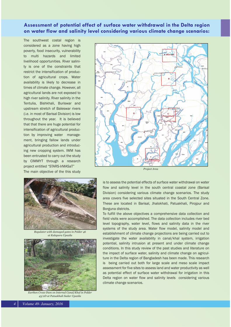
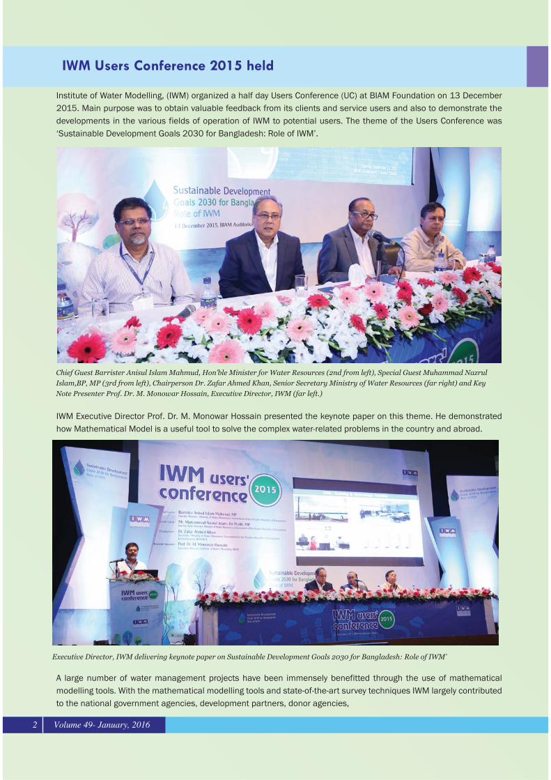
The southwest costal region is considered as a zone having high poverty, food insecurity, vulnerability to multi hazards and limited livelihood opportunities. River salini-ty is one of the constraints that restrict the intensification of produc-tion of agricultural crops. Water availability is likely to decrease in times of climate change. However, all agricultural lands are not exposed to high river salinity. River salinity in the Tentulia, Bishkhali, Buriswar and upstream stretch of Baleswar rivers (i.e. in most of Barisal Division) is low throughout the year. It is believed that that there are huge potential for intensification of agricultural produc-tion by improving water manage-ment, bringing fallow lands under agricultural production and introduc-ing new cropping system. IWM has been entrusted to carry out the study by CIMMYT through a research project entitled “STARS-IrMASaT”The main objective of the this study
is to assess the potential effects of surface water withdrawal on water flow and salinity level in the south central coastal zone (Barisal Division) considering various climate change scenarios. The study area covers five selected sites situated in the South Central Zone. These are located in Barisal, Jhalokhati, Patuakhali, Pirojpur and Borguna districts.To fulfill the above objectives a comprehensive data collection and field visits were accomplished. The data collection includes river bed level topography, water level, flows and salinity data in the river systems of the study area. Water flow model, salinity model and establishment of climate change projections are being carried out to investigate the water availability in canal/khal system, irrigation potential, salinity intrusion at present and under climate change conditions. In this study review of the past studies and literature on the impact of surface water, salinity and climate change on agricul-ture in the Delta region of Bangladesh has been made. This research is being carried out both for large scale and meso scale impact assessment for five sites to assess land and water productivity as well as potential effect of surface water withdrawal for irrigation in this Delta region on water flow and salinity levels considering various climate change scenarios.
Assessment of potential effect of surface water withdrawal in the Delta regionon water flow and salinity level considering various climate change scenarios:
Volume 49- January, 20164
Regulator with damaged gates in Polder 46 at Kalapara Upazila
Earthen Cross-Dam on Internal Canal/Khal in Polder 43/2D at Patuakhali Sadar Upazila
Project Area

The Northeast Region of Bangladesh has special natural features called Haors which are large bowl-shaped flood plain depressions. These haors accommodate about 19.37 million people most of whom are dependent on agriculture and fisheries. Boro rice is the only crop in the region, and more than 5.25 million tons of paddy are produced each year in the haor areas. These haors are frequently affected by flash flood, generated in the steep upland catchments adjacent to the border region with India. Sudden intrusion of flash flood recur-rently destroy agricultural production of about 0.33 million ha. More than 28% of the total population in the area lives below the Lower Poverty Line (LPL). For this reason, a substantial number of water management projects have been implemented by the Bangladesh Water Development Board (BWDB) in the area. BWDB is now implementing a program in the area to rehabilitate 15 nos. of existing haor projects along with construction of 14 nos. of new haor projects to provide pre-monsoon flood protection and post-monsoon drainage. Institute of Water Modelling (IWM) is providing consultancy services for mathematical modeling and topographic survey in the development program. Key activities being carried out by IWM under the assignment includes:�� ���������� ������������������� ������ �������� ��� ��� �����������! ���������������������� ��������� ����� ������������������!���� ��������������������!��� "��������������������������������������������������� ���������������� # �� ����������������������!��� �$&��������� ������ ���������� ����� ���������������� ��������������� ��� �������������� ����!��� "� �������������� ��� ���� ����������!��������� �������� ���� ���� # ���������������������������������� ����� ������� ������� # �� �������������! �����������������������!���������$&��������� ������ �������� # �� �������������������� �� �������� ���� ��
Location of New and Rehabilited Haor Projects
Field Survey Field Visit Paddy Cultivation in Haor
Mathematical Modelling and Topographic Survey Under Consultancy Servicesfor Management, Design, Supervision and other Related Services of Haor FloodManagement and Livelihood Improvement Project (BWDB Part)
Volume 49- January, 2016 5
INDIA(Meghalaya)
INDIA(Tripura)
METROKONA
SUMANGANJ
SYLHET
NLPUR
TERAPASHA
MOULVIBAZARHABIGANJ
KISHORAGANJ
GAZIPUR NORSINGONJBRANMONBRIA
DHAKA
NARAYANGNAJ
MUNSHIGANJ

The Mohananda river is one of the perennial rivers of the North West region of Bangladesh. After its entrance in Bangladesh, it passes through Bholahat, Gomastapur, Shibganj, Nachole and Nawabganj Sadar Upazila and lastly meets with the Ganges river in Godagari Upazila. During the dry season, the river water level falls substantially making existing Low Lift Pump irrigation difficult or sometimes rendering them inoperable. It is anticipated that if surface water availability could be increased, surface water irrigation would increase in the area including fishery development, navigation, environmental improvement etc. With this perspective Bangladesh Water Development Board decided to conduct a feasibility study for construction of a rubber dam on the Mohananda river for boost-ing up surface water irrigation in the area and subsequently engaged IWM as a consultant to conduct the study.The main objective of the study was to assess the feasibility of dredging the Mohananda river and construction of a Rubber Dam to facilitate irrigation around the command area, from technical, socio-economic and environmental perspective.
The project area falls under Bholahat, Gomastapur, Shibganj, Nachole and Nawabganj Sadar Upazila under Chapai Nawabganj district and Godagari Upazila under Rajshahi district. The gross area is 107848 ha and net irrigation benefitted area is 7100 ha.
The study commenced with identification of a suitable site for construction of the rubber dam considering various aspect such as river morphology, water supply to and recreational facility of Chapa Nawabganj town, reservoir capaci-ty, accessibility of the site etc. Necessary data for the study was collected through engineering survey, questionnaire survey, FGD and KII. Mathematical modelling technology was applied to assess the impact of the rubber dam and different irrigation development options on river morphology, upstream and down-stream river flow, flood and drainage, groundwater recharge, navigation etc. Besides, agro socio-economic and environmental aspects of the proposed rubber dam was also examined.
A 353.00 m long rubber dam is proposed for construction at downstream of ‘Birsre-shtho Shahid Jahangir’ road bridge adjacent to the Chapai Nawabganj town
along with necessary dredging of Mohanada river at selected locations both at u/s and d/s of the proposed rubber dam. In addition, about 815 m walkway with necessary recreational facilities are recommended for implementation.
The study reveals that due to construction of the rubber dam surface water irrigation area would increase from 4200 ha to 8000 ha. Besides, the project would enhance recreational facilities in and along the Mohananda river, ensure water availability for drinking water supply to the Chapai Nawabganj municipality area and ensure a minimum 1.00 m depth of water at upstream of the rubber dam for fishery and navigation. The recommended development interven-tions would also ensure water availability at downstream of the rubber dam. The estimated cost of the project is Tk. 16054.83 lakh and the estimated BCR and IRR is 1.89 and 24.32 % respec-tively.
Feasibility Study for Irrigation using Mathematical Modelling along the Bankof the Mohananda River
WL Variation at U/S of Rubber Dam
Project Location Map
Volume 49- January, 20166

The Bir Shrestho Captain Mohiuddin Jahangir Bridge, situated on the Sugandha River at the 17th km of Baris-al-Bhurghata Highway (N8), is one of the important bridges of the south-west region of Bangladesh. In view of its importance as well as the dynamic behavior of the Sugandha River, the Bridge is provided with two guide bunds at its two approach ends.
For the last few years, the guide bund at the Barisal end approach has become vulnerable due to erosion of the left bank of the Sugandha River. To arrest the erosion tendency as well as safeguarding the guide bund
concerned, Roads and Highways Department (RHD) entrusted Bangladesh Water Development Board (BWDB) to take up requisite protective measures as deposit works.
In the recent past, BWDB opined that before finalizing the design and costing of any permanent protective measure, it would be prudent to get a study/survey done by Institute of Water Modelling (IWM). Accordingly, a Contract was signed on 29/10/2015 between RHD and IWM to conduct the study. The objectives of the
study are to investigate the erosion problems at and around the vulnerable guide bund at the Barisal end of the Doarika Bridge, and to recommend measure(s) to strengthen/protect the guide bund concerned.
The hydro-morphological behavior of the Sugandha River has been subjected to preliminary assessment based on available historical data, field inspections and appropriate analytical tools. Comprehensive hydro-mor-phological assessment requires mathematical models to resolve the governing physical processes to a sufficient degree of detail. In this respect both one- and
two-dimensional (1-D and 2-D) models are being devel-oped and used for the present study.
The modelling tools being applied for the study are one-dimensional MIKE 11 (for river hydrodynamic modelling) and two-dimensional MIKE 21C (morpholog-ical modelling) developed by the DHI, Denmark. These modelling tools have been extensively used in several of similar projects in Bangladesh as well as many other countries.
Study for the Protection of Guide Bund at the Barisal End of the BirShrestho Captain Mohiuddin Jahangir Bridge (Doarika Bridge) onthe Sugandha River
Volume 49- January, 2016 7
Map of Study Area
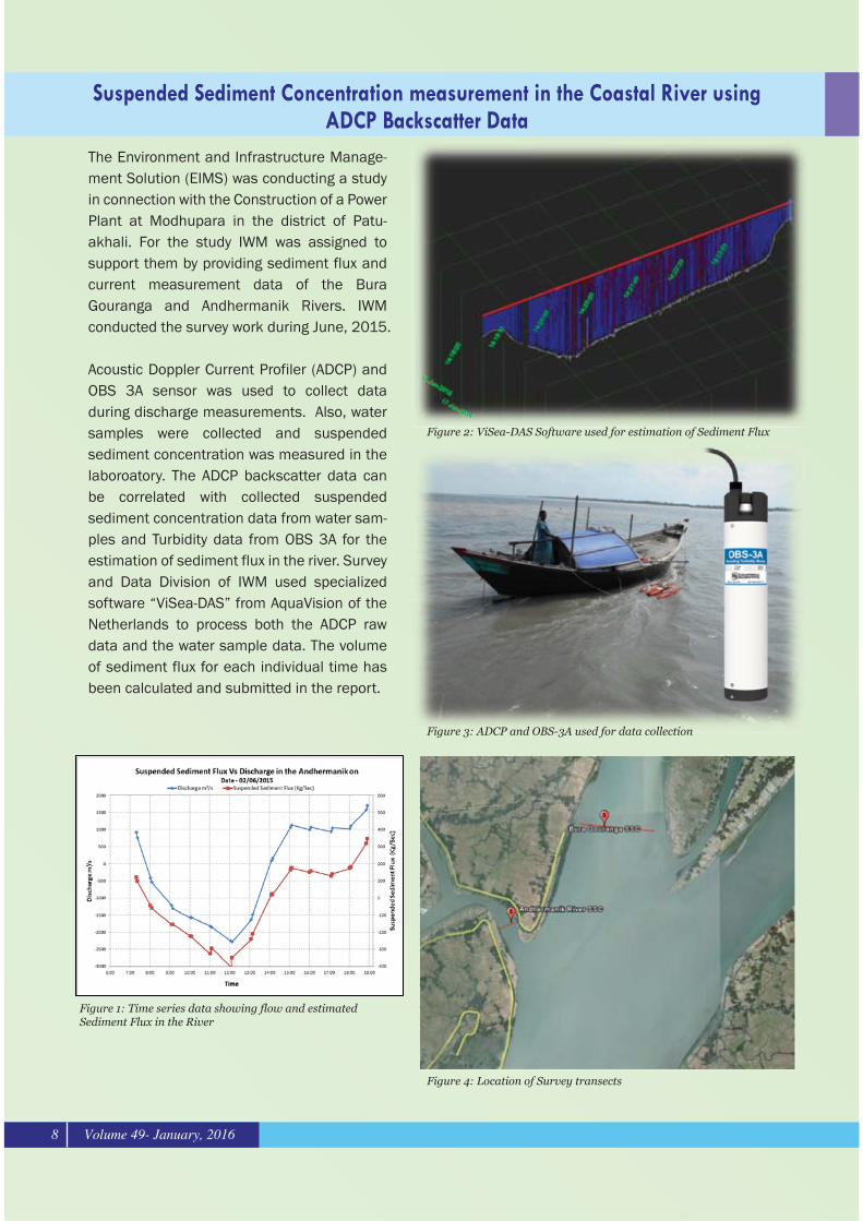
The Environment and Infrastructure Manage-ment Solution (EIMS) was conducting a study in connection with the Construction of a Power Plant at Modhupara in the district of Patu-akhali. For the study IWM was assigned to support them by providing sediment flux and current measurement data of the Bura Gouranga and Andhermanik Rivers. IWM conducted the survey work during June, 2015.
Acoustic Doppler Current Profiler (ADCP) and OBS 3A sensor was used to collect data during discharge measurements. Also, water samples were collected and suspended sediment concentration was measured in the laboroatory. The ADCP backscatter data can be correlated with collected suspended sediment concentration data from water sam-ples and Turbidity data from OBS 3A for the estimation of sediment flux in the river. Survey and Data Division of IWM used specialized software “ViSea-DAS” from AquaVision of the Netherlands to process both the ADCP raw data and the water sample data. The volume of sediment flux for each individual time has been calculated and submitted in the report.
Suspended Sediment Concentration measurement in the Coastal River usingADCP Backscatter Data
Figure 2: ViSea-DAS Software used for estimation of Sediment Flux
Figure 3: ADCP and OBS-3A used for data collection
Figure 4: Location of Survey transects
Figure 1: Time series data showing flow and estimated Sediment Flux in the River
Volume 49- January, 20168
16 Jan 2016
14:1
8:20 14
:19:
10 14:2
0:00 14
:20:
60 14:2
1:40 14
:22:
30 14:2
3:20
17 Jan 2016

A workshop was held on the Final Report of the project “Feasibility and ESIA study for Strengthening of the Existing Water Supply Distri-bution System of Dhaka to cope with the Production of Padma Water Treatment Plant Project (Phase-1) at Jashaldia” at Dhaka WASA. The meeting was chaired by Engr. Taqsem A Khan, MD of Dhaka WASA and attended by other high officials of the organi-zation. The IWM team led by Mr. Shahidur Rahman Prodhan, presented the technical require-ments and alternate options to implement the project. The presentation also included the environmental and social implications of the project and their management. A lively discussion was held after the presentation.
Book Launch: Urban Flooding of Greater Dhaka in a Changing Climate
A Workshop held on Feasibility Study of Dhaka WASA
On 23 November (2015), the culmination of 2 years of research on Urban Flooding of Greater Dhaka in a Changing Climate was published by the World Bank. The IWM team, lead by Dr. Asif M. Zaman (WRP Division), was involved in modeling of urban flooding scenarios. This study covered Eastern Dhaka, Goran-chatbari, Kallyanpur, Central Dhaka, Old Dhaka, DND and Narayanganj drainage systems, and was funded by the Bangla-desh Climate Change Resilience Fund (BCCRF), a multi-donor trust fund. The underlying premise of the study was that with more frequent and intense rainfall (such as in 2004, 2007 and 2009), climate change is likely to further aggravate flooding and waterlog-ging in the coming decades.
The study findings highlighted the importance of properly implementation of the Dhaka Detailed Area Plan, Sewerage Master Plan and Drainage Master Plan of Dhaka. Also, the other planned investments such as in the DND and Eastern Dhaka are important for increasing the resilience of Dhaka City. The study found that Dhaka will need additional investment to reduce the impacts of Climate Change. The incremental cost of adaptation for Dhaka to climate change by 2050 will be about Tk 130 crores (assuming all existing plans and proposed projects are implemented properly).Alongwith IWM’s Executive Director(Prof. Dr. M. Monowar Hossain), the event was graced by the Honorable Mayor of Dhaka North City Corporation (Mr. Annisul Huq), Director General of Bangladesh Haor & Wetland Development Board (Ms. Afroza Moazzam) and DMD of DWASA (Mr. Md. Serajuddin).
Book Launching Ceremoney
Presentation meeting on the Final Report
Volume 49- January, 2016 9
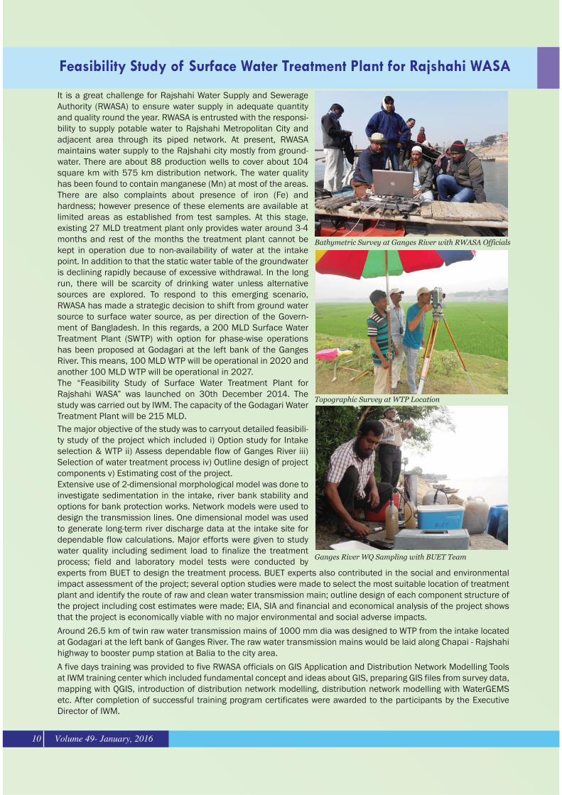
It is a great challenge for Rajshahi Water Supply and Sewerage Authority (RWASA) to ensure water supply in adequate quantity and quality round the year. RWASA is entrusted with the responsi-bility to supply potable water to Rajshahi Metropolitan City and adjacent area through its piped network. At present, RWASA maintains water supply to the Rajshahi city mostly from ground-water. There are about 88 production wells to cover about 104 square km with 575 km distribution network. The water quality has been found to contain manganese (Mn) at most of the areas. There are also complaints about presence of iron (Fe) and �� ��������� �� ������������������ ������������limited areas as established from test samples. At this stage, existing 27 MLD treatment plant only provides water around 3-4 months and rest of the months the treatment plant cannot be kept in operation due to non-availability of water at the intake point. In addition to that the static water table of the groundwater is declining rapidly because of excessive withdrawal. In the long run, there will be scarcity of drinking water unless alternative sources are explored. To respond to this emerging scenario, RWASA has made a strategic decision to shift from ground water source to surface water source, as per direction of the Govern-ment of Bangladesh. In this regards, a 200 MLD Surface Water Treatment Plant (SWTP) with option for phase-wise operations has been proposed at Godagari at the left bank of the Ganges River. This means, 100 MLD WTP will be operational in 2020 and another 100 MLD WTP will be operational in 2027.The “Feasibility Study of Surface Water Treatment Plant for Rajshahi WASA” was launched on 30th December 2014. The study was carried out by IWM. The capacity of the Godagari Water Treatment Plant will be 215 MLD. The major objective of the study was to carryout detailed feasibili-ty study of the project which included i) Option study for Intake selection & WTP ii) Assess dependable flow of Ganges River iii) Selection of water treatment process iv) Outline design of project components v) Estimating cost of the project.Extensive use of 2-dimensional morphological model was done to investigate sedimentation in the intake, river bank stability and options for bank protection works. Network models were used to design the transmission lines. One dimensional model was used to generate long-term river discharge data at the intake site for dependable flow calculations. Major efforts were given to study water quality including sediment load to finalize the treatment � ������ ����� ���� ���� ��� �� ����� ����� � � ��������� ���experts from BUET to design the treatment process. BUET experts also contributed in the social and environmental ����������������������� ������� ������������������ ������������������������������������������ ��������������������������� ������� ��������������� �� ���������������������������!�������������������� ���� �������� �������������!��������������� ������*+;<�=+;��������������������������������������������� �����������that the project is economically viable with no major environmental and social adverse impacts.
Around 26.5 km of twin raw water transmission mains of 1000 mm dia was designed to WTP from the intake located at Godagari at the left bank of Ganges River. The raw water transmission mains would be laid along Chapai - Rajshahi highway to booster pump station at Balia to the city area.
A five days training was provided to five RWASA officials on GIS Application and Distribution Network Modelling Tools at IWM training center which included fundamental concept and ideas about GIS, preparing GIS files from survey data, mapping with QGIS, introduction of distribution network modelling, distribution network modelling with WaterGEMS etc. After completion of successful training program certificates were awarded to the participants by the Executive Director of IWM.
Feasibility Study of Surface Water Treatment Plant for Rajshahi WASA
Bathymetric Survey at Ganges River with RWASA Officials
Topographic Survey at WTP Location
Ganges River WQ Sampling with BUET Team
Volume 49- January, 201610
A contract agreement was signed between Institute of Water Modelling (IWM) and Bangladesh Water Development Board (BWDB) on December 01, 2015 at the BWDB office for the study “Upgrading and Rehabilitation of Karnafuly Irrigation Project, Fatikchari FCDI, Halda Extension Irrigation Project and Nishchintapur FCDI project”.The major objectives of the study are identification of present drawbacks in the existing irrigation facilities and drainage system, assessment of adequacy of irrigation water resources and expansion of irrigation facilities with command area develop-ment through use of mathemati-cal modelling techniques. Mr. Sardar M Shah - Newaz, Direc-tor, Irrigation Management Division, IWM and Mr. Md. Abdul Hye, Director, Planning – I, BWDB signed the contract on behalf of their respective organi-zations. Prof. Dr. M. Monwar Hossain, Executive Director, IWM, Mr. Md. Mahfuzur Rahman, Chief Planning, BWDB and other senior officials of BWDB and IWM also attended the contract signing ceremony
Sanitation and drainage improvement strategy and master planfor the city of Chittagong
Signing of Contract Agreement between IWM and BWDB for the study“Upgrading and Rehabilitation of Karnafuly Irrigation Project, FatikchariFCDI, Halda Extension Irrigation Project and Nishchintapur FCDI project”
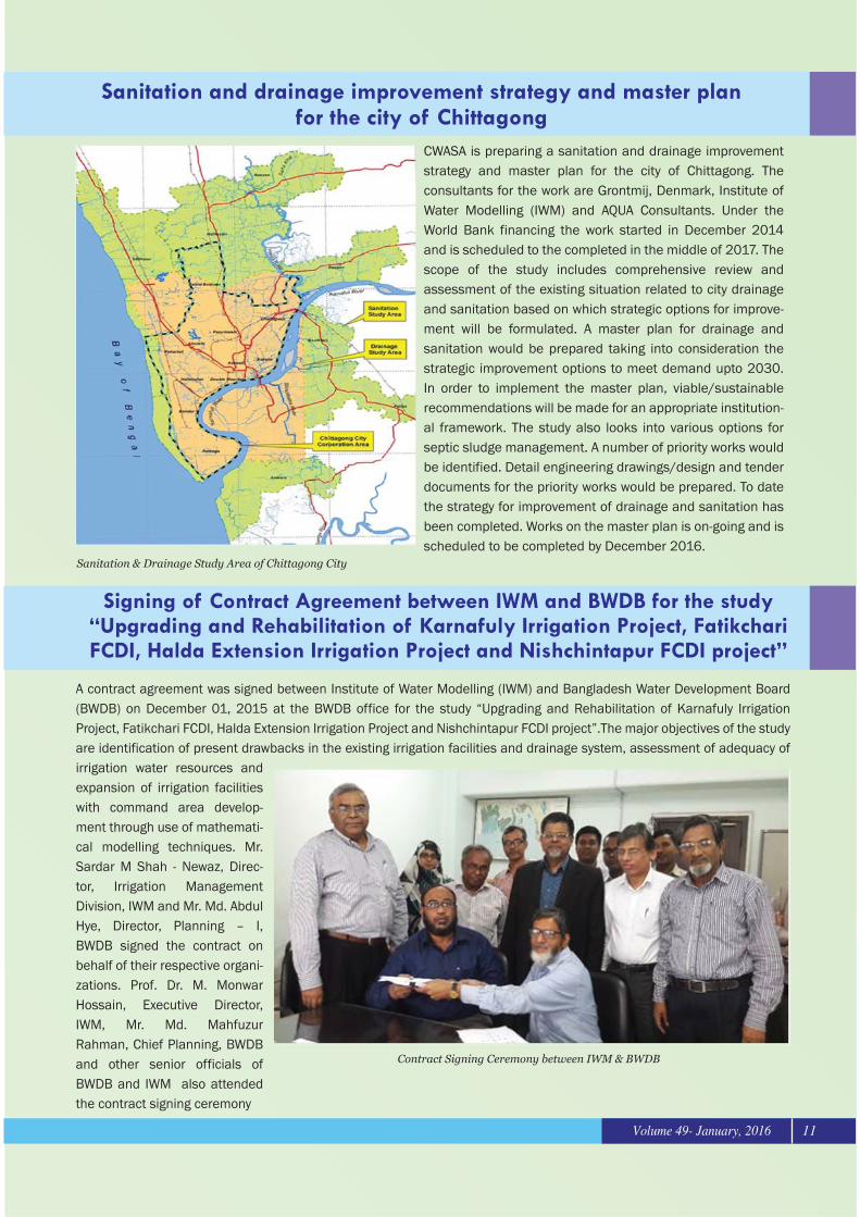
CWASA is preparing a sanitation and drainage improvement strategy and master plan for the city of Chittagong. The consultants for the work are Grontmij, Denmark, Institute of Water Modelling (IWM) and AQUA Consultants. Under the World Bank financing the work started in December 2014 and is scheduled to the completed in the middle of 2017. The scope of the study includes comprehensive review and assessment of the existing situation related to city drainage and sanitation based on which strategic options for improve-ment will be formulated. A master plan for drainage and sanitation would be prepared taking into consideration the strategic improvement options to meet demand upto 2030. In order to implement the master plan, viable/sustainable recommendations will be made for an appropriate institution-al framework. The study also looks into various options for septic sludge management. A number of priority works would be identified. Detail engineering drawings/design and tender documents for the priority works would be prepared. To date the strategy for improvement of drainage and sanitation has been completed. Works on the master plan is on-going and is scheduled to be completed by December 2016.
Sanitation & Drainage Study Area of Chittagong City
Contract Signing Ceremony between IWM & BWDB
Volume 49- January, 2016 11
Volume 49- January, 201612
Co-EditorM. Samiun Nabi
CompilationMohammad Saiful Alam Khan
Contributors