Embed Size (px)
DESCRIPTION
Flood risk management in the NetherlandsLecture at the university of Aachen (aix la Chapelle) in Germany January, 5th 2007author Robert SlomppowerpointThe article is available at the university libraryFlood risk management in the NetherlandsDike relocation, enlarging the discharge capactity room for the rivers
Citation preview
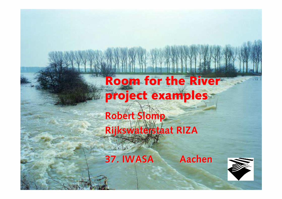
Room for the RiverRoom for the Riverproject examplesproject examples
Robert Robert SlompSlomp
Rijkswaterstaat RIZARijkswaterstaat RIZA
37. IWASA 37. IWASA AachenAachen

ContentsContents
~~ some characteristics of the Netherlandssome characteristics of the Netherlands
~~ history / the flood of 1995history / the flood of 1995
~~ the problemthe problem
~~ flood control policyflood control policy
~~ Spatial Planning Key decision ‘Room for the River’ Spatial Planning Key decision ‘Room for the River’ (SPKD) 2001(SPKD) 2001--20062006
~~ Design and construction phase 2006Design and construction phase 2006--20152015
~~ Mixed projects/ ForeMixed projects/ Fore--runners 1999 runners 1999 --20072007
~~ RVR Projects brought forward: RVR Projects brought forward: Overdiepse Overdiepse Polder, Polder, NoordwaardNoordwaard, , Westerwolte Westerwolte
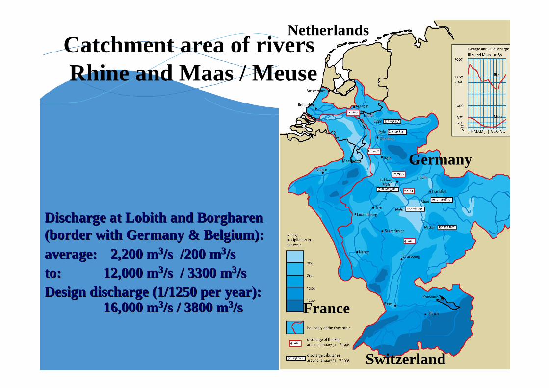
Netherlands
Germany
Switzerland
France
Discharge at Discharge at Lobith Lobith and and BorgharenBorgharen(border with Germany & Belgium):(border with Germany & Belgium):average:average: 2,200 m2,200 m33/s /200 m/s /200 m33/s /s to:to: 12,000 m12,000 m33/s / 3300 m/s / 3300 m33/s /s Design discharge (1/1250 per year):Design discharge (1/1250 per year):
16,000 m16,000 m33/s / 3800 m/s / 3800 m33/s/s
Catchment area of riversRhine and Maas / Meuse
Netherlands
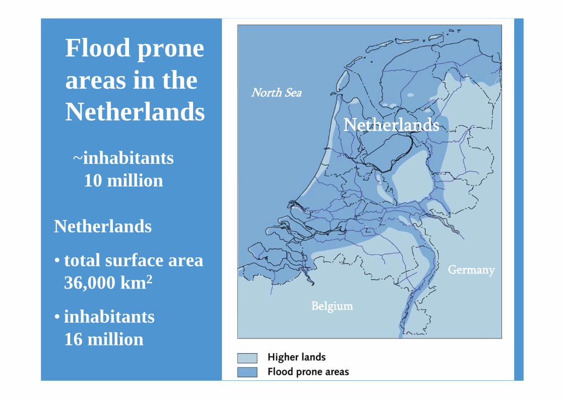
• total surface area36,000 km2
• inhabitants16 million
North SeaNorth SeaNorth SeaNorth Sea
BelgiumBelgiumBelgiumBelgium
GermanyGermanyGermanyGermany
NetherlandsNetherlandsNetherlandsNetherlands
~inhabitants10 million
Flood prone areas in theNetherlands
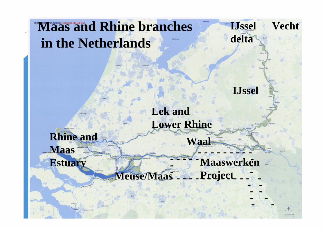
IJssel
Lek andLower Rhine
Waal
Meuse/MaasMaaswerken Project
Rhine and Maas Estuary
- - - - - - - - -- - - - - -- -- -- - - - - - - - - - - - - -
- -- -- -- -
IJsseldelta
Maas and Rhine branchesin the Netherlands
Vecht

WaalWaal
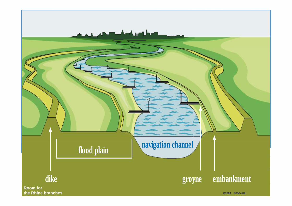
dike groyne embankment
flood plain navigation channel
R3294 E000418n
Room forthe Rhine branches

ContentsContents
~~ some characteristics of the Netherlandssome characteristics of the Netherlands
~~ history / the flood of 1995history / the flood of 1995
~~ the problemthe problem
~~ flood control policyflood control policy
~~ The Spatial Planning Key decision ‘Room for the River’ The Spatial Planning Key decision ‘Room for the River’ (SPKD)(SPKD)
~~ Design and construction phaseDesign and construction phase
~~ Mixed projects/ ForeMixed projects/ Fore--runners 1999 runners 1999 --20072007
~~ Projects brought forward: Projects brought forward: OverdiepseOverdiepse Polder, Polder, NoordwaardNoordwaard
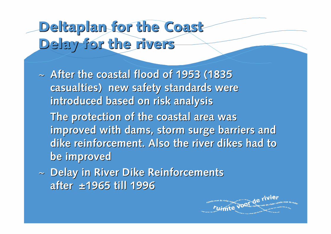
Deltaplan Deltaplan for for the the CoastCoastDelay for Delay for the the riversrivers
~~ AfterAfter thethe coastal floodcoastal flood of 1953 (1835 of 1953 (1835 casualtiescasualties) ) new safety standards were new safety standards were introduced based on introduced based on risk risk analysisanalysis
The The protectionprotection of theof the coastal areacoastal area waswasimproved with damsimproved with dams, storm, storm surge barrierssurge barriers andanddike reinforcementdike reinforcement.. AlsoAlso thethe river dikesriver dikes hadhad to to be improvedbe improved
~~ DelayDelay inin River Dike Reinforcements River Dike Reinforcements after after ±1965 ±1965 tilltill 19961996

Floods in ‘93 en ‘95
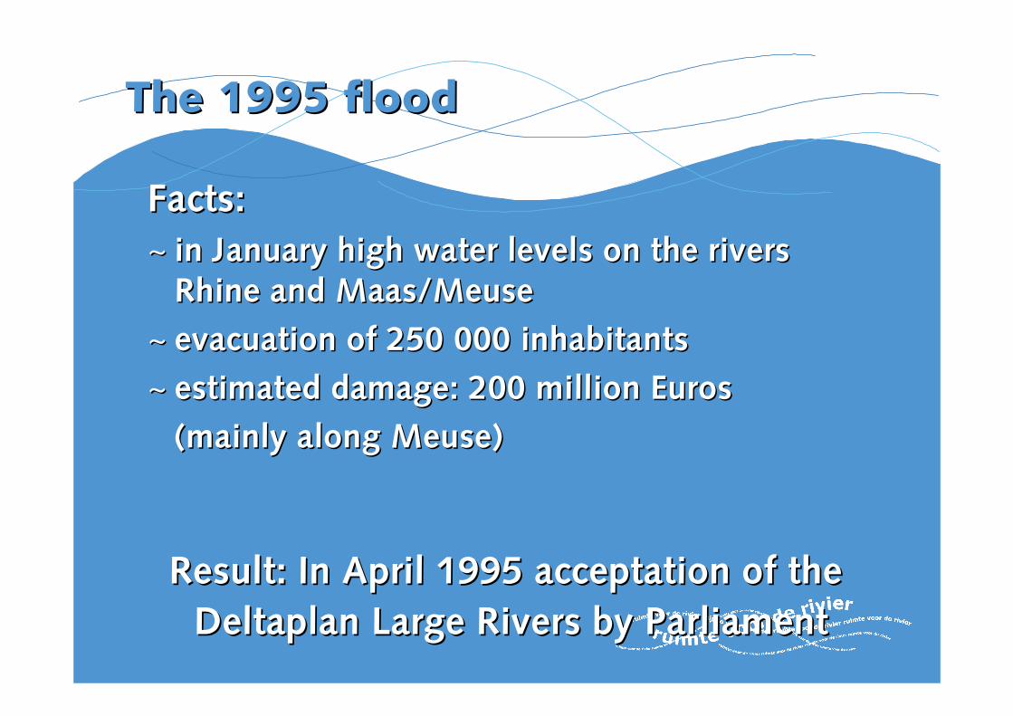
The 1995 floodThe 1995 flood
Facts:Facts:
~~ in January high water levels on the rivers in January high water levels on the rivers Rhine and Maas/Rhine and Maas/MeuseMeuse
~~ evacuation of 250 000 inhabitantsevacuation of 250 000 inhabitants
~~ estimated damage: 200 million Euros estimated damage: 200 million Euros
(mainly along (mainly along MeuseMeuse))
Result: In April 1995 acceptation of the Result: In April 1995 acceptation of the
DeltaplanDeltaplan Large Rivers by ParliamentLarge Rivers by Parliament
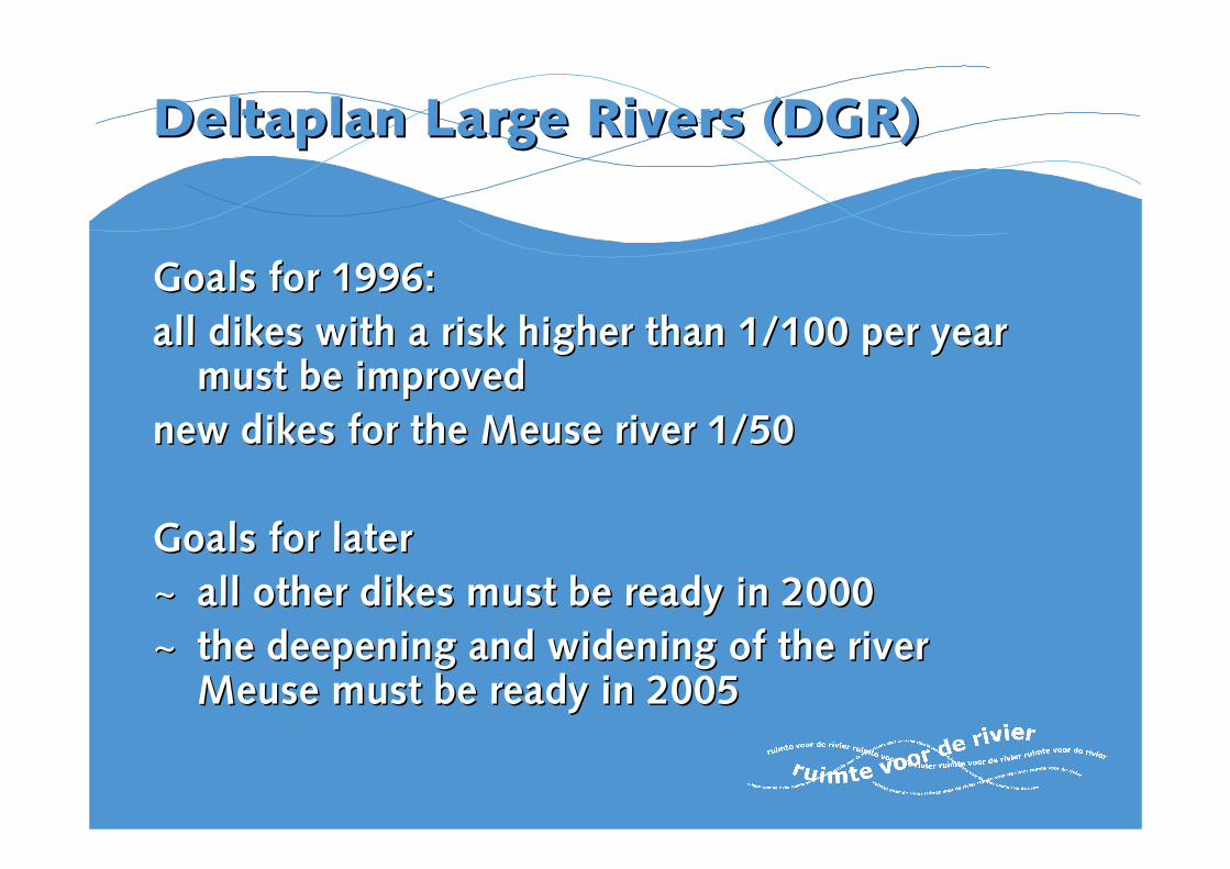
DeltaplanDeltaplan Large RiversLarge Rivers (DGR)(DGR)
Goals Goals forfor 1996:1996:
all dikes withall dikes with a riska risk higher thanhigher than 1/100 per1/100 per yearyearmustmust be improvedbe improved
new dikes for new dikes for the the Meuse river Meuse river 1/501/50
Goals Goals forfor laterlater
~~ all other dikesall other dikes mustmust be readybe ready in 2000in 2000
~~ the the deepeningdeepening andand wideningwidening of theof the river river MeuseMeuse mustmust be readybe ready in 2005in 2005
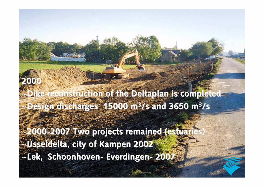
20002000
~~Dike reconstruction of the Dike reconstruction of the DeltaplanDeltaplan is completedis completed
~~Design discharges 15000 mDesign discharges 15000 m33/s and 3650 m/s and 3650 m33/s /s
~~20002000--2007 Two projects remained (estuaries)2007 Two projects remained (estuaries)
~~IJsseldeltaIJsseldelta, city of , city of Kampen Kampen 20022002
~~LekLek, , SchoonhovenSchoonhoven-- EverdingenEverdingen-- 20072007
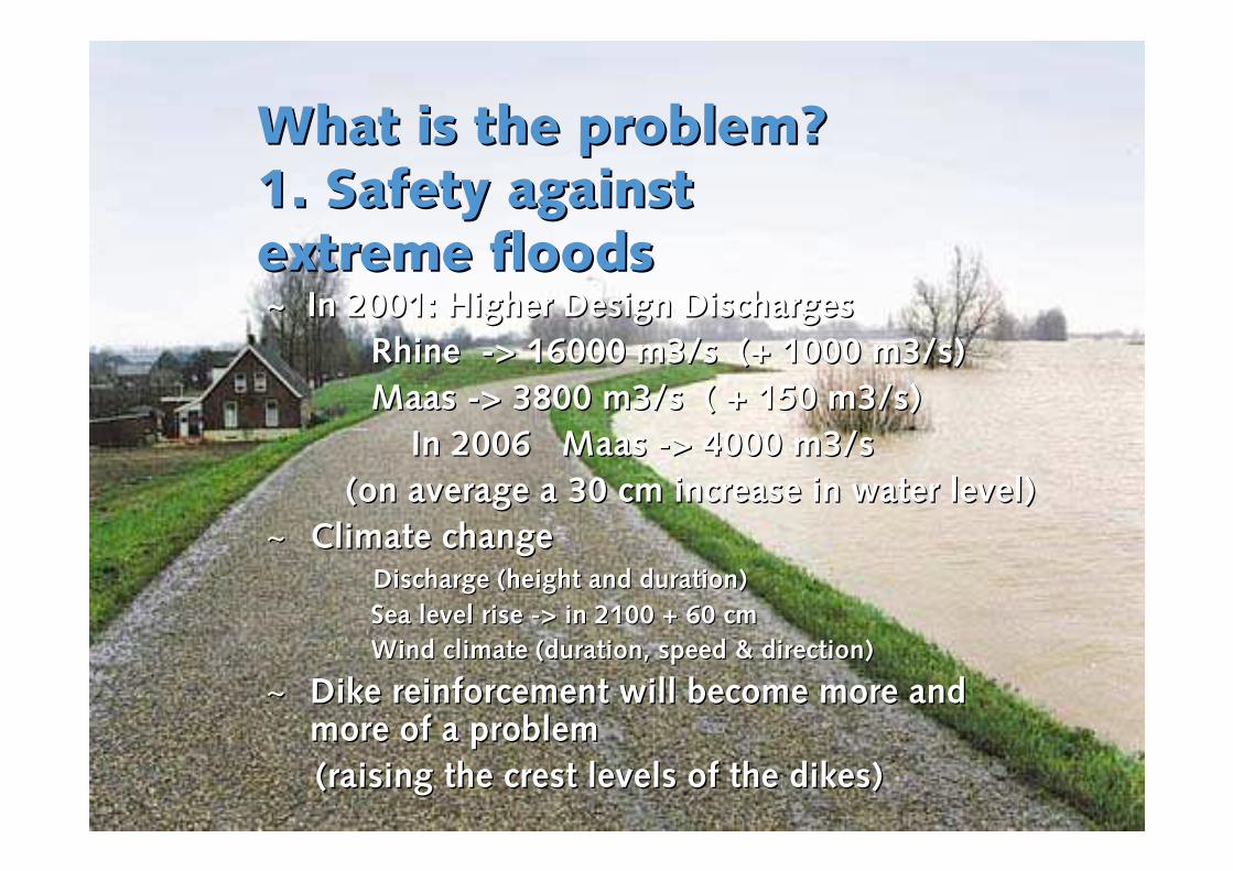
What is the problem? What is the problem? 1. Safety against 1. Safety against extreme floodsextreme floods~ ~ In 2001: Higher Design Discharges In 2001: Higher Design Discharges
Rhine Rhine --> 16000 m3/s (+ 1000 m3/s)> 16000 m3/s (+ 1000 m3/s)
Maas Maas --> 3800 m3/s ( + 150 m3/s)> 3800 m3/s ( + 150 m3/s)
In 2006 Maas In 2006 Maas --> 4000 m3/s> 4000 m3/s
(on average a 30 cm increase in water level)(on average a 30 cm increase in water level)
~~ Climate changeClimate changeDischarge (height and duration)Discharge (height and duration)
Sea level rise Sea level rise --> in 2100 + 60 cm> in 2100 + 60 cm
Wind climate (duration, speed & direction)Wind climate (duration, speed & direction)
~~ Dike reinforcement will become more and Dike reinforcement will become more and more of a problemmore of a problem
(raising the crest levels of the dikes)(raising the crest levels of the dikes)
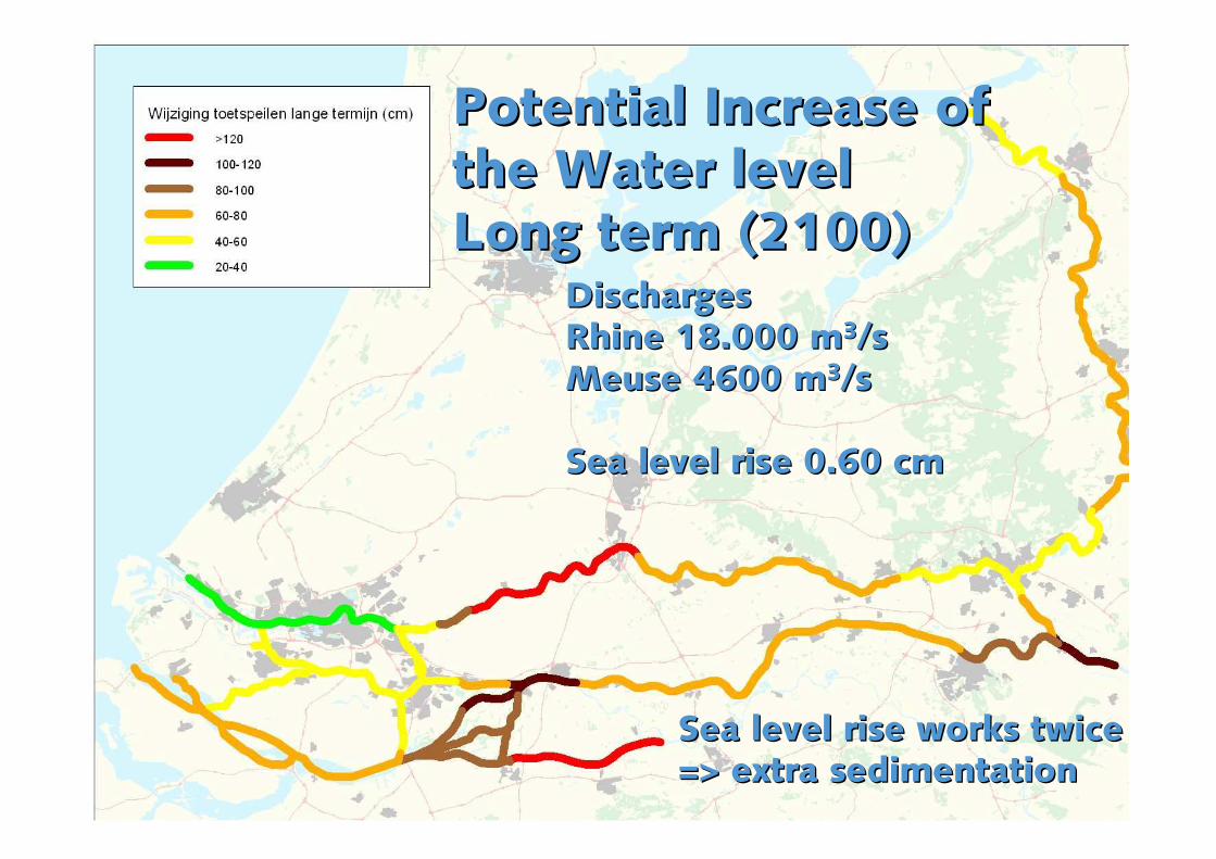
Potential Increase of Potential Increase of the Water level the Water level Long term (2100)Long term (2100)
DischargesDischargesRhine 18.000 mRhine 18.000 m33/s/sMeuse Meuse 4600 m4600 m33/s/s
Sea level rise 0.60 cm Sea level rise 0.60 cm
Sea level rise works twice Sea level rise works twice => extra sedimentation => extra sedimentation
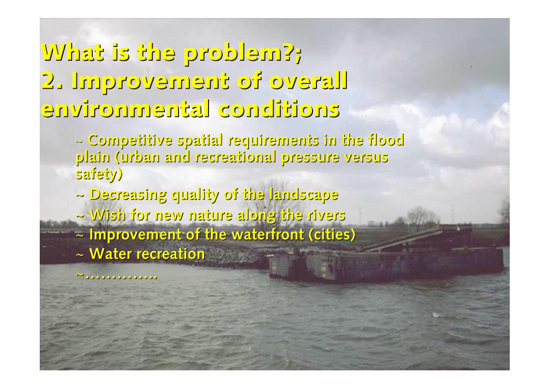
What is the problem?; What is the problem?; 2. Improvement of overall 2. Improvement of overall environmental conditionsenvironmental conditions
~~ Competitive spatial requirements in the flood Competitive spatial requirements in the flood plain (urban and recreational pressure versus plain (urban and recreational pressure versus safety)safety)
~~ Decreasing quality of the landscapeDecreasing quality of the landscape
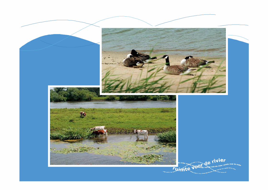
~~ Wish for new nature along the riversWish for new nature along the rivers
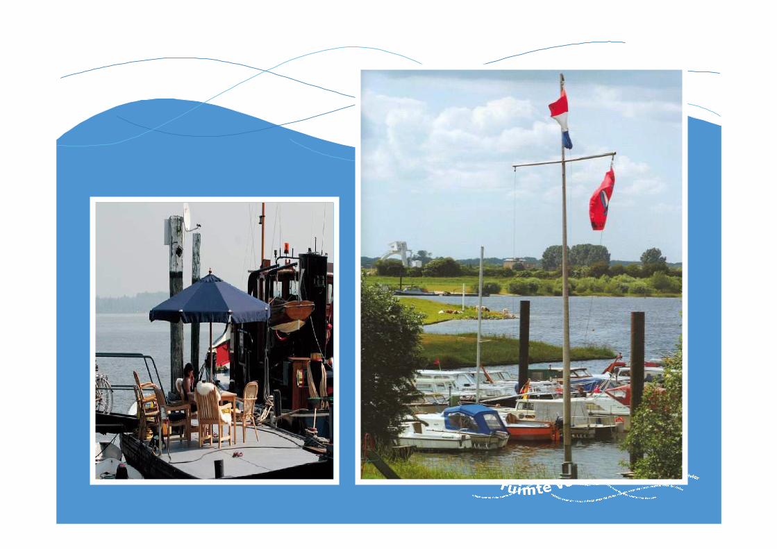
~~ Improvement of the waterfront (cities)Improvement of the waterfront (cities)
~~ Water recreationWater recreation
~~…………..…………..

ContentsContents
~~ some characteristics of the Netherlandssome characteristics of the Netherlands
~~ history / the flood of 1995history / the flood of 1995
~~ the problemthe problem
~~ flood control policyflood control policy
~~ The Spatial Planning Key decision ‘Room for the River’ The Spatial Planning Key decision ‘Room for the River’ (SPKD)(SPKD)
~~ Design and construction phaseDesign and construction phase
~~ Mixed projects/ ForeMixed projects/ Fore--runners 1999 runners 1999 --20072007
~~ RVR Projects brought forward: RVR Projects brought forward: OverdiepseOverdiepse Polder, Polder, NoordwaardNoordwaard, , Westerwolte Westerwolte
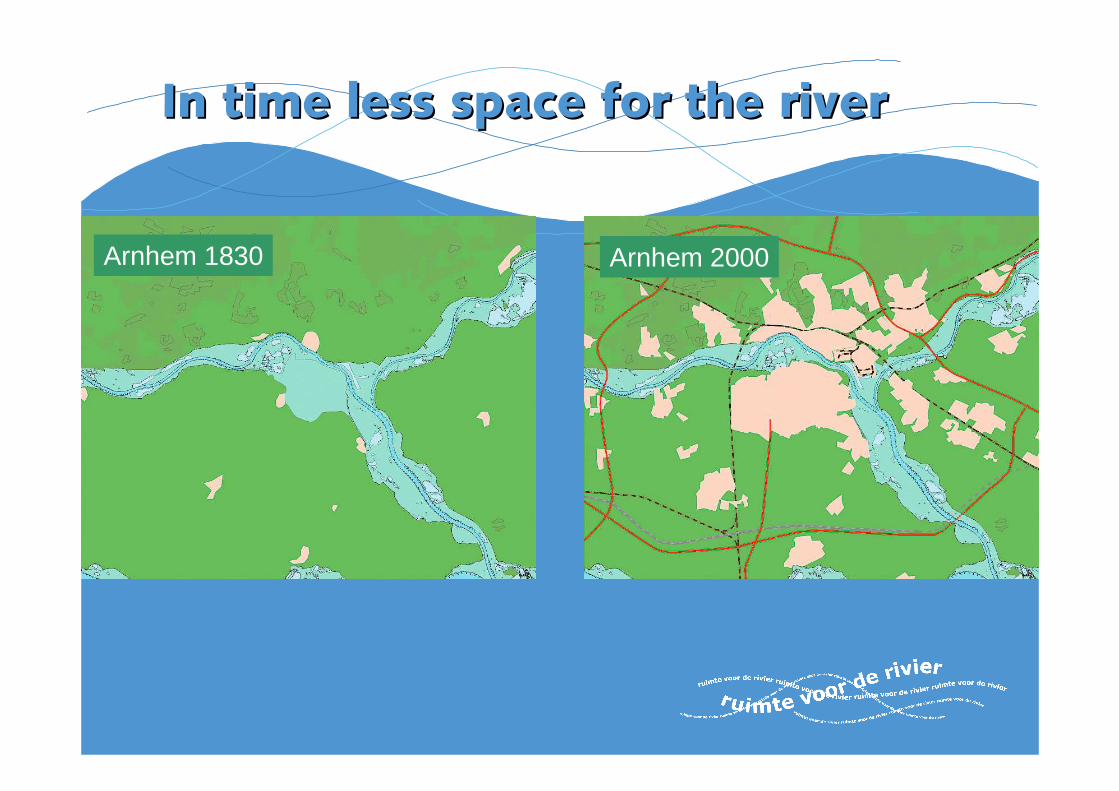
Arnhem 1830 Arnhem 2000
In time less space for the riverIn time less space for the river
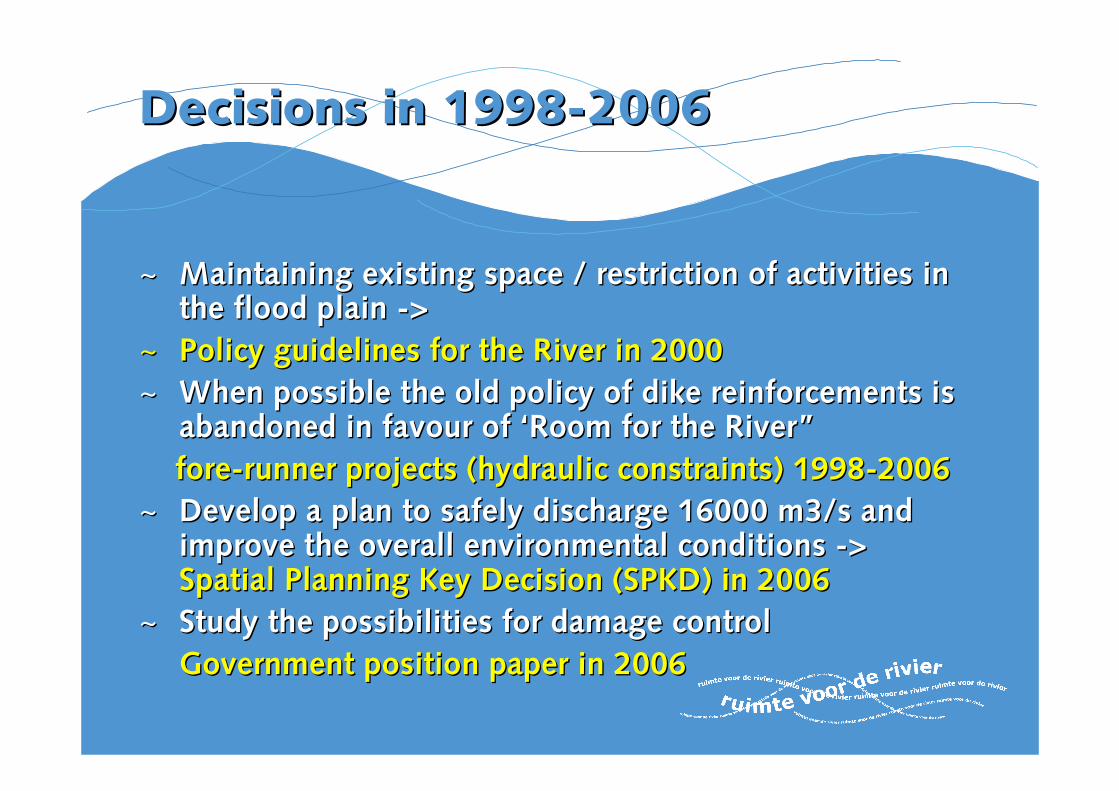
Decisions in 1998Decisions in 1998--20062006
~~ Maintaining existing space / restriction of activities in Maintaining existing space / restriction of activities in the flood plain the flood plain --> >
~~ Policy guidelines for the River in 2000Policy guidelines for the River in 2000
~~ When possible the old policy of dike reinforcements is When possible the old policy of dike reinforcements is abandoned in favour of ‘Room for the River” abandoned in favour of ‘Room for the River”
forefore--runner projectsrunner projects (hydraulic constraints) 1998(hydraulic constraints) 1998--2006 2006
~~ Develop a plan to safely discharge 16000 m3/s and Develop a plan to safely discharge 16000 m3/s and improve the overall environmental conditions improve the overall environmental conditions --> > Spatial Planning Key Decision (SPKD) in 2006Spatial Planning Key Decision (SPKD) in 2006
~~ Study the possibilities for damage control Study the possibilities for damage control
Government position paper in 2006Government position paper in 2006

ContentsContents
~~ some characteristics of the Netherlandssome characteristics of the Netherlands
~~ history / the flood of 1995history / the flood of 1995
~~ flood control policyflood control policy
~~ Spatial Planning Key decision ‘Room for the River’ Spatial Planning Key decision ‘Room for the River’ (SPKD) (SPKD)
~~ Design and construction phaseDesign and construction phase
~~ Mixed projects/ ForeMixed projects/ Fore--runners 1999 runners 1999 --20072007
~~ RVR Projects brought forward: RVR Projects brought forward: OverdiepseOverdiepse Polder, Polder, NoordwaardNoordwaard, , Westerwolte Westerwolte
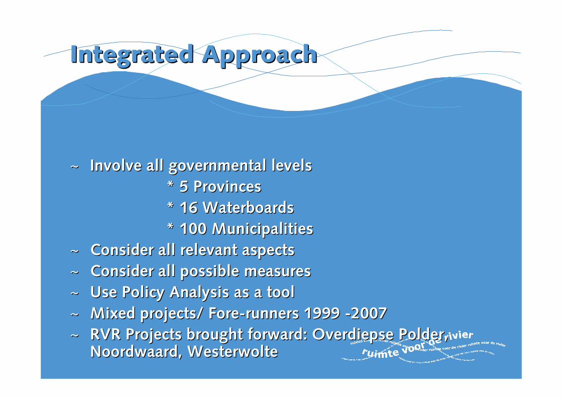
Integrated ApproachIntegrated Approach
~~ Involve all governmental levelsInvolve all governmental levels
* 5 Provinces* 5 Provinces
* 16 * 16 WaterboardsWaterboards
* 100 Municipalities* 100 Municipalities
~~ Consider all relevant aspectsConsider all relevant aspects
~~ Consider all possible measuresConsider all possible measures
~~ Use Policy Analysis as a toolUse Policy Analysis as a tool
~~ Mixed projects/ ForeMixed projects/ Fore--runners 1999 runners 1999 --20072007
~~ RVR Projects brought forward: RVR Projects brought forward: OverdiepseOverdiepse Polder, Polder, NoordwaardNoordwaard, , Westerwolte Westerwolte
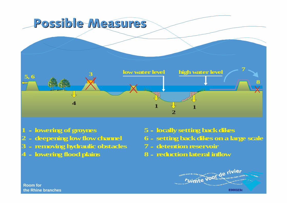
Room forthe Rhine branches E000323c
high water level
8
1234
lowering of groynesdeepening low flow channelremoving hydraulic obstacleslowering flood plains
5678
locally setting back dikessetting back dikes on a large scaledetention reservoirreduction lateral inflow
7
1 12
low water level5, 6 3
4
Possible MeasuresPossible Measures
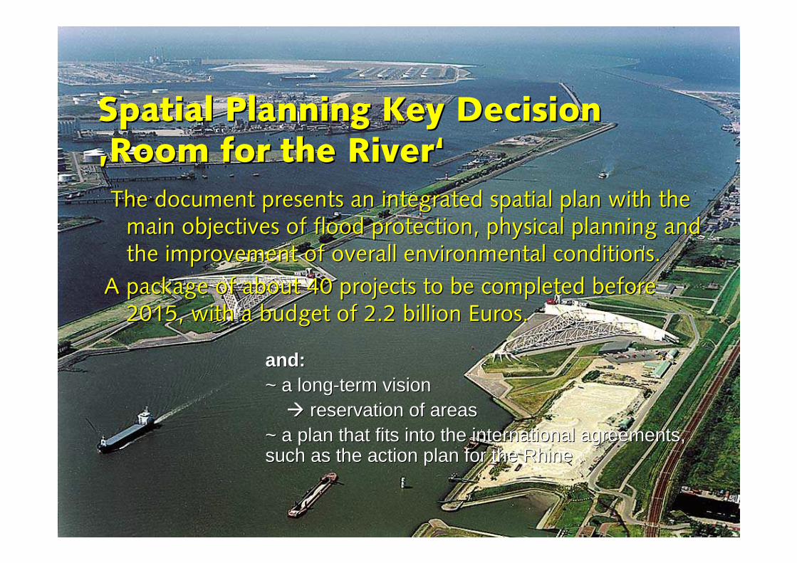
Spatial PlanningSpatial Planning Key Key DecisionDecision‚‚Room for theRoom for the River‘River‘
The document presents an integrated spatial plan with the The document presents an integrated spatial plan with the main objectives of flood protection, physical planning and main objectives of flood protection, physical planning and the improvement of overall environmental conditions. the improvement of overall environmental conditions.
A package of about 40 projects to be completed before A package of about 40 projects to be completed before 2015, with a budget of 2.2 billion Euros.2015, with a budget of 2.2 billion Euros.
and:and:~~ a longa long--term vision term vision
�� reservation of areas reservation of areas ~~ a plan that fits into the international agreements, a plan that fits into the international agreements, such as the action plan for the Rhinesuch as the action plan for the Rhine
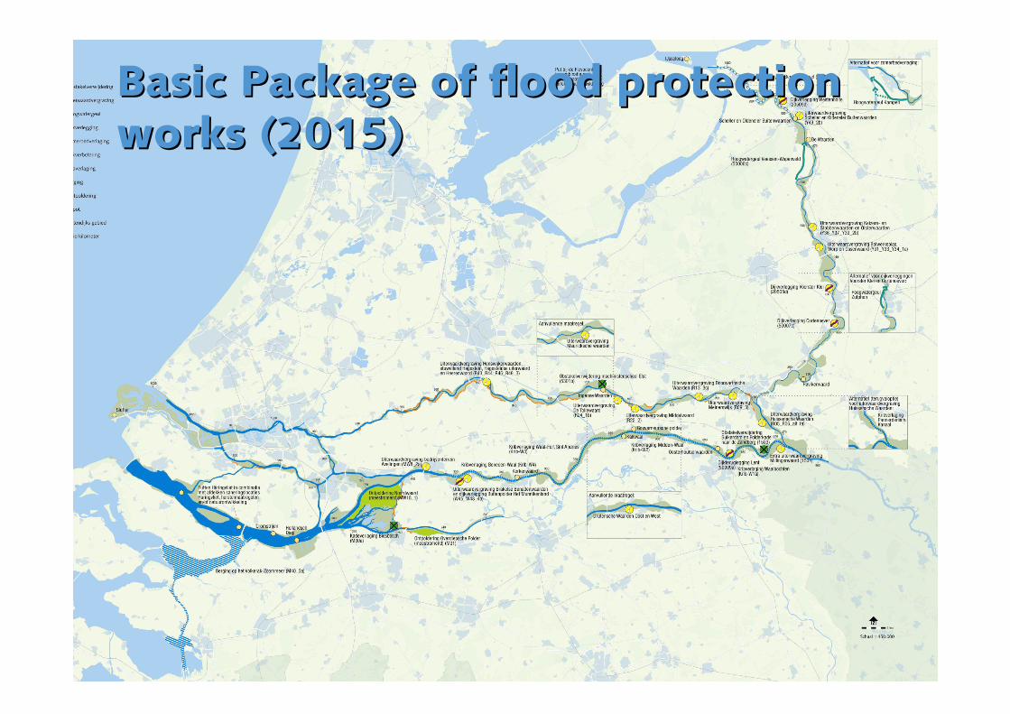
Basic Package of flood protection Basic Package of flood protection works (2015)works (2015)
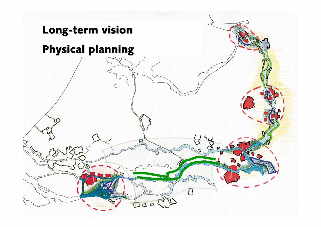
LongLong--term visionterm vision
Physical planningPhysical planning
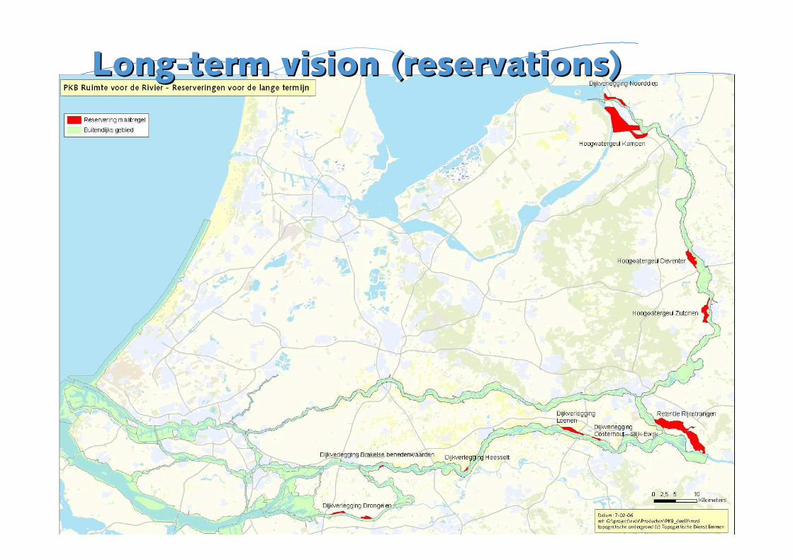
LongLong--term vision (reservations)term vision (reservations)
conclusions on conclusions on the the key key planning planning decision decision
ImportantImportant aspectsaspects are:are:
~~ awarenessawareness of theof the real problem real problem
~~ triggers liketriggers like a a floodflood (and (and floods floods in in neighbouringneighbouring countriescountries) )
~~ openopen communication communication
~~ coco--operation between nationaloperation between national andand regional regional authoritiesauthorities
Tools for policy evaluationTools for policy evaluation
Planning kit Planning kit
Risk AnalysisRisk Analysiskitkit
OptimilizationOptimilization tooltool
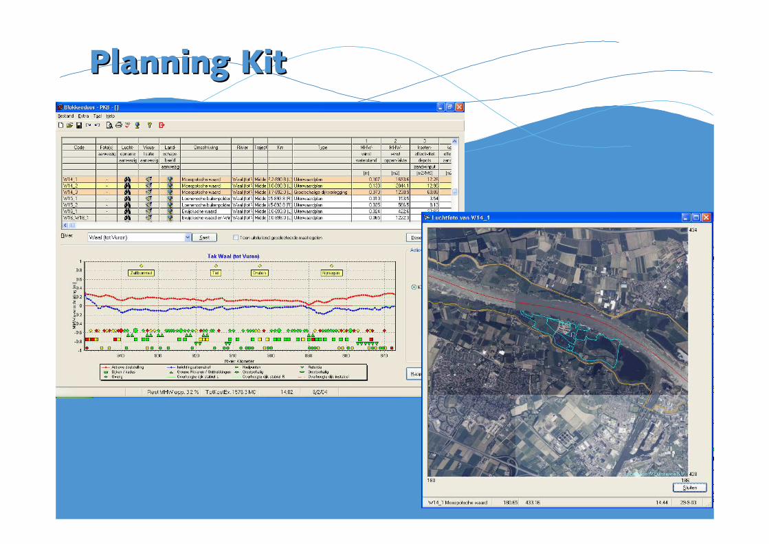
Planning KitPlanning Kit

Risk analyses kit Risk analyses kit –– WV21 WV21 blokkendoos Veiligheidblokkendoos Veiligheid
What What was the risk inwas the risk in
19501950
19751975
2000/20052000/2005
What will it be What will it be in in
2015 (2015 (current measurescurrent measures))
2050 (2050 (spatial spatial planning planning oror/more /more protection measuresprotection measures, ,
2100 and 2100 and climate changeclimate change))

Optimisation toolOptimisation tool –– determining determining optimal safety levels optimal safety levels per per dike dike ringring
ContentsContents
~~ some characteristics of the Netherlandssome characteristics of the Netherlands
~~ history / the flood of 1995history / the flood of 1995
~~ flood control policyflood control policy
~~ Spatial Planning Key decision ‘Room for the River’ Spatial Planning Key decision ‘Room for the River’ (SPKD) (SPKD)
~~ Design and construction phaseDesign and construction phase
~~ Mixed projects/ ForeMixed projects/ Fore--runners 1999 runners 1999 --20072007
~~ RVR Projects brought forward: RVR Projects brought forward: OverdiepseOverdiepse Polder, Polder, NoordwaardNoordwaard, , WesterwolteWesterwolte
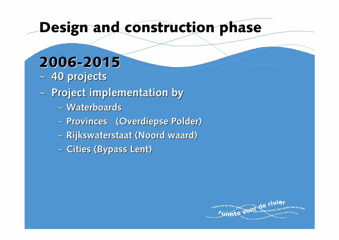
Design and construction phaseDesign and construction phase
20062006--20152015~~ 40 projects40 projects
~~ Project implementation byProject implementation by
~~ Waterboards Waterboards
~~ Provinces (Provinces (OverdiepseOverdiepse Polder)Polder)
~~ Rijkswaterstaat (Rijkswaterstaat (Noord waardNoord waard))
~~ Cities (Bypass Lent)Cities (Bypass Lent)
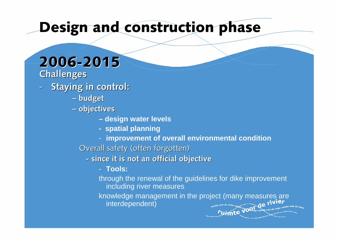
Design and construction phaseDesign and construction phase
20062006--20152015ChallengesChallenges
-- Staying in control:Staying in control:–– budgetbudget
–– objectives objectives – design water levels- spatial planning- improvement of overall environmental condition
Overall safety (often forgotten)Overall safety (often forgotten)
-- since it is not an official objectivesince it is not an official objective- Tools:through the renewal of the guidelines for dike improvement
including river measuresknowledge management in the project (many measures are
interdependent)
ContentsContents
~~ some characteristics of the Netherlandssome characteristics of the Netherlands
~~ history / the flood of 1995history / the flood of 1995
~~ flood control policyflood control policy
~~ Spatial Planning Key decision ‘Room for the River’ Spatial Planning Key decision ‘Room for the River’ (SPKD) (SPKD)
~~ Design and construction phaseDesign and construction phase
~~ Mixed projects/ ForeMixed projects/ Fore--runners 1999 runners 1999 ––2006/72006/7
~~ RvRRvR Projects brought forward: Projects brought forward: OverdiepseOverdiepse Polder, Polder, NoordwaardNoordwaard, , Westerwolte Westerwolte

Dike relocation Dike relocation BakenhofBakenhof
((Arnhem ZuidArnhem Zuid))
No regret
projects 1998-2006
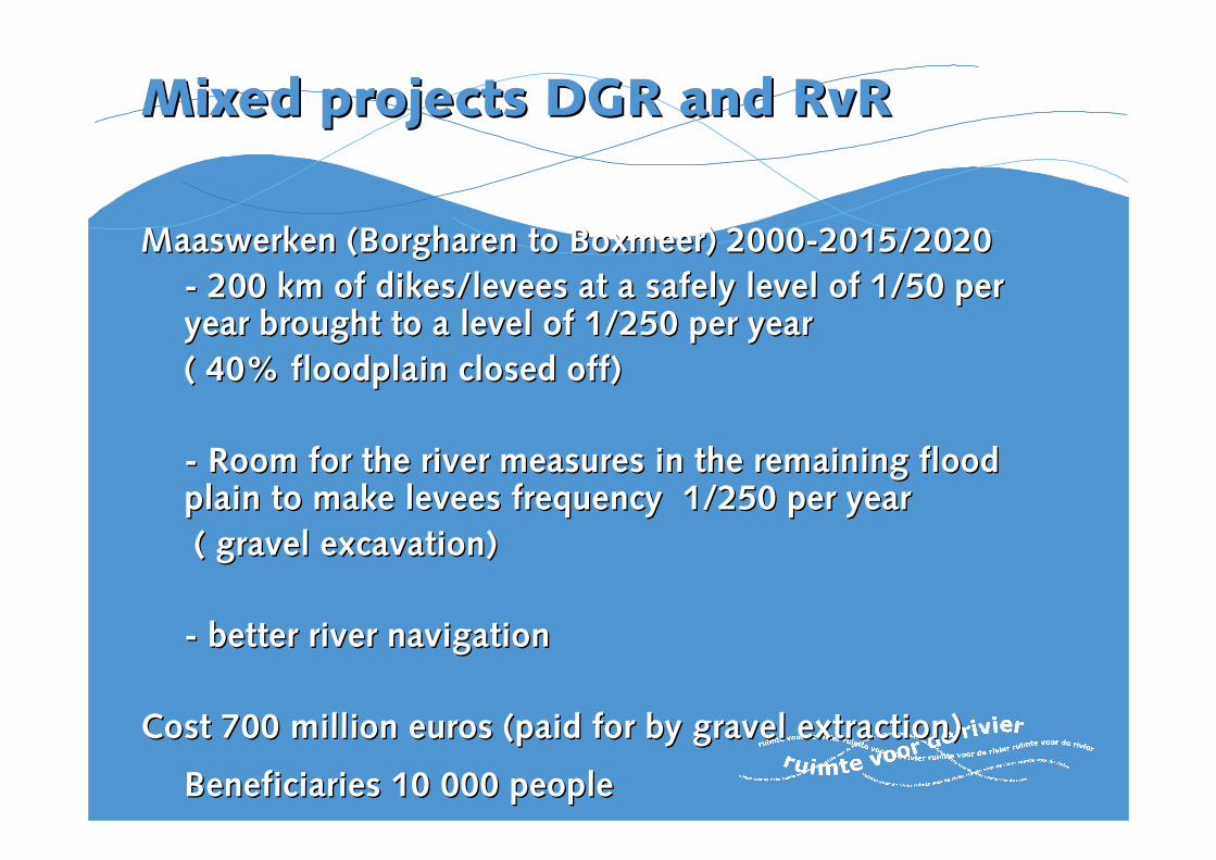
Mixed Mixed projects projects DGR and DGR and RvRRvR
MaaswerkenMaaswerken ((BorgharenBorgharen to to BoxmeerBoxmeer) 2000) 2000--2015/20202015/2020
-- 200 km of dikes/levees at a safely level of 1/50 per 200 km of dikes/levees at a safely level of 1/50 per year brought to a level of 1/250 per yearyear brought to a level of 1/250 per year
( 40% floodplain closed off)( 40% floodplain closed off)
-- Room for the river measures in the remaining flood Room for the river measures in the remaining flood plain to make levees frequency 1/250 per yearplain to make levees frequency 1/250 per year
( gravel excavation)( gravel excavation)
-- better river navigationbetter river navigation
Cost 700 million euros (paid for by gravel extraction)Cost 700 million euros (paid for by gravel extraction)
Beneficiaries 10 000 peopleBeneficiaries 10 000 people

Mixed Mixed projectsprojects DGR and DGR and RvRRvR
Dike reinforcement Dike reinforcement 2000 2000 -- 20072007
Lek Lek dikesdikes ((frequency levelfrequency level 1/2000e per 1/2000e per yearyear))
Lexmond toLexmond to Fort Fort EverdingenEverdingen
Room Room for for the the river measures river measures in the in the flood plain flood plain
~~ 30 km30 km
CostsCosts
€€ 16 million construction16 million construction
€€ 30 million total costs including planning and 30 million total costs including planning and procurement of landprocurement of land
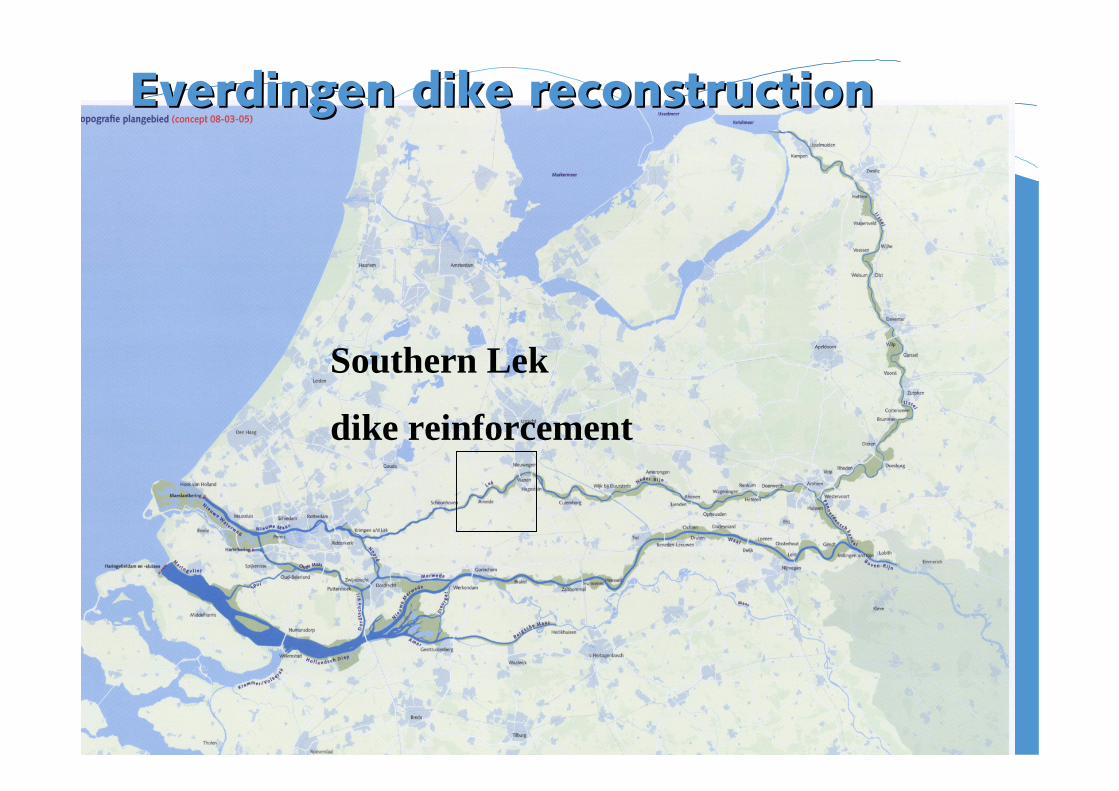
Everdingen dike reconstructionEverdingen dike reconstruction
Southern Lek
dike reinforcement
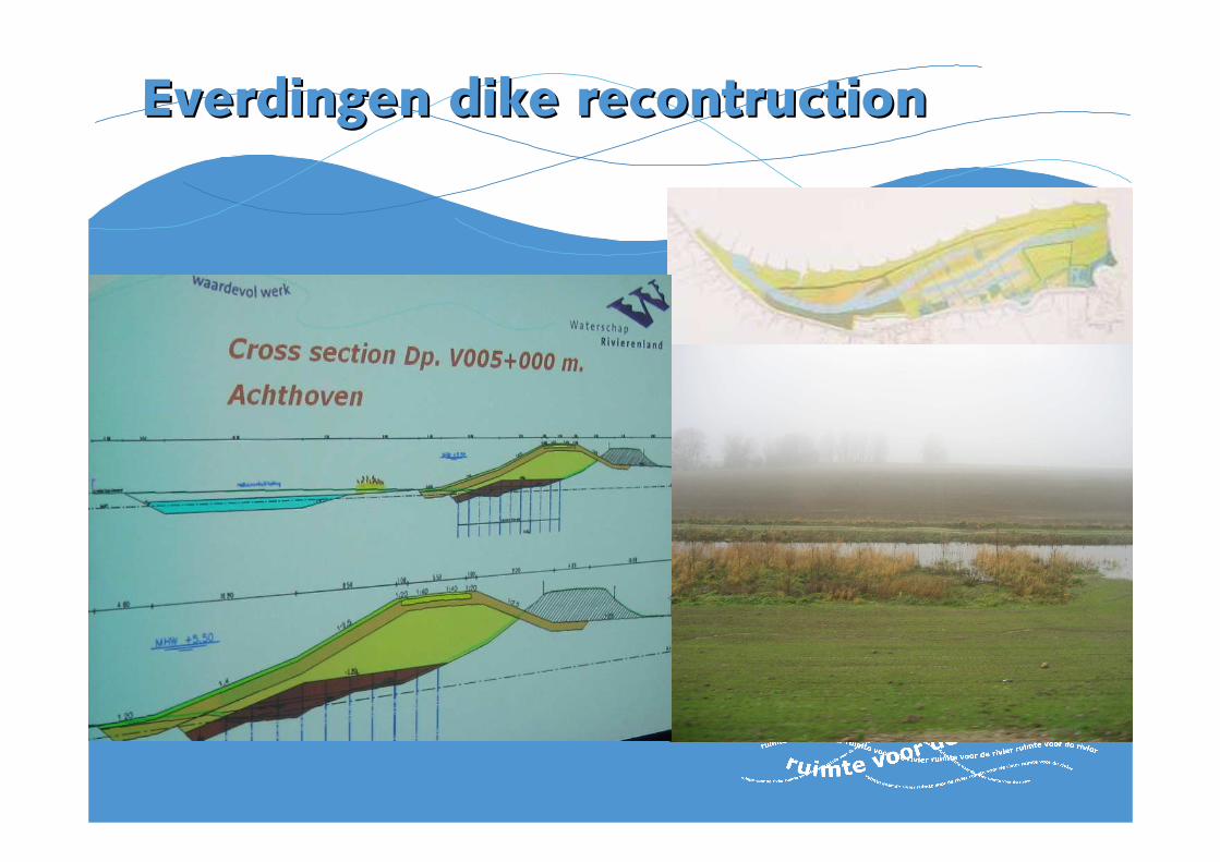
Everdingen dike recontructionEverdingen dike recontruction
125 ha nature development125 ha nature development

ContentsContents
~~ some characteristics of the Netherlandssome characteristics of the Netherlands
~~ history / the flood of 1995history / the flood of 1995
~~ flood control policyflood control policy
~~ Spatial Planning Key decision ‘Room for the River’ Spatial Planning Key decision ‘Room for the River’ (SPKD) (SPKD)
~~ Design and construction phaseDesign and construction phase
~~ Mixed projects/ ForeMixed projects/ Fore--runners 1999 runners 1999 --20072007
~~ Projects brought forward: Projects brought forward: OverdiepseOverdiepse Polder, Polder, NoordwaardNoordwaard, , Westerholte Westerholte
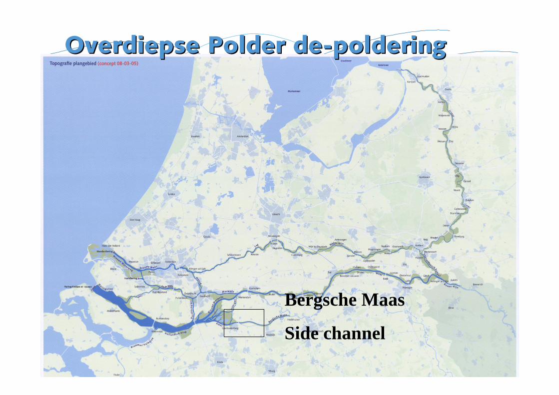
Overdiepse Overdiepse Polder dePolder de--polderingpoldering
Bergsche Maas
Side channel
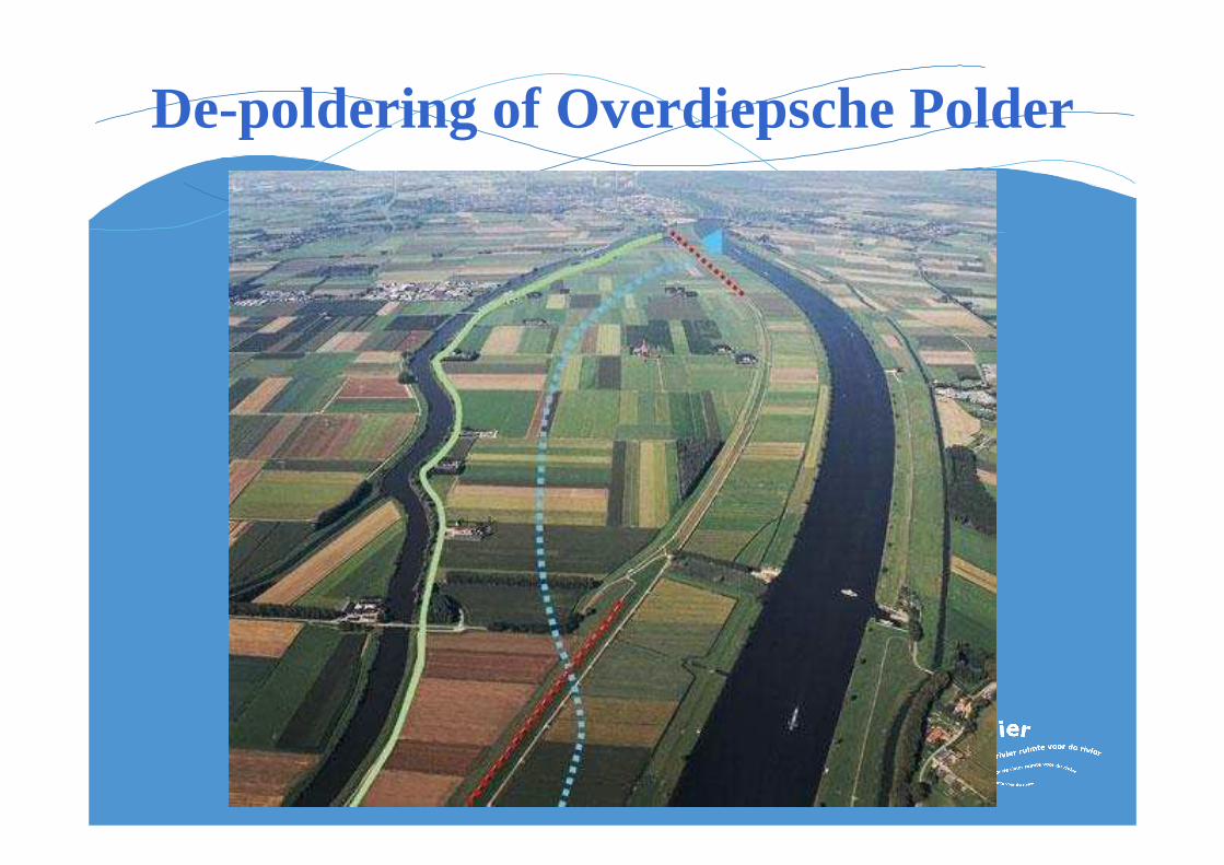
De-poldering of Overdiepsche Polder

Overdiepse Overdiepse PolderPolderIn the In the EstuaryEstuary
South shoreSouth shore: :
New New dikes designed probabilisticlydikes designed probabilisticly::
-- 100 100 yearsyears of of climate changeclimate change
-- 800 m3/s more discharge800 m3/s more discharge
-- 60 cm of 60 cm of sea level rise sea level rise
-- Uncertainties Uncertainties in waterin water levelslevels and wind and wind
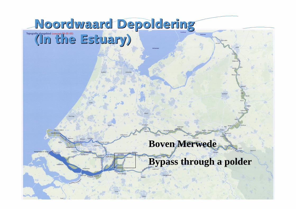
Noordwaard DepolderingNoordwaard Depoldering(In the (In the EstuaryEstuary) )
Boven Merwede
Bypass through a polder
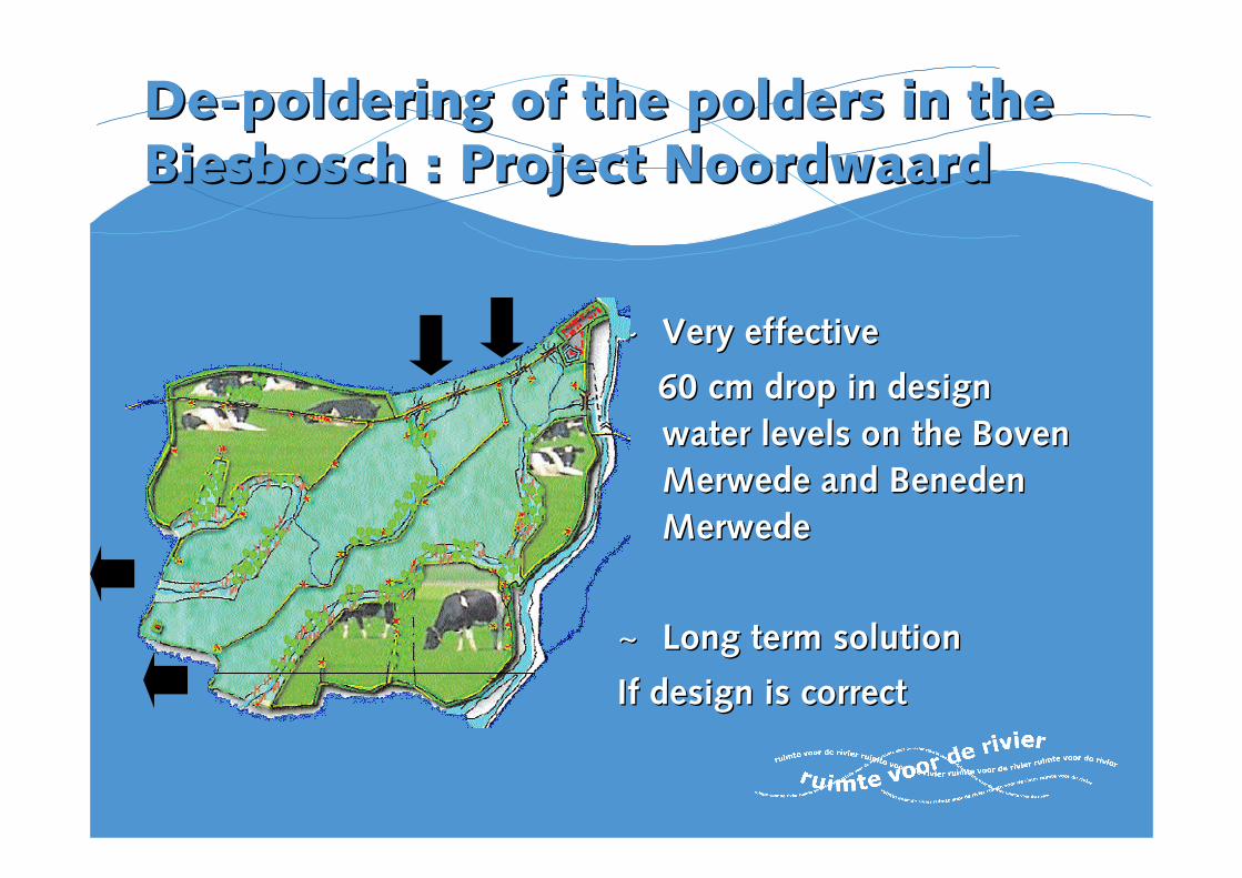
DeDe--polderingpoldering of the polders in the of the polders in the BiesboschBiesbosch : Project : Project NoordwaardNoordwaard
~~ Very effective Very effective
60 cm drop in design 60 cm drop in design
water levels on the water levels on the Boven Boven
Merwede Merwede and and Beneden Beneden
MerwedeMerwede
~~ Long term solution Long term solution
If design is correctIf design is correct
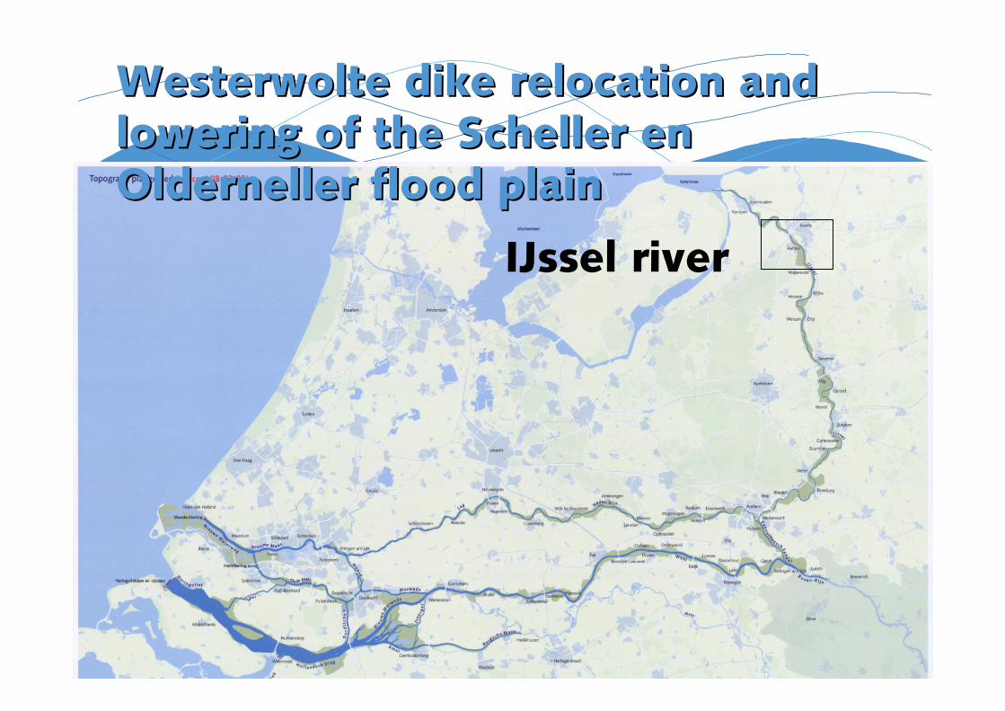
Westerwolte dikeWesterwolte dike relocationrelocation and and loweringlowering of the Scheller en of the Scheller en Olderneller flood plainOlderneller flood plain
IJssel river
Westerwolte dike relocationWesterwolte dike relocation
Design isDesign is based onbased on thethe principle that future principle that future climate change will be accomodated throughclimate change will be accomodated throughmore roommore room forfor thethe riversrivers..
Estimation Estimation of of futurefuture water water levels levels are made are made using using probabilistic probabilistic models as a checkmodels as a check
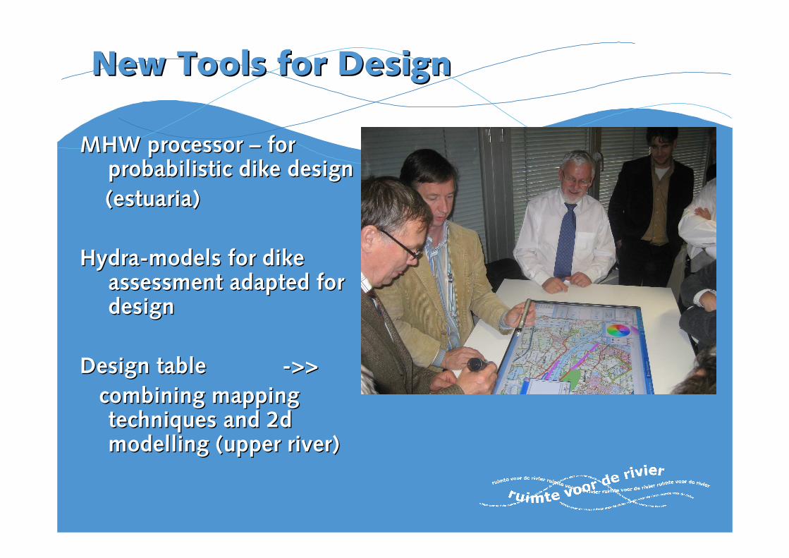
New New Tools for Tools for DesignDesign
MHW processor MHW processor –– for for probabilistic dike probabilistic dike designdesign
(estuaria)(estuaria)
HydraHydra--models models for dike for dike assessment adapted for assessment adapted for design design
Design Design table table -->>>>
combining mapping combining mapping techniques techniques and 2d and 2d modelling modelling (upper (upper riverriver))
DankeDanke


![[David C. Van Aken, William Hosford] Reporting Res(BookFi.org)](https://img.pdfslide.us/doc/110x75/55cf97ba550346d0339340a9/david-c-van-aken-william-hosford-reporting-resbookfiorg.jpg)