Embed Size (px)
Citation preview
Integrated Urban Development Plan
Dharan Sub-Metropolitan CityDharan, Sunsari,
Nepal
Final Report
Prepared By:ECoCoDE/ DIGICON J/V
Kupondole, LalitpurJanuary 2018
Integrated Urban Development Plan of Dharan Sub-Metropolitan City, 2017
1
Integrated Urban Development Plan of Dharan Sub-Metropolitan City, 2017
LOCATION MAPTABLE OF CONTENTS LIST OF TABLES LIST OF FIGURESABBREVIATIONS/ACRONYMSEXECUTIVE SUMMARY
Table of ContentsLIST OF TABLES............................................................................................................................................. 5LIST OF FIGURES........................................................................................................................................... 5ABBREVIATIONS AND ACRONYMS..........................................................................................................7EXECUTIVE SUMMARY................................................................................................................................ 81 CHAPTER I: PROJECT INTRODUCTION........................................................................................10
1.1 Background.................................................................................................................................. 101.2 Goal and Objectives................................................................................................................... 111.3 Scope and Limitations.............................................................................................................. 111.4 Methodology................................................................................................................................ 13
1.4.1 Literature Reviews...............................................................................................................................131.4.2 Data Collection.......................................................................................................................................141.4.3 Field Visit and Site Study...................................................................................................................141.4.4 Analysis.....................................................................................................................................................141.4.5 Comprehensive plan preparation..................................................................................................14
1.5 Expected Outputs....................................................................................................................... 152 CHAPTER II: MUNICIPALITY’S LONG TERM VISION AND GOALS.........................................16
2.1 Municipal Introduction............................................................................................................162.2 Municipal Vision and Principals........................................................................................... 162.3 Objectives..................................................................................................................................... 162.4 Sectoral Plan/Program and its Goals..................................................................................172.5 Outputs.......................................................................................................................................... 18
3 CHAPTER III: PREVAILING SITUATION OF DHARAN...............................................................193.1 Municipality Profile................................................................................................................... 19
3.1.1 Physical state..........................................................................................................................................193.1.1.1 Climate...............................................................................................................................................193.1.1.2 Demography....................................................................................................................................193.1.1.3 Land use and Settlement pattern...........................................................................................213.1.1.4 Physical Amenities.......................................................................................................................25
3.1.2 Social state...............................................................................................................................................283.1.3 Environmental State............................................................................................................................323.1.4 Disaster History.....................................................................................................................................353.1.5 Economic state.......................................................................................................................................373.1.6 Financial state........................................................................................................................................393.1.7 Organizational/Administrative state...........................................................................................39
3.2 Assessment and preparation of base map.........................................................................424 Chapter IV: Data Analysis and Future Projection....................................................................43
4.1 Previous Development Plan: Attempts and Achievements.........................................434.2 Population growth trend and projection...........................................................................444.3 SWOT Analysis............................................................................................................................ 46
4.3.1 Physical amenities................................................................................................................................464.3.2 Social amenities.....................................................................................................................................484.3.3 Environmental amenities..................................................................................................................504.3.4 Economy...................................................................................................................................................504.3.5 Institutional framework....................................................................................................................51
4.4 Spatial Analysis........................................................................................................................... 514.5 Financial Analysis...................................................................................................................... 524.6 Demand Analysis and Forecast.............................................................................................52
2
Integrated Urban Development Plan of Dharan Sub-Metropolitan City, 2017
4.6.1 Physical Infrastructure Demand Analysis.................................................................................534.6.2 Social Infrastructure Demand Analysis......................................................................................554.6.3 Economic Infrastructure Demand Analysis..............................................................................57
4.7 Planning Concept for IUDP......................................................................................................585 Chapter V: Thematic Urban Development Plan.......................................................................62
5.1 Physical Development Plan.................................................................................................... 625.1.1 Goal and Objectives..............................................................................................................................625.1.2 Plan and Programs...............................................................................................................................62
5.1.2.1 Land use and urban expansion...............................................................................................625.1.2.2 Housing demands.........................................................................................................................645.1.2.3 Road Network.................................................................................................................................655.1.2.4 Transportation...............................................................................................................................705.1.2.5 Water supply...................................................................................................................................755.1.2.6 Sewerage and Drainage Network..........................................................................................755.1.2.7 Electricity and communication...............................................................................................76
5.1.3 LFA for achieving physical development...................................................................................765.1.4 Summary of Physical development plan implementation..................................................785.1.5 Conclusion................................................................................................................................................80
5.2 Social Development Plan......................................................................................................... 815.2.1 Goal and Objectives..............................................................................................................................815.2.2 Plan and Programs...............................................................................................................................81
5.2.2.1 Education..........................................................................................................................................815.2.2.2 Public health....................................................................................................................................825.2.2.3 Security..............................................................................................................................................835.2.2.4 Gender Equality and Social Inclusion...................................................................................835.2.2.5 Parks and Open Spaces...............................................................................................................845.2.2.6 Public Service Centers................................................................................................................85
5.2.3 LFA for achieving social development.........................................................................................865.2.4 Summary of Social Development Plan Implementation......................................................895.2.5 Conclusion................................................................................................................................................90
5.3 Environmental Management Plan........................................................................................915.3.1 Goal and Objectives..............................................................................................................................915.3.2 Plan and Programs...............................................................................................................................91
5.3.2.1 Solid waste management...........................................................................................................915.3.2.2 Waste water management........................................................................................................925.3.2.3 Environmental deterioration...................................................................................................925.3.2.4 Climate change: mitigation and adaptation strategies.................................................935.3.2.5 Urban greenery..............................................................................................................................935.3.2.6 Conservation of environmental sensitive areas..............................................................945.3.2.7 Sustainable cities concept.........................................................................................................95
5.3.3 LFA for achieving environmental management......................................................................965.3.4 Summary of Environmental Management Plan Implementation....................................975.3.5 Conclusion................................................................................................................................................98
5.4 Disaster Risk Management Plan........................................................................................... 995.4.1 Goal and Objectives..............................................................................................................................995.4.2 Plan and Programs...............................................................................................................................99
5.4.2.1 Flood and Landslide.....................................................................................................................995.4.2.2 Fire...................................................................................................................................................... 995.4.2.3 Thunderstorm.............................................................................................................................1005.4.2.4 Epidemics......................................................................................................................................1005.4.2.5 Earthquake....................................................................................................................................1005.4.2.6 Pre-Disaster Plan........................................................................................................................1015.4.2.7 Immediate and Post-Disaster Action Plan.......................................................................102
5.4.3 LFA for achieving Disaster Risk Management.......................................................................1035.4.4 Summary of Disaster Risk Management Plan Implementation.....................................103
3
Integrated Urban Development Plan of Dharan Sub-Metropolitan City, 2017
5.4.5 Conclusion.............................................................................................................................................1045.5 Cultural and Tourism Development Plan........................................................................105
5.5.1 Goal and Objectives...........................................................................................................................1055.5.2 Plan and Programs............................................................................................................................105
5.5.2.1 Cultural heritage sites..............................................................................................................1055.5.2.2 Historical sites.............................................................................................................................1065.5.2.3 Tourism..........................................................................................................................................107
5.5.3 LFA for achieving Cultural and Tourism Development.....................................................1085.5.4 Summary of Cultural and Tourism Development Plan Implementation...................1095.5.5 Conclusion.............................................................................................................................................109
5.6 Economic Development Plan...............................................................................................1105.6.1 Goals and Objectives.........................................................................................................................1105.6.2 Plan and Programs............................................................................................................................110
5.6.2.1 Agro-Farming Development..................................................................................................1105.6.2.2 Trade promotion and Tourist Development..................................................................1115.6.2.3 Micro Industry and Business Promotion.........................................................................1115.6.2.4 Employment Generation and Poverty Reduction........................................................1115.6.2.5 Urban-Rural Linkage................................................................................................................1125.6.2.6 Promising Economic Zones....................................................................................................112
5.6.3 LFA for achieving economic development..............................................................................1135.6.4 Summary of Economic Development Plan Implementation...........................................1145.6.5 Conclusion.............................................................................................................................................115
5.7 Financial Development Plan................................................................................................1165.7.1 Goals and Objectives.........................................................................................................................1165.7.2 Plan and Programs............................................................................................................................116
5.7.2.1 Projection of budget for 2017-18........................................................................................1165.7.2.2 Possible Financial Resources for IUDP implementation...........................................1195.7.2.3 Promotional Strategy of Public Private Partnership..................................................120
5.7.3 LFA for achieving financial development................................................................................1215.7.4 Conclusion.............................................................................................................................................121
5.8 Institutional Development Plan.........................................................................................1225.8.1 Goal and Objectives...........................................................................................................................1225.8.2 Plan and Programs............................................................................................................................122
5.8.2.1 Municipal Institution of Dharan..........................................................................................1225.8.2.2 Governance...................................................................................................................................1305.8.2.3 Participation.................................................................................................................................1315.8.2.4 Co-ordination and establishment of networks.............................................................1315.8.2.5 Organization and Capacity development.........................................................................131
5.8.3 LFA for achieving institutional development........................................................................1325.8.4 Summary of Institutional Development Plan Implementation......................................1325.8.1 Conclusion.............................................................................................................................................133
6 Chapter VI: Multi Sectorial Investment Plan..........................................................................1347 Chapter VII: Prioritized Major Sub-Projects Engineering Design...................................1478 Chapter VIII: Planning and Building Bye-laws.......................................................................151
8.1 Goal and Objectives.................................................................................................................1518.2 Plan and Programs.................................................................................................................. 1518.3 Conclusion.................................................................................................................................. 151
9 CONCLUDING REMARKS................................................................................................................ 15210 APPENDIX........................................................................................................................................ 15411 BIBLIOGRAPHY.............................................................................................................................. 155
4
Integrated Urban Development Plan of Dharan Sub-Metropolitan City, 2017
LIST OF TABLES TABLE 3.1 DEMOGRAPHIC CHART OF DHARAN (CBS 2011))..................................................................................................19TABLE 3.2 WARD WISE DEMOGRAPHY OF DHARAN...................................................................................................................20TABLE 3.3 EXISTING LAND COVERAGE PATTERN........................................................................................................................21TABLE 3.4 ROAD NETWORK DHARAN (DSMC 2011)...................................................................................................................25TABLE 3.5 DRINKING WATER SUPPLY (DSMC 2011)..................................................................................................................26TABLE 3.6 INFORMATION AND COMMUNICATION STATUS (DSMC) ......................................................................27TABLE 3.7 ELECTRICITY AND WATER SUPPLY STATUS (DSMC) ......................................................................27TABLE 3.8 EDUCATIONAL INSTITUTES IN DHARAN (DSMC 2011).......................................................................................28TABLE 3.9 NUMBER OF PEOPLE TAKING VARIOUS ALLOWANCES (DSMC 2011)..........................................................30TABLE 3.10 SOCIAL SECURITY ALLOWANCE RATES (SOURCE: DSMC 2011)...................................................................30TABLE 3.11 COMMUNITY ENVIRONMENTAL POLLUTION (SOURCE: HOUSEHOLD SURVEY 2006)......................34TABLE 3.12 HISTORY OF DISASTER IN DHARAN (DISASTER RISK MANAGEMENT PLAN DHARAN)....................35TABLE 3.13 RISK BASED ON VARIOUS MONTHS OF YEAR (DRMP DHARAN)...................................................................35TABLE 3.14 TYPES OF DISASTER, ITS CAUSES AND EFFECTS AND MITIGATION MEASURES (DRMP DHARAN)36TABLE 3.15 TRADE AND INDUSTRIES IN DHARAN (SOURCE: DSMC)..................................................................................38TABLE 4.1 URBAN POPULATION GROWTH TRENDS....................................................................................................................45TABLE 4.2 URBAN POPULATION OF DHARAN IN VARIOUS YEARS.......................................................................................45TABLE 4.3 POPULATION PROJECTION OF DHARAN FOR 2031...............................................................................................46TABLE 4.4 COMPARISON OF REVENUES OF DSMC OVER VARIOUS FISCAL YEARS.......................................................52TABLE 4.5 COMPARISON OF EXPENSES OF DSMC OVER VARIOUS FISCAL YEARS........................................................52TABLE 4.6 PHYSICAL INFRASTRUCTURE DEMAND ANALYSIS...............................................................................................53TABLE 4.7 SOCIAL INFRASTRUCTURE DEMAND ANALYSIS.....................................................................................................55TABLE 4.8 ECONOMIC INFRASTRUCTURE DEMAND ANALYSIS.............................................................................................57TABLE 5.1 LIST OF OPEN SPACE FOR EVACUATION PLAN DURING EMERGENCY......................................................101TABLE 6.1 MULTI SECTORAL INVESTMENT PLAN FOR 15 YEARS.....................................................................................135TABLE 6.2 DETAIL BUDGET OF VARIOUS PROJECTS FOR 15 YEARS.................................................................................136
LIST OF FIGURES FIGURE 3-1 TEMPERATURES IN DHARAN ..............................................................................................................................19 FIGURE 3-2 RAINFALL IN DHARAN ................................................................................................................................19FIGURE 3-3 WARD WISE DIVISION MAP (DSMC 2011) .....................................................................................................20 FIGURE 3-4 POPULATION DENSITY MAP .......................................................................................................20FIGURE 3.5 EXISTING LANDUSE PLAN OF DHARAN...................................................................................................................21FIGURE 3-6 EXISTING SETTLEMENT LOCATION OF DHARAN..............................................................................................22FIGURE 3-7 CBD OF DHARAN................................................................................................................................................................22FIGURE 3-8 OLD AND NEW RESIDENTIAL BUILDINGS IN DHARAN...................................................................................23FIGURE 3-9 ENCROACHMENT NEAR RIVER BANK ..............................................................................................................23 FIGURE 3-10 SQUATTER SETTLEMENTENCROACHMENT IN ANCIENT BIJAYPUR HILL..........................................23FIGURE 3-11 LOCATION OF EXISTING TEMPLES AND PARKS IN DHARAN.....................................................................24FIGURE 3-12 YALAMBER COMMUNITY FOREST ..................................................................................................................24 FIGURE 3-13 HIMALI COMMUNITY FOREST ....................................................................................................................24FIGURE 3-14 BELOW: EARTHQUAKE MEMORIAL PARK ...................................................................................................24 FIGURE 3-15 BELOW: SAPTARANGI PARK ....................................................................................................24FIGURE 3-16 MAJOR URBAN ROAD WITHOUT DRAINAGE.....................................................................................................25FIGURE 3-17 URBAN MAIN ROAD WITH SIDE DRAINAGE .................................................................................................25FIGURE 3-18 EARTHEN ROAD IN DSMC THAT OCCUPIES 60% OF AREA........................................................................25FIGURE 3-19 EXISTING ROAD NETWORK MAP............................................................................................................................26FIGURE 3-20 ELECTRIC PUBLIC VEHICLE IN DHARAN ............................................................................................................28FIGURE 3-21 DHARAN BUS PARK (GOOGLE.COM)......................................................................................................................28FIGURE 3-22 LOCATIONS OF EXISTING EDUCATION AND HEALTH SERVICE................................................................29FIGURE 3-23 EASTERN ANFA TECHNICAL CENTER ...........................................................................................................30 FIGURE 3-24 DHARAN RANGASALA (EKANTIPUR.COM).........................................................................................................30FIGURE 3-25 PINDESHWOR TEMPLE OF DHARAN ............................................................................................................31 FIGURE 3-26 SARASWOTI KUNDA PINDESHWOR ...............................................................................................................31FIGURE 3-27 DANTAKALI TEMPLE.................................................................................................................................................31 FIGURE 3-28 PANCHKANYA TEMPLE................................................................................................................................................31FIGURE 3-29 BUDHASUBBA TEMPLE OF DHARAN.....................................................................................................................32FIGURE 3-30 LEFT: EXISTING TEMPLE COMPLEX USED FOR EXERCISE..........................................................................32FIGURE 3-31 RIGHT: VIEW OF SAPTARANGI PARK....................................................................................................................32
5
Integrated Urban Development Plan of Dharan Sub-Metropolitan City, 2017
FIGURE 3-32 RESOURCE MAP OF DHARAN....................................................................................................................................33FIGURE 3-33 INTERLINKAGE MAP OF DHARAN WITH VARIOUS MUNICIPALITIES...................................................37FIGURE 3-34 BHEDETAR BAZAAR (GOOGLE.COM) ..............................................................................................................38FIGURE 3-35 VIEW OF DHARAN FROM NEARBY HILL (WIKIPEDIA).................................................................................38FIGURE 3-36 LOCAL ART AND CRAFTWORK IN DHARAN.......................................................................................................39FIGURE 3.37 OLD ORGANIZATIONAL FRAMEWORK OF DSMC.............................................................................................41FIGURE 4-1 MAP SHOWING GRADIENT OF TOPOGRAPHY OF DHARAN...........................................................................51FIGURE 4-2 TOURISM GOLDEN TRIANGLE LOCATION MAP..................................................................................................58FIGURE 4-3 ELEMENTS OF GREEN CITY..........................................................................................................................................58FIGURE 4-4 LOW CARBON TRANSPORT..........................................................................................................................................59FIGURE 4-5 LEFT: CITY GREENING (GOOGLE.COM)...................................................................................................................60FIGURE 4-6 RIGHT: ECO FRIENDLY CONCEPT (GOOGLE.COM).............................................................................................60FIGURE 4-7 INTELLIGENT SYSTEM OF DHARAN.........................................................................................................................61FIGURE 5-1 PROPOSED LAND USE PLAN OF DHARAN..............................................................................................................63FIGURE 5-2 PROPOSED ROAD NETWORK OF DHARAN............................................................................................................65FIGURE 5-3 TYPICAL SECTION OF RINGROAD OPTION1.........................................................................................................66FIGURE 5-4 TYPICAL SECTION OF RING ROAD OPTION 2.......................................................................................................66FIGURE 5-5 TYPICAL SECTION OF URBAN ROAD "CLASS B" OPTION 1............................................................................66FIGURE 5-6 TYPICAL SECTION OF URBAN ROAD "CLASS B" OPTION 2............................................................................67FIGURE 5-7 TYPICAL SECTION OF URBAN ROAD "CLASS D"..................................................................................................68FIGURE 5-8 RIVERFRONT DEVELOPMENT CONCEPT...............................................................................................................69FIGURE 5-9 TYPICAL SECTION OF RIVER CORRIDOR................................................................................................................69FIGURE 5-10 PROPOSED OUTER RINGROAD OF DHARAN......................................................................................................70FIGURE 5-11 CONCEPT OF PROPOSED BUS PARK.......................................................................................................................71FIGURE 5-12 LOCATION OF PROPOSED BUS PARK AND PARKING LOTS.........................................................................71FIGURE 5-13 TYPICAL PARKING LOTS INSIDE CITY CENTER................................................................................................72FIGURE 5-14 IDEAS FOR PUBLIC BUS STOPS.................................................................................................................................72FIGURE 5-15 PROPOSED PUBLIC VEHICULAR ROUTE..............................................................................................................73FIGURE 5-16 PROPOSED RAILWAY TRACK FROM INARUWA TO DHARAN-6................................................................74FIGURE 5-17 PROPOSED RAILWAY STATION AND INDUSTRIAL AREA ON DSMC.......................................................74FIGURE 5-18 PROPOSED DRAINAGE DISCHARGE TO STREAMS BASED ON PROXIMITY..........................................76FIGURE 5-19 SOLAR STREET LAMPS (SOURCE: KMC)...............................................................................................................83FIGURE 5-20 CONCEPT OF STREET FURNITURE IN PUBLIC PLACES.................................................................................84FIGURE 5-21 CONCEPTS FOR INTERVENTION IN EXISTING OPEN SPACE AND PARKS FOR CREATING SOCIAL
SPACE.................................................................................................................................................................................................... 84FIGURE 5-22 PROPOSED LOCATION OF PUBLIC TOILET .................................................................................................86FIGURE 5-23 IDEAS FOR PUBLIC TOILET ..................................................................................................86FIGURE 5-24 LOCATION OF PROPOSED TREATMENT PLANTS AND LANDFILL SITE................................................93FIGURE 5-25 OPEN SPACES FOR EVACUATION PLAN DURING EMERGENCY..............................................................100FIGURE 5-26 CULTURAL HERITAGE WALK ROUTE.................................................................................................................106FIGURE 5-27 PROPOSED TOURISTIC MAP OF DHARAN.........................................................................................................107FIGURE 5-28 ORGANIZATIONAL CHART OF WARD OFFICE................................................................................................123FIGURE 5-29 NEW ORGANOGRAM OF DSMC...............................................................................................................................124FIGURE 5-30 ORGANOGRAM OF GENERAL ADMINISTRATION DIVISION.....................................................................125FIGURE 5-31 ORGANIZATIONAL CHART OF REVENUE AND FINANCIAL ADMINISTRATION DEPARTMENT
............................................................................................................................................................................................................... 125FIGURE 5-32 ORGANOGRAM OF URBAN INFRASTRUCTURE DEVELOPMENT DIVISION.......................................126FIGURE 5-33 ORGANOGRAM OF ECONOMIC DEVELOPMENT DIVISION........................................................................126FIGURE 5-34 ORGANIZATIONAL CHART OF SOCIAL DEVELOPMENT DIVISION........................................................127FIGURE 5-35 ORGANOGRAM OF FOREST, ENVIRONMENT AND DISASTER MANAGEMENT DIVISION...........127FIGURE 5-36 ORGANOGRAM OF LAND MANAGEMENT AND BUILDING REGULATION DIVISION.....................128FIGURE 5-37 CHART OF JUSTICE, LAW AND HUMAN RIGHT DIVISION..........................................................................128FIGURE 5-38 ORGANOGRAM OF PLANNING. MONITORING AND EVALUATION DIVISION...................................129FIGURE 5-39 ORGANIZATIONAL CHART OF INFORMATION, COMMUNICATION AND DATA MANAGEMENT
DIVISION...........................................................................................................................................................................................130FIGURE 7-1 LOCATIONS OF PRIORITZED THREE SUB PROJECTS.....................................................................................147FIGURE 7-2 MASTER PLAN OF BIJAYPUR HILL DEVELOPMENT PROJECT....................................................................148FIGURE 7-3 MASTER PLAN OF BIJAYPUR CHOWK (AREA = 3100 SQ.M).......................................................................149FIGURE 7-4 MASTER PLAN OF PANCHKANYA TEMPLE PREMISES DEVELOPMENT (AREA = 6500 SQ.M). . .150FIGURE 8-1 GREEN HOMES CONCEPT (UN HABITAT NEPAL)............................................................................................151
6
Integrated Urban Development Plan of Dharan Sub-Metropolitan City, 2017
ABBREVIATIONS AND ACRONYMS
ADB Asian Development BankBPKIHS BP Koirala Institute of Health SciencesCBS Central Bureau of StatisticsCBD Central Business DistrictCEN Clean Energy NepalCFUG Community Forest Users' Group CTEVT Council of Technical Education and Vocational TrainingDPR Detail Project ReportDRMP Disaster Risk Management PlanDoA Department of ArchaeologyDSMC Dharan Sub Metropolitan CityDUDBC Department of Urban Development and Building ConstructionEA Environmental Assessment EIA Environmental Impact AssessmentFAR Floor Area RatioFNCCI Federation of Nepalese Chamber of Commerce and Industry GDP Gross Domestic ProductGESI Gender Equality and Social InclusionGHGs Green House GasesGIS Geographic Information SystemHH Household Ha HectareIEE Initial Environment ExaminationIUDP Integrated Urban Development PlanJICA Japan International Co-operation AgencyKVDA Kathmandu Valley Development AuthorityLEED Leadership in Energy and Environmental DesignLGCDP Local Governance and Community Development ProjectLFA Logical Framework ApproachLPCD Liters Per Capita Per DayMDG Millennium Development GoalsMoFALD Ministry of Federal Affairs and Local DevelopmentMoUD Ministry of Urban DevelopmentMRT Mandatory Rules of Thumb MSIP Multi-Sectoral investment planNEA Nepal Electrician AuthorityNBC National Building CodeNPR Nepalese RupeesNSET Nepal Society of Earthquake TechnologyNTB Nepal Tourism BoardNTC Nepal Tele-communicationsNUDS National Urban Development StrategyPU Purbanchal UniversityPPP Public Private Partnership3R Reduce, Reuse, RecycleROW Right of WaySAP Structural Analysis ProgramSIP School Improvement PlanSRN Strategic road networkSWOT Strength Weakness Opportunity ThreatTOR Terms of ReferenceUN United NationsUN-Habitat United Nations Human Settlements ProgrammeVDC Village Development Committee
7
Integrated Urban Development Plan of Dharan Sub-Metropolitan City, 2017
EXECUTIVE SUMMARY
With the addition of new municipalities in 2071 B.S to existing 58 municipalities, the number of Municipalities in Nepal increased to 217, suggesting the rapid urbanization. With time, this urbanizing trend is expected to grow, thus having impact on the urban amenities. Hence, it is a high time introspecting on an appropriate planning approach for designing and restructuring cities. There have been Integrated Action Plan and Periodic plans as an approach towards the urban planning of Nepal’s urban cities but these planning tools still have quite a few shortcomings, major one, not being able to embrace the multi disciplinary aspects of the society or a city.
Urbanization in Dharan is growing at a very fast rate of approximately 3.61% per annum. The agricultural sector continues to be strained by changing competition in markets and reduction in farmlands due to increase in population and unpredictable climatic conditions. It is projected that, by 2032, Dharan’s population will be 300,000 i.e. double the current demography. This fact is compounded by the following numerous challenges in Dharan:
UNPLANNED AND UNCOORDINATED URBAN GROWTH
Haphazard urban growth of the Dharan Sub Metropolitan City (DSMC) has led to the decay in varying degrees of the natural and human environments in the area. In a nutshell, these include: a proliferation of slums and squatter settlements in the town, and lack of adequate provision of various services such as roads, water supply, sewerage and solid-waste collection, among others. It has contributed to the destruction of the aesthetic quality of the DSMC and imbalances the natural scape.
INADEQUATE TRANSPORT AND INFRASTRUCTURE SERVICES
There seems monopoly of rickshaw services and rent out vans and microbuses in DSMC, which dig holes in the pocket of the users. As a result, people are forced to use private vehicles i.e. private cars and motorbikes that accelerate traffic congestion as well as air pollution.
Among the inadequate facilities and services include: solid waste management system, road networks, water provision and sewage disposal systems. As a result, DSMC is usually overstretched or simply remains reluctant to provide the various services to such areas.
INSUFFICIENT HOUSING CONDITIONS
Housing development is insufficient. There is a mismatch between housing development and community facilities within the population. There is increasing problem of slums and squatters in historical areas and riverfronts.
INCREASED DETERIORATION OF ENVIRONMENTAL QUALITY
Haphazard waste disposition near forest and river, direct discharge of raw sewerage to khahare khola and Seuti and Sardu rivers, encroachment of natural setting, dust due to earthen road, open defecation, industry pollution are the main sources of environmental pollution of Dharan. However, some initiatives in waste separation and recycling have sorted some of the environmental issues of Dharan.
INADEQUATE CAPACITY OF INSTIUTIONS
With the reform of local administrative structure, staffs seem to be inadequate. Also, the lack of digital usage restricts the efficiency of service delivery.
8
Integrated Urban Development Plan of Dharan Sub-Metropolitan City, 2017
METHODOLOGY
This Integrated Urban Development Plan of Dharan for 2017-2032; serves as an urban planning tool to facilitate the growing development pattern. For preparing this IUDP, a rigorous ground research is done. With reference to the previous periodic plans literature reviews and data collection are performed, site visit, field study and meeting are done for preparing a municipal profile depicting the existing situation of Dharan. Then after, a long-term vision is set as a base for achieving an integrated urban development plan. SWOT analysis is performed to identify the probable strong and weak aspects of Dharan that can be developed as a potential, furthermore, trend analysis, spatial analysis, financial and economic analysis is done and thematic objective is set up for various strategic sectors. Plans and Programs are formulated based on the logical frame approach and various activities of each sector are identified that aids in financial planning of Dharan.
CHAPTER SYNOPSES
Chapter 1 introduces the project “Integrated Urban Development Plan” with its goal and objectives, scope and limitations; methodology employed and expected outputs.
Chapter 2 presents the long-term vision of Dharan Sub Metropolitan City, its Goal, specific objectives, theme, and its broad strategies addressed.
Chapter 3 provides the existing situation of Dharan with its regional setting, indicating the location and historical growth of Dharan, topography and drainage, geology and soils, vegetation, wildlife and all other related characteristics, population and demographic characteristics, existing housing and human settlements, existing social services and community facilities, economic activities and organization characteristics. It also critically assesses the existing situation and provides a base map plan.
Chapter 4 provides the critical analysis of the existing situation using various analysis tools and forecast a future need base demand.
Chapter 5 presents the thematic urban development plan viz. Physical, Social, Environmental, Disaster, Culture and Tourism, Economic, Financial and Institutional.
Chapter 6 highlights the multi-sectoral investment plan in various thematic development plans
Chapter 7 provides an overview of prioritized three major sub projects engineering design
Chapter 8 outlines the planning and building byelaws for Dharan.
Chapter 9 articulates the concluding remarks for the project.
The planning concept for the IUDP of Dharan embraced green city perception focused on “The Tourism Product of the East: “Green East”, of Tourism Destination Area Plan of Eastern Nepal. For a city to be considered “green”, measures and investments is required in city greening, energy efficiency, low carbon transport, green industry, green/resilient infrastructure and intelligent systems.
Due to the current reform of administrative structure of Government of Nepal (GoN), it is essential for each municipality to accumulate its own income through various revenue generation plans and also opportune to prepare its own prioritized development projects with local autonomy. This IUDP explores the potential and opportunities of Dharan for an integrated approach of urban planning. It shall guide Dharan Sub Metropolitan city for the effective implementation and management of projects over 15 years for sustainable urban development.
9
Integrated Urban Development Plan of Dharan Sub-Metropolitan City, 2017
1 CHAPTER I: PROJECT INTRODUCTION
With the increasing globalization, trend of mega cities and global cities are emerging all around the world. Nepal is the faster urbanizing and least urbanized country in South Asia. Urbanization had begun in Nepal dated early 1960s in Kathmandu. In developing countries like Nepal, urbanization is both a challenge and chance to create sustainable urban cities. Despite the comprehensive city planning, most cities of Nepal are clogged with problems of poverty, unemployment, poorly developed infrastructure, inadequate public services, acute shelter deficits and accelerated environmental deterioration. These problems are mainly the consequence of the discrepancy between the urbanization rate and their economic development pace and lack of management system.
Hence, an Integrated Urban Development Plan (IUDP)seems an ideal solution for planning the livable urban areas with cross-sectoral co-operation, multi-disciplinary framework and participatory approach. IUDP is an internationally adopted planning tool for an inclusive, comprehensive livable city.
1.1 Background
Nepal has been practicing the settlement planning since 1944; and in 1956 first National Periodic Plan was commenced. Several past focus only on the physical planning neglecting the demands of the grass root level several issues regarding poverty, health, and environmental degradation. To overcome past shortcomings; National Urban Policy 2007 was introduced which exhibits the interest of central government to support more sustainable and socially inclusive economic growth in local level. The policy is outstanding with prioritizing investment to the lagging regions and sectors of the urban area of the country fostering development of regional cities and intermediate town as well. Therefore, with the aim of reducing poverty and upgrading urban physical facilities, Ministry of Federal Affairs and Local Development (MoFALD) has prioritized investment in 25 municipalities of Nepal.
For systematic planning and overcome above shortcomings, MoFALD has developed a guideline and TOR and make available of fund for preparation of Integrated urban Development Plans for mid sized municipalities including Dharan. Dharan Sub Metropolitan City (DSMC) gone through the contract with consultant; Engineering Consultancy for Constructive Development Efforts in Nepal and Digicon P. Ltd. J/V (ECoCoDE-Digicon J/V) to prepare IUDP of Dharan Municipality.
An integrated urban development plan (IUDP) comprises a system of interlinked actions, which seeks to bring about a lasting improvement in the economic, physical, social and environmental conditions of a city or an area within the city. The key to the process is “integration”, meaning that all policies, projects and proposals are considered in relation to one another. In this regard, the synergies between the elements of the plan should be such that the impact of the plan as a whole adds up to more than the sum of the individual parts if implemented in isolation.
Dharan SMC is now implementing a large scale water supply project supported by ADB under the project Integrated Urban Development Plan. It has other sub projects i.e. community development program, mainstreaming women and backward society and pockets within the municipality. Though it is called integrated project, has not covered the numerous other sectors like social and economical developments, infrastructures needed like road and storm drainages, financial development schemes and others. These sectoral plans need to be integrated to create holistic image of city, which seems lagging in current IUDP.
10
Integrated Urban Development Plan of Dharan Sub-Metropolitan City, 2017
This proposed IUDP is a comprehensive document with multi-sectoral plans and Detail Engineering Design of three major sub-projects. The plan has envisaged a holistic document incorporating municipality’s vision, mission, goals, objectives, programs and projects to guide the city for next 15 or 20 years. It will incorporate both short term and long-term programs from 1 year to 5 years and up to 15 or 20 years. The changing scenario of the development will be coped with modified updated plans.
1.2 Goal and Objectives
The main objective of the proposed assignment is to prepare IUDP of Dharan Sub-Metropolitan City. However, the specific objectives can be listed as follows:
To set out Long-term Vision and overall Goal, Objective and Strategies for Dharan Sub- Metropolitan City (15 years)
To prepare Land Use Plan, Physical Development Plan, Social, Cultural, Economic, Financial, and Institutional Development Plan; Environmental and Risk Sensitive Land use Plan, Multi-sectorial Investment Plan (MSIP) and other relevant plans if any, in consultation with DSMC, Department of Urban Development and Building Construction (DUDBC) and MoFALD on the basis of Sectoral Goal, Objectives, Output and Programs
To prepare building bye-laws to regulate development in the town integrating Land Use and road network plan and long-term vision of DSMC
To prepare Detail Engineering Design of prioritized 3 sub-projects in consultation with DSMC and MoFALD
1.3 Scope and Limitations
Scope of consulting services for preparation of IUDP (as mentioned in expected output) include but not necessarily limited to the following:
The consultant shall spell out the Vision of the city. The vision should articulate the desires of the city and its citizens, and will provide the guiding principles and priorities for the plan's implementation. Prepare overall Integrated Urban Development Plan of entire area including existing and future (5, 10 and 20 years) land use plan in cadastral maps. This should be based on land use plan and followed by narrative description, analysis, fact and figures.
Conduct additional study on local economy and its activities including change in demographics and migration trend for 5, 10 and 20 years period.
Identify the potential area for urban development based on land suitability and other factors . Analyze present and future (5, 10, 20 years) housing needs/ market, stock, conditions and recommend strategies for land acquisition, distribution of land and housing in future.
Conduct studies on present and future (5, 10 and 20 years) demand in infrastructures (such as transportation, communication, electricity, water supply and sewerage system) and their supply. Analysis of demand should be in different scenarios with facts and figures. The recommended complete street pattern, major and minor roads, highways, arterial roads, traffic circulation, truck yard, bus bays and bus parks shall be worked out . The network plan of infrastructures, both existing and proposed shall be shown in cadastral maps with other detailed drawings and unit rate cost estimates. The consultant shall also identify and produce landfill site, treatment plant location and their cost estimate. A management scheme of both water supplies, solid waste management system and landfill site should also workout.
11
Integrated Urban Development Plan of Dharan Sub-Metropolitan City, 2017
The consultant shall carry out study of existing social infrastructure such as health, education, sports, communication, and security centers and other community facilities by addressing present deficiencies and future (5, 10 and 20 years) demands. The location and area of land required for all these infrastructures should be identified in Base maps.
Identify and assess critical, sensitive and other natural resources including parks, green belts, recreational areas along with strategies for their protection, preservation and stewardship against the adverse impact of future development and land use changes. Calculate the cost estimate on unit rate basis for their preservation and protection. Show locations and calculate future requirements of such resources.
Identify and assess natural hazards, including how significant weather events have and will impact these assessments, which may cause a threat to the Vision of the Integrated Urban Development Plan, along with strategies for avoidance/Mitigation of such hazards in the course of future development and calculate the cost estimate on unit rate basis.
Prepare the Proposed Land Use Plan for 5, 10 and 20 years in the existing cadastral maps(plans) based on:
i. The policies enunciated for different urban activities,ii. Population to accommodate maximum one hundred thousands
iii. Requirement of additional social and physical infrastructureiv. Transportation and work centerv. Parks, green belts, recreational areas
vi. Cultural and historic resources and others. Provide a full study of following Land Use Zone and recommend bye-laws for the construction
of building and other infrastructures, i. Residential zone
ii. Institutional zoneiii. Industrial zoneiv. Preserved zonev. Airport zone
vi. Urban expansion zonevii. Stream/river banks zone
viii. Green zoneix. Others
Prepare Building and Planning bye-laws that clearly spells minimum in the following areas regarding the construction of building:
i. Minimum land areaii. Maximum ground coverage
iii. Maximum floor area ratio (FAR)iv. Maximum building heightv. Maximum no. of floors
vi. Right of way of roadsvii. Set back in four sides of the building
viii. Minimum parking areaix. Minimum distance to be left in both sides of stream/river.
The Building and Planning Bye-Laws shall be prepared in accordance with Conceptual Building Bye-laws 2072 of Town Development, Urban Planning and Building Construction published by Ministry of Urban Development. (MoUD)
Preparation of detail engineering design of three prioritized sectoral projects with feasibility study
12
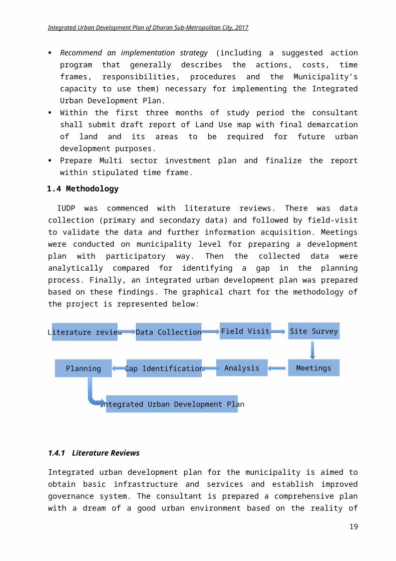
Literature review Data Collection Field Visit Site Survey
MeetingsAnalysisGap IdentificationPlanning
Integrated Urban Development Plan
Integrated Urban Development Plan of Dharan Sub-Metropolitan City, 2017
Recommend an implementation strategy (including a suggested action program that generally describes the actions, costs, time frames, responsibilities, procedures and the Municipality’s capacity to use them) necessary for implementing the Integrated Urban Development Plan.
Within the first three months of study period the consultant shall submit draft report of Land Use map with final demarcation of land and its areas to be required for future urban development purposes.
Prepare Multi sector investment plan and finalize the report within stipulated time frame.
1.4 Methodology
IUDP was commenced with literature reviews. There was data collection (primary and secondary data) and followed by field-visit to validate the data and further information acquisition. Meetings were conducted on municipality level for preparing a development plan with participatory way. Then the collected data were analytically compared for identifying a gap in the planning process. Finally, an integrated urban development plan was prepared based on these findings. The graphical chart for the methodology of the project is represented below:
1.4.1 Literature Reviews
Integrated urban development plan for the municipality is aimed to obtain basic infrastructure and services and establish improved governance system. The consultant is prepared a comprehensive plan with a dream of a good urban environment based on the reality of technical and financial resources of Municipality. For this, some Planning and Development Principles and Government Policies were reviewed that is listed below.
Integrated Urban Development Plan, Dharan Planning Norms and Standards 2015 Periodic plan of Dharan 2066/67 Nepal Urban Development Strategy 2015 Urban Road Standards 2071 Disaster Risk Management Plan Dharan 2070 Integrated Watershed Conservation and Management Plan, Sardu Khola, Dharan Dharan Municipality Green Homes Project Implementation plan, 2071 Local Governance and Community Development Program 2071 Nepal National Building Code and Building Bye-laws Building Byelaws of Dharan 3/ gS;fkf; ;DalGw sfo{ljwL @)^(
13
Integrated Urban Development Plan of Dharan Sub-Metropolitan City, 2017
1.4.2 Data Collection
Along with the literature reviews, primary data and secondary data necessary for the preparation of IUDP was collected from all the relevant sources. These data helped in preparation of GIS Base map and municipal profiles. It also aided in identifying the lagging points of the existing infrastructures and services that directed in preparing a proper sustainable urban plan.
1.4.3 Field Visit and Site Study
For creating a better idea of the project, a field visit is necessary for any of the projects. In this project also, a field visit was conducted to have a clearer picture of the physical, social and economical amenities. During the visit, the Consultant has observed the different parts of municipal area and identified the major development issues. Some site surveys were conducted for gathering the lacking information and preparing a detail GIS base map as mentioned in the scope of work. Apart from survey, meeting and gatherings were conducted with the concerned local personnel to ascertain the vision, and requirement of the city and its inhabitants. There were introductory meeting, information dissemination meeting. Visits were done on parks and environmental sensitive areas, river corridors, proposed land fill site area, old city settlements, squatter settlement areas, open spaces etc.
1.4.4 Analysis
After the literature reviews, field study and data collection, it was analyzed based on the standard norms. A trend analysis of the existing urban and economy was done with spatial analysis for identifying the current urban pattern and future probabilities, economic and financial analysis to identify the economic growth trend and profitable infrastructure investments of the city. Similarly, strength, weakness, opportunities and threats were identified for each sectoral theme with a SWOT analysis. The existing infrastructure and its current status were evaluated and a lagging or deficit point was achieved. Future projection of demographic value was made and planning was done to cater the future demand.
1.4.5 Comprehensive plan preparation
Based on study of existing infrastructures, environmental situation, health and educational status and future projected demographic value; an integrated urban plan is prepared. Plan proposed the state of BSMC socially equitable and inclusive, environmentally bearable, economically viable, effective, efficient and reliable with improved and affordable infrastructure services, providing accountability to its citizens and more responsive to their demands. These plans were formulated using Logical Framework Analysis (LFA), which is a strategic project planning and action tool that helps municipal executives and planners answer these four critical questions:
1. What are we trying to accomplish and why?2. How will we measure success?3. What other conditions must exist?4. How do we get there?
LFA uses a log frame or matrix (table) with columns and rows to help plan a project. The rows represent a hierarchy (top to bottom) of goals and objectives, from overall goal to activities, and the columns represent the way in which achievement of these goals and objectives can be verified.
14
Integrated Urban Development Plan of Dharan Sub-Metropolitan City, 2017
1.5 Outputs
The Integrated Urban Development Plan has its output as the followings:
a) Assessment and Preparation of Base Map (various GIS maps)b) Municipality Profilec) Comprehensive Development Plans–Physical, Socio-Cultural, Economic Development Plan,
Environmental Management Plan and Institutional Development Pland) Planning and Building Bye-lawse) Multi-Sectorial Investment Planf) Detail Engineering Design of Prioritized Three Sub-Projects
The IUDP is anticipated to provide improvement in the economic, physical, social and environmental conditions of a city or an area within the city with incorporation of all policies, projects and proposals; and expected to provide an improved governance system with the participation of various stakeholders of the society.
15
Integrated Urban Development Plan of Dharan Sub-Metropolitan City, 2017
2 CHAPTER II: MUNICIPALITY’S LONG TERM VISION AND GOALS
2.1 Municipal Introduction
One of the most famous and attractive city of eastern development region, Dharan lies in Sunsari District of Koshi Zone. Established as a Municipality in 2017 B.S, it converted into Sub-metropolitan in 2071 B.S, when two neighboring V.D.Cs Panchkanya and Bishnupaduka were merged in Dharan Municipality. As many cities of Nepal, the settlements of Dharan was established along the major Highway route to Dhankuta. The major business and financial activities existed along the highway and a well-adjusted area has been segregated for health, education and industry. Dharan has attempted for a planned development but the concentration has been more on the center of city, with core area being developed as trade and business hub, and as a ribbon development.
2.2 Municipal Vision and Principals
As the vision stated in periodic plan is not yet achieved by DSMC, this IUDP emphases on the same vision for achieving a model green city. Also stated in the budget speech of DSMC for fiscal year 2073/74 and approved by the city council meeting, the vision of the city is stated as:
“lzIff :jf:Yo ko{6g / Jofkfl/s k'jf{wf/M jx';f+:s[lts, cfjfl;o ;d[¢ ;x/”
“A Multi-cultural livable city with proper education, health, tourism and trade amenities”
2.3 Objectives
The main objective of the IUDP of Dharan is to create an environmentally sustainable, socially inclusive and balanced society with physical, social and economic infrastructures. With the long-term vision of “lzIff, :jf:Yo, ko{6g / Jofkfl/s k'jf{wf/M jx';f+:s[lts, cfjfl;o ;d[¢ ;x/”, for achieving the various sectoral goals, following specific objectives are set in the field of health, education, tourism and trade derived from the periodic plan of DSMC.
Strengthen the education infrastructure for quality based competitive learning environment Emphasize on public health to minimize the maternal and child mortality rate Increase local tourism through advertisements Uplift economy through establishment of local industry Focus on supply of adequate drinking water Emphasize on road development and expansion Manage solar lights on road Co-ordinate with private sector for solid waste management Manage and simplify the distribution of social allowance Construct office buildings Complete plans and programs in prioritized order Make wards child labor free zones Prepare building byelaws to regulate development in the town integrating land use and road
network plan Create effective environment friendly local governance Conduct targeted community development programs Prepare detail engineering design of prioritized three sub projects.
16
Integrated Urban Development Plan of Dharan Sub-Metropolitan City, 2017
The above-mentioned sectoral vision is mainly focused on Municipality’s governance and management system. In addition, the IUDP also aims to develop and improvise the urban area, health and environment, social security and gender equity and inclusion.
2.4 Sectoral Plan/Program and its Goals
Sectors, which are required to be incorporated, are physical infrastructures, environmental management, social and economic sectors, disaster management, climate change, economic and financial management planning and organization development plans. Such Sectoral plans and programs are back up by multisector investment plans prepared giving due attention to national concerns such as poverty reduction and social inclusion.
Based on municipality vision “A Multi-cultural livable city with proper education, health, tourism and trade amenities” following sectoral goals and strategies were fixed.
1. A planning framework, with integrated urban development approach, to be prepared for the period of 25 years based on long-term physical development concept and vision
2. Effort to provide and upgrade the minimum public service facilities and other physical infrastructure requirements like housing, employment for improving the quality of life and living standards of people in coming 25 years, considering the population increase
3. Preserve the environment of municipalities from the negative effects of urbanization. Bring balance among natural and man-made milieu to create a clean and pleasant physical atmosphere for various kinds of human activity and orient towards sustainable urban development
4. Improvement of the DSMC as a socially, economically, culturally, politically and environmentally equitable and inclusive city
5. Support economical development by creating environment for commercial and industrial activities
6. Promote inclusive social development by broadening the range of development, not limiting it to physical development, encompassing women, disabled, single women, children, the elderly and marginalized group
7. Conservation and preservation of building with archaeological, architectural and cultural importance in the historic areas of Dharan
8. Implementation of building bye-laws9. Repair and Maintenance of existing physical infrastructures10. Development of additional physical amenities based on priority of new urban expansion
To achieve the integrated urban development plan, various sectoral programs need to be planned. The sectoral plans and programs are explicated in detail in the strategic plan sub heading of Chapter 5.
17
Integrated Urban Development Plan of Dharan Sub-Metropolitan City, 2017
2.5 Outputs
The IUDP of Dharan is expected to benefit the city achieve higher economic growth with further socially inclusion and environmental benefits. Encompassing every sector of the city, it should have following outputs:
Output 1: Rehabilitation of the urban infrastructures and improvement of urban services like water supply systems, transport, sanitation, and road
Output 2: Rehabilitation of social infrastructure, including housing and improvement of social services
Output 3: Upgrading the living environment and promoting social equity
Output 4: Enabling environment for economic development
Output 5: Conservation and preservation of urban environment
Output 6: Preservation and revitalization of cultural heritage sites
Output 7: Advocating good governance and participation
Output 8: Promoting disaster risk awareness and preparedness
Output 9: Advocate green city concept for sustainability
18
Integrated Urban Development Plan of Dharan Sub-Metropolitan City, 2017
3 CHAPTER III: PREVAILING SITUATION OF DHARAN
3.1 Municipality Profile
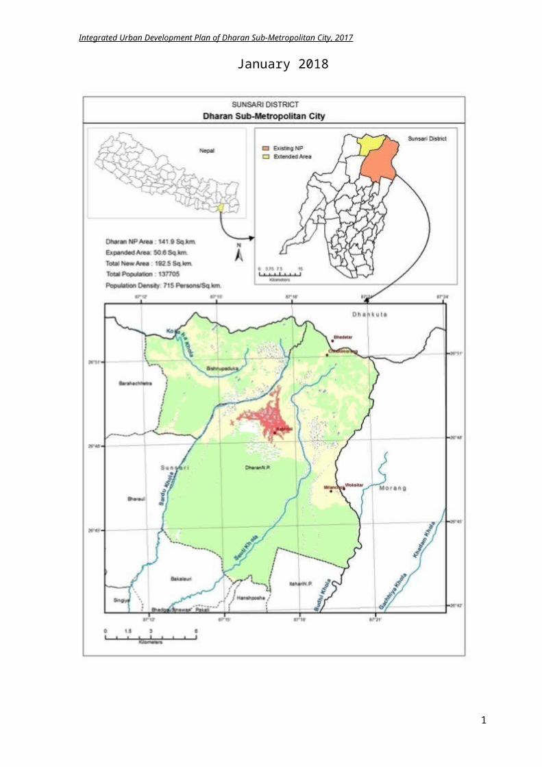
Dharan is one of the Sub-Metropolitan cities in eastern Nepal, in the Sunsari District of Koshi Zone, and is situated on the foothills of the Mahabharata Range in the north with its southern tip touching the edge of the Terai region at an altitude of 1148 ft. (349m) serving as a trading post between the hilly region and the plains of Terai region. It lies in altitude of 1778m.The Dharan municipality having area of 21.12 sq. km has been expanded by addition of two VDCs Panchkanya and Bishnupaduka and declared sub-metropolitan city in 2016, which updated DSMC to total area of 192.61 sq. km. Post recent ward readjustment, DSMC has 20 wards in total.
3.1.1 Physical state
3.1.1.1 Climate
Dharan has an average maximum temperature of 35°C and minimum temperature of 5°C, with annual rainfall 1799mm, Wind Speed at 8 km/h, and 87% Humidity. The city is warm in most of the times except few months of winter. In winter, the cold breeze of Sheet Lahar is experienced.
Figure 3-1 Temperatures in Dharan Figure 3-2 Rainfall in Dharan
Source: http://www.levoyageur.net/weather-city-DHARAN-BAZAR.html
3.1.1.2 Demography
Dharan Sub-metropolitan city has population of 1,37,705 (census 2011) with female 73,034 and male 64,671 and household numbers 32,693. Major castes are Newar, Rai, Limbu, Brahmin, Gurung, Magar, Thakuri, Kirat, Thakali etc. with religious groups mainly Hindus, Kirat, Buddhist, Christian, Muslim etc. The ward wise population is listed on chart below.
Table 3.1
Population 137,705Male 64,671
Female 73,034
Household 32,693
Population Density per km2 715
19
Integrated Urban Development Plan of Dharan Sub-Metropolitan City, 2017
Figure 3-3 Ward wise division map (DSMC 2011) Figure 3-4 Population density map
Table 3.2Ward wise Demography of Dharan
Ward no.
Total Area (sq.km) Total HH
Total Population
(2011)Male Female Population
Density
1 0.494 1,199 4,958 2,458 2,500 10,036 2 0.172 540 2,649 1,301 1,348 15,401 3 0.131 1,034 4,838 2,372 2,466 36,931 4 23.012 713 3,251 1,554 1,697 141 5 10.632 1,779 7,739 3,611 4,128 728 6 4.589 1,371 5,911 2,713 3,198 1,288 7 0.194 777 3,275 1,584 1,691 16,881 8 19.616 2,818 11,679 5,637 6,042 595 9 0.211 1,022 4,113 2,084 2,029 19,493 10 0.222 1,384 5,444 2,605 2,839 24,523 11 1.352 2,708 11,703 5,417 6,286 8,656 12 0.276 796 3,482 1,646 1,836 12,616 13 3.397 2,034 8,302 3,780 4,522 2,444 14 2.468 851 3,609 1,737 1,872 1,462 15 25.544 4,726 19,879 9,213 10,666 778 16 1.429 2,763 11,199 5,173 6,026 7,837 17 14.578 2,610 11,283 5,125 6,161 774 18 7.210 1,620 5,872 2,715 3,157 814 19 28.297 1,154 5,125 2,313 2,812 181 20 49.156 784 3,391 1,633 1,758 69
Total 192.980 32,683 137,702 64,671 73,034 714
It is obvious that the core area (wards 1, 2, 3, 7, 9, 10, 12) has the highest density, and the peripheral and new extended area (wards 4, 19, 20) has low density. With the increase in density of urban area, the demand of urban services like water supply, road and drainages, electricity etc. too escalates and planning of such physical amenities evolve as the main challenge of the IUDP.
20
Integrated Urban Development Plan of Dharan Sub-Metropolitan City, 2017
3.1.1.3 Land use and Settlement pattern
The land use within Dharan are main urban areas, residential area, agriculture area, river and water cover area, forests, road and bus parks, parks and gardens, industrial and educational areas. Most of the flat lands are in the plain (in the south) and hilly sides are mostly covered by forest. Almost 50% of the total area of Dharan is occupied by preserved Char Koshe Forest. Urban settlement lies on the center of present boundary of municipality and extended toward west. Cemetery is a noticeably located on the northern part near river front with pitiable accessibility. The eastern and western part incorporating newly comprised VDCs have the lack of urban infrastructures.
Ample agricultural land is observed within the city mostly in the peripheral area. These low angle sloping lands are good for dry cultivation like maize, millet, wheat and cereals. The current land usage is explicit in the table.
Table 3.3 Existing land coverage patternCategories Area (sq.km) Percentage (%)
Built area 3.45 1.78Forest 135.74 70.33Water Body 0.01 0.67Agriculture 45.98 23.82River bed 7.09 3.67Cutting cliff 0.87 0.45
Figure 3.5 Existing Landuse plan of Dharan
21
Integrated Urban Development Plan of Dharan Sub-Metropolitan City, 2017
The existing settlement pattern of Dharan can be clearly classified as Central Business District (CBD), Residential areas, Squatter Area, Open areas, Institutional area.
Central Business District:
As Dharan exhibits a ribbon development, core area is developed as a hub for trade and business. The modern city is extended along Koshi Highway, Dharan-Chatara Highway. This area is developed as a CBD. Then the city extends southwards along Hospital, Bus Park and Engineering College. Hospital and Bus Park both are the pulling factors for people from other areas.
Figure 3-6 Existing settlement location of Dharan
Figure
3 -- -7 CBD
of
Dharan
Residential areas
The periphery of city area is predominantly residential. There are even plotting on the periphery of the Sub metro boundary where future settlement expansion will be guided. The traditional old residential building of Dharan is mainly constructed of wooden post on ground floor with open space that were non-habitat, due to clogging water issues and the upper floors are used for residing. Today, due to drainage development, even the lower floors area used for residential purpose. The new urban area on ward number 20, 4, 5 and 6 have low dense scattered settlement pattern with mostly agricultural land.
22
Integrated Urban Development Plan of Dharan Sub-Metropolitan City, 2017
Figure 3-8 Old and new residential buildings in Dharan
Squatter settlement:
Dharan is facing the problems of encroachment of riverbanks, open spaces and area of social and cultural importance by squatters. Riverbanks are squatter by migrators. Squatter settlements in the banks of Sardu and Seuti Khola are creating an alarming threat of encroachment of the riverbanks and flood plain. This encroachment has especially occurred over the past 10 years by landless people emigrating here for access to employment and education. Besides, at the Bijaypur hill, people are occupying ancient Kirat settlement remains. The Bijaypur hill having the ancient significance is squattered. Similarly, the ancient fort (Gadhi) walls are in ruined stage that needs archaeological excavation to preserve the historical value.
Figure 3-9
Encroachment near river bank Figure 3-10 Squatter settlement encroachment in ancient Bijaypur hill
Parks and Open Spaces:
Many parks, forests and open spaces are within the city area. The small hill located North-East of city is called Bijaypur hill. Here is a sparse settlement and agrarian society. It is located on ward no 14. It is important on both cultural and natural values. Many temples of deities (Bindhabasini, Budhasubba, Panchkanya, Dantakali, and Pindeshwor temples) are located here. Several private and public parks are scattered within the city that Saptarangi Park that can be developed as a multi cultural ethnic park is located west of Sunaulochowk between Sardu and Khahare Khola. Besides, there is community forest, which maintains the green environment around the city.
23
Integrated Urban Development Plan of Dharan Sub-Metropolitan City, 2017
Figure 3-11 Location of existing temples and parks in Dharan
Figure 3-12 Yalamber community forest Figure 3-13 Himali community forest
24
Integrated Urban Development Plan of Dharan Sub-Metropolitan City, 2017
Figure 3-14 Below: Earthquake memorial park Figure 3-15 Below: Saptarangi park
Institutional area:
Dharan has many health and educational institutions. The major educational facility is teaching hospital (BPKIHS), Purbanchal Engineering College, Food Technology college, Dharan Multiple Campus. The other colleges are Sunsari Technical College, Birendra Memorial College, Dharan College of management etc. these institutions has played the important road for educational upliftment as well as increase the economic activities in city.
3.1.1.4 Physical Amenities
Road
The city is well connected to the surrounding region by two highways – Koshi highway and East West Highway. Internal roads link the internal settlements of the city areas properly. The urban road lacks drainage in major portion. The extended municipality boundary has road network but most of them are either earthen or graveled. Most of the road with the municipality area is track opened. The lack of municipal resources to maintain the road standard is reflected here. The data of DSMC shows 106 km road is black topped till 2011 but the GIS data shows 230 km road is being black topped. Total existing road length is 674.6 km.
Figure 3-16 Major urban road without drainage
Table 3.4 Road Network Dharan (DSMC 2011)
There is lack of bridge connection to newly incorporated Bishnupaduka and Panchkanya. Two bridges are constructed over Seuti River and one
कालोपते्र (Black Top) 106 KM
ग्राभेल (Gravel) 35 KM
कच्ची (Earthen) 130 KM
25
Integrated Urban Development Plan of Dharan Sub-Metropolitan City, 2017
bridge is under construction on Seuti on ward no 15. There are some suspension bridges to these areas that seem inadequate. The main Chatara road connecting to Barah Chettra, Baguwa and others lacks bridge connection. The linkage to these areas is through the seasonal river, which become difficult during rainy season.
Figure 3-17 Urban main road with side drainage Figure 3-18 Earthen road in DSMC that occupies 60% of area
Figure 3-19
Existing Road network map
Water Supply:
Sardu watershed is a major source of drinking water for Dharan. It also provides water and forest resources for local for food, fodder, fresh water and energy to upstream and downstream areas. The problems regarding the encroachment of water sources and over exploitation of watershed has led to scarcity of drinking water in Dharan city.
This has become a great challenge for the entire watershed region. Some wards of Dharan even use the source from Bhedetar. The following table shows the water consumption per day of Dharan. Among 32683 households, only 9111 water supply line is distributed that suggests most of the household in Dharan use Tubewell for water.
26
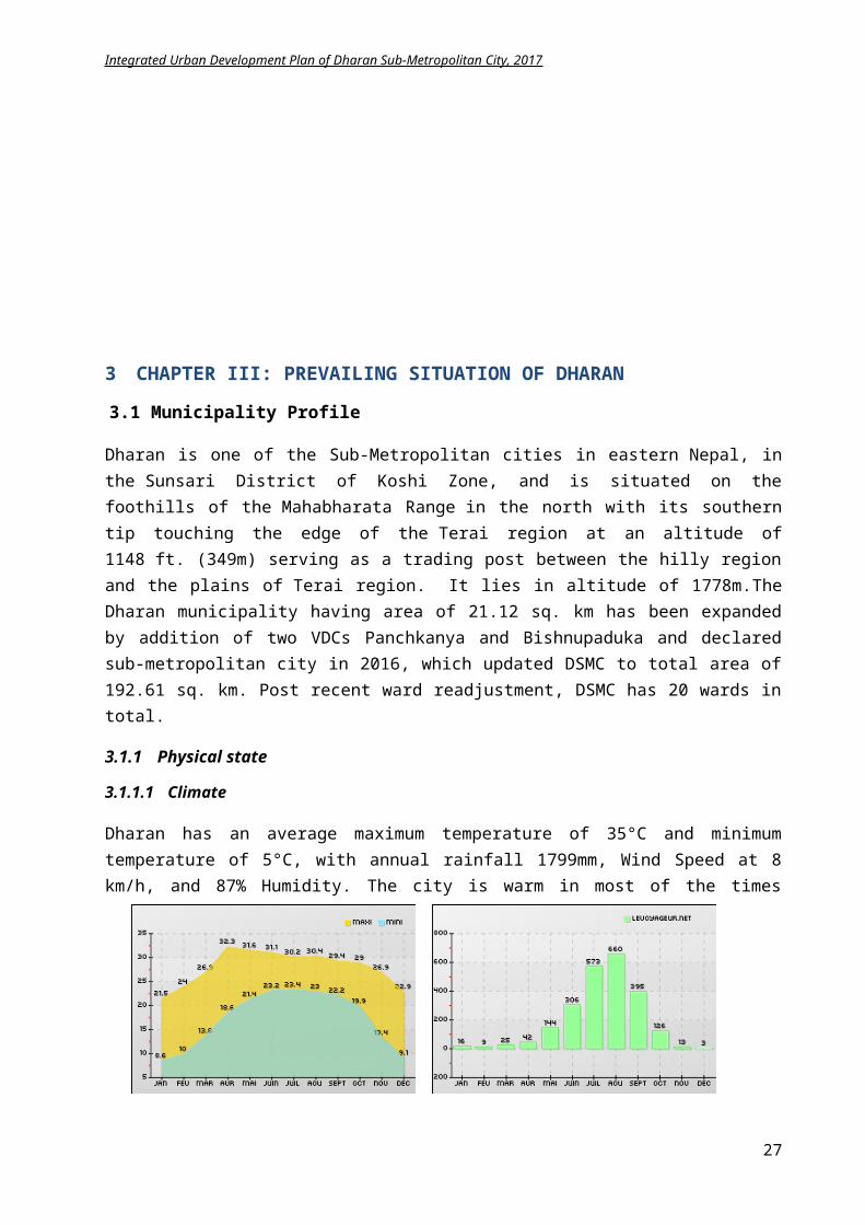
Integrated Urban Development Plan of Dharan Sub-Metropolitan City, 2017
Table 3.5 Drinking water supply (DSMC 2011)
With the help of ADB grant and loan, there is a water supply project currently being undertaken which is expected to solve water problem of the city. This project is rehabilitation and extension of water supply project, conceptualized as a piped water supply system considering conjunctive use of surface source from Khardukhola and Sardukhola streams and ground water source. Moreover, major part of the proposed project is under operation, and emphasis has been given to use existing facilities as far as possible. Major portion of the area has to be rehabilitated and two new supply systems are proposed. Based on the existing facilities, natural terrain and settlement patterns five distribution subsystems are proposed namely i) Phusre, ii) Bijaypur, iii) Sumnima, iv)Railway and v) Pindeswor. Region to be served by Pindeswor and Railway are to be newly constructed where as other subsystems are of rehabilitation nature. The system also consists of treatment and disinfection facilities, ground reservoirs, rehabilitation of existing intakes. Source protection works, plantation and re-vegetation works are also proposed in the project.
Drainage and Sewerage:
Dharan as located on the foothill of Chure Range has porous soil. Soak pit installed in every household is functioning well and there is no existing sewerage for black water. Only drainage for storm water is present. In some areas like Khahare Khola in the city area, direct sewerage is discharged to the stream polluting the water source. Management of drainage system in Dharan is relatively easy due to its slope topography. Drainage is present mainly on city core area. A proper drainage system in Phusre Khola and east of Bhanuchowk seems inadequate during monsoon time. Most of the road network lack drainage system as paved road percentage seems relatively low.
Telecommunication and Electricity:
The City is well connected with the national Nepal Telecommunication Company (NTC) and also NCell. Telephone lines are easily available within the area. Only 8615 houses are connected to landline that suggests people have higher grasp on readily available mobile phones (prepaid and post paid). Almost all houses have been connected to national grid system and there is private initiation of solar panel system. Separate feeder is given for the industrial supply.Internet users have increased over years with the augmentation of private service provider like NCell, Subisu, Worldlink, Classitech, Vianet etc. There is devoid of free Wi-Fi zones in the important public places. The summary of telecommunication and electricity supply in Dharan can be observed in table below.
Table 3.6 Information and communication status (DSMC) Table 3.7 Electricity and water supply status (DSMC)
Transportation:
Private Line Distribution 8807Public Line Distribution 304Water Consumption per day 12.5 million Ltr.
Industrial Supply Line 189
Household Supply Line 9171Other Distribution Line 181
Yearly Consumption 21110652 KW/yearStreet Line 3792
Local Newspaper 11
Distributed Telephone 8615Public Telephone Booth 16
Radio Station 1Internet Service Provider 3Cable TV 2
27
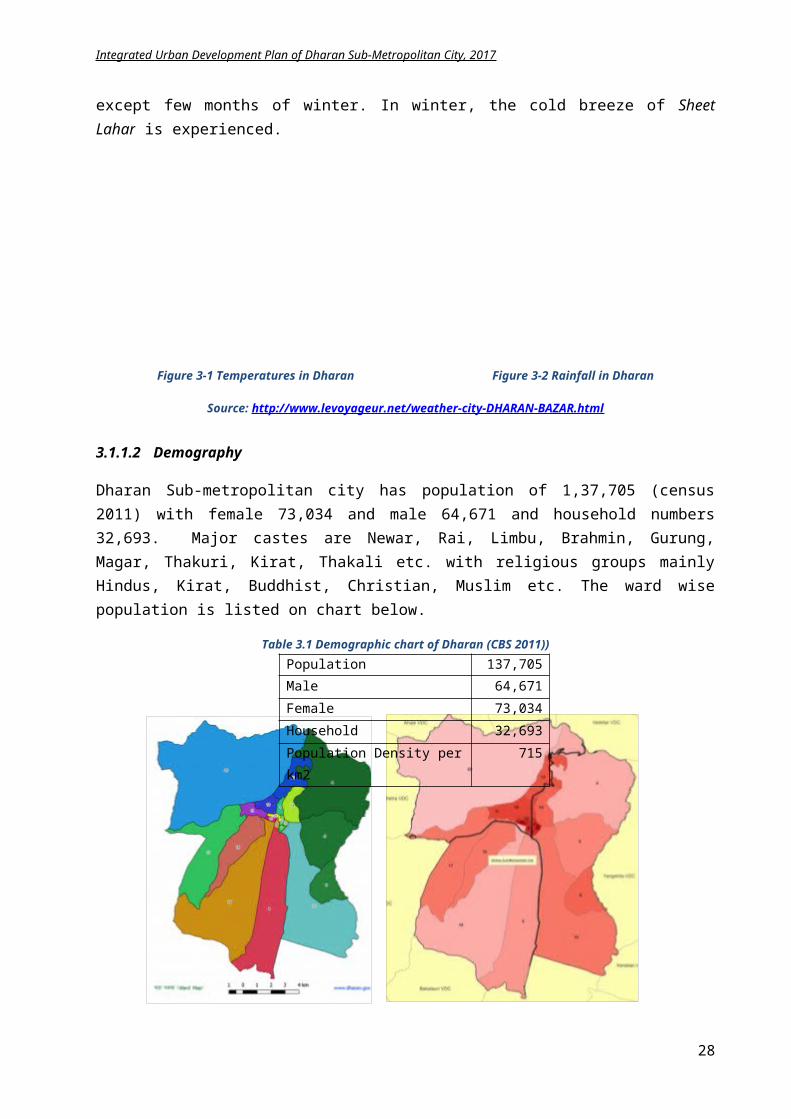
Integrated Urban Development Plan of Dharan Sub-Metropolitan City, 2017
The existing bus park at Bhanu Chowk doesn’t cater to the demand of Dharan. There is lack of adequate parking space for the intercity buses. Moreover, the parking for taxis, reserve vans and microbuses seems scarce. Dharan has lack of efficient public transportation. Rickshaws seem pre dominant in the city with higher transporting rate.
Also, there are no bus stops along the urban roads and lack of rest house / public toilets within the road sides. The existing 10 bus stops are at Panwari, Bhanu Chowk, Chatara Line, Sakul Danda, Chhattiban Chowk, Ramfal Chowk, Chauki Danda, Kishan Chowk, Saraswoti Chowk, and Simal Chowk.
Figure 3-20 Electric public vehicle in Dharan Figure 3-21 Dharan bus park (google.com)
3.1.2 Social state
Dharan is the new city formed by intermix of castes and ethnic people i.e. Rai, Newar, Limbu, Chhetri, Brahman, Tamang, Kami, Magar, Gurung etc. There are around 58 different castes following different religions. The city is famous for its education and health services.
Education:
In new context of local government, the education is the responsibility of Dharan Sub-metro city and has to handle the school level education.Besides, the informal education, pre school facility, adult literacy programs are achieved by the city.
There are decent education facilities in Dharan, from primary level to higher education, which is shown in table below. Some of the famous institutions are BP Koirala Institute of Health Science (BPKIHS), Purbanchal Engineering Campus, Mahendra Multiple campus and Pindeshwor Bidhyapeeth etc. BPKIHS is among Asia’s top Medical science Institutes.
Table 3.8 Educational institutes in Dharan (DSMC 2011)Private Government Total
Primary 45 6 51Lower secondary 5 5 10
Secondary 18 12 30Higher secondary 8 0 8
College 0 4 4Deemed University 0 1 1
Library 9 1 10Special Education (Blind/Deaf) 0 3 3
28
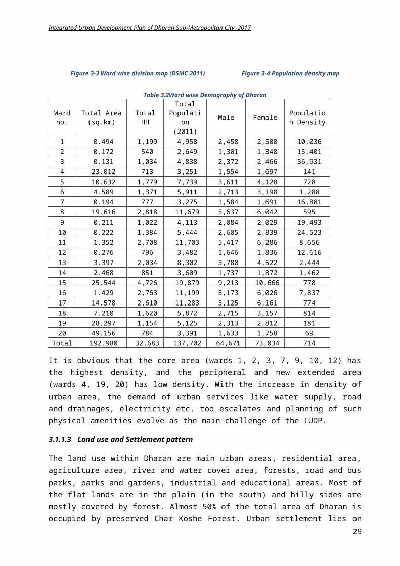
Integrated Urban Development Plan of Dharan Sub-Metropolitan City, 2017
Technical School CTEVT 5 0 5Total 90 32 122
The literacy of the Dharan is quite higher than national average. Its total literacy percentage is 84.5% among which 90.87% are male and 78.94% are female. Hence, education facilities are abundantly available and most of people in Dharan are literate. The education sector is already strong in Dharan, and only some programs is needed for escalating the literacy rate to 95% and making it first highly intellectual Sub Metro city.
Health
Dharan is developing also as a hub of health facility. BPKIHS is the famous institute for providing health services in Dharan. There are 10 government health clinics (one in each ward no. 4, 11, 13, 14, and 16, two in ward no 17 and three in war no 15) operated by DSMC, 2-health post (in ward no 5 and 20) operated by Ministry of Health and 17 private clinics but there is lack of proper infrastructures in these service-providing areas.
Figure 3-22 Locations of existing education and health service
Social security
Social security falls under the quality of governance of local body. The constitutionally enriched local body has many responsibilities to the citizens. As it has declared the welfare state, there are many tasks to perform in social security sector. The social security covers the area of:
29
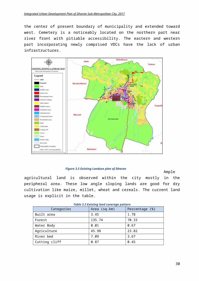
Integrated Urban Development Plan of Dharan Sub-Metropolitan City, 2017
1. Social insurance: Typically include provision for retirement pensions, disability insurance, survivor benefits and unemployment insurance.
2. Services: Medical care, financial support during unemployment, sickness, or retirement, health and safety at work, aspects of social work and even industrial relations.
3. Basic security: Assistances provided to disaster victims i.e. flood, fire, epidemics, refugee tec.
Dharan has provided the many types of social assistances – Old age allowance, scheduled caste allowances, disabled allowance, child allowances for specific groups etc. The population taking various types of allowances is listed on table;
Table 3.9 Number of people taking various allowances (DSMC 2011)Types of Allowance Nos. of Beneficiaries
1. Old age allowance 31652. Scheduled caste allowance 5193. Widow Allowance 26964. Disabled Allowances (full) 885. Disabled Allowances (heavy) 926. Children Allowance 1277. Marginalized people allowance 21
Total 6708
Dharan also provides old age, widow and disabled allowance to its citizens.
Table 3.10 Social Security Allowance Rates (Source:DSMC 2011)Types of Allowance Eligible Age Monthly Allowance NPR
Old age allowance (Dalit) 60 500Old age allowance (Others) 70 1000Widow (Above 60 yrs.) 60 500Widow (Below 60 yrs.) From date widowed 500Marginalized Not restricted to age 1000Fully Disabled (Red Card holder) Not restricted to age 1000
For the physical security of the citizens,there is police post present in each ward for assisting the citizens. 3 fire brigades and 15 firemen are appointed by DSMC for the safety of citizens during emergency for fire hazards.
Sports
Figure 3-23 Eastern ANFA technical center Figure 3-24 Dharan Rangasala (ekantipur.com)
From the beginning, Dharan has been arena for sports. The biggest and probably the best golf course of the country (18 holes) is in Dharan. DSMC in co-ordination with Dharan Football Club organizes, every year in August and September, the prestigious Budha Subba Gold Cup football tournament.
30
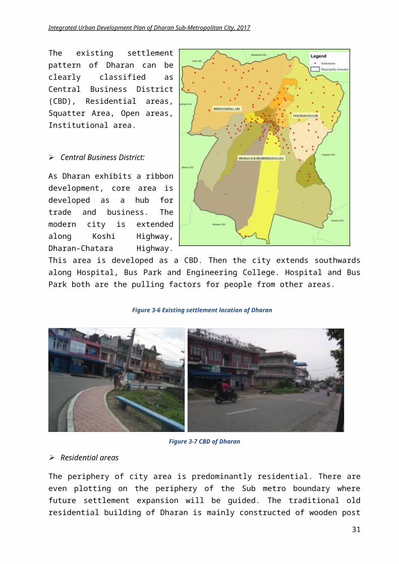
Integrated Urban Development Plan of Dharan Sub-Metropolitan City, 2017
The sport activities are mainly centered in the multipurpose stadium Dharan Rangasala. The popular sports are football, cricket, volleyball, basketball etc. The Dharan Football Club is one of the most active organizations promoting football in the city and organizes a South Asian club-level annual tournament. There are 3 swimming pools, 5 tennis courts and 3-basketball court.
Culture:
Dharan is considered as representative of the cultural, religious, social importance of entire Eastern region. There are a lot of places, which are considered as centre of religious belief like Pindeswor, Dantakali, Budhasubba, Panchkanya, and Bishnupaduka etc.
Pindeshwor temple is considered as the main religious center located in the southern part of Bijaypur Hill. During months of Shrawan, Shivaratri, Balachaturdashi, this temple is crowded by devotee. Pindeshwor temple is especially known for Bolbam Tirtha in the month of Shrawan attracting internal and external religious tourists.
Figure 3-25 Pindeshwor temple of Dharan Figure 3-26 Saraswoti kunda Pindeshwor
Dantakali Shaktipeeth is also considered as most important religious center of Dharan. There is lot of interesting speculations about the origin of this place. Budhasubba is also a famous temple in Dharan. It is quite popular for it’s bamboo tree. The lovers engrave their name on the bamboo tree.
Figure
3 --- -- -- -- -- -- -- -- -- -- -- --27 Dantakali temple Figure 3-28 Panchkanya temple
Bishnupaduka and Panchkanya area are quite popular for their religious and cultural significance. Devotees visit these places throughout the year. Moreover, in the month of poush, there are un-matching number of devotees visiting from Nepal and India.
31
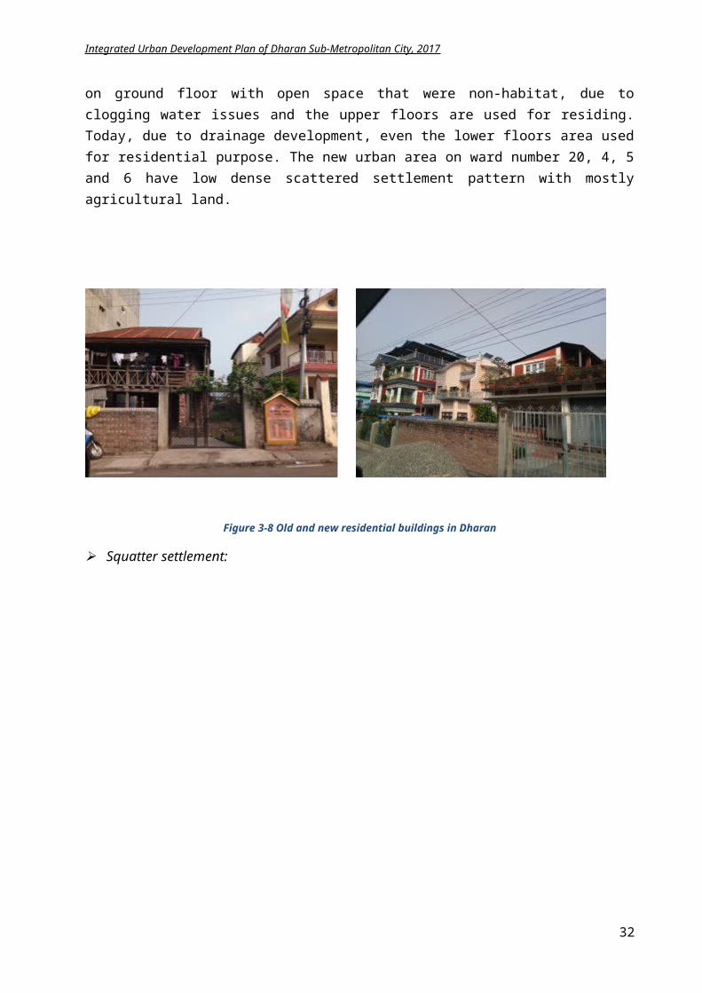
Integrated Urban Development Plan of Dharan Sub-Metropolitan City, 2017
Figure 3-29 Budhasubba temple of Dharan
Dharan is quite popular for it’s cultural significance too. Dharan city consists of multi-cultural, multi-language speaker, and multi-ethnic and multi-religious people. Dharan city is also known as the city built by Lahure. A decade ago, Dharan city and word City of Lahure were considered as synonymous. Most of the retired British army from Eastern Nepal resided here and contributed for infrastructure development of the city. So, Dharan developed as a neat and clean way which can still see within the area.
Park
There are various parks in Dharan namely Panchkanya Natural Park, Sakela Park, Saptarangi Park, British Gorkha Memorial Park, Jestha Nagarik Park and Bhukampa Smarak Park. These parks not only increase the beauty of the city but also provide a natural environment for the citizens to relax, chat and meet. There is drawback in management and operation of the park and they haves not been utilized in full fledge. These parks have higher potential for developing as picnic spots, playing areas and gathering area.
Figure 3-30 Left: Existing temple complex used for exerciseFigure 3-31 Right: View of Saptarangi Park
3.1.3 Environmental State
Dharan has Koshi Tappu Forest on the southern side, hills like Bhedetar, Bijaypur and Bishnupaduka on the surrounding and Seuti, Sardu, Khardu, Kokaha and Khahare Khola within its territory.Dharan exhibits range of topographical difference from flat land to hills. The soil of Dharan is very good for absorbing the water and managing the ground water table and additionally best for agriculture. Dharan has rich sources for aggregates, sand, and firewood. There are various conservation and preservation areas within and near the territory of Dharan.
32
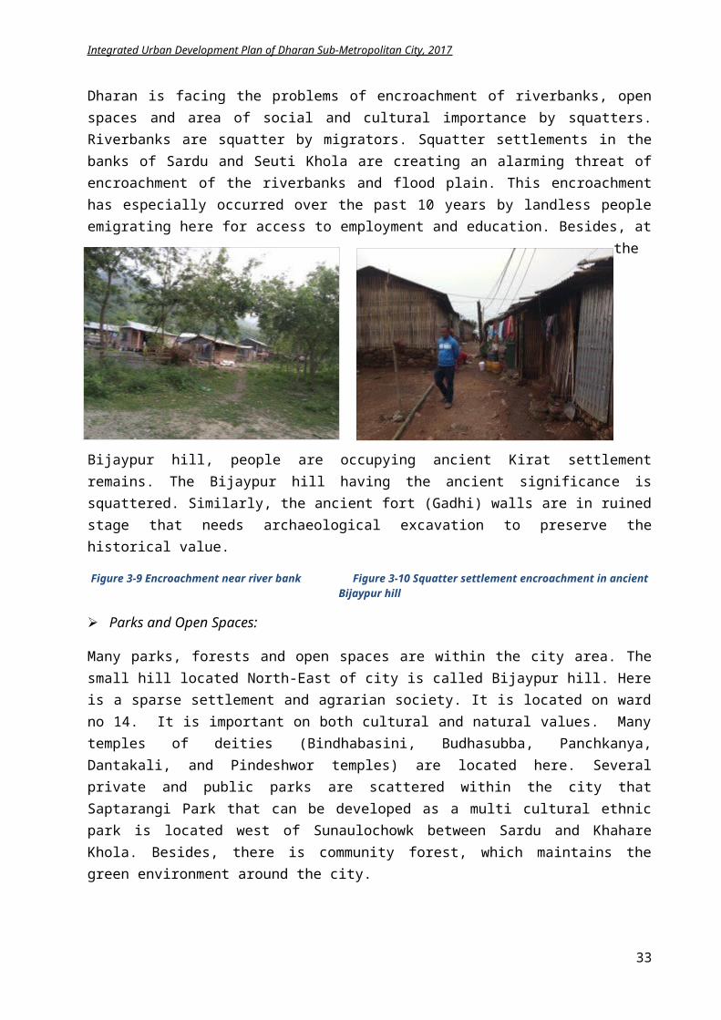
Integrated Urban Development Plan of Dharan Sub-Metropolitan City, 2017
Figure 3-32 Resource map of Dharan
Solid waste management:
Dharan produces nearly 5 tons waste per day which is collected by 5 garbage trucks. About 60 sweepers are assigned to clean the main roads and drains in two shifts daily. The garbage are collected from main and inner road area of each wards of urban area (besides Bisnupaduka and Panchakanya, which is managed in HH level) on daily, weekly and half weekly basis according to priority routes and these waste are dumped in nearby sites of Bajgara community forest and the lower side of riverbank of Seuti Khola. There is no landfill site for solid waste, and no sewerage system as well as plants for sewerage.
Promotion of the concept of 3R’s (reduce, recyle and reuse) is necessary for waste management. DSMC is initiated this technique for waste management with community support. Some inititation of community participation and inclusion is commenced by Dharan Sub-Metropolitan and which is implementing effectively that can be explained as:
Tole level environmental groups are being formed in different wards and training for the improvement of environmental quality is provided.
City level enviromental network representating these tole level groups is established. This network will revisit and solve the environmental problems of the city.
33
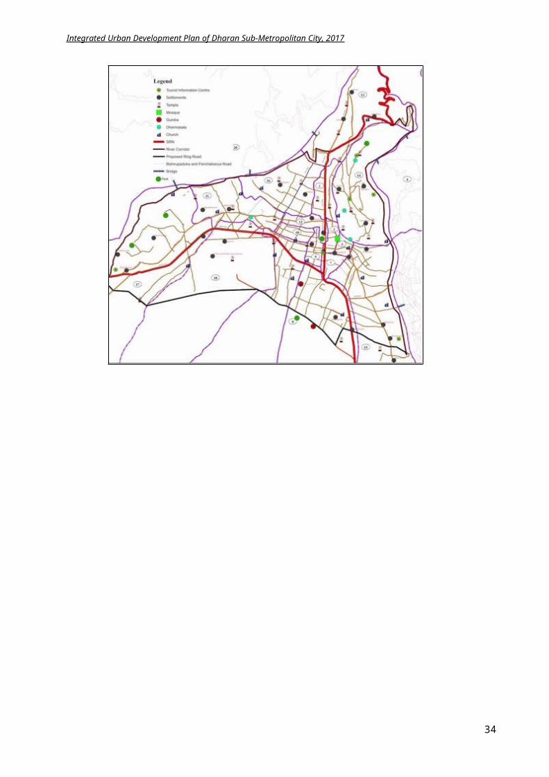
Integrated Urban Development Plan of Dharan Sub-Metropolitan City, 2017
Recyclable waste and Reuseable waste collection and selling centres being established at some points as an example.
Organization of different promotional and training events in the city Environment protection promotional activities initiated in every schools of the city.
Sanitation:
About 90% of the population in Dharan has toilet facilities. It is therefore, rated as good. Out of them about 76% of the population have cistern flush toilets, while 14% have a pour-flush toilet. Public toilets are not in proper condition. Poorly managed public toilets have been notably contributing to environmental pollution in the town. Khahare khola flowing through the middle of the city centre is experiencing the direct sewerage discharge that augment the environmental pollution, moreover encroachment of the stream by adjoining dwellers endanger its existence.
Environmental pollution:
Environmental pollution is defined as undesirable change in physical, chemical and biological characteristics of environment i.e. air, water and soil which causes harmful effects on various forms of life or property. Growing urban population has also resulted in environmental pollution of Dharan. Solid waste and sewerage mainly causes the river pollution, land and air pollution. Smell and dust escaping out, particularly from rice mill, jute mill and furniture industries results in air and noise pollution. Besides, the haphazard building construction, unmanaged displays and advertisements, grill and metal workshops along the road has increase the visual as well as sound pollution of the city. The slaughtering is not properly managed. the inner tole is still using slautering in front of road side and the slaughterhouse on ward no 6 hardly cover the demand of the city.
The sources of air pollution in Dharan municipality are mainly vehicular emissions and traffic; increase in number of vehicles, development works like road extension, building construction, open burning of solid wastes by households, agricultural and industrial activities. Black topped roads are within central municipal areas whereas roads at outskirts of municipalities are earthen or graveled. The dirty track roads are contributing significantly to the percentage of dust in the air.
Community-level major environmental problems are topped by unmanaged wastes and successively followed by bad smell, air pollution, unmanaged parking area/hat bazaar/cattle/soap, etc. The figure given in the table is based on the respondents' perspective.
Table 3.11 Community environmental pollution (Source: Household Survey 2006)
3.1.4Disaster
History
Dharan has faced many disasters like Earthquake, flood etc. and equally prone to landslide and fire. In addition, incidents of plagues, lightning and thunder and attack by wild animals can be observed.
S.N Community level problems In %1 Unmanaged wastes 83.332 Bad smell 44.793 Air pollution 36.464 Unmanaged parking/haat bazaar/cattle/shop 32.295 Unmanaged drains 26.046 Road/street problem 21.887 Drinking water problem 17.718 Open defecation 17.719 Lack of sanitation 12.5010 Noise pollution 11.46
34
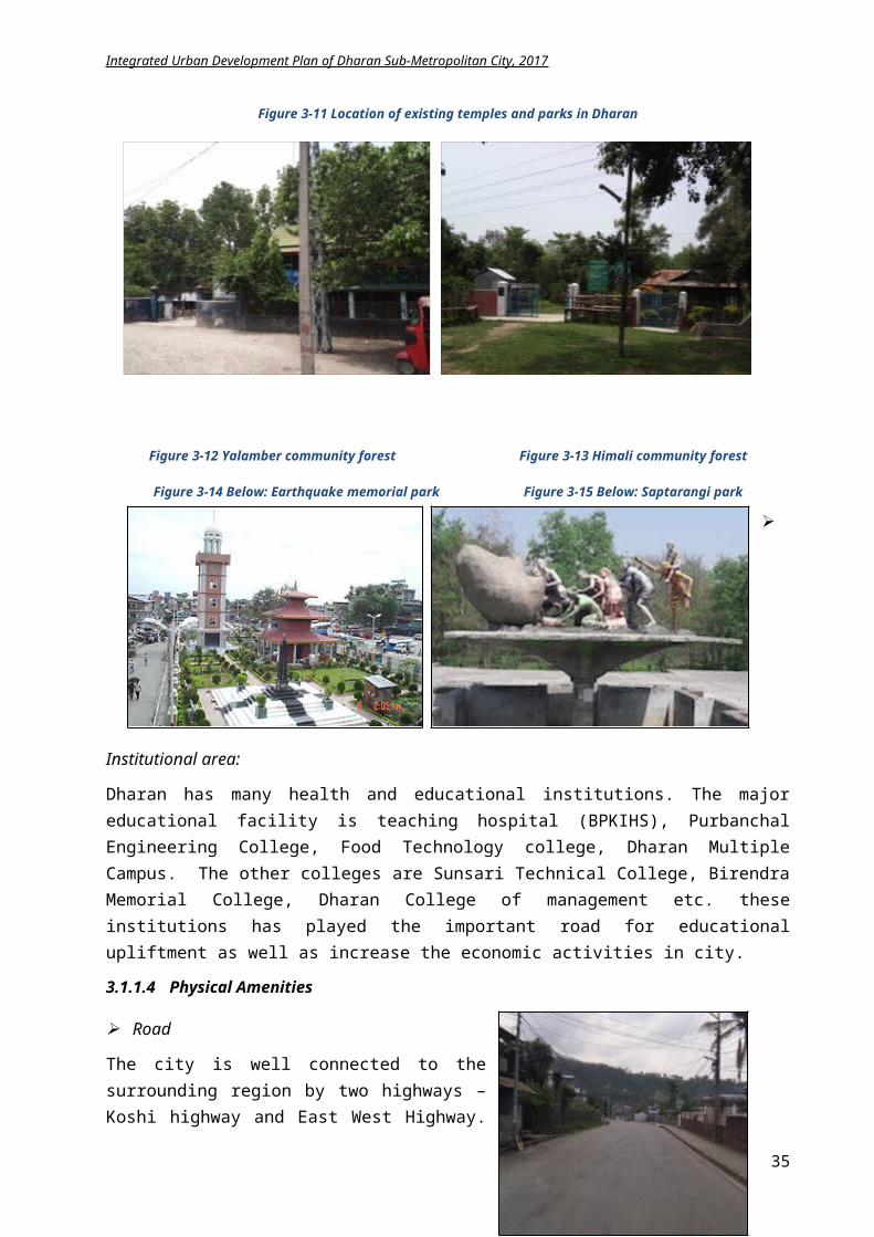
Integrated Urban Development Plan of Dharan Sub-Metropolitan City, 2017
With the increase of city size, it will be more vulnerable to epidemics. In past years various hazards like plagues, cholera, storm, fire, earthquake, lightening and landslide is observed in Dharan. The various form of hazard occurring in several years and its consequences are listed in table below.
Table 3.12 History of disaster in Dharan (Disaster Risk Management Plan Dharan) Year Disaster Effect
2031 Plagues+ Cholera 20 people dead2040 and 2041 Lightning 5 people dead2045 Earthquake 180 people killed+250 people injured, 10 thousands houses
affected+100 houses displaced, Crores of property loss, Eye diseases and diarrhea
Plague
Fire 1 person dead+ 10 people injured+ 4 cows dead+ 2 houses destroyed
2046 Fire 1 house destroyed2056 Fire 4 house destroyed2065 Flood Thousands hector of land flooded2068 Earthquake 2 people dead
Fire 2 house destroyed, 1 child deadLandslide Water supply pipe and trees destroyed
2069 Fire 1 house destroyed, loss of 50 million worth valueYearly Flood 2 dead, 52 houses damaged and abandoned, 5 alluvial land floodedEach year Fire/Flood 1 people killed, 1 people injured, damage of millions of rupees
A Disaster Risk Management Plan (DRMP) 2070 has been prepared in Dharan, which provides an immediate action plan during and post disaster. Due to it’s geological and topographical structure, Dharan lies under high risk of earthquake. The effects of earthquakes of 2045 BS and 2048 BS was severe on Dharan. The existing condition is exacerbated by the increasing urbanization, high population density, and weak structures. The houses on the bank of Sardukhola and Seutikhola are in the risk of flood and the settlement in Northern part of Municipality is in risk of landslide. Old and timber-made houses are in high risk of fire. Each month has its own risk of various disasters, which is explicit in following table.
Table 3.13 Risk based on various months of year (DRMP Dharan)
Focused on the type of natural hazards, an analysis is made to identify the cause of disaster and to minimize its effect.
Table 3.14 Types of Disaster, its causes and effects and mitigation measures (DRMP Dharan)Elements and Place of Risk Possible Risk Cause of Disaster Affected area
Disaster Mostly affected area and timeFlood Shrawan and Bhadra (Flood coming through Sardu and Seuti Khola)Landslide Shrawan, Bhadra and Ashwin(Landslide in Northern part)Fire Baisakh, Magh, Falgun and ChaitraStorm Falgun, Chaitra and BaisakhPlagues Ashad, Shrawan, and Bhadra(Especially diarrhea)Seet lahar Magh monthSnake, Monkey and wild animal attack
Attack by wild elephant through the year+ Loss due to monkey and snake attack
35
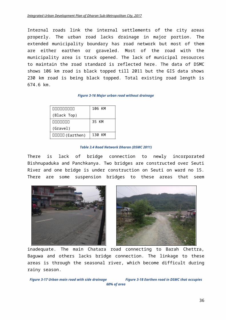
Integrated Urban Development Plan of Dharan Sub-Metropolitan City, 2017
Ear
thqu
ake
Structures constructed on weak topography, old buildings, and other physical structures
Large buildings constructed in Dharan municipality ward no. 2,3,14 and 17.
Weak seuti bridge (which connects Dharan)
Sloping landscape near sardu and seuti river (prone to landslide)
Physical infrastructure damage, fire
Human loss Disturbance in
telecommunication and electricity supply
Scarcity of drinking water and possibility of transmissibility of plague
Weak topography Weak physical
structures Lack of proper
public knowledge of appropriate construction technology
Lack of public awareness, skill manpower,etc
Manmade structures, public structures, source of income, cultural heritage, etc.
Floo
d
Settlements near sardukhola and seutikhola
Farming land, forest area, cultivated plants, road, animals, electricity, cable wire, telephone pole, etc.
Other physical infrastructures
Bank erosion, could cause death and injury
Desertification Disruption in Must-
needed facilities Property loss Scarcity of food, plague Increase in
Unemployment Increase in social
insecurity
Climate change Unmanaged
settlement Deforestation Lack of awareness Lack of planning Carelessness of
concerned authority
Human, Animals, Cultivated plants
Forests Must-needed
facilities, physical infrastructure damage, etc.
Effect houses
Fire
Buildings, physical structures, forest area
Settlements constructed using wood
Petrol pump and gas storage
Unmanaged electricity supply
Human and property loss Damage of physical
infrastructures Damage on natural
beauty, environmental pollution, etc.
Lack of public awareness
Human mistake, carelessness
Children’s reach on fire causing substances
Possible carelessness in industries
Buildings made by timber (specially in ward no 7,8,17,13, 11,15 and 16)
Unmanaged settlements near seasonal rivers
Unmanaged electricity lines
Petrol pumps in mid urban area
Lan
dslid
e
Sloping ground Water sources Forests Physical infrastructures Animals Mines
Risk of losing source of water due to soil erosion and bank erosion
Risk of Sudden flood Risk of damaging
environmental equilibrium
Human and property loss
Lack of awareness Earthquake, existing
terrain Loss of forests Drought Continuous heavy
rain
Effect on Cultivated lands
Social Economic Human loss Physical
infrastructure Existing
topography
Thu
nder
stor
m
Houses made by using timber
Cultivated plants Electric poles Animals Mobile, telephone,
television
Roof of ‘Tin’ in Dharan ward no 18
Electricity disruption and possible human loss due to falling of electric poles
Economic problem Loss of forest Drought Continuous heavy
rain
Plag
ue
Human Animal Environment
Human and animal loss Risk of loss of cultivated
plants
Lack of awareness Waste management Polluted drinking
water
3.1.5 Economic state
Dharan used to be gate way town to the hill. Now it is shifting toward Itahari. Many godowns, health and educational activities are growing to Itahary along Mahendra highway. Still it serves the hill for
36
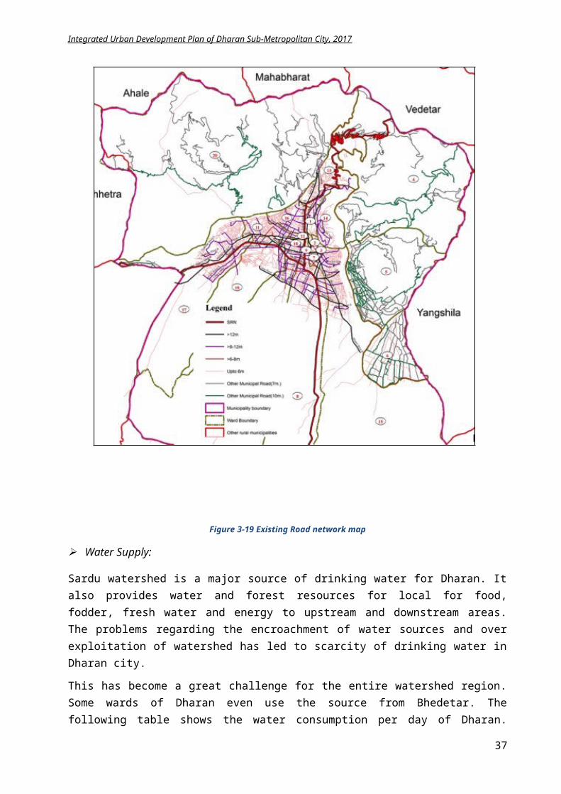
Integrated Urban Development Plan of Dharan Sub-Metropolitan City, 2017
agro product collection and providing services of finished goods and human resources. It is also one of the main towns in Dharan-Biratnagar industrial corridor. The economy of Dharan is based on,
i. Transport sector / Auto servicesii. Hotels and restaurants
iii. Banking and financeiv. Industriesv. Agro-business
vi. Health sectorsvii. Education sectors
viii. Business
Figure 3-33 Interlinkage map of Dharan with various municipalities
The main occupation of the people residing in this municipality is service (45.83%) in various private and government organizations. Apart from service, business (32.3%), agriculture (2.08%) and 19.79% are involved in other sources of economic activities. Dharan is one of the trade and industrial center of the region. It lies on the midway between Terai and Mountain of Nepal. Furthermore, it is also an economic center for connecting Dhankuta, Bhedetar toBiratnagar, Inaruwa and Itahari.According to municipal's web site, there are number of industries, hotels, shops in the city.
Table 3.15 Trade and industries in Dharan (Source: DSMC)
Trade and Industries No.Medium Scale Industry 24Small Scale Industry 104Hotel/Lodge/Guest House 78Restaurants 45Shops 1950Other business 400
37
Integrated Urban Development Plan of Dharan Sub-Metropolitan City, 2017
Tourism:
Dharan has the location advantages for tourism development as it a gateway city to hill areas. India border is just 45kms (Biratnagar). Being on the way to Dhankuta, Hile, Basantapur, Tehrathum, and Sankhuwasabha etc. and near to Mechi zone, the city has potential for tourism development. Besides, many touristic spots are scattered around like Bhedetar (Charles point), Saptarangi Park, Bijaypur Palace area, Budha Subba Temple, Koshi Tappu Wildlife reservation, Ramdhuni, Barah Chhetra etc.
According to the tourism destination plan for eastern Nepal 2016, Dharan, Illam and Taplejung area can be focused as an alternative tourism destination to the “Golden Triangle” in central Nepal, which links Kathmandu, Pokhara and Chitwan and is currently the principal tourism destination in Nepal. Based on the mountains, rivers, forests and natural beauty, the plan considers nature-based tourism as being the region’s strength, tapping in where also possible into the region’s cultural, historical and religious heritage, agriculture, hill station, adventure sports (rafting, paragliding, cycling) and urban environment possibilities. The rural setting, hiking forest area around the city has opportunity for ecotourism.
Figure 3-34
Bhedetar Bazaar (google.com) Figure 3-35 View of Dharan from nearby hill (Wikipedia)
Agriculture
Due to the topography and soil type, agriculture is a perfect source of income generation in Dharan. As agriculture is vital in these areas, statistics of agriculture can be taken as the indicator of economic development. But lack of modern technology in farming, lack of irrigation facilities, devoid of market management, and complex living standards have become main problems in young generation for considering agriculture as main income source. But still Dharan has managed its economic growth through agro-farming and animal husbandry. Availability of abundant land for agriculture makes agriculture and animal farming still an enticing economic sector for urban youth.
Industry
There are around 128 medium to small-scale industries in Dharan mainly furniture, Rice mill, Jut mill, handicraft Biscuit, Steel, Metal etc. Local handicraft is also an attraction in Dharan.
38
Integrated Urban Development Plan of Dharan Sub-Metropolitan City, 2017
Figure 3-36 Local art and craftwork in Dharan
3.1.6 Financial state
Agriculture is predominant in Dharan along with industry and business. Tourism also provides a good economy to the city. Based on source, income of Dharan sub metro is divided as internal i.e. local taxes, service charges, fees, sales, resource mobilization, dividends and bonus) and external like government grants and District development committee, Revenue Sharing, foreign aid, loans and borrowings, donations and charity gifts, and municipal funds.
The municipal expenditure is divided into current (personal consumption expenditure, office operation and service charges, grants, service costs, interest payments, back spending, contingencies) and capital expenses (capital transfer expenditure, capital construction costs, investing, principal payment and contingencies).
The total budget for F.Y 2073/74 for Dharan was NPR 933 million, out of which NPR 500 million was of IUDP for water supply. 34% of Dharan’s income is through local taxes and 6% by public participation. Similarly, 7% of total budget is spent for administrative purpose, 5% on social security related programs and 13% for infrastructure development.
3.1.7 Organizational/Administrativestate
DSMC is now lead by elected body and is divided into various divisions – administration division, financial division, revenue division, land and urban development department, infrastructure development division, social welfare division etc. in total 10 divisions. The administration part has been tried to enhance using IT but usage of digital system is weak due to the lack of manpower and funding resources. For increasing the institutional capacity of the workers, Dharan is regularly organizing some workshops and training.
Municipality has an office building which is insufficient. New one is just completed and major offices are now running from this building. This is also insufficient and new one is under construction. Thre are ward offices in each ward with 15 wards having there own building and 5 wards building on rent. Among these five buildings ward no. 2 and 6 have their office on rented building and ward no. 11, 4 and 18 with office on community building.
Dharan is a model city for public participation. Looking at the history of public participation, it is active since the beginning of the year 2035. However, the active participation was from the fiscal year to be 2054/55. During intitial years of public pariticipation, the consumer share were 25% and 40% with municipality share 75% and 60% respectively which is now 50%-50% investment cost for public and municipality.
39
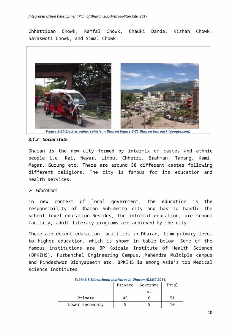
Integrated Urban Development Plan of Dharan Sub-Metropolitan City, 2017
For the capacity development of the government staffs, Dharan sub metro city has conducted workshop on the theme “b[li6sf]0f Joaxf/ kl/jt{gsf nflu ;sf/fTds ;f]r”in 2066 B.S.with the aim to expand the abilities in organizational structure and methodology, process performance, human resource development, information management system, financial management, and the coordination, development and extension of public relationsectors of Dharan.
Before the implementation of constitution and formation of local government, the government has old structure of the municipality. The previous structure of the institutional framework of DSMC is clear on table on next page
Various committees are actively participating in the DSMC, which is listed below:
1) City Social Work Coordination Committee2) City Level Revenue Collection Committee3) Environmental Sub-Committee4) Capacity Building Coordination Committee5) Monitoring and Cupervision Committee6) Integrated Municipal Planning Committee7) Evaluation Committee8) Public Private Sector Partnership Promotion Committee9) Child Protection and Enhancement Committee10) Child Relief and Rehabilitation Work Group11) Disaster Management Committee12) Municipal Project Management Committee13) Green Homes Implementation Committee
The elaborated information on municipality profile can be found on APPENDIX I.
40
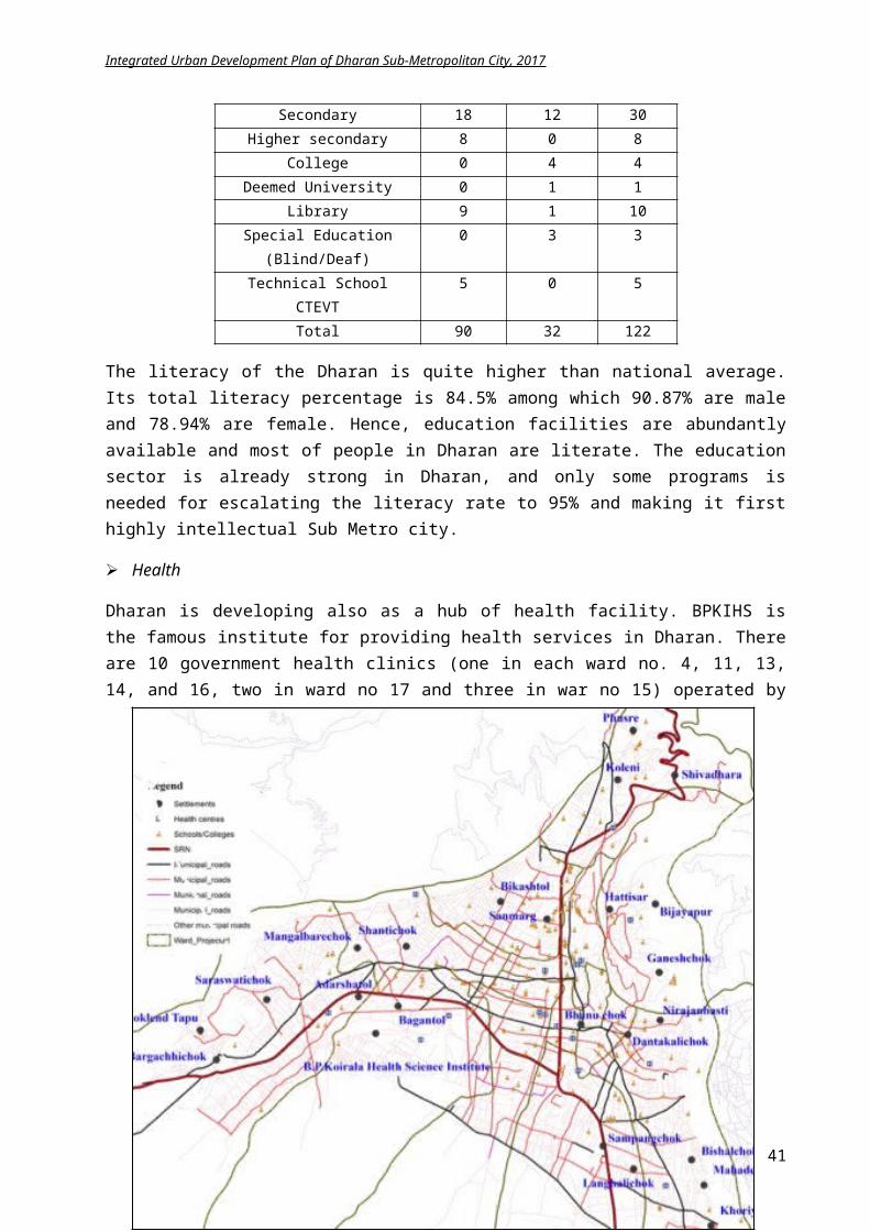
पर्य�टन तथा संस्कृतितशाखा
सामाजि�कति�कास शाखा
सूचना तथा सम्पक� शाखा
आ.ले.प. शाखा
पुस्तकालर्य इकाइ
बेरु�ुफर्च्यौर्य!ट उपशाखा
�ाता�रण तथा सरसफाइ व्य�स्थापन
उपशाखा
शिशक्षा तथा �नस्�ास्थ्र्य
उपशाखा
आकस्मिस्मक से�ा तथा �ारुणर्यन्त्रउपशाखा
ले.स.सा. सम�ेसी व्य�स्थापन उपशाखा
सूचना केन्द्र
नगर परिरषद
नगरपाशिलका बोर्ड�
लेखा तथा अन्र्य समिमतितहरु
प्रमुखको सशिच�लर्य
उपप्रमुख �र्डा समिमतित
लेखा उपशाखा
प्रशासन शाखा
आर्थिथ:क प्रशासन शाखा
रा�श्व प्रशासन शाखा
शहरी ति�कास शाखा
सामान्र्य प्रशासन उपशाखा
कानूनउपशाखा
मान� संसाधन तथा �नाशक्ती
व्य�स्थापन
भण्र्डार तथा सम्पती
व्य�स्थापानउपशाखा
खरिरदउपशाखा
नगरप्रहरीउपशाखा
दता� चलानी पंजि�करण इकाइ
स���तिनक तिनमा�ण मम�तसम्भार उपशाखा
नति�करण उ�ा� तथा सर्डकबत्ती व्य�स्थापन
उपशाखा
ति�पद �ोखिखम व्य�स्थापन उपशाखा
भौगोशिलक सूचना प्रणाली उपशाखा
भ�न नक्सा पासउपशाखा रामिFर्य भ�नसंतिहता कार्य�न्�र्यन इकाइ
न. पा. सशिच�
प्रमुख
Integrated Urban Development Plan of Dharan Sub-Metropolitan City, 2017
41
Integrated Urban Development Plan of Dharan Sub-Metropolitan City, 2017
3.2 Assessment and preparation of base map
The main objective of preparing a GIS base map is to have an overview of the municipality’s existing territory and available infrastructures and identify the main challenges and opportunities of the city in the next 10-20 years. The GIS map should have information regarding
1. Existing streets and buildings 2. Population density 3. Existing land-use4. Transportation 5. Water supply6. Drainage and Sanitation Network Plan7. Multi hazard risk map
8. Pu
blic Services9. Conservation areas10. Culture and Tourism11. Disaster Risk Management 12. Interlinkage
The detail GIS mapsfor the above existing and proposed services can be found in APPENDIX II.
Figure 3.37 Old Organizational framework of DSMC
42
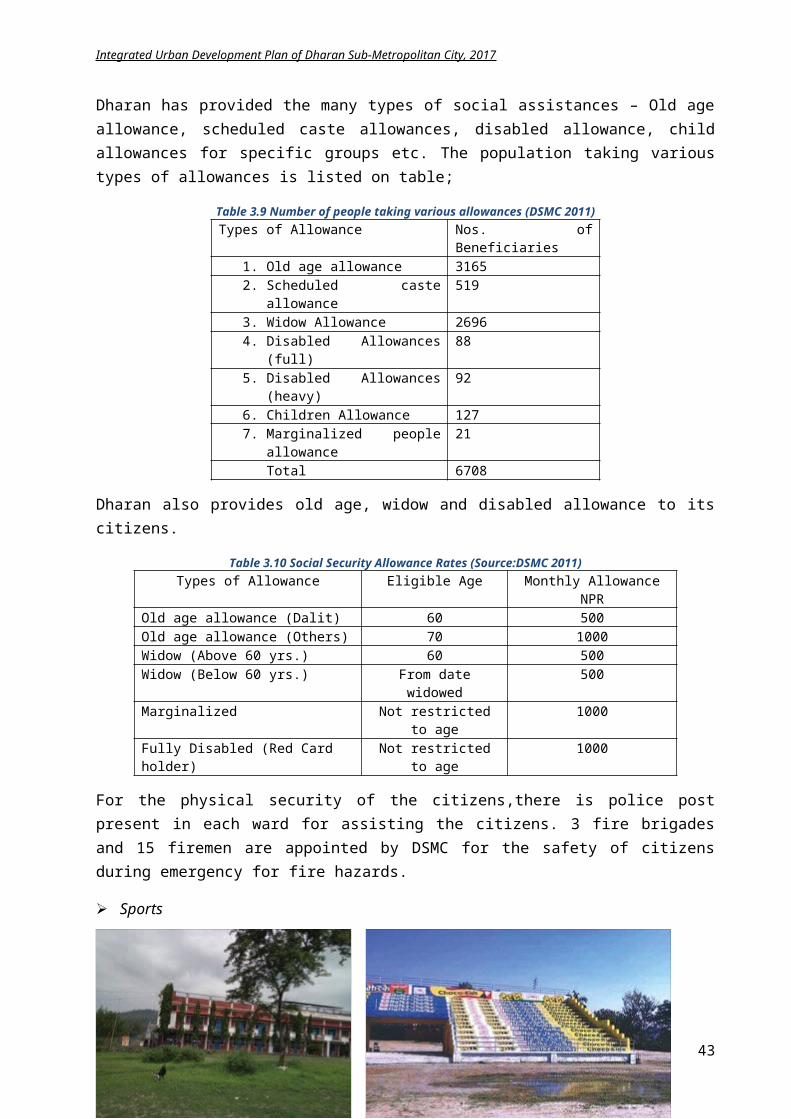
Integrated Urban Development Plan of Dharan Sub-Metropolitan City, 2017
4 Chapter IV: Data Analysis and Future Projection
4.1 Previous Development Plan: Attempts and Achievements
Looking back to the past, several infrastructures were established contributing to the development in Dharan. These are Central Campus of Technology in 1973, industrial estate in 1975 A.D and Purwanchal Engineering Campus in 1978. Some of the other prominent accomplishments in amenities are namely BP Koirala Institute of Health Sciences (BPKIHS) in 1999, Koshi Highway, East West highway, Bus park at Bhanu Chowk, Dharan Clock tower in 1991, ANFA stadium, Dharan Rangsala, Saptarangi Park.
The former periodic plan of Dharan Municipality prepared for F.Y. 2066/67 – 2071/72 was a base for the urban planning in Dharan with bottom up approach. There were certain issues and problems identified in the periodic plan mainly related to housing sector, health and education. The Periodic plan of Dharan 2066 identified the urban expansion needs and suggested the probable solution for accommodating the growing population. Besides, it also planned to conserve the architectural heritage of old town, which seems unachieved till date. The periodic plan also mentioned the need of managing the squatter settlements that is not addressed until current time. It suggested the construction of soak pit in every household and planning of sewerage line and treatment plant, not achieved yet. The land pooling and site and services under land development program were not successful in previous years.
It had formulated various programs in different sectors and the achievements of periodic plan in each sector till date is explicit below:
Sector Description Year 2062
Year 2072 Variation Remarks
Population Population 97,425 137,705 +40,280 Increase in population due to addition of 2 VDCs
43
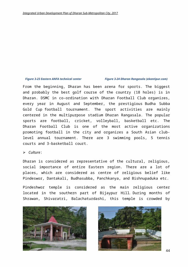
Integrated Urban Development Plan of Dharan Sub-Metropolitan City, 2017
Population density
945.88 per sq.km
715 per sq.km
-230.88 Decrease due to added boundary
HH 22,711 32,693 +9,982 Rate of building house growingFamily Size 4.3 4.21 - 0.09 Nuclear family increasing
Housing Female Ownership
Home
11.22% 20.18% +8.96% Women empowerment increasing
Pakki House 62.13% 64.05% +1.92% Large number of people can’t afford good house
Rented Home 7871 9767 +1896 Commercial activities increaseRoad Black Top 72.437
km106 km +33.563 Standard increment
Gravel 25.948 km
35 km +9.052 Easy travelling
Earthen 90.130 km
130 km +39.87 Connectivity increase
Electricity NEA Lines 75% 95% 20% Electric lines to most of the houses
Cooking Fuel Wood 49.61% 34.89% -14.72% Saving of forestLP Gas 37.38% 61.97% +24.59% Living standard growth
Kerosene 11.72% 1.45% - 10.27% Low fossil fuel consumptionWater Supply Taps 98.89% 93.84% -5.05% Insufficient supply of water
Education Literacy rate 77.19% 83.14% + 5.95% Awareness increasingFemale literacy 37.28% 77.36% +40.08% Women empowerment
Graduates 5.67% 5.09% - 0.58% Students migrating abroadEconomy Economically
active people50.49% 75.73% +25.24% Income generation growing
Industry No of industries 116 128 +12 Industry uplifting the economyEnvironment Without toilet 9.88% 2.92% -6.96% Open defecation decreasing
Sewerage - 2.82% +2.82% Initiation of sewerage
a) Physical Infrastructure:
33 km road was constructed. 39.8 km track opened with rural linkages. 2 new water sources on Railway and Pindeshwor. Rehabilitation of existing 3 water sources. Nearly 95% houses area connected to electricity. Ethnic Museum under construction.
b) Social:
Literacy rate increased to 83.14% with female literacy with outstanding increase to 77.36%encouraging gender equality.
Female ownership in land and houses rising. Nuclear Family trend is growing.
c) Economic:
25% increase in economically active population. More Industry is established. Agro farming and animal husbandry growing. Number of standard hotels and restaurants increasing. People attracted to organic farming.
44
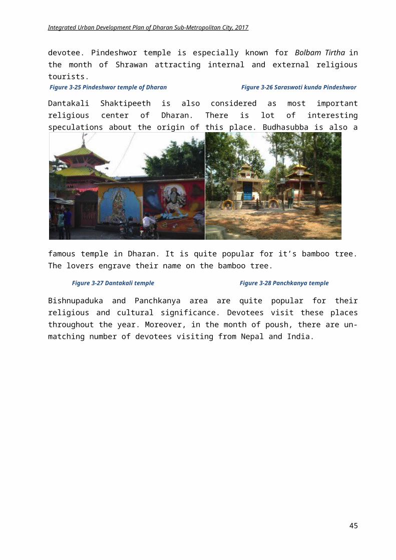
Integrated Urban Development Plan of Dharan Sub-Metropolitan City, 2017
d) Environmental:
Waste segregation concept is introduced. Energy generation plant from waste initiated. Public toilets construction in several areas. Solar energy usage and rainwater harvesting rising. Disaster Risk Management Plan for Dharan was prepared. Green homes concept for environmental sustainability growing.
e) Institutional:
Workshops and programs for strengthening the capacity development. E-governance intiated in municipality office.
4.2 Population growth trend and projection
According to a UN Study, “Population projections are calculations which show the future course of fertility, mortality and migration. They are in general purely formal calculations, developing the implications of the assumptions that are made.”The projection of population reveals expansion in city size i.e. urban growth. The MoUD (2015) states that urban growth is the consequences of three mutually reinforcing transitions:
Demographic transition i.e. more people are entering the labor force than leaving Spatial transition due to rural urban migration Economic transition due to the demise of the traditional subsistence economy, the declining
contribution of agriculture to the Gross Domestic Product (GDP) and search of new livelihood options
Based on CBS data, an analysis of urban population growth trend of Nepal is performed and it can be derived: urban population of Nepal is increasing rapidly from 1971 till 2001 and the trend will resume similarly and by 2031, 43.34% people as compared to rural will be living in the urban area that is clear in the following table and graph.
Table 4.16 Urban population growth trends1971 1981 1991 2001 2011 2021 2031
Urban Population
461938 956721 1695719 3227879 4523821 6902867 10143254
Rural population
11094045 14066118 16795378 19923544 21970683 23475186 23453778
Total Population
11555983 15022839 18491097 23151423 26494504 30378055 33597032
% Urban 3.99% 6.36% 9.17% 13.94% 17.07% 22.72% 30.19%
When overall population is growing in continual rate, Dharan also depicts the same growth trend. Dharan is also experiencing the urban growth due to
45
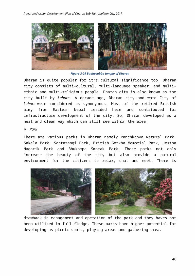
Integrated Urban Development Plan of Dharan Sub-Metropolitan City, 2017
Migration for economic opportunities Migration for official purposes Educational facilities Health facilities Rural urban linkages
The urban population of Dharan portrays continuous increment in previous years that can be obvious with the following chart.
Table 4.17 Urban population of Dharan in various years
With the rapid urbanization, more people will be migrating to urban areas, consequently increasing the size of the city. The annual growth rate of Dharan is 3.61% as per CBS 2011.The total population of Dharan as per CBS 2011 is 137,702 with male and female occupying 46.96% and 53.04% respectively. This rate is expected to increase in future due to the expansion of infrastructures and responsiveness of people to raise their living standard. Hence, the planning shall be done to accommodate the growing population that requires prediction of future demography. The population forecast for 20 years can be made with the formula for growth rate calculation,
Pt= Po (1+ r)t , where
Po = Population at the base year, Pt = Population after t years, r = growth rate
Using the above principle, by 2031, the population is expected to rise to 279,881. The population projection for the 20 years can be seen in the table below.
05000000
10000000150000002000000025000000300000003500000040000000
1971 1981 1991 2001 2011 2021 2031
Urban PopulationRural populationTotal Population
020000400006000080000
100000120000140000160000
1961 1971 1981 1991 2001 2011
PopulationIncrease
1961 1971 1981 1991 2001 2011Population 13998 20503 42146 66457 95332 137702Increase 6505 21643 24311 28875 42370
46
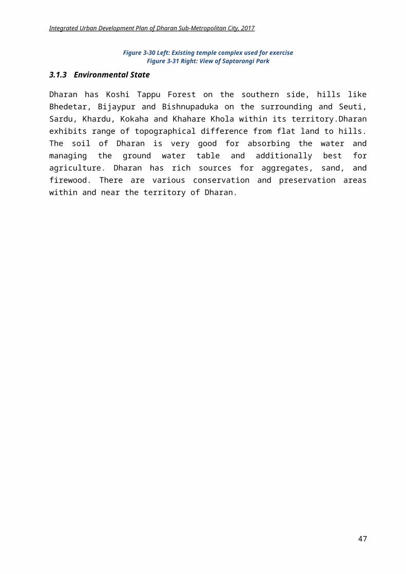
Integrated Urban Development Plan of Dharan Sub-Metropolitan City, 2017
Table 4.18 Population projection of Dharan for 2031
Population (2011) Projection (2017) Projection (2021) Projection (2031)
137,702 170,353 196,317 279,881
4.3 SWOT Analysis
SWOT refers to strengths, weaknesses, opportunities and threats. SWOT analysisis a process where the management team identifies the internal and external factors that will affect the city’s future performance. The city’s strengths and weaknesses are the internal factors and opportunity and threat are external factors. During IUDP, SWOT analysis is done for each sectoral theme to identify its potentials, major issues and probable risks thatareelucidated below.
4.3.1 Physical amenities
Land use planning
Road network
STRENGTHS Urban rural linkage/connectivity Convenience and convenience Time saving Easy / fast Service
WEAKNESS Unpaved and earthen road are high 60% Low quality road Dust, dirt, pollution No proper drain system No bicycle / pedestrian lanes
OPPORTUNITIES Direct growth of the city Economic growth Developing eco-friendly access Overall Development of the city Transform to Mega cities and global cities
THREATS Unmanaged growth and urban sprawl Increase in number of vehicles and lack of
road and parkings Air pollution Encroachment of natural setting Increase in crimes, safety issues
Transportation
STRENGTHS Eco friendly rickshaws and tempos Decreases comminuting time Convenience and luxury Ease lifestyle
WEAKNESS Use of fossil fuel Traffic congestion Dependent on technology No parking space
OPPORTUNITIES Promotion of biking Develop sustainable transport like BRT, car
sharing etc. Less impact on environment Reduce air and noise pollution
THREATS Safety issues to bicycle riders and pedestrians Conflict in ownership and management Issues of governance
Water supply system
STRENGTHS Control on growth Planned beautiful city Conservation of sensitive areas Identification of risky zones
WEAKNESS No proper implementing tools Lack of awareness No uniform design pattern Squatter settlement
OPPORTUNITIES Protection of environment Balance of eco-system Develop a uniform architecture pattern Improved Linkages between different usage
THREATS Forest area encroachment Phasing of development could lead to
exacerbation of safety concerns
47
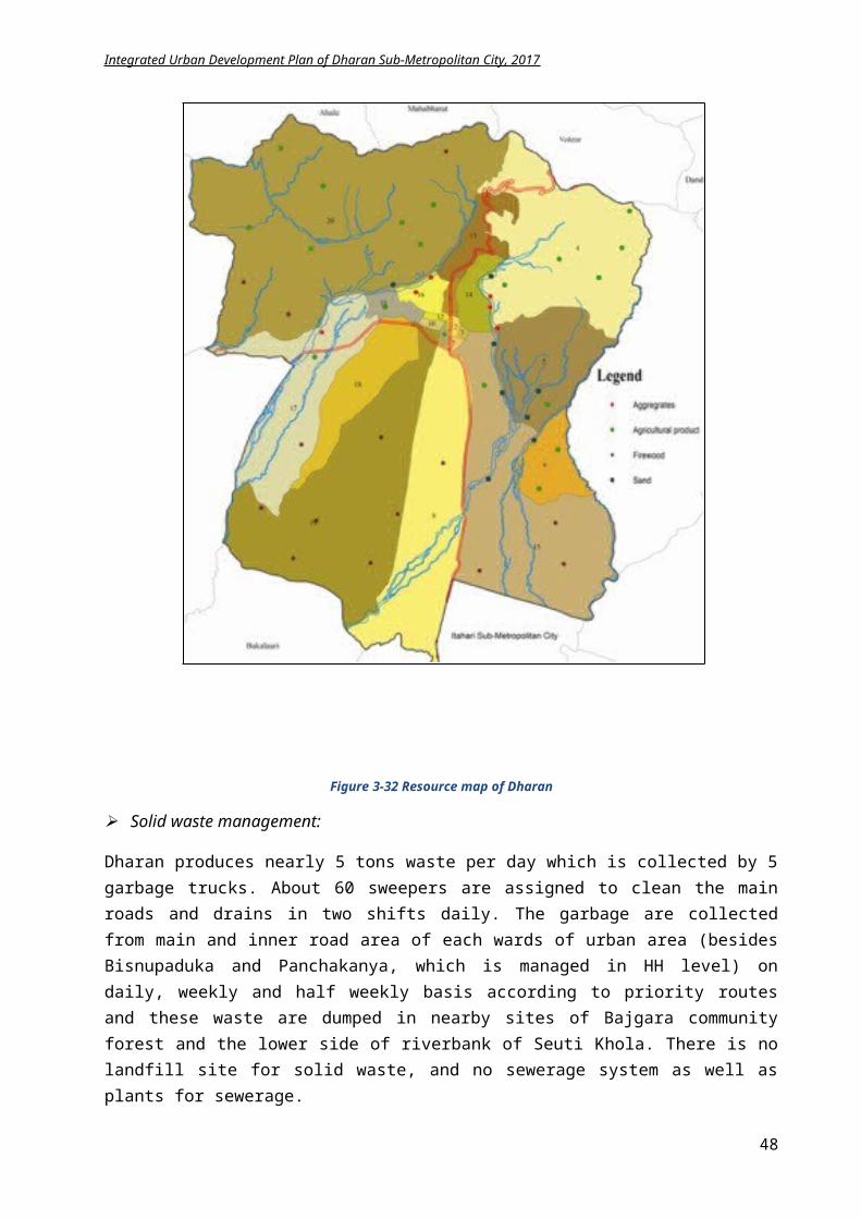
Integrated Urban Development Plan of Dharan Sub-Metropolitan City, 2017
STRENGTHS Presence of sardu and seuti khola Ample underground water resource Rain water harvesting initiation
WEAKNESS No treatment plants and storage areas Inadequate water supply to the citizens No water saving schemes in HH level
OPPORTUNITIES Rainwater harvesting for water storage Management of watershed of Sardu and seuti khola Alternativeinnovative solutions
THREATS Tube well use hamper water table label Waterhsed endangered
Drainage
STRENGTHS Natural terrain for drainage to seuti khola Soak pit in each HH for feces collection Only grey water on sewerage
WEAKNESS Inadequate drains No proper management Lack of ground water recharge Rainwater connected to sewerage No treatment plant for liquid waste
OPPORTUNITIES Well managed outlook of city Technology usage Innovative solutions
THREATS Increased cost for treatment plants Alteration on natural landscape Increase in paved surface
Electricity and Telecommunication
STRENGTHS Connection to maximum buildings Solar panels in some private homes Ease in communication through mobiles Rapid Flow of information Connection to the global world
WEAKNESS Low network coverage NTC and NCell dominant Privatization
OPPORTUNITIES Global connection Commercial market Income/revenue generation Joint ventures with various organizations
THREATS Increased cost Cyber crimes Privacy issues Dependency on technology Privatization
In the context of physical development larger number of unpaved roads, lack of sufficient drainage, inadequate water supply, devoid of sewerage system, improper commuting facility,predominantlyemerge as the main issues, whereas solar energy, rainwater harvesting, urban expansion provision, bicycles, electric and mass transit provide plentiful potential for physical amenities improvement.
4.3.2 Social amenities
Education
STRENGTHS High percentage of educated citizens Adequate number of educational institutes Famous Health institute Engineering college
WEAKNESS Traditional way of teaching Lower number of female educated Expensive Out of general public reach
48
Integrated Urban Development Plan of Dharan Sub-Metropolitan City, 2017
Food technology college Qualified employee generation Entice people from all over Nepal
Political influence Lack of qualified teachers Management issue
OPPORTUNITIES Education to all Economy growth Innovative solutions with new technology Development prospects
THREATS Population growth Increase in floating population Cyber crimes Develop as money generating institute Negative competition
Health
STRENGTHS Famous BPKHIS Accommodate large number of patients Private and public clinics to serve people Improved health of citizens Low mortality rate Accessibility in emergency
WEAKNESS Unmanaged and expensive No health insurances Political influence Lack of qualified doctors Developing as business than service Lack of new technology
OPPORTUNITIES Attract people from various zones Economic growth Competitiveness Development of modern technology in health
services
THREATS Population growth with floating population Low mortality rate Imbalance in population Business oriented and high price
Parks/Open Space
STRENGTHS Land availability Abundant parks and open space Balance in built ad natural environ Positive attitude of people Multi usage
WEAKNESS Problem of squatters and Dumping Abandoned Unproductive land Commercialization Lack of management
OPPORTUNITIES Use as shelter during emergency Income generation Ecosystem balance, Visual balance fo
THREATS Increased cost Squatter problem, Dumping Speculation and Price hike, privatization
Sports
STRENGTHS Stadium under ANFA Old football club Sports hall Increasing craze of sports like football and
cricket Broad minded citizens
WEAKNESS No proper management Lack of indoor sports area Political influence Lack of awareness High cost for infrastructure development Not compulsory on schools
OPPORTUNITIES Encourage new generation Increase global competitiveness Collaborate with schools for promotion
THREATS Developing sports as profession Maintaining reputation Risk on main stream education system
Security
49
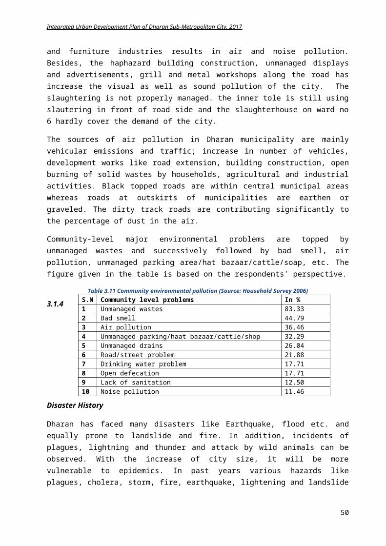
Integrated Urban Development Plan of Dharan Sub-Metropolitan City, 2017
STRENGTHS Allowances for old age, widow and disables Police stations in each ward Street lights in major streets Inclusion of local citizens
WEAKNESS Low rate of allowances Allowances not readily available No digital tracking of citizens High floating population Not adaptation to new technology Negative psychological impact on people
OPPORTUNITIES Increase social awareness Develop new technology Promote social security system
THREATS Increase in crime rates Dependent on technology
Social/Public Centers
STRENGTHS Available space for social centers Hub for exchange of ideas Build strong social relationship Educating medium Flexible usage Public willingness Knowledge sharing space
WEAKNESS Lack of enough number of public centers Increased crime rate Increase in disputes and quarrel Lack of security Lack of management Indifferent of new technology Investment issues
OPPORTUNITIES Secure public investments Promote new technology Increase communication and news flow Income generation Generation of job chances
THREATS Seasonal usage Security issues Crime increase Social issues Political influence
Decrease in family size, increasing outmigration from city, lack of social interaction, devoid of psychological security, increasing drug addiction and child and maternal mortality appears as main problems of the social environment of Dharan. The affluence of multi culture and multi ethnicity appears as a strong prospect encouraging to social development of backward and ethnic groups of Dharan. Health and education proves to be a strong backbone of Dharan.
4.3.3 Environmentalamenities
STRENGTHS About 44% coverage of Char Koshe Jhadi Abundant parks and community forest Large number of agricultural land Soak pits in each house Open defecation only 2% Waste Separation and waste recycling Waste to energy Disaster risk management plan
WEAKNESS Lack of land fill site Dumping haphazardly No conservation plans Inadequate drainage No sewerage lines Air pollution Open space not identified for hazard Evacuation plan not prepared for emergency Lack of public toilet
OPPORTUNITIES Manage forest and parks for income
generation Sustainable environmental condition Use organic waste commercially Alternative energy usage from waste Conservation of sensitive areas for
environment protection Attract tourist
THREATS River and ancient area encrochment Forest encroachment Increase in squatter settlement Increased urban population Lack of public awareness
River encroachment, lack of drainage, sewerage network, treatment plants and landfill sites, improper dumping, increasing air pollution lack of public toilets is the main environmental issues of
50
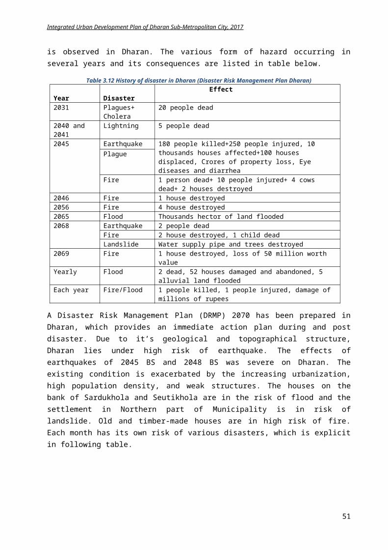
Integrated Urban Development Plan of Dharan Sub-Metropolitan City, 2017
Dharan. The growing public responsiveness on waste recycling, usage of rainwater, preparation of disaster risk management plan and investments in community forest and community parks proves the consciousness of citizen of Dharan towards environmental protection.
4.3.4 Economy
STRENGTHS Agro farming and animal husbandry Organic farming Industries Cultural heritage areas Hiking, cycling in nearby hills Sightseeing Tourism destinations Parks and community forest Famous education and health institute
WEAKNESS Lack of advertisements Decreasing attraction in agriculture Traditional technology Inadequate physical infrastructures Lack of irrigation facility Inadequate bus park and transportation facility Lack of proper funding for projects Inefficient management of internal and external
resourcesOPPORTUNITIES
Attract youth in agriculture Use of Modern techniques in agro farming Potential of tourism development through
pond, cable car, rafting, hiking and cycling trail, heritage site
Encouragement to industry through tax exemption
Develop Ayurveda centers Off-season farming Homestay
THREATS Increasing migrating trends due to
unemployment Lack of qualified and experienced trainers for
modern agriculture techniques Increased floating population Higher commuting price Costly tranportation infrastructure
As agriculture land is limited with growth of urban area, it is necessary to promote farming culture around the outside core city i.e. Bisnupaduka and Panchkanya. It is a good symptom that the new generations are attracting in commercial farming which will help for uplifting economic condition. Furthermore, it has prospectus of agro-tourism, home stey and is essential to develop a proper infrastructure for tourism. The social and cultural diversification, rich Kirat and Limbu culture is the assest for cultural tourism.
4.3.5 Institutional framework
STRENGTHS New constitution, local government
reformation Elected body E-governance initiation in sub metro office Workshops and trainings for strengthening
capacity development of staffs Public participation for development works Ward level offices Various local social groups
WEAKNESS Delay on acts, policies from central government Lack of coordination between different
stakeholders Traditional monitoring and evaluation techniques Work culture of staffs still not service oriented. Time consuming
OPPORTUNITIES Reformation Digital system in government office Effective management system Ward level service and reduce travel time Transparency
THREATS Staffs vision not change Superiority of donor agencies Lack of public awareness Security problems Lack of plans and programs
Public participation is already a model in Dharan. It is essential to maintain this identity and increase the citizens’ involvement in various projects for creating a sense of belonging. Also, e-governance and digital usage is necessary to ease the working methodology and updating the traditional technology.
51
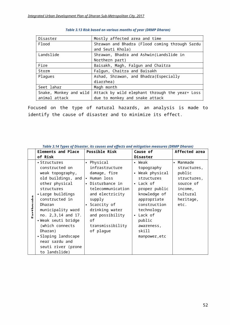
Integrated Urban Development Plan of Dharan Sub-Metropolitan City, 2017
4.4 Spatial Analysis
Dharan is expanding rapidly in these years since its establishment as a municipality in 2017 B.S. Initially there were 11 wards in Dharan that expanded to 19 wards in 2035 B.S with integration of Bajghara VDC in east and Gopha VDC in west. Furthermore, in early months of 2071, Panchkanya VDC of east was incorporated in Dharan Municipality extending the wards to 23 numbers and finally on later months of 2071, Bidhnupaduka VDC of west was also integrated in Dharan rising the number of ward to 27 wards (readjustment to 20 wards finally) and thus increasing the city size to 192.98 sq.km from 103.41 sq.km.
Figure 4-38 Map showing gradient of topography of Dharan
Dharan has varying terrain from lowland on south to hill on north side. South side is covered with conserved Char Koshe Forest, which is about 44%. From the GIS map at right, it can be observed that the area having slope greater than 30o is around 30% on north side. Hence, it can be derived that merely20% land area can be used for urban purpose like dwelling, agriculture etc. Currently Dharan has 4% built area that is relatively low compared to other sub metropolitan cities of Nepal. The GIS land use map depicts the increasing building growth. Increase in rate of construction over timemark this increasing spatial usage that can be verified with the 900 building permits per year.
4.5 Financial Analysis
From the yearly F.Y reports, it can be derived that the main source of income of Dharan is taxes, service charge, rent and participation, besides grants.Most of the budget is spent on the physical infrastructure development works, focused group projects and staff salaries. It is observed, less amount of money is spent on environmental, cultural and economic development.
Table 4.19Comparison of revenues of DSMC over various fiscal yearsRevenue F.Y 2067/68 F.Y 2068/69 F.Y 2069/70 F.Y 2070/71Taxes 13537249 14699837 18027093.12 20682549.58Service charges 15593905 15958923 18961547 23915930.25Rent 1434075 1381882 1930039 2095471Participation 26594770 39197201 9992679 22741421
Table 4.20Comparison of expenses of DSMC over various fiscal yearsExpenses F.Y 2068/69 F.Y 2069/70 F.Y 2070/71Salary 29050591 26752888.51 27974596Infrastructure 96802189 109684700Improvement programs 12465165 7787728Focused program 13216203 6054493.74
52
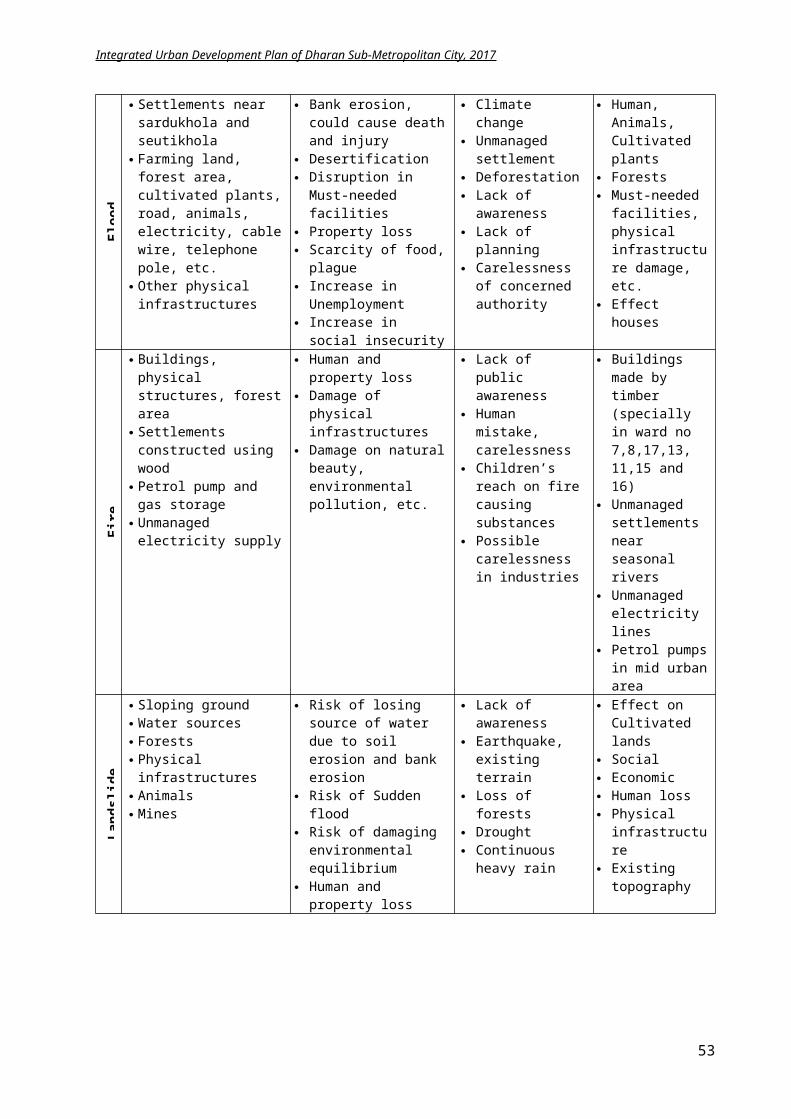
Integrated Urban Development Plan of Dharan Sub-Metropolitan City, 2017
4.6 Demand Analysis and Forecast
The forecast of population reveals increase in city size. With developmentperiod, the city will expand rapidly, thus escalating the demand in many urban services like water supply, solid waste management, housing plots and road. To address these issues, the municipality has to plan accordinglyconsidering infrastructures large enough to cater future demand.The IUDP is expected to accommodate the prerequisites of the growing population and the mandatory infrastructures needed planning likewise.
Demand analysis is performed for the coming years and a supply forecast is attainedbased on the “Urban planning norms and standards 2015.” Keeping under consideration the available existing resources and amenities, a gap is identified for the deficit facilities from the supply forecast for forthcoming years and projects/programs are formulated.
53
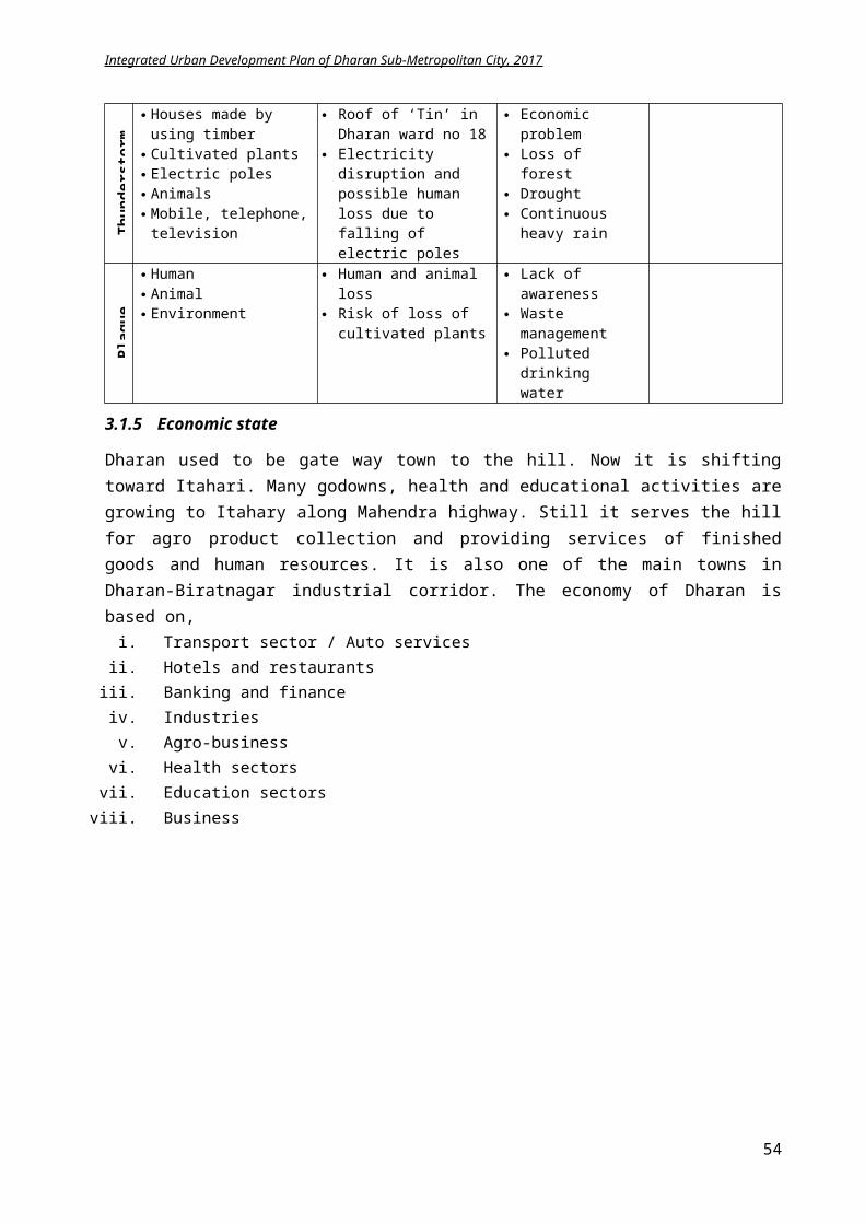
Integrated Urban Development Plan of Dharan Sub-Metropolitan City, 2017
4.6.1 Physical Infrastructure Demand Analysis
An analysis is done based on “Urban planning norms and standards 2015” for achieving the standard of Sub Metropolitan city of Nepal and the forecastedscarcity in physical infrastructure is explicit in the following table.
Table 4.21 Physical Infrastructure Demand Analysis
Types Norms Standards Existing Infrastructure
Supply Forecast 2032 Deficit Remarks
Road
7 km/sq.km ROW Setback
Footpath
Cycle Track 6.35 km/sq.km 7 km/sq.km 0.65km/sq.km 7km/sq.km
achievedExpress way, Arterial, Sub Arterial, Collector street and Local Street
Expressway
674.6 km
742.98 km
68.38 km
New construct
Arterial 30 1 2 2
All or 90% of household are within 0.5km from motorable road
Sub Arterial 22 1 2 1.5 40% Black top 100% Black top 60% Make 490kmroad
black top Collector 14 1 2 1.5 Local 10 1 2 -
Water Supply System (with storage and treatment facilities)
Metered house connection and distribution
Quantity: 100 lpcd 75lpcd 100lpcd 25lpcd Identify water sources
Elevated or underground storage reservoir
Storage capacity: 25% of total treatment capacity 19.72 Million Lit 27.9 Million Lit 8.18 Million Lit Use rainwater
harvesting
Provision of Rain water Harvesting in public buildings
Storage capacity: 7 to 10 thousand Litres In some buildings
65% of total buildings 60% buildings 730 million Litres
of rainwater
Sanitation (Sewerage System)
Full coverage by public sewer system
Min diameter of trunk line: 200mm 0.01 ha – 0.02 ha per site --- 742.98 km 742.98km New to be planned
Treatment plant 5 ha – 7 ha per site (2 Nos) No treatment plant 2 no 2 nos. New Plan and
DesignProvision of public latrines (male, female, disabled)
1 public toilet at a distance of 5km along the main road. 5 20 15 nos. New Plan and
design
Integrated Solid Waste Management
Collection Point (0.4kg/person/day)
Community collection/ Door-to-Door collection.
0.18 kg/person/day
(30 ton)
0.10 kg/person/day
(42 ton)
-0,08 kg/person/day
Reduce waste by 40%
54
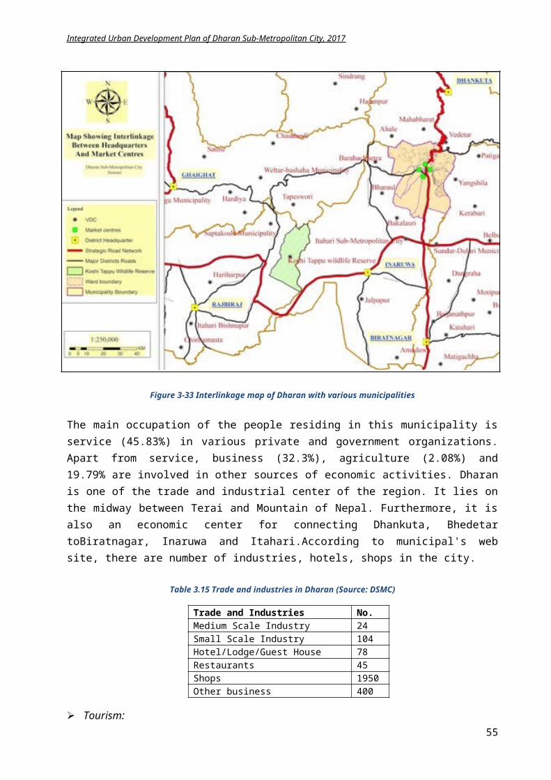
Integrated Urban Development Plan of Dharan Sub-Metropolitan City, 2017
Household level wasteseparation
1 collection point/container/ roadside pickup point serves a radius of 200m
Each day collection
Add dustbins on roadside
Transfer Station 1 Transfer Station for 1 city if the final disposal is within a distance of 10 km -- 1 no. 1 no. Plan a new
Sanitary Landfill Site Large (> then 500 tons per day) No sanitary landfill 1 no. 1 no. Plan a new
Electricity
National grid supply line and Alternative energy
Power access to 100% coverage. Electric Sub Station: 3 haTransmission Tower: 80 - 100 sq. m Distribution Tower: 20 - 25 sq. m
95% 100% 5% Promote solar energy in all
building through bye lawsAlternative Energy
(panels, battery) Solar Home System Some Private residence All buildings
Tele-communication
Landline/mobile 100 % coverage 50% 100% coverage 50% Addition ofpoints Public telephone booth (TB)
Telephone Transmission tower (ROW: 5m)1 TB at a distance of 2.5km along the main road (Standard booth)
16 TB
64 TB @ 2.5 km
48 no
New to be planned
Climate Change Center/ Disaster Management Center
City Level 1 ha along with suitable open area (2ha) for soft parking, temporary shelter, parade ground
Not identified
Stadium, open space of
BPKHIS, PU and park to be used for temporary
shelter
15 nos.
No new planning needed, only
awareness and improvisation of
evacuation routes
55
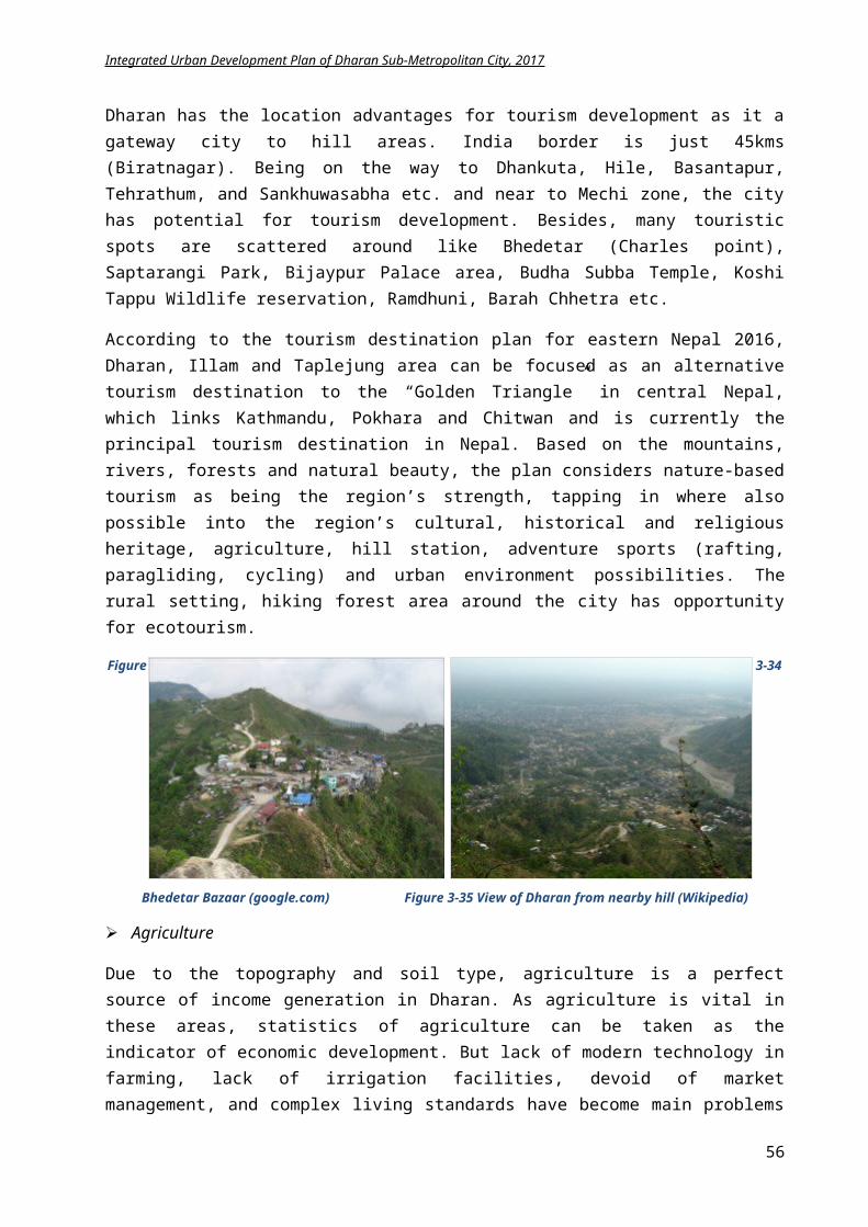
Integrated Urban Development Plan of Dharan Sub-Metropolitan City, 2017
4.6.2 Social Infrastructure Demand Analysis
An analysis is done based on “Urban planning norms and standards 2015” for achieving the standard of Sub Metropolitan city of Nepal and the forecasted scarcity in social infrastructure is explicit in the following table.
Table 4.22 Social infrastructure Demand Analysis
Types Norms Standards Existing Infrastructure
Supply Forecast 2032 Deficit Remarks
Educational Institution
Primary 1 per 3000 population at a distance of 0.4–0.8 km – 0.2 ha per site 91 nos. 94 nos. 3 nos. Construct
new schoolsHigher Secondary 1 per 7500 population at a distance of
30min in public transportation – 0.65 ha per site
32 nos. 38 nos. 6 nos. Add new high schools
Graduate/Post Graduate
1 per 25,000 population at a distance of 45min in public transportation 17 nos. 12 nos. No Upgrade only
University 1 per 40,000 population at a distance of 1hr in public transportation 5 nos. 6 nos. 1 An agricultural
university
Health Institution
District Hospital 1 per 50000 population (25 – 50 beds) 25 clinics 7 clinics No Abundant number, upgrade only
Zonal Hospital 1 per 100000 population (50 – 100 beds) 1 (650 bed) 3 (100 beds) No No extra, upgrade only
Open Space
5% of total sub metro city area 22.78% 22.78% No Improve existing
Local Park 1 @ 1000 population (1 ha per site) 6 nos. 1 park in each ward 14 nos. New to be planned
Community Park 1 @ 20000 population (2 ha per site)66 nos.
community forest
14 No Improve only
Zoo park 1 Not planned
LibraryCommunity level
Library with community hall: 1 for 15,000 population, area -2000 sq.m 9 18 9 Identify location and
construct newCommunity room: 1 for 5000 population, area – 660 sq.m 2 20 18 Plan for one in each
ward
National/Central 1 per 10000 population (0.5 hectare per site) 1 1 No Improve facility only
56
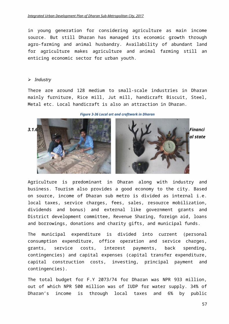
Integrated Urban Development Plan of Dharan Sub-Metropolitan City, 2017
Fire Station City level (5 to 7 km radius)
1 fire station @ 1,00,000 population (10,000 sq m per site)
1 with 3 fire brigade
2 nos.1
Design a new one
Religious Institution
Incineration /cremation areas 0.4 ha per site
In community forest and river
banks
New electric incineration 2
Improvise infrastructure, add electric chamber
Museum Regional Level 0.5 ha per site 1 under construction 1 no. No
Improve the under construction
museumArt Gallery Regional Level 0.5 ha per site No gallery 1 no. 1 New to be designedOld age home, orphanage, center for differently able people, sanatorium
Regional Level/Local Level 1 per 20,000 population (0.3 ha per site Not identified 1 no. 1 New to be designed
Police post 1 per 10,000 population (0.1 ha per site) Police bit in each ward
Police post in each ward 20 Improve structure
and facility
Security Police Station 1 per 40,000 population (0.5 ha per site) No 7 7 Construct new buildings
Police Headquarter 1 per 100,000 population (1 ha per site) No 1 no. 1 Construct newScience and Innovation Center (Exhibition Centers)
Regional Level 1 per 50,000 population (4 ha per site) 2 nos 5 nos 3 nos. Plan and Design new
57
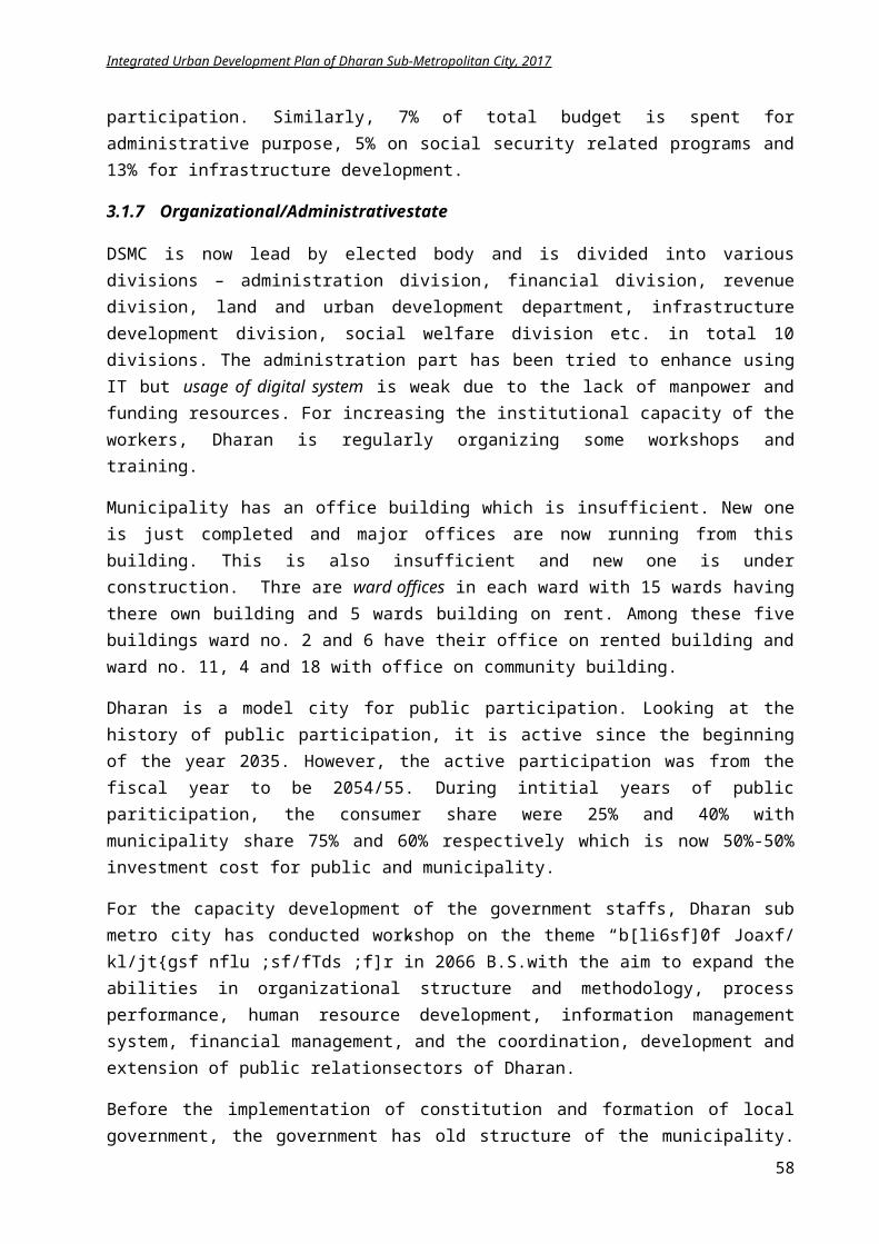
Integrated Urban Development Plan of Dharan Sub-Metropolitan City, 2017
4.6.3 Economic Infrastructure Demand Analysis
An analysis is done based on “Urban planning norms and standards 2015” for achieving the standard of Sub Metropolitan city of Nepal and the forecasted scarcity in economic infrastructure is explicit in the following table.
Table 4.23 Economic Infrastructure Demand Analysis
Types Norms Standards Existing Infrastructure
Supply Forecast 2032 Deficit Remarks
Convention Hall City level 1 per 100000 population (2 ha per site) 3 nos. 3 nos. No Upgrade only
Sports Complexes Regional level 1 per 100000 population (3 ha per site) 2 nos. 3 nos. 1 no. Plan for a new
Movie Hall Multiple halls 5 seats per 1000 population 2 nos. 7 nos. with 200
capacity 5 nos. New to be planned
Vegetable Market Neighborhood level
1 wholesale, 1 retail and 1 Slaughter house for 2 neighborhood (0.5 ha per site)1 Neighborhood = 3000 population
1 slaughter house
2 wholesale
2 slaughter house and 5 wholesale
market
1 new slaughter
house3 new
wholesale market
Identify locations and design and plan
for new
Parking space
Public parking (two/ three wheeler)
1 parking lot for each neighborhood1 neighborhood = 3000 population
Public parking in current bus-stop and road sides
Public Parking four wheeler (including provision for vertical parking)
Private parking in residence
1 public parking space for 4
wards8 nos. Plan and design for
new
Transportation system
Intra City Bus Terminal (Linking with other cities) along with urban service centers/ motels/ gas stations
1 parking lot for 200 buses and 200 trucks
1 bus stop for 20 buses
3 nos.
2 nos.
Plan and design for new bus parks
Airport National and International Airport
346 hectares – International Airport 134-227 hectares – National Airport
Airport at 40 km from Dharan
(1hr)1 1 Feasibility study
58
New Tourism Triangle
Current Golden Triangle
Integrated Urban Development Plan of Dharan Sub-Metropolitan City, 2017
4.7 Planning Concept for IUDP
Focused on the plan, The Tourism Product of the East: “Green East”, of Tourism Destination Area Plan of Eastern Nepal (2016, p.16), Dharan is to be groomed as a Green city. This regional destination area based plan is focused on establishing Dharan, Illam and Taplejung area of east as an alternative tourism destination to the “Golden Triangle” in central Nepal that connects Kathmandu, Pokhara and Chitwan making it currently the famous tourism destination. This plan embraces nature-based tourism, like mountains, rivers, forests and natural beauty, to be its strength and moreover considering region’s cultural, historical and religious heritages, agriculture, hill station, adventure sports (rafting, paragliding, cycling, canoeing, rack climbing and other urban environment possibilities.
Figure
4-39 Tourism golden triangle location map
Park
59
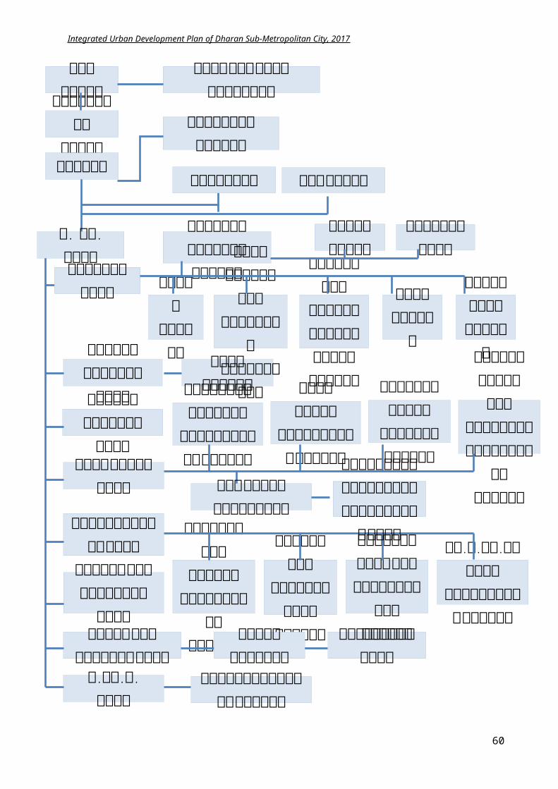
Integrated Urban Development Plan of Dharan Sub-Metropolitan City, 2017
Figure 4-40 Elements of green city
For a city to be considered “green”, measures must be taken in comprehensive manner that not only positively impacts to the city but also contributes to the environmental sustainability of the global level. For achieving a Green city, investment is required in:
a) Low Carbon Transport:
It refers to cycling, walking and public transport encouragement, use of energy efficient vehicles, thus having zero or low emission reducing Green house Gases (GHG). It also promotes the public transit oriented urban development like bus rapid transit, electric railway.
Figure 4-41 Low carbon transport
Dharan has initiation in zero emission rickshaws and cycles. Besides, railway transit and other public transport mode are on planning list from central government.
b) Green Industry:
Green industry refers to the waste reduction through Circle Economy in which byproducts of one industry is used as input of other industry. Green industry concept advocates reducing contamination at sources and effective management of sources.
Recycling the plastics and making mats and other decorative items is one the examples of green industry. Decaying the organic waste and using it as fertilizers, generating energy from waste are some of the green industry initiatives in Dharan.
c) Energy Efficient Building:
60
Integrated Urban Development Plan of Dharan Sub-Metropolitan City, 2017
This refers to reduce the amount of energy required for providing products and service. Like insulating a home allows a building to use less heating and cooling energy to achieve and maintain a comfortable temperature. Use of solar energy, wind energy, rain water harvesting for managing the day to day activities thus reducing the load in environment is termed as low energy consumption or sustainable energy usage.
Dharan has also commenced programs of solar lights, solar panels and rainwater harvesting in the city.
d) City Greening:
Increasing the greenery in the city through Roof Garden, Urban Farming, Vertical Farming, rain garden, Agricultural land, permeable pavement, Parks and Forest are elements of city greening. With the increase in built up area, city is lacking respective greenery. Greening the city is necessary for controlling the urban environment.
Dharan has conserved Char Koshe Jhadi that occupies 44% of total area. Moreover, private and community parks and forest, private gardens, side bushes uplifts the green environment of the city.
Figure 4-42 Left: City greening (google.com)
Figure 4-43 RIght: Eco friendly concept (google.com)
e) Green, Resilient Infrastructure:
Green infrastructure deals with the technology that use natural environment in a way that it maximizes its functions and seeks to put in place, either through regulatory or planning policy, mechanisms that ensure protection of natural environment, and proposes how these can be put in place through landscaped and/or engineered activities. These includes smart grid and distributed power for reducing energy consumption, using energy saving bulbs, automatic switching of streetlights during daylight or non-usage. This also refers to the decrease in energy consumption of public buildings through efficient management.
Smart grid combined with solar panels isbeing used for electricity in private buildings in Dharan.
f) Intelligent System:
61
Concept:Dharan: One of the elements of Green East
Lead Sector: HealthEducationTourism
Trade
Vision:A Multi-cultural livable city with proper education, health, tourism and trade amenities.”
Integrated Urban Development Plan of Dharan Sub-Metropolitan City, 2017
Intelligent system indicates the smart city strategy includesinstalling municipal wire line or wireless broadband networks; implementing e-government by providing a digital access to city departments’ web sites; integrating public transit with intelligent facility systems; developing distributed RES networks cutting carbon footprints, applying eco principles to reduce, recover, recycle, and reuse the urban resources. Energy-efficient solutions, computer networks, intelligent building networks, digital networking equipment, data analytics software, optical telecommunications systems, smart mobile networks, smart/intelligent applications, technologies, devices, objects, and systems, intelligent sensor/actuator networks, intelligent traffic systems, smart community technologies, resources tracking systems, all this are constituents of a smart urban entity.
Dharan Sub metro office has been using the e-governance system for tracking records but still digital system usage is lacking improvement, upgrading and holistic usage.
Figure 4-44 Intelligent system of Dharan
Among the six features of Green city concept, Dharan has extended its footstep towards every component in small extent. This supports the advocacy of Dharan as a green city of east.Hence, planning concept for IUDP of Dharan adopts the measures guiding to the green city for achieving its long-term vision of “A Multi-cultural livable city with proper education, health, tourism and trade amenities.”
62
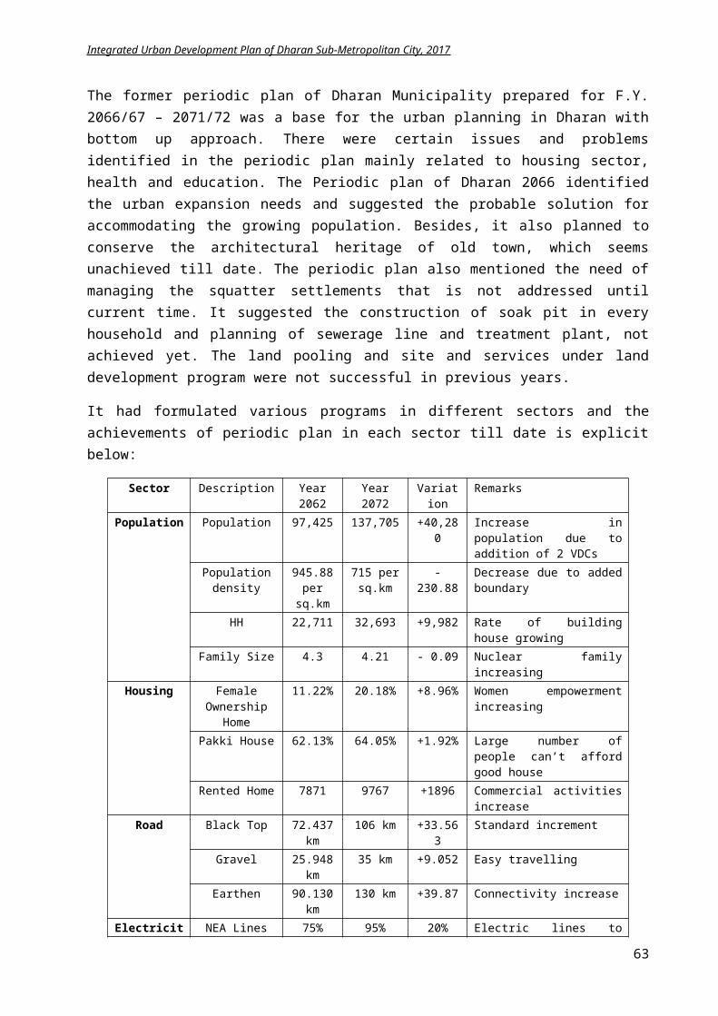
Integrated Urban Development Plan of Dharan Sub-Metropolitan City, 2017
From the prevailing situation analysis and vision, the lead sector for development of Dharan is identified. Collaborating the lead sectors with the green concept, an urban development idea is envisaged for achieving a livable sustainable Dharan city with social, economical and environmental equilibrium.
5 Chapter V: Thematic Urban Development Plan
5.1 Physical Development Plan
Physical planning is a comprehensive, multi sectorial master plan, which provides a planned spatial framework of development for the physical environment within which a balanced programme of social and economic development can be carried out. It provides the legislation necessary for the planning, controlling and implementation of the physical development process and is done to ensure the establishment of centralized infrastructure with overall responsibility for planning, evaluation, co-ordination, administration and implementation.
5.1.1 Goal and Objectives
Goal: Increasing the living standard of citizens with well equipped physical amenities utilizing less resources and maintaining the ecological stability
The long-term physical development plan of Dharan aims to improve the urban infrastructures of the Dharan. The urban infrastructures are classified as physical, social and economic.
Objectives:
To improveand developthe conditions ofroad and invest on new connections To identify the probable water supply sources To plan for new sewerage systems To prepare plan for solid waste management To encourage the usage of alternative sources for electricity To increase network efficiency of Telecommunication To identify the places for new bus stop, parking space and construct bus stops and public
toilets in required places. To repair and develop social infrastructure like Education Institution, Health Institution,
Open Space, Community Hall, and Library To increase usage of alternative energy and resources To coneect the infrastructure with digital technology To rehabilitate economic infrastructure like Parking Space, Stadium, Sports Complex, and
Movie Hall To improve the land and housing demand To prepare a proper land use plan catering the future need
63
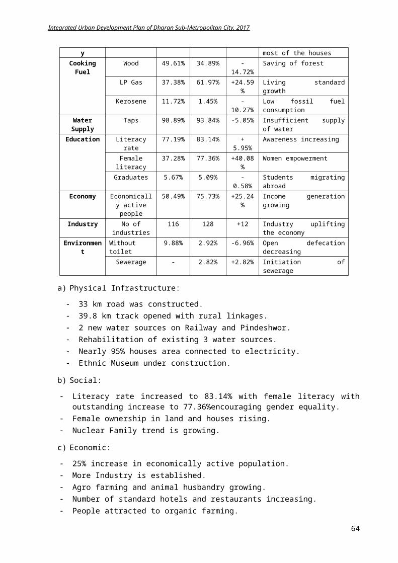
Integrated Urban Development Plan of Dharan Sub-Metropolitan City, 2017
5.1.2 Plan and Programs
5.1.2.1 Land use and urban expansion
Based on the inventory and situation analysis, the need of physical facilities for next 20 years is identified. To restrict the haphazard growth in future, a land use planning with different zoning is proposed. A proposed land use plan with the following is prepared.
i.Residential, ii.Institutional, iii.Industrial, iv.Preserved, v.Green, vi.Recreational, vii.Urban expansion, viii.Stream/river banks, ix.Agriculture, x.Others
The proposed zoning has obvious segregation of following areas namely:Urban areas, urban expansion areas, Natural resource areas, Calamity prone areas andConservation areas
The urban area can be categorized in following way.
Core area (Central Business District): The area along the Koshi Highway and from Bhanu Chowk to peripheral area having massive business activities and growth of health, business and service sector. It is potential business hub and transaction of trade and commerce.
Periphery area: Mainly residential and cottage, grocery, slaughtering, godown and other activities are on periphery of CBD. Some of those areas have industries, hotels and new business complexes. Those areas lieson periphery, demanding more investments on road, drainage and enhancement of public places.
Newly incorporated developing area: Panchkanya VDC added to municipality is on the southern part of main city area. The area being predominantly rural has opportunity for planned settlement. Much infrastructure investment is needed there. The Bisnuaduka predominantly hill area has no such a flat area for urban expansion. Besids this many agro farming, vegetable production can encourage there. The all whether road link is necessary.
Institutional area: The area with the educational facilities, health facilites and government offices are scattered around the CBD. The educational facilities are near the southern side due to the availablity of large area of land.
Indutrial area: Industrial zone is also situated on the southern side. The existing industrial area need to expand for accomodating more industries.
The immediate urban area expansion is to be limited within the older settlement of Dharan by alteration in byelaws. Then after, for restricting urban sprawl, gradual increase of towns can be planned in the neighboring wards of Bishnupaduka and Panchkanya. Near the two rivers Seuti and Sardu, the open lands are available for further expansion.
64
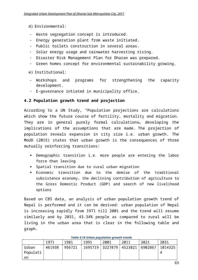
Integrated Urban Development Plan of Dharan Sub-Metropolitan City, 2017
Figure 5-45 Proposed land use plan of Dharan
5.1.2.2 Housing demands
The existing housing facilities shall also be upgraded with amenities. Besides, housing for low and middle-income groups shall be commenced from government level in collaboration with private sectors to enhance their living condition. Additionally, readjustment and relocation of squatter settlements mainly near river area shall be done.
From the population projection, it is observed with the annual growth rate of 3.61%, by 2031, the population will rise to 279,881i.e. 100,000 people shall be adjusted in the city. There are two ways to accommodate this raised population: i) densification in core area with occupying the vacant lands ii) urban expansion on periphery like Panchkanya and Bishnupaduka.
Three techniques for providing housing i) land pooling for single-family dwellers, ii) medium rise apartments (10 storey) and iii) low rise apartments (5 storey)
If we assume20% will prefer single dwelling units, 40% low rise and 40% medium rise apartments, total 75.18 Hectare area is needed. The calculation for each dwelling unit is explained below.
Single family dwelling:
20% of 100,000 = 20,000 people1 family dwelling unit = 80 sq.m+30% outer circulation space = 108 sq.mSingle family size = 20,000/5 =4000 familiesFor 4000 families space needed = 4000*108 sq.m = 432000 sq.m = 43.2 Hectare
Low Rise Apartment:
65
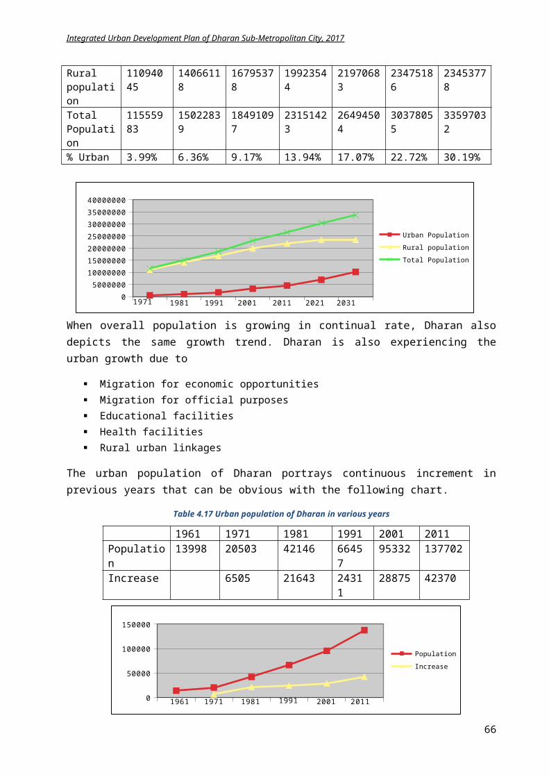
Integrated Urban Development Plan of Dharan Sub-Metropolitan City, 2017
40% of 100,000 = 40,000 people1 two bed apartment size = 60 sq.m to cater single family of 5 peopleSixapartmentunits in one floor = 360 sq.mGround coverage of Apartment = 360 sq.m+ 30% circulation space = 400 sq.mLand Area for Apartment = 800 sq.m5 storey one Low rise apartment = 400 sq.m*5=2000 sq.m1 low rise apartment have 6*5 = 30 units = 30*5= 150 peopleTotal number of apartment required = 40000/150 = 266 apartmentsTotal area required for low rise apartment = 266*800 sq.m = 212800 sq.m = 21.28 Hectares
Medium Rise Apartment:
40% of 100,000 = 40,000 people1 two bed apartment size = 60 sq.m to cater single family of 5 peopleSix apartment units in one floor = 360 sq.mGround coverage of Apartment = 360 sq.m+ 30% circulation space = 400 sq.mLand Area for Apartment = 800 sq.m10 storey one medium rise apartment = 400 sq.m*10=4,000 sq.m1 medium rise apartment have 6*10 = 60 units = 60*5= 300 peopleTotal number of apartment required = 40000/300 = 133 apartmentsTotal area required for low rise apartment = 133*800 sq.m = 106400 sq.m = 10.64 Hectares
Thus, about 400 units of single family units, 8 low rise apartment and 3 mid rise apartment will adjust the augmented population.
The vacant land in the city area is supposed to be occupied at first attaining the maximum urban density. It is expected that the scanty scattered settlement around Bishnupaduka temple will also be densified with time, when the infrastructures are improved. Moreover, the settlements of Panchkanya will also be dense in future. The probable urban expansion area for the new settlements is shown in proposed Land Use plan in Appendix II.
5.1.2.3 Road Network
From the demand analysis, the existing road network of 674.6 km is to be upgraded to 742.98 km that
66
Integrated Urban Development Plan of Dharan Sub-Metropolitan City, 2017
suggest 68.38 km road has to be constructed for meeting the Sub metropolitan standard of 7 km/sq.km.
Figure 5-46 Proposed road network of Dharan
Based on Department of Roads (DoR) and DUDBC, classification of road is done as
1. Highway (50m):The highway passing through settlement shall be made 4 lanes and footpath and cycle lanes shall be made on the either sides encouraging environment friendly approach and safety.
2. Feeder Road (Class A): 30m3. Urban Road: The hierarchy of urban road of DSMC is categorized as:
i. Ring road: 30 m
The proposed inner ring road have 4 lanes vehicle travel, with cycle lane, footpath and pedestrian track with greenery. The river corridor and ring road shall meet this standard. The standard from the urban road standards shall be followed. It is proposed to make the ring road currently 2 lanes that can be expanded to either 4 lanes in future or with provision of monorail. All the services like electricity, sewerage, telephone, water shall be made underground in this new planned ring road.
Figure 5-47 Typical Section
of ringroad option1
67
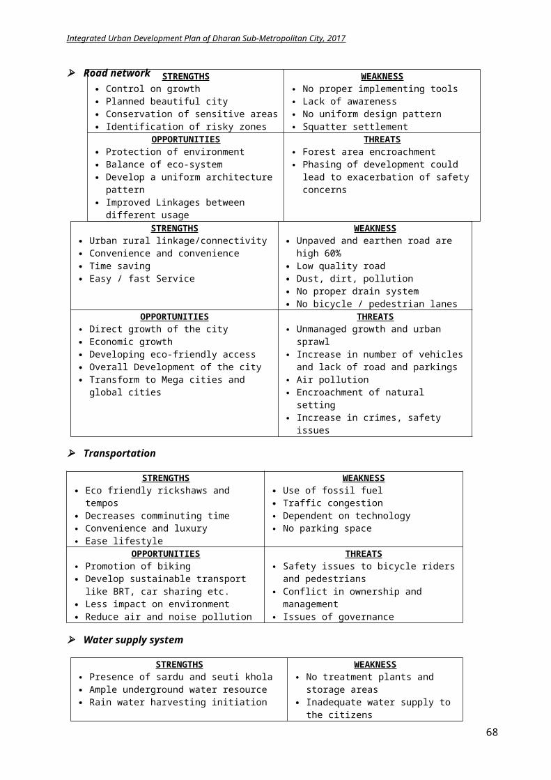
Integrated Urban Development Plan of Dharan Sub-Metropolitan City, 2017
Figure 5-48 Typical Section of ring road option 2
i. Collector Road A (Class B) ≥ 12m
This city urban road,with width greater than 12m,willconnect the access road to the feeder road, ring road and highway. These roads have 2 lanes for vehicle travel, two cycle lane and pedestrian lane with greenery comes under this category. The major road urban road of Dharan connecting to ring road shall have the width of 15m.A cycling lane and pedestrian track needs to be incorporated in some existing road in old city area and cultural heritage sites.
The road with 22m width is as follows:
S.N Name of Road From To1 Buddha Marga Tax office South 2 Camp road Pariwar Niyojan Tinkune Jungle3 Madan bhandari Marga Zero point Dhankuta road
Figure 5-49 Typical section of urban road "Class B" Option 1
68
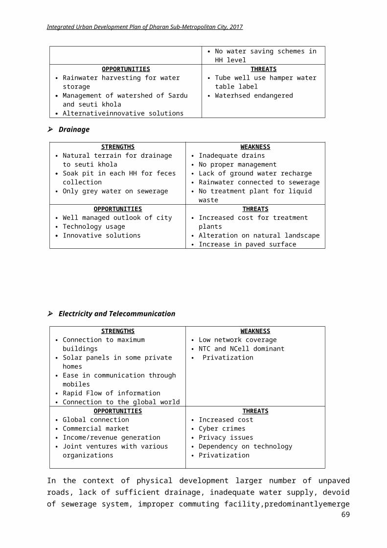
Integrated Urban Development Plan of Dharan Sub-Metropolitan City, 2017
Figure 5-50 Typical Section of urban road "Class B" option 2
The existing road of 11m shall be widened to 12m width based on road standard.Following road of DSMC shall be 15m that can be found in detail in ANNEX VI (Planning and Building Bye Laws).
S.N Name of Road From To1 Prithvi Path Simhadevi Line Red cross 2 Amarhaat Marga Krishi Upaz Dhankute road3 Laxmi Sadak Chhata Chowk Laxmi Chowk4 Tribhuwan Path Simhadevi line Ratna Road5 Mahendrapath/Buddha marga Ghantaghar Old Tax office6 Deshi Line Bhanu chowk Bhaudi7 Putali line Bus park Chatara Marga8 Kailash Path Machha bhaudi Chiniya Chowk9 Sadan road Machha bhaudi Sadan School10 Itahari Sadak Panchkanya Main road South Forest Itahari11 Panbari Main road Panbari Chokti Sunsari boundary12 Putali line Khahare Kalyan Chowk13 Narayan path Chatara line Dhankute road14 Chatara line Janapath chowk Mangalbare 15 Putali line Narayan chowk Kalyan Chowk16 Aishwarya marga Mangalbare Saptanrangi park marga17 Mahendrapath Ghantaghar Chhata chowk18 Chatara Line Chhata chowk Janapath chowk19 Amarpath Laxmi chowk Phushre20 Bhagwati marga Amarpath Pashupati chowk21 Surya Marga Dhankute road Phushre22 Janaki Marga Amarpath zeropoint Pashupati chowk23 Pashupati Marga Sumnima marga Devigaun Sardu khola24 Bhanu Marga Sadan school Char koshe Jungle25 Shahid marga Gangalal marga Seuti Khola26 Janapath Pani tanki Sumnima chowk27 Siwon marga Mangalbare Chatara marga28 Hulaki marga Saptarangi marga Sardu khola29 Buddha road Durga Chowk Camp gate30 ANFA marga Chatara road Lokpriya marga31 Namuna Marga ANFA marga Sardu Khola32 Aada Road Koshi Rajmarga Seuti Khola
Following road shall be 18m width and the typical section would resemble as in Figure 49.
S.N Name of Road From To1 Chatara Marga Ratna Chowk Sardu khola 2 Adarsha Marga Camp gate Singami Chowk3 Ratna Marga Shiva marga bhaudi Ratna chowk4 Dhankute road Khahare Khola Shiva Marga
ii. Collector Road B (Class C) : 9-10m
This urban road collects urban traffic from the city to Class B and highway. It has 2 lanes for vehicle with two pedestrian lanes and greenery. The inner urban areas with intracity transportation facility lie in this category. The road of DSMC that shall be 10m is explicit in the
69
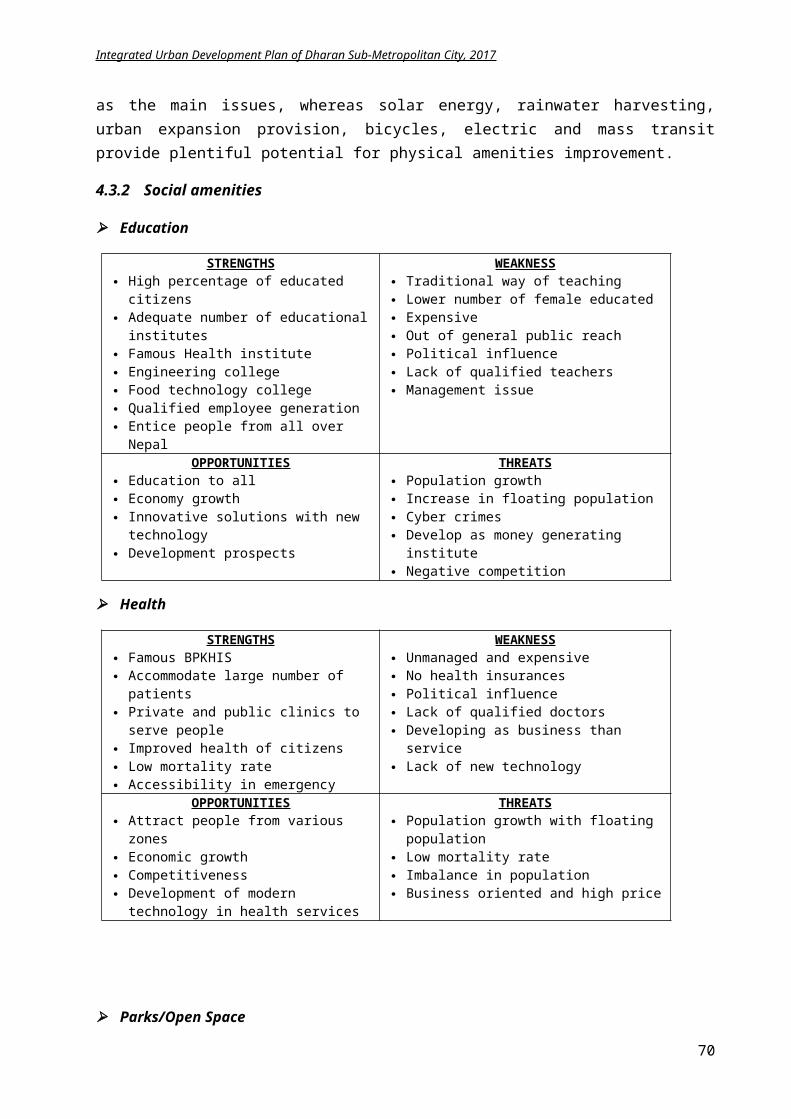
Integrated Urban Development Plan of Dharan Sub-Metropolitan City, 2017
building byelaws in ANNEX VI. If the road listed in ANNEX is not as per indicated, possible measures shall be taken for road widening.
iii. Access Road A (Class D): 8 m
This urban road has 2 lanes for vehicle with two pedestrian lanes and greenery. The inner urban areas with intracity transportation facility lie in this category.
Figure 5-51 Typical section of urban road "Class D"
iv. Access Road B (Class E): 6 m
This urban road is the access road within the city, which is connected directly to collector road and access road A. This type of road exists inside the city with low traffic volume and has only two-lane vehicle space with no separate pedestrian lane. The people are assumed to walk through the road area itself. During new road planning in side the city, the minimum width of the road shall be 6m.
The above-mentioned classification shall be followed for addition and improvements of existing road. The existing road less than 6m shall be kept as it unless initiated by local users. There will be no government investments in these small roads less than 6m in infrastructure planning. If small road width is to be planned in residential areas, this need to be financed through private investors or the investment of local user groups. For the detail study on the permissible road width within Dharan ANNEX VI “Planning and Building byelaws” shall be taken as reference.
The specific projects for road construction in DSMC are:
Track opening 68km road Black topping of 445 km 1.115 km road from Bijaypur Chowk to Panchkanya 423m road to Chatara Bridge at Chatara line 200m Road Reinforcement Sinhadevi Chowk to Bijaypur – ward 14 250m road of width 5m construction on Atridhara (way to Cremation Area)–ward 14 The Sardu Khola corridor of 7.876km is connected to existing Sumnima marg on north
and Chatara road on south. Seuti khola corridor of 4.879km is connected to existing Koshi Highway on north and
Shahid Marga on south. A recreational area or park is created near the river corridor. A link road of 2.51km from the edge of the north of Char koshe Jhadi is proposed that
will connect to this Seuti and Sardu corridor thus completing a ring road of Dharan. Road widening of 1.1 km on this proposed link road to Chatara line. Road widening as per building byelaws.
70
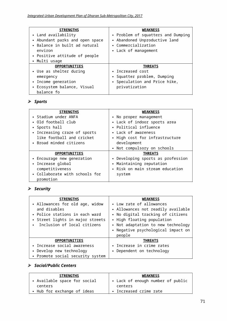
Integrated Urban Development Plan of Dharan Sub-Metropolitan City, 2017
Figure 5-52 Riverfront development concept
Green belt of above concept is proposed in some areas of river corridor. There shall be cycling track and pedestrian road along the corridor. Even, some parking space shall be allocated for the vehicles along the river corridor. A garden area of 10000 sq.m is proposed wherever applicable depending on the site condition. Similarly, a combined cycle and pedestrian lane of width 2.5m and length 15 km is proposed throughout the corridor. Besides, three parking lots each of 10000 sq.m. area is assigned along the river corridor. The tourist vehicle coming to Dharan is parked in this river corridor-parking zone for promoting walking in the city area. This parking area can also solve the future-parking problem, which city will endeavor. This parking area is proposed
At the junction of Sardu and Chatara road on the west side Seuti and Panchkanya road junction on the east side Near Bijaypur hill bottom at the river corridor.
A typical river corridor section will appear as follows:
Figure 5-53 Typical section of river corridor
Bridges:
RCC bridges and suspension bridges over Seuti, Sardu River and Khahare kholas are proposed, as there exists minimal bridges. The new nine RCC bridges shall be constructed at:
i. At Chatara line of 100m lengthii. To Sulikot Danda of 100m length
iii. To Park British Memorial of 115miv. Over Seuti River of Panchkanya marga of 115mv. Over Seuti River at Gyan Chakshu Marg of 125m
vi. Over Khahare Khola, ward no 5 of 100mvii. Over Khahare Khola, ward no 6 of 75m
71
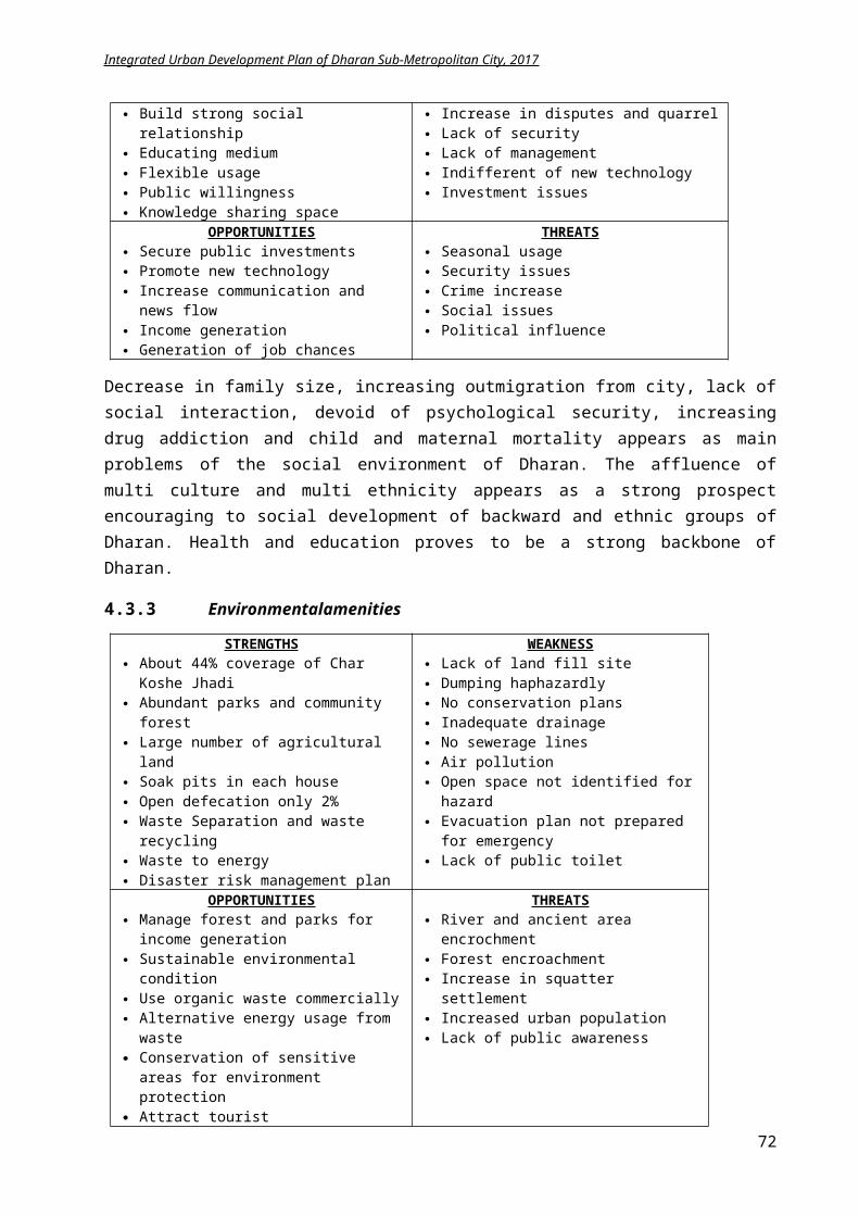
Integrated Urban Development Plan of Dharan Sub-Metropolitan City, 2017
viii. Over Khahare Khola, ward no 6 near proposed land fill site of 75mix. Over Khahare Khola, ward no 17 near Dharan road of 75 m
The new five suspension bridges shall be constructed at:
i. From Gairigaun ward no 16 over Sardu of 75m lengthii. From ward no 13-20 at Phushre to Sulikot of 75m length
iii. From ward 4-13 over Seuti of 75m lengthiv. Deurali, ward 5 over Khahare khola of 75m lengthv. From ward 5-6 over Khahare khola of 75m length
Outer Ringroad:
The 2 lane outer ringroad is proposed that will connect the outskirts of DSMC. The ringroad on the east side connects Panchkanya; ward no 4, 5 and 6 to the Seuti river corridor of Dharan. Similarly, the outer ringroad on the west side links ward no 20 and 17 with the Sardu corridor. It connects Bishnupaduka temple, Katare Village to Dharan. A total road of 55.808 km shall be constructed along with two bridges in this outer ringroad project.
Figure 5-54 Proposed Outer Ringroad of Dharan
5.1.2.4 Transportation
Buspark:
It is obvious from the analysis in above chapter that Dharan’s Bus Park is well functioning but is inadequate to serve the requisite of the city. Two new bus parks is proposed for intracity connection on ward no. 8 near Radio Nepal Station of area 10497.57 sq.m and other near Deurali Panchkanya ward no. 5 of 5000 sq.m. The intracity bus park on ward no 8 will have a
72
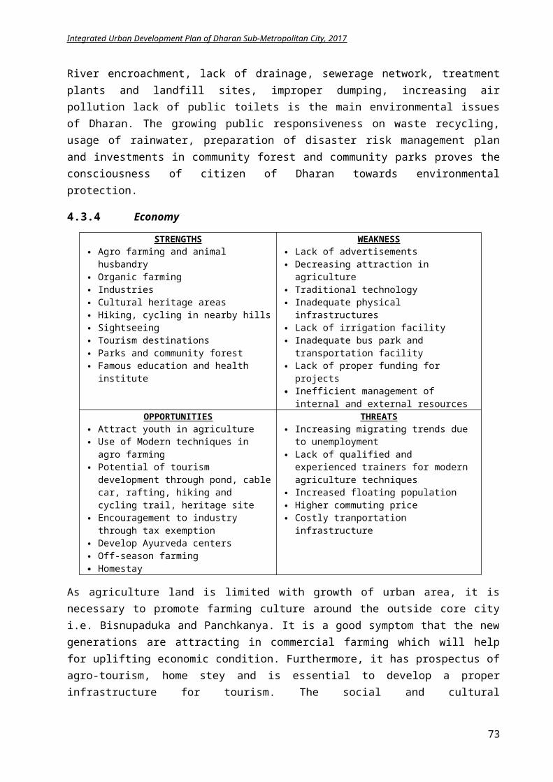
Existing Bus Park
Proposed Bus Park
Parking areas
BPKIHS
Integrated Urban Development Plan of Dharan Sub-Metropolitan City, 2017
appropriate facility of access, public toilets, ticket counter, waiting spaces, lights, and water supply and security.
Figure 5-55 Concept of proposed bus park
Figure 5-56 Location of proposed bus park and parking lots
Parking Areas:
Additionally, small parking areas for taxis, cars and tourist vehicles are proposed in ward no 13, 14, 15, 16 and 17 of each around 1560 sq.m that will accommodate around 42 small cars and 205 motorbikes. As a large chunk of land can’t be owned by DSMC, municipality has to acquire the land either by renting, leasing or buying. These taxi parks can act an element to reduce
automobile traffic. A call on service basis for taxis can be initiated to reduce the small public vehicle
movement inside the city center and save fuel.
73
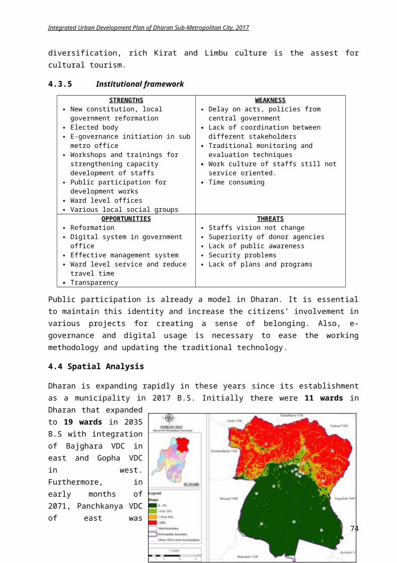
Integrated Urban Development Plan of Dharan Sub-Metropolitan City, 2017
Figure 5-57 Typical Parking lots inside city center
Bus stops:
From the infrastructure analysis, it is observed, there are around 10 existing bus stops in Dharan but without suitable shaded structures. Total 32 bus stops with shaded structures are to be fabricated in existing 10 locations and new 22 locations. The new bus stops are proposed at Mangalbare Chowk, Jestha Nagarik Park, Red Cross, Amaarhaat, Phusre, Zero Point, Devigaun, Sami Chowk, Buddha Chowk, Ratan Chowk, Railway Chowk, Bhimsen Thapa Path Chowk, Laxi Chowk, Riting Basti, College Chowk, Khoriya Basti and Khairenee. The bus stop will be constructed using light material. In primary road area, cycling lanes and bus stops can be arranges as shown in the figure below.
Figure 5-58 ideas for public bus stops
74
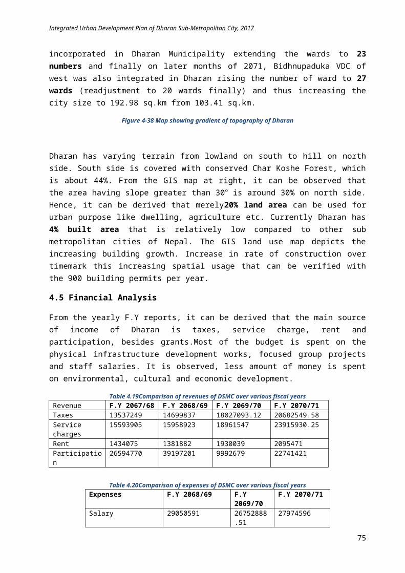
Integrated Urban Development Plan of Dharan Sub-Metropolitan City, 2017
Transportation route:
Figure 5-59 Proposed public vehicular routes
A local transportation route is proposed in DSMC along the major roads like highway, feeder road, ring road and Urban collector road Class ‘B’. The bus stops are proposed in the same public vehicular routes.
Subway:
As the highway passes through the city center, major pedestrian crossings should be safe and smooth. Sub-way is the main alternative. Hence, subways are proposed, which will maintain a visual clearance to the visual ambience of the city compared to “Akashepul”. Three subways are proposed in the main Koshi Highway – at Bargachee, Bhanu Chowk and Laxmi Chowk. The other three subways are proposed in the Chatara Road – at Buddha chowk, Railway Chowk and RTO Road Chowk towards Koshi Highway.
Railway line and industrial district:
Nepal is undergone to develop railway line East-West. Dharan has proposed to develop railway link. The link to Dharan shall be its end point on the foothill. The area will develop as a gateway to hill, a collection and storage center. GoN has a plan of proposing railway line linking east to western Terai of Nepal that passes through Inaruwa, neighboring city of Dharan. The consultant proposes a railway route connecting Inaruwa to Panchkanya of Dharan that follows the river corridor. A railway station is proposed at Khairenee of Panchkanya, which links the settlements around the hills of Dharan. This will provide an opportunity to develop the outskirts of Dharan
75
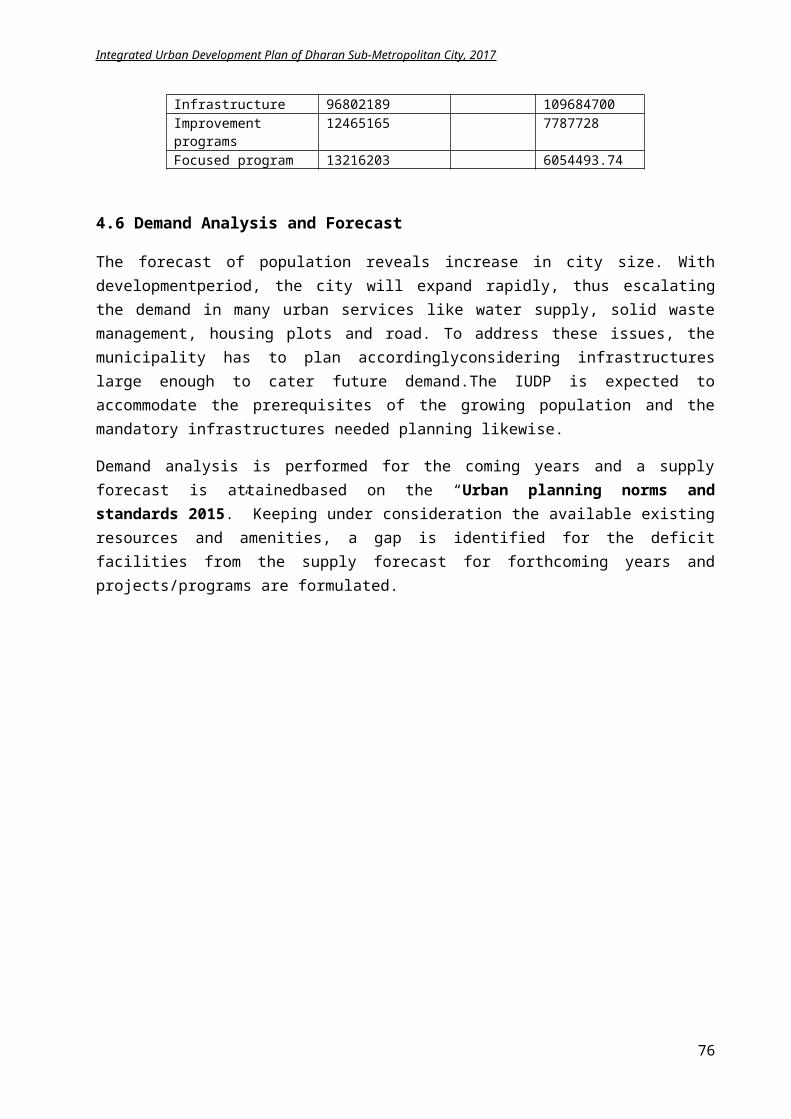
Integrated Urban Development Plan of Dharan Sub-Metropolitan City, 2017
as a new town. Moreover, industrial district is proposed near the railway station. This railway station will help the small scale industries and warehouses to boom as the products from the nearby villages and towns can be accumulated and transferred to various areas through this proposed railway line. Hence, the railway line and industrial district will help in economic uplift of Dharan.
Figure 5-60 Proposed railway track from Inaruwa to Dharan-6
Figure 5-61 Proposed railway station and industrial area on DSMC
76
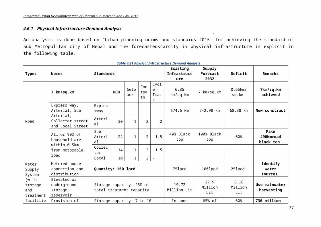
Integrated Urban Development Plan of Dharan Sub-Metropolitan City, 2017
5.1.2.5 Water supply
From the demand analysis, 27.9 million Liter water is needed to cater 279,000 people based on urban planning standard. Dharan Sub metropolitan provides 12.5 million Liter water supply per day. The other operational IUDP of Dharan funded by ADB (rehabilitation of existing water supply system and addition of two reservoir on Pindeshwor and Railway) will contribute 19.72 million liters per day (MLD) water supply to Dharan in total. Still, there will be deficit 8.18 million Liter per day water supply. The deficit amount is to be balanced by Sardu and Seuti Watershed and also rain water harvesting.
From calculation,
Rain water harvesting (gal) = catchment area (sq.ft) x rainfall (in.) x 0.673 (conversion factor)
Rainfall = 70 inch, catchment area = 500 sq.ft, 1 gallon = 3.785 Litres
Rainwater = 500*70*0.673 =23,555 gallon (if 100% rainfall efficiency considered in theory)
Rainwater collected = 500*35*0.673 (50% rainfall efficiency assumed)
=11777.5 Gallon = 44,580 Liter
Hence, 500 sq.ft catchment area will collect 44580 Litres of water. If only 50% of household (16,000) can use the rainwater harvesting technique, 713million Liter water can be reserved and the scarce amount of water can be readily recovered.
5.1.2.6 Sewerage and Drainage Network
From the analysis chapter, it is obvious; due to the presence of septic tank in each household there is no sewerage line for black water and only provision of storm water drainage along main road in city core. To cater the future demand, a new sewerage network of 742.98 km is suggested for the city. Two treatment plants construction location are identified – one in ward no 17 at southwestern corner and other in ward no 15 at southeastern end. The sewerage network connection will be constructed phase wise depending on the priority of area.
There is water clogging problems in Bhanu Chowk and direct discharge on Khahare Khola at ward no 7, 8 and 3. A proper drainage system is proposed with 8 discharge points to Sardu, Seuti and Khahare khola depending on the proximity of area.
Wards Discharge point
Wards Discharge point
14 Seuti 17,18,19 Sardu5 Seuti 1,13,16 Sardu15 Seuti 9,10,11,12 Sardu6 Seuti 7,8,3,2 Khahare
77
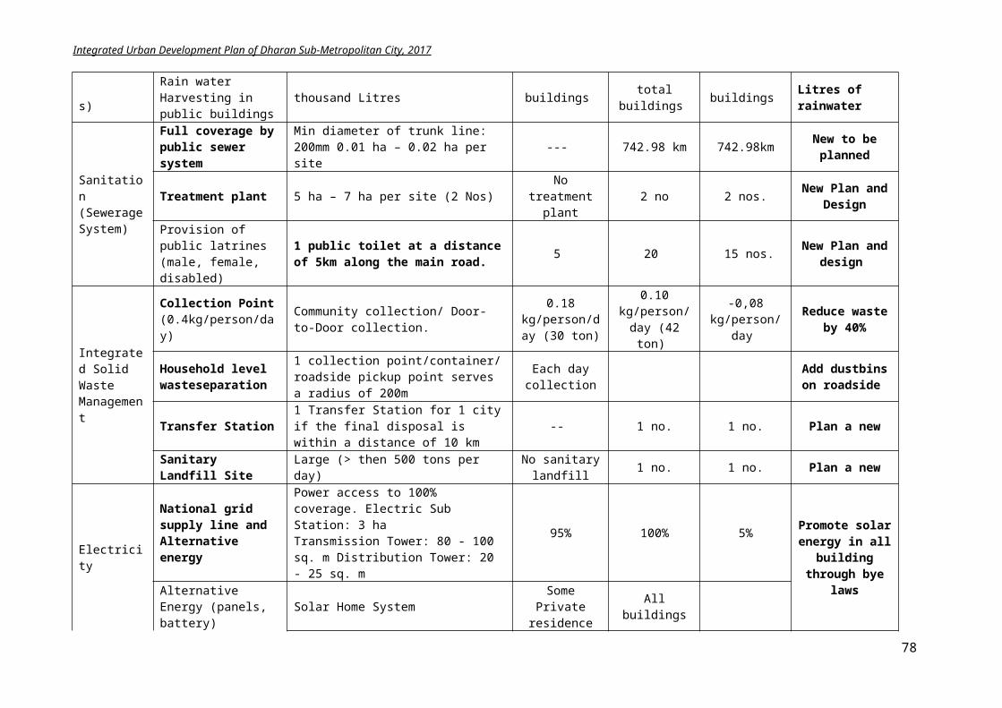
Integrated Urban Development Plan of Dharan Sub-Metropolitan City, 2017
Figure 5-62 Proposed drainage discharge to streams based on proximity
5.1.2.7 Electricity and communication
The electricity connection is to be increased from 95% to 100% in 1 year. Solar panel usage is encouraged through enforcement of byelaws in building construction and through subsidy projects. The network coverage of Telecom shall be increased with installation of new towers.
Street Lamps shall be installed at 30m distances on straight line, 15m alternately on both sides of roads.
Solar panels shall be used to operate these lights for promoting green energy concept. Free Wi-Fi zones shall be made in public places in 10 areas. Tourist information system shall be set up in major areas like Bhanu Chowk,
Panchkanya Temple, and Bijaypur Chowk etc. Websites of DSMC shall be updated regularly and promotion of services shall be done
over Internet, TVs and radios.
5.1.3 LFA for achieving physical development
Intervention Logic Indicators Means of Verification
Assumptions
Goal: Living standard of citizens will have enhanced with well equipped physical amenities (road, water supply, electricity, housing, communication) maintaining the ecological stability Objective:Improvement and development of physical infrastructure and increasing the grasp of general public for these facilities. Result:
1) Road connection of proper standard is increased.
2) Mobility is convenient
By 2032, Total road length will be
742.98 km. Road network standard
will be 7km/ sq.km
Documentation of Road and Transport Management Branch
Budget is available
Arrangement of budget as planned
78
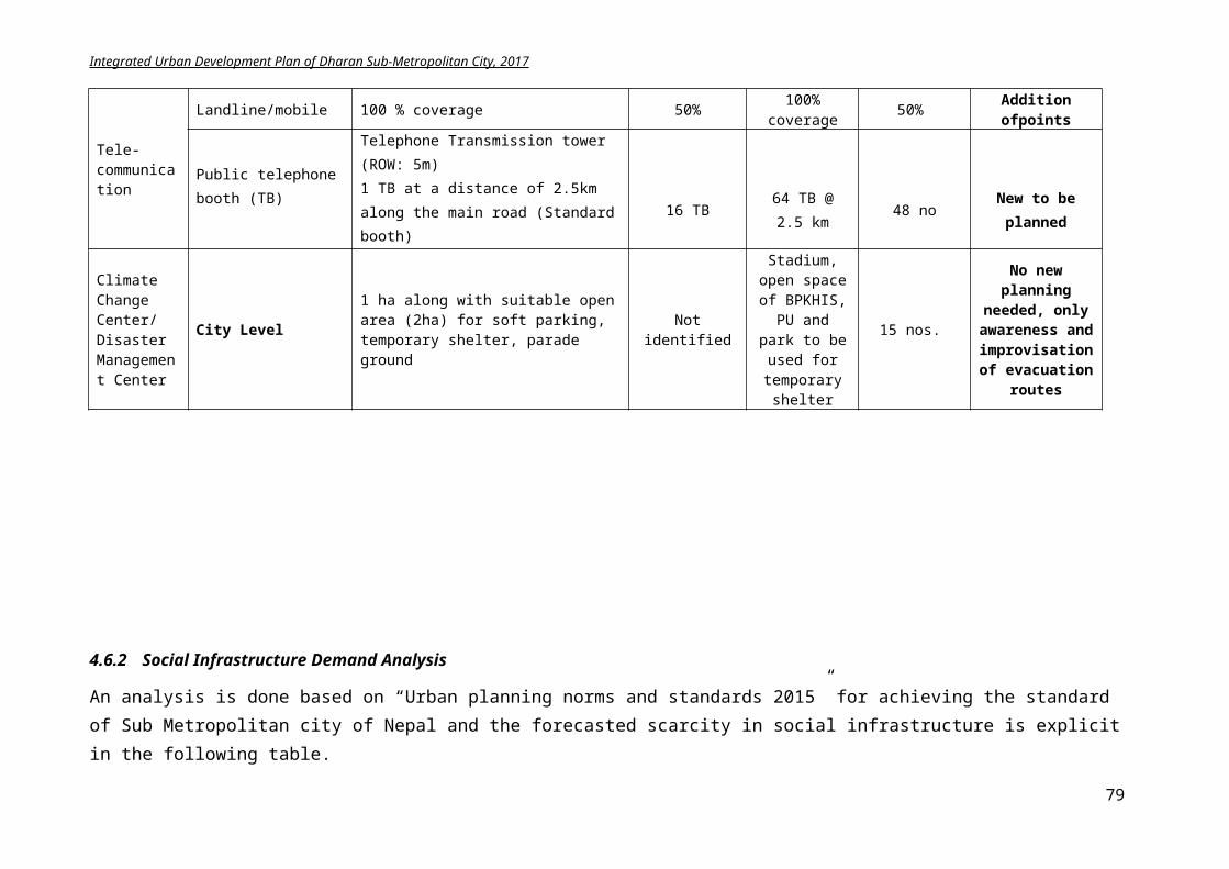
Integrated Urban Development Plan of Dharan Sub-Metropolitan City, 2017
and faster serving entire population.
3) Citizens will get the adequate drinking water.
4) Alternative energy usage will have been increased.
5) Land and housing is accessible for every income group.
6) Electricity facility will be extended.
7) Proper drainage amenities will have been provided.
8) Sewerage connection is extended through the city.
9) Communication facility will be efficient and quick.
10) More people will be using Internet.
13 bridges connecting Bishnupaduka and Panchkanya with city center will be constructed.
2 New bus parks and 8parking spaces are developed.
Electric vehicles usage is increased to 75%.
Public Vehicles number is increased.
10 public toilets are constructed.
Each people will get 100 lpcd of drinking water
Solar Street Lamps are installed in every street and road.
Electricity coverage is increased from 95% to 100%
100% houses are linked to sewerage network
90% people have grasp on communication
100% people will get grip on land and housing.
Hydropower, Energy and Street Lighting Branch records
Water supply and Solid Waste Management Branch records
Field Visits Records of
Information, Communication and Statistics Management Division
Land Management and Building Regulation Division Records
Work is efficiently performed
People participated in focused program
There is political stability
There is no bandhs and other casualties
Private sector aids in projects
Activities:Road
i. Track opening of 68.38 km roadii. Black Topping of 490 km road
iii. 1.115 km road from Bijaypur Chowk to Panchkanyaiv. 200m Road Reinforcement Sinhadevi Chowk to
Bijaypur – ward 14v. 250m road of width 5m construction on Atridhara
vi. 2.51 km link road development for ring roadvii. 0.45 km road development till bridge
viii. Widening of 1.1 km road of link road to 15m.ix. Widening of 1.38km length Janapath road to 15mx. Widening of 0.57km ANFA marga to 15m
xi. Widening of 1.21km Namuna marga to 15mxii. Extension of internal ringroad to 4 lanes
xiii. Construction of internal ringroad near Charkoshe Jhadi
xiv. Feasibility study of outer ringroadxv. Construction of outer ringroadRiver Corridor
i. Sardu River Corridor (7.876 km) constructionii. Seuti River corridor (4.879km) construction
iii. River embankment of 13 kmiv. Pedestrian and cycle lane of 2.5m width construction
(12km length)v. Garden development10000 sq.m
vi. Vehicle Parking DevelopmentBus park
i. 2 new bus parks constructionii. 5 small Parking space development
Cost: In NPR
i. 273.52 millionii. 1357.3 million
iii. 34.1 millioniv. 1.62 million
v. 1.29 millionvi. 16.993million
vii. 3.0465 millionviii. 2.75 million
ix. 3.45 millionx. 1.425 million
xi. 3.025 millionxii. 320 million
xiii. 312.150 millionxiv. 2.5 millionxv. 837.12 million
i. 168.27 millionii. 148.63 million
iii. 65 millioniv. 39million
v. 50 millionvi. 60 million
i. 310millionii. 30 million
iii. 48million
Time Frame
i. 15yrs.ii. 15yrs.
iii. 1 yr.iv. 1 yr.
v. 1 yr.vi. 3yrs.
vii. 1 yrs.viii. 3 yrs.
ix. 1 yr.x. 1 yr.
xi. 1 yr.xii. 5 yrs.
xiii. 5 yrs.xiv. 1 yr.xv. 10 yrs.
i. 5yrs.ii. 3 yrs.
iii. 3 yrs.iv. 3 yrs.
v. 5 yrs.vi. 3 yrs.
i. 8 yrs.ii. 3yrs.
iii. 6 yrs.
79
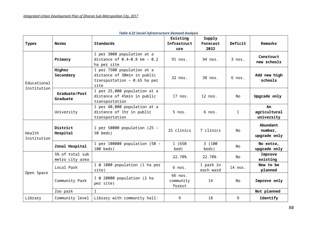
Integrated Urban Development Plan of Dharan Sub-Metropolitan City, 2017
iii. 32 bus stops shades fabricationAirport/RailwayFeasibility study, design and surveyFeasibility study of railway trackBridge
i. Three bridges construction of length 100mii. Two bridges construction of length 115m
iii. One bridge construction of length 125miv. Three bridges construction of length 75 mv. 5 suspension bridge construction of 75 m
vi. Two bridges of 115m construction on outer ringroadWater Supply
i. Rain water harvesting subsidy on 20,000 HHii. Feasibility study of water resources nearby
iii. Construction of water supply projectsElectricity and communication
i. Expansion of Electricity network ii. Feasibility study for underground electric cables
iii. Solar panel installations subsidy on 32,000 HHiv. Telecommunication and optical fibers for internet
expansion and improvementv. Free Wi-Fi on 10 public places
Sewerage and Drainagei. 745 km sewerage line installation
First phaseSecond phaseThird phase
ii. 490 km drainage constructioniii. Drainage and footpath construction on DuiDharepath,
ward no 14iv. Construction of 2 treatment plant
Solid waste Managementi. Construction of 1 land fill site
ii. Installation of 20,000 public bins on streets
Housingi. Land pooling and site and services program
commencementii. Facilitation of Investment on affordable group
housing and apartmentsiii. Relocation of squatter settlementsiv. Maintaining and updating building records
10 million 2 million
i. 360millionii. 276 million
iii. 150 millioniv. 270 millionv. 112.5 million
vi. 276 million
i. 800 millionii. 10 million
iii. 195 million
i. 10 millionii. 1 million
iii. 800 millioniv. 11.6 million
v. 0.3 million
i. 2980 million900 million900 million1180
ii. 980 millioniii. 6.57 million
iv. 400 million
i. 200 millionii. 10 million
i. 50 million
ii. 2 million
iii. 25 millioniv. 2 million
2 yrs. 1 yr.
i. 6 yrs.ii. 3yrs.
iii. 2 yrs.iv. 3yrs.v. 5 yrs.
vi. 3 yrs.
i. 15yrs.ii. 2 yrs.
iii. 5 yrs.
i. 3 yr.ii. 1 yr.
iii. 15yrs.iv. 2yrs.
v. 1 yr.
i. 15 yrs.5 yrs.5 yrs.5 yrs.
ii. 15yrs.iii. 1 yr.
iv. 15yrs.
i. 8yrs.ii. 3 yrs.
i. 4yrs.
ii. 1 yr.
iii. 4 yrs.iv. 1 yr.
5.1.4 Summary of Physical development plan implementation
Component Base year2017
Target2032
Methodology Approach Stakeholder
Road Network
642.98 km 742.98 km Road Network Planning Construct Manually
PPP Regular
Program Bidding
DSMC Users GoN Donor agency
Road Improvement
250 Km black top
742.98km black top
Road standard setting Prioritization Implementation
PPP Bidding
DSMC Tole Bikas Users GoN
Road Widening
0 1.48km Planning Relocation or
Program PPP
GoN DSMC
80
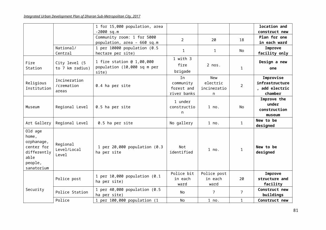
Integrated Urban Development Plan of Dharan Sub-Metropolitan City, 2017
resettlement Design and Construction
Bidding Users
River corridor
0 12.755 km Road standard setting Design and construction Monitoring
Partnership Collaboration Program Bidding
GoN DSMC Citizens Private sector Donor agency
Bridges and suspension bridges
5 18 Location identification Planning Prioritization Design and construction
Program PPP Bidding Collaboration
DSMC GoN Donor agency Users
Bus Park 1 3 Site identification Feasibility study Planning and design Construction and
Monitoring
PPP Collaboration Partnership Program
DSMC Private sector Citizens GoN
Parking Spaces
0 5 Location Identification Design and planning Construction Monitoring Operation
Privatization PPP Collaboration
DSMC Private sector Community GoN Users
Bus Stops 10 32 Standard setting Planning and design Construction and
operation
PPP Partnership Program
DSMC Private sector Citizens GoN
Airport 0 1 Site identification Feasibility study Planning and design
PPP Collaboration Partnership
DSMC Private sector GoN
Drinking water Supply
19.7 million Ltr/day
27.9 million Ltr/day
Source identification Rain water harvesting Design and construction Supply Management
PPP Program Bidding Private
DSMC Users GoN Donor agency Private Sector
Municipal drains
250 km 745 km Planning Design and construction
PPP Regular
Program
DSMC Tole Bikas GoN Donor agency
Sewerage 0 745 km Standard setting Planning and
Prioritization Design and construction
Program PPP Collaboration Mandatory
DSMC GoN Donor agency Users
Sewerage Treatment Plants
0 2 Location identification Standard setting Planning and Design Construction and
monitoring
Mandatory Program PPP Partnership
DSMC GoN Donor agency Private sector Citizens
Sanitary Landfill site
0 1 Site identificationand acquisition
Assessment Waste delivery Leveling and pressing Covering
Mandatory Program Partnership Private
DSMC GoN Donor agency Private sector Citizens NGOs
Electric public Vehicle
50% 100% Setting of standard Implementation Monitoring
Mandatory PPP
DSMC GoN NGOs User
Housing and Apartments
-- 100% Setting of standard Monitoring
Mandatory PPP Privatization
DSMC GoN Citizens Private sector
Land development programs
100% Guided land development
Land pooling Site and services
Regular Program
Partnership
DSMC GoN
81
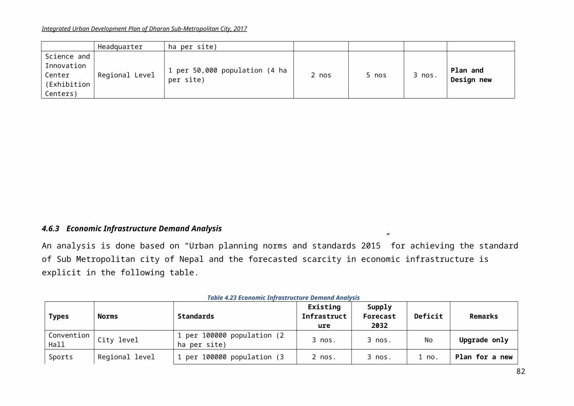
Integrated Urban Development Plan of Dharan Sub-Metropolitan City, 2017
Electrification
95% HH 100% HH Planning Line distribution
Regular Program
Collaboration Coordination
NEA DSMC GoN
UsersSolar Panel installation
50%HH 100% Planning and designSolar PV installation
Mandatory PPP Privatization
DSMC Users NGOs Private sector
Street public dust bins
20000 Location identification Design and quality Planning Implementation
Mandatory Partnership PPP Encouragement
DSMC GoN NGOs Users
Improve network coverage
80% 100% Feasibility study Increase tower efficiency Erect new towers
Program Private Collaboration
NTC Ncell DSMC
Free Wi-Fi zones
0 15 Formulation Implementation Monitoring
Partnership Program
Private sector DSMC NTC Ncell
Underground cables
100% Feasibility study Implementation
Partnership Private
NTC DSMC
Squatter settlement relocate
0 Identification of relocating areas
Community participation Fund raising Design and construction
Communication Coordination PPP Program
DSMC Squatter
group NGOs Donor agency
5.1.5 Conclusion
Physical planning will be on incremental growth basis. Planning of infrastructures will support vision and goal of the city thus making it livable. From the above elaborated plans and program, it is clear, physical infrastructure development will require huge investment. The total cost for the identified projects for physical development plan along with strategic projects is around NPR 16173.10 million.
It is impossible for Dharan Sub Metropolitan city to acquire all planning in one go. Hence, prioritization of infrastructure is maintained and a short term (1-3 years), midterm (3-5/7 years) and long term (5-15years) plans is prepared. The possible stakeholders for each programs are also identified that will help in accumulating the required budget, which city will unable to achieve on its own. There are even some cross cutting issues like landfill sites, treatment plants, information centers, hiking trial, pedestrian tracks, cycling lanes, electric vehicles and alternative energy usage that are mentioned in infrastructure plan and will also be repeated in other sectoral programs as well. In summary, physical infrastructure planning is a basic but essential component of any city development work and shall be scrutinized in detail.
82
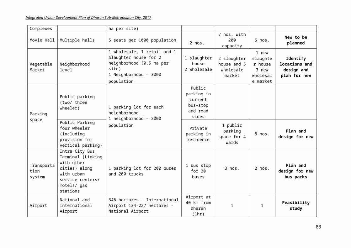
Integrated Urban Development Plan of Dharan Sub-Metropolitan City, 2017
5.2 Social Development Plan
Social development means a commitment that development processes need to benefit people, particularly but not only the poor, but also provide a recognition to that people, and the way they interact in groups and society, and the norms that facilitates such interaction, shape development processes.
The strength of a social development plan lies in its ability to engage citizens, mobilize the community and to reinforce and build the work completed already. It is the plan providing opportunities to woman, backwards and disabled people in decision making process. Dharan is the new city developed by intermix of castes and ethnic people i.e. Rai, Newar, Limbu, Chhetri, Brahman, Tamang, Kami, Magar, Gurung etc. and it become essential to develop a social development plan including all the ethnic groups.
5.2.1 Goal and Objectives
Goal: Upgrading the living environment through social inclusion and rehabilitation of social infrastructures and social services
Objectives:
To develop the social infrastructures in the city like schools, colleges, hospitals, library, city hall, police station, sport center, parks, and open spaces
To increase the social equality and gender inclusion To increase the accessibility of people to information, health services and education To plan security of inhabitants in society To ensure women empowerment To ensure women and child welfare To include differently abled people in planning To uplift the condition and status of socially backward ethnic groups
5.2.2 Plan and Programs
5.2.2.1 Education
From the situation analysis, it is clear that the literacy of the Dharan is 84.5 % which quite higher than nearby places. The education sector is already strong in Dharan, and only some programs are needed for improving the literacy rate to 95% and making it first highly intellectual Sub Metro city. Based on planning norms and standard 2015, 3 primary schools and 6 higher education institutes shall be constructed. To achieve the municipal long-term vision of making Dharan “Dharan enriched city with infrastructures for education services”, following specifics programs will aid in development of education sector:
BPKIHS, Food Technology College and Purbanchal engineering campus and a multiple campus strengthen educational facilities.
An agriculture college of eastern region is proposed. The infrastructures have to be upgraded and innovative technologies have to be
introduced. Qualified employees have to be appointed for upgrading the teaching standards. Pindeshwor Bidhyapeeth shall be developed as a multilingual University
83
Integrated Urban Development Plan of Dharan Sub-Metropolitan City, 2017
Encourage female students enrollment in schools and colleges Focus on improvement of marginalized groups education Develop the capacity of School Management Committees Preparation of guidelines and standards for Community and Private, Pre-Primary schools
and its effective implementation. Regular evaluations of private schools will be done by Municipal Education Committee
to ensure their effective performance. Physical and educational facilities of Community schools shall be developed in co-
ordination with various educational organizations. Public libraries with modern technology need to be established for increasing the right to
information. Arts and crafts programs to be established effectively.
5.2.2.2 Public health
From the analysis, it is derived there is no need of extra hospital or clinics but only the infrastructures shall be developed. For achieving the municipal long-term vision of making “Dharan enriched city with infrastructures for health services”, following programs shall be initiated:
BPKIHS needs to be upgraded with appropriate infrastructure like road network, water supply, sanitation and modern examination techniques for developing as pioneer health service and a regional hospital
Maternity baby health clinic shall be established to give services for various ethnic and backward groups
Urban community health centers need to be formed in various wards. Tax exemption for more specialized health facilities and technical and higher education
shall be introduced. Health areas should be accessible to all genders, ages and groups and create the social
cohesion with vibrant social environment. Establishment of special units in BPKIHS in collaboration with DSMC for mitigating the
future possible calamities and epidemics. Workshops and program to be conducted on local wards for raising awareness about the
primary health treatment Promotion of healthy diet and living among the citizens through ward level programs. Excellent health volunteer shall be awarded to encourage health volunteers and their
demand needs to be addressed urgently.
Programs for reducing the HIV/AIDS and drug addiction:
Formulation of Strategic planning for controlling HIV/AIDS and drug addiction in sub metropolitan tube done with coordination with concerned stakeholders
Programs related with HIV/AIDS and Drug addiction shall be conducted in close coordination with Municipal AIDS Coordination Committee
Recommendation fee will be discounted while recommending to concerned stakeholders from municipality for programs related to health treatment of drug addicted poor youth.
For involving former drug addicts in labor works and developing their working capability, municipality shall establish necessary fund.
84
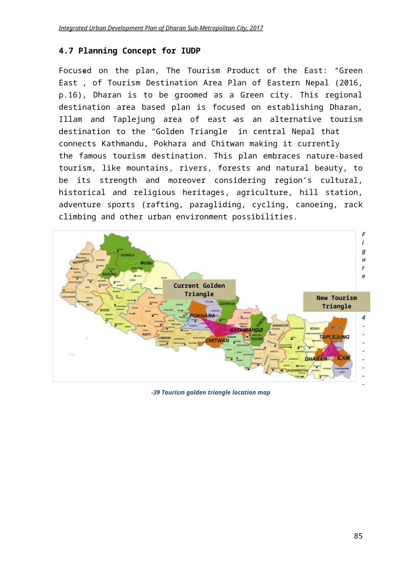
Integrated Urban Development Plan of Dharan Sub-Metropolitan City, 2017
5.2.2.3 Security
With the change in societal pattern, crimes are increasing and security of citizens is in risk. Unless the citizens are not mentally and physically safe, development of an urban area cannot be realistic. Social security of every individual is duty of municipality. Social mobilization groups shall be set in every ward with inclusion of marginalized group.
Proposed social security plans:
Educate children through security programs in school about the harassment issues. Training programs relating to
self-defense for male, female and even children.
Make the social allowance easily and readily available to the concerned people like old age people, marginalized and handicapped.
Identify the socially backward ethnic groups and work in their cultural preservation and upliftment in society.
Figure 5-63 Solar Street Lamps (Source: KMC)
Proposed physical security plans:
Police station buildings with enough spaces for catering human resources, modern equipment, and accessories in each ward shall be constructed.
A city level police headquarter is proposed. Police personnel or security guards have to be assigned by municipalities in the area
suspected to be risky. Street lamps have to be installed in every street to decrease nighttime casualties.
5.2.2.4 Gender Equality and Social Inclusion
Gender equality refers to exposure to opportunities irrespective of the gender. In a patriarchal society like Nepal, gender equality has become a talk of the town. Today 33% reservation policy in the government institutions has been done for safeguarding the rights of women. Gender equality is not only limited to female, but to the LGBT groups too. Social inclusion refers to removal of institutional barriers and the enhancement of incentives to increase access by diverse individuals and groups to development opportunities. This requires changes in policies, rules, and social practices and shifts in people’s perspectives and behavior toward excluded groups. New programs to be formulated in IUDP needs to embrace GESI parameter.
Formation of women empowerment groups and LGBT groups in ward levels. Sharing responsibility of ward level with these groups like cleaning streets, maintain roads,
street lamps, parks etc. be done for income generation.
85
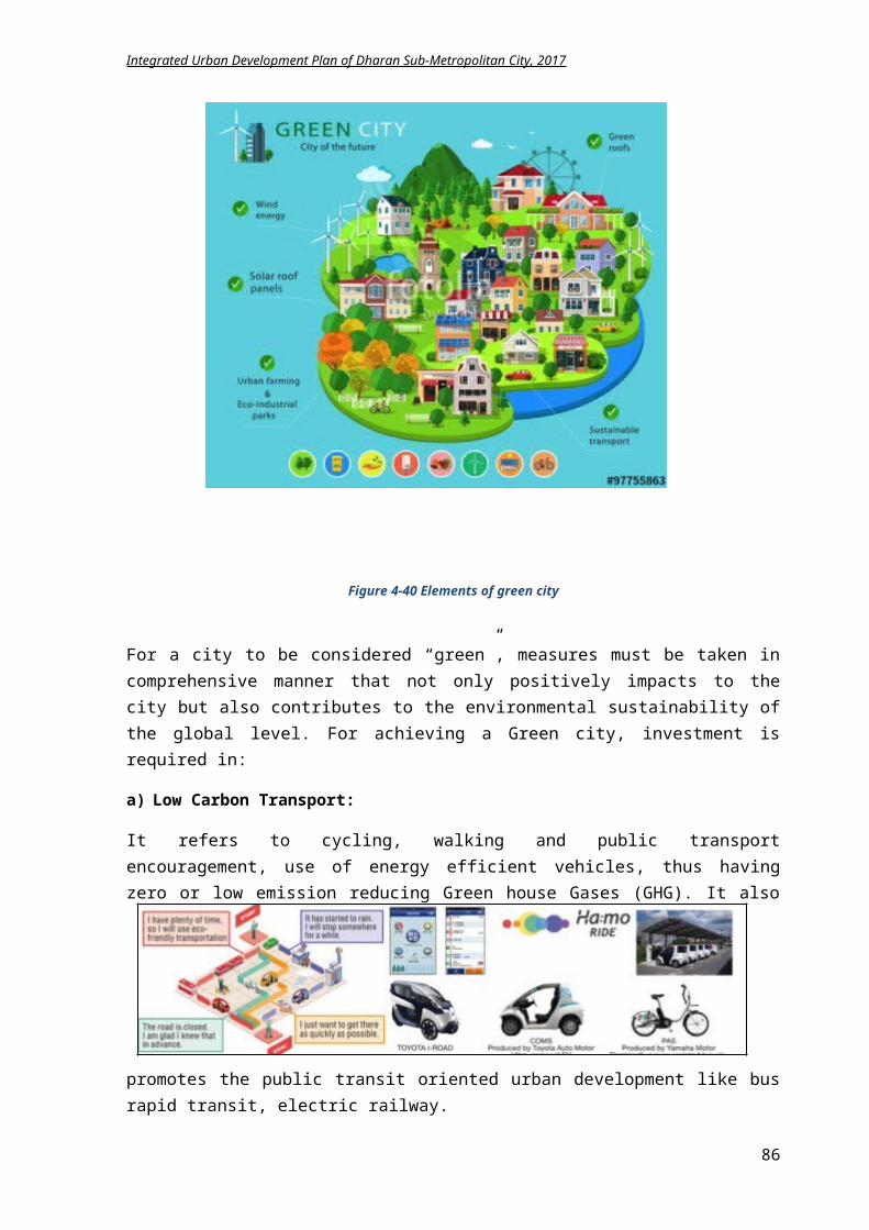
Integrated Urban Development Plan of Dharan Sub-Metropolitan City, 2017
The existing parks need addition of infrastructures like picnic shades, resting areas, toilets, walking lanes etc.
A suitable management system, like ticket charge, activity charge etc. is required for making these parks self-sustainable
Minimum charge can be allocated to the entrants for various entertainment purposes or it can be open to general public only during morning
5.2.2.5 Parks and Open Spaces
Parks of Dharan not only uplift the beauty of the city but also provide a natural environment for the citizens to relax and meet. These parks have higher potential for developing as picnic spots, playing areas and gathering area. Several activities for maintaining these open spaces and parks are proposed:
Demarcation of portions of existing parks shall be done for creating children’s play area or picnic areas.
Entrance fees for these parks can be levied during morning and evening hours and charged for remaining time of the day.
Seuti and Sardu river corridor can develop as children parks, jogging area, waiting and meeting spaces.
Public spaces and open spaces within the city can be developed into park and green area. 14 local parks are developed in the neighborhood area with 1 park in each ward.
Figure 5-64 Concept of street furniture in public placesFigure 5-65 Concepts for intervention in existing open space and parks for creating social space
86
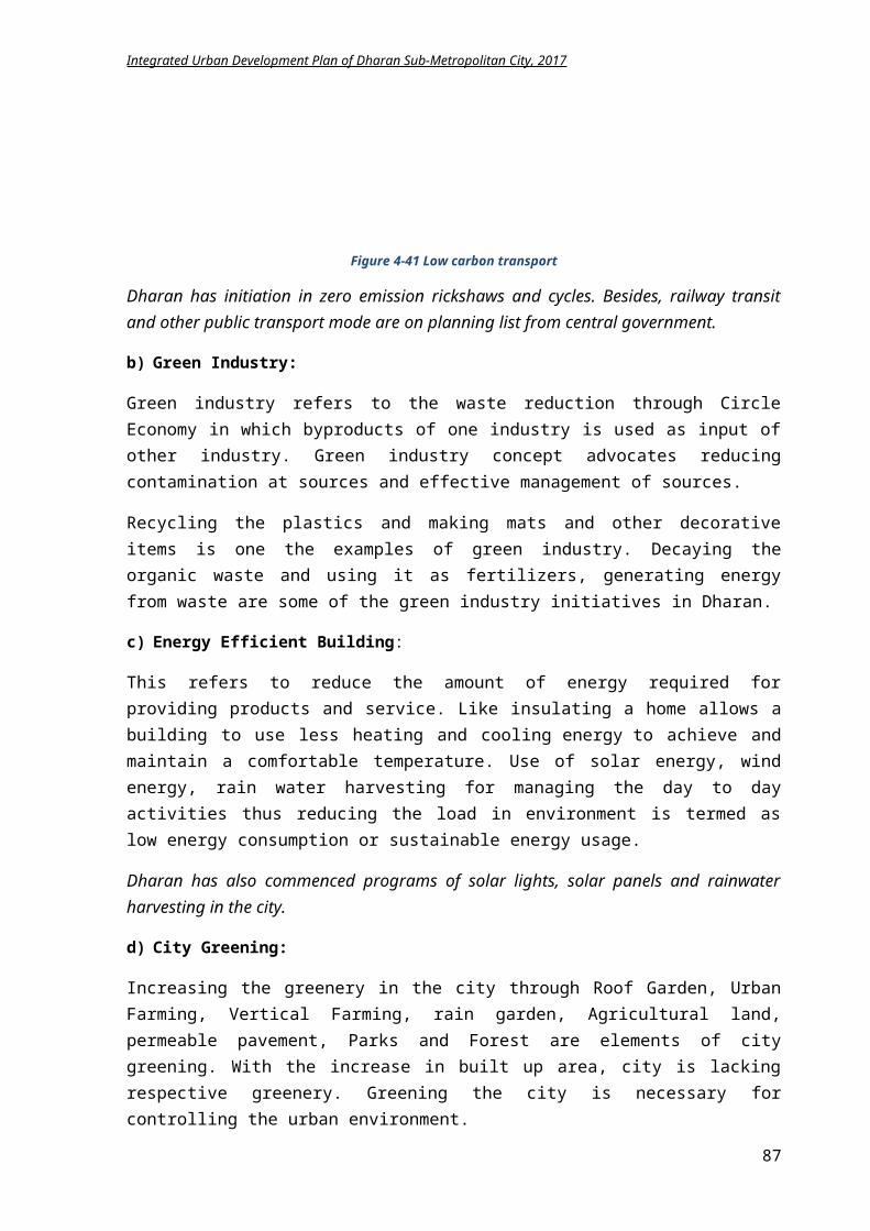
Integrated Urban Development Plan of Dharan Sub-Metropolitan City, 2017
5.2.2.6 Public Service Centers
After the reform of local bodies, the municipality needs many additional buildings for its service delivery. Ward offices as well as different section office within the municipality have to build. Based on availability of land and requirement, need identification can be done. The consultant shall prepare the design and estimate of a building. The consultant shall propose the retrofitting, conservation or restoration of old building and for reusing in such administrative purpose. Proposed activities for the development of other social centers are described beneath.
City hall The existing City halls need upgrading and improvement of infrastructures for operation.
Oldage homes, orphanage home An old age home is proposed near Pindeshwore temple, which is an ideal location for the
elderly. Near the old age home, an orphanage home is also proposed.
Exhibition centers: 3 exhibition centers for public and private events, arts exhibition, trainings shall be planned
Library/Information center: The existing government library is to be upgraded as city level library with appropriate
infrastructure 9 community libraries shall be planned and developed with e-learning.
Museum The under construction ethnic museum shall be enlarged to widen its scope as a cultural
center with performing art, center of study and research for history, culture and tradition. Necessary adjoining facilities shall be constructed.
Cultural Centre A small cultural center that provides regular trainings and workshops on the various culture
of Dharan is proposed near the ethnic museum in Bijaypur hill area.
Sports A multipurpose sports hall shall be constructed for multidisciplinary sport activities. Infrastructure upgrading of existing ANFA Academy area for developing it as a multi-sport
center. Dharan Rangsala needs construction of parapet, and other indoor facilities, improvement and
addition of infrastructures like toilets, shading area, lights for upgrading it as national stadium.
Developing small areas for sport activities within parks or outside, near group of wards. Construction of multi-purpose hall or a sports hall for indoor games that can be used for
futsal, badminton, tennis, and 5 a side football, basketball, indoors hockey etc. Inclusion of sports as main subject in educational institutes. Creating the suitable environment for local club and organizations to participate in sport
activities. Encouraging local sport club and organizations for registration in municipality and
coordinating the sport activities by formation of Sub metropolitan sport committee.
Public Toilets:
87
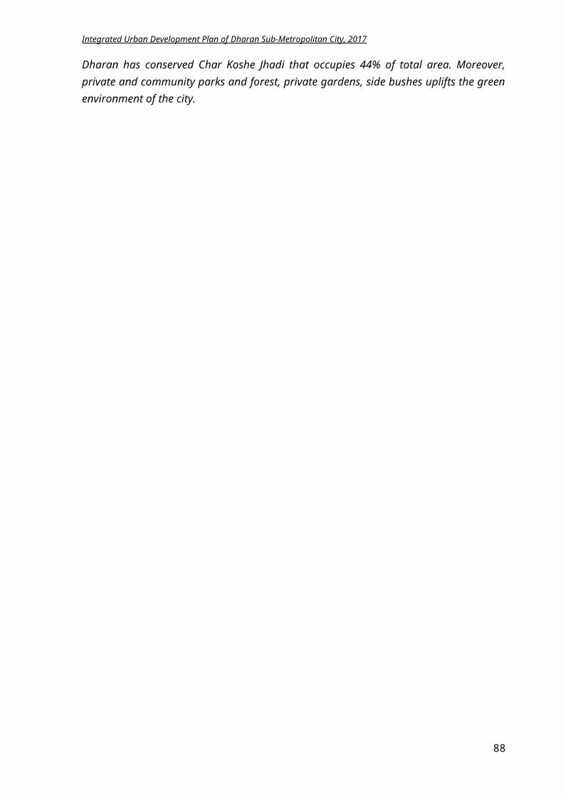
Integrated Urban Development Plan of Dharan Sub-Metropolitan City, 2017
From the municipality profile, it can be derived that there are nominal public toilet facilities with scarce infrastructure and pitiable hygiene. Hence, 8 public toilets are proposed in important public places namely i) Bhanu chowk, ward no 2, ii) Proposed bus park, ward no 8, iii) Pindeshwor temple, ward no 14, iv) Budhasubba temple, ward no 14, v)Dharan Rangasala, Janapath, ward no 16, vi) ANFA stadium, ward no 17, vii) Saptarangi park, ward no 17, viii) Bishnupaduka temple, ward no 20. Minimal charges have to be allocated for using these facilities for maintaining the cleanliness. The public toilet shall be gender friendly and cater differently abled people too.
Figure 5-66 Proposed location of public toilet Figure 5-67 Ideas for public toilet
5.2.3 LFA for achieving social development
Intervention Logic Indicators Means of Verification
Assumptions
Goal: Achieving a quality life of the citizens through inclusive social environmentEducation Sector Objective: Development of education services for including every caste, gender, age groups and ethnicity. Result: 1) Literacy rate will be
increased.2) Physical amenities of
education services will be fully developed.
3) School going rate of female students will
By 2032, Literacy rate will rise
from 83% to 95% Literacy rate of female
will increase from 77% to 95%.
Male literacy rate will rise from 80% to100%
Records of Basic and Secondary Education Office
Sports and Extra Curriculum Unit Documentation
Gender Equality and Social
Budget is available though education ministry
Private Sectors get affiliation
88
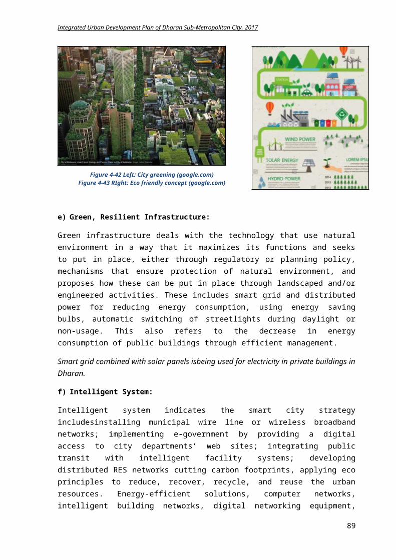
Integrated Urban Development Plan of Dharan Sub-Metropolitan City, 2017
rise.4) Higher number of
children from socially backward and ethnic groups will be going to school.
5) More people will be graduated.
6) Increase in number of literate elderly people.
7) New techniques will be adopted in educational system.
8) Extra curricular activities will augment in schools.
Percentage of students passing the exams will increase.
3 primary schools and 7 higher education institute will be established.
A multi lingual university is developed.
Admission rate in ECD will be 100%
Increase in number of scholarship holders in backward and lower caste ethnic groups
Number of schools using e-learning techniques will increase.
Sports and Arts will be included as major subject in all schools.
Security Branch records
Records of Culture, Heritage, Fine Arts and Tourism Promotion Unit
from T.U or other concerned educational institutes
There is political stability in country.
Arrangement of budget is as planned.
Focused groups are interested in programs.
Activities:i. Construction of 3 primary schools buildings
ii. Construction of 6 higher education institutes buildingsiii. Establishment of multi lingual universityiv. Facilitation of elderly classesv. Promoting modern teaching system in schools
vi. Distributing e-learning materials in government schools
vii. Scholarship provision for backward groupsviii. ECD programs in government schools
ix. Improvement of amenities of government educational facilities
x. Promotional events for increasing literacy
Cost: In NPRi. 15 million
ii. 48 millioniii. 35 millioniv. 2 millionv. 5 million
vi. 22.4 millionvii. 1.2 million
viii. 4.6 millionix. 32 million
x. 3 million
Time Framei. 5 yrs.
ii. 6 yrs.iii. 6 yrs.iv. Yearlyv. 3 yrs.
vi. 7 yrs.vii. Yearly.
viii. 3 yrs.ix. 8 yrs.
x. 2 yr.
Health Sector Objective: Improvement of public health status with provision of fast and convenient health facility to all user
groups of society Result: 1) More people will be
using maternity health services.
2) Decrease in number of unhealthy people.
3) Health services for infant and child are more effective and increased.
By 2032, Maternity morality rate
will be decreased. Child and infant
mortality rate is decreased by 50%.
Child Vaccination rate will augment to 75%.
Malnutrition rate is decreased in children below 5 yrs.
Maternity delivery rates in hospital and clinics will increase to 50%.
People using family planning mediums rises.
Number of people getting admitted to hospital for regular diseases decreases.
Records of Basic Health and Cleanliness Office
Personal Event registration unit documentations
Market monitoring, food safety and consumer protection brands records
Inventories of NGOs
Documentation of District Health Office
Budget is available though Health ministry
Health staff is appointed in adequate nos.
There is political stability in country.
There is no transmittable disease or epidemics
Activities: Cost: In NPR Time Frame
89
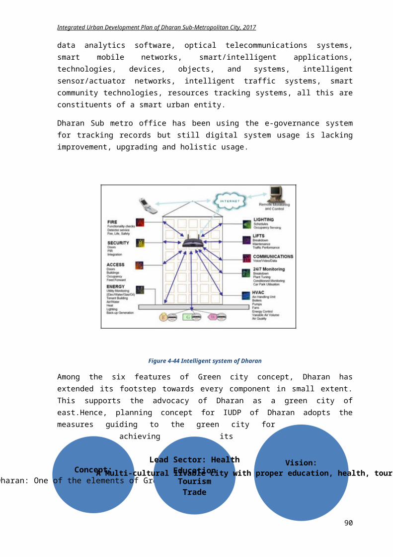
Integrated Urban Development Plan of Dharan Sub-Metropolitan City, 2017
i. Organizing child vaccination programsii. Promotion to nutrition programs
iii. Encouragement of safe and secure maternity deliveryiv. Initiating free checkup facilities for differently abled
and elderlyv. HIV/Aids rehabilitation program
vi. Empowerment programs for HIV/drug addiction community
vii. Improvement of amenities of BPKIHSviii. Establishment of health groups in each ward
i. 4 millionii. 3 million
iii. 3 millioniv. 6 million
v. 1.5 millionvi. 0.5 million
vii. 5 millionviii. 5 million
i. Yearly ii. Yearly
iii. Yearlyiv. Yearly
v. Yearlyvi. Yearly
vii. 2 yrs.viii. 2 yrs.
Women and Child Welfare Sector Objective: Encouragement of women and children welfare through security in educational, social, economical
and political inclusion Result: 1) Women participation in
politics, education, health and economic sector is increased.
2) Child labor will be decreased.
3) Homeless children will decrease.
By 2032, Family using children for
household works is decreased to 5%.
Number of women enrollment in college and school is increased
Orphanage is established.
Divorce rate and violence against women cases is minimized.
Records of Gender Equality and Social Security Branch
Social Security program Subhead records
Inventories of NGOs
Activitiesi. Promotion of demoralizing usage of child in household
worksii. Women empowerment workshops and training
iii. Training on physical securities iv. Management of women groups in each wardv. Management of child groups
vi. Rehabilitation of homeless childrenvii. Establishment of orphanage centers
Cost: In NPRi. 2 million
ii. 4.8 millioniii. 2 millioniv. 0.6 millionv. 0.6 million
vi. 1.25 millionvii. 15 million
Time Framei. 2 yrs.
ii. 2 yrs.iii. 1 yr.iv. Yearlyv. Yearly
vi. Yearly vii. 3 yrs.
Security and social mobilization Objective: Establishing social and physical security for the inhabitants Result: 1) Allowances are
provided to needy and deserving.
2) People feel secure while travelling at night.
3) Citizens are socially active and well informed.
By 2032, Rate of crime is
decreased. Cases of violence against
women and child are minimized.
Old age homes are established.
Records of Gender Equality and Social Security Branch
Social Security program Subhead records
Inventories of NGOs
Activitiesi. Events on social welfare
ii. Social mobilization coordinationiii. Establishment of social groups in each wardsiv. Research on traditional culture and ethnic groupsv. Programs on marginalized groups
vi. Establishment of old age home
Cost: In NPRi. 2 million
ii. 2 millioniii. 2 millioniv. 2 millionv. 2 million
vi. 15 million
Time Framei. Yearly
ii. Yearlyiii. 1 yr.iv. 1 yr.v. 1 yr.
vi. 3 yrs.Social Infrastructures Objective:
90
Integrated Urban Development Plan of Dharan Sub-Metropolitan City, 2017
Construction and Planning of police stations, library, city hall, museum, and exhibition centers, parks and sports center for benefitting the social interaction of citizens.
Result: 1) City level library is
established.2) Community Library is
present in each neighborhood.
3) Dharan Stadium is developed as regional Stadium.
4) ANFA stadium is developed as Sports Academy.
5) National City hall is developed.
6) Exhibitions centers are constructed in each neighborhood.
7) Ethnic museum is well developed.
8) Each ward will have 1 local park
9) Each ward will have one police stations buildings
10) A city police headquarter is constructed.
By 2032, 9 community libraries
are established. 6 exhibition halls are
constructed. 14 new parks will be
developed 13 new police station
buildings are constructed.
1 city police headquarter is built.
Existing city hall is improved and well executed.
Ethnic museum is smoothly operating.
Records of Sports and Extra Curriculum Unit
Records of Gender Equality and Social Security Branch
Documentation of Culture, Heritage, Fine Arts and Tourism Promotion Unit
Social Security Program Subhead records
City Police administrative Branch Details
Budget is available.
There is political stability in country.
Arrangement of budget is as planned.
Focused groups are interested in programs.
Construction work is operated smoothly.
Activities:Sports
i. Construction of multipurpose sports hallii. Improvement of Dharan stadium amenities
iii. Enhancement of ANFA stadiumiv. Sports scholarship for socially backward groups
Othersi. Formation of 9 community libraries
ii. Upgrading facilities city libraryiii. Construction of 3 exhibition halls iv. 13 new police post building constructionv. Improvement of 7 police stations
vi. Construction of 14 new parksvii. Upgrading of existing parks
viii. Development of ethnic museumix. Improvement of amenities of existing city hallx. Management of City hall
xi. Electric incineration chamber installmentxii. 8 public toilet construction
xiii. Solar street lamps installation
Cost: In NPR
i. 52.5 millionii. 10 million
iii. 5 millioniv. 3 million
i. 27 millionii. 5 million
iii. 45 millioniv. 65 millionv. 14 million
vi. 70 millionvii. 12 million
viii. 2 millionix. 5millionx. 1 million
xi. 10 millionxii. 7 million
xiii. 375 million
Time Frame
i. 4 yrs.ii. 3 yrs.
iii. 3 yrs.iv. Yearly
i. 8 yrs.ii. 2 yrs.
iii. 8 yrs.iv. 8 yrs.v. 3 yrs.
vi. 10 yrs.vii. 3 yrs.
viii. 2 yrs.ix. 2yrs.x. Yearly
xi. 3 yrs.xii. 4 yrs.
xiii. 10 yrs.
5.2.4 Summary of Social Development Plan Implementation
Component Base year2017
Target
2032
Methodology Approach Stakeholder
Schools 91 94 Site Identifications Design and planning Bidding
Program PPP Private
DSMC GoN Donor agency
91
Integrated Urban Development Plan of Dharan Sub-Metropolitan City, 2017
Construction investments Collaboration
Private sector
Colleges 32 38 Site Identifications Design and planning Bidding Construction
Program PPP Private
investments Collaboration
DSMC GoN Donor agency Private sector
ECD programs
100% Need identification Planning Implementation and
monitoring
Program Promotion Encouragement
DSMC Citizens NGOs
Elderly classes
90% Need identification Encouragement Planning
Program Awareness Collaboration
DSMC NGOs Citizens Youth groups
Vaccination program
100% Research Gathering of resources Planning Implementation
Partnership Regular
Program Coordination Promotional
events
DSMC NGOs Donor agency
Safe maternity programs
90% Trainings for midwives Basic educations for
delivery Standard setting for clinics
Trainings Coordination Collaboration
DSMC NGOs GoN Private sector
Free Health checkup
50% Medical camps formation Collection of basic
medicines Information flow
Regular Program
Collaboration Coordination Promotional
events
DSMC Private Sector NGOs
Women and Child welfare
100% Workshops and Trainings Program Collaboration
DSMC Citizens
Library 9 18 Need identification Feasibility study Planning and design Construction and
operation
Program Community
Participation Coordination Private
DSMC Citizens Donor agency Youth groups NGOs
Exhibition center
2 5 Site identification Design and construction
Private funding Coordination Collaboration Participation
DSMC GoN Private sector NGOs
Security (police posts)
20 20 Design Construction
Regular Program
Collaboration
DSMC GoN
Sport area 2 3 Need identification Infrastructure
improvements Design and construction
Privatization Partnership
DSMC GoN Donor agency NGOs, Users
Parks/Gardens
6 20 Improvement of existing Construction of new ones Design and planning Operation and
maintenance
Program PPP Privatization Collaboration
DSMC Citizens NGOs Private sector
Museum 1 1 Completion of existing structure
Addition of new facilities Operation and
maintenance
Program Partnership Collaboration
DSMC Private sector
City hall 1 1 Maintenance of existing hall
Collaboration Coordination
DSMC Private sector
92
Integrated Urban Development Plan of Dharan Sub-Metropolitan City, 2017
Improvement of facilities Management and
operation
Users
Public Toilets
2 10 Design and construction Monitoring Operation
PPP Partnership Program
DSMC, GoN Private sector Citizens
Electric Incineration
0 2 Research study Planning Operation
Program Collaboration
DSMC GoN NGOs
5.2.5 Conclusion
From the LFA, it is derived around NPR 1791.265 million budget is required for the social development plan of Dharan for 15 years. Major investments are required for the construction of social infrastructure facilities like school buildings, library, sports hall, exhibition halls etc.
The standard of Hospital, Clinics, School, Colleges portrays the social status of the city. Investment is required in parks and open spaces to upgrade the urban milieu and revive the fading social bonding and living style. Furthermore, investments are required in social mobilization and security strengthening of Dharan. For an inclusive social environment, focus shall be in improvement and development of social infrastructures, women empowerment, child rights and socially backward communities and ethnic groups.
5.3 Environmental Management Plan
Environmental Management is an effort to control human impact on the surrounding in order to preserve the natural resources. It focuses on improvement of human welfare in present and future generations. A clean and healthy city not only upgrades the living standard of its citizens but also reflects the beauty of the city. Therefore, protection of environment is obligatory for any city, to promote and improve all aspects of the city.
For environmental management plan, the TOR has focused on the sectors of solid waste and management of waste products, air pollution, noise and vibration, conservation of greeneries etc. This plan also caters the solid waste management plan, environmental disaster planning, identification and management of landfill site and city level pollution management plans etc.
5.3.1 Goal and Objectives
Goal: Maintaining the ecological balance of Dharan by promoting green city concept, improving the urban atmosphere, conserving sensitive areas and preserving bio diversity.
Objectives:
To prepare a proper solid waste management system by promoting waste to energy concept To formulate plans for implementing waste to energy concept To identify and conserve the environmentally sensitive areas To create a balance between natural and built environment To promote the green design principles in planning and advocate the sustainable city
concept To reduce the waste generation by promoting waste recycling To prepare environmental policy To improve urban open spaces and greenery
93
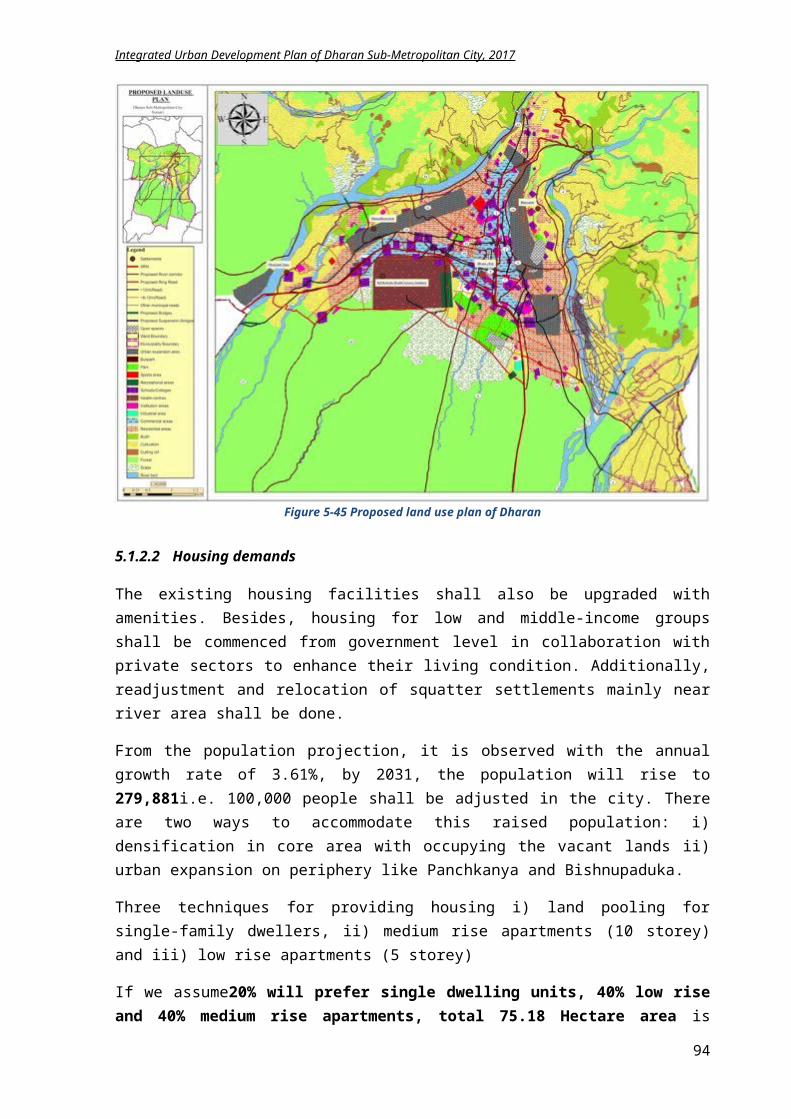
Integrated Urban Development Plan of Dharan Sub-Metropolitan City, 2017
To reduce environmental pollution To improve the ground water recharging by promoting rain water harvesting To prepare climate change adaptation and mitigation strategies and plan
5.3.2 Plan and Programs
5.3.2.1 Solid waste management
As explained in the Prevailing situation analysis chapter, solid waste management and separation is already commenced on Dharan. “Waste to energy” program is also in the priority list of Dharan but a proper strategy and implementation plan haven’t been formulated yet. A proposed series of activity for the solid waste management are described below.
Landfill site:
A landfill site is identified on the southeastern part of the city near ward no 6 of Panchkanya. This will solve the solid waste management problem of the city.
Waste Reduction, Recycling and Reuse:
As waste recycling project was operated and sensitized in municipality, this should be continued.
A waste separation system at home can be initiated by the city for separating glass, paper, electronics, organic waste and non organic waste.
The private institutions should be encouraged to participate on “waste to energy” program. Recently this is initiated, should be extended within all municipal area.
Waste production will be reduced by 40% (from 0.18 kg/person/day to 0.10 kg/person /day) by investing in organic waste production and waste recycling to achieve the green city standards that suggests 50% of the waste produced per person is recycled.
Training programs can be initiated to use the organic waste in kitchen gardens and roof gardens.
City can even develop a strategy to charge the people only for the inorganic, non degradable waste based on the garbage weight.
The recyclable and reusable material can be collected for free in exchange of the non degradable waste or can be purchased from dwellers alternatively.
A plastic free city initiative measures can be taken by the city in coordination with schools, private organizations and business owners.
Charging policy with the deposit that can be refunded for every plastic bottles (soft drinks, water, juice) has to be initiated for reduction of plastic bottle waste.
5.3.2.2 Waste water management
The existing condition of wastewater management is already explained in the drainage and sewerage chapter in physical development planning.
Sewerage treatment plants: Sewerage network of 742 km is planned which is to be constructed phase wise in 3 phases. Two-treatment plants: one in wards no 17 at southwestern corner and other in ward no 15 at
southeastern end are proposed. The bio-gas and manure production from wastes is encouraged and proposed in the plan.
Storm water management: Strategy in planning and building byelaws is made, so that the rainwater can be used for the
ground water recharge instead of mixing it with sewer and discharging it to river.
94
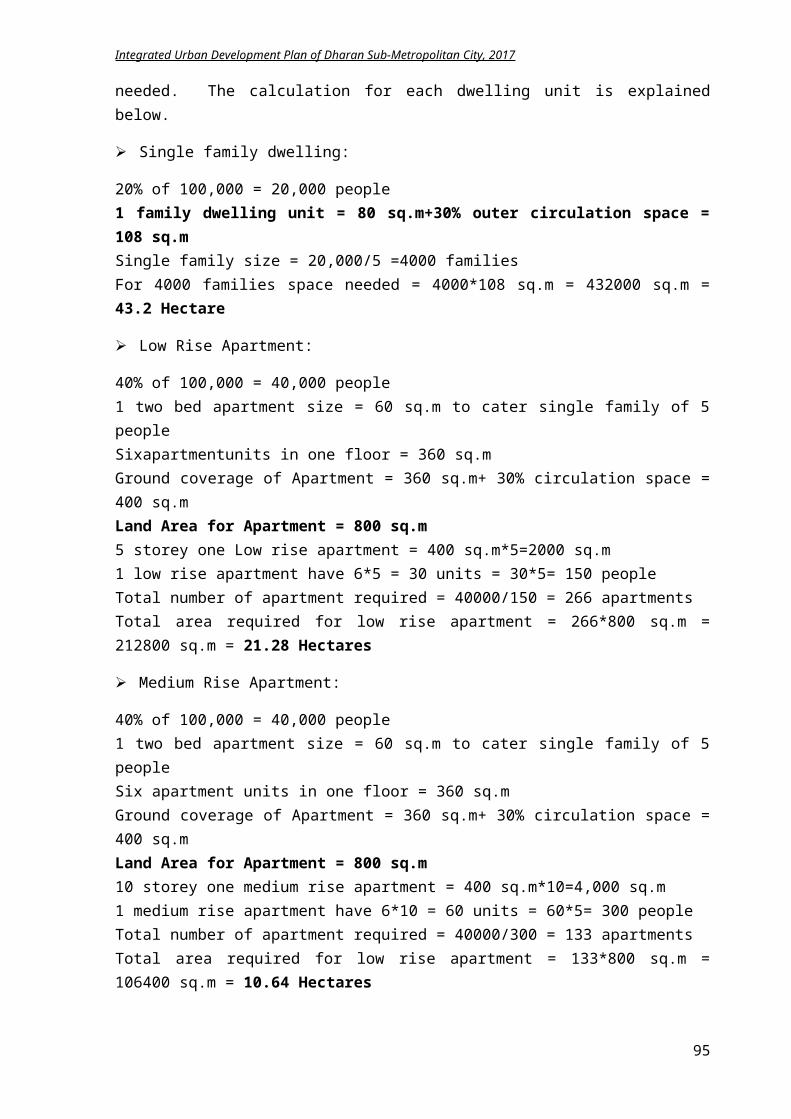
Integrated Urban Development Plan of Dharan Sub-Metropolitan City, 2017
A collection tanks can be made in various locations of the city for this side drainages, which can be used for watering vegetation around the city.
5.3.2.3 Environmental deterioration
The activities for controlling the environmental pollution are:
Taxation and awareness: Restricting vehicular emissions by regular checking and banning very old vehicles producing
smokes. Increasing awareness about reducing the usage of firewood for household purpose. Charging the people for dumping the waste haphazardly. Taxation for people who set free there pets like dogs, cow, goat, chicken on road.
Visual pollution: Visual pollution needs to be corrected by enforcing building bye-laws, restricting the
hoarding boards usage in commercial areas only. Control mechanism has to be set for managing built environment that can be achieved only
through planning and building byelaws. An incentive and penalty mechanism have to clearly stated in the byelaws of Dharan, for controlling these built structures.
Slaughter house: A new Slaughter house shall be constructed on Khairenee area of ward no 5 near Khahare
Khola, to restrict the air and visual pollution in the city center and manage the environmental issues.
Khahare Khola (Bhaudi) management: Near Khakhare khola in ward no 7 and 8, action against the stream encroachment shall be
taken. The built up area construction near this stream shall be restricted through enforcing building bye laws. The already built houses ad building shall be demolished for construction of cycle lanes, jogging track and green lane along the Khahare stream to conserve the stream. Small bridges shall also be constructed at some intervals for connectivity.
5.3.2.4 Climate change: mitigation and adaptation strategies
A climate change responsive plan and program is to be formulated to reduce and mitigate the effects of the climate change.
The newly included wards of DSMC are in more risk of this climate change. Hence, the climate change responsive and adaptive programs need to be prioritized in these areas.
95
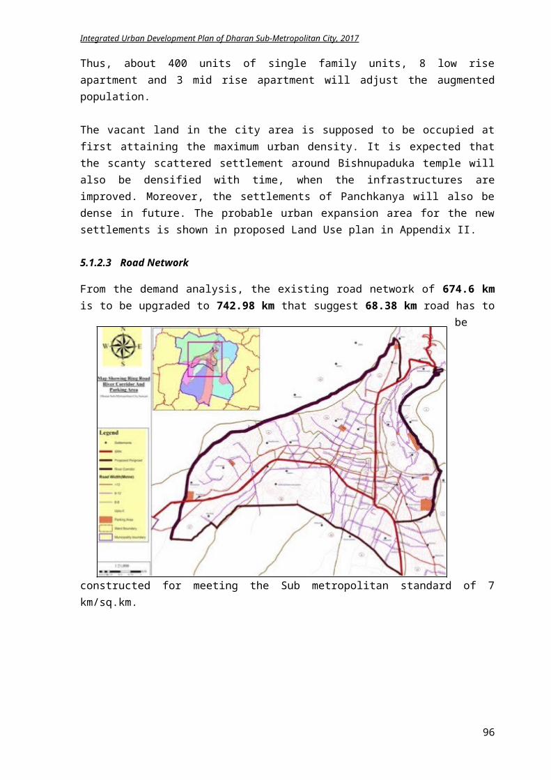
Integrated Urban Development Plan of Dharan Sub-Metropolitan City, 2017
The program like tree plantation and community forest conservation initiated in ward no 14 and others of DSMC encourages clean development mechanism and gaining incentives for carbon economics and co-ordinate with alternative energy center.
Figure 5-68 Location of proposed treatment plants and landfill site
5.3.2.5 Urban greenery
With the increasing urban population in the city core and high densification, there always a clash between natural environment and man made structures. These built structures overshadow the natural environment with lack of greeneries and plants. Even in Dharan, except the protected forest area on the south of the city, the city cores lack greeneries resulting the cityscape to be grey and dry. This exacerbates various problems in the city area resulting in rising temperatures, and heat waves producing a heat island effect. For this, urban greenery can be an ideal solution. Urban greenery can mean everything from city parks and traditional streetscaping, like trees and planters, to more modern adaptations, like green roofs and bioswales. In addition to aesthetics, these green solutions results in cleaner air, improved storm water management, safer neighborhoods and benefits the local economy. Urban greenery even makes a strong credit point in LEED certification.
Urban greenery implementation needs to be combined with planning and building byelaws of Dharan.
Tree plantation along the major roads of Dharan. Construction of park in each local neighborhood (ward). Rain garden construction in Bijaypur Chowk area. Promotional programs for encouraging people to include green roofs, green walls and urban
farming in homes. For the implementation, incentives and awareness program has to be formulated by the
DSMC.
96
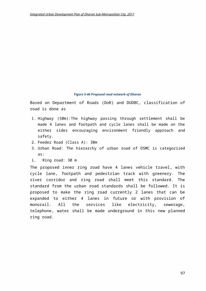
Integrated Urban Development Plan of Dharan Sub-Metropolitan City, 2017
Tax exemptions while getting building permit and incentive of time frame for building construction for people who are using urban greeneries in their homes.
5.3.2.6 Conservation of environmental sensitive areas
As explained in proposed land use plan of physical development plan, for protection of environment sensitive area, conservation areas are identified. Further activities for conserving these areas can be listed as:
River protection: A river embankment plan is needed for bounding the flow of river as these are seasonal river. The afforestation initiation on opposite bank of Sardu khola is a perfect example for reducing
landslide and maintaining environmental balance. Relocation of the squatter settlements from river areas and heritage zones.
Natural resource preservation: Conservation of natural resources and ground water table. Restriction of usage of modern technology material like marble and others during cremation
for accelerating degradation rate of the corpse. Penalty for people dumping waste near river, forest and temple areas.
Char koshe Jhadi conservation: Conservation of wildlife in forest area for developing a safari concept for observing these
animals. Sardu Watershed Eco-park:
To conserve the vital source of water of Dharan, Sardu watershed conservation plan shall be implemented. It shall be combined with a concept of eco-park as this area is rich in bio-diversity. This eco-park will help in preservation and conservation of sardu watershed and also promote eco tourism and economy of Phusre bazaar. The Eco-Park (Bio-diversity park) will have a picnic spot, memorial park (current cemetery area), water park, Bamboo museum, Herbal park, Rock view tower, flower bridge, meditation center, peace stupa, stone water spouts (Dhungedhara), bio-diversity forest, electric bridge, nursery, zoo, health park and homestay in Tamakham village. The total cost for DPR of this project is NPR 8.1 million and construction cost is NPR 350 million, which is enlisted below: Picnic spot: Consultancy cost: NPR 500,000; Construction cost: NPR 15 million Memorial park: Consultancy cost: NPR 500,000; Construction cost: NPR 5 million Water park: Consultancy cost: NPR 700,000; Construction cost: NPR 30 million Bamboo garden museum: Consultancy cost: NPR 300,000; Construction cost: NPR 10
million Herbal Park: Consultancy cost: NPR 300,000; Construction cost: NPR 5 million Bio diversity park: Consultancy cost: NPR 500,000; Construction cost: NPR 15 million Mini Zoo: Consultancy cost: NPR 500,000; Construction cost: NPR 30 million International meditation center: Consultancy cost: NPR 300,000; Construction cost: NPR 20
million Lord Shiva Statue: Consultancy cost: NPR 1 million; Construction cost: NPR 50 million Electric bridge: Consultancy cost: NPR 1 million; Construction cost: NPR 50 million Peace Stupa: : Consultancy cost: NPR 300,000; Construction cost: NPR 15 million Stone Spouts: Consultancy cost: NPR 300,000; Construction cost: NPR 10 million Rock View tower: Consultancy cost: NPR 500,000; Construction cost: NPR 10 million Cycle Safari: Consultancy cost: NPR 300,000; Construction cost: NPR 50 million Ethnic village: Consultancy cost: NPR 200,000; Construction cost: NPR 10 million Entrance gates: Consultancy cost: NPR 500,000; Construction cost: NPR 15 million
97
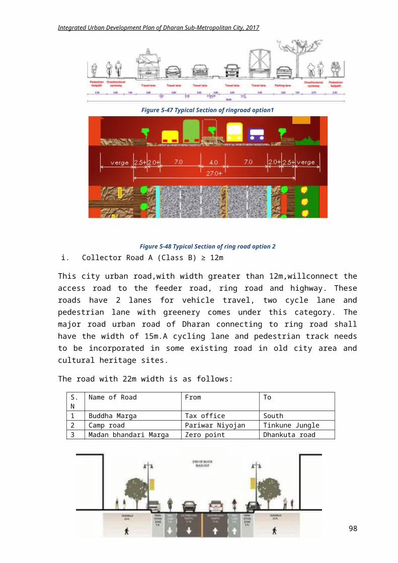
Integrated Urban Development Plan of Dharan Sub-Metropolitan City, 2017
Tamakham homestay: Consultancy cost: NPR 100,000; Construction cost: NPR 5 million Service/Amenities blocks: Consultancy cost: NPR 300,000; Construction cost: NPR 5
million
5.3.2.7 Sustainable cities concept
With the increase in urbanization trends and urban sprawl, sustainable cities concept is highly claimed in current context. A sustainable or eco city is a city with consideration of environmental impact, inhabited by people dedicated towards minimum resource intake and minimum waste output generation. With this urbanizing trends, almost over half of the population of the world will be living in city area by 2030. This will suggest more resource usage and waste generation. Hence, a compact, organic, green city can be a solution for this growing global development of cities.
The following ideology of a sustainable city can be adopted in Dharan planning byelaws too.
Walkable City:
Proposed activities: Walking needs to be promoted in Bijaypur hill which houses numerous temples like
Panchkanya, Budhasubba, Dantakali. The park, green area to be developed near the river corridor development will also promote
the walkability in the city. Apart from the main road network accessed by local vehicle, the inner city area needs to be
encouraged for walking with pedestrian lanes. A cultural route can be developed for connecting the various temples located in Bijaypur
area. Pedestrian walkways should be incorporated in existing roads for encouraging walking.
Sustainable transportation:
Proposed activities: Improvement of public transportation, electric vehicles and solar power vehicles and
promoting bicycles usage can be a mode of sustainable transportation in Dharan emphasizing the use of a diversity of fuel-efficient transportation vehicles in order to reduce greenhouse emissions and fuel demand, thus advocating the green city model.
Renewable energy:
Proposed activities: Promotion of sources of alternative energy usage, like Sun and organic waste, rainwater
harvesting to cater to the green city concept of Dharan. Solar energy can be a best alternative energy in Dharan.
Rainwater harvesting proves as solution for drinking water problem that also recharge ground water table.
Car free city:
Proposed activities: A strategy can be adopted in the old city of Dharan, like Bijaypur hill and Pindeshwor
temple, to promote bicycle or pedestrian for preserving the heritage and reducing GHG emission.
Usage of cars can be discouraged by increased taxation and improving public vehicles. A car-sharing program can be initiated in the city for primary testing.
98
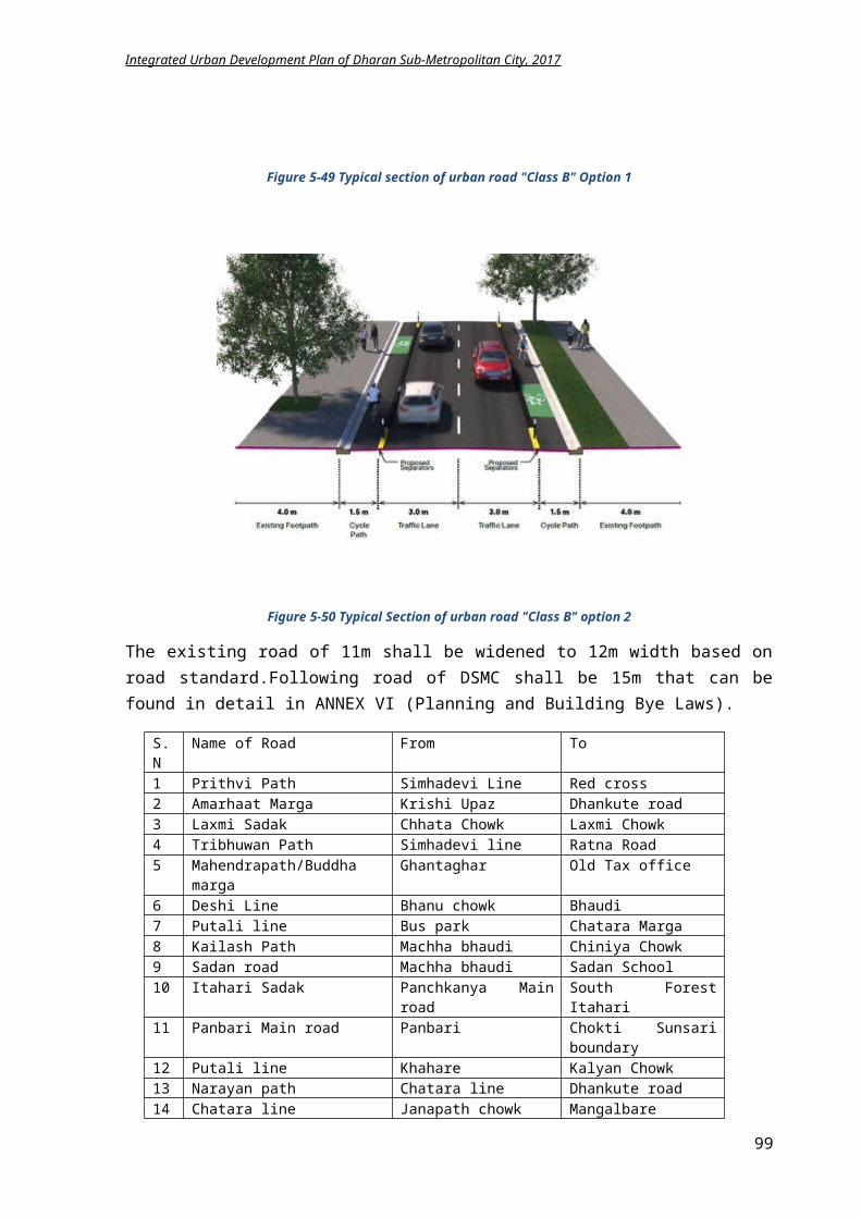
Integrated Urban Development Plan of Dharan Sub-Metropolitan City, 2017
Permeable pavements:
Proposed activities: It is recommended to use permeable paving in newly constructed road like Bijaypur hill,
having restriction of vehicle usage, for ground water penetration. Pedestrian pavements need usage of permeable material
5.3.3 LFA for achieving environmental management
Intervention Logic Indicators Means of Verification
Assumptions
Goal: Achieving a suitable secure and balanced urban living environment with less impact on nature Objective:Management of urban environment of Dharan through preservation of natural resources, forest areas, maintaining bio diversity and promoting sustainable city concept to achieve ecological balance. Result: 1) Community forests are
managed effectively.2) Natural forest will have
diverse wild life.3) Encroachment on natural
areas like forest and river will decrease.
4) Environment sensitive areas are identified and conservation is done.
5) Calamity rate is declined.
6) Watershed areas are utilized ecologically.
7) River pollution is minimum.
8) Air is cleaner.9) Waste segregation is
introduced in every household.
By 2032, Multi Hazard risk map of
Dharan is prepared. Natural Resources
mapping is prepared. Number of people
affected from landslides and flood is less.
Number of trees planted alongside the road is increased.
Groundwater table is increased.
Organic waste dumping rate is decreased by 50%.
Air pollutant particles are decreased.
Documentation of Water Supply and Solid waste management branch
Records of Forest, Environment and Disaster Management Division
Land management and building regulation division records
Budget is available
People actively participate in waste management program.
GoN is willing to address the environment issues
Activities:Environmental pollution
i. Construction of Slaughter house on ward 5ii. Enforcement of regulation and byelaws
iii. Vehicular emission restriction iv. Awareness Program for environmental pollutionv. Construction of cycle lane, footpath on Khahare khola
corridorvi. Electric public vehicles promotion
vii. Waste separation concept promotionviii. Workshop on organic fertilizers fro waste
ix. Subsidy for construction of toilets in Bishnupaduka and panchkanya
Conservation of sensitive areai. Tree plantation on opposite forest area of Sardu kholaii. Construction of water reservoirs on 5 areas of Char
Koshe Jhadi for wild life promotioniii. Water source protection programsiv. DPR for Eco-park
Urban greeneryi. Tree plantation along major roadii. Tax Exemption for promoting urban greenery
Cost: In NPR
i. 5 millionii. 3 million
iii. 6 millioniv. 5.4 millionv. 5.61 million
vi. 10 millionvii. 5 million
viii. 2.4 millionix. 1 million
i. 4 millionii. 50 million
iii. 5 millioniv. 8.1 million
i. 2.6 million
Time Frame
i. 2 yrs.ii. 3 yrs.
iii. 3 yrs.iv. 2 yrs.v. 3 yrs.
vi. 3 yrs.vii. 1 yr.
viii. 1 yr.ix. 2 yrs.
i. 2 yrs.ii. 5 yrs.
iii. Yearlyiv. 2 yrs.
i. 2 yrs.
99
Integrated Urban Development Plan of Dharan Sub-Metropolitan City, 2017
iii. Organizing workshops and trainings for green roof and urban farm
iv. Rain garden construction in Bijaypur Chowk Sustainable cities concepti. Construction of 10 km cycle lanes in major roads
ii. Development of 65 km pedestrian tracks on major roads
iii. Promotion of alternative/renewable energyiv. Promotion of car and taxi sharing programs
ii. 10 millioniii. 2 millioniv. 0.45 million
i. 20 millionii. 130 million
iii. 5 millioniv. 2 million
ii. 3 yrs.iii. Yearlyiv. 1 yr.
i. 5 yrs.ii. 6 yrs.
iii. Yearlyiv. 2 yrs.
5.3.4 Summary of Environmental Management Plan Implementation
Component Base year2017
Target2022
Methodology Approach Stakeholder
Solid waste reduction
0.18kg/ person/
day
0.10kg/ person/
day
Segregation and collection Compost plant operation Implementation Operation and management
PPP Implementation
of 3R approach Waste taxation Incentives
DSMC Ward HH NGOs GoN
Khahare Khola development
Cycle lane, green
Feasibility study Design and Construction Operation and Management
Program Partnership
DSMC Donor Agency GoN
Water source protection
Implantation of vegetation Improving water recharge
PPP Programs
DSMC Users NGOs
Forest protection
50% 50% Land use conservation plan Tree plantation Operation and management
PPP Plantation
campaign School
Program
DSMC School CFUG NGOs
Urban greenery
30% 80% Plantation of trees, bush Green roof and green facades Park and garden development Monitoring
PPP Incentives School
programs Trainings/
workshops
DSMC Citizens NGOs
Air quality 100% Clean
air
Standard setting Enforcement Monitoring
Polluters tax Subsidy for
clean energy promotion
DSMC Users NGOs
Sustainable city
75% Construction of cycle lanes and pedestrian tracks
Alternative energy study Taxi and car sharing
PPP Incentives Partnership Collaboration
DSCM Donor agency NGOs Users
Butcher House
1 2 Site identification Standard setting Design and construction
Program Partnership
DSMC Private sector
Sustainable city
75% Construction of cycle lanes and pedestrian tracks
Alternative energy study Taxi and car sharing
PPP Incentives Partnership Collaboration
DSCM Donor agency NGOs Users
5.3.5 Conclusion
Hence, the environmental management plan implies for the protection and preservation of components of environmental for a sustainable eco system. This advocates making city sustainable and encourages reducing the waste generation by 3R concept for placing fewer loads on environment. Presently, no budget is allocated for the environmental management except the
100
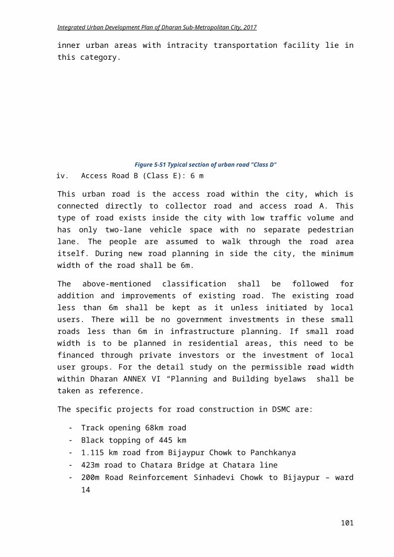
Integrated Urban Development Plan of Dharan Sub-Metropolitan City, 2017
waste collection. As sustainability is the main focus of the millennium development goal, investment is required in environment too. The total cost for environmental plans for 15 years time frame summed up to NPR 567.983 million. The severe environmental issues are related to river encroachment and watershed protection, air pollution that need to be addressed quickly.
5.4 Disaster Risk Management Plan
Disaster Risk Management is application of disaster risk reduction policies and strategies to prevent new disaster risk reduce existing disaster risk and control enduring risk, contributing to the strengthening of resilience and reduction of losses. Disaster risk reduction aims to reduce frequency of losses and damage caused by natural hazards. Nepal is opportune to have started two very important initiatives in disaster risk reduction, namely;
5.4.1 Goal and Objectives
Goal: Reducing the risk of life due to disaster related calamities through appropriate groundwork
Objectives:
To utilize the local resources to handle the situation that arises during disaster To identify the open spaces for preparing an evacuation plan To raise the disaster preparedness awareness among public To co-ordinate with local communities, stakeholders and central level to mobilize the
affected communities effectively
101
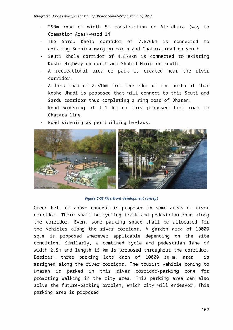
Integrated Urban Development Plan of Dharan Sub-Metropolitan City, 2017
To proceed disaster risk mitigation efficiently
5.4.2 Plan and Programs
5.4.2.1 Flood and Landslide
Proposed activities
An alarm system for detecting flooding is to be installed in Sardu and Seuti Khola within two years.
River embankment needs to be done for restricting the flooding. Settlement has to be controlled till 50m along riverside by enforcing regulations. Squatter settlements alongside river shall be relocated. The buildings adjoining Khahare Khola shall be demolished if it is constructed against
building regulations. Formation of committee with flood rescuers and conduct training for them. Conduction of programs for public awareness. Coordination and collaboration with national government rescuers. Alerting quickly through telephone, FM, local radio and newspaper. Coordinate with Police, army and Red Cross volunteers in various places for rescue
operation.
5.4.2.2 Fire
Proposed activities
A rescue operation shall be planned with three distinct phases – immediate care, medical aid first and organized relief.
Management plan of facilities required during rescue operation. A fire alarm system needs to be installed in public places or mass gathering area. Provide more fire extinguishers within Dharan. Increase fire brigade capacity. Coordinate with police and army for emergency. A preparedness program for fire led disaster shall be formulated by DSMC at ward level.
5.4.2.3 Thunderstorm
Proposed activities
Encourage proper earthing system during building construction. Working on system that provide premonition about thunderstorm. Increase public awareness about thunderstorm. Alerting citizens through newspaper, radios, TV and FMs.
5.4.2.4 Epidemics
Proposed activities
Primary health care and medical supply units for controlling epidemics need to be set up. A unit in BPKIHS has to be set up which will inform about the probable epidemics to the
Sub Metropolitan office and the office will take the necessary measures for controlling epidemics.
Alerting public and providing awareness through telephone, local radio, newspaper and FM.
5.4.2.5 Earthquake
Proposed activities
102
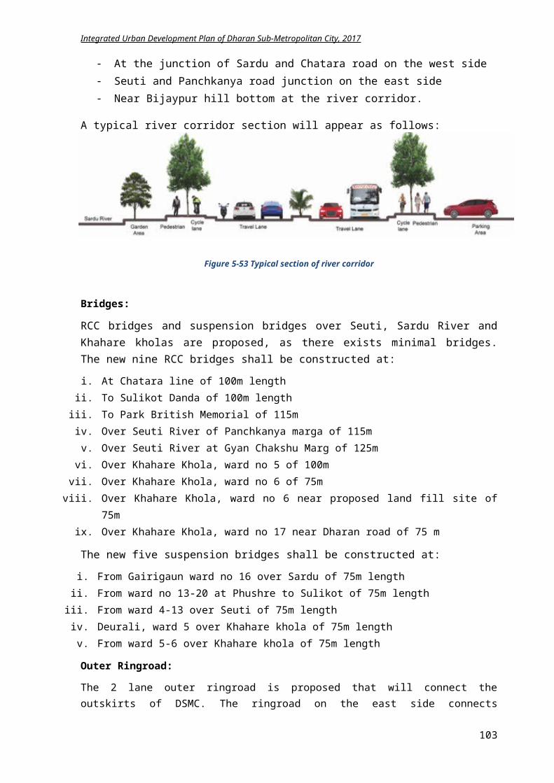
Integrated Urban Development Plan of Dharan Sub-Metropolitan City, 2017
An awareness program shall be conducted for informing people about what to do during and after earthquake.
Rehearsal of the exit pattern to closest identified open space shall be introduced to all the citizens once a year.
Educate students about the pre and post earthquake activities. Prohibition on construction of large structure in weak topography. Construction of earthquake resistant structures. Provide trainings for increasing skilled manpower for building construction. Several open spaces for gathering during disaster are identified and awareness program for
citizens shall be initiated. Evacuation master plans shall be placed in every ward. Signage in the open area used as temporary shelter during evacuation shall be places. The list of identified potential open spaces for emergency evacuation and temporary shelter
construction during earthquake hazard is mentioned in Table 17. Total 49,133 people can be accommodated at the time of disaster in these places.
Figure 5-69 Open Spaces for evacuation plan during emergency
103
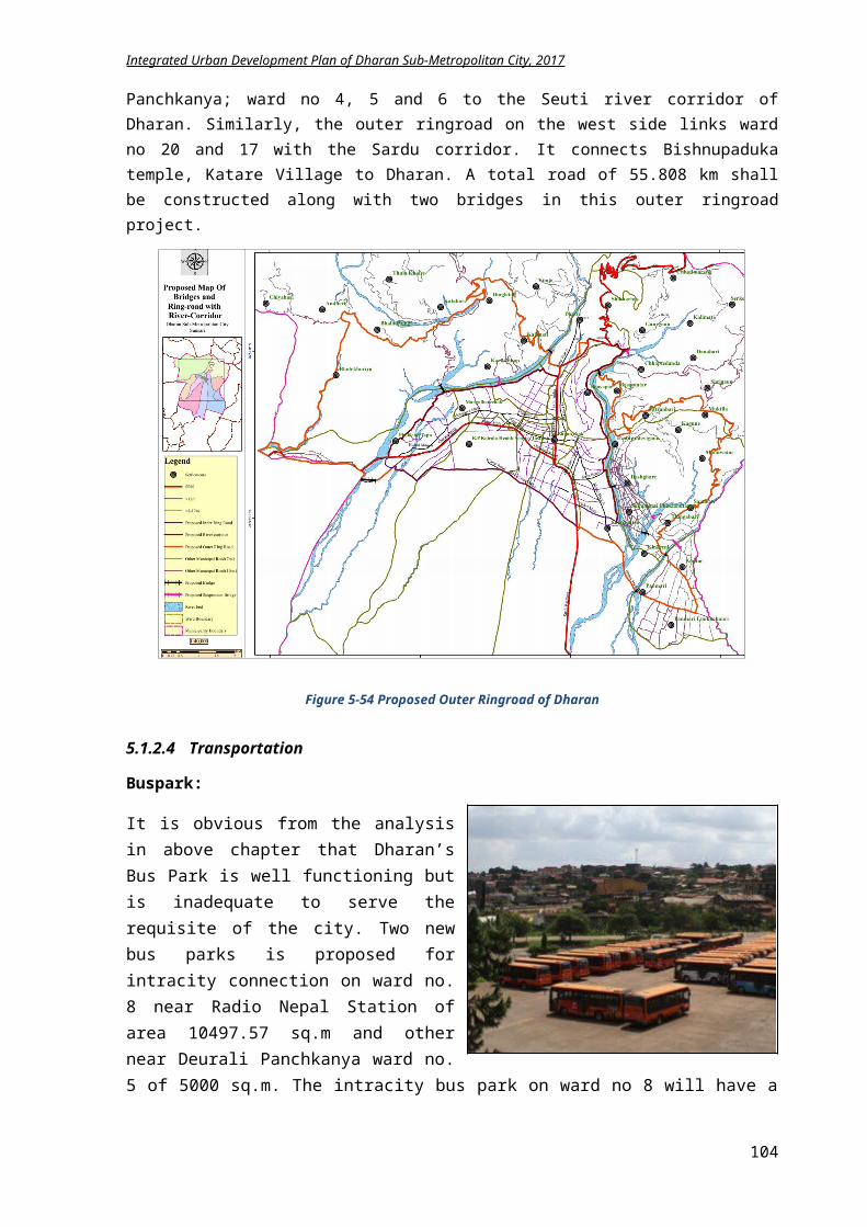
Integrated Urban Development Plan of Dharan Sub-Metropolitan City, 2017
Table 5.24 List of open space for evacuation plan during emergency
5.4.2.6 Pre-Disaster Plan
The pre-disaster action plan is derived from the Disaster risk management plan of Dharan. The action plans itself is efficient but lacks implementation.
a) Formulation and co-ordination of DSMC Disaster Risk Management Plan Formation of Disaster Risk Management Committee Activation of current committee Formation of Ward Level Disaster Risk Management Committee Identification of all organization operating in the DSMC Co-ordination with all stakeholder in DSMC
b) Public awareness and Training Disaster risk management training to Members of DSMC Disaster Risk Management Committee Identification and mapping of high risk area
S.N Project Area (sq-m) Capacity (3.5 sq.m person)1 BPKIHS – 18 16,500 4,7152 Bhanu Chowk – 14 2,275 6503 Proposed Bus park - 8 10,497.57 3,0004 Dharan Rangasala – 16 32,000 9,1435 Purbanchal Engineering college - 13 13,000 3,7156 Open space near Colony Marg – 13 8,000 2,2867 ANFA Stadium – 17 11,300 3,2298 Food Technology College – 14 3,200 9159 Mahendranagar Campus – 10 2,470 70510 Open Space near Koshi Highway -12 5,600 1,60011 Open Space near Pindeshwor path -14 9,450 2,70012 Open Space near Chatara road -17 1,620 46313 BPKIHS – 18 9,000 2,57214 Open Space near Sumnima marg-16 5,400 1,54315 Open Space near Niranjanbastimarg-15 9,525 2,72216 Open Space near Everestline-15 5,250 1,50017 Open Space near Koshi Highway-13 1,925 55018 Open Space near Surya marg-13 4,125 1,17919 Open Space near Aishwarya marg-11 1,600 1,72020 Saptarangi Park -17 4,900 1,40021 Bijaypur Chowk Park -14 612 17522 Open Space near Bhanu marg-15 7,700 2,20023 Open Space near Krishna joshi path-15 1,875 53624 Open Space near Shahid marg-15 3,250 92925 Open Space near Panchkanya marg-14 1,350 386
104
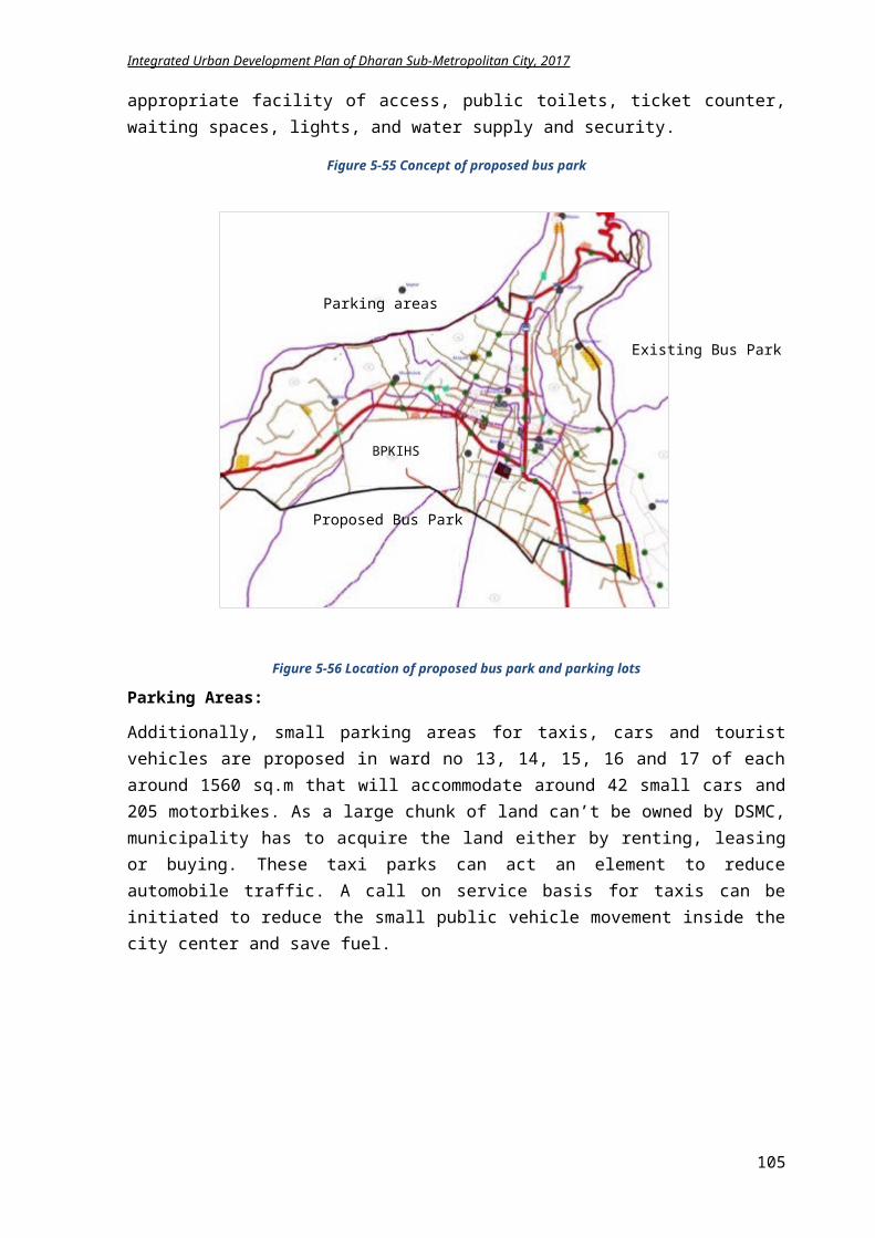
Integrated Urban Development Plan of Dharan Sub-Metropolitan City, 2017
Public awareness program in high risk zones Public awareness program about preparation for flood, landslide, earthquake, plague, etc. in the
high risk area Plague control plans and programs formulation Training for volunteers to make them capable of providing basic health service Training on Earthquake Resistant Construction to construction workers Training on Earthquake Resistant construction technology to Engineers and Technicians Retrofitting of houses which are not constructed in accordance with Engineering technique Development of Risk sensitive land-use planning
c) Rescue activities and capacity development Formation of Rescue team Rescue Training Management of facilities required for rescue operation Practice of Rescue operation
d) Physical infrastructure management and vulnerability mitigation Consideration of disaster risk while construction physical infrastructure like telephone, electricity,
road, water supply, etc. Identification and management of Emergency health centers Management of Fire-extinguisher van, Ambulance, hose pipe, first aid kit, etc. Identification of open spaces, building it properly to be utilized as emergency residing place and
declaring it like public parks and open areas of schools, colleges and government buildings. Planning to install devices to pre-monitor disaster Afforestation in the topographically vulnerable area Prohibition on extracting sand and gravel from river beds Development of Dumping site and landfill sites
5.4.2.7 Immediate and Post-Disaster Action Plan
Similarly, the post disaster action plan is also grounded on the DRMP of Dharan.
a) Management of Injured and displaced Providing information about earthquake or other disaster to people in the municipality and its
precaution needed. Performing local level rescue operation Emergency treatment for the affected Operating Emergency treatment team Transferring emergency patients to hospitals Co-ordination with national rescue team Evaluation of availability of most-needed facilities like road, bridges, telephone, etc. and
operation it temporarily Providing food, clothes and shelter to the displaced people Constructing accommodation areas for providing immediate shelter to the displaced people Proper management of dead bodies Management of debris of damaged structures Implementation of plan and timely evaluation
b) Relief distribution and reconstruction work Identification of storage location Management of materials needed for emergency shelter Rescue collection, storage and distribution Formation of Disaster Fund
c) Post-disaster plague control
105
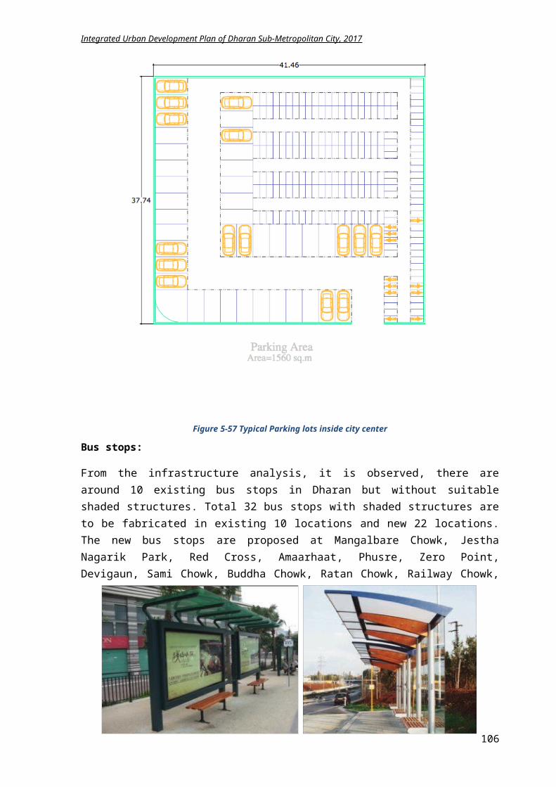
Integrated Urban Development Plan of Dharan Sub-Metropolitan City, 2017
Identification, declaration, and operation of team to evaluate the effects in the areas most vulnerable to plague
Developing public awareness about Communicable diseases Building Temporary service center and other health service centers near affected area Formation of Health operation team to treat injured people Giving priority to Physically disabled, children, old and females which providing health facility Managing nutrition required for pregnant, children, females and other people requiring immediate
help Providing facility to quickly transfer badly injured people to nearest health centers Providing vaccination to control communicable disease Managing water distribution properly Managing most-needed medicines Building toilets
5.4.3 LFA for achieving Disaster Risk Management
Intervention Logic Indicators Means of Verification
Assumptions
Goal: Reducing the risk of life due to disaster related calamities through proper planning Objective:Controlling natural and human induced calamities through pre disaster plans and identifying the most appropriate action plans during disaster for decreasing the number of affected people Result: 1) Less number of citizens
is affected by earthquake, fire, landslide and flood.
2) River bank encroachment is diminishing.
3) Deforestation rate is decreased.
4) More people take part in Disaster Risk Management Program.
5) Lesser number people are die by plague and epidemics.
By 2032, Multi Hazard risk map of
Dharan is prepared. Evacuation Plan map is
prepared. Squatter settlements are
relocated. Number of trees
plantation is increased in forest.
Rate of firewood usage for household purpose is decreased.
Records of Forest, Environment and Disaster Management Division
Land management and building regulation division documentation
Budget is available
People actively participate in awareness program.
GoN is willing to address the environment issues
Activities:i. Subsidy for Construction of earthquake resistant
buildingsii. Enforcement of regulation and byelaws
iii. Protection against landslide opposite Sardu Kholaiv. Awareness program for fire safetyv. Workshop of earthing for preventing Thunderstorm
vi. Plague control awareness programsvii. Establishment of epidemics department on BPKIHS
viii. Collaboration with BPKIHS for health serviceix. Establishment of emergency health groupsx. Establishment of local rescuing team
xi. Training for rescuersxii. Relocation of squatter settlements
xiii. Alarm system for flood in riversxiv. Evacuation plan promotion during emergencyxv. Signage for evacuation routes
Cost: In NPRi. 5 million
ii. 1 millioniii. 3 millioniv. 0.5 millionv. 0.9 million
vi. 0.5 millionvii. 20 million
viii. 0.5 millionix. 7.5 millionx. 0.7 million
xi. 0.8 millionxii. 100 million
xiii. 8 millionxiv. 2 millionxv. 1 million
Time Framei. Yearly
ii. Yearlyiii. Yearlyiv. Yearlyv. Yearly
vi. Yearlyvii. 4 yrs.
viii. Yearlyix. 1 yr.x. 1 yr.
xi. Yearlyxii. 8 yrs.
xiii. 2 yrs.xiv. Yearlyxv. 1 yr.
106
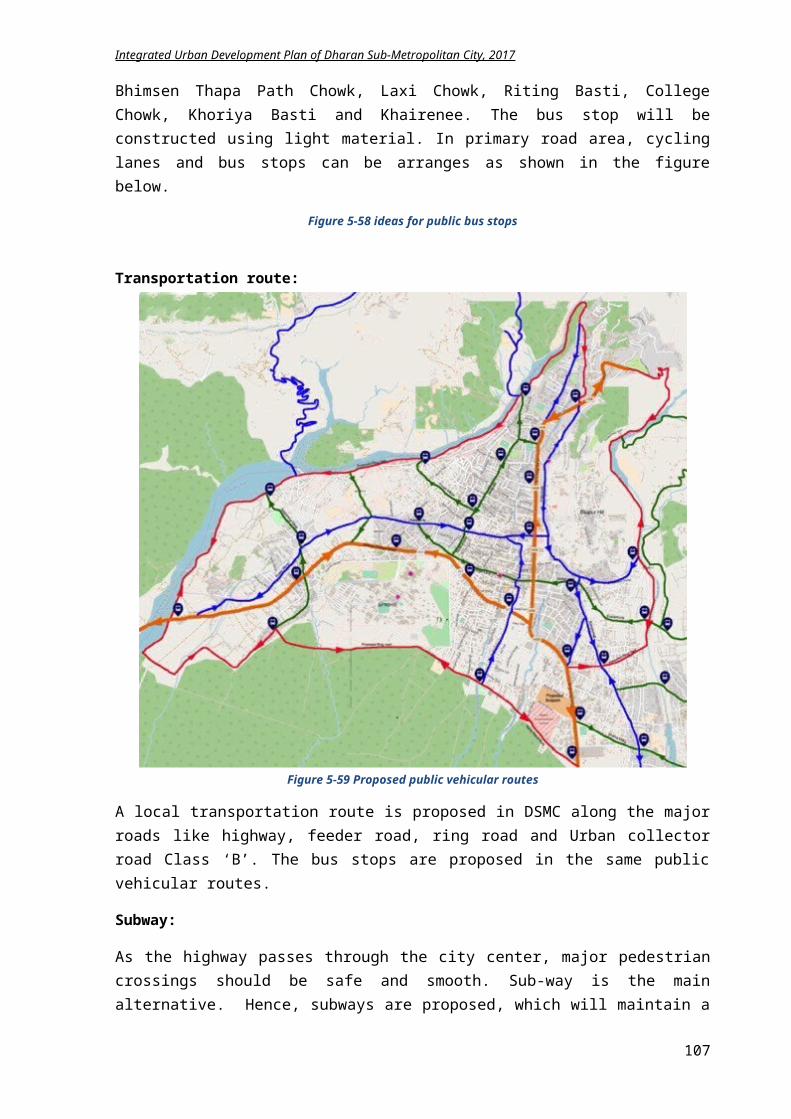
Integrated Urban Development Plan of Dharan Sub-Metropolitan City, 2017
5.4.4 Summary of Disaster Risk Management Plan Implementation
Component
Base year2017
Target2022
Basis for Target Methodology Approach Stakeholder
Earthquake resistant building
40% 100%
Earthquake prone area
Weak topography Weak physical
structures Lack of proper
public knowledge of appropriate construction technology
Large constructions without skilled manpower and technology
Standard setting of earthquake resistance building
Enforcing standards
Monitoring Workshops and
training Awareness
Program Partnership Collaborative Campaign Subsidization Awards and
felicitation
NSET DSMC HH Youth
groups School NGOs GoN
Settlements near Sardu and Seuti river
30% 0% Floor prone area River
encroachment Squatter settlement Risk of lives
River Embankment
Agro Forestry Buffer zone
creation Relocation of
settlement Awareness
Program Partnership Collaborative Campaign Coordination
DSMC NGOs User
Groups GoN
Landslides 0% Deforestation Weak topography Loss of natural
scape River
encroachment
Bio engineering and plantation
Agro Forestry Soil conservation
Program Model
demonstration Partnership
DSMC GoN NOGs CFUG
Fire safety 50% 100%
Buildings made by timber
Unmanaged electricity line
Less number of fire brigade
Petrol pumps, gas depos in residential area
Industrial area nearby
Fire extinguishers, storage water tank
Awareness Monitoring
electrical lines Managing rescue
operation Coordination with
police, army
Program Collaborative Campaign Demonstratio
n
DSMC NGOs HH Industry Hospital Police
Thunderstorm
0% Roof of ‘Tin’ in Dharan ward no 18
Electricity disruption and possible human loss due to falling of electric poles
Continuous heavy rain
Alerting Public Public awareness Working system
which can provide premonition about thunderstorm
Program Collaborative Campaign Partnership
DSMC GoN NGOs Citizen
Plaque control
100%
Polluted drinking water
Lack of waste management
Risk of lives
Awareness Alerting public Preparing nearby
health
Program Campaign Collaborative
DSMC, GoN
NGOs Citizen
5.4.5 Conclusion
The efforts for mitigating disaster risk should be planned properly and conducted accordingly. The capacity to handle the situation that could arise during disaster should be developed in the
107
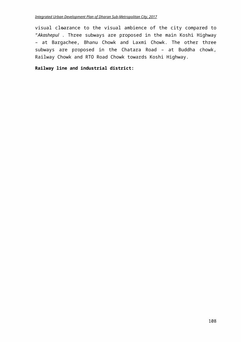
Integrated Urban Development Plan of Dharan Sub-Metropolitan City, 2017
local level and should be discussed with concerned stakeholders It is projected that 377.604million budget is required to carry out the disaster management plan for 5 years. Some projects like reinforcement of byelaws, subsidy for earthquake resistance building construction and tree plantation on areas prone to landslides requires funds every year. It is assumed that technical assistance required for disaster risk management is accomplished through local NGOs and INGOs.
5.5 Cultural and Tourism Development Plan
As explained in the concept of urban development planning of Dharan in above chapters, Dharan is to be developed as one of the triangle of the “Green East”. The continuing regional airport provides the potential for increasing tourism by attracting people coming to Lumbini to Dharan for a stay. For that urban environment, security and exploration of touristic sites are important. The rural setting, hiking forest area around Dharan has opportunity for ecotourism.
5.5.1 Goal and Objectives
Goal: Improvement of economy of Dharan through cultural and tourism development
Objectives:
Identification and preservation of important Cultural heritage sites within Dharan Identification of specific non-tangible cultures in the area Documentation of historically important sites and formulate plans for its revitalization Plan for conservation of both tangible and intangible cultures and link them to tourism
development plan Formulation of plans to promote Dharan as touristic centers Develop the culture centers (local craft, paint, architecture, museum, culture exchange,
exhibition)
5.5.2 Plan and Programs
5.5.2.1 Cultural heritage sites
Amritpinda Pindeshwor, Dantakali, Bishnupaduka, Panchkanya, and Budhasubba, Baraha, Pathibhara temple are the famous temples of cultural importance in and around Dharan. These temples are crowded throughout the year. Hence, it has high potential of attracting Hindu pilgrims in Dharan, local as well as foreign pilgrims.
Physical amenities: Improvement of amenities like road network, accessibility, drainage, solar lights in these
temple areas. Green areas like small parks, patis and relaxing area can be constructed for various cultural
activities like gatherings and marriage functions. Road connecting Bishnupaduka temple needs upgrading and other infrastructures shall be
enhanced. Infrastructures need to be developed to Baraha and Pathibhara temple that lies in the
neighboring municipality of Dharan.
108
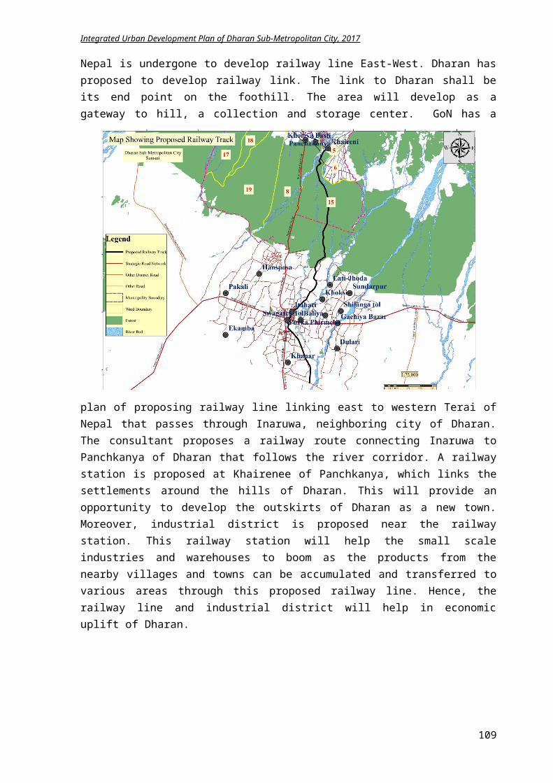
Integrated Urban Development Plan of Dharan Sub-Metropolitan City, 2017
Cultural route: A heritage walk route shall be planned for connectivity of main temples of city area i.e.
Budhasubba, Pindeshwor, Dantakali and Panchkanya temple.Cultural forest/park:
The surrounding land around Bishnupaduka can be accumulated from concerned authorities to construction of cultural forest and park. This park can promote Rudraksha plantation, which is evidently good in this area.
Bijaypur hill: Construction of cable car network linking Bijaypur danda of Dharan with Bhedetar. Panchkanya premises development shall be done which is a prioritized sub project of this
IUDP, which cost around NPR 41.6 million.
Figure 5-70 Cultural heritage walk route
5.5.2.2 Historical sites
The old city of Dharan, now squatted by some locals and the remnants of fort depleted due to negligence led to ignorance of the history. A plan needs to be formulated for reviving the old city center, Bijaypur Chowk. Following activities can be executed for revitalization of the old city:
Façade treatment: Develop a streetscape walk route from Bijaypur chowk to Panchkanya mandir by enhancing
the building facades by traditional wall arts, traditional elements or other beautification. For regulating the traditional façade, Bijaypur area shall be listed in conservation area in planning and building bye laws and rule enforcement techniques shall be promoted.
Similarly, facades of building along Budasubba temple and Pindeshwor temple route shall also be enhanced to traditional prototype design.
Stone paving: Paving the streets of cultural route of Bijaypur hill with semi permeable or permeable
building materials like brick or stones and encouraging the pedestrianization and bicycling.
109
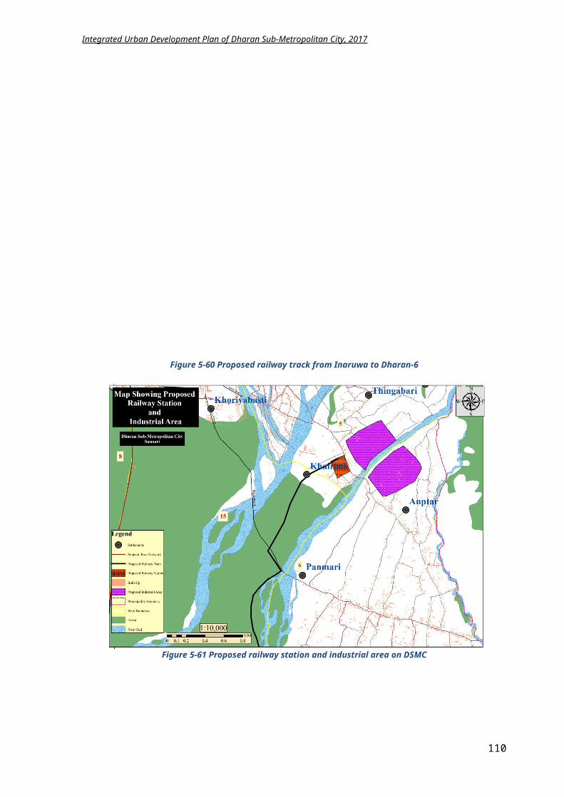
Integrated Urban Development Plan of Dharan Sub-Metropolitan City, 2017
Greenery and entertainment area: Increasing trees and greeneries along the sidewalks. Small pots of plants can be placed
wherever planting the trees are not possible. The greenery can be incorporated with street furniture along the cultural route for uplifting
the social ambience. Develop small relaxing zones with kiosks, greeneries and seat outs. Enhancing the existing garden with ponds, exercise area, jogging trial and kids play area Develop a plaza for conducting various events like awareness programs, meetings, and
exhibitions. The total cost of the project is NPR 11.82 million.
5.5.2.3 Tourism
According to the tourism destination plan for eastern Nepal 2016, Dharan, Illam and Taplejung area can be focused as an alternative tourism destination to the “Golden Triangle” in central Nepal, which links Kathmandu, Pokhara and Chitwan and is currently the principal tourism destination in Nepal. Based on the mountains, rivers, forests and natural beauty, the plan considers nature-based tourism as being the region’s strength, tapping in where also possible into the region’s cultural, historical and religious heritage, agriculture, hill station, adventure sports (rafting, paragliding, cycling) and urban environment possibilities.
Figure 5-71 Proposed touristic map of Dharan
Water entertainment at Kokaha River: Near Bishnupaduka, development Hattisar lake by constructing a dam in Kokaha river. This
lake will be multidimensional resource center i.e. fisheries, water recreation etc. The
110
Integrated Urban Development Plan of Dharan Sub-Metropolitan City, 2017
surrounding of this lake is proposed to plan as small touristic parks for relaxation with natural environment.
Chinne danda Construction of cable car network linking Bijaypur danda of Dharan with Chinne Danda. View tower construction in Chinne Danda for observing the aerial view of Dharan city. Construction of Buddha stupa at Chinne danda for attracting Buddhist tourist to
BishnupadukaAdventure sports:
Rock climbing at Bhulke Danda and Jhandi Danda Infrastructure development for Paragliding at Sulikot, Chinne Danda, which is in testing
phase currently. Improvement of infrastructure for Memodin Chwaling Ghumba, Kokaha connecting it with
Bishnupaduka for tourism development.Tourist information center:
Tourist information centers at several places proposed at Bhanu Chowk, Bijaypur Chowk, Bar Gachhi Chowk and other major crossroads to provide useful service to tourists and visitors, especially the provision of information goes hand-in-hand with other services, such as recharging facilities, toilets, Internet access, First Aid, etc.
Hiking trial/cycling route: Hiking trail development from Chinne danda, Safne Guranse Bhanjyang to Bhedetar An organic hiking tourist route or cycling route shall be developed in previous Panchkanya
VDC.Home stay/guesthouses:
Hotels and guesthouses of standard services shall be constructed in DSMC. Homestay to be developed in Kokaha, Chiuridanda, Bakhop basti, Tamanag Basti, Thamkham, Sulikot and Siddhapokhari. Taragaon Development Committee provides training for maintaining the standard of homestay.
Guided tours activities, undertaken usually by bus or in minibuses, with groups of visitors to main tourist attractions and destinations, can serve as a tourism development activity.
5.5.3 LFA for achieving Cultural and Tourism Development
Intervention Logic Indicators Means of Verification
Assumptions
Goal: Uplifting economy of Dharan by enhancing culture and tourism Objective:Identification of tourism and cultural heritage potential of Dharan and investing on its development for achieving Green East target as described in Tourism Development Action Plan of eastern Nepal Result: 1) Increase in revenue of
DSMC.2) More people are visiting
Dharan.3) Increase in demand of
organic agricultural products.
4) Fish farming and animal husbandry is increasing.
By 2032, Number of tourist is
increased. Agro farming industry
registration rate is increased.
Fish farming and animal husbandry number is raised.
A cultural heritage circuit map is prepared.
A touristic circuit map is prepared.
Records of Culture, Heritage and Tourism Promotion Unit
Documentation of Economic Development Division
Records of general Administration Division
Budget is available
There is political stability in country.
Central government provides budget.
Private sector is willing to invest.
Activities:Cultural heritage site
Cost: In NPR Time Frame
111
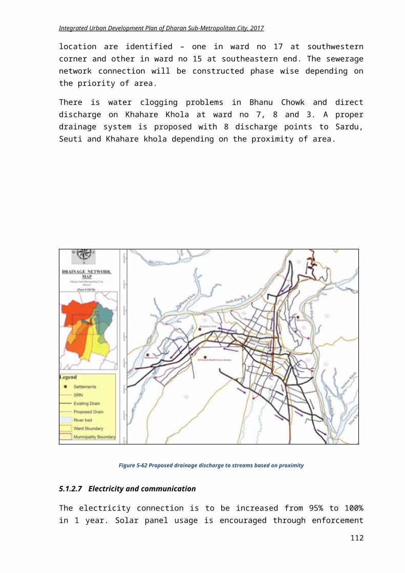
Integrated Urban Development Plan of Dharan Sub-Metropolitan City, 2017
i. Development of pedestrian lane of 4.03 km connecting famous temples
ii. Temple premises managementiii. Improvement of road to Bishnupaduka temple from
Khahare khola on ward 20iv. Construction of cable car from Bijaypur to Bhedetarv. Infrastructure development of Budhasubba,
Pindeshwor, Dantakali, Bishnupaduka templeHistorical sites
i. Façade improvements of buildings on Bijaypur Chowk
ii. Bye laws enforcement in Bijaypur hillTourism
i. Khokaha khola impoundment to develop a lakeii. Hiking trial development of 10.95 km from Chinne
danda to Bhedetariii. Construction of cable car from Bijaypur to Chinne
dandaiv. View tower construction at Chinne Dandav. Improvement of paragliding spot at Chinne Danda
vi. 5 Tourist Information centers operationvii. Hiking trial of 4.5 km to organic village at
Panchkanyaviii. Homestay workshops for Panchkanya
ix. Introduction of Guided tour in City busx. Introduction of safari concept in char koshe jhadi
xi. Rock climbing feasibility study
i. 8.06 million
ii. 1 millioniii. 4.356 million
iv. 400 millionv. 12 million
i. 5 millionii. 5 million
i. 10 millionii. 3.285 million
iii. 300 millioniv. 5 millionv. 4 million
vi. 1.5 millionvii. 1.35 million
viii. 2 millionix. 2 millionx. 3 million
xi. 2 million
i. 3 yrs.
ii. Yearlyiii. 2 yrs.
iv. 10 yrs.v. 3 yrs.
i. 2 yrs.ii. 2 yrs.
i. 2 yrs.ii. 2 yrs.
iii. 10 yrs.iv. 2 yrs.v. 2 yrs.
vi. Yearlyvii. 1 yr.
viii. 1 yr.ix. 1 yr.x. 1 yr.
xi. 1 yr.
5.5.4 Summary of Cultural and Tourism Development Plan Implementation
Component Base year2017
Target
2032
Methodology Approach Stakeholder
Temple physical infrastructures
Road, electricit
yWater
Drainage
100% Gap Analysis Prioritization Design and
construction Operation and
management Promotional strategy
Program Awareness Collaborative Partnership
DSMC Donor agency GoN User Group
Bijaypur Chowk revitalization
0 100% Need identification Space analysis Construction Fund raising Operation and
management
Program Collaborative Partnership Privatization
DSMC Users Donor agency GoN
Hiking trial development
0 10.95 km
Trail standard setting Implementation
Program Collaborative PPP
DSMC Donor agency Users
Adventure Sports (paragliding, rock climbing)
0 2 Site identification Feasibility study Standard setting Setting up Operation
Program Collaborative Partnership
DSMC Private sector Youth clubs NGO
Tourist information center
1 5 Site identification Arrangement of
equipment Establishment
Partnership Program Self running
Private sector Tole Bikas Youth clubs DSMC
Homestay/ organic village
20 Workshops/Trainings Standard setting
Assistance Subsidy
DSMC Private sector
112
Integrated Urban Development Plan of Dharan Sub-Metropolitan City, 2017
Operation Monitoring
Partnership Taragaun Citizens
5.5.5 Conclusion
As Dharan is rich culture and environment, it inessential to be conserved not only for religious essence but also for economic growth. The location of Dharan in between Terai and hill region provides benefit of varying landscape. Hence, tourism can be developed in the area. A proper tourism development plan will help conserve the culture heritage sites and natural landscape of Dharan thus benefitting the DSMC. From the strategic projects for cultural and tourism development, NPR 990.092 million budget is required for 15 years. The duration of strategic projects is maximum 5 years with only management costs and promotional events lasting for 15 years.
5.6 Economic Development Plan
Economic development is the process by which a nation improves the economic, political, and social well being of its people. It is an index, which is based on three equally weighted components: Longevity, measured by life expectancy at birth, Knowledge, measured by adult literacy and number of years children are enrolled at school and Standard of living, measured by real GDP per capita at purchasing power parity.
Commonly used criteria of economic development are increase in national income, per capita real income, comparative concept, standard of living and economic welfare of the community etc. Economy of an area can be directly related to the employment condition of that area, poverty, agricultural development, tourism development, road condition, industries and business, etc. Development in these sectors will therefore lead to the Economic Development of that area.
According to Dharan Municipality’s Plan for Fiscal year 2073/74, Dharan is the main economic center of eastern Nepal and the future plan shall focus on employment generation and poverty reduction synchronizing with local trainers for providing useful trainings to create self-employment.
5.6.1 Goals and Objectives
Goals: Standard of living of citizens is improved through employment generation and poverty reduction
Objectives:
To increase the economy of Dharan through agro farming, tourism and industry To identify the potential economic zones To formulate plans for boosting the economic activities within the DMSC To develop regional economic growth centers, and linking these centers with medium and
small towns through improved infrastructure
5.6.2 Plan and Programs
5.6.2.1 Agro-Farming Development
As clarified in earlier chapters, agriculture is a major source of income generation in Dharan. Lack of modern technology in farming, irrigation facilities, market management, and low
113
Integrated Urban Development Plan of Dharan Sub-Metropolitan City, 2017
financial capacity to invest on agro-farming has become main hindrances for developing agriculture as main income source.
Proposed activities: Dharan has alluvial soil with abundant land available for agriculture. Hence with modern
agriculture techniques along with youths’ participation on agro farming can be enticed to agriculture for income generation.
Establishment of cold storage, dairy product centers, butcher centers in different parts of the city with proper linkage to the rural areas for employment generation.
Local chicken farming on hill areas and poultry faming on southwards, Kalo Bangur farming shall be encouraged.
Professional cow farming and goat farming can be encouraged in hill areas having enough grazing lands.
In coordination with Wada Nagarik Manch and Nagarik Sachetana Kendra, youths (male and female) will be provided training about effective animal farming and agriculture.
Special efforts will be made to promote ginger, turmeric farming in the ward no 20 and 17 of sub-metropolitan city.
Develop a collection center of agro products in and around Bishnupaduka and Panchkanya area.
Guidelines and standards for animal farming management shall be formed and implemented. Off season vegetable farming and organic vegetable production shall be promoted to
Panchkanya and Bishnupaduka area. Basantatar area of Dharan 4 is proposed as a organic village with modern farming and
variety of agro product. Promote and develop the already existing organic farming and animal husbandry areas of
Panchkanya area through incentives and financial aid like providing seeds for free, trainings on making organic pesticides, providing loans for construction of green house faming areas and irrigation facilities etc.
Khahare Khola impounding on Deurali of ward no 5 for using it for irrigation purpose.
5.6.2.2 Trade promotion and Tourist Development
Trade and tourism industry of Dharan have higher potential for economic growth in DSMC. Various plans for tourism development have already been explained in heading “Cultural and Tourism development plan”. Some proposed activities for increasing tourist are:
Coordination between local and national travelling and trekking agencies for increasing number of national and international tourist.
Promotion through Internet or advertisements. Local youths, women and students can be utilized for information flow about culture,
heritage and natural picturesque of Dharan to outsiders.
5.6.2.3 Micro Industry and Business Promotion
Small and micro entrepreneurs are the engines of economic growth. Hence, their access to market, services, capital, education and technical knowledge should be eased.Proposed activities:
Necessary institutional support should be given to small and micro-enterprises in order to make them competitive in national and international markets.
Promote the fish farming in various wards 5,6 20 of Dharan and surrounding areas through river impoundment to lakes and ponds to discourage import from India and promote national products.
114
Integrated Urban Development Plan of Dharan Sub-Metropolitan City, 2017
Provide technical and financial assistance to the small women driven and community driven local industry for promoting women empowerment through trainings like knitting, painting and other crafts.
Encourage use of local products Promotion of local industries though taxes exemption and incentives in physical amenities.
5.6.2.4 Employment Generation and Poverty Reduction
For the employment generation and poverty reduction, various programs in different economic sector can be planned. Proposed activities:
Coordination to be done with concerned authority and organizations to manage remittance, which is the main income source of the municipality and programs, shall be conducted to promote it.
Programs shall be conducted to provide information to those who wants safe abroad employment.
People will be encouraged to invest the remittance money in a productive sectors like shopping malls, parking, sports hall etc.
Trainings shall be provided in coordination with various NGO and INGO to promote local employment.
5.6.2.5 Urban-Rural Linkage
One of the main sources for income generation of any city is its linkage with surrounding rural areas. It will help in economic growth of any city area.Proposed activities:
Develop the road networks to the rural areas for efficient network and connection for exporting agricultural goods.
Co-ordination with nearby exporting villages to manage safe export of agricultural goods. Coordination with small farmer of nearby villages to promote organic farming concept
within the area. Surrounding rural area like Bishnupaduka, Panchkanya, Ahale, Mahabharat, Barahkshetra
can be used for homestay and attracting tourists. Trade and networking activities in small urban sub centers should be fostered to stimulate the
rural urban economy. Establishment of cold storage, dairy product centers, butcher centers in different parts of the
city with proper linkage to the rural areas for employment generation.
5.6.2.6 Promising Economic Zones
Transportation, Information and Communication sector, Educational training institutes, Banking sector, Commercial buildings and Manpower companies for foreign employments are the assuring fields for economic development of Dharan.
DSMC can initiate lobbying with the local banking sector and finance companies for issuing loans to the local industry and trade.
Economic infrastructures like Parking Space, Bus parks, vegetable markets, Stadium, Sports Complex, and Movie Hall can escalate the revenue generation of Sub metropolitan.
Informal sector enterprises, which are active in food preparation, selling tea and coffee, tailoring, street vending of various items and domestic services also increases the economic growth rate of the city. A program for managing these sectors without hampering the beauty of the city is the main challenge of DSMC.
As there are many forests in Dharan, by organizing the community forest groups, Herbal farming and bee farming can be initiated for economic uplift.
115
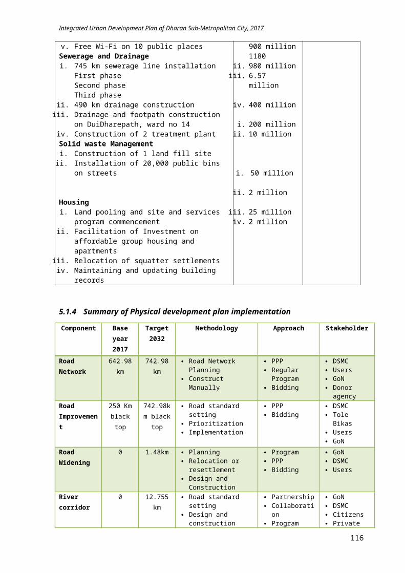
Integrated Urban Development Plan of Dharan Sub-Metropolitan City, 2017
educational and medical tourism can be promoted through bio-diversity promotion. A safari concept in Char Koshe Jadhi can be initiated with encouragement of diverse wildlife
in the forest.
5.6.3 LFA for achieving economic development
Intervention Logic Indicators Means of Verification
Assumptions
Goal: Achieving a standard quality life of the citizens through employment generation and poverty reductionAgro Farming Sector Objective: Improvement of income generation of farmers through commercialization in agriculture and animal
husbandry Result: 1) Youths are attracted
towards agro farming.2) Rise in agricultural
products and production.
3) Increase in production through development and improvements of cash crops.
4) Export of dairy and animal products is raised.
By 2032, People involving in agro
farming will rise to 50%. Registration rate of
animal farming is increased.
Export rate of cash crops is increased.
Records of Agriculture, Livestock and Co-operative works.
Agricultural development bank documentation
Employment generation and poverty reduction branch records
Budget is available though
Irrigation facility is available.
There is no loss in agricultural product.
There is no disease on crops.
Activities:i. Establishment of 5 Cold storage and collection centers
ii. Subsidy for chicken and Kalo Bangur farmingiii. Trainings on animal farming and agricultureiv. Khahare Khola impounding for irrigation design and
studyv. Construction of 10 one km irrigation canal at
Bishnupadukavi. Construction of 30 km irrigation canal at Panchkanya
vii. Preparation of guidelines for animal husbandryviii. Promotion of organic farming and off seasonal farming
ix. Loans for construction of green house farming and others
x. Networking activities with surrounding villages for product exports
xi. Improvement of access road to neighborhood rural areas
xii. Herbal and Bee farming promotionxiii. Coordination for Loan for agro farming
Cost: In NPRi. 5 million
ii. 5 millioniii. 0.8 millioniv. 10 million
v. 12 million
vi. 150 million
vii. 2 millionviii. 3 million
ix. 10 millionx. 0.6 million
xi. 4.5 million
xii. 2 millionxiii. 0.5 million
Time Framei. 5yrs.
ii. 5 yrs.iii. Yearlyiv. 3 yrs.
v. 3 yrs.
vi. 10 yrs.
vii. 1 yr.viii. 2 yrs.
ix. 4 yrs.x. Yearly
xi. 4 yrs.
xii. 3yrs.xiii. Yearly
Tourism
116
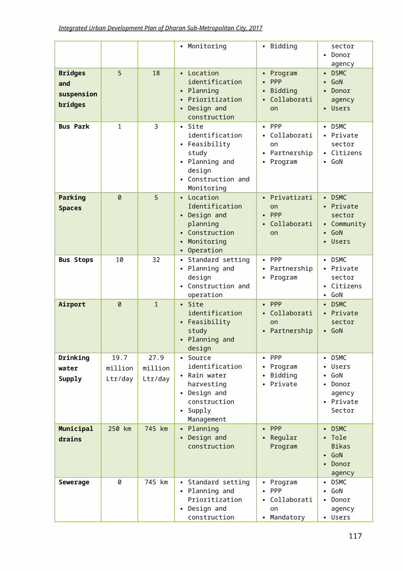
Integrated Urban Development Plan of Dharan Sub-Metropolitan City, 2017
Objective: Increment in revenue generation of Dharan through tourism promotion Result: 1) Increase in people
visiting Dharan for tourism.
2) DSMC will benefit from tourism.
By 2032, Rate of tourist will rise
by 75%. Tourism circuit map is
prepared.
Records of Economic Development Division
Information, Communication and data Management Division
Budget is available.
There is political stability in country.
Donor agencies are willing to help.
Activities:i. Coordination with national and international
travelling agenciesii. Promotional events through internet and
advertisementsiii. Educating students and local youths for information
flow
Cost: In NPRi. 1 million
ii. 1.2 million
iii. 1 million
Time Framei. Yearly
ii. Yearly
iii. YearlyEconomic Infrastructures Objective: Construction and planning of vegetable markets infrastructure, multi purpose sports hall, movie
halls for economic upliftment Result: 1) Vegetable markets are
established in each ward.
2) Enough entertainment facilities are available.
3) Adequate space is available for sports and other events.
By 2032, Vegetable markets
increase from 2 to 5. Number of movie halls
rise from 2 to 7.
Records of Economic Development division
Land Management and Building regulation Division records
Budget is available.
There is political stability in country.
Donor agencies are willing to help.
Activities:i. Construction of 3vegetable market structures.
ii. Construction of commercial complex with 5 movie halls.
Cost: In NPRi. 150 million
ii. 250 million
Time Framei. 10 yrs.
ii. 10 yrs.
Micro Industry and Business Promotion Objective: Focus on micro industry for benefitting the economic status of citizens. Result: 1) Employment is
generated.2) Informal sector
enterprises are well managed.
3) Women driven local industries are increased.
4) Investment in banks, transportation and promising economic zone is increased.
By 2032, Number of employed
people is increased Number of people
working in industry is raised
Local industry registration rate is increased.
Records of Economic Development division
Documentation of Rastriya Banijya Bank
Budget is available.
There is political stability in country.
People are convinced to operate industry.
Activities:i. Tax exemption on formation of industries.
ii. Provision of physical amenities to local industryiii. Loans for local industry formationiv. Subsidy on homestay conduction and small lodgesv. Coordination with local banks for loans
Cost: In NPRi. 10 million
ii. 5 millioniii. 10 millioniv. 10 million v. 2 million
Time Framei. 4 yrs.
ii. 3 yrs.iii. 3 yrs.iv. 2 yrs.v. Yearly
117
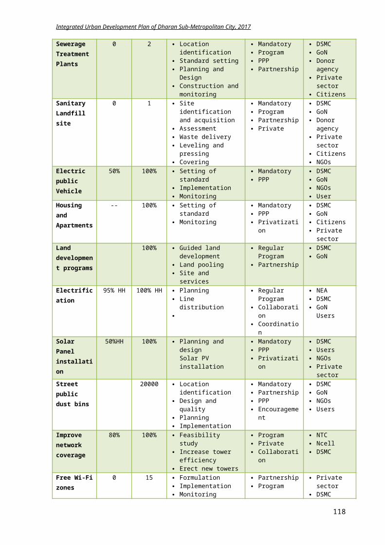
Integrated Urban Development Plan of Dharan Sub-Metropolitan City, 2017
5.6.4 Summary of Economic Development Plan Implementation
Component Base year2017
Target2022
Methodology Approach Stakeholder
Tourism Infrastructures
60% 100% Explore sites Conservation Infrastructure Construction
PPP Community
activation
DSMC GoN Community NTB
Vegetable Markets
3 5 Three in city core area Collection centers at
Bishnupaduka and Panchkanya
PPP Co-operatives Farmers
DSMC Private
Movie halls/ Malls
3 8 Need assessment Feasibility study Land acquiring Investment seeking
Promotion PPP Co-operation
Private Sector Community DSMC
Agro farming 100% Update about modern technology
Preservation of agricultural land
Commercialized farming
Trainings Workshops
Subsidy Loans
GON DSMC FNICCI-Dharan NGOs
Home stay 20 Formation of small lodge/homestay committee
DSMC PPP Collaboration
DSMC Taragaon
regency NGOs
Ware House/ Godowns and collection center
1 Panchakanya area, on the head of proposed railway
Warehouses development in PPP model
Linkage and services to hinterland
DSMC PPP Nepal Railway
FNCCI Ministry of
Commerce I/NGOs
Subsidy/Loans 50% Formation of beneficiary committee
Application in DSMC division
PPP Lobbying Promotional
events
GoN DSMC Banks
Advertisements 100% Coordination with travel agencies
Coordination with schools and youth groups
PPP Privatization Collaboration
DSMC NTC Travel agents Schools Youth groups Citizens
5.6.5 Conclusion
The economic development plan is believed to identify the probable profitable sectors of Dharan to help improving the economic growth of DSMC and its citizens. Moreover, it will focus on the poverty reduction, employment generation and promotion of tourism, agriculture and industry. The total investment required for the economical development is NPR 792.234 million with most projects to be completed within 5 years time frame. The economic infrastructures like vegetable market and cinema halls/multiplex has time frame of 10 years.
118
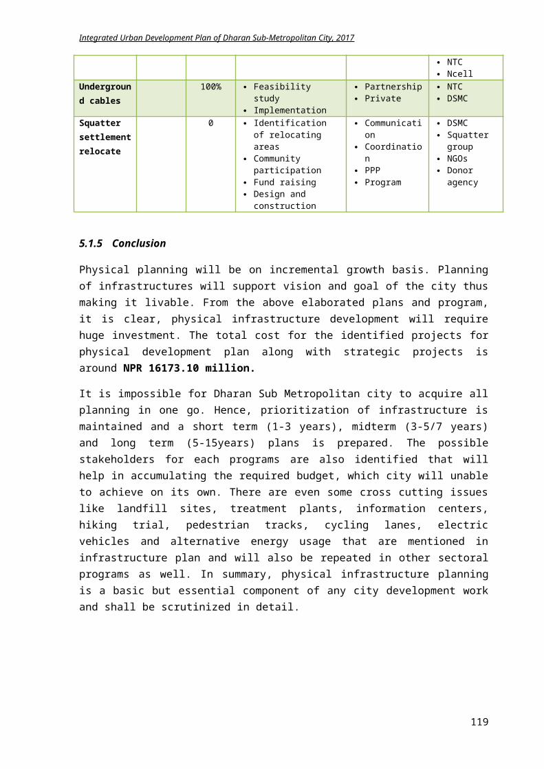
Integrated Urban Development Plan of Dharan Sub-Metropolitan City, 2017
5.7 Financial Development Plan
Financial development is a part of the development strategy to stimulate economic growth and reduce poverty, overcoming “costs” incurred in the financial system. It involves the establishment and expansion of institutions, instruments and markets that support this investment and growth process. It refers to the fulfillment of the functions of the financial system in the best manner by eliminating the market distortions.
5.7.1 Goals and Objectives
Goal: Achieving a financial sustainability through maximum utilization of available resources.
Objectives:
To identify the areas of economic potential To recognize the probable revenue generation areas of Dharan and formulate plan likewise To promote alternative funding modalities for minimizing the government municipal budget
by promoting PPP To encourage investments for financial sustainability
5.7.2 Plan and Programs
5.7.2.1 Projection of budget for 2017-18
The estimated budget of Dharan for the fiscal year 2017-18 as published by the DSMC is 1551.405, with NPR 820 million from central government and remaining 730 million the internal budget of DSMC. But from the strategic projects of each thematic plan as described in this IUDP, the total cost for the projects for the year 2017-18 is NPR 1585.20 million. A deficit of NPR 33.795 million is observed based on the budget from the central government and municipal income. The deficit amount in each sectoral plan is explicit in the table below.
S.N
Sector %
Budget from
ministry (in
million NPR)
Municipal
Budget (in
million NPR)
Total Budget DSMC
for 2017-18
Anticipated
budget 2017-18
(in million)
Deficit (in
million
NPR)
Deficit resource allocation (in million NPR)
% Internal % Externa
l
1Physical Development Plan
54 441.207 392.880 835.908 852.256 16.348 40 6.539 60 9.809
2 Strategic project 8 63.790 56.210 120.000 123.220 3.220 30 0.966 70 2.254
3Social Development Plan
13 106.770 97.230 204.000 206.241 2.241 20 0.448 80 1.793
4 Environment 6 49.403 44.900 94.303 95.428 1.126 30 0.338 70 0.788
119
Integrated Urban Development Plan of Dharan Sub-Metropolitan City, 2017
Management Plan
5Disaster Management Plan
3 21.861 18.330 40.191 42.228 2.037 0 0.000 100 2.037
6
Culture & Tourism Development Plan
5 37.281 33.234 70.515 72.014 1.499 30 0.450 70 1.049
7Economic Development Plan
5 37.808 32.462 70.270 73.032 2.762 70 1.933 30 0.829
8Institutional Development Plan
8 62.527 53.691 116.218 120.780 4.562 100 4.562 0 0.000
Total budget 100 820.647 730.758 1551.40
5 1585.200 33.795 15.236 18.559
The budget received from GoN is distributed to each sector based on percentage. Similarly, listing is done for each sector for the budget allocated by DSMC taking the reference of their annual budget record. Thereafter, scarce budget in each sector is derived. The above table clearly shows the deficit amount in each sector. Internal and external resources are identified to obtain this scarce budget.
In physical development plan, it is anticipated to attain 40% of deficit amount through internal resource and 60% from external donor agencies. Internal resource: 60% i.e. NPR 3.924 million is assumed to be arranged through municipal resource like
increase of taxes in property, business, automobile, entertainment and advertisements and increase in service taxes like parking fees, building permit, City cleaning, social infrastructure management etc.
40% i.e. NPR 2.616million shall be accumulated through people’s participation.External resource: International Donor agencies like ADB, World Bank, UN, UN Habitat Town development Fund (TDF) Lumanti Support group for shelter Winrock International Smaart Pani WaterAid Nepal Nepal Pollution Control and Environmental Management Center Alternative Energy Promotion center NCell, NTC Private Investors
In StrategicProjects plan (river corridor, drainage and Bijaypur hill development), it is anticipated to attain 30% of deficit amountthrough internal resource and 70% from external donor agencies.
Internal resource: 60% i.e. NPR 0.580 million is assumed to be arranged through municipal resource like
increase of taxes in property, business, automobile, entertainment and advertisements and
120
Integrated Urban Development Plan of Dharan Sub-Metropolitan City, 2017
increase in service taxes like parking fees, building permit, City cleaning, social infrastructure management etc.
40% i.e. NPR 0.386 million shall be accumulated through people’s participation.External resource: International Donor agencies like ADB, World Bank, UN, UN Habitat Town development Fund (TDF) Private Investors like Asian Paints, Berger, CG, LG, Samsung, Mobile companies, Beverage
companies etc.
In social development plan, it is expected to accomplish 20% of deficit amount through internal resource and 80% from external donor agencies.
Internal resource: Increase in municipal resource like increase of taxes in property, business, automobile,
entertainment and advertisements and increase in service taxes like parking fees, building permit, City cleaning, social infrastructure management etc.
External resource: International Donor agencies like ADB, World Bank, UN, GIZ TEWA UNICEF WHO Oxfam Nepal Women’s rehabilitation center (WOREC) Nepal Child NGO Federation Nepal SOS Children’s Village Women’s Foundation Nepal Saathi ActionAid Nepal
In environmental management plan, it is anticipated to attain 30% of deficit amount through internal resource and 70% from external donor agencies. Internal resource: 70% i.e. NPR 0.236 million is assumed to be arranged through municipal resource like
increase of taxes in property, business, automobile, entertainment and advertisements and increase in service taxes like parking fees, building permit, City cleaning, social infrastructure management etc.
30% i.e. NPR 0.101 million shall be accumulated through people’s participation.External resource: International Donor agencies like ADB, World Bank, UN, Sun Farmer Nepal Clean Energy Nepal Winrock International Smaart Pani International Union For conservation of nature(IUCN) Nepal WaterAid Nepal
121
Integrated Urban Development Plan of Dharan Sub-Metropolitan City, 2017
Nepal Pollution Control and Environmental Management Center Alternative Energy Promotion center
In Disaster management plan, it is assumed DSMC will seek support from the external agencies for collecting the deficit amount for completing the project.External resource: Nepal Society of Earthquake Technology (NSET) International center for integrated mountain development (ICIMOD) Disaster preparedness network Nepal Department for International development (DFID) ActionAid Nepal Care Nepal Nepal Red Cross Society Climate Change Network Nepal IUCN National Trust for Nature Conservation
In Cultural and Tourism development plan, it is expected to achieve 30% of deficit amount through internal resource and 70% from external donor agencies
Internal resource: 20% i.e. NPR 0.09 million is assumed to be arranged through municipal resource like
increase of taxes. 80% i.e. NPR 0.36 million shall be accumulated through people’s participation.
External resource: Archaeological department GIZ, UN ADB, World Bank Private Investors
In Economic development plan, it is expected to achieve 70% of deficit amount through internal resource and 30% from external donor agencies
Internal resource: The deficit amount is likely to be arranged through private investors and citizens
participation External resource: GIZ, ADB, UN Forward Nepal Sustainable Agricultural Development Program Nepal Agricultural development Bank
In Institutional development plan, it is expected to achieve 100% of deficit amount by DSMC itself through increase in taxes and service charges. Technical assistance can be acquired from concerned NGOs and INGOs.
122
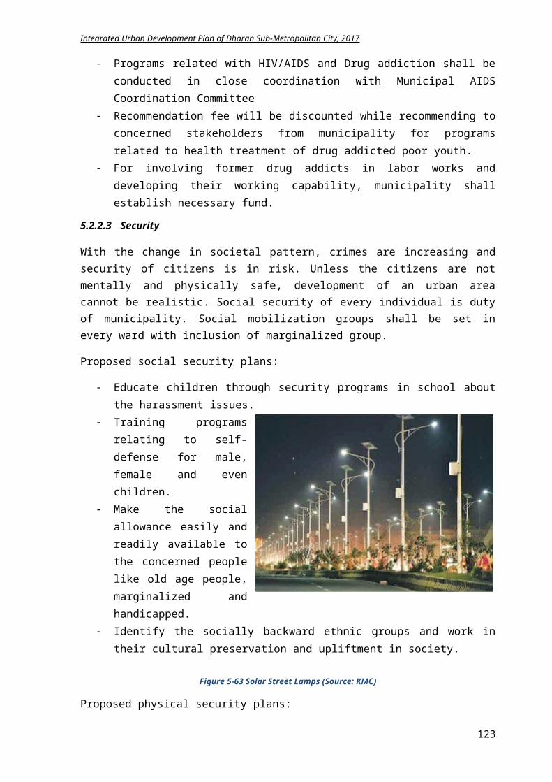
Integrated Urban Development Plan of Dharan Sub-Metropolitan City, 2017
5.7.2.2 Possible Financial Resources for IUDP implementation
Citizen’s participation Public private partnership Private investments from multinational groups like CG, Dugar Banks, Co-operatives and Finance companies Grant and loans from ADB, World Bank, UN and other INGOs Town Development Fund NGOs like ActionAid, Sun Farmer, Smaart pani, WaterAid City budget
5.7.2.3 Promotional Strategy of Public Private Partnership
For effective service delivery and management of infrastructures projects, private sector had proved to be more competent than public sector. By involving private sector, it has potential to increase operating efficiency by making investments in new technologies, bringing innovative solutions, and encouraging more transparent organizational structures. However, not all infrastructure projects are suitable for public private partnership (PPP), and conditions need to exist that entice private sector participation in the delivery of infrastructure assets and provision of service. When efficiently and transparently procured, the benefits of involving the private sector in the delivery of infrastructure include (i) efficient use of the resources, (ii) improved asset and service quality, (iii) improved public sector management, and (iv) overall improvement in public sector procurement. (ADB 2012)
Dharan already has some projects implemented in PPP model. Some of the strategy for promoting PPP modalities in Dharan is in the field of tourism, solid waste management and infrastructure development.
The proposed activity for promoting PPP is:
If government provides basic amenities like water, road, sewerage, drainage, electricity to new areas for hotel development, businessman can be attracted for tourism development. This is also a type of PPP modalities where services are provided by private sector after initiation from public sector.
Solid waste management can run on concession contract of PPP model where investment is done by private sector in the existing amenities or new innovative solutions can be derived with private ownership for certain period (15-30 years).
PPP model can be implemented in transport services like buses, taxi services. Facility or operational management contract method can be best suitable for this type with ownership to public sector. Private sector can be given incentives of tax exemption of 10% on vehicle renewal and benefit sharing of 80-20%.
The maintenance of assets and equipment of temples can be given to private sector with benefit incentive.
Open public spaces can be given on lease for 10-30 years to private sector to develop parks, commercial building etc. depending on the location.
The new projects like Bus Park, sports hall, public library can have the 60-40 public private model for investment. Benefits can be given to the shareholders like discounts on tickets or membership.
123
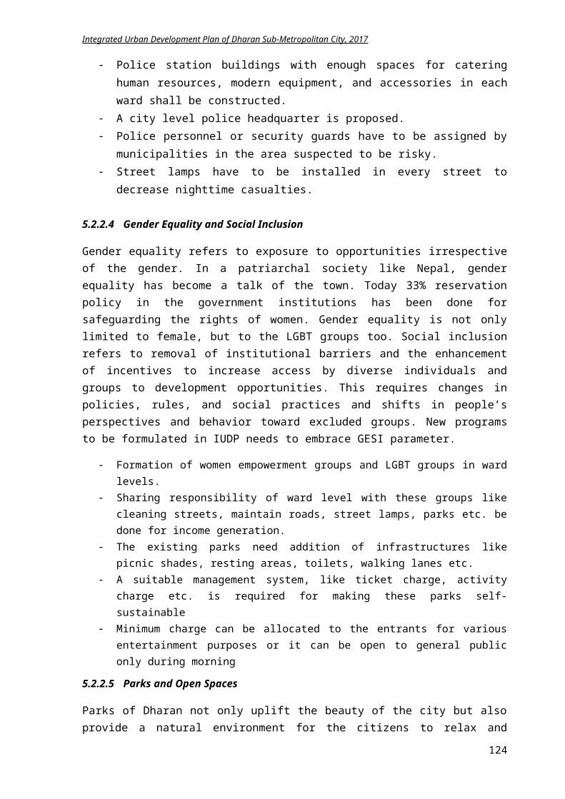
Integrated Urban Development Plan of Dharan Sub-Metropolitan City, 2017
5.7.3 LFA for achieving financial development
Intervention Logic Indicators Means of Verification
Assumptions
Goal: Achieving a financial sustainability through maximum utilization of available resourcesObjective: Identify the areas of economic potential to expand the revenue generation and encourage alternative
investment modalities for financial sustainabilityResult: 1) DSMC is collecting
more revenues.2) Banks and corporate
houses are attracted to Dharan.
3) Investments from private sector are increased.
4) Citizen’s involvement in projects increased.
5) Collaboration and partnerships with NGOs and INGOs is strong and increased.
By 2032, Internal income from
taxes and services are increased by 122 million.
Number of corporate office and banks are increased.
Strategic projects are completed.
Infrastructures are well functioning.
Records of Revenue and Financial Administration Division
Planning, Monitoring and Evaluation Division documentation
There is political stability in the country.
Enough budgets are available.
Revenue is generated.
Activities:i. Increase in property taxes, rent, income taxes
ii. Increase in service chargesiii. Initiate for Loan from TDFiv. Grant and assistance from GIZ, ADB, World Bank,
UNv. Collaboration with citizens
vi. Lobbying private sector investment
Cost: In NPR Time Frame
5.7.4 Conclusion
The development of city is indicated by its economic and financial growth. Hence, the financial plan is necessary for proper usage of budget allocated to sub metropolitan city. A proper revenue generation plan and expenditure strategy helps DSMC to balance its financial state.
Municipality has limited resources for development. So PPP model is the best as far as possible. It can be in all sectors like service, infrastructures etc.
Increase of tax is utmost important. Without increasing the tax horizon, municipality cannot fulfill the people’s desire.
City should attract new technology and management for service delivery and development. New idea for solving municipal issues are important
New industries and business should be enticed for increasing taxes and employment.
124
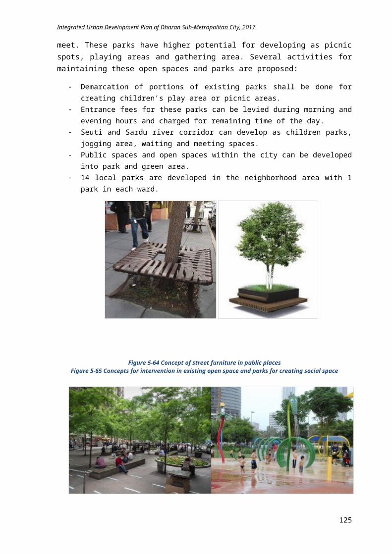
Integrated Urban Development Plan of Dharan Sub-Metropolitan City, 2017
5.8 Institutional Development Plan
Institutional development is the creation or reinforcement of a network of organizations to effectively generate, allocate and use human, material and financial resources to attain specific objectives on a sustainable basis.
5.8.1 Goal and Objectives
Goal: Accelerating and managing the development works through efficient and intelligent organizational structure by strengthening and uplifting the capability of concerned stakeholders
Objectives:
To review the existing governance modalities of the city and analyze its effectiveness
To promote the good governance system To identify the various decision making and implementing tools To promote multiple stakeholders participation To establish a proper co-ordination system between different stakeholders To stimulate capacity development of the human resources
5.8.2 Plan and Programs
5.8.2.1 Municipal structure of Dharan
It a local government with substantial authority granted through constitution of Nepal. After the recent government reform, new governing structure is formed with 10 Divisions and each division has several branches. These are listed beneath and its organogram chart is shown in Fig 5.25.
1 General Administration Divisiona. Local Service and Human Resource Development Departmentb. Public Procurement and Property Management Departmentc. Local level, state and Federation coordination Branchd. Meeting Management Branche. Marketing Monitoring and Quality Bureau, Food Safety and Consumer Protection Branchf. Internal audit branchg. Holiday, festival, Jatra festival, Degree and Divination unit
2 Revenue and Financial Administration Divisiona. Revenue Policy and Administration Branch b. Financial Administration Branch
3 Urban Infrastructure Development Divisiona. Road and Transport Management Branchb. Hydropower, Energy and Street lighting Branchc. Irrigation and Water Induced Disaster Prevention Branchd. Water supply and Solid Waste Management Branche. Public Private Partnership Unit
125
Integrated Urban Development Plan of Dharan Sub-Metropolitan City, 2017
4 Economic Development Division a. Agriculture, Livestock and Co-operative Works Departmentb. Industry and Entrepreneurship Development Departmentc. Employment Generation and Poverty Reduction Branch
5 Social Development Divisiona. Basic and Secondary Education Office Departmentb. Sports and Extra Curriculum Unit Departmentc. Basic Health and Cleanliness Office Departmentd. Gender Equality and Social Security Departmente. Culture, Heritage, Fine Arts and Tourism Promotion Departmentf. NGO Operation, Co-ordination and Regulation unit Departmentg. Social Security Program Departmenth. Personal Event Registration Unit Branch
6 Forest, Environment and Disaster Management Divisiona. Forest, Wildlife and Soil Preservation Officeb. Environment, Ecology and Water Shed Preservation Branchc. Disaster Management Branch
7 Land Management and Building Regulation Divisiona. Land-use and Settlement Development Branchb. Survey, Map and Land Ownership Branchc. Building and Building codes and Construction License Branch
8 Justice, Law and Human Rights Promotion Divisiona. City Police Administration Branchb. Justice, Law and Human Rights Promotion Branchc. Legislative Branch
9 Planning, Monitoring and Evaluation Divisiona. Plan Formulation and Implementation Branchb. Monitoring and Evaluation Branch
10 Information, Communication and Data Management Divisiona. Information Technology Development and Expansion Branchb. Data Management Branch
The existing appointed staffs shall be distributed to these various divisions according to their qualification and capacity. DSMC have one Mayor, one vice mayor, one ward Chief, 20 ward representative and one personnel appointed by central government. In each ward, there will be one ward president, 2 general member, one women member, one marginalized groups member. In each ward, there will be 11 staffs explicit in Fig 5.24. The staffs for cleaning required in ward no 4, 5, 6 and 20 is only 1. Hence, 210 staffs are required in ward level only in DSMC.
Figure 5-72 Organizational Chart of Ward office
126
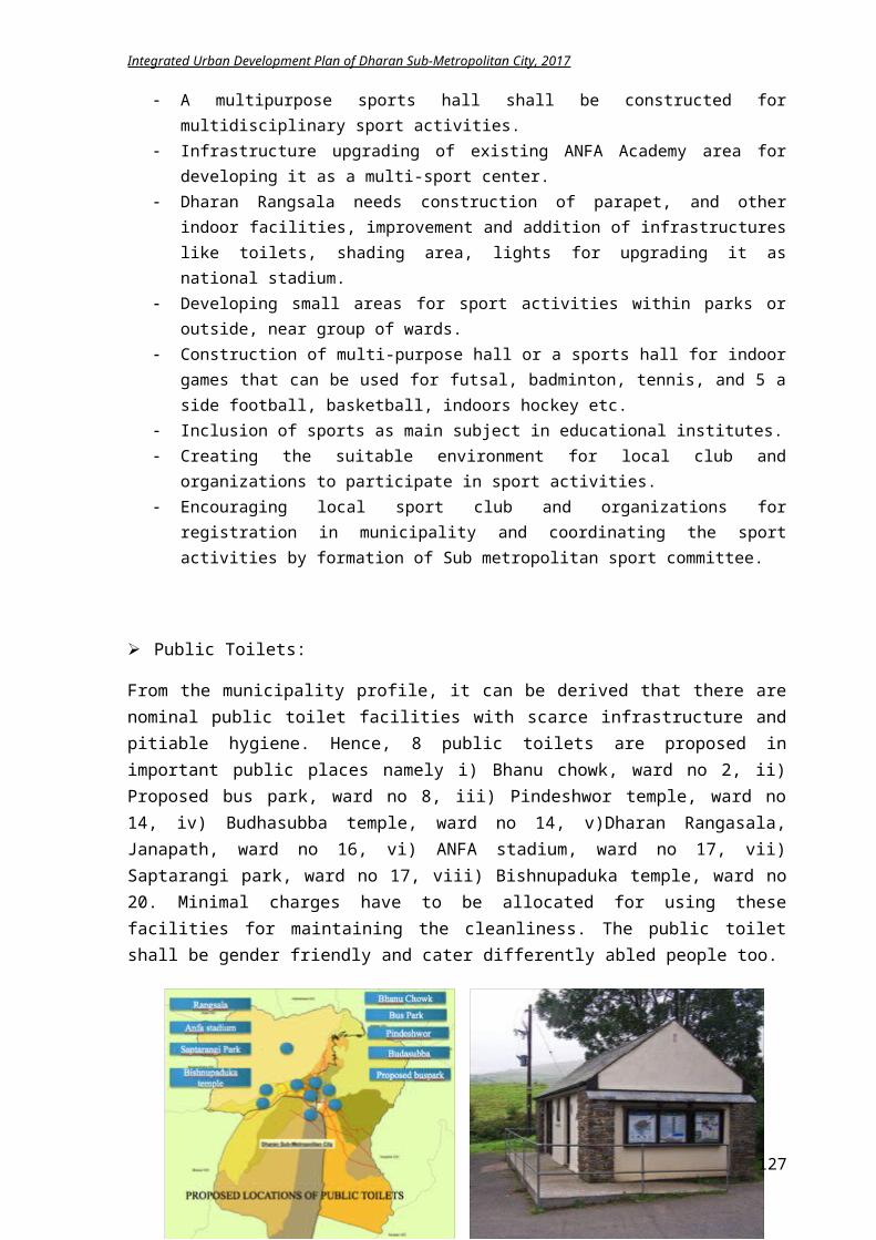
Integrated Urban Development Plan of Dharan Sub-Metropolitan City, 2017
Figure 5-73 New Organogram of DSMC
127
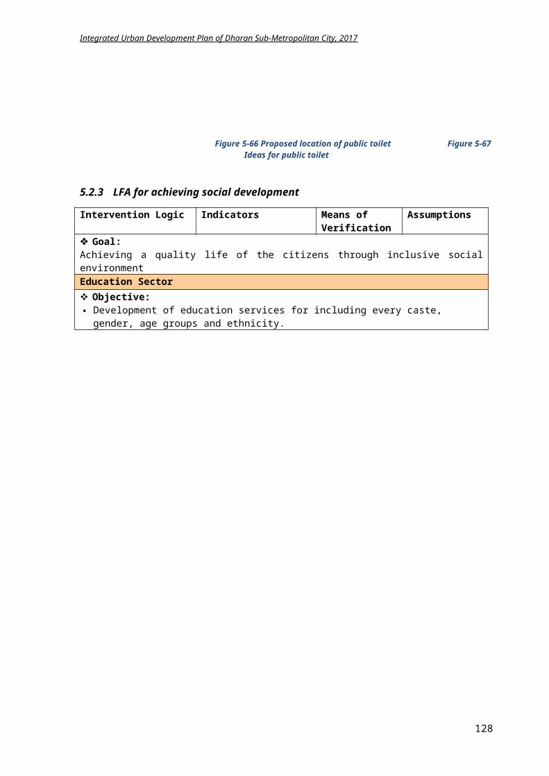
Integrated Urban Development Plan of Dharan Sub-Metropolitan City, 2017
Furthermore, after a quick brainstorming, it is concluded that the current technical staffs are abundant for running these newly formed divisions and only some experts are to be appointed like Economists, Planner, Analyst, Public Health Officer, people with knowledge of Education and social sciences. If some support staffs are needed, they can be arranged on contract basis. All the above-mentioned divisions operate under Dharan Sub Metropolitan City. An organizational chart for each division is prepared for a clearer picture of the staffs required for each division that is elucidated here forth.
Figure 5-74 Organogram of General Administration Division
In General administration division, total11 staffs are proposed with 1 executive officer, 1 accounts officer, 1 account assistant, 4 Nayab Subba (Na. Su) and 4 peons for assisting the 7 branches of administration division explicit in above chart. The 2 Na. Su will look after 4 branches as shown in above Fig 5.26.
128
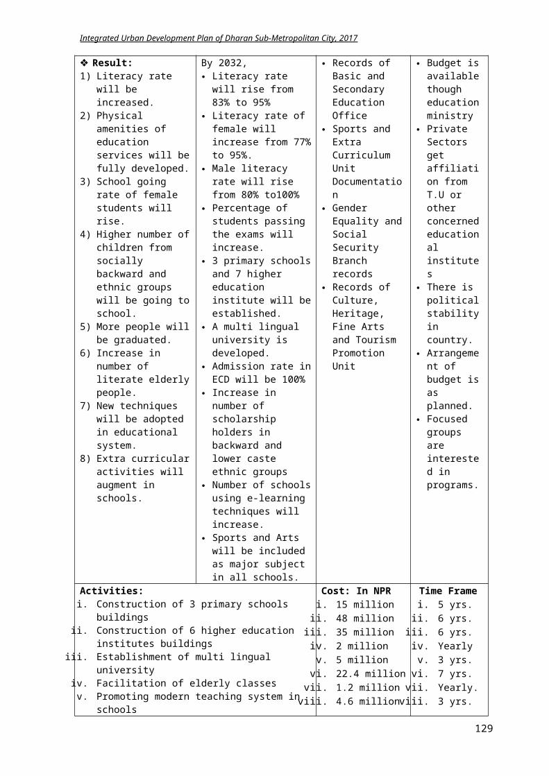
Integrated Urban Development Plan of Dharan Sub-Metropolitan City, 2017
Figure 5-75 Organizational chart of Revenue and Financial Administration Department
There will be 6 staffs in two branches of Financial administration division with1 executive officer, 1 accounts officer, 1 account assistant, 1 Na. Su and 1 peon shown in Fig 5.27.
Figure 5-76 Organogram of Urban Infrastructure Development Division
Physical infrastructure division will have 16 office staffs shown in Fig 5.28. It is proposed that Road department and Irrigation department will require 2 civil engineers as head and 4 overseers for assistance. Similarly, energy department will have 1 civil engineer as head and 1 overseer and Water supply and sanitation department have 1 engineer and 2 overseer, whereas there will be 1 office managing PPP unit. 3 peons will cater the 5 branches of Physical infrastructure division.
129
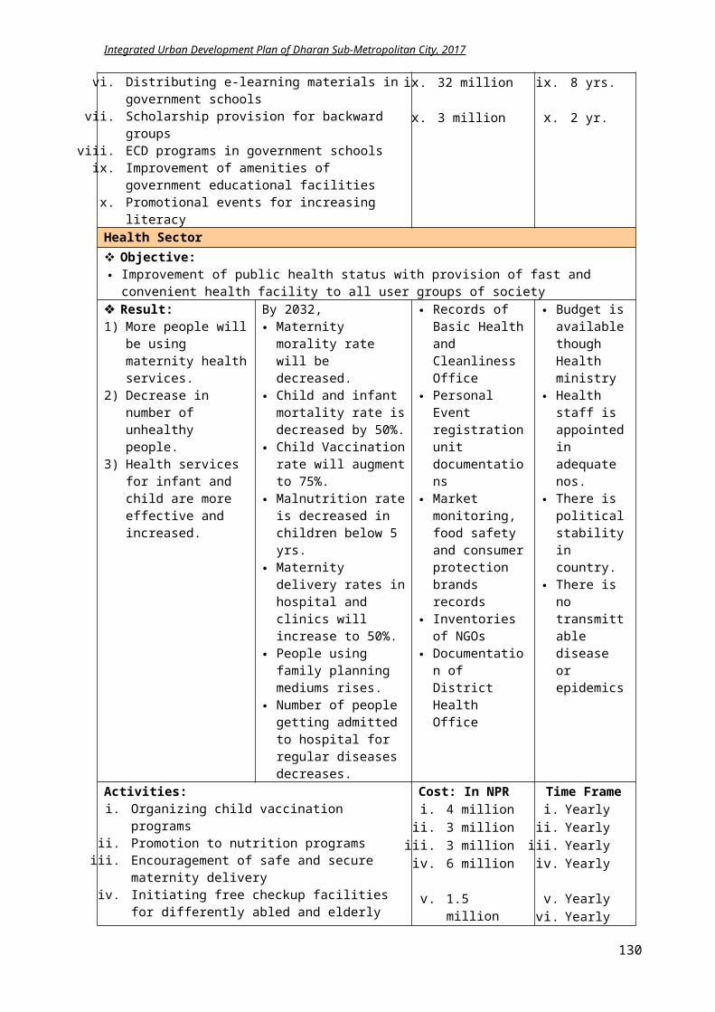
Integrated Urban Development Plan of Dharan Sub-Metropolitan City, 2017
Figure 5-77 Organogram of Economic Development Division
Economic development division will have total 13 staffs as shown in Fig 5.29. Agriculture, livestock and co-operative work department needs 3 personnel namely: agriculture officer, vetenary officer and co-operative officer with assistant for each section and 1 peon. Industry and entrepreneurship department need 1 officer, 1 Na.Su and 1 Kharidar whereas Employment
generation and poverty generation department can be handle by 1 Na.Su alone.
Figure 5-78 Organizational chart of Social Development Division
Social development division requires quite a large number of staffs (46 staffs) as the staffs from previous District Education Office will be transferred to this division and ward level health post and clinics are management by this division. Educationdeparment shall have 1 education officer, 1 Na.Su, 1 Kharidar and 1 peon. Sports department can be handle by 1 Na.Su with 1 peon. Health department will have 1 health office, 1 Na.Su, 1 Kharidar and 1 peon and additionally 20 health assistance for each eards and 1 staff nurse, 1 assistant health worker and 3 peons.Culture, heritage and tourism department needs 1 archaelogist or architect, 1 Na.Su and 2 kharidar. All the other remaining department of social development division will have 1 Na. Su each as explained in above Fig 5.30.
130
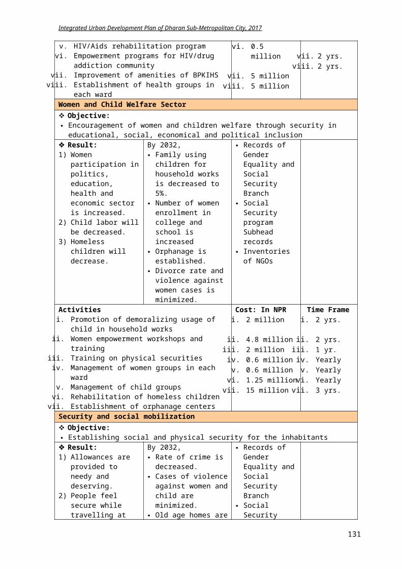
Integrated Urban Development Plan of Dharan Sub-Metropolitan City, 2017
Figure 5-79 Organogram of Forest, Environment and Disaster Management Division
131
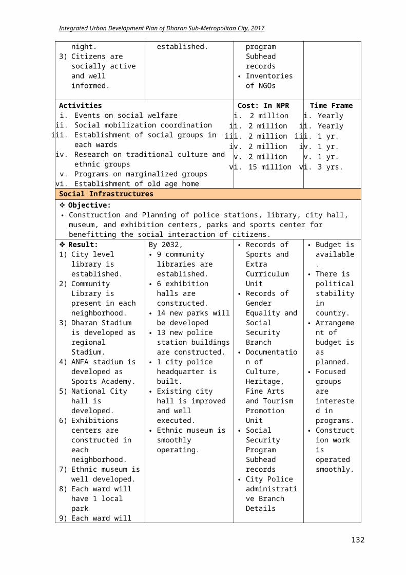
Integrated Urban Development Plan of Dharan Sub-Metropolitan City, 2017
The environment and disaster management division will have 18 staffs in total shown in Fig 5.31. Forest department need 1 forest officer, 1 ranger and 1 peon, whereas environment department need 1 environmental officer and one assistant with 2 peons. The disaster management branch will have 1 Na.Su, 1 Kharidar, 3 fire brigade drivers, 1 ambulance driver and 3 drivers (who will be responsible for driving the government vehicles during office hours).
Figure 5-80 Organogram of Land Management and Building Regulation Division
There will be 14 staffs in Land management and building division as explicit in Fig 5.32.Land use and settlement department will include 1 urban planner, 1 overseer and 1 peon. Survey and land ownership branch will have 1 survey officer, 2 Amins and 2 peons. Similarly, Building division looking after all the construction and building permit works will have 1 architect, 1 structural engineer, 2 overseer and 1 peon.
Figure 5-81 Chart of Justice, Law and Human
Right Division
132
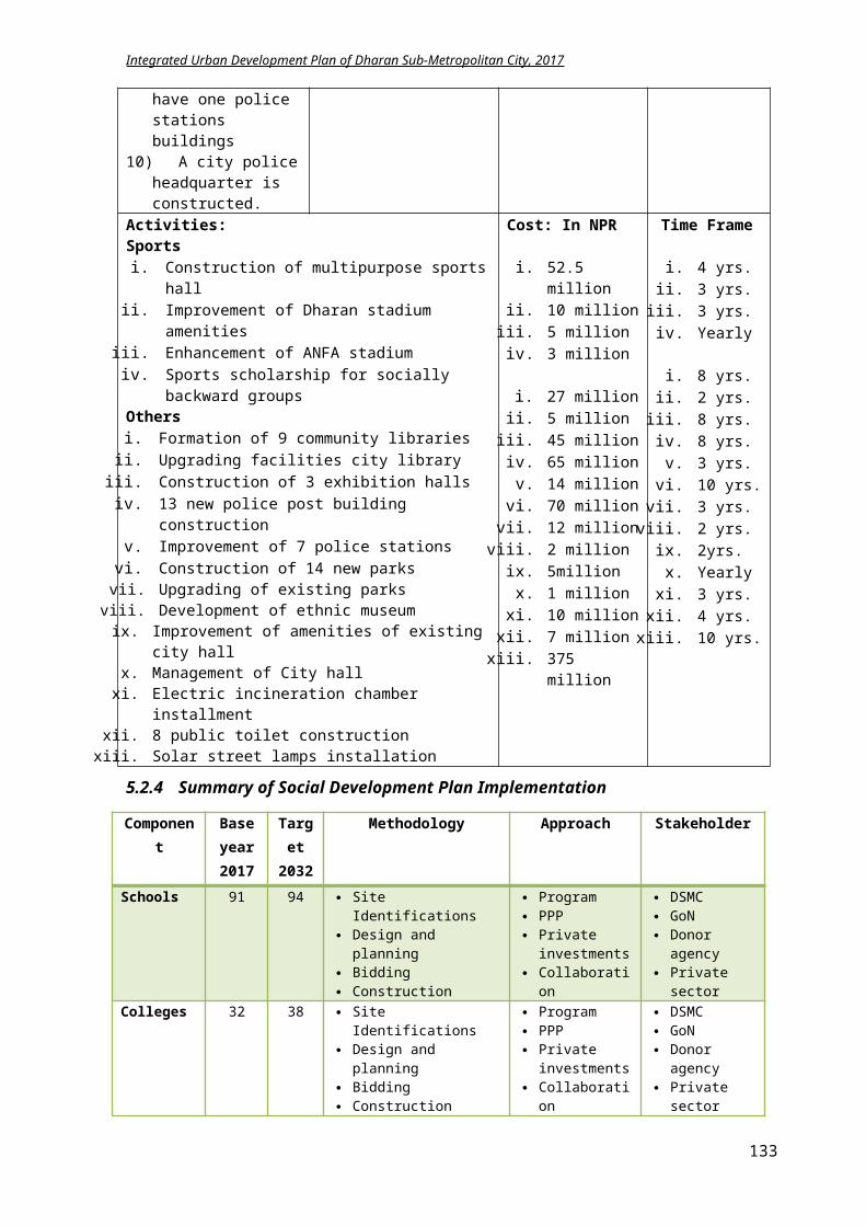
Integrated Urban Development Plan of Dharan Sub-Metropolitan City, 2017
There will be 27 staffs in Law and human rights division as explicit in above Fig 5.33. City Police department will have 1 branch officer, 1 city police chief and 20 city police. The same staff will handle Law, human right and legislative department that include 1 law officer, 1 Na.Su, 1 kharidar and 1 peon.
Figure 5-82 Organogram of Planning. Monitoring and Evaluation Division
There will be 7 staffs in Planning, evaluation and monitoring division as explicit in above Fig 5.34. Planning department will have 1 officer, 1 Na. Su, 1 kharidar and 1 peon whereas Evaluation department will have 1 Na.su and 2 peons. It is proposed that an evaluation and monitoring committee shall be formed with the executive officer of each division as its member along with mayor and this committee shall work together with the evaluation department.
133
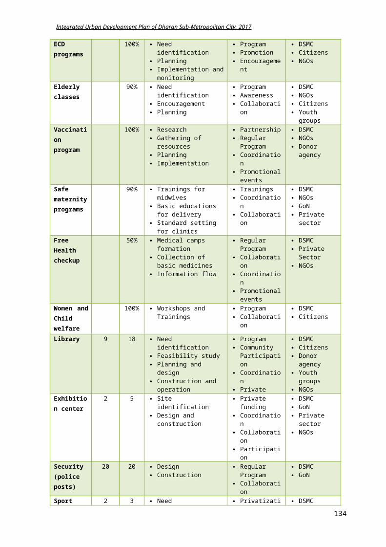
Integrated Urban Development Plan of Dharan Sub-Metropolitan City, 2017
Figure 5-83 Organizational Chart of Information, Communication and Data Management Division
There will be 5 staffs in Information, communication and data management division as explicit in above Fig 5.35. Information department will have 1 IT officer whereas statistics department have 1 statistics officer, 1 Na.Su and 1 peon.
From the above organizational planning, it can be concluded that 163 permanent staffs are required as per the new reformed municipal structure. The existing available staffs seem enough for arranging to the new divisions. The division offices will be in the same building or complex as that of Dharan Sub Metropolitan City. Each division will have its own office space with area allocated for its respective section/department.
5.8.2.2 Governance
Governance is establishment of policies, and continuous monitoring of their proper implementation, by the members of the governing body of an organization. For the effective development of any cities, only establishment of plans and policies is not important, but the execution of such plans in action is mandatory. Only with good governance, a city can achieve the targeted plan. The ultimate goal of the local government is good governances. It comes with the satisfaction of citizens to services delivered by municipality. Besides, many shortcomings i.e. infrastructures, business and trade environment, security etc. enough staffs with required qualifications and skills need to be mobilized for facilitating governance structure. Good governance is not about making 'correct' decisions, but about the best possible process for making those decisions.
For making the administration of DSMC anti-corruptive, transparent and citizen oriented and increasing the effectiveness of services and facilities to be provided to the citizens optimizing the minimum resources obtained by DSMC, following governance activities shall be articulated in the city.
Various workshops and training need to be organized for the municipal staffs to update them with the new technology, process and governance.
E-governance should be introduced to track the efficiency of municipal services i.e. streetlights, parking and Haat bazaar, road uses, waste management, public toilets and other public services etc.
Digital system is to be introduced in the DSMC offices and regular updates of the work plan in its websites shall be done for making the service more efficient.
For easy and fast service delivery, DSMC shall establish service centers and mobile service facility.
The complaints of citizens needed to be managed by ward member in ward level and officer in city level.
Electronic information system shall be commenced for establishing relation between DSMC, ward committee and citizens.
The services in ward and metropolitan office are executed on first come first serve basis. Home service for elderly and children shall be introduced. For promoting the transparency of Dharan Sub Metropolitan city’s work, public hearing,
public trial and social trial programs shall be executed.
134
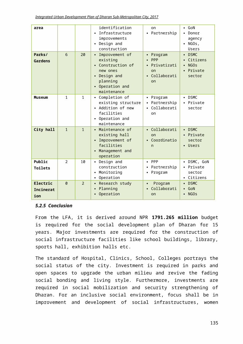
Integrated Urban Development Plan of Dharan Sub-Metropolitan City, 2017
5.8.2.3 Participation
As explained in previous chapters, Dharan is well-known model city for public participation. Basis of the “sustainable education, health, tourism and trade” is with mobilization of local resources and citizen’s involvement.Proposed activities:
Ward Committee involvement in roads, streets, drainage of buildings, the construction of school buildings and toilets etc.
Daily and weekly cleaning of road and streets in the local wards by ward committee and banning the entry of loaded vehicle and prohibit actions such as driving over speed
For the involvement of the private sector, incentives through tax exemptions and subsidy program shall be introduced.
PPP model can be operated for Park Management and Haat Bazaar Management, Truck Yards Construction, Vegetable Markets, Convention and Trade Centers construction.
5.8.2.4 Co-ordination and establishment of networks
Some of the below mentioned committees shall be formed in DSMC for effective implementation of development projects:
1. Infrastructure development committee2. Social development committee3. Economic development committee4. Environmental and disaster management committee5. Public service and capacity development committee6. Bill (ति�धेर्यक) Committee
As, Dharan municipality is model for public participation; coordination between different stakeholders and creating a good network is also a plus point of DSMC. For initiation of various development projects, stakeholders needed to be identified and network has to established for the successful completion of the project. For this, DSMC plays a pivotal role. Each branch of the 10 divisions of DSMC shall have a coordinator that synchronizes with the various national and international key players within Dharan.
5.8.2.5 Organization and Capacity development
Proposed activities: Training and workshops shall be conducted for government staffs for adopting new
technology and working styles. The management of street lamps and cleaning done by DSMC can be given to local ward
level for increasing participation and cutting off the extra expenditures of DSMC. Initiate inspiration and admiration award system for the staff for their effective work
execution and service delivery to boost their effort. Extend the responsibilities of capable candidates according to their potential and abilities for
higher level of service delivery.
5.8.3 LFA for achieving institutional development
Intervention Logic Indicators Means of Verification
Assumptions
135
Integrated Urban Development Plan of Dharan Sub-Metropolitan City, 2017
Goal:Accelerating and managing the development works through efficient and intelligent organizational structure by strengthening and uplifting the capability of concerned stakeholders Objective: Execution of good governing system by the local government and organizations with appropriate
coordination and support between various stakeholders Result:
1) Government offices use e-governance system.
2) Infrastructures of local body are functioning well.
3) Delivery of public services is efficient and quick.
4) Public service holders are up-to-date and responsive.
By 2032, Number of offices
using digital technology is increased.
Local concerned bodies monitor development works.
Each government offices have the required amenities.
Records of General Administration Division.
Planning, Monitoring and Evaluation Division documentation
Budget is available though
Support is available from donor agency.
Financial support is available from concerned ministry.
Activities:i. Construction of municipal building
ii. Improvement of 15 ward officesiii. 5 Ward offices set up iv. Retrofitting of old and dilapidated government
buildings v. Training and workshops for capacity development
vi. Introduction of digital system in 10 newly formed local divisions
vii. Organization of public hearing and trial sessionsviii. Home services for needy citizens
ix. Promotion of PPP model for investmentsx. Co-ordination with various organization
xi. Facilitation of ward level committees xii. Award systems for capable and efficient staff
xiii. Office set up for new 10 divisionsxiv. Building construction for new divisionsxv. Appointment of new technical staffs
xvi. Founding development groupsxvii. Networking of various divisions
xviii. New vehicles buying
Cost: In NPRi. 5 million
ii. 15 millioniii. 25 millioniv. 7.5million
v. 3 millionvi. 10 million
vii. 2 millionviii. 3 million
ix. 2 millionx. 3 million
xi. 2 millionxii. 3 million
xiii. 30 millionxiv. 200 millionxv. 1.5 million
xvi. 0.6 millionxvii. 1.9 million
xviii. 10 million
Time Framei. 2 yrs.
ii. 5 yrs.iii. 3 yrs.iv. 3 yrs.
v. Yearlyvi. 2 yrs.
vii. Yearlyviii. Yearly
ix. 2 yrs.x. Yearly
xi. Yearlyxii. Yearly
xiii. 2 yrs.xiv. 5 yrs.xv. 1 yr.
xvi. 1 yr.xvii. 1 yr.
xviii. 3 yrs.
5.8.4 Summary of Institutional Development Plan Implementation
Component Base year2017
Target2022 Methodology
Approach Stakeholder
Ward offices 15 20 Land acquisition Municipal investment
Tender Participation
DSMC
Division office 1 10 GoN Investment Municipal Investment
Community Participation
Tender
DSMC Citizen
Vehicles management
100% O and M survey Local Demand
Purchase Hire
DSMC Suppliers
Trainings, Skill Development
100% Demand Analysis Capacity assessment of
staffs
Regular training Hire and fire
DSMC Staffs Service
providersSpecial Courses (wiring, water
100% Demand Analysis Capacity assessment of
Hiring Service Provider
DSMC Staffs
136
Integrated Urban Development Plan of Dharan Sub-Metropolitan City, 2017
supply, Fire Fighting)
staffs Course designs
Collaboration Service providers
Networking On need basis
Committee formation Identification of key
players
Coordination Collaboration
DSMC NGO Donor agency Citizen
5.8.1 Conclusion
The institutional development plan aims to advocate the good governance tools, promote participatory techniques, increase employee’s efficiency and encourage co-ordination and networking for quicker and smoother service delivery. As the government body is reformed currently, more financing is required in new office set up, staff management and other logistics. Besides, investment is required in introduction of modern technology with digital usage in these offices. A total of NPR 677.71 million is required for institutional management and capacity development.
137
Integrated Urban Development Plan of Dharan Sub-Metropolitan City, 2017
6 Chapter VI: Multi Sectorial Investment Plan
From the various thematic plans and programs of this IUDP, specific projects are scheduled for 15 years that would cost around NPR 21369.99 million. Amongst the total budget, based on the priority, expenses are made on sectoral themes, which is explained hereafter.
From the total cost, 13% will be spent on Social Development Plan that includes education, health, security, Women empowerment, child security, backward communities, sports and community centers.
Further 5% will be spent on agriculture, tourism, industry and commerce sectors of Economic Development Plan.
54% of the total budget will be invested on infrastructures construction and improvement like road, bridges, water supply, sanitation, electricity, housing and alternative energy; and
8% is invested on strategic projects like river corridor, drainage master plan and Bijaypur hill development. The two strategic projects is related to physical development and one related to cultural and tourism development. The strategic project for physical development requires only 10% of the total budget of physical development plan whereas the strategic project for cultural and tourism development requires 6% of the budget of cultural and tourism development plan.
5% of the total budget is spent on preservation and conservation of heritage and culture areas as well as tourism development.
Moreover, 6% will be used for environmental protection, sustainable transportation, waste reduction and others of environmental management plan.
Likewise, 3% will be used for disaster risk management like flood, landslides, fire, earthquake, thunderstorm, plaque and epidemics.
The remaining 8% will be spent on capacity development and institutional development
138
Integrated Urban Development Plan of Dharan Sub-Metropolitan City, 2017
Table 6.25 Multi Sectoral Investment Plan for 15 years
Multisectoral Investment Plan15 years Investment Plan Summary (NPR million)S.N Sector Anticipated budget on thematic urban development program
% 2017-18 2018-19 2019-20 2020-22 2022-27 2027-32 TOTAL Total of 15 years
1 Physical Development Plan
54% 852.26 1135.48 1179.86 1620.16 4198.87 5195.90 14182.53 6% 8% 8% 11% 30% 37% 100%
2 Strategic project 8% 123.22 142.17758 221.046 308.212 511.51672 684.39194 1,990.56
6% 7% 11% 15% 26% 66%
3 Social Development Plan
13% 206.241 226.127 221.369 331.840 551.928 253.760 1791.265
12% 13% 12% 19% 31% 14% 100%
4 Environment Management Plan
6% 95.428 89.633 69.381 112.240 109.800 91.500 567.983 17% 16% 12% 20% 19% 16% 100%
5 Disaster Management Plan
3% 42.228 36.414 32.334 60.588 128.520 77.520 377.604 11% 10% 9% 16% 34% 21% 100%
6Culture and Tourism Development Plan
5% 72.014 122.827 104.731 234.240 441.640 14.640 990.092
7% 12% 11% 24% 45% 1% 100%
7 Economic Development Plan
5% 73.032 92.310 87.720 141.372 349.350 48.450 792.234
9% 12% 11% 18% 44% 6% 100%
8 Institutional Development Plan
8% 120.78 115.900 93.330 143.960 102.480 101.260 677.71 18% 17% 14% 21% 15% 15% 100%
100% Total budget 1585.200 1960.874 2009.773 2952.612 6394.109 6467.420 21369.99
139
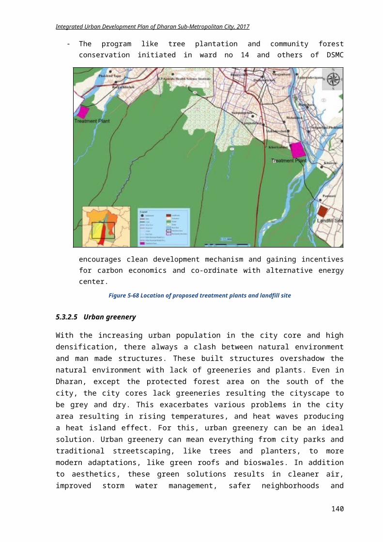
Integrated Urban Development Plan of Dharan Sub-Metropolitan City, 2017
Table 6.26 Detail budget of various projects for 15 years
Detail budget on multi sectoral plans Multi sectoral investment plan for 15 years1 Physical Development plan (in million NPR)
Activities UnitQuantit
y Rate Cost Time yrs
2017-18
2018-19
2019-20
2020-22
2022-27 2027-32
a Road1 Track opening of 68.38 km road km 68.38 4 273.52 15 10 15 15 30 100 203.522 Black Topping of 490 km road km 490 2.77 1357.3 15 25 50 50 200 200 832.3
3200m Road Reinforcement Simhadevi Chowk to Bijaypur – ward 14 km 0.2 1.62 1
1.62 4 250m road of width 5m construction on Atridhara km 0.25 1.29 1 1.29 5 2.51 km link road development for ringroad km 2.51 6.77 16.993 3 3 3.000 10.9936 0.45 km road development till bridge km 0.45 6.77 3.0465 1 3.0465 7 Widening of 1.1 km road of link road to 15m. km 1.1 2.5 2.75 3 1 1.75 8 Widening of 1.38km length Janapath road to 15m. km 1.38 2.5 3.45 1 3.45 9 Widening of 0.57km ANFA marga to 15m km 0.57 2.5 1.425 1 1.425 10 Widening of 1.21km Namuna marga to 15m km 1.21 2.5 3.025 1 3.025 11 Extension of internal ringroad to 4 lanes km 20 320 5 32012
Construction of internal ringroad near Charkoshe Jhadi km 20.81 15 312.150 5
312.150
13 Feasibility study of outer ringroad km 55.808 2.500 1 2.5 14 Construction of outer Ringroad km 55.808 15 837.12 10 200 637.12
Total 3136.1892 45.831
570.52
5 65 234 816.92003.932
7b Bridge1 Three bridges construction of length 100m m 300 1.2 360 6 40 60 60 100 100 2 Two bridges construction of length 115m m 230 1.2 276 3 92 92 92 3 One bridge construction of length 125m m 125 1.2 150 2 75 75
140
Integrated Urban Development Plan of Dharan Sub-Metropolitan City, 2017
4 Three bridges construction of length 75 m m 225 1.2 270 3 90 90 90 5 5 suspension bridge construction of 75 m m 375 0.3 112.5 5 22.5 22.5 22.5 45 6 Two bridges construction of 115m on outer ring road m 230 1.2 276 3 276 Total 1444.5 319.5 339.5 264.5 145 376 0c Airport/Railway 1 Feasibility study, design and survey of airport 10 2 5 5 2 Feasibility study of railway track 2 1 2 Total 12 7 5 d Bus park1 2 new bus parks construction sq.m 15500 0.02 310 8 30 30 30 60 160 2 5 small Parking space development sq.m 15000 0.002 30 3 10 10 10 3 32 bus stops construction no. 32 1.5 48 6 8 8 8 12 12 Total 388 48 48 48 72 172
e Subway Feasibilty study 3 1 3 Subway construction of 50m length and 5m width no 6 9.75 58.5 5 11.7 20 20 6.8 Total 61.5 3 11.7 20 20 6.8
f Water Supply1 Rain water harvesting subsidy on 20,000 HH no. 20000 0.04 800 15 40 40 60 80 200 380
2
Feasibility study of water resources nearby (Tributaries of Bishnupaduka, Panchkanya and Bhedetar) no. 10 1 10 2 5 5
3Construction of Water supply Project at Bishnupaduka and Panchkanya HH 1500 0.13 195 5 39 78 78
Total 1005 45 84 138 158 200 380g Electricity and Communication1 Expansion of Electricity network (5%) % 5 10 3 2 3 5 2 Feasibility study for underground electric cables km 58 1 1 1 3 Solar panel installations subsidy on 32,000 HH no 32000 0.025 800 15 25 50 50 100 300 275
4Telecommunication and optical fibers for internet expansion and improvement km 58 0.2 11.6 2 5 6.6
5 Free Wi-Fi on 10 public places no. 10 0.03 0.3 1 0.03
141
Integrated Urban Development Plan of Dharan Sub-Metropolitan City, 2017
Total 822.9 28.03 58 61.6 100 300 275h Sewerage and Drainage1 745 km sewerage line installation km 745 4 2980 15 100 180 200 360 1000 11402 490 km drainage construction km 490 2 980 15 40 60 80 100 350 350
3Drainage and footpath construction on DuiDharepath, ward no 14
6.57 1 6.57 4 Construction of 2 treatment plant nos 2 200 400 15 15 35 50 70 120 110 Total 4366.57 161.57 275 330 530 1470 1600i Solid waste 1 Construction of 1 land fill site no 1 200 200 8 20 20 20 40 100
2 Installation of 20,000 public dustbins on streets no 200000.000
5 10 3 3 3 4 Total 210 23 23 24 40 j Housing
1Land pooling and site and services program commencement no. 5 10
50 4 10 10 10 20
2Facilitation of Investment on affordable group housing and apartments 2 1 2
3 Housing Support for low and middle income groups HH 500 0.05 25 4 4 6 6 9 4 Maintaining and updating building records 2 1 2
Total 79 18 18 16 29
2 Strategic Projects (in million NPR)
Activities UnitQuantit
y Rate Cost Time yrs
2017-18
2018-19
2019-20
2020-22
2022-27 2027-32
a River Corridor1 Sardu River Corridor (7.876 km) construction km 7.876 168.276 7 25 25 30 50 38.276 2 Seuti River corridor (4.879km) construction km 4.879 148.633 5 25 25 35 63.633 3 River embankment km 15 5 75 5 10 10 20 35
4Pedestrian and cycle lane of 2.5m width construction km 15 3
45 5 6 9 9 21 5 Garden development 10000 sq.m sq.m 10000 0.005 50 5 10 10 10 206 Vehicle Parking Development at three places sq.m 30000 228.767 8 25 25 50 128.767 Total 715.676 60 66 129 192.63 119.27 148.767
142
Integrated Urban Development Plan of Dharan Sub-Metropolitan City, 2017
3 6b Drainage of ward 5 and 6 Construction of drainage network km 46.16 852.21 15 20 30 30 60 300 412.21
c Bijaypur hill development
1.115 km road from Bijaypur Chowk to Panchkanya km 1.115 34.108 3 10 10 14.108
Revitalization of Bijaypur chowk 5.539 2 3 2.539
Temple premises development of Panchkanya complex 24.077 3 8 8 8.077
Total 63.724 2120.53
922.18
5
3 Social development plan (in million NPR)
Activities UnitQuantit
y Rate Cost Time yrs
2017-18
2018-19
2019-20
2020-22
2022-27 2027-32
a Education1 Construction of 3 primary schools buildings no. 3 5 15 5 3 3 3 6
2 Construction of 6 higher education institutes buildings no. 6 8 48 6 6 8 8 16 10 3 Establishment of multi lingual university no. 1 35 35 6 4 5 5 10 11
4 Facilitation of elderly classes person 100 0.02 2 yearl
y 2 2 2 4 10 105 Promoting modern teaching system in schools no. 122 0.05 5 3 1.5 1.5 2
6Distributing e-learning materials in government schools no. 32 0.7 22.4 7 3 3 3 6 7.4
7 Scholarship provision for backward groups person 100 0.012 1.2 yearl
y 1.2 1.2 1.2 4 8 158 ECD programs in government schools no. 23 0.2 4.6 3 1 1.3 2.3
9Improvements of amenities of government educational institutes no. 32 1 32 8 4 4 4 8
12 10 Promotional events for increasing literacy % 10 3 2 1.5 1.5 Total 168.2 27.2 30.5 30.5 54 58.4 25b Health
1 Organizing child vaccination programs person 8000 0.000
5 4yearl
y 4 4 4 8 20 252 Promotion to nutrition programs 3 yearl 3 4 4 8 20 25
143
Integrated Urban Development Plan of Dharan Sub-Metropolitan City, 2017
y
3 Encouragement of safe and secure maternity delivery 3yearl
y 3 3 3 6 15 15
4Initiating free checkup facilities for differently abled and elderly
person 1200 0.005
6yearl
y 6 6 6 12 30 30
5 HIV/Aids rehabilitation program 1.5yearl
y 1.5 1.5 1.5 3 8 8
6Empowerment programs for HIV/drug addiction community no. 2 0.25
0.5yearl
y 0.5 0.5 0.5 1 3 37 Improvement of amenities of BPKIHS 5 2 2.5 2.5 8 Establishment of health groups in each ward no. 20 0.25 5 2 2.5 2.5 Total 28 23 24 19 38 96 106c Women & Child Welfare
1Promotion of demoralizing usage of child in household works
2 2 1 1 2 Women empowerment workshops and training no. 8 0.6 4.8 2 2.4 2.4 3 Training on physical security no. 4 0.5 2 1 2
4 Management of women groups in each ward no. 20 0.03 0.6yearl
y 0.6 0.6 0.6 1.5 4 8
5 Management of child groups no. 20 0.03 0.6yearl
y 0.6 0.6 0.6 1.5 4 8
6 Rehabilitation of homeless childrenperso
n 250 0.005 1.25yearl
y 1.25 1.25 1.25 2 5 87 Establishment of orphanage centers no. 1 15 15 3 5 5 5 Total 26.25 12.85 10.85 7.45 5 13 24d Security and Social mobilization
1 Events on Social welfare no. 20 0.1 2yearl
y 2 2 2 4 10 15
2 Social mobilization coordination 2yearl
y 2 2 2 4 10 153 Establishment of social groups in each wards no. 20 0.1 2 1 2 4 Research on traditional culture and ethnic groups 2 1 2 5 Programs for marginalized groups no. 4 0.5 2 1 2 6 Establishment of old age homes no. 1 15 15 3 6 5 4 Total 25 16 9 8 8 20 30
144
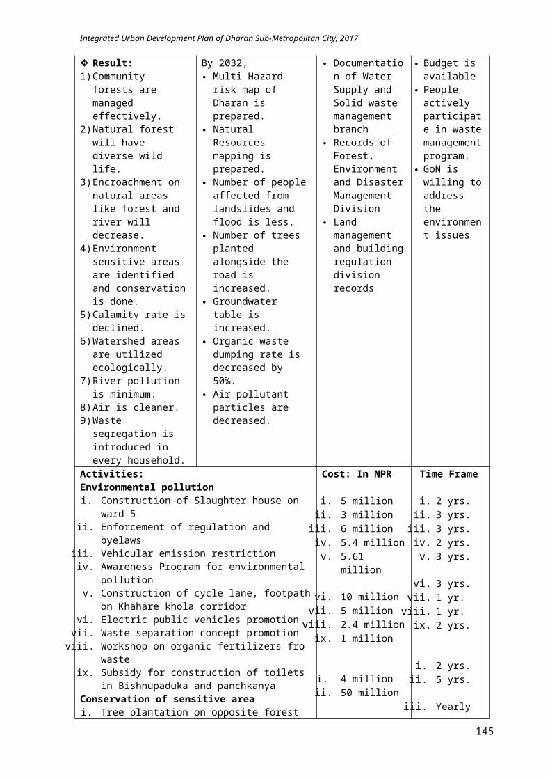
Integrated Urban Development Plan of Dharan Sub-Metropolitan City, 2017
e Sports1 Construction of Multipurpose hall/sports hall sq.m 1500 0.035 52.5 4 12 12 12 16.5 2 Improvement of Dharan Stadium amenities 10 3 3 3 4 3 Enhancement of ANFA stadium 5 3 1.5 1.5 2
4 Sports scholarships for socially backward groups person 250 0.012 3
yearly 3 4 4 8 15 15
Total 70.5 19.5 20.5 22 24.5 15 15
f Amenities1 Formation of 9 community libraries no 9 3 27 8 3 4 4 6 10 2 Upgrading facilities of city library 5 2 2.5 2.5 3 Construction of 3 exhibition halls sq.m 7500 0.006 45 8 5 6 10 12 12 4 13 new police post building construction no 13 5 65 8 5 8 10 16 26 5 Improvement of 7 police stations no 7 2 14 3 5 5 4 6 Construction of 14 new parks no 14 5 70 10 7 7 10 14 32 7 Upgrading of existing parks no 6 2 12 3 4 4 4 8 Enhancement of ethnic museum 2 2 1 1 9 Improvement of amenities of existing city hall 5 2 2.5 2.5 10 Management of City hall 1
yearly 1 1 2 2 5 8
11 Electric incineration chamber installment no 2 5 10 3 3 3 4 12 8 public toilet construction sq.m 200 0.035 7 4 1.5 1.5 1.5 2.5 13 Solar street lamps installation no 25000 0.015 375 10 30 45 45 90 165
Total 638 70.5 90.5 94.5 142.5 250 8
4 Environmental management plan (in million NPR)
Activities UnitQuantit
y Rate Cost Time yrs
2017-18
2018-19
2019-20
2020-22
2022-27 2027-32
a Pollution1 Construction of Slaughter house on ward 5 no 1 5 5 2 3 2 2 Enforcement of regulation and byelaws 3 3 1 1 1
145
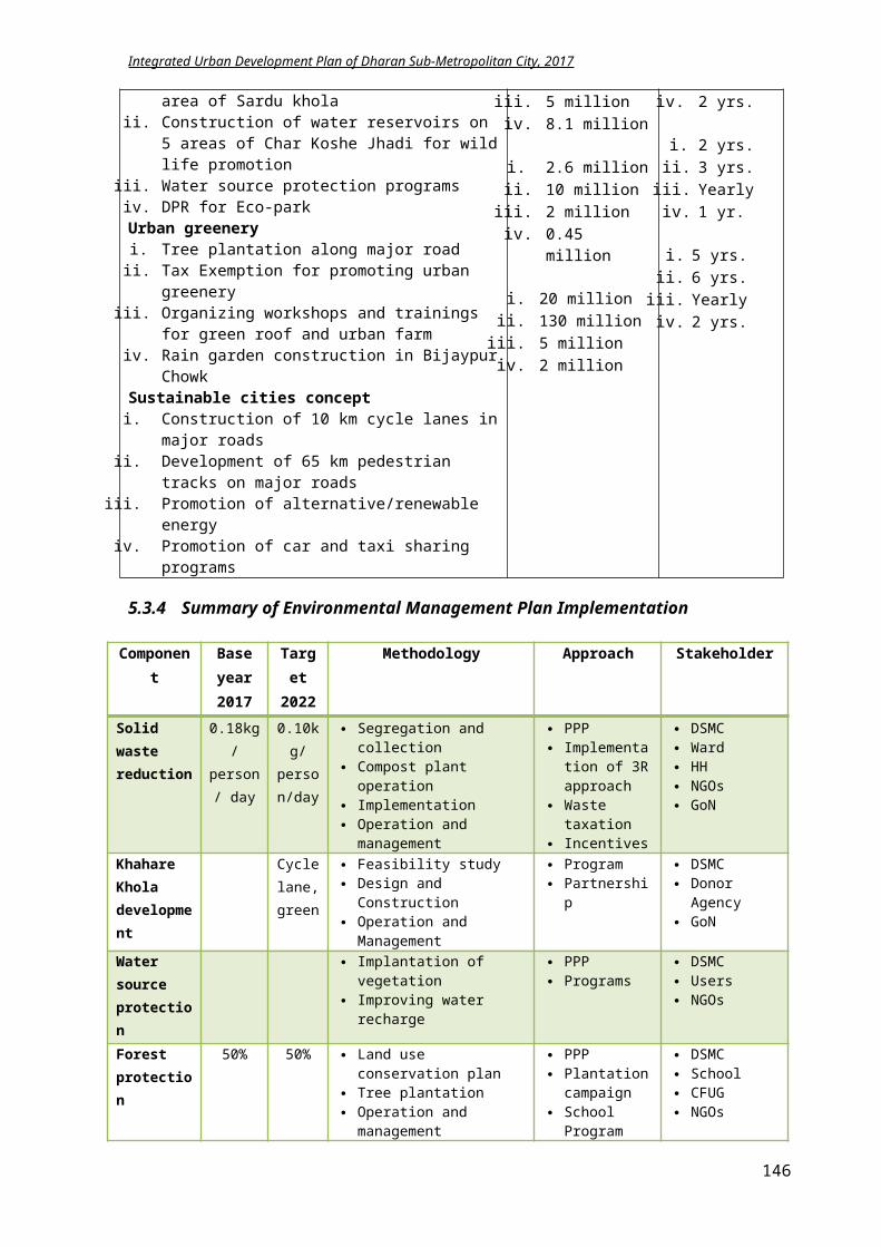
Integrated Urban Development Plan of Dharan Sub-Metropolitan City, 2017
3 Vehicular emission restriction 6 3 2 2 2 4 Awareness Program against environmental pollution no. 12 0.45 5.4 2 2.7 2.7
5Construction of cycle lane, footpath on Khahare khola corridor km 1.87 3 5.61 3 1.87 1.87 1.87
6 Electric public vehicle promotion 10 3 4 4 2 7 Waste separation concept promotion 5 1 5 8 Workshop on organic fertilizers from waste no. 8 0.3 2.4 1 2.4
9Subsidy for Construction of toilets in Bishnupaduka and panchkanya no. 1000 0.001 1 2 0.5 0.5
Total 43.41 22.47 14.07 6.87 b Conservation area
1 Tree plantation on opposite forest area of Sardu khola no. 5000 0.0008 4 2 2 2
2Construction of water reservoirs on 5 areas of Char Koshe Jhadi for wild life promotion no. 5 10 50 5 10 10 10 20
3 Water source protection programs no. 10 0.5 5 yearly 5 5 5 10 25 30
4 DPR for eco parks no. 1 8.1 8.1 2 2 6.1 Total 67.1 19 23.1 15 30 25 30c Urban greenery
1 Tree plantation along major road of 65 km no. 3250 0.0008 2.6 2 1.3 1.3
2 Tax Exemption for promoting urban greenery HH 1000 0.01 10 3 3 3 4
3Organizing workshops and trainings for green roof and urban farm times 4 0.5 2 yearl
y 2 2 2 4 10 15
4 Rain garden construction in Bijaypur Chowk sq.m 75 0.006 0.45 1 0.45
Total 15.05 6.75 6.3 6 4 10 15d Sustainable City1 Construction of 10 km cycle lanes on major roads km 10 2 20 5 4 4 4 8 2 Developing 65 km pedestrian lane on major roads km 65 2 130 6 20 20 20 40 30
3 Promotion of alternative/renewable energy 5yearl
y 5 5 5 10 25 304 Promotion of car and taxi sharing programs 2 2 1 1
Total 157 30 30 29 58 55 30
146
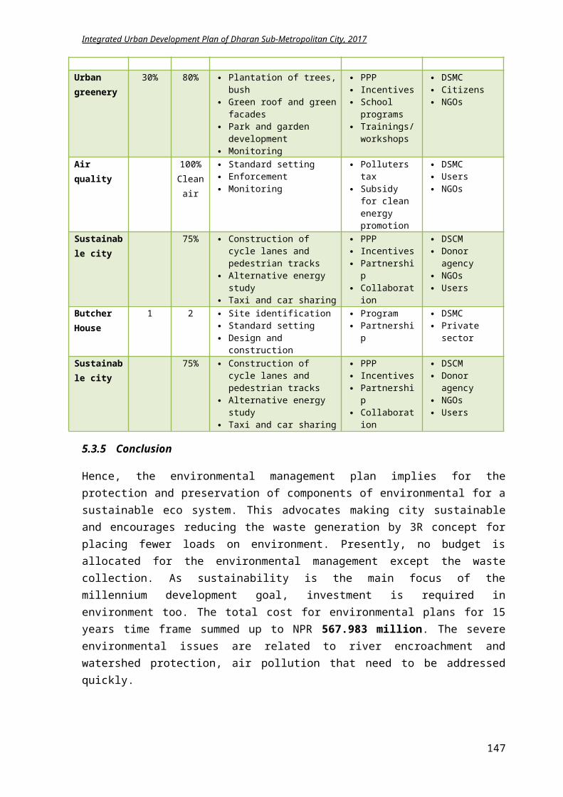
Integrated Urban Development Plan of Dharan Sub-Metropolitan City, 2017
5 Disaster Management Plan(in million NPR)
Activities UnitQuantit
y Rate Cost Time yrs
2017-18
2018-19
2019-20
2020-22
2022-27 2027-32
1Subsidy for Construction of earthquake resistant buildings no. 250 0.02 5 yearl
y 5 5 5 10 20 20
2 Reinforcement of regulation and byelaws 1 yearly 1 1 1 2 5 5
3 Protection against landslide opposite Sardu Khola sq.m 2000 0.0015 3 yearl
y 3 5 5 9 20 20
4 Awareness program for fire safety 0.5 yearly 0.5 0.5 0.5 1 2.5 2.5
5Workshop of earthing techniques for preventing Thunderstorm times 6 0.15 0.9 yearl
y 0.9 0.9 0.9 1.8 4.5 4.5
6 Plague control awareness programs 0.5 yearly 0.5 0.5 0.5 2 5 5
7 Establishment of epidemics department on BPKIHS no. 1 20 20 4 4 5 5 6
8 Collaboration with BPKIHS for health service 0.5 yearly 0.5 1 1 2 5 5
9 Establishment of emergency health groups no. 15 0.5 7.5 1 7.5 10 Establishment of local rescuing team no. 7 0.1 0.7 1 0.7 11 Training for rescuers times 4 0.2 0.8 yearl
y 0.8 0.8 0.8 1.6 4 412 Relocation of squatter settlements no. 1000 0.1 100 8 10 10 10 20 50 13 Alarm system for flood in rivers no. 4 2 8 2 4 4 14 Evacuation plan promotion during emergency 2
yearly 2 2 2 4 10 10
15 Signage for evacuation routes no. 20 0.05 1 1 1
Total 151.4 41.4 35.7 31.7 59.4 126 76
6 Cultural and Tourism Development Plan (in million NPR)
Activities UnitQuantit
y Rate Cost Time yrs
2017-18
2018-19
2019-20
2020-22
2022-27 2027-32
a Heritage site
1Development of pedestrian lane of 4.03 km connecting famous temples km 4.03 2 8.06 3
2.5 2.5 3.06
147
Integrated Urban Development Plan of Dharan Sub-Metropolitan City, 2017
2 Temple premises management nos 5 0.2 1 yearly 1 1 1 2 5 5
3Improvement of road to Bishnupaduka temple from Khahare khola on ward 20 km 1.98 2.2 4.356 2 2.178 2.178
4 Construction of cable car from Bijaypur to Bhedetar km 40 10 400 10 15 40 40 120 185
5Infrastructure development of Budasubba, Pindeshwor, Dantakali, Bishnupaduka temple nos 4 3 12 3 4 4 4
Total 425.416 24.67849.67
8 48.06 122 190 5b Historic site1 Facade treatment of houses on Bijaypur chowk no. 50 0.1 5 2 2 3
2 Byelaws enforcement in Bijaypur area 5 2 2 3
Total 10 4 6 c Tourism1 Khokaha khola impoundment to develop a lake 10 5 1 3 3 3
2Hiking trial development of 10.95 km from Chinne danda to Bhedetar km 10.95 0.3 3.285 3 1 1 1.285
3Construction of cable car from Bijaypur to chinne danda km 30 10 300 10 15 30 30 60 165
4 View tower construction at Chinne Danda no. 1 5 5 2 2 3
5 Improvement of paragliding spot at Chinne Danda no. 1 4 4 2 1 3
6 5 Tourist Information centers operation no 5 0.3 1.5 yearly 1.5 1.5 1.5 3 7 7
7Hiking trial of 4.5 km to organic village at Panchkanya km 4.5 0.3 1.35 1 1.35
8 Homestay workshops for Panchkanya 2 1 2 2 2 4
9 Introduction of Guided tour in City bus 2 1 2 10 Introduction of Safari Concept in Char Koshe Jhadi 3 2 1.5 1.5
11 Rock climbing feasibility study 2 1 2
Total 334.135 30.35 4537.78
5 70 172 7
7 Economic Development Plan (in million NPR)
Activities UnitQuantit
y Rate Cost Time yrs
2017-18
2018-19
2019-20
2020-22
2022-27 2027-32
148
Integrated Urban Development Plan of Dharan Sub-Metropolitan City, 2017
a Agro farming
1 Establishment of 5 Cold storage and collection centers no 5 1 5 5 1 1 1 2
2 Subsidy for chicken and Kalo Bangur farming no. 50 0.1 5 5 1 1 1 2
3 Trainings on animal farming and agriculture times 4 0.2 0.8 yearly 0.8 1.2 1.2 2.4 6 6
4Khahare Khola impounding for irrigation design and study 10 3 4 3 3
5Construction of 10 one km irrigation canal at Bishnupaduka km 10 2 12 3 4 4 4
6 Construction of irrigation canal on Panchkanya area km 30 5 150 10 10 15 15 30 80
7 Preparation of guidelines for animal husbandry 2 1 2
8Promotion of organic farming and off seasonal farming 3 3 1 1 1
9Loans for construction of green house farming and others
person 100 0.1 10 4 2 2 2 2
10
Networking activities with surrounding villages for product exports no. 20 0.03 0.6 yearl
y 0.6 0.6 0.6 1.2 3 3
11
Improvement of access road to neighborhood rural areas km 15 0.3 4.5 4 1 1 1 1.5
12 Herbal and Bee farming promotion 2 3 0.5 0.5 1
13 Coordination for Loan for agro farming 0.5 yearl
y 0.5 1 1 2 5 5
Total 205.4 28.4 31.3 31.8 43.1 94 14b Tourism
1Coordination with national and international travelling agencies no. 20 0.05 1 yearl
y 1 2 2 4 10 10
2Promotional events through internet and advertisements no. 24 0.05 1.2 yearl
y 1.2 1.2 1.2 2.5 6 6
3Educating students and local youths for information flow 1 yearl
y 1 1.5 1.5 3 7.5 7.5
Total 3.2 3.2 4.7 4.7 9.5 23.5 23.5c Infrastructure1 Construction of 3 vegetable market structures. no 3 50 150 10 10 15 15 30 80
2 Construction of complex with 5 movie halls. no 5 50 250 10 15 25 25 50 135
149
Integrated Urban Development Plan of Dharan Sub-Metropolitan City, 2017
Total 400 25 40 40 80 215 d Industry1 Tax exemption on construction of industries. % 25 10 4 3 3 2 2
2 Provision of physical amenities to local industry 5 3 2 1.5 1.5
3 Loans for local industry formation no. 50 0.2 10 3 3 3 4
4 Subsidy on homestay conduction and small lodges no. 20 0.5 10 2 5 5
5 Coordination with local banks for loans 2 yearly 2 2 2 4 10 10
Total 37 15 14.5 9.5 6 10 10
8 Institutional Development Plan (in million NPR)
Activities UnitQuantit
y Rate Cost Time yrs
2017-18
2018-19
2019-20
2020-22
2022-27 2027-32
a Construction of municipal building no. 1 5 5 2 2.5 2.5 b Improvement of 15 ward offices no. 15 1 15 5 3 3 3 6 c 5 Ward offices set up no. 5 5 25 3 7 7 11
dRetrofitting of old and dilapidated government buildings no. 15 0.5 7.5 3
2.5 2.5 2.5
e Training and workshops for capacity development 3 yearly 3 3 3 6 15 15
fIntroduction of digital system in 10 newly formed local divisions no 10 1 10 2
5 5
g Organization of public hearing and trial sessions times 2 yearly 2 2 2 4 10 10
h Home services for needy citizens person 1500 0.002 3 yearl
y 3 3 3 6 18 18
i Promotion of PPP model for investments 2 2 1 1
j Co-ordination with various organization 3yearl
y 3 3 3 6 15 15
k Facilitation of ward level committees 2yearl
y 2 2 2 4 10 10
l Award systems for capable and efficient staff 3yearl
y 3 3 3 6 16 15m Office set up for new 10 divisions nos. 10 3 30 2 15 15 n Building construction for new divisions nos 10 20 200 5 40 40 40 80 o Appointment of new technical staffs perso 5 0.3 1.5 1 1.5
150

Integrated Urban Development Plan of Dharan Sub-Metropolitan City, 2017
np Founding development groups no. 6 0.1 0.6 1 0.6 q Networking of various divisions no. 38 0.05 1.9 1 1.9 r New vehicles buying no. 10 1 10 3 3 3 4 Total 324.5 99 95 76.5 118 84 83
151
Integrated Urban Development Plan of Dharan Sub-Metropolitan City, 2017
7 Chapter VII: Prioritized Major Sub-Projects Engineering Design
After consultation with the steering and sub-steering committee, Dharan Sub metropolitan city had finalized three major sub projects. The core task of the consulting service is to prepare DPR of these three selected infrastructure projects. The identified sub projects are:
1. Dharan Ringroad (Sardu and Seuti Khola Corridor development)2. Drainage master plan of ward no 5 and 63. Bijaypur chowk revitalization, Bijaypur chowk to Panchkanya complex road improvement and
Panchkanya temple premises development
Figure 7-84 Locations of prioritized three sub projects
From the above plan of locations of prioritized projects, it is obvious that development is focusing towards the periphery of Dharan. The core city of DSMC had approached its saturation level in physical development and focus is needed only on management level whereas the peripheral area had potential and necessity of physical as well as managerial development for boosting the living standards of its citizens and increasing economy of Dharan.
1. Dharan Ringroad (Sardu and Seuti Khola Corridor development)
The river corridor development is one the parts of Dharan Ring road Project. Roads are to be constructed along two major rivers Sardu and Seuti of Dharan, which will be connected to the existing road network. The ring road at the southern part is expected to pass by the edge of the Char Koshe Jhadi i.e. existing Radio Nepal Marga.
The cost estimate of Ring road development is NPR 715.677million. The cost breakdown is explicit in table below:
S.N Description Total Cost (NPR)1 Sardu River corridor (7.876 km length) 168,276,616.462 Seuti River corridor (4.879 km length) 148,633,383.79
152
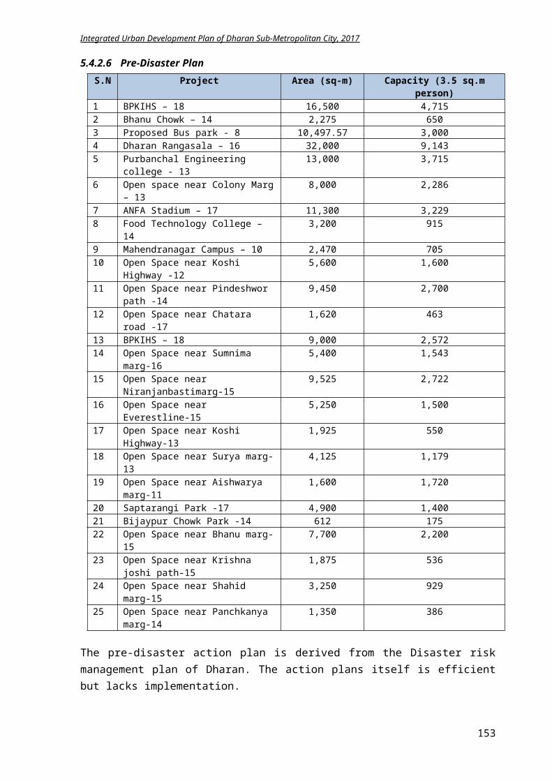
Integrated Urban Development Plan of Dharan Sub-Metropolitan City, 2017
3 River Embankment (15 km) 75,000,000.004 Pedestrian and cycle track (15 km) 45,000,000.005 Garden development (10000 sq.m) 50,000,000.006 Vehicle parking (3 hectare) 228,767,069.41
Total 715,677,069.66
2. Drainage master plan of ward no 5 and 6The total cost for construction of drainage of 46.16 km in former panchkanya VDC area is NPR 852.21 million.
3. Bijaypur chowk revitalization, Bijaypur chowk to Panchkanya mandir road improvement and Panchkanya temple premises development
The Bijaypur hill development project includes, Bijaypur Chowk revitalization (area 3100 sq.m), Road improvement from Bijaypur Chowk to Panchkanya Temple (length 1.155km) and Panchkanya temple premises development (area 6500 sq.m). The master plan of the sub project three is illustrated in Fig. 7.2.
The Bijaypur chowk improvement includes
Inclusion of conservation of traditional facades of Bijaypur hill in planning and building bye law.
Developing a prototype of traditional building façade along the cultural route of Bijaypur hill
Reviving of old architecture through façade improvement
Intervention in existing garden through storm water ponds, fish pond, rock garden, yoga garden, kids play area garden construction
Development of jogging lane and pedestrian tracks along main road
Construction of rain garden Installing kiosk at the crossroad for social
livelihood Encouragement of pedestrianization through
restriction of automobiles Increasing porosity through permeable
pavements Planting small trees on the walkways for
increasing urban greenery
Figure 7-85 Master plan of Bijaypur hill development project
The Panchkanya premises development includes enhancing the temple complex with addition of amenities like parking, kiosks, hall, toilets, gazebos, water tanks, garden and properly managing the available space for maximal usage and income generation. The total cost for the Bijaypur hill development is NPR 63.725 million.
153
Integrated Urban Development Plan of Dharan Sub-Metropolitan City, 2017
S.N Description Total Cost (NPR)1 Access road from Bijaypur chowk to Panchkanya
premises (1.155 km length):34,108,343.76
2 Bijaypur Chowk revitalization 5,539,881.333 Panchkanya temple premises development 24,077,469.40
Total 63,725,694.49
The detail design and estimate of each project is prepared separately and attached herewith the main report as APPENDIX III, IV and V.
Figure 7-86 Master plan of Bijaypur chowk (Area = 3100 sq.m)
154
Integrated Urban Development Plan of Dharan Sub-Metropolitan City, 2017
Figure 7-87 Master plan of Panchkanya temple premises development (Area = 6500 sq.m)
155
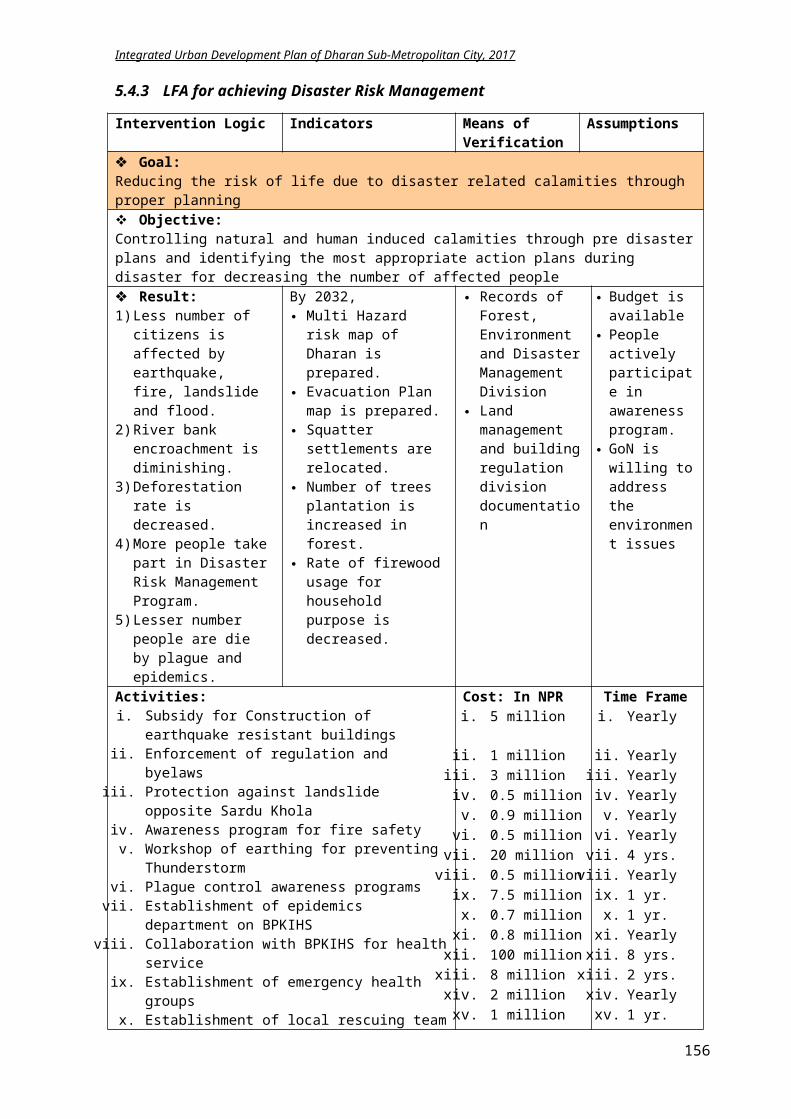
Integrated Urban Development Plan of Dharan Sub-Metropolitan City, 2017
8 Chapter VIII: Planning and Building Bye-laws
Many municipalities have comprehensive zoning byelaw that divides the municipality into different land use zones, with detailed maps. The byelaw specifies the permitted uses (e.g. commercial or residential) and the required standards (e.g. building size and location) in each zone. It states exactly:
how land may be used where buildings and other structures can be located the types of buildings that are permitted and how they may be used the lot sizes and dimensions, parking requirements, building heights and setbacks from the
street.
The building bylaws should tie up with building code and climate change initiatives. The clean, green and healthy urban environment can be obtained through individual house planning and designing. It can initiate through green house concept.
8.1 Goal and Objectives
Goal: Ensure a safe and healthy living standard for citizens through well-planned city with appropriate infrastructures
Objectives:
i. To reduce the earthquake risk in the DSMCii. To implement the building codes in the
municipalityiii. To encourage and raise awareness amongst
general public for implementing bye-laws
Figure 8-88 Green Homes Concept (UN Habitat Nepal)
8.2 Plan and Programs
The planning and building byelaws updated detail can be found in separate APPENDIXVI. Green building guidelines are also to be included in byelaws for a sustainable living. Building digitization shall also be included in the program of DSMC for regularization of byelaws.
8.3 Conclusion
The implementation of building code and planning byelaws will aid in preserving the natural resources and environmental sensitive areas. It will guide the city to implement the physical infrastructure plans properly without disturbing the natural setting.
156
Integrated Urban Development Plan of Dharan Sub-Metropolitan City, 2017
9 CONCLUDING REMARKS
The Integrated Urban Development Plan of Dharan is prepared based on “Urban Planning Norms and Standard 2015” for achieving the long-term vision of “A Multi-cultural livable city with proper education, health, tourism and trade amenities”.
Municipality profile, long-term vision analysis, identification of lead sectors, SWOT analysis, application of LFA for accomplishing specific goals, objectives, outputs, indicators, means of verifications and possible activities for implementation of plans and programs are included in this IUDP.
After the SWOT analysis, it is obvious that for physical development, investment is required mostly in road network, transportation, water supply and housing demands. For social development, funding is needed in improvement of existing social infrastructures like schools, hospitals, sports area, police stations, public toilets, bus stops and additionally women and child welfare and social security and mobilization. Similarly, environment management requires financing on promoting green concept. As Dharan already has a disaster risk management plan, less amount of budget is needed and focus is required primarily on construction of earthquake resistance buildings and organizing training and information flow. On the other hand, as Dharan is to be promoted as one of the cities of “Green East” as an alternative tourism destination to current golden triangle, attention is required in conservation of the existing heritage and cultural areas and improvement of new touristic spots not only for tourism development but also for economic uplift. Due to the current restructuring of government institution, more investment is required for setting up the organizational structure and strengthening and developing the capacity of staffs for couple of years.
For completion of most of the strategic projects, time frame ranges from 1-5 years with maximum time frame 1-15 years mainly for the physical infrastructure like road, drainage, sewerage, bridges, landfill site and treatment plant construction. The total cost for all the projects for 15 years is NPR21369.99 million.
The total estimated cost of the entire proposed projects for the year 2017-18 is NPR 1585.200 million. The total budget available for the year 2017-18 from GoN and DSMC is NPR 1551.405 million. Consequently, NPR 33.795million budget seems deficit, which shall be arranged through internal (15.236 million) and external resources (18.559million).
Sector Budget from
Municipal Budget (in
Total Budget
Anticipated budget
Deficit (in million
Deficit resource allocation (in
157
Integrated Urban Development Plan of Dharan Sub-Metropolitan City, 2017
ministry (in million
NPR)
million NPR)
DSMC for 2017-18 2017-18 (in
million) NPR) million NPR)
Internal External
Physical Development Plan
441.207 392.880 835.908 852.256 16.348 6.539 9.809
Strategic project 63.790 56.210 120.000 123.220 3.220 0.966 2.254
Social Development Plan
106.770 97.230 204.000 206.241 2.241 0.448 1.793
Environment Management Plan
49.403 44.900 94.303 95.428 1.126 0.338 0.788
Disaster Management Plan
21.861 18.330 40.191 42.228 2.037 0.000 2.037
Culture and Tourism Development Plan
37.281 33.234 70.515 72.014 1.499 0.450 1.049
Economic Development Plan
37.808 32.462 70.270 73.032 2.762 1.933 0.829
Institutional Development Plan
62.527 53.691 116.218 120.780 4.562 4.562 0.000
Total budget 820.647 730.758 1551.405 1585.200 33.795 15.236 18.559
Out of NPR 15.236 million, 4.830 million shall be accumulated by DMSC through increase in taxes and service charges and 3.463 million by citizen’s participation. The external NPR 18.559 million needs to be gathered through donor agencies (INGOs and NGOs) like UN, World Bank, ADB, UNICEF, UNHabitat, GIZ, Oxfam, Winrock, ActionAid, WaterAid, and NGOs like SunFarmer, Smaart paani, MinErgy, IUCN, NSET etc.
Based on the situation analysis, some key recommendations for the comprehensive development of Dharan are stated herewith:
Improvement of physical infrastructures for upgrading the living standard of citizens and maximizing the reach of public to such facilities.
Utilization of natural resources for the benefit of the city without hampering the environment. Enhancement of touristic spots for improving economy. Commercialization of agriculture for enticing young generation and accelerating economic
growth rate. Creating environment for alluring citizens for involvement in strategic projects. Increment of resources both financial and manpower on energy efficiency and renewable
energy. Preservation and improvement of culture and heritage of ethnic groups. Formulation of programs focused on marginalized groups, women and children welfare. Address child friendly, disable friendly and gender friendly issues during building design and
construction. Increasing the efficacy of local government through transparent and hassle free service
delivery. Establish coordination and collaboration between INGOs, NGOs and user groups through
efficient capacity development.
158
Integrated Urban Development Plan of Dharan Sub-Metropolitan City, 2017
10 APPENDIX
Appendix 1: Municipality ProfileAppendix II: GIS Base MapsAppendix III: River Corridor Development Appendix IV: Drainage Master Plan (ward 5 and 6)Appendix V: Bijaypur Hill Development (Bijaypur Chowk Revitalization, Bijaypur to Panchkanya road development and Panchkanya premise development)Appendix VI: Planning and Building Byelaws
159
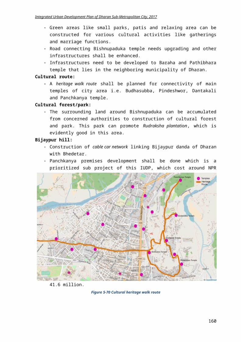
Integrated Urban Development Plan of Dharan Sub-Metropolitan City, 2017
11 BIBLIOGRAPHY 1) DUDBC, (2015), Planning Norms and Standards 2015, Nepal, Government of Nepal,
Navanari Media2) Dharan Sub Metropolitan City, (2017), Periodic plan of Dharan 2066/67, accessed on 18
June 2017 from http://www.dharan.gov.np/sites/dharan.gov.np/files/Dharan_Summary_Nepali.pdf
3) Integrated Urban Development Plan Dharan (2017), Rehabilitation, Extension and Development of Water Supply Works, accessed on 18 June from http://www.dharan.gov.np/sites/dharan.gov.np/files/documents/Initial%20Environmental%20Examination%20%28IEE%29.pdf
4) Dharan Sub Metropolitan City, (2072), F.Y 2073/74 Annual City Development Plan, Vol. 14, Dharan, Dharan Sub Metropolitan City
5) Ministry of Urban Development, (2017), Nepal Urban Development Strategy 2017, Nepal, accessed on 19 June 2017 from http://moud.gov.np/wp-content/uploads/2017/02/NUDS_cabinet-document_approved-on-2073-10-9.pdf
6) Urban Road Standards 2071, accessed on 18 June 2017 from www.cen.org.np/uploaded/Urban%20Roads%20Standard%20020215.docx
7) Dharan Municipality, (2070), Disaster Risk Management Plan Dharan 2070, Dharan, Dharan Sub Metropolitan City
8) Integrated Watershed Conservation and Management Plan9) Dharan Sub Metropolitan City, (2072), http://dharan.gov.np/ne/node/78, Dharan
Municipality Green Homes Project Implementation plan2071, accessed on 18 June 2017 from http://dharan.gov.np/ne/node/78
10) Nepal National Building Code and Building Bye-laws11) Dharan Sub Metropolitan City, (2072), Building Byelaws of Dharan,
http://dharan.gov.np/ne/act-law-directives12) Dharan Sub Metropolitan City, (2072), 3/ gS;fkf; ;DalGw sfo{ljwL @)^(,
http://dharan.gov.np/ne/act-law-directives13) सामाजि�कपरिरचालनकार्य�ति�धी२०७१14) DUDBC, (2014), Institutional development for emerging towns in Nepal: Urban
governance and development program, Nepal, Shiven Studio15) Republic of South Africa, (2016), Integrated Urban Development Framework, Co-operative
Governance and Traditional Affairs, accessed on: 16 June 2017 from http://markswilling.co.za/wp-content/uploads/2016/06/IUDF-2016_WEB.pdf,
16) Mkhambathini Municipality Intergrated Development Plan 2016-2022, accessed on 16 June 2017 from http://www.mkhambathini.gov.za/sites/default/files/Final%20IDP%202016-17.pdf,
17) Dharan Sub Metropolitan City, (2017), accessed on 18 June 2017 from http://www.dharan.gov.np/ne
18) A vision and methodology for integrated sustainable urban development: BEQUEST, Building Research & Information (2002) 30(2), 83–94, accessed on 18 June 2017 from https://www.researchgate.net/profile/Gordon_Mitchell3/publication/28578935_A_vision_and_methodology_for_integrated_Sustainable_Urban_Development_BEQUEST/links/56fe65b208aea6b77468c57c.pdf,
19) WHO, (1999), Towards a new planning process: A guide to reorienting urban planning towards Local Agenda 21, accessed on 18 June 2017 from https://www.unpei.org/sites/default/files/e_library_documents/Guide%20for%20the%20creation%20of%20Municipal%20Territorial%20Development%20Plans%20with%20an%20ecosystems%20approach.pdf ,
160
Integrated Urban Development Plan of Dharan Sub-Metropolitan City, 2017
20) GoN, (2016), Tourism destination area plan for eastern Nepal, accessed on 23 June from http://www.tourism.gov.np/downloadfile/EasternNepalTDAPlanPART1Main%20Report_1494310082.pdf , accessed on:
21) ADB, (2012), Public Private Partnership Operational Plan 2012-2020, accessed on 30 June 2017 from https://www.adb.org/sites/default/files/institutional-document/33671/ppp-operational-plan-2012-2020.pdf
22) District Development Committee Dhankuta, (2013), Periodic Plan of Dhankuta 2070-2074, Nepal, Ministry of Foreign Affairs and Local Development, Government of Nepal
23) MoFALD, (2013), Environment-friendly Local Governance Framework 2013, Nepal, Government of Nepal
24) NPC, (2012), Nepal Status Paper UN Conference on Sustainable Development Synopsis, Kathmandu, Nepal, Government of Nepal, Hillside Press (P) Ltd.
161