Embed Size (px)
Citation preview
Deliverable 2.2 Stakeholder audit and
classification
29th April 2016 Version 1.4
Abstract:
An audit of its4land stakeholders – including actors classification and identification – and selected use case areas descriptions
Project Number: 687828 Work Package: 2 Lead: KU Leuven
Type: DEC Dissemination: Public
Delivery Date: May 01 2016 Actual Delivery Date: April 2016
Contributors: Joep Crompvoets, Bruno Broucker, Rohan Bennett, Berhanu Alemie, Monica Lengoiboni, Gordon Wayumba, Mireille Biraro, Kaspar
Kundert
Its 4 Land Hengelosestraat 99 Enschede 7500AE
Netherlands Phone: +31534874532 www.its4land.com
H2020 its4land 687828 D2.2 Stakeholders Audit
3
This communication reflects only the author’s view and the Commission is not responsible for any use that may be made of the information it contains. Copyright © 2016 by the its4land consortium
The its4land consortium consists of the following partners:
University of Twente (UT) KU Leuven (KUL) Westfaelische Wilhelms-Universitaet Muenster (WWU) Hansa Luftbild AG (HL) Institut d'Enseignement Superieur de Ruhengeri (INES) Bahir Dar University (BDU) Technical University of Kenya (TUK) esri Rwanda (ESRI).
Its 4 Land Hengelosestraat 99 Enschede 7500AE
Netherlands Phone: +31534874532 www.its4land.com
H2020 its4land 687828 D2.2 Stakeholders Audit
4
Executive Summary
This deliverable report presents the results of the Stakeholder audit and classification, part of Working Package 2 ‘Get Needs’, of the European Commission Horizon 2020 project its4land. For each East African country, and accompanying use case, a refined audit of necessary stakeholders to engage with was conducted in the first 3 months of the project. This includes the identification and classification of stakeholders from the government, non-statutory entities, private sector, NGO/Not-for-Profit/Donors, Development partners, Research & Development (R&D) at multiple scales. The stakeholders classes are used for designing the subsequent data collection instruments (D2.3), whilst the stakeholders identified become participants in the data collection activities (D2.4). During this activity, specific use case areas, for the piloting and demonstration activities, are also selected and briefly described.
www.its4land.com
H2020 its4land 687828 D2.2 Stakeholders Audit
5
Contents EXECUTIVE SUMMARY 4
1. INTRODUCTION 6
2. STAKEHOLDERS CLASSIFICATION 8
3. STAKEHOLDERS IDENTIFICATION 10
4. USE CASE AREAS 17
5. CONCLUSIONS 21
www.its4land.com
H2020 its4land 687828 D2.2 Stakeholders Audit
6
1. Introduction its4land is a European Commission Horizon 2020 project funded under its Industrial Leadership program, specifically the ‘Leadership in enabling and industrial technologies – Information and Communication Technologies ICT (H2020-EU.2.1.1.)’, under the call H2020-ICT-2015 – and the specific topic – ‘International partnership building in low and middle income countries’ ICT-39-2015. its4land aims to deliver an innovative suite of land tenure recording tools that respond to sub Saharan Africa’s immense challenge to rapidly and cheaply map millions of unrecognized land rights in the region. ICT innovation is intended to play a key role. Many existing ICT-based approaches to land tenure recording in the region have not been successful: disputes abound, investment is impeded, and the community’s poorest lose out. its4land seeks to reinforce strategic collaboration between the EU and East Africa via a scalable and transferrable ICT solution. Established local, national, and international partnerships seek to drive the project results beyond R&D into the commercial realm. its4land combines an innovation process with emerging geospatial technologies, including smart sketchmaps, UAVs, automated feature extraction, and geocloud services, to deliver land recording services that are end-user responsive, market driven, and fit-for-purpose. The transdisciplinary work also develops supportive models for governance, capacity development, and business capitalization. Gender sensitive analysis and design is also incorporated. Set in the East African development hotbeds of Rwanda, Kenya, and Ethiopia, its4land falls within TRL 5-7: 3 major phases host 8 work packages that enable contextualization, design, and eventual land sector transformation. In line with Living Labs thinking, localized pilots and demonstrations are embedded in the design process. The experienced consortium is multi-sectorial, multi-national, and multidisciplinary. It includes SMEs and researchers from 3 EU countries and 3 East African countries: the necessary complementary skills and expertise is delivered. Responses to the range of barriers are prepared: strong networks across East Africa are key in mitigation. The tailored project management plan ensures clear milestones and deliverables, and supports result dissemination and exploitation: specific work packages and roles focus on the latter. This document is directly linked to ‘Work Package 2 (WP2) – ‘Get Needs’ of the its4land project. WP2 deals exclusively with the capture of the specific needs, market opportunities, and readiness of end-users in the domain of land tenure information recording in order to support design activities in WPs 3-6 and modelling activities in WPs 7-8. This document seeks to represent D2.2 of the its4land project: it intends to provide the results of the Stakeholder audit and Classification. For each East African country, and accompanying use case, a refined audit of the necessary stakeholders that must be engaged with through the different project phases is conducted. This includes the identification and classification of stakeholders from the government, Non-statutory entities, private sector, NGO/Not-for-Profit/Donors/Development partners, Research & Development (R&D) at multiple scales. The actor classes are used for designing the subsequent data collection instruments (D2.3), whilst the stakeholders identified
H2020 its4land 687828 D2.2 Stakeholders Audit
7
become participants in the data collection activities (D2.4). During this activity, specific use case areas, for the piloting and demonstration activities, are also selected and briefly described. This Deliverable report maintains a simple structure, and merely presents the stakeholders classification (Section 2), stakeholders identification (Section 3), Use case areas descriptions (Section 4), and Conclusions (Section 5).

H2020 its4land 687828 D2.2 Stakeholders Audit
8
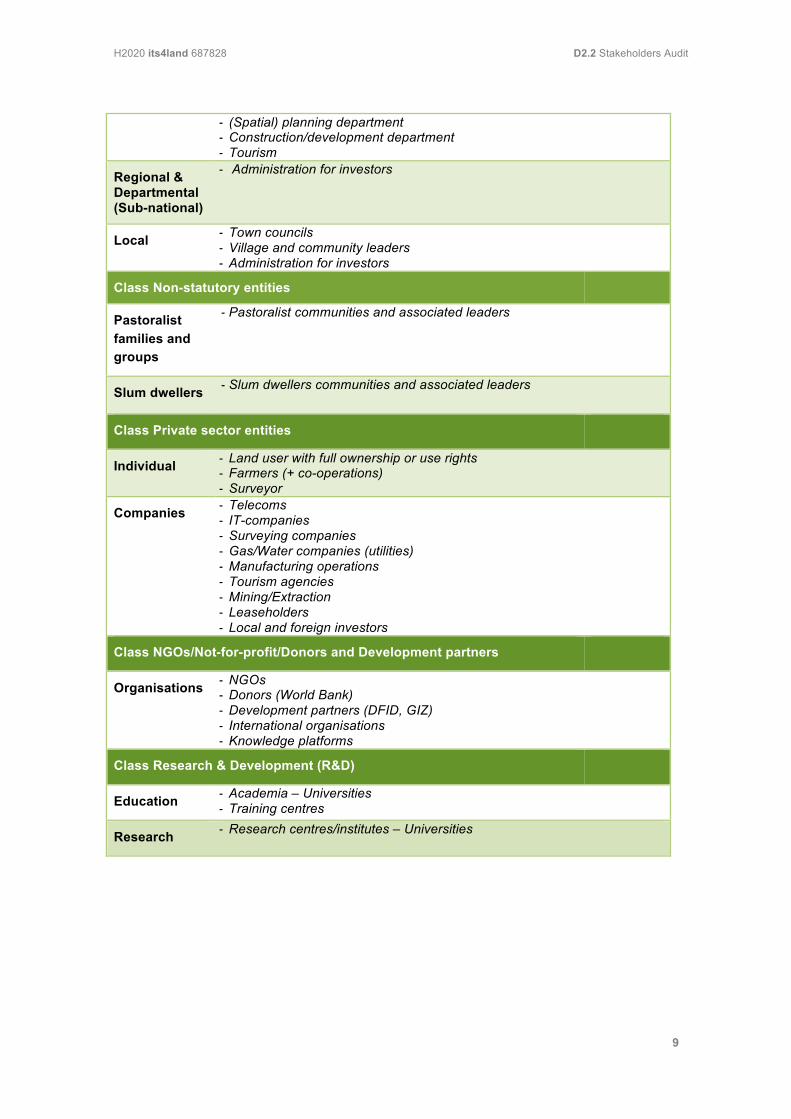
2. Stakeholders classification This section presents the key stakeholders classifications – as formed during several group meetings. The meetings aimed to identify and take into account the possible demands of the potential stakeholder groupings to the application of the different geospatial innovative technologies (sketchmaps, UAV, automated feature extraction, and geoclouds) and models (governance, capacity development, and business). These classes will be used for designing the subsequent data collection instruments (D2.3), whilst the associated stakeholders identified become participants in the data collection activities (D2.4). The following stakeholder classes can be distinguished: Public Sector entities, Non-statutory entities, Private Sector entities, NGOs/Not-for-Profit/Donors/Development partners, and Research & Development entities. The stakeholder class Public Sector entities is divided into two classes: Land administration specific and Adjacent policy domains or public organisations at different administrative levels. Most stakeholder classes include sub-classes (except NGOs/Not-for-Profit/Donors/Development partners). Both classes Public Sector refer to the same sub-classes, being: National/Federal, Regional & Departmental (sub-national), and Local. Class Non-statutory entities consists of pastoralists families and groups as well as Slum dwellers. Class Private Sector includes two sub-classes: Individuals and Companies. Class Research & Development distinguishes sub-classes Education and Research. Table 1 presents the structure of stakeholder classification. Examples for each (sub)class are presented in well in order to illustrate the meaning of the different (sub)classes.
Table 1. Main stakeholder classes, subclasses + examples
Class Public Sector Entities: Land administration specific
Subclass Examples
National / Federal
- Ministry of Agriculture - Ministry of Environment - Minstry of Lands - Cadastre - Land administration / Land Registration Offices
Regional & Departmental (Sub-national)
- Regional investment agencies
Local - Land administration / Land registration offices - Cadastre
Class Public Sector Entities: Adjacent policy domains or public organisations
National - Tax office - Agriculture - Mining and Natural Resources exploitation
H2020 its4land 687828 D2.2 Stakeholders Audit
9
- (Spatial) planning department - Construction/development department - Tourism
Regional & Departmental (Sub-national)
- Administration for investors
Local - Town councils - Village and community leaders - Administration for investors
Class Non-statutory entities
Pastoralist families and groups
- Pastoralist communities and associated leaders
Slum dwellers - Slum dwellers communities and associated leaders
Class Private sector entities
Individual - Land user with full ownership or use rights - Farmers (+ co-operations) - Surveyor
Companies - Telecoms - IT-companies - Surveying companies - Gas/Water companies (utilities) - Manufacturing operations - Tourism agencies - Mining/Extraction - Leaseholders - Local and foreign investors
Class NGOs/Not-for-profit/Donors and Development partners
Organisations - NGOs - Donors (World Bank) - Development partners (DFID, GIZ) - International organisations - Knowledge platforms
Class Research & Development (R&D)
Education - Academia – Universities - Training centres
Research - Research centres/institutes – Universities
H2020 its4land 687828 D2.2 Stakeholders Audit
10
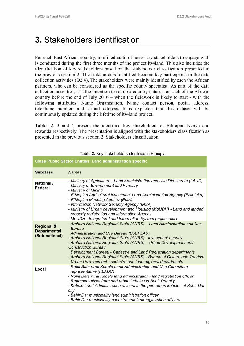
3. Stakeholders identification For each East African country, a refined audit of necessary stakeholders to engage with is conducted during the first three months of the project its4land. This also includes the identification of key stakeholders based on the stakeholder classification presented in the previous section 2. The stakeholders identified become key participants in the data collection activities (D2.4). The stakeholders were mainly identified by each the African partners, who can be considered as the specific county specialist. As part of the data collection activities, it is the intention to set up a country dataset for each of the African country before the end of July 2016 – when the fieldwork is likely to start - with the following attributes: Name Organisation, Name contact person, postal address, telephone number, and e-mail address. It is expected that this dataset will be continuously updated during the lifetime of its4land project. Tables 2, 3 and 4 present the identified key stakeholders of Ethiopia, Kenya and Rwanda respectively. The presentation is aligned with the stakeholders classification as presented in the previous section 2. Stakeholders classification.
Table 2. Key stakeholders identified in Ethiopia
Class Public Sector Entities: Land administration specific
Subclass Names
National / Federal
- Ministry of Agriculture - Land Administration and Use Directorate (LAUD) - Ministry of Environment and Forestry - Ministry of Mining - Ethiopian Agricultural Investment Land Administration Agency (EAILLAA) - Ethiopian Mapping Agency (EMA) - Information Network Security Agency (INSA) - Ministry of Urban development and Housing (MoUDH) - Land and landed property registration and information Agency - MoUDH - Integrated Land Information System project office
Regional & Departmental (Sub-national)
- Amhara National Regional State (ANRS) – Land Administration and Use Bureau Administration and Use Bureau (BoEPLAU) - Amhara National Regional State (ANRS) - investment agency - Amhara National Regional State (ANRS) – Urban Development and Construction Bureau Development Bureau - Cadastre and Land Registration departments - Amhara National Regional State (ANRS) - Bureau of Culture and Tourism - Urban Development - cadastre and land regional departments
Local - Robit Bata rural Kebele Land Administration and Use Committee representative (KLAUC) - Robit Bata rural Kebele land administration / land registration officer - Representatives from peri-urban kebeles in Bahir Dar city - Kebele Land Administration officers in the peri-urban kebeles of Bahir Dar city - Bahir Dar municipality land administration officer - Bahir Dar municipality cadastre and land registration officers
H2020 its4land 687828 D2.2 Stakeholders Audit
11
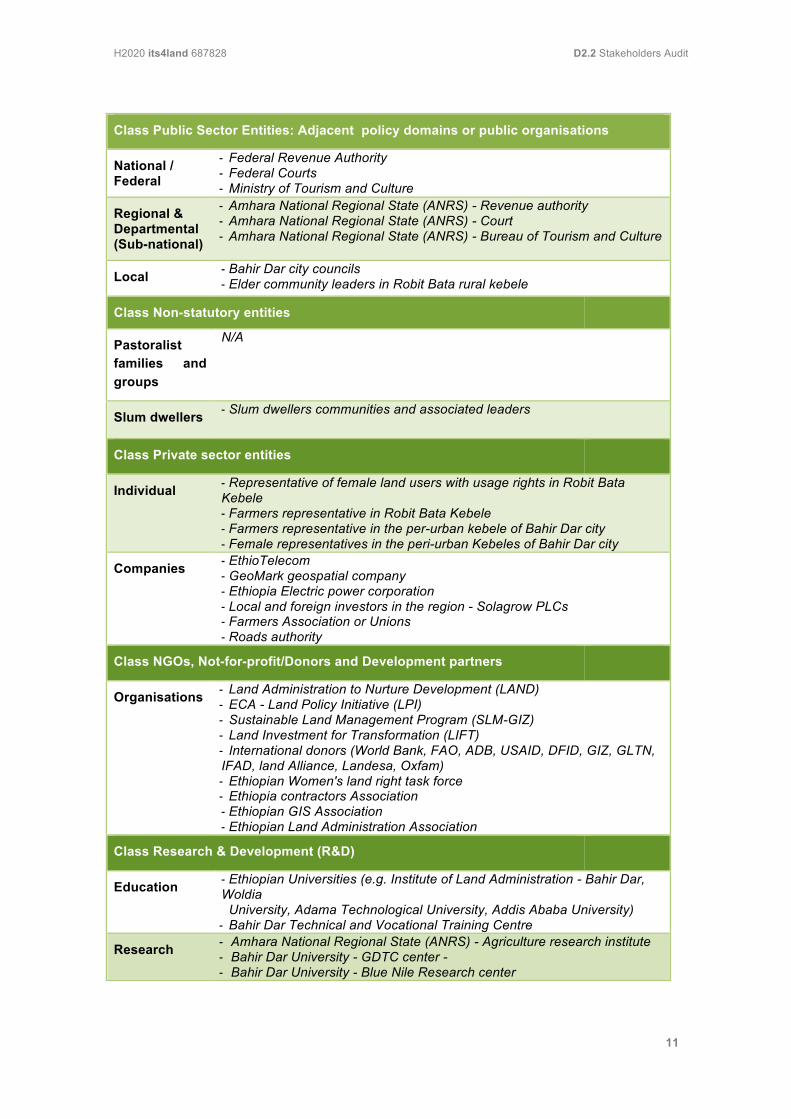
Class Public Sector Entities: Adjacent policy domains or public organisations
National / Federal
- Federal Revenue Authority - Federal Courts - Ministry of Tourism and Culture
Regional & Departmental (Sub-national)
- Amhara National Regional State (ANRS) - Revenue authority - Amhara National Regional State (ANRS) - Court - Amhara National Regional State (ANRS) - Bureau of Tourism and Culture
Local - Bahir Dar city councils - Elder community leaders in Robit Bata rural kebele
Class Non-statutory entities
Pastoralist families and groups
N/A
Slum dwellers - Slum dwellers communities and associated leaders
Class Private sector entities
Individual - Representative of female land users with usage rights in Robit Bata Kebele - Farmers representative in Robit Bata Kebele - Farmers representative in the per-urban kebele of Bahir Dar city - Female representatives in the peri-urban Kebeles of Bahir Dar city
Companies - EthioTelecom - GeoMark geospatial company - Ethiopia Electric power corporation - Local and foreign investors in the region - Solagrow PLCs - Farmers Association or Unions - Roads authority
Class NGOs, Not-for-profit/Donors and Development partners
Organisations - Land Administration to Nurture Development (LAND) - ECA - Land Policy Initiative (LPI) - Sustainable Land Management Program (SLM-GIZ) - Land Investment for Transformation (LIFT) - International donors (World Bank, FAO, ADB, USAID, DFID, GIZ, GLTN, IFAD, land Alliance, Landesa, Oxfam) - Ethiopian Women's land right task force - Ethiopia contractors Association - Ethiopian GIS Association - Ethiopian Land Administration Association
Class Research & Development (R&D)
Education - Ethiopian Universities (e.g. Institute of Land Administration - Bahir Dar, Woldia University, Adama Technological University, Addis Ababa University) - Bahir Dar Technical and Vocational Training Centre
Research - Amhara National Regional State (ANRS) - Agriculture research institute - Bahir Dar University - GDTC center - - Bahir Dar University - Blue Nile Research center
H2020 its4land 687828 D2.2 Stakeholders Audit
12
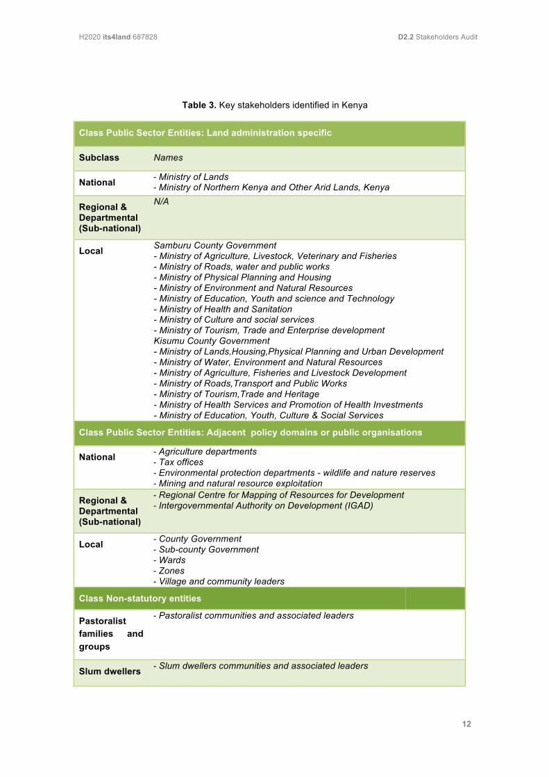
Table 3. Key stakeholders identified in Kenya
Class Public Sector Entities: Land administration specific
Subclass Names
National - Ministry of Lands - Ministry of Northern Kenya and Other Arid Lands, Kenya
Regional & Departmental (Sub-national)
N/A
Local Samburu County Government - Ministry of Agriculture, Livestock, Veterinary and Fisheries - Ministry of Roads, water and public works - Ministry of Physical Planning and Housing - Ministry of Environment and Natural Resources - Ministry of Education, Youth and science and Technology - Ministry of Health and Sanitation - Ministry of Culture and social services - Ministry of Tourism, Trade and Enterprise development Kisumu County Government - Ministry of Lands,Housing,Physical Planning and Urban Development - Ministry of Water, Environment and Natural Resources - Ministry of Agriculture, Fisheries and Livestock Development - Ministry of Roads,Transport and Public Works - Ministry of Tourism,Trade and Heritage - Ministry of Health Services and Promotion of Health Investments - Ministry of Education, Youth, Culture & Social Services
Class Public Sector Entities: Adjacent policy domains or public organisations
National - Agriculture departments - Tax offices - Environmental protection departments - wildlife and nature reserves - Mining and natural resource exploitation
Regional & Departmental (Sub-national)
- Regional Centre for Mapping of Resources for Development - Intergovernmental Authority on Development (IGAD)
Local - County Government - Sub-county Government - Wards - Zones - Village and community leaders
Class Non-statutory entities
Pastoralist families and groups
- Pastoralist communities and associated leaders
Slum dwellers - Slum dwellers communities and associated leaders

H2020 its4land 687828 D2.2 Stakeholders Audit
13
Class Private sector entities
Individual - Individual conservancies and group ranches / Institutions (private & governments) - Private land owners / private companies / institutions (private & - governments) - surveyors
Companies - Telecoms - Tourist agencies - Surveying companies - Group ranches - Water companies - Mining - Private surveyors - Private businesses - Vidmerck Limited
Class NGOs/Not-for-profit/Donors and Development partners
Organisations - Land Development and Governance Institute - Regional Centre for Mapping for Resources Development - Institute of Surveyors Kenya - KEPSA Land Sector Board - Kenya Alliance - Royal Institute of Chartered Surveyors - International Centre for Research in Agroforestry - Centre for Minority Rights Development (CEMIRIDE) - Children’s Peace Initiative - Pastoralist Development Network Kenya (PDNK) - Resource Conflict Institute (RECONCILE) - International Facilities Management Association (IFMA) - UKAID - DFID - GIZ - USAID - Land Alliance - Landesa - Oxfam - Dutch Ministry of Foreign Affairs - GLTN - FAO - Habitat International – UN Habitat - Northern Rangelands Trusts - The Nature Conservancy - International Livestock Research Institute
Class Research & Development (R&D)
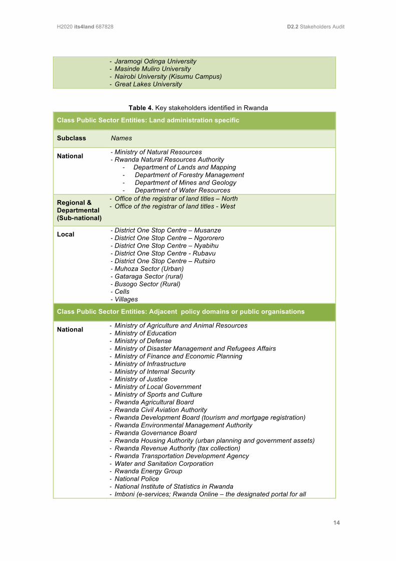
Education - Technical University of Kenya - Laikipia University – Maralal Campus - Maseno University - Jaramogi Oginga Odinga University - Masinde Muliro University - Nairobi University (Kisumu Campus) - Great Lakes University
Research - Technical University of Kenya - Laikipia University – Maralal Campus - Maseno University
H2020 its4land 687828 D2.2 Stakeholders Audit
14
- Jaramogi Odinga University - Masinde Muliro University - Nairobi University (Kisumu Campus) - Great Lakes University
Table 4. Key stakeholders identified in Rwanda
Class Public Sector Entities: Land administration specific
Subclass Names
National - Ministry of Natural Resources - Rwanda Natural Resources Authority
- Department of Lands and Mapping - Department of Forestry Management - Department of Mines and Geology - Department of Water Resources
Regional & Departmental (Sub-national)
- Office of the registrar of land titles – North - Office of the registrar of land titles - West
Local - District One Stop Centre – Musanze - District One Stop Centre – Ngororero - District One Stop Centre – Nyabihu - District One Stop Centre - Rubavu - District One Stop Centre – Rutsiro - Muhoza Sector (Urban) - Gataraga Sector (rural) - Busogo Sector (Rural) - Cells - Villages
Class Public Sector Entities: Adjacent policy domains or public organisations
National - Ministry of Agriculture and Animal Resources - Ministry of Education - Ministry of Defense - Ministry of Disaster Management and Refugees Affairs - Ministry of Finance and Economic Planning - Ministry of Infrastructure - Ministry of Internal Security - Ministry of Justice - Ministry of Local Government - Ministry of Sports and Culture - Rwanda Agricultural Board - Rwanda Civil Aviation Authority - Rwanda Development Board (tourism and mortgage registration) - Rwanda Environmental Management Authority - Rwanda Governance Board - Rwanda Housing Authority (urban planning and government assets) - Rwanda Revenue Authority (tax collection) - Rwanda Transportation Development Agency - Water and Sanitation Corporation - Rwanda Energy Group - National Police - National Institute of Statistics in Rwanda - Imboni (e-services; Rwanda Online – the designated portal for all
H2020 its4land 687828 D2.2 Stakeholders Audit
15
government e-services, incl. construction permits and eventually land transactions))
Regional & Departmental (Sub-national)
N/A
Local - Districts Juridical courts - Mediation Committees at Sector and Cell level - Representatives of cells - Representatives of villages
Class Non-statutory entities
Pastoralist families and groups
N/A
Slum dwellers N/A
Class Private sector entities
Individual - Land owners (farming activities) - Private land owners - Land surveyors - Land Valuators - Tourist guides
Companies - Esri Rwanda - Kadaster International - Private sector federation - Real Estate Association - Telecom companies - Architect bureaus - Tourism companies (hotels, guides,…)
Class NGOs, Not-for-profit/Donors and Development partners
Organisations - Association of Land Valuators - CRAFT - USAID - GIZ (Musanze One Stop Center) - DFID (Department for International Development, Government of the UK) - SNV (Dutch development agency organized as an NGO) - EuropAID - UN Habitat - Haguruka (supporting women) - Legal Aid Follow - Profemme Twesehamwe - RCN Justice and Democracy - Rwanda Initiative for Sustainable Development - Search for Common Ground - Transparency International Rwanda - UKAID - Women Association - World Bank - African Development Bank
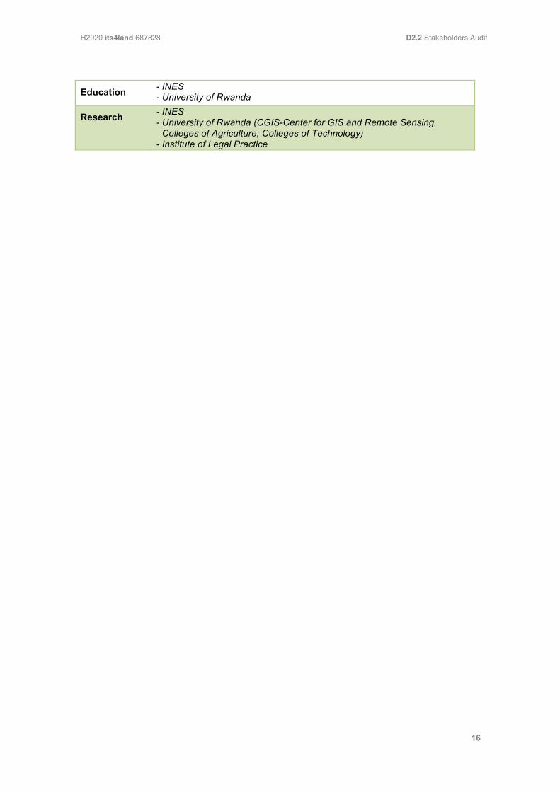
Class Research & Development (R&D)
H2020 its4land 687828 D2.2 Stakeholders Audit
16
Education - INES - University of Rwanda
Research - INES - University of Rwanda (CGIS-Center for GIS and Remote Sensing, Colleges of Agriculture; Colleges of Technology) - Institute of Legal Practice
H2020 its4land 687828 D2.2 Stakeholders Audit
17
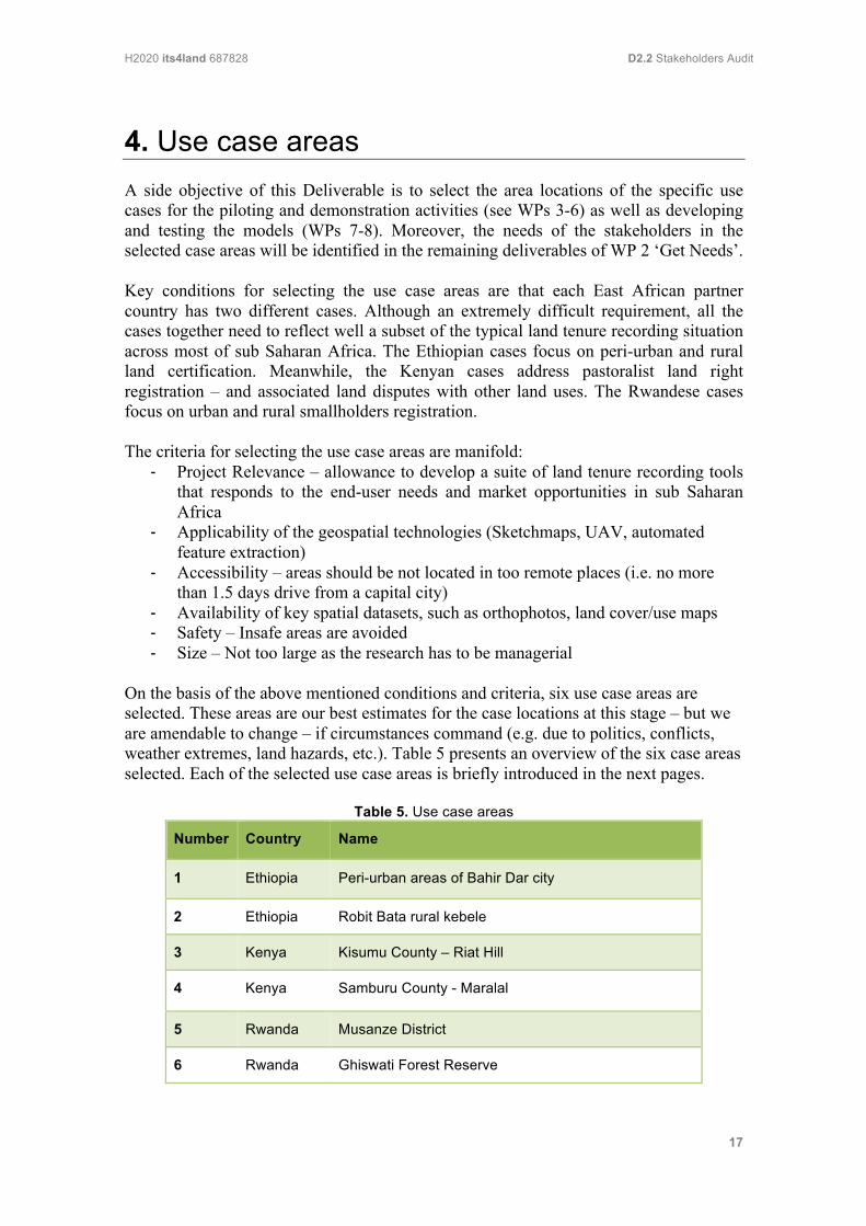
4. Use case areas A side objective of this Deliverable is to select the area locations of the specific use cases for the piloting and demonstration activities (see WPs 3-6) as well as developing and testing the models (WPs 7-8). Moreover, the needs of the stakeholders in the selected case areas will be identified in the remaining deliverables of WP 2 ‘Get Needs’. Key conditions for selecting the use case areas are that each East African partner country has two different cases. Although an extremely difficult requirement, all the cases together need to reflect well a subset of the typical land tenure recording situation across most of sub Saharan Africa. The Ethiopian cases focus on peri-urban and rural land certification. Meanwhile, the Kenyan cases address pastoralist land right registration – and associated land disputes with other land uses. The Rwandese cases focus on urban and rural smallholders registration. The criteria for selecting the use case areas are manifold:
- Project Relevance – allowance to develop a suite of land tenure recording tools that responds to the end-user needs and market opportunities in sub Saharan Africa
- Applicability of the geospatial technologies (Sketchmaps, UAV, automated feature extraction)
- Accessibility – areas should be not located in too remote places (i.e. no more than 1.5 days drive from a capital city)
- Availability of key spatial datasets, such as orthophotos, land cover/use maps - Safety – Insafe areas are avoided - Size – Not too large as the research has to be managerial
On the basis of the above mentioned conditions and criteria, six use case areas are selected. These areas are our best estimates for the case locations at this stage – but we are amendable to change – if circumstances command (e.g. due to politics, conflicts, weather extremes, land hazards, etc.). Table 5 presents an overview of the six case areas selected. Each of the selected use case areas is briefly introduced in the next pages.
Table 5. Use case areas
Number Country Name
1 Ethiopia Peri-urban areas of Bahir Dar city
2 Ethiopia Robit Bata rural kebele
3 Kenya Kisumu County – Riat Hill
4 Kenya Samburu County - Maralal
5 Rwanda Musanze District
6 Rwanda Ghiswati Forest Reserve
H2020 its4land 687828 D2.2 Stakeholders Audit
18
Bahir Dar City – Peri-Urban Areas (Ethiopia) Bahir Dar is one of the fastest growing cities in Ethiopia. The growth is taking place in all directions especially following the highways. Unlike more developed country contexts, the demarcation between rural and urban area in Ethiopia is not always sharply defined physically or administratively. Much of the contemporary growth, with high human to land interaction, is clearly taking place at the peri-urban areas in all directions of the city. The urban administration considers this part of the city as part of the rural land administration and proclamation, whereas, the rural administration considers it as part of the urban administration and policy. In this context, these areas can be described as institutionally ‘vacuum’ zones. Because of this, land administration problems such as the high level of informality and land tenure insecurity appear to be enduring problems and are an ongoing challenge for sustainably urban development, in particular in these institutional vacuum zones. At the moment, the cadastre for Bahir Dar city is considered complete. Orthophotos prepared for the cadastre purposes are available. This is an important source of input for cross-checking the accuracy of UAV data created in its4land. Besides this, the peri-urban areas are very accessible and are located very closely to the Institute of Land Administration of Bahir Dar University. Because of to these reasons these areas are selected as piloting area for the its4land project.
Robit Bata - Rural Kebele (Ethiopia) This Ethiopian rural kebele is selected on the suggestion of a senior expert of the Amhara region Bureau of Land Administration and Land Use, who is already considered as a key stakeholders in the its4land project. Robit Bata rural kebele is selected because of its good accessibility and proximity to Bahir Dar University – it is just 20 kilometers away and very accessible. In addition, the issue of the high degree of land degradation and fragmentation is a key issue in this use case. In order to tackle these problems, land tenure information are vital as input information for land consolidation purposes. Recent orthophotos are available to be used for land certification. Other strengths of this selected kebele are that it is topographically rather undulating and rural. The two selected Ethiopian use case areas are located in different settings (peri-urban vs. rural), different landscapes (flat vs. undulating type) and different land administration and land policy (rural land with unlimited use right vs. vacuum peri-urban land). Kisumu County – Riat Hill (Kenya) The Kenyan use case in Kisumu County mainly concerns the peri-urban area around Riat Hill where there is rapid expansion of the urban area into rural land. The area around Kisumo town was originally purely rural, but in recent times many people have moved in and bought land and quickly converted what was essentially rural land into the urban land. The main problem here is that the rural general boundaries cannot be maintained and secondly, the properties are increasing in value and are now in need better boundary descriptions. One of the fastest ways to provide secure land tenure to the residents is to fly the area and fix the boundaries mathematically. However
H2020 its4land 687828 D2.2 Stakeholders Audit
19
deploying conventional cameras to the area from Nairobi is considered an expensive affair. It is therefore proposed to make use of a UAV in order to demonstrate the efficiency of the new technology in fixing general boundaries within the peri-urban areas. In this context, it is good to be aware that according to the new Land Registration Act all registrable cadastral maps must have fixed boundaries. Until now the Government of Kenya has not provided any format of carrying out this requirement. Samburu County – Maralal (Kenya) Samburu County is a Kenyan county in the former Rift Valley Province. It covers an area in northern Kenya where the Samburu, Turkana and many other tribes live. Maralal is a small hillside market town lying East of the Loroghi Plateau. It is the administrative headquarters of the Samburu people. The Maralal site is basically a rural Samburu community where the predominant land use is pastoralism and the main land tenure system is the Group Ranches. However, many people have embarked on the subdivision of group ranches without adequate survey control and without proper land use planning. In this context, geospatial innovative technologies might demonstrate an alternative for providing accurate and up-to-date geospatial data supporting proper subdivision planning and the issuance of good titles. Musanze District (Rwanda) This Rwandese district is one of the 6 districts of the Northern Province and the city Musanze is one of the six secondary cities of the country (after Kigali City, the capital of Rwanda). These secondary cities are developed in other to support Kigali which is currently overpopulated by people looking for jobs and life comfort. Despite the high population density of 694 people per square kilometer, Musanze district is predominantly rural with rather small parcel sizes. 72.3% of the resident population (266,185 inhabitants) lives in rural areas vs. 27.7% in urban areas (National Census of 2012). Musanze district topography can be characterised by hills in combination with high volcanoes. The district is subdivided into 15 sectors, among which three are urban (Muhoza, Musanze and Cyuve). Muhoza is the most urbanized sector with 81.9% of its resident population living in urban areas. As such, Musanze is an excellent use case area to study the suitability of the suite of the land tenure recording tools for urban and rural smallholders. After the land tenure regulation program completed in 2013, this district is being urbanized. A large part of the agricultural land and forestry are being transformed into built up area. The rural areas are made of small plots with very fertile soils because of the volcanoes around them. The use of the UAVs might support to monitor these land use changes at more or less lower cost. Gishwati Forest Reserve In the early 20th century, Ghiswati was Rwanda’s second-largest track of indigenous forest, extending over 1,000 km². By turn of the millennium, all what remained of Ghiswati was one disjunt of 6 km² stand of forest. Forest biodiversity has been the most obvious victim of the 99% loss in Ghiswati’s original area, but it has resulted in several fatal lanslides, the drying up of streams fed by the watershed, decreased soil fertility, and flooding that destroyed hundreds of homes in 2008. A few years back, Ghiswati seemed doomed to vanish entirely. However, the members of the Rwandan parliament
H2020 its4land 687828 D2.2 Stakeholders Audit
20
adopted the draft law in September 2015 to link Gishwati and Mukura forests and gazette them as a 3427 hectares large, new National Park. In the context of its4land the Gishwati use case area is a rural area being located at the edge of the Gishwati Forest reserve as it currently exists. It is also located in a planned buffer zone for the new national park or the corridor to Mukura Forest affecting existing parcels with land titles – with conflicting purposes of the land and/or land pressures.
H2020 its4land 687828 D2.2 Stakeholders Audit
21
5. ConclusionsThis report of Deliverable D2.2 Stakeholders Audit and Classification presented the stakeholders classification used for its4land. The following stakeholder classes are distinguished: Public Sector entities, Non-statutory entities, Private Sector entities, NGOs/Not-for-Profit/Donors and Development partners, and Research & Development entities. Stakeholders class Public Sector entities is divided into two classes: Land administration specific and Adjacent policy domains or public organisations. Most of these classes can be sub-divided into sub-classes. On the application of this classification, key stakeholders to engaged in its4land are identified. The refined audit of the necessary stakeholders resulted in a comprehensive list of identified stakeholders for each East African partner country. The resulting stakeholders classes are used for designing the subsequent data collection instruments (D2.3), whilst the stakeholders identified become participants in the data collection activities (D2.4). Finally, specific use cases and locations for the piloting and demonstration activities (see WPs 3-6), as well as developing and testing the models (WPs 7-8), are also selected and briefly described. The six use case of its4land are the peri-urban areas of Bahir Dar city (Ethiopia), Robit Bata rural Kebele (Ethiopia), Kisumu County – Riat Hill (Kenya), Samburu County – Maralal (Kenya), Musanze District (Rwanda), and Ghiswati Forest Reserve (Rwanda). These use case areas provides a few vignettes of common land tenure challenges across Sub-Saharan Africa – that with careful consideration – will provide a wealth of lessons to other contexts in Sub-Saharan Africa, and perhaps beyond.