Embed Size (px)
Citation preview
P.O. Box 1749 Halifax, Nova Scotia B3J 3A5 Canada
Item No. 13.1.1
Harbour East – Marine Drive Community Council November 12, 2020
TO: Chair and Members of Harbour East – Marine Drive Community Council -Original Signed- SUBMITTED BY:
Kelly Denty, Director of Planning and Development
DATE: October 26, 2020 SUBJECT: Case 22519: Development Agreement for 1129 West Petpeswick Road,
West Petpeswick ORIGIN Application by Bianca and Pierre-Luc Sevigny. LEGISLATIVE AUTHORITY Halifax Regional Municipality Charter (HRM Charter), Part VIII, Planning & Development. RECOMMENDATION It is recommended that Harbour East – Marine Drive Community Council:
1. Give notice of motion to consider the proposed development agreement, as set out in Attachment A, to enable an intensive agricultural use, specifically additional animals and an abattoir, at 1129 West Petpeswick Road, West Petpeswick and schedule a public hearing;
2. Approve the proposed development agreement, which shall be substantially of the same form as set out in Attachment A; and
3. Require the agreement be signed by the property owner within 240 days, or any extension thereof
granted by Council on request of the property owner, from the date of final approval by Council and any other bodies as necessary, including applicable appeal periods, whichever is later; otherwise this approval will be void and obligations arising hereunder shall be at an end.

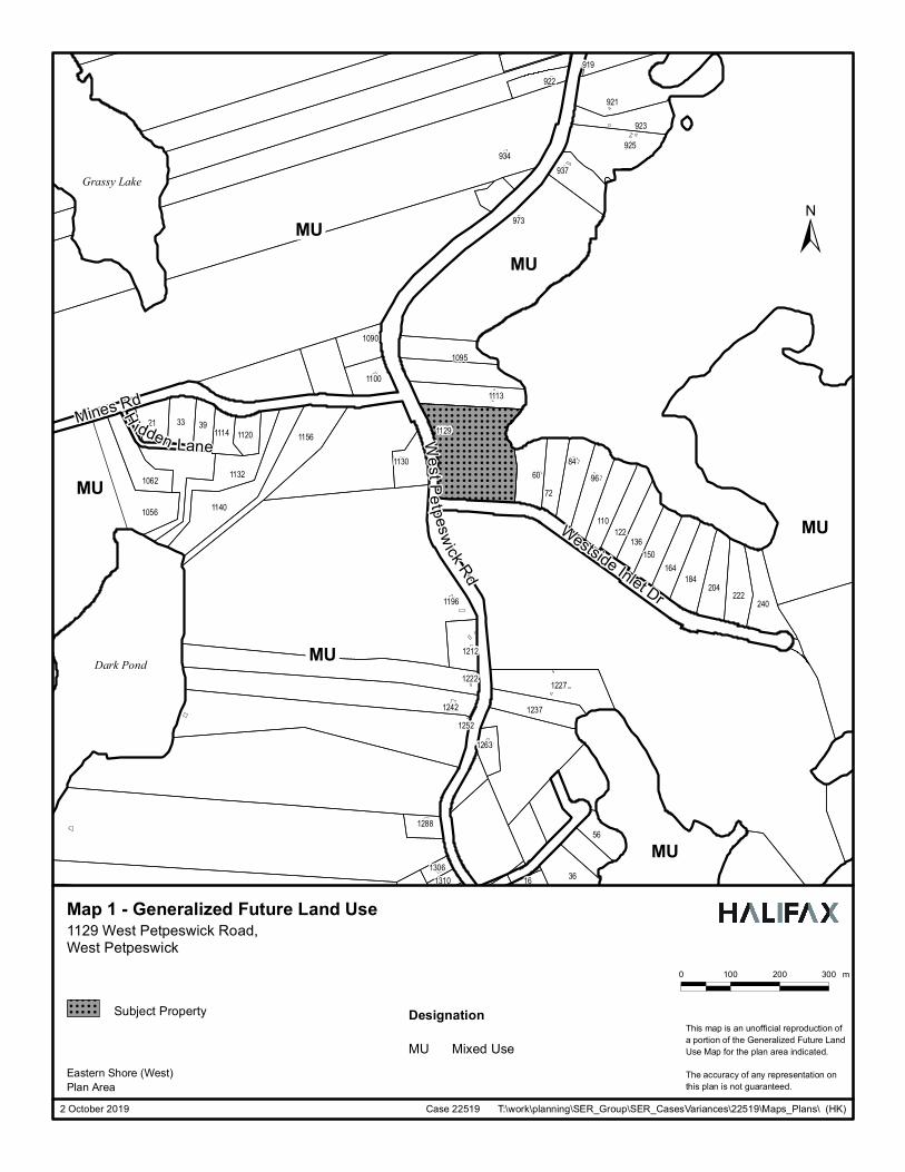
Case 22519: Development Agreement 1129 West Petpeswick Road, West Petpeswick Community Council Report - 2 - November 12, 2020 BACKGROUND Bianca and Pierre-Luc Sevigny have applied to enter into a development agreement for an intensive agricultural use at 1129 West Petpeswick Road, West Petpeswick. Within the Eastern Shore West Plan Area, intensive agricultural uses can only be considered by a development agreement in accordance with enabling policy MU-17 and implementation policy IM-10 of the Municipal Planning Strategy and Section 3.6 of the Land Use By-law. The subject site is currently being used for agricultural uses. Subject Site 1129 West Petpeswick Road, West Petpeswick Location Northeastern corner of West Petpeswick Road and Westside Inlet
Road abutting an inlet of the Atlantic Ocean. South of Highway 7 where it passes through Musquodoboit Harbour.
Regional Plan Designation Rural Commuter Community Plan Designation (Map 1)
Mixed Use Designation
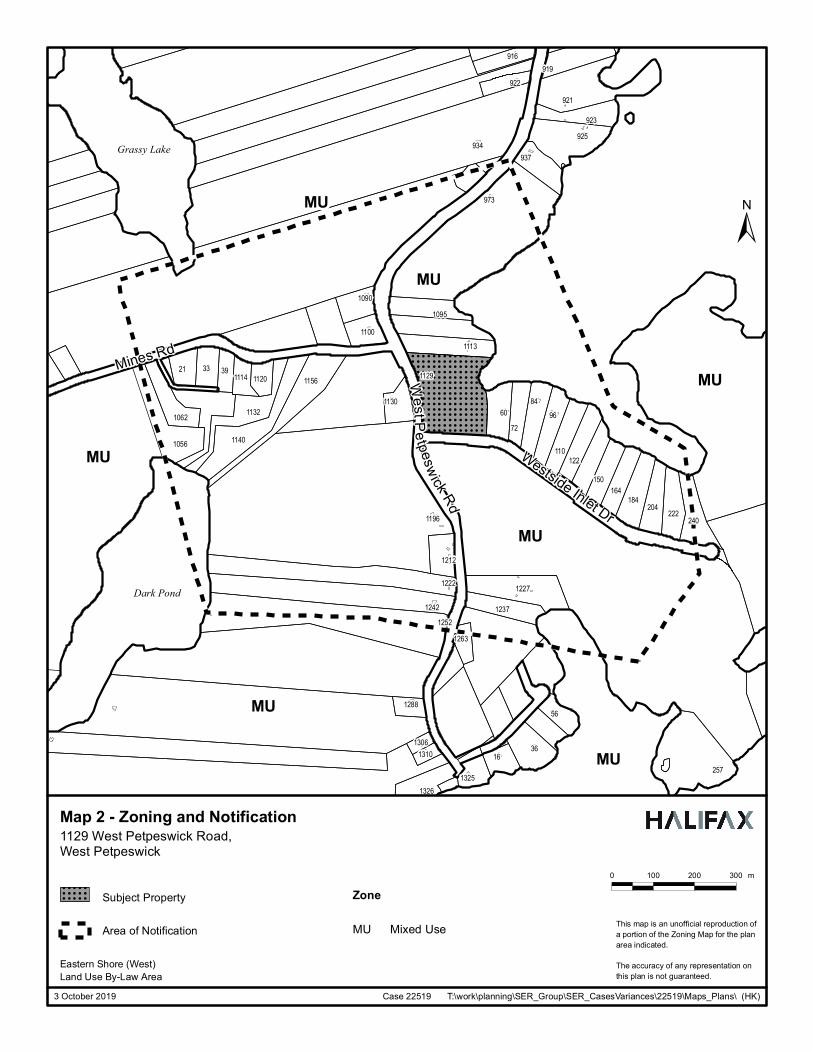
Zoning (Map 2) Mixed Use (MU-1) Zoning Size of Site 3.06 hectares (7.58 acres) Street Frontage 198.54 metres (651.2 feet) on West Petpeswick Road and 155.49
metres (510.1 feet) on Westside Inlet Road Current Land Use(s) Agricultural (a barn and livestock) Surrounding Use(s) Low density residential, vacant lands, and the Atlantic Ocean
Proposal Details Bianca and Pierre-Luc Sevigny have requested to enter into a development agreement for an intensive agricultural use to allow an abattoir and additional livestock. The major aspects of the proposal are as follows:
• operate a livestock farm with 100 chickens, 100 ducks, and 55 other livestock (6 horses, 8 hogs, 4 goats, 30 rabbits, and 7 assorted rescue animals);
• construct and operate a 53.5 square metre provincially regulated abattoir; • process chickens, ducks, and rabbits on-site up to three times per month; and • ability to have associated commercial uses including retail and a walking trail.
Enabling Policy and LUB Context The subject site is zoned Mixed Use (MU) under the Eastern Shore (West) Land Use Bylaw (LUB). The MU Zone allows for a variety of commercial uses, low density residential, community uses, and resource and traditional uses including agricultural uses. Agricultural uses are defined as “the use of land and buildings for the production of food, water, fibre or flora or the breeding and handling of animals and includes retail or market outlets for the sale of perishable agricultural goods, but shall not include any operation which involves more than fifty (50) domestic fowl and ten (10) of any other type of livestock.” Additional animals over these limits and constructing and operating an abattoir are classified as intensive agriculture and are not permitted in the zone. The subject site is designated Mixed Use (MU) under the Eastern Shore (West) Municipal Planning Strategy (MPS). Policy MU-17 enables Council to consider intensive agricultural uses by Development Agreement for lands within the MU designation. Policy IM-10 is an implementation policy that speaks to the matters Council must have regard for when considering development agreements. The intent of these policies is to allow for intensive agricultural uses, provided such uses do not negatively affect the natural environment nor surrounding development. Attachment B of this report includes the full list and analysis of relevant policies.
Case 22519: Development Agreement 1129 West Petpeswick Road, West Petpeswick Community Council Report - 3 - November 12, 2020 COMMUNITY ENGAGEMENT The community engagement process is consistent with the intent of the HRM Community Engagement Strategy. The level of community engagement was consultation, achieved through providing information and seeking comments through the HRM website, signage posted on the subject site, letters mailed to property owners within the notification area, and a public information meeting held on November 18, 2019. Attachment C contains a summary from the meeting. The public comments received include the following topics:
• Concerns about the number of animals for the size of the lot; • Concerns about how manure, odours, and pests will be managed; • Concerns about run-off contaminating the inlet; • Concerns about how animals will be enclosed and kept from straying; • Support and reservations about having an abattoir in the community; • Support for having meat produced locally; and • Support for place to learn about farming and where meat comes from.
A public hearing must be held by Harbour East – Marine Drive Community Council before they can consider approval of the proposed development agreement. Should Community Council decide to proceed with a public hearing on this application, in addition to the published newspaper advertisements, property owners within the notification area shown on Map 2 will be notified of the hearing by regular mail. The proposal will potentially impact local residents and property owners. DISCUSSION Staff has reviewed the proposal relative to all relevant policies and advise that it is reasonably consistent with the intent of the MPS. Attachment B provides an evaluation of the proposed development agreement in relation to the relevant MPS policies. Proposed Development Agreement Attachment A contains the proposed development agreement for the subject site and the conditions under which the development may occur. The proposed development agreement addresses the following matters:
• Permitted uses, including the quantity and type of livestock; • Siting, height, and massing of structures; • Design and screening of manure storage facilities; • Non-disturbance areas; • Site access and vehicular parking; • Hours of operation; and • Provisions for non-substantive amendments that include:
o changes to the amount of any type of livestock but not the overall number of livestock; o changes to the dimensions of developable areas; o changes to the design of the manure storage facilities; and o extensions to the commencement and completion dates.
The attached development agreement will permit intensive agricultural uses, subject to the controls identified above. Of the matters addressed by the proposed development agreement to satisfy the MPS criteria as shown in Attachment B, the following have been identified for detailed discussion. Protection of the Natural Environment Policy MU-17 requires Council have regard for adequate measures taken to protect the natural environment when considering development agreements for an intensive agricultural use. Policy IM-10 requires Council
Case 22519: Development Agreement 1129 West Petpeswick Road, West Petpeswick Community Council Report - 4 - November 12, 2020 to consider the suitability of the site in terms of such things as the steepness of grades and location of watercourses. The site is a 3.06-hectare (7.58-acre) corner lot abutting Porters Cove (an inlet of the Atlantic Ocean). The site is overgrown with trees and shrubs and is relatively flat with a moderate slope towards the rear lot line and Porters Cove. A stream runs parallel to the rear lot line towards Porters Cove. The development agreement limits the scale of development, controls where development can occur, regulates how manure is stored, and protects a large portion of the existing wooded area in an effort minimize any potential impact an intensive agricultural use may have on nearby watercourses. In addition to limiting the number of animals and the footprint of the abattoir, the proposed development agreement controls the scale of the development by limiting where development can occur through setbacks, minimum separation distances, non-disturbance areas, and limited disturbance areas. The agreement prohibits any development, including spreading and storing of manure and livestock, within 76.2 metres of the coastline. This setback is paired with a non-disturbance area that ensures no development (except for a 1 metre wide trail), removal of vegetation, or grade alteration can occur with the 76.2 metre setback from the watercourse and on the steepest part of the site. This protects the integrity of the land around the water and the health of the shoreline. The vegetation also helps filter any potential runoff and contaminants. The agreement also requires significant separation between the development and wells on abutting properties to mitigate potential contamination of potable water supplies. Small pens and fenced enclosures must be at least 76.2 metres away from a well on a different property, while all other structures must be 91.4 metres away. Nova Scotia Department of Environment regulates construction and maintenance of water wells. They are the agency that would investigate concerns about well contamination. The development agreement specifies design requirements for manure storage facilities. All manure stored on site must be kept in a storage facility that keeps the manure contained so that it does not travel into waterways nor seep into the soil. The controls in the development agreement consider the characteristics of the site (e.g., proximity to watercourses and topography) and seek to limit the proposed development’s impact on the natural environment. Compatibility of Use with Surrounding Development In the area surrounding the subject site, the lands are zoned MU and the existing development is primarily single unit dwellings. The MU Zone permits a variety of commercial uses including service shops, retail stores, warehousing and wholesale, as well as single- and two-unit residential dwellings and agricultural uses. As-of-right, up to 50 domestic fowl and 10 other livestock would be permitted on a lot. Two components of the proposal classify the development as an intensive agricultural use – the number of livestock and the abattoir. In considering a development agreement for an intensive agricultural use, the MPS requires consideration be given to how the use will interact with nearby development. Policy MU-17 requires Council have regard for buffering and screening to reduce visual, noise, and odour intrusions to surrounding development. Policy IM-10 requires Council consider appropriate controls to reduce conflict based on such things as the type of use; height, bulk, and lot coverage of any proposed buildings; traffic generation and parking; and open storage. Visual, Noise, and Odour Intrusions Measures have been taken to reduce noise, odour, and visual intrusions that could arise from the proposed development. These measures include separation distances, protecting existing vegetation, hours of operation, and manure management. The proposed agreement requires setbacks from lot lines and even more significant setbacks from dwellings on abutting properties. As an additional measure to help minimize noise, filter odours, and visually
Case 22519: Development Agreement 1129 West Petpeswick Road, West Petpeswick Community Council Report - 5 - November 12, 2020 screen the property, a non-disturbance area frames the sides and rear of the property. Within this buffer, the existing vegetation – which includes mature trees – cannot be removed. The development agreement limits where manure can be spread and stored. The agreement also has specific design requirements for the storage areas, including that the storage area must have a roof and be designed to prevent manure from seeping into the soil and running onto the land. Manure must be screened from view from the road and neighbouring properties. The development agreement also specifies hours of operation for the abattoir and for deliveries and collection of refuse and recyclables. The Municipality regulates noise through By-law N-200, Respecting Noise. Nuisances, particularly odours, are anticipated to be mitigated by keeping the proposed development away from neighbouring properties, protecting the existing vegetation around the perimeter of the property, regulating how manure is stored and where it is spread, and limiting hours of operation. Type of Use As stated above, there are two components of the proposal that classify it as an intensive agricultural use: the number of livestock and an abattoir. The proposed development agreement permits up to 100 chickens, 100 ducks, 6 horses, 8 hogs, 4 goats, 30 rabbits, and up to 7 other livestock. These 7 other livestock cannot include cattle, llamas, alpacas, donkeys, or mules. This is significantly more animals than permitted as-of-right and some members of the public raised concerns about the capacity of the site to accommodate this many livestock. Numerous factors influence how much space is required per animal, including how the manure is managed. The approach taken was to permit the requested number of animals but to regulate where these animals can go, require them be kept a significant distance from neighbouring uses, and to require their manure to be stored away from neighbours and in a manure storage facility. This approach seeks to mitigate the impacts such as odour and noise intrusions from livestock on surrounding uses. Abattoirs must be designed, built, and operated in compliance with Provincial regulations. The development agreement regulates the size and general placement of the abattoir. The footprint of the abattoir cannot exceed 53.5 square metres and requires a setback of at least 15.2 metres from all property lines and 91.4 metres from any dwelling on a different lot. The applicants have indicated they expect to process animals in the abattoir up to three times per month. The abattoir will be a small structure, subject to significant setbacks from the property boundaries. It is not anticipated that the abattoir will create traffic, noise, odour, or other nuisances. Height, Bulk, and Lot Coverage of Buildings There is already a barn on the property, and it was built subject to the MU Zone requirements. The rest of the buildings associated with the intensive agricultural use are proposed to be small. As noted above, the abattoir cannot exceed 53.5 square metres. Livestock pens, which include chicken coops and rabbit hutches, have been proposed to be 27.9 square metres or less. While the development agreement does not limit the size of pens, any pen under 27.9 square metres will be subject to slightly reduced setback requirements. It has been determined that the height and lot coverage regulations of the underlying zone – 10.6 metres and 35 percent, respectively – are reasonable for the proposal. In summary, it is not anticipated that the height, bulk, and lot coverage will conflict with the surrounding neighbourhood due to the controls in the proposed agreement that keep the development at a reasonable scale while providing the applicants flexibility to grow the farm. Traffic Generation and Parking The proposed livestock farm is not anticipated to generate significant amounts of traffic. The applicants have indicated that at most, up to 6 personnel will be on site when the abattoir is in operation roughly 3 times per month. The public did not identify traffic as a concern. The development agreement requires at least 6 parking spaces for the abattoir; for any other permitted use the requirements of the land use by-law apply.
Case 22519: Development Agreement 1129 West Petpeswick Road, West Petpeswick Community Council Report - 6 - November 12, 2020 Timelines for Execution of the Development Agreement The COVID-19 pandemic has resulted in difficulties in having legal agreements signed by multiple parties in short periods of time. To recognize this difficulty these unusual circumstances present, staff are recommending extending the signing period for agreements following a Council approval and completion of the required appeal period. While normally agreements are required to be signed within 120 days, staff recommend doubling this time period to 240 days. This extension would have no impact on the development rights held within the agreement, and the agreement could be executed in a shorter period of time if the situation permits. Conclusion Staff have reviewed the proposal in terms of all relevant policy criteria and advise that the proposal is reasonably consistent with the intent of the Eastern Shore (West) MPS. In recognizing the important role traditional resource uses played in this area, the development agreement provides flexibility for the establishment of a new intensive agricultural development while suitable controls limit nuisances on surrounding development and protect the natural environment. Therefore, staff recommend that the Harbour East – Marine Drive Community Council approve the proposed development agreement. FINANCIAL IMPLICATIONS There are no budget implications. The applicant will be responsible for all costs, expenses, liabilities and obligations imposed under or incurred in order to satisfy the terms of this proposed development agreement. The administration of the proposed development agreement can be carried out within the approved 2020-2021 operating budget for Planning and Development. RISK CONSIDERATION There are no significant risks associated with the recommendations contained within this report. This application may be considered under existing MPS policies. Community Council has the discretion to make decisions that are consistent with the MPS, and such decisions may be appealed to the N.S. Utility and Review Board. Information concerning risks and other implications of adopting the proposed development agreement are contained within the Discussion section of this report. ENVIRONMENTAL IMPLICATIONS No additional concerns were identified beyond those raised in this report. See the discussion section of the staff report. ALTERNATIVES
1. Harbour East – Marine Drive Community Council may choose to approve the proposed development agreement subject to modifications. Such modifications may require further negotiation with the applicant and may require a supplementary report or another public hearing. A decision of Council to approve this development agreement is appealable to the N.S. Utility & Review Board as per Section 262 of the HRM Charter.
2. Harbour East – Marine Drive Community Council may choose to refuse the proposed development
agreement, and in doing so, must provide reasons why the proposed agreement does not reasonably carry out the intent of the MPS. A decision of Council to refuse the proposed development agreement is appealable to the N.S. Utility & Review Board as per Section 262 of the HRM Charter.

Case 22519: Development Agreement 1129 West Petpeswick Road, West Petpeswick Community Council Report - 7 - November 12, 2020 ATTACHMENTS Map 1: Generalized Future Land Use Map 2: Zoning and Notification Area Attachment A: Proposed Development Agreement Attachment B: Review of Relevant MPS Policies Attachment C: Summary of the Public Information Meeting ___________________________________________________________________________ A copy of this report can be obtained online at halifax.ca or by contacting the Office of the Municipal Clerk at 902.490.4210. Report Prepared by: Meaghan Maund, Planner II, 902.233.0726
! ! ! ! ! ! ! ! ! ! ! ! ! ! ! ! ! ! !
! ! ! ! ! ! ! ! ! ! ! ! ! ! ! ! ! ! !
! ! ! ! ! ! ! ! ! ! ! ! ! ! ! ! ! ! !
! ! ! ! ! ! ! ! ! ! ! ! ! ! ! ! ! ! !
! ! ! ! ! ! ! ! ! ! ! ! ! ! ! ! ! ! !
! ! ! ! ! ! ! ! ! ! ! ! ! ! ! ! ! ! !
! ! ! ! ! ! ! ! ! ! ! ! ! ! ! ! ! ! !
! ! ! ! ! ! ! ! ! ! ! ! ! ! ! ! ! ! !
! ! ! ! ! ! ! ! ! ! ! ! ! ! ! ! ! ! !
! ! ! ! ! ! ! ! ! ! ! ! ! ! ! ! ! ! !
! ! ! ! ! ! ! ! ! ! ! ! ! ! ! ! ! ! !
! ! ! ! ! ! ! ! ! ! ! ! ! ! ! ! ! ! !
! ! ! ! ! ! ! ! ! ! ! ! ! ! ! ! ! ! !
! ! ! ! ! ! ! ! ! ! ! ! ! ! ! ! ! ! !
! ! ! ! ! ! ! ! ! ! ! ! ! ! ! ! ! ! !
! ! ! ! ! ! ! ! ! ! ! ! ! ! ! ! ! ! !
! ! ! ! ! ! ! ! ! ! ! ! ! ! ! ! ! ! !
! ! ! ! ! ! ! ! ! ! ! ! ! ! ! ! ! ! !
MU
MU
MU
56
8460
39
96
21
3616
72
33
973
919
122110
937
925
150
222204164
240
923
921922
934
184
136
1129
1227
1263
1212
1090
1114
1056
1130
1237
1196
1113
1252
1156
1140
1062
1095
1288
1222
1100
1242
13101306
1132
1120
Dark Pond
Grassy Lake
WestPe tpeswick RdMines Rd
Westside Inlet Dr
H idden Lane
MU
MU
MU
2 October 2019 Case 22519 T:\work\planning\SER_Group\SER_CasesVariances\22519\Maps_Plans\ (HK)
Subject Property
Map 1 - Generalized Future Land Use
Eastern Shore (West)Plan Area
1129 West Petpeswick Road,West Petpeswick
±
0 100 200 300 m
This map is an unofficial reproduction ofa portion of the Generalized Future LandUse Map for the plan area indicated.
The accuracy of any representation onthis plan is not guaranteed.
Designation! ! ! ! ! ! !
! ! ! ! ! ! !
! ! ! ! ! ! !
! ! ! ! ! ! !
Mixed UseMU
! ! ! ! ! ! ! ! ! ! ! ! ! ! ! ! ! !
! ! ! ! ! ! ! ! ! ! ! ! ! ! ! ! ! !
! ! ! ! ! ! ! ! ! ! ! ! ! ! ! ! ! !
! ! ! ! ! ! ! ! ! ! ! ! ! ! ! ! ! !
! ! ! ! ! ! ! ! ! ! ! ! ! ! ! ! ! !
! ! ! ! ! ! ! ! ! ! ! ! ! ! ! ! ! !
! ! ! ! ! ! ! ! ! ! ! ! ! ! ! ! ! !
! ! ! ! ! ! ! ! ! ! ! ! ! ! ! ! ! !
! ! ! ! ! ! ! ! ! ! ! ! ! ! ! ! ! !
! ! ! ! ! ! ! ! ! ! ! ! ! ! ! ! ! !
! ! ! ! ! ! ! ! ! ! ! ! ! ! ! ! ! !
! ! ! ! ! ! ! ! ! ! ! ! ! ! ! ! ! !
! ! ! ! ! ! ! ! ! ! ! ! ! ! ! ! ! !
! ! ! ! ! ! ! ! ! ! ! ! ! ! ! ! ! !
! ! ! ! ! ! ! ! ! ! ! ! ! ! ! ! ! !
! ! ! ! ! ! ! ! ! ! ! ! ! ! ! ! ! !
! ! ! ! ! ! ! ! ! ! ! ! ! ! ! ! ! !
MU
MU
MU
MU
MU
56
8460
39
96
21
3616
72
33
973
257
919
122110
916
937
925
150
222204164
240
923
921922
934
184
1129
1227
1263
1212
1090
1114
1056
1130
1237
1196
1113
1325
1252
1156
1140
1062
1095
1288
1222
1326
1100
1242
13101306
1132
1120
Dark Pond
Grassy Lake
Mines Rd
WestPetpeswick Rd
Westside Inlet DrMU
MU
3 October 2019 Case 22519 T:\work\planning\SER_Group\SER_CasesVariances\22519\Maps_Plans\ (HK)
Subject Property
Map 2 - Zoning and Notification
Eastern Shore (West)Land Use By-Law Area
1129 West Petpeswick Road,West Petpeswick
±
0 100 200 300 m
This map is an unofficial reproduction ofa portion of the Zoning Map for the planarea indicated.
The accuracy of any representation onthis plan is not guaranteed.
Zone! ! ! ! ! ! !
! ! ! ! ! ! !
! ! ! ! ! ! !
! ! ! ! ! ! !
Mixed UseMUArea of Notification
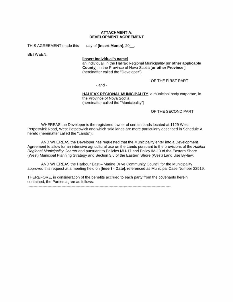
ATTACHMENT A:
DEVELOPMENT AGREEMENT THIS AGREEMENT made this day of [Insert Month], 20__, BETWEEN:
[Insert Individual’s name] an individual, in the Halifax Regional Municipality [or other applicable County], in the Province of Nova Scotia [or other Province,] (hereinafter called the "Developer")
OF THE FIRST PART
- and -
HALIFAX REGIONAL MUNICIPALITY, a municipal body corporate, in the Province of Nova Scotia
(hereinafter called the "Municipality")
OF THE SECOND PART
WHEREAS the Developer is the registered owner of certain lands located at 1129 West Petpeswick Road, West Petpeswick and which said lands are more particularly described in Schedule A hereto (hereinafter called the "Lands");
AND WHEREAS the Developer has requested that the Municipality enter into a Development
Agreement to allow for an intensive agricultural use on the Lands pursuant to the provisions of the Halifax Regional Municipality Charter and pursuant to Policies MU-17 and Policy IM-10 of the Eastern Shore (West) Municipal Planning Strategy and Section 3.6 of the Eastern Shore (West) Land Use By-law;
AND WHEREAS the Harbour East – Marine Drive Community Council for the Municipality approved this request at a meeting held on [Insert - Date], referenced as Municipal Case Number 22519;
THEREFORE, in consideration of the benefits accrued to each party from the covenants herein contained, the Parties agree as follows: ----------------------------------------------------------------------------------------------------------------
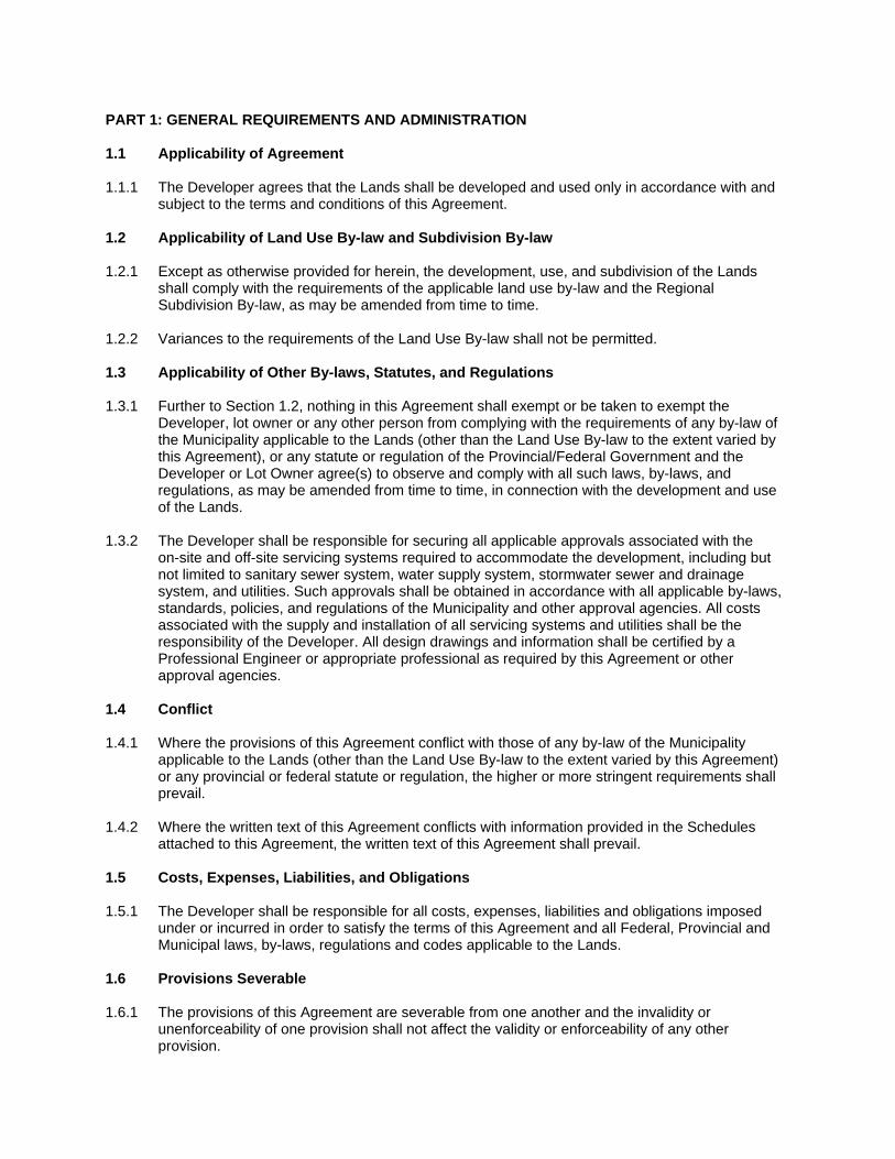
PART 1: GENERAL REQUIREMENTS AND ADMINISTRATION 1.1 Applicability of Agreement 1.1.1 The Developer agrees that the Lands shall be developed and used only in accordance with and
subject to the terms and conditions of this Agreement. 1.2 Applicability of Land Use By-law and Subdivision By-law 1.2.1 Except as otherwise provided for herein, the development, use, and subdivision of the Lands
shall comply with the requirements of the applicable land use by-law and the Regional Subdivision By-law, as may be amended from time to time.
1.2.2 Variances to the requirements of the Land Use By-law shall not be permitted. 1.3 Applicability of Other By-laws, Statutes, and Regulations 1.3.1 Further to Section 1.2, nothing in this Agreement shall exempt or be taken to exempt the
Developer, lot owner or any other person from complying with the requirements of any by-law of the Municipality applicable to the Lands (other than the Land Use By-law to the extent varied by this Agreement), or any statute or regulation of the Provincial/Federal Government and the Developer or Lot Owner agree(s) to observe and comply with all such laws, by-laws, and regulations, as may be amended from time to time, in connection with the development and use of the Lands.
1.3.2 The Developer shall be responsible for securing all applicable approvals associated with the
on-site and off-site servicing systems required to accommodate the development, including but not limited to sanitary sewer system, water supply system, stormwater sewer and drainage system, and utilities. Such approvals shall be obtained in accordance with all applicable by-laws, standards, policies, and regulations of the Municipality and other approval agencies. All costs associated with the supply and installation of all servicing systems and utilities shall be the responsibility of the Developer. All design drawings and information shall be certified by a Professional Engineer or appropriate professional as required by this Agreement or other approval agencies.
1.4 Conflict 1.4.1 Where the provisions of this Agreement conflict with those of any by-law of the Municipality
applicable to the Lands (other than the Land Use By-law to the extent varied by this Agreement) or any provincial or federal statute or regulation, the higher or more stringent requirements shall prevail.
1.4.2 Where the written text of this Agreement conflicts with information provided in the Schedules
attached to this Agreement, the written text of this Agreement shall prevail. 1.5 Costs, Expenses, Liabilities, and Obligations 1.5.1 The Developer shall be responsible for all costs, expenses, liabilities and obligations imposed
under or incurred in order to satisfy the terms of this Agreement and all Federal, Provincial and Municipal laws, by-laws, regulations and codes applicable to the Lands.
1.6 Provisions Severable 1.6.1 The provisions of this Agreement are severable from one another and the invalidity or
unenforceability of one provision shall not affect the validity or enforceability of any other provision.
PART 2: DEFINITIONS 2.1 Words Not Defined under this Agreement 2.1.1 All words unless otherwise specifically defined herein shall be as defined in the applicable Land
Use By-law and Subdivision By-law, if not defined in these documents their customary meaning shall apply.
2.2 Definitions Specific to this Agreement 2.2.1 The following words used in this Agreement shall be defined as follows:
(a) “Abattoir” means a provincially regulated facility for killing and processing domestic poultry and rabbits that is built and operated in accordance with all applicable provincial regulations, including the Meat Inspection Act, S.N.S., 1996, c. 6, as amended.
(b) “Barn” means a building used for housing livestock; for storing livestock feeds such as grain, hay, or straw; and for storage of farm produces, farm supplies, and machinery. A barn may also be used for commercial uses, as permitted by this Agreement.
(c) “Fenced Enclosure” means an outdoor area enclosed with fencing designed to contain livestock and may include a horse arena or pasture.
(d) “Livestock Farm” means the use of land, buildings, or structures for the breeding and handling of fowl, fur bearing animals, and swine primarily for commercial purposes. It includes an abattoir for domestic fowl and rabbits, required manure storages, and may include retail and/or market outlets for the sale of perishable agricultural goods.
(e) “Manure Storage Facility” means any pad, building, or manure containment area used to store or treat manure, including any portions of buildings used specifically for manure storage or treatment.
(f) “Pen” means a small, moveable roofed structure that has less than 27.9 square metres (300 square feet) of gross floor area, in which livestock are kept and may include a poultry coop or rabbit cage.
PART 3: USE OF LANDS, SUBDIVISION, AND DEVELOPMENT PROVISIONS 3.1 Schedules 3.1.1 The Developer shall develop the Lands in a manner, which, in the opinion of the Development
Officer, conforms with the following Schedules attached to this Agreement and filed in the Halifax Regional Municipality as Case Number 22519:
Schedule A Legal Description of the Lands Schedule B Site Plan Schedule C Site Plan – Enlarged Schedule D Level of Disturbance Areas
3.2 Requirements Prior to Approval 3.2.1 Notwithstanding any other provision of this Agreement, the Developer shall not occupy or use the
Lands for any of the uses permitted by this Agreement unless a Development Permit has been issued by the Municipality. No Development Permit shall be issued by the Municipality unless and until the Developer has complied with all applicable provisions of this Agreement and the Land Use By-law (except to the extent that the provisions of the Land Use By-law are varied by this Agreement) and with the terms and conditions of all permits, licenses, and approvals required to be obtained by the Developer pursuant to this Agreement.
3.3 General Description of Land Use 3.3.1 The use(s) of the Lands permitted by this Agreement are the following:
(a) Intensive agriculture limited to a Livestock Farm with a maximum of 100 chickens, 100 ducks, 6 horses, 8 hogs, 4 goats, 30 rabbits, and up to seven other livestock but may not include cattle, llamas, alpacas, donkeys, or mules;
(b) The following uses permitted within the zone applied to the lands subject to the provisions
contained within the Land Use By-law as amended from time to time unless otherwise varied by this Agreement:
i. Antique shops ii. Bakeries iii. Commercial accommodation uses iv. Craft shops v. Garden centres vi. Garden suites in conjunction with permitted dwellings vii. Grocery stores viii. Home business uses in conjunction with permitted dwellings ix. Mobile dwelling on individual lot x. Offices xi. Open space uses xii. Restaurants (take-out only) xiii. Retail stores xiv. Recreation uses xv. Single-unit dwelling xvi. Traditional uses xvii. Veterinary clinics; and
(c) Accessory uses and buildings associated with the uses permitted under this Agreement.
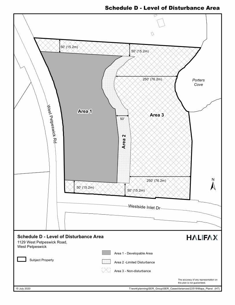
3.4 Level of Disturbance Areas
3.4.1 As identified on Schedule D, the property is divided into three areas to regulate where
development can occur. The three areas and the development permitted within them are as follows:
(a) Area 1: All uses permitted under this Agreement shall be permitted in Area 1, including the
spreading of manure and vehicular parking.
(b) Area 2: All uses permitted under this Agreement shall be permitted in Area 2, but structures associated with the permitted uses are limited to Pens and Fenced Enclosures. Manure produced by livestock on the Lands may be spread on the Lands in Area 2.
(c) Area 3: Except for trails not exceeding one (1) metre in width, no disturbance, including
development, erection of structures, clearing of vegetation, grade alteration, or housing of livestock shall be permitted in Area 3.
3.5 Building Siting and Design Requirements Building Siting 3.5.1 No buildings or structures permitted within Area 1 shall:
(a) Be less than 15.2 metres (50 feet) from any lot line;

(b) Be less than 91.4 metres (300 feet) from any residential dwelling or potable water supply,
except a dwelling or water supply on the same lot or directly related to the intensive agricultural use; and
(c) Be less than 91.4 metres (300 feet) from any watercourse or waterbody.
3.5.2 No Pen or Fenced Enclosure permitted in Area 2 shall:
(a) Be less than 9.1 metres (30 feet) from the front lot line;
(b) Be less than 15.2 metres (50 feet) from any other lot line;
(c) Be less than 76.2 metres (250 feet) from any residential dwelling or potable water supply, except a dwelling or water supply on the same lot or directly related to the intensive agricultural use; and
(d) Be less than 76.2 metres (250 feet) from any watercourse or waterbody. 3.5.3 Where there is a conflict between the Areas as shown on Schedule D and the setbacks provided
for in the text, the more stringent shall prevail. Building Height 3.5.4 The maximum height of all buildings shall not exceed 10.6 metres (35 feet). Abattoir 3.5.5 The maximum footprint of the Abattoir shall be 53.5 square metres (576 square feet). 3.5.6 In addition to the requirements of this Agreement, the Abattoir shall be designed, built, and
operated in compliance with all Provincial regulations. The Municipality may require the Developer to submit documentation that the Abattoir has been designed in compliance with all Provincial regulations when the Developer submits an application for a Development Permit for the Abattoir.
Lot Coverage 3.5.7 Lot coverage shall not exceed 35 percent. Development Permit 3.5.8 A development permit is not required for any building with a gross floor area of 20 square metres
or less. 3.6 Subdivision of the Lands 3.6.1 Any subdivision application shall be in accordance with the requirements of the Regional
Subdivision By-law. 3.7 Parking, Circulation, and Access 3.7.1 The access, circulation, and parking area shall be sited as generally shown on Schedule B and C. 3.7.2 Notwithstanding Section 3.7.1, the access, circulation, and parking area may be modified, subject
to approval from Nova Scotia Department of Transportation and Infrastructure Renewal, as applicable.
3.7.3 The parking area shall be setback a minimum of 5 metres (16.4 feet) from the front lot line and
shall be completely located within Area 1.

3.7.4 A minimum of six (6) parking spaces shall be provided on site for the Abattoir. For all other
permitted uses, the Developer shall provide parking spaces pursuant to the Land Use By-law. 3.7.5 The parking area shall be hard surfaced. If gravel is used it shall be maintained with a stable
surface that is treated to prevent the raising of dust or loose particles. 3.8 Area 3 – Non-Disturbance Area 3.8.1 As identified on Schedule D, the Developer shall maintain Area 3 as a non-disturbance area to
serve as a buffer to reduce noise, odour, and visual disturbances to nearby properties and to protect the existing vegetation and watercourses. The non-disturbance area shall be:
(a) 15.2 metres (50 feet) in depth from the north (side) lot line;
(b) 15.2 metres (50 feet) in depth from the south (flank) lot line; and
(c) 76.2 metres (250 feet) in depth from any watercourse.
3.8.2 With the exception of trails no greater than 1 metre (3.3 feet) wide, no disturbance, including
development, erection of structures, clearing of vegetation, or grade alteration shall be permitted within Area 3.
3.8.3 Further to Section 3.8.2, no livestock are permitted within Area 3. 3.8.4 Area 3 shall be identified on all plans required by the Municipality. 3.8.5 The Developer may remove dead, damaged, or diseased vegetation within Area 3 provided prior
permission is obtained from the Development Officer. Any vegetation removed shall be replaced. The Municipality may require the Developer to submit a Tree Retention Management Plan or Remediation Plan prepared by a Landscape Architect (a full member, in good standing with the Canadian Society of Landscape Architects) or other qualified professional.
3.9 Outdoor Lighting 3.9.1 Lighting shall be directed to driveways, parking areas, loading area, building entrances and
walkways and shall be arranged so as to divert the light away from streets, adjacent lots, and adjacent buildings.
3.10 Maintenance 3.10.1 The Developer shall maintain and keep in good repair all portions of the development on the
Lands, including but not limited to, the exterior of the building, fencing, walkways, recreational amenities, parking areas and driveways, and the maintenance of all landscaping including the replacement of damaged or dead plant stock, trimming and litter control, garbage removal and snow and ice control, salting of walkways and driveways.
3.11 Signs 3.11.1 The sign requirements shall be accordance with the Land Use By-law as amended from time to
time. 3.12 Screening 3.12.1 All manure must be stored so that it is fully screened from adjacent properties and from streets by
means of opaque fencing, masonry walls, suitable landscaping, or any other measure deemed suitable by the Development Officer.
3.13 Hours of Operation 3.13.1 The Abattoir shall be permitted to operate between the hours of 7:00am and 7:00pm Monday to
Friday. 3.13.2 Deliveries to the building, and the collection of refuse and recyclables, shall occur only between
the hours of 7:00am and 10:00pm. 3.13.3 Hours of operation shall conform with all relevant Municipal and Provincial legislation and
regulations, as may be amended from time to time. PART 4: STREETS AND MUNICIPAL SERVICES 4.1 General Provisions 4.1.1 All design and construction of primary and secondary service systems shall satisfy the most
current edition of the Municipal Design Guidelines and Halifax Water Design and Construction Specifications unless otherwise provided for in this Agreement and shall receive written approval from the Development Engineering prior to undertaking the work.
4.2 Off-Site Disturbance 4.2.1 Any disturbance to existing off-site infrastructure resulting from the development, including but not
limited to, streets, sidewalks, curbs and gutters, street trees, landscaped areas and utilities, shall be the responsibility of the Developer, and shall be reinstated, removed, replaced or relocated by the Developer as directed by the Development Officer, in consultation with the Development Engineer.
4.3 On-Site Water System 4.3.1 The Lands shall be serviced through a privately operated on-site water distribution system. 4.4 On-Site Sanitary System 4.4.1 The Lands shall be serviced through privately owned and operated sewer system and treatment
facility. The Developer agrees to have prepared by a qualified professional and submitted to the Municipality, the NS Department of the Environment and any other relevant agency, a design for all private sewer systems.
PART 5: ENVIRONMENTAL PROTECTION MEASURES 5.1 Stormwater Management Plans and Erosion and Sedimentation Control Plan 5.1.1 Prior to the issuance of a construction permit for the Abattoir, the Developer shall:
(a) Submit to the Development Officer a detailed Site Disturbance Plan, prepared by a Professional Engineer indicating the sequence and phasing of construction and the areas to be disturbed or undisturbed;

(b) Submit to the Development Officer a detailed Erosion and Sedimentation Control Plan
prepared by a Professional Engineer in accordance with the Erosion and Sedimentation Control Handbook for Construction Sites as prepared and revised from time to time by Nova Scotia Environment. Notwithstanding other sections of this Agreement, no work is permitted on the Lands until the requirements of this clause have been met and implemented. The Erosion and Sedimentation Control Plan shall indicate the sequence of construction, all proposed detailed erosion and sedimentation control measures and interim stormwater management measures to be put in place prior to and during construction; and
(c) Submit to the Development Officer a detailed Site Grading and Stormwater Management
Plan prepared by a Professional Engineer. 5.2 Manure Management Manure Storage Facility 5.2.1 Manure produced by the livestock on the Lands shall be stored in a Manure Storage Facility
subject to the requirements of this Agreement. The Manure Storage Facility shall:
(a) Be designed to prevent manure from seeping or overflowing onto the Lands;
(b) Be a roofed structure with reinforced concrete sidewalls on three sides; and (c) Have a non-permeable concrete floor that slopes downward from the open side and that is
sealed to the walls to prevent seepage.
5.2.2 Further to Section 5.2.1, manure produced by livestock on the Lands may be used as fertilizer on the Lands only in Areas 1 and 2 as identified on Schedule D.
5.3 Sulphide Bearing Materials 5.3.1 The Developer agrees to comply with the legislation and regulations of the Province of Nova
Scotia with regards to the handling, removal, and disposal of sulphide bearing materials, which may be found on the Lands.
PART 6: AMENDMENTS 6.1 Non-Substantive Amendments 6.1.1 The following items are considered by both parties to be not substantive and may be amended by
resolution of Council:
(a) Changes to the amount of any type of permitted livestock specified in Section 3.3.1, but not changes to the total number of livestock permitted by this Agreement;
(b) Changes to the dimensions of the Areas shown on Schedule D; (c) Changes to the requirements for the manure storage facility as specified under Section
5.2.1 of this Agreement. (d) The granting of an extension to the date of commencement of construction as identified in
Section 7.3 this Agreement; and (e) The length of time for the completion of the development as identified in Section 7.5 of
this Agreement. 6.2 Substantive Amendments
6.2.1 Amendments to any matters not identified under Section 6.1 shall be deemed substantive and
may only be amended in accordance with the approval requirements of the Halifax Regional Municipality Charter.
PART 7: REGISTRATION, EFFECT OF CONVEYANCES, AND DISCHARGE 7.1 Registration 7.1.1 A copy of this Agreement and every amendment or discharge of this Agreement shall be
recorded at the Registry of Deeds or Land Registry Office at Halifax, Nova Scotia and the Developer shall incur all costs in recording such documents.
7.2 Subsequent Owners 7.2.1 This Agreement shall be binding upon the parties hereto, their heirs, successors, assigns,
mortgagees, lessees and all subsequent owners, and shall run with the Lands which are the subject of this Agreement until this Agreement is discharged by Council.
7.2.2 Upon the transfer of title to any lot(s), the subsequent owner(s) thereof shall observe and perform
the terms and conditions of this Agreement to the extent applicable to the lot(s). 7.3 Commencement of Development 7.3.1 In the event that development on the Lands has not commenced within 5 years from the date of
registration of this Agreement at the Registry of Deeds or Land Registry Office, as indicated herein, the Agreement shall have no further force or effect and henceforth the development of the Lands shall conform with the provisions of the Land Use By-law.
7.3.2 For the purpose of this section, commencement of development shall mean issuance of a
Construction Permit for the Abattoir or a Development Permit to have more than fifty domestic fowl and ten of any other permitted livestock.
7.3.3 For the purpose of this section, Council may consider granting an extension of the
commencement of development time period through a resolution under Section 6.1, if the Municipality receives a written request from the Developer at least sixty (60) calendar days prior to the expiry of the commencement of development time period.
7.4 Completion of Development 7.4.1 Upon the completion of the development, Council may review this Agreement, in whole or in part,
and may: (a) retain the Agreement in its present form; (b) negotiate a new Agreement; or (c) discharge this Agreement;
7.5 Discharge of Agreement 7.5.1 If the Developer fails to complete the development after 7 years from the date of registration of
this Agreement at the Registry of Deeds or Land Registration Office Council may review this Agreement, in whole or in part, and may:
(a) retain the Agreement in its present form; (b) negotiate a new Agreement; or

(c) discharge this Agreement.
PART 8: ENFORCEMENT AND RIGHTS AND REMEDIES ON DEFAULT 8.1 Enforcement 8.1.1 The Developer agrees that any officer appointed by the Municipality to enforce this Agreement
shall be granted access onto the Lands during all reasonable hours without obtaining consent of the Developer. The Developer further agrees that, upon receiving written notification from an officer of the Municipality to inspect the interior of any building located on the Lands, the Developer agrees to allow for such an inspection during any reasonable hour within twenty-four hours of receiving such a request.
8.2 Failure to Comply 8.2.1 If the Developer fails to observe or perform any condition of this Agreement after the Municipality
has given the Developer 14 days written notice of the failure or default, then in each such case:
(a) The Municipality shall be entitled to apply to any court of competent jurisdiction for injunctive relief including an order prohibiting the Developer from continuing such default and the Developer hereby submits to the jurisdiction of such Court and waives any defence based upon the allegation that damages would be an adequate remedy;
(b) The Municipality may enter onto the Lands and perform any of the covenants contained in this Agreement or take such remedial action as is considered necessary to correct a breach of the Agreement, whereupon all reasonable expenses whether arising out of the entry onto the Lands or from the performance of the covenants or remedial action, shall be a first lien on the Lands and be shown on any tax certificate issued under the Assessment Act;
(c) The Municipality may by resolution discharge this Agreement whereupon this Agreement
shall have no further force or effect and henceforth the development of the Lands shall conform with the provisions of the Land Use By-law; or
(d) In addition to the above remedies, the Municipality reserves the right to pursue any other
remedy under the Halifax Regional Municipality Charter or Common Law in order to ensure compliance with this Agreement.
IN WITNESS WHEREAS the said parties to these presents have hereunto set their hands and affixed their seals the day and year first above written. SIGNED, SEALED AND DELIVERED in the presence of: Witness
(Insert Registered Owner Name) ________________________________
HALIFAX REGIONAL MUNICIPALITY
SIGNED, DELIVERED AND ATTESTED to by the proper signing officers of Halifax Regional Municipality, duly authorized in that behalf, in the presence of: Witness Witness
Per:________________________________ MAYOR Per:________________________________ MUNICIPAL CLERK
PROVINCE OF NOVA SCOTIA COUNTY OF HALIFAX On this ____________________ day of _____, A.D. 20____, before me, the subscriber personally came and appeared _________________________ a subscribing witness to the foregoing indenture who having been by me duly sworn, made oath and said that _________________________, _________________________ of the parties thereto, signed, sealed and delivered the same in his/her presence. ___________________________________ A Commissioner of the Supreme Court of Nova Scotia PROVINCE OF NOVA SCOTIA COUNTY OF HALIFAX On this ____________________ day of _____, A.D. 20___, before me, the subscriber personally came and appeared ________________________ the subscribing witness to the foregoing indenture who being by me sworn, made oath, and said that Mike Savage, Mayor and Sherryll Murphy, Acting Municipal Clerk of the Halifax Regional Municipality, signed the same and affixed the seal of the said Municipality thereto in his/her presence. _________________________________ A Commissioner of the Supreme Court of Nova Scotia
TFD-GA-001
ITIA � OF �ffl Of' �Ot{ YIIEST PEl'P£SW1CK
4&+t1.0 TO STA. '72-+19.0 !, 1171. REVISED JULY 111, 19'78.
S 81r 56' °'° E-- - - - -
JH).1111" �
2 • .;
REVI DATE
1J9 • .W ..
-N1 IS 49' '8 \It
DESCRIPTION
REVISIONS
HlflRMAJKWllll[CNISIIEPRO'IJHYCJI.Gllll-lAGILlD.AlllWSTIIREIU!ll!lll'alRrrlrn. l'JIIIOJIMIT[NPERIISSDl,AIIY!lP!IIGTRANSIIITIALTOOlfilRSOOAll'l'USEEXCEPllllATf1JllflOilTISlJWl!IAR£PRIJ!BJED.
©AGlll---00..ELlD.
Br
PIS
PROPERTY LINE SE
.-,
., .... .
E:\Buolneaa Projecta\lhe French Duck Form\FrenclLDuck.dwg, 08 Jul 2020
@
S II' 38' 1;z" E-
ATLANTICOCEAN
/WELL SET BACK (300')
/WATER COURSE SET BACK (300')
Y SET BACK (16.4')
• b, NI
�8
�wj
-m.14•----\-r .... --,39,,w-c:J' -N a5' 48' J8 w F4� 1-N U .. Iii' 411 W
• WESTSIDE '"+ INLET \
PROJEC1' No.
DRAWN Br
N'PROYED Br
-NO.
CD
{ ATLANTI
LANDS
LEWIS KEL
&
BRIAN E. IOOI( !.l!! "·
!>,1,0., I
(%)
---WEISTSIDE ES
RESERVEO RIGHT-OF-WAY ,_OP-X"
THE FRENCH DUCK GENERAL ARRANGEMENT
�lE 2D2D-05-06
PIERRE-LUC SEVIGNY, ING.
Fll.E NO . • DWG
SHEEr
,; 1
REVISION
Schedule B: Site Plan
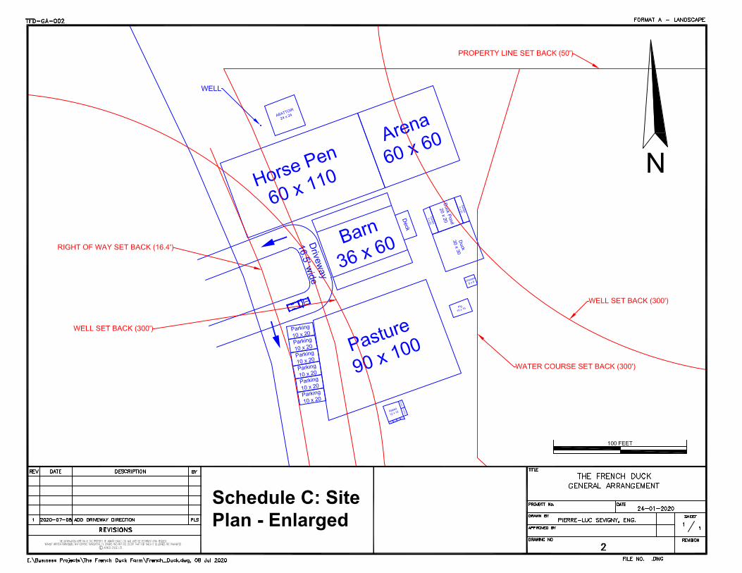
Schedule C: Site Plan - Enlarged
! ! ! ! ! ! ! ! ! ! ! ! ! ! ! ! ! ! ! ! ! ! ! ! ! ! ! ! ! !
! ! ! ! ! ! ! ! ! ! ! ! ! ! ! ! ! ! ! ! ! ! ! ! ! ! ! ! ! !
! ! ! ! ! ! ! ! ! ! ! ! ! ! ! ! ! ! ! ! ! ! ! ! ! ! ! ! ! !
! ! ! ! ! ! ! ! ! ! ! ! ! ! ! ! ! ! ! ! ! ! ! ! ! ! ! ! ! !
! ! ! ! ! ! ! ! ! ! ! ! ! ! ! ! ! ! ! ! ! ! ! ! ! ! ! ! ! !
! ! ! ! ! ! ! ! ! ! ! ! ! ! ! ! ! ! ! ! ! ! ! ! ! ! ! ! ! !
! ! ! ! ! ! ! ! ! ! ! ! ! ! ! ! ! ! ! ! ! ! ! ! ! ! ! ! ! !
! ! ! ! ! ! ! ! ! ! ! ! ! ! ! ! ! ! ! ! ! ! ! ! ! ! ! ! ! !
! ! ! ! ! ! ! ! ! ! ! ! ! ! ! ! ! ! ! ! ! ! ! ! ! ! ! ! ! !
! ! ! ! ! ! ! ! ! ! ! ! ! ! ! ! ! ! ! ! ! ! ! ! ! ! ! ! ! !
! ! ! ! ! ! ! ! ! ! ! ! ! ! ! ! ! ! ! ! ! ! ! ! ! ! ! ! ! !
! ! ! ! ! ! ! ! ! ! ! ! ! ! ! ! ! ! ! ! ! ! ! ! ! ! ! ! ! !
! ! ! ! ! ! ! ! ! ! ! ! ! ! ! ! ! ! ! ! ! ! ! ! ! ! ! ! ! !
! ! ! ! ! ! ! ! ! ! ! ! ! ! ! ! ! ! ! ! ! ! ! ! ! ! ! ! ! !
! ! ! ! ! ! ! ! ! ! ! ! ! ! ! ! ! ! ! ! ! ! ! ! ! ! ! ! ! !
! ! ! ! ! ! ! ! ! ! ! ! ! ! ! ! ! ! ! ! ! ! ! ! ! ! ! ! ! !
! ! ! ! ! ! ! ! ! ! ! ! ! ! ! ! ! ! ! ! ! ! ! ! ! ! ! ! ! !
! ! ! ! ! ! ! ! ! ! ! ! ! ! ! ! ! ! ! ! ! ! ! ! ! ! ! ! ! !
! ! ! ! ! ! ! ! ! ! ! ! ! ! ! ! ! ! ! ! ! ! ! ! ! ! ! ! ! !
! ! ! ! ! ! ! ! ! ! ! ! ! ! ! ! ! ! ! ! ! ! ! ! ! ! ! ! ! !
! ! ! ! ! ! ! ! ! ! ! ! ! ! ! ! ! ! ! ! ! ! ! ! ! ! ! ! ! !
! ! ! ! ! ! ! ! ! ! ! ! ! ! ! ! ! ! ! ! ! ! ! ! ! ! ! ! ! !
! ! ! ! ! ! ! ! ! ! ! ! ! ! ! ! ! ! ! ! ! ! ! ! ! ! ! ! ! !
! ! ! ! ! ! ! ! ! ! ! ! ! ! ! ! ! ! ! ! ! ! ! ! ! ! ! ! ! !
! ! ! ! ! ! ! ! ! ! ! ! ! ! ! ! ! ! ! ! ! ! ! ! ! ! ! ! ! !
! ! ! ! ! ! ! ! ! ! ! ! ! ! ! ! ! ! ! ! ! ! ! ! ! ! ! ! ! !
! ! ! ! ! ! ! ! ! ! ! ! ! ! ! ! ! ! ! ! ! ! ! ! ! ! ! ! ! !
! ! ! ! ! ! ! ! ! ! ! ! ! ! ! ! ! ! ! ! ! ! ! ! ! ! ! ! ! !
! ! ! ! ! ! ! ! ! ! ! ! ! ! ! ! ! ! ! ! ! ! ! ! ! ! ! ! ! !
! ! ! ! ! ! ! ! ! ! ! ! ! ! ! ! ! ! ! ! ! ! ! ! ! ! ! ! ! !
! ! ! ! ! ! ! ! ! ! ! ! ! ! ! ! ! ! ! ! ! ! ! ! ! ! ! ! ! !
! ! ! ! ! ! ! ! ! ! ! ! ! ! ! ! ! ! ! ! ! ! ! ! ! ! ! ! ! !
! ! ! ! ! ! ! ! ! ! ! ! ! ! ! ! ! ! ! ! ! ! ! ! ! ! ! ! ! !
! ! ! ! ! ! ! ! ! ! ! ! ! ! ! ! ! ! ! ! ! ! ! ! ! ! ! ! ! !
! ! ! ! ! ! ! ! ! ! ! ! ! ! ! ! ! ! ! ! ! ! ! ! ! ! ! ! ! !
! ! ! ! ! ! ! ! ! ! ! ! ! ! ! ! ! ! ! ! ! ! ! ! ! ! ! ! ! !
! ! ! ! ! ! ! ! ! ! ! ! ! ! ! ! ! ! ! ! ! ! ! ! ! ! ! ! ! !
! ! ! ! ! ! ! ! ! ! ! ! ! ! ! ! ! ! ! ! ! ! ! ! ! ! ! ! ! !
! ! ! ! ! ! ! ! ! ! ! ! ! ! ! ! ! ! ! ! ! ! ! ! ! ! ! ! ! !
! ! ! ! ! ! ! ! ! ! ! ! ! ! ! ! ! ! ! ! ! ! ! ! ! ! ! ! ! !
! ! ! ! ! ! ! ! ! ! ! ! ! ! ! ! ! ! ! ! ! ! ! ! ! ! ! ! ! !
! ! ! ! ! ! ! ! ! ! ! ! ! ! ! ! ! ! ! ! ! ! ! ! ! ! ! ! ! !
! ! ! ! ! ! ! ! ! ! ! ! ! ! ! ! ! ! ! ! ! ! ! ! ! ! ! ! ! !
! ! ! ! ! ! ! ! ! ! ! ! ! ! ! ! ! ! ! ! ! ! ! ! ! ! ! ! ! !
! ! ! ! ! ! ! ! ! ! ! ! ! ! ! ! ! ! ! ! ! ! ! ! ! ! ! ! ! !
! ! ! ! ! ! ! ! ! ! ! ! ! ! ! ! ! ! ! ! ! ! ! ! ! ! ! ! ! !
! ! ! ! ! ! ! ! ! ! ! ! ! ! ! ! ! ! ! ! ! ! ! ! ! ! ! ! ! !
! ! ! ! ! ! ! ! ! ! ! ! ! ! ! ! ! ! ! ! ! ! ! ! ! ! ! ! ! !
! ! ! ! ! ! ! ! ! ! ! ! ! ! ! ! ! ! ! ! ! ! ! ! ! ! ! ! ! !
! ! ! ! ! ! ! ! ! ! ! ! ! ! ! ! ! ! ! ! ! ! ! ! ! ! ! ! ! !
! ! ! ! ! ! ! ! ! ! ! ! ! ! ! ! ! ! ! ! ! ! ! ! ! ! ! ! ! !
! ! ! ! ! ! ! ! ! ! ! ! ! ! ! ! ! ! ! ! ! ! ! ! ! ! ! ! ! !
! ! ! ! ! ! ! ! ! ! ! ! ! ! ! ! ! ! ! ! ! ! ! ! ! ! ! ! ! !
! ! ! ! ! ! ! ! ! ! ! ! ! ! ! ! ! ! ! ! ! ! ! ! ! ! ! ! ! !
! ! ! ! ! ! ! ! ! ! ! ! ! ! ! ! ! ! ! ! ! ! ! ! ! ! ! ! ! !
! ! ! ! ! ! ! ! ! ! ! ! ! ! ! ! ! ! ! ! ! ! ! ! ! ! ! ! ! !
! ! ! ! ! ! ! ! ! ! ! ! ! ! ! ! ! ! ! ! ! ! ! ! ! ! ! ! ! !
! ! ! ! ! ! ! ! ! ! ! ! ! ! ! ! ! ! ! ! ! ! ! ! ! ! ! ! ! !
! ! ! ! ! ! ! ! ! ! ! ! ! ! ! ! ! ! ! ! ! ! ! ! ! ! ! ! ! !
! ! ! ! ! ! ! ! ! ! ! ! ! ! ! ! ! ! ! ! ! ! ! ! ! ! ! ! ! !
! ! ! ! ! ! ! ! ! ! ! ! ! ! ! ! ! ! ! ! ! ! ! ! ! ! ! ! ! !
! ! ! ! ! ! ! ! ! ! ! ! ! ! ! ! ! ! ! ! ! ! ! ! ! ! ! ! ! !
! ! ! ! ! ! ! ! ! ! ! ! ! ! ! ! ! ! ! ! ! ! ! ! ! ! ! ! ! !
! ! ! ! ! ! ! ! ! ! ! ! ! ! ! ! ! ! ! ! ! ! ! ! ! ! ! ! ! !
! ! ! ! ! ! ! ! ! ! ! ! ! ! ! ! ! ! ! ! ! ! ! ! ! ! ! ! ! !
! ! ! ! ! ! ! ! ! ! ! ! ! ! ! ! ! ! ! ! ! ! ! ! ! ! ! ! ! !
! ! ! ! ! ! ! ! ! ! ! ! ! ! ! ! ! ! ! ! ! ! ! ! ! ! ! ! ! !
! ! ! ! ! ! ! ! ! ! ! ! ! ! ! ! ! ! ! ! ! ! ! ! ! ! ! ! ! !
! ! ! ! ! ! ! ! ! ! ! ! ! ! ! ! ! ! ! ! ! ! ! ! ! ! ! ! ! !
! ! ! ! ! ! ! ! ! ! ! ! ! ! ! ! ! ! ! ! ! ! ! ! ! ! ! ! ! !
! ! ! ! ! ! ! ! ! ! ! ! ! ! ! ! ! ! ! ! ! ! ! ! ! ! ! ! ! !
! ! ! ! ! ! ! ! ! ! ! ! ! ! ! ! ! ! ! ! ! ! ! ! ! ! ! ! ! !
! ! ! ! ! ! ! ! ! ! ! ! ! ! ! ! ! ! ! ! ! ! ! ! ! ! ! ! ! !
! ! ! ! ! ! ! ! ! ! ! ! ! ! ! ! ! ! ! ! ! ! ! ! ! ! ! ! ! !
! ! ! ! ! ! ! ! ! ! ! ! ! ! ! ! ! ! ! ! ! ! ! ! ! ! ! ! ! !
! ! ! ! ! ! ! ! ! ! ! ! ! ! ! ! ! ! ! ! ! ! ! ! ! ! ! ! ! !
! ! ! ! ! ! ! ! ! ! ! ! ! ! ! ! ! ! ! ! ! ! ! ! ! ! ! ! ! !
! ! ! ! ! ! ! ! ! ! ! ! ! ! ! ! ! ! ! ! ! ! ! ! ! ! ! ! ! !
! ! ! ! ! ! ! ! ! ! ! ! ! ! ! ! ! ! ! ! ! ! ! ! ! ! ! ! ! !
! ! ! ! ! ! ! ! ! ! ! ! ! ! ! ! ! ! ! ! ! ! ! ! ! ! ! ! ! !
! ! ! ! ! ! ! ! ! ! ! ! ! ! ! ! ! ! ! ! ! ! ! ! ! ! ! ! ! !
! ! ! ! ! ! ! ! ! ! ! ! ! ! ! ! ! ! ! ! ! ! ! ! ! ! ! ! ! !
! ! ! ! ! ! ! ! ! ! ! ! ! ! ! ! ! ! ! ! ! ! ! ! ! ! ! ! ! !
! ! ! ! ! ! ! ! ! ! ! ! ! ! ! ! ! ! ! ! ! ! ! ! ! ! ! ! ! !
! ! ! ! ! ! ! ! ! ! ! ! ! ! ! ! ! ! ! ! ! ! ! ! ! ! ! ! ! !
! ! ! ! ! ! ! ! ! ! ! ! ! ! ! ! ! ! ! ! ! ! ! ! ! ! ! ! ! !
! ! ! ! ! ! ! ! ! ! ! ! ! ! ! ! ! ! ! ! ! ! ! ! ! ! ! ! ! !
! ! ! ! ! ! ! ! ! ! ! ! ! ! ! ! ! ! ! ! ! ! ! ! ! ! ! ! ! !
! ! ! ! ! ! ! ! ! ! ! ! ! ! ! ! ! ! ! ! ! ! ! ! ! ! ! ! ! !
! ! ! ! ! ! ! ! ! ! ! ! ! ! ! ! ! ! ! ! ! ! ! ! ! ! ! ! ! !
! ! ! ! ! ! ! ! ! ! ! ! ! ! ! ! ! ! ! ! ! ! ! ! ! ! ! ! ! !
! ! ! ! ! ! ! ! ! ! ! ! ! ! ! ! ! ! ! ! ! ! ! ! ! ! ! ! ! !
! ! ! ! ! ! ! ! ! ! ! ! ! ! ! ! ! ! ! ! ! ! ! ! ! ! ! ! ! !
! ! ! ! ! ! ! ! ! ! ! ! ! ! ! ! ! ! ! ! ! ! ! ! ! ! ! ! ! !
! ! ! ! ! ! ! ! ! ! ! ! ! ! ! ! ! ! ! ! ! ! ! ! ! ! ! ! ! !
! ! ! ! ! ! ! ! ! ! ! ! ! ! ! ! ! ! ! ! ! ! ! ! ! ! ! ! ! !
! ! ! ! ! ! ! ! ! ! ! ! ! ! ! ! ! ! ! ! ! ! ! ! ! ! ! ! ! !
! ! ! ! ! ! ! ! ! ! ! ! ! ! ! ! ! ! ! ! ! ! ! ! ! ! ! ! ! !
! ! ! ! ! ! ! ! ! ! ! ! ! ! ! ! ! ! ! ! ! ! ! ! ! ! ! ! ! !
! ! ! ! ! ! ! ! ! ! ! ! ! ! ! ! ! ! ! ! ! ! ! ! ! ! ! ! ! !
! ! ! ! ! ! ! ! ! ! ! ! ! ! ! ! ! ! ! ! ! ! ! ! ! ! ! ! ! !
! ! ! ! ! ! ! ! ! ! ! ! ! ! ! ! ! ! ! ! ! ! ! ! ! ! ! ! ! !
! ! ! ! ! ! ! ! ! ! ! ! ! ! ! ! ! ! ! ! ! ! ! ! ! ! ! ! ! !
! ! ! ! ! ! ! ! ! ! ! ! ! ! ! ! ! ! ! ! ! ! ! ! ! ! ! ! ! !
! ! ! ! ! ! ! ! ! ! ! ! ! ! ! ! ! ! ! ! ! ! ! ! ! ! ! ! ! !
! ! ! ! ! ! ! ! ! ! ! ! ! ! ! ! ! ! ! ! ! ! ! ! ! ! ! ! ! !
! ! ! ! ! ! ! ! ! ! ! ! ! ! ! ! ! ! ! ! ! ! ! ! ! ! ! ! ! !
! ! ! ! ! ! ! ! ! ! ! ! ! ! ! ! ! ! ! ! ! ! ! ! ! ! ! ! ! !
! ! ! ! ! ! ! ! ! ! ! ! ! ! ! ! ! ! ! ! ! ! ! ! ! ! ! ! ! !
! ! ! ! ! ! ! ! ! ! ! ! ! ! ! ! ! ! ! ! ! ! ! ! ! ! ! ! ! !
! ! ! ! ! ! ! ! ! ! ! ! ! ! ! ! ! ! ! ! ! ! ! ! ! ! ! ! ! !
! ! ! ! ! ! ! ! ! ! ! ! ! ! ! ! ! ! ! ! ! ! ! ! ! ! ! ! ! !
50' (15.2m)
250' (76.2m)
50'
PortersCove
50' (15.2m)
50' (15.2m)50' (15.2m)
250' (76.2m)
West Petpesw
ickR
d
Westside Inlet Dr
15 July 2020 T:\work\planning\SER_Group\SER_CasesVariances\22519\Maps_Plans\ (HT)
Subject Property
Schedule D - Level of Disturbance Area1129 West Petpeswick Road,West Petpeswick
±
The accuracy of any representation onthis plan is not guaranteed.
Area 1 Area 3Ar
ea2
Area 1 - Developable Area
Area 2 -Limited Disturbance! ! ! ! ! ! ! ! !
! ! ! ! ! ! ! ! !
! ! ! ! ! ! ! ! !
! ! ! ! ! ! ! ! !
! ! ! ! ! ! ! ! !
Area 3 - Non-disturbance
Schedule D - Level of Disturbance Area
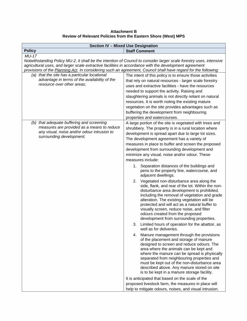
Attachment B Review of Relevant Policies from the Eastern Shore (West) MPS
Section IV – Mixed Use Designation
Policy Staff Comment MU-17 Notwithstanding Policy MU-2, it shall be the intention of Council to consider larger scale forestry uses, intensive agricultural uses, and larger scale extractive facilities in accordance with the development agreement provisions of the Planning Act. In considering such an agreement, Council shall have regard for the following:
(a) that the site has a particular locational advantage in terms of the availability of the resource over other areas;
The intent of this policy is to ensure those activities that rely on natural resources - larger scale forestry uses and extractive facilities - have the resources needed to support the activity. Raising and slaughtering animals is not directly reliant on natural resources. It is worth noting the existing mature vegetation on the site provides advantages such as buffering the development from neighbouring properties and watercourses.
(b) that adequate buffering and screening measures are provided as a means to reduce any visual, noise and/or odour intrusion to surrounding development;
A large portion of the site is vegetated with trees and shrubbery. The property is in a rural location where development is spread apart due to large lot sizes. The development agreement has a variety of measures in place to buffer and screen the proposed development from surrounding development and minimize any visual, noise and/or odour. These measures include:
1. Separation distances of the buildings and pens to the property line, watercourse, and adjacent dwellings.
2. Vegetated non-disturbance area along the side, flank, and rear of the lot. Within the non-disturbance area development is prohibited, including the removal of vegetation and grade alteration. The existing vegetation will be protected and will act as a natural buffer to visually screen, reduce noise, and filter odours created from the proposed development from surrounding properties.
3. Limited hours of operation for the abattoir, as well as for deliveries.
4. Manure management through the provisions of the placement and storage of manure designed to screen and reduce odours. The area where the animals can be kept and where the manure can be spread is physically separated from neighbouring properties and must be kept out of the non-disturbance area described above. Any manure stored on site is to be kept in a manure storage facility.
It is anticipated that based on the scale of the proposed livestock farm, the measures in place will help to mitigate odours, noises, and visual intrusion.
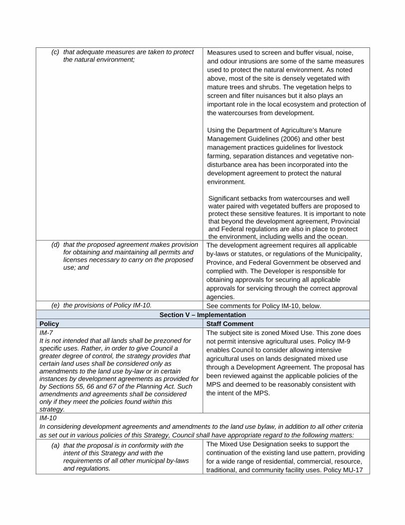
(c) that adequate measures are taken to protect the natural environment;
Measures used to screen and buffer visual, noise, and odour intrusions are some of the same measures used to protect the natural environment. As noted above, most of the site is densely vegetated with mature trees and shrubs. The vegetation helps to screen and filter nuisances but it also plays an important role in the local ecosystem and protection of the watercourses from development. Using the Department of Agriculture’s Manure Management Guidelines (2006) and other best management practices guidelines for livestock farming, separation distances and vegetative non-disturbance area has been incorporated into the development agreement to protect the natural environment. Significant setbacks from watercourses and well water paired with vegetated buffers are proposed to protect these sensitive features. It is important to note that beyond the development agreement, Provincial and Federal regulations are also in place to protect the environment, including wells and the ocean.
(d) that the proposed agreement makes provision for obtaining and maintaining all permits and licenses necessary to carry on the proposed use; and
The development agreement requires all applicable by-laws or statutes, or regulations of the Municipality, Province, and Federal Government be observed and complied with. The Developer is responsible for obtaining approvals for securing all applicable approvals for servicing through the correct approval agencies.
(e) the provisions of Policy IM-10. See comments for Policy IM-10, below. Section V – Implementation
Policy Staff Comment IM-7 It is not intended that all lands shall be prezoned for specific uses. Rather, in order to give Council a greater degree of control, the strategy provides that certain land uses shall be considered only as amendments to the land use by-law or in certain instances by development agreements as provided for by Sections 55, 66 and 67 of the Planning Act. Such amendments and agreements shall be considered only if they meet the policies found within this strategy.
The subject site is zoned Mixed Use. This zone does not permit intensive agricultural uses. Policy IM-9 enables Council to consider allowing intensive agricultural uses on lands designated mixed use through a Development Agreement. The proposal has been reviewed against the applicable policies of the MPS and deemed to be reasonably consistent with the intent of the MPS.
IM-10 In considering development agreements and amendments to the land use bylaw, in addition to all other criteria as set out in various policies of this Strategy, Council shall have appropriate regard to the following matters:
(a) that the proposal is in conformity with the intent of this Strategy and with the requirements of all other municipal by-laws and regulations.
The Mixed Use Designation seeks to support the continuation of the existing land use pattern, providing for a wide range of residential, commercial, resource, traditional, and community facility uses. Policy MU-17
provides specific guidance for applications for intensive agriculture (see comments above). The requirements of municipal by-laws and regulations have been addressed through the Development Agreement.
(b) that the proposal is not premature or inappropriate by reason of:
(i) the financial capability of the Municipality to absorb any costs relating to the development;
There are no anticipated costs to the Municipality relating to this development.
(ii) the adequacy of central or on-site sewerage and water services;
The property will be serviced by an on-site septic system, which has been reviewed and approved by the Nova Scotia Department of Environment. The applicants have installed a drilled well to provide water to the proposed development.
(iii) the adequacy or proximity of school, recreation or other community facilities;
An intensive agricultural use does not require services such as schools, recreation, or other community facilities. Therefore, there are no anticipated demands placed on schools, recreation, or other community facilities from this development.
(iv) the adequacy of road networks leading or adjacent to or within the development; and
The property has frontage on two roads: West Petpeswick Road and Westside Inlet Drive. Both roads are owned and maintained by the Department of Transportation and Infrastructure Renewal (TIR). Access to the property is via a one-way driveway that enters and exits at West Petpeswick Road. The driveway has been approved by TIR. The abattoir is not anticipated to result in a significant increase in traffic and can be accommodated within the existing road network.
(v) the potential for damage to or for destruction of designated historic buildings and sites.
There are no designated historic buildings or sites on or near this property.
(c) That controls are placed on the proposed development so as to reduce conflict with any adjacent or nearby land uses by reason of:
(i) type of use The subject site is located in a rural area south of Musquodoboit Harbour. The properties nearby are zoned mixed use but are primarily used for residential purposes – single unit dwellings – or are currently vacant. The lots are large, which allows development to be spaced apart. The proposed use can potentially conflict with surrounding uses by way of noise, odours, visual disturbances, traffic, and water contamination. The measures taken to reduce these conflicts are described in greater detail throughout the policy
matrix, but generally the measures put in place include the following: 1. Controlling the scale of the development by way
of limiting the size of the abattoir and number of animals;
2. Large separation distances between the development and nearby development (with extra separation between residential development), wells, and watercourses;
3. Setbacks from the road; 4. Non-disturbance areas along the side, flank, and
rear lot line; 5. Screening and containing the manure; and 6. Limited hours of operation for the abattoir. Agricultural uses, as well as commercial uses and other resource and traditional uses (e.g., extractive facilities and forestry uses) are permitted as-of-right. There are two components to the proposed development that classify the use as intensive agriculture rather than an agricultural use: the number of animals and the abattoir. To be classified as an agricultural use, a maximum of fifty domestic fowl and ten of any other type of livestock are permitted. The proposal requests to allow up to 100 ducks, 100 chickens, 30 rabbits, six horses, eight hogs, four goats, and seven assorted rescue animals (e.g., sheep, peacocks, etc.). The abattoir will be small, comparable in size to a typical detached garage. The applicants have stated they expect to process animals up to three times a month (however, this is not something the agreement regulates) and have up to six personnel on site at a time. The amount of livestock that is appropriate based on the size of the site varies based on a variety of factors, including how the manure is managed. Because there is no ‘rule-of-thumb’ for what the appropriate amount of livestock are per hectare, the development agreement limits where the livestock can be housed on the site, regulate where and how manure can be stored, and generally mitigates potential conflicts with abutting development. This approach will limit how much livestock can be accommodate at one time within the limited developable area on the property.
(ii) height, bulk and lot coverage of any proposed building;
The proposed development agreement regulates the bulk of the abattoir, and the height and lot coverage of any proposed structure. The height and lot coverage is the same as that of the underlying Mixed Use zone – 10.7 metres and 35%, respectively. Only the mass of the abattoir is explicitly limited. Its footprint cannot exceed 53.5 square metres, the size of a typical detached garage for a single unit dwelling. There is no limit to the footprint of a livestock pen, but those with a floor area 27.9 square metres or less have slightly less stringent setback requirements. It is anticipated the height, lot coverage, and massing regulations will not conflict with surrounding development.
(iii) traffic generation, access to and egress from the site, and parking;
TIR reviewed the proposal. Based on their review, driveway access is one-way only with a separate entrance and exit. The development agreement states any proposed changes to access, circulation, and parking require approval from TIR, as applicable. TIR also requires a permit for any work planned within 100 metres of the TIR right-of-way. The amount of traffic that will be generated from the abattoir is expected to be minimal. The applicants have indicated they anticipate there will be up to three processing days per month and on those days there will be up to six personnel on site. As such, a minimum of six parking spaces is required for the abattoir. For all other uses, parking must be accommodated on site and the quantity of spaces required will be as per the land use by-law. The development agreement requires all parking spaces be setback at least 5 metres from the front lot line. The parking area must be a hard surface, such as gravel or pavement.
(iv) open storage; and The development agreement has provisions for on-site storage of manure in terms of where it can be located and how the storage area must be designed. The agreement requires any manure kept on site be stored in a roofed structure that has reinforced concrete walls on at least three sides. The manure storage area will be required to have a non-permeable concrete floor that slopes downward from the open side (if there is one) and is sealed to the walls to prevent seepage. The development agreement requires the manure storage areas be screened from view from neighbouring properties and the street by opaque fencing, masonry walls, or adequate vegetation. Further, the storage area will be screened
from view on the north, south, and east side by a vegetated (treed) buffer. These separation distances and buffering will help reduce the negative impacts of manure, including odour.
(v) signs. No signage has been proposed. The development agreement requires that any proposed signage meet the requirements of the land use by-law.
(d) That the proposed site is suitable in terms of steepness of grades, soil and geological condition, locations of watercourses, marshes or bogs and susceptibility to flooding; and
The site is located on an inlet of the coast of the Atlantic Ocean (Porters Cove). There is a watercourse that runs from a wetland west of the property along the eastern edge of the property to the ocean. The property is relatively flat at the front (along West Petpeswick Road), but gradually slopes toward the watercourses. There are no known flooding issues on the site. There are no marshes or bogs, and based on the information available, there are no concerns about the soil and geological conditions for the intended use. With the controls established on the development through the proposed development agreement, the grade of the site is not a concern. The required setbacks from the watercourses and the non-disturbance area keep development away from the water and maintain the integrity of the landscape to protect the watercourse from runoff and erosion.
(e) Any other relevant matter of planning concern.
No other matters have been identified.
(f) Within any designation, where a holding zone has been established pursuant to “Infrastructure Charges – Policy IC-6”, Subdivision Approval shall be subject to the provisions of the Subdivision By-law respecting the maximum number of lots created per year, except in accordance with the development agreement provisions of the MGA, and the “Infrastructure Charges” Policies of this MPS.
A holding zone has not been established, and there is no subdivision proposed in conjunction with this application.

HALIFAX REGIONAL MUNICIPALITY Public Information Meeting Case 22519
The following does not represent a verbatim record of the proceedings of this meeting.
Monday, November 18, 2019 7:00 p.m.
Old School Community Gathering Place - Multipurpose Room - 7962 Nova Scotia Trunk 7 Musquodoboit Harbour, NS
STAFF IN ATTENDANCE: Meaghan Maund, Planner II, HRM Planning
Shayne Vipond, Planner III, HRM Planning Jared Cavers, Planning Technician, HRM Planning Tara Couvrette, Planning Controller, HRM Planning
ALSO IN ATTENDANCE: Councillor, David Hendsbee, District 02
Bianca & Pierre-Luc Sevigny – Applicant / Owners
PUBLIC IN ATTENDANCE: Approximately 80
1. Call to order, purpose of meeting – Meaghan Maund
Ms. Maund introduced themselves as the Planner and Facilitator for the application. They also introduced; Councillor David Hendsbee, Tara Couvrette – Planning Controller, Jared Cavers - Planning Technician, Shayne Vipond – Planner, and Bianca & Pierre-Luc Sevigny – Applicants.
Case 22519 - Application by Bianca and Pierre-Luc Sevigny to enter into a development agreement for an intensive agricultural use to allow for an abattoir and additional animals at 1129 West Petpeswick Road, West Petpeswick.
Ms. Maund explained the purpose of the Public Information Meeting (PIM) is: a) to identify that HRM has received a proposal for the site; b) to provide information on the project; c) to explain the Planning Policies and the stages of the Planning Process; and d) an opportunity for Staff to receive public feedback regarding the proposal. No decisions are made at this PIM.
1a) Presentation of Proposal – Meaghan Maund
Ms. Maund provided a brief introduction to the application and then made a presentation to the public outlining the purpose of the meeting, status of the application and the applicant’s request. Ms. Maund outlined the context of the subject lands and the relevant planning policies.
1b) Presentation by Bianca & Pierre-Luc Sevigny – Applicant
Mr. Sevigny explained the reason for the application. Mr. Sevigny explained who they are, why they would like to do this, what they are doing, where – showing site context, and when they would like to have this done and their expansion expectations. Bianca Sevigny addressed some common concerns/questions that had been brought to their attention.
2. Questions and Comments
Jude Major, Ostrea Lake Rd. – has a background in agriculture and education in farming and has been farming for 50 years. They are very happy the applicants are looking at building an abattoir because it is needed in the area. They have the following concerns because of their experience and background: the applicants do not have an education in agriculture and it is an art and very detailed science; and the piece of land is way too small for the number of animals. They are concerned about the number of animals and happy they are looking to grow gradually to those numbers, because they will probably run into some
Attachment CSummary of Public Information Meeting
serious health issues long before they get to the max numbers. You do not have enough land to properly rotate the animals. You haven’t said anything about animal welfare, animal health, and if any animals regrained. You have presented your situation as intensive agriculture, but looking at the numbers it looks like confinement agriculture, which is not going to go well. How do you manage pasture rotations with the animals? There is no space, you can’t mix certain types of animals together. You are talking about selling at the market, but nobody at the market is making any money. Concerned with marketing ideas. Most of the concerns are around animal welfare and the intensive nature of what they are trying to do on a fraction of land that would be needed for that many animals. Mr. Sevigny explained the ducks and chicken would be free range, the pigs will be rotated, the electric fence will be rotated every year, so it will not be in the same spot. Ms. Sevigny stated the pigs will be in the forest. Ms. Major – that’s great, with the chicken being free range – how big of an area, how often are you rotating their pasture, are you mixing ducks with chickens, and what about the health issues? You don’t have enough ground to raise any feed, so you will be buying everything, this will make your ultimate meat price high. Ms. Major offered to consult with them because of the experience and education they have in this area. Cheryl Negus, West Petpeswick Rd.- what is stopping your free-range chickens and ducks from going out on the road and causing an accident? Ms. Sevigny stated there will be fences. Ms. Negus – can the number of animals in this proposal ever be changed or raised? Ms. Maund – stated once the development agreement is approved the numbers are set, it is a fixed number. For them to increase the numbers, they would have to come back for an amendment and that is a whole other process they would have to go through. Ms. Negus – in the event that the smell is not being taken care of from this, what action can be taken? Ms. Maund – it is still part of the review process on how the manure is going to be managed. Ms. Negus – agrees the land can’t hold any more that what is being asked for, so they hope that if this goes through, there is not any way the amount of animals can be raised in the future. With the butcher shop, what is to stop them from bringing in other farms’ and people’s animals to be butchered? Ms. Maund – Someone with NS Dept. of Environment has to be on site for processing. They also license the facility. The facility is designed to meet their requirements. Mr. Negus – there is an inspector there when you butcher your animals, so you can’t bring other peoples birds in. Ms. Negus – in two years they can get more if they want. Ms. Maund – explained they would have to go through the development agreement process again. Alana Hogg, Westside Inlet Dr. – is in full support of this development. Believes the applicants are intelligent, caring, and ethical people. They visit the farm often and their kids are shown where meat comes from. They feel it is important for kids to understand that. They are also speaking for Bruce DeBaie who feels the same. They are their closest neighbours and they are in full support. Hugh Kerr, West Petpeswick Rd. – has a proper site survey been done? Has there been any Geotech work there? Do you know what kind of soils you are dealing with? Your effluent and manure as it seeps into the ground, will it go straight to the bay? Mr. Sevigny stated they can’t give an exact answer but the document they put up, the environmental farm plan, has those answers. Mr. Kerr – has concern about bedrock because the effluent will create a lot of phosphorus, nitrates, and carbon. Once that hits the bay it will create a seaweed problem because of the nutrients in the water. There has been a huge difference in our bay over the last couple of years in the number of crabs, the numbers are way down. That is not a good sign and they don’t want to see an abundance of seaweed and effluent because government doesn’t always get it right. You say you are going to get rid of your manure, you have a compost area of 10x10, and in the document you released, it stated your farming plan should have up to 7 months of capacity and they don’t believe that 10x10 will be big enough. Ms. Sevigny stated yes, you are right we haven’t come up with the composting plan yet because they need to work with different organizations to do that and they need more information first. Mr. Kerr – there is no septic plan, it just says a silt bed. Maybe for the abattoir, but there isn’t any septic plan that says we are going to have this buffer zone. Ms. Sevigny they can provide that now because they got the septic plan after they submitted their application. They have the engineered septic plan and it can be provided to HRM to put on the website. They can also post it on their Facebook page. Mr. Kerr – have they ever considered going mixed use for a certain amount of time and seeing how things go, before going to build this and having large infrastructure right away? Is there enough infrastructure to maintain all those animals when you are alone? Ms. Sevigny stated they will be building up to those numbers and may never even reach them. It is going to take time for them to learn how to be farmers. Colin Cameron, West Petpeswick Rd. – concerns about the number of animals. The rotation of your animals is going to be very important otherwise that soil is going to be stripped down to nothing. Concerns about potential erosion. How do you pick up chicken poop, how are you going to manage that? Ms. Sevigny
stated 70% of the poop is when they are in the chicken coop on their perch and they clean that. Mr. Cameron – if you let you pigs free range in the forest there is going to be nothing left, it is going to be stripped down to nothing. It is a small acreage, and if you maintain buffers to water zones, the area that is left for pasturing those animals is quite small, maybe an acre or two at most. Paula Milsom, East Petpeswick Rd. – would like to commend them for their enthusiasm and wants to welcome them to the community. Their main concern is runoff. They’re on the board at the Petpeswick Yacht Club, and for the past couple of years has noticed it is taking longer and longer for the tide to flush out the inlet. It used to take 1-2 days to happen and now it is taking 3-4 days. The kids spend as much time in the boat as they do out of the boat when they are learning, and the beaches have been closed due to water quality. This never happened 10-20 years ago, but it is happening now. Nature is not taking care of what it used to, they are concerned about the quality of water that the kids are playing in. Ms. Sevigny stated it is a priority of theirs as well. The environmental farm plan was not a requirement, but it is something that they wanted to do, and they will be following up with the Department of Agriculture once they get setup to make sure things are being done the right way. Jude Major, Ostrea Lake Rd. – have you applied to the Chicken Farms of NS for your free-range permit? Mr. Sevigny – no, we know about it we just haven’t done it yet. Ms. Sevigny – we definitely plan on getting it. Pat Trainer, East Petpeswick Rd., – how often will you be sending the waste from your abattoir away? Every month or every other month? How does it get transported to where it is going? Also has concerns with more traffic on the roads. Mr. Sevigny – Every processing day they will be sending waste away. They will be collecting it in buckets and taking it off site. Mr. Trainer stated horses are eating and pooping machines, curious how they will manage their poop if they are going to be out in a big field free-range. Ms. Sevigny stated they are starting with 1-2 next year and maybe the year after if they can manage that, 3. Mr. Trainer stated 2 horse can do a hell of a lot to a field in a hurry. Ernest Samson – East Petpeswick Rd. – if this is not done right we are going to have to live with the consequences. Victoria Dunbrack, Musquodoboit Harbour – you are going to free-range over your setback boundaries, how can you do that? Ms. Sevigny – the setback is for the housing. Ms. Dunbrack – the setback isn’t for the animals? They believe there should be setbacks for the animals too. Has concerns about the animals in proximity to the water, wells, and the creek. Need to start smaller and only have what you are allowed to have now. Ms. Sevigny explained the number of animals they are asking for. Also explained they put this all in one application because it is expensive, and the process takes a while to go through. Ms. Maund – explained why they were doing the development agreement process. Mr. Sevigny – stated they will be starting small and growing over time and may never reach the maximum numbers. Ms. Dunbrack stated then only have the abattoir and cut back on the number of animals. Thinks that is a great thing. Bruce DeBaie, Westside Inlet Dr. – In full support of this project. Being a close neighbour, they trust these two and knows they will do the right thing and will learn from whomever will help them. For them it is a matter of character and trust as much as it is capability and intent. To have local product is great. Pat Traynor– how are you going to contain your animals? Ms. Sevigny – the horses and pigs are all fenced with electric fencing and the chickens will have chicken wire. Mr. Traynor – if you lose your electricity it could be for a long time. Where are you getting your water? Ms. Sevigny – we have a drilled well and a generator if we lose power. We have the barn and the chicken coop to put the animals in if there is a storm. Sharon Athens – If there is a heavy rainstorm where is the chicken poop going, into the water. Mr. Sevigny – it is quite far from the animals to the water, and that is why the setback are created. Brian Kelly, Fall River – If you have 100 chicken and 100 ducks and they are pooping all over the yard and you are not picking, it up it is going to stink. When it rains it is going to wash downhill or wherever. You don’t have enough land, and I think what you are allowed now is even more than you can handle there. Abattoirs attract rats. If there is any by-product the rats will get in and once they are there if there isn’t enough to eat they are going to move all over the place looking for food. Too small of a property, too big of an idea. Ms. Sevigny – explained the processing process and with the amount there shouldn’t be too much going into the septic field. All the internal parts will be taken off-site, so none will be staying on-site. They

could compost, it is an option, but they aren’t because they don’t want to attract more predators. Mr. Kelly still feels there will be an issue with rats. Feed alone will attract rats. Richard Bell, Eastern Shore Cooperator, questions posted on his livestream video of the meeting – 1) What kind of testing is required for the groundwater to make sure nothing is getting into it? Is that part of the development agreement that you have a regular testing schedule and will it be public? 2) In the process of considering this, does HRM look at the potential impact to property values? Ms. Maund – we do not look at property values. At this point we have not looked at testing the ground water. Pamela Whelan, West Petpeswick Rd. – concerns about the inlet deteriorating further. How do you connect with city composting for the kind of waste you will have? Ms. Sevigny – They haven’t investigated that yet. It was when they were doing their environmental farm plan that said that they found out it is an option, but they haven’t gone any farther with that. Ms. Whelan – is it under active consideration that HRM is taking it into account for how you are dealing with the waste? Ms. Maund – something to keep in mind as they move forward and will be looked into. Ms. Whelan – the speed at which you are looking to do this is very worrisome. You need to really slow down and figure out some steps in you process. Jude Major, Ostrea Lake Rd. – meat birds love to die and that is a concern. What kind of horses, chickens etc., are you looking at getting. Volumes of manure are different depending on what you get. Health consideration for different types of horse are different. Commercial feed would have herbicide residue, pesticide residue, and a certain amount of genetic modification residue, so how are you looking at managing parasites within that amount of livestock on that small of an area? Ms. Sevigny – We haven’t gone down that path yet, but we would need to figure it out, as well as look into getting a vet. Ms. Major offered to help with that. Carol Young, West Petpeswick Rd. – agrees with everyone here, that tiny piece of land can’t sustain anymore growth on it then what you have now. Do not support having a slaughter house on their road. Resident – If you take the questions that have been raised here tonight back with you, research, and get the answers, the community will feel a lot better about it. Ms. Sevigny – that is their plan. They are in no rush. They will be working on all the concerns before looking at getting more animals. Resident – Thinks they should stay within the guidelines of what they have now and see how they make out before asking for more, as well as the abattoir, because they feel the abattoir is really bad. With regards to the rock, the water will run right through the rocks in this area. Whatever rain comes down will wash it down through the rocks and it will make its way to the bay. Dan Wellwood, West Petpeswick Rd. – the community has a history of negativity when it comes to anything new and they would hate to see it happen again here. The piece of land that they have is ideal in that the shape of the land is essentially a bowl that contains any immediate runoff. There are ways to test what happens with runoff that have been done on the inlet. They support what they are doing but would like to see the development plan be staged so that you get 25%, 50% to 100%. One would have to do with the water runoff. The other is for somebody to examine the farming practices that you have in 3 years’ time. There are ways this process could be staged with checks and balances. Thinks if this is the cases there would be much less resistance. Jude Major, Ostrea Lake Rd. – doesn’t believe free range will be something that anyone needs to worry about. James Shaw, West Petpeswick Rd. – the mixed-use zone – where is it divided? I will tell you, Young Dr. When they first moved there, there was a meeting to make West Petpeswick residential and they told them to leave it mixed-use. Kelsey Gallant, Ostrea Lake Rd. – it is really beneficial to have 4H in your area. It’s really good for kids to be around farms. Food that is raised and able to be bought locally is great for the community. Blair Dyer, West Petpeswick Rd. – would you be upset if it only reached the level of a hobby farm? Applicants – No. Resident – West Petpeswick Rd. – Wetland system works very well, rats I wouldn’t worry about. Doesn’t
think with that their plan will see more pests then they already have. Would like to somehow accommodate a staged approach. Believes from the comments of the neighbours that they would do that. It is really a bad idea to send these people home and say do it again in 2 year’s time. Likes the idea and wants to see this go ahead somehow, but at the same time there are lots of valid concerns. Would like to see an abattoir in the area. Believes that the treatment is such that it will contain the concerns that people are raising here. Vicoria Dunbrack – thinks if there is someway that it could be stepped approach instead of having it all at once, it would be to their advantage. Concerned about amount of space vs number of animals they are trying to raise. Has no problem with the abattoir. Just thinking of the animals and what you are taking on. Krista White, East Petpeswick – thinks what they are doing is great. Everybody is saying they would like to see a stepped system, however, regardless of whether that is part of the agreement that is what you are planning on doing anyway, correct? You guys are talking responsibility and planning on being responsible. Applicants – Yes. Councillor Hendsbee thanked everyone for coming out and explained they could come out to the Public Hearing to show support and address concerns. 3. Closing Comments
Ms. Maund thanked everyone for coming and expressing their comments. 4. Adjournment The meeting adjourned at approximately 8:55 p.m.