Embed Size (px)
Citation preview
P.O. Box 1749 Halifax, Nova Scotia B3J 3A5 Canada
Item No. 5.1.2Halifax and West Community Council
August 26, 2020 Notice of MotionSeptember 24, 2020 Public Hearing
TO: Chair and Members of Halifax and West Community Council
SUBMITTED BY: Steve Higgins, A/Director of Planning and Development
DATE: August 19, 2020
SUBJECT: Case # 22051: Development Agreement for a service station at 1656 Prospect Road, Hatchet Lake
ORIGIN
Application by Sunrose Land Use Consulting
LEGISLATIVE AUTHORITY
Halifax Regional Municipality Charter (HRM Charter), Part VIII, Planning & Development
RECOMMENDATION
It is recommended that Halifax and West Community Council:
1. Give Notice of Motion to consider the proposed development agreement, as set out in AttachmentA of this report, to enable a service station with an accessory convenience store and drive-throughrestaurant at 1656 Prospect Road, Hatchet Lake, and schedule a public hearing;
2. Approve the proposed development agreement, which shall be substantially of the same form asset out in Attachment A of this report; and
3. Require the development agreement be signed by the property owner within 240 days, or anyextension thereof granted by Council on request of the property owner, from the date of finalapproval by Council and any other bodies as necessary, including applicable appeal periods,whichever is later; otherwise this approval will be void and obligations arising hereunder shall be atan end.
Original Signed
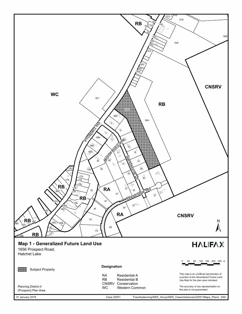
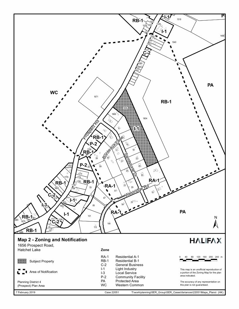
Case 22051: Development Agreement 1656 Prospect Road, Hatchet Lake Community Council Report - 2 - August 26, 2020 BACKGROUND Sunrose Land Use Consulting, on behalf of Hatchet Lake Plaza Ltd., has applied for a development agreement to permit a service station (with an associated convenience store and take-out/drive-through restaurant) at 1656 Prospect Road, Hatchet Lake. A service station is not permitted within the existing Light Industry (I-1) Zone, however it can be considered by development agreement under policies RB-10 and IM-11 of the Municipal Planning Strategy (MPS) for Planning District 4 (Prospect). The proposed development includes the subdivision of the existing lot to create a separate lot for the proposed service station. Subject Site 1656 Prospect Road (a portion of PID 40713844 on Highway 333) Location East side of Prospect Road, between the communities of Goodwood
and Hatchet Lake Regional Plan Designation Rural Commuter Community Plan Designation (Map 1)
Residential B under the Municipal Planning Strategy for Planning District 4 (Prospect)
Zoning (Map 2) I-1 (Light Industry) Zone under the Land Use By-law (LUB) for Planning District 4 (Prospect)
Size of Site Existing lot size: 4.05 hectares (10 acres) Proposed lot size: 2.02 hectares (5 acres)
Street Frontage Existing lot frontage: 147 meters (482 ft) along Prospect Road Proposed lot frontage: 73 meters (240 feet) along Prospect Road
Current Land Use(s) Vacant land except for a small vacant building Surrounding Use(s) Residential uses to the southwest (70 meters) and northeast (360
metres) Adjacent northeastern parcel: vacant with large wetland Adjacent southwestern parcel: vacant
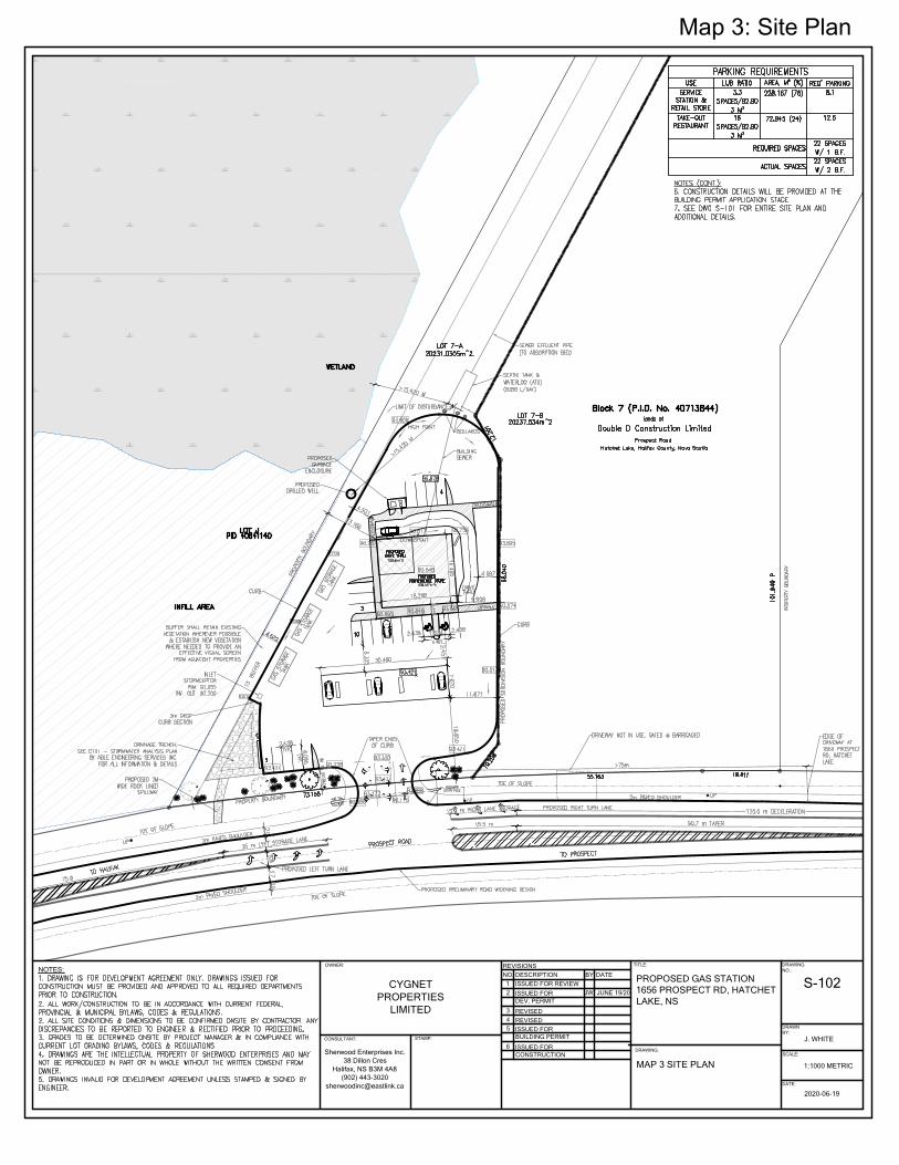
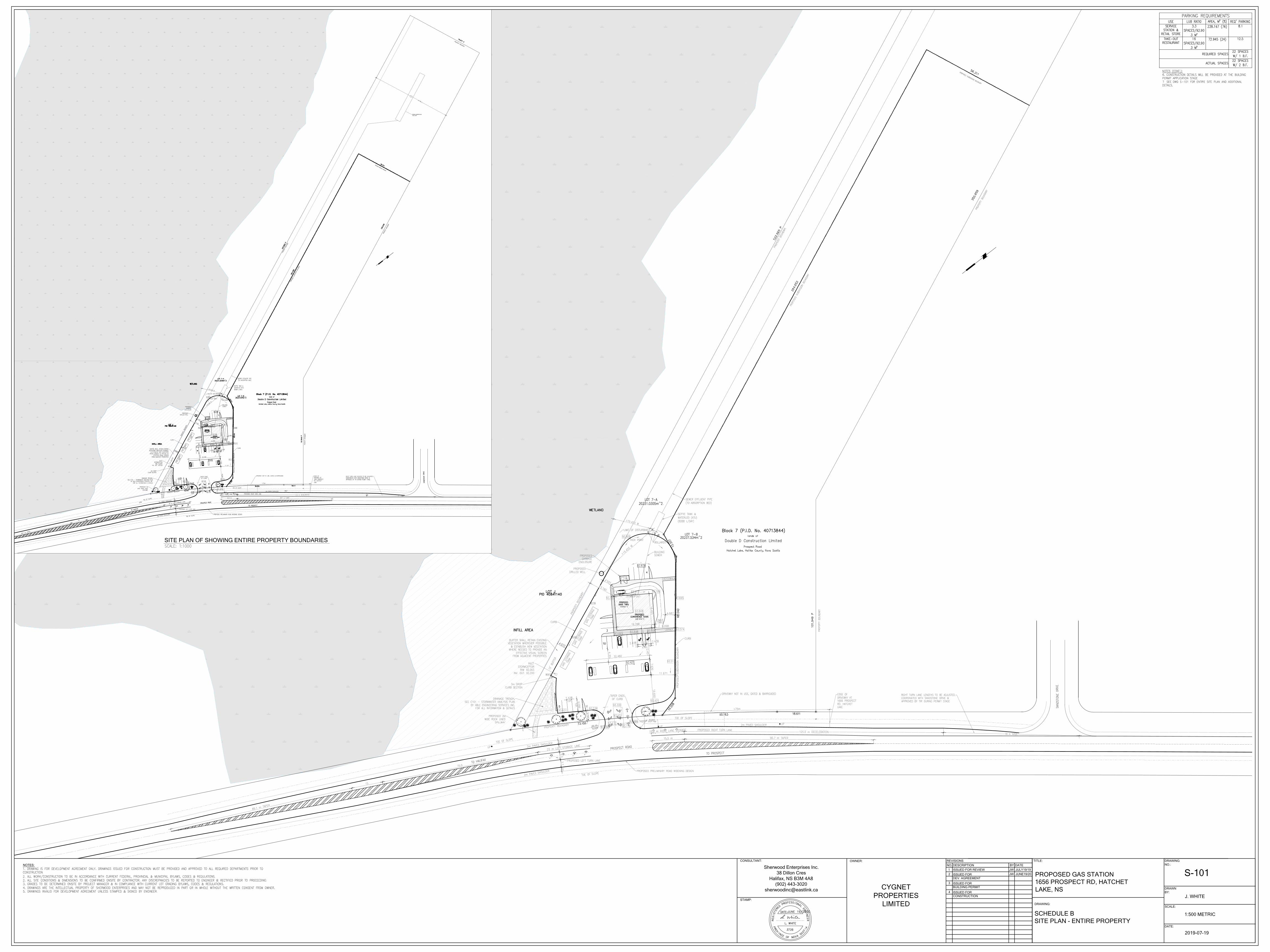
Proposal Details The applicant proposes to enter into a development agreement to permit a service station which includes a convenience store, and take-out / drive-through restaurant. Map 3 shows the proposed site plan for the development. The major aspects of the proposal are as follows:
• A four (4) fuel pump gas bar and canopy located at the front of the site; and • A single storey, main building divided into two leasehold spaces totalling 301 square metres (3,240
square feet) including a convenience store and a take-out/drive-through restaurant.
Other features of the proposed development include:
• A single vehicle access point to the site; • A fuel truck turning lane; • A vehicle queuing area for the drive-through restaurant; • Parking areas and provision for on-site pedestrian circulation; • Landscaping along the street frontage; and • A 4.6 metre (15 foot) vegetated buffer to the adjacent vacant residential and large wetland.
Enabling Policy and LUB Context The subject site is situated within the Planning District 4 (Prospect) Plan Area and designated Residential B. Within this designation, the MPS recognizes that general commercial uses and service stations may be suitably located along Prospect Road with minimal impact on the surrounding community. The MPS acknowledges that these uses provide a necessary service to the existing community, as well as support the tourist industry, but may have a greater impact on the surrounding community in terms of traffic, groundwater draw, noise, litter and aesthetics. To ensure proper integration with the community, the MPS enables the consideration of service stations through the development agreement process.
Case 22051: Development Agreement 1656 Prospect Road, Hatchet Lake Community Council Report - 3 - August 26, 2020 The subject site is zoned I-1 (Light Industry) Zone which permits a range of industrial uses such as manufacturing, warehouse, research, recycling, transportation depots, contracting storage yards and, in addition, commercial C-2 (General Business) uses such as retail stores, restaurants, medical, financial institutions, and automotive repair outlets. The proposed convenience store and restaurant uses are permitted within the applied I-1 Zone, however, service stations may only be considered in accordance with Policy RB-10 through the development agreement process. In addition to Policy RB-10, the application is subject to the general policy evaluation criteria as contained in Policy IM-11, which is applicable to all discretionary planning approvals under the MPS. Attachment B of this report contains the policies and criteria by which Council may consider this proposal. COMMUNITY ENGAGEMENT The community engagement process is consistent with the intent of the HRM Community Engagement Strategy. The level of community engagement was consultation, achieved through providing information and seeking comment through the HRM website, signage posted on the subject site, letters mailed to property owners within the notification area (Map 2) and a public information meeting held on February 27, 2019. The public meeting was attended by 22 residents and Attachment C contains a copy of the minutes from the meeting. The public comments received include the following topics:
• the number of service stations (existing and proposed) along Prospect Road; • runoff and environmental impact on wetland and on existing wells; • traffic impact; and • light pollution.
A public hearing must be held by Halifax and West Community Council before they can consider approval of the proposed development agreement. Should Community Council decide to proceed with a public hearing on this application, in addition to the published newspaper advertisements, property owners within the notification area shown on Map 2 will be notified of the hearing by regular mail. The proposal will potentially impact the following stakeholders: residents, property owners, and nearby business owners. DISCUSSION Staff has reviewed the proposal relative to all relevant policies and advise that it is reasonably consistent with the intent of the MPS. Attachment B provides an evaluation of the proposed development agreement in relation to the relevant MPS policies. Proposed Development Agreement The proposed development agreement, Attachment A, addresses the following matters: • The placement, gross floor area, and height of the proposed building, in addition to its permitted uses; • Vehicle access, parking, and circulation; • Landscaping and buffering; • Lighting and signage; and • Non-substantive amendments including:
- the granting of an extension to the date of commencement of development; and - the length of time for the completion of the development.
Staff has reviewed the proposal relative to all relevant policies and have drafted a proposed development agreement consistent with the MPS. While the proposed development agreement is consistent with the
Case 22051: Development Agreement 1656 Prospect Road, Hatchet Lake Community Council Report - 4 - August 26, 2020 intent of the MPS, staff has highlighted the following for specific discussion: Compatibility with Nearby Residential Development MPS policy calls for the consideration of the compatibility of architectural design and scale of new buildings relative to nearby land uses. MPS policy also directs consideration be given to maintenance of an adequate separation distance from low density residential development. There are vacant lots adjacent to the subject site however, there are residential units beyond these vacant lots. The nearest residential building to the southwest is located approximately 70 metres away, and the residential building to the northeast is approximately 360 metres away. Given the proximity of these residential uses, the proposed development agreement (Attachment A) requires several measures to limit the impact of the development on these residential areas:
• a pitched roof, • detailing in the façade; • equipment screening; • landscaping along Prospect Road and along the northeast property line; and • specifications around lighting requirements.
Architecture Although the subject property is located in a mostly undeveloped stretch of Prospect Road, structures with pitched roof forms and roof articulation are commonly found along Prospect Road. To recognize this common design approach, the proposed development agreement requires the commercial building to be constructed with pitched roof form and roof articulation. With respect to building scale, the proposed development agreement requires development to be distributed within one main building with a limited overall gross floor area of 418 m2 (4500 ft2).. Visual and Light Intrusion Lighting will be directed to driveways, parking areas, loading areas, building entrances and walkways, and away from streets, adjacent lots and buildings. In addition, no portion of pump island canopy will have backlighting, but the canopy may be used as an anchor to direct light immediately beneath the canopy. Impact on Natural Environment Wetland Protection Policy requires consideration be given to the potential impact of the proposed development on the natural environment, and in particular the impact on wetlands. The applicant has provided a Wetland Delineation Report with an update submitted on June 25, 2019. The report identified a large wetland on the adjacent property northeast of the subject property. The report also acknowledges no observation of a wetland within the project footprint. Since there is no identified contiguous watercourse within this wetland, a 20 metre (65.6 feet) buffer from the adjacent wetland is not required. As stated in the Wetland Report, the wetland northeast of the proposed development is extensive and well established. As a result, plants within the wetland have had ample time to adjust, enhancing their ability to degrade any contaminants leaching from the roadway (metals, petroleum hydrocarbons, PAHs, etc.). Section 26.4 of the Land Use Bylaw requires a 15 foot (4.6 meter) landscaped barrier along the side yard of commercial uses abutting residential uses or a vacant lot. This landscaped buffer can provide a visual barrier, but it can also reduce the potential indirect impacts to the wetland. The site plan attached to the proposed development agreement (Schedule B of Attachment A) shows the 15-foot (4.6 m) buffer along the northeastern property boundary. This vegetated buffer will not only provide a visual barrier but allow for capture of site run-off and general filtering capacity prior to any potential release into the adjacent wetland habitat.
Case 22051: Development Agreement 1656 Prospect Road, Hatchet Lake Community Council Report - 5 - August 26, 2020 Traffic Generation and Pedestrian Circulation Site Access A Traffic Impact Study (TIS) was submitted in support of this application due to the specific uses being proposed and the traffic volumes along Prospect Road (Route 333). The TIS asserts that the majority of traffic using the proposed development will be traffic already using the Prospect Road (pass-by trips) and that the proposed development is not expected to cause any operational difficulties on Prospect Road. This portion of Prospect Road is owned and maintained by the Nova Scotia Department of Transportation and Infrastructure Renewal (NSTIR) who have participated in the review of this application and accepted the findings. In addition to a TIS, a road access design and truck turning template was submitted by the applicant. The proposed development will have one access point on Prospect Road as shown on Schedule B of Attachment A. The current access design onto the site will be upgraded to serve the proposed development. NSTIR has reviewed the proposal and advised that the access to the site and Prospect Road will need to be widened to accommodate dedicated turning lanes. The access design and trucking turning template have been reviewed by the NSTIR and have also been deemed suitable. Further detailed access design requirements will be reviewed prior to municipal building permits and provincial right-of way permits. Pedestrian Circulation With respect to pedestrian circulation, the proposed use being an auto-centric land use is not anticipated to generate material volumes of pedestrian traffic. However, Sections 3.6.4 and 3.6.5 of the proposed development agreement require a signed dedicated pedestrian walkway from the proposed building to the adjacent site that has a building permit for an as-of right commercial plaza. Where the required walkway crosses the queueing lane for the drive-through restaurant, signage and pavement markings are required to reduce pedestrian-vehicular conflict. Proximity to other service stations in the area Throughout this Planning Application process the public has expressed concern with the number of existing and proposed service stations along the Prospect Road. It is important to note that MPS does not contain any policies which would allow the number of service stations in the area be a reason for refusing the request. For information, there are two other existing service stations along Prospect Road. A third proposal adjacent to 1300 Prospect Road recently held a public hearing at Community Council for a time extension for its development agreement. The most recently built gas station is at 180 Prospect Road at the Exhibition Park. This development is almost 6km from the subject site. The other more established service station on Prospect Road is within 4.5 km or a 5-minute drive from the proposed site. The applicant is fully aware of these service stations, yet through market analysis the applicant has determined there is still enough business from residents and tourists along Prospect Road that warrant another service station. However, to allow flexibility for the applicant, should the service station proposal not be developed, the development agreement will allow the as-of right uses permitted in the underlying I-1 (Light Industry) Zone. Conclusion Staff have reviewed the proposal in terms of all relevant policy criteria for a development agreement for a service station and advise that it is reasonably consistent with the intent of the MPS (Attachment B). The development includes architectural features to reinforce the character of the area, controlled site access and vehicular and pedestrian provisions to promote efficient on-site circulation, and landscaped buffering to provide wetland protection and a visual barrier. Therefore, staff recommend that the Halifax and West Community Council approve the proposed development agreement as set out in Attachment A.
Case 22051: Development Agreement 1656 Prospect Road, Hatchet Lake Community Council Report - 6 - August 26, 2020
FINANCIAL IMPLICATIONS
There are no financial implications. The applicant will be responsible for all costs, expenses, liabilities and obligations imposed under or incurred in order to satisfy the terms of this proposed development agreement. The administration of the development agreement can be carried out within the approved 2020-2021 operating budget of Planning and Development.
RISK CONSIDERATION
There are no significant risks associated with the recommendations contained within this report. This application may be considered under existing MPS policies. Community Council has the discretion to make decisions that are consistent with the MPS, and such decisions may be appealed to the N.S. Utility and Review Board. Information concerning risks and other implications of adopting the proposed development agreement are contained within the Discussion section of this report.
ENVIRONMENTAL IMPLICATIONS
No additional concerns were identified beyond those raised in this report.
ALTERNATIVES
1. Halifax and West Community Council may choose to approve the proposed development agreementsubject to modifications. Such modifications may require further negotiation with the applicant and mayrequire a supplementary report or a public hearing. A decision of Council to approve this developmentagreement is appealable to the N.S. Utility & Review Board as per Section 262 of the HRM Charter.
2. Halifax and West Community Council may choose to refuse the proposed development agreement,and in doing so, must provide reasons why the proposed agreement does not reasonably carry out theintent of the MPS. A decision of Council to refuse the proposed development agreement is appealableto the N.S. Utility & Review Board as per Section 262 of the HRM Charter.
ATTACHMENTS
Map 1: Generalized Future Land Use Map 2: Zoning and Notification Map 3: Site Plan
Attachment A Proposed Development Agreement Attachment B Review of Relevant Policies from the Municipal Planning Strategy for Planning
District 4 Attachment C Public Information Meeting – Summary
___________________________________________________________________________
A copy of this report can be obtained online at halifax.ca or by contacting the Office of the Municipal Clerk at 902.490.4210.
Report Prepared by: Maria Jacobs, Planner II, Current Planning, 902.490.4911
Report Approved by: Carl Purvis, Planning Applications Program Manager, 902.490.4797
! ! ! ! ! ! ! ! ! ! ! ! ! ! ! ! ! ! ! ! ! ! ! ! ! ! ! ! ! ! !
! ! ! ! ! ! ! ! ! ! ! ! ! ! ! ! ! ! ! ! ! ! ! ! ! ! ! ! ! ! !
! ! ! ! ! ! ! ! ! ! ! ! ! ! ! ! ! ! ! ! ! ! ! ! ! ! ! ! ! ! !
! ! ! ! ! ! ! ! ! ! ! ! ! ! ! ! ! ! ! ! ! ! ! ! ! ! ! ! ! ! !
! ! ! ! ! ! ! ! ! ! ! ! ! ! ! ! ! ! ! ! ! ! ! ! ! ! ! ! ! ! !
! ! ! ! ! ! ! ! ! ! ! ! ! ! ! ! ! ! ! ! ! ! ! ! ! ! ! ! ! ! !
! ! ! ! ! ! ! ! ! ! ! ! ! ! ! ! ! ! ! ! ! ! ! ! ! ! ! ! ! ! !
! ! ! ! ! ! ! ! ! ! ! ! ! ! ! ! ! ! ! ! ! ! ! ! ! ! ! ! ! ! !
! ! ! ! ! ! ! ! ! ! ! ! ! ! ! ! ! ! ! ! ! ! ! ! ! ! ! ! ! ! !
! ! ! ! ! ! ! ! ! ! ! ! ! ! ! ! ! ! ! ! ! ! ! ! ! ! ! ! ! ! !
! ! ! ! ! ! ! ! ! ! ! ! ! ! ! ! ! ! ! ! ! ! ! ! ! ! ! ! ! ! !
! ! ! ! ! ! ! ! ! ! ! ! ! ! ! ! ! ! ! ! ! ! ! ! ! ! ! ! ! ! !
! ! ! ! ! ! ! ! ! ! ! ! ! ! ! ! ! ! ! ! ! ! ! ! ! ! ! ! ! ! !
! ! ! ! ! ! ! ! ! ! ! ! ! ! ! ! ! ! ! ! ! ! ! ! ! ! ! ! ! ! !
! ! ! ! ! ! ! ! ! ! ! ! ! ! ! ! ! ! ! ! ! ! ! ! ! ! ! ! ! ! !
! ! ! ! ! ! ! ! ! ! ! ! ! ! ! ! ! ! ! ! ! ! ! ! ! ! ! ! ! ! !
! ! ! ! ! ! ! ! ! ! ! ! ! ! ! ! ! ! ! ! ! ! ! ! ! ! ! ! ! ! !
! ! ! ! ! ! ! ! ! ! ! ! ! ! ! ! ! ! ! ! ! ! ! ! ! ! ! ! ! ! !
! ! ! ! ! ! ! ! ! ! ! ! ! ! ! ! ! ! ! ! ! ! ! ! ! ! ! ! ! ! !
! ! ! ! ! ! ! ! ! ! ! ! ! ! ! ! ! ! ! ! ! ! ! ! ! ! ! ! ! ! !
! ! ! ! ! ! ! ! ! ! ! ! ! ! ! ! ! ! ! ! ! ! ! ! ! ! ! ! ! ! !
! ! ! ! ! ! ! ! ! ! ! ! ! ! ! ! ! ! ! ! ! ! ! ! ! ! ! ! ! ! !
! ! ! ! ! ! ! ! ! ! ! ! ! ! ! ! ! ! ! ! ! ! ! ! ! ! ! ! ! ! !
! ! ! ! ! ! ! ! ! ! ! ! ! ! ! ! ! ! ! ! ! ! ! ! ! ! ! ! ! ! !
! ! ! ! ! ! ! ! ! ! ! ! ! ! ! ! ! ! ! ! ! ! ! ! ! ! ! ! ! ! !
! ! ! ! ! ! ! ! ! ! ! ! ! ! ! ! ! ! ! ! ! ! ! ! ! ! ! ! ! ! !
! ! ! ! ! ! ! ! ! ! ! ! ! ! ! ! ! ! ! ! ! ! ! ! ! ! ! ! ! ! !
! ! ! ! ! ! ! ! ! ! ! ! ! ! ! ! ! ! ! ! ! ! ! ! ! ! ! ! ! ! !
! ! ! ! ! ! ! ! ! ! ! ! ! ! ! ! ! ! ! ! ! ! ! ! ! ! ! ! ! ! !
! ! ! ! ! ! ! ! ! ! ! ! ! ! ! ! ! ! ! ! ! ! ! ! ! ! ! ! ! ! !
! ! ! ! ! ! ! ! ! ! ! ! ! ! ! ! ! ! ! ! ! ! ! ! ! ! ! ! ! ! !
! ! ! ! ! ! ! ! ! ! ! ! ! ! ! ! ! ! ! ! ! ! ! ! ! ! ! ! ! ! !
! ! ! ! ! ! ! ! ! ! ! ! ! ! ! ! ! ! ! ! ! ! ! ! ! ! ! ! ! ! !
! ! ! ! ! ! ! ! ! ! ! ! ! ! ! ! ! ! ! ! ! ! ! ! ! ! ! ! ! ! !
! ! ! ! ! ! ! ! ! ! ! ! ! ! ! ! ! ! ! ! ! ! ! ! ! ! ! ! ! ! !
! ! ! ! ! ! ! ! ! ! ! ! ! ! ! ! ! ! ! ! ! ! ! ! ! ! ! ! ! ! !
! ! ! ! ! ! ! ! ! ! ! ! ! ! ! ! ! ! ! ! ! ! ! ! ! ! ! ! ! ! !
! ! ! ! ! ! ! ! ! ! ! ! ! ! ! ! ! ! ! ! ! ! ! ! ! ! ! ! ! ! !
! ! ! ! ! ! ! ! ! ! ! ! ! ! ! ! ! ! ! ! ! ! ! ! ! ! ! ! ! ! !
! ! ! ! ! ! ! ! ! ! ! ! ! ! ! ! ! ! ! ! ! ! ! ! ! ! ! ! ! ! !
! ! ! ! ! ! ! ! ! ! ! ! ! ! ! ! ! ! ! ! ! ! ! ! ! ! ! ! ! ! !
! ! ! ! ! ! ! ! ! ! ! ! ! ! ! ! ! ! ! ! ! ! ! ! ! ! ! ! ! ! !
! ! ! ! ! ! ! ! ! ! ! ! ! ! ! ! ! ! ! ! ! ! ! ! ! ! ! ! ! ! !
! ! ! ! ! ! ! ! ! ! ! ! ! ! ! ! ! ! ! ! ! ! ! ! ! ! ! ! ! ! !
! ! ! ! ! ! ! ! ! ! ! ! ! ! ! ! ! ! ! ! ! ! ! ! ! ! ! ! ! ! !
! ! ! ! ! ! ! ! ! ! ! ! ! ! ! ! ! ! ! ! ! ! ! ! ! ! ! ! ! ! !
! ! ! ! ! ! ! ! ! ! ! ! ! ! ! ! ! ! ! ! ! ! ! ! ! ! ! ! ! ! !
! ! ! ! ! ! ! ! ! ! ! ! ! ! ! ! ! ! ! ! ! ! ! ! ! ! ! ! ! ! !
! ! ! ! ! ! ! ! ! ! ! ! ! ! ! ! ! ! ! ! ! ! ! ! ! ! ! ! ! ! !
! ! ! ! ! ! ! ! ! ! ! ! ! ! ! ! ! ! ! ! ! ! ! ! ! ! ! ! ! ! !
! ! ! ! ! ! ! ! ! ! ! ! ! ! ! ! ! ! ! ! ! ! ! ! ! ! ! ! ! ! !
8
2
1
1
2
4
6
3
25
11
30
21
10
54
67
12
40
85
22
51
1814
10
20
59
79
26
2923
39
115
101
144
1550
152915351539
1604
1696
1819
1885
1536
15401562
1570
1600
1780
1796
1820
1518
1690
17741779
1794
1842
1837
1545
1556
18361861
1510
1596
1656
1776
18691879
1760
1498
1590
1666
1684
1671
1790
1763
1800
1809
1886
Prospe
ct Rd
Sandstone Dr
Westridge Rd
Borde
auxLane
WCRB
RA
RA CNSRV
RB
CNSRV
RB
RB
RB
RB
31 January 2019 Case 22051 T:\work\planning\SER_Group\SER_CasesVariances\22051\Maps_Plans\ (HK)
1656 Prospect Road,Hatchet Lake
±
0 40 80 120 160 200 240 m
RARBCNSRVWC
Residential AResidential BConservationWestern Common
This map is an unofficial reproduction ofa portion of the Generalized Future LandUse Map for the plan area indicated.
The accuracy of any representation onthis plan is not guaranteed.
Map 1 - Generalized Future Land Use
Planning District 4(Prospect) Plan Area
Designation! ! ! ! ! ! !
! ! ! ! ! ! !
! ! ! ! ! ! !
! ! ! ! ! ! ! Subject Property
! ! ! ! ! ! ! ! ! ! ! ! ! ! ! ! ! ! ! ! ! ! ! ! ! ! ! ! ! ! !
! ! ! ! ! ! ! ! ! ! ! ! ! ! ! ! ! ! ! ! ! ! ! ! ! ! ! ! ! ! !
! ! ! ! ! ! ! ! ! ! ! ! ! ! ! ! ! ! ! ! ! ! ! ! ! ! ! ! ! ! !
! ! ! ! ! ! ! ! ! ! ! ! ! ! ! ! ! ! ! ! ! ! ! ! ! ! ! ! ! ! !
! ! ! ! ! ! ! ! ! ! ! ! ! ! ! ! ! ! ! ! ! ! ! ! ! ! ! ! ! ! !
! ! ! ! ! ! ! ! ! ! ! ! ! ! ! ! ! ! ! ! ! ! ! ! ! ! ! ! ! ! !
! ! ! ! ! ! ! ! ! ! ! ! ! ! ! ! ! ! ! ! ! ! ! ! ! ! ! ! ! ! !
! ! ! ! ! ! ! ! ! ! ! ! ! ! ! ! ! ! ! ! ! ! ! ! ! ! ! ! ! ! !
! ! ! ! ! ! ! ! ! ! ! ! ! ! ! ! ! ! ! ! ! ! ! ! ! ! ! ! ! ! !
! ! ! ! ! ! ! ! ! ! ! ! ! ! ! ! ! ! ! ! ! ! ! ! ! ! ! ! ! ! !
! ! ! ! ! ! ! ! ! ! ! ! ! ! ! ! ! ! ! ! ! ! ! ! ! ! ! ! ! ! !
! ! ! ! ! ! ! ! ! ! ! ! ! ! ! ! ! ! ! ! ! ! ! ! ! ! ! ! ! ! !
! ! ! ! ! ! ! ! ! ! ! ! ! ! ! ! ! ! ! ! ! ! ! ! ! ! ! ! ! ! !
! ! ! ! ! ! ! ! ! ! ! ! ! ! ! ! ! ! ! ! ! ! ! ! ! ! ! ! ! ! !
! ! ! ! ! ! ! ! ! ! ! ! ! ! ! ! ! ! ! ! ! ! ! ! ! ! ! ! ! ! !
! ! ! ! ! ! ! ! ! ! ! ! ! ! ! ! ! ! ! ! ! ! ! ! ! ! ! ! ! ! !
! ! ! ! ! ! ! ! ! ! ! ! ! ! ! ! ! ! ! ! ! ! ! ! ! ! ! ! ! ! !
! ! ! ! ! ! ! ! ! ! ! ! ! ! ! ! ! ! ! ! ! ! ! ! ! ! ! ! ! ! !
! ! ! ! ! ! ! ! ! ! ! ! ! ! ! ! ! ! ! ! ! ! ! ! ! ! ! ! ! ! !
! ! ! ! ! ! ! ! ! ! ! ! ! ! ! ! ! ! ! ! ! ! ! ! ! ! ! ! ! ! !
! ! ! ! ! ! ! ! ! ! ! ! ! ! ! ! ! ! ! ! ! ! ! ! ! ! ! ! ! ! !
! ! ! ! ! ! ! ! ! ! ! ! ! ! ! ! ! ! ! ! ! ! ! ! ! ! ! ! ! ! !
! ! ! ! ! ! ! ! ! ! ! ! ! ! ! ! ! ! ! ! ! ! ! ! ! ! ! ! ! ! !
! ! ! ! ! ! ! ! ! ! ! ! ! ! ! ! ! ! ! ! ! ! ! ! ! ! ! ! ! ! !
! ! ! ! ! ! ! ! ! ! ! ! ! ! ! ! ! ! ! ! ! ! ! ! ! ! ! ! ! ! !
! ! ! ! ! ! ! ! ! ! ! ! ! ! ! ! ! ! ! ! ! ! ! ! ! ! ! ! ! ! !
! ! ! ! ! ! ! ! ! ! ! ! ! ! ! ! ! ! ! ! ! ! ! ! ! ! ! ! ! ! !
! ! ! ! ! ! ! ! ! ! ! ! ! ! ! ! ! ! ! ! ! ! ! ! ! ! ! ! ! ! !
! ! ! ! ! ! ! ! ! ! ! ! ! ! ! ! ! ! ! ! ! ! ! ! ! ! ! ! ! ! !
! ! ! ! ! ! ! ! ! ! ! ! ! ! ! ! ! ! ! ! ! ! ! ! ! ! ! ! ! ! !
! ! ! ! ! ! ! ! ! ! ! ! ! ! ! ! ! ! ! ! ! ! ! ! ! ! ! ! ! ! !
! ! ! ! ! ! ! ! ! ! ! ! ! ! ! ! ! ! ! ! ! ! ! ! ! ! ! ! ! ! !
! ! ! ! ! ! ! ! ! ! ! ! ! ! ! ! ! ! ! ! ! ! ! ! ! ! ! ! ! ! !
! ! ! ! ! ! ! ! ! ! ! ! ! ! ! ! ! ! ! ! ! ! ! ! ! ! ! ! ! ! !
! ! ! ! ! ! ! ! ! ! ! ! ! ! ! ! ! ! ! ! ! ! ! ! ! ! ! ! ! ! !
! ! ! ! ! ! ! ! ! ! ! ! ! ! ! ! ! ! ! ! ! ! ! ! ! ! ! ! ! ! !
! ! ! ! ! ! ! ! ! ! ! ! ! ! ! ! ! ! ! ! ! ! ! ! ! ! ! ! ! ! !
! ! ! ! ! ! ! ! ! ! ! ! ! ! ! ! ! ! ! ! ! ! ! ! ! ! ! ! ! ! !
! ! ! ! ! ! ! ! ! ! ! ! ! ! ! ! ! ! ! ! ! ! ! ! ! ! ! ! ! ! !
! ! ! ! ! ! ! ! ! ! ! ! ! ! ! ! ! ! ! ! ! ! ! ! ! ! ! ! ! ! !
! ! ! ! ! ! ! ! ! ! ! ! ! ! ! ! ! ! ! ! ! ! ! ! ! ! ! ! ! ! !
! ! ! ! ! ! ! ! ! ! ! ! ! ! ! ! ! ! ! ! ! ! ! ! ! ! ! ! ! ! !
! ! ! ! ! ! ! ! ! ! ! ! ! ! ! ! ! ! ! ! ! ! ! ! ! ! ! ! ! ! !
! ! ! ! ! ! ! ! ! ! ! ! ! ! ! ! ! ! ! ! ! ! ! ! ! ! ! ! ! ! !
! ! ! ! ! ! ! ! ! ! ! ! ! ! ! ! ! ! ! ! ! ! ! ! ! ! ! ! ! ! !
! ! ! ! ! ! ! ! ! ! ! ! ! ! ! ! ! ! ! ! ! ! ! ! ! ! ! ! ! ! !
! ! ! ! ! ! ! ! ! ! ! ! ! ! ! ! ! ! ! ! ! ! ! ! ! ! ! ! ! ! !
! ! ! ! ! ! ! ! ! ! ! ! ! ! ! ! ! ! ! ! ! ! ! ! ! ! ! ! ! ! !
! ! ! ! ! ! ! ! ! ! ! ! ! ! ! ! ! ! ! ! ! ! ! ! ! ! ! ! ! ! !
! ! ! ! ! ! ! ! ! ! ! ! ! ! ! ! ! ! ! ! ! ! ! ! ! ! ! ! ! ! !
! ! ! ! ! ! ! ! ! ! ! ! ! ! ! ! ! ! ! ! ! ! ! ! ! ! ! ! ! ! !
8
2
1
1
2
4
6
3
25
11
30
21
10
54
67
12
40
85
22
51
1814
10
20
59
79
26
2923
39
115
101
144
1550
152915351539
1604
1696
1819
1885
1536
15401562
1570
1600
1780
1796
1820
1518
1690
17741779
1794
1842
1837
1545
1556
18361861
1510
1596
1656
1776
18691879
1760
1498
1590
1666
1684
1671
1790
1763
1800
1809
1886
Prospe
ct Rd
Sandstone Dr
Westridge Rd
Borde
auxLane
WCRB-1
PA
PA
RA-1RA-1
I-1
RB-1
RA-1I-1
RB-1
I-1
RB-1
I-1
RB-1
P-2
RB-1
P-2RB-1
I-3
RB-1
C-2
C-2
C-2
I-1 P-3
7 February 2019 Case 22051 T:\work\planning\SER_Group\SER_CasesVariances\22051\Maps_Plans\ (HK)
Area of Notification
Map 2 - Zoning and Notification1656 Prospect Road,Hatchet Lake
±
This map is an unofficial reproduction ofa portion of the Zoning Map for the planarea indicated.
The accuracy of any representation onthis plan is not guaranteed.
0 40 80 120 160 200 240 mRA-1RB-1C-2I-1I-3P-2PAWC
Residential A-1Residential B-1General BusinessLight IndustryLocal ServiceCommunity FacilityProtected AreaWestern Common
Zone
Planning District 4(Prospect) Plan Area
! ! ! ! ! ! !
! ! ! ! ! ! !
! ! ! ! ! ! !
! ! ! ! ! ! ! Subject Property
REVISIONS
NO. DESCRIPTION
ISSUED FOR REVIEW
DATEBY
1
ISSUED FOR
BUILDING PERMIT
4
ISSUED FOR
CONSTRUCTION
5
JUNE 19/20JW2
ISSUED FOR
DEV. PERMIT
3
REVISED
REVISED
6
NOTES:
DRAWING
NO.:
DRAWN
BY:
DATE:
SCALE:
2020-06-19
TITLE:
Sherwood Enterprises Inc.
38 Dillon Cres
Halifax, NS B3M 4A8
(902) 443-3020
OWNER:
STAMP:
CONSULTANT:
PROPOSED GAS STATION
1656 PROSPECT RD, HATCHET
LAKE, NS
CYGNET
PROPERTIES
LIMITED
DRAWING:
MAP 3 SITE PLAN
S-102
1:1000 METRIC
J. WHITE
Map 3: Site Plan
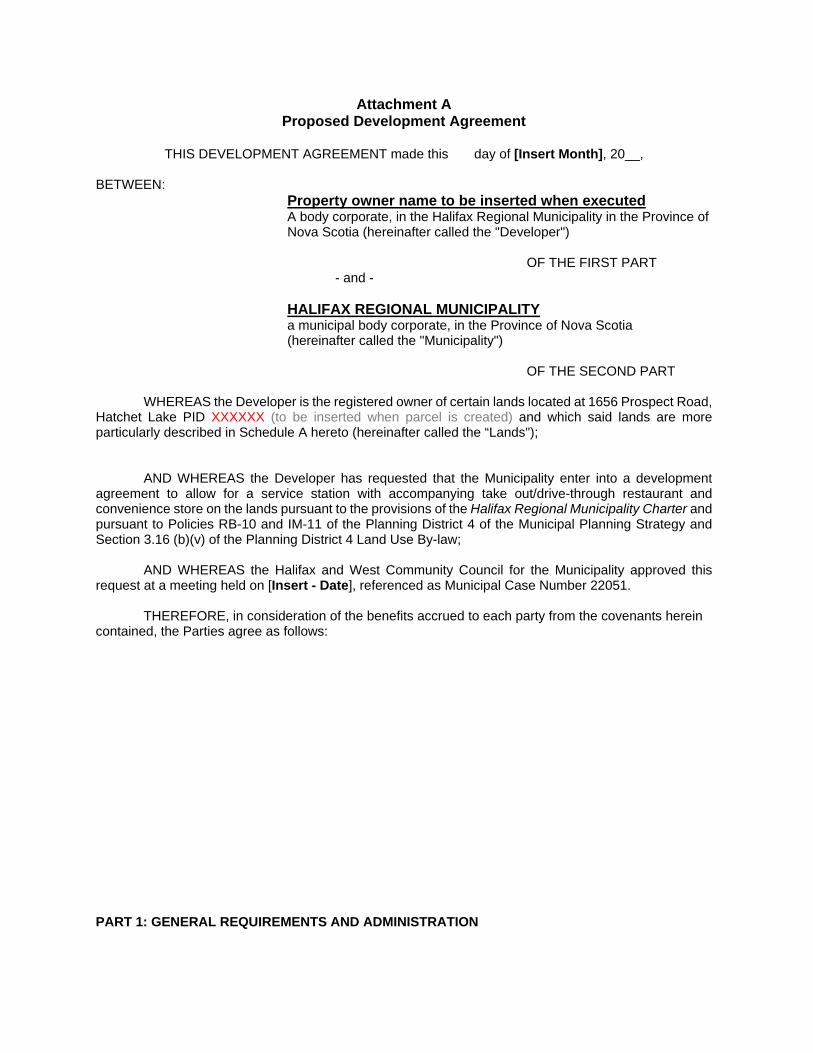
Attachment A Proposed Development Agreement
THIS DEVELOPMENT AGREEMENT made this day of [Insert Month], 20__,
BETWEEN:
Property owner name to be inserted when executed A body corporate, in the Halifax Regional Municipality in the Province of Nova Scotia (hereinafter called the "Developer")
OF THE FIRST PART
- and -
HALIFAX REGIONAL MUNICIPALITY a municipal body corporate, in the Province of Nova Scotia (hereinafter called the "Municipality")
OF THE SECOND PART
WHEREAS the Developer is the registered owner of certain lands located at 1656 Prospect Road,
Hatchet Lake PID XXXXXX (to be inserted when parcel is created) and which said lands are more particularly described in Schedule A hereto (hereinafter called the “Lands");
AND WHEREAS the Developer has requested that the Municipality enter into a development agreement to allow for a service station with accompanying take out/drive-through restaurant and convenience store on the lands pursuant to the provisions of the Halifax Regional Municipality Charter and pursuant to Policies RB-10 and IM-11 of the Planning District 4 of the Municipal Planning Strategy and Section 3.16 (b)(v) of the Planning District 4 Land Use By-law;
AND WHEREAS the Halifax and West Community Council for the Municipality approved this request at a meeting held on [Insert - Date], referenced as Municipal Case Number 22051.
THEREFORE, in consideration of the benefits accrued to each party from the covenants herein
contained, the Parties agree as follows:
PART 1: GENERAL REQUIREMENTS AND ADMINISTRATION
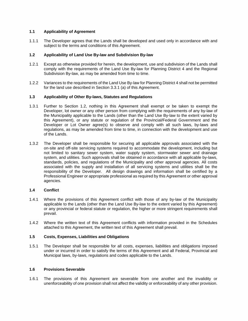
1.1 Applicability of Agreement 1.1.1 The Developer agrees that the Lands shall be developed and used only in accordance with and
subject to the terms and conditions of this Agreement. 1.2 Applicability of Land Use By-law and Subdivision By-law 1.2.1 Except as otherwise provided for herein, the development, use and subdivision of the Lands shall
comply with the requirements of the Land Use By-law for Planning District 4 and the Regional Subdivision By-law, as may be amended from time to time.
1.2.2 Variances to the requirements of the Land Use By-law for Planning District 4 shall not be permitted
for the land use described in Section 3.3.1 (a) of this Agreement. 1.3 Applicability of Other By-laws, Statutes and Regulations 1.3.1 Further to Section 1.2, nothing in this Agreement shall exempt or be taken to exempt the
Developer, lot owner or any other person from complying with the requirements of any by-law of the Municipality applicable to the Lands (other than the Land Use By-law to the extent varied by this Agreement), or any statute or regulation of the Provincial/Federal Government and the Developer or Lot Owner agree(s) to observe and comply with all such laws, by-laws and regulations, as may be amended from time to time, in connection with the development and use of the Lands.
1.3.2 The Developer shall be responsible for securing all applicable approvals associated with the
on-site and off-site servicing systems required to accommodate the development, including but not limited to sanitary sewer system, water supply system, stormwater sewer and drainage system, and utilities. Such approvals shall be obtained in accordance with all applicable by-laws, standards, policies, and regulations of the Municipality and other approval agencies. All costs associated with the supply and installation of all servicing systems and utilities shall be the responsibility of the Developer. All design drawings and information shall be certified by a Professional Engineer or appropriate professional as required by this Agreement or other approval agencies.
1.4 Conflict 1.4.1 Where the provisions of this Agreement conflict with those of any by-law of the Municipality
applicable to the Lands (other than the Land Use By-law to the extent varied by this Agreement) or any provincial or federal statute or regulation, the higher or more stringent requirements shall prevail.
1.4.2 Where the written text of this Agreement conflicts with information provided in the Schedules
attached to this Agreement, the written text of this Agreement shall prevail. 1.5 Costs, Expenses, Liabilities and Obligations 1.5.1 The Developer shall be responsible for all costs, expenses, liabilities and obligations imposed
under or incurred in order to satisfy the terms of this Agreement and all Federal, Provincial and Municipal laws, by-laws, regulations and codes applicable to the Lands.
1.6 Provisions Severable 1.6.1 The provisions of this Agreement are severable from one another and the invalidity or
unenforceability of one provision shall not affect the validity or enforceability of any other provision.

PART 2: DEFINITIONS 2.1 Words Not Defined under this Agreement 2.1.2 All words unless otherwise specifically defined herein shall be as defined in the applicable Land
Use By-law and Subdivision By-law, if not defined in these documents their customary meaning shall apply.
PART 3: USE OF LANDS, SUBDIVISION AND DEVELOPMENT PROVISIONS 3.1 Schedules 3.1.1 The Developer shall develop and use the Lands in a manner, which, in the opinion of the
Development Officer, generally conforms with the following Schedules attached to this Agreement and filed in the Halifax Regional Municipality as Case Number 22051:
Schedule A Legal Description of the Lands Schedule B Site Plan - Entire Property Schedule C Detailed Site Plan Schedule D Preliminary Stormwater Management Plan
3.2 Requirements Prior to Approval 3.2.1 Prior to the commencement of any site work on the Lands, the Developer shall consider
appropriate stormwater management throughout the construction and in the final design by providing the following to the Development Officer:
(a) A Site Disturbance Plan prepared by a Professional Engineer in accordance with this
Agreement; (b) A detailed Erosion and Sedimentation Control Plan prepared by a Professional Engineer
in accordance with this Agreement; and (c) A detailed Stormwater Management Plan prepared by a Professional Engineer in
accordance with this Agreement. 3.2.2 Prior to the issuance of a Development Permit on the Lands, the Developer shall provide the
following to the Development Officer, unless otherwise permitted by the Development Officer as per the terms of this Agreement:
(a) Nova Scotia Department of Transportation and Infrastructure approval of the site access
in accordance with this Agreement; (b) Nova Scotia Department of Transportation and Infrastructure approval of the Stormwater
Management Plan in accordance with this Agreement; (c) Nova Scotia Environment approval of on-site sewage treatment facilities in accordance
with this Agreement; (d) A detailed Landscape Plan prepared by a Landscape Architect in accordance with this Agreement; and (e) Lighting in accordance with this Agreement.
3.2.3 Prior to the issuance of the first Municipal Occupancy Permit, the Developer shall provide the following to the Development Officer:
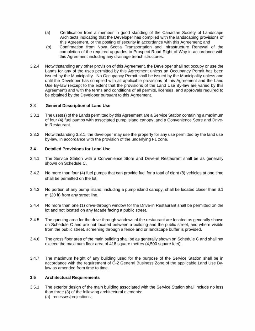
(a) Certification from a member in good standing of the Canadian Society of Landscape Architects indicating that the Developer has complied with the landscaping provisions of this Agreement, or the posting of security in accordance with this Agreement; and
(b) Confirmation from Nova Scotia Transportation and Infrastructure Renewal of the completion of the required upgrades to Prospect Road Right of Way in accordance with this Agreement including any drainage trench structures.
3.2.4 Notwithstanding any other provision of this Agreement, the Developer shall not occupy or use the
Lands for any of the uses permitted by this Agreement unless an Occupancy Permit has been issued by the Municipality. No Occupancy Permit shall be issued by the Municipality unless and until the Developer has complied with all applicable provisions of this Agreement and the Land Use By-law (except to the extent that the provisions of the Land Use By-law are varied by this Agreement) and with the terms and conditions of all permits, licenses, and approvals required to be obtained by the Developer pursuant to this Agreement.
3.3 General Description of Land Use 3.3.1 The uses(s) of the Lands permitted by this Agreement are a Service Station containing a maximum
of four (4) fuel pumps with associated pump island canopy, and a Convenience Store and Drive-in Restaurant.
3.3.2 Notwithstanding 3.3.1, the developer may use the property for any use permitted by the land use
by-law, in accordance with the provision of the underlying I-1 zone. 3.4 Detailed Provisions for Land Use 3.4.1 The Service Station with a Convenience Store and Drive-in Restaurant shall be as generally
shown on Schedule C. 3.4.2 No more than four (4) fuel pumps that can provide fuel for a total of eight (8) vehicles at one time
shall be permitted on the lot. 3.4.3 No portion of any pump island, including a pump island canopy, shall be located closer than 6.1
m (20 ft) from any street line. 3.4.4 No more than one (1) drive-through window for the Drive-in Restaurant shall be permitted on the
lot and not located on any facade facing a public street. 3.4.5 The queuing area for the drive-through windows of the restaurant are located as generally shown
on Schedule C and are not located between a building and the public street, and where visible from the public street, screening through a fence and or landscape buffer is provided.
3.4.6 The gross floor area of the main building shall be as generally shown on Schedule C and shall not
exceed the maximum floor area of 418 square metres (4,500 square feet). 3.4.7 The maximum height of any building used for the purpose of the Service Station shall be in
accordance with the requirement of C-2 General Business Zone of the applicable Land Use By-law as amended from time to time.
3.5 Architectural Requirements 3.5.1 The exterior design of the main building associated with the Service Station shall include no less
than three (3) of the following architectural elements: (a) recesses/projections;
(b) cornices and parapets; (c) peaked roof forms; (d) overhangs; (e) architectural details such as tile or stone work, and decorative moldings; or (f) any other similar architectural treatment deemed to be an acceptable equivalent.
3.5.2 The predominant roof slope shall be pitched with a minimum slope of approximately 2/12. The
structure shall be articulated with a roof design that incorporates features such as dormers, parapets, peak roof forms, or other architectural treatment considered to be acceptable.
3.5.3 Building materials shall not include vinyl siding. 3.5.4 All vents, down spouts, flashing, electrical conduits, meters, service connections, and other
functional elements shall be treated as integral parts of the design. Where appropriate, these elements shall be painted to match the colour of the adjacent surface, except where used expressly as an accent.
3.6 Parking, Circulation and Access 3.6.1 Vehicle parking shall be provided as generally shown on Schedule C and shall have a hard-
finished surface such as asphalt, concrete, interlocking precast paver stones, or an acceptable equivalent in the opinion of the Development Officer.
3.6.2 Parking spaces shall be located as generally shown on Schedule C, however the parking spaces
may be reallocated at the time of permits if required for improving vehicle circulation. At least two parking spaces must be allocated as accessible parking spaces.
3.6.3 Parking spaces, stop bars, pedestrian circulation (walkways and on-site crosswalks) and access
shall be generally as shown on Schedule C. 3.6.4 A designated pedestrian pathway connecting the main building on the subject land to the adjacent
lot to the south east as shown on Schedule B. The designated pedestrian walkway shall have a finished hard surface such as poured in place concrete, interlocking paving stones, or an acceptable equivalent in the opinion of the Development Officer. On-site crosswalks associated with the designated pedestrian pathway are shown as dashed lines on Schedule C and shall be demarcated with signs and pavement markings. The on-site crosswalks may be finished with an alternative hard surface, such as asphalt.
3.6.5 In consultation with NSTIR and the Municipal Engineer, the Development Officer may vary the
requirements of the design, orientation, and size of the vehicle access and egress points. 3.7 Landscaping 3.7.1 Prior to the issuance of a Development Permit, the Developer agrees to provide a detailed
Landscape Plan which shall provide details of the landscaped areas shown on Schedule C along Prospect Road. The Developer may provide additional plantings and landscaping features than shown on Schedule C. The Landscape Plan shall be prepared by a Landscape Architect, who shall be a member in good standing with the Canadian Society of Landscape Architects, and comply with all provisions of this section.
3.7.2 Landscaping required by Section 3.7.1 shall include the following:
(a) a 4.6 metre (15 feet) wide landscaping strip along the public street frontage, exclusive of driveways. The landscape strip shall be sodded and include a minimum of one (1) tree
(minimum of 60 mm caliper) and three (3) shrubs per 7.6 metres (25 feet) of street frontage. The incorporation of trees and shrubs into the landscaped strip may be provided in the form of groupings, provided a minimum ratio of one (1) tree and three (3) shrubs are provided per 7.6 metres (25 feet) of street frontage.
(b) Notwithstanding Section 3.7.2(a), existing trees may be substituted where trees and shrubs are required; and
(c) All other landscaped areas shall be grassed, or alternatively, natural ground covers such as water features, stone (washed or flat), mulch, perennials, and annuals may be utilized.
(d) As required by Section 26.4 of the Planning District 4 LUB, an effective 4.6 metre (15 feet) landscaped barrier is required along the northeast property line. This buffer as shown on Schedule C is to provide a visible and environmental barrier between the commercial use of the subject lands and the adjacent vacant residential property and the wetland. This buffer may consist of either existing vegetation, newly established vegetation or a combination of both. The following species are recommended for consideration: Speckled Alder, Red Maple, Red Elderberry, Pin Cherry, Willow, Balsam Fir and Grey Birch.
3.7.3 Planting details for each type of plant material proposed on the detailed Landscape Plan shall be
provided, including a species list with quantities, size of material, and common and botanical names (species and variety).
3.7.4 Plant material shall be primarily comprised of native species and conform to the Canadian Nursery
Trades Association’s Metric Guide Specifications and Standards and sodded areas to the Canadian Nursery Sod Growers' Specifications.
3.7.5 Construction Details for all tree protection hoarding, benches, light standards and luminaries, trash
receptacles, bike racks, tree grates and guards, planter seating wall, wood arbour, outdoor garbage enclosure, railings, and fencing shall be provided to the Development Officer with the Landscape Plan.
3.7.6 Prior to issuance of the first Occupancy Permit the Developer shall submit to the Development
Officer a letter prepared by a member in good standing of the Canadian Society of Landscape Architects certifying that all landscaping has been completed according to the terms of this Development Agreement.
3.7.7 Notwithstanding Section 3.7.6, the Occupancy Permit may be issued provided that the weather
and time of year does not allow the completion of the outstanding landscape works and that the Developer supplies a security deposit in the amount of 110 percent of the estimated cost to complete the landscaping. The cost estimate is to be prepared by a member in good standing of the Canadian Society of Landscape Architects. The security shall be in favour of the Municipality and shall be in the form of a certified cheque or automatically renewing, irrevocable letter of credit issued by a chartered bank. The security shall be returned to the Developer only upon completion of the work as described herein and illustrated on the Schedules, and as approved by the Development Officer. Should the Developer not complete the landscaping within twelve months of issuance of the Occupancy Permit, the Municipality may use the deposit to complete the landscaping as set out in this section of the Agreement. The Developer shall be responsible for all costs in this regard exceeding the deposit. The security deposit or unused portion of the security deposit shall be returned to the Developer upon completion of the work and its certification.
3.8 Signs 3.8.1 Signage shall be subject to the requirements of the applicable Land Use By-law and the following
additional requirements:
(a) A pump island canopy associated with a Service Station may include one (1) sign, provided the sign is not backlit and no larger than thirty (30) square feet.
(b) Signage associated with vehicle circulation and drive-through is permitted as per the Land Use By-law.
3.9 Solid Waste Facilities 3.9.1 All refuse and recycling materials shall be contained within a building, or within suitable containers
which are fully screened from view from any street. Further consideration shall be given to locating all refuse and recycling material to ensure minimal effect on abutting property owners by means of opaque fencing or masonry walls or suitable landscaping.
3.9.2 Notwithstanding Section 3.9.1 of this Agreement, small waste receptacles are permitted
throughout the development and are to be considered as part of the landscaping for the development.
3.10 Screening 3.10.1 Propane tanks, and electrical transformers shall be located on the Lands in such a way to ensure
minimal visual impact from the public street. These facilities shall be secured in accordance with the applicable approval agencies and screened by means of opaque fencing, masonry walls or suitable landscaping.
3.10.2 Rooftop equipment, including, but not limited to, satellite and other telecommunication equipment,
air handling units, elevator equipment, cooling towers and exhaust fans shall be screened (visually) from the public street and adjacent properties. The screening shall include but not limited to parapets and enclosures. Building screens shall be part of the architectural design with similar detailing and materials and not appear as add-ons.
3.11 Outdoor Lighting 3.11.1 Outdoor lighting shall be subject to the requirements of the Land Use By-law for Planning District
4 and the following additional requirements:
(a) Lighting on the Lands shall be sufficient to promote the safety and security of all users; (b) Lighting shall be directed to driveways, parking areas, loading areas, building entrances and
walkways, and shall be arranged so as to divert the light away from streets, adjacent lots and buildings;
(c) No portion of pump island canopy shall be backlit. Notwithstanding, a pump island canopy may be used as an anchor to direct light immediately beneath the canopy;
(d) Freestanding security lighting shall not exceed 5.5 metres (18 feet) in height; and (e) All exterior lighting shall be directed downward, with luminaries shielded to prevent
unnecessary glare. 3.12 Temporary Construction Structure 3.12.1 A temporary structure shall be permitted on the Lands for the purpose of housing equipment,
materials and office related matters relating to the construction of the development in accordance with this Agreement. The temporary structure shall be located no less than ten (10) feet from any watercourse buffer required by the Land Use By-law and shall be removed from the Lands prior to the issuance of the last Occupancy Permit.
3.13 Maintenance 3.13.1 The Developer shall maintain and keep in good repair all portions of the development on the
Lands, including but not limited to, the exterior of the building, fencing, walkways, parking areas and driveways, drainage trenches and the maintenance of all landscaping including the
replacement of damaged or dead plant stock, trimming and litter control, garbage removal and snow and ice control, salting or sanding of paved walkways and driveways.
PART 4: STREETS AND SERVICES 4.1 General Provisions 4.1.1 All design and construction of primary and secondary service systems shall satisfy the most
current edition of the Municipal Design Guidelines unless otherwise provided for in this Agreement and shall receive written approval from the Development Engineering prior to undertaking the work.
4.2. Off-Site Disturbance 4.2.1 Prior to the issuance of a Building Permit, the Developer agrees to provide to the Development
Officer a “Work Within Highway Right-of-Way Permit” approved by Nova Scotia Transportation and Infrastructure Renewal. Any disturbance to existing off-site infrastructure resulting from the development, including but not limited to, streets, turning lanes, street trees, landscaped areas and utilities, drainage trenches shall be the responsibility of the Developer, and shall be reinstated, removed, replaced or relocated by the Developer as directed by Nova Scotia Transportation and Infrastructure Renewal.
4.3 On-Site Sewage System 4.3.1 The Lands shall be serviced through privately owned and operated on-site sewage disposal
systems and treatment facilities. The Developer agrees to have prepared by a qualified professional and submitted to the Municipality and Nova Scotia Environment, a design for all private sewage disposal system(s). In accordance with Section 3.2.2(c), no Development Permit shall be issued prior to the Development Officer receiving a copy of all permits, licences, and approvals required by Nova Scotia Environment respecting the design, installation, construction of the on-site sewage system.
4.4 On-Site Water System 4.4.1 The Lands shall be serviced through a privately owned and operated on-site water distribution
system. PART 5: ENVIRONMENTAL PROTECTION MEASURES 5.1 Stormwater Management Plans and Erosion and Sedimentation Control Plans 5.1.1 Prior to the commencement of any site work on the Lands, including earth movement or tree
removal other than that required for preliminary survey purposes, or associated off-site works, the Developer shall:
(a) Submit to the Development Officer a detailed Site Disturbance Plan, prepared by a
Professional Engineer indicating the sequence and phasing of construction and the areas to be disturbed or undisturbed;
(b) Submit to the Development Officer a detailed Erosion and Sedimentation Control Plan prepared by a Professional Engineer in accordance with the Erosion and Sedimentation Control Handbook for Construction Sites as prepared and revised from time to time by Nova Scotia Environment. Notwithstanding other sections of this Agreement, no work is permitted on the Lands until the requirements of this clause have been met and implemented. The Erosion and Sedimentation Control Plan shall indicate the sequence of construction, all proposed detailed erosion and sedimentation control measures and
interim stormwater management measures to be put in place prior to and during construction; and
(c) Submit to the Development Officer a detailed Site Grading and Stormwater Management Plan prepared by a Professional Engineer.
5.1.2 The Developer agrees to construct, at their own expense, the Stormwater Management System
as generally shown on Schedule D, the preliminary Stormwater Management Plan for the development which conforms to the design submitted to the Development Officer and reviewed by the Nova Scotia Transportation and Infrastructure Renewal. The Developer shall provide certification from a Professional Engineer that the system, or any phase thereof, has been constructed in accordance with the approved design.
5.1.3 The Developer agrees, at its own expense, to maintain in good order all stormwater facilities on
the Lands. PART 6: AMENDMENTS 6.1 Non-Substantive Amendments 6.1.1 The following items are considered by both parties to be non-substantive and may be amended
by resolution of Council.
(a) Changes to the location of the landscaped areas which, in the opinion of the Development Officer, do not conform with Schedule C or Section 3.7 of this Agreement;
(b) Changes to the exterior design of the main buildings as detailed in Section 3.5.1; (c) Minor expansions to the main buildings not exceeding ten per cent (10%) of the gross floor
area of the building permitted by this Agreement; (d) Changes to the requirements related to signage as identified in Section 3.8 of this
Agreement; (e) The granting of an extension to the date of commencement of development as identified
in Section 7.3 of this Agreement; and (f) The length of time for the completion of the development as identified in Section 7.4 of
this Agreement. 6.2 Substantive Amendments 6.2.1 Amendments to any matters not identified under Section 6.1 shall be deemed substantive and
may only be amended in accordance with the approval requirements of the Halifax Regional Municipality Charter.
PART 7: REGISTRATION, EFFECT OF CONVEYANCES AND DISCHARGE 7.1 Registration
A copy of this Agreement and every amendment or discharge of this Agreement shall be recorded at the Registry of Deeds or Land Registry Office at Halifax, Nova Scotia, and the Developer shall incur all costs in recording such documents.
7.2 Subsequent Owners 7.2.1 This Agreement shall be binding upon the parties hereto, their heirs, successors, assigns,
mortgagees, lessees and all subsequent owners, and shall run with the Lands which are the subject of this Agreement until this Agreement is discharged by Council.
7.2.2 Upon the transfer of title to any lot(s), the subsequent owner(s) thereof shall observe and perform the terms and conditions of this Agreement to the extent applicable to the lot(s).
7.3 Commencement of Development 7.3.1 In the event that development on the Lands has not commenced within five (5) years from the
date of registration of this Agreement at the Registry of Deeds or Land Registry Office, as indicated herein, the Lands shall conform with the provisions of the Land Use By-law.
7.3.2 For the purpose of this section, commencement of development shall mean the issuance of a
Building Permit. 7.3.3 For the purpose of this section, Council may consider granting an extension of the commencement
of development time period through a resolution under Section 6.1, if the Municipality receives a written request from the Developer at least sixty (60) calendar days prior to the expiry of the commencement of development time period.
7.4. Completion of Development 7.4.1 If the Developer fails to complete the development after seven (7) years from the date of
registration of this Agreement at the Registry of Deeds or Land Registration Office, Council may review this Agreement, in whole or in part, and may: (a) retain the Agreement in its present form; (b) negotiate a new Agreement; (c) discharge this Agreement. (d) for those portions of the development which are completed, discharge this Agreement and
apply appropriate zoning pursuant the Municipal Planning Strategy and Land Use By-law for Planning District 4, as may be amended from time to time.
7.4.2 For the purpose of this section, completion of development shall mean the issuance of the first
Occupancy Permit. 7.4.3 For the purpose of this section, Council may consider granting an extension of the completion of
development time period through a resolution under Section 6.1, if the Municipality receives a written request from the Developer at least sixty (60) calendar days prior to the expiry of the completion of development time period.
7.5 Discharge of Agreement 7.5.1 Upon the completion of the whole development or complete phases of the development, Council
may review this Agreement, in whole or in part, and may: (a) retain the Agreement in its present form; (b) negotiate a new Agreement; or (c) discharge this Agreement.
PART 8: ENFORCEMENT AND RIGHTS AND REMEDIES ON DEFAULT 8.1 Enforcement 8.1.1 The Developer agrees that any officer appointed by the Municipality to enforce this Agreement
shall be granted access onto the Lands during all reasonable hours without obtaining consent of the Developer. The Developer further agrees that, upon receiving written notification from an officer of the Municipality to inspect the interior of any building located on the Lands, the Developer
agrees to allow for such an inspection during any reasonable hour within twenty-four hours of receiving such a request.
8.2 Failure to Comply 8.2.1 If the Developer fails to observe or perform any condition of this Agreement after the Municipality
has given the Developer thirty (30) days written notice of the failure or default, then in each such case:
(a) The Municipality shall be entitled to apply to any court of competent jurisdiction for
injunctive relief including an order prohibiting the Developer from continuing such default and the Developer hereby submits to the jurisdiction of such Court and waives any defence based upon the allegation that damages would be an adequate remedy;
(b) The Municipality may enter onto the Lands and perform any of the covenants contained
in this Agreement or take such remedial action as is considered necessary to correct a breach of the Agreement, whereupon all reasonable expenses whether arising out of the entry onto the Lands or from the performance of the covenants or remedial action, shall be a first lien on the Lands and be shown on any tax certificate issued under the Assessment Act;
(c) The Municipality may by resolution discharge this Agreement whereupon this Agreement
shall have no further force or effect and henceforth the development of the Lands shall conform with the provisions of the Land Use By-law; or,
(d) In addition to the above remedies, the Municipality reserves the right to pursue any other
remedy under the Halifax Regional Municipality Charter or Common Law in order to ensure compliance with this Agreement.
IN WITNESS WHEREAS the said parties to these presents have hereunto set their hands and affixed their seals the day and year first above written. SIGNED, SEALED AND DELIVERED in the presence of: Witness SIGNED, DELIVERED AND ATTESTED to by the proper signing officers of Halifax Regional Municipality, duly authorized in that behalf, in the presence of: Witness Witness
[Insert Name] Per:________________________________
HALIFAX REGIONAL MUNICIPALITY Per:________________________________ MAYOR Per:________________________________ MUNICIPAL CLERK
NOTES:
DRAWING
NO.:
DRAWN
BY:
DATE:
SCALE:
2019-07-19
TITLE:
Sherwood Enterprises Inc.
38 Dillon Cres
Halifax, NS B3M 4A8
(902) 443-3020
OWNER:
STAMP:
CONSULTANT: REVISIONS
PROPOSED GAS STATION
1656 PROSPECT RD, HATCHET
LAKE, NS
NO. DESCRIPTION
ISSUED FOR REVIEW
DATEBY
1
ISSUED FOR
BUILDING PERMIT
3
ISSUED FOR
CONSTRUCTION
4
CYGNET
PROPERTIES
LIMITED
JULY19/19JW
2
ISSUED FOR
DEV. AGREEMENT
DRAWING:
SCHEDULE BSITE PLAN - ENTIRE PROPERTY
S-101
1:500 METRIC
J. WHITE
SITE PLAN OF SHOWING ENTIRE PROPERTY BOUNDARIES
JUNE19/20JW
REVISIONS
NO. DESCRIPTION
ISSUED FOR REVIEW
DATEBY
1
ISSUED FOR
BUILDING PERMIT
4
ISSUED FOR
CONSTRUCTION
5
JUNE 19/20JW2
ISSUED FOR
DEV. PERMIT
3
REVISED
REVISED
6
NOTES:
DRAWING
NO.:
DRAWN
BY:
DATE:
SCALE:
2020-06-19
TITLE:
Sherwood Enterprises Inc.
38 Dillon Cres
Halifax, NS B3M 4A8
(902) 443-3020
OWNER:
STAMP:
CONSULTANT:
PROPOSED GAS STATION
1656 PROSPECT RD, HATCHET
LAKE, NS
CYGNET
PROPERTIES
LIMITED
DRAWING:
SCHEDULE C DETAILED SITE PLAN
S-102
1:1000 METRIC
J. WHITE
5 YEAR STORM EVENT HYDROGRAPH COMPARISON
-0 :;a 0 VJ -0 fT1 0 -I :;a 0 J> 0
2
"D
§
�
N
0
0
----
�
�
,. !.,
PROPOSED 2m WIDE ROCK LINED SPILLWAY
250mm HDPE PIPE C/W STANDPIPE AND DEBRIS SCREEN
�¾ DRAINAGE TRENCH: TOTAL AREA 193m' DEPTH 1.0m SEE DETAIL C101/1 STCB-1
1050 mm RIM: 93.055 INV OUT: 92.200 STP-1
" I,_ 3m DROP CURB SECTION TO
ACCOMMODATE 100 YEAR STORM EVENT /4"1
INLET STORMCEPTOR STC 300i ';> OR EQUIVALENT OIL/SEDIMENT SEPARATOR SEE DETAIL C101/2
0"----1
t t S 1111 ,t . I .o-,sz
., t
o>.,, ill(") "' C:"'
! aJz
xi (/)
.01-,llt
0.0:50 ·
0.045
0.040
0.035
!::l,,Q,Q�O
� 0.025
z r
--ri 0.020
rr0.01 5
)> 0.010 ·
o.□os
0.000 0 2 6 e
7J 0 ..i,.r oO cc -f :t c...
/
--/ �
I
I
I
Proposed 5 Year Subbasin Summary
� ,!EJ
5-year intensity storm with a total rainfall amount of 111.8 mm using a Chicago Stormstorm distribution.
63'-6"
SN Subbasin ID
Area Weighted Total Total Cur..e Rainfall Runo
Total Peak Runoff Runo
lime o Concentration
(ha) 1 Asphalt&Roof 0.37 2 Landscape 0.11
Number Volume (mm) (mm) (ha-mm) (ems) (days hh:mm:ss)
98.00 111.15 105.16 38.44 0.047 0 00:05:00 70.00 111.15 40.26 4.47 0.005 0 00:34:33
Existin 5 Year Subbasin Summa 5-year intensity storm with a total rainfall amount of 111.8 mm using a ChicagoStorm storm distribution.SN Subbasin Area Weighted Total Total
ID Cur..e Rainfall Runoff Number
Total Peak Runoff Runoff
Volume
Time o Concentration
(ha) (mm) (mm) (ha-mm) (ems) (days hh mm:ss) 1 Sub-01 0.48 85.00 111.15 71.02 33.81 0.040 0 00:28:48
AX SIDE SLOPES 2: 1
-
p SED SUBDMSION BOUNDARY
Pro osed 10 Year Subbasin Summa 10-year intensity storm with a total rainfall amount of 141.1 mm using a Chicago Stormstorm distribution.SN Subbasin
ID
1 Asphalt&Roof 2 Landscape
Area Weighted Total Total Curie Rainfall Runoff
Number (ha) (mm) (mmi0.37 98.00 140.28 134.24 0.11 70.00 140.28 61.75
Total Peak Runoff Runoff
Volume (ha-mm) (ems)
49.07 0.06 6.85 0.01
lime of Concentration
(days hh:mm:ss) 0 00:05:00 0 00:34:33
Existing 10 Year Subbasin Summary 10-year intensity storm with a total rainfall amount of 141.1 mm using a ChicagoStorm stcrm distribution.SN Subbasin Area Weighted Tdal Total Total Peak Time o
ID CuNa Rainfall Runof Runof Runoff Concentration Number Volume
(ha) (mm) (mm) (ha-mm) (ems) (days hh:mm:ss)1 Sub-01 0.48 85.00 140.28 97.89 46.6 1 0.06 0 00:28:48
\ !
.. o-.vg
I
/
Pro osed 100 Year Su bbasin Summa 100-year intensity storm with a total rainfall amount of 232.9 mm using a Chicago Stormstorm distribution.SN Subbasin Area Weighted Total Total Total Peak Time of
ID CuNa Rainfall Runo Runo Runo Concentration Number Volume
(ha) (mm) (mm) (ha-mm) (ems) (days hh:mm:ss) 1 Asphalt&Roof 0.37 98.00 231.54 225.43 82.41 0.099 0 00:05:00 2 Landscape 0.11 70.00 231.54 138.07 15.33 0.018 0 00:34:33
Existing 100 Year Subbasin Summary 100-year intensity storm with a total rainfall amount of 232.90 mm using a Chicago Storm storm distribution. SN Subbasin Area Weighted Total Total Total Peak Timeo
ID Cur.e Rainfall Runoff Runoff Runoff Concentration Number Volume
(ha) (mm) (mm) (ha-mm) (ems) (days hh:mm:ss)1 Sub-01 0.48 85.00 231.54 185.27 88.21 0.103 0 00:28:48
-................._ ___
__
_ - -7°'=-
U
-
RB _c
UT _____________________s
P
-
ILLW
-AY
-
OVE
-
RFL
l
o
--
......._ / �[IIIl]fIDli: ___ \_----------------------------�---
\
a;
"l] Q ,!'j
I
10
\ � "' ....., :::; - r-
!il .....,0 m--<
2 u,....., (/) ol
• )>
"' ;:i
)
I I
\
12 Tirr,e (hrs)
...
\\ �'
14
� Fl )> z 0
25-50mm DECORATIVE STONEFLOW DEFLECTOR=1�n==���1
TO SUIT (INL£T GRAlE DIii.:
ROCK TRENCH CROSS SECTION SCALE: NTS
_ 150-200mm CLEARSTONEON-WOVEN GEOTEXTILE
- 2:1 SIDE SLOPESPERFORATED OUTLET PIPE
INLET STORMCEPTOR SEE DETAIL 3/C101
' ,.. '
.,,._ ______ ...,.., . ... ' .. -· -�. . -· .. � ;SECTION YIFW
ROCK TRENCH OUTLET PROFILE SCALE: NTS
FlNSHED GRADE
ELEVATION 915 [361 MIN.
1549 DROf' ""
511
1029
. .
�----<>1219----�
SECJJON VIEW
- User--Oeiined Max Flc,w - To181 Inflow: Node - Out-01 (1656 �or:o�ed F:ood- SSA - ExF.lling 5 2019-08-0713:31 •28) - Tels: intlow Node Out -01 f1656�opos:,,:11'i:0M SSA pr�posed s 2019-06-0J 1:s;wa1
16 18 20
,,--<RAME AND COVER EMBOSSED 'STORIIICEPTOR"
,,----CONCRETE RISER AND BASE COMPONENTS C/W RUBBER GASKETS FOR JOINTS, MANUFACTURED TO CSA AND OPS STANDARDS.
______ _., ....
,---"'IJTLET PIPE 150 PVC DRl5
280
1524
'----STCIRAGIE SUMP
22
OUTLET RISER ,k MAINmtMICE NX
INLET FRAME AND GRAlE 610x610mm [24•,c241 10 BE LOCATED OYER
INLET DROP-Pl
OUTLEr RISER VAN
Pl AN YIFW CINI fT IDPl
INLET STORMCEPTOR STANDARD DETAIL SCALE: NTS
Ol/11..El"
4 3 2
KEYPLAN
LEGEND
EXISTING PROPOSED '" GATE/BUTTERFLY VALVE '" T STREET SIGN T
POWER POLE/LIGHT POLE ¢/ ---CATCH BASIN
} CULVERT } 158.5 ELEVATION
HYDRANT PROPERTY BOUNDARY
OVERHEAD LINE -SA-D-SA- SANITARY MANHOLE & PIPE -SA---SA-
- ST-0-ST- STORM MANHOLE & PIPE - ST---ST-
-WM--WM- WATER MAIN -WM-WM-e---WM-- WATER SERVICE --WM---FM--FM- FORCEMAIN -FM--FM--c-c- UNDERGROUND CONDUIT -c-- c-
CONCRETE THRUST BLOCK CURB AND DRIVEWAY CUT
SIDEWALK ·-�·-••·, .... ; ;:;_,.� ;;--.�_, ,,
STREET LINE - DRAINAGE DIRECTION ---
SWALE FLOW CONTOUR LINES
-GAS-GAS- GAS LINE -GAS-GAS-
TREE BOTTOM OF SLOPE
TOP OF SLOPE GUARD RAIL SILT FENCE -SF--SF-
· .. OTES
IJ U\J-J IS II\ kE::T�IC UI·. TS CF v::::T::::F:S UI\L::::ss c-HEP'1/1/ISE ST/\ED11 r2rn1 cJ.,J1·'" c::.::�\1_::i,,\---;1c_s sri:::i\'i\l ,'\---;=- i\l) l---(C)/llvl/\ c_ JI\JL·--. S�� '.'.--,!Al'.11-H: 1:1 .t J.J �'.'.R -I -\/t 1,::1· '.f-s:'.4 :� '.-;
4. (;Rt.I)-•:· �=:-(")\i'[\I �CR -,)-VI-'/'/ :1_Jf-?11c:;-�: C,\IY. 1---; h 1-�()I A. (;f-s:'A�Pl All
" 'lll ,t:s--::·c1 Tli F. 7,2.,I = ,i',,\C, 1:-.1R [ll __ l 1:11·\1c; rrTA I � �, STCFl-1 CL1C. �"-.T :Jl,t) CC,\/=·_ETEC.: U::C:11\IG TH:::: s:::::; -R-20 --r-·=:::;:c,_:::::;·-.
[\JE-f---CC .LI\J[I 3CS T� 55 F::w THE -1\,E OF CO I-J2::::\JTRAT C)[\J 'vlE-HC::: STCl'!l''-'1 ::v::·-,n;:. HC=:[L[D ~-::-II\G 1/1:]Clll[D C I2,,\GO ST:JR\1 'NIT I _CCi\L R/',l\l=-/\L_ i \/Os.-ll'FS.
l1R01io::;c__:: SIO-<·\G=- = /l1.9m' ---:p:;,rCSff,1 :;ic:,::-; FIi I \/Ci I_H_:IF STC:iRACF = I :=:,.7rn5
f;'. J:-;;;: \/:llD :;it,.TIC) -'l'-:'.)PC'.'.)11) Iii I '.) '.ll-:/:C..(; All'.>'/1 - )h./T, 5
Tl - l'�T (-/1.!:..TID ·:::-c,--:::t..:�1 -r::11.J1--:::1H1r-.. TS r.1 r-1_\y:-;1 Tl 1- PIA ii C,1 1/,' -, ?ll\ 1:-;
t, 5 1[.t..R ST:.:::'l'J'ii [\/[l'-F 11':::Jl\'1 J.:.:::::::,21_·rns l:._'. C.O'tC1 .:_"v,:,; \/,-C-T ::::.ALC:_1_.t..T[D ,SIi-i<: !-JT<::DES STC:RH '· D S/·.·W/·.C" i l!-L"SIS s::,F-/ii\'c. TcE cS-11-Y·E) STO�."'.:-:CE IS SHC\/'/r-._ ::::1\ n-::: ATTlLHED "'· '(E."'.R ::i�:::/·::ic:,s- l�Cl'/IP.4� SCI·
r::r?CCP.4::i I.
Tl - rc:r---:: · r::RA 1·-.JAc;- r-;T\L---:: I C: 1,,-:::I(;I'-.IID TO '.)Torr ,::., :-=:
,
'(LL.I·! ::l(Jl!H L\:U--1. UUl·il-.1'._' "U:J YU'--! S :_::1-;\1 _VL'-J S ()I' I LC.:11:.JlJ CC\J I 01\IS n -=- RO::, [PA 1·-usc=- T=cF\J:;7 S 1,1=-s UF--::1 TO c,·JF=c=-1 C'/,,V \ii.A THF RJ'."'.I< _ [··)[C SF·IL_'NAY
08/01/20 ISSUED FOR PERMIT 08/08/19 ISSUED FOR PERMIT 08/03/19 REVISED FOR NSTIR REVIEW 06/11/18 ISSUED FOR REVIEW
No. Date Revision Description
Seal
Om
Date
Sm
ENGINEERING SERVICES INC 4073 HIGHWAY 3, CHESTER. NS BOJ 1 JO TEL. 902-273-3050 FAX. 902-273-3072
SCALE: 1 :250
10m 15m
www.ableinc.ca
20m 25m
1656 PROSPECT ROAD
HATCHET LAKE, NS
SCHEDULE D PreliminarySTORMWATER ANALYSIS PLAN
Drawn NOVEMBER 1, 2018 J.KEEPING
Project No. 181101-02
Scale 1 :250
Engineer J.PINHEY Plan No.
C 1 Q 1
Attachment B: Review of Relevant Policies from the Municipal Planning Strategy for
Planning District 4 It is also recognized that larger scale general commercial operations, service stations, motels, and commercial entertainment uses may be suitably located along Highway No. 333 with minimal impact on the surrounding community. Such operations are required to provide the necessary services to expanding communities and also contribute to the growing tourist industry which is highly valued within Planning District 4. These larger scale activities, however, will have a greater degree of impact on the surrounding area in terms of traffic generation, draw on ground water resources, noise, litter and aesthetics. In order to ensure that these uses are properly integrated within the community, commercial operations which exceed ten percent of the lot area, service stations, motels and commercial entertainment uses shall only be considered by development agreement pursuant to the Planning Act.
RB-10 Notwithstanding Policy RB-2 or Policy RB-4, within the Residential B Designation, Council may consider permitting uses permitted in the general business zone, which are in excess of ten (10) percent of lot area, service stations, motels and entertainment uses in accordance with the development agreement provisions of the Planning Act. In considering such agreements, Council shall have regard to the following:
Policy Criteria Staff Comment (a) that the architectural design (external
appearance) and scale of any structures are compatible with nearby land uses;
Architectural design provisions have been included in the proposed development agreement. The site is in close proximity to residential uses therefore a pitched roof, lighting controls, buffering and landscaping requirements are included in order to minimize the impact of architectural integrity of the homes and uses along Prospect Road.
(b) that adequate separation distances are maintained from low density residential developments;
There is residential development in close proximity. The closest residential dwelling is approx. 75 metres to the southwest of the site. On both sides of the site there is a vacant lot. A buffer is required along the northeastern property line and a landscaping plan is required for the site.
(c) the provision of landscaping and screening from any adjacent residential development;
(d) the impact of the proposed use on the existing road network in terms of traffic generation and vehicular and pedestrian safety;
A Traffic Impact Study (TIS) was submitted in support of this application. The TIS asserts that the majority of traffic using the proposed development will be traffic already using the Prospect Road (pass-by trips) and that the proposed development is not expected to cause any operation related problems on Prospect Road. Prospect Road is a provincial arterial highway which handles volumes of approximately 940 vehicle trips in the am peek and 1,200 vehicles in the pm peek. The Nova Scotia Department of Transportation and Infrastructure Renewal (NSTIR) has reviewed the proposal and advised that the access to the site and the Prospect Road will need to be widened to accommodate dedicated turning lanes. A truck turning design was also submitted which was analyzed for vehicular and pedestrian safety. The proposed use, being an auto-centric land use is not anticipated to generate much pedestrian traffic. The proposed development agreement
requires a signed dedicated pedestrian pathway from the main proposed building to the adjacent site that has a building permit for a as-of right commercial plaza. This will reduce potential pedestrian and vehicle movement conflicts.
(e) the means by which solid and liquid waste will be treated;
The subject site will be serviced by on-site septic and well services. Permits will be required from NS Environment prior to a Building permit.
(f) the effects of the development on the natural environment and the means for handling stormwater runoff;
The proposed development agreement requires a detailed site grading and stormwater management plan be submitted prior to the commencement of any work on the site.
(g) the general maintenance of the development; The proposed development agreement addresses the general maintenance of the property.
(h) the hours of operation; and Given the distance from residential development and the vacant lots discussed above, no restrictions have been placed on the hours of operation of the development.
(i) the provision of Policy IM-11. See Table Below
IM-11 In considering development agreements or amendments to the land use bylaw, in addition to all other criteria as set out in various policies of this Planning Strategy, Council shall have appropriate regard to the following matters:
Policy Criteria Staff Comment (a) that the proposal is in conformity with the
intent of this Planning Strategy and with the requirements of all other municipal by-laws and regulations;
The proposal is consistent with Policy RB-10 (see above table).
(b) that the proposal is not premature or inappropriate by reason of:
…
(i) the financial capability of the Municipality to absorb any costs relating to the development;
The developer will be responsible for all costs associated with the development.
(ii) the adequacy of on-site sewerage and water services;
Please see staff comment on Policy RB-10(e) above.
(iii) the proximity of the proposed development to schools, recreation or other community facilities and the capability of these services to absorb any additional demands;
This proposal would not result in an increase to school age population nor is it anticipated to affect community recreation facilities.
(iv) the adequacy of road networks leading to or within the development; and
As discussed above under policy criteria RB-10(d) the Prospect Road is a provincial arterial highway capable of accommodating the traffic generated by the proposed development.
(v) the potential for damage to or for destruction of designated historic buildings and sites.
No historical buildings or sites have been identified.
(c) that controls are placed on the proposed development so as to reduce conflict with any adjacent or nearby land uses by reason of:
…
(i) type of use; The proposed development agreement enables the use of the lands for a service station and included an associated drive-through restaurant
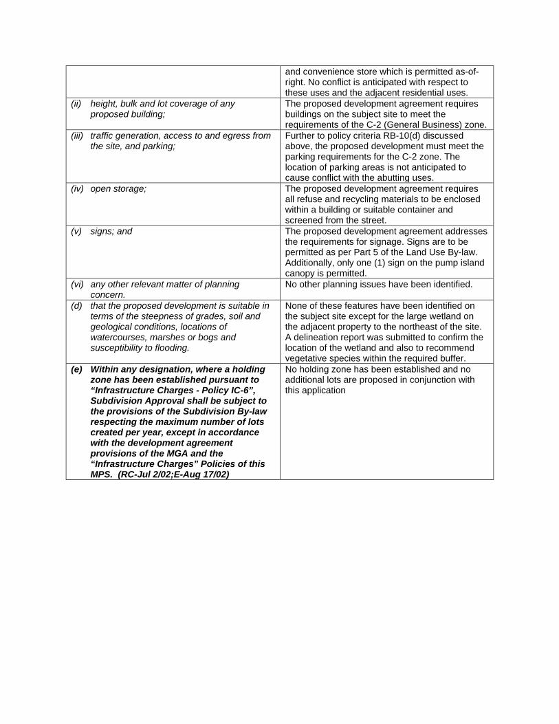
and convenience store which is permitted as-of-right. No conflict is anticipated with respect to these uses and the adjacent residential uses.
(ii) height, bulk and lot coverage of any proposed building;
The proposed development agreement requires buildings on the subject site to meet the requirements of the C-2 (General Business) zone.
(iii) traffic generation, access to and egress from the site, and parking;
Further to policy criteria RB-10(d) discussed above, the proposed development must meet the parking requirements for the C-2 zone. The location of parking areas is not anticipated to cause conflict with the abutting uses.
(iv) open storage; The proposed development agreement requires all refuse and recycling materials to be enclosed within a building or suitable container and screened from the street.
(v) signs; and The proposed development agreement addresses the requirements for signage. Signs are to be permitted as per Part 5 of the Land Use By-law. Additionally, only one (1) sign on the pump island canopy is permitted.
(vi) any other relevant matter of planning concern.
No other planning issues have been identified.
(d) that the proposed development is suitable in terms of the steepness of grades, soil and geological conditions, locations of watercourses, marshes or bogs and susceptibility to flooding.
None of these features have been identified on the subject site except for the large wetland on the adjacent property to the northeast of the site. A delineation report was submitted to confirm the location of the wetland and also to recommend vegetative species within the required buffer.
(e) Within any designation, where a holding zone has been established pursuant to “Infrastructure Charges - Policy IC-6”, Subdivision Approval shall be subject to the provisions of the Subdivision By-law respecting the maximum number of lots created per year, except in accordance with the development agreement provisions of the MGA and the “Infrastructure Charges” Policies of this MPS. (RC-Jul 2/02;E-Aug 17/02)
No holding zone has been established and no additional lots are proposed in conjunction with this application
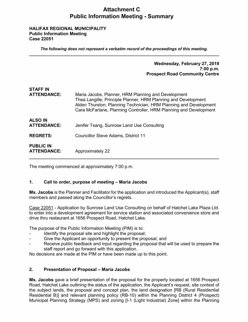
HALIFAX REGIONAL MUNICIPALITY Public Information Meeting Case 22051
The following does not represent a verbatim record of the proceedings of this meeting.
Wednesday, February 27, 2019 7:00 p.m.
Prospect Road Community Centre
STAFF IN ATTENDANCE: Maria Jacobs, Planner, HRM Planning and Development
Thea Langille, Principle Planner, HRM Planning and Development Alden Thurston, Planning Technician, HRM Planning and Development Cara McFarlane, Planning Controller, HRM Planning and Development
ALSO IN ATTENDANCE: Jenifer Tsang, Sunrose Land Use Consulting
REGRETS: Councillor Steve Adams, District 11
PUBLIC IN ATTENDANCE: Approximately 22
The meeting commenced at approximately 7:00 p.m.
1. Call to order, purpose of meeting – Maria Jacobs
Ms. Jacobs is the Planner and Facilitator for the application and introduced the Applicant(s), staff members and passed along the Councillor’s regrets.
Case 22051 - Application by Sunrose Land Use Consulting on behalf of Hatchet Lake Plaza Ltd. to enter into a development agreement for service station and associated convenience store and drive thru restaurant at 1656 Prospect Road, Hatchet Lake.
The purpose of the Public Information Meeting (PIM) is to: - Identify the proposal site and highlight the proposal;- Give the Applicant an opportunity to present the proposal; and- Receive public feedback and input regarding the proposal that will be used to prepare the
staff report and go forward with this application.No decisions are made at the PIM or have been made up to this point.
2. Presentation of Proposal – Maria Jacobs
Ms. Jacobs gave a brief presentation of the proposal for the property located at 1656 Prospect Road, Hatchet Lake outlining the status of the application, the Applicant’s request, site context of the subject lands, the proposal and concept plan, the land designation [RB (Rural Residential Residential B)] and relevant planning policy (RB-10) within the Planning District 4 (Prospect) Municipal Planning Strategy (MPS) and zoning [I-1 (Light Industrial) Zone] within the Planning
Attachment CPublic Information Meeting - Summary
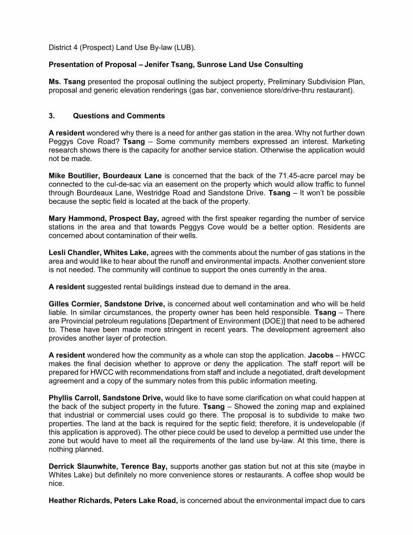
District 4 (Prospect) Land Use By-law (LUB). Presentation of Proposal – Jenifer Tsang, Sunrose Land Use Consulting Ms. Tsang presented the proposal outlining the subject property, Preliminary Subdivision Plan, proposal and generic elevation renderings (gas bar, convenience store/drive-thru restaurant). 3. Questions and Comments A resident wondered why there is a need for anther gas station in the area. Why not further down Peggys Cove Road? Tsang – Some community members expressed an interest. Marketing research shows there is the capacity for another service station. Otherwise the application would not be made. Mike Boutilier, Bourdeaux Lane is concerned that the back of the 71.45-acre parcel may be connected to the cul-de-sac via an easement on the property which would allow traffic to funnel through Bourdeaux Lane, Westridge Road and Sandstone Drive. Tsang – It won’t be possible because the septic field is located at the back of the property. Mary Hammond, Prospect Bay, agreed with the first speaker regarding the number of service stations in the area and that towards Peggys Cove would be a better option. Residents are concerned about contamination of their wells. Lesli Chandler, Whites Lake, agrees with the comments about the number of gas stations in the area and would like to hear about the runoff and environmental impacts. Another convenient store is not needed. The community will continue to support the ones currently in the area. A resident suggested rental buildings instead due to demand in the area. Gilles Cormier, Sandstone Drive, is concerned about well contamination and who will be held liable. In similar circumstances, the property owner has been held responsible. Tsang – There are Provincial petroleum regulations [Department of Environment (DOE)] that need to be adhered to. These have been made more stringent in recent years. The development agreement also provides another layer of protection. A resident wondered how the community as a whole can stop the application. Jacobs – HWCC makes the final decision whether to approve or deny the application. The staff report will be prepared for HWCC with recommendations from staff and include a negotiated, draft development agreement and a copy of the summary notes from this public information meeting. Phyllis Carroll, Sandstone Drive, would like to have some clarification on what could happen at the back of the subject property in the future. Tsang – Showed the zoning map and explained that industrial or commercial uses could go there. The proposal is to subdivide to make two properties. The land at the back is required for the septic field; therefore, it is undevelopable (if this application is approved). The other piece could be used to develop a permitted use under the zone but would have to meet all the requirements of the land use by-law. At this time, there is nothing planned. Derrick Slaunwhite, Terence Bay, supports another gas station but not at this site (maybe in Whites Lake) but definitely no more convenience stores or restaurants. A coffee shop would be nice. Heather Richards, Peters Lake Road, is concerned about the environmental impact due to cars
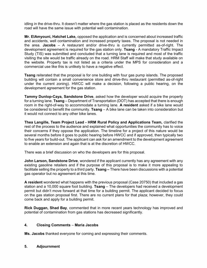
idling in the drive-thru. It doesn’t matter where the gas station is placed as the residents down the road will have the same issue with potential well contamination. Mr. ElAmyouni, Hatchet Lake, opposed the application and is concerned about increased traffic and accidents, well contamination and increased property taxes. The proposal is not needed in the area. Jacobs – A restaurant and/or drive-thru is currently permitted as-of-right. The development agreement is required for the gas station only. Tsang - A mandatory Traffic Impact Study (TIS) was submitted and concluded that a turning lane is required and most of the traffic visiting the site would be traffic already on the road. HRM Staff will make that study available on the website. Property tax is not listed as a criteria under the MPS for consideration and a commercial use like this is unlikely to have a negative effect. Tsang reiterated that the proposal is for one building with four gas pump islands. The proposed building will contain a small convenience store and drive-thru restaurant (permitted as-of-right under the current zoning). HWCC will make a decision, following a public hearing, on the development agreement for the gas station. Tammy Dunlop-Caya, Sandstone Drive, asked how the developer would acquire the property for a turning lane. Tsang – Department of Transportation (DOT) has accepted that there is enough room in the right-of-way to accommodate a turning lane. A resident asked if a bike lane would be considered to benefit the community. Tsang – A bike lane can be taken into consideration but it would not connect to any other bike lanes. Thea Langille, Team Project Lead - HRM Rural Policy and Applications Team, clarified the rest of the process to the audience and explained what opportunities the community has to voice their concerns if they oppose the application. The timeline for a project of this nature would be several months before it goes to public hearing before HWCC and if approved, then typically two to five years for build-out. The applicant can ask for an amendment to the development agreement to enable an extension and again that is at the discretion of HWCC. There was a brief discussion on who the developers are for this proposal. John Larson, Sandstone Drive, wondered if the applicant currently has any agreement with any existing gasoline retailers and if the purpose of this proposal is to make it more appealing to facilitate selling the property to a third party. Tsang – There have been discussions with a potential gas operator but no agreement at this time. A resident wondered what happens with the previous proposal (Case 20750) that included a gas station and a 10,000 square foot building. Tsang – The developers had received a development permit but didn’t move forward at that time for a building permit. The applicant decided to focus on the gas station proposal first. There are no current plans for that plaza; however, they could come back and apply for a building permit. Rick Duggan, Shad Bay, commented that in more recent years technology has improved and potential of contamination from gas stations has decreased significantly. 4. Closing Comments – Maria Jacobs Ms. Jacobs thanked everyone for coming and expressing their comments. 5. Adjournment

The meeting adjourned at approximately 7:55 p.m.