Embed Size (px)
Citation preview

Issues & Options 2 Part 2 - Site Options Within Cambridge
January 2013
Planning Services
Cambridge Local Plan - Towards 2031
20121218 Front Cover Part 2.indd 1 18/12/2012 16:34:52

Front Cover map for reference purposes only© Crown copyright and database right 2012. Ordnance Survey Licence number 100019730. This plan is not to scale.
20121218 Front Cover Part 2.indd 2 18/12/2012 16:34:52

CAMBRIDGE LOCAL PLAN TOWARDS 2031 – ISSUES AND OPTIONS 2, PART 2
CAMBRIDGE CITY COUNCIL JANUARY 2013 3
CONTENTS PAGE PAGE NUMBER A. INTRODUCTION 6
Part 1 and Part 2 documents 7 Sustainability appraisal 8 Structure of the document 8 How to respond 9 We’re here to help 10 What happens next? 10
B. JOINT WORKING AND THE DUTY TO COOPERATE 14 C: APPROACH TO SITE OPTIONS 18
Assessment of site options 18 Site selection 19 Student accommodation for the Colleges and the University of Cambridge
20
Student accommodation for Anglia Ruskin University 21 Hospice provision 21
D: RESIDENTIAL SITE OPTIONS WITHIN CAMBRIDGE 26 Site Number R1 – 295 Histon Road 27 Site Number R2 – Willowcroft, Histon Road 29 Site Number R3 – City Football Ground 31 Site Number R4 – Henry Giles House, Chesterton Road 33 Site Number R5 – Camfields Resource Centre and Oil Depot 35 Site Number R6 – 636‐656 Newmarket Road, Holy Cross Church Hall, East Barnwell Community Centre and Meadowlands, Newmarket Road
37
Site Number R7 – The Paddocks, Cherry Hinton Road 39 Site Number R8 – 149 Cherry Hinton Road 41 Site Number R9 – Travis Perkins, Devonshire Road 43 Site Number R10 – Mill Road Depot and Adjoining Properties 45 Site Number R11 – Horizon Resource Centre, Coldhams Lane 47 Site Number R12 – Ridgeons, 75 Cromwell Road 49 Site Number R13 – 78 and 80 Fulbourn Road 51 Site Number R14 – BT Telephone Exchange and Car Park, Long Road
53
Site Number R15 – Glebe Farm 55 Site Number R16 – Cambridge Professional Development Centre, Paget Road
57
Site Number R17 – Mount Pleasant House 59 Site Number R18 – 21‐29 Barton Road 61 Site Number R19 – 64‐68 Newmarket Road 63 Site Number R20 – Abbey Football Stadium 65 Site Number R21 – 315‐349 Mill Road 67
E: RESIDENTIAL MOORINGS SITE OPTIONS WITHIN CAMBRIDGE 70 Site Number RM1 – Fen Road 71

CAMBRIDGE LOCAL PLAN TOWARDS 2031 – ISSUES AND OPTIONS 2, PART 2
CAMBRIDGE CITY COUNCIL JANUARY 2013 4
PAGE NUMBER F: UNIVERSITY SITE OPTIONS WITHIN CAMBRIDGE 74
Site Number U1 – Old Press/Mill Lane 75 Site Number U2 – New Museums 77
G: MIXED‐USE DEVELOPMENT SITE OPTIONS WITHIN CAMBRIDGE 80 Site Number M1 – 379‐381 Milton Road 81 Site Number M2 – Clifton Road Industrial Estate 83 Site Number M3 – Michael Young Centre 85 Site Number M4 – Police Station, Parkside 86 Site Number M5 – 82 – 90 Hills Road and 57‐63 Bateman Street 88
H: EMPLOYMENT SITE OPTIONS WITHIN CAMBRIDGE 92 Site Number E1 – Orwell House, Orwell Furlong 93 Site Number E2 – St Johns Innovation Park 95 Site Number E3 – Merlin Place 97 Site Number E4 – Church End Industrial Estate 99 Site Number E5 – 1 and 7‐11 Hills Road 100
I: RESIDENTIAL SPACE STANDARDS 104 Internal space standards 104 External space standards 108
J: CAR PARKING STANDARDS 112 K: CYCLE PARKING STANDARDS 120 L: SITE DESIGNATIONS 128
Annex L1 – Protected Industrial Sites 133 Annex L2 – District and Local Centres 137 Annex L3 – Protected Open Spaces 151
APPENDIX 1: OTHER SITES CONSIDERED 174 APPENDIX 2: EXISTING NON‐RESIDENTIAL CAR PARKING STANDARDS
182
LIST OF MAPS: Map 1: Site Options within Cambridge 23 Map 2: Residential Site Options within Cambridge 26 Map 3: Residential Moorings Site Options within Cambridge 70 Map 4: University Site Options within Cambridge 74 Map 5: Mixed Use Site Options within Cambridge 80 Map 6: Employment Site Options within Cambridge 92

Chapter A
Introduction
20121218 - Chapter Pages Part 2.indd 1 18/12/2012 16:25:45

CAMBRIDGE LOCAL PLAN TOWARDS 2031 – ISSUES AND OPTIONS 2, PART 2
CAMBRIDGE CITY COUNCIL JANUARY 2013 6
A INTRODUCTION
A.1 The current Local Plan sets out policies and proposals to guide the future
development of Cambridge. It also sets out where future development will
take place, and identifies land for new housing, community facilities, shops
and employment. In addition, the Local Plan identifies land to be protected
from development, such as the Green Belt and Protected Open Space. It is
the key document used to determine planning applications for new
development in the city.
A.2 The current Local Plan was adopted in 2006. The City Council is now
preparing a new Local Plan, which will plan for and manage development to
2031. The preparation of the Local Plan involves a number of stages, and
between the 15th
June and the 27th
July 2012, consultation was carried out on
the Issues and Options Report, which formed the first stage of public
consultation on the new Local Plan.
A.3 Over 11,000 representations were received to the Issues and Options report
and its accompanying Sustainability Appraisal. These representations raised
a series of issues that need to be considered in drafting the new Local Plan,
including:
• Recognition of housing need, but significant concern about the
environmental impacts as well as the ability for appropriate infrastructure
to be provided;
• Mixed support for further development in the Green Belt, with many
respondents making the point that the Green Belt should be protected;
• Support for the continued redevelopment at the station and the fringe
site developments at the Southern Fringe and North West Cambridge;
• Concern about capacity in the City Centre, especially in relation to space
and the quality of the public realm;
• Support for the employment led development at Northern Fringe East
and the area around the new Cambridge Science Park Station;
• Support for a sub-regional community stadium in principle although there
was no overall support for a particular site;
• Support for an ice rink in Cambridge;
• Support for continued emphasis on non-car modes; and
• Support for a review of residential car parking standards to better reflect
national guidelines.
A.4 We would like to take this opportunity to thank all those who took the time
to respond to the consultation. This is an excellent response rate, and is very
encouraging as part of the first main stage of consultation. We are in the
process of analysing and responding to the representations received, using
these to inform the preparation of the Draft Local Plan, which will be subject
to consultation in the summer of 2013.

CAMBRIDGE LOCAL PLAN TOWARDS 2031 – ISSUES AND OPTIONS 2, PART 2
CAMBRIDGE CITY COUNCIL JANUARY 2013 7
A.5 As part of preparing the new Local Plan, the National Planning Policy
Framework requires local planning authorities to:
• Indicate broad locations for strategic development on a key diagram and
land-use designations on a proposals map;
• Allocate sites to promote development and flexible use of land, bringing
forward new land where necessary, and provide detail on form, scale,
access and quantum of development where appropriate;
• Identify areas where it may be necessary to limit freedom to change the
use of buildings, and support such restrictions with a clear explanation;
and
• Identify land where development would be inappropriate, for instance
because of its environmental or historic significance.
A.6 The Issues and Options Report set out broad locations for development and
the location of some Opportunity Areas, which were areas identified as
having potential for future improvement or development over the plan
period to 2031. The purpose of the current consultation document is to seek
views on possible sites to be allocated in the new Local Plan for different
types of development, providing more detail about site boundaries.
Part 1 and Part 2 documents
A.7 This Issues and Options 2 consultation has been split into two parts. The Part
1 document is a joint consultation between Cambridge City Council and South
Cambridgeshire District Council on options for the development strategy for
the wider Cambridge area and for site options for housing or employment
development on the edge of Cambridge on land currently in the Green Belt.
It also includes options on sub-regional sporting, cultural and community
facilities and site options for a community stadium. It builds upon the Issues
and Options consultations that the Councils have already undertaken and
provides background information in relation to the housing and employment
needs for the area as a whole, as well as outlining what that means for the
future development strategy.
A.8 This ‘Part 2 Site Options Within Cambridge’ consultation document considers
both site allocations and designations. The site allocations focus on strategic
sites that are considered central to the achievement of the development
strategy for Cambridge, for example achievement of housing requirements or
land for employment development. It also seeks your views on designations
that will be included in the new Local Plan and its accompanying proposals
map. These designations will include areas of protection, such as Protected
Open Space, and land-use designations such as local and district centres.
A.9 In addition, this Part 2 document considers more detailed matters such as
consultation on residential space standards and car and cycle parking
standards. South Cambridgeshire District Council is also consulting on a Part
2 document, which considers new issues arising from their Issues and Options

CAMBRIDGE LOCAL PLAN TOWARDS 2031 – ISSUES AND OPTIONS 2, PART 2
CAMBRIDGE CITY COUNCIL JANUARY 2013 8
consultation, including possible new site options for allocation for
development as well as matters such as possible changes to village
frameworks and designations to protect village character.
A.10 Sitting alongside this consultation document, we have prepared a technical
document, which forms a background document to the Issues and Options 2
work. Further information on the content of this technical document is
provided in Chapter C of this report.
Sustainability Appraisal
A.11 Alongside this Part 2 report, we are also consulting on a Sustainability
Appraisal (SA). SA is integral to the development of the Cambridge Local
Plan. It ensures that the environmental, economic and social effects of the
plan are assessed, and that reasonable alternatives are considered. SA of
Local Plans is a legal requirement1.
A.12 The SA objectives for Cambridge, identified in the Sustainability Appraisal
Scoping Report (June 2012), have been integrated into the assessment forms
used to assess the suitability of sites for allocation. In this way SA has been
central to the assessment of sites. The assessment forms also include
planning and deliverability criteria to give a comprehensive assessment of the
sites. Only those sites that are considered to have a potential for
development, in some cases with mitigation measures, have been put
forward for consultation in this Part 2 document. These are the sites that the
Council consider to be ‘reasonable alternatives’, and we are now looking for
your views on these sites. The SEA Directive requires that the effects of
‘reasonable alternatives’ are covered. The Government’s SEA Practical Guide
(2006) is clear that only reasonable, realistic and relevant alternatives need
to be put forward.
A.13 For the Part 1 document, a joint SA has been prepared, which considers the
impact of the site options on the sustainability objectives identified in the
Sustainability Appraisal Scoping Reports of both Councils.
Structure of this document
A.14 In terms of options for site allocations, this document has been split into the
following Chapters for ease of navigation:
• Chapter D: Residential site options within Cambridge;
• Chapter E: Residential moorings site options within Cambridge;
• Chapter F: University site options within Cambridge;
1 The Town and Country Planning (Local Planning) (England) Regulations 2012 require that an SA Report is
published for consultation alongside the ‘Proposed Submission’ Plan document. SA must be undertaken in-line
with the procedures prescribed by the Environmental Assessment of Plans and Programmes Regulations 2004,
which were prepared in order to transpose into national law the EU Strategic Environmental Assessment (SEA)
Directive.

CAMBRIDGE LOCAL PLAN TOWARDS 2031 – ISSUES AND OPTIONS 2, PART 2
CAMBRIDGE CITY COUNCIL JANUARY 2013 9
• Chapter G: Mixed-use development site options within Cambridge; and
• Chapter H: Employment site options within Cambridge.
A.15 Each of the above Chapters begins with a map showing all of the site options
being considered for that particular use within Cambridge. This is followed
by a more detailed consideration of each specific site option, and it is these
detailed descriptions where you may wish to focus any comments that you
want to submit.
A.16 Following on from the Chapters considering options for site allocations, there
are also Chapters of the document that focus on the following areas, where
we would also welcome your views. These build upon options contained in
the Issues and Options Report and provide more detail about possible policy
approaches for comment.
• Chapter I, residential space standards, considers the approach that could
be taken in the new Local Plan with regards to space standards for new
homes, in terms of both indoor and outdoor space. These standards
would apply to both market and affordable housing;
• Chapter J, car parking standards, considers the approach that could be
taken in the new Local Plan with regards to levels of car parking for
different types of development;
• Chapter K, cycle parking standards, considers the approach that could be
taken in the new Local Plan with regards to levels of cycle parking for
different types of development; and
• Chapter L, site designations, considers proposals for site designations,
which will be included on the Local Plan Proposals Map. For the purpose
of this consultation, the following site designations are considered:
o Protected Industrial Sites – Annex L1;
o District and local centres Annex L2; and
o Protected Open Spaces – Annex L3.
How to respond
A.17 Once you have looked through both the Part 1 and Part 2 documents, please
send us your comments. You can submit comments on any of the sites
considered within this report, as well as the Chapters of the report that
consider designations, car and cycle parking standards and residential space
standards. There are a number of ways in which you can do this:
• Using the Council’s online consultation system – This is our preferred
means of receiving representations as it is the fastest and most accurate
method, helping us to manage your representations quickly and
efficiently. Separate instructions on how to use the online consultation
system are provided on our website, and officers in the planning policy
team are always available to help if you have any queries. Please go to
the following link: http://cambridge.jdi-consult.net/ldf

CAMBRIDGE LOCAL PLAN TOWARDS 2031 – ISSUES AND OPTIONS 2, PART 2
CAMBRIDGE CITY COUNCIL JANUARY 2013 10
• Using the response form – If you do not have access to a computer, a paper response form can be completed and sent to the Council. Copies of the response form are available from the planning policy team.
A.18 Please note that the deadline for responses is 5pm on 18th February 2012.
Unfortunately, responses received after this deadline can only be accepted in exceptional circumstances. If you have any queries as to how to submit a representation, please contact the planning policy team, using the contact details below.
We’re here to help
A.19 Your views are important to us, but we recognise that the planning system is
not always easy to understand and navigate. We want to make sure that as many people as possible have an opportunity to have their say on the new Local Plan and site options, regardless of their previous experience with planning matters. That is why we are here to help at every stage of the process. Officers from the planning policy team are available to help guide you through the process of preparing the new Local Plan. You can contact us using one of the following methods: • You can phone us on 01223 457000 (ask to speak to someone in the
planning policy team); • You can email us at [email protected]
A.20 There will also be opportunities for you to meet officers face‐to‐face
throughout the process of preparing the new Local Plan, through exhibitions that will be held across the city during the site options consultation period. Details of these events, together with up to date information on the Local Plan review can be found on the Council’s Local Plan website:
http://www.cambridge.gov.uk/options2 A.21 For those who use social media, we shall also be providing regular updates on
the Council’s Facebook page and twitter feed. We will also provide regular updates on the Local Plan blog, which can be found at: http://cambridgelocalplan.wordpress.com/
What happens next?
A.22 Once consultation on Issues and Options 2 has finished, we will consider all of
the representations that have been received, using them to refine the site allocations that will be included in the Local Plan. We will then draft the actual Local Plan, which will include draft policies, site allocations and designations. This will be subject to a further round of public consultation in the summer of 2013, prior to being submitted to the Secretary of State for examination. At this stage, an independent Government Inspector will consider the ‘soundness’ of the Local Plan at a public examination. In other words, the inspector will consider whether the plan has been positively

CAMBRIDGE LOCAL PLAN TOWARDS 2031 – ISSUES AND OPTIONS 2, PART 2
CAMBRIDGE CITY COUNCIL JANUARY 2013 11
prepared, and that its policies are justified, effective and are in conformity
with the National Planning Policy Framework. Following this, the inspector
will produce a report of his or her findings, and then the Council will formally
adopt the Local Plan. These stages are illustrated in figure 1 overleaf.

CAMBRIDGE LOCAL PLAN TOWARDS 2031 – ISSUES AND OPTIONS 2, PART 2
CAMBRIDGE CITY COUNCIL JANUARY 2013 12
Figure 1: Stages in the preparation of the new Cambridge Local Plan
DEVELOPMENT OF EVIDENCE BASE AND PREPARATION OF ISSUES
AND OPTIONS REPORT
March 2011 – May 2012
CONSULTATION ON ISSUES AND OPTIONS REPORT AND INTERIM
SUSTAINABILITY APPRAISAL
June – July 2012
CONSIDERATION OF REPRESENTATIONS
AND PREPARATION OF SUBMISSION DRAFT LOCAL PLAN
August 2012 – May 2013
CONSULTATION ON SUBMISSION DRAFT LOCAL PLAN AND
SUSTAINABILITY APPRAISAL
Summer 2013
ADOPTION OF THE LOCAL PLAN
April 2014
INDEPENDENT EXAMINATION
Winter 2013/2014
SUBMISSION TO THE SECRETARY OF STATE
Winter 2013
CONSULTATION ON SITE OPTIONS FOR DEVELOPMENT PART 1
AND PART 2 DOCUMENTS
January - February 2013

Chapter B
Joint Working and the Duty to
Cooperate
20121218 - Chapter Pages Part 2.indd 2 18/12/2012 16:25:48

CAMBRIDGE LOCAL PLAN TOWARDS 2031 – ISSUES AND OPTIONS 2, PART 2
CAMBRIDGE CITY COUNCIL JANUARY 2013 14
B. JOINT WORKING AND THE DUTY TO COOPERATE
B.1 Planning issues are not constrained by local authority boundaries. The
National Planning Policy Framework states that public bodies have a duty to
cooperate on planning issues that cross administrative boundaries,
particularly those that relate to strategic priorities. Councils are required to
work collaboratively to ensure that strategic priorities across local boundaries
are properly coordinated and clearly reflected in individual local plans.
B.2 The City Council has a long history of joint working and has worked closely
with South Cambridgeshire District Council on a variety of planning matters
over many years reflecting the close functional relationship between the
tightly drawn city boundary and its rural surroundings. This includes working
together on key strategic and joint issues at both officer and Member level
through the preparation of Structure Plans, input to Regional Plans, the
preparation of existing development plans, joint Area Action Plans for major
developments, the preparation of joint evidence base documents on a wide
variety of topics, and other planning matters including various transport
strategy documents.
B.3 The Councils have decided to prepare separate Local Plans for Cambridge and
South Cambridgeshire, but are fully aware of the need to work effectively
together and that they will need to demonstrate how they have cooperated
effectively, both with each other and other key public bodies including the
County Council, on the preparation of their respective new Local Plans. The
Councils’ ongoing approach to joint working is therefore now a specific legal
requirement and it will be necessary to provide formal evidence of the
cooperation as part of the plan making process.
B.4 Joint working arrangements have already been established. At a Member
level, previous joint working groups have been replaced by two new Member
groups: the Cambridgeshire and Peterborough Joint Strategic Planning and
Transport Member Group which is a County wide group and the Joint
Strategic Transport and Spatial Planning Group specifically to address issues
affecting Cambridge and South Cambridgeshire. Work is ongoing at an officer
level, steered by regular meetings of senior officers: Chief Planning Officers
group for county-wide issues and officers from the three Councils for more
Cambridge-focused issues. The Cambridgeshire Councils have already
established and then commissioned the Joint Strategic Planning Unit to
prepare a strategic spatial framework for Cambridgeshire and Peterborough,
which will also help demonstrate the coordinated approach to planning for
the long term needs of the wider area and the Unit has also assisted with the
preparation of the evidence base for this consultation.
B.5 The Councils have been working together throughout the preparation of the
Issues and Options consultations on the Cambridge Local Plan and the South
Cambridgeshire Local Plan, and also the parallel consultation on issues for a

CAMBRIDGE LOCAL PLAN TOWARDS 2031 – ISSUES AND OPTIONS 2, PART 2
CAMBRIDGE CITY COUNCIL JANUARY 2013 15
new Transport Strategy for Cambridge and South Cambridgeshire. The
Councils took the same approach to joint issues in the recent Issues and
Options consultation. Each of the Issues and Options consultation documents
took a common approach to the Green Belt on the edge of Cambridge, the
future planning of Cambridge East and Northern Fringe East and sub-regional
sporting, cultural and community facilities. Each document also highlighted
the corresponding consultation by the other Council.
B.6 The Councils have agreed to continue to work jointly as plan preparation
continues. In terms of timetables, the Councils’ Local Plan programmes have
been very similar, although it did not prove possible to align them completely
for the Issues and Options (Summer 2012) consultation. The consultations
did however overlap in July 2012.

CAMBRIDGE LOCAL PLAN TOWARDS 2031 – ISSUES AND OPTIONS 2, PART 2
CAMBRIDGE CITY COUNCIL JANUARY 2013 16

Chapter C
Approach to Site Options
20121218 - Chapter Pages Part 2.indd 3 18/12/2012 16:25:51

CAMBRIDGE LOCAL PLAN TOWARDS 2031 – ISSUES AND OPTIONS 2, PART 2
CAMBRIDGE CITY COUNCIL JANUARY 2013 18
C. APPROACH TO SITE OPTIONS
C.1 In order to identify potential sites for allocation a methodology has been
developed, which is set out in further detail in the document “Technical
Background Document – Site Assessments within Cambridge”. This technical
document sits alongside the Part 2 consultation document and presents the
detailed assessments for each of the site options considered. When using
the Council’s online consultation system, a weblink to the relevant Chapter of
the technical document has been provided for each site option, to enable you
to see the detailed assessments of each site, which may help to inform your
response to site options.
Assessment of site options
C.2 To assess the suitability of sites, an assessment form has been developed,
which considers a number of criteria relating to social, economic and
environmental factors related to the location of the site, as well as criteria
relating to the planning suitability of the site. The assessment form has been
developed to fully integrate the requirements of the Sustainability Appraisal
process, and criteria in the assessment form take into account the social,
environmental and economic sustainability themes set out in the
Sustainability Appraisal Scoping Report. The assessment form also builds
upon the assessment that was carried out on potential housing sites in the
Strategic Housing Land Availability Assessment (SHLAA).
C.3 The first part of the assessment form (Level 1) is a high level sieve containing
criteria that could potentially prevent development of a site, for example if a
site is within a floodplain. The Level 2 criteria are broken down into a
number of categories to determine whether a site would be suitable for
development, as follows:
• Accessibility to existing centres and services;
• Accessibility to outdoor facilities and green spaces;
• Supporting economic growth;
• Sustainable transport;
• Air quality, pollution, contamination and noise;
• Protecting groundwater;
• Protecting the townscape and historic environment;
• Biodiversity and green infrastructure.
C.4 At the end of the Level 2 assessment, a conclusion is reached as to whether
or not a site has development potential. This conclusion also considers which
type of use would be most suitable for a site, be it residential, employment or
mixed use development. The conclusion may also identify if parts of a site
are more sensitive to development than others, or whether only part of a site
may be suitable for development. Only sites that are available, and
considered suitable in planning and sustainability terms are being consulted
upon. Those sites that have been rejected as part of the assessment work

CAMBRIDGE LOCAL PLAN TOWARDS 2031 – ISSUES AND OPTIONS 2, PART 2
CAMBRIDGE CITY COUNCIL JANUARY 2013 19
are not being consulted upon, although details of these sites have been
included within the technical document and Appendix 1 of this document.
C.5 A broad financial viability assessment of each of the sites will also be carried
out as part of the review of the Local Plan. This work is being carried out by
consultants Dixon Searle, and will help assist in determining which of the site
options will be allocated for development in the new Local Plan.
C.6 The assessment of each of the site options has been undertaken by officers in
the planning policy team at Cambridge City Council. Assistance has also been
sought from other expert officers within the Council in relation to matters
such as historic environment, biodiversity, urban design, landscape, cycling
and environmental health, as well as County Council expertise in relation to
highways, education, and minerals and waste.
Site selection
C.7 A number of sources have been used to identify sites. These include the
following sources, although this is not an exhaustive list:
• Sites allocated in the current 2006 Local Plan, associated Area Action
Plans and Supplementary Planning Documents, which have not yet been
developed;
• Sites identified in the following studies:
o Strategic Housing Land Availability Assessment, May 2012;
o Employment Land Review, 2007 and 2012 update;
o Cambridge Sub Region Retail Study, 2008;
o Cambridge Hotel Futures: Headline Findings Issues and Options
Report, April 2012;
• Any sites and site boundaries identified by the Council within the Issues
and Options Consultation, June 2012;
• Any sites subsequently submitted by landowners and developers or their
agents in response to the Issues and Options consultation;
• Any sites identified by the Council’s own departments (e.g. property
services), other Councils and statutory Government agencies.
C.8 A long list of sites was drawn up and was initially reduced by removing those
sites which had already been consulted upon in the Issues and Options
consultation in June/July 2012 (including Gypsy and Traveller Sites, major
allocations and opportunity areas), sites less than 0.5 hectares (apart from a
small number of residential sites which due to their location could be
developed at a high density), and those picked up through annual monitoring,
where planning permission had been granted.
C.9 For the residential site options, the SHLAA is a key part of the evidence. The
purpose of the SHLAA is to identify land and buildings with potential for new
housing. The Council is required to prepare a SHLAA for its area and the most
up to date version was published in May 2012.

CAMBRIDGE LOCAL PLAN TOWARDS 2031 – ISSUES AND OPTIONS 2, PART 2
CAMBRIDGE CITY COUNCIL JANUARY 2013 20
C.10 Not all of the sites included in the SHLAA have been included in this Site
Options consultation, the focus of which is on strategic sites of a certain size
(0.5 hectares or more).
C.11 The assessment of sites for employment related development has been
informed by the Employment Land Review Update 2012. The focus for
employment sites is on popular locations in the city for employment
development, notably Cambridge City Centre (particularly the Hills
Road/Station Road area), and the northern fringe area around Cambridge
Science Park, Cambridge Business Park and St John’s Innovation Centre.
Consideration is also given to the opportunities presented by the
redevelopment of the area around Cambridge Science Park Station for
further employment related development.
C.12 Some of the comments received to the Issues and Options consultation
suggested large areas of search be assessed for further development. This
would have been extremely difficult to assess given the approach that has
been taken to site assessment using the assessment form described above.
Many of the criterion within the assessment form relate to the distance from
the site to certain services and facilities, also specific planning related matters
such as whether there is a suitable access to the site and this would be very
difficult to assess for an area of search. A large number of sources have been
used to identify suitable sites, and sites were put forward following
consultation on the Issues and Options Report. The current consultation
period provides an additional opportunity for sites to be put forward to the
Council.
C.13 Opportunity Areas were consulted upon in the Issues and Options Report.
Some of the consultation responses suggested that there should be further
Opportunity Areas; in particular that Mitcham’s Corner and Newmarket Road
should be Opportunity Areas. The Council will consider these further in the
development of the Draft Local Plan.
C.14 Additional issues surrounding the need for student accommodation and the
provision of a new hospice for the Cambridge area came forward through
Issues and Options consultation, as detailed below.
Student accommodation for the Colleges and the University of Cambridge
C.15 As reported in the Issues and Options Report, if current projected growth
rates are to be met, the University of Cambridge faces a shortfall in 3,740
student rooms by 2031. While 2,000 new units of student accommodation
are to be provided at North West Cambridge, the accommodation will
primarily be for new as opposed to existing Colleges. Excluding North West
Cambridge, the Colleges estimate that around 1,500 rooms can be provided

CAMBRIDGE LOCAL PLAN TOWARDS 2031 – ISSUES AND OPTIONS 2, PART 2
CAMBRIDGE CITY COUNCIL JANUARY 2013 21
by refurbishment of existing space within their own sites. Space for further
rooms would have to be found on other sites within the city.
Question C.1:
How much new land will be needed for university growth during the plan
period and where should it be allocated?
Question C.2:
Are there other sites that might be suitable for allocation for new student
accommodation for the Colleges and the University of Cambridge?
Student accommodation for Anglia Ruskin University
C.16 Anglia Ruskin University are midway through redeveloping their East Road
campus following the masterplan and planning consent agreed in 2009. A
further extension to the campus’ teaching space was recently approved at
New Street/Young Street.
C.17 Anglia Ruskin University is keen to house as many of its students as possible
in purpose built hostel accommodation. It is making significant new provision
of student hostels as part of the redevelopment of the CB1 redevelopment at
the Station. A series of reserved matter applications have been approved or
are currently pending, with the first phase of student accommodation
providing 500 bedspaces for Anglia Ruskin University.
C.18 Anglia Ruskin University has a continuing need to provide new student hostel
accommodation and will be losing 106 bedspaces at Nightingale and Bridget’s
Hostels in Tennis Court Road. The Council is continuing to investigate site
options as part of the preparation of the Draft Plan.
Question C.3:
Are there other sites which might be suitable for allocation for new student
accommodation for Anglia Ruskin University?
Hospice provision
C.19 Representations were made to the Councils' Issues and Options reports in
relation to hospice provision. Hospices provide palliative care for the
terminally and seriously ill. They form an important part of community
infrastructure and include the Arthur Rank Hospice on Mill Road and the East
Anglia Children’s Hospices at Milton. Along with South Cambridgeshire
District Council, the Council is continuing to investigate site options as part of
the preparation of the Draft Plan.

CAMBRIDGE LOCAL PLAN TOWARDS 2031 – ISSUES AND OPTIONS 2, PART 2
CAMBRIDGE CITY COUNCIL JANUARY 2013 22
Question C.4: Are there any sites which might be suitable for allocation for new hospice provision?
C.20 Map 1 on the next page shows all of the sites being considered as possible
site allocations within Cambridge.

CAMBRIDGE LOCAL PLAN TOWARDS 2031 – ISSUES AND OPTIONS 2, PART 2
CAMBRIDGE CITY COUNCIL JANUARY 2013 23

CAMBRIDGE LOCAL PLAN TOWARDS 2031 – ISSUES AND OPTIONS 2, PART 2
CAMBRIDGE CITY COUNCIL JANUARY 2013 24

Chapter D
Residential Site Options Within
Cambridge
20121218 - Chapter Pages Part 2.indd 4 18/12/2012 16:25:51

CAMBRIDGE LOCAL PLAN TOWARDS 2031 – ISSUES AND OPTIONS 2, PART 2
CAMBRIDGE CITY COUNCIL JANUARY 2013 26
D. RESIDENTIAL SITE OPTIONS WITHIN CAMBRIDGE

CAMBRIDGE LOCAL PLAN TOWARDS 2031 – ISSUES AND OPTIONS 2, PART 2
CAMBRIDGE CITY COUNCIL JANUARY 2013 27
SITE NUMBER R1 – 295 HISTON ROAD
Ward: Arbury
Area: 0.71ha
Potential Capacity: 32
Reference(s): Local Plan 2006 Allocation Site (residential) – Site 5.17
SITE MAP
Description:
There are two buildings on this site. One is used for a furniture shop and an
education centre (tutorial school), this is a two-storey warehouse type building
extended from the rear of two former residential properties. The other is home to
Cambridge Squash Club and this is a two-storey warehouse type building.
Approximately half the site is residential garden type land. It is located
approximately 50 metres to the west of Histon Road, to the south of Chancellors
Walk and is surrounded on all sides by residential development.
COMMENTS
Pros:
• Previously developed, largely vacant site, providing opportunity for
development;
• Adjacent to an established residential community;
• Proximity to NIAB site which will have a new local centre and facilities;
• Limited visual impact; and
• No infrastructure upgrades are likely to be required.

CAMBRIDGE LOCAL PLAN TOWARDS 2031 – ISSUES AND OPTIONS 2, PART 2
CAMBRIDGE CITY COUNCIL JANUARY 2013 28
Cons:
• There are surface water flooding issues across the site. Careful mitigation
required; and
• Loss of squash courts.
For the technical assessment of this site, please visit http://cambridge.jdi-
consult.net/ldf/

CAMBRIDGE LOCAL PLAN TOWARDS 2031 – ISSUES AND OPTIONS 2, PART 2
CAMBRIDGE CITY COUNCIL JANUARY 2013 29
SITE NUMBER R2 – WILLOWCROFT, HISTON ROAD
Ward: Arbury
Area: 1.59ha
Potential Capacity: 78
Reference(s): Local Plan 2006 allocation site (for residential) – site 5.07. Also
includes SHLAA site CC312 – Land rear of 129 – 133 Histon Road
SITE MAP
Description:
Industrial area located west of Histon Road, with the far western border of the site
being the rear gardens of the properties on Richmond Road. To the north are the
rear gardens on Nursery Walk and Histon Road Local Centre. There is a recreation
ground to the south. There is a car park to the southwest of the site.
COMMENTS
Pros:
• Proximity to Local Centre and facilities;
• Adjacent to a main radial route;
• Site is directly adjacent to Histon Road Recreation Ground, which has a range
of children’s play facilities for different ages; and
• Within 400m of two primary schools.
Cons:
• There are high traffic volumes and cycling provision could be better on this
part of Histon Road; and

CAMBRIDGE LOCAL PLAN TOWARDS 2031 – ISSUES AND OPTIONS 2, PART 2
CAMBRIDGE CITY COUNCIL JANUARY 2013 30
• Any damage to protected trees on site would need to be mitigated.
For the technical assessment of this site, please visit http://cambridge.jdi-
consult.net/ldf/

CAMBRIDGE LOCAL PLAN TOWARDS 2031 – ISSUES AND OPTIONS 2, PART 2
CAMBRIDGE CITY COUNCIL JANUARY 2013 31
SITE NUMBER R3 – CITY FOOTBALL GROUND
Ward: West Chesterton
Area: 1.71ha
Potential Capacity: 147
Reference(s): Local Plan 2006 allocation site (for residential) – site 5.05.
SITE MAP
Description:
This site is currently used as a football ground (playing field, club house, stand and
car parking) for Cambridge City Football Club. The site is set away from main street
frontages in an area bounded by Victoria Road, Milton Road, and Gilbert Road. The
site is reached via the Westbrook Centre access road, which turns off Milton Road a
short distance beyond Mitcham’s Corner.
COMMENTS
Pros:
• Close to City Centre and adjacent to District Centre;
• The site is set away from the main street so there would be limited visual
impact;
• Close to primary school and Bateson Road Play Area; and
• Good public transport links to City Centre and other areas.

CAMBRIDGE LOCAL PLAN TOWARDS 2031 – ISSUES AND OPTIONS 2, PART 2
CAMBRIDGE CITY COUNCIL JANUARY 2013 32
Cons:
• Loss of City Football Ground. Any future development would need to
satisfactorily demonstrate recreational facilities are re-provided elsewhere in
a similarly accessible location;
• Poor pedestrian and cycling connectivity with surrounding area. Development
could provide an opportunity for improvement; and
• There are access problems with this site that would need to be mitigated
before any approval could be granted.
For the technical assessment of this site, please visit http://cambridge.jdi-
consult.net/ldf/

CAMBRIDGE LOCAL PLAN TOWARDS 2031 – ISSUES AND OPTIONS 2, PART 2
CAMBRIDGE CITY COUNCIL JANUARY 2013 33
SITE NUMBER R4 – HENRY GILES HOUSE, CHESTERTON ROAD
Ward: West Chesterton
Area: 0.775ha
Potential Capacity: 48
Reference(s): Local Plan 2006 allocation site (for residential) – site 5.15.
SITE MAP
Description:
This site relates to the four storey, flat roofed Social Security/Jobcentre building. It is
located on the corner of Chesterton Road and Carlyle Road. The building is set back
from Chesterton Road, with an area of car parking between the building and the
footway. There is a car park to the rear of the building.
COMMENTS
Pros:
• Close to City Centre and adjacent to Mitcham’s Corner District Centre;
• Adjacent to open space (Jesus Green);
• Existing infrastructure is likely to be sufficient;
• Close to health centres, schools and play areas;
• Good public transport links to City Centre and other areas; and
• Good cycling and walking links.

CAMBRIDGE LOCAL PLAN TOWARDS 2031 – ISSUES AND OPTIONS 2, PART 2
CAMBRIDGE CITY COUNCIL JANUARY 2013 34
Cons:
• Surface water flooding issues on site, possible to mitigate with careful
consideration to site layout; and
• The site is within an Air Quality Management Area although it is not likely that
there would be net worsening of air quality.
For the technical assessment of this site, please visit http://cambridge.jdi-
consult.net/ldf/

CAMBRIDGE LOCAL PLAN TOWARDS 2031 – ISSUES AND OPTIONS 2, PART 2
CAMBRIDGE CITY COUNCIL JANUARY 2013 35
SITE NUMBER R5 – CAMFIELDS RESOURCE CENTRE AND OIL DEPOT
Ward: Abbey
Area: 0.858ha
Potential Capacity: 35
Reference(s): SHLAA site 906 is contained within the boundary of this site to which
the oil depot area has been added
SITE MAP
Description:
This is an industrial site on the north side of Ditton Walk. It is bounded on the north
by Ditton Meadows, on the west and east by warehouse/industrial type buildings
and on the south by residential. It is in use as a resource centre and oil depot. The
site to the east was granted permission for residential development in 2011
(11/0596/FUL).
COMMENTS
Pros:
• Adjacent to an established residential community;
• Good public transport links to city centre and other areas;
• Close to play areas and accessible natural greenspace, Ditton Fields
Recreation Ground and Dudley Road Recreation Ground;
• Potential to clean up contaminated site;
• Existing infrastructure is likely to be sufficient; and
• Within 800m of Barnwell Local Centre.

CAMBRIDGE LOCAL PLAN TOWARDS 2031 – ISSUES AND OPTIONS 2, PART 2
CAMBRIDGE CITY COUNCIL JANUARY 2013 36
Cons:
• Surface water flooding issues across the site. Mitigation is possible with
careful consideration to site layout;
• Oil contamination beneath the site. Capable of remediation but some types of
residential development may not be suitable (houses with gardens); and
• Any new development needs to minimise the impact it may have on the semi-
natural private greenspace north of the site.
For the technical assessment of this site, please visit http://cambridge.jdi-
consult.net/ldf/

CAMBRIDGE LOCAL PLAN TOWARDS 2031 – ISSUES AND OPTIONS 2, PART 2
CAMBRIDGE CITY COUNCIL JANUARY 2013 37
SITE NUMBER R6 – 636-656 NEWMARKET ROAD, HOLY CROSS CHURCH
HALL, EAST BARNWELL COMMUNITY CENTRE AND MEADOWLANDS,
NEWMARKET ROAD
Ward: Abbey
Area: 1.01ha
Potential Capacity: 75
Reference(s): SHLAA – Site CC443
SITE MAP
Description:
A series of community facility and other mixed use type buildings (Church, flats,
nursery, games court, vicarage) and associated car parking, on the south side of
Newmarket Road close to the Barnwell Road/Wadloes Road roundabout. Residential
development borders the site to the east and south.
COMMENTS
Pros:
• Redevelopment of the site could make more efficient use of land and any
proposal would need to include modern replacement of community facilities;
• Close to Barnwell Road Local Centre, East Barnwell Health Centre and Peverel
Road Play Area;
• Existing infrastructure likely to be sufficient;
• Good public transport links to City Centre and other areas; and
• Existing community facilities are in very poor quality buildings and
redevelopment would enable an upgrade.

CAMBRIDGE LOCAL PLAN TOWARDS 2031 – ISSUES AND OPTIONS 2, PART 2
CAMBRIDGE CITY COUNCIL JANUARY 2013 38
Cons:
• Multiple land ownership;
• There is a Tree Preservation Order (TPO) on the Methodist Church part of the
site; and
• Noise problems affect the end of the site near Newmarket Road. Careful
mitigation required.
For the technical assessment of this site, please visit http://cambridge.jdi-
consult.net/ldf/

CAMBRIDGE LOCAL PLAN TOWARDS 2031 – ISSUES AND OPTIONS 2, PART 2
CAMBRIDGE CITY COUNCIL JANUARY 2013 39
SITE NUMBER R7 – THE PADDOCKS, CHERRY HINTON ROAD
Ward: Coleridge
Area: 2.79ha
Potential Capacity: 123
Reference(s): Local Plan 2006 Allocation (for residential) – Site 5.02
SITE MAP
Description:
Industrial estate located just to the north of Cherry Hinton Road, close to the
junction with Perne Road. The site is bounded to the north, east and south by
residential and there are allotment gardens and residential to the west.
COMMENTS
Pros:
• Close to Adkins Corner Local Centre and other facilities;
• Adjacent to an established residential community;
• Close to Cornford House Surgery, four primary schools, sports facilities and
two play areas; and
• Good public transport links to City Centre and other areas.
Cons:
• Potential contamination from industrial use but should be capable of
remediation;
• Loss of employment land; and
• Safety improvements for cyclists needed to nearby roundabout.

CAMBRIDGE LOCAL PLAN TOWARDS 2031 – ISSUES AND OPTIONS 2, PART 2
CAMBRIDGE CITY COUNCIL JANUARY 2013 40
For the technical assessment of this site, please visit http://cambridge.jdi-
consult.net/ldf/

CAMBRIDGE LOCAL PLAN TOWARDS 2031 – ISSUES AND OPTIONS 2, PART 2
CAMBRIDGE CITY COUNCIL JANUARY 2013 41
SITE NUMBER R8 – 149 CHERRY HINTON ROAD Ward: Coleridge Area: 0.55ha Potential Capacity: 17 Reference(s): SHLAA Site ‐ CC087 SITE MAP
Description: The site consists of a number of light industrial buildings (laundry site – retail shop to the front with laundry process works to the rear of site). The surrounding area is predominantly residential but there is another light industrial site to the northwest. COMMENTS Pros:
• Close to Cherry Hinton Road West and East Local Centres and facilities; • Close to railway station and good public transport links to City Centre and
other areas; • Close to Morley Memorial Primary School and Coleridge Community College; • Close to outdoor sports facilities, play space and accessible natural
greenspace; • Less than 1km from an employment centre; and • Existing infrastructure likely to be sufficient.

CAMBRIDGE LOCAL PLAN TOWARDS 2031 – ISSUES AND OPTIONS 2, PART 2
CAMBRIDGE CITY COUNCIL JANUARY 2013 42
Cons: • Loss of local laundry service; and • Concerns about noise, which should be capable of adequate mitigation and
potential contamination which should be capable of remediation.
For the technical assessment of this site, please visit http://cambridge.jdi‐consult.net/ldf/

CAMBRIDGE LOCAL PLAN TOWARDS 2031 – ISSUES AND OPTIONS 2, PART 2
CAMBRIDGE CITY COUNCIL JANUARY 2013 43
SITE NUMBER R9 – TRAVIS PERKINS, DEVONSHIRE ROAD
Ward: Petersfield
Area: 1.23ha
Potential Capacity: 43
Reference(s): Local Plan 2006 allocation site (for residential) – site 5.09.
SITE MAP
Description:
Large industrial premises located off Devonshire Road, close to the junction with Mill
Road. The site is bounded by the railway line to its east and residential to the south
and west. The site is currently in use by Travis Perkins builders suppliers. It is
currently pending a decision on an application for a mixed use development,
including some residential.
COMMENTS
Pros:
• Close to Mill Road West Local Centres and relatively close to the city centre
and facilities;
• Close to railway station and within 400m of bus services that link the site to
the City Centre;
• Close to play space and accessible natural greenspace; and
• Adjacent to an established residential community.

CAMBRIDGE LOCAL PLAN TOWARDS 2031 – ISSUES AND OPTIONS 2, PART 2
CAMBRIDGE CITY COUNCIL JANUARY 2013 44
Cons:
• Most of the site is more than 800m from nearest primary school; and
• Site is adjacent to a number of almshouses which have the status of Buildings
of Local Interest (BLIs) and front onto Mill Road. Potential for adverse impacts
but capable of mitigation.
For the technical assessment of this site, please visit http://cambridge.jdi-
consult.net/ldf/

CAMBRIDGE LOCAL PLAN TOWARDS 2031 – ISSUES AND OPTIONS 2, PART 2
CAMBRIDGE CITY COUNCIL JANUARY 2013 45
SITE NUMBER R10 – MILL ROAD DEPOT AND ADJOINING PROPERTIES
Ward: Petersfield
Area: 2.7ha
Potential Capacity: 167
Reference(s): SHLAA Site - CC102
SITE MAP
Description:
Mill Road Depot is located off Mill Road, between Kingston Street to the west and
the railway bridge to the east. The depot incorporates many of the Council’s
services, including offices, vehicle MOTs, waste disposal and collection and storage
and is industrial in nature. It is in use as the Council’s Depot, warehouse buildings
and offices, community facilities within the listed library, language school and leased
garages.
COMMENTS
Pros:
• Close to Mill Road East and West Local Centres and relatively close to the City
Centre and facilities;
• Close to railway station and within 400m of bus services that link the site to
the City Centre;
• There is an open space deficiency in Petersfield Ward which development
here could help to address;
• Existing infrastructure is likely to be sufficient;
• Close to play space and accessible natural greenspace; and

CAMBRIDGE LOCAL PLAN TOWARDS 2031 – ISSUES AND OPTIONS 2, PART 2
CAMBRIDGE CITY COUNCIL JANUARY 2013 46
• Adjacent to an established residential community.
Cons:
• Any development will need to take into account the setting of a Grade 2 listed
building;
• The site is in multiple ownership;
• Access may be difficult as it should not be from Mill Road;
• There are contamination issues on site that would need to be mitigated.
Capable of remediation but careful mitigation required; and
• There is poor cycling provision on Mill Road and the site is near a dangerous
junction. Development may provide an opportunity for improvement.
For the technical assessment of this site, please visit http://cambridge.jdi-
consult.net/ldf/

CAMBRIDGE LOCAL PLAN TOWARDS 2031 – ISSUES AND OPTIONS 2, PART 2
CAMBRIDGE CITY COUNCIL JANUARY 2013 47
SITE NUMBER R11 – HORIZON RESOURCE CENTRE, COLDHAM’S LANE
Ward: Romsey
Area: 0.82ha
Potential Capacity: 40
Reference(s): SHLAA Site - CC629
SITE MAP
Description:
A site housing the Horizon Resource Centre (a day centre) and associated car
parking. It is located just north of Coldham’s Lane, on a roundabout, and is bounded
by the railway line to the east and the residential buildings of The Paddocks to the
north.
COMMENTS
Pros:
• Adjacent to an established residential community;
• The site is close to a superstore, although access would be difficult across the
busy roundabout;
• Close to an employment centre, a primary school, sports facilities, play areas
and accessible natural greenspace; and
• Site could support reasonably high density.

CAMBRIDGE LOCAL PLAN TOWARDS 2031 – ISSUES AND OPTIONS 2, PART 2
CAMBRIDGE CITY COUNCIL JANUARY 2013 48
Cons: • Access to the site may be difficult; • Poor access to public transport; and • The site is adjacent to a busy roundabout with a high cycle accident rate.
Development may provide an opportunity for improvements to the public realm.
For the technical assessment of this site, please visit http://cambridge.jdi‐consult.net/ldf/

CAMBRIDGE LOCAL PLAN TOWARDS 2031 – ISSUES AND OPTIONS 2, PART 2
CAMBRIDGE CITY COUNCIL JANUARY 2013 49
SITE NUMBER R12 – RIDGEONS, 75 CROMWELL ROAD
Ward: Romsey
Area: 3.27ha
Potential Capacity: 120
Reference(s): SHLAA Site CC922 - Part of a Local Plan 2006 allocation site (for
residential) – site 5.14
SITE MAP
Description:
Large broadly wedge shaped industrial area, currently in use by Ridgeons, which
forms part of a Local Plan 2006 allocation site (for residential) – site 5.14. The site is
located in between the Cambridge to King’s Lynn railway line to the west and
Cromwell Road to the east. The site is used for the storage, display and sale of
building, plumbing and decorating materials, and for offices ancillary to this
business.
COMMENTS
Pros:
• Close to Fairfax Road Local Centre and shops and facilities on Mill Road at a
greater distance;
• Site is close to sports facilities, play areas and accessible natural greenspace;
• Site access is achievable and existing infrastructure is likely to be sufficient;
and
• Good public transport and cycling links.

CAMBRIDGE LOCAL PLAN TOWARDS 2031 – ISSUES AND OPTIONS 2, PART 2
CAMBRIDGE CITY COUNCIL JANUARY 2013 50
Cons:
• Site is likely to be contaminated due to multiple former light industrial uses.
Remediation is possible but it may not be suitable for houses with gardens;
• There are noise and vibration issues due to the proximity of the site to the
railway line and assessment and mitigation would be required; and
• The site is within an Air Quality Management Area although it is not likely that
there would be net worsening of air quality.
For the technical assessment of this site, please visit http://cambridge.jdi-
consult.net/ldf/

CAMBRIDGE LOCAL PLAN TOWARDS 2031 – ISSUES AND OPTIONS 2, PART 2
CAMBRIDGE CITY COUNCIL JANUARY 2013 51
SITE NUMBER R13 – 78 AND 80 FULBOURN ROAD
Ward: Cherry Hinton
Area: 0.59ha
Potential Capacity: 17
Reference(s): SHLAA – Site CC755
SITE MAP
Description:
Greenfield site to the south of Fulbourn Road, bounded by residential buildings of
Tweedale to its west and the Cambridge Water building and associated car parking
to its east. There is open agricultural Green Belt land to the south, which has been
identified as a potential Green Belt release for employment. The site to the north
has been redeveloped for residential and could provide access.
COMMENTS
Pros:
• Access could be provided through the site to the north;
• Relatively close to Cherry Hinton Local Centre and other services and facilities;
• Site is close to outdoor sports facilities, play areas and accessible natural
greenspace; and
• Good public transport links to City Centre and other areas.

CAMBRIDGE LOCAL PLAN TOWARDS 2031 – ISSUES AND OPTIONS 2, PART 2
CAMBRIDGE CITY COUNCIL JANUARY 2013 52
Cons:
• There are surface water flooding issues towards the centre of the site. Careful
mitigation required;
• There is poor cycling provision on Fulbourn Road; and
• More than 800m from existing or proposed train station.
For the technical assessment of this site, please visit http://cambridge.jdi-
consult.net/ldf/

CAMBRIDGE LOCAL PLAN TOWARDS 2031 – ISSUES AND OPTIONS 2, PART 2
CAMBRIDGE CITY COUNCIL JANUARY 2013 53
SITE NUMBER R14 – BT TELEPHONE EXCHANGE AND CAR PARK, LONG
ROAD
Ward: Trumpington
Area: 2.01ha
Potential Capacity: 76
Reference(s): SHLAA site CC583 is contained within the boundary of this larger site
which is a Local Plan 2006 Allocation (for residential) – Site 5.06
SITE MAP
Description:
The British Telecom building and car park (also known as the Cambridge Trunks
Telephone Exchange) are located to the north of Long Road, close to the junction
with Trumpington Road. It is an industrial/office style building of two and three
storeys. The site is bordered to the north by the residential properties of Porson
Court; to the east by the housing on Long Road with the protected open space of
Peterhouse Sports Ground behind; to the west by the housing on Long Road
frontage and the Perse Prep School behind; and to the south by a planting strip along
the south side of Long Road.
COMMENTS
Pros:
• The site is adjacent to an established residential community and a sports
ground, which could provide a pleasant environment for residential
development; and

CAMBRIDGE LOCAL PLAN TOWARDS 2031 – ISSUES AND OPTIONS 2, PART 2
CAMBRIDGE CITY COUNCIL JANUARY 2013 54
• Close to the proposed Parkside Federation Secondary School and a number of
outdoor sports facilities.
Cons:
• The site is more than 800m from nearest Local Centre and Health Centre/GP
service, although it would also have access to facilities at Clay Farm in the
future when it is fully developed.
For the technical assessment of this site, please visit http://cambridge.jdi-
consult.net/ldf/

CAMBRIDGE LOCAL PLAN TOWARDS 2031 – ISSUES AND OPTIONS 2, PART 2
CAMBRIDGE CITY COUNCIL JANUARY 2013 55
SITE NUMBER R15 – GLEBE FARM
Ward: Trumpington
Area: 1ha
Potential Capacity: 35
Reference(s): Local Plan 2006 Allocation (for residential) – Site 9.13 (Part)
SITE MAP
Description:
Ex farmland site, located east of Hauxton Road and north of Addenbrooke's Access
Road. It is bounded to the north by the residential properties of Exeter Close and to
the east by the housing on Shelford Road. It is a part of a much larger Local Plan
2006 allocation site 9.13 (Glebe Farm). Planning permission (09/1140/FUL) was
finalised in August 2010 for 286 homes on the adjacent site to the east, which was
also part of the 2006 Local Plan allocation. Construction is now well underway on
that site. The site was previously identified for a household recycling centre, and
that is why it was not included within the outline permission for the remainder of
the 2006 Local Plan Allocation. However, the site would not be suitable for such a
facility.
COMMENTS
Pros:
• The site is adjacent to an established residential community and permitted
residential at Glebe Farm;
• Close to outdoor sports facilities and play areas; and

CAMBRIDGE LOCAL PLAN TOWARDS 2031 – ISSUES AND OPTIONS 2, PART 2
CAMBRIDGE CITY COUNCIL JANUARY 2013 56
• Within 400m of bus services that link the site to the City Centre and other
areas.
Cons:
• The site is more than 800m from nearest Local Centre, Health Centre/GP and
primary school although there would be access to facilities at Clay Farm and
Trumpington Meadows in the future when they are fully developed.
For the technical assessment of this site, please visit http://cambridge.jdi-
consult.net/ldf/

CAMBRIDGE LOCAL PLAN TOWARDS 2031 – ISSUES AND OPTIONS 2, PART 2
CAMBRIDGE CITY COUNCIL JANUARY 2013 57
SITE NUMBER R16 – CAMBRIDGE PROFESSIONAL DEVELOPMENT
CENTRE, PAGET ROAD
Ward: Trumpington
Area: 3.15ha
Potential Capacity: 50
Reference(s): SHLAA – Site CC905
SITE MAP
Description:
Old school site, now used as training centre. Made up of old school building,
associated car parking and green space (old playing fields). Located south east of
Alpha Terrace and north of Paget Road. Fawcett Primary School bounds the site to
the north and there is open agricultural land to the east of the site, which forms part
of the Clay Farm development site.
COMMENTS
Pros:
• The site is adjacent to existing residential and permitted residential and other
services and facilities at Clay Farm;
• Close to Trumpington Local Centre and facilities;
• Close to schools, outdoor sports facilities and play areas;
• Existing infrastructure likely to be sufficient;
• Within 400m of bus services that link the site to the City Centre and other
areas; and
• Good cycle links though the Clay Farm site.

CAMBRIDGE LOCAL PLAN TOWARDS 2031 – ISSUES AND OPTIONS 2, PART 2
CAMBRIDGE CITY COUNCIL JANUARY 2013 58
Cons:
• The loss of the training centre; and
• Potential loss of protected open space (old school playing fields), although it is
likely that this would be removed from the development area.
For the technical assessment of this site, please visit http://cambridge.jdi-
consult.net/ldf/

CAMBRIDGE LOCAL PLAN TOWARDS 2031 – ISSUES AND OPTIONS 2, PART 2
CAMBRIDGE CITY COUNCIL JANUARY 2013 59
SITE NUMBER R17 – MOUNT PLEASANT HOUSE
Ward: Castle
Area: 0.57ha
Potential Capacity: 50
Reference(s): SHLAA – Site CC919
SITE MAP
Description:
This site relates to a large, four storey office building and associated car park located
on the south side of the road junction of Huntingdon Road, Histon Road and Victoria
Road. The immediate context is mixed in character, with a number of residential
properties, offices, college buildings and a public house in the locality.
COMMENTS
Pros:
• The site is close to the City Centre and both Histon Road and Victoria Road
Local Centres;
• Existing infrastructure is likely to be sufficient;
• Close to schools, a health centre, three outdoor facilities and Albion Yard
Children’s Play Area; and
• Good public transport links to City Centre and other areas.

CAMBRIDGE LOCAL PLAN TOWARDS 2031 – ISSUES AND OPTIONS 2, PART 2
CAMBRIDGE CITY COUNCIL JANUARY 2013 60
Cons:
• There are surface water flooding issues towards the west of the site. Careful
mitigation required;
• The Scheduled Ancient Monument on site (Ashwickstone) would need to be
protected in any development;
• Any development would need to protect the setting of West Cambridge
Conservation Area;
• Loss of offices; and
• The site is within an Air Quality Management Area although it is not likely that
there would be net worsening of air quality.
For the technical assessment of this site, please visit http://cambridge.jdi-
consult.net/ldf/

CAMBRIDGE LOCAL PLAN TOWARDS 2031 – ISSUES AND OPTIONS 2, PART 2
CAMBRIDGE CITY COUNCIL JANUARY 2013 61
SITE NUMBER R18 – 21-29 BARTON ROAD
Ward: Newnham
Area: 0.55ha
Potential Capacity: 15
Reference(s): SHLAA Consultation and Call for Sites – Site CC910
SITE MAP
Description:
This site includes a number of residential properties, gardens and garages that are
located south of Barton Road and south west of St Marks Court between 21 and 29
Barton Road. The surrounding context is mainly residential.
COMMENTS
Pros:
• The site is close to the City Centre and both Newnham Road and Grantchester
Local Centres;
• Within an established residential community;
• Close to outdoor sports facilities, play areas and accessible natural
greenspace; and
• Good cycle links.

CAMBRIDGE LOCAL PLAN TOWARDS 2031 – ISSUES AND OPTIONS 2, PART 2
CAMBRIDGE CITY COUNCIL JANUARY 2013 62
Cons:
• Buildings on this site are not listed but have a positive impact on the character
of the area;
• Potential loss of student accommodation; and
• Poor access to public transport
For the technical assessment of this site, please visit http://cambridge.jdi-
consult.net/ldf/

CAMBRIDGE LOCAL PLAN TOWARDS 2031 – ISSUES AND OPTIONS 2, PART 2
CAMBRIDGE CITY COUNCIL JANUARY 2013 63
SITE NUMBER R19 – 64-68 NEWMARKET ROAD
Ward: Market
Area: 0.27ha
Potential Capacity: 60
Reference(s): SHLAA – Site CC892
SITE MAP
Description:
This site is located south of Newmarket Road, between Sun Street (to the north) and
Severn Place (to the west). The site is made up of a warehouse and retail building
and associated car parking. The context is mixed use with the Dukes Court office
development to the west, the Atrium Fitness Centre to the east and the Sun Street
Pay & Display car park to the north.
COMMENTS
Pros:
• The site is in the City Centre boundary and close to the Norfolk Street Local
Centre;
• This site could potentially provide a useful pedestrian/cycle link between
Newmarket Road and East Road;
• Close to schools, GP service, children’s/teenagers play space and natural
accessible greenspace; and
• Good public transport links to City Centre and other areas.

CAMBRIDGE LOCAL PLAN TOWARDS 2031 – ISSUES AND OPTIONS 2, PART 2
CAMBRIDGE CITY COUNCIL JANUARY 2013 64
Cons:
• The site is within an Air Quality Management Area although it is not likely that
there would be net worsening of air quality; and
• Potential contamination, former contaminative uses on site. Developable but
will require mitigation.
For the technical assessment of this site, please visit http://cambridge.jdi-
consult.net/ldf/

CAMBRIDGE LOCAL PLAN TOWARDS 2031 – ISSUES AND OPTIONS 2, PART 2
CAMBRIDGE CITY COUNCIL JANUARY 2013 65
SITE NUMBER R20 – ABBEY FOOTBALL STADIUM
Ward: Market
Area: 2.88ha
Potential Capacity: 154
Reference(s): SHLAA – Site CC105
SITE MAP
Description:
Site of the existing Cambridge United Stadium with ancillary car parking. The
stadium itself is set back from the Newmarket Road frontage by an area of
hardstanding, which is used for car and cycle parking, and a number of single storey
buildings, which includes a car and van hire firm. To the east and north, the site is
surrounded by residential development. To the south there is an extensive area of
allotments. To the west there is open space, consisting of grass and scrub, linking to
Coldham’s Common.
This site, as well as the allotments to the south, are also being consulted on as a
possible option for a community stadium. The existing Abbey Stadium site is not of
sufficient size to accommodate a Community Stadium. The stadium owners are
seeking an alternative site. Inclusion of allotment land to the south would make a
larger site.
COMMENTS
Pros:
• Adjacent to an established residential community;

CAMBRIDGE LOCAL PLAN TOWARDS 2031 – ISSUES AND OPTIONS 2, PART 2
CAMBRIDGE CITY COUNCIL JANUARY 2013 66
• The site is close to schools, outdoor sports facilities, children’s/teenagers play
space and accessible natural green space;
• Good public transport links to City Centre and other areas;
• Good cycle links; and
• Opportunities to improve green infrastructure.
Cons:
• Potential contamination due to former contaminative uses on site.
Developable but will require mitigation;
• There are lease issues that need to be overcome otherwise the site would
become smaller and with the leases;
• Loss of United Football Ground. Any future development would need to
satisfactorily demonstrate recreational facilities are reprovided elsewhere in
an appropriate manner.
For the technical assessment of this site, please visit http://cambridge.jdi-
consult.net/ldf/

CAMBRIDGE LOCAL PLAN TOWARDS 2031 – ISSUES AND OPTIONS 2, PART 2
CAMBRIDGE CITY COUNCIL JANUARY 2013 67
SITE NUMBER R21 – 315-349 MILL ROAD
Ward: Romsey
Area: 0.6ha
Potential Capacity: 25
Reference(s): Local Plan 2006 Allocation Site 7.12 (Mixed Use)
SITE MAP
Description:
This site was formerly occupied by the storage and collection warehouse for the
Robert Sayle department store, using a former bowling alley and other buildings, but
these buildings, which had been disused since the new John Lewis warehouse at
Trumpington was brought into use, were demolished following a fire in 2009.
The site is bordered by Brookfields Hospital and other NHS buildings to the north.
Houses on Vinery Road border the site to the west. There is a small group of
commercial/retail buildings adjacent to the south-west corner. Opposite the site, on
the south side of Mill Road, are terraced houses from the end of the nineteenth
century. There is a planned mosque and community facilities (granted planning
permission 11/1348/FUL) on the eastern side of the site. The plot to the east forms
the other part of the Local Plan 2006 allocation (mixed use) – Site 7.12.

CAMBRIDGE LOCAL PLAN TOWARDS 2031 – ISSUES AND OPTIONS 2, PART 2
CAMBRIDGE CITY COUNCIL JANUARY 2013 68
COMMENTS
Pros:
• The site is adjacent to an established residential community, on brownfield
land and part of an existing allocation;
• Existing infrastructure likely to be sufficient;
• Close to District Centre, outdoor sports, health and education facilities; and,
• Within 400m of bus services that link the site to the City Centre and other
areas.
Cons:
• The site is within an Air Quality Management Area although it is not likely that
there would be net worsening of air quality;
• Potential contamination, former contaminative uses on site. Developable but
will require mitigation; and
• The site is adjacent to Buildings of Local Interest (Arthur Rank House and
Headway House, Brookfields Hospital are adjacent to the site)
For the technical assessment of this site, please visit http://cambridge.jdi-
consult.net/ldf/

Chapter E
Residential Moorings Site Options
Within Cambridge
20121218 - Chapter Pages Part 2.indd 5 18/12/2012 16:25:53

CAMBRIDGE LOCAL PLAN TOWARDS 2031 – ISSUES AND OPTIONS 2, PART 2
CAMBRIDGE CITY COUNCIL JANUARY 2013 70
E. RESIDENTIAL MOORINGS SITE OPTIONS WITHIN CAMBRIDGE

CAMBRIDGE LOCAL PLAN TOWARDS 2031 – ISSUES AND OPTIONS 2, PART 2
CAMBRIDGE CITY COUNCIL JANUARY 2013 71
SITE NUMBER RM1 – FEN ROAD
Ward: East Chesterton
Area: 0.98ha
Potential Capacity: Not applicable
Reference(s): Local Plan 2006 Allocation (off river moorings) – Site 3.01
SITE MAP
Description:
The site is currently green space and is located to the south and east of Fen Road
and to the north of the River Cam, close to the railway line (which is to the west). It
was allocated in the 2006 Local Plan for off-river moorings (residential).
COMMENTS
Pros:
• Greenfield site with the potential for off river moorings which could ease
some of the congestion on this part of the river;
• Close to outdoor sports facilities and accessible natural greenspace;
• Close to proposed Cambridge Science Park railway station;
• Good cycling links; and
• Potential to enhance riparian habitats.
Cons:
• Distance from City and local centres; and
• Known archaeology in the vicinity; detailed assessment would be required
ahead of any development.

CAMBRIDGE LOCAL PLAN TOWARDS 2031 – ISSUES AND OPTIONS 2, PART 2
CAMBRIDGE CITY COUNCIL JANUARY 2013 72
For the technical assessment of this site, please visit http://cambridge.jdi-
consult.net/ldf/

Chapter F
University Site Options Within
Cambridge
20121218 - Chapter Pages Part 2.indd 6 18/12/2012 16:25:56

CAMBRIDGE LOCAL PLAN TOWARDS 2031 – ISSUES AND OPTIONS 2, PART 2
CAMBRIDGE CITY COUNCIL JANUARY 2013 74
F. UNIVERSITY SITE OPTIONS WITHIN CAMBRIDGE

CAMBRIDGE LOCAL PLAN TOWARDS 2031 – ISSUES AND OPTIONS 2, PART 2
CAMBRIDGE CITY COUNCIL JANUARY 2013 75
SITE NUMBER U1 – OLD PRESS/MILL LANE
Ward: Market
Area: 2ha
Potential Capacity: Not applicable
Reference(s): Old Press/Mill Lane Supplementary Planning Document (SPD) – Local
Plan 2006 Allocation for part of the site (for University and mixed uses) - Site 7.10
SITE MAP
Description:
The site lies on the eastern bank of the River Cam, and is bounded by Silver Street to
the north, Little St Mary’s Lane to the south, and is dissected by Mill Lane. It
provides a range of accommodation for the University of Cambridge's academic and
administrative facilities.
The Old Press/Mill Lane Supplementary Planning Document (SPD) put forward a
vision that the site provides an opportunity to create an area with distinctive
character that combines high quality buildings, streets and spaces, and responds well
to its context through sensitive enhancement. It could contain a mix of uses that
complement the City’s historic core and its riverside location. Development could
support the creation of a more attractive, accessible, safe and sustainable
environment.

CAMBRIDGE LOCAL PLAN TOWARDS 2031 – ISSUES AND OPTIONS 2, PART 2
CAMBRIDGE CITY COUNCIL JANUARY 2013 76
COMMENTS
Pros:
• Sensitive redevelopment of the site is supported by the Old Press/Mill Lane
SPD;
• Key central site with potential for University/Collegiate use;
• Potential to open up public realm in this area;
• Potential to improve river frontage;
• In the vicinity of proposed district heating network;
• Close to outdoor sports facilities and accessible natural greenspace; and
• Good cycle links.
Cons:
• Risk of surface water flooding towards the centre of the site, possible to
mitigate with careful consideration to site layout;
• Known archaeology on site, detailed assessment will be required ahead of any
proposed development;
• Within Central Conservation Area and has listed buildings on site. Careful
mitigation required; and
• Within Air Quality Management Area, although it is not likely that there would
be net worsening of air quality.
For the technical assessment of this site, please visit http://cambridge.jdi-
consult.net/ldf/

CAMBRIDGE LOCAL PLAN TOWARDS 2031 – ISSUES AND OPTIONS 2, PART 2
CAMBRIDGE CITY COUNCIL JANUARY 2013 77
SITE NUMBER U2 – NEW MUSEUMS
Ward: Market
Area: 1.97ha
Potential Capacity: Not applicable
Reference(s): Local Plan 2006 allocation site (for University and mixed uses) – Site
7.08.
SITE MAP
Description:
The site currently in use as University of Cambridge buildings – Zoology museum,
lecture theatre etc. It is located on the eastern side of Corn Exchange Street. It is a
Local Plan 2006 allocation site (for University and mixed uses) – Site 7.08.
COMMENTS
Pros:
• Key central site with potential for University/Collegiate use;
• Potential to open up public realm in this area;
• Potential for better access to the museum;
• In the vicinity of the proposed district heating network;
• Close to accessible natural greenspace; and
• Close to public transport links with good cycling links.
Cons:
• Known archaeology on site, detailed assessment would be required ahead of
any proposed development;

CAMBRIDGE LOCAL PLAN TOWARDS 2031 – ISSUES AND OPTIONS 2, PART 2
CAMBRIDGE CITY COUNCIL JANUARY 2013 78
• Within Central Conservation Area with listed buildings on site. Careful mitigation required; and
• Within Air Quality Management Area, although it is not likely that there would be net worsening of air quality.
For the technical assessment of this site, please visit http://cambridge.jdi‐consult.net/ldf/

Chapter G
Mixed Use Development Site
Options Within Cambridge
20121218 - Chapter Pages Part 2.indd 7 18/12/2012 16:25:57

CAMBRIDGE LOCAL PLAN TOWARDS 2031 – ISSUES AND OPTIONS 2, PART 2
CAMBRIDGE CITY COUNCIL JANUARY 2013 80
G. MIXED USE SITE OPTIONS WITHIN CAMBRIDGE

CAMBRIDGE LOCAL PLAN TOWARDS 2031 – ISSUES AND OPTIONS 2, PART 2
CAMBRIDGE CITY COUNCIL JANUARY 2013 81
SITE NUMBER M1 – 379-381 MILTON ROAD
Ward: Kings Hedges
Area: 2.43ha
Potential Capacity: 40
SHLAA Reference(s): Local Plan 2006 allocation site (5.04) for residential use
SITE MAP
Description:
The site is mostly car showrooms and garages and is located between Milton Road
and Lovell Road, just south of the city boundary (and the Cambridgeshire Guided Bus
track).
COMMENTS
Pros:
• Potential for site to form part of a high quality employment led development
with improved site layout including some residential;
• Adjacent to an established residential community;
• Proximity to Kings Hedges Road Local Centre and facilities;
• Adjacent to a main radial route (Milton Road);
• Existing infrastructure is likely to be sufficient; and
• Within 400m of bus services that link the site to the City Centre and other
areas, including Guided Bus.

CAMBRIDGE LOCAL PLAN TOWARDS 2031 – ISSUES AND OPTIONS 2, PART 2
CAMBRIDGE CITY COUNCIL JANUARY 2013 82
Cons:
• There are surface water flooding issues on site, possible to mitigate with
careful consideration to site layout.
For the technical assessment of this site, please visit http://cambridge.jdi-
consult.net/ldf/

CAMBRIDGE LOCAL PLAN TOWARDS 2031 – ISSUES AND OPTIONS 2, PART 2
CAMBRIDGE CITY COUNCIL JANUARY 2013 83
SITE NUMBER M2 – CLIFTON ROAD INDUSTRIAL ESTATE
Ward: Coleridge
Area: 7.55ha
Potential Capacity: 100
Reference(s): Includes SHLAA site CC913 within its boundary
SITE MAP
Description:
This is a large industrial estate located either side of Clifton Road (north of the
junction between Hills Road and Cherry Hinton Road). The site is mostly in industrial
use, but also has some office type uses. Royal Mail, who have indicated that they
may move, is a notable business located here. The site shares a border with the site
at 80 Rustat Road to the north and the Cambridge Leisure Park to the south.
COMMENTS
Pros:
• Potential for site to form part of a high quality employment led development
including offices, supporting a vibrant new employment centre, around the
railway station;
• Potential for residential use within central section of the site;
• Proximity to Cherry Hinton Road West Local Centre and facilities;
• Close to medical centre, primary and secondary schools, outdoor sports
facilities, play space for children/teenagers and accessible greenspace; and
• Good public transport links to City Centre and other areas.

CAMBRIDGE LOCAL PLAN TOWARDS 2031 – ISSUES AND OPTIONS 2, PART 2
CAMBRIDGE CITY COUNCIL JANUARY 2013 84
Cons:
• Possible contamination on site. Capable of remediation but may not be
suitable for houses with gardens;
• Issues for this site with the railway noise and vibration, tannoy from the new
platform and parts of the site adjacent to the Junction and leisure park.
Detailed design and acoustic report and mitigation needed.
For the technical assessment of this site, please visit http://cambridge.jdi-
consult.net/ldf/

CAMBRIDGE LOCAL PLAN TOWARDS 2031 – ISSUES AND OPTIONS 2, PART 2
CAMBRIDGE CITY COUNCIL JANUARY 2013 85
SITE NUMBER M3 – MICHAEL YOUNG CENTRE
Ward: Queen Edith’s
Area: 1.3ha
Potential Capacity: 50
Reference(s): Local Plan 2006 - Protected Industrial Site
SITE MAP
Description:
This site has a mixture of office, industrial and warehouse uses. It is located at the
south-west end of Purbeck Road, bounded by the railway line on its western border.
COMMENTS
Pros:
• Existing employment site with potential for intensification, including some
residential;
• Proximity to Cherry Hinton Road West Local Centre and facilities;
• Close to outdoor sports facilities and children’s/teenagers play space;
• Good public transport links to City Centre and other areas; and
• Good cycle links.
Cons:
• Access is a significant issue that would need careful consideration.
For the technical assessment of this site, please visit http://cambridge.jdi-
consult.net/ldf/

CAMBRIDGE LOCAL PLAN TOWARDS 2031 – ISSUES AND OPTIONS 2, PART 2
CAMBRIDGE CITY COUNCIL JANUARY 2013 86
SITE NUMBER M4 – POLICE STATION, PARKSIDE
Ward: Market
Area: 0.49ha
Potential Capacity: 50
Reference(s): Local Plan 2006 allocation site (for residential) – Site 5.12
Site Map
Description:
This site is currently in use as a police station. It is located on the corner of Parkside
and Warkworth Terrace, opposite the north-eastern edge of Parker’s Piece. It is a
part of a Local Plan 2006 allocation site (for residential) – site 5.12, the Fire Station
next door makes up the rest of that allocation. The fire station site is currently under
construction for a mixed use development comprising the fire station, 99
apartments, a commercial unit (Class A3) and associated car and cycle parking.
COMMENTS
Pros:
• City Centre site overlooking Parker’s Piece, could provide a good central
location for hotel development with ancillary A3 uses (restaurant), alongside
some residential;
• Proximity to City Centre and Mill Road West Local Centre and facilities;
• Minimal infrastructure requirements;
• Close to sports facilities, children’s/teenagers play space and accessible
natural greenspace; and

CAMBRIDGE LOCAL PLAN TOWARDS 2031 – ISSUES AND OPTIONS 2, PART 2
CAMBRIDGE CITY COUNCIL JANUARY 2013 87
• Within 400m of bus services that link the site to the City Centre.
Cons:
• The site is within an Air Quality Management Area although it is not likely that
there would be net worsening of air quality; and
• Proximity to historic park/garden, Conservation Area and Listed Buildings with
potential for adverse impacts but capable of mitigation.
For the technical assessment of this site, please visit http://cambridge.jdi-
consult.net/ldf/

CAMBRIDGE LOCAL PLAN TOWARDS 2031 – ISSUES AND OPTIONS 2, PART 2
CAMBRIDGE CITY COUNCIL JANUARY 2013 88
SITE NUMBER M5 – 82–90 HILLS ROAD AND 57-63 BATEMAN STREET
Ward: Trumpington
Area: 0.58ha
Potential Capacity: Not applicable
Reference(s): SHLAA Site – CC872
SITE MAP
Description:
This site comprises a row of mixed-use buildings, bounded by Hills Road on the east,
Bateman Street to the north and Bateman Mews to the south. The University
Botanic Gardens share a common boundary with the site along its southern edge.
The site has potential for mixed use including residential on part.
COMMENTS
Pros:
• Mixed use area close to the City Centre and Hills Road Local Centre and
facilities, with potential for intensification and redevelopment including some
office uses with ground floor retail to the front of the site and residential to
the rear;
• Minimal infrastructure requirements; and
• Close to GP service, primary school and children’s/teenagers play space.
Cons:
• Surface water flooding towards the centre of the site, possible to mitigate
with careful consideration to site layout;

CAMBRIDGE LOCAL PLAN TOWARDS 2031 – ISSUES AND OPTIONS 2, PART 2
CAMBRIDGE CITY COUNCIL JANUARY 2013 89
• The site is within an Air Quality Management Area, although it is not likely
that there would be net worsening of air quality;
• Proximity to historic park/garden, Conservation Area and Buildings of Local
Interest with potential for adverse impacts but capable of mitigation;
• There are narrow cycle lanes and high traffic volumes.
For the technical assessment of this site, please visit http://cambridge.jdi-
consult.net/ldf/

CAMBRIDGE LOCAL PLAN TOWARDS 2031 – ISSUES AND OPTIONS 2, PART 2
CAMBRIDGE CITY COUNCIL JANUARY 2013 90

Chapter H
Employment Site Options Within
Cambridge
20121218 - Chapter Pages Part 2.indd 8 18/12/2012 16:25:59

CAMBRIDGE LOCAL PLAN TOWARDS 2031 – ISSUES AND OPTIONS 2, PART 2
CAMBRIDGE CITY COUNCIL JANUARY 2013 92
H. EMPLOYMENT SITE OPTIONS WITHIN CAMBRIDGE

CAMBRIDGE LOCAL PLAN TOWARDS 2031 – ISSUES AND OPTIONS 2, PART 2
CAMBRIDGE CITY COUNCIL JANUARY 2013 93
SITE NUMBER E1 – ORWELL HOUSE, ORWELL FURLONG
Ward: East Chesterton
Area: 0.99ha
Potential Capacity: Not applicable
Reference(s): Employment Land Review
SITE MAP
Description:
Orwell House is located immediately to the east of Cowley Road (near its junction
with Milton Road) and is bounded to the east and north of the site by Orwell
Furlong. It is located next to the western border of the Cambridge Northern Fringe
East proposals site. Part of the site is currently being used as an office and day
centre.
COMMENTS
Pros:
• Existing employment site;
• Potential for site to form part of a high quality employment led development,
supporting a vibrant new employment centre, around the train station; and
• Area will be subject to significant public transport improvement with new
Cambridge Science Park railway station and links to guided bus.

CAMBRIDGE LOCAL PLAN TOWARDS 2031 – ISSUES AND OPTIONS 2, PART 2
CAMBRIDGE CITY COUNCIL JANUARY 2013 94
Cons:
• There are surface water flooding issues towards the centre of the site possible
to mitigate with careful consideration to site layout; and
• This site falls within the Waste Water Treatment Works (WWTW)
Safeguarding Area for the Cambridge WWTW (Minerals and Waste Local
Development Framework Policy W7I), where it must be demonstrated that
the proposed development will not prejudice the continued operation of the
WWTW.
For the technical assessment of this site, please visit http://cambridge.jdi-
consult.net/ldf/

CAMBRIDGE LOCAL PLAN TOWARDS 2031 – ISSUES AND OPTIONS 2, PART 2
CAMBRIDGE CITY COUNCIL JANUARY 2013 95
SITE NUMBER E2 – ST JOHNS INNOVATION PARK
Ward: East Chesterton
Area: 3.15ha
Potential Capacity: Not applicable
Reference(s): Employment Land Review
SITE MAP
Description:
This site consists of a series of commercial buildings located to the west of the Waste
Water Treatment Works on Cowley Road. The site is bounded to the east by Milton
Road, and to the north by the A14.
COMMENTS
Pros:
• Existing employment site;
• Potential for site to form part of a high quality employment led development,
supporting a vibrant new employment centre, around the train station;
• Area will be subject to significant public transport improvement with new
Cambridge Science Park railway station and links to guided bus.
Cons:
• This site falls within the Waste Water Treatment Works (WWTW)
Safeguarding Area for the Cambridge WWTW (Minerals and Waste Local
Development Framework Policy W7I), where it must be demonstrated that

CAMBRIDGE LOCAL PLAN TOWARDS 2031 – ISSUES AND OPTIONS 2, PART 2
CAMBRIDGE CITY COUNCIL JANUARY 2013 96
the proposed development will not prejudice the continued operation of the
WWTW.
For the technical assessment of this site, please visit http://cambridge.jdi-
consult.net/ldf/

CAMBRIDGE LOCAL PLAN TOWARDS 2031 – ISSUES AND OPTIONS 2, PART 2
CAMBRIDGE CITY COUNCIL JANUARY 2013 97
SITE NUMBER E3 – MERLIN PLACE
Ward: East Chesterton
Area: 0.59ha
Potential Capacity: Not applicable
SHLAA Reference(s): Employment Land Review
Site Map
Description:
This site consists of a series of commercial properties bounded by Milton Road to the
west, the A14 to the north and by Cowley Road to the south and east.
COMMENTS
Pros:
• Existing employment site;
• Potential for site to form part of a high quality employment led development,
supporting a vibrant new employment centre, around the train station; and
• Area will be subject to significant public transport improvement with new
Cambridge Science Park railway station and links to guided bus.
Cons:
• There are surface water flooding issues towards the centre of the site,
possible to mitigate with careful consideration to site layout; and
• This site falls within the Waste Water Treatment Works (WWTW)
Safeguarding Area for the Cambridge WWTW (Minerals and Waste Local
Development Framework Policy W7I), where it must be demonstrated that

CAMBRIDGE LOCAL PLAN TOWARDS 2031 – ISSUES AND OPTIONS 2, PART 2
CAMBRIDGE CITY COUNCIL JANUARY 2013 98
the proposed development will not prejudice the continued operation of the
WWTW.
For the technical assessment of this site, please visit http://cambridge.jdi-
consult.net/ldf/

CAMBRIDGE LOCAL PLAN TOWARDS 2031 – ISSUES AND OPTIONS 2, PART 2
CAMBRIDGE CITY COUNCIL JANUARY 2013 99
SITE NUMBER E4 – CHURCH END INDUSTRIAL ESTATE
Ward: Cherry Hinton
Area: 6.62ha
Potential Capacity: Not applicable
Reference(s): Employment Land Review and proximity to the Local Plan Issues and
Options 2012 Opportunity Area – South of Coldham’s Lane
SITE MAP
Description:
Mixed industrial use site with some offices and a number of warehouses. Bounded
by Rosemary Lane to the north, Church Lane to the east and Coldham’s Lane to the
west. The southeast of the site is a residential area.
COMMENTS
Pros:
• Existing employment site; and
• Potential for intensification and upgrading as part of the wider opportunities
in the area.
Cons:
• The distance from City Centre, Local Centre (Cherry Hinton High Street) and
train station; and
• Only 25% of the site is within 400m of bus services that link to the City Centre
and other areas
For the technical assessment of this site, please visit http://cambridge.jdi-
consult.net/ldf/

CAMBRIDGE LOCAL PLAN TOWARDS 2031 – ISSUES AND OPTIONS 2, PART 2
CAMBRIDGE CITY COUNCIL JANUARY 2013 100
SITE NUMBER E5 – 1 AND 7-11 HILLS ROAD
Ward: Trumpington
Area: 1.40ha
Potential Capacity: Not applicable
SHLAA Reference(s): Employment Land Review
SITE MAP
Description:
The site comprises two large office buildings, on either side of Harvey Road. They
both lie on the eastern side of Hills Road. They are currently in office type uses with
some University buildings. The surrounding area is mixed in character, with Hills
Road predominantly commercial and Harvey Road predominantly residential.
COMMENTS
Pros:
• Existing employment site; and
• This is a sustainable location for high quality office development. There is
potential for employment intensification on this site.
Cons:
• There are surface water issues on site, possible to mitigate with careful
consideration to site layout;
• The site is adjacent to some listed buildings with potential for negative
impacts capable of appropriate mitigation; and

CAMBRIDGE LOCAL PLAN TOWARDS 2031 – ISSUES AND OPTIONS 2, PART 2
CAMBRIDGE CITY COUNCIL JANUARY 2013 101
• The site is within an Air Quality Management Area, although it is not likely
that there would be net worsening of air quality.
For the technical assessment of this site, please visit http://cambridge.jdi-
consult.net/ldf/

CAMBRIDGE LOCAL PLAN TOWARDS 2031 – ISSUES AND OPTIONS 2, PART 2
CAMBRIDGE CITY COUNCIL JANUARY 2013 102

Chapter I
Residential Space Standards
20121218 - Chapter Pages Part 2.indd 9 18/12/2012 16:26:00

CAMBRIDGE LOCAL PLAN TOWARDS 2031 – ISSUES AND OPTIONS 2, PART 2
CAMBRIDGE CITY COUNCIL JANUARY 2013
104
I. RESIDENTIAL SPACE STANDARDS
Internal Space Standards
I.1 The provision of sufficient space within new homes is an important element
of good residential design and new dwellings should provide sufficient space
for basic daily activities and needs. It is recognised that many new
developments are perceived to provide inadequate amounts of both internal
and external amenity space. This issue could be addressed by drafting
policies on minimum residential unit sizes and external amenity space.
I.2 The current Local Plan does not include a policy setting out specific internal
and external space requirements. However, the Council’s current Affordable
Housing Supplementary Planning Document specifies that Affordable Housing
“should meet Housing Corporation Design and Quality Standards or any
future replacement.”1 Historically, there has been very limited national
guidance on the issues connected with space standards within and around
the home. Whilst Planning Policy Statements provided support for the
development of residential space and layout standards, paragraph 50 of the
National Planning Policy Framework states that Local Planning Authorities
should plan for a mix of housing based on current and future democratic
trends, market trends and the needs of different groups in the community,
such as families with children, the elderly and people with disabilities.
I.3 A number of options were put forward in the Issues and Options report
consulted on during June and July 2012 for policy development on the basis
that they outlined the most appropriate way to address this issue. These
options were based on national guidance and research undertaken looking at
policies set by other Local Planning Authorities. Option 106 proposed
developing a policy, which sets out requirements for minimum standards
based on bedspaces to be used for all new residential developments and
conversions of existing dwellings to residential use. Option 107 suggested
developing a new policy outlining the minimum internal floor space and
storage space (in terms of gross floor area) for a range of dwelling types.
Option 110 meanwhile proposed that the status quo be maintained, by
taking the approach of not specifying either internal or external space
standards and continuing to use the Homes and Communities Agency
standards for all affordable housing delivered within the city. Analysis,
responses and the preferred approaches to residential space standards are
included in Appendix I of this document.
I.4 The preferred approach is to follow Option 106 on internal space standards.
However, within Option 106, following further research of existing standards
across the country and consideration of developing a Cambridge-specific
1Cambridge City Council Affordable Housing Supplementary Planning Document, January 2008,
Paragraph 26, Pages 10-11.

CAMBRIDGE LOCAL PLAN TOWARDS 2031 – ISSUES AND OPTIONS 2, PART 2
CAMBRIDGE CITY COUNCIL JANUARY 2013
105
approach, it is considered that two main approaches on overall unit sizes
require further consultation. Briefly, they comprise Option I.1 which
originates from the London Housing Design Guide which informed the
standards in the adopted London Plan (2011) (hereafter referred to as
London Plan standards) and Option I.2, which stems from the Homes and
Communities Agency Housing Quality Indicators (2008). As residential space
standards are based on the amount of space needed for key items of
furniture and circulation space within dwellings, a number of other Local
Authorities have already set out their own space standards. Both the London
Plan standards and the Homes and Communities Agency approach have been
tested by Examination in Public and repeated use through the planning
application process. Although the standards were originally developed for
housing in London or for affordable housing, they are equally applicable for
both private and affordable housing in Cambridge as they cover a full range
of dwelling types and consider the amount of space needed by residents
within their dwellings.
I.5 The unit sizes within the Housing Quality Indicators are given as a range in
order to allow some flexibility. The unit sizes provided through the Housing
Quality Indicators system vary from those provided in the London Plan, with
the largest differences exhibited in the largest dwelling types (11 square
metres difference between the top end of the Housing Quality Indicators
range and the London Plan standard). This could have an impact on the
delivery of affordable housing where housing is being funded by grant
funding for floorspace up to the level of the Housing Quality Indicator
standards only. Additionally, as Housing Quality Indicators provide a range of
unit sizes, the use of these unit sizes on a cross-tenure basis across
Cambridge could mean that developers might choose to develop private
housing at the lowest end of the range of unit sizes.
I.6 The standards would be applied on a cross-tenure basis, which would allow
for the same unit sizes to be applied across Cambridge on both private and
affordable dwellings. The standards are intended to encourage provision of
enough space in dwellings to ensure that homes can be used flexibly by a
range of residents with varied needs. The standards also aim to ensure that
sufficient storage can be integrated into units. It is also important to consider
that these standards are expressed as minimum space standards. Housing
which exceeds minimum dwelling sizes will always be encouraged, and in
order to achieve certain design configurations, work within site constraints or
deliver units to a particular segment of the housing market, designers and
developers may need to make early allowance to exceed the minimum gross
internal area for that dwelling type.

CAMBRIDGE LOCAL PLAN TOWARDS 2031 – ISSUES AND OPTIONS 2, PART 2
CAMBRIDGE CITY COUNCIL JANUARY 2013
106
Option I.1 Minimum Internal Space Standards for Residential Development
This option proposes a policy requiring the following minimum standards for
the gross internal floor area of residential units based on bedspaces:
Designed occupancy Dwelling Type Unit size in square metres
Flats
1 bedspace2 Studio 37
2 bedspaces 1 bed flat 50
3 bedspaces 2 bed flat 61
4 bedspaces 2 bed flat 70
4 bedspaces 3 bed flat 74
5 bedspaces 3 bed flat 86
5 bedspaces 4 bed flat 90
6 bedspaces 4 bed flat 99
2 storey houses
4 bedspaces 2 bed 83
4 bedspaces 3 bed 87
5 bedspaces 3 bed 96
5 bedspaces 4 bed 100
6 bedspaces 4 bed 107
3 storey houses
5 bedspaces 3 bed 102
5 bedspaces 4 bed 106
6 bedspaces 4 bed 113
7 bedspaces 4 bed 123
In order to ensure reasonable living conditions, the following requirements
will also be set out in the policy:
• Minimum bedroom sizes for single and double bedrooms respectively.
• Any room designated on plan as a study will need to be of at least the
size of a single bedroom.
• Rooms will need to have a minimum headroom of 2.1 metres in order
to allow for reasonable levels of storage and a sense of space. Any
floorspace where the ceiling height is less than 2.1 metres will not count
towards the gross internal floor area.
Applicants should state the number of bedspaces/occupiers a home is
designed to accommodate rather than simply the number of bedrooms.
When designing homes for more than six persons/bedspaces, developers
should allow approximately 10 square metres per additional
bedspace/person.
2 Bedspaces in a property refers to the number of people a property sleeps

CAMBRIDGE LOCAL PLAN TOWARDS 2031 – ISSUES AND OPTIONS 2, PART 2
CAMBRIDGE CITY COUNCIL JANUARY 2013
107
Option I.2 Minimum Internal Space Standards for Residential Development
(Range of Unit Sizes)
This option proposes a policy requiring the following minimum standards for
the gross internal floor area of residential units based on unit sizes outlined
within the Homes and Communities Agency’s Housing Quality Indicators:
Designed occupancy Dwelling Type Unit size in square metres
Flats
1 bedspace Studio 30 - 35
2 bedspaces 1 bed flat 45 - 50
3 bedspaces 2 bed flat 57 - 67
4 bedspaces 2 bed flat 67 - 75
4 bedspaces 3 bed flat 67 - 75
5 bedspaces 3 bed flat 75 – 85
5 bedspaces 4 bed flat 75 - 85
6 bedspaces 4 bed flat 85 - 95
2 storey houses
4 bedspaces 2 bed 67 - 75
4 bedspaces 3 bed 67 -75
5 bedspaces 3 bed 82 - 85
5 bedspaces 4 bed 82 - 85
6 bedspaces 4 bed 95 - 100
3 storey houses
5 bedspaces 3 bed 85 - 95
5 bedspaces 4 bed 85 - 95
6 bedspaces 4 bed 100 - 105
7 bedspaces 4 bed 108 - 115
In order to ensure reasonable living conditions, the following requirements
will also be set out in the policy:
• Minimum bedroom sizes for single and double bedrooms respectively.
• Any room designated on plan as a study will need to be of at least the
size of a single bedroom.
• Rooms will need to have a minimum headroom of 2.1 metres in order
to allow for reasonable levels of storage and a sense of space. Any
floorspace where the ceiling height is less than 2.1 metres will not count
towards the gross internal floor area.
Applicants should state the number of bedspaces/occupiers a home is
designed to accommodate rather than simply the number of bedrooms.
When designing homes for more than six persons/bedspaces, developers
should allow approximately 10 square metres per additional
bedspace/person.

CAMBRIDGE LOCAL PLAN TOWARDS 2031 – ISSUES AND OPTIONS 2, PART 2
Question I.1: Which option do you prefer? Question I.2: Are there any points which have been missed and you feel should be added (perhaps even an entirely new option?)
External Space Standards
I.7 Private amenity space can make an important contribution in improving the
quality of life of the city’s residents and supporting and enhancing local biodiversity. The National Planning Policy Framework sets out the need to seek to secure high quality design and a good standard of amenity for all existing and future occupants of land and buildings as one of the core planning principles in paragraph 17.
I.8 Within the Issues and Options report, Option 108 proposed developing a
policy setting out minimum space standards for private outdoor amenity space only. This would be based on the number of bedspaces within the dwelling and would exclude parking areas and turning spaces. Alternatively, Option 109 suggested the introduction of a policy outlining that all new residential development (both private and affordable) should seek to provide an area of outdoor private amenity space in the form of gardens, balconies, patios and roof terraces. Option 110 meanwhile proposed that the status quo be maintained, by taking the approach of not specifying either internal or external space standards and continuing to use the Homes and Communities Agency standards for all affordable housing delivered within the city.
I.9 The recommendation is to pursue a combination of Options 108 and 109,
setting out a flexible, criteria based approach to determine adequate provision of external amenity space for houses and flats. The criteria will include those issues considered to be most influential in the development management process.
I.10 The rationale for pursuing a mixture of Options 108 and 109 is based on the
varied nature of the city and the need to consider context flexibly. Cambridge has a number of areas of varying townscape character, with different densities, dwelling types and sizes, garden sizes and distances between dwellings. A universal approach to external amenity space would not necessarily be contextually suitable. As such, it is considered that a criteria‐based approach based on key issues such as location and context, orientation, shape and size of amenity space and its usability, is the most appropriate way forward. Additionally, the number of bedspaces provided by the dwelling will need to be considered in reaching an appropriate solution, providing space for seating, play space, drying and storage space.
CAMBRIDGE CITY COUNCIL JANUARY 2013
108

CAMBRIDGE LOCAL PLAN TOWARDS 2031 – ISSUES AND OPTIONS 2, PART 2
CAMBRIDGE CITY COUNCIL JANUARY 2013
109
This approach provides flexibility in design solutions, allowing the local
context to be considered.
I.11 Whilst it is relatively straightforward to ascertain minimum standards for
internal residential layout based on the size of standard items of furniture
and the need for circulation space within dwellings, outdoor amenity area
can also be configured in a similar manner. It is recognised that outdoor
amenity space for dwelling units should provide sufficient space to
accommodate a table and chairs suitable for the size of dwelling; and where
relevant, a garden shed for general storage (including bicycles where no
garage provision or cycle storage to the frontage of the dwelling is possible)
and space for refuse and recycling bins; an area to dry washing; circulation
space and an area for children to play in. However, dependent on the
context of the dwelling and the character of the surrounding area, this
external amenity space could range significantly in size. As such, beyond
setting out the types of structures and activities expected to be
accommodated within a garden or other form of external amenity space, it is
not considered appropriate to be prescriptive about minimum
garden/balcony depths. It is considered that prescribing a given minimum
depth for gardens/balconies would give rise to difficulties in delivering
housing on constrained sites. Where a site is constrained, it may still be
possible to bring housing forward with more innovative and usable solutions
to the delivery of external amenity space. Although a garden length of less
than 10 metres might not necessarily constitute a reason to refuse planning
consent, it is considerably more likely that an application might be refused
where gardens lack privacy and/or usable and accessible space; is dominated
by car parking; or is subject to an unreasonable level of overlooking or
enclosure.

CAMBRIDGE LOCAL PLAN TOWARDS 2031 – ISSUES AND OPTIONS 2, PART 2
CAMBRIDGE CITY COUNCIL JANUARY 2013
110
Option I.3: General Provision of External Amenity Space
This option sets out a flexible, criteria based approach to determine
adequate provision of external amenity space for houses and flats.
All new residential units will be expected to have direct access to an area of
private amenity space. The form of amenity space will be dependent on the
form of housing and could include a private garden, roof garden, balcony,
glazed winter garden or ground level patio with defensible space from any
shared amenity areas. The following criteria will be considered when
assessing whether appropriate amenity space has been provided:
• Location and context of the development, including the character of
the surrounding area;
• Orientation in relation to the sun at different times of year;
• Level of overlooking and enclosure impacting on the proposed
dwelling and any neighbouring dwellings;
• Shape and size of the amenity space, including the access to that
space and the practical usability of the space.
In terms of the usability of space, the policy will also need to make reference
to the need to allow sufficient external amenity space to accommodate a
table and chairs suitable for the size of dwelling; and where relevant,
provision of a garden shed for general storage (including bicycles where no
garage provision or cycle storage to the frontage of the dwelling is possible)
and space for refuse and recycling bins; an area to dry washing; circulation
space and an area for children to play in. In calculating how much space
might be required, this will be based on bedspaces. External amenity space
would not include car parking or turning areas. Suitable arrangements for
access to refuse and recycling bins should be made, in order to prevent
bins/bags being transported through dwellings.
One bedroom dwellings would not be expected to provide space for
children to play, due to the low likelihood of children occupying these units.
Larger dwellings would need to take space for children to play into account.
In addition to private amenity space, developments with flats will need to
provide high quality shared amenity areas on site to meet the needs of
residents.
Question I.3:
Are there any points which have been missed and you feel should be added
(perhaps even an entirely new option?)

Chapter J
Car Parking Standards
20121218 - Chapter Pages Part 2.indd 10 18/12/2012 16:26:03

CAMBRIDGE LOCAL PLAN TOWARDS 2031 – ISSUES AND OPTIONS 2, PART 2
CAMBRIDGE CITY COUNCIL JANUARY 2013 112
J. CAR PARKING STANDARDS
J.1 Continued growth in car ownership, both locally and nationally, means that
the provision of car parking at new developments remains a key factor in the
success of the development. Too much parking can cause car dominance and
make the environment less pleasant. Too little parking can have a similar
effect, often resulting in indiscriminate on-street parking in and around the
development.
J.2 The National Planning Policy Framework and other national guidance on car
parking standards1 explain the importance of Local Authorities using local
considerations to set parking standards for their area. The guidance states
that parking levels, particularly at ‘origin’ destinations (i.e. residential
development) should no longer simply attempt to reduce car ownership. A
Local Plan should aim to limit car usage, not car ownership. It can do this
through various policies, which can include requiring new developments to
develop travel plans for their users.
J.3 In particular, there is a need to align car parking standards with local
circumstances such as car ownership levels and access to public transport,
walking and cycling. There is also a need to allow for design flexibility within
the standards. The size, mix and type of dwellings are important in setting
the level of parking for a development.
J.4 The three options put forward in the Issues and Options report proposed a
number of ways of dealing with car parking. Option 186 proposed
maintaining car parking standards from the 2006 Local Plan (Appendix C Car
Parking Standards). Option 187 suggested new residential standards to
factor in car ownership levels in developing new residential parking
standards. Finally, Option 188 proposed completely new standards for all
development.
J.5 As a result of the responses to the consultation, in which support was spread
across the three options, it is proposed that a mixture ofall of the options
outlined is the best way forward. This involves setting completely new
standards for new residential development, whilst keeping the current
standards for all other development.
J.6 However, all the parking standards (residential and non-residential) should
be subject to criteria that help developers consider the individual local
circumstances of each new development when drawing up car parking
provision. This will help to ensure that a more holistic view is taken on all car
parking for new developments.
1 Guidance includes Residential Car Parking Research by Communities and Local Government (2007),
a Guidance Note on Residential Parking by the Chartered Institute of Highways Technicians (2012) and
the Manual for Streets (Department for Transport, 2007).

CAMBRIDGE LOCAL PLAN TOWARDS 2031 – ISSUES AND OPTIONS 2, PART 2
CAMBRIDGE CITY COUNCIL JANUARY 2013 113
J.7 The new car parking standards for Cambridge will be flexible, taking into
account the design and locality of each individual development, and
providing the correct and appropriate form of parking.
J.8 Furthermore, this combination of options will build upon where the current
standards are working well by continuing to keep the number of parking
spaces low within commercial developments, whilst also testing and updating
the standards for residential development.
J.9 The proposed options will help ensure that car parking is not overprovided.
Providing too much parking could be detrimental to the appearance of a
development and could impact on the likelihood of people using more
sustainable modes of transport. The options will allow for spaces for car
clubs and Low Emission Vehicles to be incorporated into the policy. In
addition, the standards will ensure that an appropriate number of disabled
car parking spaces are provided at each new development.
J.10 The standards proposed for new residential development (Option J.1) have
been devised using local and national car ownership levels, which have been
projected towards the end of the plan period using Communities for Local
Government guidance on residential car parking (2007), and applied to
Cambridge. In addition to this, the location (whether new development is
inside or outside a Controlled Parking Zone (CPZ)) has also influenced the
standards, with lower levels of parking required inside CPZs, in line with
national guidance and the current policy approach. The standards are
expressed as ‘No more than’ to denote the maximum number of parking
spaces allowed at a new development. This follows on from the approach in
the 2006 Local Plan, which expressed the standards in ‘maximums’.
Expressing the standards as minimums would make it more difficult to
incorporate the possibility of car free developments into the parking policy,
so this has not been pursued as an option either.
J.11 With this in mind, the options below set out the proposed car parking
standards for residential development (Option J.1) and non-residential
development (Option J.2), along with the criteria that developers will be
required to consider when setting levels of car parking at all new
development (Option J.3). As a part of Option J.3, the proposed new garage
dimensions for car, refuse and bicycle storage are also provided.

CAMBRIDGE LOCAL PLAN TOWARDS 2031 – ISSUES AND OPTIONS 2, PART 2
CAMBRIDGE CITY COUNCIL JANUARY 2013 114
Option J.1: Residential car parking standards The new standards for new residential development inside and outside the Controlled Parking Zone are proposed to be: Dwelling Size Inside Controlled Parking
Zone OutsideControlled Parking Zone
Up to 2 bedrooms No more than 1 space per dwelling.
No more than an average of 1.5 spaces per dwelling.
3 or more bedrooms No more than 1 space per dwelling.
No more than 2 spaces per dwelling.
The above standards are not to be exceeded, except where exceptional circumstances can be demonstrated. Provision lower than the maximum levels will continue to be possible, where it is deemed necessary and appropriate. The decision on what the levels and type of car parking provision will be subject to the criteria set out in Option J.3. Visitor parking should continue to be provided at the current ratio of 1 space for every 4 units, and provision for service vehicles and car club vehicles should also be taken into account. When considering visitor parking, the criteria set out in Option J.3 should again be taken into account to ensure the provision for visitors is ample and adequately located. Disabled parking will remain at the same levels indicated in the Cambridge Local Plan 2006. Option J.2: Non‐residential car parking standards The standards for non‐residential standards from Appendix C of the current Local Plan (2006), Appendix 2, are proposed for continuation. However, as with Option J.1, the level and type of parking provision at each development will again be subject to the criteria, set out in Option J.3. Disabled parking will remain at the same levels indicated in the Cambridge Local Plan 2006.

CAMBRIDGE LOCAL PLAN TOWARDS 2031 – ISSUES AND OPTIONS 2, PART 2
CAMBRIDGE CITY COUNCIL JANUARY 2013 115
Option J.3: Criteria based approach to addressing local circumstances
Although the stated parking levels should not be exceeded for residential and non-
residential development, provision of lower than the maximum levels of parking
should be possible where it is deemed appropriate and necessary. The impact of
new development upon the surrounding streets and transport network should be
considered. To account for this, this option requires developers to address the
following criteria when providing for car parking:
• The location of the development, in terms of its proximity to services
accessible by non-car modes of travel (walking, cycling and high quality public
transport routes);
• The type of development (fringe site, infill site etc.) – i.e. infill sites are much
more likely to be located in areas with existing travel patterns, behaviour and
existing controls, and may be less flexible;
• The type of development (housing or flats etc.) – Evidence shows that houses
have higher car ownerships than flats, even if they have the same number of
habitable rooms; and
• For major developments and developments that are likely to place significant
increased demand for parking in an area, the current parking situation in the
surrounding area should be considered, including the presence of parking
controls; high demand for on-street parking and conflict with commuter
parking. This would inform the setting of on-site parking levels within the
development.
In addition to consideration of the number of spaces to be provided within a
development, this option proposes new standards for the type and style of car
parking provision, dependent on site characteristics. This will need to comply with
best practice guidance and is proposed to include:
• A preference for on-plot provision where this is possible, particularly for
houses;
• The required dimensions for on-plot parking spaces, such as single; double and
tandem garages (Figure 2 below).

CAMBRIDGE LOCAL PLAN TOWARDS 2031 – ISSUES AND OPTIONS 2, PART 2
CAMBRIDGE CITY COUNCIL JANUARY 2013 116
Figure 2: Garage Dimensions

CAMBRIDGE LOCAL PLAN TOWARDS 2031 – ISSUES AND OPTIONS 2, PART 2
CAMBRIDGE CITY COUNCIL JANUARY 2013 117
Question J.1:
Do you agree with the new residential car parking standards?
Question J.2:
Do you agree with maintaining the non-residential car parking standards as they
appear in the Cambridge Local Plan 2006?
Question J.3:
Where it is feasible, should the parking for certain non-residential uses be
expressed as ‘spaces per staff’ as opposed to spaces per Gross Floor Area (GFA)?
For example, this could be the case for new development comprising office uses.
Question J.4:
Do you agree with the criteria set out in Option J.3?
Question J.5:
Are there any points which have been missed and you feel should be added
(perhaps even an entirely new option)?

CAMBRIDGE LOCAL PLAN TOWARDS 2031 – ISSUES AND OPTIONS 2, PART 2
CAMBRIDGE CITY COUNCIL JANUARY 2013 118

Chapter K
Cycle Parking Standards
20121218 - Chapter Pages Part 2.indd 11 18/12/2012 16:26:04

CAMBRIDGE LOCAL PLAN TOWARDS 2031 – ISSUES AND OPTIONS 2, PART 2
CAMBRIDGE CITY COUNCIL JANUARY 2013 120
K. CYCLE PARKING STANDARDS
K.1 In order to accommodate and promote high levels of cycling in Cambridge,
the appropriate facilities and infrastructure need to be in place. A key aspect
of cycle infrastructure is secure cycle parking. Provision of cycle parking
remains a big issue in Cambridge, and the Local Plan will have a policy and a
set of parking standards aimed at ensuring the best possible cycle parking will
be provided at new developments.
K.2 Two options on cycle parking were consulted on in the Issues and Options
report. These were option 191 (Location, Design and Quality) and Option 192
(Update the cycle parking standards in the current Local Plan (2006). These
options would allow for appropriate levels and types of cycle parking at new
developments. Both options were strongly supported during consultation.
K.3 It is recognised that there is a significant shortage of cycle parking in certain
areas of the city, including the central area, railway station and areas of
predominantly terraced housing. The redevelopment of the station area has
provided the opportunity to deliver a new cycle park. The options should
ensure that opportunities to meet existing and future demand are taken,
whenever possible.
K.4 The City Council’s Cycle Parking Guide for New Residential Developments
(2009) was produced in order to address the issues of quality and
convenience of cycle parking at new development. This document has been
used as a starting point for the development of the options for this
consultation. Responses to the Issues and Options consultation (summer
2012) indicated that the quality and convenience of cycle parking at new
developments has not always been of the appropriate standard. This issue
needs to be addressed, meeting the stated aims of the National Planning
Policy Framework, which put the balance in favour of sustainable transport
modes and giving people a real choice about how they travel.
K.5 Alongside updating the policy and standards to accord with the Cycle Parking
Guide for New Residential Developments (and any subsequent update),
further changes are proposed. For example, it is agreed that provision should
distinguish between the needs of staff and visitors, and for retail
development should distinguish between areas of the city with regards to the
level of cycle parking provision needed.
K.6 The proposed new standards are set out overleaf. The Cycle Parking Guide
for New Residential Development (2009) forms the basis for these standards.
However, there have been further updates to these, with changes made
based on advice from best practice and also the most recent cycling modal
share figures.

CAMBRIDGE LOCAL PLAN TOWARDS 2031 – ISSUES AND OPTIONS 2, PART 2
CAMBRIDGE CITY COUNCIL JANUARY 2013 121
Option K.1: Cycle Parking Standards
This option proposes new cycle parking standards for Cambridge, taking into account
the most recent local and national guidance.
The new standards will:
• Reflect the design and dimensions for cycle parking, as set out in the City
Council’s Cycle Parking Guide for New Residential Development and other best
practice guidance;
• Reflect the new single; double and tandem garage dimensions, as shown in
Figure 3.
Residential cycle parking should be:
• Located in a purpose built area at the front of the house or within a garage;
• Only located within a rear garden if locating it at the front of the house is
shown to not be in keeping with the character of the surrounding area, and
there is no garage provision;
• At least as convenient as the car parking provided.
Cycle parking for non-residential development should include:
• Parking for employees in a convenient, secure and covered location. Access to
cycle parking should be as close as is practical to staff entrances, and closer
than non-disabled staff car parking;
• Short stay cycle parking, e.g. for visitors or shoppers, should be located as close
as close as possible to the main entrances of buildings (no more than 10 m) and
should be subject to natural surveillance. For larger developments, covered
cycle parking should be considered;
• Reference to staff or students should be taken to mean the peak number
expected to be on site at any one time.
All cycle parking should minimise conflicts between cycles, motor vehicles and
pedestrians.
In addition to the above, it is proposed that some flexibility could be applied to
applications of the standards, in the following instances:
• Where strict adherence to the standards for a mixed use site is likely to result in
duplication of provision;
• For the historic core area of the city, where constraints may make application
of the standards difficult for change of use or refurbishment.
In instances where part of a site with a known shortfall in cycle parking is
redeveloped, provision in excess of the standards will be strongly recommended.

CAMBRIDGE LOCAL PLAN TOWARDS 2031 – ISSUES AND OPTIONS 2, PART 2
CAMBRIDGE CITY COUNCIL JANUARY 2013 122
TYPE OF DEVELOPMENT NUMBER OF SPACES
RESIDENTIAL
Residential dwellings 1 space per bedroom up to 3 bedroom
dwellings
Then 3 spaces for 4 bedroom dwellings, 4
spaces for 5 bedroom dwellings etc
Visitor cycle parking next to main
entrances to blocks of flats
Visitor cycle parking in the form of a wall
ring/bar or Sheffield stand at the front of
individual houses where cycle parking
provision is located in the back garden
Guesthouses and hotels 1 space for every 3 members of staff
2 spaces for every 10 bedrooms
Outside the Historic Core area (as defined
in the Historic Core Conservation Area
Character Appraisal), this should include
space for cycle hire
Nursing homes 1 space for every 3 members of staff
1 visitor space for every 10 residents
Retirement homes / sheltered housing 1 space for every 3 members of staff
1 space for every 6 residents and 1 visitor
space for every 10 residents
Student residential accommodation,
residential schools, college or training
centre
1 space per 2 bed spaces within Historic
Core Area
2 spaces per 3 bedspaces for the rest of
the city
1 space for every 3 members of staff
1 visitor space per 5 bedspaces
Hospitals 1 space for every 3 members of staff
2 visitor spaces per consulting/treatment
room
1 visitor space for every 10 bedspaces

CAMBRIDGE LOCAL PLAN TOWARDS 2031 – ISSUES AND OPTIONS 2, PART 2
CAMBRIDGE CITY COUNCIL JANUARY 2013 123
RETAIL, CULTURE, LEISURE AND SPORTS USES
Food retail 1 space for every 3 members of staff and
1 visitor space per 25m² in the City Centre
or Mill Road District Centres.
For the rest of the city, 1 space for every
3 members of staff and 1 visitor space per
50m² up to 1500m², thereafter 1 space
per 100m²
Non-food retail As above
Financial and professional services 1 space per 3 members of staff + some
visitor parking (on merit)
Food and drink 1 space for every 3 members of staff
1 short stay space for every 10m2 of
dining area in the historic core area
1 short stay space for every 15m² for the
rest of the city
Museums, Exhibition venues 1 space for every 3 members of staff
Some visitor parking on merit
Sports and recreational facilities and
swimming baths
1 space for every 3 members of staff
1 space for every 25m2 net floor area or 1
space for every 10m2 of pool area and 1
for every 15 seats provided for spectators
Places of assembly, including cinema,
theatre, stadia, auditoria and concert
halls
1 space for every 3 members of staff
1 visitor space for every 4 seats
Place of worship, public halls and
community centres
1 visitor space per 15m2 of public floor
area
BUSINESS USES
Offices 1 space for every 3 members of staff
Some visitor parking on merit
General Industry 1 space for every 3 members of staff
Some visitor parking on merit
Storage and other B class use classes On merit

CAMBRIDGE LOCAL PLAN TOWARDS 2031 – ISSUES AND OPTIONS 2, PART 2
CAMBRIDGE CITY COUNCIL JANUARY 2013 124
NON-RESIDENTIAL INSTITUTIONS
Clinics and surgeries 1 space for every 3 members of staff and
2 spaces per consulting room
Non-residential schools 1 space for every 3 members of staff
Cycle spaces to be provided for 50% of
primary school children, and 75% of
secondary school children to include a
scooter parking area
Non-residential higher and further
education
1 for every 2 members of staff
Cycle parking for 70% of students based
on anticipated peak number of students
on site at any one time
Crèches and nurseries 1 space for every 3 members of staff
1 visitor space per 5 children
A secure area to be provided for the
parking of cargo bicycles/trailers

CAMBRIDGE LOCAL PLAN TOWARDS 2031 – ISSUES AND OPTIONS 2, PART 2
CAMBRIDGE CITY COUNCIL JANUARY 2013 125
Figure 3: Garage Dimensions

CAMBRIDGE LOCAL PLAN TOWARDS 2031 – ISSUES AND OPTIONS 2, PART 2
CAMBRIDGE CITY COUNCIL JANUARY 2013 126
Question K.1
Do you agree with the new cycle parking standards?
Question K.2
Do you think there should be a separate standard requiring cycle parking at
parks, open spaces and allotments?
Question K.3
Are there any points which have been missed and you feel should be added,
perhaps even an entirely new option?

Chapter L
Site Designations
20121218 - Chapter Pages Part 2.indd 12 18/12/2012 16:26:07

CAMBRIDGE LOCAL PLAN TOWARDS 2031 – ISSUES AND OPTIONS 2, PART 2
CAMBRIDGE CITY COUNCIL JANUARY 2013
128
L. SITE DESIGNATIONS
Introduction
L.1 As part of preparing new Local Plans, we are required to indicate landuse
designations on a proposals map and identify areas where it may be necessary to
limit freedom to change the use of buildings, and support such restrictions with a
clear explanation. The current Proposals Map (October 2009) shows a number of
designations for land, which are linked to policies in the Cambridge Local Plan 2006.
In drawing up the new Local Plan, we are taking the opportunity to consult on
various designations at this early stage. For example, designations include Protected
Open Spaces.
L.2 A number of existing designations are not the subject of this consultation process
due to the separate processes for designation of these areas. Conservation Areas
and Sites of National and Local Nature Conservation Importance are also shown on
the Proposals Map. Sites of National and Local Nature Conservation Importance
include Sites of Special Scientific Interest (SSSIs), Local Nature Reserves, County
Wildlife Sites and City Wildlife Sites. The boundaries and locations of these areas will
still be shown on the Proposals Map accompanying the new Local Plan.
L.3 The Proposals Map also indicates a number of planning constraints, including the
Lord’s Bridge Consultation Area, the Air Public Safety Zone and Flood Risk Zones.
These constraints are set by external organisations and have implications for the
ongoing operation of the Mullard Radio Astronomy Observatory at Lord’s Bridge and
Cambridge Airport; and the safety of residents and the quality of the environment
respectively. These constraints do not form part of this consultation.
L.4 Many of the designations are carried through from the Cambridge Local Plan 2006.
However, since the adoption of the Cambridge Local Plan 2006, a number of
background studies have been undertaken, which provide the evidence base for
amending existing designations and proposing further designations.
L.5 The subsequent sections of this chapter are set out by designation. Each section
discusses the background to the relevant designation and is linked to an annex which
includes a table setting out the sites for designation and a number of maps showing
the sites. The annexes to this document are as follows:
• Protected Industrial Sites - Annex L1;
• District and Local Centres - Annex L2;
• Protected Open Spaces - Annex L3.
Following consultation, designations will be taken forward in the draft Local Plan and
shown on the Proposals Map.

CAMBRIDGE LOCAL PLAN TOWARDS 2031 – ISSUES AND OPTIONS 2, PART 2
CAMBRIDGE CITY COUNCIL JANUARY 2013
129
Protected Industrial Sites
L.6 The Cambridge Local Plan (2006) currently protects existing land in industrial use to
ensure an appropriate supply. Policy 7/3 of the Local Plan 2006 seeks to protect
sites currently in industrial or storage use from development that results in the loss
of industrial or storage floorspace. The objective of the policy is to maintain a
diversity of employment opportunities and a full range of services in Cambridge. In
identified protected industrial/storage sites, development that results in the loss of
industrial or storage floorspace is not allowed. In the rest of the city, development
that results in the loss of industrial or storage floorspace is only permitted if certain
criteria are satisfied. The Cambridge Local Plan 2006 designates 10 sites as
Protected Industrial Sites.
L.7 Having considered the findings of the Council’s Employment Land Review 2008, the
Employment Land Review Update 2012 and the Cambridge Cluster at 50 study, the
Issues and Options report (June 2012) presented the following three options for how
to take forward the policy of protection of industrial and storage space:
• Continue with the policy unamended (Option 125);
• Delete all identified protected sites and use the criteria based approach across
the whole city (Option 126);
• Amend the policy to encourage other forms of employment development,
where appropriate (Option 127).
The two new options were introduced to help evaluate whether a more flexible
approach would be more appropriate when considering protection of industrial and
storage space in Cambridge.
L.8 At this stage in plan making, the Council is consulting upon potential changes to
Protected Industrial Sites. Both Issues and Options stages of consultation will help
inform the Council in drawing up the policy approach on industrial/storage sites for
the draft submission Local Plan.
L.9 The proposed Protected Industrial Sites are provided in Annex L1.
District and Local Centres
L.10 Cambridge is a regional shopping centre with a hierarchy of centres. These centres
are set out in the Cambridge Local Plan 2006 and comprise the City Centre and a
number of District and Local Centres. All of these centres are identified on the
Proposals Map (October 2009) along with Primary Shopping Frontages within the
City Centre. Shopping policies in the Cambridge Local Plan 2006 seek to enhance the
vitality and viability of the City Centre and support the role of the District and Local
Centres, rather than proposing major retail expansion. The current Local Plan (2006)
describes District Centres as a ‘group of shops, separate from the town centre,
usually containing at least one food supermarket or superstore, and non-retail
services such as banks, building societies and restaurants.’ Local Centres are also
typified within the Local Plan (2006) as a ‘small grouping usually comprising a
newsagent, a general grocery store, a sub-post office and occasionally a pharmacy, a

CAMBRIDGE LOCAL PLAN TOWARDS 2031 – ISSUES AND OPTIONS 2, PART 2
CAMBRIDGE CITY COUNCIL JANUARY 2013
130
hairdresser, and other small shops of a local nature.’ District and Local Centres serve
an important function, providing people with the ability to shop close to where they
live and work. They help to meet day-to-day needs, thus reducing the need to travel
and dependence on the car. Change of use within these centres from A1 to A2 – A5
uses is only permitted where the percentage of A1 uses does not fall below 60%.
Change of use of A1 to other non A uses is only permitted in exceptional
circumstances.
L.11 The National Planning Policy Framework (paragraph 23) states that, in drawing up
Local Plans, Local Planning Authorities should define a network and hierarchy of
centres that is resilient to anticipated future economic changes. It also requires that
authorities define the extent of town centres and primary shopping areas, based on
a clear definition of primary and secondary frontages in designated centres, and set
policies that make clear which uses will be permitted in such locations.
L.12 The Council has carried out a shopping survey of the City Centre, existing District and
Local Centres and any other groupings of shops or services, which may be suitable
for future designation. The survey was carried out between November 2011 and
June 2012. The survey has been carried out on a regular basis for many years and is
an informal working document used by officers.
L.13 At this stage in plan making, the Council is consulting upon potential changes to
District and Local Centres. Evidence is still being gathered in relation to the City
Centre, as the Retail Study is being updated, and this will be included within the draft
Local Plan, which will be subject to consultation.
L.14 The Issues and Options Report consulted upon in June and July 2012 set out a
number of options on the hierarchy of centres. There was no clear favourite
between these options in the consultation responses received (Options 25 and 26).
At this stage, the consultation will look at all existing and potential District and Local
Centres.
L.15 The tables and maps in Annex L2 show the proposed District and Local Centres and a
range of changes to the existing boundaries.
Protected Open Spaces
L.16 An essential part of the character of Cambridge is formed by the city’s open spaces
and grounds surrounding historic buildings. Protected Open Spaces may be in public
ownership, but many are part of the colleges of the University of Cambridge. These
green spaces are vital for many reasons, including health and well-being, leisure and
sporting activity, and biodiversity. With increasing pressure for development in the
city, it is particularly important that green spaces are protected and enhanced and
that new open spaces are created and protected. New residential development is
required to provide open space in accordance with standards set out in Policy 3/8 of
the Cambridge Local Plan 2006. Existing open space of environmental and/or
recreational importance is protected from development by Policy 4/2 of the

CAMBRIDGE LOCAL PLAN TOWARDS 2031 – ISSUES AND OPTIONS 2, PART 2
CAMBRIDGE CITY COUNCIL JANUARY 2013
131
Cambridge Local Plan 2006. It is proposed that these extant policies will be replaced
by similar policies in the Cambridge Local Plan Towards 2031.
L.17 Providing an update on the Cambridge Local Plan 2006 and the Open Space and
Recreation Strategy 2006, an assessment of over 300 open spaces within the city was
undertaken in 2011 and contributed towards the development of the adopted Open
Space and Recreation Strategy 2011. This strategy and the survey work provides a
detailed understanding of the quantity and quality of existing provision of different
forms of open space, including sports pitches, amenity, green space, parks and
gardens, allotments, children’s play space and natural and semi-natural green
spaces. The strategy was subject to public consultation from 25 July to 2 September
2011 and was adopted by the Council at Environment Scrutiny Committee on 4
October 2011. It was produced in line with the requirements of the then extant
Planning Policy Guidance Note 17: Planning for Open Space, Sport and Recreation
(2002), but is also considered to be in conformity with the requirements of the
National Planning Policy Framework (2012).
L.18 The National Planning Policy Framework (paragraphs 73 and 74) states that planning
policies should be based on robust and up-to-date assessments of need for open
space, sports and recreation facilities and opportunities for new provision. The
assessment should identify specific needs and quantitative or qualitative deficits or
surpluses of open space. Existing open space, sports and recreation buildings and
land, including playing fields, should not be built on unless assessment has shown
that the site is surplus to local requirements; the site would be replaced by
equivalent or better provision in terms of quantity and quality in a suitable location;
or the development is for alternative sports and recreational provision, which clearly
outweighs the loss.
L.19 The Issues and Options report included ‘Option 164 – Protection of Open Space’.This
allows for the continuation of the Council’s existing policy approach to protecting
open spaces by reason of their environmental and/or recreational importance.
L.20 The sites are listed and mapped in Annex L3. The sites include allotments, amenity
greenspaces, cemeteries and churchyards, civic spaces, spaces for children and
young people, natural and semi-natural green spaces, parks and gardens and
outdoor sports facilities.
Local Green Spaces
L.21 In addition to the Council’s assessment of open spaces for protection, paragraphs 76
– 78 of the National Planning Policy Framework state that areas of green space that
are considered to be of particular importance to local communities can be
designated as Local Green Space. Local Green Spaces should only be designated
when a plan is prepared or reviewed, and should be capable of enduring beyond the
plan period. These sites would be afforded similar protection to Green Belt status.
To be designated as a Local Green Space, sites must meet the following criteria:

CAMBRIDGE LOCAL PLAN TOWARDS 2031 – ISSUES AND OPTIONS 2, PART 2
CAMBRIDGE CITY COUNCIL JANUARY 2013
132
• Where the green space is in reasonably close proximity to the community it
serves;
• Where the green area is demonstrably special to a local community and holds a
particular local significance, for example because of its beauty, historic
significance, recreational value (including as a playing field), tranquillity or
richness of its wildlife; and
• Where the green area concerned is local in character and is not an extensive
tract of land.
L.22 The Council is requesting suggestions for sites to be designated as a Local Green
Space. All sites put forward should meet the above criteria. Any sites submitted for
designation as Local Green Space during consultation will be subject to further
assessment by officers to confirm the site’s suitability for designation for this
purpose.
Question L.1:
Are there any open spaces within Cambridge, which should be considered for
designation as Local Green Space?
If you would like to put forward any sites for designation as Local Green Spaces,
please provide a map to accompany your comments, if possible.

CAMBRIDGE LOCAL PLAN TOWARDS 2031 – ISSUES AND OPTIONS 2, PART 2
CAMBRIDGE CITY COUNCIL JANUARY 2013 133
ANNEX L1: PROTECTED INDUSTRIAL SITES This Annex includes 10 Protected Industrial Sites, one of which is proposed for removal. The Protected Industrial Sites and changes proposed are listed below in Table L1.1. The Protected Industrial Sites are shown on two maps, one map that provides an overview of all the Protected Industrial Sites and one map which shows PIND10 Jedburgh Court, which is proposed for removal from the group of Protected Industrial Sites. Table L1.1: Protected Industrial Sites
Site No. Site Name Ward Reason for change
No change to designation proposed
PIND01 Kings Hedges Road ‐ Kirkwood Road/Kilmaine Close
King’s Hedges
Not applicable
PIND02 Ditton Walk (North) ‐ Beadle Industrial Estate
Abbey Not applicable
PIND03 Mercers Row Industrial Estate
Abbey Not applicable
PIND04 Ronald Rolph Court, Wadloes Road
Abbey Not applicable
PIND05 Barnwell Business Park and Barnwell Drive
Abbey Not applicable
Amendments to designation proposed
PIND06 Cherry Hinton Road ‐ Clifton Court and Clifton Road
Coleridge This site is being consulted on for mixed use in Chapter G of this document as site M2 Clifton Road Industrial Estate. If this site were to be allocated, the boundary of the protected industrial site designation would consequentially change.
PIND07 College Business Park, Coldham’s Lane
Cherry Hinton
This site is being consulted on for employment in Chapter H of this document as site E4 Church End Industrial Estate. If this site were

CAMBRIDGE LOCAL PLAN TOWARDS 2031 – ISSUES AND OPTIONS 2, PART 2
CAMBRIDGE CITY COUNCIL JANUARY 2013 134
to be allocated, there may be potential for the boundary of the protected industrial site designation to change.
PIND08 Coldham’s Lane Business Park, Coldham’s Lane
Cherry Hinton
This site forms part of the Opportunity Area for the land South of Coldham’s Lane (Option 40 in the Issues and Options Report). If this site were to be allocated, there may be potential for the boundary of the protected industrial site designation to change.
PIND09 Purbeck Road Queen Edith’s
This site is being consulted on for mixed use in Chapter G of this document as site M3 Michael Young Centre. If this site were to be allocated, the boundary of the protected industrial site designation would consequentially change.
Deletion of designation proposed
PIND10 Jedburgh Court, Jedburgh Close
King’s Hedges
The Employment Land Review 2008 recommended the removal of protection for PIND10 Jedburgh Court, Jedburgh Close. This site was considered to be small, providing limited benefit to the Cambridge economy. It was considered that the uses on this site could be accommodated on other sites within the city and this could release the land for another use such as housing along with the adjoining underused car park. As such, this site is proposed for removal from the group of Protected Industrial Sites.

CAMBRIDGE LOCAL PLAN TOWARDS 2031 – ISSUES AND OPTIONS 2, PART 2
CAMBRIDGE CITY COUNCIL JANUARY 2013 135
Overview Map of Protected Industrial Sites (PIND01 – 09)

CAMBRIDGE LOCAL PLAN TOWARDS 2031 – ISSUES AND OPTIONS 2, PART 2
CAMBRIDGE CITY COUNCIL JANUARY 2013 136
Map of PIND10 Jedburgh Court, Jedburgh Close

CAMBRIDGE LOCAL PLAN TOWARDS 2031 – ISSUES AND OPTIONS 2, PART 2
CAMBRIDGE CITY COUNCIL JANUARY 2013 137
ANNEX L2: DISTRICT AND LOCAL CENTRES This Annex includes 7 proposed District Centres and 21 proposed Local Centres.
Having clearly defined boundaries can make it easier to apply policies that protect
and maintain shopping centres. The shopping survey showed that in some cases the
boundaries of the District and Local Centres needed to be changed. In some
instances, they could be extended logically to include other shops and facilities at
the edge of the centre. In other cases, it was appropriate to remove some
properties from the centres as they were residential at ground floor level and not
District or Local Centre uses. The surveys also identified a number of new centres.
Some potential changes in the hierarchy have also been suggested where a Local
Centre might be moved up the hierarchy to be reclassified as a District Centre. This
applies to those Local Centres, which have a wide range of shops, including a
supermarket, and other facilities such as a library, doctor’s surgery, community
facility etc. The District Centres are listed in Table L2.1 whilst Local Centres are in
Table L2.2.
Table L2.1: District Centres
Site No. Site Name Ward Reason for change
Proposed amendments to District Centres
DC1 Arbury Court King’s Hedges The existing Local Centre boundary will
be amended to include the Church of the
Good Shepherd, the doctor’s surgery and
the day nursery and community centre.
The number and range of uses within the
Local Centre give rise to its
reclassification to District Centre.
DC3 Cherry Hinton
High Street
Cherry Hinton The existing Local Centre boundary will
be amended to include the Robin Hood
public house, building society and
solicitor’s office. The number and range
of uses within the Local Centre give rise
to its reclassification to District Centre.
DC4 Histon Road Arbury The existing Local Centre boundary will
be amended to include the units at Nos.
164 to 184 Histon Road. The number
and range of uses within the Local Centre
give rise to its reclassification to District
Centre.
DC5 Mill Road East Romsey The existing District Centre will be
amended to include additional units as
indicated on the map.
DC6 Mill Road Petersfield The existing District Centre will be

CAMBRIDGE LOCAL PLAN TOWARDS 2031 – ISSUES AND OPTIONS 2, PART 2
CAMBRIDGE CITY COUNCIL JANUARY 2013 138
West amended to include the doctor’s surgery
on the corner of Mill Road and Guest
Road, and a number of units on Covent
Garden.
DC7 Mitcham’s
Corner
West
Chesterton
The existing District Centre will be
amended to include additional units as
indicated on the map.
New designation proposed
DC2 Cambridge
Leisure Park
Coleridge Designation of a new District Centre on
the basis of the number of retail and
supporting uses in the area including and
adjacent to the Cambridge Leisure Park.
Table L2.2: Local Centres
Site No. Site Name Ward Reason for change
No change to designation proposed
LC2 Akeman
Street
Arbury Not applicable
LC3 Arbury
Road/Milton
Road
West
Chesterton
Not applicable
LC4 Barnwell
Road
Abbey Not applicable
LC7 Cherry Hinton
Road East
Coleridge Not applicable
LC10 Ditton Lane Abbey Not applicable
LC11 Fairfax Road Romsey Not applicable
LC12 Grantchester
Street,
Newnham
Newnham Not applicable
LC16 King’s Hedges
Road
King’s Hedges Not applicable
Proposed amendments to Local Centres
LC1 Adkins Corner Coleridge The Local Centre boundary will be
amended to include the dentist’s surgery
at No. 332 Cherry Hinton Road.
LC5 Campkin Road King’s Hedges The Local Centre boundary will be
amended to include the Community

CAMBRIDGE LOCAL PLAN TOWARDS 2031 – ISSUES AND OPTIONS 2, PART 2
CAMBRIDGE CITY COUNCIL JANUARY 2013 139
House at No. 37 Lawrence Way.
LC8 Cherry Hinton
Road West
Coleridge The Local Centre boundary will be
amended to include the veterinary
surgery at No. 89a Cherry Hinton Road.
LC9 Chesterton
High Street
East
Chesterton
The Local Centre boundary will be
amended to include the barbers shop at
No. 39 High Street.
LC13 Green End
Road
East
Chesterton
The Local Centre boundary will be
amended to include the Chesterton
Methodist Church and the Abacus Day
Nursery.
LC15 Hills Road Petersfield/
Trumpington
The Local Centre boundary will be
amended to include the corner of Hills
Road and Station Road.
LC17 Newnham
Road
Newnham The Local Centre Boundary will be
amended to exclude residential
properties at ground floor level; include
the dental surgery; and take into account
the extant planning permission which will
include a new retail unit.
LC18 Norfolk Street Petersfield The Local Centre boundary will be
amended to include units at Nos. 47 to
51 Norfolk Street and Nos. 5 to 17
Norfolk Street.
LC19 Trumpington Trumpington The Local Centre boundary will be
amended to include the Village Hall,
doctor’s surgery, the model shop and the
Tally Ho public house.
LC20 Victoria Road Castle The Local Centre boundary will be
amended to include the Carpenters Arms
public house.
LC21 Wulfstan Way Queen Edith’s The Local Centre boundary will be
amended to include the Queen Edith
Chapel, St. James’ Church and the
doctor’s surgery.
New designation proposed
LC6 Carlton Way Arbury Designation of a new Local Centre on the
basis of the number of retail uses and
public house co-located on this site.
LC14 Hawthorn
Way
West
Chesterton
Designation of a new Local Centre on the
basis of the number of retail uses co-
located on this site.

CAMBRIDGE LOCAL PLAN TOWARDS 2031 – ISSUES AND OPTIONS 2, PART 2
CAMBRIDGE CITY COUNCIL JANUARY 2013 140
Overview Map of District and Local Centres

CAMBRIDGE LOCAL PLAN TOWARDS 2031 – ISSUES AND OPTIONS 2, PART 2
CAMBRIDGE CITY COUNCIL JANUARY 2013 141
DC1 Arbury Court
DC2 Cambridge Leisure Park

CAMBRIDGE LOCAL PLAN TOWARDS 2031 – ISSUES AND OPTIONS 2, PART 2
CAMBRIDGE CITY COUNCIL JANUARY 2013 142
DC3 Cherry Hinton High Street
DC4 Histon Road

CAMBRIDGE LOCAL PLAN TOWARDS 2031 – ISSUES AND OPTIONS 2, PART 2
CAMBRIDGE CITY COUNCIL JANUARY 2013 143
DC5 Mill Road East
DC6 Mill Road West

CAMBRIDGE LOCAL PLAN TOWARDS 2031 – ISSUES AND OPTIONS 2, PART 2
CAMBRIDGE CITY COUNCIL JANUARY 2013 144
DC7 Mitcham’s Corner
LC1 Adkins Corner

CAMBRIDGE LOCAL PLAN TOWARDS 2031 – ISSUES AND OPTIONS 2, PART 2
CAMBRIDGE CITY COUNCIL JANUARY 2013 145
LC5 Campkin Road
LC6 Carlton Way

CAMBRIDGE LOCAL PLAN TOWARDS 2031 – ISSUES AND OPTIONS 2, PART 2
CAMBRIDGE CITY COUNCIL JANUARY 2013 146
LC8 Cherry Hinton Road West
LC9 Chesterton High Street

CAMBRIDGE LOCAL PLAN TOWARDS 2031 – ISSUES AND OPTIONS 2, PART 2
CAMBRIDGE CITY COUNCIL JANUARY 2013 147
LC13 Green End Road
LC14 Hawthorn Way

CAMBRIDGE LOCAL PLAN TOWARDS 2031 – ISSUES AND OPTIONS 2, PART 2
CAMBRIDGE CITY COUNCIL JANUARY 2013 148
LC15 Hills Road
LC17 Newnham Road

CAMBRIDGE LOCAL PLAN TOWARDS 2031 – ISSUES AND OPTIONS 2, PART 2
CAMBRIDGE CITY COUNCIL JANUARY 2013 149
LC18 Norfolk Street
LC19 Trumpington

CAMBRIDGE LOCAL PLAN TOWARDS 2031 – ISSUES AND OPTIONS 2, PART 2
CAMBRIDGE CITY COUNCIL JANUARY 2013 150
LC20 Victoria Road
LC21 Wulfstan Way

CAMBRIDGE LOCAL PLAN TOWARDS 2031 – ISSUES AND OPTIONS 2, PART 2
CAMBRIDGE CITY COUNCIL JANUARY 2013 151
ANNEX L3: PROTECTED OPEN SPACES
The sites listed in this Annex have already been subject to public consultation as a part
of the Open Space and Recreation Strategy 2011. Table L3.1 lists all the sites, split into
sub-sections on allotments, amenity greenspaces, cemeteries and churchyards, civic
spaces, spaces for children and young people, natural and semi-natural green spaces,
parks and gardens and outdoor sports facilities. All the sites are mapped by ward,
which is indicated in the final column of Table L3.1 to allow cross-referencing.
Table L3.1: Protected Open Spaces
Site No. Site Name Ward
Allotments (A)
A01 Auckland Road Allotments Market
A02 Baldock Way Allotments Queen Edith’s
A03 Burnside Allotments Coleridge
A04 Dawes Lane Allotments Cherry Hinton
A05 Elfleda Road Allotments Abbey
A06 Fairfax Road Allotments Romsey
A07 Fanshawe Road Allotments Coleridge
A08 Foster Road Allotments Trumpington
A09 Empty Common Allotments Trumpington
A10 Holbrook Road Allotments Queen Edith’s
A11 Wenvoe Close Allotments and Paddock Cherry Hinton
A12 Vinery Road Allotments Romsey
A13 New Street Allotments Abbey
A14 Nuffield Road Allotments East Chesterton
A15 Pakenham Close Allotments East Chesterton
A16 Perne Road Allotments Coleridge
A17 Stourbridge Grove Allotments Romsey
A18 Bateson Road Allotments West Chesterton
A21 Maple Close Allotments East Chesterton
A22 Kendal Way Allotments East Chesterton
A25 Hawthorn Way Allotments West Chesterton
A26 Peverel Road Allotments Abbey
Amenity Green Space (AGS)
AGS01 Blandford Way Play Area Arbury
AGS02 Brooks Road Play Area Romsey
AGS04 Ditton Fields Recreation Ground Abbey
AGS05 Donkey Common Petersfield
AGS06 Dudley Road Recreation Ground Abbey
AGS07 Thorpe Way Play Area Abbey
AGS08 Green End Road Recreation Ground East Chesterton
AGS09 Montreal Square Romsey
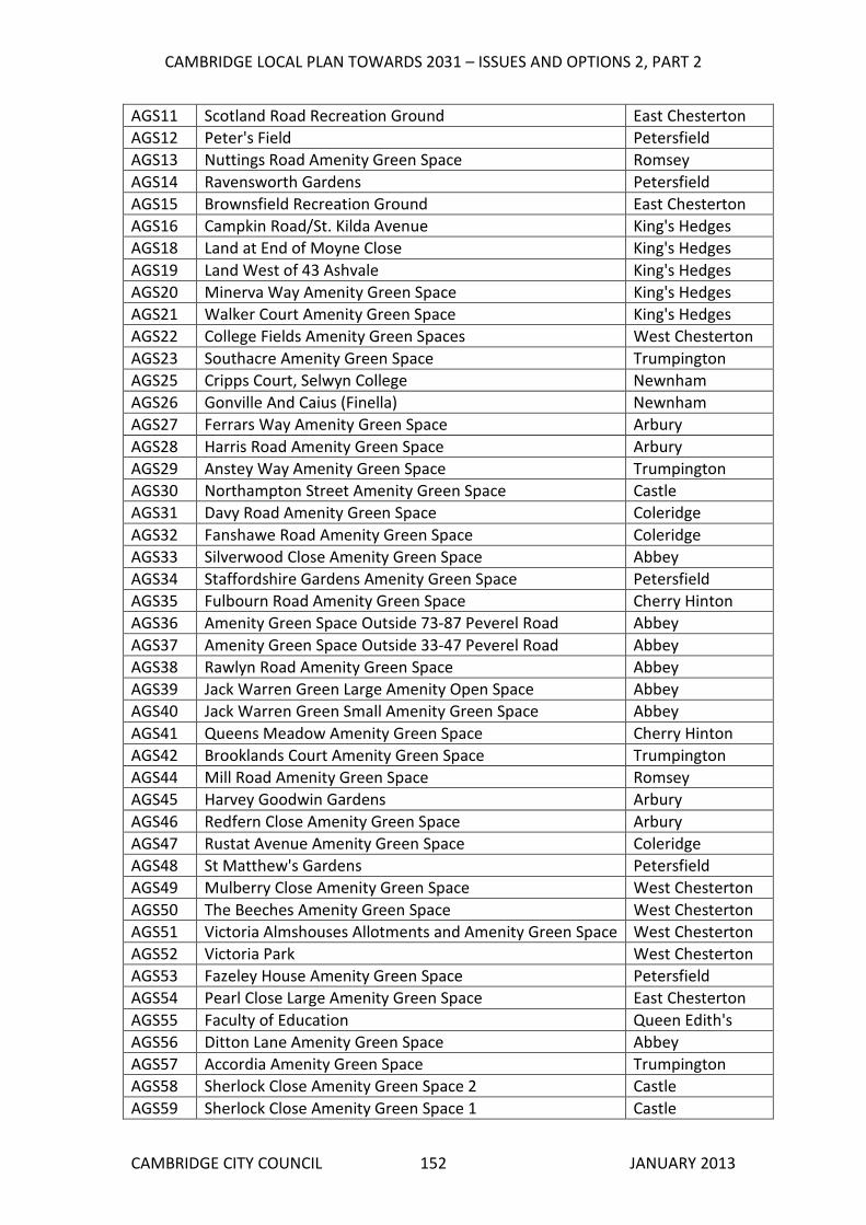
CAMBRIDGE LOCAL PLAN TOWARDS 2031 – ISSUES AND OPTIONS 2, PART 2
CAMBRIDGE CITY COUNCIL JANUARY 2013 152
AGS11 Scotland Road Recreation Ground East Chesterton
AGS12 Peter's Field Petersfield
AGS13 Nuttings Road Amenity Green Space Romsey
AGS14 Ravensworth Gardens Petersfield
AGS15 Brownsfield Recreation Ground East Chesterton
AGS16 Campkin Road/St. Kilda Avenue King's Hedges
AGS18 Land at End of Moyne Close King's Hedges
AGS19 Land West of 43 Ashvale King's Hedges
AGS20 Minerva Way Amenity Green Space King's Hedges
AGS21 Walker Court Amenity Green Space King's Hedges
AGS22 College Fields Amenity Green Spaces West Chesterton
AGS23 Southacre Amenity Green Space Trumpington
AGS25 Cripps Court, Selwyn College Newnham
AGS26 Gonville And Caius (Finella) Newnham
AGS27 Ferrars Way Amenity Green Space Arbury
AGS28 Harris Road Amenity Green Space Arbury
AGS29 Anstey Way Amenity Green Space Trumpington
AGS30 Northampton Street Amenity Green Space Castle
AGS31 Davy Road Amenity Green Space Coleridge
AGS32 Fanshawe Road Amenity Green Space Coleridge
AGS33 Silverwood Close Amenity Green Space Abbey
AGS34 Staffordshire Gardens Amenity Green Space Petersfield
AGS35 Fulbourn Road Amenity Green Space Cherry Hinton
AGS36 Amenity Green Space Outside 73-87 Peverel Road Abbey
AGS37 Amenity Green Space Outside 33-47 Peverel Road Abbey
AGS38 Rawlyn Road Amenity Green Space Abbey
AGS39 Jack Warren Green Large Amenity Open Space Abbey
AGS40 Jack Warren Green Small Amenity Green Space Abbey
AGS41 Queens Meadow Amenity Green Space Cherry Hinton
AGS42 Brooklands Court Amenity Green Space Trumpington
AGS44 Mill Road Amenity Green Space Romsey
AGS45 Harvey Goodwin Gardens Arbury
AGS46 Redfern Close Amenity Green Space Arbury
AGS47 Rustat Avenue Amenity Green Space Coleridge
AGS48 St Matthew's Gardens Petersfield
AGS49 Mulberry Close Amenity Green Space West Chesterton
AGS50 The Beeches Amenity Green Space West Chesterton
AGS51 Victoria Almshouses Allotments and Amenity Green Space West Chesterton
AGS52 Victoria Park West Chesterton
AGS53 Fazeley House Amenity Green Space Petersfield
AGS54 Pearl Close Large Amenity Green Space East Chesterton
AGS55 Faculty of Education Queen Edith's
AGS56 Ditton Lane Amenity Green Space Abbey
AGS57 Accordia Amenity Green Space Trumpington
AGS58 Sherlock Close Amenity Green Space 2 Castle
AGS59 Sherlock Close Amenity Green Space 1 Castle

CAMBRIDGE LOCAL PLAN TOWARDS 2031 – ISSUES AND OPTIONS 2, PART 2
CAMBRIDGE CITY COUNCIL JANUARY 2013 153
AGS60 Westminster College Castle
AGS61 Pye Meadow East Chesterton
AGS62 The Pightle and Principals Lodge Newnham
AGS63 Fison Road Amenity Green Space Abbey
AGS64 St Mary's Amenity Green Space Trumpington
AGS65 Hanson Court Amenity Green Space King's Hedges
AGS66 Hughes Hall Amenity Green Space Petersfield
AGS67 Pinehurst Newnham
AGS68 Borrowdale Amenity Green Space Arbury
AGS70 Carisbrooke Road Amenity Green Space Castle
AGS71 Peverel Road Small Amenity Green Space Abbey
AGS72 Barnwell Road Amenity Green Space Abbey
AGS73 Wadloes Road Amenity Green Space Abbey
AGS74 Hampden Gardens Romsey
AGS75 Whitehill Close Amenity Green Space Abbey
AGS76 Tiverton Estate Amenity Green Spaces Coleridge
AGS77 St Thomas's Square Amenity Green Spaces Coleridge
AGS78 Corrie Road Cut Through Coleridge
AGS79 Abbey House Abbey
AGS80 Brother's Place Amenity Green Space Coleridge
AGS81 Derwent Close Amenity Green Space Coleridge
AGS82 Greystoke Road Amenity Green Space Cherry Hinton
AGS83 Kelsey Crescent Amenity Green Space Cherry Hinton
AGS84 Ditton Fields Amenity Green Space Abbey
AGS85 Centre for Mathematical Sciences Newnham
Cemeteries and Churchyards (CEM)
CEM01 Trumpington Church Extension Churchyard Trumpington
CEM02 Trumpington Church Cemetery (St Mary & St Michael's
Church)
Trumpington
CEM03 Newmarket Road Cemetery Abbey
CEM04 Church End Cemetery (St Andrew's Church) Cherry Hinton
CEM05 Histon Road Cemetery Arbury
CEM06 Mill Road Cemetery Petersfield
CEM07 St Andrews Church Cemetery East Chesterton
CEM08 All Souls Lane (Ascension) Cemetery Castle
CEM09 St Mary the Less Churchyard Market
CEM10 St Giles' Churchyard Arbury
CEM11 St Peter's Churchyard Castle
CEM12 St Luke’s Churchyard Arbury
CEM13 Abbey Church (St Andrew-the-less or Barnwell Priory) Abbey
Civic Spaces (CIV)
CIV01 War Memorial Square Abbey
CIV02 Fisher Square Market
CIV03 Market Place Market
CIV04 Cambridge Leisure Park Coleridge

CAMBRIDGE LOCAL PLAN TOWARDS 2031 – ISSUES AND OPTIONS 2, PART 2
CAMBRIDGE CITY COUNCIL JANUARY 2013 154
Spaces for Children and Young People (CYP)
CYP01 Cameron Road Play Area King's Hedges
CYP02 Beales Way Play Area King's Hedges
CYP03 Ramsden Square Play Area King's Hedges
CYP04 Penarth Place Play Area Newnham
CYP05 Play Area Behind 70-78 Hazelwood Close Arbury
CYP06 Ainsworth Street Play Area Petersfield
CYP07 Ravensworth Gardens Toddler Play Area Petersfield
CYP08 Flower Street Play Area Petersfield
CYP09 Shenstone Play area Petersfield
CYP10 St Thomas' Road Play Area Coleridge
CYP11 Gunhild Way Play Area Queen Edith's
CYP12 Peverel Road Play Area Abbey
CYP13 Reilly Way Play Area Cherry Hinton
CYP14 Velos Walk Play Area Abbey
CYP15 Albion Yard Children's Play Area Castle
CYP16 Arbury Local Centre Play Area King's Hedges
CYP17 Bateson Road Play Area West Chesterton
CYP18 Hazelwood Close Toddler Play Area Arbury
CYP19 Pearl Close Toddler Play Area East Chesterton
CYP20 Hawkins Road Children's Play Area King's Hedges
CYP21 St Matthew's Primary School Petersfield
CYP22 Chestnut Grove Recreation Ground West Chesterton
CYP23 Ainsdale Children's Play Area Cherry Hinton
CYP24 Holbrook Road Children's Play Space Queen Edith's
CYP25 Discovery Way Children's Play Space East Chesterton
CYP26 Castle School Playground West Chesterton
CYP27 Kathleen Elliot Way Children's Play Space Cherry Hinton
CYP28 River Lane Play Area Abbey
Natural and Semi-natural Green Spaces (NAT)
NAT01 Bramblefields Local Nature Reserve East Chesterton
NAT02 Byron's Pool Local Nature Reserve Trumpington
NAT03 Limekiln Close Local Nature Reserve Cherry Hinton
NAT04 Logans Meadow Local Nature Reserve East Chesterton
NAT05 Paradise Nature Reserve Newnham
NAT06 Sheeps Green & Coe Fen Newnham
NAT07 Stourbridge Common Abbey
NAT08 Barnwell Pit (Lake) Abbey
NAT09 Barnwell Junction Pasture and Disused Railway Abbey
NAT10 Ditton Meadows Abbey
NAT11 Spinney - Blue Circle Coleridge
NAT12 Wetland Area (Perse School Playing Fields) Trumpington
NAT13 Lynfield Lane East Chesterton
NAT14 West Pit SSSI (Limekiln Caravan Club) Cherry Hinton
NAT15 East Pit (South of Limekiln Close LNR) Cherry Hinton

CAMBRIDGE LOCAL PLAN TOWARDS 2031 – ISSUES AND OPTIONS 2, PART 2
CAMBRIDGE CITY COUNCIL JANUARY 2013 155
NAT16 Limekiln Hill Reservoirs Cherry Hinton
NAT17 Madingley Rise Meadow Castle
NAT18 Barton Road Lake Newnham
NAT19 Meadow Triangle near Wilberforce Road and Cycle Way Newnham
NAT20 Conduit Head Road Lake Castle
NAT22 Adams Road Sanctuary (Lake) Newnham
NAT23 M11 Verge and Scrub East of M11 Newnham
NAT24 Traveller's Rest Pit (SSSI) Castle
NAT25 Netherhall Farm Meadow Queen Edith's
NAT26 Meadow & Small Wood (Peterhouse) - South of Hayster
Drive
Cherry Hinton
NAT28 Lakes Adjacent to Cherry Hinton Brook Coleridge
NAT29 Emmanuel College Gardens Market
NAT30 Barnwell East Local Nature Reserve Abbey
NAT31 Barnwell West Local Nature Reserve Abbey
NAT32 Hayster Drive Open Space Cherry Hinton
NAT33 Empty Common (Copses and Pastures) Trumpington
NAT34 Brookside Trumpington
NAT35 The Grove Newnham
NAT36 Giant's Grave Cherry Hinton
NAT37 Former Landfill Site West of Norman Way Cherry Hinton
NAT38 Former Landfill Site East of Norman Way Cherry Hinton
NAT39 River Cam Residential Gardens East Chesterton
NAT40 Disused Railway Line North of Ronald Rolph Court Abbey
NAT41 Cobbetts Corner Newnham
Parks and Gardens (P&G)
P&G01 Alexandra Gardens Arbury
P&G02 Arbury Town Park King's Hedges
P&G03 Cherry Hinton Hall Cherry Hinton
P&G04 Cherry Hinton Recreation Ground Cherry Hinton
P&G05 Chesterton Recreation Ground East Chesterton
P&G06 Christ's Pieces Market
P&G07 Coleridge Recreation Ground Coleridge
P&G08 Histon Road Recreation Ground Castle
P&G09 Jesus Green Market
P&G10 King's Hedges Recreation Ground King's Hedges
P&G11 Lammas Land Newnham
P&G12 Midsummer Common Market
P&G13 New Square Market
P&G14 Nightingale Avenue Recreation Ground Queen Edith's
P&G15 Nun's Way Recreation Ground King's Hedges
P&G16 Parker's Piece Market
P&G17 Bell School of Language Queen Edith's
P&G18 Romsey Recreation Ground Romsey
P&G19 St. Albans Road Recreation Ground Arbury
P&G20 St. Matthew's Piece Petersfield

CAMBRIDGE LOCAL PLAN TOWARDS 2031 – ISSUES AND OPTIONS 2, PART 2
CAMBRIDGE CITY COUNCIL JANUARY 2013 156
P&G21 Trumpington Recreation Ground (King George V
Memorial Playing Field)
Trumpington
P&G22 Coldhams Common Abbey
P&G23 St John's College Gardens Castle
P&G24 Cambridge University Observatory Castle
P&G25 Edgecombe Flats Green King's Hedges
P&G26 Church End Green Space Cherry Hinton
P&G27 Cambridge University Botanic Garden Trumpington
P&G28 Jubilee Gardens Arbury
P&G29 Magdalene College Grounds Castle
P&G30 Causeway Park East Chesterton
P&G31 Queens' College Newnham
P&G32 Trinity College Gardens Castle
P&G33 Christ's College Gardens Market
P&G34 Peterhouse Gardens Market
P&G35 King's College Newnham
P&G36 Pembroke College Gardens Market
P&G37 Ridley Hall Grounds Newnham
P&G38 Gonville and Caius Fellows Garden Newnham
P&G39 Selwyn College Gardens Newnham
P&G40 Newnham College Gardens Newnham
P&G41 Wychfield Castle
P&G42 Lucy Cavendish College Castle
P&G43 Fitzwilliam College Gardens Castle
P&G44 Murray Edwards College Gardens Castle
P&G45 Castle Mound Castle
P&G46 Homerton College Grounds Queen Edith's
P&G47 St Edmund's College Gardens Castle
P&G48 Trinity Hall Gardens Castle
P&G49 Gonville and Caius College Gardens Castle
P&G50 Clare College Gardens Newnham
P&G51 Anstey Hall Trumpington
P&G52 Sidney Sussex College Gardens Market
P&G53 Robinson College Gardens Newnham
P&G54 Trinity College Fellows Garden Castle
P&G55 Trinity College - Burrell's Field Castle
P&G56 Corpus Christi Market
P&G57 Clare Hall Scholars Garden Newnham
Outdoor Sports Facilities (SPO)
SPO01 Barnwell Road Recreation Ground Abbey
SPO02 Cambridge City Football Club West Chesterton
SPO03 Cambridge Football Stadium Trumpington
SPO04 Arbury County Primary School West Chesterton
SPO05 Cambridge Rugby Football Club Newnham
SPO06 Cambridge Tennis & Hockey Club Newnham
SPO07 Cambridge United FC Abbey

CAMBRIDGE LOCAL PLAN TOWARDS 2031 – ISSUES AND OPTIONS 2, PART 2
CAMBRIDGE CITY COUNCIL JANUARY 2013 157
SPO08 Chesterton Community College West Chesterton
SPO10 Churchill College Grounds Castle
SPO11 Clare College Playing Fields Trumpington
SPO12 Coleridge Community College Playing Fields Coleridge
SPO13 Colville County Primary School Cherry Hinton
SPO14 Corpus Christi Playing Fields Newnham
SPO15 Cambridge University Press Playing Fields Trumpington
SPO16 Emmanuel College Playing Field Newnham
SPO17 Fawcett Primary School Trumpington
SPO18 Fenners Cricket Ground Petersfield
SPO19 Fitzwilliam College Playing Fields Castle
SPO20 Gonville and Caius College Playing Fields Newnham
SPO21 Grove Primary School King's Hedges
SPO22 Hills Road Sport Centre (Tennis Courts) Queen Edith's
SPO24 Jesus College Market
SPO25 King's Hedges County Primary School King's Hedges
SPO26 Kings College School Newnham
SPO27 Leys School Playing Field Trumpington
SPO28 Leys and St Faiths Schools Playing Field Trumpington
SPO29 Long Road Sixth Form College Queen Edith's
SPO30 Manor Community College Playing Fields King's Hedges
SPO31 Netherhall School (South) Queen Edith's
SPO32 Queen Emma Primary School Queen Edith's
SPO33 Newnham College Playing Field Newnham
SPO34 Newnham Croft Primary School Newnham
SPO35 Pembroke, Peterhouse, Downing, St. Catherine's and
Christ's Colleges
Newnham
SPO36 Perse Preparatory School (Peterhouse College) Trumpington
SPO37 Perse School For Boys Playing Field Queen Edith's
SPO38 Perse School For Girls Playing Field Trumpington
SPO39 Abbey Meadows Primary School Abbey
SPO40 Queen Edith Primary School Queen Edith's
SPO41 University Croquet & Tennis Club (Cocks & Hens Lawn
Tennis Club)
Newnham
SPO42 Spinney County Primary School Cherry Hinton
SPO43 St. Andrews Primary School East Chesterton
SPO44 St Bede's School Coleridge
SPO45 St Faith's Playing Field Trumpington
SPO46 St John’s and Magdalene Colleges Playing Field Castle
SPO47 St Lawrence Catholic Primary School King's Hedges
SPO48 St Luke's Primary School Arbury
SPO49 St Mary's School Playing Field Trumpington
SPO50 Trinity College Playing Field Newnham
SPO51 Trinity Hall Ground Castle
SPO52 University Athletics Track Newnham
SPO53 University Rugby Club Newnham

CAMBRIDGE LOCAL PLAN TOWARDS 2031 – ISSUES AND OPTIONS 2, PART 2
CAMBRIDGE CITY COUNCIL JANUARY 2013 158
SPO54 University Rugby Club Practice Ground Newnham
SPO55 Chesterton Community College Playing Field West Chesterton
SPO56 Milton Road Primary School West Chesterton
SPO58 Mayfield Primary School Castle
SPO59 Cantabrigian Rugby Football Grounds Queen Edith's
SPO60 Cambridge Lakes Golf Course Trumpington
SPO61 Cambridge and County Bowling Club Trumpington
SPO62 Perse Preparatory School Trumpington
SPO63 Downing College Market
SPO65 Chesterton Bowls Club East Chesterton
SPO66 Trinity College Hockey Field Newnham
SPO67 Cherry Hinton Infants School Cherry Hinton

CAMBRIDGE LOCAL PLAN TOWARDS 2031 – ISSUES AND OPTIONS 2, PART 2
CAMBRIDGE CITY COUNCIL JANUARY 2013 159

CAMBRIDGE LOCAL PLAN TOWARDS 2031 – ISSUES AND OPTIONS 2, PART 2
CAMBRIDGE CITY COUNCIL JANUARY 2013 160

CAMBRIDGE LOCAL PLAN TOWARDS 2031 – ISSUES AND OPTIONS 2, PART 2
CAMBRIDGE CITY COUNCIL JANUARY 2013 161

CAMBRIDGE LOCAL PLAN TOWARDS 2031 – ISSUES AND OPTIONS 2, PART 2
CAMBRIDGE CITY COUNCIL JANUARY 2013 162

CAMBRIDGE LOCAL PLAN TOWARDS 2031 – ISSUES AND OPTIONS 2, PART 2
CAMBRIDGE CITY COUNCIL JANUARY 2013 163

CAMBRIDGE LOCAL PLAN TOWARDS 2031 – ISSUES AND OPTIONS 2, PART 2
CAMBRIDGE CITY COUNCIL JANUARY 2013 164

CAMBRIDGE LOCAL PLAN TOWARDS 2031 – ISSUES AND OPTIONS 2, PART 2
CAMBRIDGE CITY COUNCIL JANUARY 2013 165

CAMBRIDGE LOCAL PLAN TOWARDS 2031 – ISSUES AND OPTIONS 2, PART 2
CAMBRIDGE CITY COUNCIL JANUARY 2013 166

CAMBRIDGE LOCAL PLAN TOWARDS 2031 – ISSUES AND OPTIONS 2, PART 2
CAMBRIDGE CITY COUNCIL JANUARY 2013 167

CAMBRIDGE LOCAL PLAN TOWARDS 2031 – ISSUES AND OPTIONS 2, PART 2
CAMBRIDGE CITY COUNCIL JANUARY 2013 168

CAMBRIDGE LOCAL PLAN TOWARDS 2031 – ISSUES AND OPTIONS 2, PART 2
CAMBRIDGE CITY COUNCIL JANUARY 2013 169

CAMBRIDGE LOCAL PLAN TOWARDS 2031 – ISSUES AND OPTIONS 2, PART 2
CAMBRIDGE CITY COUNCIL JANUARY 2013 170

CAMBRIDGE LOCAL PLAN TOWARDS 2031 – ISSUES AND OPTIONS 2, PART 2
CAMBRIDGE CITY COUNCIL JANUARY 2013 171

CAMBRIDGE LOCAL PLAN TOWARDS 2031 – ISSUES AND OPTIONS 2, PART 2
CAMBRIDGE CITY COUNCIL JANUARY 2013 172

Appendix 1
20121218 - Chapter Pages Part 2.indd 13 18/12/2012 16:26:07

CAMBRIDGE LOCAL PLAN TOWARDS 2031 – ISSUES AND OPTIONS, PART 2
CAMBRIDGE CITY COUNCIL JANUARY 2031 174
APPENDIX 1: OTHER SITES CONSIDERED A number of sources were used to arrive at a list of sites to assess. These include the following sources, although this is not an exhaustive list: • Sites allocated in the existing adopted Local Plan 2006, associated Area Action
Plans, and Supplementary Planning Documents, which have not been developed.
• Sites identified in the following studies: o Strategic Housing Land Availability Assessment (SHLAA) May 2012. o Employment Land Review 2007 and 2012 update. o Gypsy and Traveller Provision in Cambridge: Site Assessment o Cambridge Hotel Futures: Headline Findings Issues & Options Report April 2012 o Other documents eg those produced by Cambridgeshire Horizons.
• Any sites and site boundaries identified by the Council within the Issues and Options Consultation (June 2012).
• Any sites subsequently submitted by landowners and developers or their agents in their responses to the Council’s Issues and Options consultation June‐July 2012.
• Any sites identified by the Council’s own internal directorates, other Councils, statutory government agencies, and statutory undertakers.
A long list of sites was drawn up and was initially reduced, by removing those sites which had already been consulted upon in the Issues and Options 1 consultation in June/July 2012, sites less than 0.5 hectares (apart from a small number of residential sites which due to their location could be developed at a high density), and those picked up through annual monitoring where planning permission had been granted or where the landowner has indicated that they do not wish to bring the site forward. The following tables provide information on the other sites that were considered: RESIDENTIAL Site Reference Description Reason R22 (Local Plan 2006 Allocation Site 5.13)
Milton Road Infant & Junior School (former)
Half the site has been developed, the remainder of the site has an extant planning consent and is less than 0.5ha. It does not merit allocation.
R23 (Local Plan 2006 Allocation Site 9.14)
Land between 64‐66 Peverel Road
The part of the site that is not Protected Open Space is less than 0.5ha and does not merit allocation.
R24 (Representation 16287 to Issues and Options)
Perse Playing Fields Protected Open Space. No suitable access.

CAMBRIDGE LOCAL PLAN TOWARDS 2031 – ISSUES AND OPTIONS, PART 2
CAMBRIDGE CITY COUNCIL JANUARY 2031 175
Site Reference Description Reason R25 (Representation 12286 to Issues and Options)
Emmanuel College Playing Fields
Protected Open Space.
R26 (SHLAA Site CC909)
Shire Hall site, Old Police Station, Castle Mound and 42 Castle Street
Not available for development.
R27 (Local Plan 2006 Allocation Site 5.01)
Land off Fitzwilliam Road and Clarendon Road
Under construction.
R28 (Local Plan 2006 Allocation Site 5.03)
Cromwell Road Mostly built out.
R29 (Local Plan 2006 Allocation Site 5.08)
Territorial Army, Cherry Hinton Road
Not available for development.
R30 (Local Plan 2006 Allocation Site 5.10)
The Nuffield Hospital, Trumpington Road
Not available for development.
R31 (Local Plan 2006 Allocation Site 5.11)
Caravan Park, Fen Road
Not available for development.
R32 (Local Plan 2006 Allocation Site 5.16)
147 Hills Road Under construction.
R33 (Local Plan 2006 Allocation Site 5.18)
Sandy Lane Under construction.
R34 (Local Plan 2006 Allocation Site 5.19)
135 Long Road Built out.
R35 (Local Plan 2006 Allocation Site 9.06)
Clay Farm, South of Long Road
Under construction.

CAMBRIDGE LOCAL PLAN TOWARDS 2031 – ISSUES AND OPTIONS, PART 2
CAMBRIDGE CITY COUNCIL JANUARY 2031 176
Site Reference Description Reason R36 (Local Plan 2006 Allocation Site 9.08)
Monsanto Site Under construction.
R37 (Local Plan 2006 Allocation Site 9.08)
Bell School Site, Red Cross Lane
Outline consent in place.
R38 (Local Plan 2006 Allocation Site 9.08)
Glebe Farm Extant planning consent on most of this site. The remainder is proposed for allocation as site R15.
R39 (Local Plan 2006 Allocation Site 9.15)
Land between Hills Road and Station Road
Built out.
MIXED USE Site Reference Description Reason R22 (Local Plan 2006 Allocation Site 5.13)
Milton Road Infant & Junior School (former)
Half the site has been developed, the remainder of the site has an extant planning consent and is less than 0.5ha. It does not merit allocation.
R26 (SHLAA Site CC909)
Shire Hall site, Old Police Station, Castle Mound and 42 Castle Street
Not available for development.
M6 (Local Plan 2006 Allocation Site 7.01)
New Street/Newmarket Road
Mostly built out. The remainder of the site is too small to allocate.
M7 (Local Plan 2006 Allocation Site 6.01)
Bradwell’s Court Built out.
M8 (Local Plan 2006 Allocation Site 7.11)
Brunswick Site Under construction.
M9 (Local Plan 2006
Addenbrooke’s Outline consent in place.

CAMBRIDGE LOCAL PLAN TOWARDS 2031 – ISSUES AND OPTIONS, PART 2
CAMBRIDGE CITY COUNCIL JANUARY 2031 177
Site Reference Description Reason Allocation Site 9.02) M10 (Local Plan 2006 Allocation Site 9.03)
Huntingdon Road/Histon Road
Outline consent in place.
M11 (Local Plan 2006 Allocation Site 9.05)
East of Shelford Road
Under construction.
M12 (Local Plan 2006 Allocation Site 7.02)
Betjeman House, Hills Road
Under construction.
EMPLOYMENT Site Reference Description Reason E6 (Employment Land Review 2008 and 2012)
Rail Sidings, 80 Rustat Road
There is no viable access to this site.
E7 (Employment Land Review 2012)
City House and 132 – 134 Hills Road
Existing commitment – office building.
E8 (Local Plan 2006 Allocation Site 7.05)
Coldham’s Road Built out.
M6 (Local Plan 2006 Allocation Site 7.01)
New Street/Newmarket Road
Mostly built out. The remainder of the site is too small to allocate.

CAMBRIDGE LOCAL PLAN TOWARDS 2031 – ISSUES AND OPTIONS, PART 2
CAMBRIDGE CITY COUNCIL JANUARY 2031 178
UNIVERSITY Site Reference Description Reason U3 (Local Plan 2006 Allocation Site 7.09)
Grange Farm, Wilberforce Road
Surface water issues, no suitable access, insufficient highway capacity
U4 (Representation 11134 to Issues and Options)
Meadow Triangle, land to the southern end of Wilberforce Road
Protected Open Space
U5 (Local Plan 2006 Allocation Site 7.09)
Leckhampton House
College has provided student accommodation on alternative adjacent site.
U6 (Local Plan 2006 Allocation Site 7.09)
Sedley School Site Built out.
U7 (Local Plan 2006 Allocation Site 7.14)
Bradmore Street Site
Built out for Anglia Ruskin University’s Optometry Clinic.
RESIDENTIAL MOORINGS Site Reference Description Reason RM2 (Representation 17979 to Issues and Options)
Southern Bank of River Cam, Stourbridge Common
All possible mooring areas are already in use in this area.
HOTEL Site Reference Description Reason R22 (Local Plan 2006 Allocation Site 5.13)
Milton Road Infant & Junior School (former)
Half the site has been developed, the remainder of the site has an extant planning consent and is less than 0.5ha. It does not merit allocation.
M6 (Local Plan 2006 Allocation Site 7.01)
New Street/Newmarket Road
Mostly built out. The remainder of the site is too small to allocate.

CAMBRIDGE LOCAL PLAN TOWARDS 2031 – ISSUES AND OPTIONS, PART 2
CAMBRIDGE CITY COUNCIL JANUARY 2031 179
GYPSY AND TRAVELLER SITE OPTIONS Site Reference Description Reason GT1 (Representation 9986 to Issues and Option)
Babraham Road Park and Ride
Not suitable, due to distance from facilities.
SITES C ONSULTED ON AT ISSUES AND OPTIONS STAGE The following sites were consulted on as Opportunity Areas as part of the Local Plan Issues and Options in June/July 2012. Site area Option in
I&O Report Type of development
Station Area 28 Existing allocation with planning permission.
Southern Fringe 29 Existing allocations with planning permissions
Addenbrooke’s Hospital 30 Existing allocation and safeguarded land to south
North West Cambridge 31 Existing allocations with planning permissions
West Cambridge
32 Intensification of site
Northern Fringe East – Including sewage works, Golf Driving Range, Former Park and Ride, Cambridge Business Park and Cambridge Commercial Park (all in Cowley Road Area)
33 Existing allocation, but different use – high density mixed employment led development and new railway station
Cambridge East Including Land West of Norman Way and Land East of Norman Way, Sainsbury’s, TA Centre, Hansons
34,35,36 Existing allocation which won’t be taken forward during the plan period – options to either retain allocation, allocate as safeguarded land or return to Green Belt

CAMBRIDGE LOCAL PLAN TOWARDS 2031 – ISSUES AND OPTIONS, PART 2
CAMBRIDGE CITY COUNCIL JANUARY 2031 180
Eastern Gate 38 Improvements to public realm and some development sites
Cambridge Railway Station to the City Centre and Hills Road Corridor
39 Improvements to public realm and some development sites
Land South of Coldham’s Lane
40 Opportunities for recreation and links through the area. Some development sites – Land East of Norman Way Business Park, Land West of Rosemary Lane, Norman Way Business Park, Sainsbury’s and the Territorial Army Centre
SHLAA SITES The following Strategic Housing Land Availability Assessment (SHLAA) sites were considered deliverable or developable, but have not been taken forward at this stage as they are below 0.5ha in size. SHLAA Site Reference
Description Area in hectares
202 1 Ditton Walk 0.28 430 Catholic Church of St. Vincent de Paul, Ditton
Lane 0.16
870 Ditton Fields Nursery School, Wadloes Road 0.19 855 Telephone Exchange south of 1 Ditton Lane
0.17
012 162 ‐ 184 Histon Road 0.23 057 BP Garage, 452 Cherry Hinton Road and garages
off Glenmere Close 0.26
081 152 Coleridge Road 0.21 151 Land to R/O 1 ‐ 28 Jackson Road (Car parking and
lock‐up garages) 0.27
887 98‐144 Campkin Road 0.52 1 902 Land south of the Ship, including the car park 0.34 204 48‐61 Burleigh Street 0.30 917 Auckland Road Clinic 0.20 196 31 Queen Edith’s Way 0.23 070 213 ‐ 217 Mill Road 0.22 918 18 Vinery Road 0.20
1 Over 0.5ha but too few dwellings in terms of net gain.

Appendix 2
20121218 - Chapter Pages Part 2.indd 14 18/12/2012 16:26:07

CAMBRIDGE LOCAL PLAN TOWARDS 2031 – ISSUES AND OPTIONS, PART2
APPENDIX 2: EXISTING NON‐RESIDENTIAL CAR PARKING STANDARDS The standards set out below are the existing car parking standards for new non‐residential development from the current Local Plan (2006). They can be found in Appendix C of the current Plan. It is recognised that there is a functional difference between a development which is entirely or largely for student residential accommodation, and the non‐residential elements of Colleges where there may be a variety of other uses including administrative and teaching activities. In these circumstances, it may be appropriate to make additional car parking provision commensurate with the relevant standards for such uses as “offices” and “higher and further education”. Other Residential Developments Type of Development Inside CPZ Outside CPZ
1 space for every 4 bedrooms and 1 space per resident staff.
2 spaces for every 3 bedrooms and 1 space per resident staff.
Guest houses and hotels
Off‐street coach parking to be conveniently located in relation to developments of 40 or more bedrooms.
Where there are rooms specifically designed for people with disabilities, disabled parking of at least 1 space for each room so designed should be provided.
Type of Development Inside CPZ Outside CPZ
1 space for every 10 residents, 1 space for every 2 members of staff.
1 space for every 8 residents, 1 space for every 2 members of staff.
Nursing homes
Provision must be made for ambulance parking.
1 space for every 6 units, 1 space for every 2 members of staff.
1 space for every 4 units, 1 space for every 2 members of staff.
Retirement homes/ sheltered houses
Provision must be made for ambulance parking. A covered, enclosed area with electricity sockets needs to be provided for electric buggies.
CAMBRIDGE CITY COUNCIL JANUARY 2031 182

CAMBRIDGE LOCAL PLAN TOWARDS 2031 – ISSUES AND OPTIONS, PART2
1 space for every 10 bed spaces. A pickup and drop‐off area could also be included if appropriate to the particular proposed development.
1 space for every resident warden/staff.
1 space for every 10 bed spaces. A pickup and drop‐off area could also be included if appropriate to the particular proposed development.
1 space for every resident warden/staff.
Student residential accommodation where proctorial control or alternative control on car parking exists
Where there are rooms specifically designed for people with disabilities, disabled parking of at least 1 space for each room so designed should be provided.
1 space for every 5 bed spaces.
1 space for every resident warden/staff.
1 space for every 3 bed spaces.
1 space for every resident warden/staff.
Student residential accommodation where proctorial control does not exist or where control exists but the development will house conference delegates
Where there are rooms specifically designed for people with disabilities, disabled parking of at least 1 space for each room so designed should be provided. Controls will be necessary to limit use of car parking outside conference times.
1 space for every 3 non‐resident staff plus 1 space per resident warden/staff
On merit Residential schools, college or training centre
Where there are rooms specifically designed for people with disabilities, disabled parking of at least 1 space for each room so designed should be provided.
Hospitals On merit On merit
CAMBRIDGE CITY COUNCIL JANUARY 2031 183

CAMBRIDGE LOCAL PLAN TOWARDS 2031 – ISSUES AND OPTIONS, PART2
Retail, Culture, Leisure and Sports Uses Limited car parking will be allowed in the Controlled Parking Zone (CPZ) for these types of uses. Access will primarily rely on public transport, cycling and walking. Car journeys will be accommodated through public parking, including Park and Ride. Outside the CPZ, Transport Assessments will play a key role in determining the optimal level of car parking, in particular for mixed use developments and retail parks where linked trips might lead to a level of parking below Cambridge City Council's standards. A picking up and dropping off point for taxis and mini‐buses will need to be provided. Retail, Culture, Leisure and Sports Uses
Retail Use Inside Inside CPZ Outside CPZ
Food retail Disabled car parking only. 1 space for every 50m2
GFA1up to 1,400m2 and 1 per 18m2 thereafter, including disabled car parking.
Non‐food retail Disabled car parking only. 1 space for every 50m2 GFA, including disabled car parking.
Financial and professional services
1 space for every 100m2 GFA to include customer parking, plus disabled car parking.
1 space for every 40m2 GFA, including disabled car parking.
Food and drink takeaways
1 space for proprietor resident.
1 space for every 20m2 drinking/dining area, including disabled car parking. 1 space for proprietor when resident.
1 Gross Floor Area
CAMBRIDGE CITY COUNCIL JANUARY 2031 184

CAMBRIDGE LOCAL PLAN TOWARDS 2031 – ISSUES AND OPTIONS, PART2
CAMBRIDGE CITY COUNCIL JANUARY 2031 185
Assembly, Culture, Leisure and Sports Uses
Use Inside CPZ Outside CPZ
Museums, exhibition venues
Disabled only
On merit
Sports and recreational facilities, swimming baths
1 space for every 3 staff plus disabled car parking
2 spaces for every 3 staff, plus 1 space for every 4 seats, including disabled car parking
Cinema Disabled and 1 space for every 2 staff
1 space for every 5 seats, including disabled car parking
Stadia Disabled car parking only 1 space for every 15 seats, including disabled car parking
Places of assembly including, theatre, auditoria and concert hall
Disabled car parking and 1 space for every 2 staff
1 space for every 4 seats, including disabled and staff car parking
Place of worship 1 space per 100m2 floor area, plus disabled car parking
1 space for every 8 seats, including disabled car parking
Public halls / community centres
1 space per 100m2 floor area, plus disabled car parking
1 space per 20m2 of public space, including disabled car parking
Office Use
Limited car parking will be allowed in the Controlled Parking Zone. Access will primarily rely on public transport, cycling and walking.
Business and Industrial Uses
Use Inside CPZ Outside CPZ
Offices, general industry
1 space per 100m2 GFA plus disabled car parking
1 space per 40m2 GFA, including disabled car parking
Storage 1 space per 300m2 GFA plus disabled car parking
1 space per 100m2 GFA, including disabled car parking

CAMBRIDGE LOCAL PLAN TOWARDS 2031 – ISSUES AND OPTIONS, PART2
Non‐residential Institutions
Use Inside CPZ Outside CPZ
Clinics and surgeries 1 space for every 2 professional members of staff plus 1 space per consulting room
1 space for every professional member of staff plus 2 spaces per consulting room
Non‐residential schools
1 space for every 3 staff 2 spaces for every 3 staff
Non‐residential higher and further education
1 space for every 4 staff
2 spaces for every 3 staff
Crèches 1 space for every 3 staff
2 spaces for every 3 staff
Provision for People with Disabilities Generally, at least 5% of the total number of car parking spaces, as given by the standards for outside the CPZ, should be reserved for disabled people, rounded up to the nearest whole space. Where parking provision is below the standards for outside the CPZ (including on sites within the CPZ) the required proportion of spaces reserved for disabled people will therefore be higher than 5%. Higher ratios than the 5% given above may be required in some cases by the Planning Authority, for example at medical facilities, residential care homes, community facilities and any other uses where a higher proportion of disabled users/visitors will be expected. It should be noted that provision at the above levels or any required by the Planning Authority does not guarantee that the requirements of the Disability Discrimination Act will be met, which is the responsibility of the building occupier or service provider. Spaces for disabled people should be located adjacent to entrances, be convenient to use and have dimensions that conform to Part M of the Building Regulations. If it is impossible to accommodate car parking spaces within the site, disabled car parking spaces should not be located at a distance more than 100 metres from the site. Disabled car parking spaces should be marked either 'disabled' or with a wheelchair marking.
CAMBRIDGE CITY COUNCIL JANUARY 2031 186