Embed Size (px)
Citation preview

ISO 19152 – THE LAND ADMINISTRATION DOMAIN MODEL
1,3Christiaan Lemmen, 2Prof Dr Peter van Oosterom
1 Faculty of Earth Observation and Geo-Information Science (ITC), University of Twente, P.O. Box 217, 7500 AE Enschede, THE NETHERLANDS.
2 Delft University of Technology, OTB, Section GIS Technology,
P.O. Box 5030, 2600 GA Delft, THE NETHERLANDS.
3 Netherlands Cadastre, Land Registry and Mapping Agency, P.O. Box 9046, 7300 GH Apeldoorn, THE NETHERLANDS
email: [email protected] , [email protected] , [email protected]
Abstract
This paper will focus on the Land Administration Domain Model which is under development as an International Standard at ISO. This development is an initiative of the International Federation of Surveyors – FIG. The International Standard is expected to be published in 2012. Why is this development important? What is the scope of the standard, what is included and what is not included? There will be a brief overview of the contents of the standard with attention to its core packages and to the relation to other standards (such as data quality aspects and surveying). The idea is that not only the field-survey based, high accurate, cadastral maps are supported by this standard. This would otherwise mean that many approaches would be excluded and the world is absolutely not waiting for that. On the contrary, many high accurate approaches are slow and expensive and proven not to work. A specialization of the standard, the so called “Social Tenure Domain Model (STDM)” will be introduced to the audience. This is a flexible approach to pro poor land administration on a participatory basis. The flexibility is in the unconventional options for descriptions of spatial units, parties and relations between spatial units and parties. This means informal and customary relations between people and land can be included: land administration for everyone in a local environment – not necessarily linked to formal systems but with options for future integration. Keywords: LADM, STDM, Standardisation, UML, Cadastre, Land Administration, Social Tenure
1 INTRODUCTION The development of this standard is an initiative from FIG. This development is a comprehensive, extensive, formal process with a continuous review and a continuous, creative approach to find common denominators in land administration systems and included data sets. The Land Administration Domain Model (LADM) has been published now as a Draft International Standard by the International Organization for Standardization (ISO), as ISO 19152. P-Members of ISO/TC 211, Geographic Information/Geomatics, can comment on the draft and are in the position to vote on continuation of the development. Liaisons to ISO/TC

211, such as the FIG or the Permanent Committee on GIS and Infrastructure for Asia and the Pacific, PCGIAP, can also comment on the draft. The deadline for voting and comments is June 20th, 2011. This means that the result of voting will be known during the South East Asian Survey Congress in Kuala Lumpur, Malaysia in June 2011. This gives a special ‘dimension’ to the current writing of this paper. The submitted working item proposal has been subject of a comprehensive discussion. Several reviews have been performed by the Editorial Committee. Formal comments as earlier provided by the ISO/TC 211 member bodies have been discussed and processed. The Editorial Committee’s members are from nine countries and from UN HABITAT and European Commission. During the development a continuous support from the global land community has been requested. It should be noticed that not all countries are represented in TC 211 on Geographic Information. In the South East Asia region permanent members are (May 2011): Australia (SA); People’s Republic of China (SAC), Japan (JISC), Republic of Korea (KATS), Malaysia (DSM), New Zealand (SNZ) and Thailand (TISI). Observing members of TC 211 are: Brunei Darussalam (CPRU) (corr); Hong Kong (ITCHKSAR) (corr); India (BIS); Indonesia (BSN); Mauritius (MSB) and Philippines (BPS). FIG, PCGIAP, FAO are external liaison. This paper first explains the need and importance of the standardisation of the land administration domain in paragraph 2. The scope of standardisation is explained in paragraph 3. This is followed in paragraph 4 by a brief explanation of the contents of the Draft International Standard, see ISO, 2011. A specialization of the LADM standard which is developed for customary and informal tenure systems is presented in paragraph 6. The paper end with conclusions as in paragraph 7. 2 WHY IS THIS STANDARDISATION DEVEPMENT IMPORTANT? After the development of domain-independent standards for spatial and temporal schemas for spatial features (incl. metadata standards), a next step is now the standardization of domain-specific models, as a basis for standardized (Spatial) Information Infrastructures – (S)II, also know as the geoweb – development. Some de facto standards in this area already exist, e.g. ESRI published a series of domain related standards on its website. Now there are formal International Standards under development for domains as Land Cover, Land Administration and Addressing all within ISO TC211, or CityGML (from OGC, with topographic features such as buildings, roads, water and surface elevation) or GeoSciML (GeoScience Markup Language, also from OGC), of which both are based on GML3. The standardized Land Administration Domain Model (LADM), covers land registration and cadastre in a broad sense (spatial and administrative components, source documentation included), and will serve the following goals: 1. avoid reinventing and re-implementing the same functionality over and over again, but
provide a extensible basis for efficient and effective cadastral system development based on a model driven architecture,
2. enable involved parties, both within one country and between different countries, to communicate based on the shared ontology implied by the model and
3. facilitate cadastre data exchange between in country organizations (ex: National Agency and Municipalities) and between countries or states within a country.

Such Land Administration Domain Model (ISO, 2011; Van Oosterom et al, 2006; Lemmen et al 2010a, 2010b) underpins existing conventional land administration systems. These conventional systems take into account conventional legal forms of evidence and are in principle parcel based. This means that they only cover a portion of all forms of land tenure. Also they cannot accommodate all forms of tenures. Globally there are many examples where the land use rights of informal settlement residents, slum dwellers, families and groups living under customary tenure, indigenous people, pastoralists, refugees etc. are not capable of being integrated into a conventional land administration system. The Social Tenure Domain Model (STDM) has been designed to cover all types of tenures, conventional and other social tenures such as informal and customary tenures (Augustinus et al, 2006). It compliments the Land Administration Domain Model (LADM) and allows inter-operability between the two systems (Augustinus and Lemmen, 2011). 3 WHAT IS THE SCOPE OF THE STANDARD? The draft standard for the Land Administration Domain defines a reference Model (LADM) covering basic information-related components of Land Administration (including those over water as well as land, and elements above and below the surface of the earth). It provides an abstract conceptual schema and a terminology for land administration, based on various national and international systems, that is as simple as possible in order to be useful in practice. The terminology allows a shared description of different formal or informal practices and procedures in various jurisdictions. It enables the combining of land administration information from different sources in a coherent manner. It includes agreements on data about administrative and spatial units, land rights in a broad sense and source documents (e.g. titles, deeds or survey documentation). The rights may include real and personal rights as well as customary and informal rights; the latter can be included as ‘social tenure relations’ in the STDM. Restrictions and responsibilities can be similarly represented in a flexible way to document the relationships between people and land. LADM describes the data contents of land administration in general, based on a practical approach. The roots are, amongst others, in Figs Cadastre 2014, Kaufmann, J. and D. Steudler, 1998, in Fourie, 1998, and in Henssen, 1995. Implementation can be performed in a flexible way; the standard can be extended and adapted to local situations. External links to other data bases, e.g. addresses, are included. The draft standard defines the core issues in land administration. The LADM is a conceptual schema organised in packages: (1) Party Package, (2) Administrative Package and (3) Spatial Unit Package (including the Surveying and Representation Subpackage). In section 4 the contents of those packages are presented in further detail. Existing standards have been re-used, particularly the ISO 19100 series from ISO/TC 211. LADM also includes references to the standard, ISO 19156, Geographic information – Observations and Measurements, which is under development within the ISO/TC 211. LADM can be a basis for combining data from different Land Administration Systems. The Draft International Standard includes informative example cases with people and land relationships demonstrating the flexibility of the draft standard (in Annex C). Further, the relationships with the INSPIRE (Infrastructure for Spatial Information in the European Community) Cadastral Parcels model and LPIS (Land Parcel Identification System – this is a

part of the Integrated Administration and Control System established by the European Union Member states) are described in Annexes G and H of ISO 19152. 3D Cadastres are covered in such a way that these seamlessly integrate with exiting 2D registrations. 4 CONTENTS OF THE LAND ADMINISTRATION DOMAIN MODEL The three main packages of the LADM, the Party package, the Administrative package, and the Spatial Unit package are presented here. The main class of the Party package is the class LA_Party, and its specialization LA_GroupParty. There is an optional association class LA_PartyMember (Figure 1). Parties are persons, or groups of persons, or juridical persons, that compose an identifiable single (legal) entity. A juridical person may be a company, a municipality, the state, or a church community. The definition of ‘party’ implies that a party may be a natural person, or a group of natural persons, or a non-natural person. A ‘group party’ is any number of parties, forming together a distinct entity. A ‘party member’ is a constituent of a party or group party.
Fig. 1. LADM Party package classes, Lemmen et al, 2010a The administrative package concerns the abstract class LA_RRR (with its three concrete subclasses LA_Right, LA_Restriction, and LA_Responsibility), and class LA_BAUnit (an abbreviation for ‘basic administrative unit’), see Figure 2. A ‘right’ is a formal or informal entitlement to own, to do something, or to refrain from doing something. Examples are: ownership right, tenancy right, possession, customary right, or informal right. A right can be an (informal) use right. In case of informal rights the STDM may be used. Rights may be overlapping, or may be in disagreement. A ‘restriction’ is a formal or informal entitlement to refrain from doing something; e.g. it is not allowed to build within 200 meters of a fuel station; or, a servitude or mortgage as a restriction to the ownership right. A ‘responsibility’

is a formal or informal obligation to do something; e.g. the responsibility to clean a water canal or to maintain a road. A ‘baunit’ is an administrative entity consisting of zero or more spatial units against which one or more rights (e.g. an ownership right or a land use right), responsibilities or restrictions are associated, as included in a land administration system (LA system). An example of a ‘baunit’ is a basic property unit with two spatial units (e.g. an apartment and a garage).
Fig. 2. LADM Administrative package classes, Lemmen et al, 2010a It should be observed in relation to this that certain types of rights, restrictions, and responsibilities may affect only a part of the spatial unit, with the geometric representation of that part missing. A ‘basic administrative unit’ may be a ‘party’ because it may hold a right of easement over another, usually neighbouring, spatial unit, see Figure 1. The spatial unit package concerns the classes LA_SpatialUnit, LA_SpatialUnitGroup, LA_Level, LA_LegalSpaceNetwork, LA_LegalSpaceBuildingUnit, LA_RequiredRelationshipSpatialUnit (Figure 3) and the classes in the Surveying and Representation Subpackage (see section 5). A ‘spatial unit’ is based on a point (or, multi-point), a line (or, multi-line), representing a single area (or, multiple areas) of land (or water) or, more specifically, a single volume of space (or, multiple volumes of space). Spatial units are structured in a way to support the creation and management of basic administrative units. Spatial units are a flexible concept of representing reality; e.g. spatial units may be described in text (“from this tree to that river”), or based on a single interior point, or as a collection of lines, or as a polygon, or as a 3D volume with or without topology (see Annex E of ISO 19152 with spatial profiles). A ‘spatial unit group’ is a group of spatial units; e.g.: spatial units within an administrative zone (e.g. a section, a canton, a municipality, a department, a province, or a country), or within a planning area (Lemmen et al, 2010b). A ‘level’ is a collection of spatial units with a geometric or thematic coherence. E.g. urban and rural level, or forest, railway or road level. Or formal, informal. Or a level with point based spatial units, a second level with line based spatial units, and a third level with polygon based spatial units.
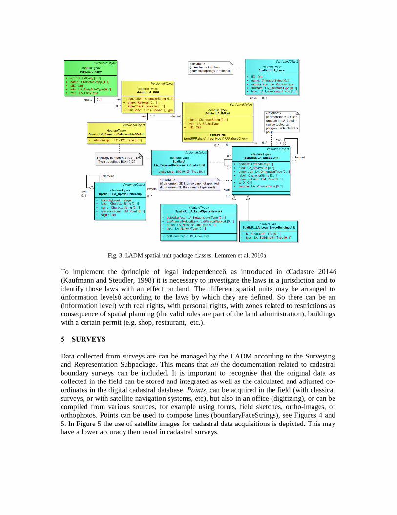
Fig. 3. LADM spatial unit package classes, Lemmen et al, 2010a
To implement the ‘principle of legal independence’, as introduced in ‘Cadastre 2014’ (Kaufmann and Steudler, 1998) it is necessary to investigate the laws in a jurisdiction and to identify those laws with an effect on land. The different spatial units may be arranged to ‘information levels’ according to the laws by which they are defined. So there can be an (information level) with real rights, with personal rights, with zones related to restrictions as consequence of spatial planning (the valid rules are part of the land administration), buildings with a certain permit (e.g. shop, restaurant, etc.). 5 SURVEYS Data collected from surveys are can be managed by the LADM according to the Surveying and Representation Subpackage. This means that all the documentation related to cadastral boundary surveys can be included. It is important to recognise that the original data as collected in the field can be stored and integrated as well as the calculated and adjusted co-ordinates in the digital cadastral database. Points, can be acquired in the field (with classical surveys, or with satellite navigation systems, etc), but also in an office (digitizing), or can be compiled from various sources, for example using forms, field sketches, ortho-images, or orthophotos. Points can be used to compose lines (boundaryFaceStrings), see Figures 4 and 5. In Figure 5 the use of satellite images for cadastral data acquisitions is depicted. This may have a lower accuracy then usual in cadastral surveys.

Fig. 4: classical cadastral survey lay out (Berry van Osch)
Fig. 5: use of satellite images for cadastral surveying
01-1
02-3
03-4
04-3
05-2
06-7
29-7
28-7
100
99-7 (orientation)
10-1
21-5
22-2
23-2 24-2
25-2
26-2
12-2
11-2
15-1 16-
2
17-2
18-2
19-2 20-
8 14-2
T
L
MT: Total Station L: Measuring line M: Distance-series

Observations made during surveys can be represented in LA_SpatialSource using the OM_Observations attribute. This is about the original observations; e.g. orientation, bearings (azimuths), distances, existing co-ordinates from ground control, digitised points, point series, arc series, parallel to, perpendicular to, collinear to, gps co-ordinates, units, object identifiers, , etc, etc. The documents can be represented in LA_Source using CI_Presentation form code attribute. Note: CI and OM are prefixes used in other ISO standards which are re-used in LADM1. The original observations as represented in LA_SpatialSource remain unchanged. Now the determination of co-ordinates from the observations can be performed. This implies transformations and also adjustments. Adjustments are needed in case of multiple observations, e.g.observations related to points observed with a gps devices which are also measured using tape. Or points which are observed with total stations from different positions. Least squares adjustments may be used. This means all observations get corrections in such a way that a mathematical correct model will be available after adjustments. E.g.: the sum of the angles (each angle is 2 bearings or azimuths) in a triangle is equal to 200 gon (which is of course not the case using the original observations). The results of this process are calculated co-ordinates which can be represented in LA_Point under the attribute originalLocation. The transformation parameters can be represented under transAndResult, see LA_Point in Figure 6. This means that the mathematical method in co-ordinate determination can be integrated in the LADM (this ‘method’ can be used under the LA_Point class) and the results of the calculations can be included in the Model. This means the transformation parameters are not lost, same for the calculations of co-ordinates and the adjustments to the original observations. Note: integration of the method is not the same as support in workflows in surveying and mapping. Next a process can start to adjust the determined “local” co-ordinates into the boundaries (under class LA_BoundayFaceString). Again transformations (geo-referencing) and adjustments may be used (needed). And the lines have to be ‘composed’ from points based on the field observations. Part of field observations is ‘what has to be connected to what’ – to get a representation of the spatial dimension of real rights or use rights or other rights. The boundaries are discontinuities here; in realty a boundary is a boundary between one homogeneous Party/Right situation and another. Now the original observations are under LA_SpatialSource and the originalLocation, and calculated co-ordinates are under LA_Point (see Figure 6) and the adjusted points in boundaries are under LA_BoundaryFaceString. The transformation parameters can be kept, as well as the survey procedure, the estimated accuracy, type of monumentation in the field, etc. The estimated accuracy of a point can be derived from the co-ordinate calculations and from the corrections to observations in the adjustment calculations. Well known is the least squares method: the sum of the squares of the corrections to the observations is minimal. This is a basis for knowledge on accuracy of “the map”. It is important to know how accurate the map is. This is the condition, not high accuracy in itself. And: even in case of high accuracy this has to be labelled with accuracy labels. 1 ISO 19115, Geographic Information – Metadata and ISO 19156, Geographic Information – Observations and Measurments. ISO 19115:2003 prefixes are MD (Metadata), CI (Citation), DQ (Data quality), EX (Extent), and LI (Lineage). OM (Observations and Maesurements) is from ISO 19156: –.

Similar approaches can be used in digitising existing maps: the original observations can be stored, the scanned map can be stored, extra measurements can be included (e.g. related to “roof and ground situation” in case of photogrammetry).
class Classes of Surv eying and Spatial Description Package
VersionedObject
«featureType»Party::LA_Party
+ extPID: ExtParty [0..1]+ name: CharacterString [0..1]+ pID: Oid+ role: LA_PartyRoleType [0..*]+ type: LA_PartyType
VersionedObject
«featureType»Admin::LA_RRR
+ description: CharacterString [0..1]+ share: Rational [0..1]+ shareCheck: Boolean [0..1]+ timeSpec: ISO14825AnnD_Type
VersionedObject
«featureType»Admin::LA_BAUnit
+ name: CharacterString [0..1]+ type: LA_BAUnitType+ uID: Oid
constraints{sum(RRR.share)=1 per type if RRR.shareCheck}
VersionedObject
«featureType»SpatialU::LA_SpatialUnit
+ address: ExtAddress [0..*]+ area: LA_AreaValue [0..*]+ dimension: LA_DimensionType [0..1]+ label: CharacterString [0..1]+ referencePoint: GM_Point [0..1]+ suID: Oid+ volume: LA_VolumeValue [0..*]
+ areaClosed() : Boolean+ computeArea() : Area+ computeVolume() : Volume+ createArea() : GM_MultiSurface+ createVolume() : GM_MultiSol id+ volumeClosed() : Boolean
VersionedObject
«featureType»SpatialR::LA_BoundaryFace
+ bfID: Oid+ /geometry: GM_Surface
VersionedObject
«featureType»SpatialR::LA_BoundaryFaceString
+ bfsID: Oid [0..1]+ /geometry: GM_MultiCurve [0..1]+ locationByText: CharacterString [0..1]
constraints{either derived geometry (2..* points) or locationByText (0 points)}
VersionedObject
«featureType»Surv ey::LA_Point
+ estimatedAccuracy: Length+ interpolationRole: LA_InterpolationType+ monumentation: LA_MonumentationType [0..1]+ originalLocation: GM_Point+ pID: Oid+ pointType: LA_PointType+ /productionMethod: LI_Lineage [0..1]+ /spaceDimension: Integer+ transAndResul t: LA _T ransformation [0..*]
+ GetTransResul t() : GM_Point
«featureType»Surv ey::LA_SpatialSource
+ measurements: OM_Observation [0..*]+ procedure: SF_SurveyProcedure [0..1]+ type: LA_SpatialSourceType
for polygon-based spatial units: no minus and at least one plus, for topology-based spatial units: at least one plus or minus
«featureType»LADM Classes 28 November 2009::LA_Source
+ acceptance: DateTime [0..1]+ extSID: ExtArchive [0..1]+ li feSpanStamp: DateTime [0..1]+ maintype: CI_PresentationFormCode [0..1]+ recordation: DateTime [0..1]+ sID: Oid+ submission: DateTime [0..1]
«codeList»Surv ey::
LA_MonumentationType
«codeList»Surv ey::
LA_SpatialSourceType
«datatype»Surv ey::LA_Transformation
«codeList»Surv ey::
LA_InterpolationType
«codeList»Surv ey::LA_PointType
0..*
0..*
+source
0..1
0..*
+source0..1
0..*
+sourcePoint 1..*
+source 1..*
0..*0,2..*{ordered} 0..*
plus
0..*
0..*
minus
1..*
0..*
0,3..*{ordered}
1..*
1..*
0..*
minus
0..*
+representedby
0..1
0..*
+element1..*
+set0..1
0..*
0..*
+rrr
1..*
+launit 1
+surveyor
1..*
0..*
+party
0..1 +rrr 0..*
1..*
plus
0..*
Fig. 6 Contents of classes of Surveying Subpackage and Spatial Representation Subpackage with main
associations, ISO, 2011 Adjustments can be performed resulting into a “local” reference system with local co-ordinates and then a second adjustment to the existing coordinates in the digital cadastral data base (geo referencing). Sometimes the second step (geo referencing) can be done

immediately. Such approaches are equal to the use of satellite images for boundary determination or existing topographic maps, in scale 1:25.000 or 1:50.000. Figure 7 gives an example from a project in Ethiopia (Lemmen and Zevenbergen, 2010d, Lemmen et al, 2009) where satellite images have been used combined with hand held, low accurate gps devices.. It should be noted that the idea to use satellite imagery for cadastral applications is not new: Kansu and Sezgin 2006; Konstantinos 2006; Paudyal and Subedi 2005; Tuladhar 2005; Ondulo and Kalande 2006. Only of late are images available with resolutions that make them useful for standard size land parcels (spatial units). Use for large pastoral ranges, forest reserves etc. has been much longer possible. The Figure 7 shows Quickbird at 60 cm resolution which were nearly cloud free; true color, with pansharpening.
Fig. 7: hand held gps combined with data collection based on satellite images – data collected by Tony Burns, see Lemmen et al, 2009.
The images have not been related to Ground Control Points. This implies that the absolute accuracy is (according to the provider of the images, Digital Globe) up to 14 meters horizontal accuracy (root mean squared error) and 23 meters vertical. Ortho-rectification will improve this, but for “absolute pixel accuracy” the Ground Control Points are needed. A small sample ortho-rectified afterwards, showed differences of -20 meter on mountain and +40m in valley. The NASA Shuttle Radar Topographic Mission (SRTM) was used for as a Digital Elevation Model for this (90 m). The applied process requires that the following should be kept: the original Quickbird images; the scanned images with pen-drawn boundaries; the gps co-ordinates; the digitized co-ordinates (digitizing based on top of the pen drawn lines); the transformation parameters to refer to the gps (wgs) system; the transformed co-ordinates and the transformation parameters to adjust to the existing digital cadastral map, as well as the calculated co-ordinates resulting from this last step. LADM can store those data, making the data re-constructible in case of technical discussions or in case of disputes.

A LA_Point can have more than one re-presentation in co-ordinates. There can be the result of a calculation with co-ordinates in a local co-ordinate system. Then there can be transformations and the results of this in a new (historically new) version of the point. This transformed point may be included into a LA_BoundaryFacestring – which is an adjusted version of the same point (in a boundary). The complexity of calculating accuracy in a process of propagation of errors is outside the LADM. But as said: the transformations can be documented and also production methods are included. Accuracy attributes (indicators) are available for all points. Software as MOVE32 may be required to support the surveying and mapping process, results can be stored in LADM in a re-constructable way. References to workflows can be made using attributes as ‘submission’, ‘acceptance’ and ‘recordation’ in the LA_Source class. Versioning is of objects is supported. A set of measurements with observations (distances, bearings, etc.) of points, is an attribute of LA_SpatialSource. The individual points are instances of class LA_Point, which is associated to LA_SpatialSource. While it is not required that the complete spatial unit is represented in one survey, a spatial source may be associated to several points. Geodetic control points, including multiple sets of coordinates for points, and with multiple reference systems, are all supported in LADM. 2D and 3D representations of spatial units use boundary face strings as instances of class LA_BoundaryFaceString, and boundary faces as instances of class LA_BoundaryFace. Coordinates themselves either come from points, or are captured as linear geometry. Spatial units may share the same representation structure: existing 2D data, whether topologically structured or not, or polygons, or unstructured boundaries, or simply point or textual descriptions, can be included. Another feature of the spatial representation within LADM is that there is no mismatch between spatial units that are represented in 2D and spatial units that are represented in 3D. Furthermore, LADM is based on accepted and available spatial schemata, such as published in the standard ISO 19107:2003 Geographic Information – Spatial schema. 6 THE SOCIAL TENURE DOMAIN MODEL STDM is basically about people-land relationships and is intended to broaden the traditional scope of land administration by providing a land information management framework that would integrate formal, informal, and customary land systems, as well as integrate administrative and spatial components. The STDM makes this possible through tools that facilitate recording all forms of land rights, all types of rights holders and all kinds of land and property objects/spatial units regardless of the level of formality. The thinking behind the STDM also goes beyond some established conventions. Traditional or conventional land administration systems, for example, relate names or addresses of persons to land parcels via rights. An alternative option is being provided by the STDM, which instead relates personal identifiers, such as fingerprints, to a coordinate point inside a plot of land through a social 2 MOVE3 is a software package for the design, adjustment and quality control of 3D, 2D and 1D geodetic networks in compliance with the procedures of the "Delft School" of geodesy. MOVE3 allows fully integrated processing of GPS and terrestrial observations. See: http://www.grontmij.com/highlights/transportation-and-mobility/Pages/MOVE3-Intelligent-software-for-geodetic-networks.aspx

tenure relation such as tenancy. The STDM thus provides an extensible basis for an efficient and effective system of land rights recording. This extensible basis means (Augustinus and Lemmen, 2011): - inclusion of the representation of all people-land relationships – the continuum of land
rights (UN-HABITAT, 2008) applied in global setting. New types of relations to be easily included. The STDM describes relationships between people and land in an unconventional manner, tackling land administration needs in hitherto neglected communities, such as people in informal settlements and customary areas. It supports the development and maintenance of records in areas where regular or formal registration of land rights is not the rule. It focuses on land and property rights which are neither registered nor registerable, as well as overlapping claims that may have to be adjudicated in terms of "who", "where" and "what right". In other words, the emphasis is on social tenure relationships as embedded in the continuum of the land rights concept promoted by Global Land Tool Network and by UN-HABITAT (2008). In the 2003 FIG workshop in Enschede (FIG, 2003) there was a lot of attention to the inclusion of ‘informal area’s’ into Cadastral Data Models. In the 2004 FIG workshop in Bamberg ‘Formal Ownership’; ‘Customary Tenure’; ‘Indigenous Tenancy’; ‘Starter, land hold, free hold Evolution’; ‘Possession’; ‘Mortgage, Usufruct, Long Lease, many Restriction Types’; ‘State Lands’; ‘Informal and Unknown people- land Relationships’; ‘Disagreement’; ‘Occupation’; ‘Uncontrolled privatization (which is in fact a kind of transaction) and ‘Conflict’ were presented as a set of (extensible) relations between people and land (Van Oosterom et al, 2004). A first start in this approach with extensible code tables was presented in a paper to the FIG working week in Paris, France (Lemmen, et al, 2003a and Lemmen et al 2003b). In the LADM a range of spatial units was introduced based on the review of Augustinus 1998.
- a range of people and social structures, this means a range of types of parties can be included, without exceptions. Parties are persons, or groups of persons, or non natural persons, that compose an identifiable single entity. A non natural person may be a tribe, a family, a village, a company, a municipality, the state, a farmers´ cooperation, or a church community. This list may be extended, and it can be adapted to local situations, based on community needs. See also Lemmen, 2010c
- a range of units of land-use rights. Land rights may be formal ownership, apartment right, usufruct, free hold, lease hold, or state land. It can also be social tenure relationships like occupation, tenancy, nonformal and informal rights, customary rights (which can be of many different types with specific names), indigenous rights, and possession. There may be overlapping claims, disagreement and conflict situations. There may be uncontrolled privatisation. Again, this is an extensible list to be filled in with local tenancies. A restriction is a formal or informal entitlement to refrain from doing something; e.g. it is not allowed to have ownership in indigenous areas. Or it may be a servitude or mortgage as a restriction to the ownership right. There may be a temporal dimension, e.g. in case of nomadic behaviour when pastoralist cross the land depending on the season. This temporal dimension has sometimes a fuzzy nature, e.g. ”just after the end of the rainy season”. See also Lemmen, 2010c
- a range of spatial units. Augustinus et al (2006) provides a comprehensive overview. See also Lemmen, 2010c. Spatial units are the areas of land (or water) where the rights and social tenure relationships apply. According to the LADM/STDM ISO-standard those areas can be represented as a text (“from this tree to that river”), as a single point, as a set of unstructured lines, as a surface, or even as a 3D volume. This range of spatial unit representation can cover community based land administration systems, or rural, or urban,

or other types of land administrations, like marine cadastres and 3D cadastres. Surveys may concern the identification of spatial units on a photograph, an image or a topographic map. There may be sketch maps drawn up locally. A sketch map may be drawn on a wall where a photograph is taken from.
- a range of different field data acquisition methods can be applied resulting in (a range of types of) (authentic) source documentation for spatial and non spatial data. Unconventional and participatory approaches in collecting evidence from the field; participation could mean the presentation fo field collected data in the evening to the community. Different data acquisition methods mean different data qualities; quality attributes can be included. E.g. Dr Zerfu Hailu and Lennart Backstrom (2006) report from Ethiopia that, because of lack of equipment and electricity in most of the villages, traditional survey methods, compass and measuring tape (cord) were used. They mention surveying and mapping as being expensive. Moreover, for collecting data for around 20 million plots covering the whole of Ethiopia other methods are needed, such as ortho photos and satellite imagery. Those images have different geometric qualities. Mosaics are composed out of images with survey times; ’old’ images may be used because they are cheaper (Lemmen and Zevenbergen, 2010d). Impreciseness has to be accepted: insisting on expensive standards is not in the benefit of the poor and government as well. Insisting on expensive standards for data acquisition has been proven not to work. In general such proposals mean that there is insufficient attention for the scale LA implementations and also insufficient attention for the option to upgrade quality later - this does not mean that there should be no attention to the maintenance of LA data.
- Promising is the use of digital pen (Milindi Rugema, 2011, Prastowo, 2011). Here a pattern is plotted on top of an (aerial or satellite) image. This pattern ‘informs’ the pen on it’s location on the image. This means the data collected in the field can be easily projected to the local people after reading the drawn lines into a pc. Or inclusion of video or sound (Barry, 2009).
- Unconventional and participatory approaches in collecting evidence from the field means that overlapping claims can de identified as a spatial unit (as a type of ‘right’, with claimants included – a what to do list for arbiters. This clarifies which area’s are probably free of conflicts.
- If many attributes are collected then many attributes have to be maintained. This means there should be awareness for this ‘multiplier’ effect. In STDM there is a minimal set of attributes. Local extensions are possible, on the other side not all attributes may be needed. Local set ups require data base expertise.
- In STDM the dynamics in reality can be represented – maintenance of spatial and non-spatial data is more feasible with a minimal number of attributes. The STDM has been designed in such a way that there is no real workflow management, nor ‘controlled’ process management. The user should (and can) easily understand what has to be done based on the use cases in the manual: retrieve/edit/delete person, group person, organization, source document, spatial unit, social tenure relation and split and merge of plots. Different sources can be combined, there is not always a need for cm or meter precision. This helps to combine and understand land administration information from different sources in a coherent way.
- For initial data collection the types of allowed spatial units, persons and social tenure relationships have to be set, for example (cane be implemented via CodeLists in STDM): - Spatial Unit Inventory source type (image, photograph, sketch, topo map, planetable
map, photo,.) - Social Tenure inventory type (paper, digital, ….)

- Spatial Unit representation type (topological, point, linebased, text, sketch, building, ..)
- Social Tenure Relation type: (ownership, informal tenure, customary tenure, cooperation, tenancy, possession, restriction, stateland, comfort, disagreement, milk, miri, waqf, conflict, occupation, network, fishing, hunting, common land, ..)
- Group type (farmers, indigenous, association, informal, ..) - Gendertype (male, female) - Quality (terrestrial, satellite image, digitized, gps, unknown,… ) - Use type (agricultural, living, ..) - Data Collector Type (senior/junior spatial/administrative data collector, conveyor) - Point type (concrete post, bottle, metal pipe, nail, monument, wooden pile) - etc
- It should be possible to perform unconventional ‘transactions’: in general there can be new types of transactions along the dimensions ‘right continuum’ (based on UN-HABITAT, 2008), ‘party continuum’, ‘spatial unit continuum’. Unconventional transactions and updates in the STDM may be: - a transaction to change or update a social tenure relationship from ‘informal’ to, for
example, ‘occupation’ and may be later to ‘free hold’. Or, in a way similar: from ‘starter’, to: ‘land-hold’, to: ‘freehold’.
- a transaction to convert from freehold back to ‘customary’ and from ‘individual person’ to ‘member’ of a ‘group person’. This could be a restitution after grabbing or after disaster (aids, tsunami, genocide) return land rights to the children (this explain the urgent need for a complete coverage, e.g. point based related in land use with fingerprint, or other biometric attributes. Do we need chromosomes here in the database needed from a social perspective?
- a transaction to change from a spatial unit under ‘conflict’ or ‘overlapping claim’ to ‘informal occupation’ and may be later to ‘leasehold’.
- all kind of transactions to support the establishment of unconventional restrictions: e.g. not allowing formal titles within a polygon or set of polygons. Or: the establishment of a planning and development area as a restriction; e.g. to avoid speculation; the establishment of a forest destruction restriction (e.g. no trees for bio fuel, palm oil etc); the establishment of a corridor restriction - right to cross land via corridor for pastoralists.
- a transaction supporting the establishment of occupation of land after disaster – if existing land rights are unknown land can be occupied and can be ‘consolidated’ later related to a bigger area where land rights are re-allocated.
- all kind of quality improvements can be seen as transactions: ‘improve’ geometric quality e.g. from point based to polygon based – this could mean introduction of land taxation to support in development. Or from text based/sketch based spatial units to polygon based spatial units. Geometric quality improvements lead to changed co-ordinates, this may have impact on area’s of spatial units. For this reason formal and calculated area’s may be represented.
- A transaction supporting ‘inheritance’ land use rights based on shares in accordance to local traditions – to avoid lost of rights. Or: ‘claiming’ land use rights in case of divorce; this claim can be recorded; this means a transaction from a share in a use right to an overlapping claim.
7 CONCLUSION A standardised data model can support developments of software which can be open source of course. It can be used as a communication approach in land administration. The Land Administration Domain Model is available as a Draft International Standard. Parts of the standards have been used in INSPIRE and LPIS. Country profiles are under development. See ISO, 2011. The acquisition of points (a survey) may concern the identification of spatial units on a photograph, on an image, or on a topographic map; cycloramas or pictometry methods (multiple images from different angles) may also be used for that purpose. Classical surveys may be used (tape, cord, total station) or gps. A survey is documented with spatial sources (a spatial source is the field evidence related to the spatial representation of one (part of) or more spatial units), instances from class LA_SpatialSource. A spatial source may be official, or not (i.e. a registered survey plan, or an aerial photograph). Paper based documents (which may be scanned) can be considered as an integral part of the land administration system; this can be field documents. Such documents with orginal data can be important for boundary reconstructions of boundaries in case of disputes. The Land Administration Domain Model includes the support of surveying in land administration – with a support of data required for quality management of geometric data. The workflows as such in here are not supported by LADM. The flexibility of STDM is in the recognition that parties, spatial units and social tenure relationships may appear in many ways, depending on local tradition, culture, religion and behaviour. Recordation in STDM may not only be based on formal registration of formal land rights, but may also be based on observations in reality, resulting in recordation of informal land use rights. There may be many recordations in many places and also different registrations. This is in support of participatory approaches resulting in data which can be managed by the people themselves. Exchange of data between formal and informal or traditional systems is possible now because of standardisations. Acknowledgements This paper could not have been prepared without the support and input of Dr Clarissa Augustinus, Dr Harry Uitermark, Prof Paul van der Molen, and Prof Dr Jaap Zevenbergen. References Augustinus, C. and Lemmen, C.H.J. 2011, What is required to bring the social element into land administration?Moving from the Land Administration Domain Model to the Social Tenure Domain Model, proceedings of the Annual World Bank Conference on Land and Poverty 2011. Worldbank, Washington DC, US. Augustinus, C., C.H.J. Lemmen and P.J.M. van Oosterom 2006, Social tenure domain model requirements from the perspective of pro - poor land management. 5th FIG regional conference for Africa : promoting land administration and good governance. Accra, Ghana.

Barry, M, 2009, Applying low-cost Technologies in the Field: Development of The Talking Titler System, World Bank / FIG Washington. FIG-ITC-ESRI 2003 Proceedings of the Workshop on Cadastral Data Modeling, March 17-18, 2003, Enschede, The Netherland Fourie, Clarissa 1998 An integrated geo-information system with emphasis on cadastre and land information systems for decesion makers in Africa, working document for the expert group meeting held at United Nations Economoc Commission for Africa, Addis Ababa, Ethiopia, 23 – 26 November 1998. Henssen, J.L.G. 1995. Basic principles of the main cadastral systems in the world. In Proceedings of the One Day Seminar held during the Annual Meeting of Commission 7, Cadastre and Rural Land Management, of the International Federation of Surveyors (FIG), May 16, Delft, The Netherlands. ISO/TC 211 2011. ISO 19152. Draft International Standard (DIS), Geographic information - Land administration domain model (LADM). Lysaker, Norway: ISO. ISO 19107 2003. Geographic Information. Spatial schema. Kaufmann, J. and D. Steudler (1998). Cadastre 2014 - A vision for a future cadastral system. FIG XXI International Congress. Brighton, U.K. Lemmen, C.H.J. and P.J.M. van Oosterom 2003a. Further progress in the development of a core cadastral domain model. FIG Working Week 2003. Paris, France. Lemmen, C.H.J., P. van der Molen, P.J.M. van Oosterom, H. Ploeger, C.W. Quak, J.E. Stoter and J. Zevenbergen 2003b. A modular standard for the cadastral domain. Proceedings Digital Earth 2003. Information Resources for Global Sustainability. Brno, Czech Republic. Lemmen, C.H.J., Zevenbergen, J.A., Lengoiboni, M., Deininger, K. and Burns, T.R. 2009 First experiences with high resolution imagery based adjudication approach for social tenure domain models in Ethiopia. In: Proceedings FIG - World Bank Conference : Land governance in support of the Millennium development goals, responding to new challenges, 9-10 March, 2009, Washington, D.C. 22 p. Lemmen, C.H.J., P.J.M. van Oosterom, C. Eisenhut and H.T. Uitermark 2010a. The modelling of rights, restrictions and responsibilities (RRR) in the Land Administration Domain Model (LADM). XXIV FIG International Congress 2010. Sydney, Australia. Lemmen, C.H.J., P.J.M. van Oosterom, R.J. Thompson, J. Hespanha and H.T. Uitermark 2010b. The modelling of spatial units (parcels) in the Land Administration Domain Model (LADM). XXIV FIG International Congress 2010. Sydney, Australia. Lemmen, C.H.J. 2010c The social tenure domain model: a pro-poor land tool. FIG Publication no 52. Copenhagen, International Federation of Surveyors (FIG), 2010. ISBN: 978-87-90907-83-9. Lemmen, C.H.J. and Zevenbergen, J.A. 2010d First experiences with high - resolution imagery - based adjudication approach in Ethiopia. In: Innovations in land rights recognition, administration and governance : joint organizational discussion paper issue 2 : proceedings from the annual conference on land policy and administration / K. Deininger, ... [et al.]. - Washington D.C. : The World Bank, 2010. 96-104.

Milindi Rugema, D. 2011 Evaluation of digital pen in data capturing for land administration purposes in Rwanda. Enschede, University of Twente Faculty of Geo-Information and Earth Observation ITC Prastowo, H. 2011 Performance evaluation of digital pen for capturing data in land information systems, LIS. Enschede, University of Twente Faculty of Geo-Information and Earth Observation ITC, 2011. UN-HABITAT 2008. Secure land rights for all. Nairobi, Kenya, United Nations Human Settlements Programme: 40pp. Van Oosterom, P.J.M., C.H.J. Lemmen, T. Ingvarsson, P. van der Molen, H. Ploeger, C.W. Quak, J.E. Stoter and J. Zevenbergen 2006. The core cadastral domain model. Computers, Environment and Urban Systems 30 (5) 627-660. Van Oosterom, P.J.M., C.H.J. Lemmen and P. van der Molen 2004. Remarks and observations related to the further development of the Core Cadastral Domain Model. Workshop Standardization in the Cadastral Domain. Bamberg, Germany, FIG: pp. 175-192. Zerfu Hailu and Lennart Backstrom, Ethiopia, 2006, Land Administration in Ethiopia, Model for Establishing Tenure Security in Other Countries, GIM International, February 2006.