Embed Size (px)
Citation preview
Irrigation Water Compliance Monitoring Programme
Annual Report 2015-2016
Technical Report 2016-49
Taranaki Regional Council ISSN: 1178-1467 (Online) Private Bag 713 Document: 1781017 (Word) STRATFORD Document: 1804710 (Pdf) January 2017

Executive summary
This is the 13th Annual Report issued by the Taranaki Regional Council (the Council) to report on compliance monitoring programmes for resource consents authorising the abstraction of freshwater for irrigation purposes in Taranaki. This report for the period July 2015–June 2016 encompasses the data collected for compliance monitoring for resource consents for pasture irrigation, horticultural and golf course irrigation; as per the recommendations from the previous report. Water is a public resource and the authorisation to take it is granted through resource consent. Associated with that permission is a public expectation that the water will be used efficiently, an expectation that can be better met if the actual amounts of water taken are accurately measured and recorded. Maintaining environmentally appropriate residual flows in streams and rivers to protect aquatic habitat is of primary concern to the Council when assessing water take applications. Monitoring of compliance with consent conditions is then required to ensure that any significant adverse effects as a result of authorised water takes are avoided. At 30 June 2016, a total of 76 resource consents to take and use freshwater for irrigation purposes were registered in the Council’s databases. Of that number, 57 were for pasture irrigation, 9 for horticultural activities and 10 for recreational purposes (golf clubs). Sixty-four consents authorised abstractions from surface water (84%) while 12 (16%) utilised groundwater sources. A total of 60 irrigation consents were exercised during the 2015-2016 monitoring year. The 2015-2016 monitoring programmes for irrigation water permits comprised a range of various components, including liaison with consent holders, site inspections, water take data collection, residual flow monitoring, water quality analysis, data review and compliance assessments. The specific range of monitoring carried out in relation to each consent is dictated by the water source, weather and flow conditions and system design. It was a busy season for the Council’s hydrological monitoring team, as the weather conditions meant the demand for irrigation was high, with irrigation starting as early as the middle of October. The Council carried out compliance monitoring inspections at 68 sites during the 2015-2016 irrigation season. The inspections included visual checks of the intake structures, screens, staff gauges, fencing around the pump sheds, downloading of data and stream gaugings. For the summer irrigation period, the rainfall recorded at the Council’s monitoring locations ranged between 61% and 86% of historical mean values. This resulted in rivers and streams running well below mean flows for the period. The low stream flows necessitated close and frequent monitoring by the Council to ensure ecological flows were maintained in those waterways being used to supply water for irrigation. During the period under review, compliance with residual flow conditions for surface water abstractions was assessed by the Council on a total of 73 separate occasions, across 28 waterways. Some irrigators were still taking water in early May 2016. Consent holder performance was assessed based on compliance with their authorised abstraction rates/volumes, maintenance of minimum residual flows, provision of abstraction records and all other general conditions of their consent(s).

The Council was required to enter a total of 17 incidents over the course of the 2015-2016 period in relation to irrigation consents. These incidents were reported to Council and staff implemented appropriate responses as they were identified. This included the issuing of seven abatement notices and one infringement notices. During the 2015-2016 year, 47% of exercised irrigation consents in Taranaki achieved a high level of environmental performance and compliance with their consents, while 20% require improvement in their compliance performance. For reference, in the 2015-2016 year, 71% of consent holders in Taranaki monitored through tailored compliance monitoring programmes achieved a high level of environmental performance and compliance with their consents, while another 24% demonstrated a good level of environmental performance and compliance with their consents. In addition to the conditions of resource consents for water abstractions, The Resource Management (Measurement and Reporting of Water Takes) Regulations 2010 place further legislative requirements on holders of consents for water abstractions greater than five litres per second. These include specific requirements for the installation of water measuring devices, verification of the accuracy of water measuring devices and data reporting. The Regulations allow for a staged implementation of the requirements, dependent on abstraction rate. All abstractions are to be compliant with the Regulations by 10 November 2016. The Council will continue to enforce implementation of the Regulations during forthcoming monitoring periods. This report includes recommendations for the 2016-2017 year.
i
Table of contents
Page
1. Introduction 1 1.1 Compliance monitoring programme reports and the Resource
Management Act 1991 1 1.1.1 Introduction 1 1.1.2 Structure of this report 1 1.1.3 The Resource Management Act 1991 and monitoring 1 1.1.4 Regional Freshwater Plan 2 1.1.5 Evaluation of environmental and administrative performance 2 1.1.6 Regional freshwater allocation 4 1.1.7 Irrigation zones 5 1.1.8 Irrigation systems 6 1.1.9 Environmental effects of exercing water permits 9
1.2 Climatological data and irrigation requirements 10 1.2.1 Droughts in Taranaki 12
1.3 Monitoring programme 13 1.3.1 Introduction 13 1.3.2 Programme liaison and management 13 1.3.3 Site inspections 14 1.3.4 Measuring and reporting of water takes 14 1.3.5 Residual flow monitoring 16 1.3.6 Data review and complaince assessment 16 1.3.7 Groundwater quality assessment 17
2. Results 18 2.1 Site inspections 18 2.2 Residual flow compliance 18 2.3 Water usage and compliance assessment 19 2.4 Groundwater quality results 20 2.5 Investigations, interventions, and incidents 20
3. Discussion 23 3.1 Discussion of site performance 23 3.2 Evaluation of performance 24 3.3 Recommendations from the 2014-2015 Annual Report 26 3.4 Alterations to monitoring programmes for 2016-2017 27
4. Recommendations 28
Glossary of common terms and abbreviations 29
Bibliography and references 30
Appendix I Example surface water abstraction permit for irrigation

ii
Appendix II Active irrigation consents in Taranaki July 2015 to June 2016
Appendix III Water take consent usage for 2015-2016
Appendix IV Report on consented water permits for farm and general water supply purposes 1
iii
List of tables
Table 1 Total rainfall from 1 October 2015 to 30 April 2016 versus historical mean values 10
Table 2 Stream gaugings below residual flow requirements 18 Table 3 Groundwater quality results 20 Table 4 Consents found to be in breach and the incidents registered 21 Table 5 Individual performance for all irrigation consent holders 24
List of figures
Figure 1 Percentage of water irrigation allocation per activity in the Taranaki region 5
Figure 2 Source of water for irrigation in Taranaki during the 2015-2016 period 5 Figure 3 Total consented water abstractions – distributed by activity 2015-2016 6 Figure 4 Pasture irrigation zones and locations of consented irrigation in Taranaki 7 Figure 5 Distribution map of the total rainfall recorded from 1 October 2015 to 31
March 2016 12
List of photos
Photo 1 Mosaic of pictures depicting k-line and long-lateral type irrigation 8 Photo 2 Mosaic of pictures depicting centre pivots 8 Photo 3 Picture depicting travelling irrigator system 8 Photo 4 Good installation of a flowmeter 16 Photo 5 Poor installation of a flowmeter 16


1
1. Introduction
1.1 Compliance monitoring programme reports and the Resource Management Act 1991
1.1.1 Introduction
This report is for the period July 2015-June 2016 by the Taranaki Regional Council (the Council) describing the monitoring programmes for resource consents authorising the abstraction of freshwater for irrigation purposes in Taranaki. This report covers the data collected for compliance monitoring for resource consents for pasture irrigation, horticultural and golf courses; as per the recommendations from the previous report. This is the 13th annual report to be prepared by the Council to report on compliance monitoring programmes for irrigation water in Taranaki. Irrigation in this report does not refer to any effluent (wastewater) application; it applies to the use of freshwater to supply dry soils with enough moisture for assisting in growing pasture. In pasture production, irrigation is mainly used to replace precipitation during periods of drought and to fulfil crop water requirements.
1.1.2 Structure of this report
Section 1 of this report is a background section. It sets out general information about: consent compliance monitoring under the RMA and the Council’s obligations; the Council’s approach to monitoring water takes though annual programmes; the resource consents held for water takes across various catchments; the nature of the monitoring programme in place for the period under review;
and a description of irrigation activities conducted in each catchment.
Section 2 presents the results of monitoring during the period under review, including scientific and technical data. Section 3 discusses the results, their interpretations, and their significance for the environment. Section 4 presents recommendations to be implemented in the 2016-2017 monitoring year. A glossary of common abbreviations and scientific terms, and a bibliography, are presented at the end of the report.
1.1.3 The Resource Management Act 1991 and monitoring
The RMA primarily addresses environmental ‘effects’ which are defined as positive or adverse, temporary or permanent, past, present or future, or cumulative. Effects may arise in relation to:
(a) the neighbourhood or the wider community around an activity, and may include cultural and social-economic effects;
(b) physical effects on the locality, including landscape, amenity and visual effects;

2
(c) ecosystems, including effects on plants, animals, or habitats, whether aquatic or terrestrial;
(d) natural and physical resources having special significance (for example recreational, cultural, or aesthetic); and
(e) risks to the neighbourhood or environment. In drafting and reviewing conditions on discharge permits, and in implementing monitoring programmes, the Council is recognising the comprehensive meaning of ‘effects’ inasmuch as is appropriate for each activity. Monitoring programmes are not only based on existing permit conditions, but also on the obligations of the RMA to assess the effects of the exercise of consents. In accordance with Section 35 of the RMA, the Council undertakes compliance monitoring for consents and rules in regional plans, and maintains an overview of the performance of resource users and consent holders. Compliance monitoring, including both activity and impact monitoring, enables the Council to continually re-evaluate its approach and that of consent holders to resource management and, ultimately, through the refinement of methods and considered responsible resource utilisation, to move closer to achieving sustainable development of the region’s resources.
1.1.4 Regional Freshwater Plan
Section 14(1)(a) of the RMA stipulates that no person may take, use, dam, or divert any water unless the activity is expressly allowed for by a resource consent, or a rule in a regional plan, or meets criteria set out in Section 14(3) of the RMA. The Regional Freshwater Plan for Taranaki (RFWP) became operative on 8 October 2001. It is a statutory document which outlines the Council’s policy with respect to activities in relation to freshwater under the RMA. Rule 15 of the RFWP provides for the abstraction of up to 50 cubic metres per day (m3/day) of surface water at a maximum rate of 1.5 litres per second (L/s) as a permitted activity for each certificate of title. The same provision applies for groundwater under Rule 48 pf the RFWP. The permitted allocations (as of right entitlements) allow for reasonable domestic and stock water needs without the need for a resource consent, provided that other conditions of the permitted rules are satisfied. However, most irrigation abstractions demand significantly more water than the daily permitted allocation and consequently require resource consents. Appendix I gives an example of a typical set of conditions for a consent to take and use surface water for irrigation purposes.
1.1.5 Evaluation of environmental and administrative performance
Besides discussing the various details of the performance and extent of compliance by the consent holders, this report also assigns a rating as to each Company’s environmental and administrative performance during the period under review. Environmental performance is concerned with actual or likely effects on the receiving environment from the activities during the monitoring year. Administrative performance is concerned with the Company’s approach to demonstrating consent compliance in site operations and management including the timely provision of

3
information to Council (such as contingency plans and water take data) in accordance with consent conditions. Events that were beyond the control of the consent holder and unforeseeable (that is a defence under the provisions of the RMA can be established) may be excluded with regard to the performance rating applied. For example loss of data due to a flood destroying deployed field equipment. The categories used by the Council for this monitoring period, and their interpretation, are as follows: Environmental Performance
High: No or inconsequential (short-term duration, less than minor in severity) breaches of consent or regional plan parameters resulting from the activity; no adverse effects of significance noted or likely in the receiving environment. The Council did not record any verified unauthorised incidents involving significant environmental impacts and was not obliged to issue any abatement notices or infringement notices in relation to such impacts.
Good: Likely or actual adverse effects of activities on the receiving environment
were negligible or minor at most. There were some such issues noted during monitoring, from self reports, or in response to unauthorised incident reports, but these items were not critical, and follow-up inspections showed they have been dealt with. These minor issues were resolved positively, co-operatively, and quickly. The Council was not obliged to issue any abatement notices or infringement notices in relation to the minor non-compliant effects; however abatement notices may have been issued to mitigate an identified potential for an environmental effect to occur.
For example:
- High suspended solid values recorded in discharge samples, however the discharge was to land or to receiving waters that were in high flow at the time;
- Strong odour beyond boundary but no residential properties or other recipient nearby.
Improvement required: Likely or actual adverse effects of activities on the receiving
environment were more than minor, but not substantial. There were some issues noted during monitoring, from self reports, or in response to unauthorised incident reports. Cumulative adverse effects of a persistent minor non-compliant activity could elevate a minor issue to this level. Abatement notices and infringement notices may have been issued in respect of effects.
Poor: Likely or actual adverse effects of activities on the receiving environment were significant. There were some items noted during monitoring, from self reports, or in response to unauthorised incident reports. Cumulative adverse effects of a persistent moderate non-compliant activity could elevate an ‘improvement required’ issue to this level. Typically there were grounds for either a prosecution or an infringement notice in respect of effects.
4
Administrative performance
High: The administrative requirements of the resource consents were met, or any failure to do this had trivial consequences and were addressed promptly and co-operatively.
Good: Perhaps some administrative requirements of the resource consents were not
met at a particular time, however this was addressed without repeated interventions from the Council staff. Alternatively adequate reason was provided for matters such as the no or late provision of information, interpretation of ‘best practical option’ for avoiding potential effects, etc.
Improvement required: Repeated interventions to meet the administrative
requirements of the resource consents were made by Council staff. These matters took some time to resolve, or remained unresolved at the end of the period under review. The Council may have issued an abatement notice to attain compliance.
Poor: Material failings to meet the administrative requirements of the resource
consents. Significant intervention by the Council was required. Typically there were grounds for an infringement notice.
For reference, in the 2015-2016 year, 71% of consent holders in Taranaki monitored through tailored compliance monitoring programmes achieved a high level of environmental performance and compliance with their consents, while another 24% demonstrated a good level of environmental performance and compliance with their consents
1.1.6 Regional freshwater allocation
At 30 June 2016, there were a total of 76 resource consents to take and use freshwater for irrigation purposes. Fifty-seven consents were for pasture irrigation, nine for irrigation associated with horticultural activities and ten for recreational purposes (e.g. golf course watering) (Figure 1). Surface water is the predominant source of water for irrigation, accounting for 64 of the 76 consented water abstractions (84%). The remaining 12 consents (16%) authorise abstractions from groundwater (Figure 2). The relatively low yields from Taranaki’s aquifers are rarely sufficient to supply an entire irrigation system, and hence groundwater usage as a primary source of irrigation water is uncommon across the region. Typically, groundwater abstractions are used to supplement surface water irrigation supply.

5
Figure 1 Percentage of water irrigation allocation per activity in the Taranaki region
Figure 2 Source of water for irrigation in Taranaki during the 2015-2016 period
The breakdown of freshwater allocation in the region indicates that pasture irrigation represents 29% of the total consented water abstractions in Taranaki. Other types of irrigation (horticultural and recreational) account for approximately 10%, with other uses1 accounting for the majority (61%) of the total water allocation across the region (Figure 3). Appendix II lists all irrigation water take consents that were active during the 2015-2016 monitoring year.
1.1.7 Irrigation zones
A regional study commissioned for the Council in 2002 (Rout, 2003) identified eight irrigation zones based mainly on climate. The zones were characterised by different
1 Includes: Aquaculture, Building Construction/Drainage/Flood Control, Chemical Processing/Manufacturing, Dairy Farm, Dairy Processing/Manufacturing, Dry Stock Farm, Hydrocarbon Exploration/Servicing Facilities, Landfills, Local Authorities, Meat and By-Product Processing, Petrochemical Processing, Piggery Farms, Poultry Farms, Power Generation – HydroPower Generation & Thermal, Quarries, Recreation/Tourism/Cultural, Road/Bridge Construction or Maintenance, Sewage Treatment, Swimming Pools, Timber Treatment or Sawmills, Water Supply or Treatment.
Pasture Irrigation74% (57)
Horticultural12% (9)
Recreational14% (10)
Surface Water84% (64)
Groundwater16% (12)

6
parameters in terms of system management and financial return. Each zone, and the location of all current irrigation consents are illustrated in Figure 4.
Figure 3 Total consented water abstractions – distributed by activity 2015-2016
The modelling exercise identified zones with the most potential for pasture irrigation requirements were Normanby (Zone 2), Inaha (Zone 3), Hawera (Zone 4) and Opunake (Zone 5). As illustrated in Figure 4, the vast majority of pasture irrigation in Taranaki does take place within Zones 2, 3, 4 and 5, which represent a 10 km wide belt of coastal land stretching from Oakura to Waitotara. The remainder of irrigators are generally located inland, between Inglewood and Eltham.
1.1.8 Irrigation systems
In general there are two types of irrigation methods; surface and pressurised. The majority of irrigation systems currently in operation in the province fall in to the pressurised category. Pressurised systems can be further differentiated based on the method of operation and equipment used. A summary of the systems encountered in the region is given below: K-line and long-lateral types – Impact sprinklers mounted on moveable laterals (Photo 1). These are the most common systems found in the region, as they are a low cost option and are relatively easy to operate. They can easily be adapted to fit in with existing farm layouts and are especially suitable for windy conditions. However, these systems are labour intensive, as they need to be moved manually on a regular basis. Centre pivot type – spray nozzles mounted on a movable lateral (Photo 2) Centre pivot type systems are automatically controlled, so have a low labour input. They are low maintenance and have versatility in application rates and are desirable on steep, rocky or uneven soils. However, they are a high capital cost option and can be expensive to run due to electricity costs. Travelling irrigators-spray nozzles mounted on fixed or rotating boom (rotary boom, fixed boom, gun irrigator, effluent irrigator) (Photo 3)
Other Uses61% (117) Pasture Irrigation
29% (57)
Horticultural5% (9)
Recreational5% (10)

7
Travelling irrigators are a low capital cost option, and are simple to operate. They can cover a large irrigation area and there is some control over the application rate. However, these systems do not perform well in windy conditions, and tend to apply uneven amounts of water, especially at the end of a run.
Figure 4 Pasture irrigation zones and locations of consented irrigation in Taranaki

8
Photo 1 Mosaic of pictures depicting k-line and long-lateral type irrigation
Photo 2 Mosaic of pictures depicting centre pivots
Photo 3 Picture depicting travelling irrigator system

9
The predominant irrigation system used in Taranaki is the K-line, accounting for 49% of all systems in use. Thirteen percent of irrigation consent holders operate solely with centre pivots, 8% operate traveling irrigators, while 17% operate more than one type of system on their farm. The remaining 13% of consent holders are yet to install irrigation infrastructure. Appendix II lists the type of system operated by each consent holder.
1.1.9 Environmental effects of exercing water permits
Environmental effects of water abstraction can include a loss of aquatic habitat and biodiversity, and impacts on cultural, recreational and aesthetic values of waterbodies. In an effort to reduce such impacts, the Council encourages the efficient use of water through technical irrigation system design, and maintenance and management practices that help with the achievement of high irrigation efficiencies. Surface water abstractions Expected periods of peak irrigation water demand normally coincide with periods of low flows in rivers and streams. During these periods, the Council closely monitors river flows and the exercising of water permits. The majority of surface water permits for irrigation require the abstraction to cease when the flow in the river providing water for irrigation reaches, or falls below, a specified level (minimum/residual flow). Policy 6.1.5 of the RFWP states that at least two-thirds of habitat within a river or stream is to be retained at mean annual low flow (MALF) levels. This figure has been derived for protection of habitat requirements for brown trout, and is considered conservative for native species. For many smaller waterways, two-thirds habitat roughly equates to two-thirds MALF, however, the cut-off flow level on many irrigation abstraction consents is in practice generally set at MALF. It is the responsibility of the consent holder to ensure compliance with consent conditions at all times. In certain coastal streams, and under certain flow conditions, tidal movements can result in the migration of saline water upstream from the coastal margin. The abstraction and application of saline or brackish water to land can have adverse effects on pumping and irrigation equipment, crops and soils. Groundwater abstractions The abstraction of groundwater for use in irrigation supply has the potential to lower groundwater levels in the vicinity of the pumping bore. The potential effects of any groundwater abstraction are assessed by the Council during the processing of a resource consent application for a groundwater take. The potential impact of any new take on existing groundwater users, and ecological receptors form a major component of this assessment. Groundwater levels in coastal bores should generally be maintained above mean sea level to avoid the risk of sea water intrusion into freshwater aquifers. Increased salinity in previously fresh groundwater can result in significant adverse ecological effects, adversely impact on existing groundwater users and potential future use.
10
Fortunately in Taranaki, the risk of saltwater intrusion is low due to the limited number of high yielding coastal bores. The Council does however monitor water indicators at five coastal sites as part of irrigation monitoring programmes, in order to assess any changes in groundwater composition as a result of abstraction. Nutrient loading Irrigated pasture typically supports higher stock numbers compared with non-irrigated pasture and consequently a higher nutrient (nitrate) loading per hectare. This is particularly the case in areas where the underlying soils are free-draining. Irrigation schemes in Zones 2, 3 and 4 occur in areas where groundwater is known to be at risk of nitrate contamination given the drainage characteristics of soils in those zones (TRC 1998, 2005). Careful management of irrigation water and fertiliser application regimes is therefore required to minimise the risk of groundwater and surface water contamination.
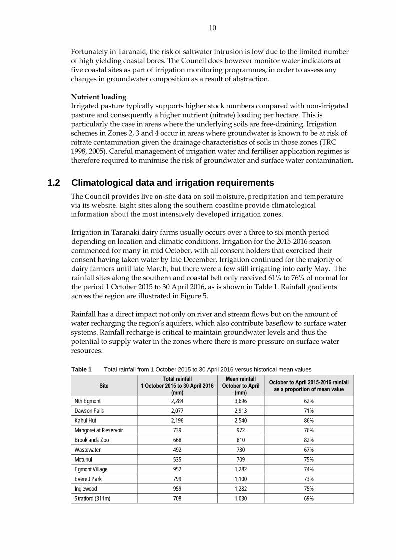
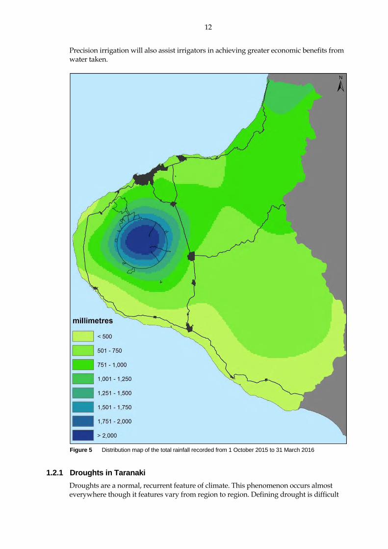
1.2 Climatological data and irrigation requirements The Council provides live on-site data on soil moisture, precipitation and temperature via its website. Eight sites along the southern coastline provide climatological information about the most intensively developed irrigation zones. Irrigation in Taranaki dairy farms usually occurs over a three to six month period depending on location and climatic conditions. Irrigation for the 2015-2016 season commenced for many in mid October, with all consent holders that exercised their consent having taken water by late December. Irrigation continued for the majority of dairy farmers until late March, but there were a few still irrigating into early May. The rainfall sites along the southern and coastal belt only received 61% to 76% of normal for the period 1 October 2015 to 30 April 2016, as is shown in Table 1. Rainfall gradients across the region are illustrated in Figure 5. Rainfall has a direct impact not only on river and stream flows but on the amount of water recharging the region’s aquifers, which also contribute baseflow to surface water systems. Rainfall recharge is critical to maintain groundwater levels and thus the potential to supply water in the zones where there is more pressure on surface water resources. Table 1 Total rainfall from 1 October 2015 to 30 April 2016 versus historical mean values
Site Total rainfall
1 October 2015 to 30 April 2016 (mm)
Mean rainfallOctober to April
(mm)
October to April 2015-2016 rainfall as a proportion of mean value
Nth Egmont 2,284 3,696 62%
Dawson Falls 2,077 2,913 71%
Kahui Hut 2,196 2,540 86%
Mangorei at Reservoir 739 972 76%
Brooklands Zoo 668 810 82%
Wastewater 492 730 67%
Motunui 535 709 75%
Egmont Village 952 1,282 74%
Everett Park 799 1,100 73%
Inglewood 959 1,282 75%
Stratford (311m) 708 1,030 69%

11
Site Total rainfall
1 October 2015 to 30 April 2016 (mm)
Mean rainfallOctober to April
(mm)
October to April 2015-2016 rainfall as a proportion of mean value
Mangaehu 634 802 79%
Kotare 968 1,151 84%
Kaka Rd – Uruti (280m) 893 1,230 73%
Pohokura Saddle (300m) 807 1,058 76%
Stony 799 981 81%
Kapoaiaia – Cape Egmont 547 717 76%
Taungatara 567 856 66%
Kaupokonui 379 588 64%
Duffys - Hawera 390 567 69%
Patea 379 575 66%
Charlies 667 840 79%
Moana Trig 687 832 83%
Rimunui Stn Waitotara 533 708 75%
Ngutuwera 416 682 61%
Accurate interpretation of climatological data is important for the planning, scheduling and operation of efficient irrigation systems. Precipitation and evapotranspiration data are fundamental to carrying out reliable water budget calculations and calculations of crop (pasture) water requirements. Crop water requirements can be defined as the depth of water needed to offset the loss of water through evapotranspiration. In other words, for any period of time, the net irrigation requirement is the amount of water which is not effectively provided by rainfall. The calculated amounts of irrigation water to be efficiently applied to pasture, should also account for the water that is lost while transporting it from its source to the pasture root zone. Some of the losses that need to be estimated are those which occur due to leakage from pipelines and evaporation from droplets sprayed through the air. To compensate for these losses, additional water must be pumped than that required to be stored in the pasture root zone. The gross irrigation requirement then, is the total amount that must be pumped which takes into consideration the irrigation efficiency. The third variable that should be accounted for when planning and operating irrigation systems is soil moisture. Some of the water that is required by the pasture may already be held in the soil, so it is critical to quantify it. There is no extra value in applying more water than the soil can hold, this only results in unnecessary costs and wastage. The only reliable way of knowing how much irrigated water can be stored in the soil at the time of irrigation is by measuring the soil moisture. By measuring the soil moisture the irrigator can be more certain that:
only the amount of water required by the plant is applied; leaching of nutrients is minimised; pasture growth and quality is maximised; the environmental impacts of irrigation are minimised; and costs are reduced.
In order to maximise the efficient use of water taken, the Council strongly urges irrigators to monitor and plan irrigation with the factors outlined above in mind.
12
Precision irrigation will also assist irrigators in achieving greater economic benefits from water taken.
Figure 5 Distribution map of the total rainfall recorded from 1 October 2015 to 31 March 2016
1.2.1 Droughts in Taranaki
Droughts are a normal, recurrent feature of climate. This phenomenon occurs almost everywhere though it features vary from region to region. Defining drought is difficult

13
as it depends on need, physical differences in regions, and varying disciplinary perspectives. In the most general sense, drought originates from a deficiency of precipitation over an extended period of time, resulting in damage to crops and resultant loss of yields. Climate change scenarios suggest that Taranaki may experience more severe weather extremes in the form of dry spells as well as heavy rainfall events. The most severe droughts in Taranaki have been in 1969-1970, 1977-1978 and 2007-2008. Changes in drought risk for the Taranaki region indicate a slight increase in the southern coast of the region. Developing climatology assessments of drought for a region provides a greater understanding of its characteristics and the probability of recurrence at various levels of severity. Information of this type is extremely beneficial in the development of response and mitigation strategies and preparedness plans.
1.3 Monitoring programme
1.3.1 Introduction
Section 35 of the RMA sets obligations upon the Council to gather information, monitor and conduct research on the exercise of resource consents within the Taranaki region. The Council is also required to assess the effects arising from the exercising of these consents and report upon them. The Council may therefore make and record measurements of physical and chemical parameters, take samples for analysis, carry out surveys and inspections, conduct investigations and seek information from consent holders. Every year the Council undertakes monitoring programmes for all pasture irrigation water permits. The programmes list all of the work that the Council could undertake during the forthcoming monitoring period and the cost of the activities to the consent holder. Because irrigation is climate dependent, the level of monitoring varies from year to year, as do associated costs. Increased monitoring is generally required during drier years. Automated monitoring systems can reduce ongoing monitoring costs for consent holders. The 2015-2016 monitoring programmes for irrigation water permits comprised a range of various components, including liaison with consent holders, site inspections, water take data collection, residual flow monitoring, water quality analysis, data review and compliance assessments. The specific range of monitoring carried out in relation to each consent is dictated by the water source, weather and flow conditions and system design. It was a busy season for the Council’s hydrological monitoring team, as the weather conditions meant the demand for irrigation was high, with irrigation starting as early as the middle of October.
1.3.2 Programme liaison and management
There is generally a significant investment of time and resources by the Council in: ongoing liaison with resource consent holders over consent conditions and their
interpretation and application; in discussion over monitoring requirements;
14
preparation for any reviews; renewals; new consents; advice on the Council's environmental management strategies and content of
regional plans; and consultation on associated matters.
1.3.3 Site inspections
The Council inspected all sites where water was actively being taken for irrigation supply purposes during the 2015-2016 monitoring year. Additionally, the “not-otherwise monitored” activities comprising of golf clubs, horticultural irrigation schemes and stock and dairy shed takes were also subject to a planned inspection visit. The 2015-2016 pasture irrigation monitoring programmes provided for an annual inspection of each pasture irrigation abstraction site to assess/evaluate compliance with consent conditions. Council staff were able to visit 100% of the active consents during the 2015-2016 monitoring period. Site inspections are focused on assessing the overall set-up of the intake structures, a visual inspection and assessment of screenings, fences, staff gauges, flowmeters, datalogger devices and planting of riparian vegetation are carried out in line with consent conditions. Monitoring programmes for surface water abstraction include checking compliance with the residual flow conditions of the consent. Residual flow conditions set minimum environmental flows to be maintained during pumping in the waterways downstream from the abstraction point. Compliance with the residual flow conditions is assessed through hydrological flow gaugings which are carried out during low flow conditions in summer. The results of residual flow monitoring are summarised in Section 2.2 and Table 2.
1.3.4 Measuring and reporting of water takes
A special condition of all irrigation water abstraction is the requirement for the consent holder to measure and record abstraction data. The information collected contributes to the sustainable management of the resource and allows for assessment of compliance with consent conditions. The information is also useful for consent holder’s in managing inputs to their operations, identifying potential energy savings, identifying operational issues and making water use efficiency gains2. The Resource Management (Measurement and Reporting of Water Takes) Regulations 2010 (the Regulations) place further legislative requirements on holders of consents for water abstractions of greater than 5 L/s, unless the taking of the water is for non-consumptive purposes.
2 Water Programme of Action Ministry for the Environment

15
The regulations require:
All water permits allowing the take of 5 L/s or more to collect and report records to a set minimum requirement3;
Measurement at the point where water is taken from a river, lake or groundwater system (unless otherwise approved by the Council to be in another location);
Continuous records of daily volumes to be collected using an appropriate flowmeter with the data transferred to the Council on at least an annual basis;
The flowmeter to meet an accuracy standard, and should be properly installed and calibrated independently every five years; and
The consent holder to be responsible for recording and transferring the data to the Council.
All abstractions captured under the Regulations were required to be compliant by 10 November 2016. The Council retains the authority to apply more stringent requirements on consent holders over and above those set out in the Regulations through the setting of consent conditions. The rates and volumes of water abstraction are measured using a flowmeter. If a flowmeter is not installed outside of the manufacturer’s specifications, large errors may occur. The error produced by a valve installed immediately upstream of the flowmeter can be as much as 50%. Errors produced by sharp bends upstream of the flowmeter can amount to 20% of the measured flow. Photo 4 shows an example of a good installation of a flowmeter, with appropriate lengths of straight pipe either side of the meter. Photo 5 shows an example of a poor installation, with an elbow in the pipework immediately downstream of the flowmeter. Poorly installed flowmeters are unlikely to pass the verification test required by a resource consent and/or the Regulations. In these instances the consent holder will be required to undertake works to allow for the successful verification of the flowmeter. Resource consents issued by the Council generally stipulate the range and frequency of data that a consent holder must record in relation to their water take. Specific requirements have become more stringent as monitoring requirements and expectations have evolved. In addition to the requirements set out in consent conditions, all takes captured under the Regulations are required to meet the data recording and submission requirements set out therein. This includes a minimum requirement to measure and record the daily volume of water taken. Records are required to cover the entire water year (1 July to 30 June) and be provided to the Council by 31 July of each year. The Council retains the authority to apply more stringent requirements on consent holders over and above those set out in the Regulations. The Council receives a mixture of manual and electronically recorded water use data each year. The majority of consent holders use a datalogger to electronically store all take data being measured by the flowmeter. Data stored on a datalogger is downloaded in the field by Council staff during end of year inspection visits, or earlier if deemed necessary. Some datalogging systems also utilise telemetry to transmit data to the Council in near
3 Refer to the document Resource Management (Measuring and Reporting of Water Takes) Regulations 2010. REF 2010/267.
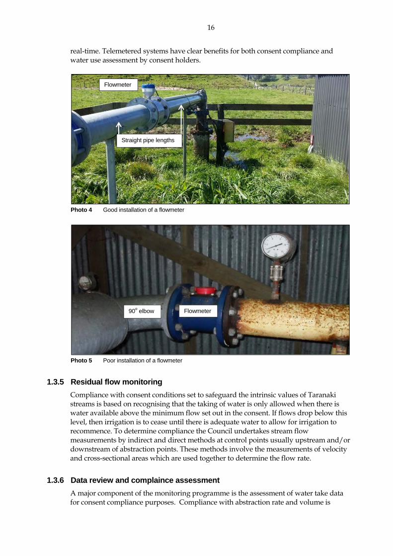
16
real-time. Telemetered systems have clear benefits for both consent compliance and water use assessment by consent holders.
Photo 4 Good installation of a flowmeter
Photo 5 Poor installation of a flowmeter
1.3.5 Residual flow monitoring
Compliance with consent conditions set to safeguard the intrinsic values of Taranaki streams is based on recognising that the taking of water is only allowed when there is water available above the minimum flow set out in the consent. If flows drop below this level, then irrigation is to cease until there is adequate water to allow for irrigation to recommence. To determine compliance the Council undertakes stream flow measurements by indirect and direct methods at control points usually upstream and/or downstream of abstraction points. These methods involve the measurements of velocity and cross-sectional areas which are used together to determine the flow rate.
1.3.6 Data review and complaince assessment
A major component of the monitoring programme is the assessment of water take data for consent compliance purposes. Compliance with abstraction rate and volume is
Flowmeter
Straight pipe lengths
Flowmeter 90o elbow

17
assessed for all consent holders that exercised their consent. Compliance with abstraction rate and/or volume limits stipulated in the applicable resource consent was determined by assessment of remotely recorded data, or by calculating from records submitted by the consent holder. Data transferred to the Council by telemetered systems is electronically assessed on receipt, with preset automated alarms activated in the event of any consent limit exceedances.
1.3.7 Groundwater quality assessment
Sampling of groundwater for hydrochemical analysis is undertaken from irrigation bores in close proximity to the coast. The purpose of this sampling is to monitor for changes in groundwater composition that may occur as a result of groundwater abstraction in these environments. Most significant is the potential for saline water to be drawn into freshwater aquifers as a result of over abstraction. This process, referred to as saline intrusion, has the potential to severely impact groundwater quality and its usability.
18
2. Results
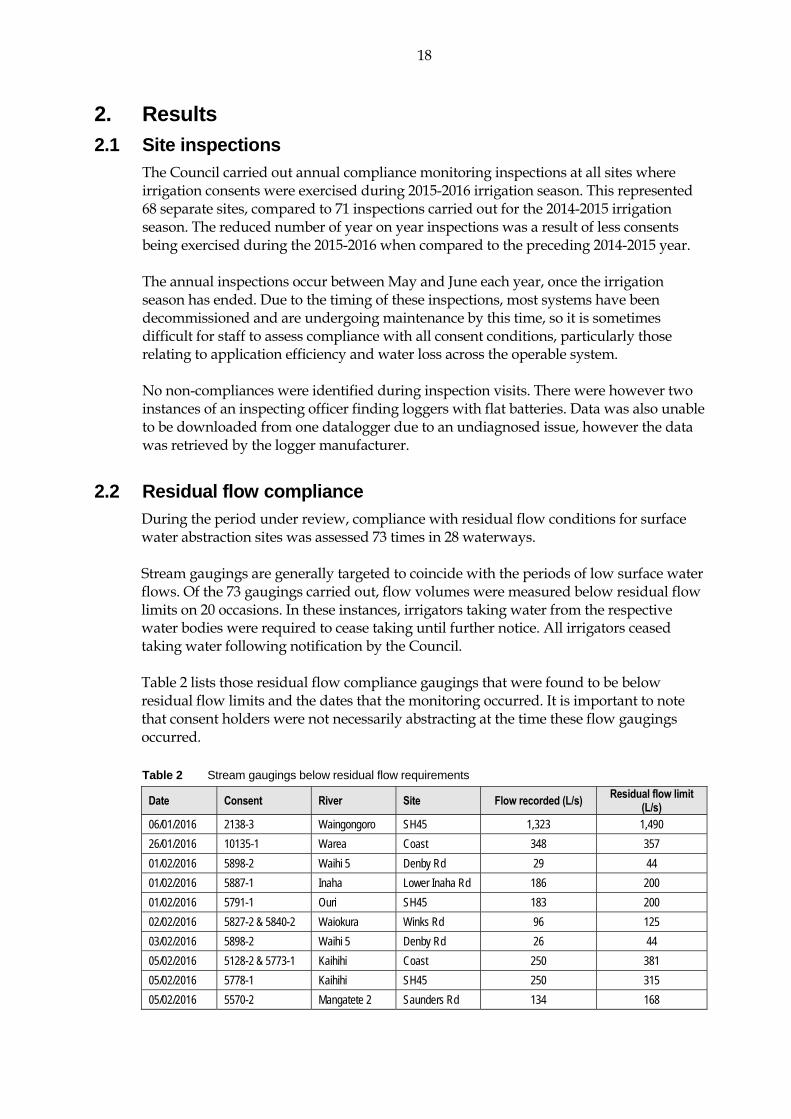
2.1 Site inspections The Council carried out annual compliance monitoring inspections at all sites where irrigation consents were exercised during 2015-2016 irrigation season. This represented 68 separate sites, compared to 71 inspections carried out for the 2014-2015 irrigation season. The reduced number of year on year inspections was a result of less consents being exercised during the 2015-2016 when compared to the preceding 2014-2015 year. The annual inspections occur between May and June each year, once the irrigation season has ended. Due to the timing of these inspections, most systems have been decommissioned and are undergoing maintenance by this time, so it is sometimes difficult for staff to assess compliance with all consent conditions, particularly those relating to application efficiency and water loss across the operable system. No non-compliances were identified during inspection visits. There were however two instances of an inspecting officer finding loggers with flat batteries. Data was also unable to be downloaded from one datalogger due to an undiagnosed issue, however the data was retrieved by the logger manufacturer.
2.2 Residual flow compliance During the period under review, compliance with residual flow conditions for surface water abstraction sites was assessed 73 times in 28 waterways. Stream gaugings are generally targeted to coincide with the periods of low surface water flows. Of the 73 gaugings carried out, flow volumes were measured below residual flow limits on 20 occasions. In these instances, irrigators taking water from the respective water bodies were required to cease taking until further notice. All irrigators ceased taking water following notification by the Council. Table 2 lists those residual flow compliance gaugings that were found to be below residual flow limits and the dates that the monitoring occurred. It is important to note that consent holders were not necessarily abstracting at the time these flow gaugings occurred. Table 2 Stream gaugings below residual flow requirements
Date Consent River Site Flow recorded (L/s) Residual flow limit
(L/s) 06/01/2016 2138-3 Waingongoro SH45 1,323 1,490
26/01/2016 10135-1 Warea Coast 348 357
01/02/2016 5898-2 Waihi 5 Denby Rd 29 44
01/02/2016 5887-1 Inaha Lower Inaha Rd 186 200
01/02/2016 5791-1 Ouri SH45 183 200
02/02/2016 5827-2 & 5840-2 Waiokura Winks Rd 96 125
03/02/2016 5898-2 Waihi 5 Denby Rd 26 44
05/02/2016 5128-2 & 5773-1 Kaihihi Coast 250 381
05/02/2016 5778-1 Kaihihi SH45 250 315
05/02/2016 5570-2 Mangatete 2 Saunders Rd 134 168

19
Date Consent River Site Flow recorded (L/s) Residual flow limit
(L/s) 12/02/2016 5878-2 Makuri Toko Rd 143 170
16/02/2016 5797-1 Oeo 5797 72 130
16/02/2016 5570-2 Mangatete 2 Saunders Rd 111 168
16/02/2016 10135-1 Warea Coast 321 357
16/02/2016 2138-3 Waingongoro SH45 896 1,490
22/02/2016 5827-2 & 5840-2 Waiokura Winks Rd 112 125
01/03/2016 5973-2 Otahi 2 Ihaia Rd 83 88
09/03/2016 5791-1 Ouri SH45 179 200
09/03/2016 5990-1 Waiteika SH45 21 30
21/03/2016 2138-3 Waingongoro SH45 1,200 1,490
2.3 Water usage and compliance assessment During the 2015-2016 monitoring period, 60 of the 76 current consents to take and use water for irrigation purposes were exercised. All consent holders who exercised their consents during the 2015-2016 period and were required to submit records, either by their conditions of their consent or the Regulations, did so within the required timeframe. Written notifications and telephone calls received advising the non-exercising of consents were also taken as provision of records. There were however some issues with incomplete data being provided, which is discussed further in later sections of this report. Analysis of the water take data collected shows that irrigation in Taranaki occurred from as early as mid October 2015, with the majority of irrigation occurring between December 2015 and March 2016. There were however 16 consent holders that were irrigating into late April/early May 2016. The highest water usage for the season was from Roger Dickie Family Trust, abstracting 1,045,020 m³. This consent took an average 130 L/s, with irrigation occurring from mid November to early May. The second highest water user was Spenceview Farms with 900,131 m³. Both takes were operated within the conditions of their respective consents for the duration of the monitoring period. The average usage for all water users for the year was 116,273 m³. Knowing the actual water usage is an important aspect of any consent monitoring programme, not only to enable the assessment of consent compliance, but also to assist the Council in their overall management of the water resource and determining water allocation limits. The data collected also allows the consent holder to make robust assessments of their water use and resultant benefits. Appendix III lists each consent holder’s 2015-2016 water usage for comparison against their maximum authorised take volume over the monitoring period. The average annual consented take volume across all irrigation consents is 952,124 m³. This is vastly different to the actual average annual usage for the 2015-2016 season of 116,273 m³. This is due to the takes only being exercised for a small proportion of the year, as demand only spikes during dry periods of the year. Also, the majority of the consent holders tend to not irrigate on a continual basis, but generally irrigate at night to minimise evaporation

20
losses and capitalise on reduced electricity supply costs. Peak irrigation does generally coincide with periods of reduced flow in the region’s rivers and stream, which means there is a reduced volume of water available for abstraction. All data collected is assessed for compliance against respective consent conditions. Following the assessment of the 2015-2016 data, 17 incidents were lodged in relation to irrigation consent non-compliances. Details relating to each non-compliance, and the follow-up actions undertaken by the Council, are presented in Section 2.5.
2.4 Groundwater quality results During the period under review, groundwater samples were obtained from a total of four coastal sites to assess salinity levels in aquifers being pumped. The results indicate groundwater salinities in the range expected in coastal areas and measured values during the 2015-2016 monitoring period show little deviation from historical mean values at each site. Further sampling of these bores during forthcoming monitoring periods will allow any changes in groundwater salinity levels to be detected. The results of the sampling carried out are presented below in Table 3.Historical means for each analyte are presented in brackets for comparison. Table 3 Groundwater quality results
Consent Site code Sample date Chloride
(g/m3) Conductivity
(mS/m) pH
Sodium (g/m3)
Number of samples
on record
5950-1 GND1203 16/02/2016 32.4 (33.8) 32.5 (31.8) 8.2 (8.6) 63.6 (60.2) 5
6026-1 GND1233 16/02/2016 67.6 (49.7) 50.7 (46.9) 7.7 (7.8) 43.8 (40.0) 5
9561-1 GND2108 03/03/2016 48.1 (47.5) 39.8 (42.8) 8.0 (8.1) 26.0 (25.6) 2
GND2109 03/03/2016 35.2 (35.5) 32.7 (35.0) 8.1 (8.1) 25.8 (25.5) 2
9608-1 GND2354 16/02/2016 88.7 (90.3) 68.3 (76.9) 8.9 (8.3) 199 (190.0) 2
2.5 Investigations, interventions, and incidents The monitoring programme for the year was based on what was considered to be an appropriate level of monitoring, review of data, and liaison with the consent holder. During the year matters may arise which require additional activity by the Council, for example provision of advice and information, or investigation of potential or actual courses of non-compliance or failure to maintain good practices. A pro-active approach that in the first instance avoids issues occurring is favoured. The Council operates and maintains a register of all complaints or reported and discovered excursions from acceptable limits and practices, including non-compliance with consents, which may damage the environment. The incident register includes events where the Company concerned has itself notified the Council. The register contains details of any investigation and corrective action taken.
21
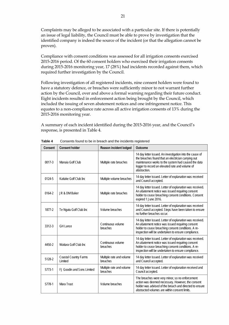
Complaints may be alleged to be associated with a particular site. If there is potentially an issue of legal liability, the Council must be able to prove by investigation that the identified company is indeed the source of the incident (or that the allegation cannot be proven). Compliance with consent conditions was assessed for all irrigation consents exercised 2015-2016 period. Of the 60 consent holders who exercised their irrigation consents during 2015-2016 monitoring year, 17 (28%) had incidents recorded against them, which required further investigation by the Council. Following investigation of all registered incidents, nine consent holders were found to have a statutory defence, or breaches were sufficiently minor to not warrant further action by the Council, over and above a formal warning regarding their future conduct. Eight incidents resulted in enforcement action being brought by the Council, which included the issuing of seven abatement notices and one infringement notice. This equates to a non-compliance rate across all active irrigation consents of 13% during the 2015-2016 monitoring year. A summary of each incident identified during the 2015-2016 year, and the Council’s response, is presented in Table 4. Table 4 Consents found to be in breach and the incidents registered
Consent Consent holder Reason incident lodged Outcome
0017-3 Manaia Golf Club Multiple rate breaches
14 day letter issued. An investigation into the cause of the breaches found that an electrician carrying out maintenance works to the system had caused the data logger to record an elevated rate and volume of abstraction.
0124-5 Kaitake Golf Club Inc Multiple volume breaches 14 day letter issued. Letter of explanation was received and Council accepted.
0164-2 JR & DM Baker Multiple rate breaches
14 day letter issued. Letter of explanation was received. An abatement notice was issued requiring consent holder to cease breaching consent conditions. Consent expired 1 June 2016.
1877-2 Te Ngutu Golf Club Inc Volume breaches 14 day letter issued. Letter of explanation was received and Council accepted. Steps have been taken to ensure no further breaches occur.
3312-3 GH Lance Continuous volume breaches
14 day letter issued. Letter of explanation was received. An abatement notice was issued requiring consent holder to cease breaching consent conditions. A re-inspection will be undertaken to ensure compliance.
4450-2 Waitara Golf Club Inc Continuous volume breaches
14 day letter issued. Letter of explanation was received. An abatement notice was issued requiring consent holder to cease breaching consent conditions. A re-inspection will be undertaken to ensure compliance.
5128-2 Coastal Country Farms Limited
Multiple rate and volume breaches
14 day letter issued. Letter of explanation was received and Council accepted.
5773-1 FJ Goodin and Sons Limited Multiple rate and volume breaches
14 day letter issued. Letter of explanation received and Council accepted.
5778-1 Mara Trust Volume breaches
The breaches were very minor, so no enforcement action was deemed necessary. However, the consent holder was advised of the breach and directed to ensure abstracted volumes are within consent limits.
22
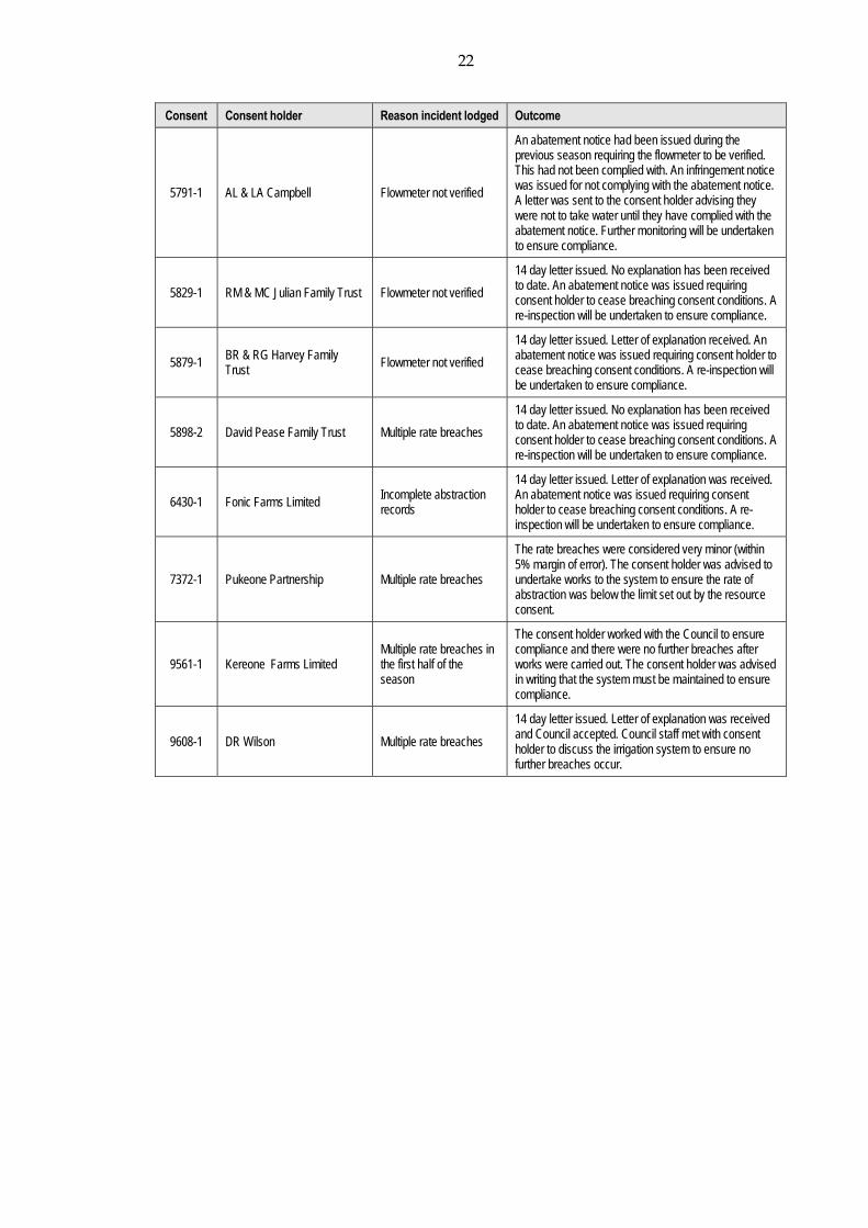
Consent Consent holder Reason incident lodged Outcome
5791-1 AL & LA Campbell Flowmeter not verified
An abatement notice had been issued during the previous season requiring the flowmeter to be verified. This had not been complied with. An infringement notice was issued for not complying with the abatement notice. A letter was sent to the consent holder advising they were not to take water until they have complied with the abatement notice. Further monitoring will be undertaken to ensure compliance.
5829-1 RM & MC Julian Family Trust Flowmeter not verified
14 day letter issued. No explanation has been received to date. An abatement notice was issued requiring consent holder to cease breaching consent conditions. A re-inspection will be undertaken to ensure compliance.
5879-1 BR & RG Harvey Family Trust Flowmeter not verified
14 day letter issued. Letter of explanation received. An abatement notice was issued requiring consent holder to cease breaching consent conditions. A re-inspection will be undertaken to ensure compliance.
5898-2 David Pease Family Trust Multiple rate breaches
14 day letter issued. No explanation has been received to date. An abatement notice was issued requiring consent holder to cease breaching consent conditions. A re-inspection will be undertaken to ensure compliance.
6430-1 Fonic Farms Limited Incomplete abstraction records
14 day letter issued. Letter of explanation was received. An abatement notice was issued requiring consent holder to cease breaching consent conditions. A re-inspection will be undertaken to ensure compliance.
7372-1 Pukeone Partnership Multiple rate breaches
The rate breaches were considered very minor (within 5% margin of error). The consent holder was advised to undertake works to the system to ensure the rate of abstraction was below the limit set out by the resource consent.
9561-1 Kereone Farms Limited Multiple rate breaches in the first half of the season
The consent holder worked with the Council to ensure compliance and there were no further breaches after works were carried out. The consent holder was advised in writing that the system must be maintained to ensure compliance.
9608-1 DR Wilson Multiple rate breaches
14 day letter issued. Letter of explanation was received and Council accepted. Council staff met with consent holder to discuss the irrigation system to ensure no further breaches occur.

23
3. Discussion
3.1 Discussion of site performance Given that this report jointly covers 76 different irrigation water take consents at numerous locations across the region, a discussion of system performance any at each location is impractical. Overall however, the examination of the data supplied to the Council for the 2015-2016 monitoring year revealed that eight of the 60 consent holders who exercised their consents during the 2015-2016 year (13%), breached one or more conditions of their resource consent. Four of these breaches related to exceedances of an abstraction rate and/or volume limit, three for having an unverified flowmeter and one for providing incomplete water take records. Discussed below are some of the key points and issues arising from the monitoring of irrigation water takes during the 2015-2016. Also discussed are some components of irrigation system monitoring, data collection and transfer that could assist consent holders in improving compliance performance and optimisation of water usage. The primary means of measuring water abstraction data is the flowmeter. In order to comply with monitoring requirements set out in consent conditions, and the requirements set out in relation to meter accuracy in the Regulations, it is critical that flowmeters are installed as per manufacturer’s specifications. The Council recommends the installation of electromagnetic flowmeters, as opposed to mechanical meters. Consent holders must ensure the meter is operable at all times, even when no water is being taken. Consent holders should not tamper with the operation of the meter, or attempt to access internals of the meter, without advising the Council and engaging a suitable qualified technician. Further information regarding preferred meter specification and operation can be obtained by contacting the Council. To ensure data being collected by a flowmeter is accurate; the accuracy of the meter needs to be confirmed by a verification test. A meter is deemed to be recording accurately (verified) when reading within 5% of a calibrated reference meter. The Regulations required all takes over 5 L/s to be verified by 10 November 2016. Resource consents being issued by the Council generally require flowmeters to be verified before the consent is first exercised. The correct installation of a good quality flowmeter will typically ensure a meter is able to pass a verification test. While the vast majority of meters in Taranaki have been verified, the Council has had to pursue enforcement action in a small number of instances to ensure compliance. Consent holders should be reminded that verification is required every five years, and plans should be put in place well in advance of reverification dates to avoid any compliance issues. The Council also received several calls from consent holders at the conclusion of the monitoring period advising of operational issues with measurement and recording equipment that had occurred during the year. In some cases, Council staff were only advised of these issues verbally while attending sites for end of year inspections. Often these issues had resulted data not being recorded for a period of time, which in some cases accounted for large portions of the irrigation season. Consent holders are reminded that they need to contact the Council as soon as they discover any operational issues with any monitoring equipment or operational issues that impact their ability comply with their consent (e.g. burst pipework). The majority of irrigation consents stipulate a
24
requirement to notify the Council of such issues in any case, and failure to do so may result in enforcement action being taken. As discussed previously in this report, the majority of irrigation consent holders record water take data on dataloggers. Data from these loggers is subsequently downloaded by Council staff at the conclusion of the monitoring year, at which point it is assessed for compliance. During the investigation and follow-up of non-compliances identified at the conclusion of the 2015-2016 monitoring year, a number of consent holders identified as non-compliant were interested in what technologies were available to enable them to view water use data in real-time and which allowed them to be notified of any impending consent exceedances. Such systems are widely available, using telemetry to transmit data electronically via the cell phone network. This data can be accessed by the consent holder and automated alarms can be set up to notify them of any impending breaches of authorised abstraction rate or volume. The Council promotes the installation of telemetry systems as a means of improving consent compliance and allowing water users to better monitor their water usage and improve water use efficiency. Irrigation consent holders are also urged to investigate the use of soil moisture monitoring equipment to assist in the efficient planning and scheduling of irrigation. By monitoring soil moisture conditions, irrigators can optimise the usage of their irrigation systems to only apply water to pasture when it is required and to cease irrigation when the optimum volume of water has been applied. This has obvious benefits in terms of maximising pasture production but can also save irrigators money by avoiding the application of water when it is not required. Soil moisture monitoring can be undertaken with handheld sensors, or with dedicated in-situ systems. The complexity and cost of each available system vary and consent holders are urged to contact the Council for further information.
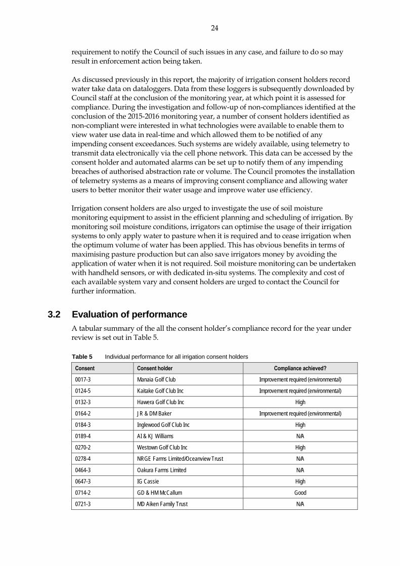
3.2 Evaluation of performance
A tabular summary of the all the consent holder’s compliance record for the year under review is set out in Table 5. Table 5 Individual performance for all irrigation consent holders
Consent Consent holder Compliance achieved?
0017-3 Manaia Golf Club Improvement required (environmental)
0124-5 Kaitake Golf Club Inc Improvement required (environmental)
0132-3 Hawera Golf Club Inc High
0164-2 JR & DM Baker Improvement required (environmental)
0184-3 Inglewood Golf Club Inc High
0189-4 AI & KJ Williams N/A
0270-2 Westown Golf Club Inc High
0278-4 NRGE Farms Limited/Oceanview Trust N/A
0464-3 Oakura Farms Limited N/A
0647-3 IG Cassie High
0714-2 GD & HM McCallum Good
0721-3 MD Aiken Family Trust N/A

25
Consent Consent holder Compliance achieved?
0880-3 IHC New Zealand Inc (NORTH TARANAKI) High
1223-3 EO & CP Lander High
1721-3 Manukorihi Golf Club Inc High
1877-3 Te Ngutu Golf Club Incorporated Improvement required (environmental)
1879-3 Wairau Nurseries N/A
2138-3 Riverside Farms Taranaki Ltd High
3171-3 Taranaki Greenhouses Limited High
3312-3 GH Lance Improvement required (environmental)
3859-2 Living Light 2000 Limited N/A
4450-2 Waitara Golf Club Inc Improvement required (environmental)
4494-2 CT & JM McDonald High
4783-2 Larsen Trusts Partnership N/A
4993-2 J & EG Sanderson High
4994-2 J & EG Sanderson High
5128-2 Coastal Country Farms Limited Improvement required (environmental)
5568-1 Cornwall Park Farms Limited Good
5570-2 Kaihihi Trust High
5571-1 Jimian Limited N/A
5623-1 WD & SC Morrison High
5636-1 Waiwira Trust High
5696-1 Kokako Road Limited N/A
5709-2 KCCG Sole Trust Good
5773-1 Goodin FJ & Sons Limited Improvement required (environmental)
5778-1 Mara Trust Good
5781-2 Waikaikai Farms Limited High
5791-1 AL & LA Campbell Improvement required (environmental)
5797-1 Pihama Farms Limited High
5807-1 Dickie Roger Family Trust High
5827-2 Walker & McLean Partnership High
5829-1 RM & MC Julian Family Trust Improvement required (environmental)
5840-2 Gibbs G Trust High
5863-2 Geary AR Trust (A R Geary) High
5876-1 GA & RJ Dorn High
5878-1 Woollaston Family Trust Partnership High
5879-1 BR & RG Harvey Family Trust Improvement required (environmental)
5887-1 A & EN Barkla High
5896-1 Kohi Investments Limited Improvement required (environmental)
5898-2 David Pease Family Trust Improvement required (environmental)
5950-1 WD & SC Morrison High
5973-1 Crosbig Trusts Partnership Good
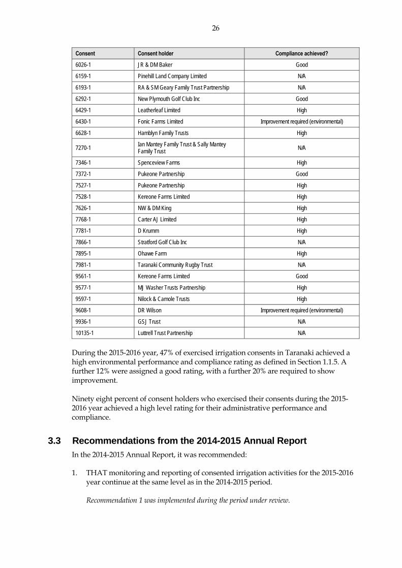
26
Consent Consent holder Compliance achieved?
6026-1 JR & DM Baker Good
6159-1 Pinehill Land Company Limited N/A
6193-1 RA & SM Geary Family Trust Partnership N/A
6292-1 New Plymouth Golf Club Inc Good
6429-1 Leatherleaf Limited High
6430-1 Fonic Farms Limited Improvement required (environmental)
6628-1 Hamblyn Family Trusts High
7270-1 Ian Mantey Family Trust & Sally Mantey Family Trust N/A
7346-1 Spenceview Farms High
7372-1 Pukeone Partnership Good
7527-1 Pukeone Partnership High
7528-1 Kereone Farms Limited High
7626-1 NW & DM King High
7768-1 Carter AJ Limited High
7781-1 D Krumm High
7866-1 Stratford Golf Club Inc N/A
7895-1 Ohawe Farm High
7981-1 Taranaki Community Rugby Trust N/A
9561-1 Kereone Farms Limited Good
9577-1 MJ Washer Trusts Partnership High
9597-1 Nilock & Camole Trusts High
9608-1 DR Wilson Improvement required (environmental)
9936-1 GSJ Trust N/A
10135-1 Luttrell Trust Partnership N/A
During the 2015-2016 year, 47% of exercised irrigation consents in Taranaki achieved a high environmental performance and compliance rating as defined in Section 1.1.5. A further 12% were assigned a good rating, with a further 20% are required to show improvement. Ninety eight percent of consent holders who exercised their consents during the 2015-2016 year achieved a high level rating for their administrative performance and compliance.
3.3 Recommendations from the 2014-2015 Annual Report In the 2014-2015 Annual Report, it was recommended: 1. THAT monitoring and reporting of consented irrigation activities for the 2015-2016
year continue at the same level as in the 2014-2015 period.
Recommendation 1 was implemented during the period under review.

27
2. THAT Council continues to liaise with consent holders who have dataloggers that are failing, so improvements in compliance at all time with consent conditions are achieved.
3. THAT the Council encourages consent holders that do not supply good quality
records to install a datalogger and transfer data electronically to the Council database via telemetry.
4. THAT the Council requires all consent holders that take above 5 L/s to comply with
the Measurement and Reporting of Water Takes Regulations 2010. N.B 10 November 2016 is the deadline for compliance.
The Council continues to work with consent holders regarding recommendations 2, 3 and 4, and to improve compliance with consent conditions and all relevant regulations.
3.4 Alterations to monitoring programmes for 2016-2017 In designing and implementing the monitoring programmes for air/water discharges in the region, the Council has taken into account:
the extent of information made available by previous authorities; its relevance under the RMA; its obligations to monitor emissions/discharges and effects under the RMA; and to report to the regional community.
The Council also takes into account the scope of assessments required at the time of renewal of permits, and the need to maintain a sound understanding of industrial processes within Taranaki emitting to the atmosphere/discharging to the environment. It is proposed that monitoring of irrigation consents continues at the same level as during the 2015-2016 year. It is proposed however that mid-season monitoring inspections and data downloads be undertaken to assess water take compliance with consent conditions for all consent holders that breached their authorised abstraction rate and/or volume limits in the 2015-2016 season. This will allow early intervention by the Council if required.

28
4. Recommendations 1. THAT the monitoring and the downloading of abstraction data occurs mid season
for those that had water take breaches during the 2015-2016 season. 2. THAT the Council encourages consent holders that do not supply good quality
records to install a datalogger and transfer data electronically to the Council database via telemetry.
3. THAT the Council continues to actively enforce the implementation of the Resource
Management (Measurement and Reporting of Water Takes) Regulations 2010.
29
Glossary of common terms and abbreviations The following abbreviations and terms may be used within this report:
Conductivity Conductivity, an indication of the level of dissolved salts in a sample, usually measured at 20°C and expressed in mS/m.
Cumec A volumetric measure of flow- 1 cubic metre per second (1 m3s-1).
g/m3 Grams per cubic metre, and equivalent to milligrams per litre (mg/L). In water, this is also equivalent to parts per million (ppm), but the same does not apply to gaseous mixtures.
Incident An event that is alleged or is found to have occurred that may have actual or potential environmental consequences or may involve non-compliance with a consent or rule in a regional plan. Registration of an incident by the Council does not automatically mean such an outcome had actually occurred.
Intervention Action/s taken by Council to instruct or direct actions be taken to avoid or reduce the likelihood of an incident occurring.
Investigation Action taken by Council to establish what were the circumstances/events surrounding an incident including any allegations of an incident.
Incident Register The Incident Register contains a list of events recorded by the Council on the basis that they may have the potential or actual environmental consequences that may represent a breach of a consent or provision in a Regional Plan.
L/s Litres per second.
m2 Square Metres..
mS/m Millisiemens per metre.
pH A numerical system for measuring acidity in solutions, with 7 as neutral. Numbers lower than 7 are increasingly acidic and higher than 7 are increasingly alkaline. The scale is logarithmic i.e. a change of 1 represents a ten-fold change in strength. For example, a pH of 4 is ten times more acidic than a pH of 5.
Resource consent Refer Section 87 of the RMA. Resource consents include land use consents (refer Sections 9 and 13 of the RMA), coastal permits (Sections 12, 14 and 15), water permits (Section 14) and discharge permits (Section 15).
RMA Resource Management Act 1991 and including all subsequent amendments.
Temp Temperature, measured in °C (degrees Celsius).

30
Bibliography and references Cameron, S.G, & White P.A., 2004: Determination of key indicators to assess groundwater
quality in New Zealand aquifers. Unpublished Institute Geological Nuclear Sciences client report 2004/111, 117pp.
Horizons Regional Council. Assessment of the Seawater Intrusion Hazard in the Manawatu
Coastal Aquifers and Monitoring Action Plan. Phreatos Limited, May 2005. Rout R, 2003: Optimisation of Farm Irrigation. Report 4579/1, prepared for Taranaki Regional
Council by Lincoln Environmental, January 2003. 55pp. MAF 1997: Best Management Guidelines for Sustainable Irrigated Agriculture. MAF Policy
Technical Paper No 00/05, ISBN 0-478-2050-1. 47 pp. Ministry for the Environment 2010: Resource Management (Measurement and Reporting of
Water Takes) Regulations 2010. 8 pp. TRC 1998: State of Environment Monitoring report 1994-97 groundwater levels, quality and
nitrate monitoring. Unpublished Technical Report 97-86 by Taranaki Regional Council, January 1998, 27 pp.
TRC 2003: A preliminary evaluation of surface water availability and demand for pasture
irrigation purposes in Taranaki. Unpublished report by Taranaki Regional Council, July 2003, 14 pp.
TRC 2005: State of Environment Monitoring 2001-2002 – Nitrates in shallow groundwater.
Unpublished Technical Report 2003-22 by Taranaki Regional Council, March 2005, 19 pp. The New Zealand Irrigation Manual. A Practical guide to profitable and sustainable irrigation.
Malvern Landcare Group. 2001. Taranaki Regional Council 2003: Pasture irrigation monitoring Annual Report 2002-2003.
Technical Report 2003-75. Taranaki Regional Council 2004: Pasture irrigation monitoring Annual Report 2003-2004.
Technical Report 2004-63. Taranaki Regional Council 2005: Pasture irrigation monitoring Annual Report 2004-2005.
Technical Report 2005-70. Taranaki Regional Council 2006: Pasture irrigation monitoring Annual Report 2005-2006.
Technical Report 2006-04. Taranaki Regional Council 2007: Pasture Irrigation Compliance Monitoring Annual Report
2006-2007. Technical Report 2007-55. Taranaki Regional Council 2009: Irrigation Water Compliance Monitoring Annual Report
2007-2008. Technical Report 2008-84.

31
Taranaki Regional Council 2010: Irrigation Water Compliance Monitoring Annual Report 2008-2009. Technical Report 2009-100.
Taranaki Regional Council 2010: Irrigation Water Compliance Monitoring Annual Report
2009-2010. Technical Report 2010-49. Taranaki Regional Council 2011: Irrigation Water Compliance Monitoring Annual Report
2010-2011. Technical Report 2011-53. Taranaki Regional Council 2012: Irrigation Water Compliance Monitoring Annual Report
2011-2012. Technical Report 2012-70. Taranaki Regional Council 2013: Irrigation Water Compliance Monitoring Annual Report
2012-2013. Technical Report 2013-100. Taranaki Regional Council 2014: Irrigation Water Compliance Monitoring Annual Report
2013-2014 . Technical Report 2014-67. Taranaki Regional Council 2015: Irrigation Water Compliance Monitoring Annual Report
2014-2015 . Technical Report 2015-85.

Appendix I
Example surface water abstraction permit for irrigation


Consent 10135-1.0
For General, Standard and Special conditions pertaining to this consent please see reverse side of this document
Page 1 of 4
Doc# 1560561-v1
Water Permit
Pursuant to the Resource Management Act 1991 a resource consent is hereby granted by the
Taranaki Regional Council Name of Consent Holder:
Luttrell Trust Partnership (Trustees: Sean Prionsese & Marianne Flora Luttrell) 78A Nopera Road RD 32 Opunake 4682
Decision Date: 25 August 2015 Commencement Date: 15 September 2015
Conditions of Consent
Consent Granted: To take and use water from the Warea River for pasture irrigation purposes
Expiry Date: 01 June 2031
Review Date(s): June Annually
Site Location: 288 Bayly Road, Warea
Legal Description: Lot 19 DP 366494 Sec 67 Blk VII Cape SD (site of take & use)
Grid Reference (NZTM) 1667764E-5656861N
Catchment: Warea

General condition a. The consent holder shall pay to the Taranaki Regional Council all the administration,
monitoring and supervision costs of this consent, fixed in accordance with section 36 of the Resource Management Act 1991.
Special conditions
1. The rate of taking shall not exceed 64.8 litres per second.
2. At least 5 working days before this consent is first exercised the consent holder shall notify the Taranaki Regional Council. Notification shall include the consent number and the date that water will be first taken, and shall be emailed to [email protected].
3. Before exercising this consent the consent holder shall install, and thereafter maintain a water meter and a datalogger at the site of taking (or a nearby site in accordance with Regulation 10 of the Resource Management (Measurement and Reporting of Water Takes) Regulations 2010. The water meter and datalogger shall be tamper-proof and shall measure and record the rate and volume of water taken to an accuracy of ± 5%. Records of the date, the time and the rate and volume of water taken at intervals not exceeding 15 minutes, shall be made available to the Chief Executive, Taranaki Regional Council at all reasonable times.
Note: Water meters and dataloggers must be installed, and regularly maintained, in accordance with manufacturer’s specifications in order to ensure that they meet the required accuracy. Even with proper maintenance water meters and dataloggers have a limited lifespan.
4. The consent holder shall provide the Chief Executive, Taranaki Regional Council with a document from a suitably qualified person certifying that water measuring and recording equipment required by the conditions of this consent (‘the equipment’):
(a) has been installed and/or maintained in accordance with the manufacturer’s specifications; and/or
(b) has been tested and shown to be operating to an accuracy of ± 5%.
The documentation shall be provided:
(i) within 30 days of the installation of a water meter or datalogger;
(ii) at other times when reasonable notice is given and the Chief Executive, Taranaki Regional Council has reasonable evidence that the equipment may not be functioning as required by this consent; and
(iii) no less frequently than once every five years.
5. If any measuring or recording equipment breaks down, or for any reason is not operational, the consent holder shall advise the Chief Executive, Taranaki Regional Council immediately. Any repairs or maintenance to this equipment must be undertaken by a suitably qualified person and a maintenance report given to Taranaki Regional Council within 30 days of any such work occurring.
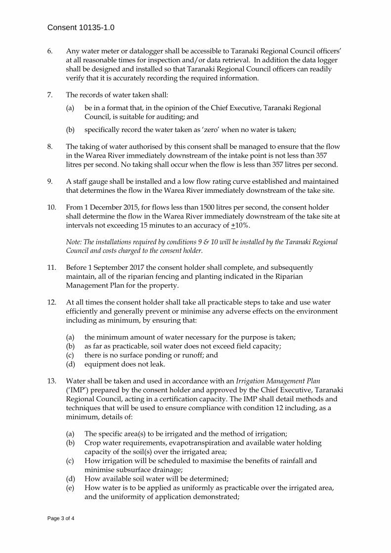
Consent 10135-1.0
Page 3 of 4
6. Any water meter or datalogger shall be accessible to Taranaki Regional Council officers’ at all reasonable times for inspection and/or data retrieval. In addition the data logger shall be designed and installed so that Taranaki Regional Council officers can readily verify that it is accurately recording the required information.
7. The records of water taken shall:
(a) be in a format that, in the opinion of the Chief Executive, Taranaki Regional Council, is suitable for auditing; and
(b) specifically record the water taken as ‘zero’ when no water is taken;
8. The taking of water authorised by this consent shall be managed to ensure that the flow in the Warea River immediately downstream of the intake point is not less than 357 litres per second. No taking shall occur when the flow is less than 357 litres per second.
9. A staff gauge shall be installed and a low flow rating curve established and maintained that determines the flow in the Warea River immediately downstream of the take site.
10. From 1 December 2015, for flows less than 1500 litres per second, the consent holder shall determine the flow in the Warea River immediately downstream of the take site at intervals not exceeding 15 minutes to an accuracy of +10%.
Note: The installations required by conditions 9 & 10 will be installed by the Taranaki Regional Council and costs charged to the consent holder.
11. Before 1 September 2017 the consent holder shall complete, and subsequently maintain, all of the riparian fencing and planting indicated in the Riparian Management Plan for the property.
12. At all times the consent holder shall take all practicable steps to take and use water efficiently and generally prevent or minimise any adverse effects on the environment including as minimum, by ensuring that:
(a) the minimum amount of water necessary for the purpose is taken; (b) as far as practicable, soil water does not exceed field capacity; (c) there is no surface ponding or runoff; and (d) equipment does not leak.
13. Water shall be taken and used in accordance with an Irrigation Management Plan (‘IMP’) prepared by the consent holder and approved by the Chief Executive, Taranaki Regional Council, acting in a certification capacity. The IMP shall detail methods and techniques that will be used to ensure compliance with condition 12 including, as a minimum, details of:
(a) The specific area(s) to be irrigated and the method of irrigation; (b) Crop water requirements, evapotranspiration and available water holding
capacity of the soil(s) over the irrigated area; (c) How irrigation will be scheduled to maximise the benefits of rainfall and
minimise subsurface drainage; (d) How available soil water will be determined; (e) How water is to be applied as uniformly as practicable over the irrigated area,
and the uniformity of application demonstrated;

Consent 10135-1.0
Page 4 of 4
(f) A leak detection programme; and (g) Information to be provided to the Taranaki Regional Council to enable
compliance to be checked.
14. The Irrigation Management Plan (‘IMP’) prepared and submitted to the Chief Executive, Taranaki Regional Council in accordance condition 13 shall also be provided to Fish and Game New Zealand at the same time. Any comments made by Fish and Game New Zealand within 15 working days of receiving a plan will be taken into account by the Chief Executive, Taranaki Regional Council when determining if the plan meets the requirements of this consent.
15. The consent holder shall ensure that the intake is screened to avoid fish (in all stages of their life-cycle) entering the intake or being trapped against the screen.
16. This consent shall lapse on 30 September 2020, unless the consent is given effect to before the end of that period or the Taranaki Regional Council fixes a longer period pursuant to section 125(1)(b) of the Resource Management Act 1991.
17. In accordance with section 128 and section 129 of the Resource Management Act 1991, the Taranaki Regional Council may serve notice of its intention to review, amend, delete or add to the conditions of this resource consent by giving notice of review annually during June for the purposes of:
(a) ensuring that the conditions are adequate to deal with any adverse effects on the environment arising from the exercise of this resource consent, which were either not foreseen at the time the application was considered or which it was not appropriate to deal with at the time; and/or
(b) to require any data collected in accordance with the conditions of this consent to be transmitted directly to the Taranaki Regional Council’s computer system, in a format suitable for providing a ‘real time’ record over the internet; and/or
(c) increasing the minimum flow specified in condition 8 to account for additional hydrological information that becomes available, recognising that the specified flow is intended to be a reasonable estimate of mean annual low flow.
Signed at Stratford on 25 August 2015 For and on behalf of Taranaki Regional Council __________________________________________ A D McLay Director - Resource Management

Appendix II
Active irrigation consents in Taranaki July 2015 to June 2016

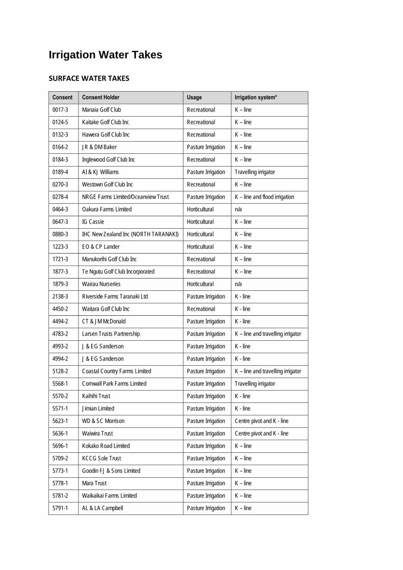
Irrigation Water Takes SURFACE WATER TAKES
Consent Consent Holder Usage Irrigation system*
0017-3 Manaia Golf Club Recreational K – line
0124-5 Kaitake Golf Club Inc Recreational K – line
0132-3 Hawera Golf Club Inc Recreational K – line
0164-2 JR & DM Baker Pasture Irrigation K – line
0184-3 Inglewood Golf Club Inc Recreational K – line
0189-4 AI & KJ Williams Pasture Irrigation Travelling irrigator
0270-3 Westown Golf Club Inc Recreational K – line
0278-4 NRGE Farms Limited/Oceanview Trust Pasture Irrigation K – line and flood irrigation
0464-3 Oakura Farms Limited Horticultural n/a
0647-3 IG Cassie Horticultural K – line
0880-3 IHC New Zealand Inc (NORTH TARANAKI) Horticultural K – line
1223-3 EO & CP Lander Horticultural K – line
1721-3 Manukorihi Golf Club Inc Recreational K – line
1877-3 Te Ngutu Golf Club Incorporated Recreational K – line
1879-3 Wairau Nurseries Horticultural n/a
2138-3 Riverside Farms Taranaki Ltd Pasture Irrigation K - line
4450-2 Waitara Golf Club Inc Recreational K - line
4494-2 CT & JM McDonald Pasture Irrigation K - line
4783-2 Larsen Trusts Partnership Pasture Irrigation K – line and travelling irrigator
4993-2 J & EG Sanderson Pasture Irrigation K - line
4994-2 J & EG Sanderson Pasture Irrigation K - line
5128-2 Coastal Country Farms Limited Pasture Irrigation K – line and travelling irrigator
5568-1 Cornwall Park Farms Limited Pasture Irrigation Travelling irrigator
5570-2 Kaihihi Trust Pasture Irrigation K - line
5571-1 Jimian Limited Pasture Irrigation K - line
5623-1 WD & SC Morrison Pasture Irrigation Centre pivot and K - line
5636-1 Waiwira Trust Pasture Irrigation Centre pivot and K - line
5696-1 Kokako Road Limited Pasture Irrigation K – line
5709-2 KCCG Sole Trust Pasture Irrigation K – line
5773-1 Goodin FJ & Sons Limited Pasture Irrigation K – line
5778-1 Mara Trust Pasture Irrigation K – line
5781-2 Waikaikai Farms Limited Pasture Irrigation K – line
5791-1 AL & LA Campbell Pasture Irrigation K – line
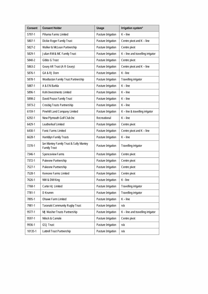
Consent Consent Holder Usage Irrigation system*
5797-1 Pihama Farms Limited Pasture Irrigation K – line
5807-1 Dickie Roger Family Trust Pasture Irrigation Centre pivot and K – line
5827-2 Walker & McLean Partnership Pasture Irrigation Centre pivot
5829-1 Julian RM & MC Family Trust Pasture Irrigation K – line and travelling irrigator
5840-2 Gibbs G Trust Pasture Irrigation Centre pivot
5863-2 Geary AR Trust (A R Geary) Pasture Irrigation Centre pivot and K – line
5876-1 GA & RJ Dorn Pasture Irrigation K - line
5878-1 Woollaston Family Trust Partnership Pasture Irrigation Travelling irrigator
5887-1 A & EN Barkla Pasture Irrigation K – line
5896-1 Kohi Investments Limited Pasture Irrigation K – line
5898-2 David Pease Family Trust Pasture Irrigation K – line
5973-2 Crosbig Trusts Partnership Pasture Irrigation K – line
6159-1 Pinehill Land Company Limited Pasture Irrigation K – line & travelling irrigator
6292-1 New Plymouth Golf Club Inc Recreational K – line
6429-1 Leatherleaf Limited Pasture Irrigation Centre pivot
6430-1 Fonic Farms Limited Pasture Irrigation Centre pivot and K – line
6628-1 Hamblyn Family Trusts Pasture Irrigation K – line
7270-1 Ian Mantey Family Trust & Sally Mantey Family Trust
Pasture Irrigation Travelling irrigator
7346-1 Spenceview Farms Pasture Irrigation Centre pivot
7372-1 Pukeone Partnership Pasture Irrigation Centre pivot
7527-1 Pukeone Partnership Pasture Irrigation Centre pivot
7528-1 Kereone Farms Limited Pasture Irrigation Centre pivot
7626-1 NW & DM King Pasture Irrigation K - line
7768-1 Carter AJ Limited Pasture Irrigation Travelling irrigator
7781-1 D Krumm Pasture Irrigation Travelling irrigator
7895-1 Ohawe Farm Limited Pasture Irrigation K – line
7981-1 Taranaki Community Rugby Trust Pasture Irrigation n/a
9577-1 MJ Washer Trusts Partnership Pasture Irrigation K – line and travelling irrigator
9597-1 Nilock & Camole Pasture Irrigation Centre pivot
9936-1 GSJ Trust Pasture Irrigation n/a
10135-1 Luttrell Trust Partnership Pasture Irrigation n/a

GROUNDWATER TAKES
Consent Consent Holder Usage Irrigation system*
0714-2 GD & HM McCallum Pasture Irrigation K – line and travelling irrigator
0721-3 MD Aiken Family Trust Horticultural n/a
3171-3 Taranaki Greenhouses Limited Horticultural K – line
3312-3 GH Lance Horticultural K – line
3859-2 Living Light 2000 Limited Horticultural n/a
5879-1 BR & RG Harvey Family Trust Pasture Irrigation n/a
5950-1 WD & SC Morrison Pasture Irrigation Centre pivot and K - line
6026-1 JR & DM Baker Pasture Irrigation K – line
6193-1 RA & SM Geary Trusts Partnership Pasture Irrigation n/a
7866-1 Stratford Golf Club Inc Recreational n/a
9561-1 Kereone Farms Limited Pasture Irrigation Centre pivot
9608-1 D Wilson Pasture Irrigation Centre pivot
*n/a - consent holder does not have any system in place.


Appendix III
Water take consent usage for 2015-2016


Water take consent usage for 2015-2016
Consent Consent holder Consented allowable
annual usage (m3/annum)
Actual water usage from 1 July 2015 to 30 June 2016 (m3/annum)
0017-3 Manaia Golf Club 36,500 8,683
0124-5 Kaitake Golf Club Inc 47,450 10,574
0132-3 Hawera Golf Club Inc 91,250 n/a*
0164-2 JR & DM Baker 255,500 39,058
0184-3 Inglewood Golf Club Inc 21,900 2,865
0189-4 AI & KJ Williams 365,000 0
0270-3 Westown Golf Club Inc 131,400 3,356.3
0278-4 NRGE Farms Limited/Oceanview Trust 4,320,432 0
0464-3 Oakura Farms Limited 36,500 0
0647-3 IG Cassie 30,660 1,469
0714-2 GD & HM McCallum 182,500 41,315.9
0721-3 MD Aiken Family Trust 30,660 0
0880-3 IHC New Zealand Inc (NORTH TARANAKI) 32,120 5,647
1223-3 EO & CP Lander 108,405 7,740
1721-3 Manukorihi Golf Club Inc 69,350 17,039
1877-3 Te Ngutu Golf Club Incorporated 73,000 9,551
1879-3 Wairau Nurseries 33,215 0
2138-3 Riverside Farms Taranaki Ltd 756,864 28,900
3171-3 Taranaki Greenhouses Limited 22,630 5,058
3312-3 GH Lance 21,900 21,090
3859-2 Living Light 2000 Limited 27,594 n/a*
4450-2 Waitara Golf Club Inc 18,250 5,781
4494-2 CT & JM McDonald 788,400 10,681
4783-2 Larsen Trusts Partnership 1,169,825 0
4993-2 J & EG Sanderson 1,022,000 69,780
4994-2 J & EG Sanderson 1,186,250 172,768
5128-2 Coastal Country Farms Limited 851,545 59,899
5568-1 Cornwall Park Farms Limited 287,437.5 22,123
5570-2 Kaihihi Trust 547,500 29,686
5571-1 Jimian Limited 1,261,440 0
5623-1 WD & SC Morrison 3,547,800 566,072
5636-1 Waiwira Trust 2,584,930 806,777
5696-1 Kokako Road Limited 1,182,600 0

Consent Consent holder Consented allowable
annual usage (m3/annum)
Actual water usage from 1 July 2015 to 30 June 2016 (m3/annum)
5709-2 KCCG Sole Trust 912,500 0
5773-1 Goodin FJ & Sons Limited 630,720 110,999
5778-1 Mara Trust 630,720 66,671
5781-2 Waikaikai Farms Limited 2,269,205 224,673
5791-1 AL & LA Campbell 958,125 157,220
5797-1 Pihama Farms Limited 1,314,000 108,787
5807-1 Dickie Roger Family Trust 6,679,500 1,045,020
5827-2 Walker & McLean Partnership 821,250 102,689
5829-1 Julian RM & MC Family Trust 1,533,000 233,784
5840-2 Gibbs G Trust 821,250 88,083
5863-2 Geary AR Trust (A R Geary) 1,144,640 358,926
5876-1 GA & RJ Dorn 1,350,500 130,920
5878-1 Woollaston Family Trust Partnership 474,500 2,297
5879-1 BR & RG Harvey Family Trust 630,720 7,923
5887-1 A & EN Barkla 547,500 51,503
5896-1 Kohi Investments Limited 1,460,000 198,289
5898-2 David Pease Family Trust 946,080 166,286
5950-1 WD & SC Morrison 313,900 89,055
5973-2 Crosbig Trusts Partnership 584,000 13,730
6026-1 JR & DM Baker 189,070 30,587
6159-1 Pinehill Land Company Limited 237,250 0
6193-1 RA & SM Geary Trusts Partnership 262,800 0
6292-1 New Plymouth Golf Club Inc 292,000 48,820
6429-1 Leatherleaf Limited 912,500 138,754
6430-1 Fonic Farms Limited 1,741,050 249,604
6628-1 Hamblyn Family Trusts 765,770 112,100
7270-1 Ian Mantey Family Trust & Sally Mantey Family Trust
378,140 0
7346-1 Spenceview Farms 3,815,856 900,131
7372-1 Pukeone Partnership 1,261,440 433,430
7527-1 Pukeone Partnership 5,545,080 346,713
7528-1 Kereone Farms Limited 3,416,400 478,447
7626-1 NW & DM King 725,328 39,373
7768-1 Carter AJ Limited 126,144 24,192
7781-1 D Krumm 105,120 n/a
7866-1 Stratford Golf Club Inc 25,550 0

Consent Consent holder Consented allowable
annual usage (m3/annum)
Actual water usage from 1 July 2015 to 30 June 2016 (m3/annum)
7895-1 Ohawe Farm Limited 1,259,250 93,885
7981-1 Taranaki Community Rugby Trust 838,857.6 0
9561-1 Kereone Farms Limited 682,550 50,105
9577-1 MJ Washer Trusts Partnership 127,750 38,698
9597-1 Nilock & Camole 647,875 50,177
9608-1 D Wilson 946,080 275,171
9936-1 GSJ Trust 385,002 0
10135-1 Luttrell Trust Partnership 2,043,532.8 0
* Consent was exercised but not required to submit records by the consent or the Regulations

Appendix IV
Report on consented water permits for farm and general water supply purposes

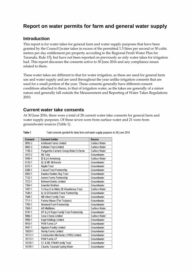
Report on water permits for farm and general water supply Introduction This report is for water takes for general farm and water supply purposes that have been granted by the Council [water takes in excess of the permitted 1.5 litres per second or 50 cubic metres per day entitlement per property according to the Regional Fresh Water Plan for Taranaki, Rule 15], but have not been reported on previously as only water takes for irrigation had. This report discusses the consents active to 30 June 2016 and any compliance issues related to them.
These water takes are different to that for water irrigation, as these are used for general farm use and water supply and are used throughout the year unlike irrigation consents that are used for a small portion of the year. These consents generally have different consent conditions attached to them, to that of irrigation water, as the takes are generally of a minor nature and generally fall outside the Measurement and Reporting of Water Takes Regulations 2010.
Current water take consents At 30 June 2016, there were a total of 28 current water take consents for general farm and water supply purposes. Of these seven were from surface water and 21 were from groundwater sources (Table 1). Table 1 Total consents granted for dairy farm and water supply purposes to 30 June 2016
Consent Consent holder Source 0095-2 Ashbrook Farms Limited Surface Water 0865-3 Kathdan Trust Limited Surface Water 1190-3 Pungarehu Farmers Group Water Scheme Surface Water 5413-2 MJ Fahy Groundwater 5990-1 ID & JA Armstrong Surface Water 6133-1 DJ & ME McKenzie Groundwater 6372-1 Naplin Trust Groundwater 6380-1 Caiseal Trust Partnership Groundwater 6903-1 Awatea Hawkes Bay Trust Groundwater 7132-1 Aorere Farms Partnership Groundwater 7272-1 Belmont Dairies Limited Groundwater 7304-1 Gwerder Brothers Groundwater 7497-1 Te Rua O te Moko 2B Ahuwhenua Trust Surface Water 7540-1 AJ & DI Dravitzki Trusts Partnership Groundwater 7608-1 MD Aiken Family Trust Groundwater 7711-1 Pariroa Marae (The Trustees) Groundwater 7783-1 Norwood Farm Partnership Groundwater 7969-1 AB Middleton Surface Water 9747-1 DP & JH Roper Family Trust Partnership Groundwater 9886-1 Sona Chosta Limited Surface Water 9900-1 Kaipi Holdings Limited Groundwater 9910-1 PKW Farms LP Groundwater 9947-1 Ngatoro Poultry Limited Groundwater 10029-1 Hernly Farms Limited Groundwater 10112-1 Construction Mechanics (1993) Limited Groundwater 10113-1 PKW Farms LP Groundwater 10120-1 SC & MJ O’Neill Family Trust Groundwater 10199-1 ClearAz Taranaki Spring Water Groundwater
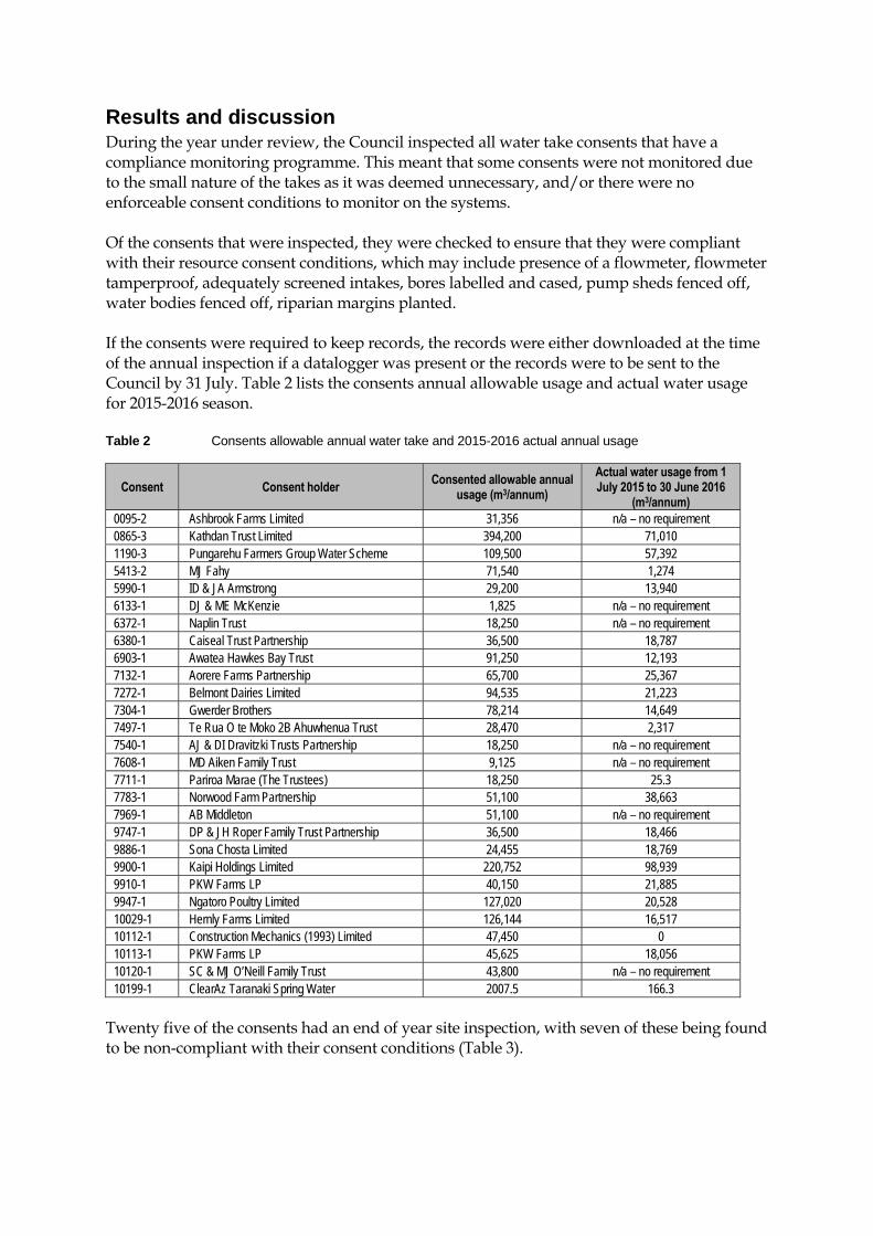
Results and discussion During the year under review, the Council inspected all water take consents that have a compliance monitoring programme. This meant that some consents were not monitored due to the small nature of the takes as it was deemed unnecessary, and/or there were no enforceable consent conditions to monitor on the systems. Of the consents that were inspected, they were checked to ensure that they were compliant with their resource consent conditions, which may include presence of a flowmeter, flowmeter tamperproof, adequately screened intakes, bores labelled and cased, pump sheds fenced off, water bodies fenced off, riparian margins planted. If the consents were required to keep records, the records were either downloaded at the time of the annual inspection if a datalogger was present or the records were to be sent to the Council by 31 July. Table 2 lists the consents annual allowable usage and actual water usage for 2015-2016 season. Table 2 Consents allowable annual water take and 2015-2016 actual annual usage
Consent Consent holder Consented allowable annual
usage (m3/annum)
Actual water usage from 1 July 2015 to 30 June 2016
(m3/annum) 0095-2 Ashbrook Farms Limited 31,356 n/a – no requirement 0865-3 Kathdan Trust Limited 394,200 71,010 1190-3 Pungarehu Farmers Group Water Scheme 109,500 57,392 5413-2 MJ Fahy 71,540 1,274 5990-1 ID & JA Armstrong 29,200 13,940 6133-1 DJ & ME McKenzie 1,825 n/a – no requirement 6372-1 Naplin Trust 18,250 n/a – no requirement 6380-1 Caiseal Trust Partnership 36,500 18,787 6903-1 Awatea Hawkes Bay Trust 91,250 12,193 7132-1 Aorere Farms Partnership 65,700 25,367 7272-1 Belmont Dairies Limited 94,535 21,223 7304-1 Gwerder Brothers 78,214 14,649 7497-1 Te Rua O te Moko 2B Ahuwhenua Trust 28,470 2,317 7540-1 AJ & DI Dravitzki Trusts Partnership 18,250 n/a – no requirement 7608-1 MD Aiken Family Trust 9,125 n/a – no requirement 7711-1 Pariroa Marae (The Trustees) 18,250 25.3 7783-1 Norwood Farm Partnership 51,100 38,663 7969-1 AB Middleton 51,100 n/a – no requirement 9747-1 DP & JH Roper Family Trust Partnership 36,500 18,466 9886-1 Sona Chosta Limited 24,455 18,769 9900-1 Kaipi Holdings Limited 220,752 98,939 9910-1 PKW Farms LP 40,150 21,885 9947-1 Ngatoro Poultry Limited 127,020 20,528 10029-1 Hernly Farms Limited 126,144 16,517 10112-1 Construction Mechanics (1993) Limited 47,450 0 10113-1 PKW Farms LP 45,625 18,056 10120-1 SC & MJ O’Neill Family Trust 43,800 n/a – no requirement 10199-1 ClearAz Taranaki Spring Water 2007.5 166.3
Twenty five of the consents had an end of year site inspection, with seven of these being found to be non-compliant with their consent conditions (Table 3).
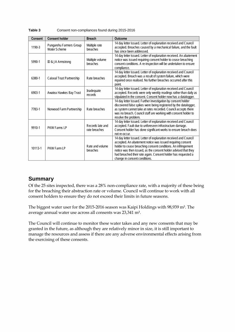
Table 3 Consent non-compliances found during 2015-2016
Consent Consent holder Breach Outcome
1190-3 Pungarehu Farmers Group Water Scheme
Multiple rate breaches
14 day letter issued. Letter of explanation received and Council accepted. Breaches caused by a mechanical failure, and the fault has since been addressed.
5990-1 ID & JA Armstrong Multiple volume breaches
14 day letter issued. Letter of explanation received. An abatement notice was issued requiring consent holder to cease breaching consent conditions. A re-inspection will be undertaken to ensure compliance.
6380-1 Caiseal Trust Partnership Rate breaches
14 day letter issued. Letter of explanation received and Council accepted. Breach was a result of system failure, which were repaired once realised. No further breaches occurred after this point.
6903-1 Awatea Hawkes Bay Trust Inadequate records
14 day letter issued. Letter of explanation received and Council accepted. Records were only weekly readings rather than daily as stipulated in the consent. Consent holder now has a datalogger.
7783-1 Norwood Farm Partnership Rate breaches
14 day letter issued. Further investigation by consent holder discovered false spikes were being registered by the datalogger, as system cannot take at rates recorded. Council accepts there was no breach. Council staff are working with consent holder to resolve the problem.
9910-1 PKW Farms LP Records late and rate breaches
14 day letter issued. Letter of explanation received and Council accepted. Fault due to unforeseen infrastructure damage. Consent holder has done significant works to ensure breach does not re-occur.
10113-1 PKW Farm LP Rate and volume breaches
14 day letter issued. Letter of explanation received and Council accepted. An abatement notice was issued requiring consent holder to cease breaching consent conditions. An infringement notice was then issued, as the consent holder advised that they had breached their rate again. Consent holder has requested a change in consent conditions.
Summary Of the 25 sites inspected, there was a 28% non-compliance rate, with a majority of these being for the breaching their abstraction rate or volume. Council will continue to work with all consent holders to ensure they do not exceed their limits in future seasons. The biggest water user for the 2015-2016 season was Kaipi Holdings with 98,939 m³. The average annual water use across all consents was 23,341 m³. The Council will continue to monitor these water takes and any new consents that may be granted in the future, as although they are relatively minor in size, it is still important to manage the resources and assess if there are any adverse environmental effects arising from the exercising of these consents.


![[HOUSING CREDIT COMPLIANCE MONITORING PLAN] CMP.pdf · [HOUSING TAX CREDIT COMPLIANCE MONITORING PLAN] Revised April 2020 Page 11 MISSISSIPPI HOME CORPORATION HTC COMPLIANCE MONITORING](https://img.pdfslide.us/doc/110x75/5f717da45245811f3d326c25/housing-credit-compliance-monitoring-plan-cmppdf-housing-tax-credit-compliance.jpg)