Embed Size (px)
Citation preview
IRONDEQUOIT BAY HARBOR MANAGEMENT PLAN
Irondequoit Bay Harbor Management Plan (11/2003)
IRONDEQUOIT BAY HARBOR MANAGEMENT PLAN Prepared for: Towns of Irondequoit, Penfield & Webster Monroe County Irondequoit Bay Coordinating Committee New York State Department of State Prepared by: Dufresne-Henry (formerly The Cavendish Partnership) 151 St. Paul Street, Floor 5 Rochester, NY 14604 With: Nutter Associates F-E-S Associates Drake Environmental Consultants November 2003

IRONDEQUOIT BAY HARBOR MANAGEMENT PLAN
Irondequoit Bay Harbor Management Plan (11/2003) i
CREDITS Thanks and appreciation to the following: IRONDEQUOIT BAY COORDINATING COMMITTEE Supervisor David Schantz, Town of Irondequoit Supervisor Channing Philbrick, Town of Penfield Supervisor Cathryn Thomas, Town of Webster
Tom Goodwin, Monroe County Department of Planning & Development IRONDEQUOIT BAY TECHNICAL STAFF Jeff Beach, New York State Department of State
Daina Beckstrand, Monroe County Soil and Water Conservation District Rochelle Bell, Monroe County Department of Planning & Development
Jim Costello, Town of Penfield Don Hauza, Town of Webster Charlie Knauf, Monroe County Department of Health Krishan Mago, AICP, Town of Irondequoit Ed Sander, Monroe County Fishery Advisory Board Bob Shearer, NYS Department of Environmental Conservation Paula Smith, Monroe County Soil and Water Conservation District IRONDEQUOIT BAY HARBOR MANAGEMENT PLAN ADVISORY COMMITTEE Dan Cappa, Town of Irondequoit Gary Copie, Town of Webster Peter Damick, Town of Webster Lars Lindeqvist, Town of Penfield Ralph Pascale, Town of Irondequoit Bill Richardson, Town of Penfield Thanks also to the following for their participation Louis Amico, Monroe County Parks Department Al Butkas, NYS Department of Environmental Conservation
Renee Casler, Monroe County Department of Planning & Development Bob Henry, Irondequoit Fish and Game Club Bob Jonas, Monroe County Water Quality Coordinating Committee Dave McLeod, New York State Department of State BMC William Mosgrober, United States Coast Guard
Sue Quarterman, Monroe County Environmental Management Council Deputy Bill Reithel, Monroe County Sheriff’s Office Lt. Steve Scott, Monroe County Sheriff’s Office Loretta Simon, New York State Department of State
This document was prepared for the New York State Department of State with funds
provided under Title 11 of the Environmental Protection Fund.
IRONDEQUOIT BAY HARBOR MANAGEMENT PLAN
Irondequoit Bay Harbor Management Plan (11/2003)
ii
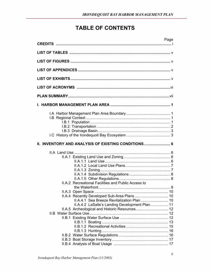
TABLE OF CONTENTS
Page CREDITS .............................................................................................................. i LIST OF TABLES ................................................................................................ v LIST OF FIGURES ............................................................................................... v LIST OF APPENDICES ........................................................................................ v LIST OF EXHIBITS............................................................................................... v LIST OF ACRONYMS .........................................................................................vi PLAN SUMMARY................................................................................................vii I. HARBOR MANAGEMENT PLAN AREA ......................................................... 1
I.A Harbor Management Plan Area Boundary .......................................... 1 I.B Regional Context ................................................................................ 1
I.B.1 Population ............................................................................ 1 I.B.2. Transportation ...................................................................... 2 I.B.3 Drainage Basin..................................................................... 3
I.C History of the Irondequoit Bay Ecosystem.......................................... 3 II. INVENTORY AND ANALYSIS OF EXISTING CONDITIONS......................... 6
II.A Land Use............................................................................................ 6
II.A.1 Existing Land Use and Zoning ............................................ 6 II.A.1.1 Land Use .............................................................. 6 II.A.1.2 Local Land Use Plans........................................... 7 II.A.1.3 Zoning................................................................... 7 II.A.1.4 Subdivision Regulations ....................................... 8 II.A.1.5 Other Regulations................................................. 8
II.A.2 Recreational Facilities and Public Access to the Waterfront .................................................................... 8
II.A.3 Open Space ...................................................................... 10 II.A.4 Recently Developed Sub-Area Plans ................................ 10
II.A.4.1 Sea Breeze Revitalization Plan .......................... 10 II.A.4.2 LaSalle’s Landing Development Plan................. 11
II.A.5 Archeological and Historic Resources............................... 12 II.B Water Surface Use........................................................................... 12
II.B.1 Existing Water Surface Use .............................................. 12 II.B.1.1 Boating ............................................................... 13 II.B.1.2 Recreational Activities ........................................ 15 II.B.1.3 Hunting ............................................................... 16
II.B.2 Water Surface Regulations ............................................... 16 II.B.3 Boat Storage Inventory...................................................... 17 II.B.4 Analysis of Boat Usage .................................................... 17
IRONDEQUOIT BAY HARBOR MANAGEMENT PLAN
Irondequoit Bay Harbor Management Plan (11/2003)
iii
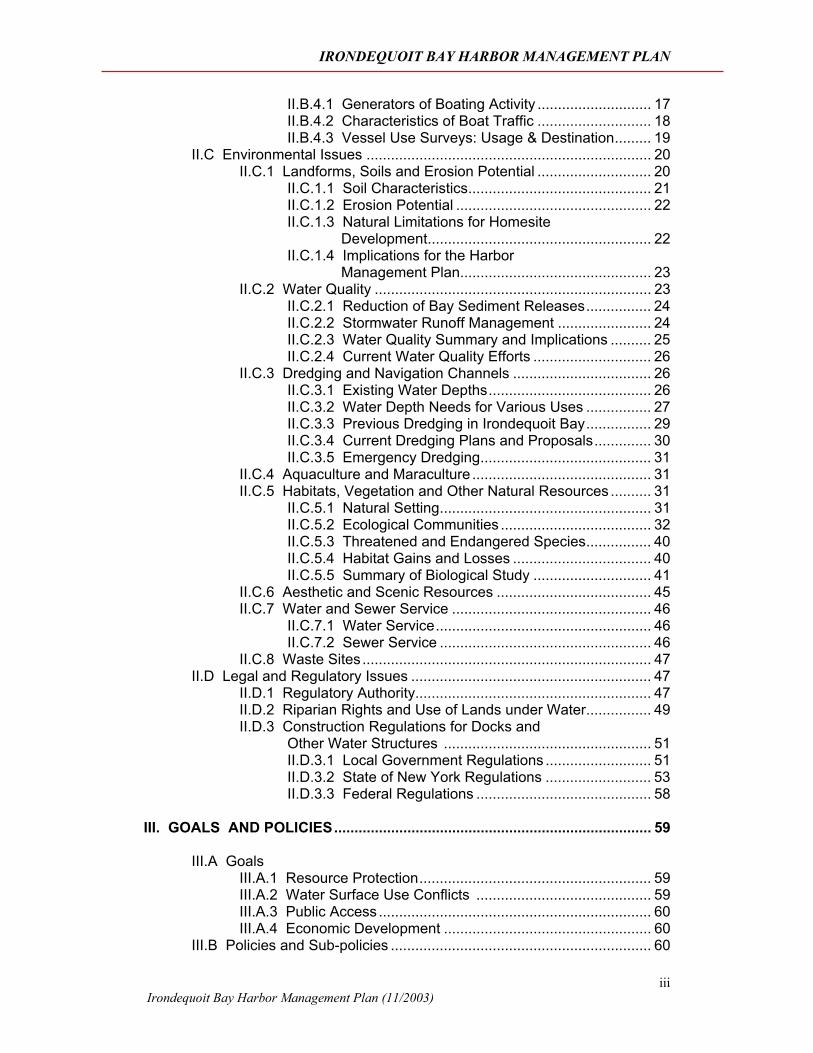
II.B.4.1 Generators of Boating Activity ............................ 17 II.B.4.2 Characteristics of Boat Traffic ............................ 18 II.B.4.3 Vessel Use Surveys: Usage & Destination......... 19
II.C Environmental Issues ...................................................................... 20 II.C.1 Landforms, Soils and Erosion Potential ............................ 20
II.C.1.1 Soil Characteristics............................................. 21 II.C.1.2 Erosion Potential ................................................ 22 II.C.1.3 Natural Limitations for Homesite
Development....................................................... 22 II.C.1.4 Implications for the Harbor
Management Plan............................................... 23 II.C.2 Water Quality .................................................................... 23
II.C.2.1 Reduction of Bay Sediment Releases................ 24 II.C.2.2 Stormwater Runoff Management ....................... 24 II.C.2.3 Water Quality Summary and Implications .......... 25 II.C.2.4 Current Water Quality Efforts ............................. 26
II.C.3 Dredging and Navigation Channels .................................. 26 II.C.3.1 Existing Water Depths........................................ 26 II.C.3.2 Water Depth Needs for Various Uses ................ 27 II.C.3.3 Previous Dredging in Irondequoit Bay................ 29 II.C.3.4 Current Dredging Plans and Proposals.............. 30 II.C.3.5 Emergency Dredging.......................................... 31
II.C.4 Aquaculture and Maraculture ............................................ 31 II.C.5 Habitats, Vegetation and Other Natural Resources .......... 31
II.C.5.1 Natural Setting.................................................... 31 II.C.5.2 Ecological Communities ..................................... 32 II.C.5.3 Threatened and Endangered Species................ 40 II.C.5.4 Habitat Gains and Losses .................................. 40 II.C.5.5 Summary of Biological Study ............................. 41
II.C.6 Aesthetic and Scenic Resources ...................................... 45 II.C.7 Water and Sewer Service ................................................. 46
II.C.7.1 Water Service..................................................... 46 II.C.7.2 Sewer Service .................................................... 46
II.C.8 Waste Sites....................................................................... 47 II.D Legal and Regulatory Issues ........................................................... 47
II.D.1 Regulatory Authority.......................................................... 47 II.D.2 Riparian Rights and Use of Lands under Water................ 49 II.D.3 Construction Regulations for Docks and
Other Water Structures ................................................... 51 II.D.3.1 Local Government Regulations .......................... 51 II.D.3.2 State of New York Regulations .......................... 53 II.D.3.3 Federal Regulations ........................................... 58
III. GOALS AND POLICIES.............................................................................. 59 III.A Goals
III.A.1 Resource Protection......................................................... 59 III.A.2 Water Surface Use Conflicts ........................................... 59 III.A.3 Public Access................................................................... 60 III.A.4 Economic Development ................................................... 60
III.B Policies and Sub-policies ................................................................ 60
IRONDEQUOIT BAY HARBOR MANAGEMENT PLAN
Irondequoit Bay Harbor Management Plan (11/2003)
iv
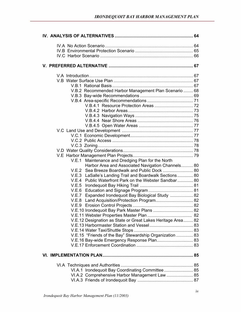
IV. ANALYSIS OF ALTERNATIVES ................................................................. 64 IV.A No Action Scenario......................................................................... 64 IV.B Environmental Protection Scenario ................................................ 65 IV.C Harbor Scenario ............................................................................. 66 V. PREFERRED ALTERNATIVE ...................................................................... 67
V.A Introduction...................................................................................... 67 V.B Water Surface Use Plan .................................................................. 67
V.B.1 Rational Basis ................................................................... 67 V.B.2 Recommended Harbor Management Plan Scenario ........ 68 V.B.3 Bay-wide Recommendations ............................................ 69 V.B.4 Area-specific Recommendations ...................................... 71
V.B.4.1 Resource Protection Areas ................................ 72 V.B.4.2 Harbor Areas...................................................... 73 V.B.4.3 Navigation Ways ................................................ 75 V.B.4.4 Near Shore Areas .............................................. 76 V.B.4.5 Open Water Areas ............................................. 77
V.C Land Use and Development ........................................................... 77 V.C.1 Economic Development.................................................... 77 V.C.2 Public Access ................................................................... 78 V.C.3 Zoning............................................................................... 78
V.D Water Quality Considerations.......................................................... 78 V.E Harbor Management Plan Projects.................................................. 79
V.E.1 Maintenance and Dredging Plan for the North Harbor Area and Associated Navigation Channels.......... 80
V.E.2 Sea Breeze Boardwalk and Public Dock ......................... 80 V.E.3 LaSalle’s Landing Trail and Boardwalk Sections ............. 80 V.E.4 Public Waterfront Park on the Webster Sandbar ............. 80 V.E.5 Irondequoit Bay Hiking Trail ............................................ 81 V.E.6 Education and Signage Program..................................... 81 V.E.7 Expanded Irondequoit Bay Biological Study ................... 82 V.E.8 Land Acquisition/Protection Program............................... 82 V.E.9 Erosion Control Projects .................................................. 82 V.E.10 Irondequoit Bay Park Master Plans ................................. 82 V.E.11 Webster Properties Master Plan ..................................... 82 V.E.12 Designation as State or Great Lakes Heritage Area........ 82 V.E.13 Harbormaster Station and Vessel .................................... 83 V.E.14 Water Taxi/Shuttle Stops ................................................. 83 V.E.15 “Friends of the Bay” Stewardship Organization .............. 83 V.E.16 Bay-wide Emergency Response Plan.............................. 83 V.E.17 Enforcement Coordination ............................................... 83
VI. IMPLEMENTATION PLAN........................................................................... 85
VI.A Techniques and Authorities ............................................................ 85 VI.A.1 Irondequoit Bay Coordinating Committee ........................ 85 VI.A.2 Comprehensive Harbor Management Law ...................... 85 VI.A.3 Friends of Irondequoit Bay .............................................. 87
IRONDEQUOIT BAY HARBOR MANAGEMENT PLAN
Irondequoit Bay Harbor Management Plan (11/2003)
v
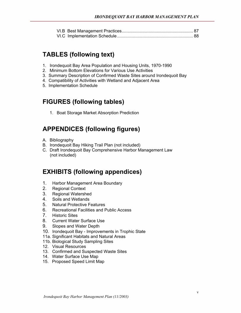
VI.B Best Management Practices........................................................... 87 VI.C Implementation Schedule............................................................... 88
TABLES (following text) 1. Irondequoit Bay Area Population and Housing Units, 1970-1990 2. Minimum Bottom Elevations for Various Use Activities 3. Summary Description of Confirmed Waste Sites around Irondequoit Bay 4. Compatibility of Activities with Wetland and Adjacent Area 5. Implementation Schedule
FIGURES (following tables)
1. Boat Storage Market Absorption Prediction APPENDICES (following figures) A. Bibliography B. Irondequoit Bay Hiking Trail Plan (not included) C. Draft Irondequoit Bay Comprehensive Harbor Management Law (not included) EXHIBITS (following appendices) 1. Harbor Management Area Boundary 2. Regional Context 3. Regional Watershed 4. Soils and Wetlands 5. Natural Protective Features 6. Recreational Facilities and Public Access 7. Historic Sites 8. Current Water Surface Use 9. Slopes and Water Depth 10. Irondequoit Bay - Improvements in Trophic State 11a. Significant Habitats and Natural Areas 11b. Biological Study Sampling Sites 12. Visual Resources 13. Confirmed and Suspected Waste Sites 14. Water Surface Use Map 15. Proposed Speed Limit Map
IRONDEQUOIT BAY HARBOR MANAGEMENT PLAN
Irondequoit Bay Harbor Management Plan (11/2003)
vi
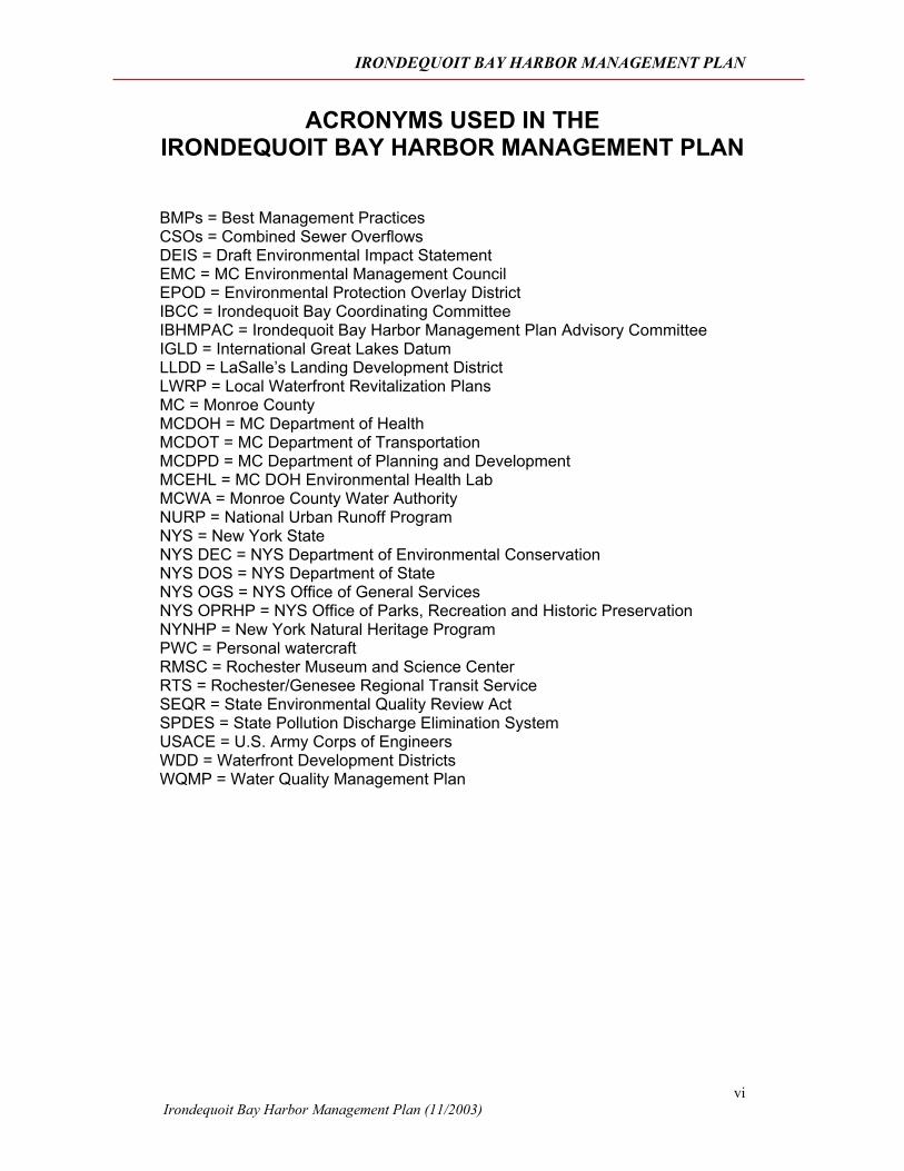
ACRONYMS USED IN THE IRONDEQUOIT BAY HARBOR MANAGEMENT PLAN BMPs = Best Management Practices CSOs = Combined Sewer Overflows DEIS = Draft Environmental Impact Statement EMC = MC Environmental Management Council EPOD = Environmental Protection Overlay District IBCC = Irondequoit Bay Coordinating Committee IBHMPAC = Irondequoit Bay Harbor Management Plan Advisory Committee IGLD = International Great Lakes Datum LLDD = LaSalle’s Landing Development District LWRP = Local Waterfront Revitalization Plans MC = Monroe County MCDOH = MC Department of Health MCDOT = MC Department of Transportation MCDPD = MC Department of Planning and Development MCEHL = MC DOH Environmental Health Lab MCWA = Monroe County Water Authority NURP = National Urban Runoff Program NYS = New York State NYS DEC = NYS Department of Environmental Conservation NYS DOS = NYS Department of State NYS OGS = NYS Office of General Services NYS OPRHP = NYS Office of Parks, Recreation and Historic Preservation NYNHP = New York Natural Heritage Program PWC = Personal watercraft RMSC = Rochester Museum and Science Center RTS = Rochester/Genesee Regional Transit Service SEQR = State Environmental Quality Review Act SPDES = State Pollution Discharge Elimination System USACE = U.S. Army Corps of Engineers WDD = Waterfront Development Districts WQMP = Water Quality Management Plan
IRONDEQUOIT BAY HARBOR MANAGEMENT PLAN
Irondequoit Bay Harbor Management Plan (11/2003)
vii
PLAN SUMMARY Irondequoit Bay: once Native American hunting and fishing grounds; a harbor of refuge and trading station for the French, the English, and the new American nation; playground of the 1890’s, has undergone a dramatic ecological and residential rejuvenation over the last 30 years due to an unprecedented investment of public planning and funds, citizen action and stewardship. One of the largest coastal bays of Lake Ontario, Irondequoit Bay offers 1,680 acres of water surface available to public use adjacent to the third largest metropolitan center in New York State. The bay is surrounded by steep embankments and wooded uplands that tower high above the water’s edge. Rare birds and plant species are scattered through the surrounding forests and wetlands. A wide range of habitat types results in a diversity of fish and wildlife that is quite unusual adjacent to a highly populated area. Adjacent urban and suburban community residents and visitors are provided a rare opportunity to experience nature through such activities as hunting, fishing, hiking, nature study and bird watching. Irondequoit Bay is also popular for its recreational activities including boating, fishing, water skiing, sailing and winter sports. The entire bay functions as a valuable ecological system, and is a major nursery area for the Lake Ontario ecosystem. The maximization of enjoyment of this resource for all users combined with the protection of the bay’s unique, diverse and sensitive ecological features is an objective highly worthy of effort and expenditure. The document examined in this executive summary, The Irondequoit Bay Harbor Management Plan, is the culmination of that effort.
The Irondequoit Bay Harbor Management Plan has been prepared as part of New York State’s Coastal Resources and Local Waterfront Revitalization Program, authorized by the Waterfront Revitalization of Coastal Areas and Inland Waterways Act to aid in the planning and regulation of water use activity in intensely-used waterfront areas.
The Harbor Management Plan was prepared to help assure greater consistency in reviewing plans among the local municipalities and various state and federal agencies. Upon its approval, the Plan would mandate state and federal agencies to adhere to the guidelines which it sets forth. The approved plan will help New York State Department of Environmental Conservation (NYS DEC), Monroe County and the sponsoring Towns of Irondequoit, Webster and Penfield cooperate to make better use of the Bay, and will also provide justification for municipal regulation of structures in, and uses of, water and underwater lands.
The Harbor Management Plan is intended as an addendum to the Local Waterfront Revitalization Plans (LWRPs) adopted by the Towns of Irondequoit (1988), Penfield (1991) and Webster (1997). The LWRPs provided guidance for the regulation of landside development in the Bay ecosystem and have been approved by the NYS Secretary of State, with the concurrence of the U.S. Office of Ocean and Coastal Resource Management. Subsequent to LWRP adoption, each Town amended its zoning ordinance to reflect LWRP findings in the waterfront area. The Harbor Management Plan addresses the regulation and use of the water surface.
The study area boundaries are Lake Ontario along the north edge of the Bay; Bay Road and Creek Street on the east; Browncroft Boulevard on the south; and
IRONDEQUOIT BAY HARBOR MANAGEMENT PLAN
Irondequoit Bay Harbor Management Plan (11/2003)
viii
NYS Route 590 and Culver Road on the west. The majority of the area included within the overall study area boundary lies within the jurisdictions of the towns of Irondequoit, Penfield and Webster. Small areas of land in the southern portion of the Bay are within the jurisdiction of the City of Rochester and the Town of Brighton.
GOALS The following Goals were developed by the Irondequoit Bay Harbor Management Plan Advisory Committee (IBHMPAC). The Goals have been used in the development of Plan Policies, Water Surface Use Recommendations and Project Recommendations.
Resource Protection
Goal 1: Better protect and enhance the sensitive natural areas and resources of the Bay.
Objectives:
1. Increase stakeholders’ awareness and appreciation of the sensitive natural areas and resources of the Bay.
2. Provide better understanding of significant fish and wildlife value, their sensitivity to development and adjacent water surface use impacts.
3. Prepare Irondequoit Bay Biological Study.
4. Balance water dependent uses and protection of sensitive natural resources of the Bay, based on the Carrying Capacity Study of the Bay.
Goal 2: Improve and protect water quality of Irondequoit Bay for desired uses which emphasize a healthy aquatic ecosystem.
Objective:
1. Ensure desired Bay water quality for its designated best use.
Goal 3: Ensure that development around the Bay occurs without impacting significant resources (e.g. environmental, historical, archeological, aesthetic features).
Objectives:
1. Have new developments fit the topography, accessibility, relationship to adjacent uses, subsurface conditions and availability of public services and utilities.
2. Manage woodlots around the Bay to maintain aesthetic character protect the views; protect steep slopes, and wildlife habitats.
IRONDEQUOIT BAY HARBOR MANAGEMENT PLAN
Irondequoit Bay Harbor Management Plan (11/2003)
ix
Water Surface Use Conflicts
Goal: Minimize and resolve water surface use conflicts and conflicts among all of the stakeholders of Irondequoit Bay.
Objectives:
1. Provide for an appropriate mix of commercial and active and passive recreational opportunities on the Bay’s water and associated land areas.
2. Ensure that development and water surface use will be designed and conducted in harmony with the environment so as not to conflict with overriding interest of conserving the natural beauty of the Bay.
Public Access
Goal: Improve public access to diverse recreational opportunities on Irondequoit Bay.
Objectives:
1. Provide adequate and safe public access to a mix of active and passive recreational opportunities on the Bay’s water and adjacent up-lands.
2. Identify, acquire, develop and maintain land around the Bay for public recreational use.
3. Coordinate and formalize development of trails around the Bay.
4. Increase points of public access through public ownership.
5. Increase public access of views to and from the Bay.
Economic Development
Goal: Make Irondequoit Bay an integral part of local and regional tourism development efforts.
Objectives:
1. Protect and improve/upgrade existing water dependent commercial and recreational uses where access, utilities and parking can be made available without significant impact on the Bay’s resource value.
2. Encourage new water dependent recreational uses or expansion of such existing uses in the LaSalle’s Landing, Sea Breeze areas and other Waterfront Development zoning districts identified in the local Master Plans, LWRPs and Monroe County Parks Department Plans.
An informal ranking of the goals was performed by the IBHMAC as an analysis exercise to assist in determining an overall direction for the Plan. The ranking demonstrated a unanimous critical interest in resource protection. Other criteria ranked include reduction of water surface use conflicts (2nd), public access (3rd) and economic development (4th).
IRONDEQUOIT BAY HARBOR MANAGEMENT PLAN
Irondequoit Bay Harbor Management Plan (11/2003)
x
WATER SURFACE USE RECOMMENDATIONS The Harbor Management Plan recommends the adoption of a water surface use scenario that balances the interests and desire for development and active recreation with the need to protect the Bay’s fragile natural resources.
In proposed regulations that should be incorporated into a new Comprehensive Harbor Management Law adopted by all of the participating municipalities, Irondequoit Bay should have a boat storage build-out of approximately 2,250. This number includes both wet and dry storage, which was arrived at by evaluation of environmental needs and the concentration of some docks into harbor areas. This represents an ability to add another 35% capacity over the next decades to accommodate increases in market demand. The increase in boat storage would be focused on areas of the Plan designated as Harbor Areas, and would be strongly discouraged from areas of the Plan designated as Resource Protection Areas.
Bay-wide Recommendations
The Harbor Management Plan is designed to have long-range vision since recreational demands and regional population have historically demonstrated only a slow pattern of growth and future growth is hard to predict. The following recommendations are made:
• Adopt a land and water use concept plan as depicted on Exhibit 14, Water Surface Use Map.
• The total build-out boat storage spaces (wet and dry), as indicated in Section V.B.2, Recommended Harbor Management Plan Scenario, should be adopted as part of the Plan.
• Future development of the waterfronts of upland areas should be limited based on suitability of access and other aquatic and upland resource protection issues.
• The Plan supports implementation of Town and County plans for the Bay ecosystem, including the Sea Breeze Revitalization Plan, the LaSalle’s Landing Plan and the Irondequoit Bay Hiking Trail Plan.
• Dockage in residential zones should be considered an accessory use.
• All existing and fully approved docks, dry storage, moorings, marinas and boat launches should be allowed to continue, subject to DEC permitting.
• A Comprehensive Harbor Management Law should be adopted which addresses wake, speed, boat storage, water surface use, noise and dredging, among many other items.
• A Harbormaster position should be created to enforce and regulate the Harbor Management Law and educate stakeholders.
IRONDEQUOIT BAY HARBOR MANAGEMENT PLAN
Irondequoit Bay Harbor Management Plan (11/2003)
xi
Winter and Off-Season Use
Winter use of the Bay’s water area consists of a moderate incidence of ice fishing, skating, snowmobiling and related activity at various points in the Bay which are accessible from Empire Blvd., Lakeshore Dr., the outlet bridge and individual properties. It appears that there is less freezing over of the Bay than in previous decades due to a variety of reasons, some climatic and some related to development.
• It is recommended that winter use of the Bay be consistent with safety, noise and clean water considerations and be appropriately regulated. Of particular concern is minimizing user conflicts, limiting the noise from motorized activity and addressing safety concerns regarding operation of motor vehicles on the ice. Noise ordinances from the three Towns should be reviewed for consistency and incorporated into the Harbor Management Law.
The increasing use of “bubbler” systems to prevent ice formation around docks means that ice is less stable in those areas.
• It is recommended that a permit system be established, directed by the Harbormaster, for all installations of ice prevention systems. Standard specifications should be developed by the Harbormaster including a provision that dock owners who utilize bubblers post warning notices in appropriate spots pertaining to the dangers of thin ice.
• A “carry-in, carry-out” policy should be established and promoted to reduce the amount and type of litter left on the ice.
Hunting
Town firearm and hunting ordinances and the regulations discussed in the DEC Hunting and Trapping Regulations Guide apply on Irondequoit Bay.
Wake and Speed Limit
Vessel speed and wake limits are currently regulated under Article 4, Part 1, Section 45-aaa of NYS Navigation Law as follows:
1. No vessel shall be operated on Irondequoit Bay, which is located within Monroe County, at a speed exceeding 25 mph.
2. No vessel shall be operated in the channel between Irondequoit Bay and Lake Ontario or within 200 feet of the shore, the channel, a dock, pier, raft or float or an anchored or moored vessel in a manner or at a speed that causes a wake that unreasonably interferes with or endangers such dock, pier, raft or float or an anchored or moored vessel but in no event at a speed exceeding 5 mph, unless for the purpose of enabling a person engaged in water skiing to take off or land.
3. The provisions of this section shall not apply to any vessel competing in or practicing for a regatta or boat race over a
IRONDEQUOIT BAY HARBOR MANAGEMENT PLAN
Irondequoit Bay Harbor Management Plan (11/2003)
xii
specified course held by a bona fide club or racing association, provided that due written notice of the date of the race has been given to the appropriate law enforcement agency at least fifteen days prior to such race, pursuant to the provisions of section 34 of this chapter, and all provisions of this section have been complied with.
4. Any person who operates a vessel in violation of any of the provisions of this section shall be guilty of a violation punishable as set forth in section 73-c of this article.
5. Nothing in this section shall be construed as prohibiting any town or county from continuing, adopting or enacting any other local laws, resolutions or ordinances related to persons operating a vessel within its limits, but no such municipality shall have the power to make less restrictive any of such provisions.
The existing navigation law should be revised as follows:
• The no-wake/5-mph zone within 200 feet of the shore, the channel, a dock, pier, raft or float or an anchored or moored vessel should be expanded to 300 feet.
• Wave-attenuating devices are not subject to the 300-foot no-wake/5-mph zone.
See Exhibit 15, Proposed Speed Limit Map
Area-specific Recommendations
See Exhibit 14, Water Surface Use Map
The water use areas, much like traditional zoning, define allowable uses, non-conforming uses and prescribe performance standards for the use and installation of improvements over the water surface. The following recommendations are made to minimize congestion, increase public safety and fulfill other stated goals of the Harbor Management Plan. Water Surface Use has been categorized as:
• Resource Protection Areas;
• Harbor Areas;
• Navigation Ways;
• Near Shore Areas; and
• Open Water Areas.
IRONDEQUOIT BAY HARBOR MANAGEMENT PLAN
Irondequoit Bay Harbor Management Plan (11/2003)
xiii
Resource Protection Areas
Irondequoit Bay’s natural resources are recommended to be protected with a Resource Protection Area. This water surface area is depicted on the proposed Water Surface Use Map and is generally associated with the following natural resource areas:
• Monroe County Environmental Management Council’s designated Environmentally Sensitive Areas;
• New York State Natural Heritage Areas; and
• Coves and environmentally sensitive areas as identified in the 1984 Gross Overview of Fish and Wildlife Resources prepared by the DEC; and the 2002 Biological Study of Irondequoit Bay by Jim Haynes, et al.
Environmentally sensitive parcels within Resource Protection Areas should be acquired to limit development in these areas. All undeveloped coves and the extreme southwest section of the Bay are recommended for maximum protection due to the diversity of fish and wildlife habitat and emergent wetlands. Minimal waterfront access is recommended in these areas. No additional development is recommended within these areas.
Speed/Wake Recommendations for the Resource Protection Areas
Regulations outlined in Section 45-aaa of NYS Navigation Law have been proposed to be extended to include most Resource Protection Areas. As such, the most appropriate craft in these areas would include non-motorized boats, such as canoes, kayaks, self-propelled paddleboats, rowboats and wind surfers.
An educational program should be initiated to help boaters understand the environmental significance of all Resource Protection Areas and the need to operate under reduced speed and wake conditions.
Boat Storage in the Resource Protection Areas
Boat storage is incompatible with Resource Protection Areas and is discouraged in such areas. If permitted, dock, slip and mooring development in Resource Protection Areas would be limited based upon the proximity to significant habitat areas and their potential impact on environmental features. Specific recommendations for boat storage in Resource Protection Areas include:
• When docks and piers are not permittable for environmental reasons, other options for riparian access should be explored.
• Shared docking facilities should be considered in the application process. If shared docking is not possible, a maximum of one dock per parcel may be permitted.
• When allowed, docks should not extend offshore more than 50 feet and be limited to a maximum of 200 square feet as recommended in Environmental Objectives and Development Management Measures
IRONDEQUOIT BAY HARBOR MANAGEMENT PLAN
Irondequoit Bay Harbor Management Plan (11/2003)
xiv
(IBCC, 1985), unless a reasonable extension would avoid the need to dredge.
Dredging in the Resource Protection Areas
No dredging should be permitted within the Resource Protection Areas.
Harbor Areas
Harbor areas are recommended within Irondequoit Bay to provide public access, safe refuge, transient berthing and economic development opportunity. The recreational demand on the Bay has grown significantly over the past decade and a half and is expected to continue to grow, exceeding current boat storage capacity. All Harbor areas should meet three primary locational criteria including water depth, waterfront development district zoning and landside support (parking and utilities).
Four Harbor Area Areas are recommended for the Bay and are designated as the North Harbor, the Center Harbor, Glen Edith and the South Harbor on the Water Surface Use Map.
North Harbor
The North Harbor includes the Outlet channel, a portion of the Irondequoit Bay Marine Park which includes the boat launch and parking facilities, a portion of the public/transient dock area shown in the Sea Breeze Revitalization Plan and the area around Mayer’s Marina. It excludes the environmentally sensitive areas north of the southernmost outlet channel markers.
The Harbor includes two recommended docking areas, one at Sea Breeze and the other in the area around Mayer's Marina. The depth of the water within the North Harbor is a limitation and dredging would be required to provide ample water depth. Consistent with the land use plans, a key recommendation of the North Harbor is to provide facilities for public access to the water, including two boat launches, transient docking for the Sea Breeze area and a public mooring area. The North Harbor should be designed to accommodate boats that take refuge in the Bay from Lake Ontario in rough weather.
The recommended carrying capacity ceiling for the North Harbor area is approximately 414 wet berths, including transient docks, seasonal docks and permanent moorings. The North Harbor is considered to be the best location for intensive build-out of wet storage due to its proximity to the Irondequoit Bay outlet and availability of required landside support such as parking, utilities, public access and appropriate zoning.
Center Harbor
The Center Harbor Area includes the area around Newport Marina. Any additional storage in this area would be contingent on providing additional landside support. The recommended carrying capacity for the Center Harbor Area is a total of 217.
IRONDEQUOIT BAY HARBOR MANAGEMENT PLAN
Irondequoit Bay Harbor Management Plan (11/2003)
xv
Glen Edith
The former Glen Edith Restaurant and adjacent parcels provide both landside support and access as well as water depth. This area, on the east side of the Bay, has historically been used for commercial and docking purposes.
The recommended maximum build-out for the Glen Edith area is a total storage of up to 100 boats, including transient and seasonal docks, dry storage and permanent moorings.
Potential South Harbor
Based on historical observations it is anticipated that because of environmental limitations such as sedimentation and reduction of lake levels the Bounty Harbor Marina and Sutter’s Marina may no longer be viable for marina activity. These two facilities are considered pre-existing non-conforming uses in a Resource Protection Area. If these facilities are no longer viable, Irondequoit Bay Park West could be considered for a marina facility to compensate for the loss of boat storage. This new marina could be developed at the north end of the park where water depths are the greatest, landside support is available and access to the open waters of the Bay is most direct. This would replace the 186 slips at the Bounty Harbor Marina and 160 slips at Sutter’s Marina and would be contingent upon closing these existing facilities. However, care must be taken in the design of the facility to avoid adverse environmental and visual impacts. Trail, vehicular and shuttle connections to LaSalle’s Landing are also recommended in the development of this area.
Consolidation of marina and storage slips located south of the proposed marina site into the overall Irondequoit Bay Park West marina would limit impacts on the sensitive shallow areas. The marina could be considered for lease to a private operator or for operation by Monroe County Department of Parks. Such development would be subject to appropriate State and Federal approvals. Additional site-specific analysis will need to be performed before this recommendation is considered.
Use of the informal launch ramp at the bottom of Orchard Park Blvd. by vehicles with trailers is inappropriate based on the ecological sensitivity of this area. It is recommended that this launch ramp be reconfigured so that boats on trailers will not be able to use this facility. To compensate for the loss of this ramp, it is recommended that a small-scale ramp be constructed in the South Harbor Area.
Special Anchorage Areas
Special Anchorage Areas are proposed to be part of Harbor Areas providing formal locations for anchoring and mooring vessels. The Special Anchorage Areas are designated on the Water Surface Use Plan. Water surface uses allowed within the Special Anchorage Areas include:
• Transient Anchorage;
• Transient Mooring;
IRONDEQUOIT BAY HARBOR MANAGEMENT PLAN
Irondequoit Bay Harbor Management Plan (11/2003)
xvi
• Seasonal Mooring; and
• Other passive recreational uses not in conflict with anchorage and mooring activities.
The Harbormaster should be responsible for managing the Special Anchorage Areas and assigning permits to parties for permanent or transient moorings. A priority system should be developed to provide Town residents and littoral property owners that have restricted water access with first opportunities to secure seasonal moorings.
Speed/Wake Recommendations for the Harbor Areas
Speed and wake control in the Harbor Areas and Special Anchorage Areas would be based on the proposed changes to the Navigation Law. An educational program should be instituted to assure compliance with the no-wake/5-mph regulations.
Boat Storage in the Harbor Areas
Subject to DEC permitting, the Harbor Areas should be considered appropriate for additional boat storage facilities if supported by adequate landside area, water surface area and dredging if able to be performed in an environmentally acceptable manner. Limits on boat storage in each of the Harbor Areas should be consistent with the recommended maximum boat storage as previously described.
Navigational Dredging in the Harbor Areas
The only area considered appropriate for dredging is the North Harbor Area. Dredging in the North Harbor Area should only be considered with further biological and chemical analysis and approval by the DEC and the USACE. No permits for dredging new and/or expanded areas should be issued for marinas that currently operate in proposed Resource Protection Areas.
Navigation Ways
Navigation ways are recommended for Irondequoit Bay to insure that travel is not limited or impacted by water surface use or improvements and to insure safe use of the Bay. Navigation ways are proposed to delineate the Navigation Channel and private Fairways.
Navigation Channel
The Outlet Channel is the only navigation channel. This channel is considered a federal navigation channel, is identified with channel markers and extends from Stony Point through the Outlet to Lake Ontario. This navigation channel is regulated with a no-wake/5-mph zone pursuant to the navigation law.
Any channel marker placed in the water should be consistent with this Plan and approved by the US Coast Guard.
IRONDEQUOIT BAY HARBOR MANAGEMENT PLAN
Irondequoit Bay Harbor Management Plan (11/2003)
xvii
Fairways
Fairways are unmarked navigation ways where previous dredging operations have created a channel to access marina facilities. These channels are considered pre-existing non-conforming uses. Fairways function as overlay zones and are primarily designed to maintain clear paths of travel connecting berthing areas and destinations. Speed and wake regulations within Fairways should be that of the underlying area. Anchoring or sitting should be discouraged within the Fairways.
Speed/Wake Recommendations for the Navigation Ways
The no-wake/5-mph speed limit should continue to be enforced in the Navigation Channel. Speed within fairways will be regulated based on the Navigation Law.
Boat Storage in the Navigation Ways
Boat storage is inappropriate for navigation ways and should be prohibited.
Navigational Dredging in the Navigation Ways
Dredging in navigational ways should only be considered following a site-specific analysis and approval by the DEC and the USACE. Dredging in private fairways should be considered a pre-existing non-conforming activity. Maintenance dredging in these areas should only be considered in order to accommodate the existing use.
Near Shore Areas
Near Shore Areas are defined in this Plan as being within 300 feet of shore and other areas described within the NYS Navigation Law. Near Shore Areas are generally appropriate for passive uses.
Speed/Wake Recommendations for the Near Shore Areas
The no-wake/5-mph speed limit regulations outlined in Section 45-aaa of NYS Navigation Law should apply to the Near Shore Areas.
Boat Storage in the Near Shore Areas
When docks and piers are not permittable for environmental reasons, other options for riparian access should be explored. This may include shared docking facilities, mooring off shore with minimal shoreline development, or access to nearby off-site dock facilities. When allowed, docks associated with single family residences should not extend offshore more than 50 feet and be limited to a maximum of 200 square feet, unless a reasonable extension would avoid the need to dredge. In no case should a structure extend offshore more than 200 feet. No additional commercial boat storage (including dry storage) should be allowed in Near Shore Areas. Multi-family residential sites would be limited based on the linear feet of shoreline contained within the parcel. The calculations to determine the maximum number of boats stored on a multi-family parcel are based on the length of shoreline as follows:
• 0-100 linear feet 1 pier or 2 boats
IRONDEQUOIT BAY HARBOR MANAGEMENT PLAN
Irondequoit Bay Harbor Management Plan (11/2003)
xviii
• 101-250 linear feet 2 piers or 4 boats
• 251-500 linear feet 3 piers or 6 boats
• greater than 500 feet 1 pier or 2 boats per 150 linear feet
The dock structure associated with multi-family parcels should not extend off-shore more than 200 feet. If adequate water depth is not found within 200 feet of the shoreline, alternative docking/boat storage options should be explored.
Dredging in the Near Shore Areas
No dredging is recommended in the Near Shore Areas of the Bay.
Open Water Areas
The remainder of the Bay not encumbered by any of the above stated designations is designated as Open Water Areas. These are areas that support active recreational use based on the following characteristics:
• Sufficient surface area;
• Adequate water depth;
• Access to Fairways and Harbor Areas; and
• Less sensitive shoreline conditions.
All existing uses should be allowed to continue in this area, as shown in Exhibit 8, Current Water Surface Use. All organized events (e.g. sailing, water skiing, fishing) should be permitted by the Monroe County Sheriff’s Department and coordinated through the Harbormaster. Provisions for reasonable access around racecourses should be considered in establishing all such courses.
Speed/Wake Recommendations for the Open Water Areas
The regulations outlined in Section 45-aaa of NYS Navigation Law should apply to the Open Water Areas. The speed limit should remain at the current 25 mph. Under emergency conditions as determined by the three Town Supervisors the speed limit may be reduced.
Boat Storage in the Open Water Areas
Boat storage (docks and moorings) is not recommended within the Open Water Areas of the Bay.
Dredging in the Open Water Areas
Dredging is not recommended in the Open Water Areas of the Bay.
PLAN PROJECTS Based on the recommendations of the Recommended Harbor Management Plan Scenario (Section V.B.2), as well as the key public revitalization plans evaluated
IRONDEQUOIT BAY HARBOR MANAGEMENT PLAN
Irondequoit Bay Harbor Management Plan (11/2003)
xix
in the Inventory phase, the following projects have been identified as critical to the success of the Harbor Management Plan:
1. Maintenance and Dredging Plan for the North Harbor Area and Associated Navigation Channels
2. Sea Breeze Boardwalk and Public Dock
3. LaSalle’s Landing Trail and Boardwalk Sections
4. Public Waterfront Park on the Webster Sandbar
5. Irondequoit Bay Hiking Trail
6. Education and Signage Program
7. Expanded Irondequoit Bay Biological Study
8. Land Acquisition/Protection Program
9. Erosion Control Projects
10. Irondequoit Bay Park Master Plans
11. Webster Properties Master Plan
12. Designation as State/Great Lakes Heritage Area
13. Harbormaster Station and Vessel
14. Water Taxi/Shuttle Stops
15. “Friends of the Bay” Stewardship Organization
16. Bay-wide Emergency Response Plan
17. Enforcement Coordination
IMPLEMENTATION PLAN
Irondequoit Bay Coordinating Committee
The IBCC was created in 1984 by an intermunicipal agreement among the Towns of Irondequoit, Penfield and Webster and the County of Monroe. Ex-officio members include representatives from the Monroe Country Environmental Health Lab, Parks Department, Department of Planning and Development, Environmental Management Council, Water Quality Coordinating Committee, Soil and Water Conservation District, Fishery Advisory Board and the NYS DEC and DOS. The IBCC is an advisory committee, whose mission is to coordinate all levels of public and private use of the Bay ecosystem, and to develop, recommend and monitor related policies. It is recommended that the IBCC and the associated technical staff be the advisory body for implementation of the Harbor Management Plan.
IRONDEQUOIT BAY HARBOR MANAGEMENT PLAN
Irondequoit Bay Harbor Management Plan (11/2003)
xx
Comprehensive Harbor Management Law
A Comprehensive Harbor Management Law is recommended to be adopted by all the local municipalities governing Irondequoit Bay. The Management Law should address issues of water surface use, permitting, vessel operation and use (including speed, wake and noise), enforcement authority, docking and sanitation. A proposed Comprehensive Harbor Management Law is included as Appendix C of this document. Generally, it includes the following provisions:
Harbormaster Position
A central goal of the Harbor Management Plan is to establish a coordinated intergovernmental approach to better manage the varied water activities that take place on the Bay. In order to achieve this goal, a major objective established by the IBHMPAC and IBCC is to create a Harbormaster position for the Bay. The Harbormaster may be a sworn employee of a local law enforcement agency, and would have knowledge of freshwater aquatic environments, boating and state and local laws and regulations. He/She would act as an ambassador for the Bay and be a person with good communications skills. The Harbormaster would bring sound overall harbor management principles and oversight to bear on the implementation of the Harbor Management Plan and water use activities in general. The Harbormaster would be a presence on the Bay, especially during weekends, holidays and other peak times during the boating season, providing information and assistance to boaters, educating the public as to the availability of facilities and informing Bay users as to boating and berthing rules and regulations.
Friends of Irondequoit Bay
The Plan recommends the creation of a non-profit educational and stewardship group to advocate for and receive funds to acquire open space, educate the public and increase awareness of the Bay and its function as a regional resource. This group could be a new organization or a committee of an existing organization. In either case, relationships should be developed with existing organizations such as The Nature Conservancy, The Genesee Land Trust, Water Education Collaborative, fishing organizations, recreational interests, historic interests, etc.
Best Management Practices
As detailed in the inventory section of this plan, limiting pollutant loads in stormwater runoff is essential for continued progress toward meeting the water quality goals for Irondequoit Bay. It is recognized that land development within the Bay watershed, and especially that occurring in the watershed areas which drain directly to the Bay, should incorporate adequate stormwater management practices. These practices should be designed to (1) minimize erosion and avoid sediment transport to the Bay during construction, (2) mitigate the effects of increased stormwater pollutant loads resulting from land disturbance and increases in impervious cover due to development activities and (3) prevent the discharge of pollutants from storage and maintenance facilities.
IRONDEQUOIT BAY HARBOR MANAGEMENT PLAN
Irondequoit Bay Harbor Management Plan (11/2003) 1
I. HARBOR MANAGEMENT PLAN AREA I.A HARBOR MANAGEMENT PLAN AREA BOUNDARY
See Exhibit 1, Harbor Management Area Boundary
Exhibit 1 identifies the overall study area for the Harbor Management Plan. The overall study area boundaries are: Lake Ontario along the north edge of the Bay; Bay Road and Creek Street on the east; Browncroft Boulevard on the south; and New York State (NYS) Route 590 and Culver Road on the west. The majority of the area included within the overall study area boundary lies within the jurisdictions of the towns of Irondequoit, Penfield and Webster. Small areas of land in the southern portion of the Bay are within the jurisdiction of the City of Rochester and the Town of Brighton.
The overall study area as defined above is consistent with:
• The Local Waterfront Revitalization Plans (LWRPs) of the Towns of Irondequoit, Penfield and Webster;
• The topography, drainage and natural watershed of the Bay;
• The road pattern surrounding the Bay and giving access to it; and,
• Land use and development patterns in the area.
Within the overall study area, Water Surface Use Areas are defined along the waterfront edges of the Bay and Irondequoit Creek, its principal tributary. These Areas are the basis for the analysis of, and planning for, water uses within the Bay and the Creek.
I.B REGIONAL CONTEXT
See Exhibit 2, Regional Context; and Exhibit 3, Regional Watershed.
I.B.1 Population
Irondequoit Bay is located in the Rochester metropolitan area, within five miles of the center of the City of Rochester. It is readily accessible from both the urban and suburban areas of the County.
Table 1 shows growth in both population and housing units between 1970 and 1990 in Monroe County and in the five municipalities that border the Bay. As the numbers show, some of the towns and the City of Rochester have experienced population declines in these two decades; other towns have been stable, while still others have seen modest growth. It should be noted that although population levels have not increased dramatically, there has been a significant growth in the number of housing units in the area, reflecting nationwide changes in family characteristics and demographic trends towards smaller households.
Much of the development occurring within the study area has been the construction of housing units, both single family and town houses. Most of this
IRONDEQUOIT BAY HARBOR MANAGEMENT PLAN
Irondequoit Bay Harbor Management Plan (11/2003)
2
housing development has been accompanied by construction of docking facilities, thereby increasing the number of boats using the Bay. While there has not been a “boom” in housing development within the study area, construction has been steady. Difficulties in obtaining approval of docking facilities has slowed some residential development, and there is, and will be, an increasing scarcity of appropriate sites for such development.
I.B.2 Transportation
Irondequoit Bay is easily accessible from anywhere within metropolitan Rochester. The NYS Rte. 590 runs parallel to the west side of the Bay in the Town of Irondequoit and ends at the Bay opening at Lake Ontario. NYS Route 104 (Rte. 104) runs east west through Irondequoit and Webster and crosses the Bay with exits at Culver Rd. in Irondequoit and Bay Road in Webster. Lake Road, at the north end of the Bay, provides local access to the Webster sandbar area. Empire Blvd., on the south end of the Bay, connects Irondequoit with Penfield.
In 1999, a new seasonal Bay outlet bridge was opened connecting Lake Rd. in Webster and Irondequoit at the mouth of the Bay. The bridge is closed to automobile traffic from April 1 to December 1, giving boaters unfettered access to the Lake during this time period.
Most of the roads that provide direct access to the Bay shoreline are under town jurisdictions. There are a number of private roads that also lead to the shoreline and serve a small number of residences. The German Village area in the Town of Irondequoit is inaccessible by car, requiring residents of about 20 homes to park and walk to their homes. Another area within Irondequoit, off Schnakel Drive, is also inaccessible by car. Some of the roads that provide shoreline access are substandard in width and have steep winding grades. These roads can be hazardous in winter weather and are detrimental for emergency access.
The Rochester/Genesee Regional Transit Service (RTS) provides bus service to the Culver Rd./Pearl Avenue/Sea Breeze area in the Town of Irondequoit. On weekdays, RTS bus service is provided along Empire Blvd., Bay Rd. and Creek St. on a route from downtown Rochester to the Xerox facilities on Phillips Road in Webster. There is no other bus service to the Bay.
The New York State-designated Seaway Trail, a tourism route, follows Lake Rd., Bay Rd. and Empire Blvd. through the study area. There are no separate bicycle paths or system of hiking trails within the immediate Bay area, although the Irondequoit Bay Hiking Trail Plan, prepared by Monroe County in cooperation with the Towns of Irondequoit, Penfield and Webster, recommends a course of action to develop a continuous public access trail around the Bay. The Town of Irondequoit’s Sea Breeze Revitalization Plan (1999) also recommends trails and linkages to the Seaway Trail. (See Recreational Facilities and Public Access to the Waterfront, Section II.A.2).
Seaplanes occasionally use the Bay for landing and take-off. A seaplane is parked at the Bounty Harbor marina located at the south end of the Bay, off Empire Blvd.
IRONDEQUOIT BAY HARBOR MANAGEMENT PLAN
Irondequoit Bay Harbor Management Plan (11/2003)
3
I.B.3 Drainage Basin
See Exhibit 3, Regional Watershed; and Exhibit 4, Soils and Wetlands
Exhibit 3 depicts a general map of the 169 square mile Irondequoit Basin. The Basin includes Irondequoit Bay and Creek, Allen’s Creek, as well as the Erie Canal and areas within the basin that are tributary to Irondequoit Creek. The basin encompasses portions of Monroe, Ontario and Wayne Counties. The Wayne County portion is small and is not considered to present any problems of a water quality or resource management nature. Portions of the City of Rochester within the Irondequoit Basin have combined sanitary and storm sewers that drain runoff through the sanitary system.
Most of the surface drainage and storm water drainage flows into Irondequoit Creek or the Bay. Small areas of the plateau in both Webster and Irondequoit drain directly into Lake Ontario.
Numerous small tributary streams and intermittent streams also flow into the Bay. They originate on the plateau, are fed in part by storm drainage outlets and cut through the steep slopes, creating deep trenches and valleys.
The level of Irondequoit Bay is determined by Lake Ontario. The levels of the two water bodies are the same, except for brief periods when the lake is tilted from strong winds or when the volume of discharge from Irondequoit Creek is exceptionally high. See Section II.C.3.1, Existing Water Depths, for a detailed discussion of water level variations.
Wetland areas comprise the entire perimeter of the Bay as it is designated as a Class I NYS wetland (RE-1). As is shown on Exhibit 4, Soils and Wetlands, and further described in Section II.C, Environmental Issues, special wetland areas are observed along the Bay with a considerable concentration in the “mud flats” area immediately north of Empire Blvd. The wetland area also extends south of Empire Blvd. along Irondequoit Creek.
The wetlands perform important drainage functions. They provide a “sponge” effect during periods of flooding or high water tables, providing temporary storage and a large area through which the water may migrate.
Throughout the Bay ecosystem there are numerous examples of poor drainage, which have had an adverse effect on slope stability and water quality over the years. In some areas, storm drainage from plateau development has been allowed to flow through the steep slope area without adequate control, causing mudslides, gullying, slumping and other problems of erosion while bringing sediment into the Bay. Many culverts, improperly maintained, are choked with sediment and are no longer functional. The natural drainage pattern has in many instances been modified by construction and filling without providing adequate means for handling the new drainage flows.
I.C HISTORY OF THE IRONDEQUOIT BAY ECOSYSTEM
The following history is taken largely from Cultural Resources Survey of Irondequoit Bay Outlet Crossing, by J.B. Higgins and Associates, with Bero Associates, Architects and the Rochester Museum and Science Center (1990).

IRONDEQUOIT BAY HARBOR MANAGEMENT PLAN
Irondequoit Bay Harbor Management Plan (11/2003)
4
Before white settlers arrived in the area, the slopes and uplands of Irondequoit Bay were highly favored as hunting and camping grounds by the Seneca Indians, and the Bay waters provided them with an abundance of fish. The first white contact with the Bay was recorded in 1610. In 1669, the French explorer Chevalier LaSalle, on route to explorations of the Mississippi River, entered the Bay with a fleet of nine canoes. In 1687, during the French and Indian Wars, the Marquis de Denonville entered the Bay with a much larger fleet in his campaign against the Seneca Nation. His actions helped to strengthen the friendship between the Seneca’s and the English, however, leading ultimately to the demise of French influence in the area. The French destroyed many Seneca villages and left for Canada, returning thirty years later to set up a trading post near the opening to the Bay. The English too set up a post at the Bay, in 1717, calling it Fort Schuyler. The trading post operated for one year and then was abandoned because of the high expense of its maintenance. The English returned to the Bay during the French and Indian War in 1759, but it was not until the American Revolution that any permanent settlements were established.
During the revolution, white settlers began to arrive from New England and eastern New York and settled on lands that were part of the Phelps and Gorham Purchase of 1788. The purchase consisted of 2.6 million acres of land from the Pennsylvania border to Lake Ontario, with Seneca Lake as the eastern boundary and the Genesee River as the western boundary. In 1796 settlers founded the Town of Northfield, now the present towns of Webster, Irondequoit, Brighton, Pittsford, Perinton, Penfield and Henrietta.
Original white settlement along Irondequoit Bay was concentrated at the southern end at Indian Landing, in large part because Irondequoit Creek was already a mill and transportation site. The Genesee River, with its steep falls, was virtually impossible to navigate. Early Northfield entrepreneurs established the Town of Tryon at the landing in 1805. They set up commercial enterprises and enticed new settlers to the area. Commercial vessels sailed into the Bay and traded at Tryon, which was expected to be the metropolis of the area. The building of the Erie Canal, however, provided a more reliable water route to the Great Lakes and Tryon gradually diminished in importance. Today it is almost obliterated, with only a few houses and paths to recall its former promise.
As Rochester began to grow, so too did Monroe County. The Town of Irondequoit was founded in 1839 from land divided from Brighton, and Webster was founded in 1840 from land that was once part of Penfield. These towns were based on a primarily agrarian economy. Farmers settled south of Lake Ontario and concentrated on growing fruits and vegetables. Extensive mill development occurred along Irondequoit Creek in Penfield, in the present-day area of Linear Park. The area was opened up for further development in the 1870’s with the introduction of railroad lines, including a line across the Lake Ontario outlet.
In the final decades of the 19th century, many technological and laborsaving developments helped to make leisure time available to a larger segment of the population. Recreational activities, once thought of as frivolous, now had a place in the lives of the middle class. Resorts and parks were developed, offering an escape from the everyday routine of work. The local result was an enthusiastic interest in lakeside and bayside recreation and resorts. Hotels began appearing
IRONDEQUOIT BAY HARBOR MANAGEMENT PLAN
Irondequoit Bay Harbor Management Plan (11/2003)
5
along the shores of Lake Ontario and Irondequoit Bay. As the lakeside became known as an attractive vacation spot, subdivisions were created and seasonal cottages were built, with the greatest construction occurring in the 1920’s.
After the Depression of the 1930’s, development around the Bay did not boom again until the Bay was fully opened to Lake Ontario by the USACE in the mid-1980’s. Unrestricted boat travel between the Lake and the Bay created a renewed interest in living around the Bay and a renewed impetus for shoreline development.
IRONDEQUOIT BAY HARBOR MANAGEMENT PLAN
Irondequoit Bay Harbor Management Plan (11/2003)
6
II. INVENTORY AND ANALYSIS OF EXISTING CONDITIONS
II.A LAND USE
II.A.1 Existing Land Use and Zoning
II.A.1.1 Land Use
The majority of land in the study area is in residential use, most of it for single-family houses on individual lots. Waterfront commercial uses, including small marinas, waterfront restaurants, small shops and service or storage uses, are primarily limited to three areas (1) the Sea Breeze/Culver Rd. peninsula area clustered around the Seabreeze Amusement Park in the Town of Irondequoit, (2) the neighboring “sandbar”/Lake Rd. area on the Bay outlet in the Town of Webster and (3) the Empire Blvd. area, primarily in the Town of Penfield. Marinas are listed in Section II.B.1.1, Boating. Restaurants on or close to the water are present on Newport Road, Culver Rd., Empire Blvd. and Lake Rd. The property at Glen Edith (formerly a restaurant), along the Webster edge of the Bay, is located south of the Rte. 104 bridge.
Other commercial uses include Seabreeze Amusement Park and various non-water-related commercial uses along Empire Blvd., Culver Rd. and Bay Rd. Institutional uses include Dewitt School on Dewitt Road in Webster and the Bay View YMCA off Bay Rd. in Penfield.
Public parks encompass approximately 230 acres of land in the Harbor Management Area, including Monroe County Irondequoit Bay Parks East and West; the Ellison Park/Tryon Park wetlands; and the Irondequoit Bay Marine Park on west side of the outlet in Irondequoit. Irondequoit Bay Marine Park is located between NYS Rte. 590 and the Bay in the Sea Breeze area. The property is owned by New York State and is managed as a park by Monroe County. In addition, the County has recently acquired approximately ten acres and created a new county park in Devil’s Cove/Helds Cove. Additional land is owned by public entities and not designated as parkland, including: the former town landfill in the Town of Brighton; the abandoned landfill on Newport Rd. and the sewage treatment plant site off Bayshore Boulevard in the Town of Irondequoit; groundwater well sites owned by the Village of Webster along Dewitt Rd.; and land owned by the State of New York along the former Hojack railroad line along Lake Rd., both in the Town of Webster. The Town of Penfield has recently acquired a parcel of land at the confluence of Irondequoit Creek and the Bay in the LaSalle’s Landing area for use as open space.
While much of the public land around the Bay is not developed for active recreational use, it does provide public access to the Bay and it helps preserve some of the sensitive environmental areas including steep wooded slopes, wetlands and wildlife habitats.
There is relatively little privately owned undeveloped land remaining within the Bay area, and as-yet undeveloped parcels generally have environmental constraints, including steep slopes and wetlands. One large parcel is Willow Point, just north of the Webster/Penfield town line, which is currently partially developed and is being planned for development for additional single-family housing. A proposal for new docking

IRONDEQUOIT BAY HARBOR MANAGEMENT PLAN
Irondequoit Bay Harbor Management Plan (11/2003)
7
facilities for this project has been submitted to New York State Department of Environmental Conservation (NYS DEC) for review.
II.A.1.2 Local Land Use Plans
Each of the municipalities in the Irondequoit Bay ecosystem has a comprehensive land use plan, and the Towns of Webster and Brighton have completed comprehensive plan updates. Except for Brighton, each of the communities also has adopted a Local Waterfront Revitalization Plan. The Towns of Penfield and Irondequoit adopted the LaSalle’s Landing Development Plan in 1997. Official adoption of Irondequoit’s Sea Breeze Revitalization Plan is pending completion of a draft generic environmental impact statement that will incorporate recommendations of the Harbor Management Plan.
II.A.1.3 Zoning
Town of Irondequoit Zoning
The majority of Irondequoit within the study area is zoned residential, primarily single-family (R-1, R-2 and R-3), with a few small parcels of multi-family (R-5). Seabreeze Amusement Park and both sides of Culver Rd. in the Sea Breeze area are zoned commercial. A few small waterfront parcels are zoned waterfront development districts (WDDs), including Newport House, and parcels along Empire Blvd. are zoned LaSalle’s Landing Development District (LLDD). The WDD zone permits restaurants, motels, hotels, yacht clubs, marinas and amusement parks, as well as multi-family residential. All uses are subject to special permit. The LLDD district permits a variety of uses, including water enhanced or water dependent uses, but excludes any uses that would require dredging or significant water depths.
Town of Penfield Zoning
Lands on the north side of Empire Blvd. in Penfield are zoned LLDD, which permits a variety of uses, including water enhanced or water dependent uses, but excludes any uses which would require dredging or significant water depths. Lands south of Empire Blvd. are zoned residential. The Bay shoreline, much of which is included in Bay Park East, is zoned Conservation-Residential (CR-2), permitting large lot single-family use (each at two acres). The remaining lands in the study area are zoned residential, with the exception of business areas along Bay Rd. and Empire Blvd.
Town of Webster Zoning
Most of the land in the Harbor Management Area in the Town of Webster is zoned residential, primarily single family. There are two small medium/high density residential districts, both near the southern town line between Bay Rd. and the shore, one at Willow Point and the other north of Glen Edith. Webster has two WDDs along the Bay, one encompassing the sandbar, and the other at Stony Point Landing. The WDD permits residential, public, restaurant, marina, retail or other uses that would benefit from and enhance the waterfront setting.
Town of Brighton Zoning
The small part of the Town of Brighton in the study area is zoned residential, partly single family and partly multi-family.

IRONDEQUOIT BAY HARBOR MANAGEMENT PLAN
Irondequoit Bay Harbor Management Plan (11/2003)
8
City of Rochester Zoning
The small part of the City of Rochester in the study area is in Tryon Park and is zoned as open space.
II.A.1.4 Subdivision Regulations
Town planning boards are empowered to regulate and approve subdivision plats as specified in Section 276-278 of the Town Law. Subdivision regulations are intended to insure that development meets acceptable standards of construction and design. All of the towns in the Bay ecosystem have adopted subdivision regulations.
II.A.1.5 Other Regulations
As part of their zoning laws, each of the three towns has adopted Environmental Protection Overlay Districts (EPODs) to protect sensitive environmental features within the Bay ecosystem. In addition, each town has adopted erosion and sedimentation control or drainage ordinances that regulate stormwater runoff during construction to insure that soil sediments do not enter water bodies. Each of the towns has also enacted docking regulations consistent with their LWRPs (see Section II.D.3, Construction Regulation for Docks and Other Water Structures).
Under the Freshwater Wetlands Act, Article 24 of the NYS Environmental Conservation Law, the entire perimeter of Irondequoit Bay has been classified by DEC as a Class I Wetland. This is the highest classification that can be assigned to a wetland. Under Article 34, the Coastal Erosion Hazard Management Act, DEC has jurisdiction over designated coastal erosion hazard areas that contain “natural protective features” and/or a “structural hazard area.” See Exhibit 5, Natural Protective Features. The NYS DEC regulates any physical disturbance at or below the mean high water level of the Bay under the Article 15 Protection of Water Permit Program. The NYS DEC also has jurisdiction over construction projects involving five acres or more of disturbance.
The U.S. Army Corps of Engineers (USACE) regulates physical disturbance below the ordinary high water level (mean high water level) under Section 404 of the Clean Water Act. Docks and other structures are also regulated under Section 10 of the U.S. Rivers and Harbors Act. For more information see Section D, Legal and Regulatory Issues.
II.A.2 Recreational Facilities and Public Access to the Waterfront
See Exhibit 6, Recreational Facilities and Public Access
Irondequoit Bay has become an important regional recreational resource. However, as with other Rochester area water resources, significant areas of residential and commercial development and/or environmentally sensitive land effectively limit public access to the water. Public access to the Bay’s waterfront is limited to public parkland and commercial uses open to the public (marinas and waterfront restaurants). In addition, there are locations that have scenic access to the water.
The majority of the Bay shoreline is in private ownership, much of it in single-family homes. There are a number of large residential developments that have common ownership of the shoreline (Bay Village; Bay Tree; Stoney Point; Point Pleasant; Willow Point, the Bluffs) and have built common docking facilities for their residents. The commercial marinas on the Bay (Mayer’s; Newport; Sutter’s; Bounty Harbor) provide
IRONDEQUOIT BAY HARBOR MANAGEMENT PLAN
Irondequoit Bay Harbor Management Plan (11/2003)
9
private docking facilities and some boat launching. Restaurants open to the public on Newport Rd. in Irondequoit and in the northeast corner and southern end of the Bay afford some degree of public access to the shoreline and are accessible by boat.
There are four large areas of public land which have been dedicated for parkland around the Bay and these areas are under the responsibility of Monroe County: Irondequoit Bay Park East (110 acres), Irondequoit Bay Park West (182 acres) and Devil’s Cove Park (ten acres) and Irondequoit Bay Marine Park (32 acres). As part of the new seasonal bridge connecting the Town of Irondequoit to the Town of Webster, the existing boat launch has been upgraded, parking has been expanded and restrooms have been constructed. The Town of Irondequoit’s Sea Breeze Revitalization Plan makes several recommendations regarding this area. In addition to these four areas on the Bay, Ellison Park, a county park which includes the wetlands south of Empire Blvd. and Tryon Park, provides significant public access to the area south of Irondequoit Bay.
According to the Waterfront Recreation Opportunities Study, prepared by the Monroe County Department of Planning and Development (MCDPD) in 1990, the sandbar is “an outstanding waterfront resource.” It is a narrow strip of land extending approximately one mile across the Bay from the Webster mainland, separating the Bay from Lake Ontario. It is a unique maritime environment, with a marina, cottages on small lots and several restaurants. The sandbar is traversed by Lake Rd., which connects at the western end with a seasonal bridge permitting boating access to the Bay in summer. Views to the Lake and Bay are spectacular. The Town of Webster has proposed building a park on the sandbar, including bay-side improvements such as parking for automobiles and boat trailers, a fishing pier with a handicap fishing station, a boat launch, landscaping, benches and restroom facilities. Funding has not yet been secured for the park, however. A private development proposal has also been made for the property.
Public access at the south end of the Bay includes Ellison Park, Irondequoit Bay Park East and Irondequoit Bay Park West. Monroe County has acquired 1135 Empire Blvd. and 909 Empire Blvd. parcels (11.3 and 33.6 acres, respectively). Both Irondequoit Bay Parks, for the most part, are unimproved. These parks offer opportunity for greater public access to the water and recreational facilities such as a boat launch, fishing pier and trails. Other public access opportunities include: the Town of Irondequoit’s proposed passive recreation park near the Newport Marina; the east side abandoned Rte. 104 rest area (Newport Cove); the Glen Edith properties, north of Rte. 104; Devil’s Cove/Helds Cove; the proposed LaSalle’s Landing promenade; and the Penfield town park, north of Empire Blvd. at the Penfield/Irondequoit town line.
Given the resurgence of the Bay for water oriented recreation, it is anticipated that there will be increased demand for public access points to the Bay and increased numbers of boating related facilities and services. To address this demand, Monroe County and the Towns of Irondequoit, Penfield and Webster have completed the Irondequoit Bay Hiking Trail Plan, which documents a course of action for the development of a trail network around the Bay. The study identifies a trail route which generally follows Lake Rd., Bay/Dewitt Rds., Empire Blvd., the existing trail from Empire Blvd. to Bay Park West, Bay Shore Blvd. and the Sea Breeze Expressway/NYS Rte. 590. The trail also connects (via secondary access routes) existing parks and publicly owned areas, as well as several areas with special views or of special interest.
IRONDEQUOIT BAY HARBOR MANAGEMENT PLAN
Irondequoit Bay Harbor Management Plan (11/2003)
10
II.A.3 Open Space
Open space around Irondequoit Bay is becoming increasingly scarce. Most land surrounding the Bay is privately owned and includes residential development and some commercial development. A majority of the remaining open space is also privately owned and is undevelopable due to steep slopes and other environmental constraints. In recent years open space in the north end of the Bay from Rte. 104 north has decreased substantially. Residential development along both the west and east shorelines and upland areas has consumed land that was open space just a few years ago. Remaining open space north of Rte. 104 includes: the uplands of the Irondequoit Bay Marine Park in Sea Breeze; a tract of land in Irondequoit north of Rte. 104 and south of Little Massaug Cove; and the publicly owned Village of Webster well fields, the abandoned Rte. 104 rest area and private property on the Bay’s east side. Public open space south of Rte. 104 includes: Devil’s Cove Park; Ellison Park, including Irondequoit Bay Park East and West; and the Town of Penfield’s park on Empire Blvd.
II.A.4 Recently Developed Sub-area Land Use Plans
The following plans have been recently developed by the towns for specific areas of the Bay.
II.A.4.1 Sea Breeze Revitalization Plan
In 1999, in an effort to revitalize one of its oldest neighborhoods, the Town of Irondequoit prepared the Sea Breeze Revitalization Plan. The purpose of the plan is to provide economic development, improve quality of life, attract destination tourism and protect the environmental qualities of the area.
Historically, the Sea Breeze peninsula grew as a multi-faceted resort and recreational center accessible by streetcar. The Seabreeze Amusement Park today is one of Upstate New York’s most attractive and popular amusement parks. The draft plan makes the following recommendations to support the revitalization of the Sea Breeze area:
Parks and Open Space
The Sea Breeze Plan recommends that parks and open space be enhanced and preserved, with a primary goal of improving public access to the waterfront. The development of the Irondequoit Bay Marine Park is recommended for completion. With the recommended realignment of Rte. 104, there will be an opportunity to enhance the north end of the Marine Park with a Bayside boardwalk and an amphitheater/festival site. Transient docking and a small-scale “muscle power” marina with a community boating program could be included in this area. A Lake boardwalk and overlook are recommended for development north of the Seabreeze Amusement Park along Culver Rd. overlooking Lake Ontario.
Tourism and Visitors
The Plan recommends the initiation of a regional clearinghouse organization or board that will help guide tourism and ensure that tourism development benefits both the local and regional communities. The clearinghouse would consist of representatives from around the region who would come together to develop a master plan for regional tourism. The plan would help ensure that communities do not exceed the demand for
IRONDEQUOIT BAY HARBOR MANAGEMENT PLAN
Irondequoit Bay Harbor Management Plan (11/2003)
11
specific types of destinations and services, and would provide economic data and inform other destinations of current regional activity and development. Such a plan would help give Sea Breeze a tourism identity.
Nature/Eco Center
The Sea Breeze Plan also recommends the establishment of a center aimed at educating and entertaining the public regarding local history, wildlife, natural habitats and environmental preservation and conservation. Irondequoit Bay provides a unique opportunity to entertain visitors and residents of area with environmental education. Sea Breeze could display and interpret its history and environmental sensitivity in an amusement park and trolley museum, interpretive trails, signage and a nature/ecological center. It is recommended that consideration be given to re-creating the historic Secret Cove, which could be a safe area for canoeing and kayaking and also be an extension of the existing man-made wetland project.
Irondequoit Bay Use
Proposed programs and facilities that relate to the use of the Bay in the Sea Breeze area include:
• Boardwalk/amphitheater;
• Community boating program;
• Transient docking and related fairways;
• Public dock;
• Fishing pier;
• Special anchorage and mooring area;
• Evaluation of dredging needs;
• Water taxi; and
• Non-motorized-watercraft marina.
II.A.4.2 LaSalle’s Landing Development Plan
In 1997, the Towns of Irondequoit and Penfield prepared the LaSalle Landing Development Plan for the area of Empire Blvd. along the Bay’s south shoreline. The plan recommends the following:
• Coordinated stormwater runoff control and management to address water quality concerns;
• Acquisition of public open space or parkland in the LaSalle Landing area. To date, the County has purchased two parcels south of Empire Blvd. Also, the Town of Penfield has purchased land for a town park located north of Empire Blvd. along the Irondequoit Creek outlet;
IRONDEQUOIT BAY HARBOR MANAGEMENT PLAN
Irondequoit Bay Harbor Management Plan (11/2003)
12
• Improved pedestrian and bicycle access through and to the area, including separation of pedestrian and vehicular traffic, construction of a boardwalk along the Bay front, a signalized intersection and a pedestrian-activated crosswalk signal;
• Controlled points of vehicular access; shared access easements and off-street parking; and other traffic management and calming techniques;
• Protection for environmentally sensitive areas, wildlife habitats and scenic views and vistas;
• A nautical style architectural design theme and coordinated signage and landscaping regulations;
• Use of incentive zoning to encourage provision of site-specific amenities;
• Prohibition of marina activities through coordinated zoning provisions; and
• Elimination of septic systems through provision of access to sewers.
II.A.5 Archeological and Historic Resources
See Exhibit 7, Historic Sites
The long history of Native American occupation and use of the Bay ecosystem resulted in a number of still extant trails and a significant concentration of archeological sites around the Bay. The Rochester Museum and Science Center’s (RMSC) Archeological Site File Data Base indicates over 50 known sites around the Bay, primarily Native American burial mounds and cemeteries. Because of the unusual concentration of sites, RMSC considers the entire Bay area to be sensitive archeologically. Details on the sites are generally not made public, but information is made available to local government officials and/or developers of individual sites, so that the proper field investigations and mitigation can be assured. Exhibit 7, Historic Sites, shows non-Native American sites identified as being historic by the State and by local agencies.
II.B. WATER SURFACE USE
II.B.1 Existing Water Surface Use
See Exhibit 8, Current Water Surface Use
Irondequoit Bay is the largest coastal bay in Monroe County. It is connected to Lake Ontario at its north end by a protected outlet channel. Irondequoit Creek flows into the Bay at its south end. The Bay is popular for numerous water recreational activities including: boating, hunting, fishing, water skiing, personal watercraft (PWC) use, ice skating, ice fishing, hiking and nature study. Increased levels of recreational activity have reduced the quality of the recreational experience for some activities. For example, it has been reported that increased docks have reduced the available open water surface area for other recreational activities. Winter recreationists have suggested that the use of bubblers has changed the formation of ice on the Bay affecting ice fishing and skating.
IRONDEQUOIT BAY HARBOR MANAGEMENT PLAN
Irondequoit Bay Harbor Management Plan (11/2003)
13
Exhibit 8 shows the current pattern of surface water use on the Bay. The following surface water uses are included: anchorages, fishing areas, areas where swimming has been observed, canoeing areas, PWC areas, water skiing areas and moorings. The exhibit indicates two water surface areas experiencing problems with boating congestion (1) an area at the north end of the Bay, just south of the outlet and (2) an area reaching north and south of the Rte. 104 bridge. Boat traffic flow along the main and branch navigation channels of the Bay is also indicated on the Water Surface Use exhibit.
Some water surface activities on the Bay are summarized as follows:
II.B.1.1 Boating
Sailing is a long-standing use of the Bay, although shifting wind patterns at the water level can create difficult sailing conditions. Regattas have traditionally been held south of the Rte. 104 bridge, in the center of the Bay. This is the main channel for navigation. Local sailing clubs have registered increasing complaints about conflicts with motorboats and lack of respect for racing areas used for regattas. The net effect appears to be that many regattas are now taking place out on the Lake. Clubs include the Rochester Canoe Club, located north of Point Lookout in Irondequoit, and the Newport Yacht Club at Little Massaug Cove.
Motorboat use of the Bay has been generally growing since the opening of the Bay in 1985. During the past several years, wake conditions and competition for space in the narrowest part of the Bay, beneath and around the Rte. 104 bridge, have caused increased water use conflicts and safety concerns.
Canoeing and kayaking at the south end of the Bay is increasing. This is concentrated in the southern end of the Bay, primarily south of Empire Blvd. on Irondequoit Creek and its wetland areas. Canoeists have found that boat wakes from increased motorboat traffic create conditions that are not conducive to canoeing. The construction of docks along the shoreline has also eliminated much of the near shore area that was suitable for canoeing. Most canoeing occurs between Empire Blvd. and Panorama Trail along Irondequoit Creek.
Commercial boat traffic is minimal at present on the Bay. The Harbortown Belle, a dinner and excursion boat based at Voyager Marina on the Genesee River routinely visits the Bay. Charter fishing vessels based at various marinas operate on the Bay and traverse the Bay to Lake Ontario. Implementation of the Sea Breeze Plan would bring a water taxi and additional excursion boat(s) to be based at the proposed public dock. If implemented, the proposed “fast ferry” to Toronto would bring additional tourists to the area, increasing the market for area attractions.
Major Commercial Marinas, Boat Rental Facilities and Private Clubs with marina facilities on Irondequoit Bay include:
Major Marinas (in excess of 150 slips) Bounty Harbor Marina 1384 Empire Blvd., Penfield, NY Wet slips, winter storage and food Mayer’s Marina 7 Lake Road, Webster, NY Wet slips, boat launch, fuel, repairs, winter storage

IRONDEQUOIT BAY HARBOR MANAGEMENT PLAN
Irondequoit Bay Harbor Management Plan (11/2003)
14
Newport Marina 500 Newport Road, Irondequoit, NY Wet slips, dry storage, fuel, pump-out, restaurant. Sutter’s Marine 512 Bay Front Street, Irondequoit, NY Wet slips, fuel, pump-out, launch and repair facilities Property leased from Monroe County. (Portion of Irondequoit Bay Park West)
Boat Rentals Bay Creek Paddling Center South side of Empire Blvd. on Irondequoit Creek, Penfield, NY; Canoe and kayak rentals and boating instruction Bayside Boat & Tackle 1200 Empire Blvd., Penfield, NY Motorboat, rowboat, sunfish sailboat, paddleboat, canoe and kayak rental and boat launch
Private Clubs Irondequoit Bay Fish and Game Club 658 Bay Front South, Irondequoit, NY Newport Yacht Club 694 Seneca Road, Irondequoit, NY Wet slips and upland dry storage Rochester Canoe Club 41 Southland Drive, Rochester, NY
Pump-Out Facilities can be found at Newport Marina, Sutter’s Marina and Irondequoit Bay Marine Park.
New residential docks have been developed over the past ten years at the Bluffs of Webster and Stoney Point residential projects off Bay Rd. in Webster and the Baytree residential development south of Newport Cove.
Boat launching on the Bay increased dramatically with the opening of the Bay to Lake Ontario. The construction of the County-operated launch site at the north end of the Bay accounts for much of this increase. The major marinas also offer boat-launching facilities and an informal launching site also exists in Bay Park West at Orchard Park Boulevard. The Town of Penfield has recently constructed a canoe launch at the mouth of Irondequoit Creek on Empire Blvd.
Anchorage areas on the Bay are used for extended periods of time during the day to fish, swim or merely sit and enjoy the water. The popular areas are those where water is calm, including Devil’s Cove/Helds Cove, mid-Bay along the Webster shoreline and the south-Bay shoreline in Irondequoit, although activity in this area has lessened due to competition with general boat traffic occupying the main channel leading to this area.
Moorings are used by a limited number of boats -- primarily sailboats -- on the Bay, mostly north of the Rte. 104 bridge. Moorings are generally associated with residential uses and are used in areas where dock lengths would be very long to achieve needed water depth.
IRONDEQUOIT BAY HARBOR MANAGEMENT PLAN
Irondequoit Bay Harbor Management Plan (11/2003)
15
“Bubbler” system use is increasing to prevent ice formation around docks and has resulted in less stable ice in those areas.
II.B.1.2 Recreational Activities
Personal Watercraft (PWC): activity is growing on the Bay in general, particularly in the northern area near the outlet, on both the Lake and Bay side. This area is the most heavily congested on the Bay due to the location of the boat launch and channel traffic between the Lake and Bay. NYS motorboat registrations for Monroe County grew from a total of 31,904 in 1997 to 31,984 in 1998, with registrations for boats of less than 16 feet, which includes PWCs, growing from 13,176 to 13, 265. While no exact statistics are recorded, the Monroe County Sheriff’s Office estimates that over 5,000 of the less than 16 feet craft are PWCs and that this number is growing rapidly. The Sheriff’s Office estimates that on a sunny peak weekend day in July 1998, there were typically some 50-100 PWCs on the Bay, and that this was an increase of some 33% over previous years. The County Sheriff’s Office has given attention to enforcing the no-wake/ 5-miles per hour (mph) speed limit within 200 feet of the shoreline.
Water skiing is a popular activity on the Bay because of the predominately calm conditions. Water skiers have found that conditions are best during off-peak hours (early morning) as wakes increase as more boats get on the Bay. The most frequented locations are the northeast and southeast corners of the Bay. A water skiing club, the Aqua Snow Skiers Club, uses the southeast corner for competitive course skiing.
Swimming is a significant activity on the lake side of the Bay outlet. Within the Bay it is not as significant, although it occurs to a limited degree at the Hillsboro Cove (Webster) area and at the Willow Point site in Webster. The Bay is generally perceived to be of inadequate quality for swimming.
Fishing for recreation is a popular activity on the Bay. Improving water quality has resulted in the development of a thriving fishery. Warm water species including largemouth and smallmouth bass, northern pike, yellow perch, walleye, brown bullhead, freshwater drum and carp are caught in many areas throughout the Bay. Cold water species such as salmon, brown trout and steelhead can be caught as they migrate from Lake Ontario through the Bay to Irondequoit Creek. The Bay also serves as an important nursery habitat for many Lake Ontario fish species, most notably Alewife and Emerald Shiner.
An experimental effort was undertaken in the mid-1980’s to re-establish the Bay and Irondequoit Creek as an Atlantic salmon habitat. The effort included intensive fish surveys and stocking efforts in Irondequoit Creek. Investigations in this regard indicated that improving water quality in Irondequoit Creek in the mid to upper reaches, in and around Powder Mills Park has resulted in the occupation of these waters by various salmonid species. The success of these species, particularly brown trout and rainbow trout has hampered the efforts to re-establish the Atlantic salmon population due primarily to inter-species competition among these desirable cold water fish.
Popular fishing locations in Irondequoit Bay include the Northeast corner of the Bay along Lake Rd. in Webster, areas adjacent to Irondequoit Bay Marine Park and Irondequoit Bay Park West, Big and Little Massaug Cove, Devil’s/Helds Cove, Stony Point, Snider Island and along Empire Blvd. at the south end of the Bay. Fishing is also popular in Irondequoit Creek from the Bay to Linear Park in Penfield.

IRONDEQUOIT BAY HARBOR MANAGEMENT PLAN
Irondequoit Bay Harbor Management Plan (11/2003)
16
There is currently no commercial fishery in Irondequoit Bay, nor are there plans for any commercial fishery.
Winter use of the Bay’s water area consists of moderate incidence of ice fishing, skating, snowmobiling and related activity at various points in the Bay which are accessible from Empire Blvd., Lakeshore Drive, the outlet bridge and individual properties. It appears that there is less freezing over of the Bay than in previous decades due to a variety of reasons, some climatic and some related to development.
II.B.1.3 Hunting
Town firearm and hunting ordinances and the regulations discussed in the DEC Hunting and Trapping Regulations Guide apply on Irondequoit Bay.
II.B.2 Water Surface Regulations
Currently, surface use regulations in place on the Bay are the speed limit/no-wake zones created by an amendment to the New York State Navigation Law in 1987. This establishes a 25-mph speed limit on the Bay and a no-wake/ 5-mph limit within 200 feet of the shoreline, a dock, pier, raft or float, or an anchored or moored vessel. These speed limits are enforced by the Marine Patrol of the Monroe County Sheriff’s Office and the State Park Police who patrol the Bay. In addition, the bordering towns are authorized to regulate boating speed within 1,500 feet of the Town’s shorelines under various laws.
State Navigation Law requires that the NYS Office of Parks, Recreation and Historic Preservation (OPRHP) issue a permit for any organized water surface activity, such as a race or regatta, which is copied to and monitored by the County Sheriff. The private sailing clubs located on the Bay annually apply for permits for their races, usually held on weekends during the summer.
A variety of conflicts have been experienced in the recreational use of the Bay, and because of the increased boating activity, incidents of these conflicts have increased. Among the more serious conflicts are the following: (1) conflicts between sail boats and motor boats, particularly during times of organized sail boat racing, (2) conflicts between PWCs and other boats, (3) conflicts between boaters and shoreline residents, particularly during periods of high water level, when wakes may cause property damage, (4) conflicts between sea planes and other recreational uses of the water and (5) conflicts between canoeists, kayakers, rowers and motor boats.
The OPRHP is the designated state agency for administration of the New York State Navigation Law. The Bureau of Marine and Recreational Vehicles has general responsibility for boating safety in New York State and provides funding and training for marine law enforcement as well as boating education programs. The Monroe County Sheriff’s Office Marine Patrol is partially funded through this program. Under the NYS Navigation Law and the NYS Town Law, no local law or ordinance pertaining to the regulation of vessels and/or the establishment of a vessel regulation zone can take effect until it has been submitted to and approved by the Commissioner of Parks, Recreation and Historic Preservation. None of the Bay area municipalities have submitted surface use regulations for such approval.
IRONDEQUOIT BAY HARBOR MANAGEMENT PLAN
Irondequoit Bay Harbor Management Plan (11/2003)
17
II.B.3 Boat Storage Inventory
Boat storage includes wet slips, commercial dry storage on land and, where applicable, water mooring areas. In 1999, a comprehensive inventory of boat storage on Irondequoit Bay was prepared. At this time, there was a total of approximately 1670 boat slips, including 890 in the Town of Irondequoit, 200 in the Town of Penfield and 580 in the Town of Webster. The bay-wide total represents an increase of 63 slips, or about ten percent, since 1992, when an inventory done by the MCDPD counted 1505 wet and dry slips.
Mooring is currently not a major form of boat storage on Irondequoit Bay. There are two small areas used for mooring, adjacent to Point Pleasant in Irondequoit and south of Stony Point in Webster. These include a total of approximately 18 moorings.
II.B.4 Analysis of Boat Usage
Considering the trends in water use, land development and boat traffic on Irondequoit Bay, a key factor in developing a successful harbor management plan for the Bay was determined to be a realistic assessment of the level of boating activity on the Bay, both today and in the future. As part of this Plan, an analysis was conducted of current and projected future boating activity on the Bay.
The historic growth in the number of wet slips on the Bay is not documented. The Bay and its use has evolved over the decades from a resort destination, to an enclosed inlet (the outlet Bridge limiting access to only small vessels) and finally to an open Bay and Harbor of Refuge. Since the Bay’s opening, demand for dockage has increased in number, size and quality. During the years 1992-1999 the number of wet slips on the Bay increased by approximately 20 slips per year, or just over 1% growth per year. In order to understand order of magnitude implications of growth in the demand for slips, Figure 1 was prepared representing 1%, 2% and 5% annual growth scenarios.
The analysis concludes that over a term of 25 years, even slow growth could have a substantial impact on boat storage on the Bay.
II.B.4.1 Generators of Boating Activity
There are three main generators of boating activity on the Bay: (1) Boats stored in or around the Bay, at docks, moorings, or in dry storage, (2) Boats entering the Bay at boat launches located within the Bay and (3) Boats coming to the Bay from elsewhere, through the Bay outlet to Lake Ontario.
The three generators of boating activity have very different characteristics, and were assessed separately to determine the number of boats, the type of activity and level of activity at various times. The results of this analysis are presented in the sections below.
Boat Storage
Commercial marinas contribute the most to boat traffic from boats stored on the Bay, especially during peak times. The boat traffic survey, which looked at origins and destinations, identified boat circulation patterns that led from the marina facilities to the outlet. This is probably partly do to the concentration of boats stored at these facilities, but also due to the availability of gas and food. Single docks do not seem to contribute significantly to traffic probably because they are spread throughout the Bay, and possibly

IRONDEQUOIT BAY HARBOR MANAGEMENT PLAN
Irondequoit Bay Harbor Management Plan (11/2003)
18
because people who live on the Bay have more flexibility when to go boating and as a result, avoid peak times. There are very few commercial dry storage or mooring facilities on the Bay, but these would have the potential of contributing to boat usage as much as a commercial marina facility.
Boat Launches
Boat launches are an important way for members of the public who do not own waterfront property to have access to boating on the Bay. The following existing launches are located on the Bay and accommodate powerboats:
• The Irondequoit Bay Marine Park located in the Sea Breeze area, adjacent to the Bay outlet;
• Mayer’s Marina on the sandbar in Webster; and
• Sutter’s Marina in Bay Park West in Irondequoit.
There are also a number of smaller boat launches at various places around the Bay, including hand carry/small boat launches at the Bayside Pub on the Webster sandbar, on Bay Front South near its intersection with Orchard Park Blvd., at the NYS Department of Transportation (DOT) historic marker on Empire Blvd. and at the canoe and kayak rental facilities on Empire Blvd.
Use of boat launches is a major source of boating activity on Irondequoit Bay. While a specific count of all launchings is not available, it is known that the Irondequoit Bay Marine Park at the outlet is the Bay’s largest and most intensely used public boat launch. In 1992, it was estimated that between 100 and 150 boat launchings occurred on a peak Saturday in July or August at the Irondequoit Bay Marine Park.
Boats from Elsewhere
The Bay outlet serves as the entrance to the Bay for boats from the Genesee River and Lake Ontario. The Bay functions as a harbor of refuge for boats coming from Lake Ontario. No data is available on the number of boats entering Irondequoit Bay from elsewhere.
II.B.4.2 Characteristics of Boat Traffic
An important characteristic of Irondequoit Bay boat traffic is its variability, depending on season, day of the week, time of day, weather and location within the Bay. Peak traffic days tend to be weekend days in July and August when the weather is good, and on those days, boaters may experience conflicts. On many other days, particularly weekdays and when the weather is not optimal, few conflicts may occur. Certain areas of the Bay experience more conflicts than others, with the most serious problems being at the outlet and around the Rte. 104 bridge.
The outlet to Lake Ontario is located at the north end of the Bay and an estimated 75% of boats in the Bay are engaged in transit to and from the outlet. These two facts mean that, particularly at peak times, there may be significant congestion at the outlet and in the navigation channel and fairways leading to it. The fact that one of the largest marinas, Bounty Harbor, is located at the southern tip of the Bay means that these boats must traverse the entire length of the Bay to reach the outlet. The 1992 survey indicated

IRONDEQUOIT BAY HARBOR MANAGEMENT PLAN
Irondequoit Bay Harbor Management Plan (11/2003)
19
that, aside from the boat launch at Irondequoit Bay Marine Park, the Bounty Harbor generated more boats on a peak day (87) than any other point of origin on the Bay.
The deep-water areas north and south of the Rte. 104 bridge are the most suitable locations for most kinds of boating activity, including motor boating, sailing, racing, etc.; however, the bridge is located at the narrowest part of the Bay. As a result, varying uses, including transit to the Outlet, compete for space in this constrained area.
II.B.4.3 Vessel Use Surveys: Usage and Destination
Vessel use surveys have been conducted, in the past, on Irondequoit Bay. Two direct surveys were conducted during the summer of 1991 by the Irondequoit Bay Monitoring Committee (IBMC); and F-E-S Associates (marine and environmental consultants). These were supplemented by an aerial photo count of instantaneous vessel use published in 1996. It is important to note that there is no standard methodology for conducting vessel use surveys. The IBMC study concentrated on usage and overall destinations. The F-E-S study was based on instantaneous “snapshot“ of usage. It is also important to recognize that boating counts for any given time period will be significantly influenced in a complex way by prevailing weather conditions at the time of the counts.
Interpretation of the boat usage on the Bay in terms of the "degree of saturation" or, analogous to motor vehicle studies, in terms of "level of service" is very difficult due to the lack of any standards by which vessel activity level can be evaluated. This is especially true for Irondequoit Bay which functions as both a body of water suitable for recreational use itself and as a launch and/or docking harbor for use of Lake Ontario. The data collected in 1991 is useful for general interpretation only because additional docks have been constructed, and more importantly, the use of personal watercraft has significantly increased since the surveys were conducted.
The following general conclusions can be made based on these surveys:
• Three areas on the Bay receive the heaviest boat traffic on peak days. These areas are:
o The outlet channel, due to the movement of boats between Irondequoit Bay, Lake Ontario, and the public boat launch at the Irondequoit Bay Marine Park.
o Devil’s Cove/Helds Cove, since it is a popular area for anchorage.
o The area around the Rte. 104 bridge, since it is in the middle of the Bay; it is the narrowest section of the Bay and the bridge piers are an obstruction to boat navigation. Devil’s Cove and the Newport Marina are popular destinations for boaters in this area, thereby increasing congestion around the bridge.
• Weather has a profound effect on the level of use on Irondequoit Bay. Peak usage occurs on Saturday and Sunday afternoons between Memorial Day and Labor Day, when the weather is sunny and warm, with calm winds. Rough conditions on Lake Ontario can increase the level of use of the Bay if conditions are right for boating on Irondequoit Bay. Smaller boats will tend to stay on the Bay in these conditions. Windy conditions can also increase the level of use
IRONDEQUOIT BAY HARBOR MANAGEMENT PLAN
Irondequoit Bay Harbor Management Plan (11/2003)
20
within Devil’s Cove/Helds Cove. Boats of all sizes tend to seek refuge from the wind in this cove since it is the only protected cove that has enough surface area and water depth for a significant number of boats to anchor.
• The public boat launch at the Irondequoit Bay Marine Park contributes more boats on the Bay than any other single marina facility. This is followed by commercial marinas and residential (multi-slip) marinas. Single docks associated with residences appeared to contribute very little to the observed boat traffic. Most of the boats launched at the Marine Park are, however, headed for Lake Ontario if conditions are suitable. Parking is the limiting factor for the number of boats launched on a peak day.
• In general, most boats in use on Irondequoit Bay are in transit to or from the outlet.
Current Plans and Proposals
The Plan is a unique planning tool, in which, if adopted will guide the three towns in creating and enforcing municipal regulations, such as dock ordinances, no-wake zones, etc. The Plan is not a regulatory document for each municipality involved; and therefore, does not address site-specific details for the entire Bay, such as dock applications pending at the time it was drafted.
The Town of Irondequoit’s Sea Breeze Revitalization Plan calls for expansion of the Marine Park on the Bay east of NYS Rte. 590, including transient docking and a small-scale hand powered watercraft marina. A public dock is suggested to accommodate such vessels as a regional ferry, an excursion/tour boat and/or a water taxi, as well as short-term public docking.
II.C. ENVIRONMENTAL ISSUES
II.C.1 Landforms, Soils and Erosion Potential
See Exhibit 9, Slopes and Water Depth
The Irondequoit Bay ecosystem is geologically unique. The Bay in preglacial times served as the mouth of the Genesee River. The glacier reworked the landscape, and when it receded, the Genesee River assumed its present alignment, the old valley was partially filled with sediment and the Bay became the outlet for a much smaller water course, Irondequoit Creek. The Bay ecosystem today consists of several major landforms that differ significantly in their natural characteristics and lend themselves to different kinds of land use.
Approximately 40% of the land area around the Bay is on the plateau, the relatively flat uplands which surround the Bay. It is from the plateau area that the Bay valley and its tributary drainage system were cut. Slopes on the plateau vary from level to about 7% (seven feet of vertical rise to 100 feet of horizontal distance).
The steep slope area comprises about 40% of the land area around the Bay. This area consists of Bay valley walls, which were largely formed from the preglacial Genesee River, and stream valley walls, which were formed by the many streams that have dissected the steep slope area. The slopes within this area are exceptionally steep, ranging from 15% to over 60%. Many of the slopes are in excess of 30%. Elevation
IRONDEQUOIT BAY HARBOR MANAGEMENT PLAN
Irondequoit Bay Harbor Management Plan (11/2003)
21
changes of 100 to 150 feet are experienced in the steep slope area as one descends from the edge of the plateau to the Bay or the Irondequoit Creek wetlands.
The wetland areas comprise about 10% of the land area around the Bay. Scattered wetlands are observed along the Bay shore and a large contiguous area of wetlands lies to the south of the Bay along Irondequoit Creek.
The final landform, the shore area, also comprises about 10% of the land area around the Bay. Included in this area are the sandbar at the north end of the Bay and all of the relatively flat land that lies between the steep slopes and the Bay or its wetlands. Slopes in the shore area are gentle, varying from level to 7%. Parts of the shore area have been formed by artificial filling, and much of the shore area is subject to frequent or periodic flooding as the level of the Bay water fluctuates.
II.C.1.1 Soil Characteristics
See Exhibit 4, Soils and Wetlands
The characteristics of soils in the Bay ecosystem have been determined largely by glacial history, for the glaciers provided the parent material from which the current soils were derived. The characteristics of the soils have also been influenced by topography, drainage and vegetation.
Plateau soils north of Ridge Road are predominantly deep, sandy and very well drained, with considerable amounts of gravel. Their coarse texture results from the fact that they were formed from beach deposits when Lake Iroquois, the postglacial lake that eventually receded into Lake Ontario, was at this level.
Plateau soils south of Ridge Rd. have much less gravel and sand and are higher in silt and clay content. They are underlain by glacial till, the relatively dense material deposited and compacted by the glacier. These soils are generally moderately well drained and deep except along Empire Blvd. in Penfield, and in portions of Webster, where bedrock is close to the surface.
The steep slopes around the Bay are formed predominantly from sediments laid down in the preglacial Genesee River valley when the entire area was covered by a lake, although some bedrock outcrops are found in the deeper stream valleys. The material is predominantly of fine sands and silts of nearly uniform consistency; this composition makes the material highly susceptible to erosion. The soils are stabilized by the native vegetation, but once this vegetation is removed the soils are highly unstable. They are well drained.
The sandbar at the north end of the Bay is the result of beach deposits. It is a uniform sand and has a high water table. It is relatively unstable material and has low bearing strength.
Soils along the creeks and the flatter areas of the shoreline are alluvial, meaning that they are derived from recently deposited sediments. They are usually of a fine consistency, poorly drained and have a high water table.
The wetland soils are classified as fresh water marsh soils. They are high in organic material and have very low bearing strength.
IRONDEQUOIT BAY HARBOR MANAGEMENT PLAN
Irondequoit Bay Harbor Management Plan (11/2003)
22
II.C.1.2 Erosion Potential
See Exhibit 4, Soils and Wetlands
The erosion potential of an area can be determined by analyzing soil characteristics and topography. The erosion potential of a given soil is related to the size and uniformity of its particles. If the soil is of relatively uniform particles of the size of silt or fine sand, such as the soil on the steep slopes around the Bay, it will be highly erodible. The degree of slope also has a direct influence on erosion potential: the greater the slope, the greater the erosion potential. Generally, the Ark port soils (AtF3) found in the Bay ecosystem have a “severe” erosion potential.
Areas with “severe” erosion potential present serious problems for development which in many cases cannot be satisfactorily handled. Grading, cutting and filling operations necessary for building structures and roads and installing underground utilities will result in severe erosion in such areas during rainy periods, creating sediment problems downstream and hazards for the construction operation and neighboring land uses. If construction is undertaken in such areas, temporary vegetation, mulching and other measures must be provided to control erosion. Where the erosion potential is very severe, erosion cannot be effectively controlled during construction without incurring prohibitive costs.
Areas with moderate erosion potential may be developed without creating serious erosion problems within their limits if effective erosion control is practiced during construction. The development of such areas, however, may modify the drainage pattern, creating erosion hazards in “downstream” areas more susceptible to erosion. Generally the Hilton (HIB), Hudson (HUB), Colonie (COB, COD3) and Collamer soils (CIA) are of this classification.
The areas with “slight” erosion potential may be readily developed without creating significant hazards of erosion, other than those arising from modifications of the drainage pattern in more erodible “downstream” areas. The Alton (AnB) series soils fall into this classification.
II.C.1.3 Natural Limitations for Homesite Development
In addition to erosion potential, other land characteristics impose limitations for development. Some of the more significant of these features are (1) depth to seasonal high water table, (2) slope, (3) flooding hazards and (4) depth to bedrock. An analysis of the limitations of land around the Bay for the development of homesites based on these five characteristics was undertaken in 1992 by the MCDPD.
Three degrees of limitations were cited: slight, moderate and severe. The pattern is observed to correspond closely with that of the erosion potential analysis. Generally the plateau area is classified as having only slight or moderate limitations for development, while the wetlands, steep slopes and shore area are classified as being severely limited for development. Attempts to develop certain areas with very severe limitations have resulted in structural problems such as cracked foundations and water inundation and have caused slumping, severe erosion and other problems of soil instability.
Again, however, the general classes obscure significant variations. Certain portions of the shore area, for example, pose far less serious limitations for development than the wetlands, even though both areas have been placed within the same general class.

IRONDEQUOIT BAY HARBOR MANAGEMENT PLAN
Irondequoit Bay Harbor Management Plan (11/2003)
23
II.C.1.4 Implications for the Harbor Management Plan
Many of the easily developed, relatively flat sites around Irondequoit Bay without erosion or wetland problems have already been developed, and the remaining undeveloped sites tend to be steep, highly erodible and/or with wetland issues. All three towns around the Bay follow required environmental review procedures, and new development will be carefully reviewed so as not to increase environmental problems. Given these facts, it is expected that the scale of new development around the Bay will be relatively limited within the time frame of the Harbor Management Plan.
II.C.2 Water Quality
See Exhibit 10, Irondequoit Bay: Improvements in Trophic State
Monroe County has taken a lead role in the effort to improve water quality in Irondequoit Bay through a comprehensive, basin scale effort sustained over a period in excess of thirty years, using County, State and Federal funds.
Degraded water quality conditions in the Bay have been recognized since the early 1900’s (Bannister and Bubeck, 1978). It was clear that the problem principally stemmed from treated and untreated sewage discharges to the Bay and its tributary streams. Beginning in the 1960's, the County Pure Waters Program was implemented to address sewage discharges. As a result of this program, all municipal wastewater effluent previously discharged to the Bay and its tributaries was diverted to the Frank E. Van Lare Sewage Treatment Plant by the late 1970’s. Additional Pure Waters Program efforts virtually eliminated combined sewer overflows (CSOs) to the Bay from the City of Rochester system in 1986.
In the early 1980’s, Monroe County developed the Irondequoit Basin Framework Plan for water quality and related resource management in the Irondequoit Basin (Taddiken, 1985), collectively known as the Water Quality Management Plan (WQMP). The WQMP, and related policies, established a goal of improving the Irondequoit Bay water quality to at least a stable mesotrophic state, similar to that occurring in nearby Finger Lakes and Lake Ontario. Although point source discharges of pollutant had been largely eliminated, it was recognized that non-point source pollution must also be addressed.
Of primary importance in attaining the established water quality goal is the reduction of phosphorus loading to the Bay. Studies conducted under the National Urban Runoff Program (NURP; O’Brien and Gere, 1983) indicated that runoff from developed and developing areas within the Bay watershed were more significant sources of phosphorus loading than agricultural sources. The primary source of the phosphorus is atmospheric deposition on impervious surfaces with subsequent “wash-off” by precipitation. As a result, the phosphorus yield to the streams in the drainage basin due to stormwater runoff was found to be directly related to the percent of land surface in the basin that is impervious. Further studies of the phosphorus budget for the Bay conducted by the Monroe County Environmental Health Laboratory (MCEHL; 1984) indicated that releases from Bay sediments were also a significant source of phosphorus loading.
As a result of these efforts, Monroe County initiated a three-pronged approach toward meeting the stated water quality goal for Irondequoit Bay. This consisted of (1) implementation of an alum treatment program and other measures to reduce the release of phosphorus from bottom sediments, (2) implementation of a non-degradation strategy
IRONDEQUOIT BAY HARBOR MANAGEMENT PLAN
Irondequoit Bay Harbor Management Plan (11/2003)
24
to address sources which may add additional pollutant loads to the Bay and (3) a reduction in the amount of phosphorus entering the Bay from tributary streams and from direct runoff areas around the Bay through implementation of stormwater runoff best management practices and public works projects aimed at reducing phosphorus loads emanating from developed and developing areas of the watershed. Each of these efforts is addressed separately below.
II.C.2.1 Reduction of Bay Sediment Releases
Under the Clean Lakes Program, a 1984 MCEHL study indicated that 60-70% of the phosphorus available for algae growth in the upper layers of water during the summer was due to release from Bay sediments, primarily those in the deep central basin. Several restorative methods were investigated to limit this release and alum sediment sealing treatments were chosen as the most cost effective. A pilot alum intervention effort proved the effectiveness of this method and alum treatment was conducted for all areas of the Bay with water depths in excess of 36 feet in 1986. Monitoring of the results indicated that the alum treatments reduced summer phosphorus levels in the upper layers by 60-75% and moved the Bay water quality closer to the target mesotrophic state.
Upon completion of the alum intervention project, it was recognized that further control and stabilization of phosphorus levels could be achieved through supplementation of oxygen in the deep waters of the Bay. The additional oxygen allows for both chemical and biological use of the phosphorus in the middle layers of the Bay during the summer, thus reducing the phosphorus export up to the warm surface layers where excess algae growth is a problem.
The Irondequoit Bay Oxygen Supplementation Project was developed to assess the feasibility and efficacy of such an approach (MCEHL, 1991). It consisted of the three-year demonstration (1993-1995) and a two-year biological response study (1996-1997).
In this program, oxygenation of the water column is achieved through the use of an injection system in which oxygen is gravity fed from a high bluff on the east side of the Bay, just north of Rte. 104, to five diffusers located six feet off the Bay bottom. The supplemental oxygen is initiated when measured oxygen levels in the middle layers of the Bay drop below a threshold value in early summer and are continued into the fall.
Monitoring of the effectiveness of the oxygenation project is accomplished through extensive chemical sampling, especially in the upper and middle layers of the Bay water column. The results indicate that the oxygen supplementation has been successful at raising the oxygen level of the middle layers of the Bay during the summer resulting in the establishment of a biological population which is utilizing upward moving phosphorus before it has a chance to reach the warm surface layers (Beelick, 1997). Monitoring and evaluation of this project continues at present.
II.C.2.2 Stormwater Runoff Management
Limiting pollutant loads in stormwater runoff flowing into the Bay is essential for continued progress toward the goals set in the WQMP. In particular, implementation of stormwater runoff management measures (mitigation of impervious surfaces), both for new development and as retrofits to already developed areas, is a priority.
IRONDEQUOIT BAY HARBOR MANAGEMENT PLAN
Irondequoit Bay Harbor Management Plan (11/2003)
25
Monroe County, in cooperation with the Towns in the Irondequoit Bay watershed, has encouraged the use of state-of-the-art stormwater best management practices (BMPs) through technical support, outreach and joint public works improvements. Specific efforts include review, comment and technical recommendations on the use of BMPs and effective erosion controls for land development proposals; public education and outreach to build understanding and support for implementation of the WQMP; and the construction and retrofit of large stormwater management works projects.
New York State requirements for construction activities (greater than five acres) require the obtaining of a general stormwater permit (GP-93-01). Phase II Stormwater regulations established a new section, 122.26 (b)(15), which deals with construction activities disturbing more than one but less than five acres. Stormwater runoff from these activities will need a permit by March 10, 2003 unless waived by the NYS DEC.
Of particular note in the later category are the flow control and diversion facilities recently installed in Irondequoit Creek, south of the Bay. Findings from the O’Brien and Gere NURP effort in Irondequoit Creek indicated that the wetland areas surrounding Irondequoit Creek can be effective at removing and retaining certain waterborne constituents. For example, almost 28% of the total annual phosphorus load can be retained by wetlands for the flows passing through.
Based upon this finding, Monroe County initiated several streamflow modifications for Irondequoit Creek just upstream from its discharge to Irondequoit Bay. These include several hydraulic changes intended to divert flow from the main channel of the Creek through the Haywood Millrace and into a nutrient deficient portion of wetlands and, commencing in 1997, the installation of a flow control structure in a narrow portion of the Irondequoit Creek channel upstream from the Bay.
These actions will increase the frequency of inundation and the dispersion of water into surrounding wetlands during storm events, facilitating the uptake and retention of nutrients and the settling of particulate matter (Coon, 1996; Johnston and Sherwood, 1996). The end effect is expected to be a reduction in the pollutant load reaching the Bay. The effectiveness of these flow controls will be assessed in an intensive monitoring program during the next five years.
In 1998, the Town of Penfield constructed a retaining wall to control erosion in Irondequoit Creek at Linear Park, immediately south of Route 441. The project was funded through the Town, the Monroe County Water Quality Management Agency/Water Quality Coordinating Committee and DEC, and was undertaken to control erosion and sediment which had been a significant source of sediment entering Irondequoit Bay (Burton and Young, 1998; Young and Burton, 1993).
II.C.2.3 Water Quality Summary and Implications
The efforts to date have been effective in improving the water quality of Irondequoit Bay and it is now approaching the specific water quality goal established in the WQMP. An illustration of the water quality goal, along with progress in achieving it, is shown on a chlorophyll-phosphorus plot in Exhibit 10, as supplied by the MCEHL.
As noted above, the primary effort in water quality improvement for the Bay is the continued reduction in nutrient loading, and particularly phosphorus, to the Bay. The sources of the nutrients have been identified as the release of phosphorus from deep

IRONDEQUOIT BAY HARBOR MANAGEMENT PLAN
Irondequoit Bay Harbor Management Plan (11/2003)
26
bottom sediments and urban runoff from impervious land areas in the watershed. Control efforts center on reductions in sediment-derived phosphorus loading through alum treatment and stabilization of oxygen levels in the middle layers of the water column, and continued efforts to mitigate for impervious cover in the surrounding and upstream watershed through the use of remediative structural means and the use of BMPs in new land development.
II.C.2.4 Current Water Quality Efforts
Current efforts consist of the continuing technical support, water quality monitoring, and public education and outreach identified in the WQMP and related efforts initiated under the Clean Lakes Program and NURP investigations.
II.C.3 Dredging and Navigation Channels
II.C.3.1 Existing Water Depths
See Exhibit 9, Slopes and Water Depth
Dredging is required when and where water depths are insufficient to accommodate vessels wishing to utilize a particular water body. Thus, the need for dredging is dependent upon three factors: bottom bathymetry; water surface elevation and its changes over time; and the type and size of vessels wishing to utilize the water body.
The bottom bathymetry of Irondequoit Bay is shown in Exhibit 9. The bottom contours are shown relative to a mean low water surface elevation of 243.3 feet above sea level, referenced to sea level at Rimouski, Quebec known as the International Great Lakes Datum (IGLD) of 1985 and referred to as IGLD-85.
As is evident, water depths for a given surface water elevation will vary substantially through the Bay. A large, deep basin (> 30 feet) occupies the central portion of the Bay extending from the Stony Point area on the north to approximately the Penfield/Webster Town line on the south. Areas north and south of the central basin are comparatively shallow with depths generally two feet or less at mean low water conditions. Dredged channels have been created through portions of the northern and southern shallows as detailed later in this section.
The water depths will vary with the elevation of the Bay water surface, which in turn varies with that of Lake Ontario due to the open connecting channel between the two. These water levels are found to vary on three time scales. Short-term changes, persisting on the order of hours and days, result from meteorological changes in winds and barometric pressure that can physically tilt the surface of the lake. The lake level also varies on an annual basis due to seasonal precipitation and temperature changes, generally peaking in June and with a minimum in December. Finally, the lake water level varies on a long-term, approximately ten to 20-year basis, due to persistent drought or over average precipitation conditions on the entire Great Lakes basin. The magnitude of the variation is generally 0.5 to 1.0 feet for the short-term fluctuations, approximately 1.5 feet for the annual cycle, and four to six feet for the long-term variations. On the basis of both the magnitude and persistence of the variations, it is found that the annual and long-term fluctuations are the most important in terms of vessel use and the consequent need for dredging.
IRONDEQUOIT BAY HARBOR MANAGEMENT PLAN
Irondequoit Bay Harbor Management Plan (11/2003)
27
To assess the impact of the water level fluctuations on the adequacy of water depths in the Bay, an analysis has been performed of the historic water level variations recorded on Lake Ontario. To remove the effect of short-term fluctuations, monthly average water level data is utilized. Measurements from the Oswego, NY gauge provide the longest continuous record for Lake Ontario, extending from 1860 to the present. For this analysis, data through the end of 1998 was utilized providing a continuous monthly record of 139 years.
Based upon this 139-year record, three levels were calculated for each month of the year; the average and those on both the low and high sides of it with a return period of approximately ten years. Thus, the high and low levels were calculated for each month with a probability of approximately 10% of occurring or being exceeded, on either the high or low end, in any one year.
II.C.3.2 Water Depth Needs for Various Uses
The water level variation and Bay depth information presented above can be used to ascertain the suitability of available water depths for various recreational boating needs. The water depth needs for recreational boating activities will vary with the type of use and the size of vessel (see Table 2).
Assuming that the nominal recreational boating season runs from approximately early April through the end of October in western New York, the minimum water level during the boating season is expected to occur during the fall months of September and October.
There are several recommendations regarding design depths for boating activities based upon safe vessel operation. These have been recently summarized in an American Society of Civil Engineers’ guidebook (ASCE, 1994).
A safety clearance, the depth below the bottom of the deepest draft vessel, is recommended by the USACE at two feet for soft bottoms (sand and mud) and three feet for hard bottoms. The corresponding Canadian government recommendation is 1.6 feet (0.5 m) for sandy bottoms and 2.4 feet (.75 m) for rock bottoms. The State of California (1984) recommends two feet below the deepest vessel or four feet; whichever is greater, for recreational boating facilities.
For the Great Lakes, the State of Michigan recommends a minimum bottom elevation at the end of recreational boat launches at 240.3 feet above sea level (IGLD-85) in Lake Ontario in order to provide a minimum three foot depth for trailered vessels below mean low water, assumed at 243.3 feet (IGLD-85) in this case. Finally, the Irondequoit Bay Coordinating Committee (1985) recommended a minimum depth of four feet for vessels of 25 feet or less. This minimum four foot depth for recreational boating on the Bay was also recognized in the 1992 Draft Irondequoit Bay Plan (IBMC) in which it is assumed for all analyses that “If 4.0 feet of water depth is not …[present]…dredging will be performed to provide 4.0 feet of water depth … calculated using the Low Water Datum.” (Italics added).
Obviously, large sailboats with fixed keels will require additional depth. The dredged access channel for the Stony Point facility included consideration for such vessels of a size expected to dock on Irondequoit Bay and had a design water depth of 6.5 feet below a measured, September 1991 water level of 245.1 feet (IGLD-85). Users of other
IRONDEQUOIT BAY HARBOR MANAGEMENT PLAN
Irondequoit Bay Harbor Management Plan (11/2003)
28
active recreational sailboat channels along the south shore of Lake Ontario, Sandy Creek and Pultneyville, generally require a minimum eight-foot depth, including a safety clearance.
In addition to boating safety, water depths must be considered in terms of water quality impacts of boating activities. Of concern is the potential for an increase in turbidity and the re-suspension of pollutant-laden sediments if powerboats are operated in shallow water. Any such impact will depend upon the engine power, the depth of the water, and the type of bottom sediments present. It has been found that turbulence from motor props will cause a re-suspension of bottom sediments when water depths are less than 30 inches or when the prop is within 12 inches of the bottom (Jackivicz and Kuzminski, 1973). In addition, rooted aquatic vegetation will not develop in heavily used boat channels if props are generally within 12 inches of the bottom.
In general, powerboats up to approximately 25 feet in length will draw approximately 18 to 24 inches of water. Larger powerboats expected to utilize Irondequoit Bay for docking, generally 36 feet in length or less, will draw from 30 to 36 inches of water. Thus, to assure that props remain over 12 inches from the bottom it is necessary to have a minimum of 36 inches (three feet) of depth in areas to be utilized by small boats and a minimum of 48 inches (four feet) of depth in areas to be utilized by larger powerboats.
On the basis of the above factors and discussion, it is concluded that safe and environmentally sound recreational boating on the Bay will require a minimum water depth of three feet for power vessels up to approximately 25 feet in length, a minimum of four feet for larger recreational power boats, and a minimum of 8.0 feet for sailboat use and 6.5 feet for sailboat docking and mooring. It is assumed that a 25-foot length is the upper limit for vessels launched via trailer on a daily basis with larger vessels generally launched via hoist on a seasonal basis and stored in water for the boating season. It is noted that the USACE was a bit more conservative in recommending minimum Bay depths of 3.5 feet for small power boats, five feet for larger cruisers and seven feet for sailboats in its 1979 Draft Environmental Impact Statement (DEIS) for the Bay channel opening.
In light of the above minimum recommended depths, and the expected seasonal and long-term water level variations, minimum bottom elevations for various use activities should be as follows on Irondequoit Bay based upon annual average and extreme (ten year return period) water levels:
Comparison of the maximum bottom elevations recommended for various uses with the bottom elevations in the Bay leads to the following conclusions:
• The deep central basin of Irondequoit Bay and the dredged access channel to Lake Ontario (maintained at a nominal eight-foot depth) is well suited for all vessel use. Docking facilities located along the shoreline in these areas will generally provide adequate water depths for all vessels with the exception of cove areas.
• Both the northern and southern shallow areas of the Bay, having bottom elevations of approximately 241 +/- feet, are suited only for small powerboat use (< 25 feet in length) and only under average water level conditions. It should be recognized that facilities located in these areas will not be able to accommodate vessels early or late in the boating season under low water conditions.
IRONDEQUOIT BAY HARBOR MANAGEMENT PLAN
Irondequoit Bay Harbor Management Plan (11/2003)
29
Unrestricted use during such times may result in unsafe operations and/or water quality impacts from the re-suspension of bottom sediments. Thus, dredging may be needed in these areas to accommodate even small powerboat facilities.
• Larger power boats, > 25 feet in length, will generally not be able to utilize the northern and southern shallow areas of the Bay during the early or later part of the boating season even with average water levels. Problems with access for such vessels will obviously be exacerbated under low water conditions. Thus, facilities anticipating use or access by large power boats will require dredging if located in either the northern or southern sections of the Bay outside the central deep basin.
• Fixed keel sailboat use and docking in the Bay can only be accommodated within the central deep basin and in the Lake access channel. Use of shallower areas of the Bay, including cove areas off the central basin, for temporary mooring of such vessels will only be possible during periods of high water levels.
II.C.3.3 Previous Dredging in Irondequoit Bay
Dredging has occurred in Irondequoit Bay in three separate areas. The largest amount has been that necessary to create and maintain the outlet channel to Lake Ontario, its connecting channel to the Bay’s central basin, and a turning and launch area east of the channel to accommodate operations at the Bay Marina public boat launch adjacent to the outlet. The two other areas consist of an access channel and docking area for the Stony Point residential development southeast of the outlet channel, and an access channel through a shoal and maintenance of docking depths at the Bounty Harbor marina located at the southeast corner of the Bay along Empire Blvd.
Dredging for the creation of the Bay outlet channel occurred in 1985-86. Approximately 35,000 cubic yards of sands with lessor amounts of silts and clays were removed and deposited in a diked area located in the northwest corner of the Bay. While the intent was to create additional emergent marsh with the spoil, failure of the dike caused the dredged material to slough and vegetation was not successfully established. Based on sampling and analysis of this area in the Biological Study of Irondequoit Bay (Haynes et. al. 2002) it appears that a stable productive community has been established.
Follow-up maintenance dredging of the outlet channel occurred in 1988 with the removal of 5,500 cubic yards of sands These were deposited in the littoral zone of the lake, to the east of the outlet jetty, for beach nourishment. A second and third round of maintenance dredging was conducted in 1993 and 2000, respectively (USACE, 1992). In each case, approximately 12,500 cubic yards of sand was removed from the outlet channel and approximately 4,000 cubic yards of silts and clay was removed from the interior Bay access channel. Extensive physical and chemical testing showed all materials to be physically compatible for beach nourishment. The channel sands were found to be unpolluted while those in the Bay channel were found to be low to moderately polluted, confirming earlier findings regarding sediment quality. For economic reasons, spoil from maintenance dredging has been disposed of at the Rochester Harbor/Irondequoit Bay Open Lake Disposal site located approximately 1.5 miles from shore in water depths of 45 to 65 feet.
Dredging for the Stony Point residential development occurred in 1992. Approximately 12,500 cubic yards of sediment was removed in order to provide an access channel and
IRONDEQUOIT BAY HARBOR MANAGEMENT PLAN
Irondequoit Bay Harbor Management Plan (11/2003)
30
docking area for shallow and keel boats. Testing of sediments indicated that they were unpolluted and disposal occurred at the Rochester Harbor/Irondequoit Bay Open Lake Disposal Site.
Maintenance dredging occurred for the Bounty Harbor Marina on the south end of the Bay in 1988. Approximately 7,000 cubic yards of material was removed from two locations; approximately 1,500 feet north of the marina in a natural shoal across the access channel from the deep central basin and in the immediate docking area. Sediment testing indicated that sediments to be dredged were unpolluted, with some oil and grease found in the marina area, and would be suited for open lake disposal. Actual disposal consisted of de-watering and disposal of most of the material on the project site.
Historically marina facilities were developed at the south end of the Bay immediately north of Empire Blvd. In recent time the marina development here has been limited to the Bounty Harbor Marina within the Town of Penfield. It is speculated that the naturally shallow water in this area has been a major factor in the disappearance of marinas with associated waterfront dockage. The frequency of need and high associated costs for navigational dredging has presumably driven these marinas out of business and discouraged proposals for new marinas.
In 1996 the Town of Penfield implemented a prohibition for new marina development, or expansion of existing marinas, through rezoning and modification of their LWRP.
II.C.3.4 Current Dredging Plans and Proposals
While there are no firm plans or timetables, it is anticipated that maintenance dredging for the existing access channels and docking areas will be required on a periodic basis. The lake access channel is projected to require the dredging of approximately 12,500 cubic yards of sands every three to five years.
The Town of Greece is currently working with other south shore communities in the development of a Regional Dredging Management Plan to address dredging needs for lake access channels along the Lake Ontario shoreline. The Irondequoit Bay outlet channel is included in this effort.
II.C.3.5 Emergency Dredging
The New York State Uniform Procedures Regulations (6 NYCRR Part 621) defines an emergency as an event which presents an immediate threat to life, health, property, or natural resources. The need for dredging rarely meets this criteria so as to allow individual or commercial dredging under the emergency authorization category of these regulations. Water levels within navigable waters annually vary depending on the time of year and long-term weather conditions. Proper siting of boating facilities must take water levels into account. Not all areas of the Bay are suitable for private or commercial dockage facilities. Within Irondequoit Bay emergency dredging would only qualify for maintenance dredging of the Bay inlet channel. This would be limited to times when water was unusually low and health and safety of boaters was a major concern.

IRONDEQUOIT BAY HARBOR MANAGEMENT PLAN
Irondequoit Bay Harbor Management Plan (11/2003)
31
II.C.4 Aquaculture and Maraculture
No current aquacultural or maracultural activities, commercial or amateur, are occurring on Irondequoit Bay, nor are there any known current plans or proposals for such activities.
Intensive aquacultural or maracultural activity is known to have the potential for adverse water quality impacts. This results from the introduction of large quantities of nutrients, especially nitrogen and phosphorus compounds, to water bodies when aquacultural production is present. It is noted in this regard that water quality improvement is an important public goal for the Bay and limiting further introduction of nutrients, especially phosphorus compounds, has been identified as critical to this effort.
II.C.5 Generalized Habitats, Vegetation and Other Natural Resources
See Exhibit 11a, Significant Habitats and Natural Areas
The information and conclusions of this section of the inventory are based primarily on existing literature. The project timeline (winter) did not permit extensive field checking of information resources.
II.C.5.1 Natural Setting
Irondequoit Bay is a coastal bay and tributary system, with extensive beds of submergent and emergent wetland vegetation in most coves and tributary mouths. There are steep silt bluffs exceeding 150 ft. along the east shore of the Bay and extensive cattail marshes along the south shore. The New York Natural Heritage Program (NYNHP) lists the entire Bay as a significant warm water fisheries concentration area.
As one of only five bay complexes along the 150-mile southern shoreline of Lake Ontario, from the Niagara River on the west to the City of Oswego on the east, the Bay is, by definition, a unique habitat. Its combination of protected shallow waters, steeply sloping edges and wooded fringes make it entirely unique among the south shore bays.
Together, the bay complexes provide spawning, nursery and feeding grounds for warm water fisheries and seasonal cold water fisheries, and also serve as sheltered resting and feeding areas for birds migrating along the lakeshore flyway Because of its unique physiological and climatic conditions, the Bay ecosystem harbors a number of rare and unique ecological communities.
Physiographic and Ecological Zones
Irondequoit Bay is located in the Erie-Ontario Lake Plain sub-zone of the Great Lakes Plain. The topography of this area is heavily shaped by erosion, with the Bay representing the pre-glacial outlet of the Genesee River.
The near-lakeshore climate is significantly tempered by the lake, so vegetation is normally held in check until after the danger of frost in spring. Autumns are long and mild, creating an island of more southerly climate between northerly zones. The growing season ranges from 170 to 180 days, permitting growth of more southerly species.
IRONDEQUOIT BAY HARBOR MANAGEMENT PLAN
Irondequoit Bay Harbor Management Plan (11/2003)
32
Lake-enhanced precipitation in the winter months normally results in a significant snow pack. Melting of this snow pack may increase erosion on steep or unprotected slopes.
The normal climax forest for the physiological zone is elm-red maple northern hardwoods, although there are significant areas of southern hardwoods with their associated under story plants close to the lakeshore. The mature forests surrounding the Bay are a mixture of northern and southern types.
Geology
The bedrock of the northern portion of the Bay, approximately from the lakeshore south to Inspiration Point, is Grimsby sandstone, while the remainder of the Bay is Camillus shale. Grimsby sandstone is a heavy-bedded siltstone with a significant quartz component. Camillus shale is part of the Queenston shale group, and is generally described as fine and erodible.
II.C.5.2 Ecological Communities
Irondequoit Bay is a very important ecological community: the entire body of water is important for warm water fish spawning, feeding and habitat and for waterfowl resting and feeding; the Bay and its associated steep slopes provide important habitat for migrating hawks, including the rare osprey and bald eagle; the marshes and shrub edges provide additional fish habitat as well as supporting shore birds, wading birds, songbirds, reptiles, amphibians and small animals; upland forests support both nesting and migratory songbirds, as well as other wildlife. It is the interaction of these communities, water, marsh and upland, which provides the rich habitat necessary to support the diversity of species. Habitat preservation is the key to species preservation.
Material for this section is drawn from a number of studies, none covers the entire project area. The most comprehensive study, the Gross Overview done by Jack Cooper of DEC (1984), is limited to the portion of the Bay north of Empire Blvd. It is also, by its own admission, a very generalized study. Fieldwork for the Cooper study was performed before the opening of the Bay outlet and reflects conditions from the-mid 1980’s. Other studies are limited both geographically and in their subject matter, e.g., studies of macroinvertebrates in the Ellison Park wetlands and the study of migratory hawks. The task of this section, then, is to assemble all these sources into a comprehensive picture of Bay ecology.
The NYNHP, which is a cooperative venture between The Nature Conservancy and the DEC, has developed standard ecological community classifications for all of New York’s ecological communities. Since their first preliminary publication in 1986, these classifications have become a standard way to categorize plant and animal communities. In classifying the communities, NYNHP applies rarity ratings. Communities listed as “secure” are not rare either in the state or worldwide. Note that lack of rarity does not necessarily mean that the community is unimportant to species survival. It may in fact be vital. There may be widespread occurrences of that community type. There is a sliding scale of rarity which includes “threatened” (many still exist but they are in some way vulnerable), and “endangered” (few exist and those few are vulnerable to extinction). For animals an additional category, “species of concern” is added, usually applied to animals whose population has been observed to be declining or who depend on an endangered ecological community for survival.

IRONDEQUOIT BAY HARBOR MANAGEMENT PLAN
Irondequoit Bay Harbor Management Plan (11/2003)
33
The habitat/ecological community categories in the various existing studies are subtly different. For this study, habitat designations have been converted to NYNHP standards wherever possible. Habitat categories discussed and mapped for this study are limited to those that either comprise a significant area, or are listed in previous studies as sensitive or significant.
Aquatic and Wetland Communities
Major aquatic communities include the following NYNHP categories:
Great Lakes Aquatic Bed:
Irondequoit Bay is the prototype for this Great Lakes ecological community, which is defined as “protected shoals,” that is, quiet bays that are protected from wave action. The “floating” and “submergent” wetland communities defined in Cooper’s (1984) and other studies are included in this habitat. This is the primary warm water fisheries habitat that makes the Bay so ecologically valuable. Primary spawning and nursery habitat occurs at depths of under six feet. More than 50% of the Bay is less than 6 feet deep. The area serves as an important spawning bed for both game and food fishes. Fishery surveys (Lane, 1988 and 1993; NYS Department of State (DOS), 1987; U.S. Fish and Wildlife Service, 1985) confirm the importance of this habitat. Keys to the success of this habitat for fish spawning, nursery and feeding are the complex structure of natural, wave washed beaches, submergent vegetation, overhanging natural vegetation, gravel/rubble bottoms, and submerged trees and woody debris. (Cooper, 1984). Protection from sedimentation and wave action is also key to community survival. The entire water surface of the Bay is considered as part of this ecological community.
Shallower parts of this community are feeding and resting areas for waterfowl such as mallards, wood ducks and blue winged teal. Deeper areas are frequented by migrating diving ducks such as buffleheads and common goldeneye.
Shallow Emergent Marsh:
Occurring at water depths of less than three feet, this habitat is characterized on Irondequoit Bay by marshes of cattails, rushes, sedges, phragmites and other emergent vegetation along bay edges, in coves and at the shallow south end along Irondequoit Creek, called the “Mud Flats.” It is an important habitat for waterfowl and songbird feeding, resting and nesting, for fish spawning and for amphibian reproduction and feeding. The key to success for this habitat is minimization of disturbance from wave action, dredging and vegetation removal. Phragmites and purple loosestrife have minimal wildlife value and tend to replace native cattails, sedges and rushes where disturbance occurs. Invasion by exotic species is evident both in the fringe marshes on the east and west shorelines, and in the wetlands to the south bordering Irondequoit Creek.
Marshes are extremely efficient filters for sediments and pollutants. Their presence greatly enhances water quality by filtration, flow control and erosion control. Monroe County, in recognition of this function, recently installed water control devices in Irondequoit Creek to lengthen water retention times in the marshes surrounding Irondequoit Creek at the south end of the Bay.
IRONDEQUOIT BAY HARBOR MANAGEMENT PLAN
Irondequoit Bay Harbor Management Plan (11/2003)
34
In addition to filtration, marshes serve as water storage, ameliorating the effects of storms and providing flood protection. The wetlands at the south end of the Bay are particularly important in this regard. The fringe marshes along the shorelines serve to physically buffer the bases of the erodible steep slopes from wave and wind action.
Fringe marshes serve as important feeding, resting and nesting areas for birds such as Red-winged Blackbird, American and Least Bittern, Common Gallinules, Marsh Wrens and Virginia Rail. Particularly in areas of permanent inundation, they are important as fish spawning areas. They are also important to local amphibian populations. Emergent marshes are rated by NYNHP as secure both in New York State and globally.
Shrub Swamp:
This habitat consists of shrubs that are tolerant of flooding, but which typically spend part of the year growing in soil which is merely damp.
Although the area of shrub swamp is small, it is an important transition zone from marsh or aquatic bed habitats to the purely terrestrial habitats. It is important as a nesting and feeding habitat for a number of songbirds and for shorebirds such as the American bittern. As a fish and amphibian spawning and nursery area, it offers dense protection to fry from larger predators. Typically occurring at the base of coves and in stream valleys, this habitat, with its water tolerance and dense root structure, is also very important for soil stabilization at the toes of steep slopes. The key to preservation of this habitat is minimizing siltation from streams, and discouraging removal of vegetation. Devil’s Cove/Helds Cove and a lagoon and associated cove at Willow Point are probably the best remaining examples of this transitional habitat on the Bay. In the large emergent marsh at the south end of the Bay, high areas grade to shrubs and then trees, providing complex habitats for birds and wildlife.
In addition to their fish spawning importance, shrub swamps support a variety of birds such as kingfishers and flycatchers. The Least Bittern, a bird listed by NYNHP as a species of concern, prefers shrub swamps for nesting.
Shrub swamps are rated by NYNHP as secure both in New York State and globally.
Sedge Meadow:
Small areas of sedge meadow exist at various sites around the Bay. This is a wet meadow community consisting of wet or flooded organic soils, dominated by sedges with an intermixture of other wetland herbaceous species. Typically occurring in stream deltas and floodplains, this habitat is important for preservation of several species of rare and unusual songbirds, which use it exclusively for nesting and feeding. The habitat is susceptible to disturbance by development because it typically occurs in flat areas that are not susceptible to deep flooding. Although the presence of this ecological community has been noted in references, it does not appear on any of the existing maps. More information is needed on the exact location of this habitat.
Sedge meadows are rated by NYNHP as secure globally and as apparently secure but possibly rare in parts of its range in New York State.
IRONDEQUOIT BAY HARBOR MANAGEMENT PLAN
Irondequoit Bay Harbor Management Plan (11/2003)
35
Terrestrial Communities
Successional Hardwoods:
Successional hardwoods are mixed forests occurring on formerly cleared sites. Their exact composition is highly influenced by local seed supplies available at the time of regrowth. Although a characteristic feature of these ecotypes is that the canopy trees do not reproduce themselves, this does not appear strictly true on the Bay. Normally, as successional trees age, they are replaced by more shade-tolerant species. On the Bay, however, the species mix is quite uniform, consisting principally of oaks (both white and red) with an admixture of cherries, birches and hickories. In difficult growing conditions such as the steep Bay Shore slopes, succession may be a slow process with the successional communities persisting for 100 years or more and only gradually being replaced by other forest types.
Based on previous studies and observations, the forests of the steep slopes surrounding the Bay are provisionally characterized as successional. Some forest areas may sufficiently mature to be in transition to other, more permanent forest types. This is an area for which additional information is needed. The Irondequoit Bay Biological Study to accomplish this is being funded by the NYS DOS and will commence in 2002.
Successional hardwoods appear to be the most frequent ecological community on the steep slopes bordering the Bay to the east and west. Because of the proximity to the lake, southern hardwoods predominate over the northern varieties more typical of the general area.
The Bay shores are, in general, characterized by extremely steep slopes and erodible soils. The presence of hardwoods on these slopes and on the adjacent uplands serves several vital erosion protection functions. Tree roots stabilize the soil; trees draw water from the soil, reducing both runoff and sub-surface flow; leaves and branches reduce the force and amount of water reaching the surface, and tree shade, even in winter, moderates snow melt rates. These factors combine to stabilize the fragile slopes. It is difficult to replace these functions by man-made stabilization methods or with other vegetation. Slope protection is proportional to the density and age of the forest.
This habitat type is, by nature, transitional. If left undisturbed, it will gradually be replaced by more permanent forest types such as the rich mesophytic forest found in the more mature woodlands of the Bay shores. If disturbed, serious erosion may result before the system can re-stabilize.
These forests are used by a variety of terrestrial wildlife such as deer, raccoons, squirrels, and smaller mammals as well as a variety of songbirds such as the Northern Oriole, American Robin, Wood Thrush, White Breasted Nuthatch and Black-capped Chickadee. They are especially important to migrating and resident raptors (hawks), which utilize them as vantage points when foraging in the Bay.
Both types of successional hardwoods are rated by NYNHP as secure both globally and statewide.
Rich Mesophytic Forest:
Rich mesophytic forests occur on moist but well-drained soils, primarily on north and east facing slopes. Although more characteristic of forests in the Appalachians and
IRONDEQUOIT BAY HARBOR MANAGEMENT PLAN
Irondequoit Bay Harbor Management Plan (11/2003)
36
Finger Lakes Highlands, they occur in stream valleys and more mature woodland areas along the edge of the Bay. This community is characterized by a wide variety of co-dominant tree species, including red and white oak, birch and black cherry, which are valued as lumber and shade trees. Conifers such as white pine may also occur. The under story consists of a well-developed shrub layer and a diverse layer of herbaceous wildflowers.
This is a rich, self-replacing forest type, which provides excellent slope stabilization and supports a variety of wildlife and birds. Its dense, layered cover provides habitat for owls, warblers and a variety of woodpeckers.
The NYNHP lists rich mesophytic forests as apparently secure globally, although possibly rare in parts of their range, and as very vulnerable in New York State, with only 6 to 100 occurrences statewide. This is an ecotype that is worth preservation as a rarity in our area.
Oak Openings:
Oak openings are a grass-savanna community occurring on well-drained, usually somewhat shallow, soils. They are dominated by a Monroe County mature oak overstory with a ground layer consisting mainly of grasses. This is a rare ecological community, with only six to twenty occurrences globally and five or fewer occurrences in New York State. Because of its rarity as a community, it also supports rare species of plants and may support rare animals that depend on its unique mixture of species and climatic factors. Although not widespread on Irondequoit Bay, it clearly is in need of preservation in its own right as a rarity.
Sand Beach:
Small areas of sand beach occur near the Bay outlet and in a few shoreline areas. These areas provide feeding areas for migratory birds, particularly shorebirds. Sand beaches are rated by NYNHP as demonstrably secure both globally and statewide.
Successional Old Field:
Successional old fields are mixed meadows, occurring on previously cleared sites that have been abandoned. In some older fields, shrubs may begin to replace the herbaceous species. Although they have less ability to stabilize steep slopes than woodlands due to shallower roots and less ability to use water, they do have some stabilization value. This is a transitional community type that usually succeeds to shrublands or forests. It is listed as apparently secure both statewide and globally.
Cultural Ecotypes
Cultural ecological communities which comprise a significant part of the Bay uplands include: flower/herb garden, mowed lawn with and without trees, mowed roadside/pathway, paved and unpaved roads and paths, and riprap/artificial lakeshore. None are unusual. Although some, most notably the residential gardens, may have some value to wildlife and birds, most do not display the diversity necessary for support of a variety of species.

IRONDEQUOIT BAY HARBOR MANAGEMENT PLAN
Irondequoit Bay Harbor Management Plan (11/2003)
37
Habitat Importance and Interactions
Remarks in this section are intended to supplement those in the specific habitat descriptions above.
Edge Transition Zones:
The importance to fish and wildlife of undisturbed transition zones between the aquatic bed and upland communities is mentioned in several studies. Cooper (1984) and Lane (1986) The most valuable of these include both an emergent marsh fringe and a shrub swamp fringe between natural aquatic bed and upland ecotypes. This transition zone is often lost when shoreline development occurs.
Raptor Habitat Requirements:
Sanderson and Allen (1994) surveyed migratory raptor (hawk) use of the Bay in spring of 1993. They report that the Bay is an important feeding, resting and foraging site for hawks migrating along the lakeshore flyway, primarily in the months of April and May. Although migrating raptors were observed around the entire shoreline, observation points for the study were primarily located in the southeast end of the Bay, near the emergent wetlands. Both eagles and osprey, as well as northern harriers and a number of other raptors were observed in significant numbers.
The authors report that standing fish crop (food availability), lack of water obstruction, water clarity and availability of perches for foraging and feeding all influence habitat suitability.
Boat traffic was observed to have a negative effect on raptor feeding patterns, often flushing foraging birds or interrupting feeding flights. Raptor use was concentrated at the less-developed southeast portion of the Bay.
Warm water Fisheries Requirements:
As gleaned from several studies, the requirements for warm water fishery spawning, nursery and feeding areas appear to be: warm, clear, shallow water, unsilted gravel or rubble substrate, suitable forage vegetation and organisms, overhanging vegetation, and underwater roots or woody debris. This combination of conditions is mainly encountered along natural, undeveloped shorelines and in coves, which are protected from erosion.
General Aquatic Trends:
Re-routing of wastewater treatment plant discharges, and control of treatment plant overflows has greatly decreased pollutant loading to the Bay since 1987-88. Water quality has dramatically improved since a nadir in the early 1970’s, when only four species of submerged aquatic plants, two of them exotics, were found in the Bay. (Forest, 1987) The submerged plant community has rebounded to 12 species as improvements in water quality and clarity and reduction in phosphorous load have improved habitat quality. It is predicted that decreases in phosphorous loadings will improve water clarity and light-dependent rooted aquatics will return and increase. This has proved dramatically true in the last several years as aquatic diversity continues to increase and populations of both forage and game fish continue to rebound.
IRONDEQUOIT BAY HARBOR MANAGEMENT PLAN
Irondequoit Bay Harbor Management Plan (11/2003)
38
Concomitant with the improvement in water quality and reduction of sedimentation has been an improvement in fisheries habitats. Both game and forage fish populations have rebounded rapidly from lows in the 1970’s. In the latest fishery report, Lane (1988) reports “only two lakes, … in some years, produced catch rates exceeding that for Irondequoit Bay.” He further stated that, at that time, he considered the Bay an underutilized fishery.
Important Habitat Areas:
• The Monroe County Environmental Management Council (EMC) considers the Irondequoit Bay Ecosystem to be one of the top environmentally sensitive areas in Monroe County, and specifically names the northeast shoreline, the Webster well field, Devil’s Cove/Helds Cove, the southeast slopes in Penfield, the Empire Blvd. Mud Flats, the southwest slopes in Irondequoit, and the Irondequoit Creek area in Brighton and Penfield as environmentally sensitive sites.
• The NYNHP and numerous studies from other sources list the entire water area of the Bay as an important warm water fish concentration area.
• The Coastal Fish and Wildlife Habitat Rating Form (NYS DOS, 1987) lists the entire shore of the Bay as a significant fish and wildlife habitat and calls it “One of the major coastal bay and tributary systems on the Great Lakes coastal region.” The pervasiveness of this view of the entire Bay as important reinforces its importance. The habitat rating form also gives the Bay a high vulnerability score, based on nesting of unusual bird species.
Coves:
Several studies (notably Cooper, 1984 and Lane, 1986) specify, as noted above, the importance of all of the cove areas as significant habitats. Coves provide a mix of ecological communities with graded transition between aquatic and terrestrial environments. They are particularly important for fish spawning and as waterfowl feeding and resting areas. (Descriptions from Cooper, 1984) The following cove habitats were listed by Cooper as significant. As noted, some have been modified by development. Refer to Exhibit 11a, Significant Habitats and Natural Areas.
• Little Massaug Cove on the west side of the Bay is listed as having a well-developed transition zone. It was heavily used by waterfowl, shore birds song birds and raptors and offered excellent habitat for warm water fish spawning, particularly northern pike. The transition area at the border of the cattails in this cove is, however, presently being filled for development.
• Big Massaug Cove, immediately to the south is also mentioned by Cooper as also having excellent pike spawning habitat and as being an important resting site for migrating buffleheads and goldeneye. It is adjacent to the Rte. 104 bridge, but is otherwise relatively undeveloped. It remains a valuable wildlife and fish habitat.
• Newport Cove, immediately to the south of Massaug Cove formerly exhibited similar characteristics, but a roadway construction and development have changed the natural shoreline and the potential for wildlife habitat.
IRONDEQUOIT BAY HARBOR MANAGEMENT PLAN
Irondequoit Bay Harbor Management Plan (11/2003)
39
• Although moderately developed, the Densmore Creek alluvial fan/wetland area retains considerable wildlife value, although some natural shoreline has been lost to bulkheading. Cooper noted that northern pike congregate here and may spawn offshore. The gradual transition between upland and aquatic habitat makes this area valuable for a variety of waterfowl, shorebirds and upland animals.
• The Glen Haven/Snider Island Complex also retains much of its wildlife habitat. The transition to a unique forested upland area and the fact that the upland areas are publicly owned and have remained undeveloped creates a site used by waterfowl, fur-bearers and upland birds. The mature forest of oak and beech provides an ample food supply for a variety of animals. The flowing creek adds to the habitat’s attractiveness for songbirds.
• On the east side of the Bay, there are six coves, two of which, Willow Point and Devil’s Cove/Helds Cove retain substantial wildlife value. Willow Point cove remains undeveloped, although there have been several proposals for shoreline development. This small cove is separated from the Bay by a transient sandbar and functions as a separate wetland complex with emergent marsh and shrub swamp. It is utilized as fish spawning habitat, and by a number of birds, including bitterns, red winged blackbirds and kingfishers. A stream valley with mature trees enhances its wildlife value.
• Devil’s Cove/Helds Cove is the largest east side cove. It includes emergent marsh, shrub swamp and upland woods. This area is utilized by migrating raptors such as red tailed hawks and osprey as well as waterfowl, wading birds such as the great blue heron, and American bittern, and perching birds such as the kingfisher and flycatchers.
Additional significant areas:
• The Mud Flats area north of Empire Blvd. is an important part of the migratory route and habitat for many shorebirds and waterfowl (EMC, 1996). These seasonal mud flats are unique in Monroe County, and the EMC cautions that dredging, dumping and/or extensive boat use could threaten the site’s existence.
• Cooper’s study does not include the wetlands to the south of Empire Blvd., which are included in this study. The south end fringe and the emergent marsh complex to the south of Empire Blvd. towards Browncroft Blvd. are very important wildlife habitat. As water quality in Irondequoit Creek continues to improve, it will probably increase in diversity. The combination of emergent marsh, shrub swamp and upland successional forest offers habitat to a wide variety of birds, reptiles, amphibians, fur-bearers, and other mammals. In a 1996 study for the U.S. Geological Survey and the Monroe County Department of Health (MCDOH), Robert McKinney (McKinney, 1996) found (counting possible, probable and confirmed breeders) 12 wetland bird species, 40 upland species and 16 species which normally utilized both habitats. In addition, he observed six species of non-breeders. The work was performed in July, after spring migration, so included principally resident species.
• The areas of gravel/rubble bottom, around Stony Point, which Cooper listed as important fish spawning habitats, are under considerable pressure from shoreline
IRONDEQUOIT BAY HARBOR MANAGEMENT PLAN
Irondequoit Bay Harbor Management Plan (11/2003)
40
development in this area. Slopes have been partially cleared, transporting erosion into the rubble bottom areas, and docks have been placed in the water in this area. The current habitat value of this area is unknown.
• The barrier bar areas at Sea Breeze and Oklahoma Beach serve as gatekeepers for the remainder of the ecotypes on the Bay. They are significant for their protective features and also as habitat for large concentrations of shorebirds and other waterfowl.
• The Webster water tower and well fields are an important upland habitat, mentioned by Cooper and also by the NYNHP and others. They are a mix of mature and successional ecological communities that offer a diversity of habitats to upland bird and mammal species.
• Forests on and adjacent to steep slopes are critical to erosion control.
II.C.5.3 Threatened and Endangered Species
The NYNHP lists seven endangered plants, one endangered insect and two nesting birds that are species of concern for the project area. Two rare migratory species also regularly visit the Bay, the bald eagle and the osprey. In addition, two rare or potentially threatened ecological communities exist in the project area.
The NYNHP information policies forbid public publication or disclosure of known locations of endangered or threatened species. This policy is in place to discourage collecting and poaching of rarities. Habitats known or purported to support endangered or threatened species have been added to the mapping of significant habitats.
This relatively large listing for a small area serves as an indicator of the uniqueness and sensitivity of the Bay ecosystem as a whole. It also speaks to careful environmental evaluation of development initiatives to minimize interference with threatened or endangered species.
II.C.5.4 Habitat Gains and Losses
Comparing forested areas today with those depicted on the Cooper map of 1984, there is a significant loss of forest, mostly to residential development. This loss is especially noticeable in the northeast quadrant of the study area. Also in comparison with the Cooper map, significant areas of shore edge emergent marsh and shrub swamp are being lost to marina and residential development. On the positive side, the quality and diversity of the aquatic bed habitat appears to be continuing to increase. Remaining forests on the slopes are becoming more diverse and mature.
There are many small development projects in progress on the Bay. Each alone does not have a significant impact, but the cumulative effects, especially when added to larger projects, are very large. Habitat preservation will occur only if cumulative effects are tracked and analyzed, and if preset preservation goals are formulated and implemented.
Additional data gathered in the previously mentioned Irondequoit Bay Biological Study will contribute significantly to a comprehensive environmental analysis of the Bay. As previously discussed, a large number of studies on the Bay exist but most of them are limited either by geographic area or subject area (fisheries, raptors, macroinvertebrates, water quality, etc.) Providing a comprehensive overview which makes sense from a
IRONDEQUOIT BAY HARBOR MANAGEMENT PLAN
Irondequoit Bay Harbor Management Plan (11/2003)
41
planning and implementation viewpoint is difficult given the fragmentation of the data. What seems most needed is a geographic framework in which to place the existing information.
II.C.5.5 Summary of the Biological Study of Irondequoit Bay (Haynes et. al. 2002)
See Exhibit 11b. Biological Study Sampling Locations
During the development of the IBHMP, the IBCC through a grant from the NYS DOS, commissioned the preparation of a biological study to assess the natural resources of Irondequoit Bay, identify distinct communities, determine the significance of these communities, and assess the potential impacts specific recommendations may have on these resources. This study also assessed the general characteristics of Bay sediments in relation to the acceptability of dredging and the type of chemical analysis that would be required before dredging could be permitted. The following are the purposes and objectives of the biological study:
Purposes of biological study are to provide:
1. Scientific data that will become the basis for the environmental review of the IBHMP, and that will be used to support the recommendations and policies contained in the Plan.
2. An assessment of the potential for dredging in areas that have been identified for additional deepwater access to Irondequoit Bay.
Objectives of the biological study are to:
1. Identify, map, and assess existing littoral (shallow water, near shore, sunlight reaches bottom) habitat, including field sampling of plants and animals living less than 16 feet (5 meters) deep (1 meter = 39.37 inches).
2. Identify, map, and assess existing upland habitat (including vegetative cover-type maps), ground-truth vegetation communities in sensitive areas, and characterize, mostly by literature review, vertebrate species likely to inhabit upland vegetation communities.
3. Identify key habitats and biological resources in the study area.
4. Determine compatibility of dredging with environmental conditions in areas specified in the preliminary IBHMP by doing sediment particle-size analysis.
This biological study represents the first comprehensive scientific study on Irondequoit Bay since the NYS Surveys in the 1930s. It includes significant data that can be used as a baseline for further assessment and determining changes within the natural communities present on the Bay. The study contains a diverse set of sub-studies that include:
1. Particle-size analysis of sediments at potential dredging sites
2. Aquatic macrophyte (large plants) studies
a. Mapping and community selection
IRONDEQUOIT BAY HARBOR MANAGEMENT PLAN
Irondequoit Bay Harbor Management Plan (11/2003)
42
b. Collection and identification
c. Sediment and metaphyton (algae) evaluation
3. Sampling and identifying aquatic animals
a. Fish
b. Amphibians
c. Wetland birds
d. Macroinvertebrates
4. Surveying and characterizing terrestrial plant communities
a. Creating maps with existing data
b. Identifying upland community types and species
5. Assess upland habitat suitability for important vertebrates
a. Bats
b. Distributional surveys of amphibians, reptiles, birds and mammals
c. Linkages of vertebrate distributions to terrestrial vegetation habitats
The following is a summary of conclusions drawn from the study:
Aquatic Habitats
Six aquatic habitats were identified by the researchers based on macrophyte beds observed in May 2002.
Aquatic macrophyte bed distribution
The extensive aquatic macrophyte beds harbor diverse and abundant macroinvertebrate and fish communities.
Few aquatic macrophytes grow deeper than five feet --probably due to lack of sunlight – and few aquatic macrophytes are found shallower than two feet – probably as a result of wave action; therefore, the critical depths to avoid disturbing in order to protect macrophyte survival and growth are between two and five feet.
A comparison of historical submersed aquatic macrophyte beds (1940-1982) and beds mapped in 2002 appear to indicate that they have largely disappeared from the southeastern (Penfield) corner of the Bay, possibly due to boating activity and associated dredging.
Characterization of Species
No federal or state species of aquatic macrophytes, macroinvertebrates, fish, amphibians or wetland birds listed as endangered, threatened or of special
IRONDEQUOIT BAY HARBOR MANAGEMENT PLAN
Irondequoit Bay Harbor Management Plan (11/2003)
43
concern were sampled in this study. However, a young bald eagle {status?} was seen and several listed species of birds are able to live in the study area
One amphibian previously unrecorded in the study area, the gray tree frog, was observed.
Policy Recommendations
Aquatic habitats sampled with critical priority for protection are Devil’s/Helds Cove (Area A-6: high species diversity, important spawning and nursery habitat) and the southwestern corner of the Bay (Area A-3: high diversity, warm water fishes). These areas and areas similar to these, such as undeveloped coves, should receive the highest protection available.
Aquatic habitats sampled with high priority for protection are Seabreeze (Area A-4: high aquatic macrophyte diversity, longnose gar captured), Webster Sandbar/Stoney Point (Area A-5: high diversity, extensive area, macrophytes disturbed in boat traffic channels, walleye captured), and Irondequoit Bay Park West (Area A-1: high abundance and diversity of fish, especially in late spring, probably spawning season). Only small portions of these areas should be developed and development should have limited impact on the shore.
Because of very shallow water (less than one foot in many places) and the apparent limitation of aquatic macrophyte growth by the discharge of Irondequoit Creek into the Bay, much of the middle, southern part of the Bay had few fish in the summer and fall, but it is valuable migratory bird habitat.
Terrestrial Habitats
Nine terrestrial areas around the Bay were identified by members of the IBTS for study.
Species Distribution
Twelve NYS-protected plants of special concern were found, ranging from seven species in the southeastern corner of the study area (Area T-1: mostly Irondequoit Bay Park East) to none in the most developed areas (Area T-6: Rte. 104 bridge, Newport Landfill and Marina; Area T-9: Empire Blvd. commercial district)
An “oak opening” habitat, formally listed as threatened by NYS was found in Area T-3. Threatened “shrub swamp transitional habitat” reportedly exists along the shore of the Bay, but it was not observed in this study.
A high quality cherry, oak and maple hardwood stand was found in the upland of Area T-3, and stands of aspen/poplar, beech, chestnut, maple and oak were found in Areas T-1, T-2 and T-8. Cottonwood grew along the shore and black locust grew in the upland regions of all areas examined.
Species Characterization
Large contiguous upland forest tracts support a high diversity of birds and mammals, many of which were observed during plant surveys. One threatened bird, seven birds of special concern and 13 mammals limited (required habitat) or
IRONDEQUOIT BAY HARBOR MANAGEMENT PLAN
Irondequoit Bay Harbor Management Plan (11/2003)
44
influenced (used for food or temporary cover) by the availability of wetlands potentially could occur in the study area, but none were observed.
The study area is an important regional center of bat biodiversity, especially the area from Point Lookout to Rte. 590 where all five species observed in the study were found.
Dredging
Historical sources of pollutants (e.g. sewers) contaminated the sediments in Irondequoit Bay. The NYS DEC developed a protocol for sediment chemical analysis required for dredging based on grain size. Potential dredging areas were defined by the IBTS staff based on the proposed Harbor Management Plan. Four sediment samples were taken in these areas. The results indicate that these areas contain high amounts of silt and organic material; therefore, substantial chemical analyses are needed before dredging can be permitted.
Erosion
The land contiguous to the Bay is highly susceptible to erosion. All-terrain-vehicle activity is removing vegetation at many locations around the Bay, especially areas T-1, T-3 and T-8, leaving soils highly vulnerable to erosion, landforms subject to destabilization, and protected plants in danger.
Environmental Impacts
Before further development proceeds, intensive surveys are needed to establish that important plant communities and species are not being removed by land clearing or dock building, and that plant communities are not being fragmented or eliminated which will diminish the diversity of animals that can live around the Bay.
The entire perimeter of the Bay is a Class I wetland that has the highest level of legal protection by New York State. The various submersed and emergent plant communities that comprise the Irondequoit Bay wetland perform valuable ecological functions as fish and wildlife habitat, and they should be preserved to the maximum extent possible in their natural state.
The forests on the steep slopes surrounding the Bay also perform valuable ecological functions. In addition to providing diverse habitats for a surprisingly robust array of birds and mammals, presence of these natural vegetation communities is essential to stabilize highly erodable soils on the very steep cliffs that surround the Bay.
To the extent that the remaining natural aquatic and terrestrial habitats around the Bay are consumed for human activities, the diversity and abundance of plants, animals and ecological communities comprising the Bay ecosystem will decrease. Before development plans are approved, intensive on-site surveys need to establish important plant and animal communities and species that could be impacted. This information can then inform the scope and design of the proposed development. It should be noted that fragmentation and elimination of plant communities will diminish the diversity of animals that can live around the Bay.
Study Limitations
IRONDEQUOIT BAY HARBOR MANAGEMENT PLAN
Irondequoit Bay Harbor Management Plan (11/2003)
45
Coves and other areas specifically targeted for development were not sampled.
By starting the project in May instead of April, early development of aquatic macrophyte beds, fish spawning in the early spring, some likely calling amphibians, some likely breeding birds, and spring ground cover plants could not be observed and tabulated.
II.C.6 Aesthetic and Scenic Resources
See Exhibit 12, Visual Resources
Irondequoit Bay is a significant aesthetic resource. Although the water itself is a beautiful natural feature of the Bay, it is the visual complexity of the entire Bay ecosystem that makes the visual quality of the Bay so spectacular. The Bay is surrounded by steep embankments and wooded uplands that tower high above the water’s edge. Rare birds and plant species are scattered throughout the surrounding woodlots and wetlands. The water is calm and soothing, and together with the all the natural elements working in concert one can easily escape the urban center that is only a few miles away. However, the visual quality of the Bay is slowly deteriorating. Houses are appearing high upon the sensitive embankments, cluttering and interrupting the flow of the natural landscape.
The entire Bay is a valuable visual resource, especially those several areas that exhibit a high degree of variety, harmony and contrast. Substantial research has outlined specific characteristics of the landscape which are said to contribute to high visual quality. Elements that have proven to be significant in visual quality research include: landform (USDA Forest Service, 1974), open land (Litton, 1982; Barringer, 1982), shoreline configuration (Pearce and Waters, 1983) special scenic features (Pemaquid, 1986), and views to the water (Kaplan, 1977; Litton, 1972).
While a complete visual quality analysis is beyond the scope of this study, after general observations the following areas are considered to have critical scenic value:
• Devil’s Cove/Helds Cove - convoluted shorelines, long unobstructed views;
• Irondequoit Bay Park East;
• Irondequoit Bay Park West;
• Big Massaug Cove;
• Webster sandbar;
• Irondequoit Creek Valley; and
• Newport Rd. - views of Rte. 104 bridge;
Implications for the Harbor Management Plan include encouraging efforts to promote careful site development so as to preserve views of the Bay’s special scenic features, including that of the water itself; and also encouraging provision of public access to the water and to vantage points which make it possible to enjoy the aesthetic and scenic resources of the Bay.

IRONDEQUOIT BAY HARBOR MANAGEMENT PLAN
Irondequoit Bay Harbor Management Plan (11/2003)
46
II.C.7 Water and Sewer Service
II.C.7.1 Water Service
Areas surrounding Irondequoit Bay are served by a variety of municipal water districts. Water service is comprehensively available throughout the Study Area and is therefore generally not a limiting factor for development, although service patterns can affect fire service.
The Sea Breeze water district buys water from the Monroe County Water Authority (MCWA). The MCWA serves the remainder of Irondequoit. A large 30-inch line serves Empire Blvd. and extends to eastern Penfield. The City of Rochester Water Bureau services the Tryon Park area, and the Browncroft Water District serves the portion of Brighton within the Bay area.
The Monroe County Water Authority has extended its services to the Town of Webster. The Village of Webster operates a well field north of the Rte. 104 bridge that has 12 wells and was designed for a service capacity of 10.5 million gallons per day. A few scattered residences, such as those along Avalon Trail and Wilbur Tract Road in Penfield, still obtain water from private wells.
Public water service may be readily extended to any area where it is desired, but generally the service follows existing roads.
II.C.7.2 Sewer Service
The west side of the Bay is generally served by the Irondequoit Bay District of the Monroe County Pure Waters system. The conveyance system in this district includes the 5.5 mile long Cross Irondequoit Tunnel, 37 miles of interceptor sewers, and the Irondequoit Pump Station in Durand Eastman Park, built to lift sewage from the Cross Irondequoit tunnel to the Van Lare wastewater treatment facility. This pump station is one of the largest such facilities in the nation. The completion of this conveyance system allowed abandonment of eight existing sewage treatment plants and the discontinuance of their discharges to Irondequoit Creek and tributaries. The Southeast Irondequoit Sewage Treatment plant was taken off line and abandoned in 1987 and sewage is now being conveyed to the Van Lare Plant via the Culver Goodman and Cross Irondequoit Tunnels.
In 1988, Monroe County conducted the Irondequoit Bay Local Collector Sewer Study to evaluate the current situation of public sewer and individual sewage disposal systems in the Bay ecosystem. The study projected that over 1,200 units of new construction could be developed in the Bay ecosystem in the future, given present zoning and environmental protection regulations at that time.
Sanitary service to units not within sewer districts is accomplished through use of individual on-site disposal systems. The MCDOH surveys performed in the late 1960’s indicated an on-site failure rate of 40%, and investigation has revealed that many on-site systems do not meet current siting requirements.
The study concluded on-site treatment and disposal systems were not recommended for future Bay development. Their use should be limited to interim treatment for existing units until sewerage service becomes available, and/or as a permanent method for isolated units where sewers are economically infeasible.
IRONDEQUOIT BAY HARBOR MANAGEMENT PLAN
Irondequoit Bay Harbor Management Plan (11/2003)
47
Topography, physical features, drainage basin separation and access conditions make it impractical to construct a single sewerage system for the entire Bay ecosystem. Sewer facilities and costs have been identified for five separate major sewer drainage basin areas that are contiguous with the Bay, and seven additional minor basin areas. The total capital construction costs for these facilities were estimated to be $4.6 million. Of the approximately 460 existing unsewered units within the study area, it was concluded that sewer service might be economically feasible for all but 45 units located in difficult areas.
No specific administrative structure has been recommended for facilities that may be constructed. The DEC’s Revolving Loan Program is identified as a funding source.
In the early 1990’s a new pumping station with additional capacity was constructed to serve the Point Pleasant Estates area and its environs, tying into the homes on Bay Front North and Schnackel Drive. In 1996 the Town of Penfield, working with Monroe County Pure Waters, completed an 8-inch diameter sewer trunk line, including two pump stations, along Empire Blvd. to the Penfield/Irondequoit town line with adequate capacity to serve adjacent properties in Irondequoit.
Properties on the Webster sandbar are currently served by individual on-site wastewater disposal systems. A force main in this area is awaiting approval for State funding pending completion of an environmental review.
II.C.8 Waste Sites
See Exhibit 13, Confirmed and Suspected Waste Sites
Sixteen confirmed waste disposal sites within the Harbor Management Plan study area and eight suspected waste sites have been identified. The locations of both the confirmed and suspected sites are shown in Exhibit 13. Table 3 provides a summary description of the confirmed waste sites.
The presence of a waste site may affect the type or degree of development and use for affected properties. The degree to which the use may be impaired is dependent upon the results of detailed investigations of the site which must be conducted on a case-by-case basis at the time development is proposed. Such studies, and any necessary remediation, are usually initiated by the project sponsor as part of the property acquisition process or during regulatory review by municipal governments upon recommendation of the Monroe County EMC and/or the MCDOH.
Beyond the potential for use limitations, there are no recognized significant environmental impacts on the Bay from the presence of any of the identified waste sites.
There are no current plans or proposals for investigating and remediating the identified waste sites.
II.D LEGAL AND REGULATORY ISSUES II.D.1. Regulatory Authority
Several agencies have regulatory authority over the surface waters, near-shore and wetlands of the Bay. The following lists agencies with permitting authority within Irondequoit Bay:
IRONDEQUOIT BAY HARBOR MANAGEMENT PLAN
Irondequoit Bay Harbor Management Plan (11/2003)
48
Federal U.S. Army Corps of Engineers, Buffalo District 1776 Niagara Street Buffalo, NY 14207 Copies of all “Joint Applications” are shared between agencies for agency jurisdictional reviews Contact: Chief of Regulatory Branch, (716) 879-4104 U.S. Fish and Wildlife Service 3817 Luker Road, Cortland, NY 13045 Generally brought into application review by USACE on projects requiring individual permit (major) from USACE. Contact: (607) 753-9334 U.S. Environmental Protection Agency, Region II Marine and Wetlands Protection Branch 26 Federal Plaza, New York, NY 10278 Generally brought into application review by USACE on projects requiring individual permit (major) from USACE. Contact: (212) 264-5170 U.S. Coast Guard Marine Safety Division 1055 East 9th Street Cleveland, OH 44114 Contact: (216) 902-6047
State NYS Department of Environmental Conservation, Region 8 6274 East Avon-Lima Rd, Avon, NY Resource management responsibilities for wildlife, habitat, fisheries, coastal erosion, and dredging; regulatory jurisdiction over Freshwater Wetlands Permits, Protection of Waters Permits, Coastal Erosion Hazard Area Permits, and Water Quality Certifications Contact: Deputy Regional Permit Administrator, Fisheries Manager and Natural Resources Supervisor, (585) 226-5400 NYS Office of General Services Corning Tower, Empire State Plaza Albany, NY 12242 Administers NYS Public Lands Law; Serves as arbiter for riparian disputes; DEC shares all applications for major dockage facilities Contact: (518) 474-2121 NYS Department of State Division of Coastal Resources and Waterfront Revitalization 41 State St., 8th Floor, Albany, NY 12231 Administers Coastal Zone Mgmt. Program in NYS. Applications are shared with NYS Coastal Consistency Form completed by DEC staff. Contact: (518) 474-0050 NYS Office of Parks, Recreation and Historic Preservation Marine and Recreational Vehicles Empire State Plaza, Building 1, 13th Floor, Albany, NY 12238-0001
IRONDEQUOIT BAY HARBOR MANAGEMENT PLAN
Irondequoit Bay Harbor Management Plan (11/2003)
49
Applications are circulated for review when cultural resource concerns are identified. Agency administers program for reviewing and approving floating docks and related proposals. Contact: (518) 474-0445
The MCDOH regulates septic systems, and Monroe County Pure Waters is responsible for wastewater treatment in the area. Local municipalities have zoning power as well as power to regulate docking.
While not regulatory, the following also are involved in aspects of development and water use on the Bay:
Monroe County Department of Planning and Development 50 West Main Street, Suite 8100, Rochester, NY 14614 Contact: (585) 428-2970 Monroe County Soil and Water Conservation District 249 Highland Avenue, Rochester, NY 14620 Consulted on erosion control measures, stormwater management facilities, etc. Receives applications through the Irondequoit Bay Coordinating Committee (IBCC). Staff participates at IBCC Technical Staff mtgs. Contact: Executive Director, (585) 473-2120 U.S.D.A. Natural Resource Conservation Service 249 Highland Avenue, Rochester, NY 14620 Contact: District Conservationist, (585) 473-2120 New York State Sea Grant - Oswego 101 Rich Hall, SUNY College at Oswego, Oswego, NY 13126 Extension Specialists in marina and waterfront development. Consulted with or refer project sponsors to on larger more complex projects. Contact: Extension Program Coordinator, (315) 312-3042 New York State Sea Grant - SUNY Brockport Morgan II, Second Floor SUNY College at Brockport Brockport, NY 14420-2928 Tel: (716) 395-2638 Email: [email protected] Agency Role: Extension Specialist on Zebra Mussels. Contact: Coastal Resources Specialist and Fisheries Specialist, (585) 395-2638
II.D.2 Riparian Rights and Use of Lands Under Water
The State of New York holds title, on behalf of the public, to lands submerged by navigable rivers, lakes and coastal waters. On Lake Ontario and its tributaries, the boundary between these “lands under water” and the privately owned upland is the elevation of the mean low water line. For Irondequoit Bay, the mean low water elevation is recognized as 243.3 feet, International Great Lakes Datum 1985. Under state law, the New York State Office of General Services (OGS) is the agency designated to administer matters pertaining to these publicly owned lands.
In New York State, the interest that a shoreline owner has in gaining access to navigable water has long been acknowledged and reflected in the laws regarding the administration of submerged lands. To secure that interest the riparian owner may be
IRONDEQUOIT BAY HARBOR MANAGEMENT PLAN
Irondequoit Bay Harbor Management Plan (11/2003)
50
allowed to place a single dock upon publicly held land for private non-commercial use. The riparian owner enjoys the exclusive use of this dock against other private interests and also holds the right to apply to the NYS OGS for authorization to place additional installations upon submerged lands.
While the right of access cannot be extinguished by State action without compensation to the upland proprietor, this right cannot be enlarged by the upland owner without compensation to the State of New York. Where shore front proprietors wish to erect permanent or substantial installations on submerged land, authorization is required in the form of a lease or easement.
A lease or easement in underwater lands is a legal instrument that allows the shorefront proprietor to use underwater lands for a specific purpose. Through the provisions of the Public Lands Law, the New York State Legislature has delegated the authority to convey the right to use underwater lands to the Commissioner of General Services. The Public Lands Law, together with the policies adopted by the NYS OGS, serve as the administrative guidelines for the conveyance of leases and easements.
The NYS OGS Division of Land Utilization Submerged Lands Program has been established to ensure that the conveyance of underwater lands administered by OGS yields the highest possible economic return to the public and complies with the provisions of the State Environmental Quality Review Act (SEQR). The Division’s staff review the regulatory notices of the USACE, the NYS DEC and NYS DOS to determine if proposed shoreline development will impact publicly owned submerged lands.
The proposed installation must also meet all local codes and ordinances. As part of the application for a lease or easement, an upland proprietor must notify the locality of his or her intention to apply for a conveyance of underwater land. An easement does not relieve the applicant of the responsibility for obtaining any regulatory permits required by NYS DEC and the USACE.
A lease or easement is different from regulatory permits that may be established to control density and regulate waterways. Although less than complete ownership, a lease or easement in underwater lands gives the upland owner a real property interest in the area on which a marine installation is located. This interest is assignable with the consent of the Commissioner of General Services.
The NYS OGS Submerged Lands Program is a multi-purpose effort aimed at the comprehensive management of a valuable public resource. The NYS OGS has stated that it recognizes that this often requires the achievement of a delicate balance between economic development and environmental preservation. The program’s commitment is to work together with local communities to ensure that the public’s right to enjoy the waters of New York State is not diminished by the development of the shoreline.
An issue in the Bay area is the situation of “keyhole” development where large upland areas with relatively small shoreline are developed for residential uses at densities that result in large numbers of docks on the Bay. There have been instances where from 28 to 250 units have been constructed on upland areas away from the shoreline and docks proposed for each of the residential units even though few if any units actually front on the shoreline.
IRONDEQUOIT BAY HARBOR MANAGEMENT PLAN
Irondequoit Bay Harbor Management Plan (11/2003)
51
II.D.3 Construction Regulations for Docks and Other Water Structures
Under existing regulations, structures proposed for placement in Irondequoit Bay are generally regulated and controlled by multiple levels of government - local, State and Federal, with overlapping jurisdictions. A summary of the requirements and principal standards, under each levels of government, for the placement of structures in the Bay is provided in this section.
II.D.3.1 Local Government Regulations
Each of the three Towns bordering the Bay has controls, either through their respective zoning ordinances or through a separate docking ordinance. All are generally based upon the 1985 IBCC recommendations contained in the Environmental Objectives and Development Management Measures, although there are some differences and inconsistencies, as discussed below.
While absent any formal approval authority, waterfront developments in any of the Towns requiring site plan or subdivision approval may also be subject to review and comment by the MCDPD and the IBCC.
The primary features of the 1985 IBCC recommendations regarding piers, docks and wharves on the Bay are as follows:
• Whenever possible, piers should not extend offshore more than 50 feet, except to reach adequate water depths for boat docking so as to reduce the amount of dredging necessary.
• The width of any pier shall not exceed eight feet and the maximum surface area shall not exceed seven hundred square feet.
• The number of piers permitted per single-family residentially zoned waterfront lot is limited by the length of water frontage as follows:
Lot Water Frontage Number of Piers Up to 100 feet 1 101 - 250 feet 2 251 - 500 feet 3 > 500 feet One additional for each
150 feet above 500 feet
• The number of piers permitted for parcels zoned for multi-family, townhouse or condominium residential uses shall be limited to provide docking space at the rate of one boat slip per residential unit and shall be for the use of residents and limited non-commercial public access.
• No more than three piers should be constructed per commercially zoned water front lot except by special permit consideration on a case-by-case basis considering the location, natural features of the site, and the need for additional docks.
• All piers should have a minimum clearance of ten feet from adjacent property lines.
IRONDEQUOIT BAY HARBOR MANAGEMENT PLAN
Irondequoit Bay Harbor Management Plan (11/2003)
52
• Moorings should be placed a minimum of 20 feet inward from property line extensions into the Bay, or such that objects moored to them swing no closer than ten feet from property line extensions, and not more than one hundred feet from shore.
• The number of moorings permitted for commercial lots are four for the first 500 feet of water frontage and one mooring per 100 feet for lots with 500 or more feet of frontage.
• The number of moorings permitted per single-family residentially zoned water front lot should be limited by water frontage as follows:
Lot Water Frontage Number of Moorings Up to 100 feet 1 101 - 250 feet 2 251 - 500 feet 3 > 500 feet One additional mooring for
each 150 feet above 500 feet
• Public and private marinas should utilize piers and docks that float or are supported on piles and should be located so as to minimize dredging for access and docking to the extent possible.
• Parking for marinas and boat launches should be provided as follows: -0.6 parking spaces per boat slip; -30 car-trailer spaces per launch ramp; -10 single spaces per launch ramp; -1000 square feet of retail floor area; and -Two spaces per boat slip that includes charter fishing.
• Dimensional standards for docking facilities were provided in a diagram and table from a 1947 National Association of Engine and Boat Manufacturers publication.
The Town of Irondequoit’s docking standards are contained in Chapter 235 (Zoning) of the Town Code, covering the Waterfront Development and LaSalle’s Landing Development District. The primary requirements are identical to the 1985 IBCC recommendations.
The Town of Penfield’s docking standards are contained in Section 4-25 of Article IV of the Town Zoning Ordinance, adopted 1988, and are applicable to all waterfront properties. Under this section, docks are permitted uses for all water front properties having a minimum of fifteen feet of frontage on the water body. The primary standards are identical to the 1985 IBCC recommendations with the following exceptions:
• A minimum pier width of three feet is established and the maximum surface area is increased to 800 square feet.
• The number of piers, docks or wharves per waterfront lot used for single family residential purposes shall not exceed one per lot, independent of the length of water frontage.
IRONDEQUOIT BAY HARBOR MANAGEMENT PLAN
Irondequoit Bay Harbor Management Plan (11/2003)
53
• Dock setback from lot line extensions into the Bay is based upon a clearance of ten feet plus the beam width of the boat. In addition, the procedure for extending lot lines in the case of a curved shoreline is specified in the ordinance.
• Commercial operation, renting or leasing of docks, launches and similar structures is expressly prohibited for residentially zoned properties.
The Town of Webster regulates docks pursuant to Article IV, Sections 225-23 through 225-33 of the Town Zoning Ordinance. These regulations were adopted in 1993 and amended in 1996. The ordinance requires site plan review by the Town Planning Board for all docking facilities except minor residential dockage, which still requires issuance of a building permit and compliance with all provisions of the ordinance.
The Town of Webster standards differ in several ways from the older 1985 IBCC recommendations. The primary differences are as follows:
• Docks associated with lots for single-family, multiple dwellings or townhouses shall not extend offshore more than two hundred feet.
• All docks must be located within a littoral parcel’s “dockage envelope,” a water area generally established by extension of property lines out two hundred feet. Exceptions to this general rule, and alternative procedures for establishing the dockage envelope, are specified for areas on a substantially curved shoreline including coves.
• The minimum width of docks is set at two feet.
• The number and length of docks for residential uses is fixed at that necessary to provide a maximum of one boat slip per residential unit. The configuration of docks and moorings within the dockage envelope is at the discretion of the Planning Board and determined on the basis of the physical characteristics, environmental features and level of use and development of the adjacent littoral parcel and those neighboring it. A minimum setback of ten feet from the dockage envelope boundary is required.
• The number and length of docks and moorings within the dockage envelope for marinas and yacht clubs is at the discretion of the Planning Board. It is based upon the physical characteristics, environmental features and level of use and development of the adjacent littoral parcel and those neighboring it as well as the availability of parking, service and support facilities on the adjacent littoral parcel necessary for utilization of the proposed dockage.
• Development of dry-storage marinas is encouraged to minimize coverage of Bay waters by dockage
• New York State DEC: proof of permit approval and lease by the NYS OGS.
• Compliance with the State Environmental Quality Review Act.
II.D.3.2 State of New York Regulations
New York State has approval authority for all structures and many activities occurring in the nearshore waters and adjacent land areas of Irondequoit Bay. This authority rests
IRONDEQUOIT BAY HARBOR MANAGEMENT PLAN
Irondequoit Bay Harbor Management Plan (11/2003)
54
primarily with DEC, with additional jurisdiction by the NYS OGS and NYS DOS in certain situations.
NYS Department of Environmental Conservation Authority
The NYS DEC authority stems from four sources: (1) DEC designation of Irondequoit Bay as a regulated wetland pursuant to Article 24, The New York Freshwater Wetlands Act and its associated regulations (6 NYCRR Part 663), (2) the regulation of disturbances to water body banks and beds pursuant to Article 15, Protection of Waters and its associated regulations (6 NYCRR Part 608), (3) the regulation of certain activities in designated Natural Protective Feature Areas pursuant to Article 34, the Coastal Erosion Hazard Areas Act and its associated regulations (6 NYCRR Part 505) and (4) the requirement that a Water Quality Certification be issued by the DEC for any required Federal Permits and actions pursuant to Section 401 of the Federal Water Pollution Control Act and its amendments.
The applicability of each of these DEC regulatory programs to structures in the Bay is described separately below.
Article 15 - Protection of Waters
Article 15 of the NY Environmental Conservation Law provides the DEC with the responsibility to regulate a variety of activities for disturbance of the bed or bank of protected streams and below the mean high water level of navigable waters. This regulation also addresses dock and mooring facilities on or above underwater land not owned by New York State. It also covers docking facilities for five or more boats and mooring areas for ten or more boats. The regulations implementing this regulatory program are found in 6 NYCRR Part 608.
The regulations also require that a permit be obtained for any excavation disturbance to the bed or bank of Irondequoit Bay, a protected water; for dredging or filling in navigable waters and adjacent marshes and wetlands, and for a dock, pier, wharf, platform, or breakwater in, on or above navigable waters with certain exceptions. The exceptions include, among others, structures authorized by the Commissioner of General Services pursuant to the NYS Public Lands Law, docking facilities providing docking for five or fewer boats and encompassing an area of less than four thousand square feet, and a mooring area providing mooring for fewer than ten boats.
The standards for permit issuance under Article 15 are given in Part 608.8. For a permit to be issued it must be found that the proposal is (1) reasonable and necessary, (2) will not endanger the health, safety or welfare of the people of the State of New York and (3) will not cause unreasonable, uncontrolled or unnecessary damage to the natural resources of the state.
401 Water Quality Certification
Pursuant to the Federal Water Pollution Control Act, any applicant for a federal license or permit within NY State must obtain a Water Quality Certification from DEC. This can be in the form of a “blanket” certification issued for Corps nationwide permits, regional permits, general permits, or individual permits. Implementation of this program in New York is as specified in 6 NYCRR Part 608 (see appendix). The Water Quality Certification is to assure that actions and activities permitted by federal authorities will not result in a contravention of established water quality standards or effluent limitations.
IRONDEQUOIT BAY HARBOR MANAGEMENT PLAN
Irondequoit Bay Harbor Management Plan (11/2003)
55
Given this narrow focus, an individual Water Quality Certification is often required for larger projects not covered by the U.S. Army Corps’ issued nationwide, general, or regional permits. When individual Water Quality Certifications are required NYS DEC uses this approval to ensure that stormwater discharges from landside, ancillary development or access facilities will be properly managed to protect water quality.
Article 24 - Freshwater Wetlands
Article 24 of the Environmental Conservation Law, the New York State Freshwater Wetlands Act, provides authority for the regulation of a broad range of activities occurring in and immediately adjacent to wetland areas. Wetlands are defined under NYS Law by the presence and dominance of certain vegetation that is indicative of periodic and sustained inundation. Wetland areas are generally regulated under the NYS program if they are 12.4 acres or larger in size.
All New York State regulated wetland areas are mapped and classified by the DEC utilizing standards found in 6 NYCRR Part 664. Final maps are then filed, with public notice, at local and county government offices. Classification of wetlands is based upon the functions and benefits provided by the wetland on a scale of I through IV, with Class I being of the highest value.
The regulated area consists of the wetland itself plus a surrounding “Adjacent Area,” commonly referred to as a wetland buffer. The adjacent area is generally the land area contained within 100 feet, measured horizontally from the wetland perimeter boundary but can be extended further, as provided in Part 664.7(d), where necessary to protect and preserve the wetland.
The perimeter of Irondequoit Bay has been designated and mapped as a Class I wetland, with wetland identification RE-1, under the NYS regulatory program. Certain areas around the Bay, generally consisting of shallow coves containing emergent marsh and identified as having particular ecological significance (Cooper, 1984), are mapped with an expanded adjacent area extending 300 feet from the wetland boundary.
It is noted that Irondequoit Bay is one of only two open water bodies along the south shore of Lake Ontario which has been entirely been designated, or the entire perimeter, has designated as regulated wetland. The other open water body so designated is Braddocks Bay, also in Monroe County. The inclusion of open water areas is provided in Part 664.6 (a)(7) wherein it is stated:
“Unvegetated open water is part of a wetland as a wetland cover type if it is substantially enclosed by wetland vegetation and is no larger than 2.5 hectares (approximately 6.2 acres). If the body of open water that is substantially enclosed by wetland vegetation is larger than 2.5 hectares (approximately 6.2 acres), then only that portion of the open water that is within 50 meters (approximately 165 feet) of the wetland vegetation is considered to constitute a wetland cover type and to be part of a wetland.”
Following this definition, the regulated wetland area for Irondequoit Bay, shown on Exhibit 4, consists of a variable width (ca. 165 feet) fringe extending into the water from the Bay shoreline or marsh edge, as appropriate to the specific location, plus an
IRONDEQUOIT BAY HARBOR MANAGEMENT PLAN
Irondequoit Bay Harbor Management Plan (11/2003)
56
adjacent area inland from the shoreline or marsh edge extending for a distance of 100 feet, or 300 feet for designated areas of significance
Based upon the wetland designation, the DEC has regulatory authority over a broad range of activities specified in Part 663.4n. Of particular relevance for structures in Irondequoit Bay, and access to the Bay shoreline, are the specified activities requiring permits if occurring in the wetland and/or adjacent area. These activities, and a description of their respective regulatory definitions and DEC assigned compatibility ratings, are presented in Table 4. The compatibility ratings are C (compatible), N (usually incompatible) and X (incompatible).
Specific standards for wetlands permit issuance are contained in 6 NYCRR Part 663.5. For activities designated usually incompatible (N), permit issuance can be made if a three-part compatibility standard is met. The activity must be (1) compatible with the preservation, protection and conservation of the wetland and its benefits, (2) would result in no more than insubstantial degradation to, or loss of, any part of the wetland and its associated benefits and (3) would be compatible with the public health and welfare.
For activities that cannot be shown to meet the three compatibility standards, or for those designated by regulation as being incompatible (X), a weighing of project benefits and impacts is done. The weighing standard is dependent upon the wetland class, with a more stringent test applied to the higher value wetlands.
Irondequoit Bay has been designated a Class I wetland, the highest value. The weighing standard for Class I wetlands states that a reduction in the benefits provided “is acceptable only in the most unusual circumstances.” Further, “A permit will be issued only if it is determined that the proposed activity satisfied a compelling economic or social need that clearly and substantially outweighs the loss of or detriment to the benefits(s) of the Class I wetland.” In discussing the specific standards, it is stated that “the vast majority of activities that could not avoid reducing a benefit provided by a Class I wetland would not be approved.” Further, the definition of compelling economic or social need is that the proposed activity carries more than a sense of desirability or urgency, “but of actual necessity; that the proposed activity must be done; that it is unavoidable.”
Article 34 - Coastal Erosion Hazard Areas
Article 34 of the NYS Environmental Conservation Law, the Coastal Erosion Hazard Areas Act, provides for the regulation of a broad range of activities within designated areas of the New York State Ocean and Great Lakes shoreline identified as being prone to coastal erosion. Details of the designation of erosion areas and the pertinent regulations are contained in 6 NYCRR Part 505, as amended in March 1988.
Within the towns of Irondequoit, Webster and Penfield, the DEC administers the regulatory program established under Article 34. Pursuant to the act, the Department identified and prepared official maps delineating “erosion hazard areas” along the shoreline. The official maps are filed with local and county governments and are available for review in the regional DEC offices.
Mapped erosion hazard areas are defined as coastal land areas containing either a “structural hazard area” or a “natural protective feature area,” or both. Structural hazard areas occur in actively eroding shorelines where the annual recession rate is 1 foot per
IRONDEQUOIT BAY HARBOR MANAGEMENT PLAN
Irondequoit Bay Harbor Management Plan (11/2003)
57
year or more. Natural protective feature areas are those land areas along the shoreline containing natural features that provide protection from erosion and/or high water conditions. Natural Protective Features are defined as near shore areas, beaches, dunes and bluffs and a Natural Protective Feature Area is one containing these features. All development is prohibited within natural protective feature areas unless specifically allowed by the coastal erosion management regulations, 6 NYCRR Part 505.8, or authorized through the variance provisions. Nearshore areas extend 1,000 feet underwater from the mean low water line or to a point where low water depth is 15 feet or greater. Beaches extend from mean low water to the seaward toe of a dune or bluff and include shorelands subject to seasonal or more frequent inundation. Where no dune or bluff exists, the landward limit of a beach may be defined by vegetation or by inundation. Bluffs include any bank with a steeply sloped face adjoining a beach or body of water. Where no beach exists, the seaward limit of the bluff is the mean low water line. The landward limit of a bluff is 25 feet landward of the bluff’s receding edge or of the point of inflection at the top of the bluff. A dune is a ridge or hill of loose earth the principal component of which is sand. Dunes are not a dominant feature on the Bay.
Areas mapped as natural protective feature areas within Irondequoit Bay are shown in Exhibit 5, Natural Protective Features. It is noted that no area of the Bay has been mapped as a structural hazard area, although structural hazard areas do exist along the sandbar in the Town of Webster extending toward the Bay shoreline from the Lake Ontario frontage of the sandbar.
All activities are regulated within erosion hazard areas under this program unless specifically exempted by the regulation. They include construction, modification, restoration or placement of structures or any other actions or use which materially alters the land including grading, dredging, excavation, fill or other disturbance of soils.
On the basis of the above definitions, this program will regulate the placement of structures and dredging in water areas of the Bay out to a distance of 1,000 feet from the shoreline for all mapped natural protective feature areas. In addition, access to and structures on the shoreline in support of Bay water uses will also be regulated under this program for these same areas.
Permit issuance standards under this program are found in Part 505.6 of the regulations. In order for a permit to be issued an activity must be found to be (a) reasonable and necessary, (b) not likely to cause a measurable increase in erosion at the site or at other locations and (c) prevents, if possible, or minimizes adverse impacts to natural protective In addition to these general permit issuance standards, there are further restrictions, requirements and exceptions provided for some regulated activities if they occur within natural protective features (Part 505.8).
For near shore areas, excavating and dredging is prohibited if it would diminish the erosion protection afforded by the near shore area. However, a permit may be issued for dredging in support of constructing or maintaining navigation ways. Permits are not required for docks, piers, wharves or structures floating or built on openwork supports if they have a top area of 200 square feet or less. In addition, docks, piers, wharves or other structures built on floats and removed in the fall of each year are also excepted.
The only other widely present natural protective features on Irondequoit Bay are bluffs and nearshore areas. The bluffs are precipitous or steeply sloped faces directly adjoining the shoreline and extending landward 25 feet from the bluff edge. Natural Protective
IRONDEQUOIT BAY HARBOR MANAGEMENT PLAN
Irondequoit Bay Harbor Management Plan (11/2003)
58
Features are defined as near shore areas, beaches, dunes and bluffs and a Natural Protective Feature Area is one containing these features. All development is prohibited within natural protective feature areas unless specifically allowed by the coastal erosion management regulations, 6 NYCRR Part 505.8, or authorized through the variance provisions. Nearshore areas extend 1,000 feet underwater from the mean low water line or to a point where low water depth is 15 feet or greater. Beaches extend from mean low water to the seaward toe of a dune or bluff and include shorelands subject to seasonal or more frequent inundation. Where no dune or bluff exists, the landward limit of a beach may be defined by vegetation or by inundation. Bluffs include any bank with a steeply sloped face adjoining a beach or body of water. Where no beach exists, the seaward limit of the bluff is the mean low water line. The landward limit of a bluff is 25 feet landward of the bluff’s receding edge or of the point of inflection at the top of the bluff. A dune is a ridge or hill of loose earth the principal component of which is sand.
NYS Department of State Authority
The New York State Department of State administers the Federal Coastal Zone Management Act within New York Sate. This includes working with local government with respect to promulgating Local Waterfront Revitalization Plans that are consistent with the 44 New York State Coastal Zone Management Policies.
These policies are generally designed to promote the beneficial use of coastal resources, prevent impairment of certain coastal resources and provide for management of activities which may impact coastal resources.
Federal and state approvals of projects within the Irondequoit Bay area must have been determined to be consistent with the 44 policies, or an approved LWRP. For projects in municipalities which do not have approved LWRPs, state and federal agencies coordinate with the Albany office of NYS DOS. When a project is determined inconsistent with the policies of an LWRP, the project must be modified by the sponsor or the approval must be denied.
II.D.3.3 Federal Regulations
The Federal government jurisdiction for activities in the Bay is administered through the USACE regulatory program, with involvement of the U.S. Environmental Protection Agency (EPA) and the U.S. Fish and Wildlife Service. The program controls the placement of any structure in, under, or over navigable waters and adjacent wetlands under Section 10 of the Rivers and Harbors Act of 1899 as well as the discharge of dredge or fill materials into waters of the United States, including wetlands, pursuant to Section 404 of the Federal Clean Water Act. Projects are authorized through the issuance of nationwide permits, regional permits and general and individual permits. In addition to the USACE program, the U.S. Coast Guard has authority over the placement of navigational aids and markers.
IRONDEQUOIT BAY HARBOR MANAGEMENT PLAN
Irondequoit Bay Harbor Management Plan (11/2003)
59
III. GOALS AND POLICIES III.A GOALS
The following Goals were developed by the Irondequoit Bay Harbor Management Plan Advisory Committee (IBHMPAC). The Goals have been used in the development of Plan Policies, Water Surface Use Recommendations and Project Recommendations.
III.A.1 Resource Protection
Goal 1: Better protect and enhance the sensitive natural areas and resources of the Bay.
Objectives:
1. Increase stakeholders’ awareness and appreciation of the sensitive natural areas and resources of the Bay.
2. Provide better understanding of significant fish and wildlife value, their sensitivity to development and adjacent water surface use impacts.
3. Prepare Irondequoit Bay Biological Study.
4. Balance water dependent uses and protection of sensitive natural resources of the Bay, based on the Carrying Capacity Study of the Bay.
Goal 2: Improve and protect water quality of Irondequoit Bay for desired uses which emphasize a healthy aquatic ecosystem.
Objective:
1. Ensure desired Bay water quality for its designated best use.
Goal 3: Ensure that development around the Bay occurs without impacting significant resources (e.g. environmental, historical, archeological, aesthetic features).
Objectives:
1. Have new developments fit the topography, accessibility, relationship to adjacent uses, subsurface conditions and availability of public services and utilities.
2. Manage woodlots around the Bay to maintain aesthetic character protect the views, protect steep slopes and wildlife habitats.
III.A.2 Water Surface Use Conflicts
Goal: Minimize and resolve water surface use conflicts and conflicts among all of the stakeholders of Irondequoit Bay.
Objectives:
1. Provide for an appropriate mix of commercial and active and passive recreational opportunities on the Bay’s water and associated land areas.
IRONDEQUOIT BAY HARBOR MANAGEMENT PLAN
Irondequoit Bay Harbor Management Plan (11/2003)
60
2. Ensure that development and water surface use will be designed and conducted in harmony with the environment so as not to conflict with overriding interest of conserving the natural beauty of the Bay.
III.A.3 Public Access
Goal: Improve public access to diverse recreational opportunities on Irondequoit Bay.
Objectives:
1. Provide adequate and safe public access to a mix of active and passive recreational opportunities on the Bay’s water and adjacent up-lands.
2. Identify, acquire, develop and maintain land around the Bay for public recreational use.
3. Coordinate and formalize development of trails around the Bay.
4. Increase points of public access through public ownership.
5. Increase public access of views to and from the Bay.
III.A.4 Economic Development
Goal: Make Irondequoit Bay an integral part of local and regional tourism development efforts.
Objectives:
1. Protect and improve/upgrade existing water dependent commercial and recreational uses where access, utilities and parking can be made available without significant impact on the Bay’s resource value.
2. Encourage new water dependent recreational uses or expansion of such existing uses in the LaSalle’s Landing, Sea Breeze areas and other Waterfront Development zoning districts identified in the local Master Plans, LWRPs and Monroe County Parks Department Plans.
An informal ranking of the goals was performed by the IBHMAC as an analysis exercise to assist in determining an overall direction for the Plan. The ranking demonstrated a unanimous critical interest in resource protection. Other criteria ranked include reduction of water surface use conflicts (2nd), public access (3rd) and economic development (4th).
III.B POLICIES AND SUB-POLICIES
Six overriding policies have been recommended to guide future decision-making regarding Irondequoit Bay. The policies directly support the goals of the Harbor Management Plan, and in turn, are supported by water surface use recommendations, project recommendations and implementation recommendations of the Plan.
Policy 1: Better protect and enhance the sensitive natural areas and resources of the Bay.
IRONDEQUOIT BAY HARBOR MANAGEMENT PLAN
Irondequoit Bay Harbor Management Plan (11/2003)
61
Policy 1a. Increase stakeholders’ awareness and appreciation of the sensitive natural areas and resources of Irondequoit Bay. Involve the community through organizations, events and public access. Develop a story line for the Bay that tells of its regional and national significance as an environmental, cultural and recreational resource.
Policy 1b. Provide a better understanding of significant fish and wildlife value, their sensitivity to development and adjacent water surface use impacts. Study and monitor the condition and status of the Bay’s natural resources, habitats and ecologies. Monitor and evaluate the effectiveness of existing local and state regulatory measures in protecting sensitive areas and propose new measures to control development and protect sensitive natural resources.
Policy 1c. Balance water dependent uses and protection of sensitive natural resources of the Bay. Encourage active recreational uses in areas of the Bay that are appropriate. Promote public docking and boat storage in areas close to the Irondequoit Bay outlet, in areas with adequate landside support and in areas with adequate water depth. Protect the open water areas of the Bay for controlled recreational use. Discourage active recreational use, docking and boat storage within environmentally sensitive areas.
Policy 2: Improve and protect the water quality of Irondequoit Bay for desired uses which emphasize a healthy aquatic ecosystem.
Policy 2a. Ensure desired Bay water quality for its designated best use. Monitor water quality and associated impacts including conducting field assessment of existing large scale developments to evaluate the adequacy of their storm water management facilities and preparing periodic corrective measures reports which incorporate the findings of field assessments for use by town officials to bring facilities into compliance. Conduct field inspection and inventory and evaluation of eroded slopes around the Bay.
Policy 2b. Educate town, county and state staff involved in storm water management related to the Bay by facilitating workshops on the findings of corrective measures reports and other studies. Seek funding sources to fix and upgrade storm water management facilities and protect and stabilize eroded slopes where problems are identified.
Policy 3: Ensure that development around the Bay occurs without impacting significant resources (e.g. environmental, historical, archeological, aesthetic features).
Policy 3a. Have new developments fit the topography, accessibility to adjacent uses, subsurface conditions and availability of public services and utilities.
Policy 3b. Manage woodlots around the Bay to protect the views, steep slopes and wildlife habitats.
Policy 3c. Monitor and assess the impact of development on the Bay. Conduct a field assessment of recent developments around the Bay to document where deviations from the stated goals have occurred. Institute consistent development regulations to address the findings of the field assessments.
IRONDEQUOIT BAY HARBOR MANAGEMENT PLAN
Irondequoit Bay Harbor Management Plan (11/2003)
62
Policy 3d. Follow NYS Silviculture Best Management Practices and Guideline for Logging Operations developed by the Cornell Cooperative Extension.
Policy 4: Minimize and resolve water surface use conflicts and conflicts among all of the stakeholders of Irondequoit Bay.
Policy 4a. Insure the safety of recreational users and stakeholders of Irondequoit Bay by adopting and enforcing speed, wake and water surface use regulations. Educate all users regarding new regulations and their purposes.
Policy 4b. Protect the Bay’s natural resources and ecosystems by controlling water surface use in designated sensitive areas.
Policy 4c. Protect open water areas and the rights of existing Bay residents and users to continue to enjoy the recreational use of the Bay.
Policy 4d. Create a Harbormaster position to coordinate marine activity and educate users on the Bay.
Policy 4e. Support the activities of various private and not-for-profit organizations such as local trails committees, etc., in forwarding the stewardship of the Bay. Support the creation of a new community stewardship and watch program for the Bay.
Policy 4f. Develop and implement a Water Surface Use Plan to minimize conflicts among competing users. Implement uniform, bay-wide, boat storage, dockage, mooring, dredging and bubbler ordinances.
Policy 4h. Develop a Bay-wide emergency response plan.
Policy 5: Improve public access to diverse recreational opportunities on Irondequoit Bay.
Policy 5a. Provide adequate and safe public access to a mix of active and passive recreational opportunities on the Bay’s water and adjacent up-lands. Identify, acquire, develop and maintain land around the Bay for public recreational use. Coordinate and formalize trails around the Bay.
Policy 5b. Implement existing and future plans for the Bay ecosystem including the Sea Breeze Revitalization Plan, the LaSalle’s Landing Plan and the Irondequoit Bay Hiking Trail Plan. Assist in the procurement and/or acquisition of needed open space required public access easements.
Policy 5c. Work with the Monroe County Parks Department to update various Bay parks master plans consistent with this Harbor Management Plan.
Policy 6: Promote Irondequoit Bay an integral part of local and regional tourism development efforts.
Policy 6a. Promote a public image of Irondequoit Bay as a regionally significant natural and recreational resource. Organize periodic awareness activities and forums to create interest in the Bay.
IRONDEQUOIT BAY HARBOR MANAGEMENT PLAN
Irondequoit Bay Harbor Management Plan (11/2003)
63
Policy 6b. Protect and improve existing water dependent commercial and recreational uses where access, utilities and parking can be made available without significant impact on the Bay’s resource value.
Policy 6c. Encourage new water dependent recreational uses or expansion of such existing uses in the LaSalle’s Landing and Sea Breeze areas and other Waterfront Development Districts identified in the local Master Plans and LWRPs and Monroe County Parks Department Plans.
Policy 6d. Provide for regulatory and financial support for public access to the Bay through acquisition of key parcels, easements and adoption of view shed protection measures.
Policy 6e. Make infrastructure investments around the Bay to encourage tourism, including facilities for transient boaters, potential water taxi, lodging, inter-modal transportation linkages, parking and interpretive signage and amenities for trail users and visitors.
IRONDEQUOIT BAY HARBOR MANAGEMENT PLAN
Irondequoit Bay Harbor Management Plan (11/2003)
64
IV. ANALYSIS OF ALTERNATIVES Three build-out scenarios were prepared to assess the impacts of varying approaches to utilizing the Bay as a resource.
1. No Action Scenario: Based on current land and water use regulations
2. Environmental Protection Scenario: Based on new regulations which restrict the development of slips in certain conditions
3. Harbor Scenario: Based on new regulations that encourage active recreational development in parts of the Bay.
IV.A NO-ACTION SCENARIO
One thousand six hundred and seventy 1670 boat storage spaces were identified around the Bay in 1999. This represents an increase of 155 over the 1,505 spaces reported in the 1992 inventory, primarily due to housing and related dockage development at the Stony Point and the Bluffs projects in Webster. On average, the pace of new dockage development during this period was 24 slips annually.
The No-Action build-out analysis assumes that:
• Irondequoit, Penfield and Webster ordinances allow one wet slip (or mooring) per single-family residential waterfront parcel. All dockage will be subject to environmental requirements and to DEC permitting;
• Dockage development for multi-family residential parcels is determined through environmental review and DEC permitting procedures, although under no circumstances is more than one dock per residential unit allowed;
• Subdivision of waterfront parcels permits the increase of the number of allowable docks or slips; and
• Dry boat storage will increase per current Town regulations.
A projected future build-out of docks was developed, as follows:
• Town Plans – Where Town-sponsored area master plans have been prepared, they were used as the basis for the Build-Out Analysis. This applies to the Sea Breeze area in Irondequoit and the LaSalle’s Landing area in Penfield and Irondequoit.
• By Right – New York State Law pertaining to the State’s ownership and regulation of “lands under water” (generally bayward from the mean low water level) gives each owner of a residential parcel with water frontage the right to access navigable waters. On Irondequoit Bay there are approximately 1,000 waterfront parcels which form the basis for the Build-Out Rationale.
• Existing – The existing number of slips was considered to be the build-out number where existing dockage development meets or exceeds the limit of one slip per single-family residential waterfront parcel, or where existing dockage
IRONDEQUOIT BAY HARBOR MANAGEMENT PLAN
Irondequoit Bay Harbor Management Plan (11/2003)
65
appears to maximize environmental protection and/or present and conceivable future needs.
• Assumed Capacity – For several sites, which have been identified as having current or possible future development interest, the Build-Out estimate was based on the evaluation of factors including topography, access and environmental conditions.
A total build-out of up to approximately 2,600 wet slips, commercial dry storage slips and moorings would be projected if this scenario was chosen. The build-out analysis is assumed to be liberal, in that all identified sites are projected to be developed. In fact, many of the sites are difficult to build on, for reasons of access, steep slopes or fragile environmental conditions and may not meet DEC’s permit issuance criteria. A significant number of these sites may therefore remain undeveloped within the time horizon of this plan.
IV.B ENVIRONMENTAL PROTECTION SCENARIO
A second boat storage build-out scenario was prepared that assumed new regulations would be developed to further protect Irondequoit Bay as an environmental resource. The build-out analysis was based on the following assumptions:
• Monroe County EMC identified environmentally sensitive areas (1996) recommended for public acquisition and protection would have minimal waterfront access permitted. Only one dock per protection area would be allowed for transient and shuttle or water taxi access.
• Unique Ecological Communities as identified for this report and by the Natural Heritage Program are recommended for public acquisition. Only minimal waterfront access would be permitted, including one dock per protection area for transient and shuttle access.
• All coves are recommended for additional protection due to fish spawning habitat and emergent wetlands. Only minimal waterfront access would be permitted including one dock per parcel. No additional development would be allowed within the cove areas.
• Boaters would have to seek dockage elsewhere, possibly outside the county.
• No dredging would be allowed outside of the Harbor and designated navigation ways.
• Development of the waterfronts of upland parcels will be limited based on suitability of access. No access is assumed for designated parcels.
• No additional dry storage would be permitted.
• Multi-Family sites would be limited to one slip per unit or based upon linear feet of usable shoreline, whichever is fewer. Calculations for allowable docks/slips is based upon current IBCC recommendations of: 0-100 linear feet (LF) allows one pier (two slips); 101-250 LF allows two piers (four slips); 251-500 LF allows three piers (six slips); greater than 500 LF allows an additional one pier (two slips) per 150 LF.
IRONDEQUOIT BAY HARBOR MANAGEMENT PLAN
Irondequoit Bay Harbor Management Plan (11/2003)
66
• Sutter's Marina lease will be allowed to expire and the slips are eliminated.
• The Bounty Harbor marina is closed and slips eliminated.
Additional Water Surface Use Assumptions that might be consistent with the Environmental Protection Concept include:
• Uniform enforcement of noise ordinance.
• Strict speed limit controls and enforcement in near shore areas.
• Ban on two-stroke engines.
Based on the above factors and assumptions, a total build-out for the Environmental Protection Scenario is up to approximately 1,560 boat storage spaces.
IV.C HARBOR SCENARIO
A third boat storage build-out scenario was prepared that assumed new regulations would be adopted to strongly encourage development on Irondequoit Bay as a recreational harbor. This build-out analysis was based on the following assumptions:
• Three primary harbor areas would be identified. Water surface zoning would be created to control water skiing, anchorage areas, sail racing, mooring areas, etc. Navigation channels and fairways would be created, marked and maintained.
• A Harbormaster would be hired to enforce regulations and educate visitors.
• Mooring areas would be developed that could accommodate five to 15 boats per acre. Moorings would be designated for a mix of seasonal and transient uses.
• The Sea Breeze waterfront would be developed based upon the Sea Breeze Revitalization Plan.
• The Newport Marina would expand its docking by 50%, provided that land-based facilities could support such expansion.
• Irondequoit Bay Park West would be built out with a higher level of marine use. A new 200-slip marina would be constructed within the Park to the north of the Irondequoit Bay Fish and Game Club and Sutter’s Marina. A beach and boat launch would be developed as well.
• The Glen Edith area would become a potential harbor area.
• The Rte. 104 overlook in Webster and the former landfill would provide landside support to a mooring area below.
• Multi-family residential developments would be allowed to provide up to one slip per unit regardless of shoreline length. Docking would be limited to 200 feet in length to protect open water areas and recreational use of the Bay. The upland parcel would have to support waterfront development.
Based on the above factors and assumptions, a total build-out for the Harbor Scenario would be up to 3,660 boat storage spaces if this scenario was chosen.
IRONDEQUOIT BAY HARBOR MANAGEMENT PLAN
Irondequoit Bay Harbor Management Plan (11/2003)
67
V. Preferred Alternative Three critical factors form the rational basis for the Water Surface Use Plan: environmental protection, public access and resolving water surface use conflicts. (See Exhibit 14, Water Surface Use Map).
V.A INTRODUCTION
The Water Surface Use Plan is the central element of the Harbor Management Plan for Irondequoit Bay. It considers types of surface water use, sources and extent of boating traffic in the Bay, development plans for key waterfront sites, water quality and the effect of all these on both the environment and recreational use of the Bay. The role of the plan is to guide the use of the water areas of the Bay, supplementing existing plans and regulation of the land surrounding the Bay, as found in the existing local waterfront revitalization plans, comprehensive plans and zoning ordinances.
The Water Surface Use Plan is based upon the goals and objectives developed by the IBHMPAC and approved by the IBCC, the inventory and analysis of existing conditions, review of prior reports and plans, reconnaissance of bay area sites and environmental conditions, comments received from the Towns of Irondequoit, Penfield and Webster, Monroe County, the IBCC and the NYS DOS and comments made at public information meetings conducted in the three Towns.
V.B WATER SURFACE USE PLAN V.B.1 Rational Basis
Environmental Protection is considered the highest priority for Irondequoit Bay.
• The NYNHP currently lists the entire Bay as a significant warm water fisheries concentration area.
• The Western New York Chapter of The Nature Conservancy identified the coastal habitat of the Bay as crucial to migratory songbirds (1995).
• The NYS DOS lists the entire the Bay and wetland complex as a significant fish and wildlife habitat and calls it “One of the major coastal Bay and tributary systems on the Great Lakes coastal region.”
• The 1998 NYS Open Space Plan has identified lands adjoining the Bay as a high priority for protection and/or acquisition.
• The EMC identified the Bay ecosystem as one of three environmentally sensitive ecosystems in Monroe County. They also identified seven sites surrounding the Bay as environmentally sensitive sites most worthy of protection.
• An informal survey of the IBHMPAC unanimously ranked Environmental Protection as a critical criteria in evaluating Water Surface Use alternatives.
• Additional studies have been performed confirming unique and important habitat areas within and surrounding the Bay (see Appendix A: Bibliography).

IRONDEQUOIT BAY HARBOR MANAGEMENT PLAN
Irondequoit Bay Harbor Management Plan (11/2003)
68
• The areas of the Bay best suited for development have already been developed. Remaining open parcels generally have environmental constraints.
• The IBCC has completed a biological analysis of the Bay that has determined that the Bay is a significant ecological resource and has identified specific areas that should be protected.
Public access to the water’s edge and to the water’s surface should be a high priority.
• The Bay’s urban location places over one million people within a 45-minute drive.
• The demand for water access is evidenced by overcrowded boat launches and heavy water surface use.
• Each of the three bordering municipalities have adopted LWRPs that promote policies, land uses and projects in support of increased public access.
• Public opinion expressed at various hearings and meetings place a heavy emphasis on public access to the Bay’s shoreline and public enjoyment of the water surface.
• The USACE designated the Bay as a harbor of refuge and created a safe channel to the Bay from Lake Ontario.
Existing water surface use conflicts need to be mitigated.
• The safe use of the Bay’s water surface is threatened by competing uses, high vessel speed, excessive boat wake, reckless operation and drinking while boating.
• Environmentally friendly uses and safe operating standards need to be identified and implemented, particularly in sensitive habitat areas.
• Specific water surface uses need to be provided for including navigation ways, harbor uses and anchorage areas.
• Both active and passive recreational use of the Bay needs to be accommodated in appropriate locations.
V.B.2 Recommended Harbor Management Plan Scenario
Although three build-out scenarios for the Bay were detailed Section IV, Analysis of Alternatives, the Harbor Management Plan recommends the adoption of a fourth, “blended,” alternative. Three factors contributed to the development of this scenario:
• Growth, while unpredictable, is inevitable, and, as illustrated by the market absorption exercise (see Figure 1), even if it is limited to a conservative 2% over the next 25 years, would result in 2,713 slips on the Bay.
• The Environmental Protection Scenario assumes moving pre-existing facilities at Sutter’s and the Bounty Harbor, which appears to be unlikely, and does not
IRONDEQUOIT BAY HARBOR MANAGEMENT PLAN
Irondequoit Bay Harbor Management Plan (11/2003)
69
consider a build out of Bay Park West that has been in discussion since acquisition of the property by Monroe County.
• The Harbor Scenario, at full build-out, does not agree with the strongly expressed emphasis on environmental protection of the Bay.
In proposed regulations that should be incorporated into a new Comprehensive Harbor Management Law adopted by all of the participating municipalities, it is recommended that Irondequoit Bay have a boat storage build-out of approximately 2,250. This number includes both wet and dry storage, which was arrived at by evaluation of environmental needs and the concentration of some docks into harbor areas. This represents an ability to add another 35% capacity over the next decades to accommodate increases in market demand. The increase in boat storage would be focused on areas of the Plan designated as Harbor Areas and would be strongly discouraged from areas of the Plan designated as Resource Protection Areas.
It is recommended that 2,250 boat storage spaces (including wet slips, permanent moorings and dry slips) be adopted as a carrying capacity ceiling for Irondequoit Bay. Permitting and regulatory agencies should consider this ceiling in reviews and approvals. The ceiling should be allocated by Town as follows:
Town of Irondequoit 1,200 Town of Penfield 50 Town of Webster 1,000
Total 2,250
V.B.3 Bay-wide Recommendations
The Harbor Management Plan is designed to have long-range vision since recreational demands and regional population have historically demonstrated only a slow pattern of growth and future growth is hard to predict. The following recommendations are made:
• Adopt a land and water use concept plan as depicted on Exhibit 14, Water Surface Use Map.
• The total build-out boat storage spaces (wet and dry), as indicated in Section V.B.2, Recommended Harbor Management Plan Scenario, should be adopted as part of the Plan.
• Future development of the waterfronts of upland areas should be limited based on suitability of access and other aquatic and upland resource protection issues.
• The Plan supports implementation of Town and County plans for the Bay ecosystem, including the Sea Breeze Revitalization Plan, the LaSalle’s Landing Plan and the Irondequoit Bay Hiking Trail Plan.
• Dockage in residential zones should be considered an accessory use.
• All existing and fully approved docks, dry storage, moorings, marinas and boat launches should be allowed to continue, subject to DEC permitting.
IRONDEQUOIT BAY HARBOR MANAGEMENT PLAN
Irondequoit Bay Harbor Management Plan (11/2003)
70
• A Comprehensive Harbor Management Law should be adopted which addresses wake, speed, boat storage, water surface use, noise and dredging, among many other items.
• A Harbormaster position should be created to enforce and regulate the Harbor Management Law and educate stakeholders.
Winter and Off-Season Use
Winter use of the Bay’s water area consists of a moderate incidence of ice fishing, skating, snowmobiling and related activity at various points in the Bay which are accessible from Empire Blvd., Lakeshore Dr., the outlet bridge and individual properties. It appears that there is less freezing over of the Bay than in previous decades due to a variety of reasons, some climatic and some related to development.
• It is recommended that winter use of the Bay be consistent with safety, noise and clean water considerations and be appropriately regulated. Of particular concern is minimizing user conflicts, limiting the noise from motorized activity and addressing safety concerns regarding operation of motor vehicles on the ice. Noise ordinances from the three Towns should be reviewed for consistency and incorporated into the Harbor Management Law.
The increasing use of “bubbler” systems to prevent ice formation around docks means that ice is less stable in those areas.
• It is recommended that a permit system be established, managed by the Harbormaster, for all installations of ice prevention systems. Standard specifications should be developed by the Harbormaster including a provision that dock owners who utilize bubblers post warning notices in appropriate spots pertaining to the dangers of thin ice.
• A “carry-in, carry-out” policy should be established and promoted to reduce the amount and type of litter left on the ice.
Hunting
Town firearm and hunting ordinances and the regulations discussed in the DEC Hunting and Trapping Regulations Guide apply on Irondequoit Bay.
Wake and Speed Limit
Vessel speed and wake limits are currently regulated under Article 4, Part 1, Section 45-aaa of NYS Navigation Law as follows:
Subsection 6. No vessel shall be operated on Irondequoit Bay, which is located within Monroe County, at a speed exceeding 25 mph.
Subsection 7. No vessel shall be operated in the channel between Irondequoit Bay and Lake Ontario or within 200 feet of the shore, the channel, a dock, pier, raft or float or an anchored or moored vessel in a manner or at a speed that causes a wake that unreasonably interferes with or endangers such dock, pier, raft or float or an anchored or moored
IRONDEQUOIT BAY HARBOR MANAGEMENT PLAN
Irondequoit Bay Harbor Management Plan (11/2003)
71
vessel but in no event at a speed exceeding 5 mph, unless for the purpose of enabling a person engaged in water skiing to take off or land.
Subsection 8. The provisions of this section shall not apply to any vessel competing in or practicing for a regatta or boat race over a specified course held by a bona fide club or racing association, provided that due written notice of the date of the race has been given to the appropriate law enforcement agency at least fifteen days prior to such race, pursuant to the provisions of section 34 of this chapter, and all provisions of this section have been complied with.
Subsection 9. Any person who operates a vessel in violation of any of the provisions of this section shall be guilty of a violation punishable as set forth in section 73-c of this article.
Subsection 10. Nothing in this section shall be construed as prohibiting any town or county from continuing, adopting or enacting any other local laws, resolutions or ordinances related to persons operating a vessel within its limits, but no such municipality shall have the power to make less restrictive any of such provisions.
The existing navigation law should be revised as follows:
• The no-wake/5-mph zone within 200 feet of the shore, the channel, a dock, pier, raft or float or an anchored or moored vessel should be expanded to 300 feet.
• Wave-attenuating devices are not subject to the 300-foot no-wake/5-mph zone.
See Exhibit 15, Proposed Speed Limit Map
V.B.4 Area-specific Recommendations
See Exhibit 14, Water Surface Use Map
The water use areas, much like traditional zoning, define allowable uses, non-conforming uses and prescribe performance standards for the use and installation of improvements over the water surface. The following recommendations are made to minimize congestion, increase public safety and fulfill other stated goals of the Harbor Management Plan. Water Surface Use has been categorized as:
• Resource Protection Areas;
• Harbor Areas;
• Navigation Ways;
• Near Shore Areas; and
• Open Water Areas.

IRONDEQUOIT BAY HARBOR MANAGEMENT PLAN
Irondequoit Bay Harbor Management Plan (11/2003)
72
V.B.4.1 Resource Protection Areas
Irondequoit Bay’s natural resources are recommended to be protected with a Resource Protection Area. This water surface area is depicted on the proposed Water Surface Use Map and is generally associated with the following natural resource areas:
• Monroe County EMC’s designated Environmentally Sensitive Areas;
• New York State Natural Heritage Areas; and
• Coves and environmentally sensitive areas as identified in the 1984 Gross Overview of Fish and Wildlife Resources prepared by the DEC; and the 2002 Biological Study of Irondequoit Bay by Jim Haynes, et al.,
Environmentally sensitive parcels within Resource Protection Areas should be acquired to limit development in these areas. All undeveloped coves and the extreme southwest section of the Bay are recommended for maximum protection due to the diversity of fish and wildlife habitat and emergent wetlands. Minimal waterfront access is recommended in these areas. No additional development is recommended within these areas.
Speed/Wake Recommendations for the Resource Protection Areas
Regulations outlined in Section 45-aaa of NYS Navigation Law have been proposed to be extended to include most Resource Protection Areas. As such, the most appropriate craft in these areas would include non-motorized boats, such as canoes, kayaks, self-propelled paddleboats, rowboats and wind surfers.
An educational program should be initiated to help boaters understand the environmental significance of all Resource Protection Areas and the need to operate under reduced speed and wake conditions.
Boat Storage in the Resource Protection Areas
Boat storage is incompatible with Resource Protection Areas and is discouraged in such areas. If permitted, dock, slip and mooring development in Resource Protection Areas would be limited based upon the proximity to significant habitat areas and their potential impact on environmental features. Specific recommendations for boat storage in Resource Protection Areas include:
• When docks and piers are not permittable for environmental reasons, other options for riparian access should be explored.
• Shared docking facilities should be considered in the application process. If shared docking is not possible, a maximum of one dock per parcel may be permitted.
• When allowed, docks should not extend offshore more than 50 feet and be limited to a maximum of 200 square feet as recommended in Environmental Objectives and Development Management Measures (IBCC, 1985), unless a reasonable extension would avoid the need to dredge.
Dredging in the Resource Protection Areas
No dredging should be permitted within the Resource Protection Areas.
IRONDEQUOIT BAY HARBOR MANAGEMENT PLAN
Irondequoit Bay Harbor Management Plan (11/2003)
73
V.B.4.2 Harbor Areas
Harbor areas are recommended within Irondequoit Bay to provide public access, safe refuge, transient berthing and economic development opportunity. The recreational demand on the Bay has grown significantly over the past decade and a half and is expected to continue to grow, exceeding current boat storage capacity. All Harbor areas should meet three primary locational criteria including water depth, waterfront development district zoning and landside support (parking and utilities).
Four Harbor Area Areas are recommended for the Bay and are designated as the North Harbor, the Center Harbor, Glen Edith and the South Harbor on the Water Surface Use Map.
North Harbor
The North Harbor includes the Outlet channel, a portion of the Irondequoit Bay Marine Park which includes the boat launch and parking facilities, a portion of the public/transient dock area shown in the Sea Breeze Revitalization Plan and the area around Mayer’s Marina. It excludes the environmentally sensitive areas north of the southernmost outlet channel markers.
The Harbor includes two recommended docking areas, one at Sea Breeze and the other in the area around Mayer's Marina. The depth of the water within the North Harbor is a limitation and dredging would be required to provide ample water depth. Consistent with the land use plans, a key recommendation of the North Harbor is to provide facilities for public access to the water, including two boat launches, transient docking for the Sea Breeze area and a public mooring area. The North Harbor should be designed to accommodate boats that take refuge in the Bay from Lake Ontario in rough weather.
The recommended carrying capacity ceiling for the North Harbor area is a total of 414 wet berths, including transient docks, seasonal docks and permanent moorings. The North Harbor is considered to be the best location for intensive build-out of wet storage due to its proximity to the Irondequoit Bay outlet and availability of required landside support such as parking, utilities, public access and appropriate zoning.
Center Harbor
The Center Harbor Area includes the area around Newport Marina. Any additional storage in this area would be contingent on providing additional landside support. The recommended carrying capacity for the Center Harbor Area is a total of 217.
Glen Edith
The former Glen Edith Restaurant and adjacent parcels provide both landside support and access as well as water depth. This area, on the east side of the Bay, has historically been used for commercial and docking purposes.
The recommended maximum build-out for the Glen Edith area is a total storage of up to 100 boats, including transient and seasonal docks, dry storage and permanent moorings.
IRONDEQUOIT BAY HARBOR MANAGEMENT PLAN
Irondequoit Bay Harbor Management Plan (11/2003)
74
Potential South Harbor
Based on historical observations it is anticipated that because of environmental limitations such as sedimentation and reduction of lake levels, the Bounty Harbor Marina and Sutter’s Marina may no longer be viable for marina activity. These two facilities are considered pre-existing non-conforming uses in a Resource Protection Area. If these facilities are no longer viable, Irondequoit Bay Park West could be considered for a marina facility to compensate for the loss of boat storage. This new marina could be developed at the north end of the park where water depths are the greatest, landside support is available and access to the open waters of the Bay is most direct. This would replace the 186 slips at the Bounty Harbor Marina and 160 slips at Sutter’s Marina and would be contingent upon closing these existing facilities. However, care must be taken in the design of the facility to avoid adverse environmental and visual impacts. Trail, vehicular and shuttle connections to LaSalle’s Landing are also recommended in the development of this area.
Consolidation of marina and storage slips located south of the proposed marina site into the overall Irondequoit Bay Park West marina would limit impacts on the sensitive shallow areas. The marina could be considered for lease to a private operator or for operation by Monroe County Department of Parks. Such development would be subject to appropriate State and Federal approvals. Additional site-specific analysis will need to be performed before this recommendation is considered.
Use of the informal launch ramp at the bottom of Orchard Park Blvd. by vehicles with trailers is inappropriate based on the ecological sensitivity of this area. It is recommended that this launch ramp be reconfigured so that boats on trailers will not be able to use this facility. To compensate for the loss of this ramp, it is recommended that a small scale ramp be constructed in the South Harbor Area.
Special Anchorage Areas
Special Anchorage Areas are proposed to be part of Harbor Areas providing formal locations for anchoring and mooring vessels. The Special Anchorage Areas are designated on the Water Surface Use Plan. Water surface uses allowed within the Special Anchorage Areas include:
• Transient Anchorage;
• Transient Mooring;
• Seasonal Mooring; and
• Other passive recreational uses not in conflict with anchorage and mooring activities.
The Harbormaster should be responsible for managing the Special Anchorage Areas and assigning permits to parties for permanent moorings. A priority system should be developed to provide Town residents and littoral property owners that have restricted water access with first opportunities to secure seasonal moorings.
IRONDEQUOIT BAY HARBOR MANAGEMENT PLAN
Irondequoit Bay Harbor Management Plan (11/2003)
75
Speed/Wake Recommendations for the Harbor Areas
Speed and wake control in the Harbor Areas and Special Anchorage Areas would be based on the proposed changes to the Navigation Law. An educational program should be instituted to assure compliance with the no-wake/ 5-mph regulations.
Boat Storage in the Harbor Areas
Subject to DEC permitting, the Harbor Areas should be considered appropriate for additional boat storage facilities if supported by adequate landside area, water surface area and dredging if able to be performed in an environmentally acceptable manner. Limits on boat storage in each of the Harbor Areas should be consistent with the recommended maximum boat storage as previously described.
Navigational Dredging in the Harbor Areas
The only area considered appropriate for dredging is the North Harbor Area. Dredging in the North Harbor Area should only be considered with further biological and chemical analysis and approval by the DEC and the USACE. No permits for dredging new and/or expanded areas should be issued for marinas that currently operate in proposed Resource Protection Areas.
V.B.4.3 Navigation Ways
Navigation ways are recommended for Irondequoit Bay to insure that travel is not limited or impacted by water surface use or improvements and to insure safe use of the Bay. Navigation ways are proposed to delineate the Navigation Channel and private Fairways.
Navigation Channel
The Outlet Channel is the only navigation channel. This channel is considered a federal navigation channel, is identified with channel markers and extends from Stony Point through the Outlet to Lake Ontario. This navigation channel is regulated with a no-wake/5-mph zone pursuant to the navigation law.
Any channel marker placed in the water should be consistent with this Plan and approved by the US Coast Guard.
Fairways
Fairways are unmarked navigation ways where previous dredging operations have created a channel to access marina facilities. These channels are considered pre-existing non-conforming uses. Fairways function as overlay zones and are primarily designed to maintain clear paths of travel connecting berthing areas and destinations. Speed and wake regulations within Fairways should be that of the underlying area. Anchoring or sitting should be discouraged within the Fairways.
Speed/Wake Recommendations for the Navigation Ways
Speed within navigation channels will be regulated based on the Navigation Law.
IRONDEQUOIT BAY HARBOR MANAGEMENT PLAN
Irondequoit Bay Harbor Management Plan (11/2003)
76
Boat Storage in the Navigation Ways
Boat storage is inappropriate for navigation ways and should be prohibited.
Navigational Dredging in the Navigation Ways
Dredging in Navigation Ways should only be considered following a site-specific analysis and approval by the DEC and the USACE. Dredging in private fairways should be considered a pre-existing non-conforming activity. Maintenance dredging in these areas should only be considered in order to accommodate the existing use.
V.B.4.4 Near Shore Areas
Near Shore Areas are defined in this Plan as being within 300 feet of shore and other areas described within the NYS Navigation Law. Near Shore Areas are generally appropriate for passive uses.
Speed/Wake Recommendations for the Near Shore Areas
The no-wake/5-mph speed limit regulations outlined in Section 45-aaa of NYS Navigation Law should apply to the Near Shore Areas.
Boat Storage in the Near Shore Areas
When docks and piers are not permittable for environmental reasons, other options for riparian access should be explored. This may include shared docking facilities, mooring off shore with minimal shoreline development, or access to nearby off-site dock facilities. When allowed, docks associated with single family residences should not extend offshore more than 50 feet and be limited to a maximum of 200 square feet, unless a reasonable extension would avoid the need to dredge. In no case should a structure extend offshore more than 200 feet. No additional commercial boat storage (including dry storage) should be allowed in Near Shore Areas. Multi-family residential sites would be limited based on the linear feet of shoreline contained within the parcel. The calculations to determine the maximum number of boats stored on a multi-family parcel are based on the length of shoreline as follows:
• 0-100 linear feet 1 dock or 2 boats
• 101-250 linear feet 2 docks or 4 boats
• 251-500 linear feet 3 docks or 6 boats
• greater than 500 feet 1 dock or 2 boats per 150 linear feet
The dock structure associated with multi-family parcels should not extend off-shore more than 200 feet. If adequate water depth is not found within 200 feet of the shoreline, alternative docking/boat storage options should be explored.
Dredging in the Near Shore Areas
No dredging is recommended in the Near Shore Areas of the Bay.

IRONDEQUOIT BAY HARBOR MANAGEMENT PLAN
Irondequoit Bay Harbor Management Plan (11/2003)
77
V.B.4.5 Open Water Areas
The remainder of the Bay not encumbered by any of the above stated designations is designated as Open Water Areas. These are areas that support active recreational use based on the following characteristics:
• Sufficient surface area;
• Adequate water depth;
• Access to Fairways and Harbor Areas; and
• Less sensitive shoreline conditions.
All existing uses should be allowed to continue in this area, as shown in Exhibit 8, Current Water Surface Use. All organized events (e.g. sailing, water skiing, fishing) should be permitted by the Monroe County Sheriff’s Department and coordinated through the Harbormaster. Provisions for reasonable access around racecourses should be considered in establishing all such courses.
Speed/Wake Recommendations for the Open Water Areas
The regulations outlined in Section 45-aaa of NYS Navigation Law should apply to the Open Water Areas. The speed limit should remain at the current 25 mph. Under emergency conditions as determined by the three Town Supervisors the speed limit may be reduced.
Boat Storage in the Open Water Areas
Boat storage (docks and moorings) is not recommended within the Open Water Areas of the Bay.
Dredging in the Open Water Areas
Dredging is not recommended in the Open Water Areas of the Bay.
V.C LAND USE and DEVELOPMENT V.C.1 Economic Development
Economic development efforts have the potential for significantly affecting the use of the Bay. Two primary areas of economic development have been identified: Sea Breeze and LaSalle’s Landing. In both cases the Towns have sponsored plans which are intended to revitalize these areas for recreation and economic development. The Harbor Management Plan endorses the goals of these plans and specific capital improvements from each of them are recommended for implementation as part of the Harbor Management Plan.
The Webster sandbar is the third area that has potential for economic development. The Town of Webster Comprehensive Plan recommends the sandbar as a waterfront development area, with a public park and a trail along the NYS DOT former railbed traversing the sandbar. It also recommends the preparation of a revitalization plan for the sandbar area, focusing on development of the proposed park, increasing public access to the waterfront through development of water dependent and water related
IRONDEQUOIT BAY HARBOR MANAGEMENT PLAN
Irondequoit Bay Harbor Management Plan (11/2003)
78
uses, maximization of the seasonal maritime environment, improvement of deteriorated housing conditions, provision of adequate utility infrastructure and insuring that the rail right-of way can be utilized as a public walkway along the Lake. The Harbor Management Plan endorses these goals and encourages the implementation of the Webster Comprehensive Plan.
V.C.2 Public Access
The Plan recommends improvements in public access, particularly at Sea Breeze, LaSalle’s Landing and on the Webster sandbar. These proposals are more fully described in the Sea Breeze, LaSalle’s Landing and the Webster plans, the Irondequoit Bay Hiking Trail Plan and Section VI of this plan.
The establishment of an education/signage program for the Bay ecosystem would help orient visitors and residents, give information about the Bay’s attractions and provide information about rules and regulations governing its use.
V.C.3 Zoning
Most of the parcels around the Bay are already developed; however, there are a few significant exceptions. Several of these parcels are zoned single-family residential, including the Damascus Temple property in Webster, the Village of Webster well field and a significant tract of land immediately to its south. There are two specific areas where the Plan recommends changes in zoning: the Webster sandbar and at Glen Edith. Both are in Webster and are currently zoned Waterfront Development, permitting a wide range of uses, with little restriction on density or height of structures. Both of these parcels have the potential for providing increased public access to the water and both are environmentally sensitive. This Plan endorses the recommendation of the Webster Comprehensive Plan to change the zoning of these parcels to Restricted Waterfront Development.
The Restricted Waterfront Development zone permits only low-medium density uses, including residential, restaurant, small shops, boat docking and other water-dependent uses. Lodging should be permitted in the form of bed and breakfasts, but hotels should not be permitted. Office use should not be permitted, except home offices. Height should be restricted to two stories and views to the water should be preserved, especially from public rights of way and other public areas. No waterfront development should be permitted in these areas unless it provides public access to the waterfront.
V.D WATER QUALITY CONSIDERATIONS
As detailed in Section II.C.2, Water Quality, Monroe County has and continues to take a lead role in efforts to improve water quality in Irondequoit Bay through a comprehensive, basin-scale effort sustained over a period in excess of thirty years.
Activities to date are based upon the 1985 Water Quality Management Plan, the 1996 Policy Report and related policies. The primary goal is the improvement of the Bay water quality to at least a nutrient-stable (mesotrophic) state, similar to that occurring in nearby Finger Lakes and Lake Ontario, from the nutrient-rich (eutrophic) water quality condition at the time. With the elimination of point source discharges of pollutants, it has been recognized that this would only be possible if non-point source pollution to the Bay was also addressed.
IRONDEQUOIT BAY HARBOR MANAGEMENT PLAN
Irondequoit Bay Harbor Management Plan (11/2003)
79
Of primary importance in attaining the established water quality goal is the reduction of phosphorus loading to the Bay. The primary source of the phosphorus is atmospheric deposition on developed, impervious surfaces with subsequent “wash-off” by precipitation. Studies indicated that releases of phosphorus from Bay sediments were also a significant fraction of total phosphorus loading.
As a result of these efforts, a three-pronged approach was taken by Monroe County to reach the water quality goal for the Bay. This consists of (1) implementation of an alum treatment program and other measures to reduce the release of phosphorus from bottom sediments, (2) implementation of a non-degradation strategy to address new pollutant sources including stormwater runoff from new development and (3) a reduction in the amount of phosphorus entering the Bay from existing development by improving dispersion and increasing retention time of stormwater flowing through the wetland complex at the south end of the Bay.
The efforts to date have been effective and successful in improving the water quality of the Bay and the water quality is now approaching the goals established in the WQMP.
Implications for the Irondequoit Bay Harbor Management Plan are:
• Disposing of human waste in New York State waters is prohibited; while it is not believed that additional regulation of boat discharge is needed at this time, new ancillary support facilities for the use of the Bay should include pumpout facilities and existing pumpout facilities should be continued.
• Ancillary support facilities for direct use of the bay, including marinas, launches and other access facilities, must incorporate careful stormwater management practices to mitigate any increases in impervious cover and to avoid the discharge of pollutants from storage and maintenance facilities.
• Water enhanced land uses, such as restaurants, shops and residential developments, must likewise incorporate stormwater best management practices to mitigate for increases in impervious cover.
• Both new ancillary support facilities and water enhanced land uses should be supported by and connected to sanitary sewers.
It is, therefore, recommended that the primary effort in water quality management for Irondequoit Bay be the continuation of the current efforts aimed at reducing nutrient loading, particularly phosphorus, to the Bay waters. This includes intervention aimed at reducing sediment derived phosphorus loading through alum treatment and/or stabilization of oxygen levels in the middle layers of the water column and continued efforts to mitigate for impervious cover in the surrounding and upstream watershed.
V.E HARBOR MANAGEMENT PLAN PROJECTS
Based on the recommendations in Section V, Selection of Alternatives, as well as the key public revitalization plans evaluated in Section II, Inventory and Analysis of Existing Conditions, the following projects have been identified as critical to the success of the Harbor Management Plan:
IRONDEQUOIT BAY HARBOR MANAGEMENT PLAN
Irondequoit Bay Harbor Management Plan (11/2003)
80
V.E.1 Maintenance and Dredging Plan for the North Harbor Area and Associated Navigation Channels
It is imperative that periodic maintenance dredging be undertaken at the jetty at the mouth of the Bay outlet as siltation at this location begins to restrict channel width and depth. This is a safety condition that requires commitment from various agencies. In addition, selective dredging may be required in conjunction with the Sea Breeze Boardwalk and Public Dock improvements identified below.
V.E.2 Sea Breeze Boardwalk and Public Dock
The creation of a new boardwalk and public dock west of the Irondequoit Bay Marine Park was identified as an important public improvement by the 1999 Sea Breeze Revitalization Plan. The project includes design and construction of a public dock, boardwalk, transient dockage, small amphitheater and festival site and a boat livery facility along the portion of the Irondequoit Bay State Marine Park shoreline adjacent to the Bay outlet. The boardwalk and public dock at Sea Breeze will function as a part of the trail system being planned around Irondequoit Bay. Funding should be provided via an appropriate mix of State, Federal and Local Sources.
The permitting process for the proposed new docks at Sea Breeze should include consideration of any adverse effects docks would have on the environmentally fragile wetland in that area. It is understood that the twenty transient slips included in the plan are a proposal only, and as such are considered a maximum number, subject to permitting.
V.E.3 LaSalle’s Landing Trail and Boardwalk Sections
The 1997 LaSalle’s Landing Development Plan, prepared jointly by the Towns of Irondequoit and Penfield, identified the creation of a shoreline trail as a priority public capital improvement project for Irondequoit Bay. The plan recommended that the two Towns, in cooperation with Monroe County, the Seaway Trail and New York State, pursue grant funding for a continuous trail along the south shoreline. The trail is proposed to be an intermodal trail system (with access for bicycles, pedestrians and hikers) which includes two sections of proposed boardwalk improvements (across Irondequoit Creek and across the water area east of the NYS DOT scenic pull-off area). The design of the two proposed sections of boardwalk was further detailed in the May, 1997 Conceptual Design Report for Boardwalks prepared for the Towns by LaBella Associates. The Town of Penfield and Monroe County have acquired additional property within the area.
V.E.4 Public Waterfront Park on the Webster Sandbar
The Town of Webster Comprehensive Plan recommends a waterfront park on the Webster sandbar. The sandbar has spectacular views of the Bay and the Lake, at-grade access to the water, excellent fishing potential, a number of existing restaurants and marinas. The location provides easy boating access to Lake Ontario, thus minimizing potential boating conflicts in the Bay. On the north side of Lake Rd. is a NYS DOT-owned abandoned rail right-of-way on a raised road bed which provides both scenic water views and the potential to connect to the nearby Seaway Trail and other planned Webster trails. This is recommended for trail development in both the Webster
IRONDEQUOIT BAY HARBOR MANAGEMENT PLAN
Irondequoit Bay Harbor Management Plan (11/2003)
81
Comprehensive Plan and the Irondequoit Bay Hiking Trail Plan and would connect with the proposed Sandbar Park.
Two parcels of land flanking Lake Rd. create a six-acre property that is the last remaining undeveloped area of significant size along the Lake or Bay within the Town of Webster that provides at-grade access to the Bay. The Town commissioned a site plan for a park at this location in 1997, including picnicking and fishing areas and a small car-top boat launch on the Bay side, and unsuccessfully sought funding for the park at that time. The Comprehensive Plan recommends that a more detailed public access plan be prepared for the entire sandbar, and that efforts be renewed to obtain the funding for the park.
V.E.5 Irondequoit Bay Hiking Trail
The Irondequoit Bay Hiking Trail Plan recommends a route for development of a continuous public trail around the Bay, including the sections in Sea Breeze, LaSalle’s Landing and the Webster sandbar discussed above. As part of the Harbor Management Plan, it is recommended that the continuous hiking trail be completed, as described more fully in the Hiking Trail Plan, incorporated herein as Appendix B.
V.E.6 Education and Signage Program
A strongly positive approach to educating individuals about their role in insuring boating safety and environmental protection is recommended. A comprehensive education and sign program can also act not only to provide notice of the Bay’s boating wake and speed regulations, but also to inform users and visitors of the history, recreation and events surrounding Irondequoit Bay. The program should include at least the following areas:
• History;
• Safety on the Bay in summer and winter;
• Weather conditions;
• Emergency services;
• Environmental protection;
• Directory of services and facilities;
• Special events and programming; and
• Communication with the Harbormaster.
Methods of implementing the education and signage program may include:
• Kiosks located at Sea Breeze Landing/Boat Launch, LaSalle’s Landing, Webster Sandbar Park, Irondequoit Bay Park East, Irondequoit Bay Park West, private marinas and boating clubs;
• Public telephone or telephone link to Harbormaster at kiosk locations;
IRONDEQUOIT BAY HARBOR MANAGEMENT PLAN
Irondequoit Bay Harbor Management Plan (11/2003)
82
• Flyer handouts, to be available at kiosk locations, Town Halls, libraries, community centers and other appropriate locations, and also distributed by the Harbormaster and County Sheriff’s office;
• Website;
• Special events, including an Annual Irondequoit Bay Appreciation Day;
• Media assistance and press releases;
• Research and reporting; and
• Partnerships with existing boater safety, environmental protection, educational, tourism and business organizations.
The education and signage program should be considered a high priority project that has the ability to have great impact at a minimal expense.
V.E.7 Expanded Irondequoit Bay Biological Study
An expanded Irondequoit Bay Biological Study should be prepared based on the recommendations contained in the initial report.
V.E.8 Land Acquisition/Protection Program
A constituency and a funding mechanism for an aggressive land acquisition program should be established. Public-private partnerships with land conservation organizations should be considered as one useful funding option.
V.E.9 Erosion Control Projects
It is recommended that structural methods for protecting the sand bluffs on the east side of Irondequoit Bay be studied and a pilot project in a key location based upon this study be undertaken.
V.E.10 Irondequoit Bay Park Master Plans
Preparation of Master Plans for Irondequoit Bay Park East and Irondequoit Bay Park West are recommended. One alternative plan for Irondequoit Bay Park West should include landside support to the South Harbor Area.
V.E.11 Webster Properties Master Plan
Preparation of a Master Plan for the development and/or protection of the NYS DOT overlook on Rte. 104, the Webster well field site and the former landfill property is recommended. The Plan should include possible surplus Rte. 104 right-of-way for public access and use and consider providing landside support to the Central Harbor Area.
V.E.12 Designation as State or Great Lakes Heritage Area
To enhance awareness and to provide a mechanism for education, the Plan recommends seeking a designation of Irondequoit Bay as a State Heritage Area or other similar statewide, regional or national designation.
IRONDEQUOIT BAY HARBOR MANAGEMENT PLAN
Irondequoit Bay Harbor Management Plan (11/2003)
83
V.E.13 Harbormaster Station and Vessel
The Plan recommends the development of a Harbormaster Station, the acquisition of a vessel and the provision of storage for such vessel. A potential location with high visibility and excellent access is adjacent to the boat launch at Sea Breeze. An appropriately sized building should be considered.
V.E.14 Water Taxi/Shuttle Stops
A plan, funding strategy and implementation strategy for public docks at key destinations should be developed. The docks could serve water taxi service, shuttle service or passenger drop-off and pick-up. Potential locations may include:
• Sea Breeze;
• LaSalle’s Landing;
• Webster sandbar;
• Devil’s Cove/Helds Cove;
• Center Harbor Area; and
• Irondequoit Bay Park West and East.
V.E.15 “Friends of the Bay” Stewardship Organization
The creation of a non-profit educational and stewardship group to advocate for and receive funds to acquire open space, educate the public and increase awareness of the Bay and its function as a regional resource is recommended.
V.E.16 Bay-wide Emergency Response Plan
It is recommended that a coordinated Bay-wide emergency response plan be developed, incorporating and coordinating existing plans, to insure comprehensive coverage of emergencies, delegate appropriate roles and responsibilities and eliminate unnecessary redundancies. The plan should be developed by the IBCC with input from the Monroe County Office of Emergency Preparedness, the Monroe County Sheriff's Department, the local law enforcement and emergency response units and the United States Coast Guard.
V.E.17 Enforcement Coordination
Enforcement of existing public safety and environmental regulations is critical for the safety of users of the Bay and protection of natural resources. The IBCC should host meetings for the various enforcement agencies with jurisdiction on Irondequoit Bay. These agencies include:
• United States Army Corps of Engineers;
• United States Fish and Wildlife Service;
• United State Environmental Protection Agency;
IRONDEQUOIT BAY HARBOR MANAGEMENT PLAN
Irondequoit Bay Harbor Management Plan (11/2003)
84
• New York State Department of Environmental Conservation;
• New York State Department of State;
• New York State Police;
• New York State Park Police;
• Monroe County Sheriff’s Office;
• Monroe County Health Department;
• Monroe County Office of Emergency Preparedness;
• Municipal Police Departments;
• Municipal Building Inspectors; and
• Municipal Fire Marshals.
This coordination has begun with boat tours for enforcement officials. This should be supplemented with a meeting, or meetings, to allow the various agencies to discuss enforcement issues prior to the boating and construction season. Meetings may also be held in late fall to discuss issues identified during the season. This will assist in improving the level of communication and understanding between agencies.
IRONDEQUOIT BAY HARBOR MANAGEMENT PLAN
Irondequoit Bay Harbor Management Plan (11/2003)
85
VI. IMPLEMENTATION PLAN VI.A TECHNIQUES AND AUTHORITIES
VI.A.1 Irondequoit Bay Coordinating Committee
The IBCC was created in 1984 by an intermunicipal agreement among the Towns of Irondequoit, Penfield and Webster and Monroe County. Ex-officio members include representatives from the Monroe Country Environmental Health Lab, Parks Department, Department of Planning and Development, Environmental Management Council, Water Quality Coordinating Committee, Soil and Water Conservation District and Fishery Advisory Board and the NYS DEC and DOS. The IBCC is an advisory committee, whose mission is to coordinate all levels of public and private use of the Bay ecosystem and to develop, recommend and monitor related policies. As stated in the intermunicipal agreement, “all parties regard the IBCC as the steward of Irondequoit Bay, providing an effective mechanism to balance the rights of all stakeholders while protecting the Bay’s ecosystem.”
It is recommended that the IBCC and the associated technical staff be the advisory body for implementation of the Harbor Management Plan.
VI.A.2 Comprehensive Harbor Management Law
A Comprehensive Harbor Management Law is recommended to be adopted by all the local municipalities governing Irondequoit Bay. The Management Law should address issues of water surface use, permitting, vessel operation & use (including speed, wake and noise), enforcement authority, docking and sanitation. A proposed Draft Comprehensive Harbor Management Law is included as Appendix C of this document. Generally, it includes the following provisions:
Water Surface Use
Water surface use regulations in the proposed Harbor Management Law are based on recommendations in the Plan. Specific areas where certain provisions of the Law pertain include Harbor Areas, Special Anchorage Areas, Resource Protection Areas, Near Shore Areas, Navigation Channels, Fairways and Open Water Areas. These provisions in the Law correspond to the descriptions of these areas in the Water Surface Use Map, Exhibit 14 of the Harbor Management Plan.
Speed & Wake Regulations
Speed and wake can be regulated with the Harbor Management Law. Existing speed and wake laws should be augmented with additional speed and wake regulations that are specific to the Water Surface Use Areas described in the Water Surface Use Plan. The State Navigation Law for Irondequoit Bay should be amended to be consistent with the Harbor Management Law regarding speed and wake.
Uniform Docking & Mooring Regulations
The Uniform Docking and Mooring provision in the Law supports the Policies and Water Surface Use Plan of this document. The provisions generally encourage a higher
IRONDEQUOIT BAY HARBOR MANAGEMENT PLAN
Irondequoit Bay Harbor Management Plan (11/2003)
86
density of docking in appropriate harbor areas and discourage docking and mooring in environmentally sensitive areas.
Noise Ordinance
The Harbor Management Law includes noise limit provisions as discussed in the Water Surface Use Plan chapter of this document.
Creating a Harbormaster Position
A central goal of the Harbor Management Plan is to establish a coordinated intergovernmental approach to better manage the varied water activities that take place on the Bay. In order to achieve this goal, a major objective established by the IBHMPAC and IBCC is to create a Harbormaster position for the Bay. The Harbormaster may be a sworn employee of a local law enforcement agency, and should have knowledge of freshwater aquatic environments, boating and state and local laws and regulations. He/She would act as an ambassador for the Bay and be a person with good communications skills. The Harbormaster would bring sound overall harbor management principles and oversight to bear on the implementation of the Harbor Management Plan and water use activities in general. The Harbormaster would be a presence on the Bay, especially during weekends, holidays and other peak times during the boating season, providing information and assistance to boaters, educating the public as to the availability of facilities and informing Bay users as to boating and berthing rules and regulations. The position should be equipped with a vessel, office space with boat slip (potentially located in Sea Breeze adjacent to Irondequoit Bay Marine Park) and would be supported by a technical assistant.
The Harbormaster duties would include, but not be limited to, the following:
• Be a visible presence on the Bay particularly during peak boating times;
• Assist boaters and other visitors; conduct public relations and educational activities; arrange emergency assistance; offer guidance and information about local facilities, attractions, marinas, pump-out facilities, vessel repair, parts and equipment, recreation, restaurants and lodging; provide information about boating rules and regulations, including speed and wake restrictions; inform visiting boaters of the rules regulating water use, including speed and wake;
• Be authorized to issue tickets for violations and work closely with the NYS DEC enforcement officials and local law enforcement agencies to monitor boating rules; enforce speed and wake restrictions;
• Assist the participating agencies and jurisdictions in implementing the Harbor Management Plan and carrying out their responsibilities for the Bay; Assist in monitoring no-discharge regulations on the Bay;
• Assist the three towns in making use of the proposed Irondequoit Bay Uniform Docking and Mooring Law;
• Monitor the use of the navigable channel into and along the Bay; the orderly flow of boat traffic within the various sub-areas of the Bay; and the use and regulation of docking and mooring spaces around the Bay;
IRONDEQUOIT BAY HARBOR MANAGEMENT PLAN
Irondequoit Bay Harbor Management Plan (11/2003)
87
• Meet regularly with the IBCC and the Towns of Irondequoit, Webster and Penfield;
• Conduct periodic surveys of boater types, times of peak activity and sub-area usage;
• Coordinate and schedule activities and organized events to minimize conflicts among the various users of the Bay; and
• Prepare an annual report for the IBCC.
It is recommended that the Harbormaster be a Civil Service position. An appropriate budget should be developed to include salary, benefits, technical support and annual supplies. New York State has a reimbursement program for marine law enforcement that could provide 50% of the cost of this program. Additional funding support should be sought via the Environmental Protection Fund administered by the NYS DOS Coastal Resources/Local Waterfront Revitalization Program and possibly in part using a portion of, or a surcharge on, launching fees.
VI.A.3 Friends of Irondequoit Bay
The Plan recommends the creation of a non-profit educational and stewardship group to advocate for and receive funds to acquire open space, educate the public and increase awareness of the Bay and its function as a regional resource. This group could be a new organization or a committee of an existing organization. In either case, relationships should be developed with existing organizations such as The Nature Conservancy, The Genesee Land Trust, Water Education Collaborative, fishing organizations, recreational interests, historic interests, etc.
VI.B BEST MANAGEMENT PRACTICES
As detailed in the inventory section of this plan, limiting pollutant loads in stormwater runoff is essential for continued progress toward meeting the water quality goals for Irondequoit Bay. It is recognized that land development within the Bay watershed, and especially that occurring in the watershed areas which drain directly to the Bay, should incorporate adequate stormwater management practices. These practices should be designed to (1) minimize erosion and avoid sediment transport to the Bay during construction, (2) mitigate the effects of increased stormwater pollutant loads resulting from land disturbance and increases in impervious cover due to development activities and (3) prevent the discharge of pollutants from storage and maintenance facilities.
The avoidance of erosion impacts and mitigation for land disturbance and impervious cover increases can both be achieved as individual development projects are reviewed at the local level. This can be done through more diligent attention to compliance with existing NYS requirements and recommendations regarding Stormwater Best Management Practices. These requirements and recommendations are contained in the 1992 DEC publication entitled Reducing the Impacts of Stormwater Runoff From New Development and any subsequent updates.
This document calls for the preparation of a Stormwater Management and Erosion Control Plan as part of planning for individual development projects. The plan must meet specific performance standards and the erosion control portion of the plan must comply with provisions and recommendations contained in the 1997 New York
IRONDEQUOIT BAY HARBOR MANAGEMENT PLAN
Irondequoit Bay Harbor Management Plan (11/2003)
88
Guidelines for Urban Erosion and Sediment Development. The stormwater management portion of the plan must include an analysis of existing conditions, an identification of potential mitigation measures and a quantitative evaluation of the effectiveness of the selected stormwater controls in mitigating project impacts.
The Towns of Irondequoit, Penfield and Webster should modify their Site Plan and Subdivision requirements to include the preparation and submission of Stormwater Management and Erosion Control Plans for all land development projects occurring in the Irondequoit Bay watershed. These Plans should comply with the specific requirements of Appendices D, E and F of the DEC State Pollution Discharge Elimination System (SPDES) General Permit No. GP-93-06. Suggested wording for insertion in the zoning ordinances, including design specifications and subdivision regulations of the three towns, is as follows:
“Applicants shall be required to prepare and submit Stormwater Management and Erosion Control Plans for all land development projects occurring in the Irondequoit Bay Harbor Management Plan area. These Plans shall comply with the specific requirements of the NYS SPEDES General Permit No. CP-93-06, Appendices D, E and F.”
The prevention of the discharge of pollutants from storage and maintenance facilities is currently under the jurisdiction of the NYS DEC for petroleum products and other toxic/hazardous substances and under the jurisdiction of the MCDOH for sanitary wastes. Current NYS DEC regulations and registration procedures for petroleum product and toxic/hazardous substance storage have been adequate to avoid any known water quality and/or aquatic wildlife impacts associated with the use of such materials. With respect to sanitary sewage, it is recommended that current efforts to provide sanitary sewers to all areas surrounding Irondequoit Bay be continued and, where feasible, accelerated to eliminate the use of individual on-site wastewater treatment facilities and to prohibit new development in areas not served by sanitary sewers.
VI.C IMPLEMENTATION SCHEDULE
Table 5 summarizes projects or actions identified in the Harbor Management Plan. They are assigned a relative priority rating on a scale of one to three. There are further described as either short- or long-term projects, and, where appropriate, as either finite or ongoing projects. Potential responsible and involved entities and funding sources are also listed.