Embed Size (px)
Citation preview

Influence of differential compaction above basement steps on salt tectonics
in the Ligurian-Provencal Basin, northwest Mediterranean
Agnes Maillarda,*, Virginie Gaullierb, Bruno C. Vendevillec, Francis Odonnea
aLMTG, UMR CNRS 5563, Universite Paul Sabatier, 39, Allees Jules Guesde, 31062 Toulouse, FrancebLaboratoire d’etude des Geoenvironments marins (LEGEM), Universite de Perpignan, 52, avenue de Villeneuve, 66860 Perpignan, France
cBureau of Economic Geology, The University of Texas at Austin, University Station, Box X, Austin, TX 78713, USA
Received 12 July 2002; received in revised form 16 February 2003; accepted 12 March 2003
Abstract
Detailed mapping of the Ligurian-Provencal Basin (northwestern Mediterranean) indicates that salt diapirs in the deep basin are restricted
to an area whose upslope boundary forms reentrants located above deep crustal transfer zones associated with the opening of the basin in
Oligo–Miocene times. Because these basement faults were no longer active in Messinian and post-Messinian times, the geographic
correlation between diapirs and basement faults cannot be attributed to slip along these basement faults coeval with salt tectonics. Using three
physical experiments, we examine how dormant (i.e. inactive) basement steps can affect the development of the overlying salt structures
during combined gravity-driven gliding and spreading. Where a basement step trends obliquely with respect to the direction of the slope and
initially offsets the base salt, grabens and salt ridges form above and downdip from the basement step, in turn forming a reentrant pointing
upslope. Where the basement step is buried under pre-Messinian compactable sediments, loading by Messinian and post-Messinian
sediments causes differential subsidence above the step, forcing grabens and salt ridges to form above and updip of the basement step. There,
too, the salt structures are confined in a triangular, reentrant-shaped area pointing upslope. The combination of these two mechanisms with
passive diapir growth during Plio-Pleistocene times explains the striking geographic correlation between salt diapirs and basement structures
in the Gulf of Lion.
q 2003 Elsevier Science Ltd. All rights reserved.
Keywords: Analogue modeling; Gulf of Lion; Transfer faults; Compaction; Salt diapirs
1. Introduction
The opening of the Liguro-Provencal Basin, northwest
Mediterranean, during Oligo–Miocene times is responsible
for the southeastward drift and rotation of the Corsica-
Sardinia block along transfer zones (Biju-Duval, 1984; Le
Douaran, Burrus, & Avedik, 1984; Rehault, Boillot, &
Mauffret, 1984; Fig. 1). The postrift sedimentary cover of
the basin includes a thick, highly mobile layer of Messinian
halite (Ryan & Hsu, 1973) that allowed for vigorous salt
tectonics and diapirism (Gaullier & Bellaiche, 1996).
In this article, we first review data from previous work to
demonstrate that there is a spatial correlation between the
location and orientation of both the salt-diapir reentrants
and the transfer zones in the pre-Messinian basement. We
then use results from analogue modeling to explain which
mechanisms may be responsible for this peculiar
correlation.
2. Geological setting
The opening of the Ligurian-Provencal Basin was a
short-lived tectonic event occurring in the general frame-
work of the slow convergence between the African and
European plates (Dewey, Helman, Turco, Hutton, & Knott,
1989; Olivet, 1996). By analogy with the marginal basins
of the western Pacific Ocean, the origin of the Ligurian-
Provencal Basin is commonly attributed to back-arc
spreading during northwestward subduction of the African
plate (Rehault et al., 1984) and the associated retreat of the
subducting slab toward the Appenines and Calabria
(Doglioni, Gueguen, Harabaglia, & Mongelli, 1999;
Gueguen, Doglioni, & Fernandez, 1997; Malinverno &
Ryan, 1986).
0264-8172/03/$ - see front matter q 2003 Elsevier Science Ltd. All rights reserved.
doi:10.1016/S0264-8172(03)00022-9
Marine and Petroleum Geology 20 (2003) 13–27
www.elsevier.com/locate/marpetgeo
* Corresponding author.
E-mail address: [email protected] (A. Maillard).

Rifting in the Ligurian-Provencal Basin took place from
late Oligocene to early Miocene times and was followed by
seafloor spreading during Aquitanian and Burdigalian times.
As it rotated counterclockwise, the Corsica-Sardinia con-
tinental block split from the European mainland, thus
widening the triangular Ligurian-Provencal Basin during
Miocene time (Guegen, 1996; Le Douaran et al., 1984;
Mauffret, Pascal, Maillard, & Gorini, 1995; Montigny, Edel,
& Thuizat, 1981; Rehault et al., 1984; Speranza et al., 2002;
Vigliotti & Langenheim, 1995).
The Gulf of Lion (Fig. 1), which represents the northwest
continental margin of the Ligurian-Provencal Basin,
Fig. 1. Location of the study area and bathymetric map of the northwestern Mediterranean Basin. The abyssal plain is restricted to a northeast–southwest-
trending depression that corresponds to the axial part of the Balearic-Provencal Basin. Numerous salt diapirs deform the middle and lower Rhone deep-sea fan.
1. Transfer zones; 2. Limit of the oceanic crust; ArFZ: Arlesian fracture zone; AsFZ: Asinara fracture zone; CFZ: Catalan fracture zone; NBFZ; North-Balearic
fracture zone.
A. Maillard et al. / Marine and Petroleum Geology 20 (2003) 13–2714

comprises crustal-scale listric normal faults and half
grabens in the continental crust underlying the upper shelf
(Gorini, Mauffret, & Le Marrec, 1993). The shape of the
margin was also influenced by recent deposition of thick
clastic Plio-Pleistocene deposits of the Rhone deep-sea fan
(Droz & Bellaiche, 1996). On the opposite side, the Corsica-
Sardinia margin is a sediment-starved margin having a
steeper continental slope (Bellaiche, 1993; Pautot, Bel-
laiche, Vanney, Rehault, & Coutelle, 1992; Rollet, 1999).
The sedimentary series in the Gulf of Lion can be
subdivided into two main sequences (Fig. 2; Rehault et al.,
1984), (1) an Oligocene-to-middle-Aquitanian synrift series
present only between the tilted basement blocks and (2) a
postrift sequence comprising upper-Aquitanian-to-Quatern-
ary series. The postrift sequence deposited first the upper-
Aquitanian to Tortonian series both on subsiding margins
and in the deep part of the basin. Then the Messinian salinity
crisis led to deposition of thick evaporites (including layers
of halite) in the deep parts of the basin and to formation of a
huge erosional unconformity on the basin’s margins. Both
the evaporitic layer and the unconformity are overlain by a
Plio-Pleistocene sequence deposited after open marine
conditions were reestablished in the Mediterranean (Fig. 2).
3. Structural pattern
3.1. Transverse basement faults or fault zones
Seismic-reflection and magnetic data have indicated that
the Ligurian-Provencal Basin contains several northwest-
southeast-trending basement features. Each of these features
corresponds to basement steps controlling the progressive
deepening of the basin toward the center of the Gulf of Lion
(Fig. 3; Chamot-Rooke, Gaulier & Jestin, 1997; Mauffret
et al., 1995).
To the southwest, the North-Balearic fracture zone
(Fig. 1), separating the basin from the Valencia trough, is
characterized by strong magnetic anomalies (Galdeano &
Rossignol, 1977), faults (Mauffret, Fail, Montadert, Sancho,
& Winnock, 1973), and magmatic bodies (Maillard, 1993;
Mauffret, 1976). This zone separates the Valencia trough,
where the top of the acoustic basement is 4000 m deep, from
the area northeast of the zone, where the basement is 5000–
6000 m deep (Maillard et al., 1992). The seismic-reflection
profile in Fig. 4 illustrates the time offset of about 1 s (TWT)
across a zone of seismic diffraction where volcanic
intrusions have been identified (Maillard & Mauffret,
1993). In this zone, the diffracting seismic character of
both volcanic rocks and halite makes it is impossible to
image clearly the faults of the fracture zone. However, the
area of volcanic vents coincides with a break in regional
basement dip, suggesting that the zone is a basement step.
Fig. 4b (right-hand side) clearly shows presalt, Miocene
reflectors onlapping on dipping, magmatic reflectors that
terminate within the synrift sediments, indicating that part
of the magmatic episode was syntectonic (Marti, Mitjavila,
Roca, & Aparicio, 1992). However, volcanic rocks are also
present near the top of Miocene sequence (Fig. 4a and other
volcanoes in the Valencia trough).
Northward, the Catalan transverse fracture zone separ-
ates the Gulf of Lion from the Pyrenean belt (Gorini et al.,
1993; Lefevre, 1981; Mauffret, Durand, de Grossouvre,
Gorini, & Nercessian, 2001). Interpretation of recent deep
seismic data across this fault zone by Mauffret et al. (2001)
and Nercessian et al. (2001) has evidenced crustal thinning
accommodated by listric basement faults and an eastward
deepening of the basement. This confirms the interpretation
of the Catalan fracture zone as a basement step.
The northeast part of the Ligurian-Provencal Basin
comprises two aligned fracture zones. The Arlesian fracture
zone (Gorini et al., 1993; Mauffret & Gorini, 1996) bounds
Fig. 2. Acoustic stratigraphy and seismic velocities of the sedimentary sequence in the northwestern Mediterranean Basin (modified from Rehault et al., 1984).
The postrift sedimentary sequence in the basin includes the Messinian evaporites, which allowed for intense salt tectonics and diapirism.
A. Maillard et al. / Marine and Petroleum Geology 20 (2003) 13–27 15

Fig. 3. Structural map of the northwestern Mediterranean Basin showing the upslope boundary of the area of Messinian salt diapirs and traces of the transfer zones overlain on the basement map. Detailed
mapping reveals that although the upslope boundary of the diapir province trends northeast–southwest, perpendicular to the slope direction, the boundary also includes three northwest–southeast reentrants
above the basement transfer zones. See text for explanations.
A.
Ma
illard
eta
l./
Ma
rine
an
dP
etroleu
mG
eolo
gy
20
(20
03
)1
3–
27
16

Fig. 4. Seismic-reflection profiles across the North-Balearic transfer zone (location on Fig. 3) showing that the northwest–southeast-trending fault zones are basement steps that control the basin’s progressive
deepening toward the center of the Gulf of Lion. The acoustic basement is offset on both sides of the transfer zone, where dipping reflectors are correlated with volcanic material (Maillard, 1993). The location of
these basement transfer zones coincides with that of salt diapirs and growth faults.
A.
Ma
illard
eta
l./
Ma
rine
an
dP
etroleu
mG
eolo
gy
20
(20
03
)1
3–
27
17

the Gulf of Lion from the Ligurian Basin. The fracture zone
forms a boundary between the thin, highly stretched
continental crust of the Gulf of Lion (Pascal et al., 1993),
where the top of the basement lies deeper than 5000 m
beneath the continental shelf, and the thicker Provencal
crust characterized by a narrow margin and a steep slope
(Maillard & Mauffret, 1999; Mauffret et al., 1995). The
Arlesian fracture zone continues toward the northwest
(onshore) in the Camargue area (Seranne, Benedicto,
Labaume, Truffert, & Pascal, 1995). Towards the southeast,
it is located along the strike of the Asinara fracture zone
(Auzende, Bonnin, & Olivet, 1973; Bayer, Le Mouel, & Le
Pichon, 1973; Rehault et al., 1984). The latter is visible
between Corsica and Sardinia by faults and magmatic
lineations lying in the Bonifacio strait (Guennoc et al., 1998;
Fig. 3).
Overall, the ocean–continent boundaries proposed by
various authors (Bayer et al., 1973; Burrus, 1984; Mauffret
et al., 1995; Rehault et al., 1984) are all offset by these
northwest–southeast fracture zones, which therefore, can be
interpreted as transfer zones that guided the opening of the
basin and evolved into transform zones during seafloor
spreading and are responsible for the complex structural and
magnetic patterns in the oceanic crust (Gennesseaux,
Rehault, & Thomas, 1989).
3.2. Distribution of salt structures
The Ligurian-Provencal Basin, especially in the Rhone
deep-sea fan area, comprises numerous salt-related struc-
tures. Alinat and Cousteau (1962) were the first to suggest
the presence of salt structures on the continental rise. Salt
diapirs have circular or elongate (up to 15 km in length)
planforms, and their crests can rise to 250 m above the
seafloor (Pautot, Le Cann, Coutelle, & Mart, 1984).
Formation of salt structures in the Ligurian-Provencal is
attributed to combined gravity gliding and spreading of the
Plio-Pleistocene overburden above the Messinian salt,
which acted as a decollement (Gaullier, 1993; Gaullier &
Bellaiche, 1996 and Dos Reis, 2001). Gravity gliding–
spreading typically induces thin-skinned extension in the
proximal (upslope) region, midslope translation, and distal
(downslope) contraction (Fig. 5; Vendeville, in review). In
the Ligurian-Provencal Basin, thin-skinned tectonics is
characterized (1) by listric normal growth faults, salt rollers
beneath fault footwalls, and rollover folds in the hanging
walls in the proximal region, (2) by broad undulations in the
midslope region, and (3) by salt-cored anticlines and diapirs
in the downslope region (Gaullier & Bellaiche, 1996).
Mapping of the diapir distribution reveals that the updip
boundary of the diapir region is generally perpendicular to
the slope, hence trending northeast–southwest in the
Ligurian-Provencal Basin (Gaullier, 1993) and north–
south in the Balearic domain, except for three northwest–
southeast-trending local reentrants. A first reentrant, located
offshore of Toulon is aligned with the Arlesian basement
fracture zone (Fig. 3; Gaullier, 1993). A second reentrant,
mapped by Gaullier (1993) and Mauffret et al. (1995) using
different seismic data sets, is located near the Catalan
fracture zone. A third reentrant is aligned with the North-
Balearic transfer zone. To the south, in the Valencia trough,
diapirs are less developed because the evaporitic layer was
initially thinner there.
3.3. Geographic correlation between subsalt and suprasalt
structural features
Previous authors (Le Cann, 1987; Mauffret, 1976; Olivet,
1987; Pautot et al., 1984; Rehault et al., 1984) noticed the
coincidence between the ocean–continent boundary and the
edge of the diapir province in the Ligurian-Provencal Basin
and have then used the latter as a marker for mapping crustal
boundaries. Chamot-Rooke et al. (1997) reinterpreted
results from seismic-refraction data and gravimetric model-
ing by Pascal, Mauffret, & Patriat (1993). Their results
indicate that the limit of the diapir province in the central
part of the basin coincides with the boundary between a very
thin crust (thinner than 5 km), located between ESP 204 and
ESP 207 (Fig. 3), whose oceanic affinity has not yet been
demonstrated, from a thicker, typical oceanic crust south of
ESP 207. The location of diapirs above the transverse
basement structures was also noticed by Biju-Duval (1984),
Mauffret (1976), and Sans and Sabat (1993). Fig. 3 clearly
shows that the northwest–southeast reentrants of the diapir-
province boundary are located near or immediately above
the basement transfer zones, suggesting that there is a
genetic relationship between the location of basement steps
and the development of salt diapirs. Likewise, in the south
part of the basin, the location of growth faults and diapirs
appears to coincide with that of the underlying North-
Balearic fracture zone. Faults and diapirs are usually located
above the crest of magmatic bodies (Fig. 4). The base salt is
offset by 0.2–0.3 s (TWT) across the North-Balearic
fracture zone. The evaporitic layers are thicker in the
northeast part of the fracture zone, owing to the deepening
of the basement. The North-Balearic fracture zone, which
marks the boundary between the aborted Valencia rift and
the deep oceanic Provencal Basin, is also the limit of thick
evaporitic deposits.
4. Possible mechanisms
Because of the geographic correlation between the
location of basement transfer zones and that of the post-
Messinian diapirs, Le Cann (1987) proposed that the
basement structures were reactivated and therefore,
influenced or controlled the formation of salt diapirs in
the overlying cover. However, the timing of basement-
fault reactivation does not match that of initiation and
growth of salt diapirs in the area. Basement transfer
zones were active during the Oligo–Miocene opening of
A. Maillard et al. / Marine and Petroleum Geology 20 (2003) 13–2718

Fig. 5. Along-slope variations in structural styles of gravity-driven thin-skinned tectonics: A. Upslope extension: Listric normal growth faults associated with rollovers folds. B. Salt rollers and midslope
translation. C. Salt anticlines. D. Downslope contraction and associated keystone grabens and diapirs. (Location on Fig. 3.)
A.
Ma
illard
eta
l./
Ma
rine
an
dP
etroleu
mG
eolo
gy
20
(20
03
)1
3–
27
19
the Ligurian-Provencal Basin (Bartrina, Cabrera, Jurado,
Guimera, & Roca, 1992; Cravatte, Dufaure, Prim, &
Rouaix, 1974), whereas diapir growth started, at the
earliest, after deposition of the Messinian evaporites. In
the northeast part of the region, there is no clear
evidence of basement-fault reactivation coeval with
growth of overlying salt structures. In the western part,
Mauffret et al. (2001) have described that synrift faults
on the western upper margin of the Gulf of Lion have
been reactivated in extension during Late Miocene times.
That fault reactivation is certainly related to the recent
uplift onshore area. In the basin and in the Valencia
Trough, however, crustal extension ceased after Lan-
ghian/Serravalian times, and this episode of fault
reactivation is absent there.
These considerations suggest that the basement steps
associated with the fault zones acted as dormant basement
relief that affected the deformation pattern of the overlying
Messinian evaporites and their Plio-Pleistocene sediment
overburden. As pre-Messinian sediments filled the basement
lows and reestablished a flat bathymetry, these sediments
compacted under their own weight and the weight of the
overlying Messinian and post-Messinian series. Because the
pre-Messinian sediments compacted much more than base-
ment rocks, the total amount of compaction varied laterally,
from less above the basement highs to greater above the
basement lows. After compaction, the geometry of the base-
Messinian is expected to mimic partly the structural relief at
the top of the basement.
Depending on the timing of differential compaction and
rate of thin-skinned tectonics of the Plio-Pleistocene
sediments, the structural relief at the base of the Messinian
may have played either a passive or an active role. First,
assuming that most of the compaction were to have occurred
before significant thin-skinned extension began, the struc-
tural relief created by compaction played a passive role:
gravity spreading–gliding of the evaporites and their
overburden was affected by the base-salt relief, which
partly controlled the location of faults and diapirs. Second, if
most of the compaction had occurred during deposition and
gliding–spreading of the Plio-Pleistocene sediments, the
resulting flexure of the salt and overburden may have
disturbed the stress field, hence the deformation pattern.
We used three physical experiments to test the influence
of steps or flexure of the base salt, whether these form before
or during deposition and gravity gliding–spreading of the
overburden. First, we reviewed the results of an experiment
by Gaullier, Brun, Guerin, & Lecanu (1993) modeling the
passive influence of a dormant basement relief during
gliding of the overlying salt-overburden system. Second, we
used a compactable experimental material analogous to the
pre-Messinian sediments in order to illustrate how basement
relief is transmitted upward during differential compaction
in the absence of salt tectonics. In the third experiment, we
combined the effect of (1) compaction of pre-Messinian
sediments and (2) gravity gliding of the Messinian
and overburden series to illustrate the active influence of
the base-salt relief created by compaction.
5. Experimental modeling
5.1. Experiment 1: Gravity gliding/spreading above
a preexisting basement step (Figs. 6 and 7)
In designing this experiment (Gaullier et al., 1993), we
assumed that the base of the Messinian salt layer was
initially offset by a dormant basement step inherited from
the rifting stage (Fig. 6). The model was built in a box 80-
cm long, 60-cm wide, and 12-cm high. The basement step
trended 308 from the direction of the slope. After deposition
of a viscous silicone layer (Silbione silicone, manufactured
by Rhone-Poulenc, France), representing the Messinian
evaporites, and a layer of dry sand, representing the brittle
Plio-Pleistocene overburden, the entire model was tilted by
2.88. Typically, tilting the model triggers downslope gliding
(slope-parallel translation of the silicone and its over-
burden), characterized by proximal extension and, if the
model is laterally confined, distal shortening. In addition,
because the downslope part of the model comprised a free
edge, no distal shortening took place. Instead, the model
also deformed by spreading, a mechanism by which the lack
of frontal buttress (i.e. low slope-parallel stress) triggers
extension of the distal overburden.
Gravity spreading–gliding caused the formation of
two families of faults (Fig. 6). The first family (908;
Fig. 6b and c) trended perpendicular to the slope, and faults
were located in the upslope and downslope regions. These
faults were associated with the updip and downdip edges of
the models, both trending normal to the direction of the
slope. Faults of the second family (Fig. 6b and c) trended
parallel to the basement step (i.e. 308) and were located
above the basement step and in a triangular region on the
downdip side of the basement step, where the viscous
decollement layer was initially thicker. Faults formed
preferentially on the downdip side of the basement step
because gravity gliding–spreading was faster, hence the
amount of extension greater, in areas where the viscous
decollement was thicker. Fig. 7 shows how these oblique
faults formed. During gliding, flow of the viscous source
layer caused the overburden located above the step to flex,
thus partly mimicking the topography of the underlying
basement. A graben bounded by two normal faults
formed in the upper hinge of the flexure, trending parallel
to the basement step. A ridge of source layer rose
reactively below the graben and eventually pierced the
graben floor diapirically. Overall, the overburden flexure
above the basement step localized the early formed faults
and associated diapiric rise. Although no syntectonic
sediments were added during this experiment, comparison
with previously published modeling results (Guglielmo,
Jackson, & Vendeville, 1997; Vendeville & Jackson, 1992)
A. Maillard et al. / Marine and Petroleum Geology 20 (2003) 13–2720

suggests that such a set-up would have triggered the
formation of diapiric stocks preferentially located in a
reentrant aligned along the basement step, as observed in
the Gulf of Lion.
5.2. Experiment 2: Upward propagation of dormant
basement relief by differential compaction (Fig. 8)
This experiment illustrates how differential compaction
of pre-Messinian sediments can transmit a dormant, fault-
controlled basement step into the Messinian and post-
Messinian series. In this model, compaction started after
deposition of the viscous decollement and its brittle
overburden. The model was constructed in a 60 £ 42 cm2
box including a 6-cm-high basement step and overlain by a
7.4-cm layer of finely ground, compactable sand powder
(representing pre-Messinian sediments). A 1.2-cm-thick
layer of viscous silicone polymer (PDMS, a transparent
Polydimethylsiloxane gum), representing the Messinian
evaporites, and a 2.5-cm-thick dry quartz sand layer,
representing the Plio-Pleistocene brittle cover, were depos-
ited above the basement and the compactable layer before
compaction began (Fig. 8a).
Compaction of the subsalt layer was achieved by
removing the air within the fine-grained sand powder using
a vacuum pump connected to the deformation box (Odonne,
Menard, Massonnat, & Rolando, 1999). The process lasted
for about 3 h, beyond which insignificant additional
compaction occurred.
Fig. 6. Experiment 1: Results from a physical model of gravity-driven
gliding–spreading by Gaullier et al. (1993). A: model set up. The regional
slope, a, was 2.88; the angle between the slope and the basement step, u,
was 308. B: Line drawing of surface deformation showing that grabens and
salt ridges are restricted to a triangular area bounded by the underlying
basement step and encompassing the downdip part of the basement step. 1:
908 faults family; 2: 308 faults family. Black arrow indicates the trend of the
step. C: Plot of fault orientations in the model illustrating the presence of
two main fault families related to the upslope and downslope model’s edges
(1: 908 family) and to the basement step (2: 308 family).
Fig. 7. Schematic cartoon showing the deformation pattern of the viscous
decollement and brittle overburden during gliding above a basement step
(from Gaullier et al., 1993).
A. Maillard et al. / Marine and Petroleum Geology 20 (2003) 13–27 21

Compaction caused the top of the fine-grained sand
powder to subside more above the down side of basement
step (where the layer was thickest) than on the up side of
the step (Fig. 8b). This differential subsidence, in turn,
partly transmitted the basement relief upward, forcing
the overlying viscous layer and brittle overburden to bend
and form a monoclinal flexure above the step (Fig. 8c). The
resulting differential relief at the surface of the model (sand
surface) comprised between 0.5 and 1 cm. In this exper-
iment, because no lateral expansion was allowed, no
Fig. 8. Experiment 2: differential compaction above a basement step. The base of the viscous decollement was initially flat. (a) Experimental set up. (b)
Overhead photograph of the model after deformation. The basement step trend is indicated by the solid black triangles, and the following cross sections by
dashed white lines referenced 1 and 2. (c) Cross sections (located on Fig. 8b) showing the effects of a differential compaction above the basement step,
including the offset of the silicone basement and the monoclinal flexure above the step. Scale bar ¼ 5 cm.
A. Maillard et al. / Marine and Petroleum Geology 20 (2003) 13–2722
extension occurred (except for minor crestal stretching on
the upper hinge of the flexure); hence no normal faults
formed.
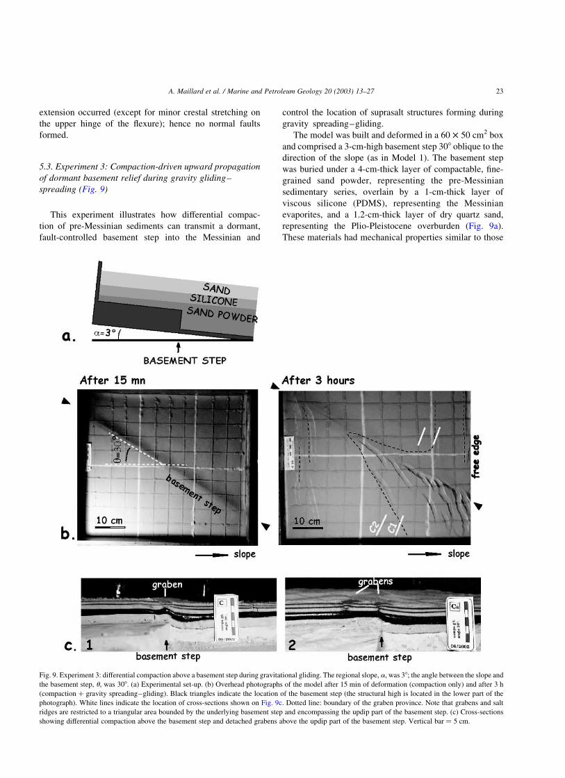
5.3. Experiment 3: Compaction-driven upward propagation
of dormant basement relief during gravity gliding–
spreading (Fig. 9)
This experiment illustrates how differential compac-
tion of pre-Messinian sediments can transmit a dormant,
fault-controlled basement step into the Messinian and
control the location of suprasalt structures forming during
gravity spreading–gliding.
The model was built and deformed in a 60 £ 50 cm2 box
and comprised a 3-cm-high basement step 308 oblique to the
direction of the slope (as in Model 1). The basement step
was buried under a 4-cm-thick layer of compactable, fine-
grained sand powder, representing the pre-Messinian
sedimentary series, overlain by a 1-cm-thick layer of
viscous silicone (PDMS), representing the Messinian
evaporites, and a 1.2-cm-thick layer of dry quartz sand,
representing the Plio-Pleistocene overburden (Fig. 9a).
These materials had mechanical properties similar to those
Fig. 9. Experiment 3: differential compaction above a basement step during gravitational gliding. The regional slope, a, was 38; the angle between the slope and
the basement step, u, was 308. (a) Experimental set-up. (b) Overhead photographs of the model after 15 min of deformation (compaction only) and after 3 h
(compaction þ gravity spreading–gliding). Black triangles indicate the location of the basement step (the structural high is located in the lower part of the
photograph). White lines indicate the location of cross-sections shown on Fig. 9c. Dotted line: boundary of the graben province. Note that grabens and salt
ridges are restricted to a triangular area bounded by the underlying basement step and encompassing the updip part of the basement step. (c) Cross-sections
showing differential compaction above the basement step and detached grabens above the updip part of the basement step. Vertical bar ¼ 5 cm.
A. Maillard et al. / Marine and Petroleum Geology 20 (2003) 13–27 23

used in Experiment 2. The fine-grained sand powder was
compacted by progressively vacuuming the air from the
layer. Model deformation started with a 15-minute-long
episode, during which only compaction occurred without
tilting of the model. No extension took place. After 15 min,
the deformation box was tilted and its down-slope endwall
removed in order to trigger gravity gliding of the over-
burden while depletion and compaction of the fine-grained
powder continued for an hour.
The overhead photograph shot after 15 min of compac-
tion (Fig. 9b) shows a flexure located above the basement
step. This observation indicates that differential compaction
had already partly transmitted the basement offset upward,
into the overlying viscous decollement and brittle over-
burden. Because no lateral movement was allowed during
this episode, only minor extension occurred, being restricted
to the formation of a small crestal graben above the
basement step, near the updip edge of the model.
Tilting and removal of the downdip endwall of the box
triggered downslope gliding of the brittle overburden.
Gliding was mostly accommodated by downslope trans-
lation of the overburden and by formation of normal faults
near the updip edge of the model. The overburden located
on the down side of the basement step was translated
downslope rigidly and was not faulted. As compaction and
gliding progressed (Fig. 9b and c), a new generation of
grabens formed in a triangular region located in the downdip
part of the model, above the higher basement block. These
grabens had arcuate traces. During the early stage of the
experiment (first half-hour), the grabens formed parallel to
and above the basement step. The grabens then propagated
obliquely with a change in trend, their traces becoming
subperpendicular to the regional direction of gliding–
spreading. Overall, the area affected by graben faulting
formed a reentrant whose apex followed the trend of the
basement step.
In Model 1 (Fig. 7; Gaullier et al., 1993), grabens
preferentially formed above the down side of the basement
step. Grabens in Model 3 (Fig. 9), however, formed
preferentially above the up side of the basement step (Fig.
9b and c). These differences can be explained as follows. In
Model 1, which has a preexisting basement step, the viscous
decollement layer had initially a flat top, and its thickness
varied abruptly across the basement step. Consequently,
faults formed above the down side of the basement step
because there the decollement was thicker, gliding was
faster, and the amount of extension greater. By contrast, the
decollement layer in Model 3 was initially evenly thick, and
its top and base were flat. During the first 15 min episode,
when only compaction was applied and the overburden was
not allowed to extend, compaction caused subsidence of the
source layer and overburden above the down side of the
basement step in a fashion similar to movement above a
vertical basement fault. Because movements of the base of
the decollement were only vertical and regional extension
was absent, the overburden deformed mainly by monoclinal
flexure. Analytical models by Couples (1977) have
predicted that such a setting leads to principal stresses
having curve trajectories. The stress field is extensional
above the rising block and compressional above the
subsiding block. During the following stage of deformation,
however, the onset of gravity gliding changed the overall,
regional stress field to extensional. This new, extensional
regional stress field was superimposed onto the local
extensional/compressional stress field associated with
flexure of the base salt. Movement of the overburden
became a combination of differential subsidence and lateral
extension, a setting similar to that above a normal basement
fault. Analytical, numerical, and physical models by
Bobineau (1992), Koyi, Jenyon, and Petersen (1993), Koyi
and Petersen (1993); Vendeville (1987, 1988), and Vende-
ville, Ge, and Jackson (1995) on salt tectonics above active
basement faults have demonstrated that (1) subsidence of
the down block (the basement hanging wall) triggers lateral
salt flow from above the footwall toward the hanging wall
and (2) grabens form preferentially above the footwall
(Fig. 10) because this area is subjected to slightly greater
extensional stresses.
Fig. 10. Numerical model of deformation of viscous silicone (representing salt) and sand (representing a brittle overburden) above a basement normal fault for
1.63 cm of fault throw at 1.3 cm h21 (from Bobineau, 1992). The viscous silicone is gray. Overburden color varies with the amount of plastic deformation:
darker areas are not deformed, lighter areas have deformed more. Fault zones appear white.
Table 1
Summary of experimental conditions and parameters for each experiment
Experiment
No./Fig.
Basement
step:height
(cm)
Initial thickness
of silicone
(cm)
Sand thickness
above silicone/
below silicone
Duration
(h)
1/Fig. 6 0.5 0.45–0.95 1 cm/None 6
2/Fig. 8 6 1.2 2.4 cm/1.4
and 7.4 cm
1
3/Fig. 9 3 1 1 cm/1
and 4 cm
3
A. Maillard et al. / Marine and Petroleum Geology 20 (2003) 13–2724

6. Conclusions
Our experimental results demonstrate that the presence of
dormant steps in the subsalt basement can affect deformation
of the overlying salt and sediment overburden. Where the
base salt is initially offset by the step before deposition of the
sediment overburden (Model 1), faults form above and
downdip from the step, in a triangular area shaped like a
reentrant. Where the base of an initially flat salt layer is
progressively offset by subsalt compaction occurring after
deposition of the salt and its overburden (Model 3), faults
form above and updip of the step, in a triangular area shaped
like a reentrant. These two situations correspond to two end
members of the process by which a basement step can
influence salt tectonics. It is likely that in natural examples,
such as the Gulf of Lion, the influence of basement steps is a
combination of both processes. Deposition of both Messinian
and post-Messinian sediments, and the resulting increase in
lithostatic stress, must have caused a progressive increase in
compaction of the subsalt sediments. The first post-
Messinian sediments, being deposited above a salt layer
having a flat base must have deformed by spreading–gliding
in a way similar to that of Model 3. The younger, post-
Messinian sediments, being deposited when the base salt had
a significant offset must have deformed in a way closer to that
of Model 1. The combination between the two deformation
styles (Models 1 and 3) would lead to the formation of
grabens and associated diapiric ridges located in a reentrant
centered on the basement step and covering both its updip
and downdip regions.
All these models comprised a relatively thick layer of
brittle overburden deposited before deformation began. No
additional layers were added during deformation. The
resulting deformation pattern included sublinear grabens
underlain by rising diapiric ridges. Modeling results by
Vendeville and Jackson (1992) and Guglielmo et al. (1997)
illustrate how this pattern would change if (1) deformation
started when the suprasalt sediments were thin and (2)
continuous sediment aggradation progressively thickened
the overburden. Their models show that through time, salt
flow tends to be concentrated along shorter segments of the
salt ridges. The final geometry consists of isolated circular
diapirs (salt stocks). The diapirs, rooted at depth into the
older salt ridges, grew by maintaining their crests at or near
the seafloor while new sediments accumulated around them
(passive diapir growth). Applying these observations to our
modeling results suggests that the combination of the
influence of subsalt basement steps and passive diapir
growth would lead to formation of circular salt stocks
restricted to a reentrant centered on the basement step, a
geometry similar to that observed in the Gulf of Lion.
This study provides a genetic explanation for the
geographic correlation between suprasalt and subsalt
structures in the Gulf of Lion. The genetic link between
the two is the influence of differential compaction of subsalt
sediments that transmit upward the basement topography
and thereby influence the development of salt structures and
overburden faults. There are, however, other mechanisms
that may also have contributed to this correlation. Thermal
anomalies associated with basement transfer zones may
have influenced the development of salt structures. Such
anomalies and high heat flows could be linked to recent
magmatic events, such as those observed along the transfer
zones (Fig. 4a; Foucher et al., 1992; Maillard & Mauffret,
1993). Reactivation of volcanoes is probable, as indicated
by recent alkaline intrusions sampled in the Valencia
trough, and suggests that the history of magmatic events
stretches from early Miocene to Plio-quaternary times
(Marti et al., 1992). Recent magmatic activity above
fracture zones could thus be linked to reactivation of the
deep faults. Jackson and Talbot (1986) suggested that
temperature gradients may influence halokinesis because
salt viscosity varies with varying temperature. The influence
of such temperature changes is, however, no longer thought
to be significant when compared with the control exerted by
the much stronger sediment overburden (Weijermars,
Jackson, & Vendeville, 1993).
Another geological parameter that could interfere with
the formation of salt structure is the pattern of loading by
deposition of the Plio-Pleistocene overburden sediments.
The continental slope and rise of the northwest Mediterra-
nean are shaped by numerous channel-levee complexes
having various planform shapes and sizes, from the large
Rhone or Valence deep-sea fans to the smaller sedimentary
bodies, such as the Fonera, Pyreneo-Languedocian (Berne,
Loubrieu, & the Calmar team, 1999), Marseille, Grand-
Rhone, and Cassidagne Ridges (Dos Reis, 2001). Recent
experimental modeling (Gaullier & Vendeville, in review;
Vendeville, in review) shows that initial planform
geometry of the sediment load directly influences the
pattern of salt deformation and the location and distribution
of associated salt diapirs. The pattern of sediment loading
in the northwestern Mediterranean may be regarded as a
potential ‘external’ process that may have also contributed
to the shape of the diapir regions in the area.
Acknowledgements
We thank Lana Dieterich for editing this manuscript, and
H. Koyi and A. Mauffret for helpful comments in their
reviews.
References
Alinat, J., & Cousteau, J. Y. (1962). Accidents de terrain en Mer de
Ligurie. Oceanographie geologique et geophysique de la medi-
terranee occidentale, Villefranche-Sur-Mer: Colloque CNRS, pp.
121–123.
Auzende, J. M., Bonnin, J., & Olivet, J. (1973). The origin of the western
Mediterranean basin. Journal of the Geological Society of London, 129,
607–620.
A. Maillard et al. / Marine and Petroleum Geology 20 (2003) 13–27 25

Bartrina, M. T., Cabrera, L. L., Jurado, M. J., Guimera, J., & Roca, E.
(1992). Cenozoic evolution of the central Catalan margin (Valencia
Trough, western Mediterranean). In E. Banda, & P. Santanach (Eds.),
Geology and geophysics of the Valencia Through, western Mediterra-
nean (Vol. 203) (pp. 219–248). Tectonophysics.
Bayer, R., Le Mouel, J. L., & Le Pichon, X. (1973). Magnetic anomaly
pattern in the Western Mediterranean. Earth and Planetary Sciences
Letters, 12, 168–176.
Bellaiche, G. (1993). Sedimentary mechanisms and underlying tectonics
structures on the northwestern Mediterranean margin, as revealed by
comprehensive bathymetric and seismic surveys. Marine Geology, 112,
89–108.
Berne, S., Loubrieu, B., & the Calmar team, (1999). Canyons et processus
sedimentaires recents sur la marge occidentale du golfe du Lion.
Premiers resultats de la campagne Calmar. Comptes Rendus de
l’Academie des Sciences de Paris, serie IIa, 328, 471–477.
Biju-Duval, B. (1984). Les marges continentales francaises autour de la
Mediterranee. In G. Boillot, M. Montadert, L. Lemoine, & B. Biju-
Duval (Eds.), Les marges continentales actuelles et fossiles autour de la
France (pp. 249–333). Paris: Editions Masson.
Bobineau, J. P (1992). Simulations numeriques de phenomenes tectoniques.
PhD Thesis. Ecole Centrale de Paris, 423 p
Burrus, J. (1984). Contribution to a geodynamic synthesis of the Provencal
Basin (North-Western Mediterranean). Marine Geology, 55, 247–270.
Chamot-Rooke, N., Gaulier, J. M., & Jestin, F. (1997). Constraints on Moho
depth and crustal thickness in the Liguro-Provencal basin from a 3D
gravity inversion: geodynamic implications. Revue de l’Institut
Francais du Petrole, 52, 557–583.
Couples, G. (1977). Stress and shear fracture (fault) patterns resulting from
a suite of complicated boundary conditions with applications to the
Wind River Mountains. Pure and Applied Geophysics, 115(1/2),
113–133.
Cravatte, J., Dufaure, P., Prim, M., & Rouaix, S. (1974). Les sondages du
Golfe du Lion: stratigraphie et sedimentologie. Notes et Memoires de la
Compagnie Francaise des Petroles, 2, 209–274.
Dewey, J. F., Helman, M. L., Turco, E., Hutton, D. W. H., & Knott, S. D.
(1989). Kinematics of the western Mediterranean. In M. P. Coward, &
D. Dietrich (Eds.), Alpine tectonics (Vol. 45) (pp. 265–283). Geological
Society of London Special Publication.
Doglioni, C., Gueguen, E., Harabaglia, P., & Mongelli, F. (1999). On the
origin of west-directed subduction zones and applications to the western
Mediterranean. In B. Durand, L. Jolivet, F. Horvarth, & M. Seranne
(Eds.), The Mediterranean basins: Tertiary extension within the Alpine
oragen (Vol. 156) (pp. 541–561). Geological Society of London Special
Publication.
Dos Reis, A. T (2001). La tectonique salifere et son influence sur
l’architecture sedimentaire quaternaire de la marge du Golfe du Lion
en Mediterranee Occidentale. These de l’Universite Paris VI, 373 p
Droz, L., & Bellaiche, G. (1996). Rhone deep sea fan: morphostructure and
growth pattern. American Association Petroleum Geologists Bulletin,
69, 460–479.
Foucher, J. P., Mauffret, A., Steckler, M., Brunet, M. F., Maillard, A.,
Rehault, J. P., Alonso, B., Desegaulx, P., Murillas, J., & Ouillon, G.
(1992). Heat flow in the Valencia Trough: geodynamic implications. In
E. Banda, & P. Santanach (Eds.), Geology and geophysics of the
Valencia through, western Mediterranean (Vol. 203) (pp. 77–98).
Tectonophysics.
Galdeano, A., & Rossignol, J. C. (1977). Assemblage a altitude constante
de cartes d’anomalie magnetiques couvrant l’ensemble du bassin
occidental de la Mediterranee. Bulletin de la Societe Geologique de
France, 7(19), 461–468.
Gaullier, V (1993). Diapirisme salifere et dynamique sedimentaire dans le
bassin Liguro-Provencal: donnees sismiques et modeles analogiques.
These de l’Universite Paris VI, 327 p
Gaullier, V., & Bellaiche, G. (1996). Diapirisme liguro-provencal: les effets
d’une topographie residuelle sous le sel messinien. Apports de la
modelisation analogique. Comptes Rendus de l’Academie des Sciences
de Paris, serie IIa, 322, 213–220.
Gaullier, V., Brun, J. P., Guerin, G., & Lecanu, H. (1993). The effect of
residual topography below a salt decollement. Tectonophysics, 228(3/
4), 363–381.
Gaullier, V., Vendeville, B. C (in review). Salt tectonics driven by sediment
progradation. Part 2: radial spreading of circular lobes. American
Association Petroleum Geologists Bulletin
Gennesseaux, M., Rehault, J. P., & Thomas, B. (1989). La marge
continentale de la Corse. Bulletin de la Societe Geologique de France,
5, 339–351.
Gorini, C., Mauffret, A., & Le Marrec, A. (1993). Structural and
sedimentary history of the Gulf of Lion (Western Mediterranean),
finding of the ECORS profiles and well log data. Bulletin de la Societe
Geologique de France, 164, 353–363.
Gueguen, E (1996). La Mediterranee occidentale, un veritable ocean.
These de doctorat de l’Universite de Bretagne occidentale, 311 pp
Gueguen, E., Doglioni, C., & Fernandez, M. (1997). Lithospheric
boudinage in the western backarc Mediterranean basins. Terra Nova,
9, 184–187.
Guennoc, P., Rehault, J. P., Gilg-Capar, L., Deverchere, J., Rollet, N., Le
Suave, R (1998). Les marges ouest et nord de la Corse: nouvelle
cartographie au 1/250000. 17eme Reunion des Sciences de la Terre,
Brest (France), 31 mars–3 avril, Resumes, 124
Guglielmo, Giovanni, Jr., Jackson, M. P. A., & Vendeville, B. C. (1997).
Three-dimensional visualization of salt walls and associated fault
systems. American Association of Petroleum Geologists Bulletin, 81,
46–61.
Jackson, M. P. A., & Talbot, C. J. (1986). External shapes, strain rates, and
dynamics of salt structures. Geological Society of American Bulletin,
97(3), 305–323.
Koyi, H., Jenyon, M. K., & Petersen, K. (1993). The effect of basement
faulting on diapirism. Journal of Petroleum Geology, 16(3), 285–311.
Koyi, H., & Petersen, K. (1993). Influence of basement faults on the
development of salt structures in the Danish Basin. Marine and
Petroleum Geology, 10(2), 82–94.
Le Cann, C (1987). Le diapirisme dans le bassin liguro-provencal, These
Universite de Bretagne occidentale, 296 pp
Le Douaran, S., Burrus, J., & Avedik, F. (1984). Deep structure of the
north-western Mediterranean basin: results of a two-ship seismic
survey. Marine Geology, 55, 325–334.
Lefebvre, D (1981). Evolution morphologique et structurale du Golfe du
Lion. Essai de traitement statistique des donnees. These de troisieme
cycle l’Universite Paris 6, 163 p
Maillard, A (1993). Structure et riftogenese du golfe de Valence
(Mediterranee Nord-Occidentale). These de doctorat de l’Universite
Paris 6, 288 p
Maillard, A., & Mauffret, A. (1993). Structure et volcanisme dans la fosse
de Valence (Mediterranee Nord-occidentale). Bulletin de la Societe
Geologique de France, 164, 338–365.
Maillard, A., & Mauffret, A. (1999). Crustal structure and riftogenesis of
the Valencia Trough (north-western Mediterranean Sea). Basin
Research, 11(4), 357–379.
Maillard, A., Mauffret, A., Watts, A. B., Torne, M., Pascal, G., Buhl, P., &
Pinet, B. (1992). Tertiary sedimentary history and structure of the
Valencia Trough (Western Mediterranean). In E. Banda, & P.
Santanach (Eds.), Geology and geophysics of the Valencia through,
western Mediterranean (203) (pp. 57–76). Tectonophysics.
Malinverno, A., & Ryan, W. B. F. (1986). Extension in the Tyrrhenian sea
and shortening in the Apennines as a result of migration driven by
sinking of the lithosphere. Tectonics, 5, 225–245.
Marti, J., Mitjavila, J., Roca, E., & Aparicio, A. (1992). Cenozoic
magmatism of the Valencia Trough (western Mediterranean): relation
between structural evolution and petrogenesis. In E. Banda, & P.
Santanach (Eds.), Geology and geophysics of the Valencia through,
western Mediterranean (203) (pp. 145–166). Tectonophysics.
A. Maillard et al. / Marine and Petroleum Geology 20 (2003) 13–2726

Mauffret, A (1976). Etude geodynamique de la marge des Iles Baleares.
These de troisieme cycle de l’Universite Paris 6, 137 p
Mauffret, A., Durand de Grossouvre, B., Gorini, C., & Nercessian, A.
(2001). Structural geometry in the eastern Pyrenees ans western Gulf of
Lion (Western Mediterranean). Journal of Structural Geology, 23(11),
1701–1726.
Mauffret, A., Fail, J. P., Montadert, L., Sancho, J., & Winnock, E. (1973).
Northwestern Mediterranean sedimentary basin from seismic reflection
profile. American Association Petroleum Geologists Bulletin, 57(11),
2245–2262.
Mauffret, A., & Gorini, C. (1996). Structural style of the Camargue area and
western Provencal basin (southeastern France): geodynamic conse-
quences. Tectonics, 15, 356–375.
Mauffret, A., Pascal, G., Maillard, A., & Gorini, C. (1995). Tectonics and
deep structure of the north-western Mediterranean Basin. Marine and
Petroleum Geology, 12(6), 645–646.
Montigny, R., Edel, J. M., & Thuizat, R. (1981). Oligo–Miocene rotation of
Sardinia: K–Ar ages and paleomagnetism data of tertiary volcanics.
Earth and Planetary Sciences Letters, 54, 261–271.
Nercessian, A., Mauffret, A., Dos Reis, A. T., Vidal, R., Gallart, J., & Diaz,
J. (2001). Deep reflection seismic images of the crustal thinning in the
eastern Pyrenees and western Gulf of Lion. Journal of Geodynamics,
31, 211–225.
Odonne, F., Menard, I., Massonnat, G. J., & Rolando, J. P. (1999). Abnormal
reverse faulting above a depleting reservoir. Geology, 27(2), 111–114.
Olivet, J. L. (1987). L’origine du bassin nord-occidental de la Mediterranee
du point de vue de la cinematique des plaques. In J. Burrus, & J. L.
Olivet (Eds.), (Vol. 35941-1) (pp. 10–49). Profils ECORS golfe du
Lion: rapport d’implantation, Paris: Institut Francais du Petrole.
Olivet, J. L. (1996). La cinematique de la plaque iberique. Bulletin du
Centre de Recherche et d’Exploration Production Elf Aquitaine, 20,
131–195.
Pascal, G., Mauffret, A., & Patriat, P. (1993). The ocean–continent
boundary in the Gulf of Lion from analysis of expanding spread profiles
and gravity modelling. Geophysical Journal, 113, 701–726.
Pautot, G., Bellaiche, G., Vanney, J. R., Rehault, J. P., & Coutelle, A.
(1992). Morphobathymetrie des marges de la Corse etablie a l’aide d’un
nouveau sondeur multifaisceaux. C.R. Acad. Sci. Paris, 314(Serie II),
603–610.
Pautot, G., Le Cann, C., Coutelle, A., & Mart, Y. (1984). Morphology and
extension of the evaporitic structures of the liguro-provencal basin: new
Seabeam data. Marine Geology, 55, 387–409.
Rehault, J. P., Boillot, G., & Mauffret, A. (1984). The western
Mediterranean Basin, geological evolution. Marine Geology, 55,
447–477.
Rollet, N (1999). Structures profondes et dynamique du Bassin Ligure et de
ses marges. These de l’Universite Pierre et Marie Curie, 292 p
Ryan, W. B. F., & Hsu, K. I. (1973) (Vol. 13). Inital Report of the Deep Sea
Drilling Project, Washington DC: US Government Printing Office,
1447 p.
Sans, M., & Sabat, F. (1993). Pliocene salt rollers and synkinematic
sediments in the northeast sector of the Valencia trough (western
Mediterranean). Bulletin de la Societe Geologique de France, 164(2),
189–198.
Seranne, M., Benedicto, A., Labaume, P., Truffert, K., & Pascal, G. (1995).
Structural style and evolution of the Gulf of Lion Oligo–Miocene
rifting: role of the Pyrenean orogeny. Marine and Petroleum Geology,
12, 809–820.
Speranza, F., Villa, I. M., Sagnotti, L., Florindo, F., Cosentino, D.,
Cipollari, P., & Mattei, M. (2002). Age of the Corsica-Sardinia rotation
and Liguro-Provencal Basin spreading: new paleomagnetic and Ar/Ar
evidence. Tectonophysics, 347, 231–251.
Vendeville, B. C. (1987). Champs de failles et tectonique en extension:
modelisation experimentale. Rennes, France, Memoires du Centre
Armoricain d’Etudes Structurales des Socles, 15, 392.
Vendeville, B. C. (1988). Modeles experimentaux de fracturation de la
couverture controlee par des failles normales dans le socle (Scale-
models of basement-induced extension). Comptes Rendus de l’Acade-
mie des Sciences de Paris, 307(Serie II), 1013–1019.
Vendeville, B.C (in review) Salt tectonics driven by sediment progradation,
part 1: mechanics and kinematics. American Association Petroleum
Geologists Bulletin
Vendeville, B. C., Ge, H., & Jackson, M. P. A. (1995). Models of salt
tectonics during basement extension. Petroleum Geoscience, 1,
179–183.
Vendeville, B. C., & Jackson, M. P. A. (1992). The rise of diapirs during
thin-skinned extension. Marine and Petroleum Geology, 9(4),
331–353.
Vigliotti, L., & Langenheim, V. E. (1995). When did Sardinia stop rotating?
New paleomagnetic results. Terra Nova, 7, 424–435.
Weijermars, R., Jackson, M. P. A., & Vendeville, B. C. (1993). Rheological
and tectonic modelling of salt provinces. Tectonophysics, 217,
143–174.
A. Maillard et al. / Marine and Petroleum Geology 20 (2003) 13–27 27