Embed Size (px)
Citation preview
INTRODUCTION TO ARC HYDRO GROUNDWATER
USGS Community for Data IntegrationDecember 2010
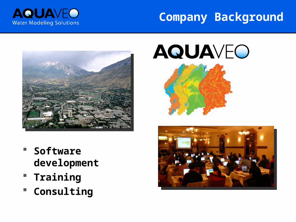
Software development
Training Consulting
Company Background
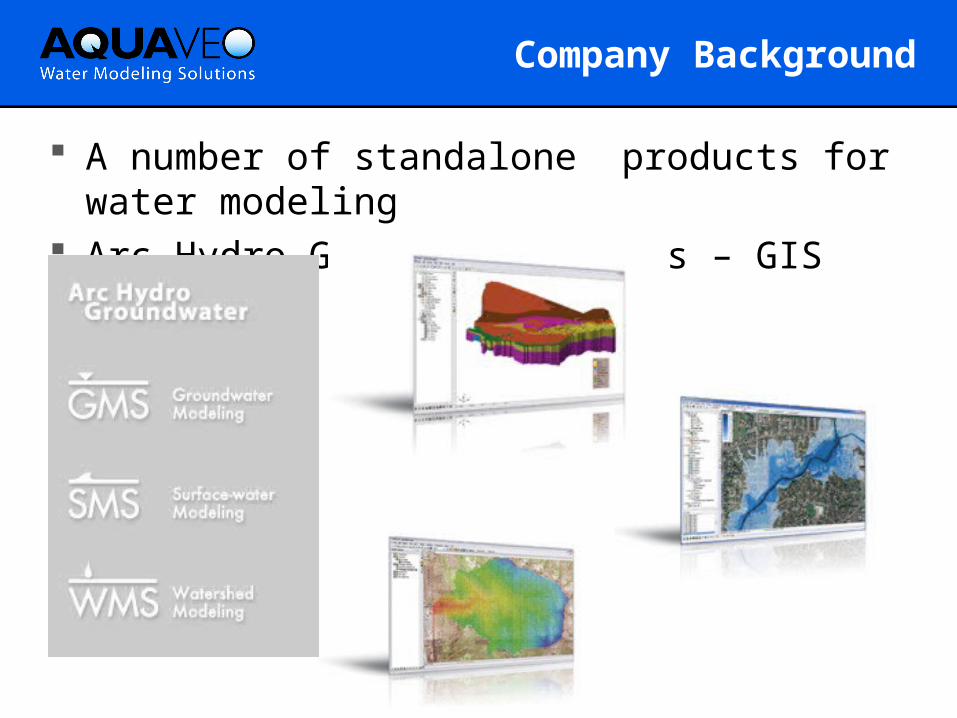
A number of standalone products for water modeling
Arc Hydro Groundwater tools – GIS based
Company Background
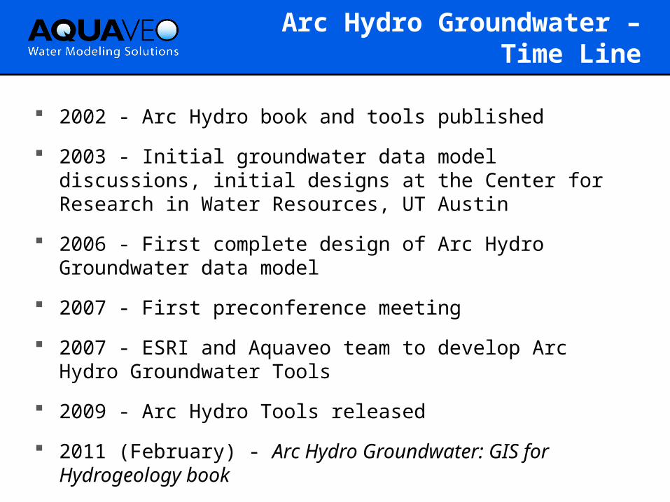
Arc Hydro Groundwater – Time Line
2002 - Arc Hydro book and tools published
2003 - Initial groundwater data model discussions, initial designs at the Center for Research in Water Resources, UT Austin
2006 - First complete design of Arc Hydro Groundwater data model
2007 - First preconference meeting
2007 - ESRI and Aquaveo team to develop Arc Hydro Groundwater Tools
2009 - Arc Hydro Tools released
2011 (February) - Arc Hydro Groundwater: GIS for Hydrogeology book
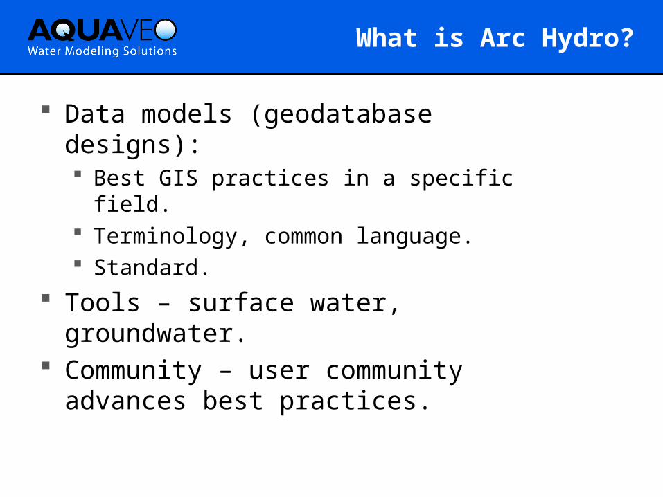
What is Arc Hydro?
Data models (geodatabase designs): Best GIS practices in a specific field. Terminology, common language. Standard.
Tools – surface water, groundwater. Community – user community
advances best practices.
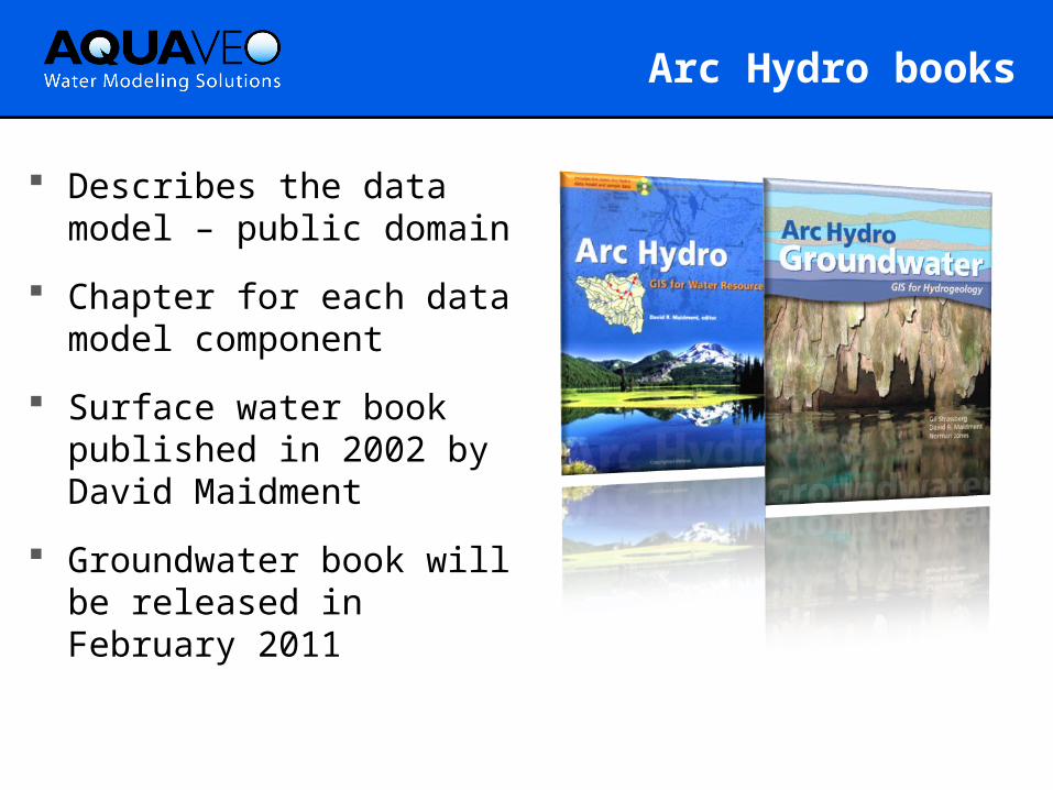
Arc Hydro books
Describes the data model – public domain
Chapter for each data model component
Surface water book published in 2002 by David Maidment
Groundwater book will be released in February 2011
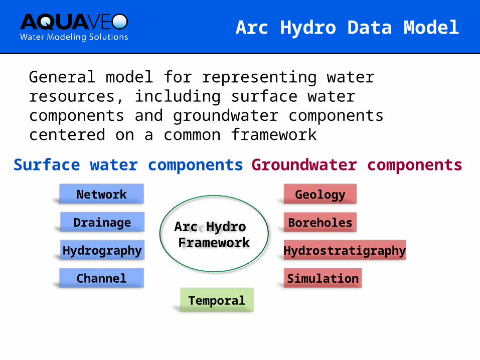
Arc Hydro Data Model
Arc Hydro Framework
Surface water components
Network
Groundwater components
BoreholesDrainage
Hydrography
Channel
Hydrostratigraphy
Geology
Simulation
Temporal
General model for representing water resources, including surface water components and groundwater components centered on a common framework
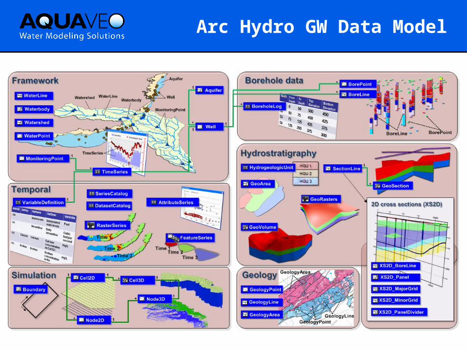
Arc Hydro GW Data Model
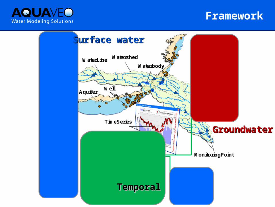
Framework
1
**
1
*
1
Well1
Aquifer
MonitoringPoint
WaterLine Watershed
TimeSeries
Waterbody
Aquifer
HydroID HydroCode Name HGUID FType
Well
HydroID HydroCode LandElev WellDepth AquiferID AqCode HGUID FType
HydroID HydroCode Name JunctionID FType
MonitoringPoint
TimeSeries
FeatureID VarID TsTime UTCOffset TsValue
VariableDefinition
VarID VarName VarDesc VarUnits
SeriesCatalog
FeatureID FeatClass VarID TsTable StartTime EndTime ValueCount
Watershed
HydroID HydroCode Name DrainID JunctionID NextDownID AreaSqKm FType
WaterBody
HydroID HydroCode Name JunctionID NextDownID AreaSqKm FType
WaterLine
HydroID HydroCode Name FlowDir NextDownID LengthKm FType
WaterPoint
HydroID HydroCode Name JunctionID FType
Surface waterSurface water
TemporalTemporal
GroundwaterGroundwater
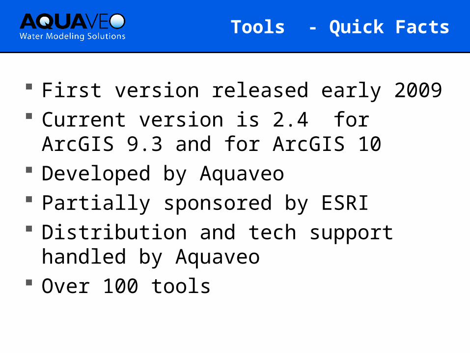
Tools - Quick Facts
First version released early 2009 Current version is 2.4 for ArcGIS 9.3
and for ArcGIS 10 Developed by Aquaveo Partially sponsored by ESRI Distribution and tech support handled
by Aquaveo Over 100 tools
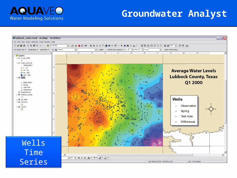
Groundwater Analyst
WellsTime SeriesImport Data
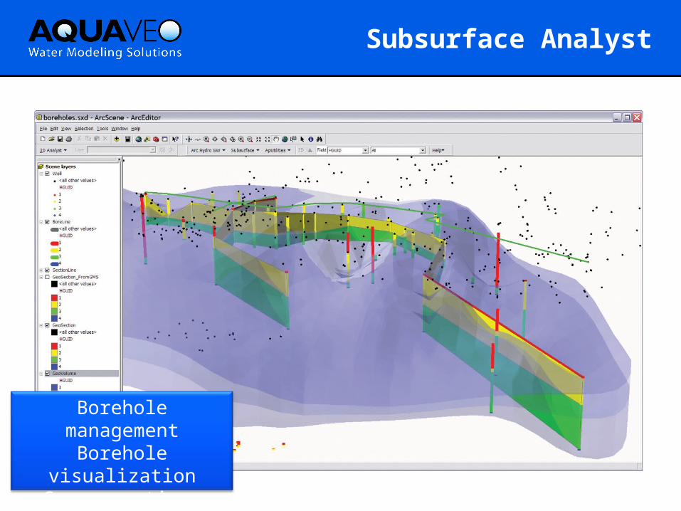
Subsurface Analyst
Borehole managementBorehole visualization
Cross-sectionsGeoVolumes
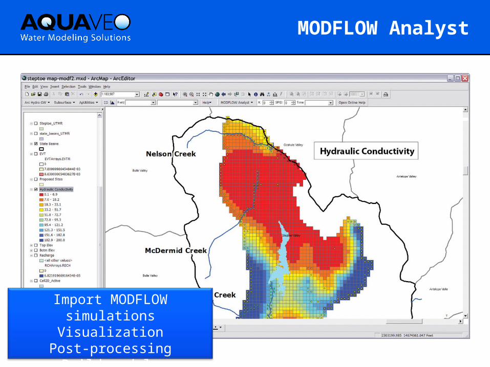
MODFLOW Analyst
Import MODFLOW simulationsVisualization
Post-processingBuild models
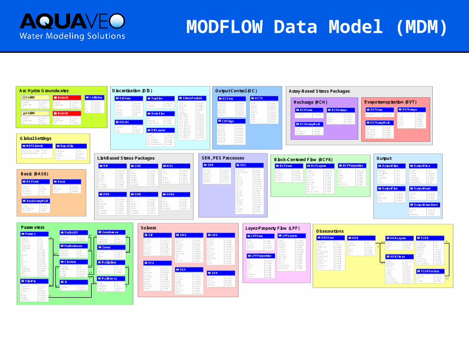
MODFLOW Data Model (MDM)
Observations
OUTNAMISCALSTOMULTHEVHTOMULTGBEVFGBTOMULTDREVFDRTOMULTRVEVFRVTOMULTCHEVFCH
OBSVars
TextLong Int.DoubleDoubleDoubleDoubleDoubleDoubleDoubleDoubleDoubleDouble
HOBIDOBSNAMIJROFFCOFFITT
HOB
OIDTextLong Int.DoubleDoubleShort Int.
HOBIDLayerPR
HOBLayers
Long Int.Long Int.Double
HOBIDOBSNAMIREFSPTOFFSETHOBSHSIMSTAThSTATddSTATFLAGPLOTSYMBOL
HOBTimes
Long Int.TextLong Int.DoubleDoubleDoubleDoubleDoubleShort Int.Long Int.
1
1..*
1..*
FLOBIDFLOBTypeOBSNAMIREFSPTOFFSETHOBSHSIMSTATISTICSTATFLAGPLOTSYMBOL
FLOB
OIDTextTextLong Int.DoubleDoubleDoubleDoubleShort Int.Long Int.
FLOBIDIJKFactor
FLOBFactors
Long Int.Long Int.Double
1
1..*
Solvers
MXITERNPARMACCLHCLOSEIPCALCWSEEDIPRSIP
SIP
Long Int.Long Int.DoubleDoubleShort Int.DoubleLong Int.
MXITERACCLHCLOSEIPRSOR
SOR
Long Int.DoubleDoubleLong Int.
MXITERITER1NPCONDHCLOSERCLOSERELAXNBPOLIPRPCGMUTPCGDAMP
PCG
Long Int.Long Int.Short Int.DoubleDoubleDoubleShort Int.Long Int.Short Int.Double
ITMXMXUPMXLOWMXBWIFREQMUTD4ACCLHCLOSEIPRD4
DE4
Long Int.Long Int.Long Int.Long Int.Short Int.Short Int.DoubleDoubleLong Int.
RCLOSEIITERHCLOSEMXITERDAMPIADAMPIOUTGMGISMISCRELAX
GMG
DoubleLong Int.DoubleLong Int.DoubleShort Int.Short Int.Short Int.Short Int.Double
STOR1STOR2STOR3ICGMXITERMXCYCBCLOSEDAMPIOUTAMGDUPDLOW
LMG
DoubleDoubleDoubleShort Int.Long Int.Long Int.DoubleDoubleShort Int.DoubleDouble
Output
TimeIDSPNumTSNumTotalTimePeriodTimeAbsoluteTime
OutputTime
OIDLong Int.Long Int.DoubleDoubleDate
TimeIDIJKFlowTypeFlow
OutputFlow
Long Int.Long Int.Short Int.Double
FileTypeDescriptionFormatCompressFilePath
OutputFiles
TextTextTextTextBlobText
TimeIDIJKHead
OutputHead
Long Int.Long Int.Double
TimeIDIJKDrawdown
OutputDrawdown
Long Int.Long Int.Double
Parameters
ZoneIDIJIZON
Zones
Long Int.Long Int.Long Int.
ParamIDPARNAMPARTYPETableCodeFieldCodeParvalBKeyvalBLBUBSCALLNISENSLogInterpLogMinValTiedSource
Params
OIDTextTextTextTextDoubleDoubleDoubleDoubleDoubleDoubleShort Int.Short Int.Short Int.DoubleTextShort Int.
ClusterIDParInstIDLayerZoneIDMultID
Clusters
OIDLong Int.Long Int.Long Int.Long Int.
MultIDIJRMLT
Multipliers
OIDLong Int.Double
ParamIDPointNameParvalBISENSMultIDSourceID
PilotPts
Long int.TextDoubleDoubleShort Int.Long Int.Long Int.
ParInstIDInstNameParamID
ParInstances
OIDTextLong Int.
1
0..*
MultIDMultNameArrayMultFunction
MultNames
OIDTextLong Int.Text
ZoneIDZoneNameArrayMult
ZoneNames
OIDTextLong Int.
1
1..*
1
1..*
1..*
1
1..*
1
1
1..*
0..*ClusterIDIZ
IZ
Long Int.Long Int.
1..*
1
ParInstIDSPID
ParInstSP
Long Int.Long Int.
0..*
1
Block-Centered Flow (BCF6)
HDRYIWDFLGWETFCTIWETITIHDWET
BCFVars
DoubleShort Int.DoubleLong Int.Short Int.
LayerLAYAVGLAYCONTRPYAM_Sf1AM_TranAM_HYAM_VcontAM_Sf2AM_WETDRY
BCFLayers
Long Int.Short Int.Short Int.DoubleDoubleDoubleDoubleDoubleDoubleDouble
IJKHYTranVcontSf1Sf2WETDRY
BCFProperties
Long Int.DoubleDoubleDoubleDoubleDoubleDouble
List-Based Stress Packages
IJKSPIDStageCondRbotIFACECondfactSourceID
RIV
Long Int.Long Int.DoubleDoubleDoubleLong Int.DoubleLong Int.
IJKSPIDQQfactIFACESourceID
WEL
Long Int.Long Int.DoubleDoubleLong Int.Long Int.
IJKSPIDElevationCondIFACECondfactSourceID
DRN
Long Int.Long Int.DoubleDoubleLong Int.DoubleLong Int.
IJKSPIDSheadEheadShdfactEhdfactSourceID
CHD
Long Int.Long Int.DoubleDoubleDoubleDoubleLong Int.
IJKSPIDBheadCondIFACECondfactSourceID
GHB
Long Int.Long Int.DoubleDoubleLong Int.DoubleLong Int.
IJK1IJK2HydchrFactorSourceID
HFB6
Long Int.Long Int.DoubleDoubleLong Int.
Array-Based Stress Packages
Recharge (RCH)
NRCHOP
RCHVars
Short Int. IJSPIDRECHIRCH
RCHArrays
Long Int.Long Int.DoubleLong Int.
Evapotranspiration (EVT)
NEVTOP
EVTVars
Short Int. IJSPIDSURFEVTREXPDIEVT
EVTArrays
Long Int.Long Int.DoubleDoubleDoubleLong Int.
SPIDAM_RECHAM_IRCH
RCHArrayMult
Long Int.DoubleLong Int.
SPIDAM_SURFAM_EVTRAM_EXPDAM_IEVT
EVTArrayMult
Long Int.DoubleDoubleDoubleLong Int.
Basic (BAS6)
IJKIBOUNDSTRT
Basic
Long Int.Long Int.Double
OptionsHNOFLOHEADNG1HEADNG2
BASVars
TextDoubleTextText
LayerAM_IBOUNDAM_STRT
BasicArrayMult
Long Int.Long Int.Double
MODFLOW_VersionDataModelVersion
MDFGlobals
TextText
Global Settings
FileTypeNunitFnameUse
NameFile
TextLong Int.TextShort Int.
Arc Hydro Groundwater
HydroIDHydroCodeIJ
Cell2D
Long Int.TextLong Int.
HydroIDHydroCodeIJ
Node2D
Long Int.TextLong Int.
HydroIDHydroCodeIJK
Cell3D
Long Int.TextLong Int.
HydroIDHydroCodeIJK
Long Int.TextLong Int.
Node3D
IJKIJIJK
CellIndex
Long Int.Long Int.Long Int.Long Int.Long Int.
Discretization (DIS)
DirectionNumWidth
DELRC
TextLong Int.Double
IJKTopElev
TopElev
Long Int.Double
IJKBotmElevBotmElevCBD
BotmElev
Long Int.DoubleDouble
SPIDPERLENNSTPTSMULTSSorTrRIV_ITMPWEL_ITMPDRN_ITMPGHB_ITMPCHD_ITMPRCH_INRECHRCH_INIRCHEVT_INSURFEVT_INEVTREVT_INEXDPEVT_INIEVT
StressPeriods
Long Int.DoubleLong Int.DoubleTextShort Int.Short Int.Short Int.Short Int.Short Int.Short Int.Short Int.Short Int.Short Int.Short Int.Short Int.
LayerLAYCBDAM_TopElevAM_BotmElevAM_BotmElevCBD
DISLayers
Long Int.Short Int.DoubleDoubleDouble
NLAYNROWNCOLITMUNILENUNIRefTime
DISVars
Long Int.Long Int.Long Int.Short Int.Short Int.Date
Output Control (OC)
IBCFCBILPFCBIRIVCBIWELCBIDRNCBIGHBCBIRCHCBIEVTCB
CBFlags
Short Int.Short Int.Short Int.Short Int.Short Int.Short Int.Short Int.Short Int.
IHEDFMIDDNFMIHEDUNIDDNUNIBDOPTIAUXSV
OCVars
Short Int.Short Int.Long Int.Long Int.Long Int.Short Int.
SPIDTSNumIHDDFLIBUDFLICBCFLHdprDdprHdsvDdsv
OCTS
Long Int.Long Int.Short Int.Short Int.Short Int.Short Int.Short Int.Short Int.Short Int.
SEN, PES Processes
ISENALLIUHEADIPRINTSISENSUISENPUISENFM
SEN
Short Int.Short Int.Short Int.Short Int.Short Int.Short Int.
MAXITERMAXCHANGETOLSOSCIBEFLGIYCFLGIOSTARNOPTNFITSOSRRMARRMARMIAPIPRCOVIPRINTLPRINTCSAFCONVLASTX
PES
DoubleDoubleDoubleDoubleShort Int.Short Int.Short Int.Short Int.Long Int.DoubleDoubleDoubleShort Int.Short Int.Short Int.Short Int.DoubleDoubleDouble
Layer-Property Flow (LPF)
HDRYWETFCTIWETITIHDWET
LPFVars
DoubleDoubleLong Int.Short Int.
LayerLAYTYPLAYAVGCHANILAYVKALAYWETAM_HKAM_HANIAM_VKAAM_SsAM_SyAM_WETDRYAM_VKCB
LPFLayers
Long Int.Short Int.Short Int.DoubleShort Int.Short Int.DoubleDoubleDoubleDoubleDoubleDoubleDouble
IJKHKHANIVKASsSyWETDRYVKCB
LPFProperties
Long Int.DoubleDoubleDoubleDoubleDoubleDoubleDouble
Arc Hydro – general data model that includes a framework, temporal, surface water, and groundwater components.
Arc Hydro (surface water) – surface water components + tools developed by ESRI.
Arc Hydro Groundwater – groundwater components + tools developed by Aquaveo (Groundwater Analyst, Subsurface Analyst, and MODFLOW Analyst).
MODFLOW Data Model – geodatabase design for storing MODFLOW simulations. Developed by Aquaveo, and works tightly with MODFLOW Analyst tools.
Data Model and Tools Summary
Additional information
Arc Hydro Groundwater Web sites
For tools - www.aquaveo.com/archydro
For data models - www.archydrogw.com
ESRI Data Model Web site
http://resources.esri.com/ArcHydro/