Embed Size (px)
Citation preview

Broad Street Cemetery Preservation Plan Salem, Massachusetts
1
INTRODUCTION The Broad Street Cemetery, established in 1655, is Salem’s second oldest burial place and a contributing resource to both the Chestnut Street National Register Historic District and McIntire Local Historic District. The property holds several hundred gravestones, monuments and tombs dating from the late 17th century into the 20th, marking the burials of many prominent Salem families including Pickering, Lambert, Dodge and Goodhue. The property also serves as a passive recreation space to the dense surrounding neighborhood, providing a grassy, shady spot for strolling, resting and picnicking. During its first 300 years, the cemetery appears to have been well-maintained, first as a Colonial era burial ground, and beginning in 1800 as a modern Victorian cemetery. The mid-20th century brought a period of decline, when trees aged and historic features eroded. By the early 2000s, much of the landscape, including fences, pathways, tombs, walls and gravestones had deteriorated leaving the cemetery in a state of neglect. In response to mounting concern over the cemetery’s poor condition, the Salem Cemetery and Historical Commissions, together with a newly formed Friends of Broad Street Cemetery, stepped forward. Working with the city’s Office of Planning and Community Development, they applied for and were awarded Community Preservation Act funds to develop a long-term preservation plan. The foregoing document is the result of this collaborative effort.
PROJECT GOAL AND OBJECTIVES
Through this project, the City of Salem aimed to devise a plan for preserving and enhancing the Broad Street Cemetery landscape. This goal included improving appearance, restoring access, and expanding its role in interpreting Salem’s history to residents and visitors. Objectives for meeting this goal included: Documenting and assessing existing conditions with a focus on grave markers and tombs,
retaining walls and fencing, circulation and access, and landscape features including trees and vegetation;
Making specific recommendations for conservation, restoration and site improvements; Establishing priorities and phases for implementing the recommendations; Providing cost estimates for recommendations; Developing a plan for maintaining the cemetery on an annual cyclical basis.
The Broad Street Cemetery lies on 2.2 acres between Summer, Broad, Winthrop and Mount Vernon Street and holds the remains of many prominent 17th, 18th and 19th century Salem families.
11-24-2020

Broad Street Cemetery Preservation Plan Salem, Massachusetts
2
PRESERVATION PLAN PROGRAM
At the commencement of the project, the city identified the following be addressed in the plan: Enclosure and Access. The
conditions of fences and walls surrounding the cemetery, including iron picket fencing/cast iron posts, cut stone walls, and concrete retaining walls/wood picket fencing varies and only one formal entrance functions. Several makeshift entrances have been established, contributing to the cemetery’s unkempt appearance.
Circulation. The cemetery
contains no established pathways, further compromising easy access.
Vegetation. The cemetery contains several varieties of trees and shrubs, both planted and
volunteer, in various states of health. Gravestones, Monuments and Tombs. Many of these features have deteriorated, and others,
such as several tomb markers, are altogether missing. Signage. Currently, the cemetery is marked with one prominent sign, located near the
Winthrop Street entrance, containing the names of some of the notable burials. Site Amenities. The existing trash receptacle, located near the Winthrop Street entrance and
used primarily for the disposal of dog waste, further detracts from the cemetery’s historic character.
The Thomas Perkins tomb, located near the eastern end, is one of 80-95 tombs found at Broad Street. Many have lost their above-ground markers, making them hard to locate.
11-24-2020
Broad Street Cemetery Preservation Plan Salem, Massachusetts
3
A BRIEF HISTORY OF THE BROAD STREET CEMETERY
BEGINNINGS (BEFORE 1655)
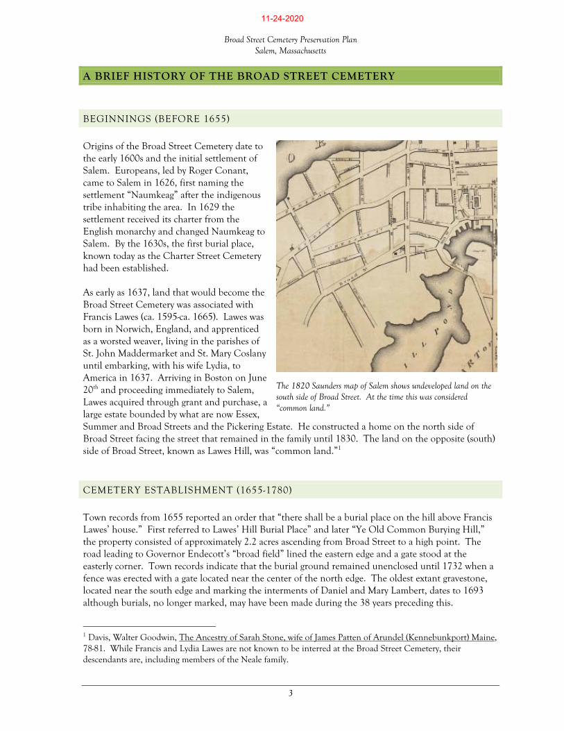
Origins of the Broad Street Cemetery date to the early 1600s and the initial settlement of Salem. Europeans, led by Roger Conant, came to Salem in 1626, first naming the settlement “Naumkeag” after the indigenous tribe inhabiting the area. In 1629 the settlement received its charter from the English monarchy and changed Naumkeag to Salem. By the 1630s, the first burial place, known today as the Charter Street Cemetery had been established. As early as 1637, land that would become the Broad Street Cemetery was associated with Francis Lawes (ca. 1595-ca. 1665). Lawes was born in Norwich, England, and apprenticed as a worsted weaver, living in the parishes of St. John Maddermarket and St. Mary Coslany until embarking, with his wife Lydia, to America in 1637. Arriving in Boston on June 20th and proceeding immediately to Salem, Lawes acquired through grant and purchase, a large estate bounded by what are now Essex, Summer and Broad Streets and the Pickering Estate. He constructed a home on the north side of Broad Street facing the street that remained in the family until 1830. The land on the opposite (south) side of Broad Street, known as Lawes Hill, was “common land.”1
CEMETERY ESTABLISHMENT (1655-1780)
Town records from 1655 reported an order that “there shall be a burial place on the hill above Francis Lawes’ house.” First referred to Lawes’ Hill Burial Place” and later “Ye Old Common Burying Hill,” the property consisted of approximately 2.2 acres ascending from Broad Street to a high point. The road leading to Governor Endecott’s “broad field” lined the eastern edge and a gate stood at the easterly corner. Town records indicate that the burial ground remained unenclosed until 1732 when a fence was erected with a gate located near the center of the north edge. The oldest extant gravestone, located near the south edge and marking the interments of Daniel and Mary Lambert, dates to 1693 although burials, no longer marked, may have been made during the 38 years preceding this.
1 Davis, Walter Goodwin, The Ancestry of Sarah Stone, wife of James Patten of Arundel (Kennebunkport) Maine, 78-81. While Francis and Lydia Lawes are not known to be interred at the Broad Street Cemetery, their descendants are, including members of the Neale family.
The 1820 Saunders map of Salem shows undeveloped land on the south side of Broad Street. At the time this was considered “common land.”
11-24-2020

Broad Street Cemetery Preservation Plan Salem, Massachusetts
4
The cemetery landscape during this time reflected the Colonial style of burial. Individual graves, arranged in short rows, were marked with portal-shaped tablets made of native stone.2 The artwork of local gravestone carvers appeared in the tablets’ tympanums. Aside from excavations associated with burials themselves, the landform was unaltered, and trees, if any, consisted of species native to New England.
EMBELLISHMENT (1780-1900)
In 1780, the property was renamed as the Broad Street Cemetery, marking the beginning of period of transformation from a Colonial era burial ground to a modern Victorian era cemetery. In 1802, eighteen proprietors commissioned stonemasons John Dodge, John Stimpson and Hooper Stimpson to construct a row of underground tombs along the “north side of the burying-hill,” beginning at the east side of the front gate. The proprietors paid $2,160.00 for the work. Numbered 1 through 18 from west to east, the tombs were built according to the following specifications:3
“The northern or back wall of the tombs to be continued up to the surface of the street, upon which is to be built a wall four feet ten inches high, one foot thick, face
2 Slate from this early period may have been derived from imported stones used as ballast in the shipping industry. 3 The tombs were constructed entirely underground and are not visible, however markers were placed above the tombs and most remain in place today.
Mid nineteenth century embellishments to the cemetery included terracing of the north slopes, fencing the perimeter, creating two formal gates, and connecting them with a carriage road (right of photo). Between 80 and 95 tombs were built into the terrace slopes. (PEM/Phillips Library Collection, Frank Cousins photograph, 1870-1890)
11-24-2020

Broad Street Cemetery Preservation Plan Salem, Massachusetts
5
rocks at least twelve inches deep, and the remainder of the wall to be made of hard burnt brick, with nitches (niches) over each tomb to receive a slate of suitable size… …[T]he tombs to be built with abutments or partition walls of face stone eighteen inches thick and three feet six inches deep, between the tombs; up on the abutments to be built brick arches eight inches thick of the hardest burnt bricks, making each of the tombs eight feet deep in the clear, in the deepest part of the arch; each tomb to be thirteen feet long and nine feet wide in the clear, and eight feet deep as aforesaid… …[T]he entrance to each tomb to be three feet wide with a suitable head, with six or seven stone steps… …[T]he whole of the tombs to be covered with earth at least eighteen inches deep on the highest part of the crown of the arch, and smoothed and leveed, with a descent to cast off the water. The back wall and head wall to be of at least fifteen inches thick to each tomb.”4
Salem incorporated as a city in 1836, shortly thereafter began making significant improvements to the cemetery. In 1841, the city funded the planting of trees in the “front” of the cemetery and in 1856 enclosed the property with an iron picket fence set on granite curbing. It is likely that the cast iron gates were erected in conjunction with the fence, establishing formal entrances on the east and west sides, and cast iron markers were appended to the fence to mark the eighteen underground tombs. A carriage road was installed along the north edge, connecting the two
4 Watkins Family Papers, 1708-1830, Folder 3, Peabody Essex Museum. For a complete transcription of the tomb specifications, refer to the Bibliography section of this plan.
Between 1855 and 1885, a shaded walkway separated the cemetery (at right) from the adjacent schools. Elms lined the walkway’s north side and cast iron bollards prevented use of the walkways by carriages. (PEM/Phillips Library Collection, Robinson photograph, 1885)
The eighteen tombs were built entirely underground and are not visible, however markers stand above ground atop most of the tombs, including one with “door” inscribed on its west face.
11-24-2020

Broad Street Cemetery Preservation Plan Salem, Massachusetts
6
gates. Manipulation of the cemetery slopes also took place, shaping the “hill” into a series of terraces descending the north side and creating spaces for private family tombs. Between 80 and 95 tombs were built into these terraces, each marked with individual monuments and/or stone façade walls. The granite block retaining walls supporting the east and west cemetery edges were likely built around this time. Tree planting continued at the cemetery into the late 19th century, including several “several scarce introduced trees,” as documented by John Robinson in 1891. Species included red pine, European ash, weeping willow, European white birch and European beech.5 Nurseryman Harlan P. Kelsey, who resided in Salem after 1902 and added trees at locations within the city including gingko and witch hazel along Broad Street, is believed to have added several varieties of crabapple trees to the cemetery, several of which may remain today.6 During this time, Salem constructed three school buildings along Broad Street, adjacent to the cemetery’s north side. These included the Oliver Primary School (1818 with several modifications by 1869), Salem Normal School (1854), and Salem High School (1855). A promenade-like pathway, shaded by towering elm trees, separated the school complex from the cemetery, greatly enhancing its setting. A pair of cast iron bollards stood at each end of the path presumably to prevent its use by carriages.
MODERNIZATION (1900-PRESENT)
Beginning in the early part of the 20th century, the cemetery entered a period of modernization, followed by decline. In 1941 the city engineer prepared plans for a concrete block retaining wall to be built along the south edge to replace an earlier wall.7 The plans specified a concrete cap and 4’ chain link fence for the top of the wall, and construction was completed in 1942. Sometime in the late 1900s, the city removed the chain link fence along the south edge and replaced it with wood picket, painted white. In the 1950s and 1960s, elms that once filled the cemetery and lined the pedestrian path along the north edge were removed through city-wide effort to control elm disease. The carriage road, no longer used for this purpose, was removed and/or covered with turf, and the pedestrian path between the cemetery and schools was replaced with asphalt parking areas. By the end of the 1900s, the cemetery appeared neglected, with many deteriorating headstones and trees in declining health.
5 Robinson, John, Our Trees: a popular account of the trees in the streets and gardens of Salem, and of the native trees of Essex County, Massachusetts, with the location of trees, and historical and botanical notes,1891, 8, 42, 72, 75, 89, 97. The red pine described by Robinson may be the species still growing along the cemetery’s north edge. 6 Chris Burke, personal interview, October 20, 2020 7 Mount Vernon Street dates to the early decades of the 1800s. It appeared on the 1851 McIntyre map of Salem but was not shown on the 1820 Saunders map. According to the Massachusetts Cultural Resource Information System (MACRIS), the houses on Mount Vernon were constructed between ca. 1900 and ca. 1930.
The wood picket fence along the south edge replaced an earlier chain link fence.
11-24-2020

Broad Street Cemetery Preservation Plan Salem, Massachusetts
7
In 2002, the city attempted to address the conditions at Broad Street by commissioning a study of its four historic burying grounds. While the study made several preliminary recommendations, it did not include detailed restoration plans. Fifteen years later, a group of history enthusiasts concerned about the cemetery’s condition formed the Friends of Broad Street Cemetery (FOBSC). In addition to advocating for the property’s long-term preservation, FOBSC organized tours and clean up efforts, installed a pollinator garden, and using social media, attracted a broad membership. The group weighed in on the scope of work for the foregoing preservation plan and were active participants in the planning process. Another recent effort by the city involved conservation treatment of several gravestones within the cemetery.
The city engineer’s drawing for the concrete block wall for the cemetery’s southern edge showed a 4’ height chain link fence atop the wall. Crews constructed the wall in 1942.
The Friends of Broad Street Cemetery, established in 2018, created a scavenger hunt to help visitors familiarize themselves with the historic property.
11-24-2020

Broad Street Cemetery Preservation Plan Salem, Massachusetts
8
HISTORIC CEMETERY STYLES
As summarized above, the Broad Street Cemetery landscape evolved over the course of 365 years, and with this evolution came a change in its physical appearance. Americans’ approaches to commemorating the dead shifted over the centuries, and variations in the landscape reflect these shifts, as follows: Colonial Burial – Approximately 1 1/3 Acres. The earliest burial areas, located on the highest points and along the south side, exhibit characteristics of 17th and 18th century American burials. Single graves dominate, marked with portal-shaped tablets made from native slate and sandstone and intricately carved by local or regional artisans. Graves are arranged in short rows but otherwise the cemetery is unplanned or plotted. As was typical of Colonial burial grounds, this area of the cemetery does not contain roads or paths. Victorian Burial – Approximately 2/3 Acres. Moving northward within the cemetery, the landscape transforms from a Colonial era burial ground to a modern facility. The earthen terraces stepping down the north slope contain rows of private tombs, and each is (or was) marked by a tablet or obelisk, or is faced with a granite wall. Family plots, enclosed with curbs or copings and marked with a large central monument, appear scattered throughout the upper sections of the cemetery.
PERIOD OF SIGNIFICANCE
The period of significance for the cemetery extends from 1655 to 1900. During this time, Salem established the burial ground, enclosed it with granite walls and iron picket fencing, created two formal entrances and connected them with a carriage road. The city graded the north slope making a series of terraces and constructing between 80 and 95 tombs. Several species of trees were planted to further embellish the landscape, providing dignity to the final resting places for many generations of Salem families. All efforts to preserve the cemetery should reflect this 245-year period.
The Colonial style covers approximately 2/3 of the cemetery, located above (south of) the terraces.
The Victorian style covers approximately 1/3 of the cemetery and includes the terraces, tombs and former carriage road bed.
11-24-2020

Broad Street Cemetery Preservation Plan Salem, Massachusetts
9
11-24-2020

Broad Street Cemetery Preservation Plan Salem, Massachusetts
10
(page intentionally blank)
11-24-2020

Broad Street Cemetery Preservation Plan Salem, Massachusetts
11
LANDSCAPE ASSESSMENT The following section of the Broad Street Cemetery Preservation Plan is an assessment of the landscape’s existing conditions. Its purpose is to document the natural built and functional features; to analyze their condition; and to outline preliminary recommendations for preservation treatment.8 Together with the information compiled about the cemetery’s history, the assessment provides a foundation for the overall plan.
SETTING
The Broad Street Cemetery lies within the McIntire Historic District, a 424-property area named for renowned Salem architect Samuel McIntire (1751-1811) who lived near two blocks from the cemetery on Summer Street. Laid out in the form of a 2.2-acre rectangle, the cemetery serves as a shady green space, wedged between Broad Street to the north, Summer Street to the east, Winthrop Street to the west, and Mount Vernon Street to the south. Summer and Winthrop abut the cemetery edges, while buildings – both institutional and residential – stand between the cemetery on Broad and Mount Vernon Streets. The character of the surrounding neighborhood is as follows: To the North – Three historic former institutional buildings (Salem High School, Oliver School
Primary School (dating to 1818), and Salem Normal School), surrounded by an asphalt driveway and parking lot, stand between the cemetery and Broad Street. These multi-story brick buildings loom over the cemetery, but at the same time add a sense of privacy and provide a buffer from Broad Street.
To the East – Private two- and two-and-one-half story, wood frame historic homes line the east
side of Summer Street, each painted in a bright hue, including grape, seafoam green, sky blue and mauve. Summer Street is narrow and traffic is limited to one-way moving north, limiting the amount of noise created by passing cars.
To the West – Private two-and-one-half story wood frame historic homes line the west side of
Winthrop Street, with gabled fronts facing the street. While traffic flows in two directions, the street is narrow, forcing vehicles to travel slowly.
8 Preservation, as defined by the National Park Service, includes four treatment options: stabilization, restoration, rehabilitation and reconstruction, as discussed at the end of this section of the Preservation Plan.
Three historic school buildings, no longer functioning as educational institutions, stand between the cemetery and Broad Street. They loom over the north side, but also provide a sense of privacy.
11-24-2020

Broad Street Cemetery Preservation Plan Salem, Massachusetts
12
To the South – Private two-and-one-half story wood frame historic homes sit close to the streets on deepish linear lots, and the back yards abut the cemetery. Small sheds and/or garages occupy some of the back yards. The cemetery sits at an elevation several feet above the back yards.
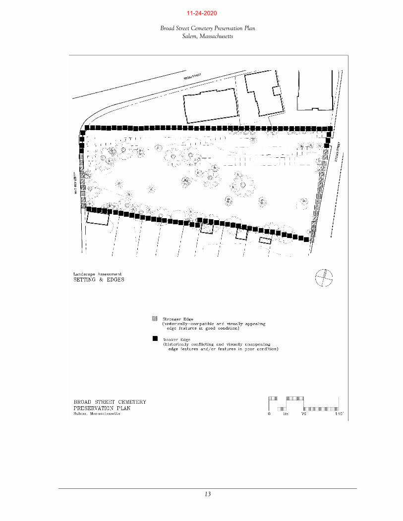
EDGES
Each of the cemetery’s four edges is lined with a different feature or combination of features, providing complete enclosure. The condition of these features ranges from stable to quite poor, as described below. Note that some features are further discussed later in this section under “historic structures.” North Edge – a vertical granite curb
or “coping,” topped by an iron 4’ height single-channel, spear-topped picket fence, lines the entire north cemetery edge. The coping ranges in height from 9 to 14” and is heavily stained and soiled. Many of the pickets have become disfigured and all have significantly rusted, and in some locations, the top channel is bent. Other signs of deterioration include a tree stump pushing through the coping resulting in a dislodged coping stone; one section of fenced replaced with flat-topped pickets; several fence panels leaning inward toward the cemetery; sections of coping leaning into the cemetery; several bent, dislodged or missing pickets; a pipe railing added to the top of pickets near the east end; a missing fence section; and parking-related signs hanging from the channel on the outside of the fence. Small cast iron plaques hang from the inside of the fence near the northeast corner, marking some of the eighteen tombs buried beneath the cemetery surface in this location.
East Edge – the vertical granite curb or “coping” returns from the north edge around to the east edge and continues to carry the picket fence. A tubular steel post, installed to replace a decorative cast iron post, marks the northeast corner. The coping and fence continue southward to a pedestrian gate flanked by two cast iron posts supported by 7’ high, 12” square granite posts, and a double-leaved vehicular gate stands to the south of the pedestrian gate. From this point southward, the east edge is retained by a bead-mortared cut granite block retaining wall, ranging in height from 4 ½ feet to approximately 7 ½ feet. The wall appears plumb with some shifting of blocks and bulging. The condition of this wall is discussed later in this section.
West Edge – the vertical granite curb or “coping” rounds the corner of Broad and Winthrop Streets and continues part way south along the west edge, carrying the same iron picket fence.
The iron picket fence and granite curb extend along the entire north edge and wraps around a portion of the east and west (shown) edges. The condition of this fence is mostly poor.
11-24-2020
Broad Street Cemetery Preservation Plan Salem, Massachusetts
13
11-24-2020

Broad Street Cemetery Preservation Plan Salem, Massachusetts
14
11-24-2020

Broad Street Cemetery Preservation Plan Salem, Massachusetts
15
At the corner, a single-leaved pedestrian gate and double-leaved vehicular gate, supported by cast iron posts, mark entrances to the cemetery. Pickets along the east edge are all intact, as is the channel. The fence ends at a 5’ high, 12” square granite column marking the beginning of a cut granite block retaining wall topped with a pyramidal-shaped granite cap. Most of this wall appears plumb, with one bulge (likely caused by roots of the adjacent oak tree standing inside the cemetery. At the southwest corner, the wall has begun to deteriorate. Mortar has dislodged and large gaps have formed between the cap and wall stones.
South Edge – A concrete retaining wall, designed and constructed during the WPA period
(1941-1942), lines the entire south edge. The wall face is not visible from inside the cemetery. A white painted wooden picket fence rests atop the wall and is in poor condition with decaying members and chipping paint. In addition to detracting from the cemetery landscape, the fence allow views into the back yards of Mount Vernon Street residents.
PARKING & CIRCULATION
Visitors to the cemetery by vehicle must park on the adjacent streets or in the former High School parking lot; the cemetery does not offer on-site parking. On-street parking is available on the east side of Summer Street or west side of Winthrop, in designated parallel spaces. The former High School building and associated parking lot had been sold to a private developer as of the writing of this plan, and the future use of the lot by cemetery visitors was yet to be determined. Pedestrians may reach the cemetery via a network of sidewalks and crosswalks leading to and from Downtown as well as the surrounding neighborhood. Sidewalks edge both sides of Broad, Summer and Winthrop Streets, and crosswalks provide safe crossings at street intersections. Asphalt surfaces most of the sidewalks, however a short section of brick pavers stand near the cemetery’s Summer Street entrance. The condition of both materials ranges from stable and ADA-compliant, to poor and non-compliant. Visitors may enter the cemetery at the northwest corner, where the historic pedestrian gate remains open at all times. The Summer Street gate has been closed and secured with a lock. Makeshift entrances stand (1) along the north edge where a section of the iron picket fence has been removed, (2) at the southwest corner, where the perimeter granite block wall has deteriorated, and (3) at a mid-point along the south edge, where a break in the picket fence allows visitors to pass through private property (on Mount Vernon Street) into the cemetery. None of these entrances, formal or makeshift, is ADA-compliant due to the presence of vertical curbing and granite or walls that must be traversed.
Parking has been provided for residents of the former school buildings on the cemetery’s north side. Visitors to the cemetery have used this area for parking too.
11-24-2020

Broad Street Cemetery Preservation Plan Salem, Massachusetts
16
Once inside the cemetery, pedestrians must travel unguided across the grassy lawns, as all pathways/carriage ways have been removed, and ADA-compliant route exists that provides a navigable route throughout. Visitors have worn a path at the northwest entrance leading into the cemetery, but this path ends at the nearby terraced slope (discussed below) where it meets a set of granite steps. Inside this gate, a set of granite steps, built on top of a tomb, lead up a steep terrace slope. These steps have a shallow riser-tread ratio and are not secured by a handrail, making them non-compliant with ADA guidelines. In addition, they are in poor condition and unsafe for visitors attempting to access the cemetery’s upper terraces.
TOPOGRAPHY
Slopes across the cemetery divide into three types, lower slopes, upper slopes, and terraces. Lower slopes extend along the north and portions of the east and west edges, abutting the granite coping and iron picket fence. This 0.25- acre area once held the cemetery’s only known carriage road, providing a level connection between the east and west gates. Upper slopes cover approximately 1.6 acres and likely contain original, unaltered topography. The landform across these slopes undulates between a series of low points and high points, providing long views across the cemetery and to the surrounding neighborhood. Separating the lower and upper slopes are a series of terraces (approximately 0.15 acre), stepping down from south to north. Two terraces, each containing tombs, descend the eastern end while a single terrace punctuates the western end.
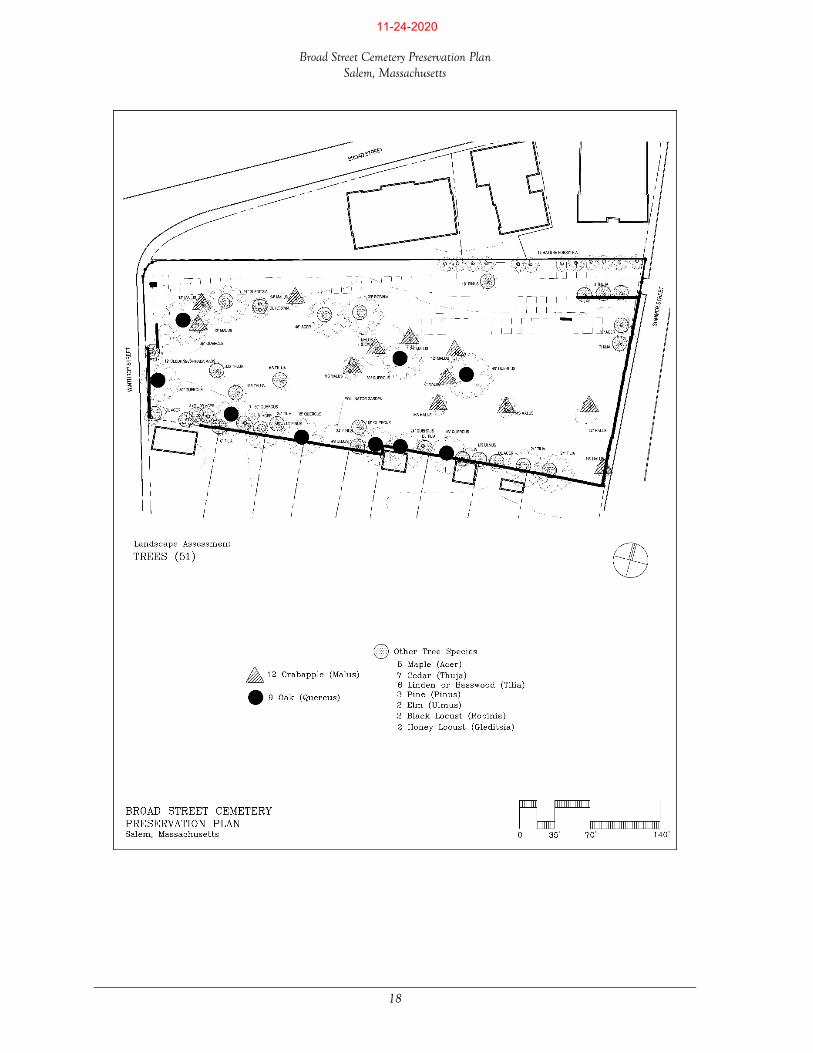
TREES & SHRUBS
Broad Street Cemetery contains a total of 51 trees, 25 trees per acre. Crabapples (Malus) constitute the largest percentage (24%) followed by oaks (Quercus) at 18%. Other species include deciduous trees, maple (Acer), linden or basswood (Tilia), honey locust (Gleditsia), elm (Ulmus) and black locust (Robinia), and evergreen trees, cedar (Thuja) and pine (Pinus). Nearly all the trees grow on the upper slope area of the cemetery.
The cemetery topography includes a terraced area near the north end, where the land steps downward and is supported by rows of private tombs.
11-24-2020

Broad Street Cemetery Preservation Plan Salem, Massachusetts
17
11-24-2020
Broad Street Cemetery Preservation Plan Salem, Massachusetts
18
11-24-2020

Broad Street Cemetery Preservation Plan Salem, Massachusetts
19
The trees range in age and condition, with several “senior” oaks and younger “volunteer” Norway maples. Approximately one- third appear to be in very good condition, including four oaks, two cedars, three lindens, and one each of honey locust, black locust, maple, elm, and pine. Most of the twelve crabapples are in declining or poor condition, and one is dead. The other trees range from good condition (strong central leaders, healthy branching) to poor (split leaders, dead limbs, thin foliage). In addition to the trees, the cemetery contains four species of shrubs, barberry (Berberus), spiraea, mulberry and forsythia, and a small pollinator garden. At the southeast corner, barberry grows atop the granite block retaining wall, and along the west edge, spiraea grows near the set of tombs. The most prominent shrub planting, a row of evenly-spaced forsythia, stands along the north edge. These plants have reached a mature height of approximately eight to ten feet, helping to screen the cemetery from the adjacent parking lot. The Friends of Broad Street Cemetery have introduced a small herbaceous perennial garden of pollinator species along the south edge.
HISTORIC STRUCTURES
The cemetery contains several masonry structures rimming gravesites (family plot enclosures), holding interments (private tombs), defining the edges (granite block and concrete walls as well as cast iron and wood picket fencing), and the condition of these varies, as follows, Family Plot Enclosures, in the form of granite curbs or copings and fences, surround family plots in the upper terrace area. Outstanding among these are the following: Plummer plot, located near the east
end of the upper terrace, features an iron spear-topped picket fence standing on a vertical granite curb enclosing plot of six family members. Egg-shaped finials top the fence posts. While rusted, the fence is largely intact.
Of the cemetery’s 51 trees, several have reached maturity. Their broad canopies form a roof over the landscape.
The Sarah Holmes plot, located near the west end, features four rock-face granite corner posts, connected by a single steel pipe rail.
11-24-2020

Broad Street Cemetery Preservation Plan Salem, Massachusetts
20
Rhoades plot, located to the south and west of the Plummer plot, outlined with rock-face granite curbing trimmed with a thermal edge, one curb per edge. The plot appears to hold several graves, including father, mother and children, all marked with one granite headstone. The curbs have separated at the corners and one curb section is leaning outward.
Sarah Holmes plot, located near the southwest corner of the upper terrace, features four rock-face
granite posts connected with steel pipe rail, enclosing the plot of a single grave. The posts appear plumb and are in good condition, and while rusted and in need of repainting, the pipe rail is intact.
Private Tombs This section is forthcoming. Granite Block Walls This section is forthcoming. Concrete Walls This section is forthcoming. Iron Fencing and Gates. As noted above under “edges,” an iron picket fence, resting atop vertical granite curbing, rims the north side of the cemetery, and extends along portions of the east and west sides. Decorative cast iron pedestrian (single-leaf) and vehicular (double-leaf) gates stand near the northeast and northwest corners. The curbing, while intact, ranges from plumb to leaning, and in one section, has altogether overturned. Grim covers most of the surface. The fence is in similarly poor condition, with many bent or missing pickets. Near the east end, a pipe rail covers the tops of the pickets, and “reserved parking” signs hang from the channel. The cast iron gates are inoperable, the gate posts have rusted, and several post finials are missing. The post at the northeast corner has been removed and a square tubular steel post serves as a replacement. Wood Picket Fencing. Four-feet height wood picket fencing, constructed of 2” x 4” lumber and installed atop the concrete retaining wall, extends along the full length of the south edge, providing a barrier between the cemetery and back yards of the neighboring residents on Mount Vernon Street. While most of the fence is intact, its condition is poor, with some members rotting, and much of the white painted finish deteriorated.
GRAVESTONES & MONUMENTS
This section is forthcoming.
11-24-2020

Broad Street Cemetery Preservation Plan Salem, Massachusetts
21
11-24-2020

Broad Street Cemetery Preservation Plan Salem, Massachusetts
22
LANDSCAPE ACCESSORIES
The city and adjacent property owners have placed signs and a trash receptacle in or adjacent to the cemetery. The condition of these is as follows: Signs. A prominent white sign with black lettering stands inside the Winthrop Street entrance (northwest corner), alerting visitors to the property’s establishment date and listing the names of several notable individuals interred within. While informative, the sign lacks information about cemetery rules and regulations (including opening-closing hours), and its large size looms over the entrance, making the feature out of scale with the cemetery landscape. Other signs stand outside the cemetery, but similarly conflict with its character. The owners of the former school buildings along the cemetery’s north edge have utilized the iron fence pickets as posts to which they’ve attached parking signs for tenants. Not only are these visually unappealing; they also encourage drivers to park up against the fence. In several locations it appears that vehicles have collided with and damaged the fence. Trash Receptacle. As noted earlier in this report, the city has maintained a steel trash receptacle outside the Winthrop Street entrance for some time. In recent years, visitors to the cemetery and other passersby have relied on the receptacle for disposal of dog waste. The city removed the receptacle in the summer of 2020, but in response to strong local objection, restored it to the same location. Because dogs are prohibited from entering the cemetery, there is no need to maintain a receptacle in this location. Not only does it clutter the one operative cemetery entrance, it detracts from the landscape’s historic character.
LANDSCAPE DETAILS
Character-Defining Features The Broad Street Cemetery landscape contains many details that both add to and detract from its historic character, most of which have been discussed above. In summary, features that help to define the historic character include: Perimeter granite block walls Cast iron fencing and gates on the east and west sides Cast iron tomb markers along the north fence (east end) Private tombs retaining the terrace slopes Mature specimen trees in very good condition Gravestones and monuments
The sign located just inside the Winthrop Street gate displays the cemetery’s establishment date and lists notable individuals interred within. It does not spell out cemetery rules and regulations.
11-24-2020

Broad Street Cemetery Preservation Plan Salem, Massachusetts
23
Plot enclosures Contemporary features that detract from the historic character include: Wood picket fencing atop the concrete retaining wall (south edge) Granite steps leading up the west terrace slope over the private tomb Trees in declining or dead condition Makeshift entrances along the north edge and southwest corner Signs appended to the outside of the cast iron fence (north edge)
Historic features that once stood within the burying ground but have been removed include: Functioning vehicular and pedestrian gates marking the east and west entrances Carriage path linking the two entrances and extending along the north edge Family plot enclosure details, including fencing
PRELIMINARY RECOMMENDATIONS
Future preservation efforts at Broad Street Cemetery will involve each of the four treatment methods outlined by the United States Secretary of the Interior’s Standards for the Treatment of Historic Properties with Guidelines for the Treatment of Cultural Landscapes (1996). They include: Preservation, where existing form, integrity and materials of the landscape will be sustained; Rehabilitation, where features in the landscape will be repaired or altered to make their use
compatible with the landscape’s historical value; Restoration, where landscape features will be returned to their original form; and Reconstruction, where landscape features no longer extant will be restored.
Based on the preceding assessment, the following preliminary recommendations should be considered for the Preservation Plan. Note that the recommendations do not appear in order of importance or priority. Restore the iron picket fencing and sets of gates along the north edge; include in this, cleaning
and straightening the granite coping supporting the fence;
Stabilize, as needed, the granite block retaining walls lining the east and west cemetery edges, including cleaning and repointing, as required;
Remove the wood picket fence along the south edge and replace with a steel picket fence of a style complementary to the iron fence along the north edge;
Work with the city to designate on-street parking spaces (Summer and/or Winthrop) for use by visitors to the cemetery;
Re-establish the carriage path connecting the east and west gates;
Remove any diseased or dying trees, as well as any volunteer invasive species (such as Norway maple);
11-24-2020

Broad Street Cemetery Preservation Plan Salem, Massachusetts
24
Develop a plan to replace trees with species appropriate to the two historic cemetery styles;
Expand and enhance the pollinator garden, integrating the design of the garden with other
cemetery needs (such as screening);
Stabilize the tombs per the recommendations of the historic structures assessment;
Conserve the gravestones and monuments identified in the assessment in need of treatment;
Restore the historic family plot enclosures;
Restore the eighteen cast iron tomb markers along the north edge;
Work with the city and developer of the former High School/Senior Center building to upgrade parking, pedestrian circulation and overall aesthetics of the north edge;
Develop a sign program to (1) welcome visitors; (2) explain the cemetery’s historical importance; (3) outline cemetery rules and regulations; and (4) direct visitors to prominent features within the cemetery. As part of this program, design an interpretive program for those visitors who cannot access the upper slope.
Develop a plan for securing the cemetery from vandalism and inappropriate uses, including installing lighting and security cameras.
11-24-2020