Embed Size (px)
Citation preview
ROAD NETWORK and TRANSPORT SERVICES
ENGR. DANILDA LEGASPIPlanning Officer II
Provincial Planning and Development Office
Technical Paper SeriesARNDP – Volume II
12|
Contents1. Introduction......................................................................................................................1
2. Existing Situation...............................................................................................................2
2.1. Road Network Situation.............................................................................................2
2.2. Transport Services.....................................................................................................3
2.3. Road Length and Density...........................................................................................8
2.4. Road Pavement Ratio...............................................................................................10
2.5. Road Condition Classification...................................................................................12
2.5.1. Provincial Road Condition.................................................................................14
2.5.2. Provincial Bridge Condition...............................................................................22
2.5.3. National Road Condition...................................................................................27
2.5.4. Municipal Road Condition................................................................................33
2.5.5. Barangay Road Condition.................................................................................34
2.6. Traffic Condition...................................................................................................... 35
3. Road Investment.............................................................................................................37
4. Summary and Recommendations...................................................................................42
i | R o a d N e t w o r k a n d T r a n s p o r t S e r v i c e s

List of TablesTable 1: Administrative Road Classification.............................................................................2Table 2: Number of PUJ/Bus/Truck Franchises for 2005-2009................................................4Table 3: Existing Total Road Network.......................................................................................8Table 4: Road Category by Type of Pavement.........................................................................9Table 5: Pavement Ratio in all roads of Agusan del Sur.........................................................10Table 6: DILG Road Condition Classification..........................................................................12Table 7: Road Condition Classification Used in this Plan.......................................................12Table 8: Provincial Road Condition........................................................................................14Table 9: List of Provincial Roads............................................................................................16Table 10: Bridges Along Provincial Roads..............................................................................22Table 11: Summary of National Road Condition....................................................................27Table 12: Summary of National Road by Type of Pavement..................................................27Table 13: Summary of National Road Condition in District I..................................................27Table 14: Summary of National Road Condition in District II.................................................28Table 15: Road Condition and Type of Pavement of National Road in District 1...................29Table 16: Road Condition and Type of Pavement of National Roads in District II.................31Table 17: Municipal Road Condition......................................................................................33Table 18: Summary of Municipal Road by Type of Pavement...............................................33Table 19: Summary of Barangay Road Condition..................................................................34Table 20: Summary of Barangay Road by Type of Pavement................................................34Table 21: Road Investment by Category................................................................................37Table 22: National Road Investment.....................................................................................38Table 23: Provincial Road Investment...................................................................................38Table 24: Barangay/FMR Road Investment...........................................................................39Table 25: Summary of Road Investments..............................................................................40Table 26: Summary of Road Condition..................................................................................41
List of FiguresFigure 1: Public Transport Network Map.................................................................................7Figure 2: Total Road Network Length......................................................................................8Figure 3: Percentage of Road Pavement.................................................................................9Figure 4: Road Network by Administrative Classification......................................................11Figure 5: Road Condition Map...............................................................................................15Figure 6: Provincial Bridges Location and Condition..............................................................26Figure 7: Condition of Provincial Roads..................................................................................36
ii | R o a d N e t w o r k a n d T r a n s p o r t S e r v i c e s

1. Introductionhis document discusses the existing road network and its condition spanning across 14 municipalities of Agusan del Sur. The data for the provincial roads were gathered through surveys and consolidated by an assigned member of the Southern
Agusanon Planning Team (SAPT). Using GPS instrument, the technical teams from the Provincial Engineering Office (PEO) determined the condition of the provincial roads. Three teams were organized, each composed of four individuals to survey the newly identified 50 provincial road sections. The condition of municipal and barangay roads were provided by the 14 municipal local government units.
TThe data for the national road, on the other hand, were generated from the two districts of the Department of Public Works and Highways in the province. This paper serves as inputs to the formulation of the second edition of the Agusan del Sur Road Network Development Plan (ARNDP), particularly on the future rehabilitation and maintenance works.
1.
2. Existing SituationAgusan del Sur roads are categorized into five, namely: National Primary, National Secondary, Provincial, Municipal or City and barangay or Farm-to-Market Road (FMR). Bridges along the road projects are considered as an integral part of the road transport sub-sector.
Agusan del Sur, a land-locked province of Caraga Region, is connected to other areas of Mindanao primarily through the Agusan-Davao road, classified as a national primary. This
1 | R o a d N e t w o r k a n d T r a n s p o r t S e r v i c e s

road, including eight bridges, has been a major lifeline enhancing the socio-economic growth and political system of the region.
National secondary roads include circumferential roads like those sections connecting the municipalities of San Luis, Talacogon, La Paz, Loreto, Veruela, and Santa Josefa, the Cuevas-Bislig Road and San Francisco-Barobo Road.
There are also other major roads connecting Agusan del Sur to its neighboring provinces. The province is linked to Surigao del Sur in the northeastern part through the NRJ-Cuevas-Bislig road; in the southeastern part through the Bayugan-Calaitan-Tandag road; in the east through NRJ-Awa-Lianga road and San Francisco-Barobo road. The road that connects the province to Bukidnon is Esperanza-Malaybalay road in southwestern portion, to Misamis Oriental is Esperanza-Cagayan road in the west portion and in the south is Loreto-Davao road, linking to Compostela Valley province and Davao Region.
The access of airport in the province is in Butuan City and Davao City, which are approximately 85 km and 205 km respectively from San Francisco town. The nearest seaport is in Nasipit, Agusan del Norte that is approximately 100 km from San Francisco town. These two ports provide important access of goods in the province to Visayas and Luzon.
2.1. Road Network SituationThe roads in the Philippines are classified into five (5) categories with responsible agencies as shown in Table 1.
Table 1: Administrative Road Classification
Classification Responsible Agency
National Road DPWH-National
DPWH-ARMM
Provincial Road Provincial Government
City Road City Government
Municipal Road Municipal Government
Barangay Road Barangay Government
Functional Road Classification
The Department of Public Works and Highways (DPWH) classified the road as shown below:
2 | R o a d N e t w o r k a n d T r a n s p o r t S e r v i c e s

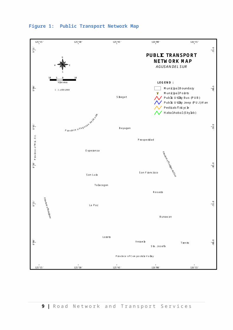
2.2. Transport ServicesThe province of Agusan del Sur can be reached both by land and water transportation. The Butuan-Davao National Highway (Daang Maharlika Highway) or the north-south backbone route served as the inter-regional road linking Davao Region and Caraga Region. It is the busiest road serving the region. The province of Surigao del Sur can be reached through east-west lateral route passing through the municipalities of Tandag, Lianga, Barobo, and Bislig City; and, Compostela Valley Province. Currently, commuters are served by Public Utility Buses, namely: Bachelor Express Incorporation, Land Transportation Incorporation, Philtranco and PP Bus Line. Agusan River is the only water transportation that can be used in going to the nearby provinces particularly Butuan City and Compostela Valley passing through the river town municipalities of Sta. Josefa, Veruela, Loreto, La Paz, Talacogon, San Luis and Esperanza. There are also barangays in the western part of the municipality of Esperanza that can be reached through this river.
From 2005 to 2009, the Land Transportation Franchising and Regulatory Board (LTFRB) of the Department of Transportation and Communications (DOTC) registered 278 operators for Public Utility Jeepney, PUJ-Dual, Van and Truck (Table 2). These served as the intra-regional/inter-provincial and intra-provincial land transport services and facilities passing the North-South backbone and the east-west lateral roads.
About 78% of the total registered operators have franchised for the regional and inter-provincial routes. These operators served the 14 municipalities in the province and barangays along Butuan City – Davao City road section, Barobo-San Francisco road section and Cuevas-Sta. Josefa-Veruela-Loreto-LaPaz-Talacogon-Prosperidad road section. The rest of the barangays are only served by single motorcycle locally known as habal-habal and skylab as well as bicycle with side car known as pedicab.
About 22% of the total registered operators have franchised for intra-provincial routes. The municipality of San Francisco is the point of origin with the destinations going to the municipalities of Prosperidad, Talacogon, San Luis, Rosario, Bunawan, Trento and Sta. Josefa. Among the 14 municipalities, the municipalities of Loreto and La Paz are not served
3 | R o a d N e t w o r k a n d T r a n s p o r t S e r v i c e s

by duly franchised PUJ/PUB service. For intra-municipality circulation, these are mostly served by tricyle (motorcycle with a side-car), pedicab and habal-habal.
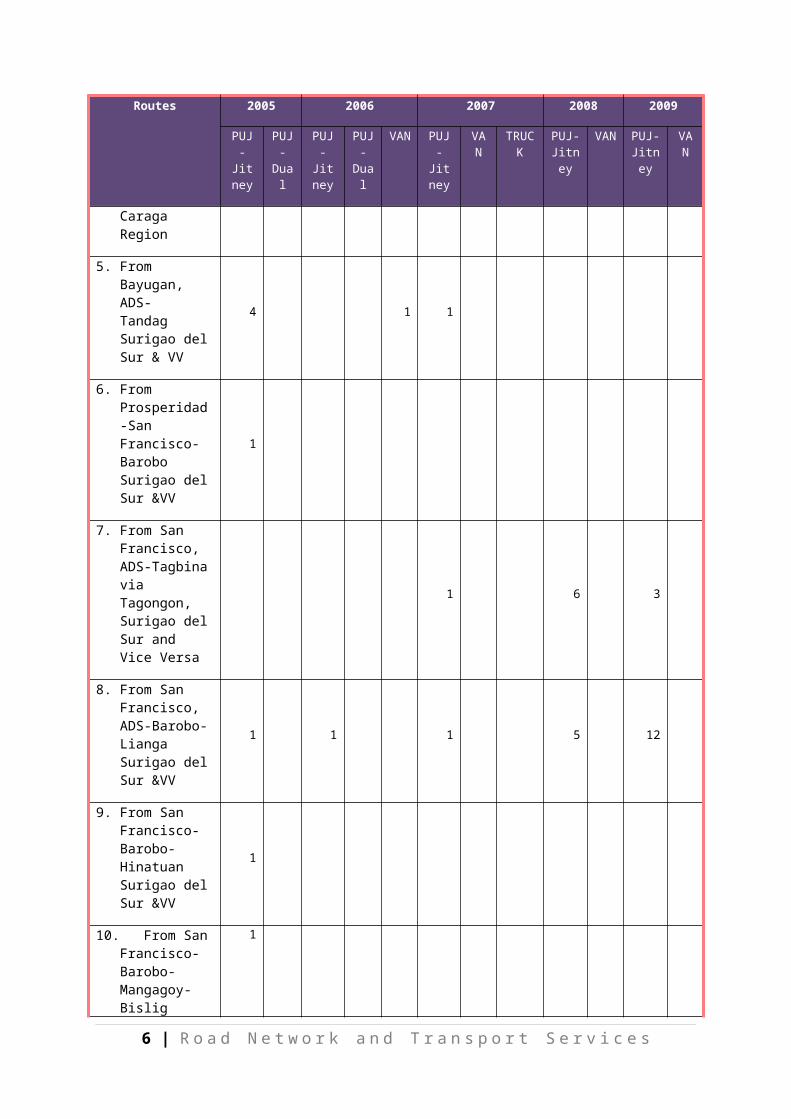
Table 2: Number of PUJ/Bus/Truck Franchises for 2005-2009
Routes 2005 2006 2007 2008 2009
PUJ-Jitne
y
PUJ-Dual
PUJ-Jitney
PUJ-Dual
VAN PUJ-Jitne
y
VAN TRUCK PUJ-Jitney
VAN PUJ-Jitney
VAN
Total =278 44 5 18 14 6 32 21 1 55 24 45 13
Regional/Inter-provincial
35 5 14 14 6 16 21 1 36 24 29 13
1. From Surigao City-Butuan City-San Francisco-Tandag & VV
6 1 1
2. From Butuan City-San Francisco-Trento-Sta. Josefa & VV
6 4 1 13 1 13 2 4
3. From Butuan City- Municipality of Prosperidad-San Francisco-Talacogon-San Luis, La Paz, & Loreto & VV
4 1
4. From Municipality of Sibagat, Esperanza, Bayugan, Prosperidad, San Francisco to any point in Caraga Region
1 3 1 1 1 8 1 3 20 1 13
5. From Bayugan, ADS- Tandag Surigao del Sur & VV
4 1 1
6. From Prosperidad-San Francisco-Barobo Surigao del Sur
1
4 | R o a d N e t w o r k a n d T r a n s p o r t S e r v i c e s

Routes 2005 2006 2007 2008 2009
PUJ-Jitne
y
PUJ-Dual
PUJ-Jitney
PUJ-Dual
VAN PUJ-Jitne
y
VAN TRUCK PUJ-Jitney
VAN PUJ-Jitney
VAN
&VV
7. From San Francisco, ADS-Tagbina via Tagongon, Surigao del Sur and Vice Versa
1 6 3
8. From San Francisco, ADS-Barobo-Lianga Surigao del Sur &VV
1 1 1 5 12
9. From San Francisco-Barobo-Hinatuan Surigao del Sur &VV
1
10. From San Francisco-Barobo-Mangagoy-Bislig Surigao del Sur &VV
1
11. From San Francsico-Hinatuan-via Bigaan &VV
1 2 1 3 4
12. From San Francsico-Bislig City-Lingig &VV
5 5 7 9 7
13. From San Francisco-Prosperidad via Magsaysay & VV
1 1 2 2
14. From San Francisco-Prosperidad via Mahayahay & VV
1
15. From Tandag SDS-Barobo-San Fran &VV
2 3 3 6
Intra-provincial 9 4 16 19 16
5 | R o a d N e t w o r k a n d T r a n s p o r t S e r v i c e s

Routes 2005 2006 2007 2008 2009
PUJ-Jitne
y
PUJ-Dual
PUJ-Jitney
PUJ-Dual
VAN PUJ-Jitne
y
VAN TRUCK PUJ-Jitney
VAN PUJ-Jitney
VAN
16. San Francisco-Prosperidad-Talacogon- San Luis &VV
3 1 1 5
17.San Francisco-Talacogon-via Borbon &VV
5 6 4
18.San Francisco-Trento – Veruela
5 3 9 12 7
19.Bunawan-San Franz-Bayugan &VV
1
20. Trento,ADS-Loreto &VV
9
Source: LTFRB-ADS
6 | R o a d N e t w o r k a n d T r a n s p o r t S e r v i c e s
7 | R o a d N e t w o r k a n d T r a n s p o r t S e r v i c e s
#Y
#Y
#Y
#Y
#Y
#Y
#Y
#Y
#Y
#Y
#Y
#Y
#Y
#Y
Loreto
La Paz
Trento
Esperanza
San Luis
Sibagat
Talacogon
Bayugan
Prosperidad
Bunawan
Rosario
Veruela
San Francisco
Sta. Josefa
8°00
' 8°00'
8°15
' 8°15'
8°30
' 8°30'
8°45
' 8°45'
9°00
' 9°00'
9°15
' 9°15'
125°15'
125°15'
125°30'
125°30'
125°45'
125°45'
126°00'
126°00'
126°15'
126°15'
1 : 1,400,000
10 0 10Kilometers
5
N
EW
S
Province of Compostela Valley
Province of Bukidnon
Pro
vinc
e of
Mis
. Or.
Province of A
LEGEND :
Municipal Points#YMunicipal Boundary
Public Utility Jeep (PUJ)/VanPublic Utility Bus (PUB)
Pedicab/TricycleHabal-habal (Skylab)
PUBLIC TRANSPORT NETWORK MAP
AGUSAN DEL SUR
Figure 1: Public Transport Network Map

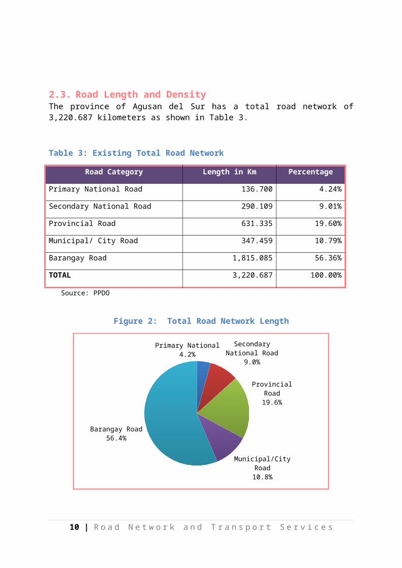
2.3. Road Length and DensityThe province of Agusan del Sur has a total road network of 3,220.687 kilometers as shown in Table 3.
Table 3: Existing Total Road Network
Road Category Length in Km Percentage
Primary National Road 136.700 4.24%
Secondary National Road 290.109 9.01%
Provincial Road 631.335 19.60%
Municipal/ City Road 347.459 10.79%
Barangay Road 1,815.085 56.36%
TOTAL 3,220.687 100.00%
Source: PPDO
Figure 2: Total Road Network Length
Primary National4.2% Secondary
National Road9.0%
Provincial Road19.6%
Municipal/City Road
10.8%
Barangay Road56.4%
8 | R o a d N e t w o r k a n d T r a n s p o r t S e r v i c e s

Table 4: Road Category by Type of Pavement
Type of Pavement
Road Category Percentage
National Provincial Municipal Barangay Total
Concrete 202.961 33.937 51.037 10.757 294.181 9.13%
Asphalt 37.522 0.000 2.130 0.100 44.892 1.39%
Gravel 186.326 443.746 261.604 1197.703 2,088.750 64.85%
Earth 0.00 153.652 32.688 606.525 792.865 24.62%
TOTAL 426.809 631.335 347.459 1,815.085 3,220.687 100.00%
Source: PPDO and PEO
Figure 3: Percentage of Road Pavement
Concrete9.1%
Asphalt1.4%
Gravel64.9%
Earth24.6%
Road density of the province is 0.359 km/sq km of land area, which is far below the standard set by the Housing and Land Use Regulatory Board (HLURB) of 1 km per square of land area. This is mainly due to the province’s large land area. However, among the provinces in Caraga Region, Agusan del Sur has the longest road network. As compared to Caraga Region with a road density of 0.434, Agusan del Sur road density is much lower and also lower than the country’s average road density of 0.597 km/sq km.
Based on the existing total road network of 3,220.687 kilometers, the province of Agusan del Sur falls short by 5,744.81 kilometers of road to meet the standard of 8,965.50 kilometers.
9 | R o a d N e t w o r k a n d T r a n s p o r t S e r v i c e s
2.4. Road Pavement RatioThe pavement ratio for all types of roads in Agusan del Sur is 11.74% (Table 5) which is 37.15% higher from the previous pavement ratio recorded in the first edition of the ARNDP. For the national roads, which are the main artery of the province, the pavement ratio of Agusan del Sur posted at 129.06% is higher for the Caraga region at 46.3% compared to the national average of 71.5%. Most of the traffic along the Provincial roads is less than 200 AADT (4- wheel vehicles), wherein gravel is the most recommended surfacing.
Table 5: Pavement Ratio in all roads of Agusan del Sur
Road category Length Paved Road Unpaved Road Pavement Ratio
National Road 426.809 240.482 186.326 129.06%
Provincial 631.335 33.937 597.398 5.68%
Municipal 347.459 53.167 294.292 18.07%
Barangay 1,815.085 10.857 1804.228 0.60%
Total 3,220.687 339.07 2881.615 11.74%
10 | R o a d N e t w o r k a n d T r a n s p o r t S e r v i c e s
11 | R o a d N e t w o r k a n d T r a n s p o r t S e r v i c e s
#Y
#Y
#Y
#Y
#Y
#Y
#Y
#Y
#Y
#Y
#Y
#Y
#Y
#Y
Loreto
La Paz
Trento
Esperanza
San Luis
Sibagat
Talacogon
Bayugan
Prosperidad
Bunawan
Rosario
Veruela
San Francisco
Sta. Josefa
8°00
' 8°00'
8°15
' 8°15'
8°30
' 8°30'
8°45
' 8°45'
9°00
' 9°00'
9°15
' 9°15'
125°15'
125°15'
125°30'
125°30'
125°45'
125°45'
126°00'
126°00'
126°15'
126°15'
DPWH I & IIProv'l Eng'g Office
SOURCE :
National RoadProvincial RoadMunicipal/Barangay Road
Municipal Boundary
#Y Municipal Points
LEGEND :
MLGU
Agusan del SurROAD NETWORK MAP
1 : 1,400,000
10 0 10Kilometers
5
N
EW
S
Province of Compostela Valley
rovin
Figure 4: Road Network by Administrative Classification

2.5. Road Condition ClassificationThe road condition classification used by the Department of Interior and Local Government is shown in Table 6.0. This is the same classification used by PEO in the submission of road inventory to DILG for the MVUC/SLRF funds.
Table 6: DILG Road Condition Classification
Average Surface Condition Remarks
Good Smooth riding, no potholes or cracking
Fair Smooth riding over most but some potholes, patching and/or cracking
Poor Uneven riding, large percentage of potholes, cracking and edge damage
Bad Very rough riding, extensive damage and potholes, badly broken edges, poor drainage
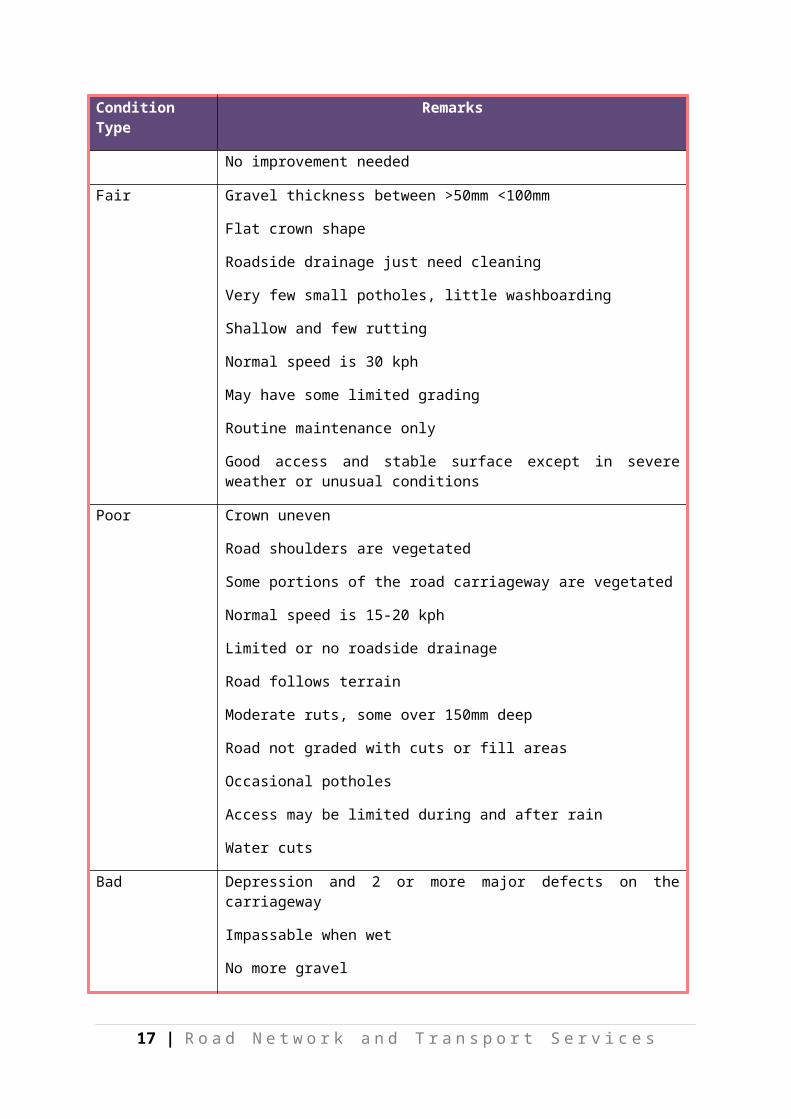
In the road condition survey for this study, the PEO adopted a different format, approach by identifying the various distresses and damages on the pavement, and reflect this in the road condition sheet shown in Table 7. The road condition classification used in this Plan is presented in Table 7.
Table 7: Road Condition Classification Used in this Plan
Condition Type Remarks
Good Carriageway has no defects
Roadside drainage clean and good condition
Crown shape good
Shoulders in good condition
Gravel thickness is 100mm or more
Normal speed is 40 kph
No significant ruttings
Access available in all weather conditions
Graded with cut and fill areas
No improvement needed
Fair Gravel thickness between >50mm <100mm
Flat crown shape
Roadside drainage just need cleaning
Very few small potholes, little washboarding
12 | R o a d N e t w o r k a n d T r a n s p o r t S e r v i c e s

Condition Type Remarks
Shallow and few rutting
Normal speed is 30 kph
May have some limited grading
Routine maintenance only
Good access and stable surface except in severe weather or unusual conditions
Poor Crown uneven
Road shoulders are vegetated
Some portions of the road carriageway are vegetated
Normal speed is 15-20 kph
Limited or no roadside drainage
Road follows terrain
Moderate ruts, some over 150mm deep
Road not graded with cuts or fill areas
Occasional potholes
Access may be limited during and after rain
Water cuts
Bad Depression and 2 or more major defects on the carriageway
Impassable when wet
No more gravel
Severe rutting
Crown very uneven
No roadside drainage
Normal speed is less than 15kph; very poor driving conditions
Not passable by 4-wheel vehicle
Access for cars and trucks may be restricted for extensive periods of time
Reconstruction needed to provide improved access, repair severe distress, and improve road to good condition
13 | R o a d N e t w o r k a n d T r a n s p o r t S e r v i c e s
1.2.
2.1.2.2.2.3.2.4.2.5.
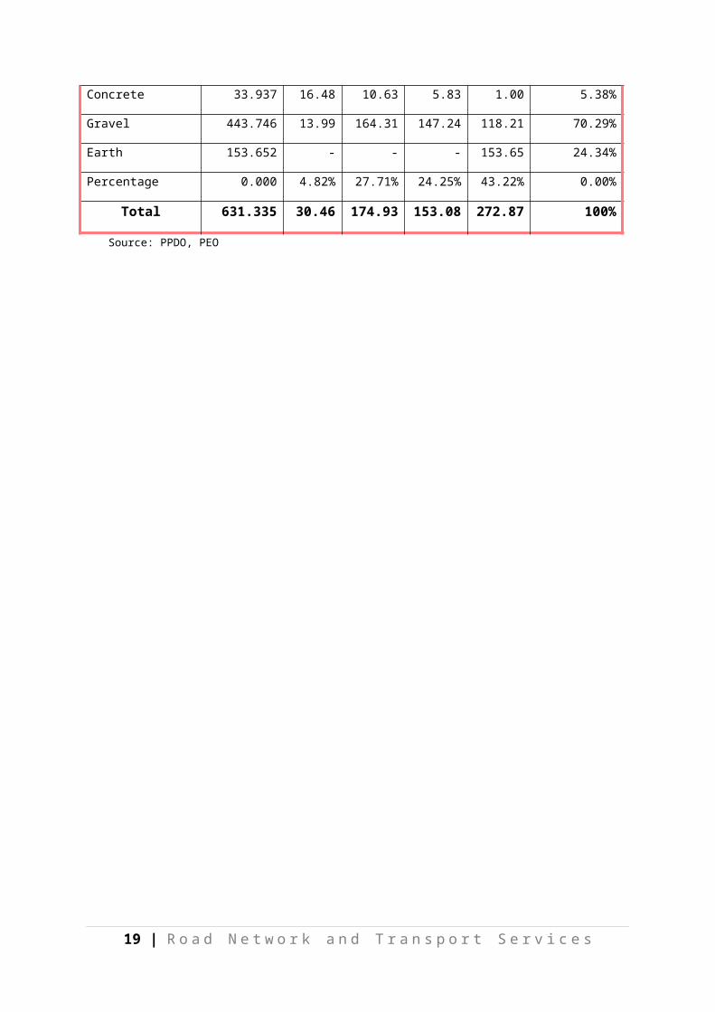
2.5.1. Provincial Road ConditionThe province has 631.335 kilometers of Provincial Road for 50 road sections, which are managed by the PEO. Compared to data in the first edition of ARNDP, the number of provincial roads increased by 99.61% from 316.28 kilometers after conducting a road reclassification. Data reveal that 67.47% (425.95 km) of these roads, whose conditions are classified as “poor” and “bad,” need to be rehabilitated (Tables 8 and 9).
Table 8: Provincial Road Condition
Type of Pavement Length (km) Good Fair Poor Bad Percentage
Concrete 33.937 16.48 10.63 5.83 1.00 5.38%
Gravel 443.746 13.99 164.31 147.24 118.21 70.29%
Earth 153.652 - - - 153.65 24.34%
Percentage 0.000 4.82% 27.71% 24.25% 43.22% 0.00%
Total 631.335 30.46 174.93 153.08 272.87 100%
Source: PPDO, PEO
14 | R o a d N e t w o r k a n d T r a n s p o r t S e r v i c e s

15 | R o a d N e t w o r k a n d T r a n s p o r t S e r v i c e s
rovin
Province of Compostela Valley
#Y
#Y
#Y
#Y
#Y
#Y
#Y
#Y
#Y
#Y
#Y
#Y
#Y
#Y
Loreto
La Paz
Trento
Esperanza
San Luis
Sibagat
Talacogon
Bayugan
Prosperidad
Bunawan
Rosario
Veruela
San Francisco
Sta. Josefa
8°00
' 8°00'
8°15
' 8°15'
8°30
' 8°30'
8°45
' 8°45'
9°00
' 9°00'
9°15
' 9°15'
125°15'
125°15'
125°30'
125°30'
125°45'
125°45'
126°00'
126°00'
126°15'
126°15'
1 : 1,400,000
10 0 10Kilometers
5
N
EW
S
BadMissing Link
National RoadGoodFair
Poor
Municipal Boundary
#Y Municipal Points
LEGEND :
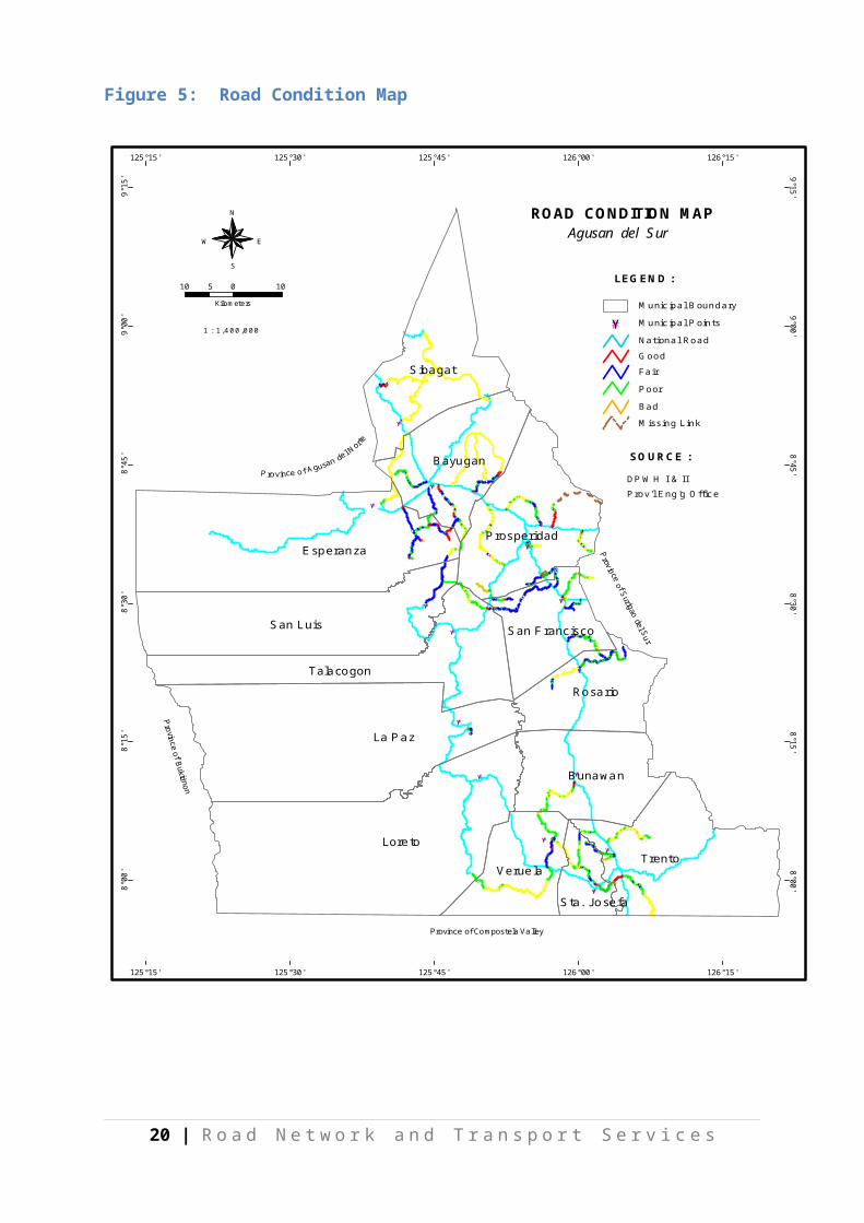
ROAD CONDITION MAPAgusan del Sur
DPWH I & IIProv'l Eng'g Office
SOURCE :
Figure 5: Road Condition Map

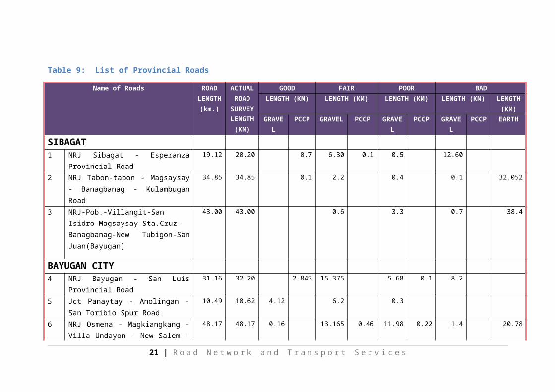
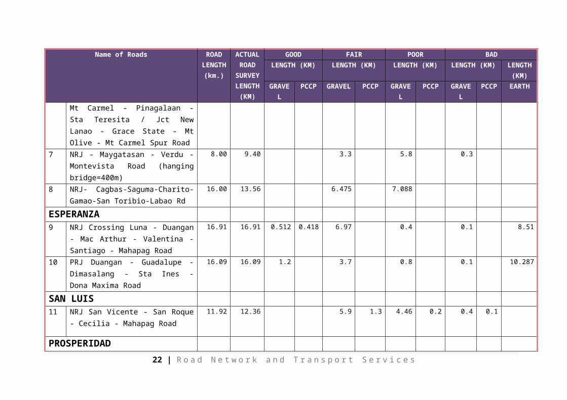
Table 9: List of Provincial Roads
Name of Roads ROAD LENGTH
(km.)
ACTUAL ROAD
SURVEY LENGTH
(KM)
GOOD FAIR POOR BADLENGTH (KM) LENGTH (KM) LENGTH (KM) LENGTH (KM) LENGTH
(KM)GRAVEL PCCP GRAVEL PCCP GRAVEL PCCP GRAVEL PCCP EARTH
SIBAGAT 1 NRJ Sibagat - Esperanza Provincial Road 19.12 20.20 0.7 6.30 0.1 0.5 12.60
2 NRJ Tabon-tabon - Magsaysay - Banagbanag - Kulambugan Road
34.85 34.85 0.1 2.2 0.4 0.1 32.052
3 NRJ-Pob.-Villangit-San Isidro-Magsaysay-Sta.Cruz-Banagbanag-New Tubigon-San Juan(Bayugan)
43.00 43.00 0.6 3.3 0.7 38.4
BAYUGAN CITY 4 NRJ Bayugan - San Luis Provincial Road 31.16 32.20 2.845 15.375 5.68 0.1 8.2
5 Jct Panaytay - Anolingan - San Toribio Spur Road
10.49 10.62 4.12 6.2 0.3
6 NRJ Osmena - Magkiangkang - Villa Undayon - New Salem - Mt Carmel - Pinagalaan - Sta Teresita / Jct New Lanao - Grace State - Mt Olive - Mt Carmel Spur Road
48.17 48.17 0.16 13.165 0.46 11.98 0.22 1.4 20.78
7 NRJ - Maygatasan - Verdu - Montevista Road (hanging bridge=400m)
8.00 9.40 3.3 5.8 0.3
16 | R o a d N e t w o r k a n d T r a n s p o r t S e r v i c e s

Name of Roads ROAD LENGTH
(km.)
ACTUAL ROAD
SURVEY LENGTH
(KM)
GOOD FAIR POOR BADLENGTH (KM) LENGTH (KM) LENGTH (KM) LENGTH (KM) LENGTH
(KM)GRAVEL PCCP GRAVEL PCCP GRAVEL PCCP GRAVEL PCCP EARTH
8 NRJ- Cagbas-Saguma-Charito-Gamao-San Toribio-Labao Rd
16.00 13.56 6.475 7.088
ESPERANZA 9 NRJ Crossing Luna - Duangan - Mac
Arthur - Valentina - Santiago - Mahapag Road
16.91 16.91 0.512 0.418 6.97 0.4 0.1 8.51
10 PRJ Duangan - Guadalupe - Dimasalang - Sta Ines - Dona Maxima Road
16.09 16.09 1.2 3.7 0.8 0.1 10.287
SAN LUIS 11 NRJ San Vicente - San Roque - Cecilia -
Mahapag Road 11.92 12.36 5.9 1.3 4.46 0.2 0.4 0.1
PROSPERIDAD 12 NRJ San Jose - Limbayugan - San Joaquin
- Aurora - Lucena - Road (Circumferential Road)
18.01 18.80 0.23 0.96 4.24 13.37
13 Road Around Brochino - Bahbah Public Market (on going=700 m)
1.53 1.50 0.7 0.5 0.3
14 NRJ San Rafael - San Roque - Calilid - San Luis Road
11.35 11.35 0.9 1.9 8.5546
15 NRJ Sta Irene - La Purisima - San Martin - New Maug Road (Circumferential Road)
12.24 12.90 0.673 2.4 0.027 5.7 4.10
16 NRJ Magsaysay - Sitio Supon - Taonaga 6.85 6.80 0.10 0.015 0.59 3.1 3
17 | R o a d N e t w o r k a n d T r a n s p o r t S e r v i c e s
Name of Roads ROAD LENGTH
(km.)
ACTUAL ROAD
SURVEY LENGTH
(KM)
GOOD FAIR POOR BADLENGTH (KM) LENGTH (KM) LENGTH (KM) LENGTH (KM) LENGTH
(KM)GRAVEL PCCP GRAVEL PCCP GRAVEL PCCP GRAVEL PCCP EARTH
Provincial Stock Farm Road
17 Government Center (Road D) 0.41 0.41 0.214 0.2
18 Government Center (Road A') 0.84 0.85 0.847
19 Government Center (Road A) 0.847 0.85 0.847
20 Government Center (Road G) 0.41 0.41 0.1 0.314
21 NRJ - San Rafael - PRJ Borbon Road 5.73 5.90 0.4 2.9 2.6 0
22 NRJ Patin-ay - Lucac - Pisaan Road 7.31 8.00 0.2 4.5 0.1 1.9 0.9 0.3 0.1
23 Government Center (Road E) 0.56 0.56 0.564
24 Government Center (Road F) 0.630.41
0.1 0.314
25 Government Center (Road C') 0.87 0.00
26 Government Center (Road C) 1.03 1.03 0.13 0.9
27 NRJ Bahbah - Puting Buhangin - Omot Provincial Road
10.81 10.81 0.6 1.6 8.61
28 NRJ Azpetia - Mabuhay - San Lorenzo - Lianga Boundary Road
16.89 16.59 3.8 0.4 0.9 0.6 10.89
29 NRJ Patin-ay – La Caridad - Tagapua Road
5.29 5.30 0.4 3.5 0.1 0.5 0.8
18 | R o a d N e t w o r k a n d T r a n s p o r t S e r v i c e s
Name of Roads ROAD LENGTH
(km.)
ACTUAL ROAD
SURVEY LENGTH
(KM)
GOOD FAIR POOR BADLENGTH (KM) LENGTH (KM) LENGTH (KM) LENGTH (KM) LENGTH
(KM)GRAVEL PCCP GRAVEL PCCP GRAVEL PCCP GRAVEL PCCP EARTH
30 NRJ - Patin-ay - Omot - Blue Guard - Lucac - Sitio Kantagan - Sitio Supon Road
12.00 12.00 4.713 3.752 0.542 0.479 0.1 2.415
TALACOGON 31 NRJ Del Monte Sitio Tuburan - Sitio Sta
Cruz - San Isidro (San Luis) Road9.02 9.41 7.11 2.3
LA PAZ 32 NRJ - Purok 3 (Poblacion) - Villa Paz -
Lower Maitom Road7.92 7.92 1.4 0.8 5.72
LORETO 33 NRJ-Bacay-Ihawan-Loreto-Boundary
Road 4.50 0.00
SAN FRANCISCO 34 NRJ Pisaan - Tagapua - Borbon - Rizal -
Del Monte Road16.64 16.54 0.61 13.83 1 1.1
35 NRJ Lapinigan -Mati - Maligaya - Cabantao Road
11.35 14.00 6 0.9 7.1
36 SFADS Public Market Roadnet 1.50 1.49 0.41 0.1 0.28 0.7
37 NRJ Karaos - Lapag - Mt Diwata Camp Site - Alegria Road
7.63 5.99 0.42 4.05 1.32 0.2
38 NRJ Barangay 1 - Bitan-agan - Das-agan - Tambis (Barobo) Road
8.14 11.00 0.352 0.048 7.3 3.3
ROSARIO
19 | R o a d N e t w o r k a n d T r a n s p o r t S e r v i c e s
Name of Roads ROAD LENGTH
(km.)
ACTUAL ROAD
SURVEY LENGTH
(KM)
GOOD FAIR POOR BADLENGTH (KM) LENGTH (KM) LENGTH (KM) LENGTH (KM) LENGTH
(KM)GRAVEL PCCP GRAVEL PCCP GRAVEL PCCP GRAVEL PCCP EARTH
39 NRJ Rosario - Mabtay - Boundary Tagbina Road
16.22 16.20 0.5 7.3 0.9 6.8 0.7
40 NRJ Poblacion Rosario-Tagbayagan-Novele-Cabawan-Sta. Cruz Road
8.30 16.80 3.9 0.8 6.3 0.1 5.7
BUNAWAN 41 NRJ San Teodoro - Poblacion - Nueva Era
- San Gabriel - Poblacion (Veruela) Road17.95 22.00 1.08 0.05 0.142 12.158 0.17 8.4
TRENTO 42 NRJ Pulang Lupa - Upper New Visayas -
Monkayo Boundary Road12.02 13.00 0.23 0.77 5.4 6.6
43 NRJ Basa - Tudela - San Isidro - Sta Maria Circumferential Road
18.36 18.36 0.496 4.764 7.884 5.2174
44 NRJ Pulang Lupa - Sta Josefa Road 7.13 7.23 1.02 1.17 0.21 4.43 0.4
46 NRJ-Poblacion - Upper Lucad - Sta. Isabel Road
9.38 9.38 0.41 1.09 1.41 6.47
47 NRJ Kapatungan-Pag-asa-Tapaz - Rd 8.96 10.74 1.7 7.04 2
48 NRJ Poblacion - Lower Lucad - Aurora Rd. 6.85 7.36 1.16 5.62 0.58
STA. JOSEFA 45 NRJ Sta Josefa - Aurora - Tapaz -
Poblacion, Veruela - Sampaguita Road 21.89 22.07 1.395 7.285 1.34 5.52 0.13 6.4
20 | R o a d N e t w o r k a n d T r a n s p o r t S e r v i c e s
Name of Roads ROAD LENGTH
(km.)
ACTUAL ROAD
SURVEY LENGTH
(KM)
GOOD FAIR POOR BADLENGTH (KM) LENGTH (KM) LENGTH (KM) LENGTH (KM) LENGTH
(KM)GRAVEL PCCP GRAVEL PCCP GRAVEL PCCP GRAVEL PCCP EARTH
49 NRJ Pob. Angas- Awao Rd 9.00 9.00 2 3.44 2.46 0.1 1
VERUELA 50 NRJ-Loreto- Binucayan- Sta. Cruz-
Katipunan Road41.00 41.00 24 7 10
Total 613.122 631.335 13.985 16.476 164.306 10.627 147.242 5.834 118.214 1.000 153.652
21 | R o a d N e t w o r k a n d T r a n s p o r t S e r v i c e s
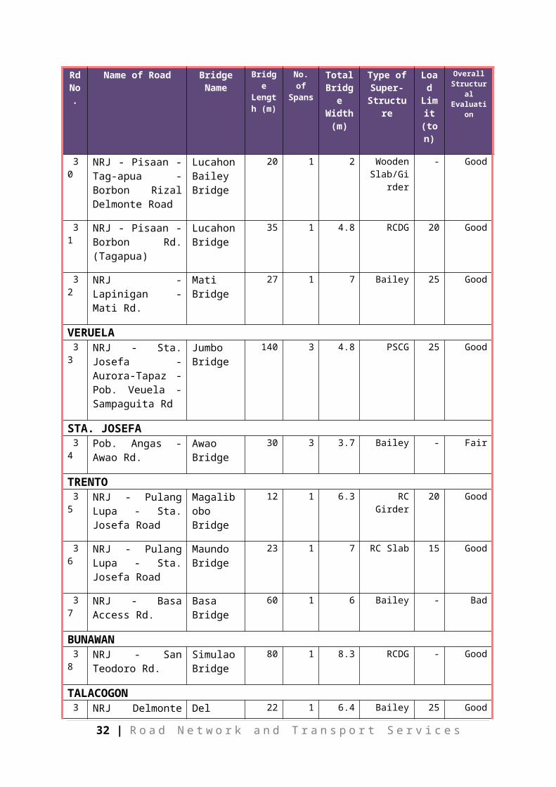
2.5.2. Provincial Bridge ConditionThere are 39 bridges along the Provincial Roads in Agusan del Sur with a total length of 1,722 linear meter (Table 10). The detailed inventory and condition of all provincial bridges shows that mostly the type of bridge structure are bailey and 28 units or 71.79% of these provincial bridges are in good condition. The locations and conditions of the provincial bridges are also shown in Figure 4.
Table 10: Bridges Along Provincial Roads
Rd No.
Name of Road Bridge Name
Bridge Length
(m)
No. of Spans
Total Bridge Width
(m)
Type of Super-
Structure
Load Limit (ton)
Overall Structural Evaluation
SIBAGAT 1 NRJ-Tabon-tabon -
Sta Maria - Sta Cruz - Perez Road
Camponay Bridge
20 1 Spillway Good
2 NRJ - Pob. Villangit - San Isidro
Sibagat Bridge
62 1 8.5 Steel Girder
- Good
3 NRJ - Sibagat - Esperanza Rd. (San Vicente)
Ilihan Bridge
20 1 7.5 RCDG - Poor
4 NRJ - Sibagat - Esperanza
San Agustin
20 1 7.5 RCDG 15 Poor
5 NRJ - Sibagat - Esperanza Rd. (Ilihan)
Sinai Bridge
27 3 7.5 RCDG - Fair
BAYUGAN 6 NRJ - Saguma -
Charito - Gamao San Toribio Bridge 2
Mahabu Bridge
21 1 10.7 RC Girder - Good
7 NRJ - Saguma - Charito - Gamao San Toribio Spillway
Saguma Spillway
30 1 6.6 Spillway - Good
8 NRJ - Saguma - Charito - Gamao - San Toribio Bridge 3
Labao Bridge
16 1 6.6 RC Girder - Good
9 NRJ - Maygatasan - Verdu - Montavista Rd.
Maygatasan Hanging BrIdge
442 1 1.5 Steel Grating
- Fair
22 | R o a d N e t w o r k a n d T r a n s p o r t S e r v i c e s
Rd No.
Name of Road Bridge Name
Bridge Length
(m)
No. of Spans
Total Bridge Width
(m)
Type of Super-
Structure
Load Limit (ton)
Overall Structural Evaluation
10 NRJ - Osmeña - Magkiangkang - Villa Undayon Rd.
Villa Undayon Bridge
40 1 7 Bailey - Good
11 NRJ- Bayugan-San Luis Road
San Isidro Bridge
20 1 6.8 RCDG 20 Fair
12 NRJ- Bayugan-San Luis Road
Muritula Bridge
23 1 RCDG Fair
13 NRJ- Bayugan-San Luis Road
Bucac Bridge
87 3 7.2 RCDG 20 Fair
14 NRJ- Bayugan-San Luis Road
Panaytay bridge
30 1 7.8 RCDG 20 Good
ESPERANZA 15 PRJ - Duangan -
Guadalupe - Dimasalang - Sta. Ines Doña Maxima Road
Agiabao Bridge
12 1 5.1 RC Slab 20 Good
16 Jct. Duangan - Guadalupe Rd.
Labao Bridge
33 1 7 Bailey 25 Good
PROSPERIDAD17 NRJ - Magsaysay -
Sitio Supon - Taonaga Prov'l. Stock Farm Rd.
Taonaga Bridge 2
17 1 7 Steel Girder
25 Good
18 NRJ - Magsaysay - Sitio Supon - Taonaga Prov'l. Stock Farm Rd.
Taonaga Spillway
17 1 5 Spillway - Good
19 NRJ - Magsaysay - Sitio Supon - Taonaga Prov'l. Stock Farm Rd.
Taonaga Bridge 1
15 1 7 Steel Girder
25 Good
20 Sta. Irene Extension Rd. (La Purisima) Rd.
Lapgap Bridge
21 1 7 Bailey 25 Good
21 Sta. Irene Extension Rd. (San Martin) Rd.
Maitom Bridge
35 1 8.6 Steel - Good
23 | R o a d N e t w o r k a n d T r a n s p o r t S e r v i c e s

Rd No.
Name of Road Bridge Name
Bridge Length
(m)
No. of Spans
Total Bridge Width
(m)
Type of Super-
Structure
Load Limit (ton)
Overall Structural Evaluation
22 NRJ - Sta. Irene Access Rd.
Maug Bridge
45 1 4 Bailey - Poor
23 NRJ - San Jose -Limbayugan - San Joaquin Rd.
San Joaquin Bridge
39 1 7 Bailey - Fair
ROSARIO 24 NRJ - Rosario- -
Mabtay - Boundary Tagbina Road
Cabantao Bridge
15 1 7.4 Steel Girder
25 Good
25 NRJ - Rosario - Tagbayagan - Palibo - Sabang - Agdawan Pob. (LAPAZ) Road
Palibo Bridge
30 1 7.4 Bailey/ Steel
Girder
25 Good
26 NRJ - Rosario - Mabtay Rd. (Libuac)
Limbatangan Bridge
36 1 7 Bailey 25 Good
27 NRJ - Rosario - Mabtay Rd. (Mabtay)
Mabtay Bridge
24 1 7 Bailey 24 Good
SAN FRANCISCO28 NJR - Pisaan -
Tagapua - Borbon - Rizal- Del Monte Rd.
Borbon Bridge
52 3 5.4 RC Girder - Good
29 NRJ - Brgy. 1 - Bitan-agan - Das - agan - Tambis Road
Bitan - agan Bridge
24 1 7.4 Bailey 25 Good
30 NRJ - Pisaan - Tag-apua - Borbon Rizal Delmonte Road
Lucahon Bailey Bridge
20 1 2 Wooden Slab/Girder
- Good
31 NRJ - Pisaan - Borbon Rd. (Tagapua)
Lucahon Bridge
35 1 4.8 RCDG 20 Good
32 NRJ - Lapinigan - Mati Rd.
Mati Bridge
27 1 7 Bailey 25 Good
VERUELA 33 NRJ - Sta. Josefa -
Aurora-Tapaz - Pob. Veuela - Sampaguita Rd
Jumbo Bridge
140 3 4.8 PSCG 25 Good
24 | R o a d N e t w o r k a n d T r a n s p o r t S e r v i c e s

Rd No.
Name of Road Bridge Name
Bridge Length
(m)
No. of Spans
Total Bridge Width
(m)
Type of Super-
Structure
Load Limit (ton)
Overall Structural Evaluation
STA. JOSEFA 34 Pob. Angas - Awao
Rd.Awao Bridge
30 3 3.7 Bailey - Fair
TRENTO 35 NRJ - Pulang Lupa -
Sta. Josefa RoadMagalibobo Bridge
12 1 6.3 RC Girder 20 Good
36 NRJ - Pulang Lupa - Sta. Josefa Road
Maundo Bridge
23 1 7 RC Slab 15 Good
37 NRJ - Basa Access Rd. Basa Bridge
60 1 6 Bailey - Bad
BUNAWAN 38 NRJ - San Teodoro
Rd.Simulao Bridge
80 1 8.3 RCDG - Good
TALACOGON 39 NRJ Delmonte Sitio
Tuburan - Sitio Sta. Cruz - San Isidro ( San Luis) Road
Del Monte Bridge
22 1 6.4 Bailey 25 Good
Total 1,722.00 LM (39 units)
25 | R o a d N e t w o r k a n d T r a n s p o r t S e r v i c e s
26 | R o a d N e t w o r k a n d T r a n s p o r t S e r v i c e s
Figure 6: Provincial Bridges Location and Condition

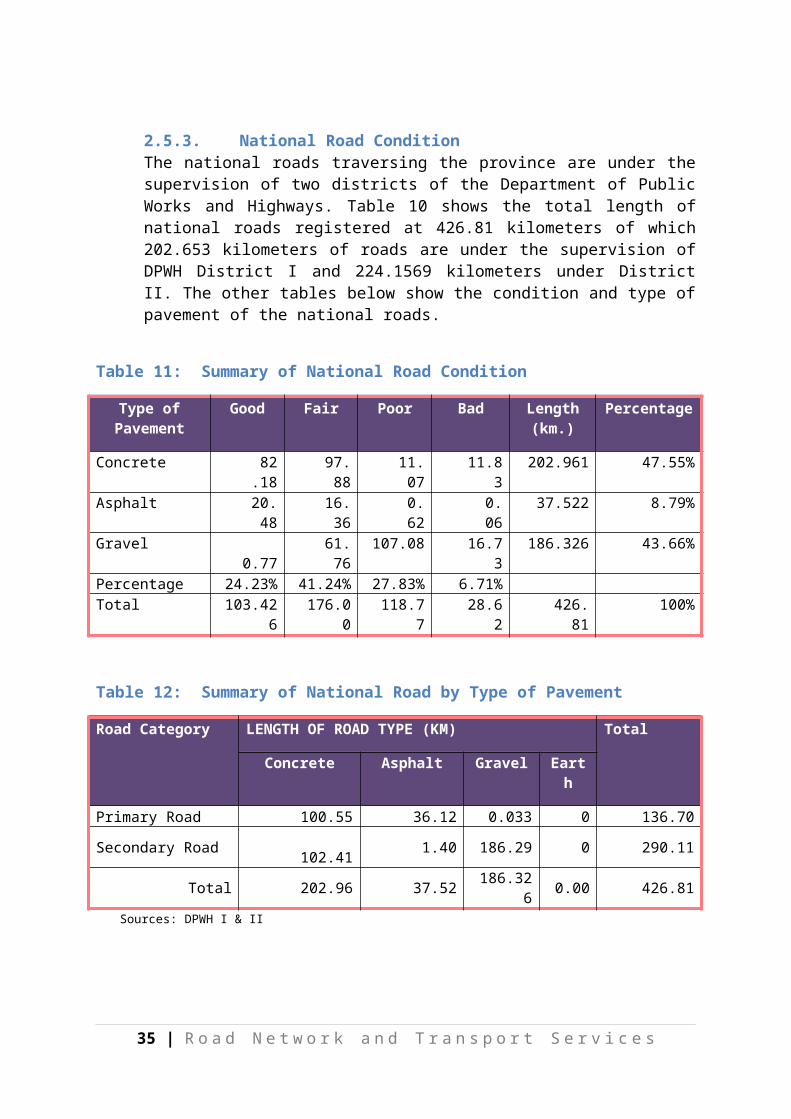
2.5.3. National Road ConditionThe national roads traversing the province are under the supervision of two districts of the Department of Public Works and Highways. Table 10 shows the total length of national roads registered at 426.81 kilometers of which 202.653 kilometers of roads are under the supervision of DPWH District I and 224.1569 kilometers under District II. The other tables below show the condition and type of pavement of the national roads.
Table 11: Summary of National Road Condition
Type of Pavement
Good Fair Poor Bad Length (km.)
Percentage
Concrete 82.18 97.88 11.07 11.83 202.961 47.55%Asphalt 20.48 16.36 0.62 0.06 37.522 8.79%Gravel 0.77 61.76 107.08 16.73 186.326 43.66%Percentage 24.23% 41.24% 27.83% 6.71% Total 103.426 176.00 118.77 28.62 426.81 100%
Table 12: Summary of National Road by Type of Pavement
Road Category LENGTH OF ROAD TYPE (KM) Total
Concrete Asphalt Gravel Earth
Primary Road 100.55 36.12 0.033 0 136.70Secondary Road 102.41 1.40 186.29 0 290.11
Total 202.96 37.52 186.326 0.00 426.81Sources: DPWH I & II
Table 13: Summary of National Road Condition in District I
Type of Pavement Good Fair Poor Bad Length (km.)
Percentage
Concrete 24.08 81.73 4.98 0.05 110.843 54.70%Asphalt 2.26 15.26 0.33 0.06 17.908 8.84%Gravel - 0.65 70.35 2.91 73.901 36.47%Percentage 13.00% 48.18% 37.33% 1.49% 100.00%
Total 26.34 97.64 75.66 3.02 202.652Source: DPWH Dist. I
27 | R o a d N e t w o r k a n d T r a n s p o r t S e r v i c e s
Table 14: Summary of National Road Condition in District II
Type of Pavement Good Fair Poor Bad Length (km.)
Percentage
Concrete 58.097 16.150 6.088 11.783 92.118 41.10%Asphalt 18.225 1.099 0.290 - 19.614 8.75%Gravel 0.766 61.112 36.731 13.816 112.425 50.15%Percentage 34.39% 34.96% 19.23% 11.42% Total 77.09 78.36 43.11 25.60 224.1565 100%
Source: DPWH Dist. II
28 | R o a d N e t w o r k a n d T r a n s p o r t S e r v i c e s
Table 15: Road Condition and Type of Pavement of National Road in District 1
District Road Section / ID Section
ROAD NETWORK
Classifi-cation
Concrete Total Length
Asphalt Total Length
Gravel Total Lengt
h
Total Length of NetworkGood Fair Poor Bad Good Fair Poor Bad Good Fair Poor Bad
Agusan-Davao RoadS00446MN
Primary Road
4.340 40.856 1.2185 0.05 46.464 1.03 15.26 0.3 0.06 16.65 0.033 0.033 63.147
Daang Maharlika ( Bayugan Rotunda )S00443MN
Primary Road
0.000 0.16 0 0 0.16 0 0 0 0 0 0 0 0.000 0 0 0.16
NRJ Butuan City- Pianing Tandag Road S00461MN
Secondary Road
1.800 0.928 0 0 2.728 0 2.91 0.033 2.761
Agusan-Malaybalay Road S00470MN
Secondary Road
0.488 1.367 1.855 0 3.110 3.110 4.965
NRJ Bayugan-Calaitan Tandag Road S00457MN
Secondary Road
3.181 2.12 5.30052 0 25.65 25.65 30.95
NRJ Bayugan-Esperanza Road S00458MN, S00468MN
Secondary Road
0.300 5.3055 0.0675 5.673 0 1.241 28.76 40.5645
0.081 0.094 0.176 0 5.956 5.956
NRJ Awa-Azpetia -Lianga Road S00459MN
Secondary Road
11.09 3.697 14.79 0 0.091 0.091 14.877
NRJ Bahbah- Talacogon Road
S00460MN, S00469MN
Secondary Road
0.4970 13.5525
2.4345 16.484 0 0.055 6.047 45.229
10.0 0.18 10.21 1.104 0.032 1.135 11.35
NRJ Bahbah-Talacogon RoadS00477MN
Secondary Road
0.269 0.081 0.35 0.123 0.123 0.473 0.946
29 | R o a d N e t w o r k a n d T r a n s p o r t S e r v i c e s
District Road Section / ID Section
ROAD NETWORK
Classifi-cation
Concrete Total Length
Asphalt Total Length
Gravel Total Lengt
h
Total Length of NetworkGood Fair Poor Bad Good Fair Poor Bad Good Fair Poor Bad
NRJ Butuan City-Talacogon-Loreto-Veruela-Sta. Josefa Road S00474MN
Secondary Road
2.287 2.991 0.905 6.182 0 34.21 11.82 18.004
NRJ Bahbah-Talacogon( By Pass ) Road S00465MN
Secondary Road
0.100 0.37 0.47 0 0.645 0.645 1.115
Total Secondary Road 19.74 40.71 3.762 0 64.22 1.227 0.032 1.258 0.645 70.31 2.91 73.87 139.345
TOTAL 24.082 81.731 4.981 0.05 110.84 2.257 15.260 0.332 0.06 17.908 0.00 0.645 70.347 2.91 73.901 202.652
30 | R o a d N e t w o r k a n d T r a n s p o r t S e r v i c e s
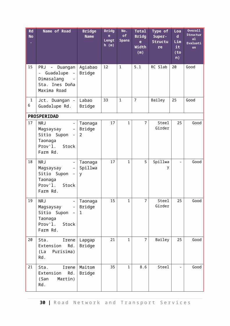
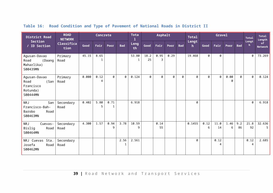
Table 16: Road Condition and Type of Pavement of National Roads in District II
District Road Section / ID Section
ROAD NETWORK
Classification
Concrete Total Length
Asphalt Total Length
Gravel Total Length
Total Length of NetworkGood Fair Poor Bad Good Fair Poor Bad Good Fair Poor Bad
Agusan-Davao Road (Daang Maharlika) S00439MN
Primary Road 45.15 8.651 53.801 18.225 0.953 0.29 19.468 0 0 0 73.269
Agusan-Davao Road (San Francisco Rotunda) S00444MN
Primary Road 0.000 0.124 0 0 0.124 0 0 0 0 0 0 0 0.000 0 0 0.124
NRJ San Francisco-Bah-Barobo Road S00463MN
Secondary Road
0.402 5.805 0.711 6.918 0 0 6.918
NRJ Cuevas-Bislig Road S00464MN
Secondary Road
4.300 1.57 0.949 3.78 10.599 0.1455 0.1455 0.126 11.014 1.466 9.286
21.892 32.6365
NRJ Cuevas Sta. Josefa Road S00462MN
Secondary Road
2.561 2.561 0 0.124 0.124 2.685
NRJ. Cuevas-Sampaguita Road S00471MN
Secondary Road
0.200 3.7 5.03 8.930 0 3.131 3.131 12.061
NRJ. Cuevas-Sampaguita Road S00466MN
Secondary Road
3.086 3.086 0 0.000 3.086
Pulang Lupa -Sta. Josefa Road S00467MN
Secondary Road
0.000 0 4.07 4.070 4.07
Pulang Lupa -Sta. Secondary 0.1970 0.215 0.412 0 2.625 2.625 3.037
31 | R o a d N e t w o r k a n d T r a n s p o r t S e r v i c e s

District Road Section / ID Section
ROAD NETWORK
Classification
Concrete Total Length
Asphalt Total Length
GravelTotal
Length
Total Length of NetworkGood Fair Poor Bad Good Fair Poor Bad Good Fair Poor Bad
Josefa Road S00472MN
Road
Butuan City - Talacogon-Loreto-Veruela-Sta. Josefa Road S00440MN
Secondary Road
2.4030 2.403 0 7.95 13.175 21.125 23.528
Butuan City - Talacogon-Loreto-Veruela-Sta. Josefa Road S00447MN
Secondary Road
0.783 0.197 0.98 0 0.31 3.352 7.620 11.282 12.262
Butuan City - Talacogon-Loreto-Veruela-Sta. Josefa Road S00478MN
Secondary Road
1.576 0.728 2.304 0 0.33 11.51 7.770 19.61 21.914
Asuncion -San Isidro, Davao del Norte-laak Comval-Veruela Road S00480MN
Secondary Road
0 0 17.336 6.7 4.530
28.566 28.566
Total Secondary Road 12.947 7.375 6.088 11.783 38.193 0 0.1455 0 0 0.1455 0.766 61.112 36.731 13.82
112.425
150.764
TOTAL 58.097 16.15 6.088 11.783 92.118 18.225 1.0985 0.290 19.6135 0.766 61.112 36.731 13.816
112.425
224.157
Source: DPWH District II
32 | R o a d N e t w o r k a n d T r a n s p o r t S e r v i c e s
2.5.4. Municipal Road ConditionThe municipal road network of the entire province totalled to 347.459 kilometers found in the 14 municipalities which is about 10.79 percent of the existing total road network of 3,220.687 kilometers. Most of these municipal roads are graveled (75.29 percent) as shown in Table 16. It also shows that 64.88 percent of these municipal roads need to be improved and rehabilitated.
Table 17: Municipal Road Condition
Type of Pavement
Length (km.)
Good Fair Poor Bad Percentage
Concrete 51.037 18.510 22.699 4.827 5.001 14.69%Asphalt 2.13 0.53 1.60 - - 0.61%Gravel 261.604 7.820 70.884 46.660 136.240 75.29%Earth 32.688 - - - 32.688 9.41%Percentage 7.73% 27.39% 14.82% 50.06% 100.00%Total 347.459 26.86 95.18 51.49 173.93
Table 18: Summary of Municipal Road by Type of Pavement
Name of Municipality
Concrete Asphalt Gravel Earth Total Length of Road
(Km.)
1. Sibagat 3.706 0 0.598 0.303 4.607
2. Bayugan 7.096 1.6 8.158 0.123 16.977
3. Prosperidad 3.92 0 3.41 0 7.330
4. San Francisco 4.484 0 10.64 2.548 17.672
5. Rosario 2.7 0.53 4.985 0 8.215
6. Bunawan 1.64 0 0 0 1.640
7. Trento 6.383 0 13.523 7.144 27.050
8. Sta. Josefa 2.17 0 5.57 14.31 22.050
9. Veruela 0.35 0 4.65 0 5.000
10. Loreto 2.471 0 0 0 2.471
11. La Paz 3.38 0 52.5 8 63.880
12. Talacogon 2.01 0 4.43 0.26 6.700
13. San Luis 0 0 142.74 0 142.740
14. Esperanza 10.727 0 10.4 0 21.127
Total 51.037 2.13 261.604 32.688 347.459
Source: MLGU/MEO/MPDO/PPDO
33 | R o a d N e t w o r k a n d T r a n s p o r t S e r v i c e s

2.5.5. Barangay Road ConditionBarangay road network of the entire province is registered at 56.36 percent of the total road network, only 0.60% of these barangay roads are concrete and asphalted. A total of 1,138.29 kilometers or 62.71 percent of these barangay roads need to be improved and rehabilitated.
Table 19: Summary of Barangay Road Condition
Type of Pavement
Length (km.) Good Fair Poor Bad Percentage
Concrete 10.757 9.49 1.27 - - 0.59%
Asphalt 0.100 - - - 0.10 0.01%
Gravel 1,197.703 94.22 571.82 179.31 352.35 65.99%
Earth 606.525 606.53 33.42%
Percentage 5.71% 31.57% 9.88% 52.83% 100.00%
Total 1,815.08 103.71 573.09 179.31 958.98
Table 20: Summary of Barangay Road by Type of Pavement
Name of Municipality
Concrete Asphalt Gravel Earth Total Length of Road (Km.)
1. Sibagat 0.65 0 76.6 108.85 186.100
2. Bayugan 0 0 219.2 61.8 281.000
3. Prosperidad 0 0 195.02 0 195.020
4. San Francisco 1.2 0 35.7 21.5 58.400
5. Rosario 0 0.1 68.9765 51.735 120.812
6. Bunawan 0 0 83.01 0 83.010
7. Trento 1.27 0 78.33 22.35 101.950
8. Sta. Josefa 6.537 0 59.895 23.49 89.922
9. Veruela 0 0 15.5 47.8 63.300
10. Loreto 0 0 55.64 166 221.640
11. La Paz 0 0 65.1 0 65.100
12. Talacogon 1.1 0 73.181 93.5 167.781
34 | R o a d N e t w o r k a n d T r a n s p o r t S e r v i c e s

Name of Municipality
Concrete Asphalt Gravel Earth Total Length of Road (Km.)
13. San Luis 0 0 0 9.5 9.500
14. Esperanza 0 0 171.55 0 171.550
Total 10.757 0.1 1,197.70 606.525 1,815.085
Source: MLGU/MEO/MPDO/PPDO
2.6. Traffic ConditionAgusan del Sur has a very light traffic condition as shown in the map below. Heavy traffic are only located at San Francisco Public Market Road section (provincial road) where Jollibee food chain and Bus Terminal are located and light traffic condition are located at Brochino-Bahbah (road around) public market (provincial road).
35 | R o a d N e t w o r k a n d T r a n s p o r t S e r v i c e s
rovi
Province of Compostela Valley
#Y
#Y
#Y
#Y
#Y
#Y
#Y
#Y
#Y
#Y
#Y
#Y
#Y
#Y
Loreto
La Paz
Trento
Esperanza
San Luis
Sibagat
Talacogon
Bayugan
Prosperidad
Bunawan
Rosario
Veruela
San Francisco
Sta. Josefa
8°00
' 8°00'
8°15
' 8°15'
8°30
' 8°30'
8°45
' 8°45'
9°00
' 9°00'
9°15
' 9°15'
125°15'
125°15'
125°30'
125°30'
125°45'
125°45'
126°00'
126°00'
126°15'
126°15'
1 : 1,400,000
10 0 10Kilometers
5
N
EW
S
BadMissing Link
National RoadGoodFair
Poor
Municipal Boundary
#Y Municipal Points
LEGEND :
ROAD CONDITION MAPAgusan del Sur
DPWH I & IIProv'l Eng'g Office
SOURCE :
36 | R o a d N e t w o r k a n d T r a n s p o r t S e r v i c e s
Figure 7: Condition of Provincial Roads

3. Road InvestmentThe Provincial Local Government Unit (PLGU) and its Municipal and Barangay Local Government Units (MLGU/BLGU) have no regular fund allocations for rehabilitation and maintenance of their respective roads. Construction and concreting of road is minimal due to insufficient funds that cannot even cope with the total length of road for rehabilitation and maintenance.
The province had been a recipient of funding for the construction and rehabilitation of roads from national government agencies like Department of Public Works and Highways (DPWH), Department of Agriculture (DA) through the Support to Emergency Livelihood Assistance Program (SELAP), Caraga Integrated Development Program (CIDP), Special Local Road Fund (SLRF), Various infrastructure Local Projects (VILP), Kalayaan sa Barangay Program (KBP), GMA Banner Program and other agencies.
It was also a recipient of funding from foreign donors in the rehabilitation of farm to market road, thru special projects like, Mindanao Rural Development Project (MRDP) financed by World Bank, and Mindanao Sustainable Settlement Area Development (MINSSAD). From 2007 to 2009, a total of 95.99 km of FMR is constructed with an investment of Php. 213,240,340.41 and road rehabilitation for 925.83 km with an investment of Php 406,215,690.38 as shown in Tables 20 and 21.
Despite the programs and projects implemented in the said years that were both funded locally and donor agencies, the improvements are still found inadequate. Majority the roads are still gravel and in poor condition.
Table 21: Road Investment by Category
Road Investment (2007-2009) TotalSource of
FundsLenght (km)
2007 (Php)
Lenght (km)
2008(PHP)
Lenght (km)
2009(Php)
Lenght (km).
Amount (Php)
National Road Investment
No data 60.0M No data 179.012M
No data 169.50M
No data
408,512,200.00
Provincial Road Investment
684.06 77.991M
315.61 18.70M 27.14 37.50M 1,026.81
134,191,841.37
Barangay/ Road Investment
176.11 249.03M
103.81 185.884M
67.79 129.08M
347.71 563,994,889.42
Total Road 860.17 387.02M
419.42 383.596M
94.93 336.08M
1,374.53
1,106,698,930.79
Source: PPDO
37 | R o a d N e t w o r k a n d T r a n s p o r t S e r v i c e s
Table 22: National Road Investment
ConstructionLenght (km)
2007 (Php)
Length (km)
2008 (Php) Length (km)
2009 (Php)
no data 30 M no data 60,000,000.00
No funds
Total (2007-2009) km. No data Php 90,000,000.00
Concretingno data 30 M no data 119,012,200.
00no data 169,500,000.
00Total (2007-
2009)km. no data Php 318,512,200.
00Total National Road Investment Php 408,512,20
0.00Source: PPDO
Table 23: Provincial Road Investment
Concreting
Length (km) 2007 (Php) Length (km) 2008 (Php) Length (km) 2009 (Php)
352.38 41,211,400.00
0.13 3,000,000.00 0.20 3,000,000.00
Total (2007-2009) km. 352.71 Php 47,211,400.00
Rehab. and Maintenance
331.68 36,780,441.37
315.48 15,700,000.00 26.94 34,500,000.00
Total (2007-2009) km. 674.10 Php 86,980,441.37
Total Provincial Road Investment Php 134,191,841.37
Source: PPDO
38 | R o a d N e t w o r k a n d T r a n s p o r t S e r v i c e s

Table 24: Barangay/FMR Road Investment
Construction
Length (km)
2007 (Php) Length (km)
2008 (Php) Length (km)
2009 (Php)
63.02 144,117,840.41
30.30 61,122,500.00 2.67 8,000,000.00
Total (2007-2009) km. 95.99 Php 213,240,340.41
Concreting
No funds No data 21,019,300.00 no data 10,500,000.00
Total (2007-2009) km. no data Php 31,519,300.00
Rehab. and Maintenance
113.09 104,912,502.3 73.51 103,742,742.65
65.126 110,580,004.10
Total (2007-2009) km. 251.73 Php 319,235,249.01
Total Barangay/FMR Road Investment Php 563,994,889.42
4. Source: PPDO
Table 25: Summary of Road Investments
Road Investment (2007-2009)
Source of Funds Lenght (km)
2007 (Php) Length (km)
2008 (php) Length
(km)
2009 (Php)
Locally Funded Project 375.49 58,800,000.00 371.39 53,340,000.00 63.59 96,000,000.00
PLGU Funded for Brgy. & Mun. Dev't Project
- 1,222,000.00 0.00 3,155,000.00 0 5,696,000.00
Caraga Integrated Dev't. Project (CIDP)
- 0.00 10.50 15,000,000.00 2.667 8,000,000.00
SLRF-MVUC Projects 20.40 1,918,842.98 0.00 0.00 0 0.00Various Infrastructure Local Projects
11.82 22,500,000.00 0.00 0.00 0 0.00
Support to Emergency 3.76 4,200,000.00 0.00 0.00 0 0.00
39 | R o a d N e t w o r k a n d T r a n s p o r t S e r v i c e s
Road Investment (2007-2009)
Source of Funds Lenght (km)
2007 (Php) Length (km)
2008 (php) Length
(km)
2009 (Php)
and Livelihood Project (SELAP)MINSSAD Road Projects
85.44 164,246,813.51 2.41 2,713,493.21 4 1,839,966.64
MRDP 15.69 25,545,387.55 55.80 83,874,249.44 13.01 22,970,537.46Kalayaan sa Barangay Program (KBP)
- 0.00 0.00 0.00 0 73,500.00
DPWH (District 1 & 2) - 108,589,140.00 0.00 203,874,000.00 0 176,500,000.00GMA Banner Program - 0.00 10.20 21,640,000.00 11.47 25,000,000.00
Total 512.60 387,022,184.04 450.30 383,596,742.65 94.74 336,080,004.10
40 | R o a d N e t w o r k a n d T r a n s p o r t S e r v i c e s

41 | R o a d N e t w o r k a n d T r a n s p o r t S e r v i c e s
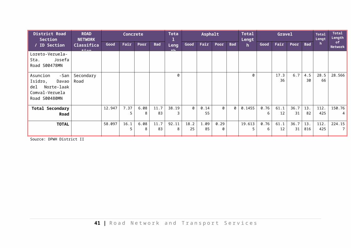
Table 26: Summary of Road Condition
Type of Pavement
Road Category Percentage
National Provincial Municipal Barangay Total
Concrete
Good 82.18 16.476 18.51 9.49 126.65 3.93%
Fair 97.88 10.627 22.699 1.27 132.48 4.11%
Poor 11.07 5.834 4.827 - 21.73 0.67%
Bad 11.83 1.000 5.001 - 17.83 0.55%
Asphalt
Good 20.48 0 0.53 - 21.01 0.65%
Fair 16.36 0 1.60 - 17.96 0.56%
Poor 0.62 0 - - 0.62 0.02%
Bad 0.06 0 - 0.10 0.16 0.00%
Gravel
Good 0.77 13.985 7.82 94.22 116.79 3.63%
Fair 61.76 164.306 70.884 571.82 868.77 26.97%
Poor 107.08 147.242 46.66 179.31 480.29 14.91%
Bad 16.73 118.214 136.24 352.35 623.53 19.36%
Earth 153.652 32.688 606.53 792.86 24.62%
TOTAL 426.81 631.335 347.46 1,815.08 3,220.687 100.00%
42 | R o a d N e t w o r k a n d T r a n s p o r t S e r v i c e s

4. Summary and RecommendationsAfter the reclassification of roads was done, the existing road network in Agusan del Sur comes to a total to 3,220.687 kilometers as reflected in ARNDP2ND Edition. It increased by 3.81% (118.067 km) compared to ARNDP 1st Edition.
Based on the current road network, only 8.21% or 264.45 km are in good condition for any type of pavement, 31.6% or 1,019.20 km in fair condition and the remaining 60.14% or 1,937.03 km are in poor and bad condition.
Majority of the roads is gravel, which constitute 64.87% or 2,089.38 kilometers of the total road network. The province’s appropriation for roads rehabilitation and maintenance is insufficient to cope with the existing demand for maintenance and rehabilitation.
Recommendation:
Given that roads are the provincial government’s assets and play a vital role in achieving Agusan del Sur’s vision, it is recommended that:
1) Sufficient funds will be earmarked annually for maintenance and improvement of roads;
2) Mobilize communities for road maintenance;3) Conduct information, education and advocacy for road maintenance; 4) Conduct periodic monitoring and evaluation; and5) Strict enforcement of road policies.
43 | R o a d N e t w o r k a n d T r a n s p o r t S e r v i c e s