Embed Size (px)
Citation preview

INTERSECTING FAULTS AND SANDSTONE STRATIGRAPHY AT THE CERRO PRIETO GEOTHERMAL FIELD
Stephen Vonder Haar and J. H. Howard Lawrence Berkeley Laboratory University of California Berkeley, California 94720
ABSTRACT
The northwest-southeast trending Cerro is part of a major regional lineament that Sonora and has characteristics of both a
Prieto extends into
wrench
fault
fault and an oceanic transform fault. It apparently penetrates deep into the basement and crustal rocks in the area and serves as a conduit for both large and rapid heat flow. Near well M-l03. where the Michoacan fault zone obliquely intersects a shorter northeast-southwest trending fault, large circulation losses during drilling indicate greater permeability and hence increased natural convective fluid flow. In the southern portion of the field, there is a shear fault zone in the vicinity of wells M-48, M-91, and M·l0l. Temperature contour maps suggest that this shear zone aids in rapidly distributing geothermal fluid away from the Cerro Prieto fault zone, thus enhancing recharge.
We have studied the distribution of lithologies and temperature within the field by comparing data from well cuttings, cores, well logs, and geochel1lical analyses. Across the earliest developed portion of the field, in particular along a- 1.25-km northeast-southwest section from well M-9 to M·10, interesting correlations emerge that indicate a relationship among lithology, microfracturing, and temperature distribution. In the upper portion of Reservoir. A of this stratigraphic section, between 1,200 and 1,400 m, the percentage of sandstones ranges from 20 to 55. Temperatures are 225°C to 275°C based on well logs, calcite isotope maxima, and Na-K-Ca indices. Our study shows that an isothermal high in this vicinity corresponds to the lowest total percentage of sandstones. Scanning electron microphotographs of well cores and cuttings from sandstone and shale units reveal clogging, mineral dissolution,
..'............'-,..}= Boundary of Sol ton Trough
Faults (dashed where uncertain)
• Quaternary volcanoes
USA ·········M"EXico
114"
XBLSOI-6718
Figure 1. Location map of the regional geology of the Cerro Prieto geothermal field.

119
SALTON TROUGH FAULTING //""
-::-----"-""
o 50 100 I I
Kilometers I
GULF OF CALIFORNIA
---1'------1-
XBL 797-7515A
Figure 2. Salton Trough faults indicating zone of cross faulting and the major northwest-southeast hybrid transform faults.
------~
o
@
50 I
Kilometers
CD
100 I
, ,,
,
,
®
OF /eALI FORNIA ,
---.- ______ J' CD
XBL 797-7585
Figure 3. Key reference map to articles on Salton Trough faulting. KEY: (1) Barnard, 1968; (2) USGS, 1972; (3) Henyey and Bischoff, 1973; (4) Gastil et aI., 1975; (5) Meidav and Rex, 1970; (6) Howard et aI., 1979; (7) Donnelly, 1974; (8) Ortlieb, 1978; (9) Vander Haar and Gorsline, 1977; (10) Vander Haar and Gorsline, 1975; (11) Puente C. and VonderHaar, 1980; (12) Gastil and Grummenscher, 1977; (13) Sumner, 1972; (14) Sharp, 1976; Johnson and Hadley, 1976; (15) Goulty and Golman, 1978; (16) De la Fuente and Sumner, 1974; (17) Sylvester and Smith, 1976; (18) Babcock, 1974;"(19) Proctor, 1968; (20) Noble et aI., 1977; Razo, 1976; Alonso, 1966; Reed, 1976; Mercado, 1976; Vander Haar and Puente C., 1979; Prian C., 1979; Corwin et al., 1978; and Alonso E. et al., 1979; (21) Puente C., and de la Peiia L., 1979; (22) SotaP., 1975; (23) Crowe, 1978; (24) Kasameyer, 1976; Kasameyer et aI., 1978; (25) Lofgren, 1979; (26) Meidav et aI., 1976; (27) Tewhey, 1977; (28) Chan and Tewhey, 1977; (29) Todd and Hoggatt, 1976; (30) Albores et al:, 1979,

120
WELL DOCUMENTED LESS WELL DOCUMENTED
o 0 0 0 UNCERTAIN ..1.. NORMAL
Figure 4. Structural map of the Salton Sea region based on combined geophysical data.
and mineral precipitation along microfractures. Our working hypothesis is that these sandy shale and silt· stone facies are most amenable to increased microfracturing and, in turn, such microfracturing allows for higher temperature fluid to rise to shallower depths in the reservoir.
Ongoing research is aimed at achieving a coherentgeological model that illustrates reservoir capacity, and at understanding fluid flow along major faults, lateral distribution through fault shear lones, and variable movement within deltaic clastics that have in part been microfractured.
INTRODUCTION
Geological evolution of the Cerro Prieto region (Fig. 1) has been a complex blend of rifting, rapid deltaic sedimentation, and large-scale strike-slip faulting. To understand geothermal fields in this region, it is impor· tant to be familiar with the fault intersections and with
o I
MILES
LEG END
10 I
o EL CENTRO
N
t
0
0
0
0
\ 0 00\ 0
\0 \f;
\~ \~ (' \
XBL 797-2121A
the effects of tectonism and water-rock interactions on initial sandstone porosity and permeability. In this paper, we first explore analogs for the pattern of faulting at Cerro Prieto and then focus on secondary porosity and permeability in the producing horizons.
SALTON TROUGH FAULTING
In Figure 2, a detailed compilation of faulting illustrates a number of fault intersections. These data were compiled from more than 100 published and unpublished articles with many of the specific key references shown in Figure 3. The Salton Sea area has a distinct northeast· southwest series of faults, each approximately 3 km long between the Banning/Mission Creek strikeslip fault (part of the San Andreas system) and the northern end of the Brawley/Imperial strikeslip fault (Fig. ~; also Meidav and Howard, 1979).
Similar northeast-southwest trending across faults at the Cerro Prieto field (Fig. 5) have been confirmed by recent studies (Vonder Haar and Puente C., 1979; Puente C. and de la Pena L., 1979). The northwestsoutheast trending Cerro Prieto fault and a parallel fault segment, the Michoacan fault, are part of a major re
,, M·,•
• GEOTl1ERMAL WELL
1$00 .......==;;m 1oI£I£RS
XBL 804 -102::;
Figure 5. Faults in the vicinity of the Cerro Prieto field showing cross-faults and the very productive well M-103.

121
gional lineament that reaches into Sonora (Gastil and Krummenacher, 1977) and has characteristics of both a wrench fault zone and an oceanic transform fault (see Vonder Haar and Puente C., 1979). This major regional lineament is believed to penetrate deep into the crustal and basement rocks, which range from 7 km thick in the northern Gulf of California (Phillips, 1964) to as great as 20 km at the Mexican/United States international boundary (Biehler et ai., 1964). This style of faulting, namely a deep penetrating regional fault with down-dropped blocks at fault intersections is important in connection with the occurrence of geothermal resources because they apparently serve as conduits for high heat flow. The oblique intersection of the Patzcuaro fault zone and the Michoacan fault zone are associated with wells having greater permeability and are thus areas presumed to have increased natural convection. The prolific production of well M-l03, large amounts of lost circulation, and the surface manifestations of the Laguna Volcano area southwest of well M-101, supprt this conclusion. (See the articles by De Boer, 1980; also Valette and Esquer P., 1979, for magnetic and geochemical data related to these fault intersections.)
Another facet of fault intersections is their role in aiding distribution of the geothermal fluids away from a deep penetrating fault such as the Cerro Prieto fault.
%
XBL 797-7583
Figure 6. I nterpretive block diagram of a portion of the oceanic transform fault "A" in the FAMOUS area of the Mid-Atlantic Ridge (after Choukroune et al., 1978). The intersecting faults and 200-m-wide active zone of strike-slip movement within a 4-km-wide trough suggest the possible complexity of faulting along the Cerro Prieto fault and within the production field.
Transform Fault "A" Famous Area Mid-Atlantic Ridge
XBL 798-11490
Figure 7. Diagram illustrating the complex faulting near an oceanic transform fault; a possible analog to Salton Trough faults.
Such a fault is believed to be a linear or perhaps even a discreet point source at a given moment in geologic time (se.e Delaney and Pollard, 1980). Such a single controlling fault should lead to a field that clUsters within a few hundred meters of it. However, increased permeability, recharge capacity, and storativity that result from these fault shear zones create geothermal fields on the order of 2 to 10 km widths.
A third area of cross-faulting is (Fig. 2) approximately 100 km southeast of Cerro Prieto, where the Cerro Prieto Lineament enters the Gulf of California. These faults have been confirmed by field studies (Ortlieb, 1978). Although there is an en echelon style to the Cerro Prieto fault zone in this area, flooding frequency and duration data (Vonder Haar and Gorsline, 1979) indicate that saline surface waters would hamper groundlevel geophysical surveys and drilling of shallow wells for heat flux data. Presumably a geothermal resource is present at depth.
Still another facet of faulting in the Salton Trough may pertain to the origin of Cerro Prieto volcano and the adjacent geothermal field. Both may be the result of yet another fault intersection, namely the meeting of the basin bounding San Felipe fault zone (Fig. 2) with the Cerro Prieto Lineament.
There are other indications of fault intersection in the Salton Trough/Upper Gulf of California area. Magnetic data suggest reactivation of earlier rifting faults (see de Boer, 1980) and regional gravity data indicate that the Gila Lineament extends into the Salton Trough from Arizona to near the Imperial fault's southernmost end.

122
s N 2400
E
.c 0. Q)
Cl
2900
o O.Skm '------'~
Zone (200m wide) of E-W Ironsform
movement
XBL 798 -11491
Figure 8. Section across the oceanic transform fault "A" based on deep-submersible dives showing active faulting within a wider fault zone.
TECTONIC ANALOGS TO CERRO PRIETO
The Dead Sea rift zone; oil-producing basins in southern California, and the Afar region in Africa, among others, provide stimulating comparisons to the Cerro Prieto region. However, perhaps the most useful models for faulting for Salton Trough geothermal fields come from the detailed observations by deep diving submersibles along transform faults and hydrothermal centers in the FAMOUS area of the mid-Atlantic ridge and in the Gulf of California.
Underwater exploration of transform fault "An in the FAMOUS area is summarized in a three-dimensional block diagram (Fig. 6), on a scale appropriate to the Cerro Prieto field. As shown further in Figure 7, crossfaults and normal faults extend for up to 5 km on both sides of the present zone of active transform movement, which was located in a 200-m-wide central zone. Hydrothermal activity (Fig. 8) was noted in this zone, as were numerous step faults with as much as 250 m of cumulative displacement.
Drilling at the mouth of the Gulf of California by the Deep Sea Drilling Project (DSDP) (Geotimes, July 1979) resulted in a hypothesis about the opening of the Gulf that bears on interpretation of the structural geology in the vicinity of the Cerro Prieto field. The sequence began approximately 20 m. y. ago with weathered granite and alluvial outwash gravels. Perhaps by the late Miocene (5 to 10m. y, ago) a rifting stage took place with listric faults (concave upward with a decrease dip angle at depth) in the basement. Around 4.5 m. y. ago, subsidence was active and the opening of the gulf began, with a transform-fault-related opening of the present gulf around 3.5 m. y. (see also Terres and Crowell, 1979). To date, geophysical studies near Cerro Prieto have not revealed listric faults in the basement. However, rotational faults related to early rifting may be confined to areas 50 km or more west and southwest of the geother· mal field (see Gastil et aI., 1979; Dokka and Merriam, 1979). It is important for a geological model of Cerro
0.7 million years
afler SHARMAN, 1976
XBL 798-11489
Figure 9. Interpretation of the evolution of the Carmen Basin in the Gulf of California; a possible analog to pullapart basins in the Salton Trough. Note the assymetry and multiple-basin formation between two transform faults.
Prieto to include older basement faults that may couple with more recent strike-slip generated faults. Such coupling would increase the potential fluid flow network along fractures thus extending the area of maximum energy available for production.
Submersible studies in the Guaymas Basin in the central Gulf of California (Lonsdale and Lawvor, 1980) are also interesting when considering the geology of the Cerro Prieto field. They show a transform fault that has a shear zone approximately 1 km wide. Cross-faults cover an area 1 to 2 km wide, and the sea bed has hydrothermal minerals, which oxygen isotopes indicate precipitated between 2200 and 240°C.
Earlier investigations in the Gulf of California by Sharman (1976) provide yet another important possible model (Fig.9) for the zone between the Imperial and Cerro Prieto faults. As drilling progresses at Cerro Prieto

123
5rO__,-_7TO__.-_9~0~.-~1I0~-r~13~0~.-~150 A Transform fault
0./\f\ Fracture zone.~. I Spreading center
..QC1.> S--.=r.a:::
C1.>
Coalescence of spreading centers andc~_ elimination of a
transform fault
0___ , :::l
U •MIVv;J 111---1VVW °5~0~~~7~0~L-~9~0~L--ILI0--L--13LO--L---150
No fracture zone Spead ing Center -Transform Fault after SHARMAN, 1976
Intersection Angle, Degrees XBL 798-11493
( Worldwide)
Figure 11. A cartoon of the possible evolution of the San AnXBL 798-11494
dreas, Imperial, and Cerro Prieto faults illustrating where fracture zones should exist if these faults are
Figure 10. Confirmation of the concept that transform type pure transform types. faults need not be at 90° to spreading centers (af
ter Sharman, 19761.
,/ - Events;,: 5, < 6 magnitude, 1932 -1972 /
6,5-1948 Events >5 1912-1978 //'Data from Hileman, Allen and Nordquist, 1973 Johnson 1979
,/ o 50 100 /I , I 1
Kilometers ~~~~() ~:v~ /~
/ ' /' i \
''''v/ '
I 6+01940-44
5,001938 i • o 7.101934 o 0
5,00 1935 61 / o 0
o 05.4'194005.4 4.8 I940Z~J 6401940 .5 1955 1974/ r940 '
62 1915' :07.11 40 o 5.201957 5.5 ;-., 52 o
57 .~ 1940/-r" 5601954 '.pol I 5,1 6,0019356,50 1948 / 6.501934.
/ I 6.5'1954
62.11rtl 1~3~ 199~ :1942 ,
6,001937 6+01955-59! ~.~01958 6.801918 /
i I XBL 797-75578
g 80-c C1.>
12 60 C1.> a..
.~ 40-..Q :::l E 20
Figure 12. Earthquake epicenters and recorded magnitudes in the Salton Trough for events of Richter magnitude> 6.
0

• • ••
124
335 1973-1978 Seismic sfations Towns Epicenters <2.5 km ML" 71 (1940) ML "65 (19421
..
\ "• ..4\ .... ...• ..,.
:.-:_ t .... !lilt .:-:r,.......He-: "..• f·~O,.,..
· .t!( •
32 75
••• • .~
• MEXICALI ~ ...
\ ..• c .. o ,0
00
1
Figure 13, Central Salton Trough epicenters showing the connecting activity between the Imperial and San Andreas faults (data from Johnson, 3979). Epicenter location error less than 2.5 km, M L refers to local Richter magnitude.
Central Salton Trough Earthquake Hypocenters
'" aJ
"" o
400
g. 300
:€ g
Preliminory doto from G,FUIS ond others
For period Oct. 1976 to Sept. 1978
All earthquakes <5 magnitude
85% between I and 3 magnitude
'0 200 ... aJ
..0 E 100 ::J
Z
76% of earthquakes between 2 and 8km depth
o o 2 4 6 8 10 12 14 16 18 20 Depth (kmJ
XBL 798 -11492.
XBL 797-7516
Figure 15, Earthquake epicenters in the vicinity of the Cerro Prieto and Imperial faults; data from Albores et al., 1979. Tectonic interpretations of recent movement between major en echelon faults are supported by these data and similar data along the northtrending zone between the Imperial and San Andreas faults.
Figure 14. Earthquake depths in the Salton Trough north of the Mexican-U.S. border, although difficult to quantify in the Salton Trough, show a concentration near geothermal fields in a zone from 2 to 6 km_ (Richter magnitudes, locall.

125
reservoirs modelers should consider that multiple basins EARTHQUAKE DATA
separated by upraised blocks were formed sequentially. A map of epicenters and magnitudes for the Salton Perhaps such an arrangement of basins represents episodic Trough (Fig. 12) indicates a high degree of tectonic shifts of the heat source on a scale of 5 to 20 km. activity. A story is shown by a regional plot of micro
seismic events (Fig. 13). Our interpretation of these Another aspect of faulting related to spreading events, most of 1 to 3 Richter magnitude, is that they
centers is indicated in Figure 10. The intersection angle are predominantly a series of northeast-southwest crossbetween main fault and cross fault need not be 90°. Thus faults that link the Imperial and San Andreas faults. the geometry of the basins east of the present Cerro Prieto Over 800 events are plotted in Figure 14 with major field can have margins as much as ± 20° from normal concentrations at 4 to 6 km depth. The error on these or parallel to the major regional fault. depths could be as much as ± 2 km, (G. Fuis, 1978,
personal communication; see also Fuis et aI., 1977a, Figure 11 represents one of many possible modes of b, c, 1978a, b, c).
evolution of oceanic transform faults and spreading centers. These "cartoons" are intriguing for they sug The fact that depths of occurrence are shallow is imgest patterns that may fit regional geophysics data. portant evidence of repeated activity that maintains For example, the Tule Check geothermal area 15 km fracturing and allows fluid flow through fractures at northwest of Cerro Prieto could be an abandoned frac geothermal production depths in the Salton Trough. ture zone, as seen in Figure 11 (D) with a remnant heat More refined data on depths of earthquakes are needed anomaly that is now cut off from the main Cerro Prie for the Cerro Prieto area (Fig. 15) in order to document to and Imperial pull-apart system. whether these events are in the production zone or at
SANDSTONE STRATIGRAPHY w M-6 M-9 M-29 M-25 M-5 M-14 M-2IA M-IO M-53 E
[0] (0] (0] r200rr1~40mlPOml [200m1[206m1 ~o NI'!J~oNWJ~o NWJ 10 S E J 10 NW J
[0]
0~----r---------------------~r--Y~~~~~5r-~r-~------------~r-----,
./
I \500 l -\ I \ I-- I- -\ I - 1----_1 \\ -- -- i'-I-~ -1000 I 2 I 1
~ __ l--
,\\ "q~---D~ I \
2
~ 1-;--- '"" jri>' ,\~ I4~ -1500 2-\ M-19A 11~ '" \ 2
\ [200m] 3 10NW \
3 ,~\ I\ 4
-2000 f-
\ I \
0 1km L ! !
\ Distance wells projected shown in ( 1 \ @ ~ % of sandstone in unit 3
I Production 3000 '- Interval .
Sandstone data from well cullings after Elders and others, 1978 X8L 797-7587A
Figure 16. Sandstone units defined by relatively continuous major shale zones. Within the production reservoir the sandstone percentage, as in unit 3, varies from 20% to 50% with a minimum near we1lM-14 (see Fig. 5 for well locations).
I

126
the interface of the deltaic sediment and the basement of granodiorite, volcanics, and metasedimentary rocks.
SANDSTONE POROSITY
Figure 16 represents the basis of a working hypothe· sis, namely that zones of lower total sandstone percentage, approximately 20% to 50% , are better for geothermal production than zones of, say, 80% total sandstone. Th is hypothesis has two corollaries (1) secondary porosity caused by geothermal fluids is spotty throughout a field, and (2) fracture porosity is relatively greater in siltstones, shales, and sandstones that have been densified. Detailed comparison of sandstone percentage, lithofacies types, mineral data, and resistivity are in progess but available information support the hypoth· esis (Elders, 1980, personal communication; Wilt, 1980, personal communication).
Scanning electron microphotographs of well cuttings and cores reveal mineral dissolution and mineral precipitation, clogging of pore throats, and apparent phases of overgrowth. Selected photographs present an idea of these features. A laminated siltstone in well NL·l at 1888 m (Fig. 17) shows little porosity and little densification, while deeper samples in NL-l at 2720 m in the production region (Figures 18, 19, 20) illustrate clogging and precipitation. Figures 21 and 22 at 3209 m in the same well document a dramatic change to a metamorphosed zone with reduced secondary porosity. Well M-38 samples at 1215 to 1372 m show clay and framework minerals (Figs. 23 and 24) and M·3 at 2203 m (Fig. 25) is a spectacular example of silica mineral precipitation adjacent to clay min· erals.
Figure 18. Sandstone showing mixed secondary porosity and newly precipitated hydrothermal minerals from production zone of well NL-1 at 2720 m depth. Field of view across the SEM photograph is 0.2 mm.
XBB 799-12511
Figure 19. Sandstone; closeup of the same sample as Figure 18. Note the long hairlike crystals (jllite?) and wafer·shaped clay or zeolite minerals partially filling a pore throat between sand grains. Sample taken at 2720 m depth from well NL·1. Field of view across the photograph is 0.2 mm. This is an example of altered secondary permeability effects.
XBB 799-12528
Figure 17. Low-porosity laminated deltaic siltstone from well NL·1 at 1888 m depth; field of view across the SEM photograph is 0.2 mm.

127
799-12518
Figure 20. Sandstone; closeup view of a portion of Figure 18. During sample preparation 'a grain was plucked leaving behind the hydrothermally precipitated clay cement. Sample from 2720 m depth in well NL-L Field of view across the SEM photograph is 0.2 mm.
XBB 799-12524
Figure 21. Metamorphosed very dense sandstone from well NL-1 at 3209 m depth. Field of view is 1.0 mm. This is an example of a super-mature secondary porosity zone susceptible to microfracturing.
XBB 799-12527
Figure 22. Closeup of Figure 21 showing reduced porosity due to precipitation of framework minerals_ Note how grains were broken during sample preparation compared with Figure 18. Sample from well NL-1 at 3209 m depth. Field of view across the SEM photograph is 0.5 mm.
XBB 797-9450
Figure 23. Clay and framework minerals, or mineral overgrowth in a pore space. Sample taken from well M-38, at depths from 1215 to 1372 m; field of view across the SEM photograph is 0.1 mm.
128
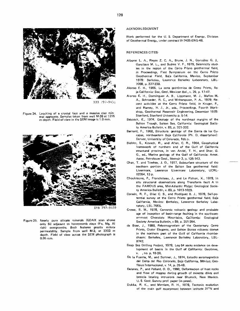
XBB 797-9451
Figure 24. Leaching of a crystal face and a massive clay minerai aggregate. Samples taken from well M-38 at 1215 m depth. Field of view in the SEM image is 1.0 mm.
XBB 797-9459
Figure 25. Nearly pure silicate minerals (EDAX scan shows only Sil adjacent to honeycomb clays (Fe. Mg, AI rich) overgrowths. Both featu res greatly reduce permeability. Sample from well M·3, at 2203 m depth. Field of view across the SEM photograph is 0.05 mm.
ACKNOWLEDGMENT
Work performed for the U. S. Department of Energy, Division of Geothermal Energy, under contract W·7405-ENG-48.
REFERENCES CITED
AI bores L. A .. Reyes Z. C. A., Brune, J. N., Gonzalez G. J .• Garcilazo M. L., and Suarez V. F., 1979, Seismicity studies in the region of the Cerro Prieto geothermal field, in Proceedings, First Symposium on the Cerro Prieto Geothermal Field, Baja California, Mexico, September 1978: Berkeley, Lawrence Berkeley Laboratory, LB L7098, p. 227-23B.
Alonso E. H.• 1966, La zona geotermica de Cerro Prieto, Baja California: Soc. Geol. Mexican Bol.. v. 29, p. 17-47.
Alonso E. H., Dom(nguez A. B., Lippmann, M. J., Mafion M. A.. Schroeder, R. C., and Witherspoon. P. A.• 1979. Recent activities at the Cerro Prieto field, in Kruger, P., and Ramey, H. J., Jr., eds., Proceedings, Fourth Workshop. Geothermal Reservoir Engineering, December 1978: Stanford, Stanford University p. 5-14.
Babcock. E., 1974, Geology of the northeast margins of the Salton Trough, Salton Sea. California: Geological Society America Bulletin, v. 85, p. 321-332.
Barnard, F., 1968, Structural geology of the Sierra de los Cucapas, northeastern Baja California (Ph. D. dissertation): Denver, University of Colorado, 155 p.
Biehler. S., Kovach, R., and Allen, C. R., 1964, Geophysical framework of northern end of the Gulf of C'alifornia structural province, in van Andel, T. H.• and Shor, G. G., ed., Marine geology of the Gulf of California: Amer. Assoc. Petroleum Geol., Memoir 3, p. 126-143.
Chan, T. and Tewhey, J. D., 1977, Subsurface structure of the southern portion of the Salton Sea geothermal field: Livermore, Lawrence Livermore Laboratory, UCRL52354,13 p.
Choukroune, P., Francheteau, J., and Le Pichon, X., 1978, In situ structural observations along Transform fault A in the FAMOUS area, Mid-Atlantic Ridge; Geological Society America Bulletin, v. 89, p. 1013-1029 ..
Corwin. R. F., D(az C. S., and Rodfguez B. J., 1978, Self-potential survey at the Cerro Prieto geothermal field, Baja California, Mexico: Berkeley, Lawrence Berkeley Laboratory, LBL-7065.
Crowe, B. M.• 1978, Cenozoic volcanic geology and probable age of inception of basin-range faulting in the southeastern most Chocolate Mountains, California: Geological Society America Bulletin, v 89, p. 251-264.
de Boer, J., 1980, Paleomagnetism of the Quaternary Cerro Prieto, Crater Elegante, and Salton Buttes volcanic domes in the northern part of the Gulf of California rhombochasm: Berkeley, Lawrence Berkeley Laboratory, LBL9742.
Deep Sea Drilling Project, 1979, Leg 64 seeks evidence on development of basins in the Gulf of California: Geotimes, v. ,no. p. 18-20.
De la Fuente, M., and Sumner, J., 1974, Estudio aeromagnetico del Delta del Rio Colorado, Baja California, Mexico; Geofisica Internacional, v_ 14, p. 35-48.
Delaney, P., and Pollard, D. D., 1980, Deformation of host rocks and flow of magma during growth of minette dikes and breccia bearing intrusions near Shyrock, New Mexico. U. S. Geol. Survey prof. paper lin press!.
Dokka, R. K., and Merriam, R. H., 1979, Tectonic evolution of the main gulf escarpment between latitude 31°N and

129
300 N, northeastern Baja California, Mexico, in Abbott, R. L., and Gastil, R. G., eds., Baja California Geology: San Diego, San Diego State University, p. 139-147.
Donnelly, M. F., 1974, Geology of the Sierra del Pinacate volanic field, northern Sonora, Mexico, and southern Ari· zona, U. S. (Ph. D. dissertation): Stanford, Stanford Uni· versity, 722 p.
E'lders, W. A., Hoagland, J. R., Olson, E. R., McDowell, S. D., and Collier, P., 1978, A comprehensive study of samples from geothermal reservoirs: Petrology and light stable isotope geochemistry of twenty-three wells in the Cerro Prieto geothermal field, Baja California, Mexico: Riverside, California, Institute of Geophysics and Plane· tary Physics, University of California, Report UCR/IGPP. 78/26, p. 263.
Fuis, G., and others, 1977a, Preliminary catalogues of earthquakes in the northern Imperial Valley, California: U. S. Geological Survey Open-File Report, 77-694.
-, 1977b, Preliminary catalogues of earthquakes in the northern Imperial Valley, California: U. S. Geological Sur· vey Open-File Report, 77-869.
-, 1977c, Preliminary catalogues of earthquakes in the northern Imperial Valley, California: U. S. Geological Survey OpenFile Report, 77-431.
-, 1978a, Preliminary catalogues of earthquakes in the northern Imperial Valley, California: U. S. Geological Survey OpenFile Report, 78-74.
-, 1978b, Preliminary catalogues of earthquakes in the northern Imperial Valley;California: U. S. Geological Survey OpenFile Report, 78-671.
-, 1978c, Preliminary catalogues of earthquakes in the northern Imperial Valley, California: U. S. Geological Survey OpenFile Report, 78·673.
Gastil, G., and Krummenacher, D., 1977, Reconnaissance geology of coastal Sonora between Puerto Lobos and Bahia Kin.o: Geological Society America Bulletin v. 88, p. 189198.
Gastil, R. G., Phillips, R. P., and Allison, E. C., 1975, Reconnaissance geology of the State of Baja California: Geological Society America Memoir 140, 170 p.
Goulty, N. R., and Golman, R., 1978, Repeated creep events on San Andreas FaUlt near Parkfield, California, record· ed by a Strainmeter array: Journal Geophysical Research, v. 83, p. 5415-5419.
Henyey, T., and Bischoff, J., 1973, Tectonic elements of the northern part of the Gulf of California: Geological So· ciety America Bulletin, v. 84, p. 315-330.
Hileman, J. A., Allen, C. R., and Nordquist, J. M., 1973, Seismicity of the southern California region 1932 to 1972: Pasadena, Seismological Laboratory, California Institute Technology, 94 p.
Howard. J., et aI., 1979, Geothermal resource and reservoir investigations of U. S. Bureau of Reclamation leaseholds at East Mesa, Imperial Valley. California: Berkeley, Lawrence Berkeley Laboratory, LBL-7094; 305 p.
Johnson, C. E., 1979, I, CEDAR an approach to the computer automation of short-period local seismic networks; II, Seismotectonics of the Imperial Valley of Southern California (Ph. D. dissertation): Pasadena, Calif. Inst. Technol ogy, 332 p.
Johnson, C. E. and Hadley, D. M., 1976, Tectonic implications of the Brawley earthquake swarm, Imperial Valley, January, 1975; Bulletin Seismological Society America. v. 66, p. 1133-1144.
Kasameyer, P., 1976, Preliminary interpretation of resistivity and seismic refraction data from the Salton Sea geothermal field: Livermore, Lawrence Livermore Laboratory,
UCRL·52115, 10 p. Kasameyer, P., Younker, L., and Tewhey. J., 1978, Salton Sea
geothermal system: II, Thermal source modeling and resource assessment: Livermore, Lawrence Livermore Laboratory, 30 p., unpub. report.
Lofgren, B. E., 1979, Measured crustal deformation in Imperial Valley, California, in Proceedings, First Symposium on Cerro Prieto Geothermal Field, Baja California, Mexico, September 1978: Berkeley, Lawrence Berkeley Laboratory, LBL-7098, p. 141-145.
Lonsdale, P., and LaVlNer, L. A., 1980, Submersible study of immature plate boundary zones in the Gulf of California: Geological Society America Bulletin, 8 p. lin press).
Manon M. A., Mazor, E., Jimenez S. M. E., Sanchez A. A., Fausto L. J. J., and Zenizo, C., 1977, Extensive geochemical studies in the geothermal field of Cerro Prieto, Mexico: Berkeley, Lawrence Berkeley Laboratory, LBL·7019, 113 p.
Meidav, T., and Howard, J. H., 1979, An update of tectonics and geothermal resource magnitude of the Salton Sea geothermal resource: Geothermal Resources Council Transactions, v. 3, p. 445·448.
Meidav, T., and Rex, R., 1970, Investigation of geothermal resource in the Imperial Valley: Riverside, California, Institute Geophysics and Planetary Physics, University of California, 54 p.
Meidav, T., et aI., 1976, An ,electrical resistivity survey of the Salton Sea geothermal field, Imperial Valley, California; Livermore, Lawrence Livermore Laboratory, UCR L-13690, v. 1 and 2, 68 p.
Mercado G. S., 1976, Movement of geothermal fluid and temperature distribution in. the Cerro Prieto geothermal field, Baja California, Mexico, in Proceedings Second United Nations Symposium on the Development and Use of Geothermal Resources, San Francisco, May 1975: Washington, D. C., U. S. Government Printing Office, v. 1, p.492-494.
Noble, J. E., Manon M. A., Lippmann, M. J., and Witherspoon, P. A., 1977, A study of the structural control of fluid flow within the Cerro Prieto geothermal field, Baja California, Mexico: Dallas, Society of Petroleum Engineers, SPE·6763.
Ortlieb, L., 1978, Neotectonics from marine terraces along the Gulf of California, in Proceedings, Symposium on Earth Rheology and Late Isostatic Movements, Stockholm, 1977: New York, John Wiley and Sons.
Phillips, R. P., 1964, Seis,mic refraction studies in the Gulf of California, in van Andel, T. H., and Shor, G. G., eds., Marine geology of the Gulf of California: Amer. Assoc. Petro. Geol., Memoir 3, p. 90-121.
Prian C. R., 1979, Lithologic conditions of the Cerro Prieto wells based on well interpretations; in Proceedings, First Symposium on the Cerro Prieto Geothermal Field, Baja California, Mexico, September 1978: Berkeley, Lawrence Berkeley Laboratory, LBL-7098, p.49-56.
Proctor, R. J., 1968, Geology of the Desert Hot Springs/Upper Coachella Valley area, California: San FranciSCO, California Division of Mines and Geology, Special Report, 50 p.
Puente C. I., and de la Pena L. A., 1979, Geolog(a del campo geotermico de Cerro Prieto, in Proceedings, First Symposium on the Cerro Prieto geothermal field, Baja Califor· nia, Mexico, September 1978: Berkeley, Lawrence Berkeley Laborator~ LBL·7098; P 17-40.
Razo, A., 1976, Sinopsis geol6gica del campo geotermico de Cerro Prieto, Baja California: Mexicali, Comisi6n Federal de Electricidad. Internal report.
Reed, M. J., 1976, Geology and hydrothermal metamorphism

130
in the Cerro Prieto geothermal field, Mexico, in Proceedings, Second United Nations Symposium on the Development and Use of Geothermal Resources, San Francisco, May 1975: Washington, D. C., U. S. Government Printing office, v. 1, p. 539-547.
Sharman, G., 1976, The plate tectonic e'ilolution of the Gulf of California (Ph. D. dissertation): San Diego, University of California, 86 p.
Sharp, R. V., 1976, Surface faulting in the Imperial Valley during the earthquake swarm of January-February, 1975: Bulletin Seismological Society of America, v. 66, p. 11451154.
Soto-Pineda, S., 1975, Campo geotermico de Cerro Prieto sobre la falla San Jacinto y su posible ampliaci6n hacia la falla Imperial. Comisi6n Federal de Electricidad, Mexico, Internal Report, June, 13 p.
Summer, J. R., 1972, Tectonic significance of gravity and aeromagnetic investigations at the head of the Gulf of California: Geological Society of America Bulletin, v. 83, p.3103-3120.
Sylvester, A. G., and Smith, R. R., 1976, Tectonic transpersion sand basement-controlled deformation in San Andreas fault zone, Salton Trough, California: American Association of Petroleum Geologists Bulletin, v. 60, p. 2081-2101.
Terras, R., and Crowell, J. C., 1979, Plate tectonic framework of the San Andreas/Salton Trough juncture, in Tectonics of the juncture between the San Andreas fault system and the Salton Trough, southeastern California: San Diego, University of California, p. 15-26.
Tewhey, J. D., 1977 Geologic characteristics of a portion of the Salton Sea geothermal field; L.ivermore, L.awrence Livermore L.aboratory, UCRL-52267,. 51 p.
Todd, V. R., and Hoggatt, W. C., 1976, Elsinore fault zone in
the Tierra Blanca Mountains, Eastern San Diego L.og California (abstract): Geological Society of America, Program and Abstracts, p.416417.
Truesdell, A. H., 1979, The use of fluid geochemistry to indicate reservoir processes at Cerro Prieto, Mexico, in Kruger, P., and Ramey, H. J., Jr., eds., Proceedings, Fourth Workshop, geothermal reservoir engineering, Stanford, December, 1978: Stanford, Stanford University, p. 239242.
U. S. Geological Survey, 1972, The Borrego Mountain earthquake of April 9, 1968: U. S. Geological Survey Professional Paper 787,207 p.
Valette, J. N., and Esquer P. I., 1979, Geochemistry of superficial emissions in the Cerro Prieto Geothermal Field (abstract), in .Program and Abstracts, Second Symposium on the Cerro Prieto Geothermal Field, Baja California, Mexico, October 17-19: Mexicali, Comisi6n Federal de Electricidad, p. 32-33.
Vonder Haar, S. P., and Gorsline, D. S., 1975, Flooding frequency of hypersaline coastal evironments using orbital imagery-geologic implications; Science, v. 190, p. 147-149.
-, 1977, Hypersaline lagoon deposits and processes in Baja California, Mexico: in Geoscience and Man, v. 17, p. 165177.
-, 1979; Flooding frequency and sedimentation unit correlation of tidal flat and coastal saline facies along the upper Gulf of California, Mexico: Geological Society America Abstracts with Programs, Annual Mtg., November 1979, p.533.
Vonder Haar, S., and Puente C. I., 1979, FaUlt intersections and hybrid transform faults in the southern Salton Trough geothermal area, Baja California, Mexico: Geothermal Resources Council Transactions, v. 3, p. 761-764.
INTERSECCION DE FALLAS Y ESTRATIG'RAFIA DE ARENISCAS EN EL CAMPO GEOTERMICO DE CERRO PRIETO
RESUMEN
La falla de Cerro Prieto, de direcci6n aproximada NO-SE, es parte de un lineamento regional principal que se extiende a Sonora y tiene caracterrsticas de falla de desplazamiento de rumbo y de falla transformada oceanica. ~n apariencia, penetra profundamente en el basamento y en las rocas de la corteza del area y sirve como conducto para flujos gran des y rapidos de calor. Cerca del pozo M-103, donde la fall a de Michoacan interseca oblicuamente una falla mas corta de direcci6n aproximada NE-SO,
grandes perdidas de circulaci6n durante las perforaci ones indican mayor permeabilidad y, en consecuencia, un mayor flujo natural convectivo de fluido. En la zona S del campo hay una zona de fallas de cizalla en la vecindad de los pozos MAS, M-91 y M-101. Los mapas de contornos de temperaturas sugieren que esta zona de cizalla ayuda en la dipida distribuci6n del fluido geotermico hacia afuera de la zona de la falla de Cerro Prieto, aumentando de esta forma la recarga.

131
Se estudio la distribucibn de litologfas y temperatura dentro del campo comparando datos de recortes de pozos, nucleos, registros de pozos y am'llisis geoqufmicos. A traves de la porcion del campo primeramente desarrolIada, en particular a 10 largo de una seccibn de 1.25 km de direcci6n aproximada NE-SO desde el pozo M-9 al M-10, emergen correlaciones interesantes que indican una relaci6n entre la litologla, el microfracturamiento y la distribucibn de temperatura. En la porci6n superior del yacimiento A de esta secci6n estratigrafica, entre 1200 y 1400 m, el porcentaje de areniscas varia entre 20 y 55. Las temperaturas, basadas en registros de pozos, maximos isot6picos de calcita e indices Na-K-Ca, se encuentran en la gama 225-275°C. EI estudio muestra que una alta isotermia en esta vecindad corresponde al porcentaje total mas bajo de areniscas. Microfotograffas de barrido electr6nico de nucleos y recortes de pozos correspondientes a unidades de areniscas y lutitas revelan obstrucciones, disoluci6n y precipitacion mineral a 10 largo de las microfracturas. Nuestra hipbtesis de trabajo es que estas facies de lutitas arenosas y limolitas son muy proclives a microfracturarse y que a su vez dicho microfracturamiento permite que los fluidos de alta temperatura fluyan hacia profundidades mas superficiales en el yacimiento.
Por 10 comun se lIevan a cabo investigaciones dirigidas a lograr un modelo geologico coherente que muestre la capacidad del yacimiento y a entender el flujo de fluido a 10 largo de fallas principales, la distribucibn lateral a trayeS de zonas de fallas de cizalla y el movimiento variable dentro de sedimentos deltaicos que han sido parcial mente microfractu rados.
INTRODUCCION
La evolucion geologica de la region de Cerro Prieto ha sido una mezcla compleja de agrietamientos (rifting), sedimentacion deltaica rapida y afallamiento de desplazamiento de rumbo, en gran escala. Para entender los campos geotermicos en esta region es importante familiarizarse con las intersecciones de fallas y con los efectos del tectonismo y de las interacciones agua-roca en la porosidad y permeabilidad inicial de las areniscas. En este trabajo se exploran primeramente conformaciones de afallamiento analogas a las de Cerro Prieto y luego la permeabilidad y porosidad secundaria de los horizontes productivos.
AFALLAMIENTO DE LA DEPRESION DEL SALTON
En la figura 2 se muestra un numero de intersecciones de fallas por medio de una recopilacibn detallada de afallamientos. Estos datos fueron recolectados de mas de 100 ardculos. algunos publicados y otros no. La figura 3 muestra referencias claves especfficas. EI area del Mar del Salton muestra una serie de fallas con direcci6n clara NE-SO; cada serie tiene aproximadamente 3 km de largo y se extiende entre la falla de desplazamiento de rumbo Banning/
Mission Creek (parte del sistema San Andres) y el extremo N de la falla de desplazamiento de rumbo Brawley/Imperial (Fig. 4; tambien Meidav y Howard, 1979).
Fallas transversales similares, de direccion aproximada NE-SO (Fig. 5), han sido confirmadas en el campo de Cerro Prieto por estudios recientes (Vonder Haar y Puente, C., 1979; Puente, C. y de la Pena, L., 1979). La falla de Cerro Prieto de direcci6n aproximada NO-SE y un segmento de falla paralelo, la falla de Michoacan, son parte de un lineamento regional importante que lIega hasta Sonora (Gastil y Krummenacher, 1977) y tiene caracterfsticas de una zona de fall as de desplazamiento de rumbo y una falla transformada oceanica (Vonder Haar y Puente, C., 1979). Se cree que este lineamento regional principal penetra profundamente en las rocas de la corteza y del basamento, que varian en espesor de 7 km en la parte N del Gotfo de California (Phillips, 1964) a 20 km en el Ifmite internacional entre Estados Unidos y lVIexico (Biehler et al., 1964). Este estilo de afallamiento, constituido por una falla regional profunda con bloques sumergidos en las intersecciones de fall as, es importante en conexi6n con el acontecimiento de recursos geotermicos porque aparentemente sirve como conducto para altos flujos de calor. La interseccibn oblicua de la zona de fallas de Patzcuaro y la zona de fallas de Michoacan esta asociada con pozos de gran permeabil idad, y por eso se presume que es un area de conveccibn natural aumentada. Esta conclusion esta basada en la prol ffica producci6n del polO M-1 03, en grandes cantidades de circulacion perdida y en las manifestaciones superficiales del area de Laguna Volcano al SO del pozo M-101 (ver 10sartLculosde De Boer, 1980, y tambieln Valette y Esquer, P., 1979, por datos magneticos y geoqu(micos relacionados a la interseccion de estas fall as).
Otra faceta de las intersecciones de fallas es el papel que desempefian ayudando a distribuir los fluidos geotermicos provenientes de fall as de penetraci6n profunda, tal como la falla de Cerro Prieto. Se cree que en un momento dado del tiempo geologico, dicha falla fue una fuente lineal 0 hasta una fUente puntual discreta (Delaney y Pollard, 1980). Una falla (mica de control como la descrita, deberfa resultar en un campo que se extienda a unos pocos cientos de metros de ella. Sin embargo, la mayor permeabilidad, la capacidad de recarga y el almacenamiento que resultan de estas zonas de fallas de cizalla crean campos geotermicos del orden de 2 a 10 km de ancho.
Aproximadamente 100 km al SE de Cerro Prieto, donde el lineamento de Cerro Prieto entra en el Golfo de California, hay una tercera area de afallamiento transversal (Fig. 2). Estas fallas han sido confirmadas por estudios de campo (Ortlieb, 1978). Aunque la zona de fallas de Cerro Prieto tiene un estilo escalonado en esta area, la frecuencia de inundaciones y los datos de duraci6n indican que las aguas superficiales salinas impedirian levanta

132
mientos geof(sicos a nivel del suelo y perforaci ones de pozos someros para la recoleccion de datos sobre el flujo de calor. Presumiblemente existe un recurso geotermico a profundidad.
A otra faceta del afallamiento en la Depresion del Salton concernirla el origen del volcan de Cerro Prieto y el campo geotermico adyacente. Ambos podrfan ser el resultado de otra interseccion de fallas: el encuentro de la zona de fallas de San Felipe, que limita la cuenca (Fig. 2), con el lineamento de Cerro Prieto.
Hay otras indicaciones de interseccion de fallas en el area de la Depresi6n del Salton/Golfo de California Superior. Datos magneticos sugieren reactivacion de antiguas fallas de rift (de Boer, 1980) y datos de gravedad regional indican que el lineamento Gila se extiende hasta la Depresion del Salton, desde Arizona hasta las inmediaciones del extremo S de la falla Imperial.
ANALOGOS TECTONICOS DE CERRO PRIETO
La zona de rift del Mar Muerto, las cuencas productoras de petroleo en el S de California y la region de Afar en Africa, entre otras, proveen comparaciones estimulantes con la region de Cerro Prieto. Sin embargo, los modelos de afallamiento mas utiles pata los campos geotermicos de la Depresion del Salton, provienen posiblemente de observaciones detalladas lIevadas a cabo por sumergibles de buceo profundo a 10 largo de fallas transformadas y centros hidrotermicos en el area FAMOUS de la Cresta del Atlantico Medio y en et Golfo de California.
La exptoracion submarina de la falla transformada "A" en el area FAMOUS se resume en un diagrama tridimensional (Fig. 6), en una escala apropiada para el campo de Cerro Prieto. Como se muestra en la figura 7, las fallas transversales y las normales se extienden hasta 5 km a ambos lados de la zona actual de movimiento de transformaci on activo, que fue local izado en una zona central de 200 m de ancho. En esta zona se nota actividad hidrotermica (Fig. 8), como tambien numerosas fallas en graderfa con un desplazamiento acumulativo de hasta 250 m.
Perioraciones en la boca del Golfo de California por el Deep Sea Drilling Project (DSDP) (Geotimes, julio 1979) proporcionaron como resultado una hipotesis sobre la apertura del Golfo que se relaciona con la interpretacion de la geologia estructural en la vecindad del campo de Cerro Prieto. La secuencia comenzo hace alrededor de 20 millones de ai'ios con granitos desgastados por la accion atmosferica y gravas aluviales. Posiblemente para el final del Mioceno (hace de 5 a 10 millones de arios) tuvo lugar una etapa de agrietamiento con fallas Ifstricas (conca va hacia arriba con un angulo de inclinacion decreciente a profundidad) en el basamento. Hace aproximadamente 4.5 millones de anos, el asentamiento del terreno era activo y
comenzo la apertura del Golfo. La apertura del Golfo actual, relacionada con fallas de transformacion, tuvo lugar hace aproximadamente 3.5 millones de an os (ver tam bien Terres y Crowell, 1979). Hasta la facha, los estudios geoHsicos realizados en el area de Cerro Prieto no han revelado fall as I fstricas en el basamento. Sin embargo, es posible que existan fallas de rotacion relacionadas con afallamiento temprano confinadas en areas situadas a 50 km 0 mas al o y SO del campo geotermico (Gastil et al., 1979; Dokka y Merriam, 1979). Es importante que los modelos geologicos de Cerro Prieto incluyan fallas del basamento mas antiguas, que puedan acoplarse con fallas mas recientes generadas por desplazamiento de rumbo. Dicho acoplamiento aumentarfa la red potencial de flujo de fluido a 10 largo de las fall as, extendiendo de este modo el area de energfa maxima disponible para produccion.
Los estudios lIevados a cabo por medio de sumergibles en la Cuenca Guaymas, situada en la parte central del Golfo de California (Lonsdale y Lawvor. 1980), son tambien interesantes cuando se considera la geologia del campo de Cerro Prieto. Estos estudios muestran una falla de transformacion que tiene una zona de cizalla de aproximadamente 1 km de ancho. Las fallas transversales ocupan un area de 1 a 2 km de ancho y el fondo del mar tiene minerales hidrotermicos que precipitaron entre 2200 y'240°C, segun indican los isotopos de ox(geno.
Investigaciones previas hechas por Sharman (1976) en el Golfo de California. proveen otro modelo posible de importancia (Fig. 9) para lazona situada entre las fallas Imperial y de Cerro Prieto. Mientras las perforaeiones progresan en el yacimiento de Cerro Prieto, los model adores deberian considerar que se formaron en secuencia cuencas multiples separadas por bloques elevados. Es posible que esta distribucion de cuencas represente desplazamientos episodicos de la fuente de calor en una escala de 5 a 20 km.
En la figura 10 se indica otro aspecto del afaliamiento relacionado con los centros de dispersion. EI cingulo de interseccion entre la falla principal y la falla transversal no necesariamente es de 900. De all i que la geometrfa de las cuencas situadas al E del campo actual de Cerro Prieto pueda tener desviaciones de hasta ± 20 respecto a las direcciones normal y paralela a la falla regional principal.
La figura 11 representa uno de los varios modos posibles de evolucion de las fallas de transformaci6n oceanicas y de los centros de dispersion. Estos diagramas son importantes porque sugieren patrones que podrfan ajustarse a los datos geoffsicos regionales. Por ejemplo, el area geotermica de Tule Check, situada 15 km al NO de Cerro Prieto, podrfa ser una zona de fracturas abandonada. como se ve en la figura 11 (D), con una anomalfa residual de calor que en la actualidad se encuentra separada del sistema principal de Cerro Prieto e Imperial.
133
DATOS SISMICOS
Un mapa de epicentros y magnitudes parala Depresion del Salton (Fig. 12) indica un alto grado de actividad tectonica. En la figura 13 se muestra una historia de los sucesos microsfsmicos por medio de un gratico regional. La interpretacion de estes sucesos, la mayorfa de ellos de magnitud entre 1 y 3 en la escala Ritcher, es que son predominantemente una serie de fallas transversales de direccion NE-SO que vinculan las fallas Imperial y San Andres. En la figura 14 se grafican mas de 800 sucesos que se concentran principalmente entre 4 y 6 km de profundidad. EI error en estas profundidades puede lIegar a ser de hasta ± 2 km (G. Fuis, 1978, comunicacion personal; ver tambien Fuis et al., 1977 a, b, c, 1978 a, b, c).
EI hecho de que las profundidades de ocurrencia sean someras es una evidencia importante de actividad repetida que mantiene el fracturamiento y permite el flujo de fluido a traves de fracturas a profundidades de produccion geotermica en la Depresion del Salton. Se necesitan datos mas precisos sobre las profundidadesde los sismos en el area de Cerro Prieto (Fig. 15) para documentar si estos sucesos tienen lugar en la zona de produccion 0 en la interfase de los sedimentos deltaicos y el basamento de granodioritas, vulcanitas y rocas metasedimentarias.
POROSIDAD DE LAS ARENISCAS
La figura 16 representa la base de una hipotesis de trabajo: que zonas con porcentajes totales de areniscas bajos, aproximadamente 200/0 a 500/0, son mejores para la produccion georermica que zonas con, por ejemplo, 80% de areniscas. Esta hipotesis tiene dos corolarios: 1) la porosidad se!;undaria causada por fluidos geotEirmicos no es uniforme a traVElS del campo, y 2) la porosidad de fracturas es relativamente mayor en limolitas, lutitas y areniscas que han side densificadas. Actualmente se esta haciendo una comparacion detallada de porcentaje de areniscas, tipos de litofacies, datos de minerales y resistividad, pero la informacion disponible corrobora la hipotesis (Elders, 1980, comunicacion personal; Wilt, 1980, comunicacion personal).
Microfotograffas de barrido electronico de recortes y nucleos de pozos revelan disolucion y precipitacion minerai, atascamiento de gargantas de poros y fases aparentes de sobrecrecimiento. Algunas fotograffas seleccionadas ilustran estos rasgos. Una limolita laminadadel pozo NL-1, a 1888 m (Fig. 17), muestra poca porosidad y poca densificacion, mientras que muestras mas profundas en NL-1, a 2720 m en la zona de produccion (Fig. 18, 19,20)' reveIan atascamiento y precipitacion. Las figuras 21 y 22, a 3209 m en el mismo pozo, documentan un cambio dramatico a una zona metamorfoseada con porosidad secundaria reducida. Muestras del pOlO M-38 entre 1215 y 1372 m indican arcilla y minerales de armaz6n (Figs. 23 y 24) y
el pozo M-3 a 2203 m (Fig. 25) es un ejemplo espectacular de precipitacion mineral de sllice adyacente a minerales arcillosos.
AGRADECIMIENTOS
Este trabajo fue ejecutado para el U. S. Department of Energy, Division of Geothermal Energy, bajo contrato W-7405-ENG-48.
TITULOS DE FIGURAS
Figura 1. Mapa de localizacibn de la geologIa regional del campo geotermico de Cerro Prieto.
Figura 2. FaUas de la Depresion del .Salton que indican lazona de afallamiento transversal y las principales fallas de transformacion h!brida de direccion NO-SE.
Figura 3. Mapas de referencias a artfculos sobre el afallamiento de la Depresion del Salton. 1) Barnard, 1968; 2) USGS, 1972; 3) Henyey y Bischoff, 1973; 4) Gastil at al., 1975; 5) Meidav y Rex, 1970; 6) Howard at al., 1979; 71 Donnelly, 1974; 81 Ortlieb, 1978; 9) Vonder Haar y Gorsline, 1977; 10) Vonder Haar y Gorsline, 1975; 11) Puente C. y Vonder Haar, 1980; 121 Gastil y Grummen scher, 1977; 13) Sumner, 1972; 14) Sharp, 1976; Johnson y Hadley, 1976; 151 Goulty y Golman, 1978; 16) de la Fuente y Sumner, 1974; 171 Sylvester y Smith, 1976; 18) Babcock, 1974; 19) Proctor, 1968; 20) Noble at al., 1977; Razo, 1976; Alonso, 1966; Reed, 1976; Mercado, 1976; Von"der Haar y Puente, C., 1979; Prian, C., 1979; Corwin at al., 1978; y Alonso at al., 1979; 211 Puente, C. y de la Pena, L., 1979; 22) Soto-P., 1975; 23) Crowe, 1978; 24) Kasameyer, 1976; Kasameyer at al., 1978; 25) Lofgren, 1979;26} Meidav et al., 1976; 271 Tewhey, 1977; 281 Chan y Tewhey: 1977; 29) Todd y Hoggart, 1976; 30) Albores at al., 1979.
Figura 4. Mapa estructural de la region del Mar del Salton, basado en datos geofisicos combinados.
Figura 5. Faltas en la vecindad del campo de Cerro Prieto, que muestran fall as transversales y el muy productivo pozo M-l03.
Figura 6. Diagrama interpretativo de una porcion de la falla de transformacion oceanica '~A" en el area FAMOUS de la Cresta del Atl€mtico Medio (Choukroune et al., 1978). Las fall as que se intersecan y la zona activa del movimiento de desplazamiento del rumbo, de 200 m de ancho dentro de una depresion de 4 km de ancho, sugieren la posible complejidad del afallamiento a 10 largo de la falla de Cerro Prieto y dentro del campo de produccion.
Figura 7. Diagrama que ilustra el complejo afallamiento existente en las inmediaciones de una falla de transformacion oceanica; posible analogo de las fallas de la Depresion del Salton.
Figura 8. Seccion transversal de la falla de transformacion oceanica "Au, basada en wceos de inmersion profunda, que muestra un afallamiento activo dentro de una zona de fallas mas ancha.
Figura 9. Interpretacion de la evolucion de la Cuenca Carmen en el Golfo de California; una posible analog!a con las cuencas separadas en la Depresion del Salton. N6tese la asimetria y la formaci on de multiples cuencas entre las dos fallas de transformaci6n.
Figura 10. Confirmacion del concepto de que las fallas de tipo de transformadon no necesitan esiar a goo de los centros de dispersion (Sharman, 19761.
Figura 11. Un diagrama de la posible evolucion de las fal/as de San Andres, Imperial y de Cerro Prieto que ilustra d6nde deberian estar las zonas de fracturas si estas fa

lias fueran del tipo de transformaci6n puro. Figura 12. Epicentros de sismos y magnitudes registradas en la
Depresi6n del Salton para eventos de magnitud ;;;. 5 en la escala Richter.
Figura 13. Epicentros de la Depresi6n Central del Salton que muestran la actividad que vincula las fallas Imperial y de San Andres (datos de Johnson, 1979). Error en la ubicaci6n del epicentro menor que 2.5 km. ML representa la magnitud local Richter.
Figura 14. Profund{dades de sismos en la Depresi6n del Salton al N de la frontera entre Mexico y Estados Unidos, aunque diffciles de cuantificar en la Depresi6n del Salton, muestran una concentraci6n cerca de los campos geotermicos en una zona de 2 a 6 km (magnitudes Richter, locales).
Figura 15. Epicentros de sismos en la vecindad de las fallas Imperial y de Cerro Prieto; datos de Albores at al., 1979. I nterpretaciones tect6nicas de movimientos recientes entre las principales failas escalonadas son soportadas por estos datos y otros similares a 10 largo de la zona de direcci6n aproximada N, entre las fallas Imperial y de San Andres.
Figura 16. Unidades de areniscas definidas por zOnas principales de lutitas relativamente continuas. Dentro del yacimiento en produccion el porcentaje de areniscas, como en la unidad 3, varfa de 20% a 50%, con un mlnimo cerca del pozo M-14 (ver Fig. 5 para ubicacion del pow).
Figura .17. Limolitas deltaicas laminadas de baja porosidad del pozo NL-1 a 1888 m de profundidad; el campo de vision a traves de la microfotografia de barrido electronico es 0.2 mm.
Figura 18. Arenisca que muestra porosidad secundaria mixta y minerales h idrotermicos de precipitaci6n reciente, obtenida en la zona de produccion del pozo NL-1 a 2720 m de profundidad. EI campo de vision a traves de la microfotograffa de barrido electronico es 0.2 mm.
Figura 19. Arenisca; vista magnificada de la misma muestra que aparece en la figura 18. Notese los largos cristales fili formes (iilita) y las arciJIas con forma de oblea 0 minerales de ceolita que cubren parcial mente una garganta
134
Figura 20.
Figura 21.
Figura 22_
Figura 23.
Figura 24.
Figura 25.
de poro entre granos de arena. Muestra tomada a 2720 m de profundidad del pozo NL-1. EI campo de vision a traves de la fotograffa es 0.2 mm. Este es un ejemplo de efectos de permeabilidad secundaria alterada. Arenisca; vista magnificada de una porci6n de la figura 18. Durante la preparacion de la muestra se arranco un grano dejando a la vista el cementa arcilloso precipitado hidrotermicamente. Muestra obtenida a 2720 m de profundidad en el pozo NL-l. EI campo de vision a traves de la microfotografia de barrido electronico es 0.2mm. Arenisca muy densa metamorfoseada obtenlda en el pozo N L·1 a 3209 m de profundidad. EI campo de vision es 1.0 mm. Este es un ejemplo de una zona de porosidad secundaria super-madura susceptible a microfracturamiento. Vista magnificada de la figura 21 que muestra porosidad reducida debido a la precipitacion de los minerales del armazon. N6tese como se quebraron los granos durante la preparacion de la muestra comparado con la figura 18. Muestra obtenida del pozo NL-1 a 3209 m de profundidad. EI campo de vision a traves de la microfotografia de barrido electronico es 0.5 mm. Arcilla y minerales del armazon, 0 sobrecrecimiento mineral en un espacio de poro. Muestra obtenida del pozo M-38 a profundidades que vadan de 1215 a 1372 m; el campo de vision a traves de la microfotogratia de barrido electronico es 0.1 mm. Lixiviaci6n de una cara del cristal y un agregado masivo de mineral de arcilla. Muestras obtenidas del pozo M-38 a 1215 m de profundidad. EI campo de vision en la imagen de microscopia electronica de barrido es 1_0mm. Minerales de silicatos casi puros (el barrido EDAX muestra solo Sil adyacentes a la estructura celular hexagonal de sobrecrecimiento de arcillas (ricas en Fe, Mg y All. Ambos rasgos reducen enormemente la permeabilidad. Muestra obtenida del pozo M-3 a 2203 m de profundidad. EI campo de vision a traves de la microfotograffa de barrido electronico es 0.05 mm.