Embed Size (px)
Citation preview
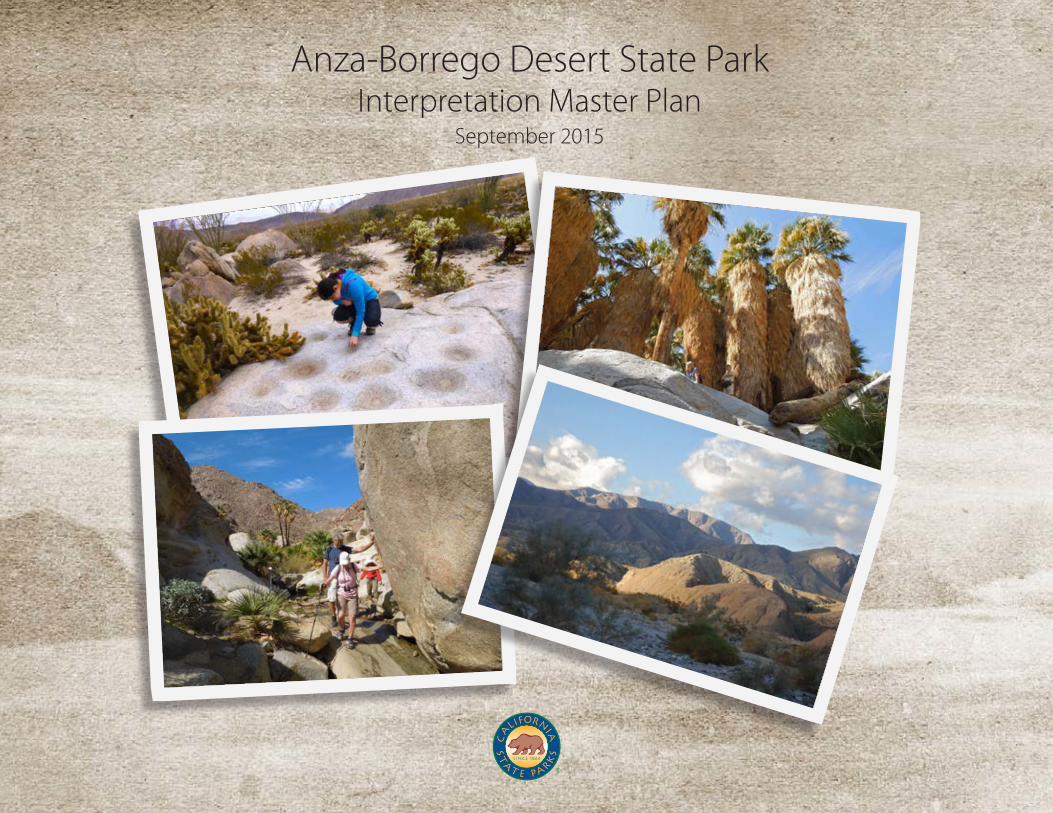
Anza-Borrego Desert State ParkInterpretation Master Plan
September 2015

Anza-Borrego Desert State Park Interpretation Master Plan

Anza-Borrego Desert State Park Interpretation Master Plan
© 2015 California State Parks
No part of this document may be reproduced without permission. California State Parks and Anza-Borrego Desert State Park are registered trademarks of the California Department of Parks and Recreation. To receive this publication in an alternate format, contact Terry Gerson, Colorado Desert District Senior Park and Recreation Specialist, at (760)-767-4960.
Cover photos by Sally Theriault.
Prepared by: The Acorn Group, Inc.180 South Prospect Avenue, Suite 230Tustin, CA 92780www.acorngroup.com
Approved by:
__________________________________________________________________Kathy Dice, Superintendent, Anza-Borrego Sector
__________________________________________________________________Dan Falat, Superintendent, Colorado Desert District
__________________________________________________________________Brian W. Cahill, Acting Division Chief, Interpretation and Education

Anza-Borrego Desert State Park Interpretation Master Plan
Sunrise over the Borrego Badlands
Phot
o by
Bill
Gra
cey

Anza-Borrego Desert State Park Interpretation Master Plan
i
The old sea bed, where once rolled the headwaters of the Vermilion Sea, is still a
ghostly memory of its former state. And a memory not too dim, either. At dawn all
the hollows of the badlands swim with misty haze that startlingly suggests water. And
when sunset flings the long blue shadow of Coyote Peak far out across the dry reaches
the effect is breath-taking. There they are again, all those ancient bays and winding
gulfs and lagoons. And beyond them the purple grey of the great sea.
Marshal SouthDesert Magazine
February 1940

Anza-Borrego Desert State Park Interpretation Master Plan
ii
TABLE OF CONTENTSEXECUTIVE SUMMARY
CHAPTER 1: INTRODUCTION TO THE PLAN 1.1 Park Overview1.2 Plan Purpose1.3 Planning Process1.4 Park Planning History
CHAPTER 2: PLANNING FOUNDATION2.1 Park Resources2.2 Implications of Park Resources for Interpretation2.3 Current Status of Interpretation2.4 Guiding Statements from the General Plan2.5 Highlights from Past Planning Efforts2.6 Local and Regional Influences2.7 Visitation and Visitor Use
CHAPTER 3: SUMMARY OF STAKEHOLDER INPUT
CHAPTER 4: INTERPRETIVE DIRECTION4.1 Spirit of Place4.2 Updated Interpretive Goals 4.3 Interpretive Periods 4.4 Analysis of Themes from the General Plan4.4.1 Updated interpretive themes 4.5 Direction for Education
CHAPTER 5: RECOMMENDATIONS5.1 Overview: The Big Picture5.2 Recommended Objectives and Strategies (Organized
by Goal)5.3 Recommended Facilities, Media, and Programming 5.3.1 Overview of Recommended Installations5.3.2 Recommended Installations by Park Sector5.3.3 Recommended Electronic Media5.3.4 Recommended Personal Media and Public Programs5.3.5 Recommended Educational Programming5.4 Phasing Recommendations
APPENDIX A: REFERENCES USED
APPENDIX B: 2014 VISITOR SURVEY REPORT
APPENDIX C: 2014 VISITOR SURVEY QUESTIONS
APPENDIX D: STAKEHOLDER SESSION REPORTS
APPENDIX E: EDUCATOR NEEDS ASSESSMENT
APPENDIX F: INTERPRETIVE GOALS, GUIDELINES, AND THEMES FROM THE GENERAL PLAN
APPENDIX G: LOGIC MODEL (Expected Outcomes and Impacts)
APPENDIX H: VISITOR SURVEY DATA SPREADSHEET (This appendix is published as a separate document)
Anza-Borrego Desert State Park Interpretation Master Plan
1
ACKNOWLEDGMENTSThe Acorn Group interpretive planning team members Jennifer Rigby, Ron Thomson, and Rici Peterson wish to thank the following people and organizations for their assistance in preparing this plan.
Abby Barker, Senior Park Aide, Anza-Borrego Desert State Park
Joanie Cahill, Regional Interpretive Specialist & Summer Learning Manager, California State Parks
Robin Connors, Associate State Archaeologist, Colorado Desert District
Kathy Dice, State Park Superintendent, Anza-Borrego Desert State Park
Terry Gerson, Senior Park and Recreation Specialist, Colorado Desert District
L. Louise Jee, Research Analyst II GIS, Colorado Desert District
Briana Puzzo, Education Manager, Anza-Borrego Foundation
Michael Rodriques, Regional Interpretive Specialist, Colorado Desert District
Paige Rogowski, Executive Director, Anza-Borrego Foundation
Sally Theriault, State Park Interpreter II, Anza-Borrego Sector
LuAnn Thompson, State Park Interpreter I, PORTS Program, Colorado Desert District
Heather Thomson, Archaeological Project Lead, Colorado Desert District
Special thanks to our tour guides—Park Rangers Steve Bier, Kelly McCague, Dennis Stephen, Jeri Zemon, and Supervising Ranger Nicole Van Doren—for sharing the desert with us. Additional thanks to the many professional photographers who supported this project by sharing their beautiful desert imagery. Any photo not bearing a credit was taken by either The Acorn Group or California State Parks.
Jim Stebbins ASLA, LEED AP and Henry Priess AIA, both of Illumination Systems, Inc.
Jason Stonehawk, intern, The Acorn Group
Layout and Proofreading: Erfert Fenton, Claudia McCue
Anza-Borrego Desert State Park Interpretation Master Plan
2 ExecutiveSummary
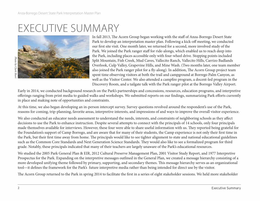
EXECUTIVE SUMMARY In fall 2013, The Acorn Group began working with the staff of Anza-Borrego Desert State Park to develop an interpretation master plan. Following a kick-off meeting, we conducted our first site visit. One month later, we returned for a second, more involved study of the Park. We joined the Park ranger staff for ride-alongs, which enabled us to reach deep into the Park, including places accessible only with four-wheel drive. Stopping points included Split Mountain, Fish Creek, Mud Caves, Vallecito Ranch, Vallecito Hills, Carrizo Badlands Overlook, Culp Valley, Grapevine Hills, and Mine Wash. (Two months later, one team member also joined the Park ranger pilot for a fly-along). In addition, The Acorn Group project team spent time observing visitors at both the trail and campground at Borrego Palm Canyon, as well as the Visitor Center. We also attended a campfire program, a docent-led program in the Discovery Room, and a tailgate talk with the Park ranger pilot at the Borrego Valley Airport.
Early in 2014, we conducted background research on the Park’s partnerships and concessions, resources, education programs, and interpretive offerings ranging from print media to guided walks and workshops. We submitted reports on our findings, summarizing Park efforts currently in place and making note of opportunities and constraints.
At this time, we also began developing an in-person intercept survey. Survey questions revolved around the respondent’s use of the Park, reasons for coming, trip-planning, favorite areas, interpretive interests, and impressions of and ways to improve the overall visitor experience.
We also conducted an educator needs assessment to understand the needs, interests, and constraints of neighboring schools as they affect decisions to use the Park to enhance instruction. Despite several attempts to connect with the principals of 14 schools, only four principals made themselves available for interviews. However, these four were able to share useful information with us. They reported being grateful for the Foundation’s support of Camp Borrego, and are aware that for many of their students, the Camp experience is not only their first time in the Park, but their first time away from home. The principals would like to see tighter alignment to state and national educational guidelines such as the Common Core Standards and Next Generation Science Standards. They would also like to see a formalized program for third grade. Notably, these principals indicated that many of their teachers are largely unaware of the Park’s educational resources.
We studied the 2005 Park General Plan & EIR, 2012 Cultural Preserve Management Plan, 2001 Visitor Study Report, and 1977 Interpretive Prospectus for the Park. Expanding on the interpretive messages outlined in the General Plan, we created a message hierarchy consisting of a more developed unifying theme followed by primary, supporting, and secondary themes. This message hierarchy serves as an organizational tool—it defines the framework for the Park’s future interpretive media rather than being intended for direct use by the visitor.
The Acorn Group returned to the Park in spring 2014 to facilitate the first in a series of eight stakeholder sessions. We held more stakeholder
Photo by Clark Short
Anza-Borrego Desert State Park Interpretation Master Plan
3ExecutiveSummary
sessions in fall 2014 and spring 2015. These sessions gathered input from both internal stakeholders (Park staff, Foundation staff, Foundation docents and volunteers, and site stewards) and external stakeholders (members of the community, tribal representatives, Park visitors, and other interested people). Sessions were held at Borrego Springs High School, the Park’s Visitor Center, San Diego Museum of Natural History, and San Diego Zoo Safari Park.
The intent of these sessions was to seek input on the Park’s interpretive stories and the various methods used to tell them. We asked stakeholders to comment on the draft message hierarchy and share impressions of current interpretive opportunities. Results were consistent across all eight sessions. Participants would like to see:
• more reliable and visible wayfinding tools,• more prominently displayed access points,• greater emphasis on the significance of the region’s dark skies,• improved print media including maps,• access to podcasts and other pre-loaded information, and• more user-friendly websites.
Some people voiced interest in revealing paleontological and archaeological resources for public display. They cited the difficulty of getting visitors to value something that is not seen or understood.
Using iPads and a field survey application called QuickTapSurvey, we conducted the visitor survey at the Palm Canyon trailhead and Visitor Center entrance in spring and fall 2014. Results of 163 surveys indicate that though people love the Park, in general they’re frustrated with the lack of wayfinding information and desire more interpretation. Although preferences for interpretive delivery systems vary with age, many people prefer signs and exhibits. Results also indicate the Internet has become the most popular planning resource. Nearly half (45%) of the respondents identified the Chamber of Commerce’s ABDSP website as a primary source of information.
In spring 2015, one of our team members returned to the Park to study interpretive opportunities at Little Blair Valley Cultural Preserve. Based on stakeholder and staff input, we also refined the message hierarchy. At this time, we established goals, guidelines, and objectives for Park interpretation and education. Grounded in the General Plan and enhanced by The Acorn Group’s background research, firsthand observation, staff interviews, and field research (stakeholder sessions, visitor surveys, and educator needs assessment), these goals, guidelines and objectives became the basis for our recommendations for interpretive media. These parameters and recommendations are included in this Interpretation Master Plan.
Throughout this two-year process, we worked closely with staff of Anza-Borrego Desert State Park. We delivered the draft Interpretation Master Plan in June 2015 and this final document in September 2015.

Anza-Borrego Desert State Park Interpretation Master Plan
4
Phot
o by
Cla
rk S
hort

Anza-Borrego Desert State Park Interpretation Master Plan
5Chapter1:IntroductiontothePlan 1.1ParkOverview
CHAPTER 1: INTRODUCTION TO THE PLAN 1.1 PARK OVERVIEW
Why a Park?Anza-Borrego Desert State Park was formed in 1932 to protect a handful of rare palm oases. Over time, the Park’s holdings have expanded significantly—and so has its mission. Today the Park exists to provide protection and stewardship for a significant piece of the western Colorado Desert, with its vast array of natural, scenic, cultural, historic, and prehistoric values. The Park also provides opportunities for visitors—whether from around the globe or down the street—to experience quality outdoor recreation in, and enjoyment of, a healthy natural environment. In the process, the Park aims to educate, enlighten, and inspire, instilling in each visitor, regardless of background or interest, a sense of wonder and appreciation for one of America’s finest and most fragile heritage landscapes.
The Long ViewOver time, the Park aims to achieve its ultimate vision: a diverse, pristine, functioning environment where nature’s processes unfold unimpeded; cultural resources are respected and cared for; research informs science and stewardship; and people can enjoy the Park’s unique offerings: special places, quality recreation, outstanding wildlife, beauty, solitude, darkness, quiet, and personal challenges that foster insight and growth.
1.2 PLAN PURPOSEInterpretation is a form of communication, and interpretive planning is a process that maximizes that communication in ways that are relevant and meaningful. Interpretive planning reveals the messages an institution seeks to convey, strategies to convey those messages, and goals and objectives that establish the purpose, and later, the effectiveness, of those strategies.
In the California State Park System, interpretation master plans take a long-range approach to planning. Aiming for a 10–15 year horizon, a plan analyzes existing conditions while looking at opportunities and constraints for expanding interpretation and meeting audience needs. A plan should recommend improvements that not only provide opportunities for remarkable interpretive experiences, but also help solve resource management problems by promoting support for Park practices and cultivating a stewardship ethic in the visiting public.
Palm Oasis
Phot
o by
Om
ar B
árce
na
Anza-Borrego Desert State Park Interpretation Master Plan
6 1.3PlanningProcess Chapter1:IntroductiontothePlan
At Anza-Borrego Desert State Park, interpretive planning has meant taking stock of expansive tracts of land, diverse landscapes and topography, a stunning array of plants and animals, and a far-ranging collection of stories and topics. Listening sessions, interviews, intercept surveys, site visits, and observations have informed the process, enabling the planning team to test assumptions and better understand the needs of staff, volunteers, and visitors.
An interpretation master plan produced within the California State Park System is followed by an Interpretation Action Plan, a roadmap that offers a mechanism for achieving the goals, objectives, and strategies presented in the interpretation master plan. The action plan establishes priorities among the strategies and the tasks necessary to implement the strategies, as well as responsibilities, funding sources, and potential partners.
Throughout these efforts, planners need to remain mindful of the aim of interpretation—to reveal deeper meaning and forge intellectual and emotional connections with visitors. To this end, for each interpretive opportunity at Anza-Borrego Desert State Park, we have used the places, people, events, and other “tangible” elements of the desert to tell bigger and deeper stories.
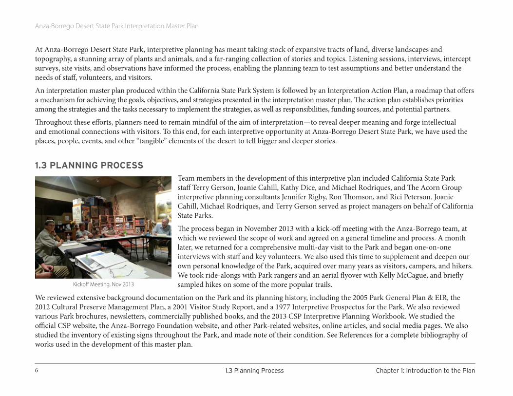
1.3 PLANNING PROCESSTeam members in the development of this interpretive plan included California State Park staff Terry Gerson, Joanie Cahill, Kathy Dice, and Michael Rodriques, and The Acorn Group interpretive planning consultants Jennifer Rigby, Ron Thomson, and Rici Peterson. Joanie Cahill, Michael Rodriques, and Terry Gerson served as project managers on behalf of California State Parks.
The process began in November 2013 with a kick-off meeting with the Anza-Borrego team, at which we reviewed the scope of work and agreed on a general timeline and process. A month later, we returned for a comprehensive multi-day visit to the Park and began one-on-one interviews with staff and key volunteers. We also used this time to supplement and deepen our own personal knowledge of the Park, acquired over many years as visitors, campers, and hikers. We took ride-alongs with Park rangers and an aerial flyover with Kelly McCague, and briefly sampled hikes on some of the more popular trails.
We reviewed extensive background documentation on the Park and its planning history, including the 2005 Park General Plan & EIR, the 2012 Cultural Preserve Management Plan, a 2001 Visitor Study Report, and a 1977 Interpretive Prospectus for the Park. We also reviewed various Park brochures, newsletters, commercially published books, and the 2013 CSP Interpretive Planning Workbook. We studied the official CSP website, the Anza-Borrego Foundation website, and other Park-related websites, online articles, and social media pages. We also studied the inventory of existing signs throughout the Park, and made note of their condition. See References for a complete bibliography of works used in the development of this master plan.
Kickoff Meeting, Nov 2013
Anza-Borrego Desert State Park Interpretation Master Plan
7Chapter1:IntroductiontothePlan 1.4ParkPlanningHistory
In addition to interviewing staff and key volunteers, we conducted several public listening sessions to gather input from people with an interest in Park interpretation and resource management. Sessions were advertised ahead of time, and were held in various venues in Borrego Springs as well as in San Diego and Escondido. Attendees were asked to provide input on the scope of topics to be interpreted, a draft thematic message structure, and visitor-related issues and problems that could be aided by enhanced interpretive opportunities. See Chapter 3 for a summary of what we learned, and Appendix D for a detailed report on every session.
The visiting public was also tapped in the development of this plan. Visitor intercept surveys were held in spring and fall 2014. See Section 2.4 for an analysis of the survey results, and Appendices B and C for details on the survey questions and data collected. For a spreadsheet showing all data collected, see Appendix H, published as a separate document.
At the end of the information-gathering period, we developed specific goals for interpretation at the Park, and one or more measurable objectives for each goal. These specific, highly detailed goals and objectives were based on the initial goals and objectives as described in the Park’s General and Cultural Preserve Management plans, and influenced by feedback gathered during the information-collecting process. After submitting the draft goals and objectives for approval, we developed a series of strategies outlining the general approach to achieving, or working toward, each objective.
From these strategies, we developed a set of general recommendations for interpretive products (“media”) and programming for the Park, including phasing suggestions. The final task was to develop a list of next steps for Park management to consider, among them the development of Action and Implementation plans for each interpretive offering.
1.4 PARK PLANNING HISTORYAlthough this document represents the Park’s first Interpretation Master Plan, it has developed out of a history of extensive interpretive programming as well as various planning efforts over several decades.
The first interpretive study at the Park (Anza-Borrego Desert State Park Interpretive Prospectus) was published in 1976 and revised in 1977. It included a review of Park resources, visitor needs, existing conditions, activities, interpretive priorities, and preliminary interpretive themes. In the Prospectus, the primary theme focused on the evolution of the Park landscape and biome. The two secondary themes focused on human involvement with the desert, and the Park’s need for preservation and protection.
The interpretive section of the 2005 General Plan further developed these early ideas into a set of themes touching on natural and cultural history and management. These themes can be found within Appendix F. Finally, in 2012, the publication of the Park’s Cultural Preserve Plan documented the presence of various cultural sites and how best to interpret them.
This Interpretation Master Plan is meant to advance these initial efforts.

Anza-Borrego Desert State Park Interpretation Master Plan
8
Morteros at Little Blair Valley Cultural Preserve

Anza-Borrego Desert State Park Interpretation Master Plan
9Chapter2:PlanningFoundation 2.1ParkResources
CHAPTER 2: PLANNING FOUNDATIONThis chapter describes the interpretable resources of the Park; the current status of interpretation at the Park, and guiding statements from the Park’s General Plan. It also briefly discusses outside influences that should be taken into consideration in the development of interpretive opportunities. Finally, it summarizes what we learned about Park visitation, including the results of an on-site visitor survey.
2.1 PARK RESOURCESThis review of Anza-Borrego Desert State Park’s natural, cultural, and recreational resources summarizes the significant stories that underlie the Park’s significance, notes management concerns for sensitive resources, and offers suggestions for how these resources fit into the interpretive planning process.
This is only a summary. For details on any particular resource or management concern, please refer to the Park’s 2005 General Plan and/or the 2012 Cultural Preserve Management Plan.
Physical Resources Currently measuring nearly 650,000 acres and stretching across three counties, Anza-Borrego Desert State Park (ABDSP) exceeds all normal scales of human/land relationships. No less than 34 USGS topo maps (7.5 minute scale) are required to cover the Park.
Geological Record The Park rests on a part of California that is being torn away from the North American continent by the action of the San Andreas Fault, creating the Salton Trough. Between 8 and 1 MYA (million years ago), a relatively complete geological record of over 19,000 feet of fossil-bearing sediment was laid down along this rift valley’s western margin by the action of the Colorado River and locally derived streams. Today’s landscape encompasses a complicated network of faults, rotating crustal blocks, mountain ranges, sedimentary basins, and erosional surfaces. Decades of research regarding the sedimentary and tectonic history of this area, including the Salton Trough, have contributed significantly to scientific understanding of the region’s geology.
Although the timing is unclear, within the last million years to 10,000 years, continued uplift of the Peninsular Ranges during the last million years contributed to changes in weather patterns of Southern California. At some point 10,000 or more years ago, these changes brought on a desert climate, altering considerably the past environmental conditions recorded by the geology and paleontology of ABDSP.
Font’s Point
Anza-Borrego Desert State Park Interpretation Master Plan
10 2.1ParkResources Chapter2:PlanningFoundation
Topography The Park’s unique and robust topography, which ranges from near sea level to elevated pine forest, forms a substrate for its complex patterns of hydrology, climate, vegetation, wildlife, and human uses over time. Fragile badlands, canyons carved deeply into the many mountains, ancient sea beds and playas, palm oases, and a series of alluvial fans and bajadas all contribute to the Park’s remarkable character.
Several major fault lines cross the Park, their ongoing tectonic and seismic stories traceable in mismatched rocks and soil types, elongated ridges and valleys, broad alluvial fans and bajadas draping the feet of steeply uplifted mountain ranges, and telltale groupings of native palms at perennial seeps and springs.
Remnants of ancient Lake Cahuilla are visible within Park boundaries, at Travertine Point in the Park’s northeastern corner. In addition, views of the lake’s former shoreline can be easily traced along the eastern flank of the Santa Rosa Mountains.
Geological hazards in and near the Park include rock falls, landslides, earthquakes, and subsidence due to groundwater overdraft.
ClimateLate November through March are the Park’s most comfortable months. By March, highs are typically around 85°F, and reach 100° by May. June through September, daytime highs are challenging, often exceeding 110° in July and August. Rainfall varies from a mean annual of 6+ inches at higher elevations in the west, to less than 3 inches at lower elevations in the east. Precipitation itself rarely ruins a Park visit. However, flash floods generated by distant storms are serious hazards, particularly for the unwary, unprepared visitor exploring a dry wash on a seemingly sunny, carefree day.
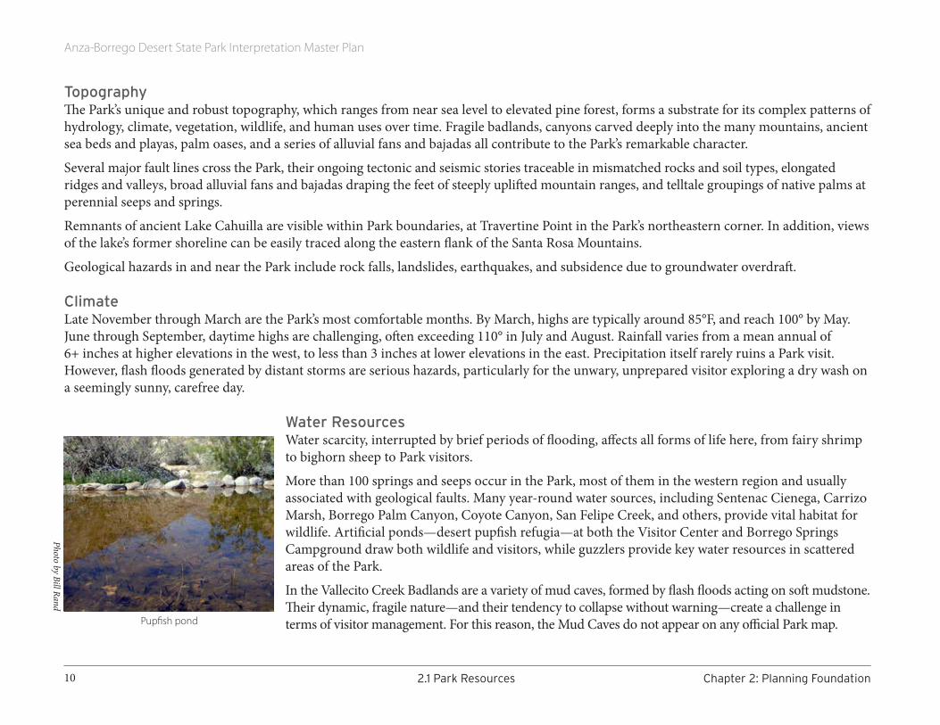
Water ResourcesWater scarcity, interrupted by brief periods of flooding, affects all forms of life here, from fairy shrimp to bighorn sheep to Park visitors.
More than 100 springs and seeps occur in the Park, most of them in the western region and usually associated with geological faults. Many year-round water sources, including Sentenac Cienega, Carrizo Marsh, Borrego Palm Canyon, Coyote Canyon, San Felipe Creek, and others, provide vital habitat for wildlife. Artificial ponds—desert pupfish refugia—at both the Visitor Center and Borrego Springs Campground draw both wildlife and visitors, while guzzlers provide key water resources in scattered areas of the Park.
In the Vallecito Creek Badlands are a variety of mud caves, formed by flash floods acting on soft mudstone. Their dynamic, fragile nature—and their tendency to collapse without warning—create a challenge in terms of visitor management. For this reason, the Mud Caves do not appear on any official Park map.
Photo by Bill Rand
Pupfish pond
Anza-Borrego Desert State Park Interpretation Master Plan
11Chapter2:PlanningFoundation 2.1ParkResources
Minerals and MinesFor over a century, the area attracted miners in search of a variety of minerals including gold, non-precious metals, tourmaline, garnet, dolomite, molybdenum, calcite, gypsum, volcanic ash, and sand. There is an abandoned calcite mine in the northeastern section of the Park. It played a role in WWII, as its quality calcite was valuable in the manufacture of military gunsights.
Today a commercial, open-pit gypsum mine operates just outside the Park boundary, southeast of Ocotillo Wells.
Soils The Park’s soils are fragile. Biological soil crusts, mycorrhizae and rhizobia, soil-dwelling insects, and small mammals play important ecological roles. Together they affect soil structure, nutrient cycling, erosion reduction, water infiltration, and seed germination. Camping and off-trail and off-road travel have an impact on these systems.
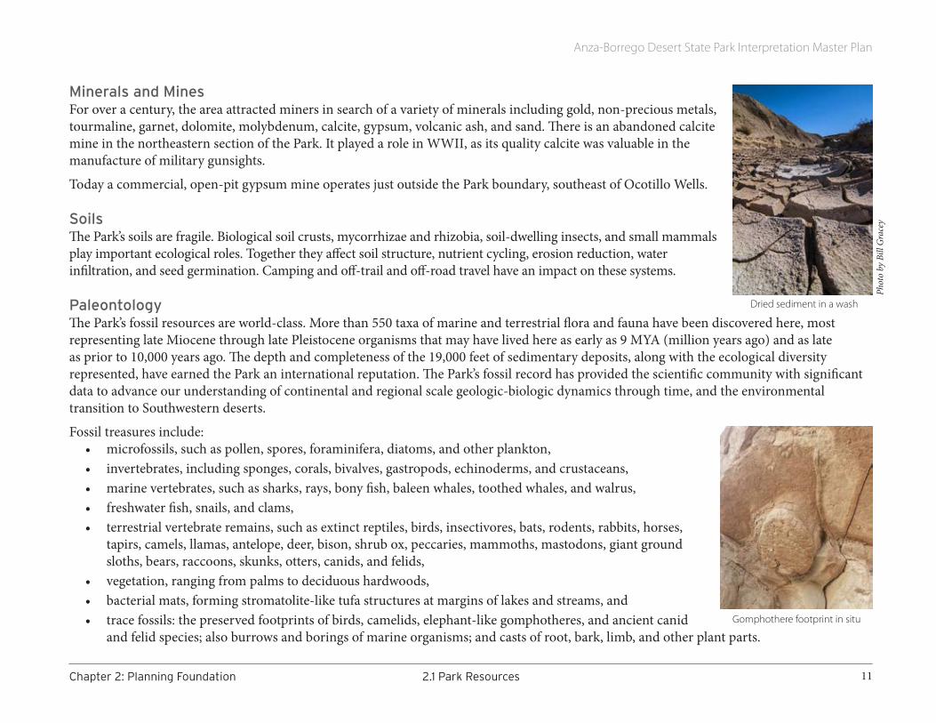
PaleontologyThe Park’s fossil resources are world-class. More than 550 taxa of marine and terrestrial flora and fauna have been discovered here, most representing late Miocene through late Pleistocene organisms that may have lived here as early as 9 MYA (million years ago) and as late as prior to 10,000 years ago. The depth and completeness of the 19,000 feet of sedimentary deposits, along with the ecological diversity represented, have earned the Park an international reputation. The Park’s fossil record has provided the scientific community with significant data to advance our understanding of continental and regional scale geologic-biologic dynamics through time, and the environmental transition to Southwestern deserts.
Fossil treasures include:• microfossils, such as pollen, spores, foraminifera, diatoms, and other plankton,• invertebrates, including sponges, corals, bivalves, gastropods, echinoderms, and crustaceans,• marine vertebrates, such as sharks, rays, bony fish, baleen whales, toothed whales, and walrus,• freshwater fish, snails, and clams,• terrestrial vertebrate remains, such as extinct reptiles, birds, insectivores, bats, rodents, rabbits, horses,
tapirs, camels, llamas, antelope, deer, bison, shrub ox, peccaries, mammoths, mastodons, giant ground sloths, bears, raccoons, skunks, otters, canids, and felids,
• vegetation, ranging from palms to deciduous hardwoods,• bacterial mats, forming stromatolite-like tufa structures at margins of lakes and streams, and• trace fossils: the preserved footprints of birds, camelids, elephant-like gomphotheres, and ancient canid
and felid species; also burrows and borings of marine organisms; and casts of root, bark, limb, and other plant parts.
Dried sediment in a wash
Phot
o by
Bill
Gra
cey
Gomphothere footprint in situ
Anza-Borrego Desert State Park Interpretation Master Plan
12 2.1ParkResources Chapter2:PlanningFoundation
Fossil-bearing BadlandsApproximately one-third of the land area of the Park consists of badlands, formed in fossil-rich soft to hard sand and gravel sediments. Continuous erosion of these sediments exposes new fossils to the Park paleontology surveys. Many of the Park jeep roads and hiking trails pass through these sensitive resource areas. Unauthorized motorcycle and 4-wheel activity away from the roads increases erosion, scars and defaces the slopes in an unsightly manner, and damages fossils.
BIOLOGICAL RESOURCES
Park HabitatsThe ABDSP’s biodiversity is unmatched by all other State Parks in California. Its remarkable array of plant and animal species are completely adapted to, and often dependent on, the region’s climatic extremes. Park habitats fall into five broad categories:
• washes, arroyos and adjacent terraces,• wetland and riparian areas,• open desert scrub,• desert/montane transition, and• montane.
Washes and arroyos are usually dry, with ephemeral floods during intense rainfall events and more sustained, lower-level flows typical in winter and spring. Here are found the iconic Sonoran tree species—smoketree, desert willow, mesquites, ironwood, and palo verde—along with an array of wildlife species. Washes attract the Park’s highest visitor use; people typically move through the Park along washes and terraces. Camping is also common in these areas. Transportation ranges from 2- or 4-wheel drive vehicles to horses, hiking boots, and mountain bikes.
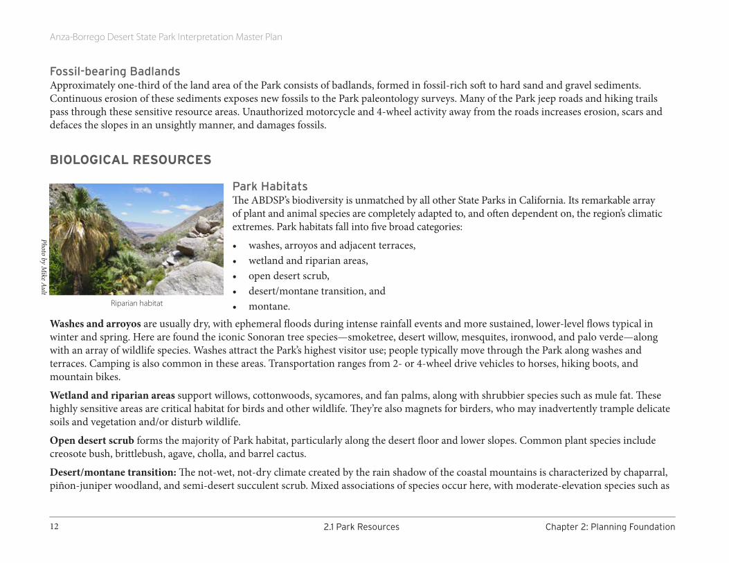
Wetland and riparian areas support willows, cottonwoods, sycamores, and fan palms, along with shrubbier species such as mule fat. These highly sensitive areas are critical habitat for birds and other wildlife. They’re also magnets for birders, who may inadvertently trample delicate soils and vegetation and/or disturb wildlife.
Open desert scrub forms the majority of Park habitat, particularly along the desert floor and lower slopes. Common plant species include creosote bush, brittlebush, agave, cholla, and barrel cactus.
Desert/montane transition: The not-wet, not-dry climate created by the rain shadow of the coastal mountains is characterized by chaparral, piñon-juniper woodland, and semi-desert succulent scrub. Mixed associations of species occur here, with moderate-elevation species such as
Riparian habitat
Photo by Mike Ault

Anza-Borrego Desert State Park Interpretation Master Plan
13Chapter2:PlanningFoundation 2.1ParkResources
chamise, buckwheat, and sugarbush found alongside lower-desert plants such as cactus, agave, and brittlebush. Tough as they are, these habitats are dynamic and often subjected to various events and forces, including fire, edge impacts, and trespass.
Montane habitat, typically found on the western-facing slopes of the Peninsular Ranges in the Park, offers a markedly different visitor experience from the lower, more arid desert areas. Here, the Park’s coolest and wettest conditions support forests, chaparral, grasslands, and meadows and their associated fauna. Typical tree species include live and deciduous oaks along with various conifers. Bush and chaparral species include manzanita, mountain mahogany, and ceanothus. Extremely rare (possibly endemic) plants occur here, including the Cuyamaca Rockcress and Cuyamaca Larkspur.
Plant Life More than 900 plant taxa from nearly 100 different families have been documented in the Park. Sunflower, pea, and grass families dominate.
Though the Park is spectacular in many ways, it’s world-famous for its spring wildflower bloom. Not every year is a winner, but when winter precipitation stacks up just right, the subsequent spring yields spectacular displays of color across washes, bajadas, upland areas, and the desert floor—drawing an additional 300,000 visitors to the Park.
Animal Life AmphibiansUp to 12 species of amphibians, including tree frogs, toads, and salamanders, may be found in ABDSP. Isolated as they are to the Park’s scarce wetland and riparian habitats, these populations are particularly vulnerable to extirpation.
ReptilesThe Park’s geographic relationship to other regional environments supports a remarkably unique reptilian assemblage, with 60 taxa deemed likely. This distribution provides particularly important information for scientific understanding of evolution and adaptation. Typical species range from desert iguana to chuckwalla, California king snake, ubiquitous side-blotched lizard, and four species of rattlesnake.
BirdsDespite the Park’s predominantly dry environment, nearly 300 species of birds have been documented here, and species presence is extremely
Open desert scrub hosts a rich diversity of species.
Phot
o by
Jerr
y Ki
rkha
rt
Hooded Oriole on Octotillo
Phot
o by
Bill
Gra
cey
Anza-Borrego Desert State Park Interpretation Master Plan
14 2.1ParkResources Chapter2:PlanningFoundation
variable over the course of a year. Over 50 species are found here year-round; several species are spring/fall migrants; some are here only for breeding; and a typical Christmas count typically yields over 100 species. Many are sensitive species. This complex of species diversity, distribution, and seasonality have earned the Park its designation as a Globally Important Bird Area. Protection of existing water resources is critical to avian survival and diversity. Popular species of note are roadrunner, quail, orioles, wrens, and warblers.
MammalsMammals can be found in virtually all Park habitats, contributing heavily to soil and vegetation processes and serving as essential prey resources. Rodents—including desert kangaroo rats, woodrats, pocket and field mice, gophers, and antelope ground squirrels—outnumber all other mammals, with 31 species represented. At least 14 species of bats exist here, along with shrews, moles, rabbits, hares, kit and gray foxes, ringtails, weasels, badgers, raccoons, bobcats, opossums, and skunks. Larger mammals include coyotes, mountain lions, Peninsular bighorn sheep, and mule deer. Bighorn and mountain lion stimulate the most interest in the visiting public. This popular interest adds a layer of complexity to the Park’s management of these protected species.
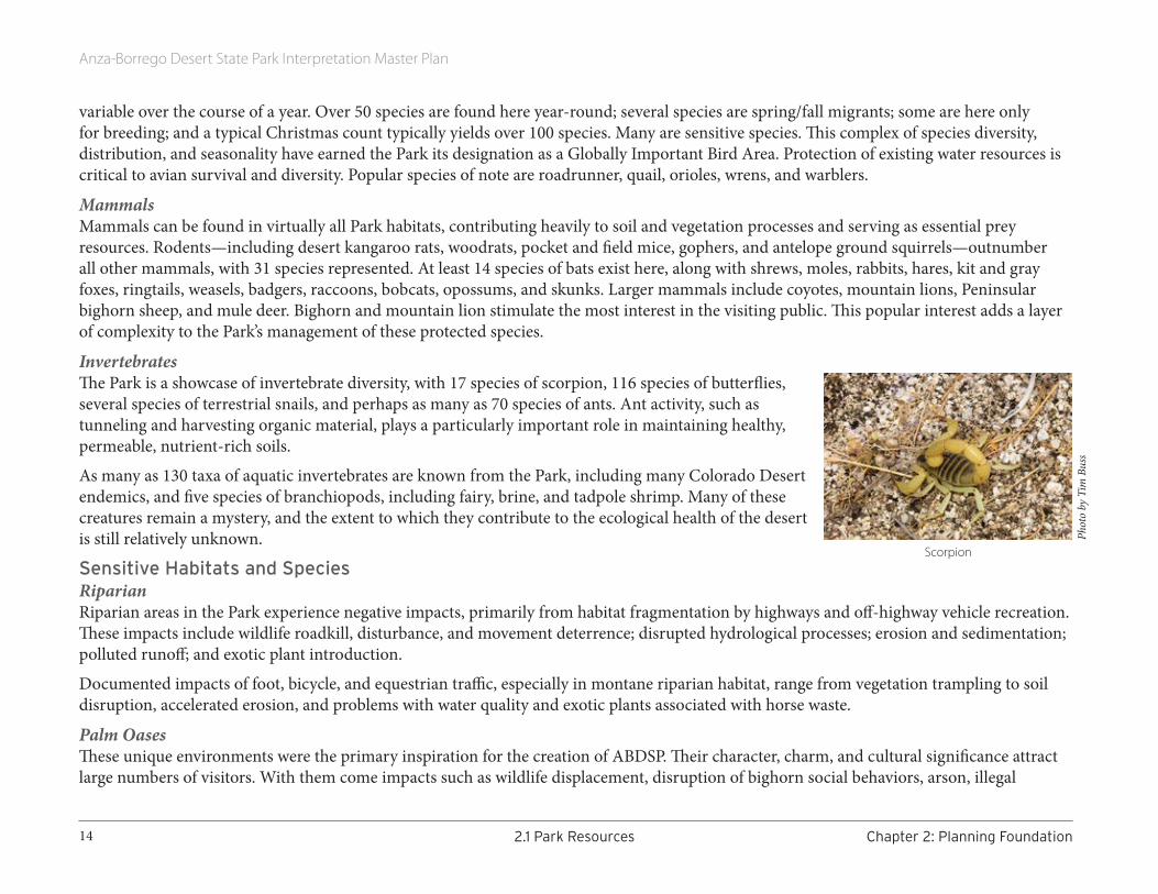
Invertebrates The Park is a showcase of invertebrate diversity, with 17 species of scorpion, 116 species of butterflies, several species of terrestrial snails, and perhaps as many as 70 species of ants. Ant activity, such as tunneling and harvesting organic material, plays a particularly important role in maintaining healthy, permeable, nutrient-rich soils.
As many as 130 taxa of aquatic invertebrates are known from the Park, including many Colorado Desert endemics, and five species of branchiopods, including fairy, brine, and tadpole shrimp. Many of these creatures remain a mystery, and the extent to which they contribute to the ecological health of the desert is still relatively unknown.
Sensitive Habitats and SpeciesRiparianRiparian areas in the Park experience negative impacts, primarily from habitat fragmentation by highways and off-highway vehicle recreation. These impacts include wildlife roadkill, disturbance, and movement deterrence; disrupted hydrological processes; erosion and sedimentation; polluted runoff; and exotic plant introduction.
Documented impacts of foot, bicycle, and equestrian traffic, especially in montane riparian habitat, range from vegetation trampling to soil disruption, accelerated erosion, and problems with water quality and exotic plants associated with horse waste.
Palm OasesThese unique environments were the primary inspiration for the creation of ABDSP. Their character, charm, and cultural significance attract large numbers of visitors. With them come impacts such as wildlife displacement, disruption of bighorn social behaviors, arson, illegal
Scorpion
Phot
o by
Tim
Bus
s

Anza-Borrego Desert State Park Interpretation Master Plan
15Chapter2:PlanningFoundation 2.1ParkResources
camping and campfires, groundfires, vegetation trampling, soil compaction, excessive noise, vandalism, and trash. Hiking and climbing along unstable canyon walls near most oases may also increase erosion and degrade surface water quantity and quality.
Mesquite BosqueRegional depletion of groundwater is slowly undermining this sensitive habitat type, which provides important nitrogen-fixing functions for cycling nutrients through the desert ecosystem. Mesquite bosque also offers avian nesting and feeding areas, and protection from sun and wind for wildlife and humans. The impact of camping in these popular areas remains to be assessed.
Ciénegas (Alkali Marshes)These freshwater wetlands and associated hydrophytic vegetation are extremely important for biotic diversity and may also play an important role in dispersing the power of desert floods. Past damage from human uses, including cattle ranching and intentional burning, have resulted in massive invasion of tamarisk. Ongoing restoration continues to raise the quality of these sensitive habitats.
Montane Vernal Pools and MeadowsThese complexes are inhabited by native and non-native grass species, wildflowers (including the endangered Cuyamaca Lake downingia and Parish’s meadowfoam), and sensitive species of branchiopods. Management of sensitive species is complicated by the fact that parts of Cuyamaca Lake are managed by other agencies as a reservoir and recreation facility.
Desert Ephemeral PlayasThese apparently lifeless expanses shelter sensitive plants and the cysts of fairy shrimp and other branchiopods. These cysts lie dormant and hatch only when playas are saturated. Dry playa soils are easily broken by foot and vehicular traffic, exposing them to wind erosion, destroying shrimp cysts, and leaving tracks that remain visible for years.
Small Springs and SeepsThe Park’s isolated springs and seeps, as its most stable water supplies, serve as important focal points for biodiversity. As remnants of formerly extensive regional waters, they often serve as refuges for genetically distinct populations as well.
Sand DunesDune systems, each approaching or exceeding a square mile in area, can be found along Clark Lake, in Ant Hill and other areas of the Borrego Badlands, and in Blow Sand Canyon. Fragile surface
Clark Dry Lake, an ephemeral playa
Sand dunes (aerial view)
Mesquite along wash
Phot
o by
Law
renc
e Hog
ue
Anza-Borrego Desert State Park Interpretation Master Plan
16 2.1ParkResources Chapter2:PlanningFoundation
crust, vulnerable to foot or vehicle traffic, protects much of these dune areas, creating moister, cooler underground microhabitats supporting dependent plant and animal assemblages including the Colorado Desert fringe-toed lizard.
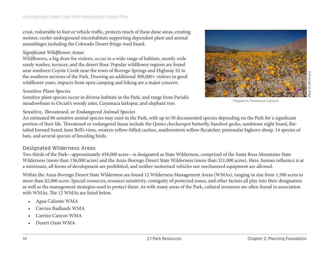
Significant Wildflower AreasWildflowers, a big draw for visitors, occur in a wide range of habitats, mostly wide sandy washes, terraces, and the desert floor. Popular wildflower regions are found near southern Coyote Creek near the town of Borrego Springs and Highway S2 in the southern sections of the Park. Drawing an additional 300,000+ visitors in good wildflower years, impacts from open camping and hiking are a major concern.
Sensitive Plant Species Sensitive plant species occur in diverse habitats in the Park, and range from Parish’s meadowfoam to Orcutt’s woody aster, Cuyamaca larkspur, and elephant tree.
Sensitive, Threatened, or Endangered Animal SpeciesAn estimated 86 sensitive animal species may exist in the Park, with up to 50 documented species depending on the Park for a significant portion of their life. Threatened or endangered fauna include the Quino checkerspot butterfly, barefoot gecko, sandstone night lizard, flat-tailed horned lizard, least Bell’s vireo, western yellow-billed cuckoo, southwestern willow flycatcher, peninsular bighorn sheep, 14 species of bats, and several species of breeding birds.
Designated Wilderness AreasTwo thirds of the Park—approximately 458,000 acres—is designated as State Wilderness, comprised of the Santa Rosa Mountains State Wilderness (more than 136,000 acres) and the Anza-Borrego Desert State Wilderness (more than 321,000 acres). Here, human influence is at a minimum, all forms of development are prohibited, and neither motorized vehicles nor mechanized equipment are allowed.
Within the Anza-Borrego Desert State Wilderness are found 12 Wilderness Management Areas (WMAs), ranging in size from 1,500 acres to more than 82,000 acres. Special resources, resource sensitivity, contiguity of protected zones, and other factors all play into their designation as well as the management strategies used to protect them. As with many areas of the Park, cultural resources are often found in association with WMAs. The 12 WMAs are listed below.
• Agua Caliente WMA • Carrizo Badlands WMA• Carrizo Canyon WMA• Desert Oasis WMA
Poppies in Henderson Canyon
Phot
o by
Bill
Gra
cey

Anza-Borrego Desert State Park Interpretation Master Plan
17Chapter2:PlanningFoundation 2.1ParkResources
• Granite Mountain WMA • Grapevine Mountain WMA • Jacumba Mountain WMA • Sheep Canyon WMA• Pinyon Ridge WMA • Sombrero Peak WMA• Vallecito Mountains WMA • Whale Peak WMA
Cultural PreservesABDSP currently has eight Cultural Preserves (CP). Designation as a Cultural Preserve adds an extra layer of protection for certain areas in the Park that harbor extraordinary prehistoric and historic resources. Though more than 80% of the land areas in these preserves already lie within designated Wilderness, certain focused management approaches to Cultural Preserves helps protect these lands, which hold a special significance for both native peoples and the state’s history.
In preserves, visitor impacts are carefully managed, with emphasis on day use and passive recreation. Hiking, horseback riding, mountain biking, and hike-in camping are restricted to established and designated areas only. Some limited vehicle use is possible, but only in certain areas. In every preserve, special zones where highly sensitive resources occur are restricted from any and all visitor use.
The Cultural Preserve Management Plan (CPMP) calls for interpretation of these archaeological and historic resources in order to increase understanding, provide an enhanced user experience, and provide unique opportunities for partnerships with local tribes and historic groups.
The Park’s 2012 Cultural Preserve Management Plan and the 2005 General Plan describe in detail the resources at each CP, along with specific interpretive topics to cover. Below is a synopsis of each CP.
We-nelsch, 443 acresThe first Cultural Preserve created in the Park, We-nelsch protects numerous prehistoric and historic Kumeyaay resources, including a huge village site from which it takes its name. We-nelsch
A Cultural Preserve
Anza-Borrego Desert State Park Interpretation Master Plan
18 2.1ParkResources Chapter2:PlanningFoundation
witnessed the earliest interactions between Southern California’s first peoples and Europeans. The site also contains portions of the Mormon Battalion Trail and Southern Emigrant Trail, as well as the remains of a Butterfield Stage station.
Angelina Spring, 437 acres/ 26 cultural sites This stopping place along an ancient, well-used passageway between the desert floor and the mountain heights offered water to native peoples as well as miners, cattlemen, and livestock. As in many CPs, Angelina Spring is a regional resource for tribal gatherings and educational visits, and is considered a sacred area.
Coyote Canyon, 29,000+ acres, including 20 miles of Coyote Creek and adjacent floodplain landscape In addition to a vital riparian ecosystem, this highly concentrated and significant cultural site includes very ancient and well-used prehistoric travel routes between native people’s desert and mountain resources and communities as well as historic travel routes for de Anza, colonists, and livestock herders.
Culp Valley, 1277 acres Rock-shelter dwellings, freshwater springs, and the lush growth of native vegetation tell the story of seasonal visitation by native peoples, both prehistorically and post-contact. Ranchers also valued this area for its rich grazing resources.
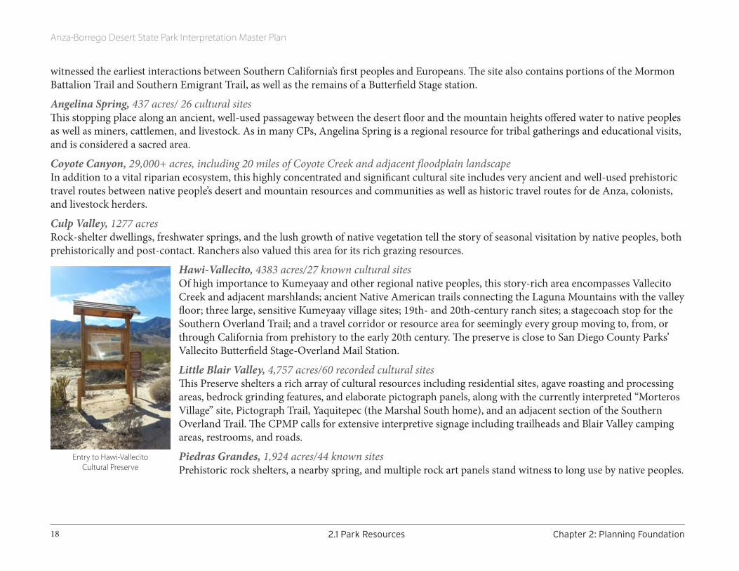
Hawi-Vallecito, 4383 acres/27 known cultural sitesOf high importance to Kumeyaay and other regional native peoples, this story-rich area encompasses Vallecito Creek and adjacent marshlands; ancient Native American trails connecting the Laguna Mountains with the valley floor; three large, sensitive Kumeyaay village sites; 19th- and 20th-century ranch sites; a stagecoach stop for the Southern Overland Trail; and a travel corridor or resource area for seemingly every group moving to, from, or through California from prehistory to the early 20th century. The preserve is close to San Diego County Parks’ Vallecito Butterfield Stage-Overland Mail Station.
Little Blair Valley, 4,757 acres/60 recorded cultural sites This Preserve shelters a rich array of cultural resources including residential sites, agave roasting and processing areas, bedrock grinding features, and elaborate pictograph panels, along with the currently interpreted “Morteros Village” site, Pictograph Trail, Yaquitepec (the Marshal South home), and an adjacent section of the Southern Overland Trail. The CPMP calls for extensive interpretive signage including trailheads and Blair Valley camping areas, restrooms, and roads.
Piedras Grandes, 1,924 acres/44 known sites Prehistoric rock shelters, a nearby spring, and multiple rock art panels stand witness to long use by native peoples.
Entry to Hawi-Vallecito Cultural Preserve

Anza-Borrego Desert State Park Interpretation Master Plan
19Chapter2:PlanningFoundation 2.1ParkResources
Southern Overland Trail, 315 acres/26 linear miles The Preserve harbors the best-protected stretch of this extensively-used historic route, which for many years connected the North American interior with the Pacific and its coastal valleys. The ruins of the Carrizo Stage Station are also within the Preserve. Foot, horse, and bicycle travel are allowed on less-sensitive, already “overwritten” sections of the trail, which is still identifiable by its classic “U”-shaped profile and rust-scraped rocks. Multiple interpretive opportunities described in the CPMP include signs, brochures, podcasts, and living history events. The section through Vallecito is the site of Vallecito Days, the annual multi-agency re-enactment event.
PARK COLLECTIONSDue in large part to the undisturbed nature of Park settings, ABDSP has yielded excellent collections of paleontological, natural history, and cultural specimens. The world’s scientific research community benefits from, and contributes to, these rare and valuable collections, which have been growing steadily throughout the 20th century and continue to do so today.
Scientific collecting of fossils from lands now enclosed within the Park started in the late 19th century. These fossils—vertebrate, invertebrate, and paleobotanic—represent over 550 taxa; the Stout Research Center collection is currently houses about 22,000 specimens, with at least 500 more at other institutions. Remarkably, they form a (mostly) unbroken sequence, beginning in the middle Miocene epoch (more than 9 MYA) and proceeding through the Pliocene (5 to 2.6 MYA) to the late Pleistocene age (210,000 to 10,000 years ago). This wide variety of organisms represents a broad diversity of paleoenvironments and paleolandscapes. Several Park vertebrate fossils represent the world’s earliest or latest stratigraphic records for those taxa.
Park natural history collections include herbarium and zoological materials, including many bighorn sheep skulls.
Cultural collections stretch back at least 4,500 years and include a wide variety of flaked and ground stone tools, shell and wood items, ecofacts (plant materials, shells, and bone), and ceramics. Of special note are significant assemblages of stone tools and late prehistoric ollas (aboriginal ceramic vessels). Archaeological lithic artifacts, largely attributed to the Malpais or San Dieguito traditions, may be mid-to-early Holocene. Mid-Holocene artifacts include Archaic, Elko period materials, while late prehistoric artifacts result from Cahuilla and/or Kumeyaay (Ipai, Tipai, and Kamia) occupation.
Most historic materials are farming, ranching, mining, and mid-20th century military items. Only a few historic artifacts represent early European occupation. Most historic artifacts consist of hardware or munitions from WWII military exercises. Photographs, maps, and other documents are in the historic collection.
As described in the Park’s 2005 General Plan, Park collections can support interpretation. However, although some items are available for
Bivalve fossils in situ

Anza-Borrego Desert State Park Interpretation Master Plan
20 2.1ParkResources Chapter2:PlanningFoundation
ABDSP exhibits, hands-on use is highly discouraged and requires written permission. Additionally, some highly sensitive localities, records, and site data are restricted to authorized personnel only. Information on localities is prohibited in a public format.
Interpretive topics that arise from the Park’s collections include the role of water in landscape evolution, prehistoric conditions, and modern biotic and human adaptations; geological development of the landscape; late Cenozoic paleontological settings; biological adaptations and ecological patterns in arid and semi-arid environments; prehistoric human adaptations and settlement in desert conditions; and historic and modern land-use patterns.
Many ABDSP collections are housed in California State Parks’ Colorado Desert District Stout Research Center and the Begole Archaeological Research Center (BARC). These facilities include labs, research libraries, collections, and archives. Other collections are housed in various museums and universities in California and around the US.
RECREATIONAL RESOURCES Visitors to ABDSP bring with them a wide range of interests, but most share a desire for a quality experience in beautiful natural surroundings.
Many are interested in movement-based activities such as hiking, biking, or even just a scenic drive. The Park also attracts visitors interested in its diverse contents and topics—wildflowers, bighorn sheep, history, snakes and lizards, geology, fossils, starry skies, Native American cultural resources, or birds—not to mention two increasingly rare qualities: peace and solitude.
The Park does not disappoint.
ABDSP hosts an average of 600,000 visitors per year, rising to nearly 900,000 in “good wildflower” years. The vast majority of these visitors arrive between November and April, with up to 35% visiting in March during the better wildflower seasons.
Most visitors are day-users, with only about one in four camping overnight. Most (75%) visit the Park’s northern sections. Half of visitor traffic is concentrated in the Visitor Center/Borrego Palm Canyon area.
RoadsWith over 100 miles of paved public roads, popular activities on or near roads include auto touring, cycling, walking, running, camping, wildlife viewing, and wildflower viewing. Many Park facilities such as campgrounds are near or on paved roads.
Fonts Point
Anza-Borrego Desert State Park Interpretation Master Plan
21Chapter2:PlanningFoundation 2.1ParkResources
Recreational Access Highway-legal motor vehicle, equestrian, foot, and bicycle traffic is allowed on all Park roads, while only foot traffic is allowed off-road. More than 90% of the Park’s 400+ miles of primitive dirt roads are accessible by four-wheel drive only. Even then, sudden changes in weather often trigger temporary road closures. No unregistered or “green or red sticker”-registered vehicles may be operated in the Park.
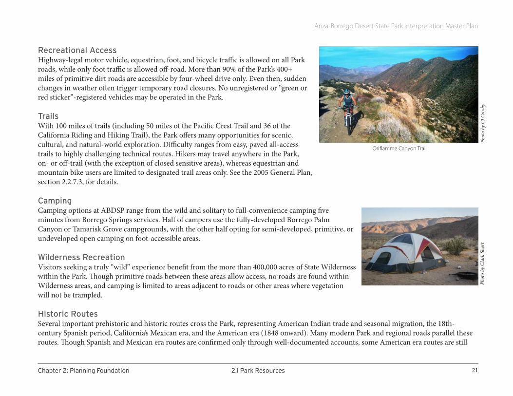
TrailsWith 100 miles of trails (including 50 miles of the Pacific Crest Trail and 36 of the California Riding and Hiking Trail), the Park offers many opportunities for scenic, cultural, and natural-world exploration. Difficulty ranges from easy, paved all-access trails to highly challenging technical routes. Hikers may travel anywhere in the Park, on- or off-trail (with the exception of closed sensitive areas), whereas equestrian and mountain bike users are limited to designated trail areas only. See the 2005 General Plan, section 2.2.7.3, for details.
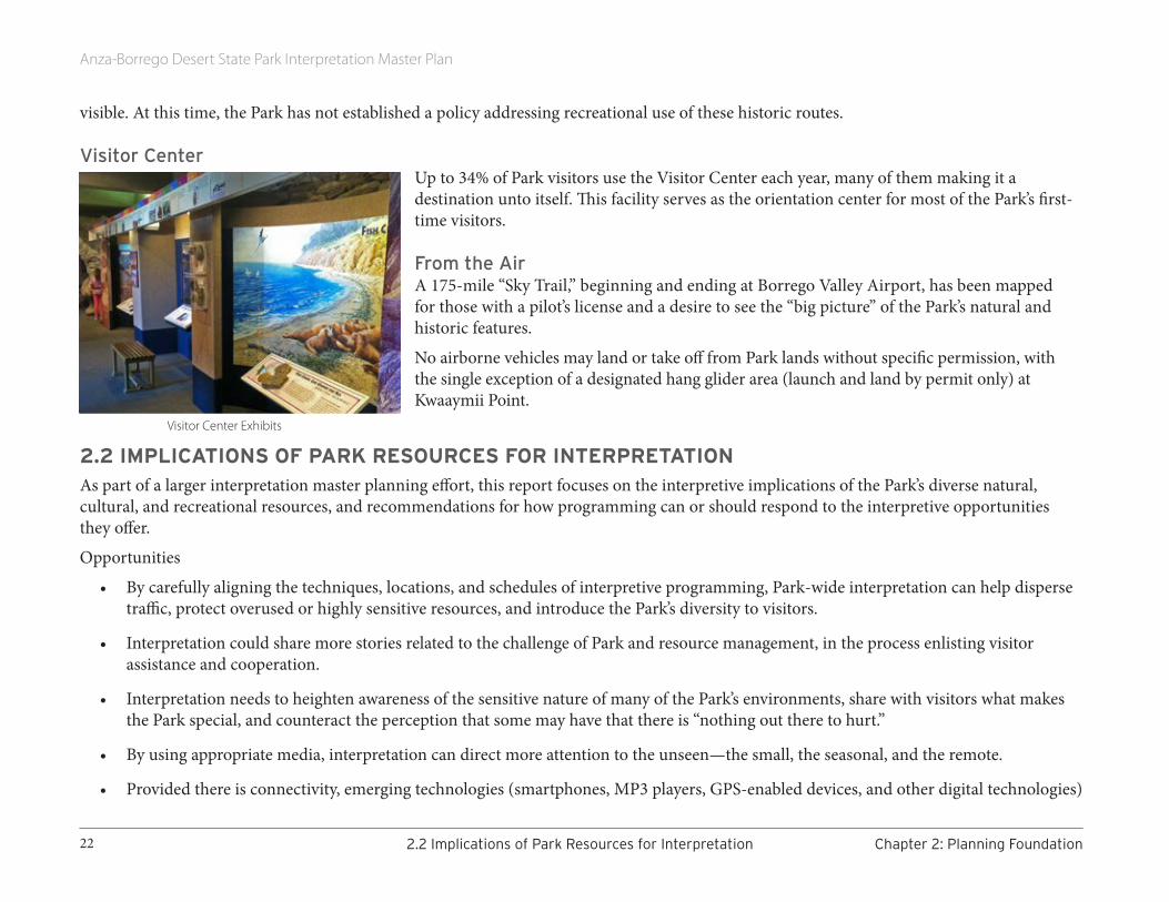
CampingCamping options at ABDSP range from the wild and solitary to full-convenience camping five minutes from Borrego Springs services. Half of campers use the fully-developed Borrego Palm Canyon or Tamarisk Grove campgrounds, with the other half opting for semi-developed, primitive, or undeveloped open camping on foot-accessible areas.
Wilderness RecreationVisitors seeking a truly “wild” experience benefit from the more than 400,000 acres of State Wilderness within the Park. Though primitive roads between these areas allow access, no roads are found within Wilderness areas, and camping is limited to areas adjacent to roads or other areas where vegetation will not be trampled.
Historic RoutesSeveral important prehistoric and historic routes cross the Park, representing American Indian trade and seasonal migration, the 18th-century Spanish period, California’s Mexican era, and the American era (1848 onward). Many modern Park and regional roads parallel these routes. Though Spanish and Mexican era routes are confirmed only through well-documented accounts, some American era routes are still
Oriflamme Canyon Trail
Phot
o by
CJ C
rosb
yPh
oto
by C
lark
Sho
rt
Anza-Borrego Desert State Park Interpretation Master Plan
22 2.2ImplicationsofParkResourcesforInterpretation Chapter2:PlanningFoundation
visible. At this time, the Park has not established a policy addressing recreational use of these historic routes.
Visitor CenterUp to 34% of Park visitors use the Visitor Center each year, many of them making it a destination unto itself. This facility serves as the orientation center for most of the Park’s first-time visitors.
From the AirA 175-mile “Sky Trail,” beginning and ending at Borrego Valley Airport, has been mapped for those with a pilot’s license and a desire to see the “big picture” of the Park’s natural and historic features.
No airborne vehicles may land or take off from Park lands without specific permission, with the single exception of a designated hang glider area (launch and land by permit only) at Kwaaymii Point.
2.2 IMPLICATIONS OF PARK RESOURCES FOR INTERPRETATIONAs part of a larger interpretation master planning effort, this report focuses on the interpretive implications of the Park’s diverse natural, cultural, and recreational resources, and recommendations for how programming can or should respond to the interpretive opportunities they offer.
Opportunities
• By carefully aligning the techniques, locations, and schedules of interpretive programming, Park-wide interpretation can help disperse traffic, protect overused or highly sensitive resources, and introduce the Park’s diversity to visitors.
• Interpretation could share more stories related to the challenge of Park and resource management, in the process enlisting visitor assistance and cooperation.
• Interpretation needs to heighten awareness of the sensitive nature of many of the Park’s environments, share with visitors what makes the Park special, and counteract the perception that some may have that there is “nothing out there to hurt.”
• By using appropriate media, interpretation can direct more attention to the unseen—the small, the seasonal, and the remote.
• Provided there is connectivity, emerging technologies (smartphones, MP3 players, GPS-enabled devices, and other digital technologies)
Visitor Center Exhibits

Anza-Borrego Desert State Park Interpretation Master Plan
23Chapter2:PlanningFoundation 2.3CurrentStatusofInterpretation
could offer new opportunities for interpretation of Park resources, particularly among select target audiences. Although there is concern that digital technologies detract attention from the real elements of an experience, there is a growing body of research that suggests the contrary.
• This interpretive planning process provides an ideal opportunity to discuss and prioritize recommendations in the Cultural Preserve Management Plan and elsewhere, and consolidate all suggestions and recommendations into a single coherent strategy.
ChallengesThe size of the Park and variety of its resources is an interpretive challenge that is best addressed via a hierarchy of messages. If visitors leave with only a single message, it should relate to the vast size and character of the Park (the “unifying” theme identified in this plan). More specific interpretive stories of “change,” “diversity,” and “inspiration” are nestled under that message. Every interpretive offering, from individual ranger or volunteer programs to written and exhibit interpretation, educational programs, etc., should make clear links to the unifying theme, or one or more of the primary themes.
Given the importance and widespread evidence of human use and occupation of lands within ABDSP, as described in the CPMP and this inventory, interpretation of human impacts needs to be re-evaluated and probably expanded.
Similarly, the popularity of the Park’s wildflowers can be harnessed to expand visitor knowledge of other important Park stories, perhaps gradually adjusting visitor expectations and lessening disappointment when the flowers aren’t at their peak.
Calling attention to Park resources requires calling attention to their fragility. Placement of interpretive media must consider implications for resource protection.
Recommendations for interpretive media need to be accompanied by recommendations for their upkeep and maintenance in order to prolong their usefulness in this harsh, remote environment.
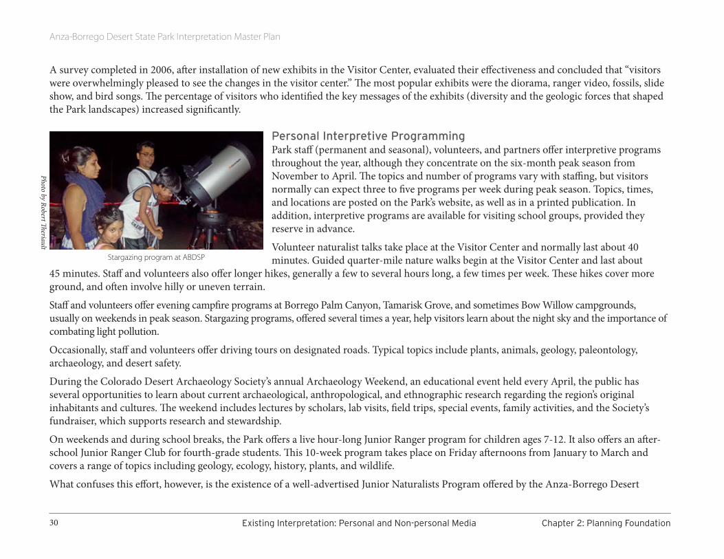
2.3 CURRENT STATUS OF INTERPRETATION
Existing Partnerships and Concessionaires
Partner: Anza-Borrego FoundationThe Anza-Borrego Foundation (ABF) is the Park’s one cooperating association. Established in 1967, the Foundation’s purpose is to support Anza-Borrego Desert State Park and its resources. Its mission statement reads, “Our mission is to protect and preserve the natural landscape, wildlife habitat, and cultural heritage of Anza-Borrego Desert State Park for the benefit of present and future generations.”

Anza-Borrego Desert State Park Interpretation Master Plan
24 2.3CurrentStatusofInterpretation Chapter2:PlanningFoundation
The Foundation’s headquarters are located in Borrego Springs. A staff of eight, including an executive director, education manager, education coordinator, and a board of trustees comprised of 14 members, carry out the organization’s functions. The Foundation is very transparent—staffing, operational details, and financial statements are posted on Guidestar.org, easily accessed through a link on the Anza-Borrego Foundation’s website.
Specific functions of the Foundation include land acquisition, support of research, operation of two retail facilities, and education. Since its inception, it has purchased and preserved over 53,000 acres of land, largely comprised of private inholdings transferred to the State Park to ensure habitat connectivity and ease of movement for wildlife, especially bighorn sheep and mountain lions. With the assistance of state and federal agencies, the Resources Legacy Fund Foundation’s Preserving Wild California program, The Nature Conservancy, and individual donors, the Foundation has purchased several major ranch properties (over $23 million in cumulative land value). They include Sentenac Canyon and Cienega, Lucky 5 Ranch, Mason Valley, Vallecito Ranch, Horse Canyon, and Tulloch Ranch.
Additionally, the Anza-Borrego Foundation supports the field study work of graduate students through the Howie Wier Memorial Conservation Grant program, ornithological studies through the Paul Jorgensen Memorial Bird Research Grant, as well as archaeological research in Colorado Desert District parks through the Begole Archaeological Research Grant program. Although all these grants are open to university faculty, undergraduate or graduate students, or researchers affiliated with a university, the latter grant is also open to independent scholars, governmental agencies, or private cultural resource management firms.
The Foundation also sponsors science symposia, lectures, and courses pertaining to research efforts in archaeology. Coursework offered in January and February 2014, for example, included their six-part Archaeology for Citizen Scientists: An Introduction 2014. The Foundation also was responsible for the construction of the new Begole Archaeological Research Center at District Headquarters. The Begole Center houses the extensive collections of artifacts from Cuyamaca Rancho and Anza-Borrego Desert State Parks as well as Palomar Mountain State Park, Salton Sea State Recreation Area, and the Picacho State Recreation Area. It provides storage space, office space, and laboratory workspace for Park archaeologists, visiting scientists, and Park volunteers, and is open for tours during the Archaeology Weekend sponsored by the Colorado Desert Archaeology Society (see page 30).
Through its Paleontology Society Educational Support Program, the Foundation provides grant support to its members, State Park staff, and scientists and scholars pursuing educational or research activities relevant to paleontology in Anza-Borrego Desert State Park and its surrounding region.
The Foundation is part of a three-way partnership with the Park and the University of California, Irvine. Offices of both the University (specifically the Natural Reserve System) and the Foundation are housed at the Steele/Burnand Anza-Borrego Desert Research Center. The center also provides a base of operations and venue for scientists to conduct their work, as well as a setting for the Sonoran Desert Research Symposium, a day of presentations and field tours that showcase Park research activity.

Anza-Borrego Desert State Park Interpretation Master Plan
25Chapter2:PlanningFoundation 2.3CurrentStatusofInterpretation
The Foundation manages and operates two retail facilities: the ABDSP Visitor Center sales area, and the State Park Store in Borrego Springs. Merchandise runs the gamut from field guides, books, checklists, and maps to clothing, hats, cookbooks, postcards, and notecards. “Kid-friendly items” are more prevalent at the Visitor Center. Revenue from both facilities directly supports Anza-Borrego Desert State Park needs.
Several Borrego Springs businesses currently support the Foundation, including the Borrego Springs Resort, Borrego Valley Inn, Bike Borrego, The Springs at Borrego, Bighorn Fudge Co., Borrego Outfitters, and others. While their financial contributions are helpful, their “votes of support” are critical, given the confusing presence of a competing non-profit, the Anza-Borrego Natural History Association.
The Foundation offers several programs, some in partnership with other institutions. It offers in-depth educational courses (some for certification), lectures, workshops, Desert Hostel trips to such locations as Arizona, Utah, and Yellowstone Park, field programs, and astronomy and night sky photography workshops; conducts a fifth-grade environmental camp; and supports the distance learning program—Parks Online Resources for Teachers and Students (PORTS). The Foundation works in partnership with the San Diego County Office of Education (specifically their Outdoor Education unit) to offer the environmental camp. Both it and PORTS are described in the Park Education Program section.
Partner: Anza-Borrego Desert State Park Paleontology SocietyThe Anza-Borrego Desert State Park Paleontology Society is a Parks volunteer association with informal origins in the early 1970s. In the early 1990s, the program was formally incorporated into the Colorado Desert District resource management plan. Directed by the District Paleontologist, Society volunteers receive rigorous training in field, laboratory, and curatorial aspects of fossil collection and management, undergoing a season-long certification course and re-examination every two years. The result is a well-trained, ambitious, and talented group that applies multiple skills in the recovery of fossils, including search, discovery, mapping, recording field data, excavation, collection, cleaning, repair, photography, identification, database entry, and museum curation. Members are instrumental in developing Program policies and protocols. Advanced members teach classes for newer members. Society members participate in active outreach through public tours and demonstrations, student programs (including Camp Borrego), community lectures, articles, and presentations at professional scientific conferences; and by connecting with paleontology professionals and volunteers at other institutions.
Partner: Colorado Desert Archaeology SocietyColorado Desert Archaeology Society (CDAS) is a volunteer organization formed in the 1990s to assist Park staff with the documentation, preservation, and protection of the district’s prehistoric and historic cultural resources; it also interprets for the public. Society members
Inside the Park’s Visitor Center

Anza-Borrego Desert State Park Interpretation Master Plan
26 2.3CurrentStatusofInterpretation Chapter2:PlanningFoundation
complete certification training on professional goals and ethics, field survey, site recordation, and collections curation. CDAS volunteers staff the library at the Begole Archaeological Research Center, raise funds for expansion and improvement of the Center and its library resources, and help Park staff manage the Site Steward program, which mobilizes trained volunteers to keep an eye on more than 30 sensitive sites within the Park. CDAS provides public education and interpretive services as well; see page 35.
Partner: Anza-Borrego Desert State Park (ABDSP) Botany SocietyThe ABDSP Botany Society is a group of Park volunteers committed to preserving and protecting the Park’s unique plant resources. Trained by experts on an ongoing basis, volunteers assist staff with mounting and curating specimens for the Park’s herbarium, help to eradicate invasive plant species, and offer several very popular wildflower and plant walks in the spring through the Anza Borrego Foundation.
Concessionaires at ABDSPTwo companies are permitted by the California Department of Parks and Recreation to conduct commercial operations within the Park.
Borrego Jeep Photo Adventures offers overland trips to attractions such as Slot Canyon, Wind Caves, Coyote Canyon, Blair Valley, and prehistoric Native American village sites. Owned and staffed by a certified professional photographer, this company provides jeep tours and, if requested, photography instruction to minimum two-person groups. To date, Borrego Jeep Photo Adventures has conducted over 300 jeep trips in addition to astrophotography workshops. Interviewed in spring of 2014, owner Aaron Dennis said business varies with the strength of the spring blooming season. He wishes “fossils were promoted as heavily as ‘hit or miss’ wildflowers.” 1
California Overland Desert Excursions has several overland vehicles, allowing them to offer concurrent tours as well as overnight camping for individuals and groups. Lasting just over two hours, four to five hours, or eight hours, single-day excursions take participants to Sheep Canyon, Blair Valley, and Split Mountain. The company also offers two-day overnights, as well as programs tailored for schools (e.g., La Jolla Country Day School, El Cajon School District, Westridge School) and universities (e.g., University of California, San Diego). As of September 2015, California Overland Desert Excursions conducted 220 tours in the Park in 2014, and as of September 2015 had conducted 180 tours.
Other Collaborations at ABDSPIn addition to these two concessionaires, other groups organize trips to the Park to attend workshops, lectures, and work projects that focus on their specific realm of interest. For example, the Sierra Club sponsored a week-long habitat restoration trip in February 2014. Combining camping, hiking, and field work, these members worked under the supervision of Park staff to remove invasive Saharan mustard.
The recently formed Tubb Canyon Desert Conservancy is also working on eradicating mustard. Collaborating with the Foundation and the Park, their mission is to educate the public on identifying and properly removing Saharan mustard throughout the Park.
1 Due to the fragility of the Park’s fossil resources, ABDSP does not share their exact locations with the general public.

Anza-Borrego Desert State Park Interpretation Master Plan
27Chapter2:PlanningFoundation ExistingInterpretation:PersonalandNon-personalMedia
The San Diego Chapter of the California Native Plant Society encourages its members to attend Park presentations sponsored by the Anza-Borrego Desert State Park Botany Society.
While not directly affiliated with the Park, the San Diego Audubon Society occasionally offers field trips in pursuit of particular birds, such as Le Conte’s thrasher, verdin, and ladder-backed woodpecker. Their morning bird-watching walks are free.
The San Diego Natural History Museum offers a number of free group hikes through its Canyoneers program.
In addition, groups that charge a fee for a program on Park land or accommodate 25 or more people are required to pull a special events or film permit. In 2013 the Park issued 35 special events permits for Boy Scouts and Girl Scouts, Jeep clubs, bike clubs, Foundation events, foot races, horse events, and weddings, to name a few. The Park also issued 11 film permits for projects ranging in scope from large productions to magazine shoots, car commercials, and photography classes.
EXISTING INTERPRETATION: PERSONAL AND NON-PERSONAL MEDIA
Initial ObservationsDesigning an array of interpretive programs and media that address the size of ABDSP and the diversity of the Park’s resources is a significant challenge. The “Existing Conditions and Issues” chapter of the Park’s General Plan provides a description of the interpretive program as of 2005. That narrative makes several important observations.
• The complexity of the Park’s resources often requires interpretation to help visitors relate to and appreciate the significance and relevance of what they see.
• Despite the efforts of the Park and Anza-Borrego Foundation, some visitors arrive without sufficient knowledge of the dangers existing in desert environments. Others leave without an appreciation of the desert’s unique spirit of place, and many never realize their actions can negatively affect Park resources, or just how sensitive these desert resources are.
• ABDSP has a long history of high quality interpretive programming presented by Park staff, volunteers, and partners.
• Although the Park’s Visitor Center provides critical orientation to both physical setting and interpretive storylines, the building is not large enough to accommodate the large number of visitors that arrive during the wildflower season. Visitors can feel crowded, which is counter to the feeling of solitude and refuge that the desert can offer.
• Even though use of the Visitor Center can be heavy, many visitors to the Park, including those who travel through Park boundaries, never come within an hour’s drive of a staffed facility. This reality creates a pressing need for interpretation that is self-directed and dispersed.
Anza-Borrego Desert State Park Interpretation Master Plan
28 ExistingInterpretation:PersonalandNon-personalMedia Chapter2:PlanningFoundation
• Despite the isolation and solitude that much of the Park offers, public demand for interpretation and education exceeds existing capacity and selected areas suffer more impacts than others, leading to the question of whether visitor use should be concentrated or dispersed.
• Relative to the size of the Park, there are very few designated hiking trails. Some existing trails are poorly marked and not easily accessible to a broad range of users including seniors, families, and disabled people. There are few connections to regional trail systems.
In the past, requests from schools for educational assistance and demands for step-on tour guides have been greater than the capacity of the Park and its partners to respond. Realities of limited funding for off-site field trips, coupled with in-class demands on teachers, have led to a period of uncertainty about the long-term future of formal education programs held in parks and a pressing need to discover new ways to deliver the valuable lessons that only park resources can provide.
Interpretive FacilitiesCurrently, the Park’s interpretive facilities are located in the north and include the 7,000-square-foot Visitor Center.
Offerings inside the Visitor Center include:
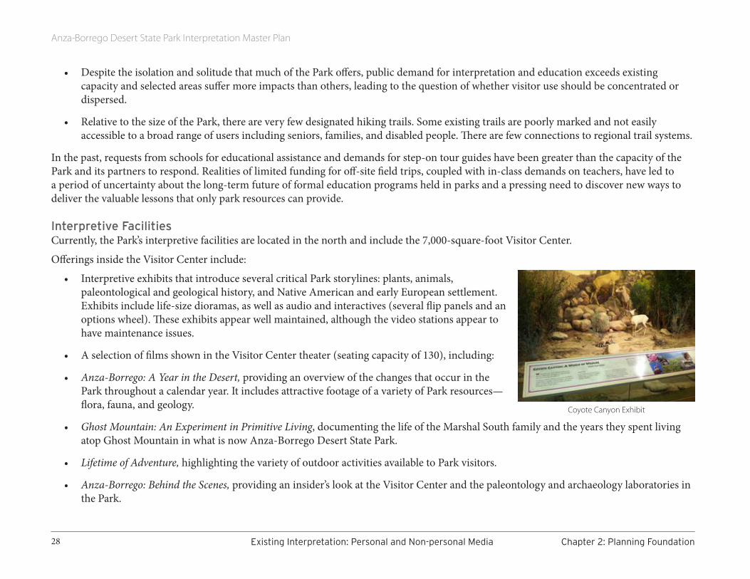
• Interpretive exhibits that introduce several critical Park storylines: plants, animals, paleontological and geological history, and Native American and early European settlement. Exhibits include life-size dioramas, as well as audio and interactives (several flip panels and an options wheel). These exhibits appear well maintained, although the video stations appear to have maintenance issues.
• A selection of films shown in the Visitor Center theater (seating capacity of 130), including:
• Anza-Borrego: A Year in the Desert, providing an overview of the changes that occur in the Park throughout a calendar year. It includes attractive footage of a variety of Park resources—flora, fauna, and geology.
• Ghost Mountain: An Experiment in Primitive Living, documenting the life of the Marshal South family and the years they spent living atop Ghost Mountain in what is now Anza-Borrego Desert State Park.
• Lifetime of Adventure, highlighting the variety of outdoor activities available to Park visitors.
• Anza-Borrego: Behind the Scenes, providing an insider’s look at the Visitor Center and the paleontology and archaeology laboratories in the Park.
Coyote Canyon Exhibit
Anza-Borrego Desert State Park Interpretation Master Plan
29Chapter2:PlanningFoundation ExistingInterpretation:PersonalandNon-personalMedia
• A hands-on indoor Discovery Lab, providing a cool, out-of-the-sun venue for regular nature talks. Children’s books, a variety of touchable specimens, and exhibits inside display cases invite close observation. In addition, Park staff have prepared a scavenger hunt that provides structure for a family visit to this room.
• A centrally located information desk staffed with knowledgeable and helpful volunteers and rangers. To one side, a sales area offers items to increase visitor comfort and enjoyment (hats, walking sticks, sunscreen, etc.), reading materials on Park topics, and take-away mementos of a Park visit.
• A public address system allows for announcements of programs and theater presentations.
There is an amphitheater adjacent to the Visitor Center with a view of the mountains on the western boundary of the Park.
Landscaped as a desert garden, the roof of the Visitor Center provides a delightful walk, as well as an elevated view of both the desert floor and distant mountains.
In addition to the Visitor Center complex, the Park currently has outdoor campfire facilities at two of the three developed campgrounds: Borrego Palm Canyon and Tamarisk Grove.
Posted on TripAdvisor“A lovely visitors centre [sic] with helpful staff and a good garden with plants identified, and lots of trails.” GlowingG
“The Visitor Center is first rate with information about the Park.” Salt_City_Sue
There is a small exhibit about the Kumeyaay at the Tamarisk Grove Campground office.
Interpretive merchandise is available online, at the Visitor Center, at Tamarisk Grove and Borrego Palm Canyon Campgrounds, and at a small store in Borrego Springs. They provide materials for those who want to learn more about Park resources and extend the memory of their visit. The Park’s cooperating association, the Anza-Borrego Foundation, operates these stores and maintains an inventory consisting of books, guides, and educational souvenirs that promote the Park’s mission and support its interpretive themes. A variety of practical items (compasses, bottled water, and tweezers to remove cactus needles, for example) helps visitors have a safe visit or handle minor first aid.
Although the Visitor Center building can be crowded during peak seasons, it and the adjacent facilities provide a range of personal and non-personal interpretation that is well above average.
Anza-Borrego Desert State Park Interpretation Master Plan
30 ExistingInterpretation:PersonalandNon-personalMedia Chapter2:PlanningFoundation
A survey completed in 2006, after installation of new exhibits in the Visitor Center, evaluated their effectiveness and concluded that “visitors were overwhelmingly pleased to see the changes in the visitor center.” The most popular exhibits were the diorama, ranger video, fossils, slide show, and bird songs. The percentage of visitors who identified the key messages of the exhibits (diversity and the geologic forces that shaped the Park landscapes) increased significantly.
Personal Interpretive ProgrammingPark staff (permanent and seasonal), volunteers, and partners offer interpretive programs throughout the year, although they concentrate on the six-month peak season from November to April. The topics and number of programs vary with staffing, but visitors normally can expect three to five programs per week during peak season. Topics, times, and locations are posted on the Park’s website, as well as in a printed publication. In addition, interpretive programs are available for visiting school groups, provided they reserve in advance.
Volunteer naturalist talks take place at the Visitor Center and normally last about 40 minutes. Guided quarter-mile nature walks begin at the Visitor Center and last about
45 minutes. Staff and volunteers also offer longer hikes, generally a few to several hours long, a few times per week. These hikes cover more ground, and often involve hilly or uneven terrain.
Staff and volunteers offer evening campfire programs at Borrego Palm Canyon, Tamarisk Grove, and sometimes Bow Willow campgrounds, usually on weekends in peak season. Stargazing programs, offered several times a year, help visitors learn about the night sky and the importance of combating light pollution.
Occasionally, staff and volunteers offer driving tours on designated roads. Typical topics include plants, animals, geology, paleontology, archaeology, and desert safety.
During the Colorado Desert Archaeology Society’s annual Archaeology Weekend, an educational event held every April, the public has several opportunities to learn about current archaeological, anthropological, and ethnographic research regarding the region’s original inhabitants and cultures. The weekend includes lectures by scholars, lab visits, field trips, special events, family activities, and the Society’s fundraiser, which supports research and stewardship.
On weekends and during school breaks, the Park offers a live hour-long Junior Ranger program for children ages 7-12. It also offers an after-school Junior Ranger Club for fourth-grade students. This 10-week program takes place on Friday afternoons from January to March and covers a range of topics including geology, ecology, history, plants, and wildlife.
What confuses this effort, however, is the existence of a well-advertised Junior Naturalists Program offered by the Anza-Borrego Desert
Stargazing program at ABDSP
Photo by Robert Theriault

Anza-Borrego Desert State Park Interpretation Master Plan
31Chapter2:PlanningFoundation ExistingInterpretation:PersonalandNon-personalMedia
Natural History Association (see Borrego Springs 2015 Village Guide, http://issuu.com/borregosprings/docs/2015vg_onlineversion/1). Sounding nearly identical to the Park’s Junior Ranger program, this program lacks staff instruction. It is based on use of a booklet (available free of charge at the Borrego Desert Nature Center), a day of family exploration in the desert, and a Junior Naturalist patch and signed certificate upon completion of the booklet’s activities.
Park staff present Backcountry Seminars, in-depth programs that last several hours on topics such as flint knapping, preparing pottery in the Native American way, endangered desert bighorn, and bird watching.
In general, thanks to the volunteers and partners that supplement Park staff, personal services cover a range of topics and are well above average in quality. They are, however, concentrated in certain areas and not well distributed throughout the Park.
Self-directed Interpretive ProgrammingThe Park’s website (http://www.parks.ca.gov/?page_id=638)2 is an increasingly important resource for basic visiting information, maps and orientation, accessibility, weather, permits, interpretive program schedules, and discussion of management issues that affect the Park. It adheres to a basic template adopted by all California state parks. Although that template offers levels of information, the full range of Park resources is not easily discovered.
Currently, the website’s emphasis on wildflowers reinforces the perception that spring blooms are the most significant visitor attraction. In contrast, information about the human history associated with the Park is not well represented. Perhaps because of the size and diversity of the Park, the website offers little detail on how to experience many areas of the Park.
Every other year, the Park publishes and distributes a free magazine that includes maps along with general information about the Park, Park trails, and Park partners. Staff mail copies upon request, hand them out at Park facilities, and place them in businesses in Ocotillo Wells and Borrego Springs as well as at Agua Caliente and Vallecito County Parks.3 Different editions of this publication, revised throughout the year, offer basic information as well as articles on a changing variety of subjects. The magazine reaches about 100,000 visitors per year.
Visitors can buy a Park brochure that includes maps, photos, rules/regulations, advice on desert safety, and very brief summaries of facilities at Tamarisk Grove, Bow Willow/Mountain Palm Springs, and Fish Creek.
Posted on TripAdvisor“Good well marked trails and helpful volunteers in the visitor centre. Trails to suit all abilities and trail guides available.” rallyist
2 URL as of August 2015 3 These two properties are part of ABDSP and operated by the County of San Diego.
Anza-Borrego Desert State Park Interpretation Master Plan
32 ExistingInterpretation:PersonalandNon-personalMedia Chapter2:PlanningFoundation
The Park currently distributes information packets in several languages, available at the Visitor Center.
Over 100 miles of paved public roads pass through or are adjacent to Park lands. Many of the most popular Park destinations, including facilities offering visitor services, campgrounds, and scenic attractions, are in proximity to paved roads. Activities on or near paved roads include auto and bicycle touring, walking, jogging, camping, and wildflower viewing. There are information kiosks at nine Park entrances.
In addition to paved roads, the Park has approximately 100 miles of trails, including 50 miles of the Pacific Crest Trail and approximately 36 miles of the California Riding and Hiking Trail. The Juan Bautista de Anza National Historic Trail runs through the Park.
These trails can be grouped into three broad categories classified by their primary purpose:
• Nature trails—those encouraging investigation of the natural world,
• Cultural trails—those serving as a window into the ethnography or history of a particular area, and
• Scenic trails—those offering scenic vistas
Park trails offer many levels of difficulty, ranging from paved all-access trails to trails for visitors seeking a physical, technical, mental, emotional, or spiritual challenge. Wayfinding to this array of trails offers a challenge of its own, raising questions such as:
• What sign types are needed?
• How many signs are adequate?
• Are there alternatives that do not compromise the remote feel of the desert?
• How can signs be adequately maintained in the remote and harsh desert environment?
Visitors can ask at the Visitor Center for free copies of six nature trail guides (Yaqui Well Trail, Palm Canyon Trail, Elephant Tree Trail, Cactus Loop Trail, Narrow Earth Trail, and Palm Canyon Trail) and a driving tour guide (Erosion Road). The ‘Ehmuu-Morteros Trail interprets the Little Blair Cultural Preserve from the perspective of native peoples. The trail guides have a uniform look, though each is printed with its own ink colors.
A prominent kiosk adjacent to Visitor Center parking and restrooms has visitor information and maps of the Park.
A desert garden surrounding the Visitor Center provides a quick look at some of the vegetation typical of the 600,000-acre Park. There is a map of the Visitor Center area, etched into a stone panel, just outside the main entrance. Throughout the garden, interpretive panels challenge visitors to think about topics like adaptation. Around the Visitor Center, among the plantings along trails and in garden areas, there are low-to-the-ground stone plant identification panels. A pond for the rare desert pupfish is located along the path to the Visitor Center. An

Anza-Borrego Desert State Park Interpretation Master Plan
33Chapter2:PlanningFoundation ExistingInterpretation:PersonalandNon-personalMedia
interpretive panel highlights their natural history and ecological status.
Because the desert environment can be extremely hard on display materials, many of the larger panels in the garden have been significantly affected by sunlight—some are nearly unreadable with severely faded images.
Located along the trail between the Visitor Center and Borrego Palm Canyon Campground, there is a series of panels designed to help visitors understand the size of our solar system and the relative distances between planets.
Another series of panels, also etched in stone, highlights common birds, cacti, insects, and rodents.
There are two warning signs (for mountain lions and rattlesnakes) along the Borrego Palm Canyon Trail.
The Park’s inventory currently lists 45 outdoor interpretive panels plus 26 new panels interpreting the cultural preserves inside Park boundaries. Although two of the 45 panels and all of the cultural preserve panels are new, many of the others have been negatively affected by the harsh desert environment.
A sampling of the panel titles suggests the variety of Park resources:
Arroyo Tapiado’s Cave
Palm Spring
Native Palm Groves
Peninsular Bighorn Sheep
The Carrizo Badlands
17 Palms Oasis
Borrego Valley and the Peninsular Range
Fault Lines & Flash Floods
A Fossil Reef—High and Dry
Chaparral
Morteros
Yaquitepec
The Bailey Cabin
Built to Last
A Canyon Called Home
A Home in a Palm Oasis
A Message on the Rocks
Hellhole Canyon Area (trailhead with safety signs)
Borrego Palm Canyon Nature Trail (trailhead with smaller panels and safety signs)
Welcome to Hawi
Welcome to Culp Valley Cultural Preserve
Welcome to a Kumeyaay Village
Signs fade quickly in the desert sun

Anza-Borrego Desert State Park Interpretation Master Plan
34 ExistingInterpretation:PersonalandNon-personalMedia Chapter2:PlanningFoundation
WWII Army tank crews installed a “Hollywood and Vine” street sign that the Park has maintained as historic.
As is often the case, these panels and signs were produced at different times, using different materials and designs. Harsh desert conditions quickly degrade unshaded, outdoor signs and many in the Park show significant signs of deterioration.
The prevalence of temporary signs in campgrounds (generally safety information) and outside the Visitor Center (generally program information) indicates a need for a professional-looking solution for communicating changing conditions, as well as seasonal and safety information.
There also are nine California Historic Landmarks within the Park: Box Canyon; Butterfield Overland Mail Route; El Vado; Palm Spring; San Gregorio; Santa Catarina; San Felipe Valley and Stage Station; Pedro Fages Trail; and Vallecito Stage Depot (Station). These are bronze tablets on stone pillars.
Because of the large percentage (85%) of visitors who come to the Park in springtime to see wildflowers, the Park provides:
• a telephone hotline with up-to-date information about the Park and flowers
• a weekly publication that provides information on both the flowers and pollinators and directs visitors to the best blooms, and
• a section on the Park’s website that shows flower photos and provides bloom updates.
Park staff have developed a list of interpretive sign needs that will be considered during this planning process.
Park staff have turned the size and location of the Park to its advantage by creating a Sky Trail, a low-impact activity that guides pilots, via several loop tours (including Harper Loop and Clark Dry Lake Loop) on a 175-mile tour of the natural and historic features of the Park, some of which can only be seen from the air. The Sky Trail begins and ends at Borrego Valley Airport.
Partner-provided InterpretationAnza-Borrego Foundation is the Park’s most prominent interpretive partner. The Foundation, formed in 1967 to help the state acquire in-holdings within the boundaries of the Park, reorganized in 1989 as an independent charitable 501(c) 3 nonprofit corporation. It manages all sales at the ABDSP Visitor Center and State Park Store in Borrego Springs. Its mission is to protect and preserve the natural landscapes, wildlife habitat, and cultural heritage of Anza-Borrego Desert State Park for the benefit and enjoyment of present and future generations.
Park signs vary in style—and in condition.

Anza-Borrego Desert State Park Interpretation Master Plan
35Chapter2:PlanningFoundation ExistingInterpretation:PersonalandNon-personalMedia
Until recently, ABF considered the Anza-Borrego Institute to be their education arm. In the past, the Institute provided in-depth educational courses to more than 1,300 visitors each year; offered comprehensive field programs, a fifth-grade environmental camp, citizen science research; and PORTS (Parks Online Resources for Teachers and Students). Currently, those educational activities occur under the auspices of ABF; references to the Institute are being phased out.
The Anza-Borrego Foundation has constructed a straw-bale building that is home to the Begole Archaeological Research Center. The Begole Center, located at the entrance to the Colorado Desert District headquarters, houses the extensive collections of artifacts from Cuyamaca Rancho and Anza-Borrego Desert State Parks as well as Palomar Mountain State Park and the Picacho State Recreation Area. It provides storage space, office space, and laboratory work space for Park archaeologists, visiting scientists, and Park volunteers, and is open for tours during Archaeology Weekend.
California State Parks actively encourages participation from volunteer groups with proposals consistent with the needs and values of ABDSP.
Currently, volunteers assist staff in a multitude of ways:
• Approximately 100 volunteers provide information to the public, plan and present interpretive programs, help maintain structures and grounds, and assist with school groups and special programs. Visitor Center Volunteers and Volunteer Naturalists must complete an initial training program as well as yearly refresher training.
• The ABDSP Paleontology Society holds an annual open house during Borrego Days weekend, with an opportunity for visitors to go behind the scenes of a working paleontology preparation laboratory and see the Stout Research Center’s paleontology collection hall (see anzaborregopaleo.org).
• Interpretation by trained volunteers from the Colorado Desert Archaeology Society also helps educate and disseminate stewardship-focused information for visitors. In addition to sponsoring the highly popular Archaeology Weekend, CDAS publishes brochures focused on resource stewardship and hosts monthly educational programs for the public.
• Volunteers, including Camp Hosts, provide information and assistance to hikers, campers, and other Park visitors.
• Approximately 70 volunteers assist with a variety of natural resource projects, including radio-telemetry tracking of mountain lions and bighorn sheep and an annual three-day bighorn sheep count. This information is available for interpretation.
Phot
o co
urte
sy S
am W
ebb/
ABF
ABF hike in Slot Canyon

Anza-Borrego Desert State Park Interpretation Master Plan
36 InterpretationthroughOtherVenues Chapter2:PlanningFoundation
• Other clubs and organizations, including equestrian groups, youth organizations, and four-wheel-drive clubs, help clean up and maintain various areas of the Park and work on specific, smaller projects of educational interest. Advisory teams solicit input on ongoing projects or planning efforts.
• Juan Bautista de Anza National Historic Trail interprets the 1,200-mile journey of de Anza across the Southwest. The National Park Service (nps.gov/juba/) and the Anza Trail Foundation (anzahistorictrail.org) are major partners in this effort. Sections of the trail are marked with the trail logo.
INTERPRETATION THROUGH OTHER VENUES
Anza-Borrego Desert Natural History AssociationEstablished as an educational non-profit 501(c)3 organization in 1971, the Anza-Borrego Desert Natural History Association (ABDNHA) is devoted to enhancing the public’s understanding, appreciation, and enjoyment of the Anza-Borrego Desert and surrounding areas.
In 1999, ABDNHA opened the Desert Nature Center and Store at 652 Palm Canyon Drive in Borrego Springs. ABDNHA has published numerous books about the Anza-Borrego region, and the ABDNHA Nature Center offers one of the finest natural history book stores in the West. The Nature Center serves as headquarters for many educational programs and special events. The association’s website includes trip planning information on both natural and historical features of the Park. The Just for Kids section has activities for children. In addition, it publishes a 26-mile “Southern Emigrant Trail” auto tour brochure with mile markers to locate seven stops.
Shared Borders & Interpretive PotentialABDSP shares nearly 40 miles of border with Sovereign Native American lands (overseen by the Bureau of Indian Affairs, including Los Coyotes Indian Reservation [kumeyaay.info/los_coyotes.html] and the Santa Rosa Indian Reservation [santarosacahuilla-nsn.gov]). Other Native American lands border the Park in the Santa Rosa Mountains, and share borders along numerous parcels to the east, north of County Highway S22. The Kumeyaay and Desert Cahuilla have extensive cultural ties to the region and can offer valuable insights into interpretive storylines and themes.
Nearly 240 miles of the Park’s border abut Bureau of Land Management holdings, and 10 miles are adjacent to Cleveland National Forest.
Vallecito Stage Station County Park, located on 71 acres of San Diego County property adjacent to ABDSP, includes a restored adobe stage stop and a campground with 44 primitive sites and three group use areas (www.sandiegocounty.gov/parks/Camping/vallecito.html). Since human history within the Park currently is under-interpreted, this Park could provide welcome supplemental resources as well as additional facilities for visitors in the southern reaches of Anza Borrego Desert State Park.

Anza-Borrego Desert State Park Interpretation Master Plan
37Chapter2:PlanningFoundation InterpretationthroughOtherVenues
Also operated by San Diego County, Agua Caliente County Park sits on 910 acres that are owned by California State Parks and are part of ABDSP. The Park offers swimming and bathing facilities that open up natural hot springs to public use, a 140-unit campground, horseshoe pits, shuffleboard, and a children’s play area (http://www.sandiegocounty.gov/content/sdc/parks/Camping/vallecito.html). These county facilities are located in the southern portion of the Park near the historic Campbell Ranch and could bolster the potential to interpret human activity while providing an attractive destination for future Park visitors.
Roughly five miles of ABDSP adjoin Cuyamaca Rancho State Park, creating a bio-corridor from coastal mountain range to desert floor (http://www.parks.ca.gov/?page_id=667).
Almost 35 miles of ABDSP border Ocotillo Wells State Vehicular Recreation Area and its 42,000 acres of off-highway-vehicle recreation opportunities (http://ohv.parks.ca.gov/?page_id=1217). Those who use Ocotillo Wells tend to comprise a very different audience from those who visit the Park. Many Ocotillo Wells visitors drive through the Park on their way to and from their riding experiences. Depending on outreach efforts, these potential users can be a source of new partners as well as uncontrolled and sometimes unwitting use of fragile areas.
ABDSP completely surrounds the towns of Borrego Springs (nearly 48,000 acres) and Shelter Valley (nearly 2,000 acres) providing additional potential community partnerships for dissemination of information and recruits for volunteer activities.
Commercially Provided InterpretationThe In-Ko-Pah Tower is a privately owned tourist attraction at the southernmost end of ABDSP, near the Mountain Springs area along Interstate 8. The four-story rock tower, built in the 1920s, serves as a museum and viewpoint.
Borrego Jeep Photo Adventures has a permit with California Department of Parks and Recreation to offer overland trips to Slot Canyon, the Wind Caves, Coyote Canyon, Blair Valley, and Native American village sites (borregojeepphototours.com).
California Overland Desert Excursions, also permitted by the state, has several overland vehicles, allowing them to offer tours as well as overnight camping for individuals and groups (californiaoverland.com).
Samples of Social Media Comments from Travelers The website TripAdvisor.com provides travelers with the opportunity to comment on Park experiences. Although unscientific, these comments provide some insight into what visitors find noteworthy. Overall, the Park had received 172 “reviews” as of fall 2013. Of these, 136 rated the Park excellent, 30 very good, and 6 average.
Phot
o by
Gre
ater
Sou
thw
este
rn
Expl
orat
ion
Com
pany
Anza-Borrego Desert State Park Interpretation Master Plan
38 InterpretationthroughOtherVenues Chapter2:PlanningFoundation
The following comments, which span the year 2013 and the first few days of 2014, are a sample of the feedback related to interpretation. Please note that these are direct quotes and, as such, have not been edited.
“The state park is great. There is an excellent visitors’ center with knowledgeable rangers and four different short movies. There are several hikes nearby, along with other suggestions for more distant parts of the park, which is huge.” gtd123, January 2, 2014
“Except for the showpiece visitor’s center and understandably popular Borrego Palm Canyon Nature Trail, the park is quiet, uncrowded, and without traffic, even during the last few days of a warm December . . . At the visitor’s center, be sure to ask for the “nature trail guide” pamphlets to help you understand what you are seeing out on the trails. They also have a night sky information print-out so you can have fun identifying stars and constellations as you sit around the campfire.” jtimothyk, January 1, 2014
“Park staff are very friendly and knowledgeable and can recommend hikes for all abilities. (We stayed in the vicinity of the visitors’ center.) Exhibits and short film in the visitors’ center are good as well as the interpretive signs placed along the walkways.” georgestayshome, January 1, 2014
“We decided to try this trail [Alcoholic Pass] and were really disappointed when we were unable to find the trailhead. We had driven from Palm Springs for the day and it was disappointing. We drove beyond the end of the road, over an unpaved and rocky path for longer than we needed to, but were unable to find anything. Very disappointing. We ended up going back to the Visitors Center and doing the paved walkway around there. Very vast and beautiful, but not the real thing. We’ll have to try again.” dhcbecker, December 2013
“The visitors center has wonderful, helpful, volunteers who will help you find things to do and to see in the park.” MoreRandR4me, November 29, 2013
“The Visitor Center is a great stop for up to date information about trails and the hiking conditions.” ChristinaB520, August 17, 2013
“We (with 11 yr old son) really enjoyed slot canyon trail. It is somewhat tricky to find the trail head.” awesomeradiologist, June 7, 2013
“If you need any information, or just want to take a break from camping, visit their beautiful Visitor Center. Their staff is very friendly and helpful, and their displays are in fact very interesting.” lilyblue25, June 5, 2013
“The visitor center is beautiful with a plant identifying walk and helpful folks.” K_M_McK, May 18, 2013
“Visitor center worth a trip. Rangers relatively helpful in suggesting hikes. Nice supply of maps and books.” MichiganSam, March 2013
“Loved the views and weather. Some of the trails one could easily get lost as they are not well marked.” MicheleColette, January 2013

Anza-Borrego Desert State Park Interpretation Master Plan
39Chapter2:PlanningFoundation 2.4GuidingStatementsfromtheGeneralPlan
2.4 GUIDING STATEMENTS FROM THE GENERAL PLAN
Park PurposeThe purpose of Anza-Borrego Desert State Park is to preserve the unique and diverse natural, cultural, and scenic resources of this Western Colorado Desert Region and to provide opportunities for high quality recreation that supports a healthy natural environment.
This desert park environment nurtures peaceful solitude, astronomical clarity, amazing forms of life, glimpses of the past, and a tremendous scope for the imagination. Therefore, management of Anza-Borrego Desert State Park will be based upon the goal of preserving, instilling an appreciation for, and making available these treasured qualities and experiences for present and future generations.
Mission Statement The mission of Anza-Borrego Desert State Park is to be the premier park in California in protecting and managing resources, inspiring and educating park patrons, and serving those needs of the public which are consistent with park objectives.
Vision Statement Anza-Borrego Desert State Park is a place of awe, inspiration, and refuge. The vast desert landscape and scenery are preserved in a pristine condition. The full array of natural and cultural resources are cared for so as to perpetuate them for all time while supporting those seeking enjoyment from these resources. Park visitors are delighted with the condition and level of facilities, enhancing their experience of the park. Visitors are able to access unique and special areas of the park so as to instill knowledge and appreciation of these places. Emphasis is placed on having park visitors experience the true, real, tangible desert environment, even if it leads to some level of uncertainty or discomfort, because this leads to personal insight and perspective only gained by first-hand knowledge. The park maintains one’s ability, if desired, to camp in any particular location within the park as long as it does not compromise the health, safety, and welfare of park visitors or compromise park resources. The park is a place where silence can be found and total darkness achieved. At this park, the forces of nature remain undeniably stronger than human forces, and people, in general, visit, but do not remain.

Anza-Borrego Desert State Park Interpretation Master Plan
40 2.4GuidingStatementsfromtheGeneralPlan Chapter2:PlanningFoundation
Interpretive Guidelines from the 2005 General PlanThe following guidelines for interpretation are extracted from the Park’s 2005 General Plan. We used them as a basis for the development of the specific, measurable objectives and strategies outlined in 5.2 (Recommended Objectives and Strategies).4
California State Parks’ primary opportunity for engaging the public in the benefits and value of preserving desert wilderness and related cultural resources lies within the Park’s interpretive program offerings. Through an intensive interpretive program, Park resources can be better cared for—protecting the Park’s integrity for many generations.
Interpretation is a communication process that forges emotional and intellectual connections between the interests of the audience and the inherent meanings of the resource. Through interpretation, the Park provides experiences, information, direction, and stewardship opportunities for visitors.
Provide meaningful interpretive opportunities accessible to as many visitors as possible by offering a diverse selection of personal and non-personal services in a variety of locations, languages, and settings throughout the park.
California State Parks shall strive to create “world-class” facilities that support stewardship and study of Anza-Borrego Desert State Park’s (ABDSP) “world-class” resources.
Develop outreach and partnerships with area schools, child-care, and youth groups. Create and present programs aligned with state educational standards featuring ABDSP’s natural and cultural resources, as well as the scientific processes associated with recording and understanding them.
Create unequalled youth and adult educational, research, and interpretive opportunities through the Anza Borrego Institute (Institute). The Institute is an outdoor education and research program combining the Stout Research Center, Colorado Desert Archaeological Society, backcountry seminars, interagency studies, and the Park’s interpretive and specialist staff.
Develop an ongoing relationship with the Borrego Springs School District. Create a program track that builds upon students’ understanding and appreciation of Park resources from year to year. This includes, but is not limited to: in-school programs, park programs, ranger ride-alongs, student internships, professional mentoring, and student service projects.
Support staff and volunteers through training (both in content and method), materials, facilities, and evaluation to promote high quality interpretive services.
Employ sufficient staff to meet visitor and management demand for interpretive programming.
Reevaluate and update the existing interpretive messages on all wayside panels to ensure accuracy, cultural sensitivity, alignment with the
4 The guidelines on pages 36 to 38 represent a subset of those found in the General Plan. The original list was more expansive because it also included, and was interlaced with, the 2005 unifying and primary interpretive themes. For the original language, which incorporates goals, guidelines, and unifying and primary themes, see Appendix F.
Anza-Borrego Desert State Park Interpretation Master Plan
41Chapter2:PlanningFoundation 2.4GuidingStatementsfromtheGeneralPlan
Park interpretive plan and where pertinent, current laws and prohibitions.
Use signs and other media to protect resources from damage due to visitor use.
Coordinate with neighboring federal, state, and local agencies to provide information to the public that delineates boundaries between ABDSP and its neighboring land-management agencies, and explains the recreational policies of each.
Provide interpretive experiences that help visitors understand the significant environmental changes that have taken place at ABDSP.
Provide interpretive experiences that help visitors experience and understand the dynamic processes of geological change and how this is relevant to their lives.
Provide opportunities for visitors to experience the many awe-inspiring features of ABDSP.
Interpret the significant climate and landscape changes that have taken place at ABDSP.
Enhance visitors’ understanding of the prehistoric wildlife and plants found in this desert environment.
Provide experiences that help visitors understand the process of fossil collection, cleaning, cataloging, storing, and interpretation.
Provide information, directions, and interpretive programs/materials that promote safe exploration of the park, so visitors are not harmed by the desert’s severe climatic effects (may require multi- lingual content).
Provide interpretive experiences that lead to visitor understanding of the unique adaptations of the Colorado Desert’s plants and animals.
Provide interpretive experiences that lead to visitor understanding of the features and mythology of the night sky.
Provide opportunities for visitors to understand that the sedimentary materials of the badlands were originally laid down by oceans, lakes, and rivers and are now being carved by rain and wind erosion.
Provide interpretive experiences that lead to visitor understanding that flash floods are common in the desert, due to the biannual rainfall patterns and the lack of plant life to absorb runoff.
Provide opportunities for visitors to understand that rainfall patterns are the dominant factor, along with temperature and wind conditions, which determine the dynamics of the spring wildflower bloom.
Strive to enhance visitors’ understanding that because of the climate, the desert soil is fragile and bears scars of damage for centuries.
Provide interpretive experiences leading visitors to an understanding that desert wetlands or oases are extraordinarily important to the survival of a plethora of species.
Provide interpretive opportunities for visitors to see and understand how early people, and more recently the Cahuilla and Kumeyaay peoples lived on this land we now call ABDSP.

Anza-Borrego Desert State Park Interpretation Master Plan
42 2.5HighlightsfromPastPlanningEfforts Chapter2:PlanningFoundation
Enhance visitors’ understandings of the Kumeyaay and Cahuilla cultures and the effects Euro-American cultures have had on them.
Establish an interpretive partnership with local Native American communities to facilitate the dissemination of information about the historical resources in the Park.
Train and/or provide information to park staff and park volunteers to make public presentations on local Native American cultures and historic uses of the Park. Cultural specialists, interpreters, and other Park staff should work collaboratively to generate content of presentations and potential visual aids.
Provide experiences that further the visitors’ understanding that Euro-American use of the land included a wide variety of mining, ranching, and farming development.
Provide visitor opportunities to learn about the many threatened or endangered plants and animals due to loss of habitat caused by human impacts.
Involve visitors in understanding that the future of ABDSP and all wild places depends upon the choices humans make regarding resource use and management.
2.5 HIGHLIGHTS FROM PAST PLANNING EFFORTSThe General Plan and Cultural Preserve Plan provide a great many recommendations specific to interpretation. They range from descriptions of particular natural, prehistoric, or historic sites suited to interpretation; best topics for particular sites; ways interpretation can help accomplish particular site-specific management goals; and more.
The purpose of this Interpretation Master Plan is not to prescribe specific treatments at specific sites, but to identify overall approaches and strategies for interpretation. We do not revisit the material here, but instead offer highlights from past planning efforts that align with this current 2015 plan:
• dark sky interpretation,
• development of an interpretive facility at Vallecito/Campbell Ranch,
• educational outreach programs,
• self-guiding trails,
• interpretive signage at trailheads and at cultural preserve zones,

Anza-Borrego Desert State Park Interpretation Master Plan
43Chapter2:PlanningFoundation 2.6LocalandRegionalInfluences
• interpretation of the Southern Overland Trail, and
• use of trained volunteer interpreters as guides for certain restricted cultural preserve zones. Cultural interpretation will acknowledge multiple points of view, employ various voices, and convey respect.
2.6 LOCAL AND REGIONAL INFLUENCESPrint media and social media go a long way in shaping the weekends of Southern California residents. Recent articles in Sunset (March 2015), the Los Angeles Times (March 2014), Orange County Register (March 2015), and San Diego Tribune (February 2015) routinely remind readers of the Park’s wildflowers, as well as hiking opportunities, neighboring resorts, and other notable features. Information about the Park is also disseminated through such means as the Julian News (February 2015) and other backcountry newspapers published in towns relatively near to Borrego Springs. For first-time visitors who read these articles, they likely base their decision to visit on desert wildflower bloom cycles. They remain largely unfamiliar with the Park’s other, equally spectacular resources.
Local sources of information include the Anza-Borrego Foundation, Anza Borrego Natural History Association, Borrego Springs Chamber of Commerce, and neighboring Ocotillo Wells State Vehicular Recreation Area. In addition, several useful publications are in circulation, including the comprehensive guidebook, The Anza-Borrego Desert Region, and two Anza-Borrego Desert region maps, the Recreation Map published by Wilderness Press and Recreation Map and Guide published by Earthwalk Press.
Social media also shapes a visitor’s experience and expectations. Posts on TripAdvisor, Yelp, hikespeak.com, Virtual Tourist, and San Diego Reader, for example, reveal travel tips, “best kept secrets,” and favorite camping sites and trails. Comments posted on Facebook, Twitter, Yonder, and Instagram also shape visitor decisions. These social media venues tend to attract a younger demographic already immersed in the social media frontier and technology. They also serve to build an online community that attracts new and potential visitors, while providing them with opportunities to connect and participate. In turn, these venues promote information sharing and thus supplement the Park’s existing marketing efforts. Current statistics reveal:
• 78% of Americans say social media impacts their purchasing decisions, revealing just how pervasive it has become.
• 50% of Internet users are active on Facebook. A strong Facebook presence correlates with a successful campaign overall and can connect with millions of potential visitors (a number which, we realize, poses its own set of problems).
• 52% of marketers have gained a customer through Facebook, and 35% have done so through Twitter. Social media efforts that result in direct customer conversion are statistically more common than anticipated.
• While 70% of social media users have an account on Facebook, 50% have an account on Google+. Data analysis has forecast that

Anza-Borrego Desert State Park Interpretation Master Plan
44 2.6LocalandRegionalInfluences Chapter2:PlanningFoundation
Google+ will become a more dominant social media site in coming years.
• Pinterest is the fastest growing social network. Its heavy use of images is proving to be a very effective marketing tool.
• Social media is growing in popularity with the older demographic as well. Although social media has traditionally been associated with the younger generation, marketing has a far wider age range to consider when promoting products or services.
• 54% of people on Facebook use the FB mobile application. The average Facebook user is connected to 80 community pages, events, and groups.
• Currently, social media icons are posted on various California State Park websites, though sometimes sporadically and often limited to links for posting comments only. On the Borrego Springs Chamber of Commerce website (www.abdsp.org), Facebook and Twitter icons have a very small screen presence and are not listed under that site’s web links.
• A growing number of Park visitors get information about Park activities and possible recreational opportunities via social media. These sources generally are not curated, which can lead to misinformation, resource damage, or site overuse.
• Though there are several Facebook pages about ABDSP, each created by a different organization, only one is maintained by ABDSP: https://facebook.com/anzaborregodesertstatepark (as of September 2015). The existence of other ABDSP-labeled Facebook pages can be confusing to the public. For example, the Borrego Springs Chamber of Commerce administers the page https://www.facebook.com/AnzaBorrego/info?tab=overview, yet it bears the CSP logo. Of all Facebook pages related to ABDSP, the two named above are the most visited.
• When users visiting ABDSP’s web page (http://www.parks.ca.gov/?page_id=638) click on the Facebook link at the bottom, they’re taken to not to the ABDSP-maintained Facebook page, but to that of the entire State Park system (https://www.facebook.com/CaliforniaStateParks). Park staff should consider the benefits of changing that routing in order to keep ABDSP-related Facebook activity focused on its own Facebook page.
As a social marketing tool, social media is very successful at affecting behavior ranging from consumer purchases to participation in political activism. Social marketing represents a unique system for understanding “who” visitors are and “what” they desire and then organizing the development, delivery, and communication of products, services, and messages to meet those desires in an appropriate, resource-protecting manner. Changing behavior at a grassroots level through social marketing is often a more effective means of enforcing rules, protecting resources, and keeping visitors safe. Park staff should consider this tactic for curbing the popularity of the Mud Caves among youth group leaders.

Anza-Borrego Desert State Park Interpretation Master Plan
45Chapter2:PlanningFoundation 2.7VisitationandVisitorUse
2.7 VISITATION AND VISITOR USEOur understanding of Anza-Borrego Desert State Park visitors is based on data revealed in three different studies: a survey conducted by The Acorn Group in 2014, a two-phase survey conducted at the Visitor Center in 2004 and 2006, and a survey conducted by the University of Montana in 2001.
Summary of the 2014 surveyIn spring and fall 2014, staff of The Acorn Group administered a visitor survey at the Park over the course of seven days. We used iPads and QuickTapSurvey, a mobile tablet field survey application, to conduct in-person intercept surveys at the entrance to the Visitor Center and the trailhead at Borrego Palm Canyon.
In summary, the data reveal noteworthy trends: visitors are frustrated with the lack of wayfinding information; are interested in seeing more interpretation such as signs and exhibits; and their preferences for interpretive delivery systems correlate to their age. In advance of their trips, most visitors, regardless of age, rely on the Internet as a primary source of information. The complete survey report, list of survey questions, and data spreadsheet (including additional charts and separate tallies of March and November responses), are provided as appendices in this document.
Anza-Borrego Desert State Park seems to be Southern California’s “backyard” desert park, with 53% of surveyed visitors living within 120 miles of one of the Park’s boundaries. The majority (64%) of participants were repeat visitors, with the largest group reporting one visit or less per year. Spring brings out the newcomers, attracting 50% more first-time visitors than does fall.
A full 47% of respondents were day trip visitors; 35% expected to stay at the Park a half day or less. Another 28% had planned a one- or two-day visit, and 24% had planned three or more days. In post-survey conversations, many visitors mentioned that they were stopping by the Park en route to other destinations (such as Palm Springs or the coast). The Park attracts many older visitors. Seventy-two percent (72%) of participants were over 50, and the single largest group (33%) was 60–69.
Eighty-one percent of respondents had been to the Park’s Visitor Center, where the most frequent activities were viewing exhibits (35.5%), viewing a film (20%), and asking for information at the front desk (19%). Visitors were asked about their general preferences for interpretive delivery systems (media) when visiting a park such as Anza-Borrego Desert. Traditional, non-personal media (signs, kiosks, and exhibits) ranked first for the majority of visitors, and within that category, trailhead and trailside signs were most preferred.
Despite the fact that 72% of respondents own smartphones, interest in mobile technology is significantly higher in the younger half of the population. This disproportion is likely to dissolve over time as this younger half ages and technological advances continue.
Results also reveal a correlation between increased age and a preference for one-on-one interaction with staff. This finding, which aligns with national trends, may be explained in part by education’s late-20th-century move away from didacticism (a largely one-way process in which

Anza-Borrego Desert State Park Interpretation Master Plan
46 2.7VisitationandVisitorUse Chapter2:PlanningFoundation
learners receive their information from an authoritative person) toward a more self-reliant, self-motivated experiential model.
We asked visitors to identify three favorite Park interpretive topics. Combined results strongly favor natural history, with 57% of participants ranking wildflowers as first, second, or third choices. Wildlife follows close behind, garnering votes from 50% of visitors. Geology was selected by 32% and desert plants in general by 27%. These data are consistent with previous studies. Given the Park’s desire to broaden the visitor’s exposure to, and appreciation of, resources beyond wildflowers, staff face a notable challenge.
Respondents overwhelmingly rely on the Internet to plan their visits. When asked to name their primary visit-planning resource, the ABDSP website was claimed by nearly half (45%) of users, outranking the second, third, and fourth most-popular options combined (guidebooks and maps; friends and family; “I don’t plan, I just go”).
In the survey, the wording for the ABDSP website option was “Official Park website.” However, we doubt most visitors understand which of the four commonly used websites is considered “official”: California State Parks’ ABDSP website; the Anza-Borrego Foundation’s website; the Anza-Borrego Desert Natural History Association’s website; or the Borrego Springs Chamber and Visitors’ Bureau website (the latter site ranks first in a Google search for the words “Anza Borrego Desert State Park”). Additionally, survey administrators did receive several verbal comments about many of the links on the State Parks-sponsored ABDSP website leading unhelpfully to the Sacramento site.
Summary of two-phase survey conducted at the Visitor Center in 2004 and 2006In 2004, Park staff launched a two-phase research project to inform decisions related to the design, creation, and evaluation of new exhibits at the Visitor Center. Phase I was directed at collecting data relevant to the development of messages for Park visitors. Phase II evaluated the effectiveness of the new exhibits at conveying those messages.
While this study focused more on evaluating the remodeled Visitor Center than acquiring demographic data and understanding needs and interests of visitors, it nevertheless yielded data of use to the current interpretation master planning effort. Consistent with the other studies, the largest group of respondents fell within an age range of 60–69 years. Over three-quarters of respondents (76%) were from California and of them, 43.5% were from San Diego County.
The reasons cited for stopping in the Visitor Center included: general information (29%), specific activities at the Visitor Center (25%), a general tendency to visit centers, (20%), and because the visit was recommended by a family member or friend (14%). When asked about overall satisfaction with the Park, 28% of visitors indicated they would like to see more identification signs (28%) and more interpretation (28%).
Reception to the intended messages increased significantly in 2006 following the Center’s redesign. Sixty-four percent of respondents successfully recalled the overarching theme of diversity, geologic forces, and changing landscapes, climate, life forms, and history. Over 32% of visitors recalled a main message about the Park related to desert stewardship; 22% recalled a message about desert appreciation. Time spent engaged in the Center increased from an average of 45 minutes (2004) to 59 minutes (2006). Opportunities to receive messages increased as
Anza-Borrego Desert State Park Interpretation Master Plan
47Chapter2:PlanningFoundation 2.7VisitationandVisitorUse
visitors spent more time at exhibits interacting with various interpretive media, such as the flip boxes.
When asked what information sources they found most useful, visitors reported: personal interaction with rangers and volunteers (23%), publications (21%), maps (20%), A/V presentations (20%), indoor signs (11%), and outdoor signs (4%). Least useful information sources included AQ/V presentations (31%), outdoor signs (19%), publications (12%), indoor signs (12%), and personal interaction with rangers and volunteers (12%). Rationale for these rankings included “over-produced A/V media” and “not enough outdoor signs.” These visitors also expressed interest in learning more about wildlife, flora (wildflowers specifically), trails, regional history, and geology.
Summary of University of Montana 2001 surveyThis study’s purpose was to characterize Park visitors, understand the nature of their visit and impressions of the Park, and reveal their perceptions of how the Park is managed. Over 56% of the visitors surveyed were from San Diego County and over half were between the ages of 36 and 60 years. Not surprisingly, given the date of this survey (2001), the common medium that provided visitors their first exposure to Park information was word of mouth, followed by guidebooks and road maps.
The reasons cited for visiting the Park included its scenic beauty, unique characteristics, wildness, nature displays, and role as a sanctuary for wildlife. Generally speaking, respondents expressed interest in seeing the Park managed as a refuge and a showcase for displays of nature. Preservation of Park resources appeared to be more important than changing facilities or modifying the Park to better accommodate recreational use, visitor concerns, or local interests.
When presented with photographs that portrayed a range of ecological or management conditions—pristine conditions and heavily scarred conditions; crowded areas and areas of solitude; natural trails with minimal “structural” improvements and engineered trails with paving and numerous signs—visitors were asked to rank the images according to acceptability. While they indicated a preference for more natural conditions, visitors appeared willing to accept a small amount of impact and some crowding. However, at increasing levels of impact and crowding, they indicated the conditions were not acceptable.
With regard to trails, results were more difficult to interpret. In general, the rating of acceptability increased as trail conditions became less primitive. Wide natural-surface paths defined by rock trail margins and accented with some signs were preferred over rougher, less marked trails. However, visitors were not particularly interested in signed, paved trails.
When asked to provide additional comments about the Park and their Park experience, visitors expressed an interest in seeing distance markers; small, unstaffed information stations at all Park entrances; better road signs along highways and dirt roads; (improved) trail signs, maps and handouts; more plant identification signs on the roof of the Visitor Center; and more natural trails with brochures.

Anza-Borrego Desert State Park Interpretation Master Plan
48
Wind Caves
Phot
o by
Dan
Mor
se/D
JFra
ntic
Flick
r
Anza-Borrego Desert State Park Interpretation Master Plan
49Chapter3:SummaryofStakeholderInput
CHAPTER 3: SUMMARY OF STAKEHOLDER INPUTBy conducting eight stakeholder listening sessions over the course of a year, we learned a good deal from the people who know the Park best—its staff, volunteers, most frequent visitors, area residents, subject experts, and others.
In these sessions, attendees were first invited to consider and help improve a draft set of Park themes. Later, attendees were asked about the practicalities—ways that interpretation can help meet the needs of visitors and the Park itself.
Theme Input Stakeholder input helped us refine the draft thematic structure to better reflect the comprehensive and dynamic nature of Park resources and their meaning as expressed in the Park’s General Plan. Many attendees drew attention to the uniqueness of this place, with frequent references to the inspirational, mysterious, and/or spiritual nature of their relationship to the Park, and the role of the harsh and arid landscape in shaping this relationship. Several asked for more emphasis on recreation and enjoyment. Additional input helped us weave in dark sky resources, as well as focus on the vital link between ongoing scientific research at the Park, Park stewardship, and the growing body of knowledge worldwide. We were also grateful for input by tribal elders on current and ancestral relationships with the land.
Interpretive SolutionsWhen attendees were asked to identify practical ways for interpretation to improve the visitor experience and better meet the needs of the Park itself, remarkably consistent trends emerged:
• Improved wayfinding aids to help visitors navigate the large, challenging landscape. Improved highway signage was frequently mentioned.
• Better orientation to activities: what to see and do, and where one can go. Improved map resources were frequently suggested.
• Better “entry experiences” that convey Park arrival and the specialness of the place.
• The need for a stronger presence in the southern section of the Park. A southern interpretive center was consistently mentioned.
• A need was expressed for more widely dispersed interpretive information throughout the Park—in particular, an improved, better-maintained interpretive signage system.
• Appropriate implementation of 21st-century field technology for information and interpretation is desired. Podcasts and GPS-linked interpretation were frequently specified.

Anza-Borrego Desert State Park Interpretation Master Plan
50 Chapter3:SummaryofStakeholderInput
• Improved visitor understanding of the fragility of Park resources is needed—along with the rules, restrictions, and protected areas that help preserve them.
• Visitors need a clearer understanding of boundaries, to help those coming from adjacent recreation areas avoid inadvertent damage to the Park.
• Better preparation information is needed (before and after arrival) regarding health, safety, and vehicle appropriateness.
• More personnel, particularly rangers, are needed to better handle widespread areas and find time to be more available to the public. Participants would like to see more personal interaction between knowledgeable staff and visitors.
• More widespread support for the Park is needed, including sustained public funding.
Nature often puts unprepared visitors at risk.
Phot
o by
Dan
Mor
se/d
jfran
tic F
lickr

Anza-Borrego Desert State Park Interpretation Master Plan
51Chapter3:SummaryofStakeholderInput

Anza-Borrego Desert State Park Interpretation Master Plan
52
Elephant Knees at Fish Creek
Phot
o by
Bry
ce B
radf
ord
Anza-Borrego Desert State Park Interpretation Master Plan
53Chapter4:InterpretiveDirection 4.1SpiritofPlace/4.2UpdatedInterpretiveGoals
CHAPTER 4: INTERPRETIVE DIRECTION4.1 SPIRIT OF PLACEAnza-Borrego Desert State Park is a vertical mile (and more) of diversity, harboring multiple life zones and thousands of species; a land with a fascinating geological past, a fossil record spanning 450 million years, and some 12,000 years of human activity; a living laboratory; and a harsh, unforgiving, vast landscape roughly the size of Rhode Island.
This Park is all these, and more. One can spend a lifetime learning its details—and many people do just that.
Yet long after such facts and figures fade from memory, those who’ve fallen under the desert’s spell can sense its intangible, indelible signature—its spirit of place. Some might describe it as a mood; others a physical sensation; others a spiritual experience. Perhaps it’s a mixture of all three.
No matter how you define it, this spirit of place is real. Whether the Park inspires a sudden cry of delight, moves visitors to tears, or simply produces an ongoing series of “oh wows,” it’s the spirit of place at work. It transforms starkness into lavish abundance, and shifts our focus from the discomforts of an inhospitable, dangerous land to the joys of discovery. It reveals the beauty of the whole in the smallest detail, and shows us eternity in a fleeting moment.
We believe interpretation’s chief job is setting up every possible opportunity for the visitor to experience this spirit of place, to let it take root, and to watch it grow.
4.2 UPDATED INTERPRETIVE GOALS The seven interpretive goals below are meant to reflect the current status of Park resources and interpretive programming, the expressed needs and interests of Park management, and the anticipated needs and interests of current visitors as well as those expected in the foreseeable future.
Goal 1: Targeted audiences will take advantage of new and expanded interpretive and educational opportunities on behalf of Anza-Borrego Desert State Park (Park).
Goal 2: Targeted audiences will be able to easily retrieve information, both on-site and off-site, on how to visit and enjoy the Park.
Goal 3: Targeted audiences will become increasingly aware of the diversity of natural, cultural, and historical resources at the Park and the depth of its legacy stories.
Anza-Borrego Desert State Park Interpretation Master Plan
54 4.3InterpretivePeriods Chapter4:InterpretiveDirection
Goal 4: Targeted audiences will better appreciate the Park’s natural, cultural, and historical resources and legacy stories.
Goal 5: Targeted audiences will deepen their understanding about important but currently under-interpreted concepts about the Colorado Desert and its past as well as current desert systems and interactions, such as long-term climate change and the Park’s fossil record.
Goal 6: Audiences will deepen their understanding of important but currently under-interpreted concepts about human connections to the desert over time, including the stories of the Kumeyaay, Cahuilla, Cupeño, and other original inhabitants.5 Goal 7: Based on their deeper understanding of the fragility of Park resources and the need for protection and preservation, the audience will demonstrate increased adherence to Park rules and regulations.
4.3 INTERPRETIVE PERIODS
GeologicalEarly geology of the Park includes establishment of now metamorphosed basement rock, during late Ordovician (at least 450 million years ago [MYA]), followed by emplacement of intrusive rocks of the Cretaceous (120–100 MYA). Subsequently tectonic reorganization of the west coast of North America (30–25 MYA) set the stage for movement along the San Andreas fault system, separation of Baja California from mainland Mexico and creation of the Gulf of California (15–10 MYA). Mid-continent uplift of the late Miocene (8–5 MYA) and establishment of the Colorado River brought sediments to fill the opening rift. Closure of the Panama Land Bridge (by 3 MYA) created a land route for exchange of terrestrial organisms between North and South America while shutting off interchange between the Caribbean/Gulf of Mexico marine faunas and floras and the eastern Pacific marine environments, including the Gulf of California. Beginning approximately 1 MYA, faulting of the San Jacinto and Elsinore systems promoted uplift of approximately 3.4 miles of previously buried local and Colorado River sediments, with their entombed fossil load. Within the last 1 million years, continued uplift of peninsular and local mountains contributed to permanent alteration of the southern California weather patterns, promoting desert conditions in ABDSP.
PaleontologicalThe Park’s impressive paleontological record spans at least the last 9 million years, with the majority of fossil sites recorded from Vallecito Creek/Fish Creek Badlands, an over 3.4 mile thick section of unbroken sediment accumulation, starting in the late Miocene (about 6.5 MYA) and extending through the entire Pliocene to late Pleistocene (about 0.9 MYA). Other areas of the Park include fossiliferous sediments older than 1 MYA to younger than about 750,000 years old; between 200,000 and 10,000 years old; and a couple of recently locally extinct pronghorn antelope fossils, less than 100 years old. The 550+ fossil plants and animals preserved in the badlands document the environmental changes associated with these Epochs. In fact, they represent the longest continuous record of life for this time period in North America.
5 Based on input received during the tribal stakeholder session, at which an individual suggested substituting specific tribal references with the term original inhabitants, this language is meant to point out that other tribal groups also have a presence on the land. We understand this merits further review by tribal representatives.

Anza-Borrego Desert State Park Interpretation Master Plan
55Chapter4:InterpretiveDirection 4.3InterpretivePeriods
Prehistoric/Historic Significant human history is associated with sites within the Park’s boundaries.
Native HomelandArchaeological lithic artifacts, largely attributed to the San Dieguito tradition, are primarily mid-to-early Holocene (about 6,000 BCE). Mid-Holocene artifacts include Archaic, Elko period materials, while later prehistoric artifacts result from Cahuilla and/or Kumeyaay (Ipai, Tipai, and Kamia) occupation. Many of the Park’s occupation sites retain cultural and often sacred importance to modern tribal members.
Travelers and TrailsOne of the primary, recurring stories associated with Anza-Borrego is the passage of humans into and through the desert. For centuries, Native Americans conducted trade in the area of the present Park and migrated as seasons and environmental conditions changed. The Spanish staged expeditions—Pedro Fages (1772) and Juan Bautista de Anza (1774)—traversed the Park. During the era of Mexican sovereignty, the trail blazed by explorers became the Sonoran Road used by gold seekers from the south and immigrants and invading troops from the north. The San Antonio–San Diego Mail Line (1857) and then the Butterfield Overland Mail Line (1858) provided mail and stagecoach service across the desert. As is often the case, the limited modern road network generally follows historic routes.
Modern IsolationSince the late 19th century, a survey of land use within Park boundaries reveals a persistent tension between isolation and modernization. Cattlemen began homesteading the Borrego Valley about 1875. By the end of the 1920s, a crossroads community offered only a handful of services—a post office, general store, and gas station. During World War II, when the military set up training camps in the valley, it introduced the first paved roads and electricity to Borrego Springs. After the war and creation of the state park, developers introduced tourism-related enterprises that offered a foray into the desert—for many the antithesis of urban life. Elsewhere, isolated homesteads continued to satisfy the needs of some, such as ranchers Everett and Lena Campbell, poet/artist/author Marshal South, artist Marjorie Reed, and lawyer Christian Holland, to escape to the fringe of modern life for solitude and inspiration.
Phot
o by
Gre
ater
Sou
thw
este
rn
Expl
orat
ion
Com
pany

Anza-Borrego Desert State Park Interpretation Master Plan
56 4.4AnalysisofThemesfromtheGeneralPlan Chapter4:InterpretiveDirection
4.4 ANALYSIS OF THEMES FROM THE GENERAL PLAN The 2005 General Plan outlines a series of Park interpretive themes, all centering on the concept of “change.” They capture much of the significance of Anza Borrego Desert State Park:
Unifying Theme: Anza Borrego Desert State Park epitomizes nature’s prevailing theme—change.
Primary Theme 1: Tectonic activity and erosive forces continue to shape the landscape, building mountains, creating basins, and developing scenic wonders.
Primary Theme 2: Climate changes over time have dramatically influenced plants and animals that are adapted for the current desert conditions and have led to extinction for others.
Primary Theme 3: The powerful effects of water can be seen throughout ABDSP in the formation of dusty arroyos, eroded badlands, slot canyons, desert washes, and palm oases, as well as in the fossils left behind.
Primary Theme 4: People have brought change upon the landscape, beginning perhaps 12,000 years ago and continuing today.
The intent of the primary themes is to reflect and expand upon the unifying theme. They cover tectonics, erosion, and other land-shaping forces; ongoing changes brought about by the forces of climate and water; and the many changes from human activity over time. Each primary theme was followed by a set of theme guidelines, most of which suggested supporting topics for the themes.
One of the purposes of an Interpretation Master Plan is to further refine and expand on the themes in the General Plan, usually by providing supporting themes for each primary and secondary theme. When comparing the General Plan themes to the rest of the content in the plan, however, the planners noticed that many important concepts identified in the General Plan needed a stronger emphasis in the primary theme statements. Many of these important concepts were included in the guidelines given for the themes, but not in the primary themes themselves, and some were not included at all. For example, there is no reference in the primary themes to resource protection and stewardship, so critical to Park management and the visitor experience, though it was briefly addressed in a theme guideline. Messages about American Indians were addressed within Primary Theme 4, but they could be strengthened by a focus on respect for living cultures and sacred sites of the Kumeyaay, Cahuilla, Cupeño, and other original inhabitants. The themes didn’t fully address General Plan’s Section 2.2.4, a brilliant description of the intangible yet all-important aesthetic experience of the Park, which stirs the human spirit and inspires an array of human endeavors from art to scientific study. Again, this was addressed only in a theme guideline, and needed much more emphasis. A resource whose protection has recently become a critical issue not only within the Park but also internationally—preservation of our vanishing dark skies, the world’s oldest resource—was only marginally inferred in a theme guideline.
The eight listening sessions conducted with Park stakeholders further informed the planners’ thinking. Structured as cooperative workshops and attended by many long-time volunteers, subject experts, Park staff, and others close to the Park, these sessions gathered feedback on Park
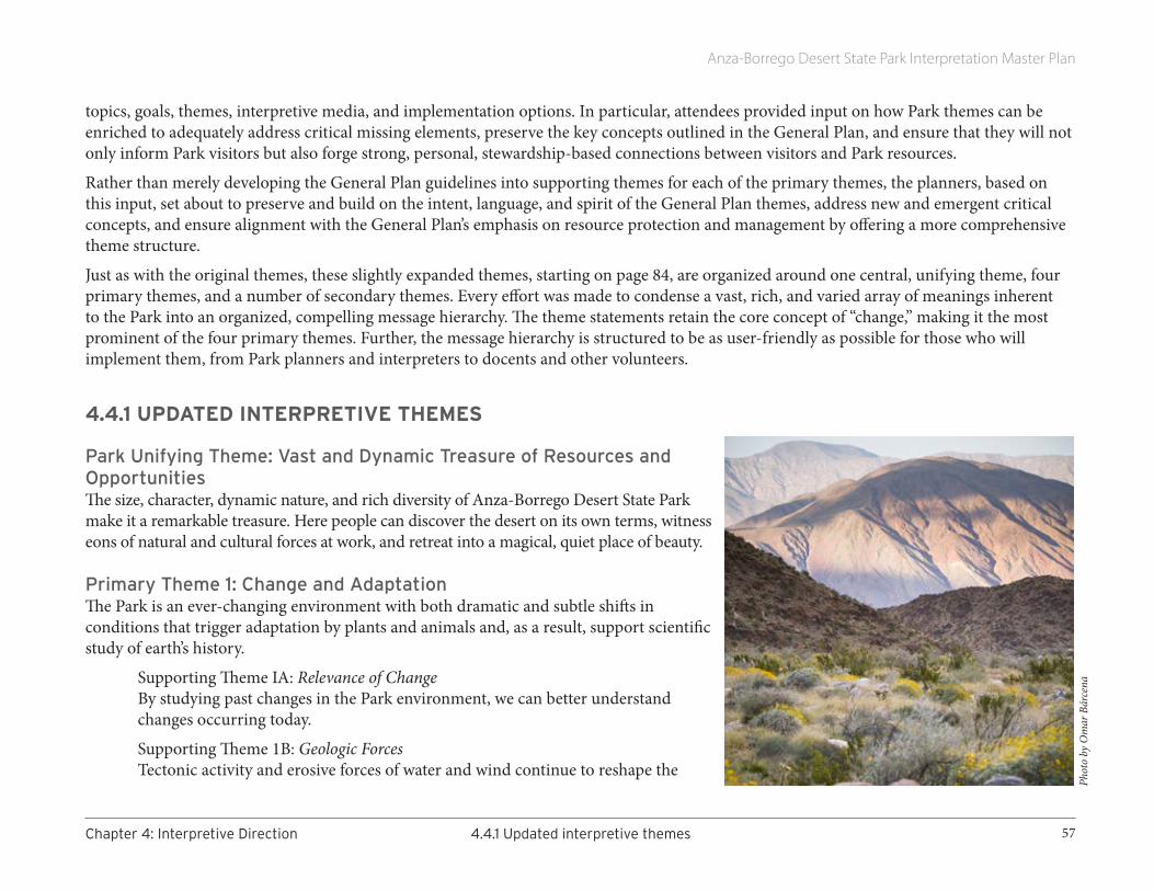
Anza-Borrego Desert State Park Interpretation Master Plan
57Chapter4:InterpretiveDirection 4.4.1Updatedinterpretivethemes
topics, goals, themes, interpretive media, and implementation options. In particular, attendees provided input on how Park themes can be enriched to adequately address critical missing elements, preserve the key concepts outlined in the General Plan, and ensure that they will not only inform Park visitors but also forge strong, personal, stewardship-based connections between visitors and Park resources.
Rather than merely developing the General Plan guidelines into supporting themes for each of the primary themes, the planners, based on this input, set about to preserve and build on the intent, language, and spirit of the General Plan themes, address new and emergent critical concepts, and ensure alignment with the General Plan’s emphasis on resource protection and management by offering a more comprehensive theme structure.
Just as with the original themes, these slightly expanded themes, starting on page 84, are organized around one central, unifying theme, four primary themes, and a number of secondary themes. Every effort was made to condense a vast, rich, and varied array of meanings inherent to the Park into an organized, compelling message hierarchy. The theme statements retain the core concept of “change,” making it the most prominent of the four primary themes. Further, the message hierarchy is structured to be as user-friendly as possible for those who will implement them, from Park planners and interpreters to docents and other volunteers.
4.4.1 UPDATED INTERPRETIVE THEMES
Park Unifying Theme: Vast and Dynamic Treasure of Resources and OpportunitiesThe size, character, dynamic nature, and rich diversity of Anza-Borrego Desert State Park make it a remarkable treasure. Here people can discover the desert on its own terms, witness eons of natural and cultural forces at work, and retreat into a magical, quiet place of beauty.
Primary Theme 1: Change and Adaptation The Park is an ever-changing environment with both dramatic and subtle shifts in conditions that trigger adaptation by plants and animals and, as a result, support scientific study of earth’s history.
Supporting Theme IA: Relevance of Change By studying past changes in the Park environment, we can better understand changes occurring today.
Supporting Theme 1B: Geologic Forces Tectonic activity and erosive forces of water and wind continue to reshape the
Phot
o by
Om
ar B
árce
na

Anza-Borrego Desert State Park Interpretation Master Plan
58 4.4.1Updatedinterpretivethemes Chapter4:InterpretiveDirection
Park’s landscapes.
Supporting Theme 1C: Climate Change Climate change has dramatically influenced habitat, challenging plants and animals to adapt or become extinct.
Supporting Theme 1D: Weather In contrast to the long-term patterns of climate change, daily and seasonal weather patterns produce bursts of rain and snow, periods of heat, cold, and wind, and stretches of calm. Some set erosive forces to work; others create shifting patterns of sunlight and shadow that change the Park’s appearance.
Supporting Theme 1E: Fossil Record The Park’s rich fossil record allows us to glimpse into the prehistoric past and learn about the changes that have occurred to the flora and fauna of Southern California.
Supporting Theme 1F: Water Water plays a critical role in defining the appearance of both natural and cultural landscapes.
Supporting Theme 1G: Human Presence Human travel, occupation, and stewardship of the desert have brought change that continues today.
Subtheme 1Ga: Land Use By studying the history and impact of human land use in the Park, we can better understand the desert environment and make more informed management decisions.
Subtheme 1Gb: Passing through the Desert People have used the desert as a corridor for travel by foot, horse, stagecoach, and auto.
Subtheme 1Gc: People of the Desert Others, from prehistoric settlers, to the Kumeyaay, Cahuilla, Cupeño, and other original inhabitants, to ranchers, prospectors, homesteaders, the military, and today’s homeowners, adapt to sometimes difficult conditions in the desert and call it home.
Subtheme 1Gd: Exploration and Discovery In the past and even today, the Park has a certain mystique that triggers adventure, exploration, and scientific inquiry.

Anza-Borrego Desert State Park Interpretation Master Plan
59Chapter4:InterpretiveDirection 4.4.1Updatedinterpretivethemes
Primary Theme 2: Diversity of Land and LifeThe Park is a land of surprising richness—even seasonal lushness—in a seemingly stark landscape.
Supporting Theme 2A: Habitat and Species Diversity Unmatched in the California State Park System, the Park’s habitat diversity and variety of landforms support remarkable species diversity.
Supporting Theme 2B: Habitat and Species Rarity Due to its rare and sensitive habitats, plants, and animals, the Park requires protection and careful management.
Supporting Theme 2C: A Setting as a Field Station The Park’s habitat and species diversity make it a remarkable field station for scientific study.
Primary Theme 3: InspirationDay and night, the beauty, history, and scientific study of the Park have provided inspiration in the past, and still do today.
Supporting Theme 3A: Shapes, Colors, Patterns The Park rewards those who take time to observe nature’s endless and sometimes surprising variety of shapes, colors, patterns, and rhythms. Life in the desert is influenced by daily, seasonal, and long-term change.
Supporting Theme 3B: Solitude The Park provides a vast preserve of solitude and escape, expansive vistas, dark skies, and uncommon quiet.
Supporting Theme 3C: Dark Skies The Park is dedicated to protecting the desert’s naturally dark skies, and to educating the public about their importance to wildlife, astronomy, and human health.
Supporting Theme 3D: Sacredness Native peoples continue to consider special places within the Park as sacred, worthy of respect and protection.
Supporting Theme 3E: Expression In art and words, the desert comes to life in the paintings of Marjorie Reed, the journals of the deAnza expedition, and the articles of Marshal South, among others.
Supporting Theme 3F: Scientific Study Milky Way
Phot
o by
Aar
on D
enni
s

Anza-Borrego Desert State Park Interpretation Master Plan
60 4.5DirectionforEducation Chapter4:InterpretiveDirection
Scientists are drawn to the desert in pursuit of research and new knowledge.
Supporting Theme 3G: Recreation
People are drawn to the desert in pursuit of a broad range of recreational opportunities.
Primary Theme 4: Protection and PreservationSurrounded by development, the Park relies on policy and human behavior to protect and preserve sacred sites as well as threatened, increasingly rare natural and cultural resources.
Supporting Theme 4A: Stewardship The sheer size and diversity of the Park present a management challenge that can serve as a model for other large, complex land stewardship efforts.
Supporting Theme 4B: New Knowledge Scientific study of the Park provides valuable information that Park managers use to assist with both stewardship and preservation and educators use to instruct students.
Supporting Theme 4C: Legacy of Native Peoples In the face of dramatic change, the Kumeyaay, Cahuilla, Cupeño, and other original inhabitants retain significant links to cultural practices honed by centuries of desert habitation. They remain the Park’s first stewards.
Supporting Theme 4D: Vigilance Park stewards—staff, volunteers, and partners—need help from visitors and the general public if the Park’s integrity and distinctive character are to survive.
4.5 DIRECTION FOR EDUCATION Currently the Park and Anza-Borrego Foundation offer three programs for students engaged in formal learning at the elementary level: the Parks Online Resources for Teachers and Students (PORTS) program, programs for Borrego Elementary School and for other schools, and Camp Borrego. These programs differ from others because they are designed to enrich grade-specific curricula and address specific academic guidelines. While the Park and Foundation have been diligent about program alignment, these guidelines recently shifted and new alignments to the following documents are needed: Next Generation Science Standards for California Public Schools; California Common Core State Standards for Mathematics; and California Common Core State Standards for English Language Arts and Literacy in History/Social Studies, Science, and Technical Subjects. In addition, California has a set of Environmental Principles and Concepts that informed development of
Phot
o by
Law
renc
e Hog
ue
Elephant Tree
Anza-Borrego Desert State Park Interpretation Master Plan
61Chapter4:InterpretiveDirection 4.5DirectionforEducation
the Education and the Environment Curriculum, and continue to inform development of new state frameworks that drive curriculum and instruction. Based on the Next Generation Science Standards, a new Science Framework for California Public Schools is in production. While a draft History-Social Science Framework for California Public Schools has been issued, it is not in circulation as of this date, although the corresponding History-Social Science Content Standards for California Public Schools (1998 edition) remain valid. California State Parks acknowledges these alignment tasks, as noted in the Interpretation Planning Workbook (2013).
The PORTS program takes students on virtual field trips to several parks, including Anza-Borrego Desert State Park. This distance-learning program enables cash- and time-strapped classes to engage in live, interactive presentations from the Park without leaving their school. Designed for elementary and middle schools, PORT’s Desert Stories, Today and Yesterday is organized around three or four 50-minute in-class lessons, any number of one-hour videoconferences, and optional extensional activities. An elementary class might book a single videoconference, while a middle school might book as many as 10 in order to reach all students at a particular grade level. The program focuses on geology, paleontology, and desert ecology. Through mobile satellite transmission, it allows students to virtually travel to Borrego Palm Canyon and Borrego Badlands and ask live questions of Park staff. In 2014–2015, its tenth year of operation, this particular PORTS program reached a total of 8,100 students. Most participants are located in San Diego, Imperial, Los Angeles, Riverside, and Contra Costa counties, but students from all over California can experience and have access to Anza-Borrego via PORTS. The PORTS program is the recipient of the 2014 Superintendent’s Award for Excellence in Museum Education, a joint project between the California Association of Museums and the Office of the State Superintendent of Public Instruction.
Each fourth-grade student at Borrego Elementary School participates in an all-day ride-along with a State Parks ranger. Students at this school can also participate in a Friday afternoon Junior Ranger Club (see Interpretive Resources report). In prior years, schools within Borrego Springs Unified School District participated in in-class programs conducted by Park staff. Currently, staffing limitations prevent these programs from being offered.
School groups that tour on their own are encouraged to begin their visit at the Visitor Center, exploring the exhibits and watching the film. From there, school groups are encouraged to visit Palm Canyon Trail, Blair Valley, Elephant Trees Trail, and the Mine Canyon Village Site. Park staff offer interpretive programs for visiting school groups. Typically 45 minutes in length, these K-12 programs are available at no charge on a limited number of days (with advance reservations). Given the financial and transportation limitations imposed on field trips, however, only a few schools (less than six) took advantage of this service in 2013 and 2014.
The Anza-Borrego Foundation works in partnership with the San Diego County Office of Education (specifically their Outdoor Education unit) to offer Camp Borrego, a fifth-grade “environmental education tent camp” experience in the desert. Based at the Borrego Palm Canyon Campground, Camp Borrego runs in early spring, hosting underserved inner-city students from San Diego and Imperial counties. It is funded entirely by donations and grants. During the three-day, two-night camping experience, students learn about desert ecology, fossils, basic research methods, and natural and cultural resources career opportunities. They explore desert springs and oases by day and have fun black-lighting and enjoying traditional campfire activities by night. For most of these students, this is their first opportunity to camp and their first
Anza-Borrego Desert State Park Interpretation Master Plan
62 4.5DirectionforEducation Chapter4:InterpretiveDirection
visit to the desert.
Academically speaking, Camp Borrego offers the perfect venue to engage students in the work of scientists and understand how and why it is relevant to their own lives. This is called for in the Next Generation Science Standards as a common thread that ties sequential learning activities together. Properly taught, science begins with engagement (asking questions and defining problems), moves toward exploration (planning and carrying out exploratory investigations), and concludes with explanation (the analysis and interpretation of data). The new standards also call for the understanding of four disciplinary core ideas (physical sciences; life sciences; earth and space sciences; and engineering, technology, and applications of science) throughout each academic year—a major shift from the 1998 science content standards.
Several factors limit the Park’s ability to expand its education program offerings. A lack of funding at the school and district level prevents many schools from being able to afford the expense of a field trip. Further, teachers and administrators face mounting pressure to have students perform well on content-driven standardized tests. Time away from classroom instruction therefore needs to be justified. Field trip programs need to be aligned to specific content standards in order for teachers to document their educational efficacy.
Inadequate funding prevents Park staff from developing and offering new programs and materials for those field trips. Further, given the new academic guidelines, Park staff needs to have the time to study the new standards and align content in order to create the best fit for its programs and services. Time is as much a limiting factor as funds.
Additionally, a lack of awareness contributes to low visitation by classroom groups. Respondents to our educator needs assessment indicated teachers are largely unaware of the Park’s educational resources, even if they were able to justify a field trip.

Anza-Borrego Desert State Park Interpretation Master Plan
63Chapter4:InterpretiveDirection 4.5DirectionforEducation
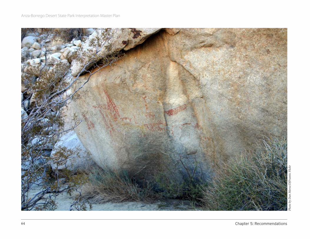
Anza-Borrego Desert State Park Interpretation Master Plan
64 Chapter5:Recommendations
Phot
o by
Dan
Mor
se/D
JFra
ntic
Flick
r
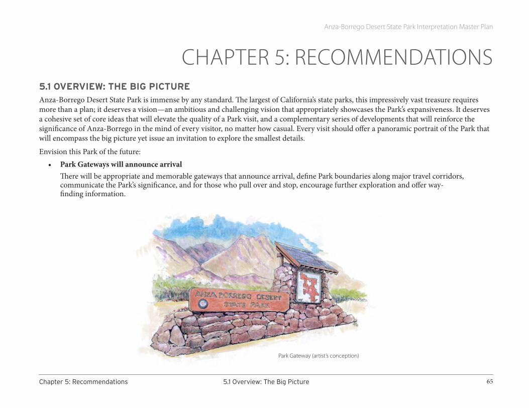
Anza-Borrego Desert State Park Interpretation Master Plan
65Chapter5:Recommendations 5.1Overview:TheBigPicture
CHAPTER 5: RECOMMENDATIONS5.1 OVERVIEW: THE BIG PICTUREAnza-Borrego Desert State Park is immense by any standard. The largest of California’s state parks, this impressively vast treasure requires more than a plan; it deserves a vision—an ambitious and challenging vision that appropriately showcases the Park’s expansiveness. It deserves a cohesive set of core ideas that will elevate the quality of a Park visit, and a complementary series of developments that will reinforce the significance of Anza-Borrego in the mind of every visitor, no matter how casual. Every visit should offer a panoramic portrait of the Park that will encompass the big picture yet issue an invitation to explore the smallest details.
Envision this Park of the future: • Park Gateways will announce arrival
There will be appropriate and memorable gateways that announce arrival, define Park boundaries along major travel corridors, communicate the Park’s significance, and for those who pull over and stop, encourage further exploration and offer way- finding information.
Park Gateway (artist’s conception)

Anza-Borrego Desert State Park Interpretation Master Plan
66 5.1Overview:TheBigPicture Chapter5:Recommendations
• Cultural Preseve Gateways will alert visitors when they enter areas of special cultural significance, and help them both understand and respect these protected zones.
• A new Visitor Center will host travelers in the south.Visitors to the southern portions of the Park will enjoy orientation and interpretive services equal to those offered at the existing Visitor Center at Palm Canyon in the north. A new southern facility, operated by State Parks staff and volunteers or in collaboration with a partner organization, will explain visiting options, provide contextual exhibits focused on the distinctive resources of the south, and offer the same friendly and informative personal services that have become a hallmark in the north. Short trails will encourage exploration on-site, suggest links to other Park features, and provide wayfinding advice.
Replication of Reed’s studio at the Southern Visitor Center (artist’s conception)

Anza-Borrego Desert State Park Interpretation Master Plan
67Chapter5:Recommendations 5.1Overview:TheBigPicture
• A well-conceived system of interpretive signs, panels, and installations will encourage visitor discovery.A new system of interpretive signs will evolve on three levels.
Level 1, Roadside Signs, will serve the dual purposes of wayfinding and broad-brush interpretation for the most casual travelers through the Park. These low-content signs, sited along Park highways, will be designed to be read from a moving vehicle.
Level 2, Simple Pull-off Areas, will encourage travelers to leave their vehicles, stretch their legs, enjoy one of the Park’s many scenic overlooks, or observe a particular natural or cultural feature linked to one of the Park’s primary themes.
Level 3, Discovery Way Stations, are also pull-off areas, but more complex. These installations will be designed to facilitate discovery, encouraging visitors to pause, learn, and explore. They will offer hands-on/minds-on interaction, in some cases using representative objects.
Discovery Way Station with fossil replica (artist’s conception)

Anza-Borrego Desert State Park Interpretation Master Plan
68 5.1Overview:TheBigPicture Chapter5:Recommendations
None of these levels will require staff, instead relying on state-of-the-art, durable, weather-resistant media to communicate their interpretive message.
Each level will be carefully sited:
Level 1 sites will be chosen for their wayfinding potential—each sign helping travelers find a Park resource, without undue intrusion on the adjacent landscape or viewshed.
Level 2 sites will be chosen for safety and proximity to a theme-related resource. Pull-over sites must be safe and located only where bona fide stories can be interpreted.
Level 3 sites require the most complex criteria for selection. To be developed as a discovery way station, a site must:
• Visually overlook an important Park feature that is linked to one of the Park’s primary interpretive themes.
• Interpret a story that supports the use of a tactile element(s).
• Be along or near a primary roadway, and accessible by ordinary vehicle.
• Be located where some level of on-site development will neither damage nor encroach on significant natural or cultural resources.
• Be located where additional discovery/exploration opportunities are nearby.
• 21st-century technology will enhance traditional wayfinding and interpretation.In the future, on-site visitors will not get lost. Vastly improved wayfinding tools will help them not only navigate but explore. Signs will be evident but not intrusive; mobile technology will help preserve uncluttered landscapes. Maps, printed and digital, will be professionally drawn and elegantly readable. Where appropriate and not intrusive, additional interpretive media will reward those who invest time to explore. To supplement traditional media applications, the Park’s audiences will have access to interpretive programming and orientation information via familiar 21st-century technologies including digital and social media. Even the remoteness of some Park resources should not negate the ultimate interpretive usefulness of emerging technologies, if not today, sometime soon.
• All materials and approaches, including those provided by an interpretive partner, will serve as examples of best practices.

Anza-Borrego Desert State Park Interpretation Master Plan
69Chapter5:Recommendations 5.2RecommendedObjectivesandStrategies(OrganizedbyGoal)
5.2 RECOMMENDED OBJECTIVES AND STRATEGIES (ORGANIZED BY GOAL)A series of big and small steps, rooted in the expressed goals of this plan, will move the Park closer to realizing its potential. One project at a time, the big picture will come into focus.
Below are the goals first outlined in section 4.2 of this report. For each, we have added at least one specific, measureable objective, as well as strategies for accomplishing each objective.
Goal 1: Targeted audiences will take advantage of new and expanded interpretive and educational opportunities on behalf of Anza-Borrego Desert State Park (Park).
Objective 1. Seventy-five percent of targeted audiences will indicate they are aware of two or more new, expanded Park interpretive and educational opportunities available to them.
Strategy a. Review and revise the Park’s website to reflect the Park’s diverse resources and the full array of interpretive/educational opportunities available. Balance the current emphasis on wildflowers (or adjust seasonally) with topics and information related to other Park resources, stories, and themes. Link Park offerings with audience interests, e.g., “for geology see X, for American Indian history see Y, for birds visit Z”.
Strategy b. Review and revise orientation materials provided at the Visitor Center, specifically to help on-site visitors learn about the size of the Park and the many features they can visit beyond the Visitor Center complex. Choose a prominent location in or adjacent to the Visitor Center—the courtyard area may be ideal—and install a user-friendly kiosk that conveys the range of activities, areas, and sights one can experience at the Park. This should replace the existing framed map currently on the exterior wall, as well as the hard-to use vertical topo map on the display just inside the Visitor Center.
Strategy c. Evaluate existing roadside media and begin to plan new wayfinding and roadside interpretive media, including signs, maps, interpretive panels, and applications of emerging technologies.
Strategy d. Enrich the visitor’s Park entry experience by providing gateways that act as welcome portals. Locations will be at Park entry points along primary highways. These gateways should provide basic orientation and introduce the Park’s interpretive themes. They should also alert visitors to the availability of mobile apps with
Improved orientation systems can help reduce negative impacts

Anza-Borrego Desert State Park Interpretation Master Plan
70 5.2RecommendedObjectivesandStrategies(OrganizedbyGoal) Chapter5:Recommendations
location-specific interpretive content to enhance the Park experience, and point to WiFi access points where such content can be easily downloaded. Consider the feasibility of installing WiFi service at the welcome portals and at Christmas Circle.
Strategy e. Provide discovery way stations within the Park’s interior. These should be located where resource stories naturally connect to and illustrate Park themes (for example, Clark Dry Lake carries a rich array of climatic, ecological, historic, and stewardship stories). Each discovery way station will offer interactive opportunities and encourage additional exploration. Where feasible, mobile technology will provide enriched content.
Strategy f. Work with the Anza Borrego Foundation to adjust their website to highlight new interpretive/educational opportunities as they become available.
Strategy g. Fully brief volunteers, partners, and local tourism staff about all new opportunities.
Objective 2. Fifty percent of targeted audiences will report increased use of new, expanded Park interpretive and educational opportunities.
Strategy a. Develop several well-designed Park Gateway installations to create a compelling arrival experience, welcome visitors and travelers to the Park, and provide basic visiting information.
Strategy b. Experiment with both the location and schedule of new opportunities to maximize use by targeted audiences.
Strategy c. Distribute new opportunities throughout the Park, in appropriate locations, particularly in the south. Develop a contact and interpretive center in the southern portion of the Park that will provide more information to visitors approaching the Park from San Diego and Imperial Counties. Begin by exploring or expanding upon cooperative operations with San Diego County Parks, Cuyamaca State Park, Octotillo Wells SVRA, and other willing partners.
Strategy d. Develop a longer-term strategy to develop and use properties at Vallecito.
Strategy e. Develop an approach to social media that announces new opportunities to targeted audiences and provides information explaining how to take full advantage of these new opportunities. Work with social media experts to ensure that the information provided is targeted to appropriate audiences, takes advantage of current media social media trends, and remains flexible and capable of adjusting to new trends as they occur.
Strategy f. Without abandoning the current emphasis on introducing the Park’s primary stories, add media at the existing Visitor Center to help it serve as a hub for a Park visit, rather than a “one-stop and I’ve seen-it-all” experience. Provide more advice on where to go other than the Visitor Center, how to find the way, and what awaits.
Objective 3. Park staff will witness a 25% increase in the number of positive public comments about the Park’s interpretive and educational opportunities, as posted through social media venues.

Anza-Borrego Desert State Park Interpretation Master Plan
71Chapter5:Recommendations 5.2RecommendedObjectivesandStrategies(OrganizedbyGoal)
Strategy a. All new media will be the highest quality possible given budget and staffing available, and will be regularly updated with new content consistent with updates to Park website content.
Goal 2: Targeted audiences will be able to easily retrieve information, both on-site and off-site, on how to visit and enjoy the Park.
Objective 1. Visits to the updated Park website and similar media that provide information for planning a visit will increase by 50%, and 75% of users will report high levels of satisfaction with its features.
Strategy a. Use experienced, quality, professional web experts to restructure and improve the Park website so that content—including existing, new, and seasonal opportunities—is clear, easy to understand, and easy to navigate. Remove or relocate the current link to the Sacramento site to prevent visitors seeking Park-related content from being directed away from relevant content.
Strategy b. Employ high-quality images that reflect the full range of opportunities and venues for interpretive/educational opportunities, particularly seasonal activities and initiatives like dark skies.
Strategy c. Ensure staff time and training to keep the website up-to-date and engaging.
Strategy d. Use social media and mobile technology to encourage the use of on-site orientation and wayfinding information at the Visitor Center and at well-visited locations throughout the Park (campgrounds, for example). Consider working with partners and volunteers to provide portable orientation resources (information vans or portable exhibits) during periods of heavy visitation.
Strategy e. Provide improved wayfinding media (including directional signs, visible mileage markers, and easy-to-use maps) so that targeted audiences can locate all interpretive and educational opportunities easily, including seasonal activities.
Goal 3: Targeted audiences will become increasingly aware of the diversity of natural, cultural, and historical resources at the Park and the depth of its legacy stories.
Objective 1. As a result of taking advantage of new, expanded interpretive and educational opportunities, 75% of targeted audiences will report increased awareness of the Park’s diverse resources and legacy stories.
Strategy a. Review all free publications currently distributed (including both State Park and Foundation materials) and evaluate for ease of use, accuracy of information, and orientation to the full range of interpretive/educational opportunities available. Make adjustments where possible and appropriate, to better focus on Park diversity and seasonal change. Include more “I’d-like-to-see-that” photos to entice visitation to appropriate lesser-known sites.
Strategy b. Work with the Foundation to develop and distribute a new program that helps disperse visitation beyond the

Anza-Borrego Desert State Park Interpretation Master Plan
72 5.2RecommendedObjectivesandStrategies(OrganizedbyGoal) Chapter5:Recommendations
Visitor Center and campgrounds—perhaps a desert quest6 or passport program that encourages more focused visits to one or more locations in the Park.
Strategy c. Improve wayfinding throughout the Park and increase the availability of free maps that highlight the diversity of Park resources and interpretive venues. Add signs or markers at important field locations, trailheads, vistas, etc.
Objective 2. Seventy-five percent of targeted audiences will be able to describe a natural, cultural, or historical resource they were not aware of prior to accessing the Park’s new, expanded interpretive and educational opportunities.
Strategy a. Review the mix of resources currently interpreted in the field and make changes to ensure that all of the Park’s primary themes are addressed appropriately.
Strategy b. Highlight appropriate lesser-known resources on the Park and Foundation websites, social media, and in partner publications. Adjust as needed to provide interpretive balance.
Strategy c. Review and adjust the Park’s current driving tour brochures for links to the primary themes and distribution of visitation. Address relevance and meaning, not just facts and information in the tour narratives. If appropriate, develop new tours that include lesser-known sites. Consider the use of non-printed alternatives to disseminate these tours.
Goal 4: Targeted audiences will better appreciate the Park’s natural, cultural, and historical resources and legacy stories.
Objective 1. Seventy-five percent of targeted audiences will indicate, via comments to staff or on social media, greater appreciation for the Park’s resources and legacy stories as a result of taking advantage of new, expanded interpretive and educational opportunities.
Strategy a. Identify locations for new discovery way stations followed by a plan for funding and development.
Strategy b. Ensure that all interpretive/educational opportunities address meaning and relevance (the interpretive value) in addition to providing facts and information.
Strategy c. Provide interpretive training that ensures that all staff and volunteers understand and use the Park’s primary interpretive themes, and are able to meet appropriate levels of interpretive competency.
Objective 2. Fifty percent of targeted audiences will identify cultural and/or historic resources as a reason they would recommend a visit to the Park.
6 Questing differs from geocaching in that it does not alter the landscape in any way. Quests are self-guided experiences focused on helping users learn to read the land, understand and form personal connections with resources, and/or cultivate a sense of place. Questing tools can be as simple as a set of clues and a map.

Anza-Borrego Desert State Park Interpretation Master Plan
73Chapter5:Recommendations 5.2RecommendedObjectivesandStrategies(OrganizedbyGoal)
Strategy a. Review the Park’s website and expand the current emphasis on visiting opportunities to include a wider range of visitable Park resources.
Strategy b. Develop new media that focus on the Park’s historical resources.
Goal 5: Targeted audiences will deepen their understanding of important but currently under-interpreted concepts about the Colorado Desert and its past and current desert systems and interactions, such as long-term climate change and the Park’s fossil record.
Objective 1. Seventy-five percent of audience members who access media describing the desert’s Pleistocene past will be able to describe what this region looked like during this epoch, as well as some of the animals and plants that lived here.
Strategy a. Develop new media that links Visitor Center interpretation of the Pleistocene past with appropriate field locations and provide interpretive materials about those locations. Ensure that all interpretation conveys a strong stewardship message about these fragile resources. Ensure that a selection of megafauna and microfauna fossils are presented in an attractive, imagination-stimulating, secure way, using models or casts when required.
Strategy b. Ensure that the Pleistocene past is included in any plans for new media in the field (signs, brochures, driving tours, online applications, discovery way stations, etc.).
Strategy c. Work with partners to increase access (physical, where appropriate, and online) to the Park’s important fossil collections or replicas of specimens, including a glass-enclosed area where visitors may observe real-time preparation of paleontological specimens.
Strategy d. Include visual depictions of the Pleistocene past online and in the field at appropriate locations using durable, desert-appropriate media.
Objective 2. Seventy-five percent of audience members who access media describing physical forces that act on the desert will be able to describe in general terms how tectonic activity, water, and/or wind shape the Park’s landscapes.
Strategy a. Develop new media that explain, in lay terms, the physical forces that shape Park landscapes generally (in the existing Visitor Center, online, and on location/discovery way stations).
Strategy b. Revisit the media and materials available in the Visitor Center’s Discovery Room and refocus on providing hands-on/minds-on activities that convey interpretive concepts about the objects. Make the Discovery Room more secure, available and independent of staff availability. Make the Discovery Room more flexible (useful for school groups during periods of school visitation and for family or youth groups on weekends, for example).

Anza-Borrego Desert State Park Interpretation Master Plan
74 5.2RecommendedObjectivesandStrategies(OrganizedbyGoal) Chapter5:Recommendations
Strategy c. Highlight the physical forces that shape desert landscapes in illustrated staff presentations (campground talks and discovery way stations, for example) and provide information on appropriate places to see evidence of those forces in the field.
Objective 3. Seventy-five percent of audience members who access media illustrating the Park’s species and habitats will be able to explain in general terms why certain species and habitats require protection and management, and how scientific research informs that management.
Strategy a. Review and revise existing media that address species and habitats and ensure that they include interpretation of the science, presented in lay terms, related to Park management decisions.
Strategy b. Develop new messages for free publications and social media that highlight management initiatives related to species and habitat protection.
Strategy c. Provide training to all staff and volunteers so they can integrate management initiatives into talks and tours where appropriate.
Objective 4. Seventy-five percent of audience members who access media illustrating desert ecological principles will be able to describe one or more adaptations of desert plants and animals to extremes of climate.
Strategy a. Review the use of the Visitor Center’s Discovery Room and ensure that ecological principles, including adaptation, are interpreted in lay terms and reinforced with hands-on/minds-on activities.
Strategy b. Consider expansion of PORTS programs to address desert ecological principles.
Strategy c. Develop discovery way stations focused on ecological principles and adaptations.
Goal 6: Audiences will deepen their understanding of important but currently under-interpreted concepts about human connections to the desert over time, including the stories of original inhabitants. 7
Objective 1. Seventy-five percent of audience members who access media describing human connections to the desert will be able to state how desert resources have sustained the lives and cultures of the original inhabitants.
Strategy a. Engage members of the Kumeyaay, Cahuilla, Cupeño, and other tribes and bands in dialogue related to interpretation of their relationship with desert resources.
Strategy b. Set up a process for developing and reviewing new materials that interpret the traditional and contemporary relationships original inhabitants and their descendants have with the desert environment.
7 Based on input received during the tribal stakeholder session, we replaced specific names of California Indians with the term “original inhabitants.”

Anza-Borrego Desert State Park Interpretation Master Plan
75Chapter5:Recommendations 5.2RecommendedObjectivesandStrategies(OrganizedbyGoal)
Strategy c. Develop new media in the field (wayside panels, online applications, driving tours, discovery way stations, etc.) to interpret the cultures of original inhabitants.
Strategy d. Ensure that all such media explain the sacred nature of cultural resource sites within Park boundaries and help develop respect for those sites.
Objective 2. Seventy-five percent of audience members who access media illustrating human connections to the desert will be able to describe at least one Park connection to historic events and places, such as the Anza expedition, Great Southern Overland Route, Butterfield Stage, or use by cattle ranchers, prospectors, homesteaders, or the military.
Strategy a. Develop a contact station in the field, in the southern portion of the Park, primarily focused on interpretation of human connections to the desert. Assess possible field locations for this contact station and develop an action plan to develop a field presence. Alternatives might include both staffed and unstaffed locations and cooperative ventures with other partners including San Diego County Park facilities and Ocotillo Wells SVRA.
Strategy b. Develop self-guiding materials (online and publications) coordinated with new wayfinding media linked to the human history of the Park.
Strategy c. Develop a short (5–10 minute) audiovisual program for use in the Visitor Center, online, and in field locations focused on an introduction to the human history of the Park.
Strategy d. Consider expansion of PORTS programs to address the range of human history related to the Park.
Strategy e. Develop discovery way stations focused on the primary historical themes of the Park.
Goal 7: Based on their deeper understanding of the fragility of Park resources and the need for protection and preservation, the audience will demonstrate increased adherence to Park rules and regulations.
Objective 1. Seventy-five percent of audience members will report support of Park management actions aimed at protecting Park resources.
Strategy a. Include protection messages in new media beyond the Visitor Center complex.
Strategy b. Influence visitor behavior by improving wayfinding to those Park resources that can withstand increased visitation. Consider the value of using orientation and wayfinding materials to disperse visitation and reduce concentrated activity and overuse that can damage Park resources.
Strategy c. Include media in the Visitor Center and at campgrounds that explain the fragility of the desert environment and provide specific tips on how visitors can help protect desert resources.
Anza-Borrego Desert State Park Interpretation Master Plan
76 5.2RecommendedObjectivesandStrategies(OrganizedbyGoal) Chapter5:Recommendations
Objective 2. Seventy-five percent of audience members will be able to describe a link between at least one fragile Park resource and a rule or regulation that protects it.
Strategy a. Train staff and volunteers so they can include a concrete and memorable protection message in appropriate talks and tours.
Strategy b. Include a field experience in all group visit programs designed to improve a Park resource.
Strategy c. Develop volunteer and community-based programs to enlist partners, Foundation members, and residents (permanent and seasonal) in projects to improve the health of Park resources.
Objective 3. Park staff will witness a 25% increase in the number of positive public comments about the need to protect and preserve fragile Park resources as posted on social media sites.
Strategy a. Develop a social media presence, using Instagram and Twitter, for example, that highlights those fragile desert resources most appreciated by visitors and worthy of protection.
Strategy b. Model good stewardship by replacing all damaged and outdated interpretive exhibits and panels throughout the Park with either new panels or alternative media well suited to desert conditions.
Strategy c. Establish a monitoring and maintenance regime to ensure that new panels and alternative media remain in good condition, and are visible and functioning.
Strategy d. Review safety concerns and reported injuries in the Park and develop media to increase visitor awareness of dangers. Adjust seasonally as needed.
Objective 4. Park staff will witness a 25% decrease in the number of citations issued for violations of rules and regulations during the first five years following implementation of the Interpretive Master Plan.
Strategy a. Develop new regulatory signage that explains the reason for each rule and regulation cited.
Strategy b. Continue to develop a social media presence, using Instagram and Twitter, for example, that highlights those fragile desert resources most appreciated by visitors and worthy of protection.
Strategy c. Continue to model good stewardship by replacing all damaged and outdated regulatory signage throughout the Park with highly resilient media well suited to desert conditions.
In order to sustain momentum, State Parks will need to develop a strategy and schedule for developing the next level of planning detail—an Interpretation Action Plan that includes specific tasks for each objective.

Anza-Borrego Desert State Park Interpretation Master Plan
77Chapter5:Recommendations 5.3.1OverviewofRecommendedInstallations
5.3 RECOMMENDED FACILITIES, MEDIA, AND PROGRAMMING
5.3.1 OVERVIEW OF RECOMMENDED INSTALLATIONS
Park GatewaysPark Gateways will be located at primary entry corridors into the Park. Designed as an arch spanning a roadway, each gateway will be architecturally memorable yet sensitive and appropriate to its setting. Materials will complement the surroundings, and the size will suit each particular location. Quality of both design and construction will be unmistakable. Travelers will find these gateways visually arresting, and, without question, will understand that they are entering one of the Earth’s special places.
Serving as both entry and exit markers, Park Gateways will carry thematically appropriate, very brief messages.
These architectural features will include interpretive material as well as traditional (directional signs) and electronic wayfinding tools (e.g., mobile apps, Wi-Fi access points, and phone-accessed audio guides that do not require an Internet connection).
Cultural Preserve GatewaysThese architectural features will be located at entry points to designated Cultural Preserves. Like Park Gateways, their design and construction will be thematically appropriate, and interpretive materials (whether simple or elaborate) will help visitors understand, appreciate, and treat these areas with an extra level of respect. However, as there are no roads into Cultural Preserves, Cultural Preserve Gateways will be placed along paths or trails rather than roads.
PulloutsPullouts will range in complexity and level of visitor interaction from roadside signs to discovery way stations. To some degree each serves to orient the visitor and help them locate a particular Park resource.
GLOSSARYCultural Preserve Gateway—Architectural feature that announces the visitor’s arrival at a cultural preserve within the Park.
Directional sign—Print or digital tool that routes vehicular or foot traffic at key decision points, entrances, and exits.
Discovery Way Station—Installation that features an interpretive panel and three-dimensional object.
Electronic media—Device, such as a smartphone or tablet, that stores and allows distribution or use of electronic information through a mobile app, audio guide, and other form.
Interpretive panel—Sign that combines text and visuals to tell a story about an object, person, place, or event.
Park Gateway—Architectural feature that announces the visitor’s arrival at Anza-Borrego Desert State Park.
Pullout—Road-parallel area that displays an interpretive panel or other signage that connects a specific site to the visitor.
Regulatory sign—Sign that states rules and regulations and explains the reasons for them.
Visitor Center—Facility that functions as a portal to understanding the Park and prepares a person to experience it.
Anza-Borrego Desert State Park Interpretation Master Plan
78 5.3.1OverviewofRecommendedInstallations Chapter5:Recommendations
Discovery Way StationsRepresenting the most complex of the pullouts, Discovery Way Stations will feature interpretive panels and large three-dimensional objects. Examples might include a replica stagecoach at Vallecito Valley, a replica fossilized imperial walrus skeleton near Bow Willow Campground, or bas-relief figures of vernal pond life at Clark Dry Lake. Designed as tactile experiences, the way stations will draw visitors into deeper engagement with the Park’s more compelling resources—an extended walk along a trail, perhaps, or exploration of a historic site. Visitors will leave each discovery way station with a better understanding of one or more of the basic concepts that rest at the core of Anza-Borrego’s significance.
Southern Visitor CenterWhile the Visitor Center at Palm Canyon is a popular destination for visitors who arrive from the north, it does not necessarily serve visitors who arrive from the south.
We recommend transforming Vallecito Ranch into a new southern visitor center. While it should adhere to the same exemplary standards for providing information, orientation, and interpretive services as the Borrego Palm Canyon Visitor Center, its focal points should differ. This setting is ripe for interpretation of the historical “periods” identified on page 55: Native Homeland; Travelers and Trails; and Modern Isolation. Here is an excellent opportunity to discuss ways transportation routes and water availability shaped (and continue to shape) human settlement in Southern California. It is equally appropriate as a setting to showcase desert-inspired art, such as the pictographs and petroglyphs of the Kumeyaay, paintings of Marjorie Reed, and writing and print making of Marshal South.
Existing Visitor CenterWe also recommend refreshing some of the displays in the northern Visitor Center at Palm Canyon, including the introductory display featuring a montage of symbolic, but possibly confusing icons of the Park and vertically displayed map. Given the number of visitors who ask front desk staff and volunteers wayfinding questions, this map might prove more useful as a tabletop relief map. In addition, given recent advances in technology, Park staff should upgrade the current audiovisual presentations. A new circular “directory” kiosk in the courtyard would help visitors shape their visit according to area of interest, level of difficulty, and time commitment.
Interpretive PanelsInterpretive panels translate information about a place, object, person, or event into brief stories that enhance the visitor’s appreciation for and understanding of Park resources. Done well, they serve as Park ambassadors. Reflecting Park themes and richly illustrated, interpretive panels can enhance the visitor’s experience and help manage behavior, whether Park staff or volunteers are present or not. An interpretation action plan will serve to identify priorities for panel development, replacement (of existing media), and placement (e.g., within pullouts, discovery way stations, trailheads, and Cultural Preserves).
Anza-Borrego Desert State Park Interpretation Master Plan
79Chapter5:Recommendations 5.3.2RecommendedInstallationsbyParkSector
Regulatory SignsWhile regulatory signs are seldom associated with interpretive tools, they become interpretive when they move beyond citing problematic activity to explain the consequences of such activity on Park resources or visitor safety. For many visitors, understanding the reasons behind (and benefits of) regulations generates better and more lasting compliance. Where feasible, we recommend taking an interpretive approach when developing regulatory sign content.
5.3.2 RECOMMENDED INSTALLATIONS BY PARK SECTORInterpretive signs have played an important role in the mix of media employed by ABDSP. Based on past installations, it is also clear that desert conditions and remote settings require adaptation. Traditional media—interpretive panels mounted in standard hardware—may not be the best solution for the Park’s exposed, dusty landscapes, baked in intense sunlight. By the same token, emerging technologies, digital technologies, and social media may not always be appropriate for installations far from settled towns.
For those reasons, it’s important to be innovative with interpretive solutions and to consider a full range of techniques and media. The recommendations described below describe a variety of physical installations; they can and should be supplemented with other solutions—for example, carry-along publications and previously uploaded programs or smartphone apps (discussed later in this report).
To aid future planners, we have divided ABDSP into six geographically equal sectors and developed a map for each. Every sector has one or more recommended installations (please refer to the Glossary, section 5.3.1, for a definition of each installation type).

Anza-Borrego Desert State Park Interpretation Master Plan
80 5.3.2RecommendedInstallationsbyParkSector Chapter5:Recommendations
Map 1: Coyote Canyon + Borrego Palm Canyon
Park Gateways: None. Visitors to this sector will already be in the Park and will have passed a Gateway feature.
Discovery Way Stations: The relatively heavy visitation to this sector makes it a good place to introduce basic information and begin (or continue) the important process of generating emotional and intellectual connections with the Park. This might be best accomplished with a discovery way station that introduces one of the Park’s icons—bighorn sheep, for example—or asks visitors to contemplate a manifestation of the vastness of the Park, such as the starry night sky. The chosen topics should fit within the primary themes of inspiration and diversity of land and life.
Examples of sculptural elements might include: a COR-TEN steel bighorn ram and ewe or a “map” of the night sky that visitors can rotate.
Pullouts: This heavily visited sector of the Park offers several potential locations for roadside pullouts. Specific sites and topics will be determined as part of the next level of planning.
Northern Visitor Center: This document includes several recommendations for interpretation at the existing Visitor Center in Borrego Springs (see pages 69, pages 71– 74, and 76 in section 5.2, Recommended Objectives and Strategies).
Interpretive panels: Because this sector offers many opportunities to connect with visitors in significant numbers, all of the Park’s primary themes should be introduced using interpretive panels. Topics/locations will be determined during the next level of planning, beginning with an assessment of existing interpretive panels and the use of complementary new or alternative media suggested elsewhere in this document.
Cultural Preserve Gateways: The Cultural Preserves within ABDSP’s boundaries merit special recognition; roads into each of the preserves will be marked. Each cultural preserve gateway will welcome visitors, convey the significance of the area, and help visitors understand its status as one of several special places of cultural significance within the Park. Each Cultural Preserve gateway will bear its own distinctive icon, to be developed as part of future planning.
The Cultural Preserve gateway in this sector will introduce visitors to Coyote Canyon Cultural Preserve.

Anza-Borrego Desert State Park Interpretation Master Plan
81Chapter5:Recommendations 5.3.2RecommendedInstallationsbyParkSector
Coyote
Canyon
Borrego PalmCanyon
Anza
WarnerSprings
BorregoSprings
TamariskGrove
Ranchita
1
0 1 2 3 4 5Miles
LegendPark GatewayWay StationCultural GatewayVisitor CenterPoint of InterestHighway; Local HighwayLocal Road
Park RouteTrail/No VehiclesCultural
WildernessABDSP Boundary
ABDSP-Interpretive Locations-Sector 1
6
4
2 5
3
1
Key Map

Anza-Borrego Desert State Park Interpretation Master Plan
82 5.3.2RecommendedInstallationsbyParkSector Chapter5:Recommendations
Map 2: Tamarisk Grove + Blair Valley + Vallecito + Marshal South Home
Park Gateways: This sector plays an important role in welcoming visitors to the Park. Its location, accessible from highways S-2, S-22, 78, and 79, offers four possible sites for gateways.
Each Park gateway should be designed to display messages on both sides. One side will welcome visitors; the other will alert them that they’re leaving the Park and remind them of the preservation messages they’ve absorbed during their visit. In some cases, the exit message may provide additional information about entering other lands with special status, such as an Off-Highway Motor Vehicle Recreation Area or a military reservation.
Discovery Way Stations: This sector is an ideal place to develop a discovery station, or stations, that address the primary themes of inspiration and change/adaptation, particularly related to human influence and land use.
Examples of sculptural elements could include: a COR-TEN steel figure of explorer Juan Bautista de Anza, a replica stagecoach (providing an opportunity to discuss both the history of travel and the artistic inspiration of Marjorie Reed), a COR-TEN steel figure of cattle or cattle ranchers, or COR-TEN steel figures of native peoples (for example, prehistoric Native Americans with morteros to represent early occupation, or a modern scene that connects present and past and reinforces the sacredness of certain sites).
Pullouts: Because several highways pass through this sector, there are multiple possibilities for roadside pullouts. Exact locations will be determined during the next level of planning.
Southern Visitor Center: This IMP recommends initiating plans to develop a facility to serve visitors to the southern half of the Park, particularly those who travel from San Diego.
Interpretive panels: This is an interpretively rich sector of the Park with multiple sites and encompassing all of the Park’s primary themes. Specific locations and topics will be determined during the next level of planning.
Cultural Preserve Gateways: Reflecting the resource richness of this sector, there are four Cultural Preserves to be marked with gateway panels. Each will welcome visitors to the preserve and explain the significance of the area, the people connected to this land, and what the site contributes to ABDSP. Each cultural preserve gateway will bear the distinctive cultural preserve icon (to be developed).
The four Cultural Preserves in this sector are: Angelina Spring, Culp Valley, Hawi-Vallecito, and Little Blair Valley.

Anza-Borrego Desert State Park Interpretation Master Plan
83Chapter5:Recommendations 5.3.2RecommendedInstallationsbyParkSector
EarthquakeValley
Borrego PalmCanyon
WarnerSprings
Julian
BorregoSprings
TamariskGrove
Ranchita
GraniteMountain
AguaCaliente
BlairValley
WhalePeak
Lucky 5
Tulloch
1
2
0 1 2 3 4 5Miles
LegendPark GatewayWay StationCultural GatewayVisitor CenterPoint of InterestHighway; Local HighwayLocal Road
Park RouteTrail/No VehiclesCultural
WildernessABDSP Boundary
ABDSP-Interpretive Locations-Sector 2
6
1 4
5
3
2
Key Map

Anza-Borrego Desert State Park Interpretation Master Plan
84 5.3.2RecommendedInstallationsbyParkSector Chapter5:Recommendations
Map 3: Lucky 5
Park Gateway: This is a small sector, relative to the overall size of the Park. It will have a single entrance/exit installation along S-1 at the boundary of Cuyamaca Rancho State Park.
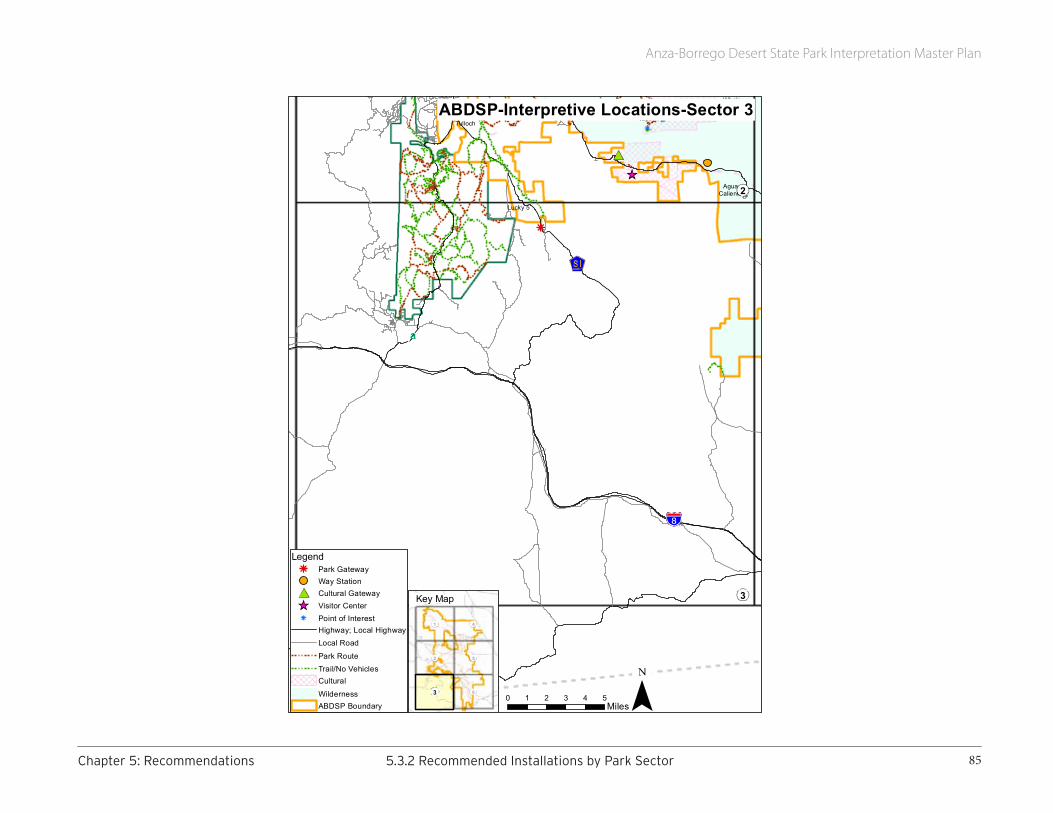
Anza-Borrego Desert State Park Interpretation Master Plan
85Chapter5:Recommendations 5.3.2RecommendedInstallationsbyParkSector
EarthquakeValleyJulian
GraniteMountain
AguaCaliente
BlairValley
WhalePeak
Lucky 5
Tulloch
3
2
0 1 2 3 4 5Miles
LegendPark GatewayWay StationCultural GatewayVisitor CenterPoint of InterestHighway; Local HighwayLocal Road
Park RouteTrail/No VehiclesCultural
WildernessABDSP Boundary
ABDSP-Interpretive Locations-Sector 3
6
1 4
2 5
3
Key Map

Anza-Borrego Desert State Park Interpretation Master Plan
86 5.3.2RecommendedInstallationsbyParkSector Chapter5:Recommendations
Map 4: Calcite Mine + Clark Dry Lake
Park Gateway: This sector will have a single Park gateway along Highway S-22.
Because this sector shares a boundary with Ocotillo Wells State Vehicular Recreation Area (OWSVRA), and because permitted activities in the two areas are radically different, this Park gateway is particularly important. Visitors, both arriving and departing, need to know the type of state land they have entered and what activities are permitted, and not permitted, within each.
Discovery Way Stations: This sector is an ideal place to interpret the themes of biological diversity and change/adaptation, particularly the role that water and erosion play in shaping Park landscapes.
Examples of sculptural elements might include: a bas relief of vernal life at Clark Dry Lake, a dynamic 3-D representation of the “slots” carved in the landscape by nature and humans, or a COR-TEN steel figure of a calcite miner.
Pullouts: Specific pullouts will be determined during future planning.
Interpretive panels: Specific locations and topics will be determined during the next level of planning.
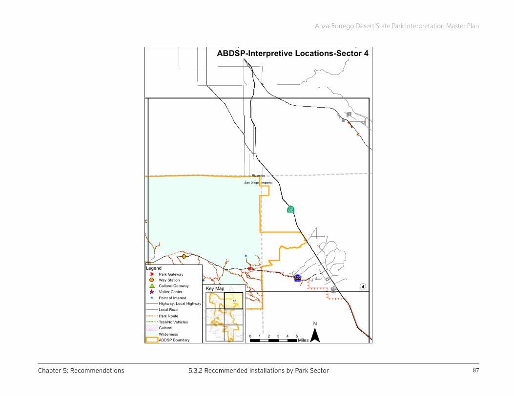
Anza-Borrego Desert State Park Interpretation Master Plan
87Chapter5:Recommendations 5.3.2RecommendedInstallationsbyParkSector
OcotilloWells
BorregoSprings
Riverside
San Diego Imperial
1 4
0 1 2 3 4 5Miles
LegendPark GatewayWay StationCultural GatewayVisitor CenterPoint of InterestHighway; Local HighwayLocal Road
Park RouteTrail/No VehiclesCultural
WildernessABDSP Boundary
ABDSP-Interpretive Locations-Sector 4
6
1
2 5
3
4
Key Map

Anza-Borrego Desert State Park Interpretation Master Plan
88 5.3.2RecommendedInstallationsbyParkSector Chapter5:Recommendations
Map 5: Fish Creek
Park Gateway: This sector will have a single gateway along Highway 78.
Discovery Way Stations: This sector provides opportunities to interpret change/adaptation, in particular the geologic forces that shaped the desert badlands. Although the topic of fossils must be handled carefully and in conjunction with the protection and preservation theme, the fossil record in this sector opens the door to discussion of the scientific value of the Park. Also, since the Southern Emigrant Trail passed through this sector, there are opportunities to interpret human crossings and land uses.
Examples of sculptural elements might include: replicas of fossils or Pleistocene animals, a COR-TEN steel figure of a paleontologist, or figures of an emigrant party on the trail.
Pullouts: Specific pullouts will be determined during future planning.
Interpretive panels: Specific locations and topics will be determined during the next level of planning. However, because this sector shares a boundary with Ocotillo Wells State Vehicular Recreation Area (OWSVRA), and because permitted activities in the two areas are radically different, it is particularly important to help visitors understand OWSVRA, its boundaries, and how permitted and non-permitted activities vary depending on which property one is visiting.
Cultural Preserve Gateway: The Southern Overland Trail Cultural Preserve is located in this sector.
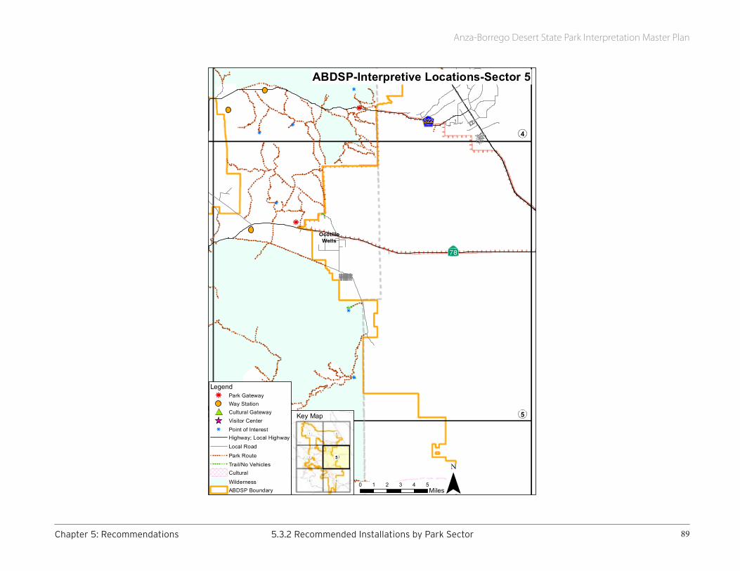
Anza-Borrego Desert State Park Interpretation Master Plan
89Chapter5:Recommendations 5.3.2RecommendedInstallationsbyParkSector
OcotilloWells
BorregoSprings
BowWillow
AguaCaliente
WhalePeak
1 4
2 5
0 1 2 3 4 5Miles
LegendPark GatewayWay StationCultural GatewayVisitor CenterPoint of InterestHighway; Local HighwayLocal Road
Park RouteTrail/No VehiclesCultural
WildernessABDSP Boundary
ABDSP-Interpretive Locations-Sector 5
6
1 4
2
3
5
Key Map

Anza-Borrego Desert State Park Interpretation Master Plan
90 5.3.2RecommendedInstallationsbyParkSector Chapter5:Recommendations
Map 6: Bow Willow + Mountain Palm Springs
Park Gateway: This sector will have a single gateway along Highway S-2.
Discovery Way Stations: This sector provides opportunities to interpret the peoples of the desert (past and present) and the diversity of life. Examples of sculptural elements might include COR-TEN steel figures of native peoples, representations of vernal life, or replicas of fossils or Pleistocene animals.
Pullouts: Specific pullouts will be determined during future planning.
Interpretive panels: Specific locations and topics will be determined during the next level of planning.
Cultural Preserve Gateway: The Piedras Grandes Cultural Preserve is in this sector.

Anza-Borrego Desert State Park Interpretation Master Plan
91Chapter5:Recommendations 5.3.2RecommendedInstallationsbyParkSector
Ocotillo
BowWillow
AguaCaliente
WhalePeak
63
2 5
0 1 2 3 4 5Miles
LegendPark GatewayWay StationCultural GatewayVisitor CenterPoint of InterestHighway; Local HighwayLocal Road
Park RouteTrail/No VehiclesCultural
WildernessABDSP Boundary
ABDSP-Interpretive Locations-Sector 6
3
1 4
2 5
6
Key Map

Anza-Borrego Desert State Park Interpretation Master Plan
92 5.3.3RecommendedElectronicMedia Chapter5:Recommendations
5.3.3 RECOMMENDED ELECTRONIC MEDIAIncreasingly prevalent and rapidly evolving, electronic or digital media hold promise as interpretive tools. Their value lies in their ability to enhance static interpretation: they can promote real-time, interactive, engaging experiences shared between Park interpreters and visitors, and focused on cultivating a sense of place.
Results of the 2014 visitor survey reveal that interest in mobile technology is significantly higher in the younger half of the population. Nearly 70% of respondents between the ages of 20 and 49 prefer it as their interpretive delivery system. Its effectiveness is a function of selecting the right tool in consideration of all the variables—audience receptivity, current use of personal devices like smartphones, Internet or network connectivity, and resources at hand.
Considering that this trend is likely to rise, Park staff should explore the feasibility of installing Wi-Fi service at gateways and pullouts where feasible, and alerting visitors to its presence at Christmas Circle. At these Wi-Fi access points, visitors could easily download Park information.
Given how quickly the field is evolving, however, Park staff will need to remain nimble in this marketplace and not select a mobile technology provider until they are ready to move forward. We recommend looking for firms that offer the greatest versatility in developing a digital profile for Anza-Borrego Desert State Park. Some products, for example, currently offer a wide range of customizable features that support both smartphones and non-smartphones.8 This platform flexibility, combined with the integration of social media sites, can reach a larger demographic of existing and potential Park visitors.
Certain web-based platforms can support a native environment that requires only a cellular connection for the visitor; no data connection is needed in the field. Guide by Cell’s Cell Phone Audio Guide, for example, allows visitors to dial in and listen to any information, including information they may have missed, even after their visit. Further, its compatibility with all major platforms could make this smartphone app a good candidate for this situation. Features like geolocation, push notification functionality, and Google Maps integration would be beneficial for wayfinding throughout the Park.
The Cell Phone Audio Guide provides access when visitors dial a few keys on their phone. Pre-recorded audio files can be easily uploaded by staff at the web-based administrative website, or recorded over the phone. Customization of their platform can also include user-added content and data storage. In addition to these features, this technology allows video and audio to be embedded or even linked to YouTube and other video sharing websites like Vimeo, Facebook, or Flickr. However, consideration should be given to file size and download rates for video and audio for both smartphones and non-smartphones.
8 Non-smartphones are mobile phones lacking the ability to run applications (“apps”).

Anza-Borrego Desert State Park Interpretation Master Plan
93Chapter5:Recommendations 5.3.4RecommendedPersonalMediaandPublicPrograms
Several smartphone apps, once downloaded, do not require further internet or cell signal access to provide content. This is especially useful in locations where Wi-Fi is impractical and cell signal is weak to nonexistent. Two developers of interpretive apps of this type are Toursphere (now part of OnCell) and Bar-Z.
5.3.4 RECOMMENDED PERSONAL MEDIA AND PUBLIC PROGRAMSPersonal services have the potential to be an extremely compelling and memorable interpretive technique, particularly when delivered in one of the Park’s evocative settings. Park staff understand this and have developed a full seasonal calendar of programs: daytime talks, Discovery Room presentations, campfire programs in the evening, and special topic talks/tours by interpretive partners.
The following recommendations build on that solid foundation in ways that ensure that personal services, like all other interpretive media, will help achieve targeted goals, reach new audiences, and focus on primary themes.
In the future, personal service should evolve in several ways:
• Contacts with on-site visitors should become more flexible and less formal. More “roving” and fewer scheduled daytime tours will multiply the number of meaningful interactions between visitors and staff/volunteers.
• Experimentation should be expected and rewarded. Personal services grow and mature each time a new venue attracts a different audience, or a new topic explores an additional facet of a park theme.
• Training and evaluation should be a welcome and productive part of every interpreter’s professional development. Flexibility and experimentation require new skills and depend on new information. Master interpreters could be used to nurture and encourage the talents and abilities of newer interpreters, or even seasoned tour guides who want to learn about hands-on demonstrations and roving techniques. In addition, the primary themes in this IMP may suggest additional training topics and lead to discussions of the most effective ways to present different information to more diverse audiences.
More specific recommendations include:
• Each evening program should be linked directly to one of the IMP’s primary themes. For example, with limited distractions, campground programs are an ideal way to introduce the audience to the vastness of the Park, the diversity of the Park’s landscapes and
Trained volunteer naturalists are important partners.
Phot
o by
Bob
Per
ry

Anza-Borrego Desert State Park Interpretation Master Plan
94 5.3.4RecommendedPersonalMediaandPublicPrograms Chapter5:Recommendations
animal species, the long human history associated with the Park, and the night skies that mirror the expansiveness of the land beneath. After an evening program, program attendees should be eager to wake up the next morning and discover something new, enjoy a different adventure, or explore a less traveled trail.
• At least some daytime programming should be less formal, unscheduled, and seemingly spontaneous. Volunteers should be encouraged to “rove” more heavily visited venues (outside the Visitor Center, for example, or in a full campground), and trained in techniques that lead to conversations with visitors. A large-scale map of the Park (or a 3-D model) could be used as a catalyst to highlight the size and variety of the Park and disperse visitors, even repeat visitors, moving them away from features that are overused during heavy visitation.
Dialogues rather than monologues often lead to heightened learning. They are more visitor-centric, responding to audience needs rather than catering to staff interests. A skilled interpreter should be able to field a visitor’s question about a Park resource and develop an effective, albeit short, thematic interaction; the Park’s themes are so diverse that nearly any conversation can relate to a topic of importance. Informal, friendly interactions often encourage questions about how to “see” the Park, and can be a valuable tool for orientation. Roving can be one of more effective ways to discuss Park management, preservation, and stewardship concerns.
Less formal interaction also appeals to visitors unwilling to commit to a scheduled talk or tour. Learning is “painless.” It happens easily, naturally, and at a visitor’s pace, according to their schedule, for whatever length of time they are willing to invest.
• More programs will be hands-on/minds-on; the Park will become a place where all the senses are used to create enduring memories linked to primary themes. Staff and volunteers will collect a variety of theme-related items that can be handled by their audiences. Those items should be portable so they can be used in several appropriate settings. During times of heavy visitation or inclement weather, the Discovery Room in the Visitor Center, currently an underused resource, might be used to engage families and groups in interactive activities.
• Staff and volunteers will develop participatory activities that encourage exploration, discovery, or immersion in Park-related tasks, normal activities that occur on a regular basis. For example, there might be one or two times a day when families are invited to help monitor bird activity or record which plants are in bloom. They can log their data in one of many citizen science apps, for example Audubon Bird or Nature’s Notebook.
• Further, given the popularity of citizen science campaigns among adults, staff will consider tapping visitors already engaged in informal, yet focused activities, such as birdwatchers and native plant enthusiasts who visit the Park. Expanding the citizen science programs beyond what is already in place (the Bighorn Sheep Count, HawkWatch, Christmas Bird Count, and
Volunteers at the summer sheep count
Phot
o by
Don
End
icott
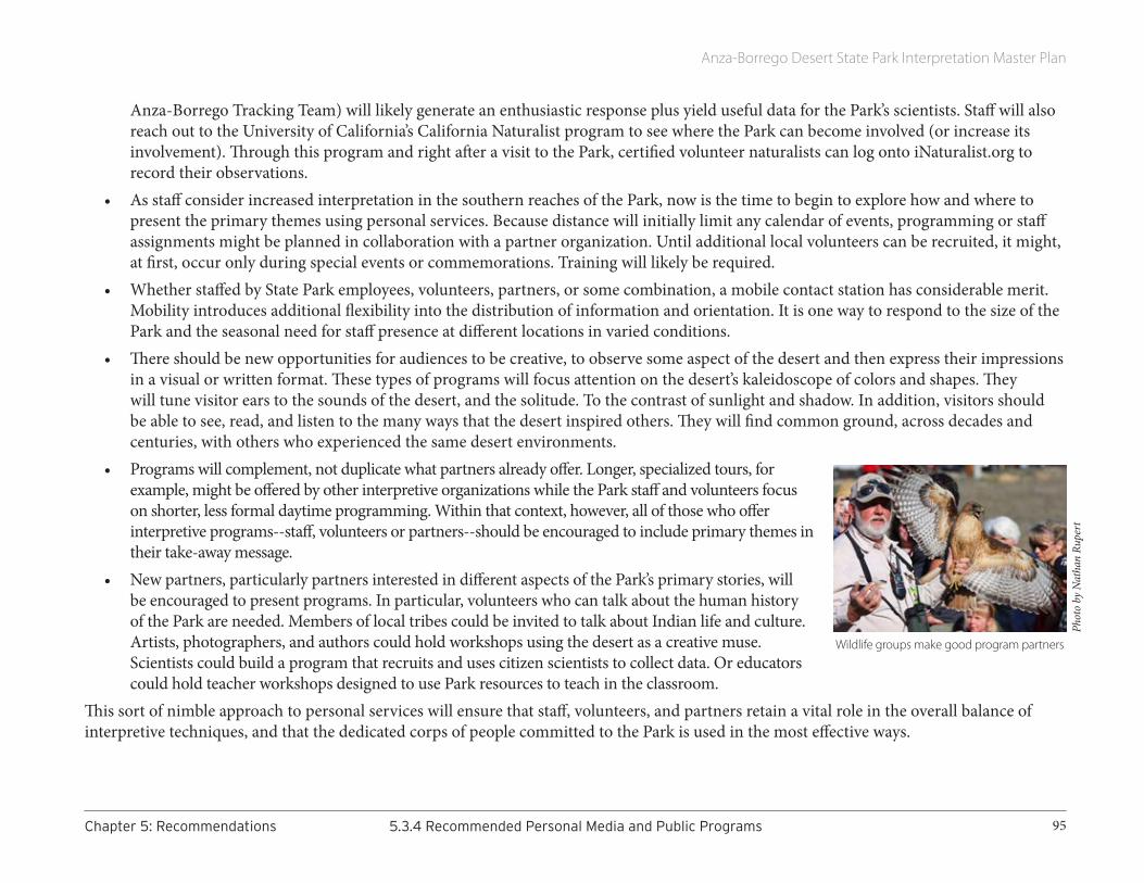
Anza-Borrego Desert State Park Interpretation Master Plan
95Chapter5:Recommendations 5.3.4RecommendedPersonalMediaandPublicPrograms
Anza-Borrego Tracking Team) will likely generate an enthusiastic response plus yield useful data for the Park’s scientists. Staff will also reach out to the University of California’s California Naturalist program to see where the Park can become involved (or increase its involvement). Through this program and right after a visit to the Park, certified volunteer naturalists can log onto iNaturalist.org to record their observations.
• As staff consider increased interpretation in the southern reaches of the Park, now is the time to begin to explore how and where to present the primary themes using personal services. Because distance will initially limit any calendar of events, programming or staff assignments might be planned in collaboration with a partner organization. Until additional local volunteers can be recruited, it might, at first, occur only during special events or commemorations. Training will likely be required.
• Whether staffed by State Park employees, volunteers, partners, or some combination, a mobile contact station has considerable merit. Mobility introduces additional flexibility into the distribution of information and orientation. It is one way to respond to the size of the Park and the seasonal need for staff presence at different locations in varied conditions.
• There should be new opportunities for audiences to be creative, to observe some aspect of the desert and then express their impressions in a visual or written format. These types of programs will focus attention on the desert’s kaleidoscope of colors and shapes. They will tune visitor ears to the sounds of the desert, and the solitude. To the contrast of sunlight and shadow. In addition, visitors should be able to see, read, and listen to the many ways that the desert inspired others. They will find common ground, across decades and centuries, with others who experienced the same desert environments.
• Programs will complement, not duplicate what partners already offer. Longer, specialized tours, for example, might be offered by other interpretive organizations while the Park staff and volunteers focus on shorter, less formal daytime programming. Within that context, however, all of those who offer interpretive programs--staff, volunteers or partners--should be encouraged to include primary themes in their take-away message.
• New partners, particularly partners interested in different aspects of the Park’s primary stories, will be encouraged to present programs. In particular, volunteers who can talk about the human history of the Park are needed. Members of local tribes could be invited to talk about Indian life and culture. Artists, photographers, and authors could hold workshops using the desert as a creative muse. Scientists could build a program that recruits and uses citizen scientists to collect data. Or educators could hold teacher workshops designed to use Park resources to teach in the classroom.
This sort of nimble approach to personal services will ensure that staff, volunteers, and partners retain a vital role in the overall balance of interpretive techniques, and that the dedicated corps of people committed to the Park is used in the most effective ways.
Wildlife groups make good program partners
Phot
o by
Nat
han
Rupe
rt

Anza-Borrego Desert State Park Interpretation Master Plan
96 5.3.5RecommendedEducationalProgramming Chapter5:Recommendations
5.3.5 RECOMMENDED EDUCATIONAL PROGRAMMINGShould Park staff secure the resources they need to create new, vibrant programs that resonate with target audiences (students and teachers), they will need to develop creative marketing venues to get the word out. Such venues could include web-based material, social media conduits, and print media displayed at district offices and schools. Park staff should also consider collaborative education outreach efforts with organizations such as the Desert Protective Council, which recently produced the Salton Basin Living Laboratory curriculum.
Despite the limiting factors, Park staff should consider invigorating the Park’s education programs with new outreach efforts to share the desert with schools beyond the town limits of Borrego Springs. Such efforts, pending funding and staffing, could include a STEM9-focused traveling desert paleo laboratory designed for upper elementary and middle school levels, and a series of traveling trunks designed for lower elementary levels.
Traveling Paleo Lab: Housed in a modified tractor-trailer and designed to resemble a scientific research laboratory, the desert paleo program could travel to school sites and offer students an opportunity to excavate fossil replicas, collect and analyze data, and draw conclusions about the region during the Pleistocene Epoch. Academic in focus, driven by the Next Generation Science Standards, enhanced by real and replicated fossils and scientific equipment, and delivered by Park staff or docents, this paleo lab could significantly enhance a school’s science curriculum, if only for a day. Given the key factors teacher identify as important in their decision to participate in PORTS10, namely relevance to academic content standards and the introduction of technology into the classroom, the paleo lab would likely be a valued, popular venue.
Traveling Trunks: Based on a variety of topics—desert botany, desert wildlife, geology, people of the desert, starry nights and Indian skies, expeditions across the desert—these trunks could contain hands-on materials, replicated artifacts and biofacts, books, and curricula with links to a new e-Park library. A classroom teacher could use a tablet or PC to download a Park app and display audio and visual content for classroom use and discussion. Traveling trunks can serve as an exceptional resource that teachers appreciate; however, they do require staff support for reservations, check-out, returns, and inventory control.
Camp Borrego, a Day in the Desert: Given the popularity of Camp Borrego, the Foundation and Park may wish to consider expanding the camp’s capacity by offering a secondary “lite” version. Given the commitment of time and staff for the three-day program at the fifth-grade level, there could be a one-day plus early evening program offered at the third-grade level. This abbreviated program would provide students a chance to explore the desert for an entire day and would directly align with the Next Generation Science Standards (third grade: ecosystems, biological evolution, Earth’s systems, and Earth and human activity). At the same time, because this would not be an overnight program, it
9 STEM is an acronym for the academic disciplines science, technology, engineering, and mathematics.10 PORTS 2013/2014 Teacher Survey Report.
Photo courtesy Anza Borrego Foundation
Anza-Borrego Desert State Park Interpretation Master Plan
97Chapter5:Recommendations 5.4PhasingRecommendations
would not require use of the yurts or showers, or preparation of meals other than one dinner. The program could conclude after dinner, a campfire, and early evening star-gazing.
Park staff should consider giving a single-vehicle Park pass for one free night of camping at Palm Canyon Campground to students who participate in these or other programs. Some families who otherwise do not visit Anza-Borrego Desert State Park might be prompted by this incentive.
5.4 PHASING RECOMMENDATIONSInterpretive planning in California State Parks follows recommendations put forth in the agency’s Interpretation Planning Workbook (2013), a document that defines the steps necessary for undertaking long- and short-term interpretive planning projects. This workbook also describes the systematic development of planning documents and the roles each fulfills in addressing interpretive planning efforts.
In a typical state park, developing a phased approach to project implementation is straightforward. The scale is manageable, the acreage is contiguous, access points are few, and interpretive opportunities are centrally located. Anza-Borrego Desert State Park is anything but typical. Its scale is massive, its land encircles a town, the Park has multiple access points, and interpretive opportunities are widely dispersed. While the Wind Caves might beckon a person to visit the southeast section, Coyote Canyon might beckon another to visit the northwest section 66 miles away.
The Park is vast, and recommendations in the Interpretation Master Plan take this vastness into account. Implementing the recommendations will require money, time, and the expertise and commitment of staff. Per California State Park guidelines, it will also require development of an Interpretation Action Plan, Annual Interpretation Action Plans, Annual Interpretation Implementation plans, and Interpretive Project and Program plans.
We encourage the Park to take the following steps, in order of priority:
1. Develop an Interpretation Action Plan to establish short-term (e.g., 1–5 year) strategies for reaching goals and objectives proposed in the Interpretation Master Plan. An Interpretation Action Plan is an excellent management tool. It enables the Park to assign realistic tasks among the interpretive staff and address immediate needs, most notably the interpretive panel replacement project (in process at the time of publication) and development of new wayfinding tools, including use of electronic media.
Every Interpretation Action Plan also identifies funding sources and partners—key to the long-term success of any project. Interpretive partners may be especially valuable in helping the Park address human history themes. For example, the Park has many long-standing relationships with tribal members, particularly pertaining to archaeology and cultural studies. We see value in expanding such collaboration to develop interpretive strategies focused on bringing native voices and cultures to

Anza-Borrego Desert State Park Interpretation Master Plan
98 5.4PhasingRecommendations Chapter5:Recommendations
the forefront. Such a partnership would benefit tribal members as well as the Park and its visitors.
2. Every year, develop an Annual Interpretation Implementation Plan. Referencing the Interpretation Master and Interpretation Action plans, this document should identify priority objectives and establish specific actions and responsibilities for the coming year.
3. In collaboration with the consultant team, develop an Interpretive Project Plan for the interpretive panel replacement project. This project management tool will allow the Park to address specific strategies related to replacing the Park’s existing interpretive signage, including panels that are free-standing, framed in kiosks, or embedded in stone monuments, as well as creating new panels where needed. This plan will also identify reader objectives for each panel, ensuring that the content remains purpose-driven and focused.
4. Upon completion of the interpretive panel replacement project, develop an Interpretive Project Plan for the proposed pullouts and discovery way stations. Comparable to the tasks defined in step 3, this effort will allow the Park to address strategies related to roadside and trailside interpretation, including the development of new pullouts and more complex discovery way stations that integrate panels, three-dimensional materials, and digital media. As technologies are ever-evolving, this project plan will require research time for staff to determine the best options available to the Park at that particular time and into the near future.
5. Staff should continue tackling the recommendations in the Interpretation Master Plan systematically, as outlined in CSP’s Interpretation Planning Workbook. Such work includes researching the availability of funders and partners. Some recommendations, such as converting the Vallecito Ranch grounds into a southern visitor center, come with challenges: a big price tag; safety issues; and extensive planning with architects and landscape architects specializing in historic and cultural preservation. Strong partnerships can help. This may present an ideal opportunity to expand State Parks’ existing partnership with San Diego County and cultivate new interpretive partnerships in Julian and San Diego as well.
While the consultant team was encouraged to “think big,” we realize funding and staffing constraints are quite real, and must be resolved before staff can address certain recommendations.
Anza-Borrego Desert State Park Interpretation Master Plan
99AppendixA:ReferencesUsed
APPENDIX A: REFERENCES USED
REFERENCES USED IN PREPARING THIS REPORT
All Aboard, The Life and Work of Marjorie ReedGary FillmoreSchiffer Publishing, Ltd.Atglen, Pennsylvania2009
Anza-Borrego Desert State ParkCultural Preserve Management PlanCalifornia State Parks2012
Anza-Borrego Desert State ParkFinal General Plan & Environmental Impact ReportCalifornia State Parks2005
Anza-Borrego: A Photographic JourneyErnie CowanSunbelt Publications, Inc.San Diego, California2014
Borrego Beginnings, Early Days in the Borrego Valley, 1910-1960Phil BrigandiAnza-Borrego Desert Natural History AssociationBorrego Springs, California 2001
Fossil Treasures of the Anza-Borrego DesertGeorge T. Jefferson and Lowell Lindsay, eds.Sunbelt Publications, Inc.San Diego, California 2006
Interpretation Planning WorkbookInterpretation and Education DivisionCalifornia State ParksSacramento, California2013
Just Before SunsetLora L. ClineSunbelt Publications, Inc.San Diego, California 20081984
Marshal South and the Ghost Mountain Chronicles: An Experiment in Primitive Living Marshal South, author; Diana Lindsay, ed.Sunbelt Publications, Inc.San Diego, California 2005
Old Time Cattlemen and Other Pioneers of the Anza-Borrego AreaLester ReedAnza-Borrego Desert Natural History AssociationBorrego Springs, California 2004
Strangers in a Stolen LandRichard CarricoSunbelt Publications, Inc.San Diego, California 2008
The Anza-Borrego Desert Region: A Guide to the State Park and Adjacent Areas of the Western Colorado DesertLowell and Diana LindsayWilderness PressBirmingham, Alabama2012
The Anza Trail and the Settling of CaliforniaVladimir GuerreroHeyday BooksBerkeley, California2006

Anza-Borrego Desert State Park Interpretation Master Plan
100 AppendixB:2014VisitorSurveyReport
APPENDIX B: 2014 VISITOR SURVEY REPORT
OVERVIEW In spring and fall 2014, staff of The Acorn Group administered a visitor survey at Anza-Borrego Desert State Park. A total of 163 survey responses were collected, asking visitors questions about their use of the Park, including reasons for coming, trip-planning, favorite areas, interpretive interests, and ways to improve the overall visitor experience.
METHODOLOGYWritten surveys were administered using iPads and QuickTapSurvey, a mobile tablet field survey application.
With QuickTapSurvey, visitors were able to study each question, scroll through response options, and enter or select responses at their own pace. Rici Peterson and Jennifer Rigby were on hand to welcome visitors, get them started, and answer any questions. QuickTapSurvey’s objectivity eliminates the potential for interviewer bias. The software also ensures confidentiality, raising respondents’ comfort levels and increasing the likelihood of more honest, forthright responses.
We approached visitors at two sites: outside the entry doors of the Visitor Center, and at Borrego Palm Canyon trailhead. Data were collected for seven days (March 15, 16, and 18; April 1 and 2; and November 11 and 12, 2014). Weather was consistently sunny. As midday temperatures rose and visitors became less tolerant of sun, operations were moved from the trailhead to the relatively cool Visitor Center entrance.
On the whole, visitors seemed happy to participate and were pleased to learn that the Park was undertaking a long-term planning effort. Many engaged us in conversation after finishing their surveys, often sharing their enthusiasm for the Park.
LIMITATIONS OF THE STUDYAlthough we feel this study offers useful information, it is not strictly scientific. Due to the small sample size (N = 163, out of an estimated annual 600,000 visitors), the results are neither valid nor reliable for extrapolation to the entire Park visitor population. Further, though every effort was made to include all visitors encountered, sampling was not strictly randomized. Finally, visitation was too low to warrant collection at other venues such as Christmas Circle or Vallecito County Park. Some responses, including “favorite areas to visit,” are therefore likely biased toward Borrego Palm Canyon and the Visitor Center, where the data were gathered.
Although results should not be regarded as accurate predictions of the responses, needs, or interests of the ABDSP visitor population as a whole, they may be used for discussing, theorizing, and creating profiles of interviewees.
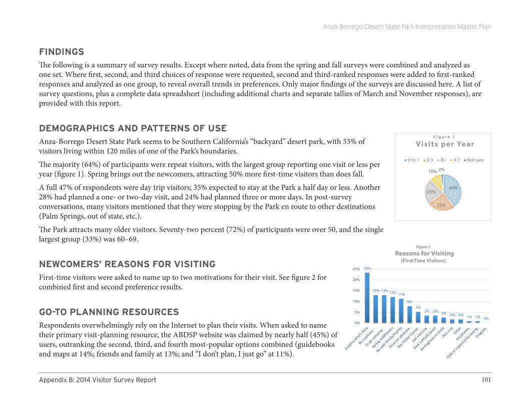
Anza-Borrego Desert State Park Interpretation Master Plan
101AppendixB:2014VisitorSurveyReport
FINDINGSThe following is a summary of survey results. Except where noted, data from the spring and fall surveys were combined and analyzed as one set. Where first, second, and third choices of response were requested, second and third-ranked responses were added to first-ranked responses and analyzed as one group, to reveal overall trends in preferences. Only major findings of the surveys are discussed here. A list of survey questions, plus a complete data spreadsheet (including additional charts and separate tallies of March and November responses), are provided with this report.
DEMOGRAPHICS AND PATTERNS OF USE Anza-Borrego Desert State Park seems to be Southern California’s “backyard” desert park, with 53% of visitors living within 120 miles of one of the Park’s boundaries.
The majority (64%) of participants were repeat visitors, with the largest group reporting one visit or less per year (figure 1). Spring brings out the newcomers, attracting 50% more first-time visitors than does fall.
A full 47% of respondents were day trip visitors; 35% expected to stay at the Park a half day or less. Another 28% had planned a one- or two-day visit, and 24% had planned three or more days. In post-survey conversations, many visitors mentioned that they were stopping by the Park en route to other destinations (Palm Springs, out of state, etc.).
The Park attracts many older visitors. Seventy-two percent (72%) of participants were over 50, and the single largest group (33%) was 60–69.
NEWCOMERS’ REASONS FOR VISITINGFirst-time visitors were asked to name up to two motivations for their visit. See figure 2 for combined first and second preference results.
GO-TO PLANNING RESOURCESRespondents overwhelmingly rely on the Internet to plan their visits. When asked to name their primary visit-planning resource, the ABDSP website was claimed by nearly half (45%) of users, outranking the second, third, and fourth most-popular options combined (guidebooks and maps at 14%; friends and family at 13%; and “I don’t plan, I just go” at 11%).
23%
8%
13% 13% 12% 11%
5%3% 3% 3% 2% 2% 1% 1% 0%
0%
5%
10%
15%
20%
25%
Figure 2
Reasons for Visiting(First-Time Visitors)
40%
25%
23%
10% 2%
F i g u r e 1
V i s i t s p e r Ye a r
0 to 1 2-3 8+ 4-7 Not sure

Anza-Borrego Desert State Park Interpretation Master Plan
102 AppendixB:2014VisitorSurveyReport
In the survey, the wording for the ABDSP website option was “Official Park website.” However, we doubt most visitors understand which of the four commonly used websites is considered “official”: California State Parks’ ABDSP website; the Anza-Borrego Foundation’s website; the Anza-Borrego Desert Natural History Association’s website; or the Borrego Springs Chamber and Visitors’ Bureau website (the latter site ranks first in a Google search for the words “Anza Borrego Desert State Park”).
REPEAT VISITORS’ FAVORITE AREAS Return visitors were asked to name their favorite Park areas, with second and third choices allowed. Figure 3 shows combined results of all responses.
VISITOR CENTER Eighty-one percent of respondents had been to the Park’s Visitor Center, where the most frequent activities were viewing exhibits (35.5%), viewing a film (20%), and asking for information at the front desk (19%). Interestingly, the Discovery Area gathered only 0.5 percent of responses, with no significant difference between participants visiting with children and those visiting without. However, visitors who offered conversational remarks about the Discovery Area were positive about their experiences.
INTERPRETIVE MEDIA: GENERAL PREFERENCESVisitors were asked about their general preferences for interpretive delivery systems (media) when visiting a park such as ABDSP.
Traditional, non-personal media (signs, kiosks, and exhibits) ranked first for the majority of visitors, and within that category, trailhead and trailside signs were most preferred. When coupled with responses to the open-ended “what needs improvement” and “what do you wish you’d known” questions--both dominated by requests for more and better wayfinding and interpretive signs—this finding suggests that it may be wise to invest in careful planning for a system of improved and more extensive signage Park-wide. It also suggest that older visitors are more likely than their younger counterparts to ask for, expect, trust, and accept information delivered directly by Park authority figures.
0%
5%
10%
15%
20%
25%
30%
Figure 3
Favorite Areas

Anza-Borrego Desert State Park Interpretation Master Plan
103AppendixB:2014VisitorSurveyReport
MEDIA PREFERENCE BY AGE Despite the fact that 72% of respondents own smartphones, interest in mobile technology is significantly higher in the younger half of the population (figure 4). This trend is likely to rise as cohorts age out and technological advances continue.
Results also reveal a correlation between increased age and a preference for one-on-one interaction with staff. This finding, which aligns with national trends, may be explained in part by education’s late-20th-century move away from didacticism (a largely one-way process in which learners receive their information from an authoritative person) toward a more self-reliant, self-motivated experiential model.
FAVORITE TOPICSVisitors were given a chance to report up to three favorite Park interpretive topics (see figure 5). Combined results strongly favor natural history, with 57% of participants ranking wildflowers as first, second, or third choices. Wildlife follows close behind, garnering votes from 50% of visitors. Geology was selected by 32% and desert plants in general by 27%.
STAYING CONNECTED, POST-VISITVisitors were asked in what ways (if any) they’d like to stay connected to the Park after they return home. Figure 6 shows results. Again, visitors may or may not grasp the distinctions between “official” websites. Additionally, survey administrators did receive several verbal comments about many of the links on the State Parks-sponsored ABDSP website leading unhelpfully to the Sacramento site.
60% 60%
38%54%
39%29%
20%
7% 10%
13%
14%31%
35%
20% 10%38% 7% 3%
13% 20% 13%25% 28% 35%
80%
B E T T E R2 0 - 2 9 3 0 - 3 9 4 0 - 4 9 5 0 - 5 9 6 0 - 6 9 7 0 - 7 9 8 0 O R
F i g u r e 4
Interpretive Media Preference by Age
Sign/exhibit Live program/tour Mobile tech Ask sta�
0%5%
10%15%20%25%30%35%40%
March November
Figure 5
Favorite Park Topic (combined choices)

Anza-Borrego Desert State Park Interpretation Master Plan
104 AppendixB:2014VisitorSurveyReport
OPEN-ENDED QUESTIONSThe survey included two open-ended questions: “Is there anything you wish you’d known before you arrived at the Park?” and “What, if any, facilities, trail features, signs, programs, or other Park features need improvement?”
Below we offer each set of responses grouped by type or topic.
WHAT VISITORS WISH THEY’D KNOWN BEFORE ARRIVING
Pre-trip planning/logistics • It was tough to find good, printable maps. Wish I could have had that ahead
of time• Better access to a Park map• Update on wildflowers• Pre camping registration• Accommodations• Always interested in good info on desert road conditions• Dirt roads, so need four-wheel drive for several roads• That we would have to pay for an extra car• Too many closed areas you can’t access if you are disabled. I cannot hike in.• Weather• Information on Wildflowers• Bighorn sighting • No, we pretty much research it before, but the wildflower info was 2 weeks outdated• Snakes activity time• Microbrews available, and organic food• Knowing whether organic food is available for purchase in town, along with grass-fed beef• When wildflowers are blooming• Ranger guided tours
24%21%
19%
12%9%
6% 4% 3% 2% 1%0%
5%
10%
15%
20%
25%
30%
F i g u r e 6
H o w V i s i to rs W i s h to S tay C o n n e c te d Po st - v i s i t ( � rst c h o i c e s )

Anza-Borrego Desert State Park Interpretation Master Plan
105AppendixB:2014VisitorSurveyReport
Travel/Wayfinding• We noticed that there was very little signage for this wonderful visitor center...had to look hard for it. Also, people at the Mexico
restaurant and art institute gave sketchy directions. No one explained what a great ‘museum’ this is...friends told us about it.• Wanted to know that the trailhead was another 1.5 miles further on from the visitor centre and that was the location where we were to
purchase our pass• How long it takes to drive here from outlying towns like Indian Wells CA• Lack of signs along the road led to a 36-mile detour and cut in to our planned time in the Park• Directions, because my smartphone stopped working so would not show the map• Better signage to Palm Canyon from S3
Orientation to activities• A list of activities• Did not realize how much the Park had to offer • Trail locations with descriptions and lengths• Maps for hikes available in the Park• The location of nearby interpretive short trails• Hiking/biking trails• Hiking
Interpretive experiences11
• More about local geology • More about this year’s rainfall history, & chance of seeing blooms in November• A lot more about geology which I feel would give me a more dynamic and ongoing appreciation of this fabulous area• More about early first nations people• The videos
11 Most responses in this group suggest these particular visitors may have misunderstood the question, which probes the adequacy and availability of information needed before a trip (e.g., travel planning, on-site supplies, what to bring, what not to bring, vehicle suitability, weather awareness, camping info, costs, etc.)
Anza-Borrego Desert State Park Interpretation Master Plan
106 AppendixB:2014VisitorSurveyReport
Positive/other comments• We love this park and visit annually. State parks are something that I value greatly as a citizen of California and think they are worth
every dollar we put into them.• Great location, beautiful Visitor Center• We LOVE this park!!!!!!!• We had lots of info so there is not anything we wished we had known earlier.• Its existence• Happy to be here!• It is a hidden gem! • Nope, the web sites covered it all.
WHAT VISITORS THINK NEEDS IMPROVEMENT
Pre-trip planning/logistics• Website• First come/first served camping for trailers, please
Travel/wayfinding• Better signs along Highway 78--we drove past and got way past Octotillo Wells before finally asking for directions• The sign at the main road was difficult to see - too small and worn• Signage leading to park• Signs into the park from the highway and from town. We had to stop twice for directions. • Better sign in Borrego Springs• More signage for roads and sites...a map downtown to look at...big board• Signs, big signs explaining what is here. Call it a museum...etc. as it sounds more exciting• Better signage for “Anza Borrego” park—not just desert parks. When GPS fails, more signs with details would be very helpful!• Signage• We got lost going to Tamarisk Grove campground
Anza-Borrego Desert State Park Interpretation Master Plan
107AppendixB:2014VisitorSurveyReport
• Four-wheel-drive road signs. Trailheads difficult to find• Yaqui well sign and trailhead from primitive road• Elephant Tree signs are totally deteriorated, and no orientation map• Good signage is always appreciated• Website needs improvement• Trail mark• Better roadside alerts to trail heads, e.g. Rainbow Canyon Trail quarter mile ahead, Rainbow Canyon Trailhead or a turnout• Better trail marking• Trails need more orientation/wayfinding signs• Signs• Signage • None, most trails and roads are signed
Orientation to activities• Update some trailhead or road side signs.• More info regarding upcoming movies--post the schedule on a porch chalkboard
Interpretive experiences• Would be great to have audio tours to download and listen to while driving through the park• Please replace missing numbers on Palm Canyon Nature Trail• The Palm Canyon Trail has several number plates missing from its round trip walk• Plant identifiers not always visible• More plant signage• Signs need to be kept up• More trail signs• Cultural preserve signs, interpretive signs
15 Here the interviewer showed respondent a marked-up Park map, helping him/her identify areas as needed.
Anza-Borrego Desert State Park Interpretation Master Plan
108 AppendixB:2014VisitorSurveyReport
• Missing signage at the exhibit about Native Americans, and the docent didn’t know what the cradleboard was. It would be nice to be notified.
• Prehistoric Native American info• More guided tours in southern part of park
Facilities /maintenance/staffing • Radio station does not work• Trail maintenance...maybe more carons12
• I think the trail heads and trails need to be upgraded and made, where possible, a little more accessible• Disabled access to areas closed to vehicles• More accessibility for two-wheel-drive rented vehicles which we out of staters must use• Garbage cans at trailhead• Camping registration• Campsites and shade areas in campsites• One toilet was running which wasted water.• RV section for primitive/dry camping please. And clotheslines at the campsites• Campground site availability • Upgrade RV park utilities• Have a Facebook page for info, pictures and comments• Art from local people • Some of the drip irrigation hoses need to be hidden a bit more• More enforcement of [problem] ORV [users]...I’d like to have their heads• Get rid of as many invasive plants as possible to give our native species a chance to survive• All need more money. More knowledgeable rangers, less kind but need improvement volunteers.13 If I was to put more money in one
area I would put it into paid personnel
12 This participant may have meant “cairns.”13 This participant may have been trying to say, “Hire more rangers, instead of relying on volunteers, who, though kind, are not as knowledgeable.”

Anza-Borrego Desert State Park Interpretation Master Plan
109AppendixB:2014VisitorSurveyReport
Positive/other comments• All good• We enjoy all aspects of the park• All good• Flower and scenery bookmarks please...to give my women friends. The animal ones are more for kids.• Cooler weather
Implications of the Survey• In general, this study indicates that visitors, Park staff, and the Park itself may benefit from:• Increased and improved wayfinding systems along major travel routes into Park entry points, developed in coordination with
transportation authorities;• A well-planned, consistently designed wayfinding system within the Park, helping visitors find and move more efficiently between Park
points of interest;• Replaced and new interpretive kiosks at trailheads and points of interest;• Wayside interpretive panels along some of the more popular trails;• Improvements to web-based planning resources, including Park websites, printable maps, weather reports, and the like;• Exploration of ways to leverage mobile technology for interpretive and wayfinding purposes, including alternative connectivity
solutions where provider signals do not reach. Specific recommendations for interpretive media are addressed in section 5.3 of this interpretation master plan.
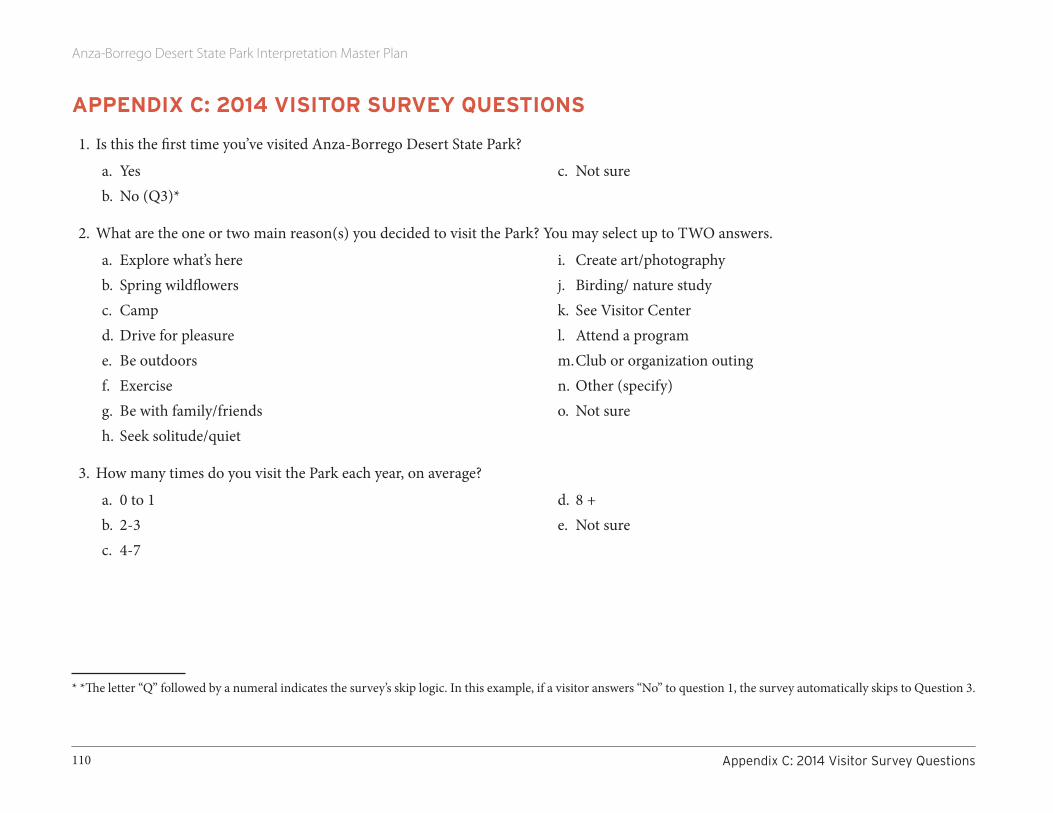
Anza-Borrego Desert State Park Interpretation Master Plan
110 AppendixC:2014VisitorSurveyQuestions
APPENDIX C: 2014 VISITOR SURVEY QUESTIONS
1. Is this the first time you’ve visited Anza-Borrego Desert State Park?
a. Yes b. No (Q3)*
c. Not sure
2. What are the one or two main reason(s) you decided to visit the Park? You may select up to TWO answers.
a. Explore what’s hereb. Spring wildflowersc. Campd. Drive for pleasure e. Be outdoors f. Exercise g. Be with family/friendsh. Seek solitude/quiet
i. Create art/photography j. Birding/ nature studyk. See Visitor Center l. Attend a program m. Club or organization outing n. Other (specify) o. Not sure
3. How many times do you visit the Park each year, on average?
a. 0 to 1b. 2-3 c. 4-7
d. 8 +e. Not sure
* *The letter “Q” followed by a numeral indicates the survey’s skip logic. In this example, if a visitor answers “No” to question 1, the survey automatically skips to Question 3.

Anza-Borrego Desert State Park Interpretation Master Plan
111AppendixC:2014VisitorSurveyQuestions
4. Please show the interviewer your favorite Park areas on the map.15 You may select up to three.
a. Borrego Palm Canyonb. Visitor Centerc. Box Canyon/Blair Valley/Little Blair Valleyd. Oriflamme/Chariot /Rodriguez canyonse. Rancho Vallecito Cultural Preservef. Hellhole Canyon/Culp Valleyg. Shelter Valley, Sentenac/Grapevine/Plum Canyonh. Pinyon Mountains area (including Harper/Mine Wash/Pinyon
Wash)i. Jacumba Mountains area (including Piedras Grandes, Dos
Cabezas, Mortero Wash, Carrizo Canyon, Dolomite Wash, Jojoba Wash)
j. Carrizo Creek drainage (Carrizo Creek Wash/Arroyo Seco del Diablo/Arroyo Tapiado/Palm Spring/Canyon Sin Nombre/Carrizo Badlands)
k. Upper Coyote Canyon area (Horse Canyon, Alder Canyon, Turkey Track, Bailey’s Cabin)
l. Lower Coyote Canyon (Sheep Canyon, Desert Gardens,
Middle/Lower Willows)m. Rockhouse Canyon/Clark Valley/Clark Dry Lake n. Tamarisk area (Lizard Wash/Yaqui Well/Yaqui Pass) o. Pacific Crest Trailp. Fish Creek area (Sandstone Canyon , Oyster Shell Wash,
Lyceum Wash, Wind Caves, Elephant Knees, Split Mountain)q. Mountain Palm Springs/Bow Willow/Indian Gorge arear. Upper Borrego Badlands (Truckhaven Trail, Inspiration Wash,
Thimble Trail, Short Wash)s. Lower Borrego Badlands (Borrego Mountain Wash, San Felipe
Wash, Fault Wash, Rainbow Wash, Hills of the Moon, Buttes Pass Road, Cut Across Trail, The Slot, Goat Trail, Blow Sand Canyon)
t. Calcite Mines/Seventeen Palms area (Arroyo Salado, Tule Wash, Basin Wash, Truckhaven Rocks, North Palm, South Palm)
u. Not Surev. Other (specify)
5. About how much time will you spend at the Park during this visit?
a. An hour or lessb. 2-3 hoursc. Half dayd. Full day
e. 1-2 daysf. 3 or more daysg. Other (specify)
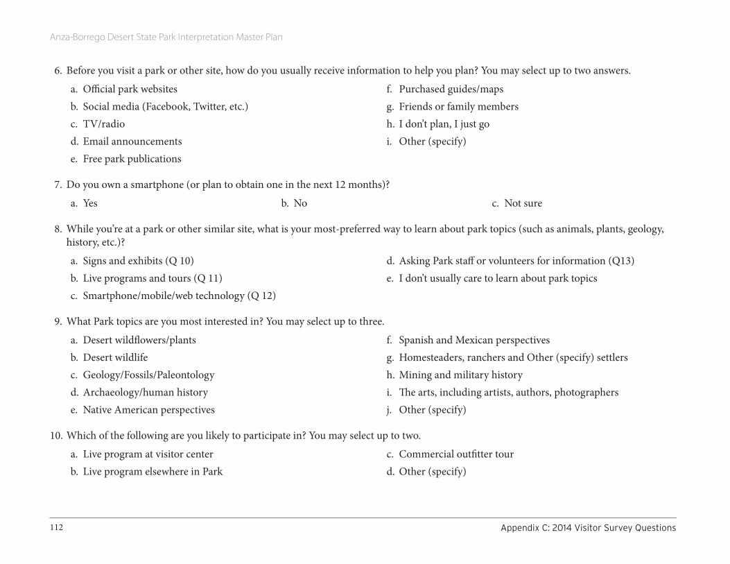
Anza-Borrego Desert State Park Interpretation Master Plan
112 AppendixC:2014VisitorSurveyQuestions
6. Before you visit a park or other site, how do you usually receive information to help you plan? You may select up to two answers.
a. Official park websitesb. Social media (Facebook, Twitter, etc.)c. TV/radiod. Email announcementse. Free park publications
f. Purchased guides/mapsg. Friends or family membersh. I don’t plan, I just goi. Other (specify)
7. Do you own a smartphone (or plan to obtain one in the next 12 months)?
a. Yes b. No c. Not sure
8. While you’re at a park or other similar site, what is your most-preferred way to learn about park topics (such as animals, plants, geology, history, etc.)?
a. Signs and exhibits (Q 10)b. Live programs and tours (Q 11)c. Smartphone/mobile/web technology (Q 12)
d. Asking Park staff or volunteers for information (Q13)e. I don’t usually care to learn about park topics
9. What Park topics are you most interested in? You may select up to three.
a. Desert wildflowers/plants b. Desert wildlifec. Geology/Fossils/Paleontologyd. Archaeology/human historye. Native American perspectives
f. Spanish and Mexican perspectives g. Homesteaders, ranchers and Other (specify) settlers h. Mining and military historyi. The arts, including artists, authors, photographersj. Other (specify)
10. Which of the following are you likely to participate in? You may select up to two.
a. Live program at visitor centerb. Live program elsewhere in Park
c. Commercial outfitter tourd. Other (specify)
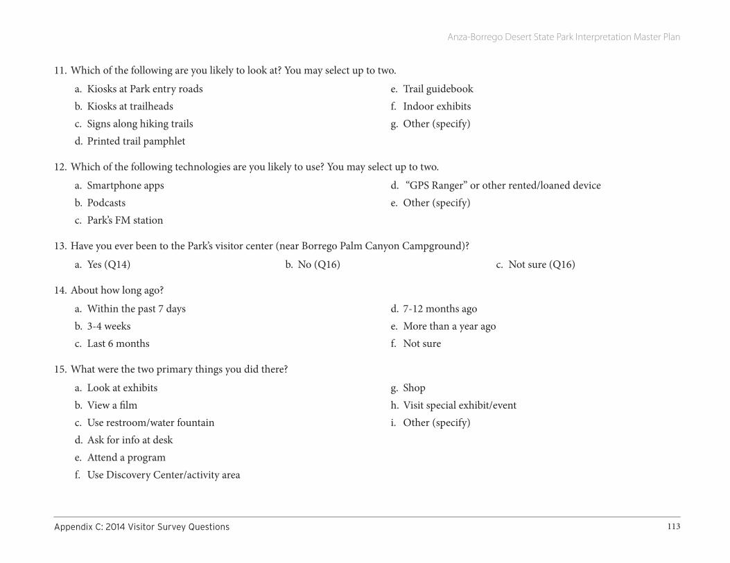
Anza-Borrego Desert State Park Interpretation Master Plan
113AppendixC:2014VisitorSurveyQuestions
11. Which of the following are you likely to look at? You may select up to two.
a. Kiosks at Park entry roadsb. Kiosks at trailheadsc. Signs along hiking trailsd. Printed trail pamphlet
e. Trail guidebookf. Indoor exhibitsg. Other (specify)
12. Which of the following technologies are you likely to use? You may select up to two.
a. Smartphone appsb. Podcastsc. Park’s FM station
d. “GPS Ranger” or other rented/loaned devicee. Other (specify)
13. Have you ever been to the Park’s visitor center (near Borrego Palm Canyon Campground)?
a. Yes (Q14) b. No (Q16) c. Not sure (Q16)
14. About how long ago?
a. Within the past 7 days b. 3-4 weeks c. Last 6 months
d. 7-12 months agoe. More than a year agof. Not sure
15. What were the two primary things you did there?
a. Look at exhibitsb. View a filmc. Use restroom/water fountaind. Ask for info at deske. Attend a programf. Use Discovery Center/activity area
g. Shoph. Visit special exhibit/eventi. Other (specify)
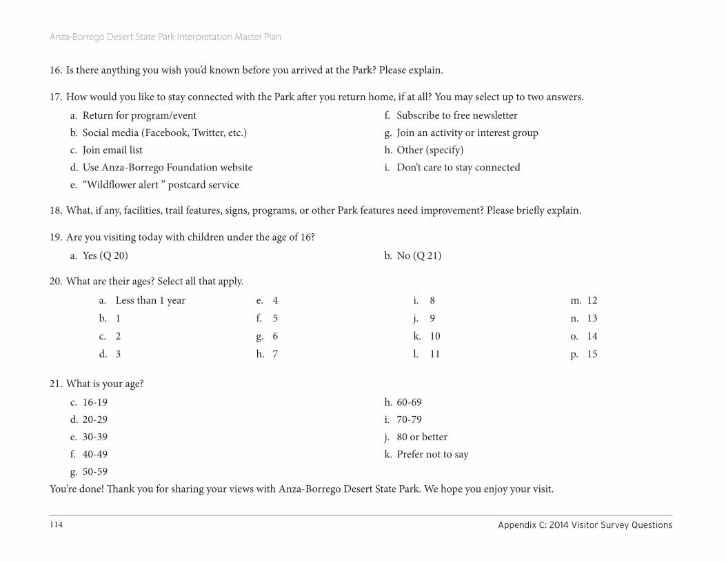
Anza-Borrego Desert State Park Interpretation Master Plan
114 AppendixC:2014VisitorSurveyQuestions
16. Is there anything you wish you’d known before you arrived at the Park? Please explain.
17. How would you like to stay connected with the Park after you return home, if at all? You may select up to two answers.
a. Return for program/eventb. Social media (Facebook, Twitter, etc.)c. Join email listd. Use Anza-Borrego Foundation websitee. “Wildflower alert ” postcard service
f. Subscribe to free newsletterg. Join an activity or interest group h. Other (specify)i. Don’t care to stay connected
18. What, if any, facilities, trail features, signs, programs, or other Park features need improvement? Please briefly explain.
19. Are you visiting today with children under the age of 16?
a. Yes (Q 20) b. No (Q 21)
20. What are their ages? Select all that apply.
a. Less than 1 yearb. 1c. 2d. 3
e. 4f. 5g. 6h. 7
i. 8j. 9k. 10l. 11
m. 12n. 13o. 14p. 15
21. What is your age?
c. 16-19d. 20-29e. 30-39f. 40-49g. 50-59
h. 60-69i. 70-79j. 80 or betterk. Prefer not to say
You’re done! Thank you for sharing your views with Anza-Borrego Desert State Park. We hope you enjoy your visit.
Anza-Borrego Desert State Park Interpretation Master Plan
115AppendixD:StakeholderSessionReports
APPENDIX D: STAKEHOLDER SESSION REPORTS
STAKEHOLDER LISTENING SESSION #1, MONDAY MARCH 17, 2014Attendees:
1. Sam Webb (longtime volunteer)
2. Steve Bier (park ranger)
3. Shirley Cate (volunteer)
4. Dave Van Cleve (former ABDSP Superintendent)
5. Arnold Mroz (OWSVRA, paleo)
6. Scot Martin (resource management, CSP Colo. Desert District)
7. Jerry Goldsmith
8. Sharon Goldsmith (ABF, Volunteer)
9. Mike Evans (owner, Tree of Life native nursery; long-term ABDSP lover)
Part I: Comments on Draft Thematic Framework1. The park’s time scales run from the hourly to eons
2. Astronomy; we were the world’s second designated “Dark Skies Community” and are applying for designation as a “Dark Sky Park.”
3. How to minimize your impacts on the resource: choices, skills, enhanced experiences that result
4. Inform people about the pressures and potential changes to Park resources including dark skies
5. Themes need more emphasis on protection/preservation of natural processes, ecology, and what you don’t see.

Anza-Borrego Desert State Park Interpretation Master Plan
116 AppendixD:StakeholderSessionReports
Part II: Interpretation’s role in meeting the needs of visitors and the park, and media that can best accomplish it.
Question 1: What are visitors needing, but not getting?
Jen’s Group
Winners:
a. Southern part of park: a Visitor Center via Interstate 8/They need more info earlier in their visitb. Family-oriented/family-centric opportunities other than the Visitor Centerc. More info that’s relevant and engaging for children
Other ideas:
d. Interpretation to its fullest, particularly roving interpreters in the fielde. To understand how this part of the world got to look like this; swamp to desert. It drives the rest of the story.f. Auto tour (erosion road exists)g. Info about sheep, wildlife watching opportunities.h. They leave with a sense of disappointment that they didn’t see sheep. We set up an expectationi. Desert adaptations; how you have to change/how to see the desert; your wildlife-watching strategiesj. At car stops, get folks to movek. Wayfindingl. How desert is important to visitorm. Connection to post-contact history (ranching, mining, military)n. OHVR—can we challenge visitors with equally exciting recreation?
Rici’s Group
Winners:
a. What to bring/how to prepare for safety, enjoyment, and the craft of being in natureb. Park rules/do’s and don’ts…and the reasons that lie behind themc. How to have/show respect for Park resources when they’re part of the pervasive “entertainment culture”
Anza-Borrego Desert State Park Interpretation Master Plan
117AppendixD:StakeholderSessionReports
Other ideas:
d. People don’t know what to aske. Park info: Locations, special experiences, specific resources to visit, etc.f. To know that no one can “do it all” in one visit or many visitsg. That there’s life beyond the Visitor Center—many things to do and seeh. That coming to the Visitor Center first is highly recommended i. What activity best fits their allotted time/limits of vehicle/physical conditionj. Understand the resources—what there is to see/dok. Park boundaries, and how management and rules and regulations change with agency/ differences between ABDSP, Ocotillo Wells,
and BLM landsl. Wayfinding infom. Road conditions, hazards (climate, floods, wildlife, etc.)n. A way to access various levels of info according to a person’s interests and existing knowledge levels
Question 2: What does the Park need, but isn’t getting?
Jen’s Group
a. Winners: Increased awareness in the greater publicb. Programs to connect families/non-park usersc. Public stewardship (public buy-in)
Other ideas:
d. Money/funding/staffe. Resource protectionf. Explain how park research is relevant to visitorsg. Capacity to purchase and manage more landh. Venues to promote advocacy on behalf of the parki. Use of existing “impacted” land, rather than virgin desert programs, for interpretation (programs and facilities)

Anza-Borrego Desert State Park Interpretation Master Plan
118 AppendixD:StakeholderSessionReports
Rici’s Group
Winners:
a. Protection from ongoing impacts (to cultural sites, soils, desert pavement, endangered species, habitats, roads, dark skies, etc.), including inadvertent impacts from DHS and military activity.
b. Political support for the Parkc. People of all ages who will speak out/act on behalf of the Park, at all levels (from the friendly “ambassador” to advocates to outright
defenders).Other ideas:
d. Contiguity of protected areas, including viewsheds, adequate buffers, acquisition of inholdingse. Multiple markers of recognition (e.g., World Heritage program, The Nature Conservancy’s Last Great Places, etc.f. Moneyg. Awareness of its uniqueness, why it’s important, and all that this impliesh. Protection of dark skiesi. More academic research that uncovers new information about the Park’s unique and fragile resources (from species to geologic
phenomena to whatever) and leads to increased support for its stewardshipj. Recognition of the Foundation as the official support groupk. Love!
Question 3: What media options work best for ABDSP?
Jen’s Group
Winners
a. GPS Rangers/electronic mediab. Interactive exhibitsc. Interpretive panels within and outside the Parkd. Working farm/living history

Anza-Borrego Desert State Park Interpretation Master Plan
119AppendixD:StakeholderSessionReports
Other ideas:
e. Social mediaf. Films (cultural)g. Letterboxingh. Promotional literaturei. Old-fashioned literature packets in hotels and rental unitsj. Maps
Rici’s Group
a. Improved Park website so that people will stop relying on other websites that are easier to use, more informative, but less accurate (sometimes very wrong)
b. Kiosks at major dirt road intersections that are so relevant/attractive that drivers get out to read them; including wayfinding, orientation (rules, hazards, conditions), and interpretation
c. Improved maps: offer interpretive info, offer more map optionsd. More staff offering personal interpretatione. Interpretive signs that are replaced/updated before they deterioratef. Mobile media
Other remarks/ideas
g. Consider “enforcement cams” h. Marshall South’s family collection of personal articles may be available for display if certain conditions are met.i. Use more roving interpretationj. Use the interpretive approach to conveying Park rules, weave in Leave No Trace and Tread Lightly guidelines. k. Current signs throughout park are stylistically haphazard, missing, confusing, and/or deteriorated to the point of uselessness. l. People want to know about, see, and learn about wildlife, particularly sheep. Offer real-time or reasonably current info about sheep,
viewing conditions, etc.m. Be sure interpretation stays current with ongoing research findings
Anza-Borrego Desert State Park Interpretation Master Plan
120 AppendixD:StakeholderSessionReports
STAKEHOLDER LISTENING SESSION #2, TUESDAY MARCH 18, 2014Location: Anza-Borrego Desert State Park Visitor Center
Attending:
1. Nancy Estes (former ABDSP interpreter)
2. LuAnn Thompson (Park interpreter/distance learning)
3. Mary Ekelund (vol. hike leader, interpretive program scheduler, teacher)
4. Paul Larson (Vol. at VC, paleo/natural history/botany; Junior Ranger program, ABF)
5. Jeri Zemon (ranger, interpretive background)
6. Carol Black (Archaeo Society chair)
7. Judy Smith (paleontology)
8. Jim Smith (paleontology)
9. Susan Gilliland (volunteer; anthro/nat. history; VC, Adopt a Wash, site steward, Colorado Desert Archaeology Society
10. Randy Redfern (volunteer, paleo)
11. Kathy Dice (Park Superintendent, long term Park lover)
12. Stan Rohrer (site steward, physics teacher, hike leader)
Part I: Comments on Draft Thematic FrameworkWhat helps me in looking at the Park is history, from the beginning of time up until the present. The people who have come through this area have experienced all the things we see today. I reference my father’s era, my grandfather’s era, etc. I can see things through human history.
The first primary theme is about change, but there is nothing biological there. Invasive species are affecting the biological environment. The statement is too static, but diversity of land and life is not static.
Anza-Borrego Desert State Park Interpretation Master Plan
121AppendixD:StakeholderSessionReports
Opportunities to interpret the night sky.
Under “change,” include ongoing changes in available resources (e.g., creosote).
Phenomena that people come out here for (flowers, star showers, etc) are unpredictable by nature.
Unifying theme needs to include “cultural” to read “…natural and cultural forces at work.”
Unifying theme should convey the landscape’s richness, not just vastness. It’s a hidden treasure.
Need to tell the story of the Earth: scientific research to document Earth’s changes (core sampling to determine when poles shift, etc.).
Expand upon “diversity.” Make sure we emphasize diversity of habitats and landforms.
Inspiration is for everyone, not just artists and authors.
We should add onto the science message that we’re using science to further our management decisions.
Supporting theme of human presence, 1Fc, Discovery: The phrase “long history” feels like it’s all in past tense. Current visitors can also have adventures; consider “the long history continues today.”
This is one of the best teaching laboratories for desert environments, a good place to teach science to new scientists.
There is lot of mystery here. We are still in a discovery mode, and have only explored the tip of the iceberg.
Yes, and so many people just don’t care about the resources. This acknowledgement—that we don’t know everything—is a good reason for these people to not engage in destructive behavior.
Primary theme of Inspiration should include inspiration that comes from observing nature so closely. Coming up to a chuparosa and seeing a hummingbird. That personal connection. Direct experiences with nature.
The kids really like hearing the stories of rangers. Junior Ranger program is a great opportunity.
One of the great stories of this Park is what is gone, due to geological change, as well as human impact.
Anza-Borrego Desert State Park Interpretation Master Plan
122 AppendixD:StakeholderSessionReports
Other remarks/ideas:
Drones would support the work of Park rangers by venturing into inaccessible distant places.
On the other hand, there is a negative impact to these drones.
Part II: Interpretation’s role in meeting the needs of visitors and the Park, and media that can best accomplish it
Question 1: What are visitors needing, but not getting?
Jen’s Group
Winners:
1. A Welcoming Center in southern entrance to Scissors Crossinga. Visitor center for people in Backcountry did not succeed.
2. Personal experiences with Park staff; they want the “one on one.”3. Podcasts, audio tours, GPS rangers4. Signage: Appropriate, correct, informative, directional
Other ideas:
5. Definite signage, e.g, Little Surprise Canyon near Hellhole “This is not an official trail.”6. Footsteps that go to the Discovery Lab; a lot of people miss it7. Begole Archaeology Center—visitors assume this is the Visitor Center. Ditto for office.8. Picnic facilities in developed areas as well as Culp, Blair, Rancho Vallecito, Bow Willow9. Get them away from Palm Canyon, to rustic yet inviting places10. More opportunity for interpretive-oriented kiosks. 11. Broader base of info—engage the reader by asking questions12. Identity of “sensitive area”—what does that mean? Not enough info.13. Park boundary signs. When are people in the Park, and when aren’t they?14. Visitors need to understand the fragility of the desert.
Anza-Borrego Desert State Park Interpretation Master Plan
123AppendixD:StakeholderSessionReports
a. Their behavior has an impact. b. A higher level of understanding
15. Campfire for adults and kids16. Blair Valley—no signage to get to interpretive trail17. We need something at the South End—info station, different exhibits, Southern VC that does not duplicate Borrego Springs.18. A lot of history has intersected here19. People arrive from I-8 and S-22. We never get ahold of them.20. Reference mile markers. We need driving info. 21. Enhance nature interpretation on audio tours.
Rici’s Group
Winners:
1. Remote, non-centralized interpretation, especially in South End2. Signs: wayfinding, orientation, and interpretive3. More opportunities and resources for personal interpretation, ranger encounters
Other ideas:
4. Replacement signs5. Park entry kiosks at all entries6. Soap in restrooms (people complain)7. People need to know they’ll need 4WD before they arrive in their 2WD vehicles, as well as knowing there are many 2WD
opportunities in the Park8. To understand that EVERYTHING is protected9. To understand what is here, what was here, and the stories of the Park10. Where and what the Cultural Preserves are, and the rules for visiting11. Safety information12. Information to help them prepare for visits13. To not have unrealistic expectations/disappointment over lack of wildflowers

Anza-Borrego Desert State Park Interpretation Master Plan
124 AppendixD:StakeholderSessionReports
Question 2: What is the Park needing, but not getting?
Jen’s Group
Winners:
1. Uniformed staff: interpretive staff and volunteer coordinators2. Visitor Center at South Entrance3. A publication with a really good map and mile markers4. More visitor facilities
a. There is only one place to stop—Blair Valley (below 70) to rest, picnic, orientOther ideas:
5. Role of ranger expanded to be more available for interpretation6. More contact with unsupervised hiking groups, particularly in southern Park below 78 (Agua Caliente, Bow Valley)7. Wayside panels and sitting areas—not in wilderness backcountry, but the places where people are already going.8. Facilities, e.g., garbage collection9. Better maps—including those posted on Internet10. Borrego Springs is designated as a Dark Sky community, but the Park is still not designated as a Dark Sky Park (they are
working on that).11. The ability to see the BIG picture, to support planning ahead and not having to react to today only.
Rici’s Group
Winners:
1. To convey the Park’s worth—it’s not a wasteland2. Better communication and understanding of rules and the reasons behind them3. Protection of cultural and natural resources (site stewards, etc.)4. Rangers—interpretive and enforcement5. Compliance with rules

Anza-Borrego Desert State Park Interpretation Master Plan
125AppendixD:StakeholderSessionReports
6. Money for infrastructure and maintenance7. Clearer messaging aimed at stray Ocotillo Wells riders8. More cooperation with Ocotillo Wells9. More communication/coordination between volunteers and rangers, as well as within and between various volunteer groups
(update each other on conditions, species presence, etc.)10. A constituency—broad based, popular political support11. To separate our identity from the Statue Garden
Question 3: What media options are best for the Park?
Jen’s Group
Winners:
1. Kid-friendly content: media, activities, discovery carts2. Emerging technologies: apps, audio tours; podcasts, GPS rangers3. Websites devoted to people who want to explore
a. A balance between protection and a desire to exploreb. Mapsc. Market your URL
4. Staff-guided tours, walks, talksOther ideas:
5. Outreach to new media, hike leaders
6. Hands-on experiences at special events
7. Seminars and symposia (research-informed meetings)

Anza-Borrego Desert State Park Interpretation Master Plan
126 AppendixD:StakeholderSessionReports
Rici’s Group
Winners:
1. Improved website2. Personal interpretation3. Visitor Center in Southern Park
Other ideas:
4. Personal contact with rangers—people love that5. Interpretive signs, wayfinding/orientation signs6. Mobile technologies: QR codes, GPS rangers, smartphone apps7. Social media8. Low-power FM transmissions (OW has excellent, well designed messaging)9. Driving tours of any sort (new media or paper guides)10. Videos/films—in Park, and online11. Better exhibits12. News releases and feature articles13. Entry kiosks at every entry14. Access to Vallecito Ranch15. Radio/TV programs in San Diego16. Native Americans as interpreters/demonstrators17. Cross-marketing and cooperative interpretation with other institutions (museums, etc.)

Anza-Borrego Desert State Park Interpretation Master Plan
127AppendixD:StakeholderSessionReports
STAKEHOLDER LISTENING SESSION #3, TUESDAY, APRIL 1, 2014Location: Anza-Borrego Desert State Park Visitor Center
Attending:
1. Paul Johnson, retiring naturalist affiliated with ABDSP since 19732. Iris Seifert, community member (and desert lover)3. Ashley Kvitek, Anza Borrego Foundation education coordinator 4. Nancy Parker, Park volunteer5. Bill Parker, Park volunteer 6. Gerry Gregory, Park volunteer7. Jaime Mendez, Park interpreter at OHV 8. Lee Mendez, retired interpreter and volunteer 9. Sally Theriault, Park interpreter
Part I: Comments on Draft Thematic FrameworkWhat the draft omits:
It is hard to make a living here as a plant or animal. [Paul] I don’t see “change” as the primary theme. It is an adaptation and survival story. It includes people: native people.
Preservation of the environment, spiritual heritage of the Indians.
All the stuff people are afraid of: rattlesnakes, tarantulas, etc. (the first questions they ask).
Inspiration: protecting the experience of being inspired. It is not just for artists and writers.
We want to preserve this vastness for future generations as the world gets smaller.
Diversity: we have to able to interpret from a macro, as well as micro, point of view. We border an OHV park. Audiences intermingle and are very different.
We can use different tools.

Anza-Borrego Desert State Park Interpretation Master Plan
128 AppendixD:StakeholderSessionReports
Supporting themes 3b: we capture dark skies. But there should be (in primary 3 inspiration) a statement about dark skies stewardship. Or 3d: to protect that inspirational aspect that includes dark skies.
The darkness of the sky causes you to retreat. The morning Sun causes you to wake up. It’s a different rhythm in this desert.
Should we move stewardship to a primary theme?
Some of the statements overlap. Exploration: weave dark skies into this.
The science aspects are very impressive. A lot of cutting edge research is happening here.
Vastness: I can see for 50 miles. This is unique. You don’t see this expanse from within a forest. This (the vista) has an effect on us.
Weather: need to add. The Park is here because of weather and microclimates.
Part II: Interpretation’s role in meeting the needs of visitors and the Park, and media that can best accomplish it
Question 1: What are visitors needing, but not getting?
Jen’s Group
Winners:
1. More access points. There are portals, but nothing else beyond a monument sign.2. More interaction with people. More personal interpretation; more contact with people for a more interactive experience. 3. Revealed, accessible archaeo and paleo resources that are not in private and separate silos. It is difficult to value what isn’t seen,
much less in context (e.g., in situ). How can visitors love what they don’t know about?Other ideas:
4. Podcasts so they have the information5. Pre-loaded information. A more user-friendly set of websites that are regularly updated6. Volunteer opportunities that don’t require lengthy training. We need short-term volunteer opportunities too7. A real understanding of the value of a desert8. Any kind of interactive opportunity that enables visitors to explore on their own

Anza-Borrego Desert State Park Interpretation Master Plan
129AppendixD:StakeholderSessionReports
9. To value the diversity of all that is here10. Those who do not go to the visitor center (80% of visitors) do not get anything.11. Amenities, such as toilets and more places to get water (beyond Borrego Springs)12. Knowledge of what they need (they sometimes don’t know)13. More willingness of docents and naturalists to go to visitors (more responsiveness and deeper outreach)14. Site-specific “what happened here” interpretation15. The “bad guy” experience—the 49ers, smugglers, desert rats, as well as the communities found here—Canebrake, Borrego
Springs, Shelter Valley, Banner Grade, San Felipe.Ron’s Group
Winners:
1. Basics information, directions, safety information2. Dispersed information and interpretation at locations other than the visitor center3. A sense of arrival at the Park’s seven main (highway) entrances4. Information/interpretation on the highways5. New perspectives, new approaches to interpretation
Other ideas:
6. Opportunities to provide input and feedback into what they (visitors) need7. Different family experiences8. More diverse experiences9. Planned (rather than stumble upon) experiences that achieve interpretive goals10. Experiences that whet the appetite for more11. Pre-visit information

Anza-Borrego Desert State Park Interpretation Master Plan
130 AppendixD:StakeholderSessionReports
Question 2: What is the Park needing, but not getting?
Jen’s Group
Winners:
1. Appropriate number of staff for a park of this size/more funding2. A more user-friendly website for staff to work with3. The Park needs people to financially support the Foundation. We need to better market the Foundation. The Park needs
visitors to know who its supporter is.Other ideas:
4. A capacity to interpret regulation5. More funding6. A southern entry to the Park with a unified branding/labeling/marketing identity7. Connectivity with two county parks8. Protection9. People to stop looking at ABDSP as “fluff.” It is important on its own terms. It deserves respect and public support.10. Psychological benefits that are valued (peace, solitude). This aspect is lost on today’s society. The Park could have a retreat
center.11. Biggest bang for the buck (e.g., develop Canyon Sin Nombre, or the Flying Tigers story).12. Adventure tourism in the Park.13. Stability (e.g., visitor center hours of operation), especially in light of talk of a southern portal.14. A stewardship base through volunteers and visitors; land stewardship (trail maintenance, exotics removal, cultural resource
protection).Ron’s Group
Winners:
1. Staff, dollars, sustained support from balanced sources (both public and private).2. Focused, set priorities for interpretation and how and where to reach targeted audiences.

Anza-Borrego Desert State Park Interpretation Master Plan
131AppendixD:StakeholderSessionReports
3. Off season, non-wildflower interpretation.4. Strategies to reach more people with interpretation.5. Information on targeted audiences.
Other ideas:
6. Better and more non-personal interpretation that uses a variety of media at more locations.7. Expanded interpretation into other locations.
Question 3: What media options are best for the Park?
Jen’s Group
Winners:
1. When we get to a vista, the three-panel presentations are very effective. We need more permanent signs and monuments.2. Podcasts (apps) with rules. iPhones with GPS or other navigational tools that work here. Internet access at the visitor center.3. Stuff they can do ahead of time through tools that are available to them.
Other ideas:
4. QR codes and/or NFC tags5. Social media, e.g., Facebook, Twitter. Website access. The website currently gets confused with the Chamber of Commerce.6. Geocaching (currently illegal in Park), letter boxing, Park quests, etc.
Ron’s Group
Winners:
1. Need to match the media/techniques to targeted audiences.2. More interpretive media that will reach young (20s and 30s) audiences; social media, for example, experiential, hands-on,
active not passive programs/media.3. More information and interpretive signs.4. Outreach to targeted audiences.

Anza-Borrego Desert State Park Interpretation Master Plan
132 AppendixD:StakeholderSessionReports
Other ideas:
5. Patient, sustained programs that build on earlier contacts with repeat and more advanced messages for school groups and repeat visitors.
STAKEHOLDER LISTENING SESSION #4, NOVEMBER 3, 2014Location: San Diego Natural History Museum, Balboa Park
Attending:
1. Eugenie Newton (member, Colorado Desert Archaeology Society and site steward)2. Don Endicott (ABDSP volunteer and site steward)3. Melinda Lee (camper and cyclists, former ABF member) 4. Fernando Conarrubias (San Diego Zoo zookeeper)5. Rita Boss (staff, SDNHM)
Part I: Comments on Draft Thematic FrameworkAttendance was small; quality of input was high. We decided not to divide into two groups.
People are interested in the diversity of animals, e.g., bighorn sheep, snakes, birds (if they are birders). They’ll ask where to see them and what is interesting about them. They seek out special desert plants as well. Others are interested in the cultural history (de Anza, Butterfield, homesteaders, cattlemen). The question was raised about where this connection is made on the message hierarchy. We can address these aspects through the stories we tell and the experiences we provide. We need to help visitors think about what life in the desert was like back then (to get to an emotional connection).
Another person shared that what makes ABDSP so fascinating is the millions-of-years-old interplay between paleontology, geology, botany, and zoology that is deep and rich. It also demonstrates the consequences of (non-anthropogenic) climate change. Borrego Valley looked like Lake Henshaw during the Pleistocene Epoch.
Another person asked what our ultimate goal is: to help people better understand why this Park is special and in need of preservation.

Anza-Borrego Desert State Park Interpretation Master Plan
133AppendixD:StakeholderSessionReports
The overarching theme needs some wordsmithing. What is worthy of preservation? The Park or the experiences? One person thought the statement feels a bit preachy and sterile. What is it about this place that makes me want to come back? What is about this place that is “unique?”
Visitors will need more of an introduction to the themes. (Ron clarified that the theme is a communication tool of use to the Park management team and media developers). We need to be aware that a lot of visitors will not have received any form of interpretation. Guided walks will be useful for developing understanding.
Note: The message hierarchy will be further fleshed out with key concepts and supported by interpretive goals, objectives, and strategies.
Part II: Interpretation’s role in meeting the needs of visitors and the Park, and media that can best accomplish it
Question 1: What are visitors needing, but not getting?
One individual likes media, such as well-designed brochures and visitor centers that do not detract from either the landscape or the experience.
Another individual commented that while people live in cities that are constantly changing, they can return year after year to a desert campsite that remains the same.
The visitor needs the following:
a. At various entry points, a setting that clearly indicates you are entering a designated, special place. This needs to happen for arrival from the south, Julian, Salton Sea, etc.b. Information kiosks at entrances that provide current updates of things that have occurred, places to visit, etc.c. Access to emerging technologies, like the ability to access a constantly updated website in order to plan a visit. See Yosemite National Park for a gold standard.d. Wayfinding information e. An improved Park magazine and map. Current versions are not sufficient. The map in the current brochure provides a big picture, but it isn’t helpful for navigation. Compare it to a NPS map. Maybe ABDSP needs a northern map and a southern map? Maybe the Park needs discipline-specific maps/brochures, e.g., if want to see archaeo, go here.f. The newsletter (a good idea, though dissemination is limited). g. Social media conduits for wildflower updates.
Anza-Borrego Desert State Park Interpretation Master Plan
134 AppendixD:StakeholderSessionReports
h. Better access to the webcam. i. Better awareness for first-time visitors who come largely unprepared. We need to get the message out about the heat, dehydration, sunburn, etc.j. Smartphones are not reliable in the Park. You’d have to go on airplane mode to conserve your battery.
Question 2. What is the Park needing, but not getting?
Preservation of cultural resource sites, e.g. Mine Wash; control of graffiti; conveyance of a sense of respect; a realization among visitors that these sites are part of our collective heritage, not just the heritage of California Indians. These are all “respect” issues.
Look at Woodland Park Zoo for well-done identification signs.
Don’t forget the interpretive talks given by rangers and the importance of interpretive training in some cases.
STAKEHOLDER LISTENING SESSION #5, NOVEMBER 5, 2014Location: San Diego Zoo Safari Park, Escondido
Attending:
1. Debra Erickson, San Diego Safari Park
2. Rick Halsey, California Chaparral Institute
3. Greg Rubin, California Native Landscape
4. Stan Rohrer, Anza-Borrego site steward
5. Barbara Rohrer, Anza-Borrego visitor
Part I: Comments on Draft Thematic FrameworkThe message hierarchy is written for Park management and volunteers to better understand how to integrate these stories into programs and media. Note to TAG: we need to reinforce the fact that the hierarchy is for internal use. It currently is missing the key concepts (we know this). The biggest challenge is to get the visitor’s attention. Barbara would like to see more interpretation about California Indians. Note: the message hierarchy currently does not place “weight” on any subtheme.
Rick: Fire has become a very important shaper of the desert, e.g., desert chaparral at Culp Valley. Invasives have set in. Degradation of Culp
Anza-Borrego Desert State Park Interpretation Master Plan
135AppendixD:StakeholderSessionReports
Valley and Blair Valley is a big concern.
Part II: Interpretation’s role in meeting the needs of visitors and the Park, and media that can best accomplish it
Question 1: What are visitors needing, but not getting?
While at the San Diego Zoo, Debra’s programs started at Palm Canyon and ended at the visitor center. She wanted participants to have an open-ended discovery experience first. Greg always starts at the visitor center. Greg’s favorite site is Death Valley because of the differing vignettes—Painted Rocks, Zabrinski’s Point, etc. He always starts at a visitor center. Several people concurred that interpretation needs to be in Bow Willow, Tamarisk Grove, Palm Canyon.
The ABDSP maps are not sufficient. Is the website sufficient? People need to be empowered to know what they can do. They typically really on maps and suggestions for activities. See Safari Park entrance station as a good example. Need a brochure with activities by time commitment. “I only have an hour. What can I do?”
Is the experience a discovery experience? Do they go to the website first? Do they go the visitor center?
Greg feels that overall the richness of the Park is not being conveyed.
Question 2. What is the Park needing, but not getting?
Older people go to the northern end. Younger people go to southern end. We need a spot at the south end of the Park (between Highway 78 and 8).
The Park walks a fine line between needing to protect everything and wanting to share it with visitors.
The Park needs an active, aggressive maintenance program (invasives).
The Park needs a web cam, needs better map, a set of rules (for campers, for hikers) posted everywhere (inc. capacity at a hike, at a campground, restoration notes). Parks need accessible trails. Consider boardwalks into sensitive areas.
The Park needs drones for surveillance.
The Park needs its own website and own social media network (currently goes to the State). The social media network icons shown on the website are positioned at the bottom of the web page (bad design practice).
Our goal for the IMP: to enhance and distribute visitation throughout three, even four seasons; and enhance participation among currently underrepresented groups, such as K-12 students.

Anza-Borrego Desert State Park Interpretation Master Plan
136 AppendixD:StakeholderSessionReports
Question 3: What are preferred media?
Wifi will not be allowed in the Park (Stan). Greg wants more interpretive signage and road markers. Need topo display at the Park to discover experiences. Rick suggested a passport program. Intergenerational experiences. Write everything at the seventh grade level (SDZ).
STAKEHOLDER LISTENING SESSION #6, NOVEMBER 10, 2014Location: Anza-Borrego Desert State Park Visitor Center
Attending:
1. Robin Connors, district archaeologist
2. Kathy Bryson, site steward
3. Russell Cahill, retired, State Parks director
4. Reena Deutsch, Park visitor and part-time community resident
5. Roger Riolo, Park visitor and volunteer
6. Suzanne Emery, site steward
7. Bob Emery, site steward
Discussion of Themes“Retreating into a magical, quiet place” may be esoteric. Rici qualified that that aspect is just one aspect. Words like “discover” and “witness” are also important. Russ qualified that this place is two hours from how many millions of people? You don’t need to go to the Gobi Desert to witness what Anza-Borrego offers. It is incredibly valuable.
Handout:Where does accessibility come in? Can visitors access the resources being interpreted?
Orientation is important. People arrive with a blank slate.
Our theme statement is soft. Exploitation is a real problem. We fought a power line in the 1970s. People are extracting, not consuming resources. You see the effects of industrial uses of the desert. Add to that multiple uses of the desert and lasting scars. No matter what you do at the desert, there is an impact.
Anza-Borrego Desert State Park Interpretation Master Plan
137AppendixD:StakeholderSessionReports
The Park has plenty of interpretation about the core scientific disciplines, but what is missing is history. Where are the miners for example? What about the history of research at Clark Lake (the NSF-funded radio telescope)? The current scientists? The Park’s historical stories (China Camp, cabins, Marshal South) need interpretation too even though the resources are disappearing.
This is one of the world’s greatest reserves. And the history of the Park management is a great story unto itself: e.g., the number of cultural reserves.
Diegueno: omit use of term.
Roger brought up the importance of telling the whole story—ecology, geology, climate. If it weren’t for the resources, people wouldn’t be here. What is unique about this story?
Joanie brought up the concept of danger. You can die here without the right equipment. Note wildlife, elements, cactus spines.
We caught the specialness in the first sentence. Despite its attraction, it hasn’t been loved to death. Compare it to Ocotillo Wells which has been loved to death.
Uniqueness:Anza Borrego is its own world.
You can camp wild.
It is big. You are so small. You recognize your insignificance in this grand place.
The diversity of the Park—raw wildness where nature is in charge.
Grandeur applies to ABDSP. It allows you get away from the hubbub, a tough thing in Yosemite.
Elevation gain: below sea level to 6,000’.
The greatest number of lizard species (33) than anywhere in North America due to elevation gain.
What do visitors need?Reena says history interpretation.
Bob: Vallecito Co Park has a modicum of it; County doesn’t do much interpretation. San Diego Gas & Electric did a Kumeyaay piece that was very well done. Can it be made more available to people?
Kathy: People need to appreciate the cultural history of this place; they don’t respect it at all; they pocket artifacts; they don’t know these places were NA’s homes.

Anza-Borrego Desert State Park Interpretation Master Plan
138 AppendixD:StakeholderSessionReports
Reena: People she knows are super-respectful of artifacts and NA areas; it’s hard for other groups to come in and interpret as they can’t charge for it; other groups need to fill in the gaps where Park staff can’t. But it’s hard for other groups to do this—they aren’t allowed to charge, and size is limited.
Joanie: Groups can get a concession agreement. Take another look at that. Is it state policy? The Park grants favors to some favorite organizations, says Reena.
Roger: Is the SDG&E brochure still in print? Yes they are per Kathy; at this year’s Archaeology Weekend SDG&E distributed a bunch. Partners with the Park can assist in interpretive programs.
Joanie: Adequate wayfinding. Even I get lost! No sign to help you, or it’s worn out or shot up. Portal experience: other parks have it; you know when you’re in the special space. Entering at the south end today, do you know you’ve arrived?
Roger: Problem is bigger than just the south entry. At only one of our four entries do you know you’re entering somewhere special. Should volunteers do station interpretation on high-traffic days? Bring brochures etc. to reach out at the entry points? We have no way to know who is in the Park, and the visitors don’t know either.
Russ: Portal issue is really important. People love to take photos of themselves at the entries. We don’t have that. Every park in the US seems to have it, people think it’s important….but not here.
Jenny: It’s hard to enforce regulations because many people don’t really know their behavior is unlawful; signs could help with that. Wayfinding relative to here at the VC. Is it adequate at the VC? There are people lining up to ask at the desk what to do with their 2-hour window. How can we improve that?
Robin: She feels there’s TOO much signage at the VC entry experience. Instead we need signage that is more direct and useful, answering the questions most visitors want to know. There should be more space for that.
Joanie: Historically there have been so many things to experience here; docent would act as the answer key (what kind of vehicle, do you want to walk or not, etc.). Now more is needed.
Kathy: For a day trip, by the time you get to the VC and stand in line, half your day is gone. Info kiosks out on the Park at entries would intercept that and get people oriented by time and interest out there, not here.
Russ: Too many signs in backcountry can spoil the experience. A map is better.
What does the Park need? Rangers that aren’t so focused on law enforcement. Reena: More interpretive rangers. Roger: Historically they were more interpretive, now

Anza-Borrego Desert State Park Interpretation Master Plan
139AppendixD:StakeholderSessionReports
they are spread too thin and have too many interfering duties.
Interpreting to young people…get them out of their video games. On the other hand they have smartphones so can access good info…can the Park take that path and make better connections?
We are doing research on connecting with the Millennials. What about Wi-Fi?, Jen asks. Why do we not have it here? Are we missing an opportunity for youth to connect with the Park? How do we inspire them to use their social media to spread stewardship instead of exploitation? Joanie thinks it is simply a feasibility issue, with the exception of wilderness lands, of course, where such things would never be allowed.
Bob: This morning a fellow came in and asked if our Wi-Fi is on 24/7…and we didn’t know we even had Wi-Fi at the VC! His point is that IF it can be made to work throughout the Park, let’s go for it. His two daughters do everything with smartphones.
Russ: Park will become irrelevant if they don’t connect to the future generation NOW.
(Note: Though everyone in this meeting was over 65, they all seemed to feel that mobile technology is essential).
Joanie: Because of the Park’s size, that technology is essential to reach people efficiently.
Jen: What about the Park website? How well does it serve? Reena: Park map won’t print out. Jen points out that it seems poorly built; for example, action buttons at the bottom (they should always be at the top); links are irrelevant and not useful (some lead to Sacramento for example—people want info specific to ABDSP).
Russ: It’s even hard to get to the weather report.
Jen: Did you know that the Park has a webcam? Most people don’t even know; not easy to find on the website.
Wrap-up—anything else?Kathy expected more discussion at this meeting about on-the-ground interp. People need to be made aware that it’s against the law to remove pieces of the Park, whether rocks or cultural artifacts. And people need to be welcomed, feel welcomed.
Jen: Layers of signage, experiences, info that we will be investigating. Think of the whole visitor experience from home to Park to home again.
Russ: Signs are only so effective. Is there an alternative? Despite signs, people can’t resist picking up petrified wood, etc.
Kathy: Likes the Cultural Preserve signs and their messages of respect.
Roger: Interpretation can help with compliance. 35% of people act appropriately via engineering, but 60% comply because of interp. We lack that. Interpretation is a great management tool.

Anza-Borrego Desert State Park Interpretation Master Plan
140 AppendixD:StakeholderSessionReports
STAKEHOLDER LISTENING SESSION #7, NOVEMBER 12, 2014Location: Anza-Borrego Desert State Park Visitor Center
Attending:
1. Joanie Cahill, CSP staff
2. Brian Cahill, CSP staff & former regional interpreter
3. Bill Barker, Park volunteer
4. Abby Barker, Park staff
5. Kathy Bussey, Park volunteer
6. Regina Roster, Park staff
7. John Lemberg, Park staff
Theme input:Joanie: Is the notion of the physical challenge there? Is there mention of the fun? Recreation needs to be there.
Brian: Witness as a term implies detachment. We want people to have experiences. Use an active voice.
Regina: What about the sense of wonder?
Subtheme input: See subtheme 3: Recreation is missing. It can fit into the inspiration subtheme. Inspiration does not drive recreation. Recreation results in inspiration. Human connection (expand upon).
Subtheme 2: And therefore, the desert is a great laboratory. Move the scientific study to subtheme 2 and 4. Omit it from subtheme 3.
In subtheme 3 (3F) we need to add “seasonal rhythm.”
See subtheme 4: Under preservation and stewardship: we need to mention how the Park is under constant threat. Talk to Joanie about PBS show about current threats to Park’s integrity.
See subtheme 4: Anza-Borrego is so important to scientists. This value is noted in subtheme 3. Should it appear in subtheme 4? The Park is important as a laboratory for scientists. The science is important to understand and care for the Park. This scientific pursuit is unusual for State Parks. ABDSP is particularly rich. Uniquely suited for scientific research…
Native people were the first stewards. They managed the land. (Make sure this point is covered.) Rici’s word to consider: “legacy.”

Anza-Borrego Desert State Park Interpretation Master Plan
141AppendixD:StakeholderSessionReports
Subtheme 1GC. Don’t use “mysterious.” Consider “Illusive” “mystique.”
Primary theme 2: “Park is a land of stark contrasts.” Don’t use “stark.” Consider “dynamic.”
The desert is surprisingly rich and diverse. Where is this mentioned?
Solution: “Surprising richness—even lushness—in a seemingly stark landscape.”
What visitors aren’t getting:Kathy: People with limited mobility aren’t able to use our trails. They see only our garden; need more easy, accessible trails and improved garden experience.
Bill and Abby say that handicapped folks should be able to take their vehicles into protected areas where normally only hiking is allowed.
We’re 2.5 or 3 hours away from urban areas. People aren’t aware that getting here is harder and more complicated than the map leads them to expect. So we need to reach people before they decide to get in their cars.
What about planning trips? Bill: People come to the VC to plan their hikes. We note that many people don’t do much planning. Abby: many people who seem to be computer literate don’t know we even have a website. Joanie: Our website is very hard to use, and links to inappropriate Sacramento-level info rather than ABDSP info.
When people get to the Park—what do people seem to be missing? Abby: People can’t access the Park because they have only 2wd vehicles. John: When we first came out, we assumed we could access Bow Willow in our 2wd vehicle. We paid $15.00 for the campsite; access information was misleading. Abby: Storms can change access overnight.
What about interpretive signage for the Cultural Preserve areas? Adequate signage?
Bill: We can’t get into a “cactus garden” area anymore, even in April/May when the cacti are in bloom. Now it’s a Cultural Preserve so access is restricted. Nothing tells you that til you’re way in there and then you see a tiny sign. Need a sign at the beginning of the road!
Abby: We get a lot of complaints about signage. They ask, why don’t we have big signs like NPS? People expect it. We explain that we’re about wilderness, but they aren’t satisfied, they want big signs.
We’re proposing gateways at the four main highway entrances (Bill says eleven if you count minor ones). There’s no entry statement/portal experience. The second level is orientation; third is regulatory signage; the fourth level is the interpretive overlay (from signs to exhibits to programs to emerging tech).
Anza-Borrego Desert State Park Interpretation Master Plan
142 AppendixD:StakeholderSessionReports
Let’s talk about emerging technology (Internet connections/WiFi stations, apps, podcasts, GPS ranger, etc.).
Brian: You’ll hear a lot of naysayers but we do need to go that direction.
Bill: Yes we need.
Kathy: Reception is a big problem. App would solve that IF you plan ahead. Or you could rent devices here for RFID.
Brian: We could let them download the app right here at the VC!
John: He hears positives about PORTS and other programs, outreach programs. I think Internet is great but could never take the place of personal onsite experience. He’d like to see a minimal amount of high tech stuff—a supplement, not something to replace real experience.
Abby: We’ve traveled all over. Loved having a device in our car that gives history, etc. Every time that’s available we use it…and love it! Jen reminds us that technology changes fast.
Joanie: It’s not about high tech…some RV-ers only read the Park paper within their vehicles and never actually use the Park. Orientation is a good use for emerging tech.
Abby: People used to love the low-power FM radio when it actually existed.
What does the Park need that interpretation can address?
Joanie: People don’t know when they cross into Park lands.
John: saw folks in the campground who thought they could use air rifles in the campground…big miscommunication.
Abby: a teenager shot a jackrabbit and said he didn’t know he couldn’t do that (it was Easter weekend).
How do we reach young people? Might be different pathways…try social marketing via social media. Mud Caves are an example: management prefers that groups don’t use them as destination…recruit other groups to spread the word that it’s not a good idea.
Wayfinding signage—help people find the VC for example. They can’t see the building from the parking lot even, despite the signs. Abby suggests footprints on the walkway.
Help people understand what a State Park is, and the value of the wilderness/dark skies etc.
Regulatory signage: people need to know the difference between NPS, CSP, federal passes, CA passes, etc.

Anza-Borrego Desert State Park Interpretation Master Plan
143AppendixD:StakeholderSessionReports
Media:First-person power: people skills, smiling etc.
John: The movie productions are very enjoyable. Good quality.
Regina: Need good maps—all kinds.
Jen: Entry to VC shows the map, the dinosaur, the mortero, etc. The vertical topo map—do people use it for wayfinding?
Kathy: The 3D, colored display is really hard to read. Paper is much easier. Bill: Need mileage indicators. The big map outside from 2010—people use it all the time.
Brian: A new bronze or something permanent out on the porch—staff can use as visual aid in busy seasons.
Jen suggests a 3-D sculptured map of some kind on the porch. A decision grid: how much time, how old the kids, fitness level, car level, etc.
Joanie says those can be answered at each portal, too: I have one hour. Or what can I do in my 2WD vehicle. Very changeable—a static panel cannot do that.
Abby: Conditions posted on our road board: at bottom, we are reminded that we always recommend 4wd after any rainstorm.
STAKEHOLDER LISTENING SESSION #8, FEBRUARY 24, 2015Location: Borrego Springs High School
Attending:
1. Robin Connors, CSP staff
2. Dennis Connors, external stakeholder
3. Terry Gerson, CSP staff
4. Carmen Lucas, Kwaaymii Laguna Band of Indians (but not official tribal representative)
5. Jennifer Rigby, The Acorn Group (contractor)
6. Heather Thomson, CSP staff
7. Ernest “Chuka” Pingleton, Council member, Viejas Band of Kumeyaay Indians

Anza-Borrego Desert State Park Interpretation Master Plan
144 AppendixD:StakeholderSessionReports
Notes:After introductions and Jenny’s explanation of the intent of the Interpretation Master Plan, we launched into a discussion regarding the proposed message hierarchy. Carmen raised the issue about placing the onus for the visitor’s experience on the visitor. She shared that the “desert is full of secrets and that it is important to have self-discovery. We need to encourage the public to use their own intelligence to discover these things on their own. As a preface to any visit, we need to convey that every part of the Park is sacred.”
Theme input:Carmen and Chuka offered edits to sections of the message hierarchy. They include:
Secondary Theme 1Gb: People of the DesertCarmen emphasized the ingenuity of indigenous people. Media need to draw attention to how they actually lived there. How do we embrace and celebrate our culture so that the dominant society doesn’t “throw us away. We are slowly getting ourselves back.” She also offered the fact that “we are masters of adaptation.”
Carmen and Chuka both expressed concern with the listing of specific peoples—the Kumeyaay, Cahuilla, and Cupeño—because it omits others. “American Indian” is too broad a term; “native people” has other problems. Carmen suggested “original inhabitants.”
Could we say Kumeyaay, Cahuilla, Cupeño, and other original inhabitants?
At the same time, Carmen reminded us she does not represent the views of any tribal group and that we should seek additional input.
Supporting Theme 3C: SacrednessThis speaks to respecting what others respect. The Park needs to advocate for a sense of reverence—people need to have this upon entry. Carmen reiterated the importance of visitors discovering things on their own. She is concerned about technology and its focus on “play” at the risk of being devoid of reverence. Descendants of original inhabitants still view this Park as their land, their traditional cultural landscape. (She reminded us “We never surrendered or signed treaties.”)

Anza-Borrego Desert State Park Interpretation Master Plan
145AppendixD:StakeholderSessionReports
Primary Theme 4: Protection and PreservationThis wording needs editing to improve syntax. It currently reads:
Surrounded by development, the park demonstrates the capacity of human activity and policy to protect and preserve sacred sites as well as threatened, increasingly rare natural and cultural resources.
Could we say, Surrounded by development, the park relies on policy and human behavior to protect and preserve sacred sites as well as threatened, increasingly rare natural and cultural resources.
Supporting Theme 4C: Legacy of Native PeoplesAgain, this raises the question of identity. Do we keep the list and add other original inhabitants? Do we omit the list and say, the Indians who have occupied this desert region?
At this point, Carmen reminded us to talk to tribal representatives regarding the wording.
The discussion changed to portals and visitor centers. Everyone agreed the Park needs a portal for the entrance from Julian (e.g., near Scissors Crossing). It also needs a portal upon entry at the badlands (north from Border patrol). The presence of Border Patrol really presents a negative tone. Can their operation be moved to the wind generators?
Carmen expressed concern about signing new cultural resource sites. She would like them to be self-directed discoveries. The sites are at a “different level of consciousness. Let the visitors discover a level of intangible existence.”
Dennis suggested that those sites [that receive foot traffic and are subject to problematic behavior] be used to address the needs of casual visitors.
At Mine Wash, make the signage more educational. Call out any findings regarding evidence of plants introduced in ancient times and about trails having indigenous origins (e.g., travel from the Salton Sea through the mountains). Carmen emphasized that these people were not hunters and gatherers, but rather, highly sophisticated people.

Anza-Borrego Desert State Park Interpretation Master Plan
146 AppendixE:EducatorNeedsAssessment
APPENDIX E: EDUCATOR NEEDS ASSESSMENT
INTRODUCTIONCreating an Interpretation Master Plan requires understanding the needs and interests of target audiences. Given that one of the target audiences for Anza-Borrego Desert State Park (Park) is K-12 students and educators, The Acorn Group launched an educator needs assessment in spring 2014. Its purpose was to understand the needs, interests, and constraints of neighboring schools in terms of impact on decisions to use the Park to enhance instruction.
METHODOLOGYBased on a list provided by the Anza-Borrego Foundation, Acorn Group staff electronically sent a letter to the principals of 14 schools within five school districts: Borrego Springs Unified School District, Calexico Unified School District, Imperial Unified School District, National City Unified School District, and Oceanside Unified School District. These schools had participated in Camp Borrego. The purpose of this March 2014 communication was to schedule time for a 10-minute phone interview. Given the low response, a follow-up letter was sent electronically in April. Four principals replied and scheduled time interviews. These were conducted before the end of the academic year.
In October 2014, we sent a second follow-up letter to non-respondents (10 remaining principals). Two responded, but despite our multiple attempts to reach out and schedule phone interviews, none were actually conducted. Acorn Group staff sent additional correspondence, suggested that the principals consider completing the survey tool on their own time and returning it electronically. To date, we have not heard back from them.
With spring testing and summer recess on the horizon last spring and back-to-school issues on the horizon this fall, timing for this assessment has not been optimal. However, because the feedback we did manage to gather is consistent, we are compiling this report in order to remain on schedule for the Interpretation Master Plan.
FINDINGSFour phone interviews were conducted between April and May 2014. Three of the respondents were principals and one was a teacher who served as a chaperone at Camp Borrego last year. Acorn Group interviewers followed the same script for each conversation. We began by providing a brief description of our work, followed by 11 questions (some broken down further). Responses to these questions are recorded in the attachment five.
Fifth grade students participate in Camp Borrego and have an extremely positive experience. For many, it represents their first camping trip,

Anza-Borrego Desert State Park Interpretation Master Plan
147AppendixE:EducatorNeedsAssessment
and they particularly appreciate the opportunity to sleep outdoors and have a campfire. Some come prepared for the outdoor education program—they engage in classroom lessons and study the syllabus before and keep a nature journal during the program. Others have not the benefit of pre-trip lessons. Either way, the program enables students to become fully immersed in the desert experience. For many, Camp Borrego represents their first time away from home and for most, their first time in the Park.
Some schools, like Borrego Springs Elementary School, follow a spiraling schedule that ensures each student at a particular grade level has an opportunity to explore the Park in a non-duplicative way. First and second graders go to the Visitor Center and hike a short distance to Palm Canyon or toward Hellhole Canyon. Fourth graders participate in the Junior Ranger Program and experience a ranger ride-along; fifth graders participate in Camp Borrego and participate in a ranger-led science program in the classroom. Currently third graders lack a specific desert-based program, and addressing this void is something Borrego Springs would like to see happen.
Any class can sign up for a PORTS program. For other schools, field trips to the Park are reserved for fifth grade classes who participate in Camp Borrego.
While the schools informally align Park programs to their district’s scope and sequence, and Common Core Standards (more so than newly adopted Next Generation Science Standards), they value the Park’s capacity to give students a desert experience irrespective of content standards. Realizing these field trips are the only opportunity many of their students will have deep in the desert, they appreciate the relevance of this “place-based” education.
Funding remains a critical issue and language can pose a barrier. To encourage repeat visitation of students and their families, the Park could consider one-time waiving of camping or day-use fees.
Respondents also reported that many of their teachers are largely unaware of the Park’s educational resources. They would like to see greater participation—and a formalized program for third grade.
CONCLUSIONAlthough this needs assessment reflects the input of only four respondents, it nonetheless yields interesting information for the Park. Respondents are grateful for the Foundation’s support of Camp Borrego. They value the experiences their students receive, the new amenities at Camp Borrego, and the relevance of the desert experience to their students’ own lives.
As administrators and teachers increasingly see reference to Common Core Standards, Next Generation Science Standards, STEM (science, technology, engineering, mathematics) initiatives, and the new Science and History-Social Science Frameworks, they likely will be interested in alignment with these guidelines, though they also recognize the value of the outdoor experience on its own terms.
Should State Park (and school district) budgets increase, Park staff should reexamine their capacity to offer K-12 (or K-6) programs and once again reach out to these 14 schools and others.

Anza-Borrego Desert State Park Interpretation Master Plan
148 AppendixE:EducatorNeedsAssessment
EDUCATION ATTACHMENT I: ROSTER
Borrego Springs Unified School District
Borrego Springs Elementary School: Sherilynn Polanco, principal14*
Calexico Unified School District
Blanche Charles Elementary School: Anna Monninger, principal
Cesar Chavez Elementary School: Juan Carlos Padilla, teacher*
Dool Elementary School: Lilian Dimian, principal
Jefferson Elementary School: Lucio Padilla, principal
Kennedy Gardens Elementary School: Elise Ramirez, principal*
Mains Elementary School: Lizbeth Lopez, principal
Rockwood Elementary School: Frederick Lunuza, principal
Imperial Unified School District
Ben Hulse Elementary School: Nancy Rood, principal*
TL Waggoner Elementary School: Dana Malone, teacher
National City Unified School District
Ira-Harbison Elementary School: Alfonso Denegri, principal
Kimball Elementary School: Sonia Ruan, principal
Rancho de la Nation Elementary School: Natalie Martinez, principal
Oceanside Unified School District
Santa Margarita Elementary School: Jessica Poumele, principal
* responded
Anza-Borrego Desert State Park Interpretation Master Plan
149AppendixE:EducatorNeedsAssessment
EDUCATION ATTACHMENT 2: INTRODUCTORY LETTER
Dear
We are hoping you are willing to assist us by answering a few questions. California State Parks has retained the services of The Acorn Group to develop Anza-Borrego Desert State Park’s interpretive master plan. Our work includes assessing the needs and interests of existing and target audiences, as well as making recommendations regarding facilities, media, programs, and services for visitors, including K-12 students.
We would appreciate about 10 minutes of your time for a phone interview. We have some questions to ask, all related to field trip and classroom logistics, potential constraints, and desired experiences for your students.
Please let us know if you are willing to provide some feedback and if so, what day and time is most convenient. (If we need to contact a different staff member, please let us know this as well.) We are striving to make Anza-Borrego Desert State Park’s programs and amenities as engaging and relevant as possible for students.
Thank you very much.
Sincerely,
Jennifer
Jennifer Rigby
The Acorn Group(714) [email protected]

Anza-Borrego Desert State Park Interpretation Master Plan
150 AppendixE:EducatorNeedsAssessment
EDUCATION ATTACHMENT 3: INTRODUCTORY FOLLOW-UP LETTER
Dear
We are sending this email again in hopes we can schedule a brief phone interview with you sometime this week or next.
California State Parks has retained the services of The Acorn Group to develop Anza-Borrego Desert State Park’s interpretive master plan. Our work includes assessing the needs and interests of existing and target audiences, as well as making recommendations regarding facilities, media, programs, and services for visitors, including K-12 students.
We would appreciate about 10 minutes of your time for a phone interview. We have some questions to ask, all related to field trip and classroom logistics, potential constraints, and desired experiences for your students.
Please let us know if you can provide some feedback and if so, what day and time is most convenient for a call. (If we need to contact a different staff member, please let us know this as well.) We are striving to make Anza-Borrego Desert State Park’s programs and amenities as engaging and relevant as possible for students.
Thank you very much.
Sincerely,
Jennifer
Jennifer Rigby
The Acorn Group(714) [email protected]

Anza-Borrego Desert State Park Interpretation Master Plan
151AppendixE:EducatorNeedsAssessment
ATTACHMENT 4: SECOND FOLLOW-UP LETTER
Dear
We realize you are busy with the new academic year, but we would greatly appreciate 10 minutes for a phone call to ask you some pivotal questions about your school’s participation in programs at Anza-Borrego Desert State Park. We are developing the Park’s interpretive master plan and educational programs are part of that document.
We have specific questions related to field trip logistics, challenges, and desired experiences for your students. Could you please let us know if we can call you and if so, which day and time. (If we need to contact a different staff member please let us know this as well.)
Thanks very much.
Sincerely,
Jennifer
Jennifer Rigby
The Acorn Group(714) [email protected]

Anza-Borrego Desert State Park Interpretation Master Plan
152 AppendixE:EducatorNeedsAssessment
ATTACHMENT 5: NARRATIVE RESPONSES
District or County Office of Education: ImperialDate: 04.03.14 Name: Nancy RoodTitle: Principal, Ben Hulse
1. Does your school currently take field trips to Anza-Borrego Desert State Park? Yes, the fifth grade does the outdoor education program, Thirty fifth graders go for two nights (Monday – Wednesday)
2. What aspects of their visits work particularly well? No charge to our students or schools. It is a great experience. For some, it is their first time away from home. The hands-on activities are wonderful.
What aspects of their visits need changing or improving? No. They do an excellent job with everything, food and yurts included.
What materials do your students use to help prepare for these trips or reinforce learning afterward? This is my first year at this school. In other schools, we had always received lessons in advance. Students keep a journal during the program.
What physical amenities would enhance your students’ experiences at the Park? We bought tokens in advance and gave them to students for showers.
3. Do your schools currently have Park staff or volunteers visit classrooms and deliver programs? Yes, a third grade program. (Nancy will follow up with who exactly came).
What aspects of these programs work particularly well?
What aspects of these programs need changing or improving?
What materials do your schools use to help prepare for these programs or reinforce learning afterward?
4. What do you think is the future of your schools’ field trips? Will they continue, increase, or decrease? It still looks good. We do not anticipate any changes. We have an active PTO that raises funds for individual class and school-wide programs.
5. If they decrease, what can State Parks do to provide you with replacement experiences?
6. What, if any, new experiences would you like to see offered for students as well as teachers? Biz Town Junior Achievement is one of our goals.

Anza-Borrego Desert State Park Interpretation Master Plan
153AppendixE:EducatorNeedsAssessment
7. Does the district base academic decisions to use a site for field trips primarily on relevance to Common Core Standards and Next Generation Science Standards? Or is the emphasis more on the district’s Scope and Sequence? Sometimes we have field trips that are just for fun. We also try to tie into CCS and Next Gen, but we don’t even have all the curriculum yet.
8. Beyond the cost of bus transportation and classroom time constraints, are there other factors that limit your schools’ use of the Park? No, but classroom time is guarded!
9. Do your schools use the PORTS program? I do not know if this school has. My other school did several times.
What aspects work particularly well? We had to get someone (county office + district technician) had to help us set it up. We’ve had the Anza Borrego and Crystal Cove programs.
What aspects need changing or improving?
10. Do your schools attend Camp Borrego? See above.
What aspects work particularly well?
What aspects need changing or improving?
11. Do Park rangers conduct programs at your schools? See above.
What aspects work particularly well?
What aspects need changing or improving?
12. Can you think of ways your schools can help State Parks protect or interpret Park resources?

Anza-Borrego Desert State Park Interpretation Master Plan
154 AppendixE:EducatorNeedsAssessment
District or County Office of Education: Borrego Springs Elementary SchoolDate: April 7, 2014Name: Sherilynn PolancoTitle: Principal
1. Do your schools currently take field trips to Anza-Borrego Desert State Park?
Students go to two programs: 1. every year our fourth graders go to the Junior Ranger Program, 10-12 weeks, every Friday (two hours after school). We provide the transportation. They follow a syllabus, go to the paleo lab and visitor center, and take hikes. 2. Every year our fifth graders go to the AB Foundation outdoor camp.
Also, any teacher can sign up for a field trip or PORTS program. (First and second graders typically go to the visitor center and hike to Palm Canyon and Hellhole. The Park is such a great community partner. LuAnn does the Junior Ranger program and PORTS. She has been available for years. Ranger Bier does a fifth grade science classroom program. And in fourth grade, every student goes on a ranger ride-along (2-3 per car). The Ocotillo Wells OHV comes out and brings their telescope for an evening astronomy program, 5-8 p.m. five months in a row. This is held at our school.
What aspects of their visits work particularly well?
What aspects of their visits need changing or improving? Nothing, though we would love to add more! What I would like to change overall? I wish kids K-3 would realize they are in the middle of a state Park. I wish they understood this. Without our field trips, they would never get to the visitor center on their own. By fourth grade, they get it.
What materials do your schools use to help prepare for these trips or reinforce learning afterward? Syllabuses are great and in use.
What physical amenities would enhance your students’ experiences at the Park? Nothing. But I would like it if kids who live in Borrego Springs could go to the Park for free (Palm Canyon—camp for free during the off-season).
2. Do your schools currently have Park staff or volunteers visit classrooms and deliver programs?
Once a week for fifth grade (Ranger Bier).
What aspects of these programs work particularly well? All of it.
What aspects of these programs need changing or improving?
What materials do your schools use to help prepare for these programs or reinforce learning afterward?
Anza-Borrego Desert State Park Interpretation Master Plan
155AppendixE:EducatorNeedsAssessment
3. What do you think is the future of your schools’ field trips? Will they continue, increase, or decrease? We would like to normalize it, e.g., everyone in third grade would always go to xx; in fourth grade, you would always go to yy.
4. If they decrease, what can State Parks do to provide you with replacement experiences? I wish the ride-alongs could go to 3rd grade. That way, we would have programs at 3-5th grade consistently.
5. What, if any, new experiences would you like to see offered for students as well as teachers?
Just waive day-use or camping fees and expand programs into the lower grade levels. Most of our students are immigrants. Camping is not culturally normal.
6. Does the district base academic decisions to use a site for field trips primarily on relevance to Common Core Standards and Next Generation Science Standards? Or is the emphasis more on the district’s Scope and Sequence?
It’s a mix. In this sense, because we live here, it is very local. We find a way to make it (Park field trips) fit. If we were to standardize the field trips, we would refer to the CCS and NGSS.
7. Beyond the cost of bus transportation and classroom time constraints, are there other factors that limit your schools’ use of the Park? We work our field trips around the bus schedule. Because we are so close, buses are not a huge problem as long as we are not short of drivers.
8. Do your schools use the PORTS program? Yes. See above.
What aspects work particularly well?
What aspects need changing or improving?
I do not feel I am qualified to comment. Many of our kids are in a dual immersion program where reading and writing are in Spanish. The distance learning aspect plus the language barrier was a bit hard. It is a great program for kids who speak English.
The technology is variable—it sometimes works and sometimes doesn’t. This isn’t the Park’s problem; it is our problem due to our internet connection.
9. Do your schools attend Camp Borrego? See above.
What aspects work particularly well?
What aspects need changing or improving?
Anza-Borrego Desert State Park Interpretation Master Plan
156 AppendixE:EducatorNeedsAssessment
10. Do Park rangers conduct programs at your schools? See above.
What aspects work particularly well?
What aspects need changing or improving? or improving?
11. Can you think of ways your schools can help State Parks protect or interpret Park resources?
I think we can do a better job of publishing news to our staff, kids, and parents about what the Park is already doing and offers. We could do a better job talking about it and being explicit about it. We can improve our communication to our parents. Every year, every class should study the desert. We could also improve the quality of background info the kids have.

Anza-Borrego Desert State Park Interpretation Master Plan
157AppendixE:EducatorNeedsAssessment
District or County Office of Education: Kennedy Gardens Elementary SchoolDate: May 6, 2014Name: Elisa RamirezTitle: Principal
1. Do your schools currently take field trips to Anza-Borrego Desert State Park?
Yes, our migrant program students attend Camp Borrego.
What aspects of their visits work particularly well?
They loved camping, sleeping outdoors, and the campfire.
What aspects of their visits need changing or improving?
Apparently either the restrooms or the restroom lighting.
What materials do your schools use to help prepare for these trips or reinforce learning afterward? None
What physical amenities would enhance your students’ experiences at the Park? Does the Park have water? The City swimming pool was damaged in the earthquake and our students have been without a swimming pool. Access to water would be great.
2. Do your schools currently have Park staff or volunteers visit classrooms and deliver programs?
No.
What aspects of these programs work particularly well?
What aspects of these programs need changing or improving?
What materials do your schools use to help prepare for these programs or reinforce learning afterward?
3. What do you think is the future of your schools’ field trips? Will they continue, increase, or decrease? We will continue to attend Camp Borrego. Our teachers’ selection of field trips elsewhere include Legoland-type excursions. I do not think they are aware of the Park’s offerings.
4. If they decrease, what can State Parks do to provide you with replacement experiences?
5. What, if any, new experiences would you like to see offered for students as well as teachers?

Anza-Borrego Desert State Park Interpretation Master Plan
158 AppendixE:EducatorNeedsAssessment
6. Does the district base academic decisions to use a site for field trips primarily on relevance to Common Core Standards and Next Generation Science Standards? Or is the emphasis more on the district’s Scope and Sequence? They want to see academic ties, but do not align elements to specific standards.
7. Beyond the cost of bus transportation and classroom time constraints, are there other factors that limit your schools’ use of the Park? Teachers’ level of awareness.
8. Do your schools use the PORTS program? No.
What aspects work particularly well?
What aspects need changing or improving?
9. Do your schools attend Camp Borrego? Yes. See above.
What aspects work particularly well?
What aspects need changing or improving?
10. Do Park rangers conduct programs at your schools? No.
What aspects work particularly well?
What aspects need changing or improving? or improving?
11. Can you think of ways your schools can help State Parks protect or interpret Park resources? Please send literature so teachers can become aware of Park programs.

Anza-Borrego Desert State Park Interpretation Master Plan
159AppendixE:EducatorNeedsAssessment
District or County Office of Education: Date: May 6, 2014Name: Juan Carlos PadillaTitle: Teacher, Cesar Chavez (Calexico)
1. Do your schools currently take field trips to Anza-Borrego Desert State Park?
What aspects of their visits work particularly well?
They went through the migrant program. Many had never attended any camping before. They really enjoyed the campfire, sleeping outdoors.
What aspects of their visits need changing or improving?
Nothing (except for spending more time)!
What materials do your schools use to help prepare for these trips or reinforce learning afterward?
None.
What physical amenities would enhance your students’ experiences at the Park?
Restrooms or restroom lighting.
2. Do your schools currently have Park staff or volunteers visit classrooms and deliver programs? No.
What aspects of these programs work particularly well?
What aspects of these programs need changing or improving?
What materials do your schools use to help prepare for these programs or reinforce learning afterward?
3. What do you think is the future of your schools’ field trips? Will they continue, increase, or decrease?
Our migrant field trip is done on a yearly basis and that will continue. Other than that, teachers do their own field trips (Legoland, Sea World). They have never considered visiting the Park during the day.
4. If they decrease, what can State Parks do to provide you with replacement experiences?

Anza-Borrego Desert State Park Interpretation Master Plan
160 AppendixE:EducatorNeedsAssessment
5. What, if any, new experiences would you like to see offered for students as well as teachers?
I am not familiar with the Park. Water is a big draw. City pool broke in 2010. Very few opportunities to go swimming.
6. Does the district base academic decisions to use a site for field trips primarily on relevance to Common Core Standards and Next Generation Science Standards? Or is the emphasis more on the district’s Scope and Sequence?
Primarily has to be educational, but the District does not match a trip to any particular set of standards.
7. Beyond the cost of bus transportation and classroom time constraints, are there other factors that limit your schools’ use of the Park? No. More than anything, awareness that there is a Park. The first time I heard about the Park is last year.
8. Do your schools use the PORTS program? No.
What aspects work particularly well?
What aspects need changing or improving?
9. Do your schools attend Camp Borrego? Yes. See above.
What aspects work particularly well?
What aspects need changing or improving?
10. Do Park rangers conduct programs at your schools?
What aspects work particularly well?
What aspects need changing or improving?
11. Can you think of ways your schools can help State Parks protect or interpret Park resources? Please send literature so I can spread the word!

Anza-Borrego Desert State Park Interpretation Master Plan
161AppendixF:InterpretiveGoals,Guidelines,andThemesfromtheGeneralPlan
APPENDIX F: INTERPRETIVE GOALS, GUIDELINES, AND THEMES FROM THE GENERAL PLAN The goals, guidelines, and themes below are quoted verbatim from the 2005 General Plan. They are provided for reference, as they formed the foundation for the revised goals, guidelines, and themes reflected in this Interpretation Master Plan (see 4.2, Updated Goals, and 4.4.1, Updated Interpretive Themes).
2005 INTERPRETIVE GOALSCalifornia State Parks’ primary opportunity for engaging the public in the benefits and value of preserving desert wilderness and related cultural resources lies within the Park’s interpretive program offerings. Through an intensive interpretive program, Park resources can be better cared for—protecting the Park’s integrity for many generations.
Interpretation is a communication process that forges emotional and intellectual connections between the interests of the audience and the inherent meanings of the resource. Through interpretation, the Park provides experiences, information, direction, and stewardship opportunities for visitors.
GOAL – Interpretation 1: Provide opportunities to increase visitors’ knowledge and appreciation of the significant natural and cultural resources of the Park, expand their understanding of ecological relationships, and heighten their awareness and sensitivity to human impacts, without compromising the integrity of the Park’s exceptional resources.
GUIDELINE – Interpretation 1a: Provide meaningful interpretive opportunities accessible to as many visitors as possible by offering a diverse selection of personal and non-personal services in a variety of locations, languages, and settings throughout the Park.
GUIDELINE – Interpretation 1b: California State Parks shall strive to create “world-class” facilities that support stewardship and study of the Park’s “world-class” resources.
GOAL – Interpretation 2: Include outreach efforts to develop partnerships with and support from the community for interpretive programming and environmental education. Current and potential partners include: local resorts; local Chambers of Commerce (such as Elderhostel and Borrego Days); local, regional, and non-profit organizations with similar or complimentary goals (such as the Anza-Borrego Foundation, the San Diego Zoological Society, the San Diego Archaeological Center, and the San Diego Natural History Museum); colleges and universities; concessionaires; and government agencies (such as the San Diego County Office of Education’s County Outdoor Schools and Youth-At-Risk program).
Anza-Borrego Desert State Park Interpretation Master Plan
162 AppendixF:InterpretiveGoals,Guidelines,andThemesfromtheGeneralPlan
GUIDELINE – Interpretation 2a: Develop outreach and partnerships with area schools, child-care, and youth groups. Create and present programs aligned with state educational standards featuring ABDSP’s natural and cultural resources, as well as the scientific processes associated with recording and understanding them.
GUIDELINE – Interpretation 2b: Create unequalled youth and adult educational, research, and interpretive opportunities through The Anza-Borrego Institute. The Institute is an outdoor education and research program combining the Stout Research Center, Colorado Desert Archaeological Society, backcountry seminars, interagency studies, and the Park’s interpretive and specialist staff.
GUIDELINE – Interpretation 2c: Develop an ongoing relationship with the Borrego Springs School District. Create a program track that builds upon students’ understanding and appreciation of park resources from year to year. This includes, but is not limited to: in-school programs, park programs, ranger ride-alongs, student internships, professional mentoring, and student service projects.
GOAL – Interpretation 3: Strive to achieve Park management goals through interpretation whenever possible, including safety, land-use, critical resources, human impacts, and other issues.
GUIDELINE – Interpretation 3a: Support staff and volunteers through training (both in content and method), materials, facilities, and evaluation to promote high quality interpretive services.
GUIDELINE – Interpretation 3b: Employ sufficient staff to meet visitor and management demand for interpretive programming.
GUIDELINE – Interpretation 3c: Reevaluate and update the existing interpretive messages on all wayside panels to ensure accuracy, cultural sensitivity, alignment with the Park interpretive plan and where pertinent, current laws and prohibitions.
GUIDELINE – Interpretation 3d: Use signs and other media to protect resources from damage due to visitor use.
GUIDELINE – Interpretation 3e: Coordinate with neighboring federal, state, and local agencies to provide information to the public that delineates boundaries between ABDSP, its neighboring land-management agencies, and explains the recreational policies of each.
Original Interpretive Themes (2005)
Park Unifying Theme: Anza-Borrego Desert State Park epitomizes nature’s prevailing theme—change.
GUIDELINE – Unifying Theme: Provide interpretive experiences that help visitors understand the significant environmental changes that have taken place at ABDSP.
Primary Theme 1: Tectonic activity and erosive forces continue to shape the landscape, building mountains, creating basins, and developing scenic wonders.
GUIDELINE – Theme 1a: Provide interpretive experiences that help visitors experience and understand the dynamic processes of geological change and how this is relevant to their lives.
Anza-Borrego Desert State Park Interpretation Master Plan
163AppendixF:InterpretiveGoals,Guidelines,andThemesfromtheGeneralPlan
GUIDELINE – Theme 1b: Provide opportunities for visitors to experience the many awe-inspiring features of ABDSP.
Primary Theme 2: Climate changes over time have dramatically influenced plants and animals that are adapted for the current desert conditions and have led to extinction for others.
GUIDELINE – Theme 2a: Interpret the significant climate and landscape changes that have taken place at ABDSP.
GUIDELINE – Theme 2b: Enhance visitors’ understanding of the prehistoric wildlife and plants found in this desert environment.
GUIDELINE – Theme 2c: Provide experiences that help visitors understand the process of fossil collection, cleaning, cataloging, storing, and interpretation.
GUIDELINE – Theme 2d: Provide information, directions, and interpretive programs/materials that promote safe exploration of the Park, so visitors are not harmed by the desert’s severe climatic effects (may require multi- lingual content).
GUIDELINE – Theme 2e: Provide interpretive experiences that lead to visitor understanding of the unique adaptations of the Colorado Desert’s plants and animals.
GUIDELINE – Theme 2f: Provide interpretive experiences that lead to visitor understanding of the features and mythology of the night sky.
Primary Theme 3: The powerful effects of water can be seen throughout ABDSP in the formation of dusty arroyos, eroded badlands, slot canyons, desert washes, and palm oases, as well as in the fossils left behind.
GUIDELINE – Theme 3a: Provide opportunities for visitors to understand that the sedimentary materials of the badlands were originally laid down by oceans, lakes, and rivers and are now being carved by rain and wind erosion.
GUIDELINE – Theme 3b: Provide interpretive experiences that lead to visitor understanding that flash floods are common in the desert, due to the biannual rainfall patterns and the lack of plant life to absorb runoff.
GUIDELINE – Theme 3c: Provide opportunities for visitors to understand that rainfall patterns are the dominant factor, along with temperature and wind conditions, which determine the dynamics of the spring wildflower bloom.
GUIDELINE – Theme 3d: Strive to enhance visitors’ understanding that because of the climate, the desert soil is fragile and bears scars of damage for centuries.
GUIDELINE – Theme 3e: Provide interpretive experiences leading visitors to an understanding that desert wetlands or oases are extraordinarily important to the survival of a plethora of species.
Primary Theme 4: People have brought change upon the landscape, beginning perhaps 12,000 years ago and continuing today.
GUIDELINE – Theme 4a: Provide interpretive opportunities for visitors to see and understand how early people, and more recently the
Anza-Borrego Desert State Park Interpretation Master Plan
164 AppendixF:InterpretiveGoals,Guidelines,andThemesfromtheGeneralPlan
Cahuilla and Kumeyaay peoples lived on this land we now call ABDSP.GUIDELINE – Theme 4b: Enhance visitors’ understandings of the Kumeyaay and Cahuilla cultures and the effects Euro-American cultures have had on them. Establish an interpretive partnership with local Native American communities to facilitate the dissemination of information about the historical resources in the Park. Train and/or provide information to Park staff and park volunteers to make public presentations on local Native American cultures and historic uses of the Park. Cultural specialists, interpreters, and other park staff should work collaboratively to generate content of presentations and potential visual aids.
GUIDELINE – Theme 4c: Provide experiences that further the visitors’ understanding that Euro-American use of the land included a wide variety of mining, ranching, and farming development.
GUIDELINE – Theme 4d: Provide visitor opportunities to learn about the many threatened or endangered plants and animals due to loss of habitat caused by human impacts.
GUIDELINE – Theme 4e: Involve visitors in understanding that the future of ABDSP and all wild places depends upon the choices humans make regarding resource use and management

Anza-Borrego Desert State Park Interpretation Master Plan
165AppendixG:LogicModel(ExpectedOutcomesandImpacts)
APPENDIX G: LOGIC MODEL (EXPECTED OUTCOMES AND IMPACTS)
This flowchart outlines the expected long-term impacts of interpretation master planning at Anza-Borrego Desert State Park.
Management:State of CaliforniaAnza-Borrego Desert State Park (ABDSP)
Staff:ABDSPAnza Borrego Foundation (ABF) Consultant team
Volunteers:ABF docentsABF volunteersExternal stakeholders
Funding:Proposition 81 grant
Research:Front-end assessment;Stakeholder sessions
Interpretation master planning effort:Site analysisStaff interviewsEducator needs assess-ment
Summary of:Park resourcesEducation programs,Interpretive programs,Existing partnerships
Message hierarchyInterpretive goals and objectivesInterpretive guidelinesInterpretive strategies
New document:ABDSP Interpretation Master Plan
Recommendations:Non-personal mediaPersonal mediaPhasing
Among visitors:Increased awareness and knowledge of, and adherence to Park rules
Increased awareness of Park boundaries andaccess points
Increased awareness and knowledge of and appre-ciation for Park resources and legacy stories
Reduced incidence of violations of rules
Improvedexperiences and greater satisfaction with Park visits
Among the larger community:Increased understanding of Park resources and issues
Increased commitment to Park stewardship directly and indirectly
At ABDSP:Increased protection of Park resources due to visitor stewardship behavior
Enhanced conservation and preservation of Park resources
Inputs Activities Outputs Outcomes Impacts
Logic Model