Embed Size (px)
Citation preview

2016-2025
HAWAIIIntelligent Transportation System
Strategic Plan
March 2015

ii Hawaii ITS Strategic Plan
2Introduction
5Goals of the ITS Strategic Plan
7Plan Overview
8ITS Today an d Tomorrow
17ITS Program Approach
20Cost
21Measuring & Reporting Outcomes
CONTENTS
GOVERNOR’S MESSAGE
Aloha,As Governor of the State of Hawaii, I am committed to ensuring our administration works toward effi ciency through the development of vanguard solutions that allow us to adapt to our rapidly changing environment. Collaborating with partners to institute effective, advanced traffi c management protocols is key in preserving the natural beauty of the islands while minimizing commute times to enhance the quality of life for our citizens. In addition, the state’s economic growth depends on the effi cient transportation of goods.
My administration’s Action Plan pledges to address the issues facing our state in a direct and forthright manner, and transportation is a top priority. Now more than ever, we must fi nd viable ways to use technology to facilitate easier access, and to foster expansion of programs that will protect our islands from infrastructure pitfalls.
Hawaii’s statewide transportation system must be regularly upgraded to counter traffi c challenges and to become a reliable network our drivers can depend upon. As Hawaii progresses and new technology enhances communication potential, our transportation department is tapping into advanced resources that will enable them to operate for the full benefi t of travelers. Improved communication through innovative traffi c management features and response procedures will help our roadway system reach its full potential.
With the increased demand of growing island communities comes the responsibility to provide businesses, residents and visitors with practical methods that foster safe and sensible commutes. As the glaring need for change becomes impossible to ignore, I am pleased to present the Hawaii Intelligent Transportation Systems (ITS) Strategic Plan, designed to guide HDOT with the tools needed to optimize the transportation experience. I invite you to familiarize yourself with ITS and envision a transportation network that caters to the needs of Hawaii’s people.
Mahalo,
David Y. IgeGovernor of the State of Hawaii

1March 2015
DIRECTOR’S MESSAGE
Aloha,In the midst of a growing population juxtaposed with shrinking budgets, the State of Hawaii is searching for innovative ways to effectively manage its transportation systems for the benefi t of all. The evident worsening congestion demands creative solutions now, as building our way out of traffi c problems has proven ineffectual. Vital traffi c management along with dependable and safe transportation options will improve the quality of life for Hawaii residents, contribute to environmental sustainability, and foster economic stability.
In keeping with these objectives, the Hawaii Department of Transportation (HDOT) is up for the chal-lenge of giving our people the resources and results they need. I’m pleased to announce that HDOT is initiating a new plan for actively managing our transportation system—the Hawaii Intelligent Transporta-tion Systems (ITS) Strategic Plan. I am confi dent that this dynamic proposal will successfully guide HDOT in controlling congestion on our roadways through the various resources, technologies, and tools outlined herein.
The comprehensive ITS plan maps out a ten-year program of investment in state-of-the-art equipment, operations, and staffi ng with the purpose of:
Facilitating faster incident resolution to minimize risk of backups and secondary crashes.
Offering real-time traffi c condition information to all commuters, enabling them to make informed decisions regarding where, when, and whether to travel.
Improving cooperation and collaboration between HDOT and partner agencies—including the City and County of Honolulu—and eventually expanding ITS statewide.
You are invited to review the ITS Strategic Plan and participate in the ongoing discussion about how to continually better our transportation network and cultivate a system that effectively responds to the needs of our island travelers.
Mahalo,
Ford N. FuchigamiDirector, Hawaii Department of Transportation

2 Hawaii ITS Strategic Plan
INTRODUCTION
Hawaii’s surface transportation system is under multiple pressures from aging roads and bridges, growing traffi c congestion, and the high cost of construction. The resulting traffi c congestion and safety issues are of increasing concern, and the Hawaii Department of Transportation (HDOT) has committed to “saving lives, saving time, and saving money” through construction projects for system preservation, restoration, capacity and safety improvements; multi-modal programs; and intelligent transportation systems (ITS). ITS uses advanced technologies and communica-tions to improve the operations of new and existing infrastructure. Typical ITS deployments include:
Closed circuit television cameras (CCTV) to monitor operations and improve incident response.
Electronic variable message signs (VMS) to inform drivers of incidents, travel times, and other information to help them make driving decisions en-route.
Traffic sensors to monitor traffic flow, calculate travel time, and provide data that can be used for planning and performance monitoring.
Traveler information systems – these systems fuse data from multiple sources to provide real-time traffic congestion, incident, and event information to travelers. The public receives the information via accessible means such as the Internet, hand-held devices (e.g. smart phones or other personal digital devices) and are
informed of conditions and mode choices to make decisions before the start of their trip.
Traffic operations centers (TOC), where traffic data is processed and managed, and where trained operators monitor conditions and respond to incidents by supplying important information to the public and coordinating with incident responders.
ITS provides a relatively new and evolving set of tools, enabling DOTs to get the most out of their built infrastructure through pro-active system operations and management, in particular by providing incident management and traveler information. The AASHTO 2006 publication “The 21st Century Operations-Oriented State DOT” states:
Obtaining the best possible performance from the existing system is surely the number one priority of all state DOTs. Current realities indicate that a major source of loss of perfor-mance—urban and rural—is the result of operational problems, from both a mobility and safety perspective.
As state DOTs increasingly focus on customers and performance, they must consider how best to maintain their commitment to highway service by incorporating operations as well as capacity expansion into their mission plan.
As the Federal Highway Administration (FHWA) has documented (see Figure 1), over half of all congestion can be attributed to operational issuesi. Thus, fi nding ways to address these issues is vital.

3March 2015
HDOT’s ITS program began with the construction of the H-3 Harano Tunnels, which opened in 1997. The H-3 system includes a tunnel and freeway manage-ment system, variable message signs at key approaches to the tunnels and to alternative routes, CCTV cameras to monitor conditions, and a traffi c operations center at the H-3 Tunnel where all the systems are brought together to support HDOT’s management of the H-3. Since startup of the H-3 systems, VMS and CCTVs have been deployed beyond the H-3 tunnel approaches on Oahu. Addi-tional HDOT efforts include installing traffi c detection on the H-1, H-201 and H-2 roadways, initiation of the Go Akamai traveler information system, and the launch of a Freeway Service Patrol (FSP) on Oahu.
This ITS Strategic Plan (“Plan”) provides a framework for implementing ITS in a coordinated and comprehensive fashion in Hawaii to meet today’s transportation challenges and to plan for the future. The Plan is dynamic in nature, with its goals focused primarily on providing tools to support incident management and to provide advanced traveler information (via the web and phone) for Hawaii. Updates of the Plan may look toward expanding these goals to other ITS functional areas and providing more specifi cs for statewide ITS deployments.
Benefi ts of ITSITS supports several key HDOT transportation objectives:
ITS improves safety. Incident management systems have been shown to reduce crashes. One good example amongst many is the St. Louis, Missouri Freeway Management Program. St. Louis has implemented an ITS freeway management program that includes traffic cameras, communications, electronic message signs, traffic detection, and a freeway service patrol to reduce delay and improved safety on its freeway system. An analysis of the St. Louis program’s incident data for the period between 2000-2008 found that secondary crashes due to incidents were dramatically reduced by over 1,000 secondary crashes annually, resulting in an annual social benefit of over $78 million and a reduction of annual congestion costs of $1.1 millionii.
The likelihood of a secondary crash increases by 2.8 percent for each minute the primary incident continues to be a hazard. Causes include the dramatic change in traffic conditions, including the rapid spreading of queue length, the substantial drop in traffic speed, and rubbernecking. Secondary crashes due to congestion resulting from a previous crash are estimated to represent
This ITS Strategic Plan provides a framework
for implementing ITS in a coordinated and
comprehensive fashion in Hawaii to meet
today’s transportation challenges and to plan
for the future.
40%
25%
10%
15%
5%5%
BottlenecksTraffi c Incidents
Work ZonesBad Weather
Poor Signal TimingSpecial Events / Other
Figure 1: Causes of Congestion

4 Hawaii ITS Strategic Plan
ITS provides reliable information about congestion. Travelers who have real-time information about traffic conditions, emergencies, incidents, and planned events may decide that they need to leave earlier or later, or change travel modes and, in cases when travel is not absolutely necessary, may choose to skip the trip entirely. Evaluation of traveler information services has shown benefits in improved on-time reliability, better trip planning, and reduced early and late arrivals. Studies show that drivers who use route-specific travel time information instead of area-wide traffic advisories can improve on-time performance by 5 to 13 percentiv. Hawaii’s infrastructure is unable to handle the demands of vehicle traffic during many hours of the day. In the 2014 INRIX National Traffic Scorecard Annual Report, Honolulu ranked highest in the US when it comes to travel times motorists spend on the roadways during peak traffic hours. On Maui, Highway 30 (Honoapiilani Highway) is frequently backed up from the tunnel to Kaanapali. Traveler information can result in small but significant changes in travel behavior, bringing noticeable changes to drive times in Hawaii.
ITS is a tool for incorporating sustainable principles in the transportation system. ITS is not about building new highways or widening existing ones. Rather, ITS focuses on the transportation network as it exists today and uses technology to allow agencies to get the most out of their investments in transportation infrastructure. A benefit-cost analysis of the Hawaii Freeway Service Patrol demon-stration project (2009-2011) resulted in an 8:1 ratio, meaning that, for every $1 the Hawaii DOT spent on its FSP program, $8 in benefits were realized. And notably, the congestion-reducing aspects of ITS are important tools towards reducing greenhouse gas emissions.
ITS promotes economic growth. Incident management programs and policies have been shown to reduce crashes and clear roadways quickly, allowing for efficient movement of goods and people. Efficient movement provides direct economic benefits including direct savings to transportation users through reduced operating costs. Based on data from the Texas Transportation Institute, every ten minutes of traffic delay on highways costs each driver $600 per year, and $3300 per year for commercial vehicles.
ITS is a high technology solution for Hawaii, promoting the creation of high-tech jobs in managing, operating, and maintaining ITS systems and equipment. In 2009, the London School of Economics Information Technology and Innovation Foundation found that investment in ITS creates a “network effect” throughout the economy and directly benefits economic growth by stimulating job creation across multiple sectors, including green jobs, high-tech, and related industriesv. In addition, the US DOT has determined that an average of 50 percent of ITS spending goes directly to wages and salaries.
ITS promotes enhanced quality of life. ITS helps reduce congestion and provides real-time traveler information using VMS, the web, and phone systems—giving travelers the opportunity to be better informed. A study of travelers in Seattle found benefits from traveler information include avoiding congestion, reducing uncertainty and stress, saving time, and improving travel safetyvi. Where they have options—such as taking other routes, using other modes, or delaying their trip—traveler information allows them to save time and be more productive. Even when they do not have options, traveler information provides a valuable service to drivers.
The Plan is dynamic in nature, with its goals
focused primarily on providing tools to support incident
management and to provide advanced
traveler information (via the web and phone)
for Hawaii.
20 percent of all crashes. Incident management programs prevent secondary incidents by reducing the duration of traffic incidents, and by publicizing the incident using VMS and traveler information systems. HDOT’s Strategic Highway Safety Plan identifies a goal of reducing annual crashes from 135 to 100, and incident management systems will contribute to meeting that goaliii.

5March 2015
HDOT has established three goals for its ITS program:
Implement an interagency incident management program
Provide advanced traveler information
Expand ITS statewide
These goals directly support HDOT Highways Division’s mission to provide safe, effi cient, and accessible land transportation facilities, and are framed by planning and policy work accom-plished to date.
Goal #1: Implement an interagency incident management programIncident management consists of surveillance and detection, mobilization and response, and information dissemination. HDOT’s role is a supporting one, providing assistance to fi rst responders (police, fi re, and emergency med-ical services) in all three areas of incident management.
HDOT will implement an interagency incident management program through Freeway Service Patrol, video coverage, variable message signs, incident management information systems, and interagency coordination. HDOT will focus initially on the freeway system and expand to other National Highway System roads.
Studies from around the world show that incident management programs consistently produce signifi cant benefi ts.
San Antonio, Texas experienced a 41% reduction in crash frequency.
In Georgia, incident duration was reduced from 67 minutes to 21 minutes, and incident-related delay was reduced by 7.25 million vehicle hours in one year.
In Japan, there was a 50% reduction in secondary crashes after real-time incident detection and warning systems were installed.
In Los Angeles, the benefits of the Los Angeles Metro FSP outweighed costs 8:1.
Goal #2: Provide advanced traveler informationAdvanced traveler information systems (ATIS) take real-time and static data on transportation conditions, incidents, and events; fuse the data in a database; and disseminate it to the public via the web (and personal web-enabled devices), twitter feeds, phone, and other means. It is a key component of an effective traffi c and congestion management program. By providing information on traffi c conditions, construction, special events, incidents, and advisories, travelers can make informed travel choices. Thus, individual travelers
GOALS OF THE ITS STRATEGIC PLAN
ii

6 Hawaii ITS Strategic Plan
These goals directly support HDOT
Highways Division’s mission to provide safe, effi cient, and accessible
land transportation facilities...
become active participants in congestion management as they are empowered with the information and may choose to change their individual travel behaviors.
In coordination and cooperation with the City and County of Honolulu, advanced traveler information for HDOT begins with collection of data on real-time traffi c conditions on its freeways. Deployment of detection devices enables HDOT to provide information about travel times, congestion, and incidents to the traveling public for both pre-trip and en-route planning and information. Additional data and advisories about special events and construction are also being provided through web-based services and a 511 telephone system.
Traveler information benefi ts have been quantifi ed in the US:
In Houston, 85% of motorists surveyed changed their route after viewing real-time information on freeway VMS.
In Virginia, 90% of 511 phone users found the service useful; 49% indicated they had changed their travel plans due to information obtained through the 511 system.
In Missouri, 85% of tourists surveyed were aware of at least one ATIS component and 48% of the travelers had used the system; 50% of those who were aware of at least one ATIS component said that they saved time.
Goal #3: Expand ITS statewideThe area of coverage for the Plan is the State of Hawaii. Because of the number of residents, visitors, and vehicles on Oahu, a conscious decision was made to focus ITS deployment on Oahu’s freeway system fi rst. While this Plan includes detailed deployment of ITS devices and systems for Oahu only, it calls for additional planning work to be done before HDOT is able to comprehensively expand ITS to the islands of Hawaii, Maui, and Kauai.
To start, in 2014 HDOT began work to create the Hawaii Statewide ITS Architecture. Development of an architecture consistent with the National ITS Architecture is a FHWA requirement to warrant that ITS projects are eligible for federal funds. The County of Hawaii developed its Architecture in 2012, and Oahu’s Regional ITS Architecture was completed in 2003. The Hawaii ITS Architecture will include regional architectures for the islands of Maui and Kauai, ensuring funding eligibility of ITS projects when completed in 2016.
ii
7March 2015
HDOT’s ITS Strategic Plan is built on two primary principles: fi rst, implement functions and systems that are cost-effective and can be readily leveraged and expanded in the future; and second, build off of these investments to create sustainable, effective ITS systems. By doing so, HDOT will be able to build a viable ITS infrastructure and opera-tions program that will provide traveler information and enhanced incident management for the foreseeable future.
Full implementation of the ITS Program in Hawaii—which includes additional staff to support design, programming, operations, and mainte-nance as well as fi eld equipment—will provide outcomes and benefi ts to achieve HDOT’s goals.
PLAN OVERVIEW
The ITS Program has a 10-year timeframe and is divided into the following periods:
Current Program: Today-Year 3- FY 2016 - FY 2018- FY 2017
Near-Term Plan: Years 4-6- FY 2019 - FY 2021- FY 2020
Long-Term Plan: Years 7-10- FY 2022 - FY 2024- FY 2023 - FY 2025
Investments in a rich traveler information program will yield:
A robust website that presents speed data, travel times, and event information as well as offers personalized services and alerts to users.
A fully functional 511 telephone system with interactive voice response will provide the same information that is available on the website.
Investments in incident management will produce:
An expanded Freeway Service Patrol program.
A coordinated incident management program with the City & County of Honolulu’s Depart-ment of Transportation Services (DTS) and first responder agencies.
Developed and implemented diversion plans based on consensus with DTS and first responder agencies.
A joint traffic management center (JTMC), where traffic is actively managed and opera-tionally integrated with Hawaii’s emergency and transportation management agencies.
As the program grows, traveler information and incident management will help HDOT save time, save lives, and save money.

8 Hawaii ITS Strategic Plan
HDOT’s ten-year program includes investments in telecommunications, fi eld devices, computer systems, operations, maintenance, and staffi ng. This section describes existing infrastructure and the planned ITS through 2025.
Over the next 10 years, HDOT will:
1. Complete a Robust Communications Network
Telecommunications to transmit data between devices in the fi eld to a data processing or traffi c operations center is an integral part of any ITS program. HDOT uses three types of telecommunications—fi ber optic cable, traditional telephone service, and various wireless communications—between its existing fi eld devices and its TOC at the H-3 Harano Tunnels. The ITS Plan will improve the communications network functionality, capacity, and reliability to provide the ITS services outlined in this Plan.
Consistent with the strategy of leveraging available resources, HDOT’s communication system is planned to enhance and be enhanced by the City’s communication system. An HDOT-owned fi ber optic network, augmented by the City’s fi ber optic network, will provide the most reliable communications and have suffi cient bandwidth to support snapshot images and streaming video from the CCTV network. It will also provide much-needed redundancy for the majority of telecommu-
nications infrastructure (comprised of both State and City resources). As part of its network commu-nications plan, HDOT will continue to look at wireless options to enhance and cost effectively deliver its overall communications system.
2. Install ITS Equipment on HDOT Facilities
A number of ITS devices have been or will soon be implemented to support incident management and traveler information needs on Oahu. These include spot speed (Figure 2) and travel time detection (Figure 3), closed circuit television cameras (Figure 4 and Figure 5), and variable message signs (Figure 6). These devices have been deployed using current funding with placement prioritized for locations where the most immediate benefi t will be recognized. Future funding will be directed to expand deployment on Oahu.
Spot Speed DetectionSpot speed detection enables HDOT to assess traffi c conditions in real time. Detection is placed at several locations along a facility, and the data is monitored for changes from free-fl ow speed. Data from these devices will be used for incident management, performance measurement data collection, and traveler information. Spot speed detection was installed on the H-1, H-2, and H-201 Freeways in 2010. Similar spot speed detection devices are included in the ITS Program for H-3, Pali, and Likelike Highways.
ITS TODAY AND TOMORROW

LEGEND
Existing Travel Time Detection Device
Future Travel Time Detection Device
H3
H2
H1
H1
Likelike Hwy
Farrington Hwy
Pali Hwy
KUNIA
KAPOLEI
WAIANAE
MILILANI
AIEA
DIAMOND HEAD
LEGEND
Existing Spot Speed Device
Future Spot Speed Device
H3
H2
H1
H1 Likelike HwyFarrington Hwy
Pali Hwy
KUNIA
KAPOLEI
MILILANI
Waianae
AIEA
DIAMOND HEAD
9March 2015
The ITS Plan proposes
to improve the communications
network functionality, capacity, and
reliability...
Figure 2: Existing and Future Spot Speed Locations
Figure 3: Existing and Future Travel Time Detection Locations
Travel Time D etectionTravel time detection was installed along H-1 and H-201, between the Waiawa Interchange and Punahou Street in 2011. Expansion of the travel time system will include the remainder of H-1, along H-2 and H-3, as well as select locations on the Pali, Likelike, and Farrington Highways. Using data collected from these devices, estimated travel time will be calculated and will be provided in traveler information systems including variable message signs on key roadways, web, phone, and other information dissemination media as the technology evolves. In addition, this data will also be used to measure freeway system performance.
“The Plan is dynamic in nature, with its goals
focused primarily on providing tools to support incident
management and to provide advanced
traveller information (via the web and phone)
for Oahu.”
Likelike Hwy
Pali Hwy
Farrington Hwy.
KUNIA
KAPOLEI
MILILANI
AIEA
DIAMOND HEADLEGEND
Existing City CCTVExisting HDOT CCTV
H3
H2
H1 H1
H1
H1
LEGEND
Future HDOT CCTV
H3
H2
H1
H1Likelike Hwy
Farrington Hwy
Pali Hwy
KUNIA
KAPOLEI
WAIANAEMILILANI
AIEA
DIAMOND HEAD
10 Hawaii ITS Strategic Plan
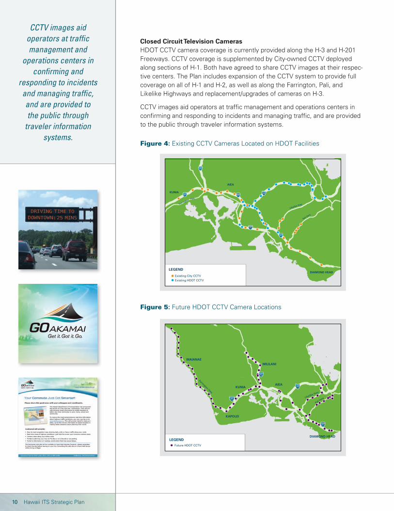
CCTV images aid operators at traffi c management and
operations centers in confi rming and
responding to incidents and managing traffi c, and are provided to the public through
traveler information systems.
Closed Circuit Television CamerasHDOT CCTV camera coverage is currently provided along the H-3 and H-201 Freeways. CCTV coverage is supplemented by City-owned CCTV deployed along sections of H-1. Both have agreed to share CCTV images at their respec-tive centers. The Plan includes expansion of the CCTV system to provide full coverage on all of H-1 and H-2, as well as along the Farrington, Pali, and Likelike Highways and replacement/upgrades of cameras on H-3.
CCTV images aid operators at traffi c management and operations centers in confi rming and responding to incidents and managing traffi c, and are provided to the public through traveler information systems.
Figure 4: Existing CCTV Cameras Located on HDOT Facilities
Figure 5: Future HDOT CCTV Camera Locations

“The Plan is dynamic in nature, with its goals
focused primarily on providing tools to support incident
management and to provide advanced
traveller information (via the web and phone)
for Oahu.”
LEGEND
Existing Variable Message Sign
Proposed Variable Message Sign
H3
H2
H1
H1 Likelike Hwy
Farrington Hwy
Pali Hwy
KUNIA
KAPOLEI
WAIANAE
MILILANI
AIEA
DIAMOND HEAD
11March 2015
The traveler information website,
available at www.goakamai.org, is the aggregation
point for all traveler information from HDOT’s
ITS system...
Variable Message SignsAs part of the initial H-3 program deployment, VMS were installed along its length, including installations on approaches to H-3 from the H-1 corridor and Windward Oahu. These signs have exceeded their life cycle, are no longer supported by the manufacturer, and must be replaced.
Replacement of existing VMS is phased based on operational priority and available funding. The fi rst three years of the Plan include replacing four existing VMS and installing six new VMS in the H-1 corridor. Two of the existing VMS were replaced in 2012 and are currently planned for demonstration of travel time messaging. New VMS on H-2, Pali, and Likelike Highways are planned, and the eventual replacement of all existing VMS and CMS on H-3 and in the Harano Tunnels are included in the 10-year Plan timeframe.
3. Provide a Traveler Information Website and Telephone SystemThere are two elements of the traveler information system: a traveler information website and mobile-ready applications, and an integrated, interactive telephone system. Both systems have been deployed, and enhancements will be implemented in the fi rst three years of the program with additional enhancements planned in the Near- and Long-Term plans as needed. Each is described below.
WebsiteThe traveler information website, available at www.goakamai.org, is the aggregation point for all traveler information from HDOT’s ITS systems and includes travel time and congestion information, event information (incident, construction, and public events that impact travel), a portal for other transportation services, and personalized services.
Summer 2010 marked the fi rst public release of the joint State-City ATIS website. Under the name “Go Akamai”, the website includes a congestion map based on data collected from the spot speed devices and provides the user with access to State and City CCTV images. Enhancements since the initial release include integration with traffi c incident information, select City and County of Honolulu arterial information (currently all special events), and mobile applications for smart phones.
Figure 6: Existing and Future VMS Locations

PEARL CITY
WAIPAHUAIEA
PearlridgeShopping
Center
Like
like
Hwy
Nimitz Hwy
Ala Moana Blvd
Farrington
Kam
eham
eha
Hw
y.
Hwy
Hw
y
Kamehameha
Kam
eham
eha
Pali
Hwy
Uni
vers
ity
Palo
lo A
ve.
Kap
ahu
lu A
ve.
6th A
ve .
Diamond Head R.
Ainak
oa A
ve.
Ave
Pearl HarborNaval Shipyard
HonoluluInternational
Airport
SALT LAKE
DOWNTOWN
MANOA
KAIMUKI
KAHALA
AINA HAINA
Kalanianaole Hwy.
MOANALUA
LILIHA-KAPALAMA
Hwy.
WAIPIO
WAIKELEKUNIA
EWA
WAIAWAKa U
ka B
lvd.
Fort
Wea
ver
Rd
.
Paiw
a St
. Lu miaina St.
H1
H1
H3
H1
H1
H2
Kun
ia R
d.
Kahala Ave.
Kealaolu A
ve.
12 Hawaii ITS Strategic Plan
The interactive voice response phone
system will be accessed by dialing
511, a federally designated number
for traveler information use.
About the ATIS program name, tagline, and logo:
The ATIS program is named “Go Akamai” or “go smart”.
The tagline is “Get it. Got it. Go.” It was chosen because it conveys a sense of speed in obtaining valuable travel planning information. It also implies that the system is easy to navigate and helps travelers get to where they need to go faster.
TelephoneThe development of the infrastructure to support dissemination of traveler information through a website also supports other dissemination media including an interactive voice response phone system. The system is ac-cessed by dialing 511, a federally designated number for traveler information use. Launched in the fall of 2013, the telephone system provides a full range of traveler information including current speed conditions, projected travel times, event details, and access to information on alternate travel modes.
4. Expand Freeway Service Patrol CoverageHDOT’s incident management program was implemented in 2009 with roving freeway service patrols. FSP operates between 5 a.m. and 7 p.m., Monday through Friday, on H-201 and H-1 between the Kunia Interchange and Ainakoa Interchange and on H-2 from the Waiawa Interchange to Ka Uka Boulevard (see Figure 7). The program has provided over 60,000 assists and averages close to 1,000 assists per month. In surveys received from motorists who have been assisted by FSP, 97 percent rate the program as “excellent”. The ITS Plan assumes expansion of the FSP over the 10-year program beyond its current 29 freeway miles of service on H-1 to more than 40 miles of service.
Figure 7: Freeway Service Patrol Area of Service

13March 2015
5. Improve Incident Management Through Traffi c OperationsTunnel and freeway operations are provided at the H-3 TOC by operators who support traffi c operations and incident management on the H-3 facility and some select sections of other Oahu roadways. These operators rely on software and technology systems to do their jobs. First opened in 1997, the systems equipment and software at the TOC has or will reach its life cycle end during the 10-year window of this strategic plan. Since inception of HDOT’s ITS program, the H-3 video wall, the fi eld device communications system, and hardware supporting the tunnel management software system have been replaced. Replacement of other obsolete ITS-related systems at the H-3 TOC and along the H-3 freeway is included in the Near- and Long-Term Plans.
Joint Traffi c Management CenterThe City and County of Honolulu, in conjunction with HDOT, is moving forward with a Joint Traffi c Management Center (JTMC) project. As currently planned, the JTMC will house HDOT’s ITS operations as well as portions of the City’s Police (HPD), Fire (HFD), Emergency Medical Services (EMS), Department of Transportation Services (DTS), and other organizations with functions related to active traffi c management. Co-location of key staff within the JTMC will allow for better incident management and coordination between these agencies.
The Plan assumes that the JTMC will be operational in Year 3 (2018). Benefi ts to and requirements from the ITS Program resulting from JTMC development and implementation are:
The JTMC will improve HDOT’s ability to meet the two ITS program goals—improved incident management and traveler information.
Systems staff will be needed to plan and operate the hardware, software, and communications systems in the JTMC.
HDOT will incur ongoing costs to occupy and operate the JTMC.
If the JTMC project does not move forward, HDOT will expand the existing systems and facilities at the H-3 TOC to manage the expanded incident management and traveler information functions. Additionally, interagency coordination to support incident management and interconnected computer systems will also be required. The Plan addresses systems needs independ-ent of the location of the systems.
6. Provide Ongoing Support to Implement and Maintain the Program.
ITS is more than systems and devices. It also needs ongoing support functions, including fi eld maintenance, HDOT’s System Manager Contract, and ITS public outreach. Operations for traveler information, FSP, and the JTMC were previously discussed.
Co-location of key staff within the Joint Traffi c Management
Center will allow for better
traffi c management coordination
between agencies.

14 Hawaii ITS Strategic Plan
Field maintenance encompasses the
ongoing preventative and responsive
maintenance needed to keep ITS equipment
functioning.
Field MaintenanceField maintenance encompasses the ongoing preventative and responsive maintenance needed to keep ITS equipment functioning. Today, limited preventative maintenance is done on a regular basis, with most work due to outages or breakdowns. HDOT has limited maintenance staff and has contract-ed some of these services to third parties.
In the Plan, costs associated with maintenance are designated for staff needed to perform preventative and responsive maintenance work, as well as for replacement equipment.
System ManagerHDOT currently contracts with a System Manager to provide support for various ITS activities that cannot be accomplished with its current staffi ng levels. To date, this support has included development of procurement materi-als for ITS projects, development of the traveler information website and phone system, ITS strategic planning efforts, support to initiate and monitor the Freeway Service Patrol, and other ITS activities as required.
The Plan assumes continued staff support via the System Manager in the Current and Near-Term phases of the ITS Program. Staff support through the System Manager will be maintained at current levels, then reduced in Years 4 and 5 after an ITS organization within HDOT has been established. It is expected that the majority of new staff positions will be created by year 4 and fi lled by Year 6. At that point, HDOT will either have suffi cient ITS staff to perform the functions or will need to secure funding to continue the System Manager contract. Should there be neither new staff nor a System Manager, continued implementation of the ITS Program Plan elements will be delayed and some of the implemented systems will be at risk due to lack of maintenance.
Public OutreachAs HDOT rolls out new ITS projects, a public outreach program will be devel-oped that will be proactive in terms of providing information about the ITS Plan elements and its benefi ts. Also, as part of monitoring performance of the ITS Program, an annual public opinion telephone survey will be conducted that addresses general attitudes about traffi c congestion on Oahu roads and implementation of ITS devices and systems.
7. Implement ITS on the Neighbor Islands The ITS Program focuses planning, design, and construction dollars primarily on Oahu, where the greatest level of congestion and incidents are found. Today, ITS on the neighbor islands is almost nonexistent with the exception of about 25 CCTV cameras on Hawaii Island and a single, permanent VMS on Maui.
HDOT recognizes that the neighbor islands will benefi t from traveler information and incident management functions as well as other potential ITS applications. Development of the Hawaii Statewide ITS Architecture is included as part of the Current Program. Future projects that are identifi ed will be programmed for annual funding starting in Year 4 (2019).

15December 2011
In order to continue to develop, implement, and expand the ITS
program, HDOT must address the associated
staffi ng needs and a projected gap in
available resources.
8. Increase Staff to Operate, Maintain, and Expand the ProgramIn order to continue to develop, implement, and expand the ITS program, HDOT must address the associated staffi ng needs and a projected gap in available resources. To offset staffi ng shortfalls under the Current phase of the program, this Plan proposes supplementing maintenance of some devices and systems by requiring the vendor or installer to provide extended warranty service. As addressed previously, the System Manager is supplementing other staffi ng needs for the Current and Near-Term programs.
Unlike more traditional DOT operations and maintenance staff skills, ITS requires specialized skills in systems and software engineering processes, roadway operations, incident management, computer and software systems, and communications networks and fi eld technologies such as VMS, CCTV, and traffi c detectors. Managing the implementation, maintenance, and operations of ITS in Hawaii is a complex task for several reasons:
1. Lack of nationally-accepted design manuals and standards – There are no manuals or national standards for ITS that provide design standards or parameters. Each Hawaii ITS project is a tailored solution based on a federally guided decision-making process.
2. Statewide span of ITS responsibility – The approach for planning, deploying, operating, and maintaining ITS beyond Oahu has yet to be developed. This will require close coordination with District Engineers and branch leadership within HDOT to prioritize and implement ITS projects, operate and maintain the infrastructure, and, where appropriate, train local staff.
3. Policy recommendation and interpretation authority – The impacts that ITS planning, design, construction, maintenance, and operation have in the HDOT organization are far-reaching and require coordination with multiple branches and districts; within them, numerous sections; and between them, many federal and county agencies. The ability to recom-mend and interpret HDOT-adopted ITS policies is needed to move these interagency discussions forward with minimal delay.
4. Stakeholder involvement – FHWA requires that ITS project planning and design involve potential stakeholders. The process typically involves a large group of stakeholders, and consensus-building is key to the ITS project planning and design. In addition to transit, transportation services, and public works departments, the stakeholders can include affected agencies such as Police, Fire, EMS, Emergency Management, Informa-tion Technology, and others that may share the systems themselves or have input to how the systems should operate. HDOT will need to lead these consensus efforts.

16 Hawaii ITS Strategic Plan
Further adding to the complexity of ITS
project design, operation, and ongoing
maintenance, technology is
continually and rapidly changing.
5. Continuous changes in technology – Further adding to the complexity of ITS project design, operation, and ongoing maintenance, technology is continually and rapidly changing. The design solution developed for an ITS application today will likely not be the same solution selected next year. Plus, this continuous change makes maintenance and replacement of ITS components more complex. Each replacement decision must be made considering the state of the market in terms of the technology being addressed, including whether the technology remains current and avail-able, whether new technologies meet functional needs, whether new technologies require changes to operations or maintenance practices, and other complicating factors.
New HDOT staff positions are needed to meet the growth and supporting skill sets required to implement the ITS Strategic Plan. These are tied to the addition of specifi c functions and other key milestones in the plan. The staffi ng approach developed to support implementation of the ITS Strategic Plan is based on three primary principles:
Additional Staff, Additional Skills. The incorporation of the new systems with the legacy systems, as well as the geographic expansion of and development of wholly new systems, requires new and innovative prob-lem solving, new skill sets, and new staff. While existing staff may be trained to run and manage some of these systems, additional staff are required for the ongoing design, construction, operations, and mainte-nance of the ITS Program. New positions are also required to provide leadership in interagency coordination, management, and administration of the ITS Program.
Consolidation. ITS functions united within a single organization responsi-ble for the complete ITS Program, including statewide functions, will enable direct coordination and facilitate cohesive planning, programming, construction, operation, and maintenance of the ITS Program. Plus, a united ITS group will readily leverage skills across functional areas, resulting in efficiencies in staffing resources. The Plan calls for moving existing staff from various sections in the Highways Division to an ITS organization.
Elevation. The ITS functions are currently housed between the Traffic Branch and the Oahu District. The ITS Program proposes a new ITS organization where the elevation of ITS functions within HDOT reflects a focus on managing the investment in the transportation infrastructure to get the most out of those dollars. In addition, the ITS Program will be a statewide function so that the skills developed from the program investment in Oahu are leveraged across the state.

17March 2015
To achieve HDOT’s ITS goals, the ITS Strategic Plan is broken into the Current (0-3 years), Near-Term (Years 4-6), and Long-Term (7+ years) Pro-grams. The Current Program concentrates on what can be constructed and implemented within the fi rst three years of the program with existing resources and programmed funds. The Near- and Long-Term strategies assume a signifi cant expan-sion of resources and funding for implementation of ITS infrastructure and systems to support comprehensive incident management and ad-vanced traveler information systems.
Current ProgramThe Current Program is very opportunistic in that it focuses on fi eld devices that are relatively quick to install with mostly solar power, rely on wireless communication, and require limited design. In addition to the already launched traveler informa-tion website and the FSP, these are the functions and systems that will be implemented in the fi rst three years of the Plan:
Travel condition information for Trans-Koolau routes and travel time display on VMS.
JTMC construction, systems/staff migration, and start-up.
Near- and Long-Term StrategiesWhere the focus of the Current Program is to get information about roadway conditions to the traveling public by deploying data collection de-vices and information systems as quickly and easily as possible, the focus of the Near- and Long-Term Plans is to expand and strengthen the traveler information and incident management functions and services by leveraging the early investments to create workable and effective ITS systems. These are planned for completion over the life of the Plan:
Ongoing traveler information web and phone systems.
ITS devices and communications on major roadways.
Expanded FSP.
JTMC operations and maintenance.
Expanded ITS on neighbor islands.
The implementation of the Near- and Long-Term Plans is highly dependent on the availability of additional staff resources and funding.
ITS PROGRAM APPROACH

1918 Hawaii ITS Strategic Plan March 2015
This table provides additional detail about the infrastructure elements and summarizes the program initiatives and staff support that are part of the Current Program, Near- and Long-Term Plans.
TABLE 1: Deployment Summary of the ITS Plan
Infrastructure
Program Initiatives & Support
Cost
Construction (Affected Roadways)
Traveler Information
Staff and System Manager
Freeway Service Patrol
Public Relations
JTMC
Website, mobile and 511 phone enhancements
Staff support and specialty needs through System Manager contract
HDOT organizational changes with addition of 11 new positions, including one Branch Manager; 2 section heads; administrative support; 2 operations engineers; 2 systems engineers; 2 maintenance technicians
Maintain current service (geographic coverage, times, and days to be determined), evaluate and expand
Create and initiate program to promote the ITS Program; begin implementation of annual public opinion telephone survey
Facility construction, systems migration, and staff occupancy
Ongoing maintenance of website and phone systems
System Manager contract services transition in Year 4
HDOT staff increases: 2 staff to support engineering, design and systems; 1 staff to support systems
Continued service, limited expansion based on previous evaluation.
Continued promotion of the ITS Program and its elements, but at a lower rate than in the fi rst 3 years of the program; continue annual telephone survey
Occupy the JTMC; begin to provide joint incident mgmt and traveler info
Ongoing maintenance of website and phone systems
No System Manager contract services
Continued service
Continued promotion of the ITS Program at same rate as near-term; and annual telephone survey
Continue to provide joint incident management and traveler information
Equipment to be Installed
Design
Current Program (0-3 Years) Near-Term Plan (4-6 Years) Long-Term Plan (7-10 Years)
Years 1–3 Total: $37.5 Million
Oahu:H-2 SouthH-1 Core(Telecommunications)H-201Pali Hwy
Neighbor Islands: To be determined, based on Statewide ITS Plan.
Years 4–6 Total: $69.3 Million
Oahu:H-2 NorthFarrington HwyH-3H-1 Outer CoreLikelike Hwy
Neighbor Islands: To be determined, based on Statewide ITS Plan.
Years 7–10 Total: $121.7 Million
Telecommunications: Wireless CCTV: 25 new (augment City camera network to provide complete coverage)VMS: 7 new and 2 replacement for posting travel timesSpeed Detection: 34 new on Trans-Koolau routes
Telecommunications: Fiber-optic (25.5 miles) CCTV: 24 newVMS: 10 new; 2 replacement Travel Time Detection: 3 nodes
Telecommunications: Fiber-optic (60 miles) CCTV: 36 new; 15 replacementVMS: 7 new (plus 80 in H-3 tunnel/corridor)Travel Time Detection: 15 nodes (Farrington, Pali & Likelike)Replacement of Priority H-3 Legacy Systems
Pali HwyH-201
H-2 SouthLikelike HwyH-3
H-2 NorthNeighbor Islands (TBD)
H-1 Core TelecommunicationsNeighbor Islands (TBD)
Farrington HwyNeighbor Islands (TBD)
ITS Infrastructure
Program Initiatives / Contract Support
Existing Staff
New Staff
JTMC
ITS O&M
ITS Infrastructure
Program Initiatives / Contract Support
Existing Staff
New Staff
JTMC
ITS O&M
ITS Infrastructure
Program Initiatives / Contract Support
Existing Staff
New Staff
JTMC
ITS O&M
$12.6 M
$14.4 M
$5.6 M
$3.1 M
$1.4 M$0.4 M
$61.7 M
$22.8 M
$9.0 M
$9.3 M
$17.7 M
$1.2 M
$38.0 M
$14.4 M
$6.1 M
$5.7 M $4.3 M$0.8 M
Oahu:H-1 CoreH-1 Outer CoreH-3Pali HwyLikelike Hwy
20 Hawaii ITS Strategic Plan
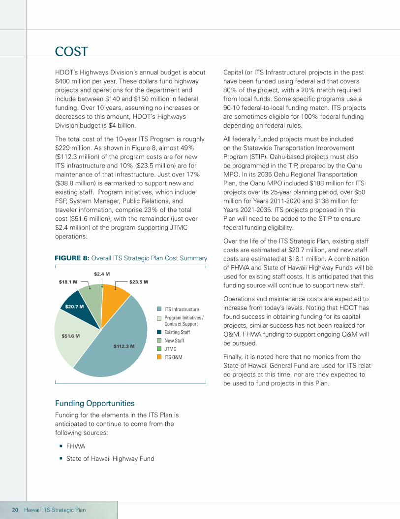
HDOT’s Highways Division’s annual budget is about $400 million per year. These dollars fund highway projects and operations for the department and include between $140 and $150 million in federal funding. Over 10 years, assuming no increases or decreases to this amount, HDOT’s Highways Division budget is $4 billion.
The total cost of the 10-year ITS Program is roughly $229 million. As shown in Figure 8, almost 49% ($112.3 million) of the program costs are for new ITS infrastructure and 10% ($23.5 million) are for maintenance of that infrastructure. Just over 17% ($38.8 million) is earmarked to support new and existing staff. Program initiatives, which include FSP, System Manager, Public Relations, and traveler information, comprise 23% of the total cost ($51.6 million), with the remainder (just over $2.4 million) of the program supporting JTMC operations.
Capital (or ITS Infrastructure) projects in the past have been funded using federal aid that covers 80% of the project, with a 20% match required from local funds. Some specifi c programs use a 90-10 federal-to-local funding match. ITS projects are sometimes eligible for 100% federal funding depending on federal rules.
All federally funded projects must be included on the Statewide Transportation Improvement Program (STIP). Oahu-based projects must also be programmed in the TIP, prepared by the Oahu MPO. In its 2035 Oahu Regional Transportation Plan, the Oahu MPO included $188 million for ITS projects over its 25-year planning period, over $50 million for Years 2011-2020 and $138 million for Years 2021-2035. ITS projects proposed in this Plan will need to be added to the STIP to ensure federal funding eligibility.
Over the life of the ITS Strategic Plan, existing staff costs are estimated at $20.7 million, and new staff costs are estimated at $18.1 million. A combination of FHWA and State of Hawaii Highway Funds will be used for existing staff costs. It is anticipated that this funding source will continue to support new staff.
Operations and maintenance costs are expected to increase from today’s levels. Noting that HDOT has found success in obtaining funding for its capital projects, similar success has not been realized for O&M. FHWA funding to support ongoing O&M will be pursued.
Finally, it is noted here that no monies from the State of Hawaii General Fund are used for ITS-relat-ed projects at this time, nor are they expected to be used to fund projects in this Plan.
Funding OpportunitiesFunding for the elements in the ITS Plan is anticipated to continue to come from the following sources:
FHWA
State of Hawaii Highway Fund
COST
FIGURE 8: Overall ITS Strategic Plan Cost Summary
$2.4 M
$23.5 M$18.1 M
$20.7 M
$51.6 M
$112.3 M
ITS Infrastructure
Program Initiatives / Contract Support
Existing Staff
New Staff
JTMC
ITS O&M

21March 2015
The Plan’s goals, programmatic elements, approach, and funding are considered essential in systematically implementing ITS in Hawaii. To this end, measuring the success of the ITS Program is vital to guide expansion of ITS, ensure suffi cient funding, and validate best use of the funds that are applied. In short, performance metrics are quantifi ed to confi rm that Hawaii is getting the
expected return on its investment in ITS and, when needed, the program is adjusted to make sure that it is. The evaluation metrics that will be used are summarized in the following table. These metrics will measure the progress in meeting the Plan’s goals over the next 10 years. Annual reports will be published showing the ITS Plan’s growth and its performance against these metrics.
MEASURING AND REPORTING OUTCOMES
Metric Category Description
Detection, VMS, and CCTV Coverage
Travel Time
Website and 511 Telephone System
Customer Satisfaction
The GoAkamai website and 511 telephone system provide real-time traffi c information so that travelers are better able to plan their trips using information posted. This metric includes tracking the number of website hits and phone calls.
A public opinion telephone survey will be administered periodically. The survey will include general questions to gauge opinions about how HDOT is dealing with congestion through ITS applications and specifi c questions about the Plan elements.
FSP Service
Detection refers to traffi c sensors that measure vehicle speeds or travel times. This measure considers the total coverage proposed in the ITS Plan for detection, VMS, and CCTV deployment, and compares it with the actual coverage to date.
Travel time is the average time it takes for vehicles to travel from one point to another and is one of the fundamental measures of freeway performance. Using travel time detection devices, travel time will be measured and historical trends will be developed to understand the actual travel times and assess overall system performance.
Additionally, percent variation will be reported. The variation shows the fl uctuation in travel time on a specifi c roadway during a certain period (e.g., AM or PM peak). Minimizing the variation in travel time is expected to be a key benefi t of ITS as travelers can readily recognize the variation in their commute.
This metric considers the actual number of service hours and days of service provided, miles of freeway coverage, and the number of motorists assisted by the FSP.
Motorists being assisted by FSP are given a survey which they can fi ll out and mail back to HDOT. This metric considers the rating given to the FSP program (e.g., excellent, good, fair, poor) and the perceived response time (the time it took the FSP vehicle to arrive on scene, from the motorists’ perspective).
For more information, contact: Hawaii Department of Transportation Public Affairs Office, 869 Punchbowl Street Honolulu, Hawaii 96813
Phone: 808.587.2160 Fax: 808.587.2313 Email: [email protected] www.hawaii.gov/dot www.goakamai.org
i US DOT, Federal Highway Administration. Traffic Congestion and Reliability: Trends and Advanced Strategies for Congestion Mitigation. Available at http://www.ops.fhwa.dot.gov/congestion_report/congestion_report_05.pdf.ii http://www.benefitcost.its.dot.gov/; includes inset box statisticsiii Karlaftis, Latoski, Richards, Sinha: “ITS Impacts on Safety and Traffic Management: An Investigation of Secondary Crash Causes,” ITS Journal, 1999, Vol. 5, pp.39-52.
Chang, Rochon: Performance Evaluation and Benefit Analysis for CHART—Coordinated Highways Action Response Team—in Year 2005 Final Report, University of Maryland, College Park, MD, May 2006.iv Vasudevan, Meenakshy, Karl Wunderlich, James Larkin, and Alan Toppen. “A Comparison of Mobility Impacts on Urban Commuting Between Broadcast Advisories and Advanced Traveler Information Services,” Paper Presented at the 84th Annual Transportation Research Board Meeting. Washington, DC. 9–13 January 2005. Benefits ID: 2005-00285.v Liebenau, Jonathan with Robert Atkinson, Patrik Kärrberg, Daniel Castro and Stephen Ezell. The UK’s Digital Road to Recovery. April 2009.vi US DOT, Federal Highway Administration. Managing Demand Through Travel Information Services. Document No. 14072; Publication No. FHWA-HOP-05-005 2005.
This document was prepared by the ICx Transportation Group.