Embed Size (px)
Citation preview
Kyushu University Global COE ProgramJournal of Novel Carbon Resource Sciences, Vol. 4, pp. 21-26, Sep. 2011
Integrated Soil Investigation for the Geothermal Pipe Route in Steep Area
Budi Sulistijo and Adriyanto D. KusumoResearch Group of Earth Resources Exploration, Faculty of Mining and Petroleum Engineering,
the Institute of Technology Bandung, Indonesia
A high terrain area with steep slope is one of the geotechnical problems in the geothermal field, which caused instability of the main facilities. A long period of heavy rain and the topography such as a steep slope could cause the landslides in the surrounding area of the main geothermal facilities, such as geothermal pipeline. Once landslides occur, either a part or all of the geothermal facilities may be moved away from their original positions.
The data of soil profile obtained only from the borehole data shows a limitation to identify the shape of landslide and the surface of failure. It may be difficult to evaluate the slope stability accurately only by using this data. Hence, integrated soil investigation which consists of borehole, Standard Penetration Test, Cone Penetration Test, Geophysical Survey, and Engineering Geology Mapping and Ground Water is proposed in this paper and this method can not only improve the geotechnical data but also discuss the mechanism of landslide more accurately.
(Received May 26, 2011; accepted August 5, 2011)
1. Introduction Indonesia is a country which has potential geothermal
energy resources due to its location along the Ring of Fire. The geothermal fields in Indonesia have been identified in Sumatera, Java, Sulawesi, Bali, Nusatenggara, and Maluku. In some of them, the geothermal power plants have been installed and operated in order to meet the demand of electricity such as in Sumatera, Java, and Sulawesi. The geothermal fields in Indonesia are mainly located at the high terrain area, has geological structures. They are also located in forest area with the altered material, weathered product, and pyroclastic rocks.
The pipeline system is used to deliver the steam from production well to the power plant. A high terrain area with steep slope is one of warning area which causes instability of the main facilities in the geothermal field. The identification of the geomorphological control factors causing landslide is the fundamental importance and constitutes the basis for a correct assessment of landslide hazard1). A long period of heavy rain and steep slope could cause landslides in surrounding of main geothermal facilities, such as geothermal pipeline.
The landslide occurs not only in simple model but also in complex model2). Once landslides occur, either a part or all of geothermal facilities may be moved away from their original positions. Consequently, this condition needed a high cost to restore.
The information of soil characteristic, such as soil properties, soil profiles, sliding surface, and groundwater influence are needed to restore the surrounding area and facilities of landslide. An integrated soil investigation which consists of geological engineering mapping, drilling, Cone Penetration Test, and geophysical survey has been conducted to obtain the information of beneath surface in the landslide area. Based on the results of a series of the field tests, the mechanism of landslide and subsurface structures could be detected.
2. Methodology The soil properties and soil profile in landslide area
are obtained from integrated site investigation which consists of geological engineering mapping, drilling, Cone Penetration Test, and geophysical survey.
Geological engineering mapping is one of the series of field observation in order to obtain geological features, such as rocks, cracks, springs, faults, subsidence and old landslides and the in-situ water quality measurements, relative pipe movement, and ground temperature at each pipeline support. The results obtained from these investigations are used in order to produce geological map and to identify the mechanism of landslides.
Boring was conducted in order to obtain geotechnical parameter of soil and rocks. Furthermore, the Standard Penetration Test (SPT) is conducted during drilling, which is used as the estimation of soil strength parameter. The SPT test has been performed after undisturbed sampling or at each depth interval of 1.5 meter. The number of blows is called N with units of blow/feet.
Cone Penetration Test was conducted in order to obtain in-site geotechnical parameter of soil which depends on stratigraphic layer. The cone resistance value and local friction or friction sleeve value has been observed at every 20 cm depth interval. The penetration speed is maintained at approximately 2 cm/sec. Those tests have been performed to reach cone resistances value > 160 kg/cm2. In the Cone Penetration Test (CPT), a cone on the end of a series of rods is pushed into the ground at a constant rate and continuous measurements are made of the resistance to penetration of the cone and of a surface sleeve.
The geophysical survey has been widely used to support geotechnical investigation. In this study, geophysical survey was also conducted by using two-dimensional electrical resistivity and self potential methods. This method has been successful in detection of area with complex geology3,4) and in investigation of landslides5-10).
Technical Report

Journal of Novel Carbon Resource Sciences, Vol.4, Sep. 2011
The electrical resistivity survey is one of the geophysical techniques that use variations of electrical resistivity value to determine subsurface material. It is carried out by put current into the ground through the steel current electrodes and measuring potential difference using steel potential electrodes. The Self Potential (SP) survey is conducted by measuring the difference of natural potential between two electrodes driven into the ground. The SP method has been applied in engineering and environmental applications, such as the investigation landslides6).
3. GeologyThe soil or rocks material in geothermal field consists
mainly of altered materials, pyroclastic rocks altered in various alteration degrees, and weathered products11). Andesite boulders, obsidian boulders and springs are commonly found in the geothermal field.
The geothermal field in Indonesia generally consists of hornblende, andesite, lava flow, lahars, tuffaceous breccias and lapili, sandy pumiceous tuff, undifferentiated volcanic rocks, obsidian and volcanic breccias. Due to the thermal activity, the intensive of the alteration is observed in the most geothermal field.
4. Site investigation In some cases, the landslides are mostly induced by the
heavy rainfall. In addition, the topographical factor such as dip of soil/rock layering and rock/soil stratification affect the depth of landslides. Most of the geothermal fields are located in a high terrain area in Indonesian so the high rainfall generally affected the stability of slope. A steep slope and the presence of geological structural tend to occur landslides then after a long period of rainfall, the landslide may occur.
Some tuff material usually stables in undisturbed condition. However, but it is very sensitive to the water because some tuff materials such as orange tuff in West Java have a high water absorbsion and then becomes to be brittle. Special attention has to be paid during the excavation of orange tuff zone such as minimum handling, cover with plastic in disturb area during the rainy period in order to reduce run them off. The orange tuff at dumping site will be eroded easily due to the characteristics of orange tuff.
Site investigations have been performed after landslide in order to obtain geotechnical data and soil profile. These works consisted of geological engineering mapping, in-situ water measurement, ground temperature measurement, drilling, Cone Penetration Test, electrical resistivity tomography survey, and self potential survey.
The landslide area has been investigated in detail and a recent topographic contour was made based on the all data obtained so far. This data has been used as a base map for all geotechnical investigation in landslide area.
4.1 Drilling Boring investigation was conducted along pipeline
route in order to detect the subsurface condition of the
landslide areas.According to boring results, the tuff material is mainly
observed with various thicknesses in all boreholes and andesite is also found in several boreholes. The description of the andesite core from the boring results must be carried out by carefully to identify that the andesite from boring results is originally boulder or lava or the intrusion of rock because the boring operation for the soil investigation was usually stopped when the bit reached the rocks (andesite, obsidian) because the rocks are considered as bedrock with continuous layer and unlimited thickness. This assumption can be accepted if the rock forms a lava flow or intrusion of rock. In many cases, the rocks in geothermal area are in boulder form only with various thicknesses from the several cm up to several meters. Lateral distribution of the boulder of rocks is varieties depend on the originality of boulder. Misunderstanding of the rocks type description will lead a miss design in the reinforcement program.
All of the N SPT value of tuffaceous clay showed a low value, which is at 1 blow/ft. This indicates that the tuff layer has been altered.
4.2 Cone Penetration Test (CPT)Several CPT testing have been carried out in this
site. Some of them were conducted in and around in the landslide area and others were done located along pipeline route. This result showed that cone resistance is reached in various depths from 10.6 meter to 15.8 meter. The CPT value cannot represent the in-site condition because the penetration depth was restricted by the boulder rocks (andesite, obsidian, etc) in some cases. Special attention must be given to explain whether the high resistance is caused by the soil condition or by the existence of boulder of andesite or obsidians.
4.3 Geological engineering mapping Several soil movement indicators installed in the
landslide area showed the occurrence of minor tension crack, heave, landslide, subsidence and pipe support movement. Some pipe supports are moved to the down slope direction, some of them were done to both of the down slope and the sideways direction, and others were done to the up slope direction.
The geological structure such as discontinuities is one of the major factors which influenced the landslide. Several cracks are observed in those areas. The discontinuities are occasionally filled with water and cause an increasing buoyancy effect. In tropical forest area with very thick decomposed leaves, the accurate discontinuities mapping is very difficult. The alternative method for the discontinuities mapping was the electrical resistivity tomography method and the self potential method. These methods can represents the discontinuities locations and the discontinuities condition such as dry or filled with water.
The ground temperature at each pipe support indicated a constant value, at + 28 °C.
The ground water level in each borehole was measured
Integrated Soil Investigation for the Geothermal Pipe Route in Steep Area
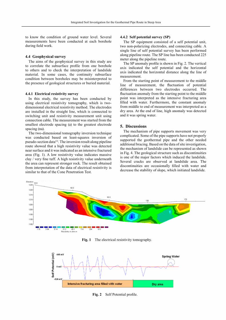
4.4.2 Self potential survey (SP)The SP equipment consisted of a self potential unit,
two non-polarizing electrodes, and connecting cable. A single line of self potential survey has been performed along pipeline route. The SP line has been conducted 225 meter along the pipeline route.
The SP anomaly profile is shown in Fig. 2. The vertical axis indicated the self potential and the horizontal axis indicated the horizontal distance along the line of measurement.
From the starting point of measurement to the middle line of measurement, the fluctuation of potential differences between two electrodes occurred. The fluctuation anomaly from the starting point to the middle point was interpreted as the intensive fracturing area filled with water. Furthermore, the constant anomaly from middle to end of measurement was interpreted as a dry area. At the end of line, high anomaly was detected and it was spring water.
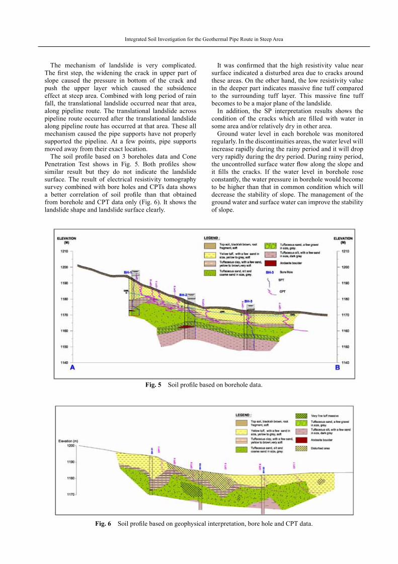
5. Discussions The mechanism of pipe supports movement was very
complicated. Some of the pipe supports have not properly supported the geothermal pipe and the other needed additional bracing. Based on the data of site investigation, the mechanism of landslide can be represented as shown in Fig. 4. The geological structure such as discontinuities is one of the major factors which induced the landslide. Several cracks are observed at landslide area. The discontinuities are occasionally filled with water and decrease the stability of slope, which initiated landslide.
to know the condition of ground water level. Several measurements have been conducted at each borehole during field work.
4.4 Geophysical survey The aims of the geophysical survey in this study are
to correlate the subsurface profile from one borehole to others and to check the interpretation of landslide material. In some cases, the continuity subsurface condition between boreholes may be misinterpreted to the presence of geological structures or buried material.
4.4.1 Electrical resistivity surveyIn this study, the survey has been conducted by
using electrical resistivity tomography, which is two-dimensional electrical resistivity method. The electrodes are installed in the straight line, which is connected to switching unit and resistivity measurement unit using connection cable. The measurement was started from the smallest electrode spacing (a) to the greatest electrode spacing (na).
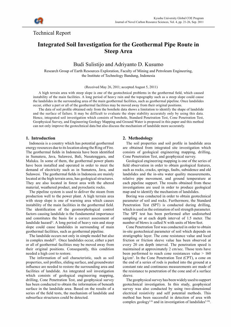
The two-dimensional tomography inversion technique was conducted based on least-squares inversion of pseudo-section data12). The inversion result along pipeline route showed that a high resistivity value was detected near surface and it was indicated as an intensive fractured area (Fig. 1). A low resistivity value indicates massive clay / very fine tuff. A high resistivity value underneath the area can represent stronger rock. The result obtained from interpretation of the data of electrical resistivity is similar to that of the Cone Penetration Test.
Fig. 1 The electrical resistivity tomography.
Fig. 2 Self Potential profile.
Journal of Novel Carbon Resource Sciences, Vol.4, Sep. 2011
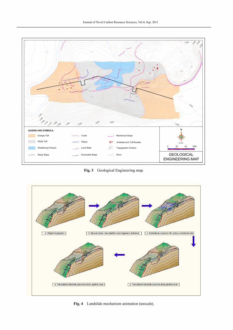
Fig. 3 Geological Engineering map.
Fig. 4 Landslide mechanism animation (unscale).
Integrated Soil Investigation for the Geothermal Pipe Route in Steep Area
The mechanism of landslide is very complicated. The first step, the widening the crack in upper part of slope caused the pressure in bottom of the crack and push the upper layer which caused the subsidence effect at steep area. Combined with long period of rain fall, the translational landslide occurred near that area, along pipeline route. The translational landslide across pipeline route occurred after the translational landslide along pipeline route has occurred at that area. These all mechanism caused the pipe supports have not properly supported the pipeline. At a few points, pipe supports moved away from their exact location.
The soil profile based on 3 boreholes data and Cone Penetration Test shows in Fig. 5. Both profiles show similar result but they do not indicate the landslide surface. The result of electrical resistivity tomography survey combined with bore holes and CPTs data shows a better correlation of soil profile than that obtained from borehole and CPT data only (Fig. 6). It shows the landslide shape and landslide surface clearly.
It was confirmed that the high resistivity value near surface indicated a disturbed area due to cracks around these areas. On the other hand, the low resistivity value in the deeper part indicates massive fine tuff compared to the surrounding tuff layer. This massive fine tuff becomes to be a major plane of the landslide.
In addition, the SP interpretation results shows the condition of the cracks which are filled with water in some area and/or relatively dry in other area.
Ground water level in each borehole was monitored regularly. In the discontinuities areas, the water level will increase rapidly during the rainy period and it will drop very rapidly during the dry period. During rainy period, the uncontrolled surface water flow along the slope and it fills the cracks. If the water level in borehole rose constantly, the water pressure in borehole would become to be higher than that in common condition which will decrease the stability of slope. The management of the ground water and surface water can improve the stability of slope.
Fig. 6 Soil profile based on geophysical interpretation, bore hole and CPT data.
Fig. 5 Soil profile based on borehole data.
Journal of Novel Carbon Resource Sciences, Vol.4, Sep. 2011
6. Conclusions The data of soil profile based on borehole data has
a limitation to identify the landslide shape and failure surface accurately.
The combination method which consists of boring data, SPT, CPT, geophysical survey was suggested and applied to the investigation in landslide area. From this result, the shape of landslide and failure surface can be identified by using this method.
Integrated soil investigation which consists of borehole, SPT, Cone Penetration Test, geophysical survey, and engineering geology mapping can not only improve the geotechnical data in landslide area but also detect the mechanism of landslide more accurately. The combination of all works lead successful in the landslides investigation and slope stability analysis.
References1) P. Revellino, F. M. Guadano, and O. Hungr, Landslides,
5, 59 (2007).2) B. Sulistijo, 3rd Asian Engineering Symposium on
Geology and the Environment, Jogjakarta (2001).
3) B. Sulistijo and R. Luhansa, 11th International Symposium on Mineral Exploration ISME-XI, Espoo, Finland (2010).
4) D. H. Griffiths and R. D. Barker, J. Appl. Geophys, 29, 211 (1993).
5) V. A. Bogolovsky and A. A. Ogilvy, Geophysics, 42, 562 (1977).
6) A. Godio and G. Bottino, Phys. Chem. Earth, 26, 705 (2001).
7) J. H. Mauritsch, W. Seiberl, R. Arndt, A. Romer, K. Schneiderbauer, and G. P. Sendlholfer, Eng. Geol., 56, 373 (2000).
8) J. P. T. Caris and T. W. J. van Asch, Eng. Geol., 31, 249 (1991).
9) V. Lapena, P. Lorenzo, A. Perrone, and S. Piscitelli, Bull. Eng. Geol. Environ., 62, 259 (2003).
10) M. G. Drahor, G. Görktürkler, M. A. Berge, and T. Ö. Kurtulmuş, Environ. Geol., 50, 147 (2006).
11) B. Sulistijo, A. D. Kusumo, and W. Sengara, Proc. 2nd Intl. Symp. of Novel Carbon Res. Scie., VII-19, Bandung (2009).
12) M. H. Loke and R. D. Barker, Geophys. Prospect, 44, 131 (1996).