Embed Size (px)
Citation preview

A66 Northern Trans-Pennine PEI Report - 06. Biodiversity
17/09/21 Revision P01 6-ii
IntegratedProjectTeam
CONTENTS
6 Biodiversity ........................................................................................................... 1
6.1 Introduction ............................................................................................................. 1
6.2 Legislative and Policy Framework............................................................................ 1
6.3 Assessment Methodology........................................................................................ 5
6.4 Assessment Assumptions and Limitations ............................................................... 6
6.5 Study Area .............................................................................................................. 7
6.6 Baseline Conditions ................................................................................................ 8
6.7 Potential Impacts................................................................................................... 57
6.8 Design, Mitigation and Enhancement Measures..................................................... 60
6.9 Assessment of the Likely Significant Effects........................................................... 63
6.10 Monitoring ........................................................................................................... 225
FIGURES
6.1 - Designated Sites
6.2 - Priority Habitats and Ancient Woodland
6.3 - Phase 1 Habitat Survey
APPENDICES
6.1 – Draft Habitat Regulations Assessment (HRA) Screening Report
6.2 - Ecological Field Surveys Methodology and Study Areas

A66 Northern Trans-Pennine PEI Report - 06. Biodiversity
17/09/21 Revision P01 6-1
IntegratedProjectTeam
6 Biodiversity
6.1 Introduction
6.1.1 This chapter presents the Preliminary Environmental Information (PEI) in relation to the biodiversity assessment, and is informed by Appendix 6.1 – Habitats Regulations Assessment (HRA) Screening Report.
6.1.2 In addition, there are also potential secondary/indirect effects on biodiversity arising from other disciplines. Please also refer to the following chapters to understand potential impact pathways:
• Chapter 5: Air Quality • Chapter 7: Climate
• Chapter 10: Landscape and Visual Effects
• Chapter 12: Noise and Vibration
• Chapter 14: Road Drainage and the Water Environment.
6.1.3 The methodology follows the requirements of Design Manual for Roads and Bridges (DMRB) LA 108 Biodiversity (Highways England, 2020a)1.
6.1.4 Stakeholder consultation is a key part of the assessment process. Key stakeholders for biodiversity, including Natural England, the Environment Agency and the various Local Authorities (LA) have been consulted throughout the project development process. During the current preliminary design and environmental assessment phase, two biodiversity focussed Technical Working Groups (TWG) have been established involving these organisations (covering the Habitats Regulations Assessment (HRA), and the Ecological Impact Assessment (EcIA)), through which baseline evidence, the emerging design, assessment methodology and initial assessment findings have been shared, discussed and feedback received. Other stakeholders have also been engaged through the project Focus Groups and via the scoping opinion process.
6.1.5 In addition to the TWG, Focus Groups and scoping opinion, a number of stakeholders have been consulted to gather baseline data and inform the assessment.
6.1.6 Stakeholder engagement is ongoing and will continue to the DCO application submission.
6.2 Legislative and Policy Framework
Legislation
6.2.1 The following key legislation is relevant to this assessment:
• The Conservation of Habitats and Species (CHS) Regulations 2017 (as amended by the EU Exit Regulations 2019) (the ‘Habitat Regulations 2017’)
• Ramsar Convention on Wetlands (United Nations Educational, Scientif ic Cultural Organisation, 1971)
• The Birds Directive (Council Directive 2009/147/EC on the conservation of wild birds)
• Wildlife and Countryside Act (WCA) 1981 (as amended)
• Natural Environment and Rural Communities (NERC) Act 2006 particularly the section 41 list of habitats and species of Principal Importance for Conservation (referred to as Priority Habitats or Species in this report)
1 Highways England (2020a) Design Manual for Roads and Bridges LA 108 Biodiversity, available at: https://www.standardsforhighways.co.uk/prod/attachments/af0517ba-14d2-4a52-aa6d-1b21ba05b465?inline=true [accessed 1 September 2021]

A66 Northern Trans-Pennine PEI Report - 06. Biodiversity
17/09/21 Revision P01 6-2
IntegratedProjectTeam
• The Countryside and Rights of Way Act 2000
• The Hedgerow Regulations 1997
• Protection of Badgers Act 1992
• The Invasive Alien Species (Enforcement and Permitting) Order 2019.
National planning statement for national networks
6.2.2 The primary policy basis for deciding whether or not to grant a Development Consent Order (DCO) is the National Policy Statement for National Networks (NPSNN) (Department for Transport, 2014)2, which sets out policies to guide how DCO applications will be decided and how the effects of national networks infrastructure should be considered by the relevant decision maker. The policies for biodiversity and ecological conservation include statements that:
“Biodiversity is the variety of life in all its forms and encompasses all species of plants and animals and the complex ecosystems of which they are a part. Government policy for the natural environment is set out in the Natural Environment White Paper (NEWP). The NEWP sets out a vision of moving progressively from net biodiversity loss to net gain, by supporting healthy, well-functioning ecosystems and establishing more coherent ecological networks that are more resilient to current and future pressures…” (NPSNN paragraph 5.20)
6.2.3 The NPSNN also advises:
“In taking decisions, the Secretary of State should ensure that appropriate weight is attached to designated sites of international, national and local importance, protected species, habitats and other species of principal importance for the conservation of biodiversity, and to biodiversity and geological interests within the wider environment.” (NPSNN paragraph 5.26)
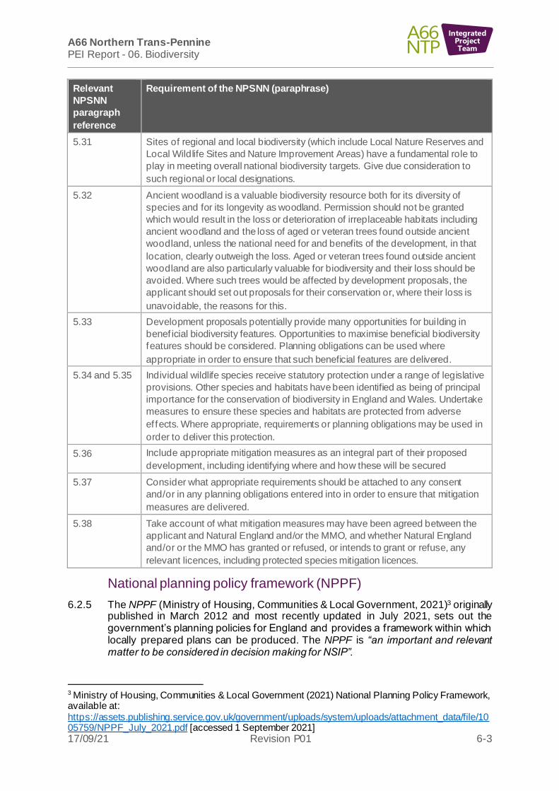
6.2.4 Table 6-1: Relevant NPSNN policies for the biodiversity assessment methodology identif ies the NPSNN policies relevant to the biodiversity assessment methodology.
Table 6-1: Relevant NPSNN policies for the biodiversity assessment methodology
Relevant
NPSNN
paragraph
reference
Requirement of the NPSNN (paraphrase)
4.22 Under the Habitats Regulations, consideration will be given to European sites or
on any site to which the same protection is applied as a matter of policy, either
alone or in combination with other plans or projects.
5.22 Outline any likely significant effects on internationally, nationally and locally
designated sites of ecological or geological conservation importance on protected
species and on habitats and other species identified as being of principal
importance for the conservation of biodiversity and that the statement considers
the full range of potential impacts on ecosystems.
5.23 Demonstrate how the project has taken advantage of opportunities to conserve
and enhance biodiversity conservation interests.
5.29 Ensure proposals mitigate the harmful aspects of the development and, where
possible, to ensure the conservation and enhancement of the site’s biodiversity
are acceptable.
2 Department for Transport (2014) National Policy Statement for National Networks, available at: https://assets.publishing.service.gov.uk/government/uploads/system/uploads/attachment_data/file/387222/npsnn-print.pdf [accessed 6 September 2021]
A66 Northern Trans-Pennine PEI Report - 06. Biodiversity
17/09/21 Revision P01 6-3
IntegratedProjectTeam
Relevant
NPSNN
paragraph
reference
Requirement of the NPSNN (paraphrase)
5.31 Sites of regional and local biodiversity (which include Local Nature Reserves and
Local Wildlife Sites and Nature Improvement Areas) have a fundamental role to
play in meeting overall national biodiversity targets. Give due consideration to
such regional or local designations.
5.32 Ancient woodland is a valuable biodiversity resource both for its diversity of
species and for its longevity as woodland. Permission should not be granted
which would result in the loss or deterioration of irreplaceable habitats including
ancient woodland and the loss of aged or veteran trees found outside ancient
woodland, unless the national need for and benefits of the development, in that
location, clearly outweigh the loss. Aged or veteran trees found outside ancient
woodland are also particularly valuable for biodiversity and their loss should be
avoided. Where such trees would be affected by development proposals, the
applicant should set out proposals for their conservation or, where their loss is
unavoidable, the reasons for this.
5.33 Development proposals potentially provide many opportunities for building in
benef icial biodiversity features. Opportunities to maximise beneficial biodiversity
features should be considered. Planning obligations can be used where
appropriate in order to ensure that such beneficial features are delivered.
5.34 and 5.35 Individual wildlife species receive statutory protection under a range of legislative
provisions. Other species and habitats have been identified as being of principal
importance for the conservation of biodiversity in England and Wales. Undertake
measures to ensure these species and habitats are protected from adverse
ef fects. Where appropriate, requirements or planning obligations may be used in
order to deliver this protection.
5.36 Include appropriate mitigation measures as an integral part of their proposed
development, including identifying where and how these will be secured
5.37 Consider what appropriate requirements should be attached to any consent
and/or in any planning obligations entered into in order to ensure that mitigation
measures are delivered.
5.38 Take account of what mitigation measures may have been agreed between the
applicant and Natural England and/or the MMO, and whether Natural England
and/or or the MMO has granted or refused, or intends to grant or refuse, any
relevant licences, including protected species mitigation licences.
National planning policy framework (NPPF)
6.2.5 The NPPF (Ministry of Housing, Communities & Local Government, 2021)3 originally published in March 2012 and most recently updated in July 2021, sets out the government’s planning policies for England and provides a framework within which locally prepared plans can be produced. The NPPF is “an important and relevant matter to be considered in decision making for NSIP”.
3 Ministry of Housing, Communities & Local Government (2021) National Planning Policy Framework, available at: https://assets.publishing.service.gov.uk/government/uploads/system/uploads/attachment_data/file/1005759/NPPF_July_2021.pdf [accessed 1 September 2021]

A66 Northern Trans-Pennine PEI Report - 06. Biodiversity
17/09/21 Revision P01 6-4
IntegratedProjectTeam
Local planning policy
6.2.6 The following local planning policies are relevant to the assessment:
• Eden Local Plan (2014-2032) (Eden District Council, 2014)4 Policy ENV1 and Policy ENV4
• County Durham Plan (Adopted 2020) (Durham County Council, 2020)5 Policy 26, Policy 40, Policy 41, Policy 42 and Policy 43
• Richmondshire Local Plan (2012-2028) adopted 2014 (Richmondshire District Council, 2014)6 Core Policy CP12
• Cumbria BAP (Cumbria Biodiversity Partnership, 2001)7
• Durham County Council BAP (2012/13) now listed on North East England Nature Partnership (North East England Nature Partnership, 2013)8
• Richmondshire District Councils BAP (Richmond County Council, 2014)9
Standards and guidance
6.2.7 In addition to compliance with the NPSNN and NPPF, this assessment has been compiled in accordance with professional standards and guidance. The standards and guidance which relate to the assessment are:
• The UK Biodiversity Action Plan (UK BAP) (Her Majesty's Stationary Office, 1994)10
• Guidance for Ecological Impact Assessment in the United Kingdom Third Edition (Chartered Institute of Ecology and Environmental Management, 2018)11
• Design Manual for Roads and Bridges (DMRB) LA 101 Introduction to Environmental Assessment (DMRB LA 101), Revision 1 July 2019 (Highways England, 2019a)12
4 Eden District Council (2014) Eden Local Plan 2014 to 2032, available at: https://www.eden.gov.uk/media/5032/edenlocalplan2014-2032finalwithoutforeword.pdf [accessed 1 September 2021] 5 Durham Council (2020) County Durham Plan – Adopted 2020, available at: https://www.durham.gov.uk/media/34069/County-Durham-Plan-adopted-2020-/pdf/CountyDurhamPlanAdopted2020vDec2020.pdf?m=637424969331400000 [accessed 1 September 2021] 6 Richmond County Council (2014) Richmondshire Local Plan 2012 - 2028 Core Strategy (Adopted 9 December 2014), available at: https://www.richmondshire.gov.uk/media/9616/core-strategy-2012-28.pdf [accessed 1 September 2021] 7 Cumbria Biodiversity Partnership (2001) The Cumbria Biodiversity Action Plan, available at: https://www.cumbria.gov.uk/planning-environment/conservation/biodiversity/bio_bap.asp [accessed 1 September 2021] 8 North East England Nature Partnership (2013) Biodiversity Priorities, available at: https://neenp.org.uk/natural-environment/biodiversity-priorities/ [accessed 1 September 2021] 9 Richmond County Council (2014) Richmondshire Biodiversity Action Plan, available at: https://www.richmondshire.gov.uk/media/5114/richmondshire-biodiversity-action-plan.pdf [accessed 1 September 2021] 10 Her Majesty's Stationary Office (1994) Biodiversity: The UK Action Plan, available at: https://assets.publishing.service.gov.uk/government/uploads/system/uploads/attachment_data/file/272038/2428.pdf [accessed 1 September 2021] 11 Chartered Institute of Ecology and Environmental Management (2018) Guidance for Ecological Impact Assessment in the United Kingdom Third Edition 12 Highways England (2019a) Design Manual for Roads and Bridges LA 101 Introduction to environmental assessment, available at: https://www.standardsforhighways.co.uk/prod/attachments/54b0eb69-fd65-4fa5-a86b-7313f70b3649?inline=true [accessed 1 September 2021]
A66 Northern Trans-Pennine PEI Report - 06. Biodiversity
17/09/21 Revision P01 6-5
IntegratedProjectTeam
• DMRB LA 104 Environmental Assessment and Monitoring (DMRB LA 104), Revision 1, Aug 2020 (Highways England, 2019b)13
• DMRB LA 108 Biodiversity (DMRB LA 108), Revision 1, March 2020 • DMRB LA 115 Habitat Regulation Assessment (DMRB LA 115), Revision 1,
January 2020 (Highways England, 2020b)14
• DMRB LD 118 Biodiversity Design (DMRB LD 118), Revision 1, March 2020 (Highways England, 2020c)15
• DMRB LD 119 Roadside environmental mitigation and enhancement (DMRB LD 119), Revision 1, March 2020 (Highways England, 2020d)16
6.3 Assessment Methodology
6.3.1 The assessment on biodiversity resources will be prepared in accordance with DMRB LA 104, DMRB LA 108 and DMRB LD 118, (which has been revised to align with the CIEEM Guidelines for Ecological Impact Assessment in the UK and Ireland).
6.3.2 The assessment will consider both construction and operation and will also be informed by the air quality assessment (refer to Chapter 5: Air Quality), noise assessments for sensitive resources (Chapter 12: Noise and vibration) and the drainage and hydrology assessment (Chapter 14: Road Drainage and the Water Environment).
Importance of biodiversity resource
6.3.3 The assessment to inform this PEI Report chapter will f irst focus on determining the importance of the biodiversity resources identified within the study area using the guidance in Table 3.9 of DMRB LA 108. Baseline studies (desk study and field survey) will then be used to establish the relative importance of the biodiversity resource as International or European importance, UK or National importance, Regional importance, County or equivalent authority importance or Local importance.
Level of impact
6.3.4 Potential impacts to inform this PEI Report will be described in terms of temporary (during construction only) or permanent, reversible or irreversible, positive or negative. Professional judgement will be used to assess whether an impact is likely to negatively or positively impact the integrity of a resource. Where we have not been able to quantify the magnitude of impacts at this stage, due to the gaps in survey data, a precautionary approach has been undertaken to identify the potential level of impact.
13 Highways England (2019b) Design Manual for Roads and Bridges LA 104 Environmental assessment and monitoring. Revision 1, available at: https://www.standardsforhighways.co.uk/prod/attachments/0f6e0b6a-d08e-4673-8691-cab564d4a60a?inline=true [accessed 1 September 2021] 14 Highways England (2020b) Design Manual for Roads and Bridges LA 115 Habitat Regulation Assessment, Revision 1, January 2020, available at: https://www.standardsforhighways.co.uk/prod/attachments/e2fdab58-d293-4af7-b737-b55e08e045ae?inline=true [accessed 1 September 2021] 15 Highways England (2020c) Design Manual for Roads and Bridges LD 118 Biodiversity Design, Revision 1, March 2020, available at: https://www.standardsforhighways.co.uk/prod/attachments/9317652b-4cb8-4aaf-be57-b96d324c8965?inline=true [accessed 1 September 2021] 16 Highways England (2020c) Design Manual for Roads and Bridges LD 119 Roadside environmental mitigation and enhancement, Revision 1, March 2020, available at: https://www.standardsforhighways.co.uk/prod/attachments/6cacd1e7-dcff-4ff8-aa64-bd5556a5eedc?inline=true [accessed 1 September 2021]
A66 Northern Trans-Pennine PEI Report - 06. Biodiversity
17/09/21 Revision P01 6-6
IntegratedProjectTeam
Assessing significance
6.3.5 The PEI Report will describe any potential likely significant effects of the project on biodiversity resources based on the preliminary baseline information collected to date and the current understanding of the project. An assessment of whether there is the potential for a significant effect has been made using professional judgement using the preliminary information available currently regarding the likely presence of the habitat, species and source impact pathways (where known) and the current stage of design. The level of significance has been defined using Table 3.13 of DMRB LA 108. A full impact assessment including assessment of magnitude/level of impact will be undertaken for the ES in accordance with DMRB LA 108 and in line with CIEEM guidance.
Surveys completed to date
6.3.6 In order to determine baseline conditions within the study area, a range of habitat and protected species surveys have been undertaken or are currently underway (Appendix 6.2: Ecological field surveys methodology and study areas). All surveys have been undertaken in accordance with relevant industry guidance/standards and/or through consultation with statutory consultees. The scope of these surveys was determined through a desk study, including consideration of the habitats present within the project Zone of Influence (ZoI) through a detailed review of aerial photos, Ordnance Survey (OS) mapping, the Multi-Agency Geographic Information for the Countryside (MAGIC) database and habitat data received from previous surveys undertaken and the Local Environmental Records Centres. Biological records for habitats and species were received from Environmental Records Information Centre North East (ERIC NE), North and East Yorkshire Ecological Data Centre (NEYEDC), Cumbria Biodiversity Data Centre (CBDC), Cumbria Amphibian and Reptile Group (ARG) and Rachel Hepburn for an adder record (member of North East Reptile and Amphibian Group NERAG). Only biological records recorded within the last ten years were included in the assessment as these are most likely to represent the current species assemblage of an area. Freshwater ecology records were downloaded from the Environment Agency Ecology and Fish Data Explorer17 and white-clawed crayfish and fish survey data was provided by the Eden Rivers Trust (ERT).
6.3.7 Survey areas for respective survey types have been informed by desktop data, best practice guidance for each feature type (as detailed in DMRB LA 108) and considering the likely ZoI applicable to the anticipated impacts of the project. Survey areas and methodologies are described in Appendix 6.2: Ecological field surveys methodology and study areas.
6.3.8 Ecology surveys are ongoing, as indicated in the last column of Appendix 6.1: Ecological field surveys methodology and study areas. Baseline surveys will be completed in time to inform the ES.
6.4 Assessment Assumptions and Limitations
6.4.1 There are a small number of areas within the desktop study area where the full list of biological records, as detailed in paragraph 6.5.2, were yet to be provided at the time of writing the PEI. An updated request for biological records for the full extent of the draft DCO boundary will be included in the ES.
6.4.2 Ecology surveys are ongoing as set out in Appendix 6.2: Ecological field surveys methodology and study areas, and therefore this assessment has been based on preliminary desktop assessment and survey data available at the time of assessment
17 Environment Agency (2021) Ecology and Fish Data Explorer, available at https://environment.data.gov.uk/ecology/explorer/ [accessed 1 September 2021]

A66 Northern Trans-Pennine PEI Report - 06. Biodiversity
17/09/21 Revision P01 6-7
IntegratedProjectTeam
(incorporating data from surveys to end of June 2021, with surveys after that time unavailable due to time required for data processing and quality assurance and assessment). The complete baseline will be included in the ES.
6.4.3 Surveys were undertaken within a study area based on the draft DCO boundary at the time of survey. There are a limited number of locations where the current draft DCO boundary extends further (particularly where alternative routes are under consideration), therefore surveys are (or will be, depending on season) being undertaken to cover the full draft DCO boundary in order to inform the ES. For the purpose of the PEI Report a precautionary approach has been applied assuming presence of a protected/notable species in the absence of survey data.
6.4.4 Phase 1 Habitat surveys are planned for all draft DCO scheme boundaries plus a 250m buffer but are not complete in all areas (due to changes in boundary and/or restricted land access). Consequently, assumptions on habitat assemblages have been based on aerial photos to complete gaps until a Phase 1 Habitat survey can be undertaken. The initial Phase 1 Habitat plan (Figure 6.3: Phase 1 Habitat Survey) has not to date been fully ground-truthed in these areas that are as yet un-surveyed so may contain inaccuracies. This will be updated for the ES.
6.4.5 Use of desk data from Natural England relating to Priority Habitats has not been reviewed in the field to confirm condition. This resource also omits rivers and hedgerows as Priority Habitats within the dataset for this study area, and as a result these linear habitats are not presented within report mapping for Priority Habitats (Figure 6.2: Priority Habitats and Ancient Woodland). These habitats have been considered within baseline reporting and the likely significant effect tables in the PEI Report and will be fully mapped for the ES.
6.4.6 No aquatic species field survey data was available at the time of writing due to time required for data processing and analysis. Consequently, assumptions on species presence/likely absence are based on desktop data and habitat assessment of rivers.
6.4.7 Limited bat activity survey data was available at the time of writing; consequently, the assessment of impacts on crossing points is limited and based on a review of the desk top information, known bat species and Phase 1 Habitat survey information. These sources have been used to assess areas of high habitat quality for foraging and connectivity within the landscape that may be affected by the proposed scheme. For these bat species a precautionary approach has been taken (assuming species are present where the habitat is suitable) and therefore represents a robust approach to identifying potential significant effects at this stage. Full survey data will be available for, and will inform, the ES.
6.4.8 Great crested newt were assumed present for ponds that were difficult to access e.g. extensive wetlands or steep sided water features, when they were within 250m of an existing population.
6.4.9 There are limitations related to the Affected Road Network (ARN) as described in 6.5.3.
6.5 Study Area
Route wide
6.5.1 The study area is defined in accordance with DMRB LA 108, LD 118 and CIEEM Guidelines for Ecological Impact Assessment in the UK and Ireland. In line with this guidance, the draft DCO boundary, including potential construction areas, is included along with the project’s ZoI on each biodiversity resource. In establishing the ZoI, potential impact pathways during construction and/or operational phases were

A66 Northern Trans-Pennine PEI Report - 06. Biodiversity
17/09/21 Revision P01 6-8
IntegratedProjectTeam
considered in relation to air quality, water quality, noise and vibration, which could have direct or indirect effects on biodiversity resources.
6.5.2 For the purposes of the ecological desktop study, the study area was defined as follows with measurements taken from the nearest point from the draft DCO boundary and the desk study areas are shown on Figure 6.1: Designated Sites.
• 2km radius for international sites of nature conservation importance (or 30km for SAC where bats are noted as one of the qualifying interests).
• 2km radius for nationally designated sites for nature conservation importance.
• 1 km radius for regionally important and local non-statutory designated sites. • 1 km radius for protected/notable species.
• 1 km radius for Section 41 Habitats of Principal Importance, Ancient Woodland Inventory sites and veteran trees.
6.5.3 Additionally, a high level review of any other statutory sites where a potential impact pathway exists (e.g. considered to be hydrologically linked or where there may be changes in air quality and noise due to increased traffic volume on the road) has been undertaken. This has included a review of designated sites and ancient woodlands within the ecology study area to identify any that that are potentially impacted by changes to the traffic within the wider ARN (sites within 200m of the ARN). The assessment at this stage has focussed on the sensitivity of the habitats and species for which the sites have been designated to changes in air quality, and a review of likely air quality changes anticipated through the preliminary modelling. Once more air quality information is available, including relating to nitrogen deposition, a full assessment of impact on receptors along the ARN will be undertaken and will be reported in the ES. A detailed review alongside other topics (e.g. hydrology, soils, geomorphology, etc) of potential impact pathways associated with designated sites will be undertaken to inform the ES.
6.5.4 The desktop assessment has incorporated the use of OS mapping and aerial imagery to identify key habitats and areas for field survey.
6.5.5 Environmental records obtained included freely available data from the MAGIC website, Natural England Open Data and the National Biodiversity Network (NBN) Atlas. In addition, records from database searches with relevant statutory and non-statutory consultees including the Environment Agency, CBDC, North Cumbria Barn Owls Study Group, ERIC Natural England, NEYEDC, River Eden Rivers Trust, Charles Fletcher (Yorkshire County Recorder for macro-moths), Suzanne May Cumbria Amphibian and Reptile Group (CARG), Bob Marsh (Yorkshire County Recorder for Coleoptera), the North Yorkshire Bat Group and Richard Lansdown for aquatic plant, moss, liverwort and lichen species associated with the River Eden SSSI.
6.5.6 The ZoI for each biodiversity resource is described in Appendix 6-2: Ecological field surveys methodology and study areas.
6.6 Baseline Conditions
Route wide
Statutory designated sites
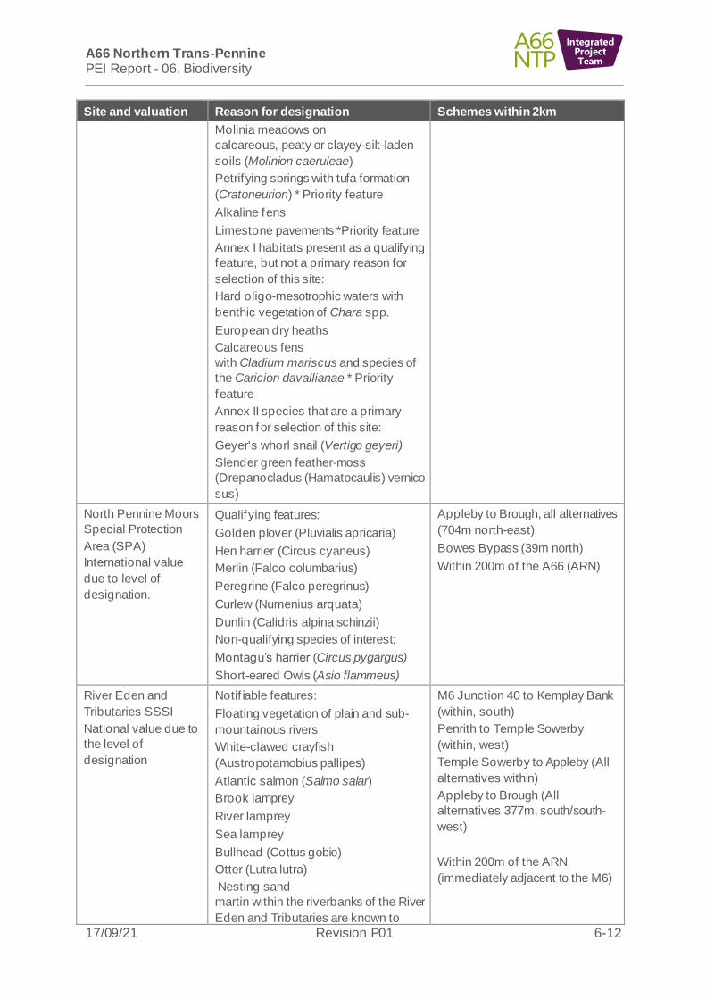
6.6.1 There are four SACs, one SPA, one Local Nature Reserve (LNR) and one National Nature Reserve (NNR) within the 2km route wide study area. There are no SACs designated for bats within 30km of any of the schemes. There are ten SSSIs designated for biodiversity within the route wide study area (three SSSI are
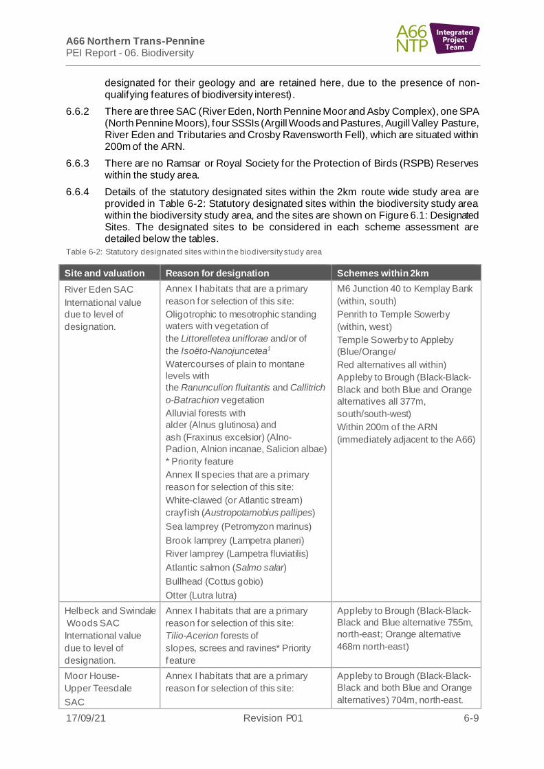
A66 Northern Trans-Pennine PEI Report - 06. Biodiversity
17/09/21 Revision P01 6-9
IntegratedProjectTeam
designated for their geology and are retained here, due to the presence of non-qualifying features of biodiversity interest).
6.6.2 There are three SAC (River Eden, North Pennine Moor and Asby Complex), one SPA (North Pennine Moors), four SSSIs (Argill Woods and Pastures, Augill Valley Pasture, River Eden and Tributaries and Crosby Ravensworth Fell), which are situated within 200m of the ARN.
6.6.3 There are no Ramsar or Royal Society for the Protection of Birds (RSPB) Reserves within the study area.
6.6.4 Details of the statutory designated sites within the 2km route wide study area are provided in Table 6-2: Statutory designated sites within the biodiversity study area within the biodiversity study area, and the sites are shown on Figure 6.1: Designated Sites. The designated sites to be considered in each scheme assessment are detailed below the tables.
Table 6-2: Statutory designated sites within the biodiversity study area
Site and valuation Reason for designation Schemes within 2km
River Eden SAC
International value
due to level of
designation.
Annex I habitats that are a primary
reason for selection of this site:
Oligotrophic to mesotrophic standing
waters with vegetation of
the Littorelletea uniflorae and/or of
the Isoëto-Nanojuncetea1
Watercourses of plain to montane
levels with
the Ranunculion fluitantis and Callitrich
o-Batrachion vegetation
Alluvial forests with
alder (Alnus glutinosa) and
ash (Fraxinus excelsior) (Alno-
Padion, Alnion incanae, Salicion albae)
* Priority feature
Annex II species that are a primary
reason for selection of this site:
White-clawed (or Atlantic stream)
crayf ish (Austropotamobius pallipes)
Sea lamprey (Petromyzon marinus)
Brook lamprey (Lampetra planeri)
River lamprey (Lampetra fluviatilis)
Atlantic salmon (Salmo salar)
Bullhead (Cottus gobio)
Otter (Lutra lutra)
M6 Junction 40 to Kemplay Bank
(within, south)
Penrith to Temple Sowerby
(within, west)
Temple Sowerby to Appleby
(Blue/Orange/
Red alternatives all within)
Appleby to Brough (Black-Black-
Black and both Blue and Orange
alternatives all 377m,
south/south-west)
Within 200m of the ARN
(immediately adjacent to the A66)
Helbeck and Swindale
Woods SAC
International value
due to level of
designation.
Annex I habitats that are a primary
reason for selection of this site:
Tilio-Acerion forests of
slopes, screes and ravines* Priority
feature
Appleby to Brough (Black-Black-
Black and Blue alternative 755m,
north-east; Orange alternative
468m north-east)
Moor House-
Upper Teesdale
SAC
Annex I habitats that are a primary
reason for selection of this site:
Appleby to Brough (Black-Black-
Black and both Blue and Orange
alternatives) 704m, north-east.

A66 Northern Trans-Pennine PEI Report - 06. Biodiversity
17/09/21 Revision P01 6-10
IntegratedProjectTeam
Site and valuation Reason for designation Schemes within 2km
International value
due to level of
designation.
Hard oligo-mesotrophic waters with
benthic vegetation of Chara spp.
Alpine and Boreal heaths
Juniper (Juniperus
communis) formations on heaths or
calcareous grasslands
Calaminarian grasslands of the
Violetalia calaminariae
Siliceous alpine and boreal grasslands
Semi-natural dry grasslands and
scrubland facies on calcareous
substrates (Festuco-Brometalia) (*
important orchid sites)
Molinia meadows on
calcareous, peaty or clayey-silt-laden
soils (Molinion caeruleae)
Hydrophilous tall herb fringe
communities of plains and of the
montane to alpine levels
Mountain hay meadows
Blanket bogs
Petrifying springs with tufa
formation (Cratoneurion) *Priority
feature
Alkaline fens
Alpine pioneer formations of the
Caricion bicoloris-atrofuscae* Priority
feature
Siliceous scree of the montane to snow
levels
(Androsacetalia alpinae and Galeopsiet
alia
ladani)
Calcareous and calcshist screes of the
montane to alpine
levels (Thlaspietea rotundifolii)
Calcareous rocky slopes with
chasmophytic vegetation
Siliceous rocky slopes with
chasmophytic vegetation
Annex I habitats present as a qualifying
feature, but not a primary reason for
selection of this site:
European dry heaths
Limestone pavements *Priority feature
Annex II species that are a primary
reason for selection of this site:

A66 Northern Trans-Pennine PEI Report - 06. Biodiversity
17/09/21 Revision P01 6-11
IntegratedProjectTeam
Site and valuation Reason for designation Schemes within 2km
Round-mouthed whorl
snail (Vertigo genesii)
Marsh saxifrage (Saxifraga hirculus)
North Pennines
Moors SAC
International value
due to level of
designation.
Annex I habitats that are a primary
reason for selection of this site:
European dry heaths
Juniper (Juniperus
communis) formations on heaths or
calcareous grasslands
Blanket bogs (* if active bog) *Priority
feature
Petrifying springs with tufa
formation (Cratoneurion) *Priority
feature
Siliceous rocky slopes
with chasmophytic vegetation
Old sessile oak woods
with Ilex and Blechnum in the British
Isles
Annex I habitats present as a qualifying
feature, but not a primary reason for
selection of site:
Northern Atlantic wet heaths with cross-
leaved heath (Erica tetralix)
Calaminarian grasslands of
the Violetalia calaminariae
Siliceous alpine and boreal grasslands
Semi-natural dry grasslands and
scrubland facies on calcareous
substrates (Festuco-
Brometalia) (*important orchid sites)
Alkaline fens
Siliceous scree of the montane to snow
levels (Androsacetalia alpinae and Gale
opsietalia ladani)
Calcareous rocky slopes
with chasmophytic vegetation
Annex II species present as a qualifying
feature, but not a primary reason for
site selection:
Marsh saxifrage
Bowes Bypass (39m north)
Within 200m of the ARN
Asby Complex SAC
International value
due to level of
designation.
Annex I habitats that a primary reason
for selection of this site:
Semi-natural dry grasslands and
scrubland facies on calcareous
substrates (Festuco-Brometalia) (*
important orchid sites)
Within 200m of the ARN relating
to M6 Junction 40 to Kemplay
Bank (immediately adjacent to the
M6 motorway)
A66 Northern Trans-Pennine PEI Report - 06. Biodiversity
17/09/21 Revision P01 6-12
IntegratedProjectTeam
Site and valuation Reason for designation Schemes within 2km
Molinia meadows on
calcareous, peaty or clayey-silt-laden
soils (Molinion caeruleae)
Petrifying springs with tufa formation
(Cratoneurion) * Priority feature
Alkaline fens
Limestone pavements *Priority feature
Annex I habitats present as a qualifying
feature, but not a primary reason for
selection of this site:
Hard oligo-mesotrophic waters with
benthic vegetation of Chara spp.
European dry heaths
Calcareous fens
with Cladium mariscus and species of
the Caricion davallianae * Priority
feature
Annex II species that are a primary
reason for selection of this site:
Geyer's whorl snail (Vertigo geyeri)
Slender green feather-moss
(Drepanocladus (Hamatocaulis) vernico
sus)
North Pennine Moors
Special Protection
Area (SPA)
International value
due to level of
designation.
Qualifying features:
Golden plover (Pluvialis apricaria)
Hen harrier (Circus cyaneus)
Merlin (Falco columbarius)
Peregrine (Falco peregrinus)
Curlew (Numenius arquata)
Dunlin (Calidris alpina schinzii)
Non-qualifying species of interest:
Montagu’s harrier (Circus pygargus)
Short-eared Owls (Asio flammeus)
Appleby to Brough, all alternatives
(704m north-east)
Bowes Bypass (39m north)
Within 200m of the A66 (ARN)
River Eden and
Tributaries SSSI
National value due to
the level of
designation
Notif iable features:
Floating vegetation of plain and sub-
mountainous rivers
White-clawed crayfish
(Austropotamobius pallipes)
Atlantic salmon (Salmo salar)
Brook lamprey
River lamprey
Sea lamprey
Bullhead (Cottus gobio)
Otter (Lutra lutra)
Nesting sand
martin within the riverbanks of the River
Eden and Tributaries are known to
M6 Junction 40 to Kemplay Bank
(within, south)
Penrith to Temple Sowerby
(within, west)
Temple Sowerby to Appleby (All
alternatives within)
Appleby to Brough (All
alternatives 377m, south/south-
west)
Within 200m of the ARN
(immediately adjacent to the M6)

A66 Northern Trans-Pennine PEI Report - 06. Biodiversity
17/09/21 Revision P01 6-13
IntegratedProjectTeam
Site and valuation Reason for designation Schemes within 2km
comprise the largest colony in
Cumbria.
Crosby Ravensworth
Fell SSSI
National value due to
the level of
designation
Notif iable features:
One of the few remaining areas of
lowland heathland in Cumbria.
Limestone pavements are an important
feature of the site and form the western
outliers of the Great Asby Complex of
pavements.
Other habitats which are of secondary
interest but contribute to the overall
value of the site include calcareous and
acid grasslands and base-rich flushes.
The site also supports an assemblage
of typical moorland breeding birds such
as golden plover (Pluvialis apricaria),
red grouse (Lagopus lagopus scotica),
redshank, oystercatcher, curlew and
lapwing.
Within 200m of the ARN relating
to M6 Junction 40 to Kemplay
Bank (immediately adjacent to
M6)
Cliburn Moss SSSI
and NNR
National value due to
the level of
designation
A basin mire which supports wet
fen/bog, wet grassland and dry heath,
self -sown woodland, ditches/drains and
a pond. Supporting a mix of fen, bog
and heath communities with several
rare and or scarce plant species. It also
supports a diverse range of aquatic
beetle species and is of county
significance for breeding birds.
M6 Junction 40 to Kemplay bank
(1.77km west)
Udford Low Moss
SSSI
National value due to
the level of
designation
Notif iable features:
Fen and carr-woodland communities as
one of the few intact valley fens in
eastern Cumbria.
Tall fen and diverse fen grassland.
Wet (willow and alder) and dry
woodland (ash, or oak-birch), some
semi-natural and ancient in origin.
Breeding records for redshank, water
rail, snipe, reed bunting, sedge warbler
and marsh tit.
Presence of red squirrel.
Penrith to Temple Sowerby
(957m, eastnorth)
Cowraik Quarry Local
Nature Reserve
(LNR)
National level for
biodiversity resource
due to the presence
of the Priority Habitat
deciduous woodland
and potentially on the
Notif iable features:
Red squirrel (Sciurus vulgaris)
Deciduous woodland
Heathland
Many bird species
M6 Junction 40 to Kemplay Bank
1.80km north
Penrith to Temple Sowerby
1.58km north
A66 Northern Trans-Pennine PEI Report - 06. Biodiversity
17/09/21 Revision P01 6-14
IntegratedProjectTeam
Site and valuation Reason for designation Schemes within 2km
presence of
heathland.
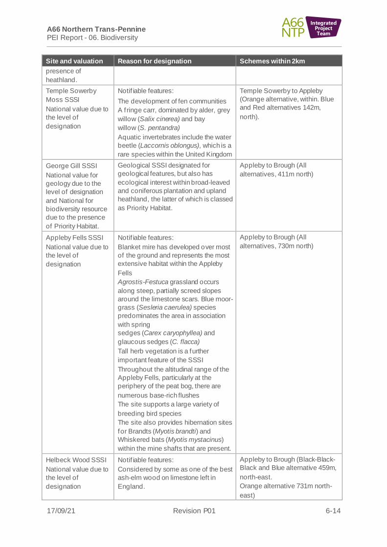
Temple Sowerby
Moss SSSI
National value due to
the level of
designation
Notif iable features:
The development of fen communities
A f ringe carr, dominated by alder, grey
willow (Salix cinerea) and bay
willow (S. pentandra)
Aquatic invertebrates include the water
beetle (Laccornis oblongus), which is a
rare species within the United Kingdom
Temple Sowerby to Appleby
(Orange alternative, within. Blue
and Red alternatives 142m,
north).
George Gill SSSI
National value for
geology due to the
level of designation
and National for
biodiversity resource
due to the presence
of Priority Habitat.
Geological SSSI designated for
geological features, but also has
ecological interest within broad-leaved
and coniferous plantation and upland
heathland, the latter of which is classed
as Priority Habitat.
Appleby to Brough (All
alternatives, 411m north)
Appleby Fells SSSI
National value due to
the level of
designation
Notif iable features:
Blanket mire has developed over most
of the ground and represents the most
extensive habitat within the Appleby
Fells
Agrostis-Festuca grassland occurs
along steep, partially screed slopes
around the limestone scars. Blue moor-
grass (Sesleria caerulea) species
predominates the area in association
with spring
sedges (Carex caryophyllea) and
glaucous sedges (C. flacca)
Tall herb vegetation is a further
important feature of the SSSI
Throughout the altitudinal range of the
Appleby Fells, particularly at the
periphery of the peat bog, there are
numerous base-rich flushes
The site supports a large variety of
breeding bird species
The site also provides hibernation sites
for Brandts (Myotis brandti) and
Whiskered bats (Myotis mystacinus)
within the mine shafts that are present.
Appleby to Brough (All
alternatives, 730m north)
Helbeck Wood SSSI
National value due to
the level of
designation
Notif iable features:
Considered by some as one of the best
ash-elm wood on limestone left in
England.
Appleby to Brough (Black-Black-
Black and Blue alternative 459m,
north-east.
Orange alternative 731m north-
east)

A66 Northern Trans-Pennine PEI Report - 06. Biodiversity
17/09/21 Revision P01 6-15
IntegratedProjectTeam
Site and valuation Reason for designation Schemes within 2km
Dominant ash (Fraxinus excelsior) tree
species.
Rich herb communities including dog’s
mercury (Mercurialis perennis) and
ramsons (Allium ursinum).
Presence of lichen species which are
characteristic of an ancient woodland.
Presence of two small artificial tarns
Large breeding bird population
Swindale Wood SSSI
National value due to
the level of
designation
Notif iable features:
Dominant ash (Fraxinus excelsior) tree
species
Rich herb communities including dog’s
mercury (Mercurialis perennis) and
ramsons (Allium ursinum).
Presence of lichen species which are
characteristic of an ancient woodland
Large breeding bird population
Appleby to Brough (Black-Black-
Black and Blue alternatives
1.3km, north-east.
Orange alternative 1.28km north-
east)
Bowes Moor SSSI
National value due to
the level of
designation
Notif iable features:
Bowes Moor SSSI meets the criteria for
designation under the terms of the
European Community Directive
79/409/EEC on the Conservation of
Wild Birds, in particular moorland
birds.
Drier parts of the blanket bog support
areas dominated by species such as
heather
Shallower peats and drier mineral soils
support heathland.
Bowes Bypass (255m north-west)
Augill Valley Pasture
SSSI National value
due to the level of
designation
Species-rich unimproved grassland
containing a number of rare and locally
restricted plant species and represents
one of the most diverse of its kind in
East Cumbria. This grassland grades to
woodland along the steep banks of
Augill Beck, supporting a varied ground
f lora with ancient woodland indicator
species.
Within 200m of the ARN related to
Appleby to Brough (all
alternatives)
Kilmond Scar SSSI
National value due to
the level of
designation
Notif iable features:
On the shallow soils which are prone to
drought, rock ledges, crevices and
scree, open vegetation contains a well-
developed moss layer, which contains
an abundant number of drought tolerant
annual and perennial species, including
biting stonecrop (Sedum acre).
Bowes Bypass (747m south-east)
Cross Lanes to Rokeby (all
alternatives) 1.39km north-east

A66 Northern Trans-Pennine PEI Report - 06. Biodiversity
17/09/21 Revision P01 6-16
IntegratedProjectTeam
Site and valuation Reason for designation Schemes within 2km
Deeper limestone soils support
grassland species. The most common
of which are common
bent (Agrostis capillaris) and red
fescue (Festuca rubra).
Brignall Banks SSSI
National value due to
the level of
designation
Notif iable features:
The wood itself has had little human
management which has resulted in the
site being species rich.
On base-rich soils wych
elm (Ulmus glabra) and ash (Fraxinus
excelsior) mainly dominate the area.
On the more acidic soils, mature trees
are present.
The site supports a varied bryophyte
and lichen f lora, including several
lichens which are sensitive to air
pollution and are rare in Durham
County.
There is a diverse range of woodland
bird species including great spotted
woodpecker (Dendrocopos major).
Cross Lanes to Rokeby (all
alternatives) 607m south-east
Black Scar Quarry
SSSI
National level for
geological resource
and National level for
biodiversity resource
due to the presence
of Priority Habitat
Geological SSSI supporting dense
woodland habitat as a non-qualifying
feature which is classified as Priority
Habitat.
A1(M) Junction 53 Scotch Corner
(1.25km east).
Non-statutory designated sites
6.6.5 There are 22 non-statutory designated sites within the route wide study area. These are shown on Figure 6.1: Designated Sites and described in Table 6-3. It is assumed for the purposes of the PEI Report, that all non-statutory sites are designated for biodiversity resources of importance on a County level unless the site contains ancient woodland, where the importance is of National value (see paragraph 6.6.8) or Annexe 1 habitat where the importance is of International value.
6.6.6 Within 200m of the ARN, there is one CWS (Disused Railway Line near Newbiggin), three LWS (Pallet Hill, Ravensworth Park – Castle Fetch and the de-notif ied site of Stephen Bank Road Verge) and one Natural England Nature Improvement Area.
Table 6-3: Non-statutory designated sites
Site Reason for designation Scheme within 1km or within
200m of the ARN
Morecombe Bay
Limestone and
Wetlands Nature
Improvement Area
The Morecambe Bay area –
internationally important for its
wildlife –is of only 12 Nature
Improvement Areas (NIAs) in
England. The site supports over
Within 200m of ARN (M6, closest to
the M6 J40 to Kemplay Bank
Roundabout scheme (approximately
38km south west).

A66 Northern Trans-Pennine PEI Report - 06. Biodiversity
17/09/21 Revision P01 6-17
IntegratedProjectTeam
Site Reason for designation Scheme within 1km or within
200m of the ARN
(International value
due to level of
designated sites
within the Area).
1700 ha of Priority Habitat
(including wetland, limestone,
grassland and woodland)
supporting a variety of bird,
invertebrate and plant species.
Disused Railway
Line near Newbiggin
County Wildlife Site
(CWS)
Species-rich grassland, scrub and
tree habitats on banks of railway.
M6 Junction 40 to Kemplay Bank
(1km, south)
Within 200m of the ARN
Skirsgill Woods
County Wildlife Site
(CWS)
Broadleaved woodland M6 Junction 40 to Kemplay Bank
(within, south)
Yanwath Wood
CWS
Broadleaved woodland M6 Junction 40 to Kemplay Bank
(53m, west)
Myers Beck
(Mardale Road)
CWS
Myers Beck and associated riparian
grassland. Water vole population
listed in reasons for designation.
M6 Junction 40 to Kemplay Bank
(444m, north)
Whinfell Forest
CWS
(National value)
Mainly ancient, replanted woodland
with waterbodies and grassland
mosaics. Also designated for a
population of red squirrels.
Penrith to Temple Sowerby
(adjacent to scheme, east)
Watersmeet
(Eamont & Eden)
CWS
Riparian habitat. Penrith to Temple Sowerby (983m, north)
Acorn Bank Woods
and Garden CWS
Broadleaved woodland with formal
gardens and pond habitats.
Temple Sowerby to Appleby, Orange
alternative 337m, north
River Lyvennet
Floodplain CWS
Low lying wetland (mire and
swamp)/woodland habitat mosaic.
Temple Sowerby to Appleby. (Blue,
and Red alternatives 914m, west
and Orange 776m, west)
Chapel Wood
(Appleby in
Westmorland) CWS
(up to International
value)
Broadleaved ancient woodland.
May qualify as Annexe 1 alluvial
woodland habitat, for which the
adjacent River Eden SAC is
designated (to be confirmed
pending further surveys).
Temple Sowerby to Appleby (Blue,
Red and Orange alternative, within,
south-west)
Ross Wood CWS
(National value)
Broadleaved ancient woodland
(oak).
Temple Sowerby to Appleby (Blue,
Orange and Red alternatives at
146m, south).
Dowpits Wood
(National value)
Broadleaved ancient woodland (ash
and oak).
Temple Sowerby to Appleby
(Orange and Red alternatives at
904m, west and Blue 933m west)
Sandford Mire CWS Lowland Fens, species-rich mire. Appleby to Brough (All alternatives -
within)
Swindale Woodland
CWS
Broadleaved woodland. Appleby to Brough (Black-Black-
Black and Blue alternative, 513m,

A66 Northern Trans-Pennine PEI Report - 06. Biodiversity
17/09/21 Revision P01 6-18
IntegratedProjectTeam
Site Reason for designation Scheme within 1km or within
200m of the ARN
south. Orange alternative 514m,
south)
Tricklebanks Wood
CWS
(National value)
Ancient woodland. Appleby to Brough (All alternatives)
933m, south west.
Thorsgill Wood LWS
(National value)
Broadleaved ancient woodland and
marsh.
Cross Lanes to Rokeby (455m, east)
Teesbank Woods,
Rokeby LWS
(National value)
Mainly ancient woodland, with river,
bare rock and shingle banks.
Cross Lanes to Rokeby (60m, north
east)
Rokeby Park
and Mortham Wood
LWS
(National value)
Parkland, woodland and pasture
(Priority habitat and potential
Ancient Woodland).
Cross Lanes to Rokeby (within)
Stephen Bank Road
Verge (De-notified
LWS)
Species-rich grassland habitat
Stephen Bank to Carkin Moor (within, north)
Within 200m of the ARN
Aske Estate
Woodlands LWS
(National value)
Deciduous woodland, possibly ancient woodland.
Stephen Bank to Carkin Moor (938m, south-west)
Ravensworth Park –
Castle Fetch LWS
Pond, marsh, wet grassland, scrub
and tree habitats and open mosaic
habitats.
Within 200m of the ARN relating to
Stephen Bank to Carkin Moor
Pallet Hill LWS Significant population of non-
breeding waterbirds.
Within 200m of the ARN relating to
A1(M) Junction 53 Scotch Corner
Limekiln Wood Site of Importance for Nature Conservation (SINC)
(County, though
Limekiln Wood itself
is Ancient Woodland
therefore partly
National value)
Broadleaved woodland including
ancient woodland.
Within 200m of the ARN,
approximately 8.7km south of the
A1(M) Junction 53 Scotch Corner
6.6.7 There are also ten sites of invertebrate significance within the River Eden SAC/River Eden and tributaries SSSI namely: Eamont Bridge Banks of River Eamont (River Eamont), Lowther Bridge (River Lowther), Temple Sowerby Shingle Bank (River Eden), Temple Sowerby Moss, River Eden Oglebird Scar Ers (River Eden) and Acorn Bank (Crowdundle Beck), Bolton shingle bank (River Eden), Helbeck Wood, Swindale Wood and Great Musgrave Swindale Beck Ers. These are of County level value due to the designation at the level of Cumbria.
Priority habitats and ancient woodland sites
6.6.8 The desktop study identified nine Priority Habitat types within the draft DCO boundary of the route wide project: deciduous woodland (broadleaved and mixed), rivers and streams, good quality semi-improved grassland (lowland meadows and pastures),

A66 Northern Trans-Pennine PEI Report - 06. Biodiversity
17/09/21 Revision P01 6-19
IntegratedProjectTeam
lowland fens, upland heath purple moor-grass and rush pastures, lowland dry acid grassland, coastal and floodplain grazing marsh (floodplain grazing marsh only) and traditional orchards. The additional Priority Habitats upland hay meadow was identif ied within 250m of the route wide draft DCO boundary.
6.6.9 Within 200m of the ARN there are 22 ancient woodlands (Augill Beck, Augil l Bridge Wood, Bessygill, Borrowdale, Chapel, Cocklet, Deepdale, Deepgill, Gillbeck Wood, Graham’s Gill/ Jack Wood, Limekiln, Lowgill, Lowhurst Wood, Newbiggin Wood, Oglebird Plantation, Raughtonguil Wood, Sexton Hagg, Sexton Hagg Extension, Teesbank, Thorsgill Wood, Warth, Waterfall).
6.6.10 All ancient woodland sites and veteran trees are considered to be of National importance due to their irreplaceable nature. Areas of which meet the criteria for Priority Habitat are considered to be of National value.
6.6.11 The location of Priority Habitats, ancient woodlands and ancient/veteran trees are shown on Figure 6.2: Priority Habitats and Ancient Woodland.
Phase 1 habitats
6.6.12 The habitats recorded within 250m of the draft DCO boundary during the Phase 1 Habitat surveys are outlined in Table 6-4: Phase 1 Habitat types and shown on Figure 6.3: Phase 1 Habitat Survey. Valuations are based on current survey data and a review of habitats included in relevant County/Local Authority Plans and Strategies. Valuations may be revised down for the ES when further Phase 1 Habitat survey data is available. This is considered to be a robust assessment with highest possible level of valuation stated on a precautionary basis.
Table 6-4: Phase 1 Habitat types
Habitat type and valuation Description
Broadleaved semi-natural woodland
Majority up to National value due to the presence
of Priority Habitats (deciduous woodland types).
Up to International value for the Temple Sowerby
to Appleby scheme due to the possible presence
of an Annex 1 woodland habitat
County or Local Authority Plan Habitats present;
Cumbria BAP - Upland oak woodland, upland
mixed ash woodland, wet woodland.
Durham County Council BAP - Woodland and
Scrub (Ancient Semi-Natural Woodland including
Planted Ancient Woodland Sites, Restored Native
Woodland on Ancient Sites, Other Broadleaf
Woodland, Wet Woodland.
Richmondshire District Councils BAP - Ash
woodland, oak woodland, wet woodland, other
woodland types, lowland wood pasture and
parkland
Several types of this woodland are present across
the route, most being small and/or fragmented from
other areas of continuous semi-natural habitats,
with varying degrees of naturalness. Drier
soils/areas support pedunculate oak (Quercus
robur) as the canopy dominant. The drier stands
are dominated by ash (Fraxinus excelsior). Where
f ield layers are evident in both the ash (Fraxinus
excelsior) and oak woodlands, these are often
represented by dog’s mercury
(Mercurialis perennis) and native bluebell
(Hyacinthoides non-scripta).
Chapel Wood CWS is designated for broad-leaved
woodland habitats. These woodlands may qualify
as the Annex 1 alluvial woodland habitat, for which
the adjacent River Eden SAC is designated.
Broadleaved plantation woodland
Up to National value due to the possible presence
of Priority Habitats (deciduous woodland types).
County or Local Authority Plan Habitats present;
Cumbria BAP - Upland oak woodland, upland
mixed ash woodland, wet woodland.
This is present in many locations either as part of
amenity planting contiguous to the A66 corridor, or
over more native woodland habitats. There is great
diversity amongst the planted stands.

A66 Northern Trans-Pennine PEI Report - 06. Biodiversity
17/09/21 Revision P01 6-20
IntegratedProjectTeam
Habitat type and valuation Description
Durham County Council BAP - Woodland and
Scrub (Ancient Semi-Natural Woodland including
Planted Ancient Woodland Sites, Other Broadleaf
Woodland, Wet Woodland.
Richmondshire District Councils BAP - Ash
woodland, oak woodland, wet woodland, other
woodland types, lowland wood pasture and
parkland.
Coniferous plantation woodland
Up to National value due to the possible presence
of Priority Habitats (heathland).
County or Local Authority Plan Habitats present;
Cumbria BAP - Wet woodland.
Durham County Council BAP - Woodland and
Scrub (Ancient Semi-Natural Woodland including
Planted Ancient Woodland Sites, Wet Woodland.
Richmondshire District Councils BAP - Wet
woodland, other woodland types, lowland wood
pasture and parkland
These are either dominated wholly by conifer
species or have a low mix of broad-leaved species.
These woodlands tend to be dominated by Scot’s
pine, Norway spruce (Picea abies), silver fir (Abies
alba), or are stands of Leyland cypress (Cupressus
x leylandii).
Mixed semi-natural woodland
Up to National value due to the presence of
Priority Habitats (deciduous woodland types and
heathland).
County or Local Authority Plan Habitats present;
Cumbria BAP - Upland oak woodland, upland
mixed ash woodland, wet woodland.
Durham County Council BAP - Woodland and
Scrub (Ancient Semi-Natural Woodland including
Planted Ancient Woodland Sites, Restored Native
Woodland on Ancient Sites, Other Broadleaf
Woodland, Wet Woodland.
Richmondshire District Councils BAP - Ash
woodland, oak woodland, wet woodland, other
woodland types, lowland wood pasture and
parkland
Various species-mixes are present across the
scheme, often originating from plantation woodland
but sufficiently developed as to form mixed semi-
natural woodlands.
Mixed semi-natural plantation woodland
Up to National value due to the possible presence
of Priority Habitats (deciduous woodland types
and heathland).
County or Local Authority Plan Habitats present;
Cumbria BAP - Upland oak woodland, upland
mixed ash woodland, wet woodland.
Durham County Council BAP - Woodland and
Scrub (Ancient Semi-Natural Woodland including
Planted Ancient Woodland Sites, Restored Native
Woodland on Ancient Sites, Other Broadleaf
Woodland, Wet Woodland.
Of ten these are associated with mature gardens,
game planting or are more recently planted
woodland blocks within private land.

A66 Northern Trans-Pennine PEI Report - 06. Biodiversity
17/09/21 Revision P01 6-21
IntegratedProjectTeam
Habitat type and valuation Description
Richmondshire District Councils BAP - Ash
woodland, oak woodland, wet woodland, other
woodland types, lowland wood pasture and
parkland
Dense scrub
Up to County value due to the possible presence
of County or Local Authority Habitats (woodland
and scrub).
County or Local Authority Plan Habitats present;
Durham County Council BAP - Woodland and
Scrub,
The route wide area is typified by dominant stands
of hazel, hawthorn, willow, gorse or bramble, each
being locally dominant where they occur.
Blackthorn occurs at much lower densities.
Scattered scrub
Local value unless within the Priority Habitat
Open Mosaic Habitat, which would be National
value as a whole
Self -seeded and planted stands of scrub on rail
embankments and road verges, scattered along
rocky exposures/ escarpments, scattered along
riverbanks, is represented by growth at woodland
edges, or occurs as remnants of defunct hedge
systems. Species composition similar to dense
scrub.
Broadleaved parkland scattered trees
National value due to presence of Priority Habitat
(Wood- Pasture and Parkland) and ancient and/or
veteran trees
County or Local Authority Plan Habitats present;
Durham County Council BAP - Parkland and
Wood Pasture
Richmondshire District Councils BAP - lowland
wood pasture and parkland
This is represented by diverse types which include
areas of semi-natural grassland overplanted with
trees. Some of these trees are mature with veteran
features; where such trees are present, these have
been noted as of importance.
Mixed parkland scattered trees
National value due to presence of Priority Habitat
(Wood- Pasture and Parkland)
County or Local Authority Plan Habitats present;
Durham County Council BAP - Parkland and
Wood Pasture
Richmondshire District Councils BAP - lowland
wood pasture and parkland
Includes trees over marshy grassland habitats with
mature pine trees and standing deadwood or
scattered trees on amenity grasslands including
mature examples of Scot’s pine.
Semi-improved acid grassland
Up to National value due to presence of Priority
Habitat (Lowland Acid Grassland)
County or Local Authority Plan Habitats present;
Durham County Council BAP - Lowland Heath
(Acid Grassland)
Richmondshire District Councils BAP - moorland
edge including Upland acid grassland,
This grassland type is only found in a few locations,
typically of sheep-grazed pasture.
Semi-improved neutral grassland False oat grass (Arrhenatherum elatius) is
dominant with abundant red fescue, frequent
presence of Yorkshire-fog, occasional cock’s-foot,

A66 Northern Trans-Pennine PEI Report - 06. Biodiversity
17/09/21 Revision P01 6-22
IntegratedProjectTeam
Habitat type and valuation Description
Up to National value due to presence of Priority
Habitat (Lowland Meadows and Upland Hay
Meadows)
County or Local Authority Plan Habitats present;
Durham County Council BAP - Lowland Meadows
and Pasture
common bent, crested dog’s-tail, common couch
(Elymus repens), meadow foxtail (Alopecurus
pratensis) and rare sheep’s fescue. Forb diversity
in these grasslands varies and can be limited to
ruderal species or can be diverse.
Improved grassland
Local value
This is one of the most frequent habitat types route
wide, outside the highway boundary. It is typically
dominated by perennial rye grass (Lolium
perenne), sometimes with frequent smooth
meadow grass (Poa pratensis), cock’s-foot
(Dactylis glomerata), Yorkshire-fog (Holcus
lanatus) and white clover (Trifolium repens).
Marsh/marshy grassland
Up to National value due to presence of Priority
Habitat (Coastal and Floodplain Grazing Marsh,
Upland Flushes, Fens and Swamps, Purple Moor-
grass and Rush Pastures)
County or Local Authority Plan Habitats present;
Cumbria BAP - purple moor-grass and rush
pasture, reedbed.
Durham County Council BAP - Lowland Fen
(Reedbed, Lowland Fen habitats), Floodplain
Grazing Marsh
Richmondshire District Councils BAP - f lood plain
grassland, fens, reedbeds.
This habitat is evident in both areas of floodplain
and other low-lying ground across the scheme.
Areas of the Yorkshire-fog dominated /damp
neutral grasslands frequently grade into this
habitat. This includes a range of areas where tufted
hair-grass dominates, to areas dominated by hard-
rush; and across gradients from low species
diversity to species-rich damp habitats.
Poor semi-improved grassland
Local value
False oat grass (Arrhenatherum elatius) is
dominant with abundant grasses similar to semi-
improved grassland.
Continuous bracken
Local value
This occurs as monotypical stands on steep
hillsides. Occasional bracken management was
recorded within agricultural land, with evidence of
areas that have been cut and bailed.
Tall ruderal vegetation
Local value
This habitat is present along the river and stream
corridors route wide, which are often fenced off
f rom adjacent pasture. It is also present at field
margins, within hedgerow ground flora, and on
embankments and cuttings for current and prior rail
corridors, and at roadsides.
The most dominant species is common nettle, with
locally frequent patches of rosebay willowherb, and
occasional ragwort, hogweed (Heracleum
sphondylium), cow parsley (Anthriscus sylvestris),
coltsfoot (Tussilago far-fara), broad-leaved dock,
scattered throughout.
Several stands of Himalayan balsam were
identified across the route wide project.
A66 Northern Trans-Pennine PEI Report - 06. Biodiversity
17/09/21 Revision P01 6-23
IntegratedProjectTeam
Habitat type and valuation Description
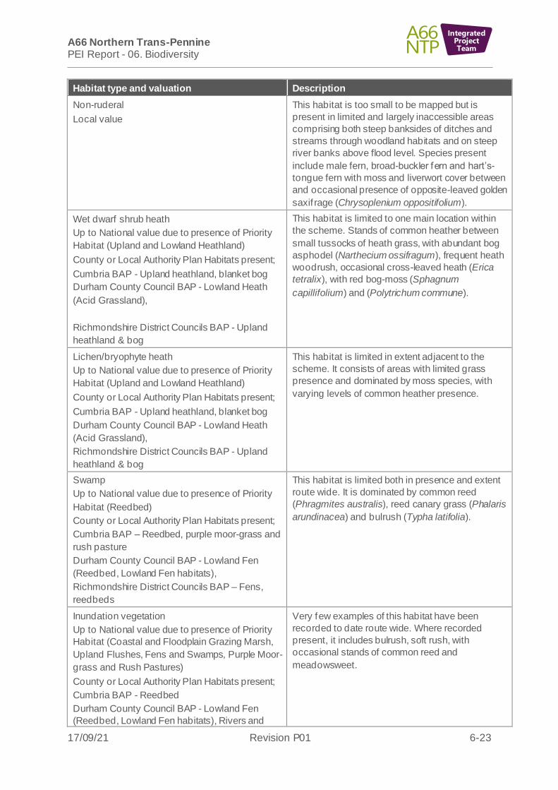
Non-ruderal
Local value
This habitat is too small to be mapped but is
present in limited and largely inaccessible areas
comprising both steep banksides of ditches and
streams through woodland habitats and on steep
river banks above flood level. Species present
include male fern, broad-buckler fern and hart’s-
tongue fern with moss and liverwort cover between
and occasional presence of opposite-leaved golden
saxif rage (Chrysoplenium oppositifolium).
Wet dwarf shrub heath
Up to National value due to presence of Priority
Habitat (Upland and Lowland Heathland)
County or Local Authority Plan Habitats present;
Cumbria BAP - Upland heathland, blanket bog
Durham County Council BAP - Lowland Heath
(Acid Grassland),
Richmondshire District Councils BAP - Upland
heathland & bog
This habitat is limited to one main location within
the scheme. Stands of common heather between
small tussocks of heath grass, with abundant bog
asphodel (Narthecium ossifragum), frequent heath
woodrush, occasional cross-leaved heath (Erica
tetralix), with red bog-moss (Sphagnum
capillifolium) and (Polytrichum commune).
Lichen/bryophyte heath
Up to National value due to presence of Priority
Habitat (Upland and Lowland Heathland)
County or Local Authority Plan Habitats present;
Cumbria BAP - Upland heathland, blanket bog
Durham County Council BAP - Lowland Heath
(Acid Grassland),
Richmondshire District Councils BAP - Upland
heathland & bog
This habitat is limited in extent adjacent to the
scheme. It consists of areas with limited grass
presence and dominated by moss species, with
varying levels of common heather presence.
Swamp
Up to National value due to presence of Priority
Habitat (Reedbed)
County or Local Authority Plan Habitats present;
Cumbria BAP – Reedbed, purple moor-grass and
rush pasture
Durham County Council BAP - Lowland Fen
(Reedbed, Lowland Fen habitats),
Richmondshire District Councils BAP – Fens,
reedbeds
This habitat is limited both in presence and extent
route wide. It is dominated by common reed
(Phragmites australis), reed canary grass (Phalaris
arundinacea) and bulrush (Typha latifolia).
Inundation vegetation
Up to National value due to presence of Priority
Habitat (Coastal and Floodplain Grazing Marsh,
Upland Flushes, Fens and Swamps, Purple Moor-
grass and Rush Pastures)
County or Local Authority Plan Habitats present;
Cumbria BAP - Reedbed
Durham County Council BAP - Lowland Fen
(Reedbed, Lowland Fen habitats), Rivers and
Very few examples of this habitat have been
recorded to date route wide. Where recorded
present, it includes bulrush, soft rush, with
occasional stands of common reed and
meadowsweet.

A66 Northern Trans-Pennine PEI Report - 06. Biodiversity
17/09/21 Revision P01 6-24
IntegratedProjectTeam
Habitat type and valuation Description
Streams (Floodplain Grazing Marsh, Exposed
Riverine Sediments)
Richmondshire District Councils BAP – Fens,
reedbeds, flood plain grassland
Standing water eutrophic
Up to National value due to presence of Priority
Habitat (Ponds)
County or Local Authority Plan Habitats present;
Durham County Council BAP - Ponds
Richmondshire District Councils BAP – standing
water
A variety of waterbodies are present across the
scheme including quarry ponds, large ornamental
ponds, farmland ponds, waterbodies formed from
old ox-bows of the rivers, ponded areas with
wetland areas, wet ditches, and man-made
drainage or water storage ditches.
Standing water mesotrophic
Up to County value due to presence of County or
Local Authority Plan Habitat
County or Local Authority Plan Habitats present;
Cumbria BAP - Mesotrophic standing waters
Richmondshire District Councils BAP – Standing
water
This habitat is limited to a recently created
ornamental pond with good water quality but little to
no marginal or aquatic vegetation.
Running water eutrophic
Up to County value due to presence of County or
Local Authority Plan Habitat
County or Local Authority Plan Habitats present;
Richmondshire District Councils BAP – Flowing
water
Field ditch systems are limited in extent but were
almost always found to be in flow. In most cases
these pass-through agricultural lands and have
slightly higher nutrient status than the sources they
are connected to.
Running water mesotrophic
International value due to them being within or
functionally linked to the River Eden SAC
County or Local Authority Plan Habitats present;
Cumbria BAP - Rivers and streams
Durham County Council BAP - Rivers and
Streams (Floodplain Grazing Marsh, Exposed
Riverine Sediments)
Richmondshire District Councils BAP - Flowing
water
The scheme is crossed by the River Eden and
tributaries of River Eamont/Trout Beck to the west
of the Pennines and then by the River Greta/River
Tees and River Swale to the east of the Pennines.
Natural inland cliff acid/neutral
Up to National value due to possible presence of
Priority Habitat (Inland Rock Outcrop and Scree
Habitats)
This area is too small to be mapped but is evident
in several locations along the banks of the River
Eden and its tributaries. Often this is up to 4m high;
however, on the River Eamont in the Whinfell area
and along the River Greta east of Rokeby Hall is a
section where this is significantly higher.
Other exposure acid/neutral
Up to National value due to possible presence of
Priority Habitat (Inland Rock Outcrop and Scree
Habitats)
There are limited areas of rock exposure route
wide, none very extensive and mostly obscured by
surrounding vegetation.
Artif icial spoil Large areas of this habitat are associated with
quarry industries along the route or with storage
A66 Northern Trans-Pennine PEI Report - 06. Biodiversity
17/09/21 Revision P01 6-25
IntegratedProjectTeam
Habitat type and valuation Description
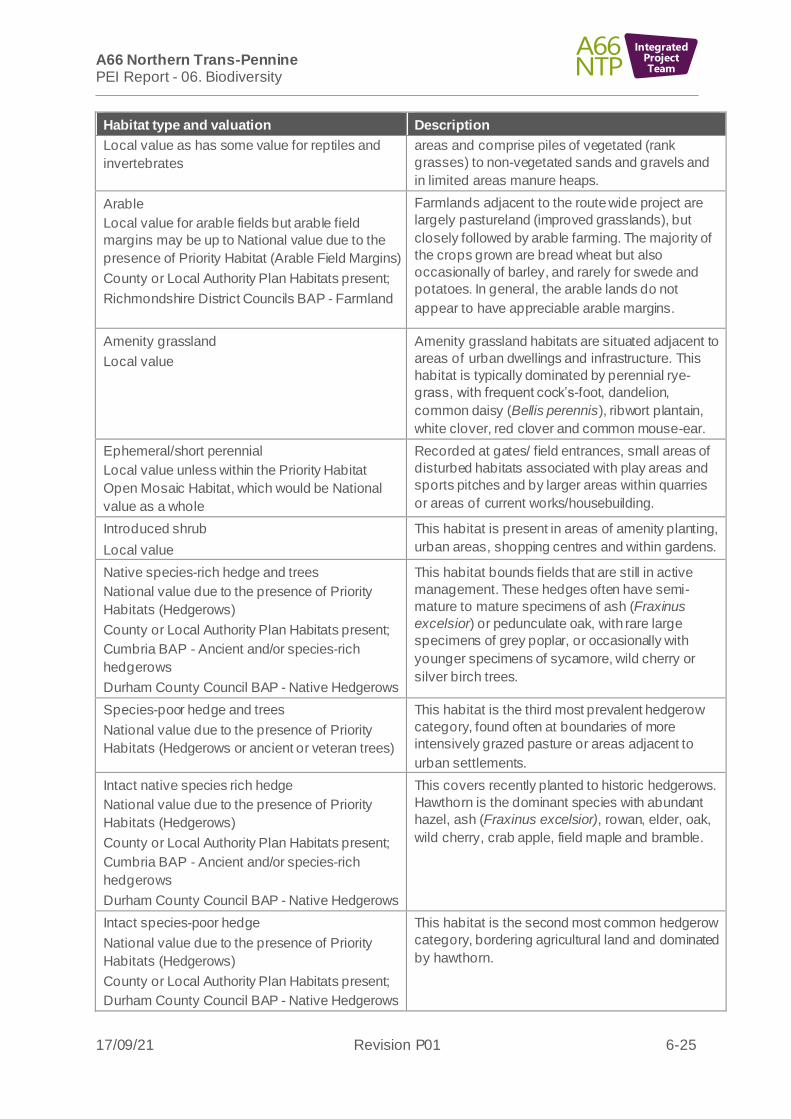
Local value as has some value for reptiles and
invertebrates
areas and comprise piles of vegetated (rank
grasses) to non-vegetated sands and gravels and
in limited areas manure heaps.
Arable
Local value for arable fields but arable field
margins may be up to National value due to the
presence of Priority Habitat (Arable Field Margins)
County or Local Authority Plan Habitats present;
Richmondshire District Councils BAP - Farmland
Farmlands adjacent to the route wide project are
largely pastureland (improved grasslands), but
closely followed by arable farming. The majority of
the crops grown are bread wheat but also
occasionally of barley, and rarely for swede and
potatoes. In general, the arable lands do not
appear to have appreciable arable margins.
Amenity grassland
Local value
Amenity grassland habitats are situated adjacent to
areas of urban dwellings and infrastructure. This
habitat is typically dominated by perennial rye-
grass, with frequent cock’s-foot, dandelion,
common daisy (Bellis perennis), ribwort plantain,
white clover, red clover and common mouse-ear.
Ephemeral/short perennial
Local value unless within the Priority Habitat
Open Mosaic Habitat, which would be National
value as a whole
Recorded at gates/ field entrances, small areas of
disturbed habitats associated with play areas and
sports pitches and by larger areas within quarries
or areas of current works/housebuilding.
Introduced shrub
Local value
This habitat is present in areas of amenity planting,
urban areas, shopping centres and within gardens.
Native species-rich hedge and trees
National value due to the presence of Priority
Habitats (Hedgerows)
County or Local Authority Plan Habitats present;
Cumbria BAP - Ancient and/or species-rich
hedgerows
Durham County Council BAP - Native Hedgerows
This habitat bounds fields that are still in active
management. These hedges often have semi-
mature to mature specimens of ash (Fraxinus
excelsior) or pedunculate oak, with rare large
specimens of grey poplar, or occasionally with
younger specimens of sycamore, wild cherry or
silver birch trees.
Species-poor hedge and trees
National value due to the presence of Priority
Habitats (Hedgerows or ancient or veteran trees)
This habitat is the third most prevalent hedgerow
category, found often at boundaries of more
intensively grazed pasture or areas adjacent to
urban settlements.
Intact native species rich hedge
National value due to the presence of Priority
Habitats (Hedgerows)
County or Local Authority Plan Habitats present;
Cumbria BAP - Ancient and/or species-rich
hedgerows
Durham County Council BAP - Native Hedgerows
This covers recently planted to historic hedgerows.
Hawthorn is the dominant species with abundant
hazel, ash (Fraxinus excelsior), rowan, elder, oak,
wild cherry, crab apple, field maple and bramble.
Intact species-poor hedge
National value due to the presence of Priority
Habitats (Hedgerows)
County or Local Authority Plan Habitats present;
Durham County Council BAP - Native Hedgerows
This habitat is the second most common hedgerow
category, bordering agricultural land and dominated
by hawthorn.

A66 Northern Trans-Pennine PEI Report - 06. Biodiversity
17/09/21 Revision P01 6-26
IntegratedProjectTeam
Habitat type and valuation Description
Defunct native species-rich hedge
Up to National value due to the possible presence
of Priority Habitats (Hedgerows)
County or Local Authority Plan Habitats present;
Cumbria BAP - Ancient and/or species-rich
hedgerows
Durham County Council BAP - Native Hedgerows
This habitat occurs as either gappy mature hedges
or as hedges where the gaps have been planted by
young whips.
Defunct species-poor hedge
Up to National value due to the possible presence
of Priority Habitats (Hedgerows)
County or Local Authority Plan Habitats present;
Durham County Council BAP - Native Hedgerows
The majority of hedgerows within 250m of the
scheme and are represented by defunct species-
poor hedgerows. These are primarily dominated by
hawthorn, or occasionally by blackthorn.
Dry stone wall
Local value
Dry stone walls are evident route wide as boundary
features. These features vary in condition to being
intact to dilapidated with moss and lichen species
present on the stone.
Dry ditch
Local value
Limited areas of dry ditches are present route wide,
dominated by species typical of acid or neutral
grasslands, with occasional presence of wetland
species or ruderals.
Bare ground
Local value unless within the Priority Habitat
Open Mosaic Habitat, which would be National
level as a whole
Bare ground is found along riverbanks, adjacent to
inland cliff areas. Greater expanses of this habitat
are found at areas of current works or quarries.
Rivers and tributaries
6.6.13 The project crosses a number of rivers of varying magnitude. The largest river crossed by the project is Trout Beck which forms part of the River Eden and Tributaries SAC/SSSI. There are also watercourse crossings of numerous tributaries that flow into the River Eden and Tributaries SAC/SSSI, including the River Eden itself and the River Eamont. Based on habitat assessment and available desk study records, a number of these watercourses are considered likely to support the qualifying species (Atlantic salmon (Salmo salar), European bullhead (Cottus gobio), lamprey species and otter) and are therefore considered to be functionally linked to the River Eden and Tributaries SAC/SSSI. These watercourses include: Light Water, Keld Sike, Cringle Beck, Moor Beck, Eastfield Sike, Yosgill Sike and Woodend Sike.
6.6.14 The River Eden, River Eamont, Trout Beck and Light Water qualify as a sub-type 2 water course of plain to montane levels with the Ranunculion fluitantis and Callitricho-Batrachion vegetation (3260), a qualifying feature of the River Eden and Tributaries SAC. The eastern section of the route crosses tributaries that flow into the River Greta, River Tees, River Swale and Tutta Beck, as well as Tutta Beck itself . With the exception of Tutta Beck, these watercourses are minor in nature and are typically high in the catchment and close to the source.
6.6.15 None of the watercourses crossed by the route meet the qualifying criteria for headwater stream priority habitat as defined by JNCC due to their modified nature (Brig, 2008)18. The River Eden, River Eamont and the lower reaches of Crooks Beck
18 Brig (2008) UK Biodiversity Action Plan Priority Habitat Descriptions

A66 Northern Trans-Pennine PEI Report - 06. Biodiversity
17/09/21 Revision P01 6-27
IntegratedProjectTeam
and Lowgill Beck are mapped as Priority Habitat (rivers) on Natural England’s open source data layer.
6.6.16 All rivers and streams are considered to be of International value where they are within the River Eden SAC or functionally linked to the SAC. All other watercourses outside of designations are considered to be of Local value.
Protected and Priority Species
6.6.17 Surveys for protected and Priority Species are ongoing and Table 6-5: Protected and Priority Species, provides a high-level summary of preliminary findings up to the end of June 2021. The complete baseline will be included in the ES. Valuations are based on current survey data and may be revised down for the ES when further species survey data is available. This is considered to be a robust assessment as the highest expected level of valuation is stated on a precautionary basis.
Table 6-5: Protected and Priority Species
Species and
valuation
Description Scheme
Bats (roosting in
structures and trees)
Up to Regional value
due to the expected
size of maternity and
hibernation roosts
present.
Roosting opportunities exist throughout the project within
residential properties (predominantly constructed of
stone), farm buildings and many mature trees present
across all the habitat types.
The desktop study identified the presence of numerous
roost sites throughout the project, including maternity
roosts for common pipistrelle (Pipistrellus pipistrellus),
soprano pipistrelle (Pipistrellus pygmaeus), brown long-
eared bat (Plecotus auritus) and Daubenton’s bat (Myotis
daubentonii). Hibernation sites for whiskered bat (Myotis
mystacinus) and Brandt’s bat (Myotis brandtii) were also
noted within mines present within Appleby Fell SSSI, over
1.5km f rom the Appleby to Brough scheme.
Preliminary bat roost assessments for structures have
identified six confirmed roosts, 61 structures with high
potential, 70 with moderate potential and 63 with low
potential.
Preliminary bat roost assessments for trees have
identified 39 trees with high potential, 100 with moderate
potential and 95 with low potential.
All schemes apart
f rom A1(M) Junction
53 Scotch Corner
had potential bat
roosts.
All schemes have
potential tree roosts.
Bats (activity)
Up to National value
due to the scheme
supporting key flight
routes for rarer
species at the limit of
their published range
for example Leisler’s
bat (Nyctalus leisleri)
The desk study (completed in September 2020) identified
common species of bat (Wray et al. 2010), common
pipistrelle (Pipistrellus pipistrellus), soprano pipistrelle
(Pipistrellus pygmaeus), and brown long-eared bat
(Plecotus auritus) and the rarer species (Wray et al.
(2010) Nathusius pipistrelle (Pipistrellus nathusii),
Natterer's bat (Myotis nattereri), Daubentons bat (Myotis
daubentonii), Whiskered bat (Myotis mystacinusi) and
Brandt’s bat (Myotis brandtii). No Annex II bat species
were identified.
Preliminary review of the data collected by the static bat
detectors show that 33,257 bat passes from 53 locations
were recorded. Preliminary results have shown that
species recorded include soprano pipistrelle (16669
passes), common pipistrelle (11168 passes), Myotis
All schemes apart
f rom A1(M) Junction
53 Scotch Corner
have potential bat
crossing points.

A66 Northern Trans-Pennine PEI Report - 06. Biodiversity
17/09/21 Revision P01 6-28
IntegratedProjectTeam
Species and
valuation
Description Scheme
species (3331 passes), noctule (Nyctalus noctule) (1265
passes), Leisler’s bat (Nyctalus leisleri) (489 passes),
brown long-eared bat (304 passes) and Nathusius
pipistrelle (31 passes).
A total of 56 locations were identified through the desk
study where potential bat flight routes will be directly
af fected by the proposed scheme alignment. These points
cover a range of habitat types including woodland,
hedgerow/linear feature, river corridor or
culvert/underpass.
Red squirrel (Sciurus
vulgaris)
Up to National value
due to the rarity and
conservation status of
this species
Habitats suitable for supporting red squirrel were present
within 250m of the project and records occurred within
2km, including a designated national red squirrel refuge.
The initial terrestrial mammal transect surveys undertaken
between November 2020 to January 2021 identified
potential red squirrel field signs within 250m of the draft
DCO boundaries. Due to the difficulty of distinguishing
between f ield signs for grey or red squirrels, these findings
cannot be used to confirm the presence of red squirrels.
Subsequent camera traps and incidental sightings
conf irmed red squirrel presence towards the eastern end
of the project.
Red squirrels are
conf irmed at M6
Junction 40 to
Kemplay Bank,
Penrith to Temple
Sowerby and
Appleby to Brough.
Otter (Lutra lutra)
Up to International
value for key natal
sites within the SAC.
Up to County value in
other locations due to
the inclusion in Local
Biodiversity Action
Plans.
Suitable watercourses and associated riparian habitats
are present within 250m of the project. In addition, the
desk study identified records of otter within 2km. There
are a range of main rivers and suitable tributaries in both
rural and urban areas across the length of the project.
There are no significant wetlands or pond networks within
250m of the draft DCO boundary.
Otter f ield signs were identified within 250m of the project
including (at the time of writing) 32 potential holts and/or
resting sites.
The camera trap surveys are ongoing and data is
unavailable for inclusion in the PEI Report; however
results will be used to inform the ES.
All schemes apart
f rom A1(M) Junction
53 Scotch Corner
have suitable habitat
for otters and records
of otters.
Otters f ield signs
were identified at all
schemes apart from
A1(M) Junction 53
Scotch Corner and
Stephen Bank to
Carkin Moor.
Water vole (Arvicola
amphibius)
Up to County value
due to the
conservation status of
this species and
inclusion in Local
Biodiversity Action
Plans.
There is suitable habitat to support water vole within 100m
of the project and a small number of water vole records
were identified within 2km. A water vole reintroduction
project in the Warcop area was carried out in 2007 with
further releases in 2010. This project has been
coordinated by the Cumbria Water Vole Project based at
Cumbria Wildlife Trust in partnership with Eden River
Trust (Cumbria Biodiversity Data Centre, 2010). Sites are
appropriately managed by landowners in conjunction with
the Environment Agency and the Cumbria Water Vole
Project.
Only one potential water vole field sign was identified
across the project, a feeding station that could not be
All schemes apart
f rom A1(M) Junction
53 Scotch Corner
have suitable habitat.
Water vole records
were only found
within 2km of
Appleby to Brough
scheme.

A66 Northern Trans-Pennine PEI Report - 06. Biodiversity
17/09/21 Revision P01 6-29
IntegratedProjectTeam
Species and
valuation
Description Scheme
conf irmed as water vole. The feeding station was located
in the Penrith to Temple Sowerby scheme.
Badger (Meles meles)
Local value as this
species is not of
conservation concern
Habitats suitable for supporting badger are present within
250m of the project, along with records of badger within
2km. These habitats include areas of woodland, scrub,
hedgerows, rough grassland, road verges and ditches.
Ten main badger setts, 18 outlier setts, six subsidiary
setts and four annexe setts have been identified within
250m of the draft DCO scheme boundaries. All identified
setts have been subject to badger bait marking surveys,
the results of which are detailed under the relevant
schemes.
All schemes include
suitable habitat. All
schemes have
desktop records for
badger within 2km
apart f rom
A1(M) Junction 53
Scotch Corner
Other terrestrial
mammals –
Pine marten (Martes
martes)
Up to National value
due to the rarity
conservation status of
this species
Polecat (Mustela
putorius)
Brown hare (Lepus
europaeus)
Hedgehog (Erinaceus
europaeus)
Deer
Up to County value
due to inclusion with
local Biodiversity
Action Plans
There were no biological records of pine marten within
2km of the project boundary and limited suitable habitat.
Suitable habitat with potential to support polecat was
recorded within 250m of the project draft DCO
boundaries, including records of this species within 2km.
No polecat signs were identified during survey transects.
However, camera traps did record evidence of an
unconf irmed species of the mustelidae family, which had
potential to be polecat.
There is an abundance of suitable habitat that could
support brown hare within 250m of the project draft DCO
boundary and records occurred within 2km. Brown hare
f ield signs and incidental sightings were recorded, and
camera traps showed brown hare to the east and west of
the project.
There is an abundance of suitable habitat that could
support hedgehog within 250m of the project draft DCO
boundary and records of hedgehog occurred within 2km.
No f ield signs of hedgehog or camera trap/incidental
sightings have been identified so far.
There is an abundance of suitable habitat that could
support deer within 250m of the project draft DCO
boundary and records of roe deer occurred within 2km.
Field signs, camera traps and incidental sightings have all
conf irmed roe deer in the area.
Pine marten is
scoped out of all
schemes.
Polecat, brown hare,
hedgehog and deer
are scoped into all
schemes with details
listed under Scheme
descriptions.
Birds
Up to International
value due to breeding
and wintering bird
habitat and
populations being
functionally linked to
the SPA.
Up to National value
for non-SPA qualifying
species due to
The majority of habitats within the project provide suitable
nesting and foraging opportunities for species typical of
farmland, hedgerows and open habitats. Land within the
project which may be functionally linked to the North
Pennine Moors SPA was considered as a priority for bird
surveys. The desk study produced records of several
notable bird species which are relevant to the route wide
project. These included: lapwing (Vanellus vanellus),
curlew (Numenius arquata), oystercatcher (Haematopus
ostralegus), snipe (Gallinago gallinago), redshank, pink-
footed goose (Anser brachyrhynchus), whooper swan
(Cygnus cygnus), woodcock (Scolopax rusticola), redwing
Suitable habitats
occur on all schemes
for both breeding and
wintering birds.

A66 Northern Trans-Pennine PEI Report - 06. Biodiversity
17/09/21 Revision P01 6-30
IntegratedProjectTeam
Species and
valuation
Description Scheme
inclusion of some
species on Schedule 1
of the Wildlife and
Countryside act and
Red and Amber Birds
of Conservation
Concern.
(Turdus iliacus), fieldfare (Turdus pilaris), black redstart
(Phoenicurus ochruros), kingfisher (Alcedo atthis), golden
plover (Pluvialis apricaria) and barn owl (Tyto alba).
Natural England provided additional information about
potential locations (close to Kirkby Thore and Warcop)
which were known to support significant numbers of
wintering and breeding lapwing and breeding redshank,
oystercatcher and potentially curlew.
Of the four SPA citation species, only golden plover was
recorded during breeding bird surveys. A single golden
plover was recorded during the June survey visit, on the
southern edge of the SPA, northwest of Bowes. Two
Schedule 1 species were recorded during the breeding
bird surveys – f ieldfare and kingfisher – along with 16
Birds of Conservation Concern (BoCC) Red List species a
maximum of 21 Amber BoCC Listed species. Three active
sand martin colonies were recorded.
Two SPA species were recorded during wintering bird
surveys – golden plover and merlin (Falco columbarius).
Golden plover was recorded across the majority of the
survey area, with a maximum count of 750 noted during
the January visit. Single merlins were recorded near
moorland areas during the January surveys only. A total of
six Schedule 1 species were recorded during the wintering
bird surveys – barn owl, redwing, fieldfare, brambling
(Fringilla montifringilla), marsh harrier (Circus
aeruginosus) and merlin – along with a maximum of 16
BoCC Red List species and 16 Amber BoCC Listed
species.
Reptiles
Up to County value
due to the inclusion of
all four common reptile
species in Local
Biodiversity Action
Plans
Desk study records for slow worm (Anguis fragilis) and
adder (Vipera berus) occurred within 2km of the route
wide project. The majority of habitats within the study area
are unsuitable for reptiles due to the prevalence of
agricultural land (arable and grazed pasture).
Nevertheless, pockets of suitable habitat exist, and these
are largely associated with linear features (such as
roadside verges, stone walls, hedgerows, ditches and
streams) and a few areas of rank semi-natural habitat.
Large populations and widespread presence are thought
to be unlikely due to a lack of records and unsuitable
nature of the majority of the habitats within the study area.
However, common lizard presence is anticipated in certain
areas and other widespread reptiles, namely adder, slow
worm, grass snake (Natrix helvetica) may be present in
low numbers.
Suitable habitat for
reptiles occurs within
all schemes.
A limited reptile
survey was
undertaken within the
Temple Sowerby to
Appleby scheme but
no reptiles were
recorded.
Amphibians
Up to County value
due to the inclusion of
great crested newts in
Great crested newt (Triturus cristatus) presence has been
conf irmed through desktop study and field survey within
the project draft DCO boundary, along with common frog
(Rana temporaria), common toad (Bufo bufo), palmate
All schemes include
waterbodies within
500m and suitable

A66 Northern Trans-Pennine PEI Report - 06. Biodiversity
17/09/21 Revision P01 6-31
IntegratedProjectTeam
Species and
valuation
Description Scheme
Local Biodiversity
Action Plans
newt (Lissotriton helveticus), smooth newt (Lissotriton
vulgaris) and alpine newt (Ichthyosaura alpestris). There
were 87 waterbodies within 500m of the route wide
project, of which 64 were either dry, not present or had a
negative eDNA results for great crested newts. There was
conf irmed presence of great crested newt for 11 of the 23
ponds with some further surveys results still pending.
terrestrial habitat for
amphibians.
Field survey data
conf irmed presence
of great crested
newts at four
schemes – Penrith to
Temple Sowerby,
Temple Sowerby to
Appleby, Appleby to
Brough and Stephen
Bank to Carkin Moor.
Fish
Up to International
value for key spawning
or commuting routes
within the SAC. Up to
County value in other
locations due to the
inclusion of some fish
species in Local
Biodiversity Action
Plans.
Desk study records of fish species of conservation value
exist for rivers crossed by the scheme including Trout
Beck, Hayber Beck and Lowgill Beck. Atlantic salmon
(Salmo salar), European bullhead (Cottus gobio), lamprey
sp., European eel (Anguilla anguilla), brown/sea trout
(Salmo trutta) and European grayling (Thymallus
thymallus) have been recorded in Trout Beck. Atlantic
salmon, European bullhead and brown/sea trout were
recorded in Hayber Beck. Atlantic salmon and brown/sea
trout were also recorded in Low Gill Beck.
Species of conservation value were recorded within the
wider desk study search area for all schemes; however, it
should be noted that many of these sites where these
records exist may not be hydrologically connected to
watercourses crossed by the scheme and are provided for
context. Furthermore, many of the watercourses crossed
by the project are considered unsuitable for notable fish
species due to habitats present, their ephemeral nature or
the presence of barriers to fish migration downstream of
the crossing point. Barriers to fish migration were typically
anthropogenic in nature (for example perched culverts),
but natural barriers such as waterfalls were also noted.
No f ield survey data is available for fish at the time of
writing. The results of route wide fish surveys will be
reported in the ES.
All schemes apart
f rom A1(M) Junction
53 Scotch Corner
include suitable
habitat for f ish.
White-clawed crayfish
(Austropotamobius
pallipes)
Up to International
value for key sites
within the SAC. Up to
County value in other
locations due to the
inclusion of in Local
Biodiversity Action
Plans.
Desktop study records of white clawed crayfish were
identified within 2km of the project. However, it should be
noted that many of the sites where these records exist
may not be hydrologically connected to watercourses
crossed by the project and are provided for context and to
highlight the potential for this species to be present.
In 2020, f ield surveys were undertaken at six of twenty-
two sites screened in for survey based on habitat
assessment. Five of the six surveys completed returned a
nil catch. A healthy population of white-clawed crayfish
were recorded in Unnamed Tributary of Mire Sike 6.12
(Mire Sike is a tributary of the River Eden). The survey
All schemes apart
f rom A1(M) Junction
53 Scotch Corner
include suitable
habitat for white
clawed crayfish.
Desk study records
were identified at M6
Junction 40 to
Kemplay Bank,
Penrith to Temple
Sowerby, Temple

A66 Northern Trans-Pennine PEI Report - 06. Biodiversity
17/09/21 Revision P01 6-32
IntegratedProjectTeam
Species and
valuation
Description Scheme
site is located approximately 2.5km upstream of the
conf luence with the River Eden and the SAC/SSSI
boundary.
Sowerby to Appleby
and Appleby to
Brough.
Terrestrial
invertebrates
Up to National value
as there are Priority
Habitats of particular
value to invertebrates
and national rarities
could be identified.
Records for six-hundred and twenty-four terrestrial
invertebrates were returned within 2km of the scheme.
One hundred and seventy-three of these were species of
conservation concern. The following Pantheon Broad
Habitat Types (Pantheon, 2018)19 were identified across
the Scheme - DW1 Decaying Wood, A1 Arboreal, F21 Tall
Sward and Scrub, F22 Short Sward and Bare Ground,
F24 Upland, S1 Shaded Woodland Floor, W23 Running
Water, W24 Marshland. In addition, several areas were
identified as Open Mosaic Habitat on Previously
Developed Land, which is a Priority Habitat and of
particular value to terrestrial invertebrates.
All schemes
contained areas of
high terrestrial
invertebrate potential
apart f rom A1(M)
Junction 53 Scotch
Corner.
Aquatic invertebrates
Up to National value
as there are nationally
scarce invertebrates
known to be present.
Desktop records of aquatic invertebrate species of
conservation value were identified across the project. The
large-mouthed valve snail (Valvata macrostoma)
(recorded in the River Eden, within the desk study search
area for the Temple Sowerby to Appleby Scheme) is a
Nationally Rare, and a Priority Species.
In addition, eight Nationally Scarce aquatic invertebrate
species were identified in the desk study. No other notable
species or Invasive Non-native Species were identified in
the desk study.
No f ield survey data is available for aquatic invertebrates
at the time of writing. The results of route wide aquatic
invertebrate surveys will be reported in the ES.
Aquatic invertebrate
species of
conservation value
have been identified
within the desk study
search area for all
schemes with the
exception of Stephen
Bank to Carkin Moor
and A1 (M) Junction
53 Scotch Corner.
Macrophytes
Up to National value
as there are nationally
scarce macrophyte
species known to be
present.
Macrophyte species of conservation value have been
identified within the desk study area for the project. The
Nationally Scarce stream water crowfoot (Ranunculus
penicillatus subsp. Penicillatus) was recorded on the River
Eamont and River Lowther, within the desk study search
area for the M6 Junction 40 to Kemplay Bank and Penrith
to Temple Sowerby schemes.
Bladder sedge (Carex vesicaria), which is Vulnerable in
England, was identified within the desk study search area
for the Appleby to Brough Scheme.
The Invasive Non-Native Species Canadian pondweed
(Elodea canadensis) and Nuttall’s waterweed (Elodea
nuttallii) was also identified in the desk study search area
for a number of Schemes.
Whilst complete analysis of macrophyte field survey data
was not available at the time of writing this report, it
should be noted the Nationally Scarce bryophyte Porella
pinnata was recorded during surveys of Trout Beck
All schemes apart
f rom A1(M) Junction
53 Scotch Corner
include suitable
habitat for
macrophytes.
19 Pantheon (2018) Pantheon, available from: https://www.brc.ac.uk/pantheon

A66 Northern Trans-Pennine PEI Report - 06. Biodiversity
17/09/21 Revision P01 6-33
IntegratedProjectTeam
Species and
valuation
Description Scheme
(Temple Sowerby to Appleby, in the vicinity of the Red
alternative).
M6 Junction 40 to Kemplay Bank
6.6.18 River Eden SAC and River Eden Tributaries SSSI are immediately adjacent to the south of this scheme in two locations and drain into the River Eamont (a tributary of the River Eden and part of the SAC and SSSI designations). Qualifying features for each statutory designation are listed in Table 6-2: Statutory designated sites within the biodiversity study area. The following habitats and vegetative communities, that are the qualifying features of the River Eden SAC, are assumed to be present in the River Eamont:
• Watercourses of plain to montane levels with the Ranunculion fluitantis and Callitricho-Batrachion vegetation.
• Alluvial forests with Alnus glutinosa and Fraxinus excelsior Alno-Padion, Alnion incanae, Salicion albae * Priority feature.
6.6.19 Cowraik Quarry SSSI (1.5km north) is designated for its geological features, but also supports the Priority Habitats deciduous woodland and lowland heathland. With the A686 forming a likely barrier, between this site and the scheme. Cowraik Quarry LNR (1.5km north) is designated for the aforementioned Priority Habitats.
6.6.20 The scheme has four non-statutory sites nearby; Disused Railway Line near Newbiggin CWS, Skirsgill Woods CWS, Yanwath Wood CWS and Myers Beck CWS, and the county value invertebrate sites at Eamont Bridge, Banks of River Eamont (River Eamont), Lowther Bridge (River Lowther).
6.6.21 There are four statutory designated sites within 200m of the ARN, namely River Eden SAC, River Eden and Tributaries SSSI, Asby Complex SAC and Crosby Ravensworth Fell SSSI, the non-statutory site Disused Railway Line near Newbiggin CWS and ancient woodland at Newbiggin Wood and Raughtonguil Wood.
6.6.22 Within 200m of the draft DCO boundary (construction dust/demolition activities) are River Eden SAC, River Eden and Tributaries SSSI, Yanwath Wood CWS and Skirsgill Wood CWS.
6.6.23 The majority of habitats here were identif ied as areas of improved grassland, hardstanding areas and buildings, followed by the amenity grasslands associated with urban habitat and infrastructure at Penrith. The riparian corridor/running water habitat category provided by the River Eden and River Eamont formed the next most prevalent habitat, adjacent to which were areas of semi-natural woodlands and mixed woodland habitats. There were several areas of semi-natural mixed woodland habitats identif ied through desk study and confirmed through field study to be the Priority Habitat (deciduous woodland). Protected plant species present in this scheme include bluebell. Invasive species recorded include giant hogweed and Himalayan balsam associated with the banks of the River Eamont.
6.6.24 This scheme crosses Thacka Beck, a tributary of the River Eamont, south of Pategill and forms part of the Eamont (Upper) WFD waterbody (GB102076071020) which achieved ‘Good’ Ecological status under WFD in 2019. The proposed alignment falls within a section of Thacka Beck that is already culverted as a result of the existing A686, A66 and of the Cumbria Constabulary buildings. There is potential for habitats upstream and downstream of the existing culverts to support notable and/or protected aquatic species. However, this watercourse is considered to be disconnected from the River Eamont under low flow conditions as it is significantly perched at the

A66 Northern Trans-Pennine PEI Report - 06. Biodiversity
17/09/21 Revision P01 6-34
IntegratedProjectTeam
confluence with the River Eamont, which restricts fish migration between the two rivers.
6.6.25 The desk study identif ied 30 records of bats (eight species) within a 2km radius of the scheme. The desk study confirmed three roosts of notable conservation interest, one common pipistrelle maternity roost, one pipistrelle species maternity roost , and one soprano pipistrelle maternity roost. Two further roosts were noted, a myotis species roost and a whiskered bat roost. The preliminary bat roost assessment identif ied two confirmed bat roosts, one at Cumbria Police Headquarters and one at Carlton Hall. Cumulative results for activity transects undertaken for this scheme were 27 common pipistrelle, 27 soprano pipistrelle, two myotis species and five noctule. A potential bat crossing point providing connectivity between the maternity roost in Penrith hospital to the River Eamont corridor was identif ied at the Carleton Hall underbridge passing beneath the A66.
6.6.26 There were nine otter records from the past ten years located within 2km of the draft DCO boundary of this scheme including road casualties and sightings along the River Eamont and Thacka Beck. Otter field signs were identif ied on all the watercourses surveyed within 250m of the scheme and eight potential holts/resting sites identified. There is one potential crossing point where Thacka Beck is culverted under the A66.
6.6.27 There were no records of water vole within 2km of this scheme although Myers Beck CWS lists a water vole population in reasons for designation. Three sections of watercourses were surveyed for water vole. There were no field signs for water vole identif ied within 100m of the scheme.
6.6.28 There were 61 red squirrel records from the past ten years located within 2km of the draft DCO boundary of this scheme. Initial terrestrial mammal walking transects confirmed red squirrel presence. Detailed red squirrel carrying capacity and visual surveys were then carried out and evidence of red squirrel was recorded along all transects within all identif ied suitable habitat surrounding this scheme.
6.6.29 There were 23 badger records from the past ten years located within 2km of the draft DCO boundary of this scheme, including badger roadkill and one sett. Field surveys have identif ied two main setts (with associated outlier/annexe setts) and one independent outlier sett has been identif ied within 250m of the draft DCO boundary of the scheme. Badger bait marking was undertaken at one of the setts, which indicated badgers were foraging and commuting through the woodland directly north of the A66 carriageway and using the existing underpass which provides access to the Cumbria Police Constabulary under the A66 to reach woodland to the south.
6.6.30 No camera trap data or field signs of pine marten were observed from suitable habitat located within 250m of this scheme.
6.6.31 There were four polecat, two brown hare, four roe deer and 37 hedgehog records from the past ten years located within 2km of the draft DCO boundary however no field signs or incidental sightings of any of the species were identif ied for this scheme. Four out of the six camera traps did record the presence of potential polecat species.
6.6.32 During wintering bird surveys, reasonable numbers of four gull species (black-headed, common, herring and lesser black-backed), house sparrow, bullf inch and dipper were recorded. During breeding bird surveys, reasonable numbers of lesser black-backed gull (peak count of 41 in April), oystercatchers (five in April), grey wagtail, dipper (both recorded during all visits), house martin and swift (low numbers recorded in May and June) were recorded. Two active sand martin colonies were located directly adjacent to the draft DCO boundary and a third was recorded approximately 200m from boundary.

A66 Northern Trans-Pennine PEI Report - 06. Biodiversity
17/09/21 Revision P01 6-35
IntegratedProjectTeam
6.6.33 Three records of slow worm were identif ied just north of Penrith. No other reptile records occurred within 2km of the scheme. Further reptile habitat assessment and/or potential surveys are proposed for areas of rough-semi natural grasslands, open mosaic habitat and woodland edge habitats as suitable terrestrial habitat. Connective corridors are provided by rail corridors and watercourse banks.
6.6.34 The historic records for common lizard are separated from the works by urban dwellings and associated infrastructure, however the presence of suitable habitat within 100m of the works, which may be subject to potential fragmentation impacts, requires further survey for reptile species.
6.6.35 Historic desk data records are held for substantial numbers of common toad (aggregation/migration) on the River Eamont at Brougham Bridge and for smaller numbers of the common species palmate newt, smooth newt, common frog. In addition there are records for the invasive species alpine newt at Gilwilly Industrial estate with suitable links for this species to move along, via rail and watercourses connecting to this scheme.
6.6.36 Two ponds were fully surveyed (including eDNA surveys) for great crested newt and both are scoped out based on the surveys undertaken with the assumption great crested newt are likely absent. Neither of these ponds supported common toad (breeding habitat). Further desk review and/or surveys are required with regard to potential impacts upon common toad.
6.6.37 Seven terrestrial invertebrate species of conservation concern were identified in the desktop study: Grey Dagger (Acronicta psi), Dot Moth (Melanchra persicariae), Melanostoma dubium, Banded General soldierfly (Stratiomys potamida), Banded Demoiselle (Calopteryx splendens), Comma (Polygonia c-album) and Dark Giant Horsefly (Tabanus sudeticus).
6.6.38 Thacka Beck was classified by the Environment Agency as ‘Good’ for the fish element in 2019 and was classified as “high” in 2015 and 2016. Environment Agency fish surveys undertaken within the desk study area between 2013 and 2016 recorded the presence of the following species of conservation value: Atlantic salmon, European bullhead, brown/sea trout (Salmo trutta), European eel (Anguilla anguilla), lamprey sp. (Petromyzontidae sp.) and European grayling (Thymalus thymalus).
6.6.39 Records of white-clawed crayfish were identif ied within the desk study search area but none identified in Thacka Beck. A survey of Thacka Beck will be undertaken later in 2021.
6.6.40 Thacka Beck was classified by the Environment Agency as ‘High’ for the macroinvertebrate element in 2019 and has been classified as ‘High” since 2014. Five Environment Agency invertebrate monitoring sites were identified within the desk study search area. The black-legged water-snipefly Ibisia marginata was recorded within the desk study search period; 2010 to 2021. Thacka Beck was classified as ‘Good’ for the combined macrophyte and phytobenthos element in 2019 and has been classified as ‘Good’ since 2015. The only notable species recorded (desk study data) in Thacka Beck were stream water crowfoot Ranunculus penicillatus subsp. Penicillatus and the invasive species Canadian pondweed.
Penrith to Temple Sowerby
6.6.41 River Eden SAC and River Eden Tributaries SSSI are both within the scheme boundary, their qualifying features are listed in Table 6-2: Statutory designated sites within the biodiversity study area Udford Low Moss SSSI (954 east), Cliburn Moss SSSI and Cliburn Moss NNR are located 1.7km to the south. There are two non-statutory designated sites within 1km of the scheme, Whinfell Forest CWS (adjacent, east) and Watersmeet (Eamont and Eden) CWS.

A66 Northern Trans-Pennine PEI Report - 06. Biodiversity
17/09/21 Revision P01 6-36
IntegratedProjectTeam
6.6.42 Cowraik Quarry SSSI is designated for geological features, but supports the Priority Habitats deciduous woodland and lowland heathland. There are likely barriers between this site and the scheme from the River Eamont and the A686 main road. Cowraik Quarry LNR is designated for the aforementioned Priority Habitats.
6.6.43 Within 200m of the ARN are the River Eden SAC, River Eden and Tributaries SSSI.
6.6.44 Within 200m of the draft DCO boundary (construction dust/demolition activities) are River Eden SAC, River Eden and Tributaries SSSI, Whinfell Forest CWS, Salter Wood AW and Oglebird Plantation AW.
6.6.45 This scheme was surveyed as being dominated by improved grassland, arable and species-poor semi-improved neutral grassland. These were bound mainly by fences and stone walls but to the east more intact species-rich hedgerows with trees and species-poor hedges with trees were present. The farmland habitats were crossed by the River Eamont to the north (rivers and streams Priority Habitat), with an area of broad-leaved woodland (deciduous woodland Priority Habitat) and a vertical area of inland cliff (sandstone). There was a small tributary Light Water which was connected to floodplain marshy grassland habitat (Priority Habitat). Smaller areas of species–rich semi-improved neutral grassland (Priority Habitat), plantation woodland, marsh and scrub and scattered trees were present in areas both north and south of the A66. The large woodland block to the south associated with the Centre Parcs tourist destination, contained mixed woodland habitats (Planted Ancient Woodland Site and Priority Habitat) and coniferous plantation. An area of wet woodland is also present to the east of the scheme. Pond habitats are present of varying type and quality and condition (some confirmed as the pond Priority Habitat).
6.6.46 The protected and/or otherwise notable plant species recorded from desk and field study include bluebell, hoary cinquefoil, common cudweed and a stream water crowfoot subspecies. (Ranunculus pencillatus subsp. pencillatus), and river jelly lichen (Collema dichotomum). The following invasive species are also present: Himalayan balsam, Canadian waterweed, Nuttall’s waterweed and yellow archangel (L. galeobdolon subspecies argentatum).
6.6.47 This scheme crosses four tributaries (Unnamed Tributary of Light Water 3.1, Light Water, Unnamed Tributary of River Eamont 3.3 and Unnamed Tributary of River Eamont 3.5; Figure 14.1: Surface Water Features) that form part of the Eamont (Lower) WFD waterbody (GB102076070990) and one watercourse (Swine Gill) that forms part of the Eden Lyvennet to Eamont waterbody (GB102076070980). These waterbodies achieved ‘Good’ and ‘Moderate’ Ecological status respectively under WFD in 2019.
6.6.48 With the exception of Light Water, the watercourses crossed by this Scheme are minor and are considered unlikely to support (surveys pending) notable and/or protected aquatic species (including qualifying species of the River Eden SAC/SSSI) as habitats are either unsuitable, ephemeral or disconnected to the wider catchment as a result of natural and man-made barriers.
6.6.49 In contrast, the habitats in Light Water upstream and downstream of the existing A66 culvert (which is considered passable for aquatic species) have the potential to support notable and/or protected aquatic species, including the qualifying species of the River Eden SAC/SSSI. This watercourse likely qualif ies (surveys pending) as a sub-type 2 water course of plain to montane levels with the Ranunculion fluitantis and Callitricho-Batrachion vegetation and is considered to be functionally linked to the SAC/SSSI.
6.6.50 The desk study identif ied 88 records of bats (seven species) within a 2km radius of the scheme, including 37 roosts, of which five were maternity roosts including a Daubentons bat maternity roost within Brougham castle 150m from the western end

A66 Northern Trans-Pennine PEI Report - 06. Biodiversity
17/09/21 Revision P01 6-37
IntegratedProjectTeam
of the scheme. The preliminary bat roost assessment identif ied two bat roosts, the first within the structure known as Highbarn and the second roost (assumed) relates to bat tiles that were observed within the roof section of one of the buildings within Whinfell Park. Cumulative results of bat passes from activity transects for the scheme were 31 common pipistrelle, 61 soprano pipistrelle, one pipistrelle species, ten myotis species, 51 noctule and eight brown long eared bat. Six potential bat crossing points have been identif ied across the scheme. These include one culvert at Light Water bridge, four ‘hopover’ locations at Whinfell Park, High Barn, Sw inegill plantation and Whinfell House and one location at the proposed Center Parcs junction.
6.6.51 There were 11 otter records from the past ten years located within 2km of the draft DCO boundary of this scheme. Records consist of seven counts of roadkill, prin ts and counts of individuals at Brougham Old Bridge. The roadkill on Swine Gill and the unnamed tributaries of River Eamont relate to existing watercourse road crossing points that are to be expanded under the draft DCO boundary. Seven sections of watercourses were surveyed for otter. There were nine potential holt and/or resting features within 250m of the scheme. Seven were on the River Eamont, one was on Swine Gill and the remaining feature was on an unnamed tributary of River Eamont.
6.6.52 Seven sections of watercourses were surveyed for water vole. A potential water vole feeding station (highly suitable reed bed) was identified within 100m of the scheme.
6.6.53 There were 167 red squirrel records from the past ten years located within 2km of the draft DCO boundary of this scheme. The high number of records is due to the red squirrel reserve at Whinfell Forest. Initial terrestrial mammal walking transects, followed by detailed red squirrel carrying capacity and visual surveys, confirmed the presence of red squirrels along all transects within all identif ied suitable habitat surrounding this scheme.
6.6.54 There were 21 badger records from the past ten years located within 2km of the draft DCO boundary of this scheme. Records included counts of individual adults, a sett and an associated latrine and one roadkill record. Field surveys have identif ied four main setts, one independent outlier sett and one independent annexe sett within 250m of the draft DCO boundary of this scheme. Three of the main setts (setts 8, 9 and 11) were identif ied as requiring badger bait marking surveys which were all undertaken during March 2021.
6.6.55 No camera trap data or field signs of pine marten were observed from suitable habitat located within 250m of this scheme.
6.6.56 There were four polecat records from the past ten years located within 2km of the draft DCO boundary of this scheme. No field signs of polecat were identif ied during the terrestrial mammal walking transect surveys that took place between November 2020 and January 2021. However, ten out of the 16 camera traps that were deployed did record the presence of potential polecat species.
6.6.57 There were two brown hare and 23 hedgehog records from the past ten years located within 2km of the draft DCO boundary of this scheme. No field signs or incidental sightings of brown hare were identified.
6.6.58 There were six roe deer records from the past ten years located within 2km of the draft DCO boundary of this scheme. Deer field signs and incidental sightings have also been recorded within 250m of the scheme and deer have been pictured on the wildlife cameras left on site.
6.6.59 During wintering bird surveys, considerable numbers of common gull, mistle thrush and skylark (all recorded during all four surveys, peak count of 401 in December, peak count of 19 in January and peak count of 79 in February, respectively) were recorded. Three bramblings and 28 yellowhammer were recorded in February. During

A66 Northern Trans-Pennine PEI Report - 06. Biodiversity
17/09/21 Revision P01 6-38
IntegratedProjectTeam
breeding bird surveys, one lesser redpoll, 19 meadow pits, 11 oystercatchers and 12 yellowhammers were recorded in April. In May, 52 house martins, five tree sparrows and three reed buntings were recorded and in June, 52 house sparrows and two common sandpipers were recorded. One active sand martin colony was recorded along the River Eamont.
6.6.60 There are historic records for common lizard at Whinfell Forest due south of the A66. Further reptile habitat assessment and/or potential surveys are proposed for areas of rough-semi natural grasslands, marsh and woodland edge habitats as suitable terrestrial habitat.
6.6.61 Historic desk data records are held for substantial numbers of common toad (aggregation/migration) on the River Eamont at Brougham Bridge. There are historic records for all native amphibian species within Whinfell Forest (due south of A66) and using the ponds for breeding activities and extensive terrestrial habitat provision. There are also records for all native amphibian species at Acorn Bank, and for common toad and common frog at Temple Sowerby SSSI both sites are over 1km east of the scheme and separated by the River Eden, both sites with good local provision of suitable terrestrial habitat.
6.6.62 Nine ponds were subject to amphibian survey, of these seven ponds were removed from survey (pond habitat not evident/pond habitats unsuitable/great crested newt assumed likely absent). Two ponds were found to support great crested newt to the south of the A66, one online with Light Water (west of the Centre Parks Junction), based on eDNA results and one pond (due east of the Centre Parks Junction) with confirmed breeding. Both of these latter ponds have good adjacent terrestrial habitat for amphibians and some connectivity to further areas of good habitat within Whinfell Forest.
6.6.63 Fifty-six terrestrial invertebrate species of conservation concern were recorded; five Priority Species, 38 notable, eight Red data book and five nationally scarce.
6.6.64 The waterbodies mentioned in paragraph 6.6.38 were classified by the Environment Agency as ‘High’ for the fish element in 2019 and have both been classified as ‘high’ since 2015. Environment Agency fish monitoring sites were identified within the desk study search area on the River Eamont, River Lowther and Crowdundle Beck and the following species of conservation value were recorded between 2010 and 2021: Atlantic salmon, European bullhead, lamprey species, European eel, brown/sea trout and European grayling.
6.6.65 Records of white-clawed crayfish were identif ied within the desk study search area from the River Lowther, River Eden and River Eamont and a survey of Light Water was undertaken in 2020 and returned a nil catch.
6.6.66 The Eamont (Lower) WFD waterbody was classified by the Environment Agency as ‘Good’ for the invertebrate element in 2019. The Eden Lyvennet to Eamont WFD waterbody was classified as ‘High’ for the invertebrate element in 2019 and has been classified as ‘High’ since 2015. The following species of conservation value were recorded on the River Eden, River Eamont and River Lowther between 2010 and 2021: black-legged water-snipefly, yellow-legged water-snipefly (Atherix ibis), March brown mayfly (Rhithrogena germanica) and the whirligig beetle (Gyrinus aeratus).
6.6.67 The same waterbody classified by the Environment Agency as ‘Good’ for the combined macrophyte and phytobenthos element in 2019 and has been classified as ‘Good’ since 2015. The Eden Lyvennet to Eamont WFD waterbody was classified as ‘Moderate’ for the combined macrophyte and phytobenthos element in 2019 and has been classified as ‘Moderate’ since 2015. Environment Agency macrophyte survey data was available from five sites within the desk study search area from the River Lowther, River Eamont and River Eden and the following species have been

A66 Northern Trans-Pennine PEI Report - 06. Biodiversity
17/09/21 Revision P01 6-39
IntegratedProjectTeam
recorded: stream water crowfoot (Ranunculus penicillatus subsp. Penicillatus) and the invasive species Canadian pondweed and Nuttall’s waterweed.
Temple Sowerby to Appleby
6.6.68 As set out in Chapter 2: The Project and Chapter 3: Alternatives, three alternative routes are under consideration for this scheme. This section includes a general overview of all three alternatives for this scheme then describes biodiversity resources for each route where they differ from the overview (Refer to Chapter 2: The Project, for detailed descriptions for each route alternative).
6.6.69 River Eden SAC and River Eden Tributaries SSSI are within all alternatives for this scheme. Temple Sowerby Moss SSSI is 700m north-west of this scheme. Qualifying features for each statutory designation are listed in Table 6-2: Statutory designated sites within the biodiversity study area. Chapel Wood (Appleby in Westmorland) CWS, Acorn Bank Woods and Garden CWS and River Lyvennet Floodplain CWS, Ross Wood CWS and Dowpits Wood CWS are all within 1km of this scheme. The following county level invertebrate sites are within 1km of the scheme: Temple Sowerby Shingle Bank (River Eden), Temple Sowerby Moss, River Eden Oglebird Scar Ers (River Eden) and Acorn Bank (Crowdundle Beck) and Bolton shingle bank (River Eden).
6.6.70 The following designated sites are within 200m of the ARN: River Eden SAC and River Eden Tributaries SSSI.
6.6.71 Within 200m of the draft DCO boundary (construction dust/demolition activities) are River Eden SAC, River Eden and Tributaries SSSI, Temple Sowerby SSSI, Chapel Wood CWS and AW, Ross Wood CWS and AW.
6.6.72 This scheme predominantly passed through mixed farmland of improved pasture and arable which were bound by species-rich hedgerows with trees (Priority Habitat) some of which supported mature trees of importance in their own right. To the west was an area of fen with peat formation and willow and alder carr (Annex 1 habitat and Priority Habitat) woodland, namely Temple Moss SSSI. To the east was Trout Beck a tributary of the River Eden, which the scheme crossed with both natural and man-made channel features and evidence of Ranunculus spp. (Annex 1 habitat). Pond habitats were present of varying type, quality and vegetation composition (some potential Priority Habitats and others very poor). Other habitats included young to established areas of broad-leaved and mixed plantation woodlands with diverse canopy species and a species-rich area of semi-improved acid grassland (Priority Habitat). The protected and or otherwise notable plant species recorded from desk and f ield study included: harebell (Campanula rotundifolia), tormentil (Potentilla erecta), bitter vetch (Lathyrus linifolia), crosswort (Cruciata laevipes), devils-bit scabious (Succissa pratensis), common wintergreen (Pyrola rotundifolia), slender sedge (Carex lasiocarpa) and the liverwort Porella pinnata. The following invasive species are also present: Himalayan balsam and rhododendron.
6.6.73 All three alternatives for this scheme cross Trout Beck which forms part of the River Eden and Tributaries SAC/SSSI and is considered to be of high conservation value. Watercourses in this scheme form part of the Trout Beck WFD waterbody (GB102076070930) which achieved ‘Good’ Ecological status under WFD in 2019.
6.6.74 The desk study identified 121 records of bats (eight species) within the study area for all routes, including 80 roosts of which 16 were maternity roosts. The desk study identif ied 19 roosts of notable conservation interest within 2km of the scheme.
6.6.75 There were 13 otter records from the past ten years located within 2km of the draft DCO boundary of each route alternative. Six of the records were roadkill, one of which was related to Trout Beck, three to the River Eden, and two of which were not

A66 Northern Trans-Pennine PEI Report - 06. Biodiversity
17/09/21 Revision P01 6-40
IntegratedProjectTeam
associated with a watercourse or body of water. None of the roadkill records were on road watercourse crossing points, existing or proposed. The remaining records were of spraint, prints and counts of individuals.
6.6.76 There were no records of water vole. There were 61 red squirrel records, no pine marten, three polecat, two roe deer and 23 hedgehog records within 2km of the draft DCO boundary for any route of this scheme.
6.6.77 There were nine badger records from the past ten years located within 2km of the draft DCO boundary of each route alternative. The records consisted of counts of individuals and a latrine.
6.6.78 Badger, otter, water vole, red squirrel, pine marten, polecat, brown hare, roe deer, hedgehog surveys have not yet been completed for all route alternatives being considered for this scheme.
6.6.79 There were notable flocks of wintering and breeding birds along this scheme which are described under each route.
6.6.80 There are no historic reptile records for this scheme. A single reptile survey has been completed to date within this scheme. No reptiles were recorded and are assumed likely absent, however further surveys are ongoing across areas of suitable habitat associated with the alternative routes.
6.6.81 There are historic records for all native amphibian species at Acorn Bank and for common toad and common frog at Temple Sowerby SSSI both sites are within connected semi-natural habitat to the scheme. In a pond north-west of British Gypsum, there are records for great crested newt, smooth newt, common frog and common toad. To the west of the scheme are further records for common frog. There are historic records for great crested newt, common toad and palmate newt at Colby, but the River Eden in this location is a perceived barrier at least for great crested newt and palmate newt.
6.6.82 Twenty-four ponds were subject to amphibian survey. Seventeen were removed from surveys (pond habitat not evident/pond habitats unsuitable/great crested newt assumed likely absent). A cluster of seven ponds were found to support great crested newt due west of Main Street in Kirkby Thore, prior to the British Gypsum site. Through this area connective corridors are likely provided by banks of watercourses, hedgelines and the disused and active rail corridors.
6.6.83 Fifty terrestrial invertebrate species of conservation concern were recorded within the draft DCO boundary of each route alternative; 19 Priority Species, 18 notable, seven Red data book and six nationally scarce.
6.6.84 Environment Agency desk study data exists for Trout Beck where the following fish species of conservation value were recorded between 2010 and 2021: Atlantic salmon, European bullhead, lamprey sp., European eel, brown/sea trout and European grayling.
6.6.85 No desk study data for white clawed crayfish was identif ied for the watercourses crossed by any of the routes but records are known to occur on the River Eden, River Lyvennet, Hoff Beck and Nether Hoff Sike watercourses.
6.6.86 Six Environment Agency invertebrate monitoring sites were identified within the desk study search area for all routes. The large-mouthed valve snail (Valvata macrostoma) (recorded in the River Eden) is a Nationally Rare, UK BAP species and Priority Species. In addition, the following species of conservation value (Nationally Scarce) were recorded: the caddisfly Allotrichia pallicornis, yellow-legged water-snipe, March brown mayfly, the riff le beetle Riolus subviolaceus, the whirligig beetle Gyrinus

A66 Northern Trans-Pennine PEI Report - 06. Biodiversity
17/09/21 Revision P01 6-41
IntegratedProjectTeam
aeratus, black-legged water water-snipefly and smooth ramshorn snail Gyraulus laevis.
6.6.87 No desk study data for macrophyte species of conservation value was returned, with the exception of the invasive species Canadian pondweed. Whilst complete analysis of macrophyte field survey data was not available at the time of writing this report, it should be noted the Nationally Scarce bryophyte Porella pinnata was recorded during surveys of Trout Beck (Temple Sowerby to Appleby, in the vicinity of the Red alternative).
Blue alternative
6.6.88 The scheme here is in close proximity to the River Eden SAC and River Eden SAC and Tributaries SSSI (Annex 1 habitats and Priority Habitat) and goes over an area of woodland and scrub (Chapel Wood CWS and Priority Habitat), with open mosaic habitats (Priority Habitat) and acid grassland (Priority Habitat) that forms the northern bank of the river. West of this the scheme passes over the Settle to Carlisle railway (active) with scrub and open mosaic habitats (Priority Habitat) and adjacent hedgerows, semi-improved grassland and improved and arable habitats.
6.6.89 Whilst following the habitats present in the overall habitat description, this alternative crosses greater areas of species-rich hedgerows with trees, improved grassland and arable fields at the eastern end of the route. Generally greater areas of agricultural land and intact species-poor hedgerows are crossed, due to this route having a wider land take for the new carriageway and verges. It then crosses mixed woodland, species-rich hedgerow habitats and crosses double hedges (confirmed Priority Habitat and may be classed as ‘Important’ hedges).
6.6.90 The route crosses Trout Beck on a viaduct, over banks with scattered trees and riparian habitats of gravels, sandy inland cliffs and in channel habitats with water crowfoot species (Ranunculus spp.) confirmed present (Annex 1 habitat and Priority habitat). Open mosaic habitat (Priority Habitat) is also affected by this alternative.
6.6.91 Trout Beck in the vicinity of the Blue alternative is considered to be of high conservation value despite being subject to historic over deepening and straightening, which is evident from review of aerial imagery and old maps. This section of river is actively recovering from being straightened and the installation of soft bank protection; this is evidenced by the extensive bank erosion that was recorded. This alternative also crosses Unnamed Tributary of Trout Beck 4.2 (Figure 14.1 Surface Water Features).
6.6.92 Nineteen potential bat crossing points have been identif ied from the desk study assessment of the habitats and records associated with this alternative. Of these five are tree/hedgerow lined narrow roads, one is Trout Beck river corridor and the remaining 12 are hedgerows/field boundaries with occasional mature trees. The preliminary bat roost assessments identif ied one structure with moderate bat roost potential and one structure with high bat roost potential within the draft DCO boundary or within 100m of the potential bat crossing points.
6.6.93 There are three brown hare records from the past ten years located within 2km of the draft DCO boundary of Blue.
6.6.94 During wintering bird surveys there were large flocks of lapwing including a flock of over 500 observed in fields northwest of Kirkby Thore in January. Reasonable numbers of fieldfare were recorded in December (162) and January (201). During breeding bird surveys oystercatcher and curlew, which were both recorded in low numbers, one kingfisher, two dippers. A peak count of 146 house sparrows were recorded across all routes, with many records associated with Kirkby Thore.
A66 Northern Trans-Pennine PEI Report - 06. Biodiversity
17/09/21 Revision P01 6-42
IntegratedProjectTeam
6.6.95 Three areas were identified as having high terrestrial invertebrate potential along this alternative, namely the shingle banks adjacent to the Troutbeck crossing, along the Roman Road between Long Marton and the railway, and the parkland at Colby Laithes. Surveys are ongoing and results are not available for the PEI Report; however, the presence of species assemblage types and notable species has been assumed based on the preliminary results received to date.
Red alternative
6.6.96 This alternative crosses largely mixed farmland and the same habitats as per the Blue alternative, despite minor differences, including a different and much reduced area for the construction compound to the north of the scheme crossing a portion of a mixed semi-natural woodland, a newly planted mixed plantation on slope above Keld Sike and improved and semi-improved grassland. Due south it passes through habitats of improved grassland and arable, before crossing Keld Sike and a further field of improved grassland and species-rich intact hedgerows. The alternative continues through arable habitats, passing to the north of a species-rich acid grassland (confirmed Priority Habitat) and coniferous and mixed plantations, before improved grassland and crossing Trout Beck (confirmed Priority Habitat and presence of Annex 1 Habitat) and associated woodland habitats (may be Priority Habitat and an Annex 1 habitat) and floodplain area.
6.6.97 This alternative also crosses Trout Beck (approximately 1km further upstream than the Blue alternative) and Keld Sike (a tributary of Trout Beck). The section of Trout Beck in the vicinity of this route is characterised by areas of bedrock (bed and banks) on the left-hand bank and areas of bank erosion on the right-hand bank. This alternative crosses Keld Sike approximately 400m upstream of its confluence with Trout Beck.
6.6.98 A total of 18 potential bat crossing points have been identif ied from the desk study assessment of the habitats and records associated with the Red alternative. Of these five are tree/hedgerow lined narrow roads, and 15 are hedgerows/field boundaries with occasional mature trees. The preliminary bat roost assessments identif ied five structures with moderate bat roost potential and three structures with high bat roost potential within the draft DCO boundary or within 100m of the potential bat crossing points.
6.6.99 During wintering bird surveys there were reasonable flocks of lapwing, including 100 observed on fields west of Long Marton. A flock of 220 starlings was recorded during the February surveys. Willow warbler was recorded across all alternatives in reasonable numbers. A total of 126 house sparrows were recorded across all alternatives, with many records associated with Kirkby Thore. During breeding bird surveys there were curlew, oystercatcher and tree sparrow, which were all recorded in low numbers. Willow warbler was recorded across all alternatives, with a peak count of 24 in April. Low numbers of yellow wagtail were noted in fields to the east and southeast of Kirkby Thore.
6.6.100 Four areas were identif ied as having high terrestrial invertebrate potential along this alternative, namely shingle banks adjacent to the Troutbeck crossing at Powis House, along the Roman Road between Long Marton and the railway, the parkland at Colby Laithes, and Brandcrook Hill. Surveys are ongoing and results are not available for the PEI Report; however, the presence of species assemblage types and notable species has been assumed based on the preliminary results received to date.
6.6.101 Whilst complete analysis of macrophyte field survey data was not available at the time of writing this report, it should be noted the Nationally Scarce bryophyte Porella pinnata was recorded during surveys of Trout Beck (Temple Sowerby to Appleby, in the vicinity of the Red alternative).

A66 Northern Trans-Pennine PEI Report - 06. Biodiversity
17/09/21 Revision P01 6-43
IntegratedProjectTeam
Orange alternative
6.6.102 To the north, this alternative crosses mixed arable and improved grassland habitats, some with species-rich intact hedges and trees (Priority Habitat and may be ‘Important’). Parallel to this to the south along the existing A66 the dualling crosses improved grassland and intact hedgerow.
6.6.103 The dualling of the existing A66, includes local road upgrades to the south of the A66 over hedgerow and roadside verge habitats of semi-improved grassland and tall ruderal habitats, whilst the main route then moves south of the existing A66 alignment and over the designation of River Eden SAC and River Eden and Tributaries SSSI at Trout Beck (Annex 1 habitat and Priority Habitat). It then crosses an area of mixed habitats including open mosaic habitat (Priority Habitat), pond/ marsh, bracken, grassland scrub and woodland, associated with an old channel of the river and the roman road. It then passes through further farmland habitats of improved grassland, arable and hedgerows (Priority Habitat and may be ‘Important’), but also over semi -natural habitats associated with the disused rail corridor and the roman road where not used as grazing pasture.
6.6.104 On the existing A66, the route is diverted to the north across the roman road, which forms an islanded area of hedgerow (Priority Habitat or may be ‘Important’) sections, dense to scattered scrub, scattered broad-leaved trees and grassland habitats, this also being in close proximity to and encroaching into the adjacent River Eden SAC/River Eden SSSI designation (with Annex 1 habitats and Priority Habitat). This route then sweeps to the south and under the proposed new section of A66.
6.6.105 There is one brown hare record located within 2km of the draft DCO boundary of this alternative.
6.6.106 Four areas were identif ied as having high terrestrial invertebrate potential along this alternative namely along the Roman Road between Long Marton and the railway, the parkland at Colby Laithes, the disused railways at Eden View and Bridge End Farm. Surveys are ongoing and not available to inform the PEI Report; however, the presence of species assemblage types and notable species has been assumed based on the preliminary results received to date.
Appleby to Brough
6.6.107 As set out in Chapter 2: The Project and Chapter 3: Alternatives, alternative routes are under consideration for this scheme for two of the three sections. This section describes features relevant to all alternatives. Information specific to any single alternative is described under each heading below (Refer to Chapter 2: The Project for detailed descriptions for each alternative).
6.6.108 Moor House and Upper Teesdale SAC and North Pennine SPA are 704m north east of this scheme and the River Eden SAC and River Eden Tributaries SSSI are 700m south of this scheme. Appleby Fells SSSI is 1.5km north off the eastern end of this scheme and Hellbeck and Swindale Woods SAC and SSSIs are 520m north of this scheme. George Gill geological SSSI is 400m to the north.
6.6.109 There are six non-statutory sites for this scheme: Sandford Mire CWS, Tricklebanks Wood CWS, Swindale Woodland CWS and the following sites of invertebrate significance: Helbeck Wood, Swindale Wood and Great Musgrave Swindale Beck Ers.
6.6.110 The following designated sites are within 200m of the ARN: Argill Woods and Pastures SSSI, Augill Valley Pasture SSSI and Sandford Mire CWS.
6.6.111 Sandford Mire CWS is the only designated site within 200m of the draft DCO boundary (construction dust/demolition activities).
A66 Northern Trans-Pennine PEI Report - 06. Biodiversity
17/09/21 Revision P01 6-44
IntegratedProjectTeam
6.6.112 This scheme passes to the south of the North Pennines Area of Outstanding Natural Beauty (AONB), with more upland influences on the habitat types present including both good and poor condition fen, mires, bryophyte heath, dry heath, wet dwarf shrub heath, acid grassland (all Priority Habitats and Annex 1 upland heathland habitat present); amongst arable and improved grassland habitats and some large areas of marshland, coniferous woodland and mixed woodland. In the wider area there are further important habitats (many Priority Habitats as per upland and deciduous woodland, rivers and streams and floodplain grazing marsh). The protected and or otherwise notable plant species recorded from desk and field study include: harebell (Campanula rotundifolia), tormentil (Potentilla erecta), bitter vetch (Lathyrus linifolia), crosswort (Cruciata laevipes), devils-bit scabious (Succissa pratensis), common wintergreen (Pyrola rotundifolia), slender sedge (Carex lasiocarpa). The following invasive species are also present: giant hogweed on the River Eden and rhododendron.
6.6.113 This scheme crosses two tributaries (Unnamed Tributary of Mire Sike 6.12, and Cringle Beck) that form part of the Eden - Scandal Beck to Lyvennet WFD waterbody (GB102076070880) and seven tributaries (Hayber Beck/Moor Beck, Eastfield Sike, Unnamed Tributary of Lowgill Beck 6.1, Lowgill Beck, Woodend Sike, Yosgill Sike and Unnamed Tributary of Lowgill Beck 6.7; Figure 14.1: Surface Water Features) that form part of the Low Gill (Crooks Beck) WFD waterbody (GB102076070750). These waterbodies achieved ‘Good’ and ‘Poor’ Ecological status respectively under WFD in 2019.
6.6.114 All the tributaries crossed by the scheme ultimately flow into the River Eden and Tributaries SAC/SSSI. Based on habitat assessment and desk study records, all the watercourses (with the exception of Unnamed Tributary of Lowgill Beck 6.1 and Unnamed Tributary of Lowgill Beck 6.7) crossed by this scheme are considered to be functionally linked to the SAC/SSSI. Crooks Beck (which Moor Beck and Lowgill Beck flow in to) and the lower reaches of Lowgill Beck are mapped as priority river habitat on Natural England’s open source data layer.
6.6.115 The desk study identif ied 135 records of bats (eight species) within a 2km radius of the study area for all routes, including 57 roosts of which three were maternity roosts (two locations). Five roosts of notable conservation interest were identif ied through the desk study. Survey results are described under each alternative below.
6.6.116 A water vole reintroduction project in the Warcop area was carried out in 2007 with further releases in 2010. 127 animals were released at Rossmede Tarn & Plantation ponds in 2007. 165 animals were released at Forestry pond, Conservation pond and Cringle Beck in 2008. There were 17 water vole records in the study area.
6.6.117 There were 78 red squirrel records, no pine marten, two polecat, no brown hare and 18 hedgehog records from the past ten years located within 2km of the draft DCO boundary of the Black-Black-Black route and the alternative sections.
6.6.118 There were ten badger records from the past ten years located within 2km of the draft DCO boundary of the Black route/Blue alternative route. The records consist of counts of individuals with low accuracy and field signs in Helbeck Wood.
6.6.119 The desk study returned one adder record located close to the River Eden south-west of Greta Bridge, three records of slow worm; one near the adder location and two that are adjacent Greta Bridge.
6.6.120 Historic records are scant within 2km of this scheme and are for common frog at the west and eastern ends of the scheme to the north of the A66. And a single record for common toad to the west of the scheme, due south of the A66 at Ormside. There is much presence of connective corridors across this area provided by the many small streams on the hill sides of the Pennines.

A66 Northern Trans-Pennine PEI Report - 06. Biodiversity
17/09/21 Revision P01 6-45
IntegratedProjectTeam
6.6.121 Twenty-two ponds were subject to amphibian survey, of these 15 ponds were removed from surveys (pond habitat not evident/pond habitats unsuitable/great crested newt assumed likely absent). Two (of the 22) ponds with great crested newt confirmed present (breeding habitat) and five (of the 22) are deemed inconclusive from a survey perspective (some within extensive wetland habitat that is extremely diff icult to survey safely), but are within connective habitat of great crested newt presence, so have great crested newt assumed present for the purposes of assessment.
6.6.122 Forty-five terrestrial invertebrate species of conservation concern were recorded; 12 Priority Species, 28 notable, four Red data book and one nationally scarce.
6.6.123 Environment Agency desk study data exists for Hayber Beck where the following fish species of conservation value were recorded between 2010 and 2021: Atlantic salmon, European bullhead and brown/sea trout. Both Atlantic salmon and brown/sea trout were also recorded in Low Gill Beck. Additional Environment Agency fish monitoring sites were identified within the desk study search area for the Scheme on George Gill, River Eden, Swindale Beck and Augill Beck. The following species of conservation value were recorded between 2010 and 2021: Atlantic salmon, European bullhead, European eel and brown/sea trout.
6.6.124 Desk study records for white clawed crayfish exist for Hayber Beck approximately 2km upstream of the existing A66 crossing at Warcop. Further records of white-clawed crayfish were identif ied within the desk study search area from Mire Sike, River Eden, and Helm Beck. The survey of Unnamed Tributary of Mire Sike 6.12 identif ied a healthy white-clawed crayf ish population. Further surveys are ongoing and will be reported in full in the ES.
6.6.125 The waterbodies described in paragraph 6.6.91 were classified by the Environment Agency as ‘High’ for the invertebrate element in 2019 and have both been classified as ‘High’ since 2015. Six Environment Agency invertebrate monitoring sites were identif ied within the desk study search area for this scheme, on Helm Beck, Hitlon Beck, Crooks Beck, Swindale Beck and Augill Beck. The following species of conservation value (Nationally Scarce) were recorded (2010 - 2021) from Helm Beck and Hitlon Beck: the Riffle beetle Riolus subviolaceus and the caddisfly Potamophylax rotundipennis.
6.6.126 The Eden - Scandal Beck to Lyvennet WFD waterbody was classified by the Environment Agency as ‘High’ for the combined macrophyte and phytobenthos element in 2019 and has been classified as ‘High’ since 2015. The Low Gill (Crooks Beck) WFD waterbody was classified by the Environment Agency as ‘High’ for the combined macrophyte and phytobenthos element in 2019 and was classified as ‘High’ in 2016 and ‘Good’ in 2015. Six Environment Agency invertebrate monitoring sites were identif ied within the desk study search area for this scheme, from Helm Beck, Hitlon Beck, Crooks Beck, Swindale Beck and Augill Beck. Bladder sedge (Carex vesicaria) which is Vulnerable in England and the invasive species Canadian pondweed were both recorded.
Black-Black-Black route
6.6.127 This route crosses the watercourses and habitats described above.
6.6.128 A total of 13 potential bat crossing points have been identif ied through the scheme extents for the Black-Black-Black route. The preliminary bat roost assessments identif ied seven structures with moderate bat roost potential and five structures with high bat roost potential within the draft DCO boundary or within 100m of the potential bat crossing points.

A66 Northern Trans-Pennine PEI Report - 06. Biodiversity
17/09/21 Revision P01 6-46
IntegratedProjectTeam
6.6.129 There were five otter records from the past ten years including two roadkill records, one on the existing road watercourse crossing point on Eastfield Sike, and the second on the existing road watercourse crossing point on Moor Beck main river. This alternative extends existing crossing points and creates several new crossing points for otter.
6.6.130 There were six roe deer records from the past ten years located within 2km of the draft DCO boundary of Black route/Blue alternative.
6.6.131 Wintering bird survey results included a peak count of 880 lapwings during January surveys, 40 golden plovers during February’s visit, 186 curlew in March, 16 pink -footed geese in February and 22 oystercatchers in March. A single marsh harrier was recorded during the January survey. One dead barn owl was noted during the March survey visit. During the 2020 Arcadis breeding bird surveys, a single peregrine was observed flying north to south over the current A66. Barn owls were also recorded along this scheme. During the 2021 breeding bird surveys, the following records were of note: a single tree pipit was observed north of Sandford during the May survey. Low numbers of tree sparrow and one kestrel were also noted.
6.6.132 Six areas were identif ied as having high terrestrial invertebrate potential, namely Meadow Bank View, Warcop Training Area, along the B6259, opposite Sandiford Mire, opposite New Hall, and Ketland Moor. Surveys are ongoing and not available to inform the PEI Report; however, the presence of species assemblage types and notable species has been assumed based on the preliminary results received to date.
Blue alternative (central section)
6.6.133 This alternative crosses the same watercourses and habitats described above, with the exception of the section in the vicinity of the Warcop Training Centre. This alternative also has two additional watercourse crossings of Moor Beck, one approximately 100m upstream of the current A685 crossing and a second approximately 50m upstream of the Moor Beck and Eastfield Sike confluence.
6.6.134 There are five otter records from the past ten years located within 2km of the draft DCO boundary of this alternative. There are two roadkill records, one on the existing road watercourse crossing point on Eastfield Sike, and the second on the existing road watercourse crossing point on Moor Beck main river. This alternative also extends existing crossing points and creates several new crossing points for otter, of particular note this alternative crosses Moor beck (highly suitable maternity habitat) f ive times.
6.6.135 Wintering bird survey results included 136 curlews in March and 36 meadow pipits during March. Breeding bird survey results included four curlews, 22 meadow pipits and low numbers of tree sparrow. Willow warblers were recorded across all alternatives, with a peak count of 28 in May.
6.6.136 Seven areas were identif ied as having high terrestrial invertebrate potential, namely Meadow Bank View, Warcop Training Area, along the B6259, opposite Sandiford Mire, opposite New Hall, Ketland Moor and Toddygill Plantation. Surveys are ongoing and not available to inform the PEI Report; however, the presence of species assemblage types and notable species has been assumed based on the preliminary results received to date.
Orange alternative (eastern section)
6.6.137 This alternative crosses the same watercourses and habitats described above. The alignment is broadly consistent with the Black-Black-Black route described above with respect to its interaction with watercourses, with the exception of the section to the far east of the scheme. At this location the Orange alternative section crosses Lowgill Beck and Unnamed Tributary of Lowgill Beck 6.7 further south of the Blue

A66 Northern Trans-Pennine PEI Report - 06. Biodiversity
17/09/21 Revision P01 6-47
IntegratedProjectTeam
and Black alignments in this section of the route, which are consistent in this location and represent a widening of the existing A66 culvert. Unlike the Black-Black-Black route and Blue alternative that cross Lowgill Beck in a section that is already modified by the existing A66, the Orange alternative crosses a more natural section of river that is well-connected to the low-lying floodplain. The river in this reach has natural bed and banks and a wide riparian corridor consisting of riparian woodland and some riparian ponds.
6.6.138 Unnamed Tributary of Lowgill Beck 6.7 is shallow with gravel and cobble substrate in the vicinity of the proposed Orange alternative watercourse crossing. Downstream of this point the river was characterised by very shallow water over deep sand and silt. This watercourse is unlikely to be of high conservation value and is considered unlikely to support notable and/or protected aquatic species, including qualifying species of the River Eden and Tributaries SAC/SSSI.
6.6.139 For bats, the Orange alternative shares the majority of the same crossing points as detailed above within the Black-Black-Black route and the Blue alternative, but differs at the eastern end of the alignment with an additional crossing point with a line of trees/hedgerow to the south of Mains House farm, giving a total of 14 crossing points identif ied for the alternative. The preliminary bat roost assessments identif ied seven structures with moderate bat roost potential and seven structures with high bat roost potential within the draft DCO boundary or within 100m of the potential bat crossing points. Two further structures are yet to be assessed due to access l imitations, namely a cottage in Low Broomrigg and Mainsgill House to the west of Brough. These assessments will be reported in the ES.
6.6.140 There are four otter records from the past ten years located within 2km of the draft DCO boundary of this alternative. There are two roadkill records, one on the existing road watercourse crossing point on Eastfield Sike, and the second on the existing road watercourse crossing point on Moor Beck main river. This alternative also extends existing crossing points and creates several new crossing points for otter, of particular note, the draft DCO boundary creates a new crossing point over Lowgill beck that is currently undisturbed and is highly suitable otter habitat.
6.6.141 There are two roe deer records from the past ten years located within 2km of the draft DCO boundary of this alternative.
6.6.142 Wintering bird survey results included 50 starlings in March, west of Brough and 73 common gulls during March survey visit. Breeding bird survey results included 18 lesser redpolls, recorded near the eastern end of the scheme and 12 oystercatchers noted in fields west of Brough.
6.6.143 Seven areas were identif ied as having high terrestrial invertebrate potential namely Meadow Bank View, Warcop Training Area, along the B6259, opposite Sandiford Mire, opposite New Hall, Ketland Moor and West View. Surveys are ongoing and not available to inform the PEI Report; however, the presence of species assemblage types and notable species has been assumed based on the preliminary results received to date.
Bowes Bypass
6.6.144 The scheme is situated at the eastern edge of the North Pennines AONB and the North Pennines Moors SAC and North Pennine Moors SPA are 39m north. Qualifying features are listed in Table 6-2: Statutory designated sites within the biodiversity study area. Bowes Moor SSSI is located 39m north-west and Kilmond Scar SSSI is located 747m south-east of this scheme.
6.6.145 The following designated sites are within 200m of the ARN: North Pennines Moors SAC, North Pennine Moors SPA, Bowes Moor SSSI.

A66 Northern Trans-Pennine PEI Report - 06. Biodiversity
17/09/21 Revision P01 6-48
IntegratedProjectTeam
6.6.146 Within 200m of the draft DCO boundary (construction dust/demolition activities) are North Pennines Moors SAC, North Pennine Moors SPA, Bowes Moor SSSI.
6.6.147 The habitats recorded largely comprised improved grassland with fences or stone walls as boundary features. There were a few areas of arable, species-poor semi-improved grassland, amenity grassland, scattered trees, marshy grassland. There was a disused rail line to the east which contains areas of semi-improved neutral grassland and stone walls with non-ruderal habitat (ferns), This area and the wider area also supported a few pond habitats. To the east were also active and disused limestone quarries, part of which is a designated site Kilmond Scar SSSI. In the wider area were many ancient or veteran trees, many associated with Deepdale Ancient Woodland. The protected and or otherwise notable plant species recorded: common heather, early purple orchid (Orchis mascula), good-King-Henry (Blitum bonus henricus), tormentil, marsh ragwort (Jacobaea aquaticus), Welsh poppy (Meconopsis cambrica), harebell, and the endemic species perennial f lax (Linum perenne ssp. anglicum).
6.6.148 This scheme crosses only Unnamed Tributary of River Greta 7.3 north of Bowes, which forms part of the Greta from Sleightholme Beck to Eller Beck WFD waterbody (GB103025072140). This waterbody achieved ‘Moderate’ Ecological status under WFD in 2019. This minor watercourse is heavily modified by numerous culver ts; the proposed alignment falls entirely within a section of the watercourse that is already culverted for 600m (under the existing A66 and surrounding agricultural land). Approximately 150m upstream of the confluence with the River Greta, the watercourse flows down a series of waterfalls which are impassable for all f ish species; the watercourse is therefore considered unlikely to support notable and/or protected aquatic species associated with the River Greta.
6.6.149 The desk study identif ied a total of ten records of bats within a 2km search radius including four species (common pipistrelle, soprano pipistrelle and whiskered/Brandt’s bat). No notable roosts of conservation interest were identified as part of the desk study. The preliminary bat roost assessments identif ied three structures with moderate bat roost potential and six structures with high bat roost potential within the draft DCO boundary or within 100m of the potential bat crossing points. A total of four potential bat crossing points were identified within the scheme, all of which are attributed to existing accommodation underpass or underbridge structures. Cumulative results (bat passes) for the scheme were limited to one common pipistrelle.
6.6.150 There was one otter record from the past ten years located within 2km of the draft DCO boundary of this scheme. One otter field sign was identif ied on a watercourse surveyed within 250m of this scheme. No potential holt and/or resting features have been identif ied within 250m of the scheme.
6.6.151 There were no records of water vole within 2km of the draft DCO boundary. No field signs for water vole were identif ied within 100m of the scheme.
6.6.152 There were no red squirrel records from the past ten years located within 2km of the draft DCO boundary of this scheme. Due to the lack of red squirrel f ield signs being identif ied during the terrestrial mammal walking transect route surveys, no further detailed surveys were considered necessary.
6.6.153 There were 41 badger records from the past ten years located within 2km of the draft DCO boundary of this scheme. All records were associated with a sett located north of Bowes at High Crag, spanning from 2013 to 2014 and consisted of badger movements and field signs such as snuffle holes and latrines. Field surveys found no badger setts of any classification or field signs of badgers using the area for foraging or commuting purposes within 250m of the scheme.
A66 Northern Trans-Pennine PEI Report - 06. Biodiversity
17/09/21 Revision P01 6-49
IntegratedProjectTeam
6.6.154 No camera trap data or field signs of pine marten were observed from suitable habitat located within 250m of this scheme.
6.6.155 There were no polecat records but eight brown hare, four roe deer and 14 hedgehog records from the past ten years located within 2km of the draft DCO boundary of this scheme. No field signs of any species were identif ied during the relevant surveys and no species have been pictured on the wildlife cameras.
6.6.156 During wintering bird surveys there were, 157 common gull, 326 lapwings (both recorded in December), 662 starling, 15 golden plovers and one merlin (all recorded in January). Data from the Arcadis breeding bird surveys (2020) included golden plover commuting in the survey area. Breeding bird surveys (2021) identified: in April, 22 curlews, 13 mistle thrushes and three redshanks. In May, a peak count of 102 lapwings, 28 oystercatchers and one spotted flycatcher. In June, one golden plover (SPA citation species) and on the southern edge of the SPA, a single marsh tit was recorded and a peak count of 308 starlings were recorded.
6.6.157 There are no historic records for reptiles within 2km of the draft DCO boundary, but there is a record for adder (4km south-west) on the northern bank of the River Greta south of Rokeby, with potential for connections via the River Greta to Bowes. There is also an anecdotal record for adder on moorland to the north of Bowes in February 2021, approximately 2.6km distance north and with connective habitat to the proposed scheme. There is a record for common lizard 521m to the west of the works within habitats connected to Hulands Quarry and the northern road verge. The presence of suitable habitats at the peripheries of this scheme have the potential to support adder (north of the scheme within moorland and south of the Scheme associated with the banks of the River Greta). Common lizard may also be present within habitats to the peripheries of Hulands Quarry, the disused rail corridor and road verges. Due to these areas being connected to the works further surveys are required.
6.6.158 The only historic record is for great crested newt at Hulands Quarry to the east of this scheme. Works are proposed within 600m, with connective habitat provided by the quarry fringes and stone wall habitats.
6.6.159 Three ponds were subject to amphibian survey, and of these two are within the quarry, these have been scoped out based a complete survey (great crested newt assumed likely absent). It is likely other ponds in this area will require survey based on the adjacent desk study record for great crested newt. The remaining one was scoped out due to this being running water and not a pond.
6.6.160 Five terrestrial invertebrate species of conservation concern were recorded; Small Heath (Coenonympha pamphilus) a Priority Species; Green Hairstreak (Callophrys rubi) a Durham BAP species; and three notable flies Dactylolabis transversa, Limnophila pulchella and Limonia trivittata.
6.6.161 The waterbody mentioned in paragraph 6.6.148 was classified by the Environment Agency as ‘Moderate’ for the fish element in 2019 and has been classified as “Moderate” since 2015. Environment Agency fish monitoring sites were identified within the desk study search area on the River Greta. The following species of conservation value were recorded between 2010 and 2021: Atlantic salmon, European bullhead and brown/sea trout.
6.6.162 No records of white-clawed crayfish were identified within the desk study search area for this scheme. A survey of Unnamed Tributary of River Greta 7.3 is scheduled for 2021.
6.6.163 The waterbody mentioned in paragraph 6.6.54 was classified by the Environment Agency as ‘High’ for the invertebrate element in 2019 and has been classified as

A66 Northern Trans-Pennine PEI Report - 06. Biodiversity
17/09/21 Revision P01 6-50
IntegratedProjectTeam
“High” since 2015. Environment Agency invertebrate monitoring sites were identified within the desk study search area on the River Greta, Slightholme Burn and Greta Burn. The only species of conservation value recorded (2010 - 2021) was the caddisfly Allotrichia pallicornis from the Greta Burn.
6.6.164 The waterbody mentioned in paragraph 6.6.54 was classified by the Environment Agency as ‘High’ for the combined macrophyte and phytobenthos element in 2019 and has been classified as ‘High’ since 2014. One Environment Agency macrophyte monitoring sites was identif ied within the desk study search area for the scheme.
6.6.165 No desk study records of macrophyte species of conservation value or invasive species were returned.
Cross Lanes to Rokeby
6.6.166 As set out in Chapter 2: The Project and Chapter 3: Alternatives, two alternative junctions are under consideration for this scheme. This section describes features relevant to all alternatives. Information specific to any single alternative is described under each heading below (Refer to Chapter 2: The Project for detailed descriptions for each alternative).
6.6.167 Brignall Banks SSSI (607m south-east) and Kilmond Scar SSSI are within 2km of this scheme. There are three non-statutory sites within 1km. Teesbank Woods, Rokeby LWS (460m north), Thorsgill Woods LWS (558m north) and Rokeby Park and Mortham Woods LWS (immediately adjacent to the scheme).
6.6.168 There are currently no designated sites within 200m of the ARN, but several Ancient Woodland sites are present including Jack Wood, Thorsgill Wood, Waterfall Wood and Teesbank Wood).
6.6.169 Within 200m of the draft DCO boundary (construction dust/demolition activities) are Jack Wood AW and Waterfall Wood AW.
6.6.170 The dominant habitat is arable with smaller areas of broad-leaved woodland (Priority Habitat/Ancient Woodlands) and a large extent of parkland habitat with many veteran and ancient trees and deadwood resource. The protected or otherwise notable plant species are extensive for this scheme. Notable protected plant species include: early purple orchid (Orchis mascula), common cow wheat (Melampyrum pratense) and bluebell. The following invasive species are present: Himalayan balsam and Japanese knotweed. There is an area of suspected treated giant hogweed, to the south of the A66.
6.6.171 The alternatives in this scheme cross watercourses that form part of the Greta from Gill Beck to River Tees WFD waterbody (GB103025072130) and Tees from Percy Beck to River Greta WFD waterbody (GB103025072512). These waterbodies both achieved ‘Good’ Ecological status under WFD in 2019.
6.6.172 The desk study identif ied 39 records of bats (seven species), including four roost records for common/soprano pipistrelle.
6.6.173 Badger, otter, water vole, red squirrel, pine marten, polecat field, brown hare, deer, hedgehog surveys have not yet been completed for all route alternatives being considered for this scheme.
6.6.174 There are six badger, 24 otter, two red squirrel, ten brown hare, 13 roe deer records and 21 hedgehog records from the past ten years located within 2km of the draft DCO boundary of this route. The draft DCO boundary creates five new potential otter crossing points that are currently undisturbed and expands of three existing potential crossing points.

A66 Northern Trans-Pennine PEI Report - 06. Biodiversity
17/09/21 Revision P01 6-51
IntegratedProjectTeam
6.6.175 There are no polecat or water vole records from the past ten years located within 2km of the draft DCO boundary for this scheme.
6.6.176 The desk study identif ied records for slow-worm adjacent to the highway boundary and suitable habitat is present. A single adder record was also returned from the River Greta due south of the A66. The connective distance to the works from the adder record is significant, being at 2.6km and almost within the accepted home range of 2km for adder, with suitable habitat between the record and the works. The two records for slow-worm near to Greta Bridge, due south-west of the works are significant and are within connective habitat to the works areas via road verges, grasslands, hedgerows and woodlands. Therefore, the presence of slow-worm is anticipated for habitats both within and adjacent to the works. For adder there also remains potential for this species to be present within works areas, based on connective features between the record and the works.
6.6.177 No historic records were received for any amphibian species.
6.6.178 Eight ponds were subject to amphibian survey, of these five ponds were removed from surveys (pond habitat not evident/pond habitats unsuitable/great crested newt assumed likely absent). Three (of the eight ponds) remain scoped in for further survey due to access limitations.
6.6.179 Six terrestrial invertebrate species of conservation concern were recorded for this scheme.
6.6.180 Greta from Gill Beck to River Tees WFD waterbody was classified by the Environment Agency as ‘High’ for the invertebrate element in 2019 and has been classified as “High” since 2015. Tees from Percy Beck to River Greta WFD waterbody was classified by the Environment Agency as ‘High’ for the invertebrate element in 2019 and 2016, having been classified as ‘Good’ previously. The following species of conservation value were recorded (2010 - 2021): the caddisfly Allotrichia pallicornis and the yellow-legged water-snipe.
6.6.181 Greta from Gill Beck to River Tees WFD was classified by the Environment Agency as ‘High’ for the combined macrophyte and phytobenthos element in 2019 and has been classified as ‘High’ since 2014. Tees from Percy Beck to River Greta WFD waterbody was classified by the Environment Agency as ‘Good’ for the combined macrophyte and phytobenthos element in 2019 and has been classified as ‘Good’ since 2014.
Black Cross Lanes – Black Rokeby route
6.6.182 The Black Cross Lanes – Black Rokeby route (herein referred to as Black route) creates islands of previously connected land at the Rokeby junction within which are habitats of stone walls, semi-improved grasslands, gardens with amenity grasslands and scattered trees, buildings.
6.6.183 This route crosses four watercourses (Unnamed Tributary of Tutta Beck, Unnamed Tributary of Tutta Beck 8.1, Tutta Beck, Unnamed Tributary of Tutta Beck 8.2). Tutta Beck is crossed approximately 150m east of Moorhouse Lane. Optimal fish habitat was recorded in this section, characterised by diverse habitats (pools, runs, riffles and glides) with gravel and cobble substrate, and marginal silt deposits. The section of this watercourse in the vicinity of the proposed crossing is sinuous and dynamic; the channel is actively meandering, as evidenced by significant bank erosion and point bar deposition. This watercourse has the potential to support notable and/or protected aquatic species, including species associated with the River Greta and River Tees. The tributaries of Tutta Beck are minor watercourses and considered likely to be ephemeral; based on habitat assessment (surveys pending) and their

A66 Northern Trans-Pennine PEI Report - 06. Biodiversity
17/09/21 Revision P01 6-52
IntegratedProjectTeam
ephemeral nature, these watercourses are considered unlikely to support notable and/or protected aquatic species.
6.6.184 The preliminary bat roost assessments identif ied nine structures with moderate bat roost potential and seven structures with high bat roost potential within the draft DCO boundary or within 100m of the potential bat crossing points. One further structure is yet to be assessed due to access limitations. A total of seven potential bat crossing points have been identif ied within the alignment. All of these points are linear hedgerow/woodland corridors that cross the alignment providing connectivity between the woodland areas noted above. The locations include Cross Lanes junction (B6277), Streetside Farm, the farm track entrance to Rokeby Grange, a hedgerow to the south of Rokeby Chapel and two further locations to the west of Rokeby Grove.
6.6.185 The Black route alignment creates a new water vole crossing point on Tutta Beck and expands an existing crossing point on an unnamed tributary of Manyfold Beck.
6.6.186 Records of note from the wintering bird surveys included: during March, 850 lapwings, 679 golden plovers and 75 fieldfares. One dead barn owl was recorded during the February survey. Records of note from the breeding bird survey included the following: 11 tree sparrows and reasonable numbers of oystercatchers noted on fields to the north and south of the Black alignment.
6.6.187 Four areas were identif ied as having high terrestrial invertebrate potential, namely Rokeby Park, Greta Bridge, Church Plantation and Cross Lanes. Surveys are ongoing and not available to inform the PEI Report; however, the presence of species assemblage types and notable species has been assumed based on the preliminary results received to date.
6.6.188 The Tees from Percy Beck to River Greta waterbody has not been assessed by the Environment Agency for the fish element. The Greta from Gill Beck to River Tees waterbody was not assessed for the ‘f ish’ element in 2019; this waterbody was last classified by the Environment Agency as ‘Good’ for the fish element in 2014. The following species of conservation value were recorded between 2010 and 2021: Atlantic salmon, European bullhead, European eel, brown/sea trout and European grayling.
Blue (Cross Lanes) alternative
6.6.189 Habitats present here are as in the description above, differing in that the footprint of this alternative includes a greater extent of hedgerows and trees and improved grassland habitats. This alternative creates islands of previously connected land at the Cross Lanes junction and an islanded area between the two roads (existing and proposed route of A66), within which are habitats of stone walls, semi-improved grasslands, gardens with amenity grasslands and scattered trees and buildings.
6.6.190 This alternative junction crosses four watercourses (Punder Gill, Unnamed Tributary of Punder Gill 8.1, Unnamed Tributary of Tutta Beck 8.1 and Unnamed Tributary of Tutta Beck 8.2). Punder Gill is crossed approximately 500m west of Moorhouse Lane. A habitat assessment of this section of watercourse has yet to be completed, however based on review of aerial imagery, this section is considered likely to consist of similar habitats to those recorded in the surveyed section of Tutta Beck (which Punder Gill becomes further downstream) as described above. Based on this assumption, this watercourse has the potential to support notable and/or protected aquatic species, including species associated the River Greta and River Tees. As for the Black route, the minor tributaries of Manyfold Beck and Punder Gill that are crossed are considered likely to be ephemeral. They are considered unlikely (surveys pending) to support notable and/or protected aquatic species.
A66 Northern Trans-Pennine PEI Report - 06. Biodiversity
17/09/21 Revision P01 6-53
IntegratedProjectTeam
6.6.191 All the potential bat crossing points listed above for the Black route/Orange alternative are duplicated within the Blue alternative junction with an additional point on Tutta Beck to the east of Tutta Bridge. The preliminary bat roost assessments identified nine structures with moderate bat roost potential and seven structures with high bat roost potential within the draft DCO boundary or within 100m of the potential bat crossing points. One further structure is yet to be assessed due to access limitations.
6.6.192 The draft DCO boundary expands existing water vole crossing points over Punder Gill, an unnamed tributary of Manyfold Beck, Manyfold Beck and an unnamed tributary of Tutta Beck, and creates new crossing points on an unnamed tributary of Punder Gill.
6.6.193 Records of note from the wintering bird surveys include, during March, 14 house sparrows, 32 mallards and common gull. Records of note from breeding bird surveys include, during April, 69 fieldfares and reasonable numbers of Mallard. A single yellow wagtail was noted on fields west of Rokeby during the June survey.
6.6.194 Seven areas were identif ied as having high terrestrial invertebrate potential namely Rokeby Park, Greta Bridge, Church Plantation, Cross Lanes, Princess Charlotte Wood, Smithy Cottage and North Bitts. Surveys are ongoing and not available to inform the PEI Report; however, the presence of species assemblage types and notable species has been assumed based on the preliminary results received to date.
6.6.195 Given that fish are a highly mobile species and the aquatic habitat is broadly consistent in the vicinity of the Black route and the Red and Orange alternatives, the desk study records described for the Black route above are equally relevant to this junction alternative.
Orange (Rokeby) Alternative
6.6.196 The habitats within this alternative junction are the same as the overview, differing in that the habitat affected includes both severance of and disturbance to an area of broad-leaved woodland (Priority Habitat) and a greater area of the southern boundary of the parkland habitat associated with Rokeby Hall. This junction alternative does not interact with any watercourses.
6.6.197 The preliminary bat roost assessments identif ied five structures with moderate bat roost potential and three structures with high bat roost potential within the draft DCO boundary or within 100m of the potential bat crossing points. A total of f ive potential bat crossing points have been identif ied within the junction alternative. All of these points are linear hedgerow/woodland corridors that cross the alignment providing connectivity between the woodland areas noted above.
6.6.198 Records of note from the wintering bird surveys include: during March, 12 fieldfares, 12 meadow pipits and six black-headed gulls. Breeding bird records consist of common and widely encountered Green List species.
6.6.199 The four areas identified as having high terrestrial invertebrate potential for the Black route are applicable for this alternative junction and walkover surveys were/will be undertaken.
6.6.200 Given that fish are a highly mobile species and the aquatic habitat is broadly consistent in the vicinity of the Black route, Red and Orange alternative junctions, the desk study records described for the Black route above are equally relevant to this alternative junction.
Stephen Bank to Carkin Moor
6.6.201 There are no statutory designated sites scoped in for assessment for this scheme. There are two non-statutory sites within 1km of the scheme, namely Aske Estate

A66 Northern Trans-Pennine PEI Report - 06. Biodiversity
17/09/21 Revision P01 6-54
IntegratedProjectTeam
Woodlands LWS and Ravensworth Park – Castle Fetch LWS. Stephen Bank Road Verge LWS (within the scheme) has been de-notified and is no longer a LWS.
6.6.202 Ravensworth Park – Castle Fetch LWS is within 200m of the ARN.
6.6.203 The de-notif ied Stephen Bank Road Verge LWS is within 200m of the draft DCO boundary (construction dust/demolition activities).
6.6.204 The predominant habitat here was identif ied as arable with some improved grassland, between which are small areas of broadleaved woodland, a variety of hedge conditions from new to old and species-rich with trees. A few small watercourses were present which supported modified wetland habitats including a previously wooded area, that has been felled and developed into an extensive reedbed (classed as deciduous woodland Priority Habitat but now the majority is reed bed which is also considered Priority Habitat). The scheme also passes through several woodland blocks of mixed plantation (deciduous woodland Priority Habitat) which are largely lacking in good structure, and/or good ground flora. The protected and/or otherwise notable plant species recorded include: field mouse-ear, lesser spearwort (Ranunculus flammula), devil’s-bit scabious, corn spurrey (Spergularia arvensis), bluebell, crosswort, harebell and tormentil. The following invasive species present include: Himalayan balsam, Japanese rose (Rosa rugosa), rhododendron.
6.6.205 This scheme crosses five minor tributaries (Unnamed Tributary of Dalton Beck 9.2, Unnamed Tributary of Dalton Beck 9.3, Mains Gill, Unnamed Tributary of Holme Beck 9.1, Unnamed Tributary of Holme Beck 9.2) that flow into Holme Beck and form part of the Skeeby/Holme/Dalton Bk from Source to River Swale WFD waterbody (GB104027069180). This waterbody achieved ‘Moderate’ Ecological status under WFD in 2019. The watercourses crossed by this scheme are minor and are considered unlikely to support (surveys pending) notable and/or protected aquatic species as habitats are either unsuitable, ephemeral or disconnected to the wider catchment as a result of man-made barriers that restrict the movement of aquatic species.
6.6.206 The desk study identif ied three records of bats (common pipistrelle and noctule) within a 2km search area from the scheme, neither record related to a roost site. The preliminary bat roost assessments identif ied two structures with moderate bat roost potential and five structures with high bat roost potential within the draft DCO boundary or within 100m of the potential bat crossing points. A total of seven potential bat crossing points were identif ied within the scheme. Of these, one is a woodland block that will be predominantly lost (opposite Ravensworth Lodge), five are linear habitats (hedgerow/woodland) and one is Mains Gill watercourse to the south of the existing A66 alignment. Cumulative results (bat passes) for the scheme were four common pipistrelle, six soprano pipistrelle and one noctule.
6.6.207 There were three otter records from the past ten years located within 2km of the draft DCO boundary of this scheme. The records consisted of spraints and two roadkill. One roadkill is associated with an existing crossing point on an unnamed tributary of Smallways Beck and adjoining fishing ponds, the second is an existing road crossing point on the unnamed Tributary of Holme Beck. No otter field signs were identified on any of the watercourses surveyed within 250m of this scheme. Seven sections of watercourses were surveyed for otter. No potential holt and/or resting features have been identif ied within 250m of the Stephen Bank to Carkin Moor scheme.
6.6.208 Six sections of watercourses were surveyed for water vole. There were no field signs for water vole identif ied within 100m of this scheme.
6.6.209 There were two badger records from the past ten years located within 2km of the draft DCO boundary of this scheme. Field surveys have found no badger setts of any classification or field signs of badgers using the area for foraging or commuting
A66 Northern Trans-Pennine PEI Report - 06. Biodiversity
17/09/21 Revision P01 6-55
IntegratedProjectTeam
purposes within 250m of the scheme. However, camera traps 4 and 5 did identify badger activity within two of the woodland areas located to the north of the existing A66 carriageway.
6.6.210 No camera trap data or field signs of pine marten were observed from suitable habitat located within 250m of this scheme.
6.6.211 There are three otter records, no polecat, no brown hare, one roe deer, one hedgehog and no red squirrel records from the past ten years located within 2km of the draft DCO boundary of this scheme.
6.6.212 Red squirrel detailed surveys have not yet been completed for this scheme.
6.6.213 Records of note from the wintering bird surveys include six grey partridges, 101 linnets and 22 stock doves (December). Records from the breeding bird surveys include: 21 linnets, 17 tree sparrows, 15 skylarks and one kestrel (May) and 14 house martins, 31 house sparrows and one spotted flycatcher (June).
6.6.214 There were no reptile desktop records returned for this scheme, though suitable habitats are present and surveys are ongoing.
6.6.215 There are records for smooth newt and great crested newt to the west of this scheme. And within connected habitats provided by the roadside verge. There is only one further historic record for common frog to the north-west of this scheme, but within connected habitats.
6.6.216 Nine ponds were subject to amphibian survey, of these four ponds were removed from surveys (pond habitat not evident/ pond habitats unsuitable/great crested newt assumed likely absent) and one further pond was not accessed. Of the remaining four ponds, one pond has confirmed presence of great crested newt (between farm buildings at the junction of Waitlands Lane and New Lane), one has inconclusive eDNA result (within 168m due south of the existing A66 on New Lane) with assumed presence of great crested newt for the purposes of assessment, and two poor quality ponds are subject to further survey with precautionary assumed presence of great crested newt. Adjacent to here is the watercourse crossing on the Unnamed Tributary of Holme Beck 9.3. which may be used for great crested newt to reach other adjacent areas of suitable terrestrial habitat both north and south of the A66, along with Smallways Beck to the immediate west of Stephen Bank to Carkin Moor Scheme.
6.6.217 Three records of terrestrial invertebrate species of conservation concern were identif ied: Small Heath and Wall, both Priority Species; and the Near Threatened water beetle Oreodytes davisii.
6.6.218 The WFD waterbody discussed in paragraph 6.6.205 was classified by the Environment Agency as ‘Good’ for the fish element in 2019 and has been classified as ‘Good’ since 2015. The following species of conservation value were recorded between 2010 and 2021: European bullhead and brown/sea trout.
6.6.219 No records of white-clawed crayfish were identified within the desk study search area for this scheme. A survey of Mains Gill was undertaken in 2020 and returned a nil catch, surveys are ongoing.
6.6.220 This WFD waterbody was classified by the Environment Agency as ‘High’ for the invertebrate element in 2019 and has been classified as ‘High’ since 2015.
6.6.221 This WFD waterbody was classified by the Environment Agency as ‘Moderate’ for the combined macrophyte and phytobenthos element in 2019 and has been classified as ‘Moderate’ since 2015.

A66 Northern Trans-Pennine PEI Report - 06. Biodiversity
17/09/21 Revision P01 6-56
IntegratedProjectTeam
A1(M) Junction 53 Scotch Corner
6.6.222 There is only one geological SSSI, namely Black Scar Quarry SSSI (1.25km east) scoped in for assessment for this scheme, this site supports the Priority Habitat deciduous woodland.
6.6.223 No further non-statutory sites have been identified within 1km of the works.
6.6.224 There are no statutory sites within 200m of the ARN, there is one non-statutory site Pallet Hill LWS within 200m of the ARN.
6.6.225 There are no designated sites within 200m of the draft DCO boundary (construction dust/demolition activities).
6.6.226 This scheme passes over areas of recently disturbed ground associated with recent junction works at Scotch Corner and small areas of the following habitats: broad-leaved semi-natural woodland within the roundabout (Priority Habitat), broad-leaved plantation, scattered broad-leaved trees and hedgerow (Priority Habitat). The following invasive species are present: yellow archangel (L. galeobdolon subsp. argentatum) and montbretia (Crocosmia x crocosmiiflora), rhododendron, hollyberry cotoneaster (Cotoneaster bullatus). This scheme does not interact with any watercourses.
6.6.227 The desk study identif ied five bat records within a 2km search, area of the scheme. The records were of three species, common pipistrelle, soprano pipistrelle and Daubenton’s bat. Of these records, only one was for a roost, noted as a 200-count soprano pipistrelle roost an indicative 750m to the east of the draft DCO boundary. The soprano pipistrelle roost identified above is the only significant roost identified in the desk study for the scheme. No potential bat crossing points were identified within the extent of the proposed alignment. Cumulative results (bat passes) for the scheme were seven common pipistrelle, six soprano pipistrelle, one myotis species and one noctule.
6.6.228 There were no badger, otter, water vole, red squirrel, pine marten, brown hare or hedgehog records from the past ten years located within 2km of the draft DCO boundary of this scheme. Field surveys and camera traps have also found no field signs of any species listed above.
6.6.229 There is one polecat record from the past ten years located within 2km of the draft DCO boundary of this scheme. No field signs of polecat were identif ied dur ing the terrestrial mammal walking transect surveys that took place between November 2020 and January 2021. However, four out of the five camera traps that were deployed did record the presence of potential polecat species.
6.6.230 There is one roe deer record f rom the past ten years located within 2km of the draft DCO boundary of this scheme. There have been no field signs identified or incidental sightings of deer within 250m of the scheme. However, deer have been pictured on four out of the five wildlife cameras left on site around this scheme.
6.6.231 Records of note from the wintering bird surveys include: six grey partridges during February, nine yellowhammers during March, ten house sparrows during February and 60 meadow pipits during March. Records from the 2021 breeding bird surveys included the following: in April, two lesser redpolls, and 14 yellowhammers. In May, 25 starlings and six skylarks. June records included: two kestrels, three mistle thrushes and six house martins.
6.6.232 There are historic records for smooth newt from a couple of ponds within a cluster, located to the north-east of the A1M and Junction 53.

A66 Northern Trans-Pennine PEI Report - 06. Biodiversity
17/09/21 Revision P01 6-57
IntegratedProjectTeam
6.6.233 Five ponds were subject to amphibian survey, four of these were removed from surveys (pond habitat not evident/ pond habitats unsuitable/great crested newt assumed likely absent). With one pond scoped in for further survey.
6.6.234 No reptile desktop records were returned for this scheme, though there is suitable habitat present and surveys are ongoing.
6.6.235 Three records of terrestrial invertebrate species of conservation concern were identif ied: Small Heath and Wall, both Priority Species; and the Near Threatened water beetle Oreodytes davisii.
6.7 Potential Impacts
Construction
Habitat loss
6.7.1 Temporary and permanent habitat loss will occur route wide. The draft engineering boundary (shown in Figures 2.1: M6 Junction 40 to Kemplay Bank to Figure 2.8: A1(M) Junction 53 Scotch Corner) shows the expected maximum extent of temporary and permanent site clearance to facilitate construction.
6.7.2 The highways designs detailed for each scheme, where available, indicate the likely extent of permanent habitat loss (See Chapter 4: Environmental Assessment Methodology and Chapter 2: The Project, for further details). The types of habitat lost permanently are predominantly improved grassland, arable land, hedgerows, woodland and semi-improved grassland. The highways design has fully considered designated sites and Priority Habitats and seeks to avoid habitat loss of high conservation value. The alignment width will also be minimised at water crossings to reduce potential impacts.
6.7.3 The remainder of the area included in the draft engineering boundary that falls outside the permanent land take will be used for temporary compounds, haul and access routes, storage and borrow pits, or has been included to allow for flexibility when fixing the detailed design (e.g. to achieve balance of cut and fill) . Temporary land take areas will be reinstated post-construction taking account of disturbance and compaction. Opportunities to enhance sites, where possible, will be considered within the ES in consultation with stakeholders and landowners. The construction period is expected to last between 2024 to 2029. The majority of habitats affected by temporary loss are arable land, improved grassland and hedgerow. Priority Habitats have been avoided through design, where possible, although losses remain. Areas of parkland (potentially ancient woodland) and mature trees may be lost at Rokeby and will be subject to further design review to avoid or reduce impacts.
Habitat fragmentation
6.7.4 Construction of the project will cause temporary and permanent habitat fragmentation
both directly through habitat loss, severance, and through disturbance. This will have the greatest impact on schemes which are all or partially offline including Temple Sowerby to Appleby, Appleby to Brough, Bowes Bypass and Stephen Bank to Carkin Moor. This may affect the ability of plants to disperse, alter community composition and compromise species persistence. In terms of fauna, the offline sections of the road may reduce the viability of existing habitats through reduction of core area and edge effects, sever breeding, foraging or other important resources, reduce dispersal, increased competition and inbreeding. For example, a number of hedgerows will be lost during the construction phase.

A66 Northern Trans-Pennine PEI Report - 06. Biodiversity
17/09/21 Revision P01 6-58
IntegratedProjectTeam
6.7.5 Noise and temporary lighting from construction compounds and vehicle movements along haul routes may compound disturbance effects and also deter species from crossing an area to reach an important resource.
Habitat damage or degradation
6.7.6 Habitats within or adjacent to the scheme, and those which are hydrologically connected, will be at risk of damage and degradation through sediment run-off, water pollution, dust and vehicle emission deposits. Changes to temporary drainage and the hydrological regime may lead to loss, degradation and/or pollution of sensitive habitats. This is particularly relevant at the crossing at Trout Beck which forms part of the River Eden SAC and River Eden and Tributaries SSSI. There are numerous other watercourse crossings along the route wide project. Further details of potential impact pathways are discussed in Chapter 14: Road Drainage and the Water Environment.
6.7.7 Increased deposition of dust on sensitive habitats may cause degradation (for example loss of species, alteration of vegetation community) on sensitive habitats such as the ancient woodland and Chapel Wood CWS adjacent to the Temple Sowerby to Appleby scheme, and Rokeby Park and Mortham Wood LWS adjacent to the Cross Lanes to Rokeby scheme.
Disturbance
6.7.8 Construction activities including vehicle and personnel movements, noise and vibration may have potential impacts on sensitive species such as breeding and over-wintering birds, roosting bats and other mammals such as otters. If disturbance causes one or several individuals to move away from an area this can result in abandonment of young, reduction in territory and breeding opportunities, increased predation risk and use of critical energy reserves.
6.7.9 Temporary lighting for construction may affect nocturnal species including bats by deterring use of traditional foraging resources, commuting routes or roost locations; and changing the availability of airborne invertebrate prey.
Species mortality
6.7.10 Vegetation clearance, topsoil stripping and construction have potential to injure and kill a wide range of species. For example, slow moving species, such as reptiles, amphibians, hedgehogs, terrestrial invertebrates and nesting birds, are susceptible to vegetation clearance activities. Similarly, tree felling operations can directly injure or kill roosting bats, nesting birds and squirrels. In-channel works may also risk injury or killing of fish, crayfish and aquatic invertebrates. In addition, and depending on the timing of vegetation and site clearance, species may be in hibernation or breeding season increasing the risk of direct mortality. The effects of mortality on species populations will vary depending on their reproductive strategy, parental investment, how long-lived individual animals are, the rarity of the species and how well connected the habitat is to source populations. For example, site clearance on a habitat containing a rare species may affect long-term population viability, or destruction of a bat maternity colony may have a long-term effect on a regional population.
6.7.11 Temporary construction traffic and vehicle diversions may also increase the chance of a road traffic collisions, on other species including badger, otter, deer, polecat, hedgehog, bats and barn owl.
6.7.12 Increased mortality may also be caused by risk of entrapment in excavations, storage piles and equipment
A66 Northern Trans-Pennine PEI Report - 06. Biodiversity
17/09/21 Revision P01 6-59
IntegratedProjectTeam
Operation
Habitat fragmentation
6.7.13 During the operational phase, the proposed project will result in permanent habitat
fragmentation through severance from traffic movements. The east-west alignment of the proposed project will result in loss of ecological connectivity for north-south movements, which has potential implications for ecosystem and species resilience. However, with habitat creation and enhancement along the route, east-west dispersal and commuting opportunities are likely to be increased for many species.
Habitat damage or degradation
6.7.14 Habitats within or adjacent to the operational project, and those which are hydrologically connected, will be at risk of indirect damage and degradation through permanent changes to drainage, pollution from road-run off, changes to vehicle emissions and nitrogen deposition. The permanent effects of changes to drainage design and pollution from the operational road surface are detailed in Chapter 14: Road Drainage and the Water Environment.
6.7.15 Increased deposition of nitrogen and other airborne pollutants arising from increased traffic volumes in the wider road network and/or diversions, may also affect the integrity of vegetation communities. Crosby Ravensworth Fell SSSI and Asby Complex SAC are ancient woodlands within 200m of the ARN and therefore have been included in further assessment in relation to potential air quality impacts (refer to the Chapter 5: Air Quality).
Disturbance
6.7.16 Operational traffic noise and lighting may have permanent effects on how species use foraging, commuting and breeding resources. Limited and ubiquitous species may habituate to areas with higher disturbance effects (Bennie, et al.,, 2018)20. However, increased levels of disturbance, such as noise and lighting, will displace most species, including inhibiting and compromising breeding in faunal species and in plants may be shown to affect vegetation composition, times of flowering and/or complex impacts through effects upon plant and invertebrate interactions (foraging). (Bennie, et al., 2016)21.
6.7.17 Roads and associated infrastructure, such as footpaths, cycle paths and bridleways may also increase levels of human disturbance, through access to recreation areas, which were not previously accessible.
6.7.18 Newly installed permanent lighting at junctions may adversely affect nocturnal species such as bats, by affecting use of traditional foraging ground, commuting routes or inhibiting use of roosting locations. Lighting may also change the availability of airborne invertebrate prey, which can benefit some bat species and reduce foraging availability for others. Lighting along watercourse crossings and underpasses along the road can also affect mammals such as otter.
20 Bennie, J., Davies, T.W., Cruse, D., Bell.F.,Gaston, K.J., (2017). Journal of Applied Ecology 2018; 55;442-440 for Artificial light at night alters grassland vegetation species composition and phenology, available at: https://BESjournals.online.wiley.com/doi/full/10.1111/1365-2664.1927 [accessed 1 September 2021] 21 Bennie, J., Davies, T.W., Cruse, D., Gaston, K.J., (2016). Journal of Applied Ecology 2016; Vol104; issue3; pgs611-620 for Ecological effects of artificial light at night on wild plants, available at: https://BESjournals.online.wiley.com/doi/full/10.1111/1365-2745.12551 [accessed 1 September 2021]

A66 Northern Trans-Pennine PEI Report - 06. Biodiversity
17/09/21 Revision P01 6-60
IntegratedProjectTeam
Species mortality
6.7.19 Habitat severance may result in species crossing the new carriageway to access foraging and breeding resources. This is likely to result in injury and direct mortality and an increased risk of road traffic accidents through vehicle collision with larger mammal species such as deer, badger and otter. Many other smaller species are equally susceptible to direct mortality from vehicle collision and subsequent impacts on local-regional populations. Barn owl can be particularly susceptible to road traffic collision as they forage/hunt on roadside verges; equally, many bat species are at risk of collision with vehicles as they fly low when crossing roads.
6.7.20 The dualling of the route wide project is likely to increase traffic speeds and volume in most stretches, which may exacerbate vehicle collision risk. Traffic on side roads may also increase at certain times.
6.7.21 In addition, species with reduced ranges, compromised foraging/breeding resources and suffering stresses from changes to their environment, may be more susceptible to wildlife diseases as a result of the works.
6.8 Design, Mitigation and Enhancement Measures
Design
6.8.1 Baseline information has been used to highlight the presence of biodiversity resources, (for example designated sites, Priority Habitats and areas of importance for species), to ensure, where possible, these receptors are avoided during the design process and designed out where possible. Land take has been minimised as far as possible and construction impacts have been designed out/minimised as far as possible, for example locating access tracks/haul roads and site compound/material storage areas outside of ecologically sensitive sites/habitats. This is an ongoing process and ecological constraints will continue to be fully considered during preliminary and detailed design.
6.8.2 To avoid loss of riparian habitat, fragmentation of riparian corridors and impacts to riverbeds, new bridges will be designed as clear spanning structures with abutments set well back from the river’s edge, wherever possible. It is anticipated that the Environment Agency will require a 5m undisturbed buffer zone between the river ’s edge and the abutment, or more where the position of the abutments have the potential to alter geomorphological processes and natural river function. Aquatic ecologists will work closely with design engineers to ensure proposed watercourse crossings meet best practice in terms of ecological connectivity, based on the species present..
6.8.3 The indicative Environmental Masterplans, to be submitted with the DCO application, will indicate areas for ecology mitigation and enhancement with the objective of connecting surrounding habitats and suggested areas of replacement habitat. Habitats will be replaced on at least a like for like basis with some habitats including waterbodies and watercourses replaced with two for each one lost. Woodland of conservation value will be replaced at a suitable ratio to account for the longevity of that habitat. Planting required for landscape integration, visual screening or noise and water attenuation will all be reviewed to maximise biodiversity gain where possible. The value of all habitat reinstatement, creation and enhancement will be measured
A66 Northern Trans-Pennine PEI Report - 06. Biodiversity
17/09/21 Revision P01 6-61
IntegratedProjectTeam
by applying the Defra Biodiversity Metric 2.0 (Natural England, 2019)22. Initial indicative ecological mitigation areas are shown on the map book23.
6.8.4 Underpasses and crossing point installations for a range of mammal species will be incorporated into the design at appropriate points. These will be comprehensively determined based on data from the ongoing surveys and preliminary design. Ecologists will work closely with design engineers to ensure proposed crossings meet DMRB standards. However, at this time the extent and location of mammal crossing points are, as yet, unconfirmed.
6.8.5 Lighting will be minimised across the project. Where lighting is required, for example at junctions, suitable lighting choices or adaptations will be designed in to avoid light spill to sensitive habitats.
6.8.6 Drainage design will ensure road run-off is channelled into a suitable system to protect retained and newly created habitats. Balancing ponds will be designed as a biodiversity resource with draw-down zones, shallow sides and shelving to maximise opportunities for aquatic wildlife. All balancing ponds will be surrounded by either wetland planting, species-rich grassland or a scrub/grassland mosaic to maximise opportunities for a range of species.
Mitigation
6.8.7 In accordance with best practice, an Environmental Management Plan (EMP) will be produced in advance of construction works commencing. Impacts during construction, handover and operation will be managed through strict adherence to the EMP (see Appendix 4.1: Outline of Environmental Management Plan for a description of what will be contained in the EMP). This will entail application of best practice techniques and a suite of bespoke control measures to demonstrate compliance with relevant environmental legislation. In addition, with respect to the European Site designations, the EMP will outline environmentally sensitive areas and detail how such areas will be protected during the construction works and subsequent maintenance.
6.8.8 All site works will be carried out in accordance with best environmental working practices to ensure adequate pollution control measures are implemented during construction and operation. This will also include monitoring to ensure the continued effectiveness of working practices.
6.8.9 Any works that disturb drainage features will include necessary mitigation or reinstatement to ensure the features retain their correct working function.
6.8.10 All trenches and work excavations will either be backfilled or covered overnight, or fenced off, to prevent animals falling in, or earth ramp(s)/egress points will be included to allow a means of escape.
6.8.11 Short term airborne pollution resulting from site vehicle emissions and dust will be controlled through best practice measures such as wetting, if dictated by very dry weather conditions.
6.8.12 Appropriate measures will be taken to avoid the spread of invasive and non-native plants, such as Himalayan balsam.
22 Natural England (2019) The Biodiversity Metric 2.0 (JP029) 23 The map book is available as part of the consultation materials at: http://www.highwaysengland.co.uk/A66-NTP

A66 Northern Trans-Pennine PEI Report - 06. Biodiversity
17/09/21 Revision P01 6-62
IntegratedProjectTeam
6.8.13 Where tree surgery to the crown or roots of trees is necessary, this will be undertaken in accordance with British Standard (BS) 3998:2010 Tree Work Recommendations (British Standard, 2010)24 and appropriate Arboricultural Association advice notes.
6.8.14 The presence of important ecological features has implications for the timing of construction activities. The avoidance of periods of particular sensitivity for protected species such as nesting birds, fish, reptiles and amphibians will be detailed in the EMP and adhered to.
6.8.15 In the event that there is a likelihood of adverse effects on protected species (such as great crested newts, bats, otter, water vole or badger for example), the project will only proceed under a licence granted by Natural England. This will require evidence that there is no alternative approach, and that there will be no detriment to the maintenance of the species at a favourable status in its natural range in order to issue a licence. Where appropriate, specific mitigation and compensation measures will be implemented in such circumstances.
6.8.16 Where certain important ecological features have been identif ied, or where there is potential presence, and impacts are unavoidable during construction, Reasonable Avoidance Measures and/or Precautionary Working Methods will be developed and implemented under supervision by an Ecological Clerk of Works (ECoW). For example, during a sensitive site clearance and displacement for reptiles.
6.8.17 Pre-construction surveys will be carried out where required.
6.8.18 Planting will be native and locally sourced, where possible. The EMP will include details of the objectives to be achieved by the Landscape and Ecological Management Plan (LEMP) and key measures that must be undertaken (see Appendix 4.1: Outline of Environmental Management Plan) for a description of what will be included in the EMP). This will likely include a framework for long term management and monitoring
Enhancement
6.8.19 In line with national and local policy, opportunities have been sought to landscape the soft estate in such a way as to provide habitats of enhanced ecological value compared to those that are lost and to increase connectivity. This can be achieved, for example, by altered management of retained habitat and/or planting treelines/hedgerows to provide safe commuting routes for species. Areas required for temporary land-take during construction, for example compound areas and access tracks, will be enhanced for wildlife where possible during reinstatement. All projects must be designed to maximise biodiversity delivery to contribute to Highways England’s Corporate target to achieve no net loss of biodiversity by 2025 (Department for Transport & Highways England, 2020)25; (Highways England, 2015)26. Detailed habitat and species-specific enhancement measures are yet to be designed and will be influenced by ongoing survey information.
24 British Standard (2010). BS 3998:2010 Tree Work Recommendations 25 Department for Transport and Highways England (2020) Road Investment Strategy 2 (RIS2):2020 to 2025, available at: https://www.gov.uk/government/publications/road-investment-strategy-2-ris2-2020-to-2025 [accessed 1 September 2021] 26 Highways England (2015) Biodiversity Plan. Available at: https://assets.publishing.service.gov.uk/government/uploads/system/uploads/attachment_data/file/441300/N150146_-_Highways_England_Biodiversity_Plan3lo.pdf [accessed 1 September 2021]

A66 Northern Trans-Pennine PEI Report - 06. Biodiversity
17/09/21 Revision P01 6-63
IntegratedProjectTeam
6.9 Assessment of the Likely Significant Effects
Route wide
6.9.1 The potential impacts, high level mitigation and Likely Significant Effects (LSE) based on the preliminary information available are summarised in the table below for the route wide project. All information in this table will be applicable to each scheme, unless otherwise indicated. Table 6-6: Route wide - likely significant effects to Table 6-20: A1(M) Junction 53 Scotch Corner - likely significant effects (Biodiversity) include details for each scheme for each biodiversity resource to highlight additional impacts/mitigation requirements specific to that scheme.
6.9.2 The following biodiversity receptors have been scoped out of the assessment for all schemes.
• Pine marten: scoped out due to the absence of historical biological records within 2km of the schemes in addition to the scheme locations being outside known ranges for pine martens. Furthermore, no evidence has been collected during initial terrestrial mammal surveys to indicate their presence. Consequently, pine marten has been scoped out of the assessment.
• Hazel dormouse: scoped out due to the absence of historical biological records within 2km, the lack of suitable habitat being present within the survey area. Furthermore, no evidence has been collected during initial terrestrial mammal surveys to indicate their presence. Consequently, hazel dormouse has been scoped out of the assessment.
6.9.3 The assessment of air quality (deposition) effects on designated sites and habitats has been informed by the outputs of air quality modelling, as described in Chapter 5: Air Quality and the noise modelling, as described in Chapter 12: Noise and Vibration. The potential effects are reported in relation to each specific site within the scheme closest to the site or habitat, however it should be noted that the air quality and noise modelling is route-wide and therefore consider the effect of all schemes (the project) on that site or habitat. They are also based on traffic modelling that includes consideration of other proposed development and proposed upgrades to the wider Strategic Rout e Network and is therefore inherently cumulative.
Table 6-6: Route wide - likely significant effects
Receptor and Valuation: Statutory Designated sites (National to International Value – see Table 6-2 for values for specific sites)
Potential Impacts (Construction)
Habitat loss: potential for direct loss of habitat through site clearance for the temporary or permanent footprint of the route wide project.
Habitat f ragmentation: potential for fragmentation impacts on designated sites relating to watercourses such as River Eden SAC and SSSI. No direct
f ragmentation impacts are predicted for terrestrial-based designated sites. Habitat fragmentation for species associated with the designated site may cause
issues with dispersal or access to foraging resources, which may affect local population viability.
Habitat damage/degradation: there are potential air quality effects on designated sites within 200m of construction activities, which may cause degradation to
sensitive habitats and species. Potential water pollution issues may also cause indirect effects on designated sites. Potential spread of invasive species into
designated sites.

A66 Northern Trans-Pennine PEI Report - 06. Biodiversity
17/09/21 Revision P01 6-64
IntegratedProjectTeam
Disturbance: potential noise and lighting from construction activities may disturb species associated with the site.
Species loss: direct mortality of species associated with the designated site may occur during site clearance if due care is not taken.
Potential Impacts (Operation)
Habitat damage/degradation: there are potential air quality effects on designated sites within 200m of the Affected Road Network which may cause degradation
to sensitive habitats and species. Air quality impacts have been assessed for each designated site separately, within Chapter 5: Air Quality section of the PEI
Report. Where there is the potential for impacts to sites or habitats then these are stated under each scheme, but this is currently limited to where a 1% change
in the baseline concentrations for nitrogen (gaseous) are detected through air quality modelling and assessment following LA105 guidance. Further details are
required regarding nitrogen loading (deposition), increased nitrogen impacts due to ammonia, and detail regarding cumulative effects. These will be addressed
within the ES. Water pollution from road run off and changes to drainage may cause habitat degradation.
Disturbance: potential required lighting for safety at junctions may have a negative impact on plant species/vegetation communities within designated sites.
Potential for increased disturbance through recreational activities from new walking, cycling, and horse-riding routes and increased traffic noise, which may
disturb species associated with the site.
Species loss: potential for increased direct mortality of mobile species associated with the site from traffic collisions.
Design, Mitigation and Enhancement Measures
Habitat loss: designated sites have been avoided through design, where possible. Any remaining temporary direct impacts, such as discharge routes, will be
examined through ongoing design reviews to relocate these outside of designated sites, where possible.
Habitat f ragmentation: mitigation related to habitat and species fragmentation below will be relevant to mitigate impacts on designated sites. Avoiding isolation of
designated sites, and identifying opportunities to improve connectivity, will be considered during the ongoing design of habitat replacement and enhancement.
Habitat damage and degradation: best practice construction methods with respect to working in/near water and dust suppression will be employed and will be set
out in the EMP. Protection measures to avoid disturbance to invasive species that could cause their spread and likely implementation of measures to eradicate
these species from works areas will be detailed in the EMP. The air quality assessment is ongoing and appropriate mitigation for the operational stage will be
considered full for the ES if air quality impacts are identified.
Disturbance: operational lighting design will be reviewed by ecology specialists to avoid or mitigate lighting impacts. Further assessment is required for
recreational impacts and operational traffic noise to inform any required mitigation.
Species loss: measures set out in the EMP will include sensitive vegetation clearance and ECoW supervision during vegetation clearance and c onstruction
activities.
Likely Significant Effect
Following Mitigation?
Set out under each scheme for individual designated sites.
Receptor and Valuation: Non-statutory Designated sites (County value)
Potential Impacts (Construction and Operation)

A66 Northern Trans-Pennine PEI Report - 06. Biodiversity
17/09/21 Revision P01 6-65
IntegratedProjectTeam
Habitat loss: potential for direct loss of habitat through site clearance for the temporary or permanent footprint of the route wide project.
Habitat f ragmentation: potential for fragmentation impacts where part of a site is lost. Habitat fragmentation for species associated with the designated site may
cause issues with dispersal or access to foraging resources, which may affect local population viability.
Habitat damage/degradation: there are potential air quality effects (dust) on designated sites within 200m of construction activities, which may cause degradation
to sensitive habitats and species. Potential water pollution issues may also cause indirect effects on designated sites. Potential spread of invasive species into
designated sites
Disturbance: potential noise and lighting from construction activities may disturb species associated with the site.
Species loss: direct mortality of species associated with the designated site may occur during site clearance if due care is not taken
Potential Impacts (Construction and Operation)
Habitat loss: potential for direct loss of habitat through site clearance for the temporary or permanent footprint of the route wide project.
Habitat f ragmentation: potential for fragmentation impacts on designated sites relating to watercourses such as River Eden SAC and SSSI. No direct
f ragmentation impacts are predicted for terrestrial-based designated sites. Habitat fragmentation for species associated with the designated site may cause
issues with dispersal or access to foraging resources, which may affect local population viability.
Habitat damage/degradation: there are potential air quality effects (dust) on designated sites within 200m of construction activities, which may cause degradation
to sensitive habitats and species. Potential water pollution issues may also cause indirect effects on designated sites. Potential spread of invasive species into
designated sites
Disturbance: potential noise and lighting from construction activities may disturb species associated with the site.
Species loss: direct mortality of species associated with the designated site may occur during site clearance if due care is not taken
Design, Mitigation and Enhancement Measures
Habitat loss: designated sites have been avoided through design, where possible. Any remaining temporary direct impacts, such as discharge routes, will be
examined through ongoing design reviews to relocate these outside of designated sites, where possible.
Habitat f ragmentation: mitigation related to habitat and species fragmentation below will be relevant to mitigate impacts on designated sites. Avoiding isolation of
designated sites, and identifying opportunities to improve connectivity, will be considered during the ongoing design of habi tat replacement and enhancement.
Habitat damage and degradation: best practice construction methods with respect to working in/near water and dust suppression will be employed and will be set
out in the EMP. Protection measures to avoid disturbance to invasive species that could cause their spread and likely implementation of measures to eradicate
these species from works areas will be detailed in the EMP. The air quality assessment is ongoing and appropriate mitigation for the operational stage will be
considered full for the ES if air quality impacts are identified.
Disturbance: operational lighting design will be reviewed by ecology specialists to avoid or mitigate lighting impacts. Further assessment is required for
recreational impacts and operational traffic noise to inform any required mitigation.
Species loss: measures set out in the EMP will include sensitive vegetation clearance and ECoW supervision during vegetation clearance and construction
activities.

A66 Northern Trans-Pennine PEI Report - 06. Biodiversity
17/09/21 Revision P01 6-66
IntegratedProjectTeam
Likely Significant Effect
Following Mitigation?
Set out under each scheme for individual designated sites.
Receptor and Valuation: Habitats (apart from Rivers and Streams) (Local to International value - see Table 6-3 for specific habitat values)
Potential Impacts (Construction)
Habitat loss: potential direct impacts include temporary and permanent habitat loss of predominantly improved grassland and arable fields with smaller losses of
woodland and parkland, scrub, semi-improved and marshy grassland, tall ruderal, amenity grassland, waterbodies, bracken, lichen/bryophyte heath and
ephemeral/ short perennial habitats. In terms of linear habitats, losses are anticipated for predominantly hedgerows with smaller losses of tree lines, ditches and
running water.
Habitat f ragmentation: the existing road already causes fragmentation though this may be widened in many areas. Offline sections and clearance for
construction activities have the potential to cause further fragmentation. This impact may occur during vegetation removal ac tivities and may affect natural
colonisation and dispersal of native plant species.
Habitat damage/degradation: potential for an increased risk of air and water pollution or siltation incidents from construction activities as well as changes to the
hydrological regime which may cause degradation of retained habitats.
With sensitive design the project also has the potential to reduce or rectify existing pollution issues with a potential beneficial impact upon existing vegetation or
ecological potential. Ground compaction of construction areas may damage soil mycorrhiza and reduce potential for successful ecological recovery or success of
new planting post construction. There is a risk of indirect loss of trees through poor provision or maintenance of protection measures. Poor soil storage may limit
the potential for existing seed banks to develop a natural vegetative community when re-used. Potential for spread of existing invasive species of giant hogweed
and impacts to semi-natural habitats, as a result of loss of the known present invasive species giant hogweed and Himalayan balsam.
Species loss: no impacts are anticipated to notable or protected plant species, however general losses to a number of common or widespread species may
occur during construction through vegetation clearance or construction traffic movement.
Potential for positive impacts to semi-natural habitats, as a result of removal of the known present invasive species giant hogweed and Himalayan balsam.
These impacts may affect the integrity of a range of habitat types on a permanent/irreversible basis.
Potential Impacts (Operation)
Habitat loss: potential shading of bankside vegetation under or adjacent to bridges may prevent re-colonisation of native flora, which may result in different
species being found in close proximity to new structures (aquatic and terrestrial habitats).
Habitat f ragmentation: the operational widened carriageway could impact species undertaking a northward acclimatisation as a result of climate change. More
positive impacts may occur for species with an east- west increase in distribution due to reconnection of habitats as a result of planned mitigation.
Habitat damage/degradation: potential for air pollution from traffic, road-run off and pollutants or sediments to impact adjacent habitats through
inf iltration into soils or through flowing into watercourses. Potential for failure of planting proposals or target habitat type not being reached.
Disturbance: potential required lighting for safety at junctions to have a negative impact on plant species /vegetation communities, particularly those associated
with Priority Habitats or Priority Species and those within designated sites. Potential for increased disturbance through recreational activities from new walking,

A66 Northern Trans-Pennine PEI Report - 06. Biodiversity
17/09/21 Revision P01 6-67
IntegratedProjectTeam
cycling, and horse-riding routes through creation of bare soil habitats, or may promote the provision of additional habitats for species more tolerant of/ or that
thrive on some levels of disturbance.
Species loss: potential for increased air pollution impacts upon local species in terms of ability to attain species-rich habitats and reduction in pollinators for
species present and reduced seed production and dispersal for species using invertebrate pollination mechanisms.
Poor replacement or orientation of the affected existing stone wall habitats may affect any local lichen and moss species from continued presence and result in
loss of these communities or loss of those more sensitive species.
These impacts may affect the integrity of a range of habitat types on a permanent/irreversible basis.
Design, Mitigation and Enhancement Measures
Habitat loss: use of mitigation hierarchy and good design to avoid impacts to habitats of value or high/very high distinctiveness, where feasible.
Loss on a temporal scale would be mitigated to some effect by planting sufficiently mature vegetation, but some effects would remain.
Use of green hay or heather brash from existing roadside verges of value, or adjacent local nature sites may also be employed and stated in the EMP.
Translocation of hedgerow habitats may be employed alongside planting schemes, to retain local diversity and to provide early establishment of vegetation to
promote connectivity of habitats.
Planting of some areas of more mature vegetation may be employed to provide early establishment of vegetation to promote connectivity of habitats.
Sensitive soil storage is required to avoid loss of any valued natural seed bank and to avoid potential for encroachment on adjacent habi tats during construction.
Habitat f ragmentation: losses of connective habitat along verges is to be mitigated for by early planting of vegetative strips adjacent to the verges to maintain
vegetative community presence of semi-natural habitats, where possible.
Habitat damage/degradation: use of pollution avoidance measures, and soil/ substrate storage as per EMP. Efforts to be taken to retain semi-mature to mature
trees by appropriate protection measures during construction. Protection measures to avoid disturbance to invasive species that could cause their spread and
likely implementation of measures to eradicate these species from works areas will be detailed in the EMP.
Disturbance: operational lighting design will be reviewed by ecology specialists to avoid or mitigate lighting impacts. Further assessment is required for
recreational impacts and operational traffic noise to inform any required mitigation.
Species loss: specific protection measures as defined in the EMP would limit the potential for impacts to any protected or noteworthy species or habitats
(including trees). This may include translocation where feasible.
Likely Significant Effect
Following Mitigation?
The majority of impacts are considered to be temporary/reversible when mitigation for habitat replacement and protection of
retained/created habitat is taken into account. Due to ongoing mitigation design, permanent impacts on loss and fragmentation of
habitats cannot be ruled out at this stage. Losses of Priority habitat such as broad-leaved woodland and species-rich grassland
will take a long time to replace and the loss of mature trees cannot be mitigated. Air quality impacts on habitats have yet to be
assessed. Habitat loss, fragmentation and degradation may be assessed as a major impact on a resource of up to National
importance (for the majority of schemes), which is a Large or Very Large effect and therefore significant. Potential LSE

A66 Northern Trans-Pennine PEI Report - 06. Biodiversity
17/09/21 Revision P01 6-68
IntegratedProjectTeam
anticipated for construction and operation. There are habitats of potentially International importance on the Temple Sowerby to
Appleby scheme and the significance level is adjusted accordingly.
Receptor and Valuation: Rivers/streams (International with regards to SAC and Local at all other locations)
Potential Impacts (Construction)
Habitat loss: potential loss of river/stream habitat during construction of watercourse crossings on a temporary and permanent basis. This has the potential to
decrease numbers and diversity of aquatic species in those areas. This includes localised shading from proposed water crossing.
Habitat f ragmentation: potential fragmentation of aquatic habitats either temporarily during construction of watercourse crossings or permanently.
Habitat damage/degradation: potential damage to aquatic habitats and/or degradation physically during construction as a result of in-channel works and
dewatering, or as a result of degradation of surface water quality (for example. sediment and chemical discharge from site runoff). In addition, there is risk of
accidental spillage of pollutants (for example fuel/oil leakage from the storage of plant).
These impacts may affect the integrity of rivers/streams on a permanent/irreversible basis.
Potential Impacts (Operation)
Habitat damage/degradation: potential damage to aquatic habitats and/or degradation during operation. Polluted surface water runoff containing sediment,
hydrocarbons and soluble pollutants, such as copper and zinc, may enter surface water features or groundwater resources via t he proposed highway drainage
system, including from spillages. Impacts to rivers and streams as a result of air quality are not considered, in line with LA 105 Air Quality, therefore operational
air quality impacts are only considered for sensitive riparian habitat.
These impacts may affect the integrity of rivers/streams on a permanent/irreversible basis.
Design, Mitigation and Enhancement Measures
Habitat loss: loss of river/stream habitat will be avoided where possible through sensitive watercourse crossing design in line with best practice guidance.
Wherever possible for larger channels, watercourse crossings, including channels and floodplains, will be clear span rather than culverts and the length of the
crossing minimised. Natural riverbed and banks will be maintained, limiting the impact on watercourse crossings to shading and associated loss of in-channel
and riparian vegetation locally.
Where culverts are used (on minor watercourses), they will be bottomless (or sunk/inverted 30cm below natural bed level to allow natural substrate to be
deposited) and aim to maintain natural bank features.
Habitat f ragmentation: during construction, passage will be maintained within watercourses; dewatering of the entire channel will be avoided.
During operation, aquatic habitat upstream and downstream of new watercourse crossings will be as well connected as possible as a result of best practice
crossing design as outlined above.
Habitat damage/degradation: best practice construction methods with respect to working in/near water will be employed. This will involve avoiding use of p lant in-
channel where possible, creation of dry working areas and the control of sediment (for example through the use of silt fencing, filtration systems and settl ing
ponds). These measures will be set out in the EMP.
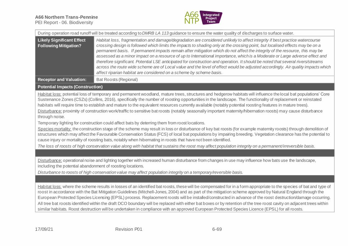
A66 Northern Trans-Pennine PEI Report - 06. Biodiversity
17/09/21 Revision P01 6-69
IntegratedProjectTeam
During operation road runoff will be treated according to DMRB LA 113 guidance to ensure the water quality of discharges to surface water.
Likely Significant Effect
Following Mitigation?
Habitat loss, fragmentation and damage/degradation are considered unlikely to affect integrity if best practice watercourse
crossing design is followed which limits the impacts to shading only at the crossing point, but localised effects may be on a
permanent basis. If permanent impacts remain after mitigation which do not affect the integrity of the resource, this may be
assessed as a minor impact on a resource of up to International importance, which is a Moderate or Large adverse effect and
therefore significant. Potential LSE anticipated for construction and operation. It should be noted that several rivers/streams
across the route wide scheme are of Local value and the level of effect would be adjusted accordingly. Air quality impacts which
affect riparian habitat are considered on a scheme by scheme basis.
Receptor and Valuation: Bat Roosts (Regional)
Potential Impacts (Construction)
Habitat loss: potential loss of temporary and permanent woodland, mature trees, structures and hedgerow habitats will influence the local bat populations’ Core
Sustenance Zones (CSZs) (Collins, 2016), specifically the number of roosting opportunities in the landscape. The functionality of replacement or reinstated
habitats will require time to establish and mature to the equivalent resources currently available (notably potential roosting features in mature trees).
Disturbance: proximity of construction work/traffic to sensitive bat roosts (notably seasonally important maternity/hibernation roosts) may cause disturbance
through noise.
Temporary lighting for construction could affect bats by deterring them from roost locations.
Species mortality: the construction stage of the scheme may result in loss or disturbance of key bat roosts (for example maternity roosts) through demolition of
structures which may affect the Favourable Conservation Status (FCS) of local bat populations by impairing breeding. Vegetation clearance has the potential to
cause injury or mortality of roosting bats, notably when hibernating in roosts that have not been identified.
The loss of roosts of high conservation value along with habitat that sustains the roost may affect population integrity on a permanent/irreversible basis.
Potential Impacts (Operation)
Disturbance: operational noise and lighting together with increased human disturbance from changes in use may influence how bats use the landscape,
including the potential abandonment of roosting locations.
Disturbance to roosts of high conservation value may affect population integrity on a temporary/reversible basis.
Design, Mitigation and Enhancement Measures
Habitat loss: where the scheme results in losses of an identified bat roosts, these will be compensated for in a form appropriate to the species of bat and type of
roost in accordance with the Bat Mitigation Guidelines (Mitchell-Jones, 2004) and as part of the mitigation scheme approved by Natural England through the
European Protected Species Licensing (EPSL) process. Replacement roosts will be installed/constructed in advance of the roost destruction/damage occurring.
All tree bat roosts identified within the draft DCO boundary will be replaced with either bat boxes or by retention of the tree roost cavity on adjacent trees within
similar habitats. Roost destruction will be undertaken in compliance with an approved European Protected Species Licence (EPSL) for all roosts.

A66 Northern Trans-Pennine PEI Report - 06. Biodiversity
17/09/21 Revision P01 6-70
IntegratedProjectTeam
In areas of proposed vegetation clearance, any trees containing cavities/Potential Roosting Features that have no evidence of use by bats (and therefore do not
fall within the requirements of mitigation through the EPSL process), should be retained and attached to nearby trees and/or artificial structures to provide a
‘temporal bridging’ of tree roost opportunities. This will compensate for the loss of woodland roosting opportunities and mitigate for the time allowed for
alternative tree roost features to develop in nearby trees/woodland. Where mature trees offer the opportunity, such techniques can also be used to replace
potential roosting features.
Disturbance: the construction methodology will require implementation of preventative measures to avoid disturbance of roost locations from construction noise
and vibration. Any sensitive locations will also require measures to avoid light spill illuminating roost entrances.
Species mortality: destruction of known roosts will be undertaken under the EPSL process with a method statement in place for sensitive timing of works, or
movement of bats by a bat-licensed ecologist prior to works commencing, to reduce the risk of injury or mortality. The EPSL process will also ensure
replacement roosts are provided so that the FCS of local bat populations will not be impaired.
Likely Significant Effect
Following Mitigation?
The majority of impacts are considered to be temporary/reversible when mitigation is taken into account or reduced so as not to
affect the integrity of the bat population (this will be a requirement under EPSL). Due to ongoing surveys, There may be further
identification of bat roosts of high conservation value (maternity roosts of rarer species) for which mitigation design (including
design of associated crossing features and foraging resource) is not confirmed. Loss of such roosts and associated habitat or
connectivity may affect integrity of the population on a permanent/irreversible basis. If permanent impacts remain after mitigation,
this may be assessed as a major impact on a resource of Regional importance, which is a Moderate or Large effect and
therefore significant. Potential LSE anticipated for construction and operation.
Receptor and Valuation: Bat Activity (Foraging and Commuting) (up to National)
Potential Impacts (Construction)
Habitat loss: the temporary and permanent loss of woodland, grassland, wetland and hedgerow habitats will have an effect on the local bat populations’ CSZs,
namely their ability to forage and commute through the landscape. Whilst lost habitats will be replaced post construction, the functionality of these new habitats
will require time to establish and mature to the equivalent resources currently available (notably woodland height and structure).
Habitat f ragmentation: the vegetation clearance required for construction of the schemes will affect bat flight lines on a temporary basis. Removal of linear
corridors for construction compounds will result in temporary severance of flight routes and/or a loss of functionality through severance of connections between
roosts and foraging grounds.
Habitat damage/degradation: potential increase in dust and vehicle emission deposits from the construction phase which may degrade sensitive habitats used as
key resource for foraging, notably ancient woodland. Additionally, water pollution may affect aquatic habitats. This degradation may result in a potential loss of
invertebrate food source(s) in the local area.
Disturbance: potential disturbance impacts arising from temporary lighting for construction and associated elevated noise level which may affect nocturnal
species; for example, inhibiting bats from using existing foraging resources or commuting routes. This may also affect the av ailability of airborne invertebrate
prey.

A66 Northern Trans-Pennine PEI Report - 06. Biodiversity
17/09/21 Revision P01 6-71
IntegratedProjectTeam
Species mortality: the construction stage of the scheme will likely result in temporary loss or disturbance of key foraging/commuting habitat resources, affecting
the FCS of local bat populations by impairing their ability to breed (for example severing links between maternity roosts and key foraging resources).
Increases in construction traffic in proximity to bat roosts may increase road mortality through collisions with site vehicles (RTAs).
The loss of foraging resource and flight lines may affect population integrity on a permanent/irreversible basis.
Potential Impacts (Operation)
Habitat f ragmentation: the widening of the road online and the creation of new offline sections will sever/fragment the landscape north to south on a permanent
basis. Key flight routes between foraging resources and roost locations may be affected in the long term.
Habitat damage/degradation: the operation of the new road alignment may result in an increase in vehicle emissions which may affect sensitive habitats us ed as
key resources for foraging. This degradation has potential to change invertebrate biomass and species composition in the local area.
Disturbance: operational noise and lighting together with increased human disturbance from changes in use will affect how bats use the landscape, including the
potential abandonment of roosting locations and reduction in use of foraging resource which may reduce the range of the species present.
Species mortality: bats habituate to established flight routes connecting roosting and foraging resources, even when the flight paths have been severed by a new
road alignment. Bats crossing new live carriageway will be highly susceptible to collision with vehicles where they will follow the new contour profile of the historic
crossing point.
The habitat fragmentation and increase in mortality may affect population integrity on a permanent/irreversible basis.
Design, Mitigation and Enhancement Measures
Habitat loss: the CSZs for the bat species identified within the Scheme areas extend between 1km to 4kms radius from communal roost s ites (Collins 2016).
Where losses of key foraging habitats are noted as affecting a notable/significant proportion of this habitat type within the CSZ, measures to phase habitat
removal will be considered.
Landscape design will be sympathetic to the locations of key foraging habitats, any retained bat roosts, established flight lines and any roost structures/bat boxes
that are provided as mitigation for roost loss and habitats will be replaced and enhanced for bats where possible.
Habitat f ragmentation: mitigation measures to retain key flight routes during construction will include the following:
• Minimising the physical break and duration of the flight path severance.
• Minimising light and noise pollution.
• Erecting temporary alternative flight routes (wattle screens and/or pot grown plants to create temporary hedgerows within severed flight routes).
• Reinstating severed flight routes each evening and on completion of the works.
• Established flight lines will be retained in their original location where possible through design, in conjunction with planting schemes to direct and
encourage bats to maintain the crossing location.
• Replacement of established flight paths will likely be required via either greening of over bridges or installation of wildli fe underpasses/culverts of
appropriate dimensions. Additionally, wattle screening will be provided as a temporary measure whilst new planting matures.

A66 Northern Trans-Pennine PEI Report - 06. Biodiversity
17/09/21 Revision P01 6-72
IntegratedProjectTeam
• Where f light routes coincide with planned structures, these will be designed with the requirements of the species to provide appropriate and effective
mitigation for the severance, where possible.
• Foraging/commuting parallel to the alignments will be encouraged through habitat mitigation and landscaping plans.
Habitat damage/degradation: the planned mitigation/planting throughout the scheme extents will replace lost habitats providing alternative sources of foraging
resource. Habitat removal will be staged to ensure local resources are not substantially reduced concurrently. Pollution control measures will be implemented as
outlined in the habitats and rivers section.
Disturbance: where possible the effects of disturbance to key commuting routes will be avoided/minimised through design and location of construction activities.
The construction methodology will require implementation of preventative measures to avoid light spill on bat flight routes or key foraging resources. These will
be incorporated into the EMP.
The operational lighting plan will be reviewed by a bat ecologist to ensure light spill on sensitive habitats is avoided or mitigated.
Species mortality: the above measures to maintain bat flight lines across the project will reduce the likelihood of species mortality in both construction and
operational stages. In addition, other measures during construction may include traffic calming where vehicles are operational during the crepuscular/night-time
hours that bats are active.
Likely Significant Effect
Following Mitigation?
The majority of impacts are considered to be temporary/reversible when mitigation is taken into account or reduced so as not to
affect the integrity of the bat population. Due to ongoing surveys, there may be further identification of key flight routes for rarer
species at the limit of their published range (Leisler’s bat (Nyctalus leisleri) for which mitigation design (including design of
crossing features and associated planting) is not confirmed. Loss of such connectivity and increased risk of mortality may affect
integrity of the population on a permanent/irreversible basis. If permanent impacts remain after mitigation, this may be assessed
as a major impact on a resource of National importance, which is a Large or Very Large effect and therefore significant. Potential
LSE are anticipated for both construction and operation.
Receptor and Valuation: Red squirrel (Sciurus vulgaris) (Up to National)
Potential Impacts (Construction)
Habitat loss: potential for temporary and permanent loss of red squirrel foraging, commuting and breeding habitat such as areas of woodland, tree lines and
hedgerows to decrease numbers of red squirrels in areas which are impacted.
Habitat f ragmentation: potential temporary fragmentation and severance of suitable habitat during construction due to clearance of hedgerows between
woodland blocks may affect local population viability.
Habitat damage/degradation: potential increase in dust deposition during construction may represent harmful impacts to woodland habitats utilised by red
squirrel resulting in reduction in foraging resource which may affect local population viability.
Disturbance: potential increase in noise and lighting during construction may cause stress in red squirrels forcing individuals to unnecessarily expend energy and
time responding to disturbance which may affect local population viability.

A66 Northern Trans-Pennine PEI Report - 06. Biodiversity
17/09/21 Revision P01 6-73
IntegratedProjectTeam
Species mortality: clearance of vegetation (woodland, tree lines and hedgerows in particular) associated with the route wide project development has the
potential to directly injure or kill red squirrels.
The loss of habitat may affect population integrity on a permanent/irreversible basis.
Potential Impacts (Operation)
Habitat f ragmentation: the widening of the road online and the creation of new offline sections will sever/fragment the landscape north to south on a permanent
basis. Suitable woodland areas located north and south of the alignment may become permanently severed, isolating populations.
Habitat damage/degradation: the operational phase may cause an increase in noise, vibration and light which may represent a negative impact to habitats
utilised by red squirrel such as areas of woodland, tree lines and hedgerows. Air quality related degradation through emissions may result in a loss of food
source in woodland.
Disturbance: increased traffic noise and lighting may cause individuals to unnecessarily expend energy and time responding to disturbance which may affect
local population viability.
Species mortality: potential mortality associated with crossing roads to disperse or access foraging resources.
The fragmentation of habitat may affect population integrity on a permanent/irreversible basis.
Design, Mitigation and Enhancement Measures
Habitat loss: both temporary and permanent suitable red squirrel habitat loss will be mitigated by habitat replacement and enhancement measures. These
measures will include compensation tree and hedgerow planting and woodland management for existing woodland areas. Whilst lost habitats will be replaced
post construction, the functionality of these new habitats will take time to develop to the equivalent resources currently av ailable (notably woodland height and
structure).
Habitat f ragmentation: will be mitigated by the inclusion of red squirrel crossing points along appropriate areas of new road alignments. These crossing points
may include rope bridges or green bridges. Habitat fragmentation will also be mitigated by compensational planting along the route which will ensure suitable red
squirrel commuting and foraging resources are connected, where possible.
Habitat damage/degradation:
Air quality impacts on woodland will be minimised during construction through dust suppression. Operational air quality impacts on woodland are to be
conf irmed.
Disturbance: direct and indirect impacts associated with construction activities will be mitigated by measures included within the EMP to reduce noise and
temporary lighting impacts on sensitive woodland sites.
Species mortality: measures set out in the EMP will include sensitive vegetation clearance and ECoW supervision during vegetation clearance and construction
activities. Clearance of red squirrel habitat will be undertaken under a conservation licence, which will ensure the risk of species mortality is reduced and habitat
features are replaced.
Likely Significant Effect
Following Mitigation?
The majority of impacts are considered to be temporary/reversible when mitigation is taken into account or reduced so as not to
affect the integrity of the red squirrel population. Due to ongoing surveys, there may be further identification of woodlands

A66 Northern Trans-Pennine PEI Report - 06. Biodiversity
17/09/21 Revision P01 6-74
IntegratedProjectTeam
supporting red squirrel and design of crossing features and associated planting to reconnect fragmented habitat is not confirmed.
Any replacement woodland habitat will also take time to mature and be of use to the species. Loss of habitat, connectivity and
increased risk of mortality may affect integrity of the population on a permanent/irreversible basis. If permanent impacts remain
after mitigation, this may be assessed as a major impact on a resource of National importance, which is a Large or Very Large
effect and therefore significant. Potential LSE anticipated for both construction and operation.
Receptor and Valuation: Otter (Lutra lutra) (Up to International)
Potential Impacts (Construction)
Habitat loss: temporary and minor permanent loss of otter foraging, commuting and holt habitat along main rivers, tributaries and ordinary watercourses
throughout the scheme has the potential to decrease otter numbers in affected areas.
Habitat f ragmentation: otters may be physically prevented from travelling along watercourses during construction activities in the absence of mitigation which
may reduce access to foraging resources or shelter or prevent them dispersing or breeding successfully.
Habitat damage/degradation: surface run off of pollutants may compromise the quality of foraging resources.
Disturbance: potential noise and light disturbance impacts could cause stress to otters forcing individuals to unnecessarily expend energy and time responding to
disturbance which may affect local population viability.
Species mortality: otter mortality has the potential to increase during the construction period through destruction of holts or resting sites wi thout due care,
changes to commuting routes that may increase road traffic collisions or accidental injury or death on construction sites.
The minor loss of habitat and direct loss of holts may affect population integrity on a temporary/reversible basis.
Potential Impacts (Operation)
Habitat f ragmentation: otters may be physically prevented from travelling along watercourses in the operation phase due to poor design of culverts o r bridges.
This may be exacerbated in flood conditions.
Habitat damage/degradation: the operational phase may cause an increase in vehicle deposits and surface run off of pollutants which may affect local population
viability.
Disturbance: traffic noise, vibration and lighting and increased presence of people have potential to impact otter foraging, commuting and holts which may affect
local population viability.
Species mortality: potential increase in mortality associated with crossing roads to disperse or access foraging resources.
Habitat f ragmentation and increased risk of mortality may affect population integrity on a permanent/irreversible basis.
Design, Mitigation and Enhancement Measures
Habitat loss: both temporary and permanent habitat loss will be mitigated by riparian habitat replacement and enhancement measures.
Habitat f ragmentation: mitigation through design of watercourse crossing points that are suitable for otter to use. Inclusion of mammal ledges, where appropriate,
will ensure otter use in flood conditions.

A66 Northern Trans-Pennine PEI Report - 06. Biodiversity
17/09/21 Revision P01 6-75
IntegratedProjectTeam
Habitat damage/degradation: direct and indirect impacts associated with construction activities will be mitigated by measures included within the EMP. These
measures will include sensitive working practices and potential use of ECoW supervision during activities such as vegetation clearance and construction around
existing and new watercourse crossing points. An assessment of the potential impacts of operations-phase runoff on surface water quality will be undertaken by
the water team using the Highways England Water Risk Assessment Tool (HEWRAT); HEWRAT outputs are used to design suitable treatment ponds for road
runof f. During operation road runoff will be treated according to DMRB LA 113 guidance to ensure the water quality of discharges to surface water (See Chapter:
14 Road Drainage and the Water Environment).
Species mortality: temporary or permanent destruction of known holts and resting sites will be undertaken under the EPSL process with a method s tatement in
place for sensitive clearance and supervision by an otter-licensed ecologist to reduce the risk of injury or mortality. The EPSL process will also ensure installation
of artificial holts, as required. Otter crossing points on watercourses will be accompanied by otter-proof fencing to ensure animals are funnelled into safe crossing
points and reduce the risk of mortality on the carriageway.
Likely Significant Effect
Following Mitigation?
The majority of impacts are considered to be temporary/reversible when mitigation is taken into account or reduced so as not to
affect the integrity of the otter population. As long as construction and design mitigation is in place, including design of water
crossing points suitable for otters to prevent road mortality, the remaining impacts should not affect the integrity of this resource
and would be temporary/reversible in nature. This may be assessed as a negligible impact on a resource of up to International
importance, which is a Slight effect and therefore not significant. No LSE are anticipate (Construction and Operation).
Receptor and Valuation: Water vole (Arvicola amphibius) (County)
Potential Impacts (Construction)
Habitat loss: potential temporary and minor permanent loss of water vole foraging and burrow habitat along tributaries and ordinary watercourses throughout the
scheme may affect local population viability.
Habitat f ragmentation: potential for new crossing points over watercourses to fragment water vole habitat which may affect local population viability.
Habitat damage/degradation: potential increase in dust, noise and vibration may lead to surface run off of pollutants/dust and habitats becoming less d esirable,
which may affect local population viability.
Disturbance: potential noise and visual disturbance are unlikely to have a significant effect on water vole.
Species mortality: water vole mortality has the potential to increase during the construction period through direct destruction of burrows and riparian habitat
without due care or collapse of burrows due to nearby vibration and excavation.
The minor loss of habitat and direct loss of burrows may affect population integrity on a temporary/reversible basis.
Potential Impacts (Operation)
Habitat f ragmentation:
water voles may be physically prevented from travelling along watercourses in the operation phase due to poor design of culverts or bridges. This may be
exacerbated in flood conditions.
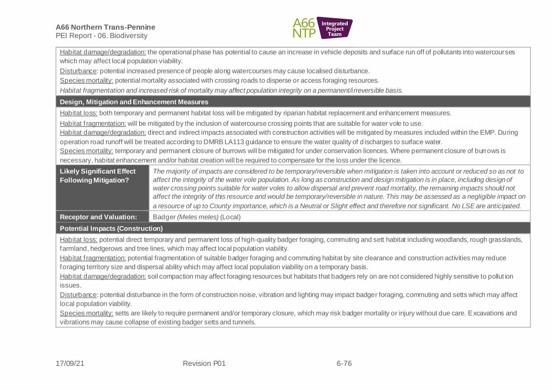
A66 Northern Trans-Pennine PEI Report - 06. Biodiversity
17/09/21 Revision P01 6-76
IntegratedProjectTeam
Habitat damage/degradation: the operational phase has potential to cause an increase in vehicle deposits and surface run off of pollutants into watercourses
which may affect local population viability.
Disturbance: potential increased presence of people along watercourses may cause localised disturbance.
Species mortality: potential mortality associated with crossing roads to disperse or access foraging resources.
Habitat fragmentation and increased risk of mortality may affect population integrity on a permanent/irreversible basis.
Design, Mitigation and Enhancement Measures
Habitat loss: both temporary and permanent habitat loss will be mitigated by riparian habitat replacement and enhancement measures.
Habitat f ragmentation: will be mitigated by the inclusion of watercourse crossing points that are suitable for water vole to use.
Habitat damage/degradation: direct and indirect impacts associated with construction activities will be mitigated by measures included within the EMP. During
operation road runoff will be treated according to DMRB LA113 guidance to ensure the water quality of d ischarges to surface water.
Species mortality: temporary and permanent closure of burrows will be mitigated for under conservation licences. Where permanent closure of burrows is
necessary, habitat enhancement and/or habitat creation will be required to compensate for the loss under the licence.
Likely Significant Effect
Following Mitigation?
The majority of impacts are considered to be temporary/reversible when mitigation is taken into account or reduced so as not to
affect the integrity of the water vole population. As long as construction and design mitigation is in place, including design of
water crossing points suitable for water voles to allow dispersal and prevent road mortality, the remaining impacts should not
affect the integrity of this resource and would be temporary/reversible in nature. This may be assessed as a negligible impact on
a resource of up to County importance, which is a Neutral or Slight effect and therefore not significant. No LSE are anticipated.
Receptor and Valuation: Badger (Meles meles) (Local)
Potential Impacts (Construction)
Habitat loss: potential direct temporary and permanent loss of high-quality badger foraging, commuting and sett habitat including woodlands, rough grasslands,
farmland, hedgerows and tree lines, which may affect local population viability.
Habitat f ragmentation: potential fragmentation of suitable badger foraging and commuting habitat by site clearance and construction activities may reduce
foraging territory size and dispersal ability which may affect local population viability on a temporary basis.
Habitat damage/degradation: soil compaction may affect foraging resources but habitats that badgers rely on are not considered highly sensitive to pollut ion
issues.
Disturbance: potential disturbance in the form of construction noise, vibration and lighting may impact badger foraging, commuting and setts which may affect
local population viability.
Species mortality: setts are likely to require permanent and/or temporary closure, which may risk badger mortality or injury without due care. Excavations and
vibrations may cause collapse of existing badger setts and tunnels.

A66 Northern Trans-Pennine PEI Report - 06. Biodiversity
17/09/21 Revision P01 6-77
IntegratedProjectTeam
Badger mortality may increase during the construction period through changes to commuting routes that may increase road traff ic collisions or accidental injury
or death on construction sites.
All the potential impacts, apart from habitat degradation/damage, may affect local population integrity on a temporary/reversible basis.
Potential Impacts (Operation)
Habitat f ragmentation: potential fragmentation of suitable badger foraging and commuting habitat by offline sections of the project may reduce foraging territory
size and dispersal ability which may affect local population viability on a permanent or longer-term basis.
Habitat damage/degradation: habitats that badgers rely on are not considered highly sensitive to pollution issues and badgers are known to acclimatise to traffic
noise and the presence of people as they are regularly found in roadside locations and urban areas.
Disturbance: badgers are known to acclimatise to traffic noise and the presence of people as they are regularly found in roadside locations and urban areas so
no long- term disturbance impacts are anticipated.
Species mortality:
potential increase in mortality associated with crossing roads to disperse or access foraging resources.
Habitat fragmentation and mortality may affect local population integrity on a permanent/irreversible basis.
Design, Mitigation and Enhancement Measures
Habitat loss: temporary and permanent habitat loss will be mitigated by habitat replacement and enhancement measures. These measures will include
compensation tree and hedgerow planting and woodland management for existing woodland areas but may include a further loss of intensively managed
agricultural land and improved grassland which are prime foraging resources for badger.
Habitat f ragmentation: mitigated by the inclusion of crossing points suitable for badger along new road alignments along with appropriate badger fencing. These
crossing points may include culverts with terrestrial mammal ledges, badger underpasses, overpasses and tunnels. Habitat frag mentation will also be mitigated
by compensational replanting schemes along the route which will ensure suitable badger commuting and foraging habitats remain connected to one another
throughout the route.
Habitat damage/degradation: Damage and degradation to suitable badger habitats will be mitigated via compensational replanting schemes of woodland, tree
lines, rough grasslands and hedgerows. If temporary and/or permanent closure of existing badger setts is required, this will be mitigated for under individual
licences to interfere with setts (dens). Where permanent closure of a sett is necessary artificial setts may be required to compensate for the loss.
Disturbance: the EMP will include sensitive working practices to reduce disturbance impacts to badgers during construction.
Species mortality: temporary and permanent closure of existing badger setts will be mitigated for under individual licences to interfere with setts.
Badger fencing will be used around sections of carriageway where high badger activity has been identified and/or badger terri tories are likely to be significantly
impacted and severed as a result of new road alignments to prevent road mortality.
Likely Significant Effect
Following Mitigation?
The majority of potential impacts are considered to be temporary/reversible when mitigation is taken into account, although
permanent fragmentation and species road mortality cannot be ruled out at this stage as specific crossing features for badgers
have not yet been confirmed. Mitigation for fragmentation and road mortality will be considered at the next stage of design

A66 Northern Trans-Pennine PEI Report - 06. Biodiversity
17/09/21 Revision P01 6-78
IntegratedProjectTeam
development. If permanent impacts remain after mitigation, this may be assessed as a major adverse impact on a resource of
Local importance, which is a Slight effect and therefore not significant. No LSE are anticipated.
Receptor and Valuation: Other terrestrial mammals (County):
Polecat (Mustela putorius); Brown hare (Lepus europaeus); Deer; Hedgehog (Erinaceus europaeus) (Up to County)
Potential Impacts (Construction)
Habitat loss: loss of suitable terrestrial mammal habitats such as hedgerows, woodlands, rough grasslands, open arable fields, areas of scrub and riparian banks
will be lost on a temporary and permanent basis which may affect local population viability.
Habitat f ragmentation: potential fragmentation of suitable foraging and commuting habitat by new road alignments will reduce foraging territory size and may
af fect local population viability.
Habitat damage/degradation: habitats that these species rely on are not considered highly sensitive to pollution issues although hedgehog does rely on
invertebrate-rich habitats and polecats on certain aquatic species, which may be affected by local pollution incidents.
Disturbance: potential disturbance in the form of construction noise, vibration and lighting may impact mammal foraging, commuting and sheltering which may
af fect local population viability.
Species mortality: vegetation clearance has the potential to disturb, kill or injure deer, polecat, hedgehog and brown hare. Hedgehogs are particularly susceptible
to mortality or injury from vegetation clearance during hibernation. Excavations and vibration may cause collapse of burrows used by polecats.
All the potential impacts may affect local population integrity on a temporary/reversible basis.
Potential Impacts (Operation)
Habitat f ragmentation: potential permanent fragmentation of suitable terrestrial mammal foraging and commuting habitat as a result of the new road alignments
may af fect local population viability.
Habitat damage/degradation: habitats that these species rely on are not considered highly sensitive to pollution issues during the operational phase.
Disturbance: potential increase in traffic noise, vibration and lighting and increased presence of people have potential to impact foraging, commuting and
sheltering sites which may affect local population viability.
Species mortality: terrestrial mammal mortality may increase during operation as species such as polecat, hedgehog, deer and brown hare cross the road to
access foraging and commuting routes.
Habitat fragmentation and increased risk of mortality may affect local population integrity on a permanent/irreversible basis.
Design, Mitigation and Enhancement Measures
Habitat loss: will be mitigated via the development of integrated landscaping plans which include the replacement of important terrestrial mammal foraging,
commuting and resting habitats and the enhancement of these habitats, where possible and appropriate.
Habitat f ragmentation: mitigated by the inclusion of crossing points suitable for terrestrial mammals along new road alignments along with appropriate fencing
(including deer-proof where required). Habitat fragmentation will also be mitigated by compensational replanting along the route.

A66 Northern Trans-Pennine PEI Report - 06. Biodiversity
17/09/21 Revision P01 6-79
IntegratedProjectTeam
Habitat damage/degradation: Direct and indirect impacts associated with construction impacts will be mitigated by measures included within the EMP.
Disturbance: the EMP will include sensitive working practices to reduce disturbance impacts to terrestrial mammals during construction.
Species mortality: measures will include sensitive working practices and potential use of ECoW supervision during vegetation clearance and const ruction
activities.
Likely Significant Effect
Following Mitigation?
The majority of potential impacts are considered to be temporary/reversible when mitigation is taken into account, although
permanent fragmentation and species road mortality cannot be ruled out at this stage as specific crossing features for terrestrial
mammals have not yet been confirmed. Mitigation for fragmentation and road mortality will be considered at the next stage of
design development. If permanent impacts remain after mitigation, this may be assessed as a major adverse impact on a
resource of up to County importance, which is a Slight or Moderate effect and therefore significant. Potential LSE are anticipated
during operation.
Receptor and Valuation: Wintering Birds (up to International value due to SPA species)
Potential Impacts (Construction)
Habitat loss: potential loss of high-quality bird foraging and roosting habitats such as hedgerows, wetlands and wet pasture may decrease numbers and diversity
of wintering birds in areas which are impacted.
Habitat damage/degradation: potential increase in dust and polluted run-off during construction which may represent a deleterious impact to habitats utilised by
wintering birds such as heathland, ancient woodland and aquatic habitats which may result in a loss of food source. Potential increased risk of pollution of
aquatic environments through the surface run off of pollutants/dust. Both impacts may affect local population viability on a temporary basis.
Disturbance: potential increase in noise, vibration and light during construction as well as increased visual disturbance may cause stress in wintering birds, force
individuals to unnecessarily expend energy and time responding to disturbance rather than feeding which may affect local population viability on a temporary
basis.
Species mortality: clearance of vegetation associated with the project has the potential to disturb wintering birds.
Habitat loss may affect local population integrity on a permanent/irreversible basis.
Potential Impacts (Operation)
Habitat damage/degradation: the operational phase has potential to cause an increase in vehicle deposits and surface run-off of pollutants into watercourses and
wetland habitats which may affect food resources.
Disturbance: increased noise and visual impacts associated with the operational activities of increased traffic and human presence have the potential to cause
stress in wintering birds. The route may be brought closer to a notable wintering bird site where 500 lapwing were recorded to the north west of Kirkby Thore.
Species mortality: potential to increase mortality through traffic collision due to higher traffic volume, greater width of the carriageway and increased speed of
traf f ic.
Disturbance and increased road mortality are unlikely to affect local population integrity and will have temporary/reversible effects only due to habituation.

A66 Northern Trans-Pennine PEI Report - 06. Biodiversity
17/09/21 Revision P01 6-80
IntegratedProjectTeam
Design, Mitigation and Enhancement Measures
Habitat loss: mitigated through the development of integrated landscaping plans which include the replacement of important wintering bird foraging and roosting
habitats and the enhancement of these habitats, where possible and appropriate.
Habitat damage/degradation:
direct and indirect impacts associated with construction impacts will be mitigated by measures included within the EMP. During operation road runoff will be
treated according to DMRB LA 113 guidance to ensure the water quality of discharges to surface water.
Disturbance: noise barriers and visual screens will be used during construction. The reduction of disturbance effects during the operational phase is yet to be
conf irmed.
Species mortality: measures will include sensitive working practices and potential use of ECoW supervision during vegetation clearance and const ruction
activities.
Likely Significant Effect
Following Mitigation?
The majority of potential impacts are considered to be temporary/reversible when mitigation is taken into account. Replacement
for habitat loss for wintering birds has also yet to be designed fully, but due to the mobility of wintering birds and availability of
suitable habitat in the vicinity this impact is considered to not affect the integrity of the population and be temporary/reversible.
These mitigation requirements will be considered at the next stage of design development. This is a minor adverse impact on a
resource of up to International importance, which is a Moderate or Large effect and therefore significant. Potential LSE are
anticipated during construction and operation. The valuation for wintering birds varies by scheme and this is set out in the tables
below.
Receptor and Valuation: Breeding Birds (Up to International value due to SPA species)
Potential Impacts (Construction)
Habitat loss: direct impacts associated with the loss of high-quality bird breeding and foraging habitats such as hedgerows, rough grassland, scrub, woodland
and f ield margins have the potential to decrease numbers and diversity of breeding birds in those areas.
Habitat damage/degradation: potential increase in dust and polluted run-off during construction may represent a deleterious impact to habitats utilised by
wintering birds such as heathland, ancient woodland and aquatic habitats which may result in a loss of food source. Potential increased risk of pollution of
aquatic environments through the surface run off of pollutants/dust may make habitats less desirable to wintering bird. Both impacts may affect local population
viability on a temporary basis.
Disturbance: potential increase in noise, vibration and light during construction as well as increased visual disturbance may cause stress in barn owl, forcing
individuals to unnecessarily expend energy and time responding to disturbance rather than feeding which may affect local population viability on a temporary
basis.
Species mortality: clearance of vegetation associated with the project has the potential to cause injury or mortality to breeding birds without due care.
Habitat loss may affect local population integrity on a permanent/irreversible basis.
Potential Impacts (Operation)

A66 Northern Trans-Pennine PEI Report - 06. Biodiversity
17/09/21 Revision P01 6-81
IntegratedProjectTeam
Habitat damage/degradation: the operational phase has potential to cause an increase in vehicle deposits and surface run-off of pollutants into watercourses and
wetland habitats which may affect food resources for some species.
Disturbance: potential disturbance impacts associated with the increased traffic noise and presence of people have the potential to cause stress in breeding
birds which may cause a reduction in resilience and survival rates.
Species mortality: potential to increase mortality through traffic collision due to higher traffic volume, greater width of the carriageway and increased speed of
traf f ic.
Disturbance and increased road mortality are unlikely to affect local population integrity and will have temporary/reversible effects only due to habituation.
Design, Mitigation and Enhancement Measures
Habitat loss: mitigated through the development of integrated landscaping plans which include the replacement of important breeding bird foraging and nesting
habitats and the enhancement of these habitats, where possible and appropriate.
Habitat damage/degradation: direct and indirect impacts associated with construction impacts will be mitigated by measures included within the EMP. During
operation road runoff will be treated according to DMRB LA 113 guidance to ensure the water quality of discharges to surface water.
Disturbance: noise barriers and visual screens will be used during construction along with careful timing of vegetation clearance and certain construction
activities outside the breeding bird season, where possible.
To avoid disturbance impacts from construction activities, it may be necessary to monitor the presence of SPA citation species during works close to the SPA to
ensure any negative impacts are minimised. Specific measures would be included in the EMP.
The reduction of disturbance effects from traffic noise during the operational phase is yet to be confirmed. If recreational areas are created in areas of breeding
bird habitat, footpaths will be included to encourage people away from sensitive areas.
Species mortality: measures will include sensitive working practices and timing and potential use of ECoW supervision during vegetation clearance and
construction activities.
Likely Significant Effect
Following Mitigation?
The majority of potential impacts are considered to be temporary/reversible when mitigation is taken into account. Replacement
for habitat loss for breeding birds has also yet to be designed fully, but due to the mobility of breeding birds and availability of
suitable habitat in the vicinity this impact is considered to not affect the integrity of the population and be temporary/rev ersible.
These mitigation requirements will be considered at the next stage of design development. This is a minor adverse impact on a
resource of up to International importance, which is a Moderate or Large effect and therefore significant. Potential LSE are
anticipated during construction and operation. The valuation for breeding birds varies by scheme and this is set out in the tables
below.
Receptor and Valuation: Barn Owl (Tyto alba) (Regional due to habitat assessment indicating the area would support no more than 10 pairs route wide)
Potential Impacts (Construction)
Habitat loss: direct impacts associated with construction activities include the loss of high-quality barn owl breeding, roosting and foraging habitats such as
mature trees, tussocky grassland, farm buildings and field margins have potential to decrease numbers of barn owls in those areas.

A66 Northern Trans-Pennine PEI Report - 06. Biodiversity
17/09/21 Revision P01 6-82
IntegratedProjectTeam
Habitat damage/degradation: potential increase in dust which may represent a deleterious impact to habitats utilised by barn owl such as ancient woodland,
tussocky grassland, old structures and mature trees. Construction related degradation may result in a loss of food source which may affect local population
viability.
Disturbance: potential increase in noise, vibration and light during construction as well as increased visual disturbance may cause stress in barn owl, forcing
individuals to unnecessarily expend energy and time responding to disturbance rather than feeding which may affect local population viability on a temporary
basis.
Species mortality: clearance of trees and structures for the project has the potential to kill or injure breeding and/or roosting barn owls.
Habitat loss may affect local population integrity on a permanent/irreversible basis.
Potential Impacts (Operation)
Habitat damage/degradation: the operational phase has potential to cause an increase in vehicle deposits and surface run-off of pollutants into adjacent habitats
which may affect food resources.
Disturbance: potential disturbance impacts associated with the increased traffic noise and presence of people have the potential to cause stress in breeding barn
owls which may cause a reduction in resilience and survival rates.
Species mortality:
potential to increase mortality through traffic collision due to higher traffic volume, greater width of the carriageway and increased speed of traffic. This may be a
particular issue if barn owls are attracted to newly created road side habitats for foraging.
Species mortality may affect local population integrity on a permanent/irreversible basis.
Design, Mitigation and Enhancement Measures
Habitat loss: suitable barn owl foraging habitat and any loss of confirmed nest sites would be mitigated for through the provision of nest boxes and habitat
creation in areas which have been identified as being suitable through survey work.
Habitat damage/degradation: direct and indirect impacts associated with construction activities will be mitigated by measures included within the EMP.
Disturbance: careful timing of certain construction activities near to known barn owl breeding sites, where possible. The EMP will include sensitive working
practices to reduce any disturbance impacts on barn owl.
Species mortality: careful timing of structure demolition and tree clearance of known barn owl roosts will be undertaken under method statement.
Likely mitigation measures along the project would include construction of cuttings or mounds to increase the flight height of barn owls at areas identified as
likely crossing points. These measures would minimise the risk of barn owl mortality through collisions with vehicles.
Likely Significant Effect
Following Mitigation?
The majority of potential impacts are considered to be temporary/reversible when mitigation is taken into account, although
permanent changes to operational disturbance and risk of species road mortality cannot be ruled out at this stage as specific
mitigation has not been confirmed as yet. Replacement for habitat loss and nesting sites for barn owls has also yet to be
designed fully. These mitigation requirements will be considered at the next stage of design development. If permanent impacts

A66 Northern Trans-Pennine PEI Report - 06. Biodiversity
17/09/21 Revision P01 6-83
IntegratedProjectTeam
remain after mitigation, this may be assessed as a major adverse impact on a resource of up to Regional importance, which is a
Moderate or Large effect and therefore significant. Potential LSE are anticipated during construction and operation.
Receptor and Valuation: Reptiles (up to County)
Potential Impacts (Construction)
Habitat loss: potential for loss of habitats used by reptile species including hibernation sites and/or refuges and potential for loss of natal den site for adder.
Habitat f ragmentation: potential for fragmentation impacts during construction through loss of habitats and widening of existing barriers to dispersal.
Habitat damage/degradation: potential for pollution incidents during construction within reptile habitats in particular aquatic habitats for grass snake, which may
be af fected by local pollution incidents and sedimentation.
Disturbance: potential additional vehicle and personnel movements through reptile habitats during construction may affect local population viability on a
temporary basis.
Species mortality: clearance of vegetation and reptile habitat features without due care, has the potential to cause injury or mortality to active or hibernating
reptiles.
Habitat loss may affect local population integrity on a permanent/irreversible basis.
Potential Impacts (Operation)
Habitat f ragmentation: permanent widening of existing barriers and severance or isolation of areas by creation of habitat ‘islands’ surrounded by road
inf rastructure. Potential additional shading from structures or new planting may reduce basking areas.
Habitat damage/degradation and disturbance: potential for operational pollution from road run-off and disturbance by additional people using the roadside
habitats which may affect local population viability.
Species mortality: potential for species mortality through provision of additional roads and cycle paths.
Habitat fragmentation may affect local population integrity on a permanent/irreversible basis.
Design, Mitigation and Enhancement Measures
Habitat loss: mitigated through the development of integrated landscaping plans which include the replacement of reptile habitat, features such as hibernacula
and the enhancement of existing habitats, where possible and appropriate.
Habitat f ragmentation: habitat connectivity features for reptiles provided throughout construction and through the landscaping plans. Where islanded populations
are likely, reptile translocation may be required.
Habitat damage/degradation: direct and indirect impacts associated with construction impacts will be mitigated by measures included within the EMP. During
operation road runoff will be treated according to DMRB LA 113 guidance to ensure the water quality of discharges to surface water.
Disturbance: retained habitat will be fenced off for protection during construction, and vehicles and personnel will use clearly marked haul routes and footpaths.
In the operational stage, if recreational areas are created in areas of reptile habitat, footpaths will be included to encourage people away from sensitive habitats.
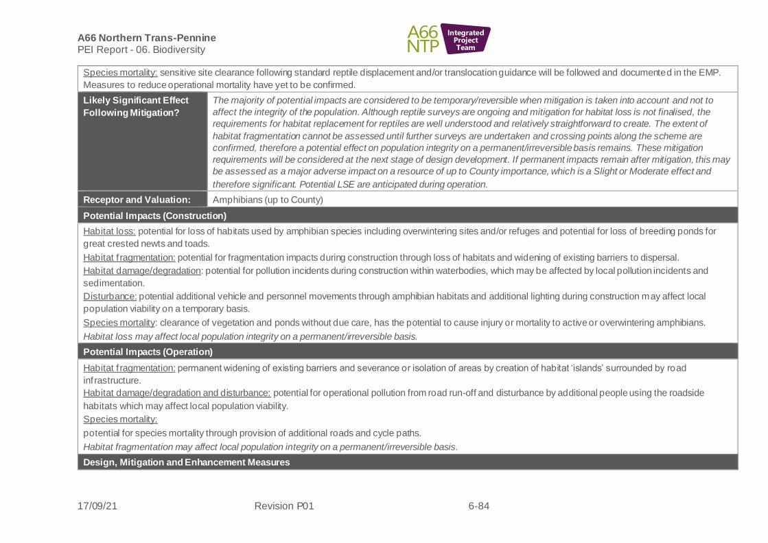
A66 Northern Trans-Pennine PEI Report - 06. Biodiversity
17/09/21 Revision P01 6-84
IntegratedProjectTeam
Species mortality: sensitive site clearance following standard reptile displacement and/or translocation guidance will be followed and documented in the EMP.
Measures to reduce operational mortality have yet to be confirmed.
Likely Significant Effect
Following Mitigation?
The majority of potential impacts are considered to be temporary/reversible when mitigation is taken into account and not to
affect the integrity of the population. Although reptile surveys are ongoing and mitigation for habitat loss is not finalised, the
requirements for habitat replacement for reptiles are well understood and relatively straightforward to create. The extent of
habitat fragmentation cannot be assessed until further surveys are undertaken and crossing points along the scheme are
confirmed, therefore a potential effect on population integrity on a permanent/irreversible basis remains. These mitigation
requirements will be considered at the next stage of design development. If permanent impacts remain after mitigation, this may
be assessed as a major adverse impact on a resource of up to County importance, which is a Slight or Moderate effect and
therefore significant. Potential LSE are anticipated during operation.
Receptor and Valuation: Amphibians (up to County)
Potential Impacts (Construction)
Habitat loss: potential for loss of habitats used by amphibian species including overwintering sites and/or refuges and potential for loss of breeding ponds for
great crested newts and toads.
Habitat f ragmentation: potential for fragmentation impacts during construction through loss of habitats and widening of existing barriers to dispersal.
Habitat damage/degradation: potential for pollution incidents during construction within waterbodies, which may be affected by local pollution incidents and
sedimentation.
Disturbance: potential additional vehicle and personnel movements through amphibian habitats and additional lighting during construction may affect local
population viability on a temporary basis.
Species mortality: clearance of vegetation and ponds without due care, has the potential to cause injury or mortality to active or overwintering amphibians.
Habitat loss may affect local population integrity on a permanent/irreversible basis.
Potential Impacts (Operation)
Habitat f ragmentation: permanent widening of existing barriers and severance or isolation of areas by creation of habitat ‘islands’ surrounded by road
inf rastructure.
Habitat damage/degradation and disturbance: potential for operational pollution from road run-off and disturbance by additional people using the roadside
habitats which may affect local population viability.
Species mortality:
potential for species mortality through provision of additional roads and cycle paths.
Habitat fragmentation may affect local population integrity on a permanent/irreversible basis.
Design, Mitigation and Enhancement Measures

A66 Northern Trans-Pennine PEI Report - 06. Biodiversity
17/09/21 Revision P01 6-85
IntegratedProjectTeam
Habitat loss: mitigated through the development of integrated landscaping plans which include the replacement of amphibian habitat, features such as replacing
ponds on a 2:1 basis and the enhancement of existing habitats, where possible and appropriate.
Habitat f ragmentation: habitat connectivity features for amphibians provided throughout construction and through the landscaping plans. Where islanded
populations are likely, great crested newt translocation may be required which will also cover other amphibians.
Habitat damage/degradation: direct and indirect impacts associated with construction impacts will be mitigated by measures included within the EMP. During
operation road runoff will be treated according to DMRB LA 113 guidance to ensure the water quality of discharges to surface water.
Disturbance: retained habitat will be fenced off for protection during construction, and vehicles and personnel will use clearly marked haul routes and footpaths.
In the operational stage, if recreational areas are created in areas of amphibian habitat (particularly around great crested newt ponds), footpaths will be included
to encourage people away from sensitive habitats.
Species mortality: sensitive site clearance following standard great crested newt displacement and/or translocation guidance will be followed and documented in
the EMP. Measures to reduce operational mortality have yet to be confirmed but may include measures to ensure amphibians are not entrapped within new
structures such as balancing ponds and control structure or appropriate use of fencing.
Likely Significant Effect
Following Mitigation?
The majority of potential impacts are considered to be temporary/reversible when mitigation is taken into account and not to
affect the integrity of the population. Although mitigation for amphibian habitat loss is not finalised, the requirements for habitat
replacement for amphibians are well understood and relatively straightforward to create. The extent of habitat fragmentation has
not been assessed to date and crossing points along the scheme are yet to be confirmed, therefore a potential effect on
population integrity on a permanent/irreversible basis remains. These mitigation requirements will be considered at the next
stage of design development. If permanent impacts remain after mitigation, this may be assessed as a major adverse impact on
a resource of up to County importance, which is a Slight or Moderate effect and therefore significant. Potential LSE are
anticipated during operation. It should be noted that great crested newts are subject to the EPSL process which would ensure
the integrity and favourable conservation status of this species is maintained therefore residual LSE are unlikely but cannot be
ruled out at this stage.
Receptor and Valuation: Fish (up to International)
Potential Impacts (Construction)
As per the Rivers section. Considerations specific to fish are described below.
Habitat loss: potential for the temporary loss (during construction) of spawning and nursery habitats including, clean gravels used for spawning by salmonids
(Salmo salar) and lamprey species and marginal silts used by larval (ammocoete) stage lampreys.
Disturbance: elevated levels of noise and vibration associated with the construction phase have the potential to disturb aquatic species, including the migratory
features of the River Eden and Tributaries SAC/SSSI.
Temporary lighting for construction may affect aquatic species by disturbing nocturnal migratory behaviours.

A66 Northern Trans-Pennine PEI Report - 06. Biodiversity
17/09/21 Revision P01 6-86
IntegratedProjectTeam
Species mortality: aquatic species could be killed or injured during construction. Eggs laid in spawning habitats could be destroyed or damaged and individuals
(particularly juveniles) could be killed or injured as a result of direct impact with plant or through hypoxia associated with dewatering.
These impacts may affect local population integrity on a permanent/irreversible basis.
Potential Impacts (Operation)
Potential operations phase impacts to fish are described above for Rivers; these include road runoff, the potential for habitat fragmentation and habitat
degradation as a result of poorly designed watercourse crossings that could restrict the migration of fish.
Habitat fragmentation and degradation may affect local population integrity on a permanent/irreversible basis.
Design, Mitigation and Enhancement Measures
Mitigation to protect fish during construction and operation is outlined in the Rivers section.
Habitat loss and fragmentation: watercourse crossings will be designed to facilitate fish passage and the design will consider the potential loss of habitat
upstream and downstream of the crossing location associated with altered fluvial geomorphological processes.
Disturbance: impacts will be minimised through sensitive timing of works giving rise to significant noise and vibration and best practice construction, such as low
impact piling methodologies. This is of particular relevance to migratory aquatic species (Atlantic salmon, sea lamprey and river lamprey). No night work will be
permitted in close proximity to watercourses without prior agreement from the Environment Agency and Natural England, and sensitive site lighting will be used.
Methodologies and timing of works in/near water will be agreed with Natural England and the Environment Agency.
Species mortality: all fish (including juvenile lamprey that live in marginal sediments) will be translocated prior to dewatering works. Methods and translocation
sites will be agreed in consultation with Natural England and the Environment Agency.
Likely Significant Effect
Following Mitigation?
Habitat loss, fragmentation and damage/degradation are considered unlikely to affect integrity of fish populations on a permanent
basis if best practice watercourse crossing design and pollution controls are followed. There remains the potential for
temporary/reversible impacts after mitigation which do not affect the integrity of the resource, this may be assessed as a
negligible adverse impact on a resource of up to International importance, which is a Slight effect and therefore not significant.
No LSE anticipated for construction and operation. It should be noted that several rivers/streams across the route wide scheme
vary in their value for fish and the level of effect would be adjusted accordingly.
Receptor and Valuation: Aquatic Invertebrates, including White clawed crayfish (Austropotamobius pallipes)
(County to International)
Potential Impacts (Construction)
As per the Rivers section of this table. Considerations specific to aquatic invertebrates are described below.
Habitat damage/degradation: in the absence of suitable mitigation, there is potential for invertebrate (including crayfish) habitat/refuges to be
damaged/degraded. This may be physically as a result of in-channel works and dewatering, or as a result of degradation of surface water quality from site runoff
or chemical/fuel spill and siltation.

A66 Northern Trans-Pennine PEI Report - 06. Biodiversity
17/09/21 Revision P01 6-87
IntegratedProjectTeam
Species mortality: in the absence of mitigation, there is potential for aquatic invertebrates to be killed or injured during construction, eit her as a result of direct
impact with plant/equipment or through hypoxia associated with dewatering.
In addition to pollution, there is also the risk of introducing invasive crayfish, particularly signal crayfish (Pacifastacus leniusculus) to project sites on
plant/equipment during construction. This species is known to outcompete white-clawed crayfish and also carries a plague (Phanomyces astaci) that white-
clawed crayfish are not immune to which can rapidly kill off an entire population at a site/area in just a few weeks.
Habitat loss and degradation may affect local population integrity on a permanent/irreversible basis.
Potential Impacts (Operation)
As per the Rivers section of this table. Considerations specific to aquatic invertebrates are described below.
Habitat f ragmentation: poorly designed watercourse crossings/culverts have the potential to restrict the movement of aquatic invertebrates.
Habitat damage/degradation: in the absence of mitigation, there is potential for aquatic invertebrates to be impacted by polluted surface water runoff. This
includes accidental spills on the road entering watercourses.
Species mortality: in the absence of mitigation there is potential for aquatic invertebrate mortality as a result of accidental spill of toxic chemicals.
Habitat fragmentation and degradation may affect local population integrity on a permanent/irreversible basis.
Design, Mitigation and Enhancement Measures
As per the Rivers section of this table. Considerations specific to aquatic invertebrates are described b elow.
Habitat damage/degradation: best practice construction methods with respect to working in/near water will be employed during construction, and operational
phase road runoff will be treated prior to discharge.
Species mortality: Prior to dewatering or intrusive in-channel works, all crayfish will be translocated by a suitably licenced, white-clawed crayfish surveyor. This
would be undertaken in combination with a fish translocation. Methods and translocation sites will be agreed in consultation with Natural England and the
Environment Agency.
Strict biosecurity protocols will be followed during construction and maintenance of assets to mitigate the risks of introducing signal crayfish and other aquatic
Invasive Non-native Species and pathogens to watercourses.
Likely Significant Effect
Following Mitigation?
Habitat loss, fragmentation and damage/degradation are considered unlikely to affect integrity of aquatic invertebrate populations
on a permanent basis if best practice watercourse crossing design and pollution controls are followed. There remains the
potential for temporary/reversible impacts after mitigation which do not affect the integrity of the resource, this may be assessed
as a negligible adverse impact on a resource of up to International importance, which is a Slight effect and therefore not
significant. No LSE anticipated for construction and operation. It should be noted that several rivers/streams across the route
wide scheme will likely vary in their value for aquatic invertebrates and the level of effect would be adjusted accordingly.
Receptor and Valuation: Terrestrial invertebrates (Up to National)
Potential Impacts (Construction)
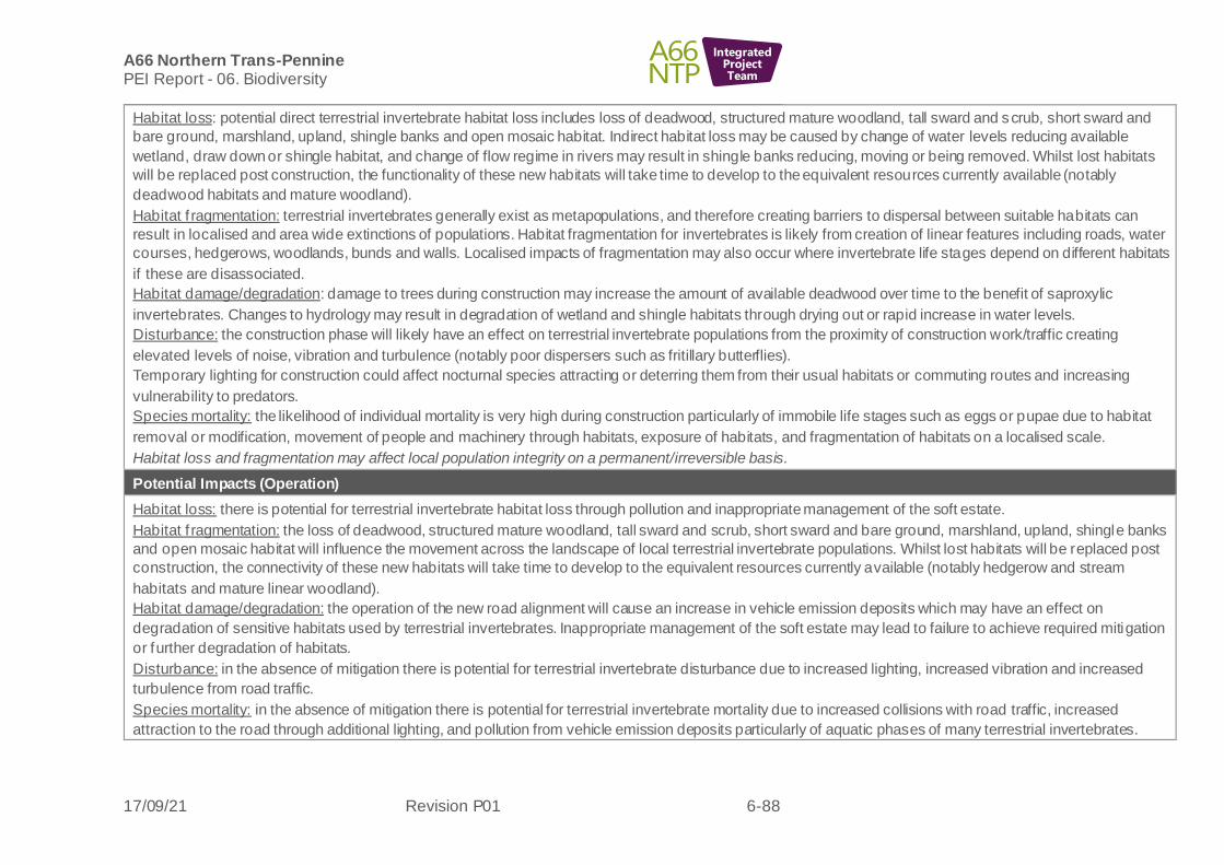
A66 Northern Trans-Pennine PEI Report - 06. Biodiversity
17/09/21 Revision P01 6-88
IntegratedProjectTeam
Habitat loss: potential direct terrestrial invertebrate habitat loss includes loss of deadwood, structured mature woodland, tall sward and scrub, short sward and
bare ground, marshland, upland, shingle banks and open mosaic habitat. Indirect habitat loss may be caused by change of water levels reducing available
wetland, draw down or shingle habitat, and change of flow regime in rivers may result in shingle banks reducing, moving or being removed. Whilst lost habitats
will be replaced post construction, the functionality of these new habitats will take time to develop to the equivalent resources currently available (notably
deadwood habitats and mature woodland).
Habitat f ragmentation: terrestrial invertebrates generally exist as metapopulations, and therefore creating barriers to dispersal between suitable habitats can
result in localised and area wide extinctions of populations. Habitat fragmentation for invertebrates is likely from creation of linear features including roads, water
courses, hedgerows, woodlands, bunds and walls. Localised impacts of fragmentation may also occur where invertebrate life stages depend on different habitats
if these are disassociated.
Habitat damage/degradation: damage to trees during construction may increase the amount of available deadwood over time to the benefit of saproxylic
invertebrates. Changes to hydrology may result in degradation of wetland and shingle habitats through drying out or rapid increase in water levels.
Disturbance: the construction phase will likely have an effect on terrestrial invertebrate populations from the proximity of construction work/traffic creating
elevated levels of noise, vibration and turbulence (notably poor dispersers such as fritillary butterflies).
Temporary lighting for construction could affect nocturnal species attracting or deterring them from their usual habitats or commuting routes and increasing
vulnerability to predators.
Species mortality: the likelihood of individual mortality is very high during construction particularly of immobile life stages such as eggs or pupae due to habitat
removal or modification, movement of people and machinery through habitats, exposure of habitats, and fragmentation of habitats on a localised scale.
Habitat loss and fragmentation may affect local population integrity on a permanent/irreversible basis.
Potential Impacts (Operation)
Habitat loss: there is potential for terrestrial invertebrate habitat loss through pollution and inappropriate management of the soft estate.
Habitat f ragmentation: the loss of deadwood, structured mature woodland, tall sward and scrub, short sward and bare ground, marshland, upland, shingle banks
and open mosaic habitat will influence the movement across the landscape of local terrestrial invertebrate populations. Whilst lost habitats will be replaced post
construction, the connectivity of these new habitats will take time to develop to the equivalent resources currently available (notably hedgerow and stream
habitats and mature linear woodland).
Habitat damage/degradation: the operation of the new road alignment will cause an increase in vehicle emission deposits which may have an effect on
degradation of sensitive habitats used by terrestrial invertebrates. Inappropriate management of the soft estate may lead to failure to achieve required mitigation
or further degradation of habitats.
Disturbance: in the absence of mitigation there is potential for terrestrial invertebrate disturbance due to increased lighting, increased vibration and increased
turbulence from road traffic.
Species mortality: in the absence of mitigation there is potential for terrestrial invertebrate mortality due to increased collisions with road traffic, increased
attraction to the road through additional lighting, and pollution from vehicle emission deposits particularly of aquatic phases of many terrestrial invertebrates.

A66 Northern Trans-Pennine PEI Report - 06. Biodiversity
17/09/21 Revision P01 6-89
IntegratedProjectTeam
Habitat loss and fragmentation may affect local population integrity on a permanent/irreversible basis.
Design, Mitigation and Enhancement Measures
Habitat loss: loss of high value habitats will be avoided where possible. High value habitats lost as a result of the construction will be re-instated post
construction. Where the scheme results in a loss of an identified terrestrial invertebrate habitat of importance, they will b e compensated for in a form appropriate
to the habitat requirements of the species assemblages present, where possible.
Habitat f ragmentation: fragmentation of habitats will be avoided where possible. Habitats fragmented as a result of the construction will be re-connected post
construction, where possible. Where the scheme results in disconnection of an identified terrestrial invertebrate habitat of importance, they will be compensated
for in a form appropriate to the habitat requirements of the species assemblages present. Hedgerows and other linear features will include gaps such as gates to
provide access points for invertebrate movement.
Habitat damage/degradation: minor damage to trees can be of benefit to invertebrates through creation of deadwood habitat. Translocation of existing standing
deadwood and creation of new deadwood will increase available habitat. Degradation of habitats will be avoided, and mitigation will include enhancement of
retained habitats and additional habitat creation.
Disturbance: mitigation will include careful design to minimise light spill, pollution control, and buffering of habitats to reduce turbulence effects.
Species mortality: Possible translocation of invertebrates in specific life stages and/or food or other plants, including deadwood, important for their lifecycle.
Likely Significant Effect
Following Mitigation?
The majority of potential impacts are considered to be temporary/reversible when mitigation is taken into account as long as
habitat features are replaced and fragmentation can be mitigated by additional habitat creation. There is potential for a
permanent/irreversible loss of species associated with mature woodland or mature trees but this should not affect the integrity of
the population after mitigation. If permanent impacts remain after mitigation, this may be assessed as a minor adverse impact on
a resource of up to National importance, which is a Slight or Moderate effect and therefore significant. Potential LSE are
anticipated during construction and operation.
Receptor and Valuation: Macrophytes (International)
Potential Impacts (Construction)
As per the Rivers section of this table. Considerations specific to macrophytes are described below.
Habitat loss: macrophytes (including Annex I habitat: 3260 Water courses of plain to montane levels with the Ranunculion fluitantis and Callitricho-Batrachion
vegetation, a qualify feature of the River Eden and Tributaries SAC/SSSI).
Habitat damage/degradation:
there is potential for macrophytes (including Annex I habitat: 3260 Water courses of plain to montane levels with the Ranunculion fluitantis and Callitricho-
Batrachion vegetation, a qualify feature of the River Eden and Tributaries SAC/SSSI) to be damaged/degraded during construction. This may be physically as a
result of in-channel works and dewatering, or as a result of degradation of surface water quality from site runoff or chemical/fuel spill.
In addition, there is the potential for the introduction and/or spread of invasive species of macrophyte when working in or near watercourse as a result of
contaminated plant/equipment. This may negatively impact/alter the function of the native macrophyte assemblage.

A66 Northern Trans-Pennine PEI Report - 06. Biodiversity
17/09/21 Revision P01 6-90
IntegratedProjectTeam
Habitat loss and degradation may affect local population integrity on a permanent/irreversible basis.
Potential Impacts (Operation)
As per the Rivers section of this table. Considerations specific to macrophytes are described below.
Habitat loss: habitat with the potential to support macrophytes in the future may be lost/degraded as a result of shading associated with new watercourse
crossings.
Habitat damage/degradation: In the absence of mitigation, there is potential for macrophytes to be impacted by polluted surface water road runoff (including one-
of f accidental chemical spills) and excessive sediment delivery to watercourses.
Habitat fragmentation and degradation may affect local population integrity on a permanent/irreversible basis.
Design, Mitigation and Enhancement Measures
As per Rivers section of this table. Considerations specific to macrophytes are described below.
Habitat loss: opportunities to translocate macrophyte beds of conservation value that will be lost will be investigated and assessed on a case-by-case basis, as
will the potential to reduce riparian shading (where appropriate) to promote natural macrophyte growth to mitigate for the loss of macrophytes at new
watercourse crossings.
Habitat damage/degradation: best practice construction methods with respect to working in/near water will be employed during construction, and operational
phase road runoff will be treated prior to discharge.
Strict biosecurity protocols will be followed to mitigate the risk associated with the introduction of invasive species.
Likely Significant Effect
Following Mitigation?
Habitat loss, fragmentation and damage/degradation are considered unlikely to affect the integrity of macrophyte populations,
including Annexe 1 habitat which is a qualifying feature of the River Eden SAC, if best practice watercourse crossing design and
pollution controls are followed. There will be localised loss through shading on a permanent/irreversible impacts, which is unlikely
to affect the integrity of the resource. This may be assessed as a minor adverse impact on a resource of up to International
importance, which is a Moderate or Large effect and therefore not significant. Potential LSE anticipated for construction and
operation. It should be noted that several rivers/streams across the route wide scheme will likely vary in their value for
macrophytes and the level of effect would be adjusted accordingly.
M6 Junction 40 to Kemplay Bank
6.9.4 Table 6-7: M6 Junction 40 to Kemplay Bank - likely significant effects, provides some specific details about the biodiversity resources on the above scheme. In general, potential impacts and mitigation measures described in Section 6.8 will be applicable unless otherwise stated.
6.9.5 The following biodiversity receptors have been scoped out of the assessment for this scheme:
• Pine marten
• Hazel dormouse

A66 Northern Trans-Pennine PEI Report - 06. Biodiversity
17/09/21 Revision P01 6-91
IntegratedProjectTeam
Table 6-7: M6 Junction 40 to Kemplay Bank - likely significant effects
Receptor Potential Impacts (Construction) Potential Impacts (Operation) Design, Mitigation and
Enhancement Measures
Likely Significant
Effect Following
Mitigation?
Statutory
Designated sites
River Eden SAC
and River Eden
and Tributaries
SSSI
(International)
As per route wide for designated sites
and rivers.
No new watercourse crossing points
(and associated habitat
loss/degradation) are proposed for this
scheme.
Small-scale direct and indirect impacts
may occur through the construction of
discharges into the River Eamont,
which forms part of the SAC/SSSI,
though direct habitat loss is not
anticipated.
These potential impacts may affect the
integrity of the resource on a
permanent/irreversible basis in the
absence of mitigation, which may be
assessed as a major adverse impact.
As per route wide for designated
sites and rivers.
Proposed new discharges to the
River Eamont, which forms part of
the SAC/SSSI, have the potential
to impact water quality.
The following Annex 1 habitat type
is susceptible to negative impacts
f rom nitrogen deposition: Alluvial
forests with alder (Alnus glutinosa)
and ash (Fraxinus excelsior) (Alno-
Padion, Alnion incanae, Salicion
albae) * Priority feature. This
habitat has not been recorded on
this scheme currently, but Phase 1
habitat surveys are ongoing and its
presence cannot be ruled out.
Further air quality assessment will
be undertaken to inform the ES
and operational impacts on riparian
habitats associated with the SAC
and SSSI cannot be ruled out at
this stage.
These potential impacts may affect
the integrity of the resource on a
permanent/irreversible basis in the
absence of mitigation, which may
As per route wide for
designated sites and rivers.
Proposed mitigation is predicted
to reduce impacts during
construction so as not to affect
the integrity of the site, although
small-scale temporary terrestrial
habitat loss may occur. Annex 1
habitats will be avoided through
design, where possible.
Opportunities to translocate
macrophyte beds of
conservation value that will be
lost will be investigated and
assessed on a case-by-case
basis, as will the potential to
reduce riparian shading (where
appropriate) to promote natural
macrophyte growth to mitigate
for the loss of macrophytes at
new watercourse crossings.
Such mitigation will be agreed
in consultation with the Natural
England and the Environment
Agency. This may be assessed
as a negligible adverse impact
during construction once
mitigation is taken into account.
Potential for negligible
adverse impacts on a
resource of International
importance, which is a
Slight effect and
therefore not significant.
No LSE anticipated
relating to habitat
loss/degradation
(Construction).
Potential for major
adverse impacts on a
resource of International
importance, which is a
Very Large ef fect and
therefore significant.
Potential adverse LSE
anticipated relating to air
quality (Operation).

A66 Northern Trans-Pennine PEI Report - 06. Biodiversity
17/09/21 Revision P01 6-92
IntegratedProjectTeam
Receptor Potential Impacts (Construction) Potential Impacts (Operation) Design, Mitigation and
Enhancement Measures
Likely Significant
Effect Following
Mitigation?
be assessed as a major adverse
impact.
During operation, the water
quality effects will be fully
mitigated, but operational air
quality impacts are not yet
known. Air quality impacts have
the potential to affect the
integrity of the site only if the
Alluvial forest habitat is present
within the SAC and within 200m
of the ARN (to be confirmed by
further survey). This may be on
a permanent/irreversible basis,
which may be assessed as a
major adverse impact.
Additional land may be required
to support mitigation measures.
Asby Complex
SAC
(International)
As per route wide.
No potential for direct impacts due to
this site being situated too far f rom the
works.
There is limited potential from indirect
air pollution impacts
(noxious/deposition) and the presence
of habitats and/or species sensitive to
these ef fects within this site.
These potential impacts may affect the
integrity of the resource on a
permanent/irreversible basis in the
absence of mitigation, which may be
assessed as a major adverse impact.
As per route wide,
There is the potential for indirect
air pollution impacts as a result of
increased nitrogen loading
(noxious/deposition) and the
presence of habitats and/or
species sensitive to these effects
within this site.
These potential impacts may affect
the integrity of the resource on a
permanent/irreversible basis in the
absence of mitigation, which may
be assessed as a major adverse
impact.
As per route wide,
Further air quality assessment
is required before impact levels
can be reduced.
Potential for major
adverse impacts on a
resource of International
importance, which is a
Very Large ef fect and
therefore significant.
Potential adverse LSE
anticipated relating to air
quality (Operation).

A66 Northern Trans-Pennine PEI Report - 06. Biodiversity
17/09/21 Revision P01 6-93
IntegratedProjectTeam
Receptor Potential Impacts (Construction) Potential Impacts (Operation) Design, Mitigation and
Enhancement Measures
Likely Significant
Effect Following
Mitigation?
Crosby
Ravensworth Fell
SSSI (National)
As per route wide,
No potential for direct impacts due to
this site being situated too far f rom the
works.
There is limited potential from indirect
air pollution impacts
(noxious/deposition) and the presence
of habitats and/or species sensitive to
these ef fects within this site (mosses,
liverworts and lichens).
As per route wide,
There is the potential for indirect
air pollution impacts as a result of
increased nitrogen loading
(noxious/deposition) and the
presence of habitats and/or
species sensitive to these effects
within this site (mosses, liverworts
and lichens).
As per route wide,
Further air quality assessment
is required before impact levels
can be reduced.
Potential for major
adverse impacts on a
resource of National
importance, which is a
Large or Very Large
ef fect and therefore
significant. Potential
adverse LSE anticipated
relating to air quality
(Operation).
Cowraik Quarry
(geological) SSSI
(National value,
based on
presence of
Priority Habitats)
This site is separated from the Scheme
via a main road (A686) and urban
dwellings in east Penrith, therefore no
direct losses and situated at too great a
distance (>200m from works) for
indirect impacts.
No change anticipated.
None identified None identified No change on a resource
of National importance
would be a Neutral effect
and therefore not
significant. No LSE are
anticipated.
Non-statutory
Designated sites
Skirsgill Wood
CWS (County)
Yanwath Wood
CWS (County)
Myers Beck
(Mardale Road)
CWS (County)
Disused Railway
Line near
As per route wide for designated sites
and habitats.
Temporary disturbance to land within
Skirsgill Woods through disturbance or
compaction of soils upon ground flora
and trees. Loss of trees possible for
watercourse connection. Total area of
potential temporary loss is
approximately 700m2.
No direct impacts are anticipated for
Myers Beck CWS and Yanwath Wood
As per route wide for designated
sites and habitats.
There is the potential for indirect
air pollution impacts to as a result
of increased nitrogen loading
(noxious/deposition) and the
presence of sensitive habitats
and/or further sensitive species as
receptors within Skirsgill Wood and
Disused Railway Line near
Newbiggin LWS.
As per route wide for
designated sites and habitats.
Skirsgill woods: planting of
appropriate species over area
disturbed for connection to
watercourse. Tree protection
and replacement tree planting.
Skirsgill woods: measures to
avoid spread of and removal of
non-native invasive plant
species giant hogweed and
Potential for major
adverse impacts on a
resource of County
importance, which may
be assessed as a
Slight/Moderate effect
and therefore significant.
Potential LSE are
anticipated related to
habitat loss and air

A66 Northern Trans-Pennine PEI Report - 06. Biodiversity
17/09/21 Revision P01 6-94
IntegratedProjectTeam
Receptor Potential Impacts (Construction) Potential Impacts (Operation) Design, Mitigation and
Enhancement Measures
Likely Significant
Effect Following
Mitigation?
Newbiggin LWS
(County)
Lowther Bridge
Site of
Invertebrate
Significance
(County)
Eamont Bridge/
Banks of River
Eamont Sites of
Invertebrate
Significance
(County)
CWS due to distance from the scheme.
Yanwath Wood and Lowther Bridge site
of invertebrate may be subject to
indirect, pollution impacts. Myers Beck
is also designated for water voles. This
is assessed under water voles and the
impact on the local population will be
assessed relative to this site subject to
further surveys.
At Skirsgill Wood and Disused Railway
Line near Newbiggin LWS, there is also
limited potential through indirect air
pollution impacts (noxious/deposition)
due to presence of sensitive
habitats/further sensitive species as
receptors within this site.
The small-scale woodland loss and air
quality impacts may affect the integrity
of Skirsgill Wood and Disused Railway
Line near Newbiggin and pollution
af fects may affect the integrity of
Yanwath Wood CWS and the Lowther
Bridge site on a permanent /
irreversible basis in the absence of
mitigation, therefore a major adverse
impact is predicted.
Potential operational impacts are
considered to be
permanent/irreversible and have
potential to affect the integrity of
these sites therefore a major
adverse impact is predicted.
localised removal of Himalayan
balsam (impossible to eradicate
based on upstream resource)
could be considered as a
potential benefit of the scheme.
Yanwath Wood and Lowther
Bridge site of invertebrate
significance: as per route wide
measures to be detailed in
EMP.
Proposed mitigation is predicted
to reduce impacts during
construction so as not to affect
the integrity of the Yanwath
Wood and the Lowther Bridge
site. Due to loss of mature
woodland habitat, the impact on
Skirsgill Wood may be
assessed as a major adverse
impact during construction.
Further design review will aim
to avoid impacts on the
woodland thereby reducing this
impact level.
Further air quality assessment
is required before impact levels
can be reduced.
quality (Construction and
Operation).
Morecombe Bay
Limestone and
Wetlands Nature
This site is 37km away from the
scheme and only included here for
Within 200m of ARN, no significant
increase in nitrogen deposition
(<1%) and the current nitrogen
Mitigation for air quality is yet to
be agreed but may include
provision of newly created
Potential for major
adverse impacts on a
resource of International

A66 Northern Trans-Pennine PEI Report - 06. Biodiversity
17/09/21 Revision P01 6-95
IntegratedProjectTeam
Receptor Potential Impacts (Construction) Potential Impacts (Operation) Design, Mitigation and
Enhancement Measures
Likely Significant
Effect Following
Mitigation?
Improvement
Area
(International).
potential operational impacts related to
the ARN.
No change anticipated.
deposition is below critical load.
However, due to further inputs
required for air quality modelling,
potential impacts cannot be ruled
out at this stage.
Potential for operational air quality
to af fect a small proportion of the
site, which is may affect the
integrity of the site on a permanent
/ irreversible basis, which may be
assessed as a major adverse
impact.
habitats where existing habitats
are to be degraded.
importance, which is a
Very Large ef fect and
therefore significant.
Potential adverse LSE
anticipated relating to air
quality (Operation).
Habitats
Newbiggin Wood
AW
Raughtonguil
Wood AW
Woodland,
Improved
grassland,
woodlands, semi-
improved neutral
grasslands and
hedgerow
(Up to National
value due to
As per route wide
Direct habitat loss is predominantly
improved grassland then woodland
(approx. 12ha, of which 1.39ha is
Priority Habitat) and semi-improved
neutral grassland (approx. 6Ha) with
approx. 250m of hedgerow lost and
smaller losses on other habitat types.
Approximately 15 semi-mature or
mature individual trees will be lost,
some of which may be ancient or
veteran.
Newbiggin Wood Ancient Woodland is
22.7km north and Raughtonguil Wood
AW is 18.2km north of this scheme and
only included due to being 200m from
As per route wide
Air quality impacts may occur on Newbiggin Wood AW and Rautonguil Wood AW as they are within 200m of the ARN. The current stage of air quality modelling has identified a 1% increase in nitrogen for where Newbiggin Wood and Raughtonguil Wood are within 200m of the ARN, this increase provides the potential for detrimental impacts upon habitats and species (mosses, liverworts and lichens). In addition the current critical loads for nitrogen are exceeded in both these ancient woodlands.
As per route wide
Further air quality assessment and mitigation design is required but there may be a need for further mitigation areas to offset air quality impacts related to habitat degradation.
Habitat creation to include
woodland planting including
parkland, hedgerow and
species-rich grassland and
wetland mosaic.
Identif ication of areas with
native bluebell and provide
suitable protection measures
through EMP.
Potential adverse LSE
anticipated as per route
wide table due to loss of
Priority Habitats
(Construction and
Operation).
Potential for major
adverse impacts on a
resource of up to
National importance,
which is a Large or Very
Large ef fect and
therefore significant, in
relation to air quality
(Operation)

A66 Northern Trans-Pennine PEI Report - 06. Biodiversity
17/09/21 Revision P01 6-96
IntegratedProjectTeam
Receptor Potential Impacts (Construction) Potential Impacts (Operation) Design, Mitigation and
Enhancement Measures
Likely Significant
Effect Following
Mitigation?
presence of
Priority Habitat)
the ARN. No direct impacts are
anticipated.
Online alignment therefore widening of
an existing form of fragmentation rather
than creating new f ragmentation
impacts.
Potential for wind-throw impacts to
trees not subject to existing wind forces
upon removal of external facing trees at
periphery of M6/ A66 junction and
verges.
Potential for spread of existing invasive
species of giant hogweed and
Himalayan balsam at location due west
of M6 on River Eamont.
Potential for loss of bluebell through
ground disturbance to wooded habitats
during construction.
No further impacts are anticipated to
notable or protected plant species in
this scheme.
These potential impacts may affect the integrity of the resource on a permanent / irreversible basis in the absence of mitigation, which may be assessed as a major adverse impact.
Temporal loss of new habitat
condition to reach target condition
for all new areas of planting.
Rivers/streams
(International with
regards to SAC
and Local at all
other locations)
As per route wide
No new watercourse crossing points
(and associated habitat
loss/degradation) are proposed for this
scheme; the alignment falls within a
section of Thacka Beck that is already
culverted as a result of the existing
As per route wide
Impact assessment as per River
Eden SAC.
As per route wide
The existing culvert at Thacka
Beck is significant in length and
is considered likely to be a
barrier to migration for aquatic
species therefore there are
potential beneficial effects to be
Potential adverse LSE
anticipated relating to air
quality (Operation) as
per River Eden SAC.

A66 Northern Trans-Pennine PEI Report - 06. Biodiversity
17/09/21 Revision P01 6-97
IntegratedProjectTeam
Receptor Potential Impacts (Construction) Potential Impacts (Operation) Design, Mitigation and
Enhancement Measures
Likely Significant
Effect Following
Mitigation?
A686, A66 and of the Cumbria
Constabulary buildings.
Small-scale direct and indirect impacts
may occur through the construction of
discharges into the River Eamont,
which forms part of the SAC/SSSI,
though direct habitat loss is not
anticipated.
Impact assessment as per River Eden
SAC.
explored in further design
review.
Bats (Roosts)
(Regional)
As per route wide.
Based on current survey results, no
structures with bat roost potential are
likely to be lost as a result of the
scheme although preliminary surveys
have identified two bat roosts within
50m of the draft DCO boundary which
may be subject to disturbance.
Nine trees with moderate to high
potential to support roosting bats are
within the construction area and likely
to require clearance.
As per route wide. As per route wide. Potential adverse LSE as
per route wide table
subject to ongoing
surveys
(Construction and
Operation).
Bat Activity
(Foraging and
Commuting)
(National)
As per route wide
Temporary loss of key foraging
resource until habitat replanting
scheme completed and matures.
As per route wide.
One potential bat crossing point
(Carleton Hall underpass) has
been identified that will be affected
by the scheme where it is
extended.
As per route wide. Potential adverse LSE as
per route wide table
subject to ongoing
surveys and possible
f ragmentation impacts
(Construction and
Operation).

A66 Northern Trans-Pennine PEI Report - 06. Biodiversity
17/09/21 Revision P01 6-98
IntegratedProjectTeam
Receptor Potential Impacts (Construction) Potential Impacts (Operation) Design, Mitigation and
Enhancement Measures
Likely Significant
Effect Following
Mitigation?
Red Squirrel
(Up to National)
As per route wide.
Habitat loss (temporary and permanent)
for red squirrel for this scheme includes
small areas of woodland and woodland
edges as well as connecting tree lines
and hedgerows.
As per route wide.
Possible fragmentation impacts at
the eastern end of the scheme.
As per route wide, including a
potential requirement for a
crossing point feature (rope
bridge) at the eastern extents of
the scheme to ensure suitable
woodland habitats remain
connected and help reduce the
risk of squirrel mortality through
traf f ic collision.
Potential adverse LSE as
per route wide table due
to habitat loss and
possible fragmentation
impacts
(Construction and
Operation).
Otter
(Up to
International)
As per route wide.
Loss of terrestrial otter habitat is limited
to areas surrounding the existing
Thacka Beck crossing point.
Based on current survey results, no
otter holts are likely to be lost as a
result of the scheme as no new road
watercourse crossing points are
proposed. Surveys have identified
potential holts within 250m of the draft
DCO boundary along the River Eamont
which may be subject to disturbance.
As per route wide.
There is potential for disturbance
impacts of otter commuting and
foraging habitats and otter holts
due to the proximity of the new
road alignment to the River
Eamont.
As per route wide. No LSE are anticipated
as per route wide table.
Water Vole
(Up to County)
As per route wide.
Myers Beck CWS has a water vole
population in the reasons for
designation and presence of water vole
on this scheme cannot be ruled out.
Loss of terrestrial water vole habitat is
limited to areas surrounding the existing
Thacka Beck crossing point.
As per route wide.
The operational phase could cause
an increase in vehicle deposits and
surface run off of pollutants into
Thacka Beck which could cause a
deleterious impact to foraging
habitats.
As per route wide. No LSE are anticipated
as per route wide table.

A66 Northern Trans-Pennine PEI Report - 06. Biodiversity
17/09/21 Revision P01 6-99
IntegratedProjectTeam
Receptor Potential Impacts (Construction) Potential Impacts (Operation) Design, Mitigation and
Enhancement Measures
Likely Significant
Effect Following
Mitigation?
Vibration and excavations could cause
the collapse of burrows if active water
voles burrows are present.
Badger
(Local Value)
As per route wide.
Loss of suitable badger foraging and
commuting habitat is limited to
woodland and scrub edges and some
open rough grassland areas
immediately surrounding this scheme.
Construction areas are located
immediately next to or within known
badger territories, with three setts likely
to require closure on a temporary or
permanent basis.
As per route wide.
There is potential for permanent
f ragmentation of suitable badger
habitat to the eastern extents of
this scheme where a known
badger clan have territory and
setts either side of the existing A66
carriageway.
There is potential for the
permanent closure of three setts
due to the proximity of the new
road alignment to these existing
setts.
As per route wide.
Habitat loss will be
compensated by additional
woodland planting immediately
to the north and south of the
new road alignment.
The potential habitat
f ragmentation will be mitigated
by the presence of a badger
f riendly crossing point being
installed or enhanced at the
eastern extents of this scheme
combined with badger fencing
which will increase the usage of
this safe crossing point.
No LSE are anticipated
as per route wide table.
Other Terrestrial
Mammal species
Polecat
Brown hare
Deer
Hedgehog
(Up to County)
As per route wide.
Habitat loss (temporary and permanent)
for other terrestrial mammal species
including deer, polecat, brown hare and
hedgehog for this scheme includes
hedgerows, woodland, woodland
edges, grassland, open fields, areas of
scrub and riparian banks.
As per route wide. As per route wide.
Potential habitat fragmentation
for hedgehog, polecat and
brown hare will be mitigated by
the presence of a mammal
f riendly crossing point being
installed or enhanced at the
eastern extents of this scheme
As per route wide table
due to habitat loss and
f ragmentation impacts
(Construction and
Operation) although this
is likely to be mitigated
by the proposed
underpass. If this is
conf irmed, this would
reduce the impact level
to Moderate and the
level of effect to Slight,

A66 Northern Trans-Pennine PEI Report - 06. Biodiversity
17/09/21 Revision P01 6-100
IntegratedProjectTeam
Receptor Potential Impacts (Construction) Potential Impacts (Operation) Design, Mitigation and
Enhancement Measures
Likely Significant
Effect Following
Mitigation?
which is not significant.
No LSE predicted.
Wintering Birds
(Up to County)
As per route wide.
Habitat loss for wintering birds for this
scheme includes hedgerows, mature
trees and grassland.
As per route wide. As per route wide As per route wide table
although valuation is
lower for this scheme so
predicted effect is a
minor adverse effect on
a county resource
therefore a Neutral or
Slight effect is predicted
which is not significant.
No LSE predicted.
Breeding Birds
(Up to County)
As per route wide.
Habitat loss for breeding birds for this
scheme includes hedgerows, mature
trees and grassland.
The River Eamont is located to the
south of this Scheme so disturbance
impacts on riverine species will be a
particular issue. Three active breeding
sand martin colonies (two adjacent to
the Scheme boundary) were identified
during surveys and grey wagtail and
dipper were also noted.
As per route wide
Disturbance impacts on riverine
birds associated with the River
Eamont will also be an issue in the
operational phase, as the Scheme
brings the road closer to riverine
habitat.
As per route wide As per route wide table
although valuation is
lower for this scheme so
predicted effect is a
minor adverse effect on
a county resource
therefore a Neutral or
Slight effect is predicted
which is not significant.
No LSE predicted.
Barn owl
(County)
As per route wide.
This Scheme is located on the southern
edge of Penrith and opportunities for
barn owl are less common compared to
the wider DCO Draft Boundary.
As per route wide. As per route wide. Potential adverse LSE as
per route wide table
(Construction and
Operation).

A66 Northern Trans-Pennine PEI Report - 06. Biodiversity
17/09/21 Revision P01 6-101
IntegratedProjectTeam
Receptor Potential Impacts (Construction) Potential Impacts (Operation) Design, Mitigation and
Enhancement Measures
Likely Significant
Effect Following
Mitigation?
However, there are mature trees and
structures largely confined to the south
of the route with potential for barn owl
but surveys are ongoing.
Reptiles
(Up to County)
As per route wide.
Reptile habitat potential along road
verges and other habitats.
As per route wide.
As per route wide.
Potential adverse LSE as
per route wide table
(Construction and
Operation).
Amphibians
(Up to County)
As per route wide.
No impacts anticipated to great crested
newt as assumed likely absent based
on surveys.
No anticipated impacts to pond habitats
used by amphibian species or to the
River Eden in terms of potential
breeding habitat for common toad.
Large numbers of common toad in
vicinity and potential for colonisation of
new balancing ponds created (even
prior to their completion). Other more
common amphibian species may also
colonise these ponds. Potential for
alpine newt presence. Care to be taken
with regard to biosecurity and legal
requirements (cannot be released into
the wild if trapped during works).
As per route wide and including
potential for entrapment of
amphibians within drainage
structures (road drainage and
balancing pond control structures)
with resultant mortality.
Potential for mortality associated
with road traffic interaction on
migratory routes.
Potential for impact on migratory
movements of common toad.
As per route wide and including
suitable design of road drainage
measures at control structures
for both road drainage and
balancing pond control
structures to either prevent
ingress or entrapment.
Avoidance of use of road salts
adjacent to balancing ponds
(desiccating impact on
amphibians).
Review requirement for suitable
fencing to reduce potential for
amphibian road traffic
accidents.
Provision of overwintering
habitat outside of floodplain
near to balancing ponds.
Ponds with shallow margins on
at least one side (south
preferably) to allow natural
Potential adverse LSE as
per route wide table
relating to common toad
only (Construction and
Operation).

A66 Northern Trans-Pennine PEI Report - 06. Biodiversity
17/09/21 Revision P01 6-102
IntegratedProjectTeam
Receptor Potential Impacts (Construction) Potential Impacts (Operation) Design, Mitigation and
Enhancement Measures
Likely Significant
Effect Following
Mitigation?
colonisation of plant species
and invertebrate assemblages
as prey for amphibian species.
Fish
(Up to
International)
As per route wide.
No new watercourse crossing points
(and associated habitat
loss/degradation) are proposed for this
Scheme.
Fish survey and eDNA data, which will
be used to identify fish species of
conservation value, is pending.
As per route wide.
As per route wide. No LSE anticipated as
per route wide table.
White-Clawed
Crayf ish (WCC)
(Up to
International)
As per route wide.
No new watercourse crossing points
(and associated habitat
loss/degradation) are proposed for this
Scheme.
Desk study records of WCC exist within
close proximity to Thacka Beck. Survey
and eDNA data, which will be used to
conf irm the presence/absence of WCC
in Thacka Beck, is pending.
As per route wide.
As per route wide. No LSE anticipated as
per route wide table.
Terrestrial
invertebrates
(Up to National)
As per route wide. As per route wide. As per route wide. Potential adverse LSE
anticipated as per route
wide table (Construction
and Operation).
Aquatic
invertebrates
(Up to National)
As per route wide.
No new watercourse crossing points
(and associated habitat
loss/degradation) are proposed for this
As per route wide. As per route wide.
No LSE anticipated as
per route wide table
(Construction and
Operation).

A66 Northern Trans-Pennine PEI Report - 06. Biodiversity
17/09/21 Revision P01 6-103
IntegratedProjectTeam
Receptor Potential Impacts (Construction) Potential Impacts (Operation) Design, Mitigation and
Enhancement Measures
Likely Significant
Effect Following
Mitigation?
Scheme; the alignment falls within a
section of Thacka Beck that is already
culverted.
Aquatic invertebrate survey data, which
will be used to identify species of
conservation value and assess the
current condition of Thacka Beck, is
pending.
Macrophytes
(up to
International)
As per route wide.
No new watercourse crossing points
(and associated habitat
loss/degradation) are proposed for this
Scheme; the alignment falls within a
section of Thacka Beck that is already
culverted.
Macrophyte survey data, which will be
used to identify species of conservation
value and assess the current condition
of Thacka Beck, is pending.
As per route wide. As per route wide.
Potential adverse LSE
anticipated as per route
wide table
(Construction and
Operation).
Penrith to Temple Sowerby
6.9.6 Table 6-8: Penrith to Temple Sowerby - likely significant effects provides some specific details about the biodiversity resources on the above scheme. In general, potential impacts and mitigation measures described in Section 6.8 will be applicable unless otherwise stated.
6.9.7 The following biodiversity receptors have been scoped out of the assessment for this scheme:
• Pine marten
• Hazel dormouse

A66 Northern Trans-Pennine PEI Report - 06. Biodiversity
17/09/21 Revision P01 6-104
IntegratedProjectTeam
Table 6-8: Penrith to Temple Sowerby - likely significant effects
Receptor Potential Impacts (Construction) Potential Impacts (Operation) Design, Mitigation and
Enhancement Measures
Likely Significant
Effect Following
Mitigation?
River Eden SAC
and River Eden and
Tributaries SSSI
(International)
As per route wide for designated sites
and rivers.
No new watercourse crossing points
(and associated habitat degradation
as a result of shading) are proposed
within the SAC/SSSI site boundary.
Very localised (~20m) degradation
(shading) of sub-type 2 water course
of plain to montane levels with the
Ranunculion fluitantis and Callitricho-
Batrachion vegetation (3260)
associated with the widening of the
existing crossing of Light Water; this
watercourse is considered likely
(surveys pending) to be functionally
linked to the SAC/SSSI.
Construction of proposed new
discharges to the River Eamont, which
forms part of the SAC/SSSI have the
potential to adversely impact water
quality in the SAC/SSSI.
These potential impacts may affect the
integrity of the resource on a
permanent/irreversible basis in the
absence of mitigation, which may be
assessed as a major adverse impact.
As per route wide for designated
sites and rivers.
In the absence of mitigation
proposed new discharges to the
River Eamont which form part of
the SAC/SSSI have the potential
to adversely impact water quality
in the SAC/SSSI.
The following Annex 1 habitat
type is susceptible to negative
impacts from nitrogen deposition:
Alluvial forests with alder (Alnus
glutinosa) and ash (Fraxinus
excelsior) (Alno-Padion, Alnion
incanae, Salicion albae) * Priority
feature. This habitat has not been
recorded on this scheme currently
but Phase 1 habitat surveys are
ongoing and its presence cannot
be ruled out.
Further air quality assessment will be undertaken to inform the ES and operational impacts on riparian habitats associated with the SAC and SSSI cannot be ruled out at this stage.
These potential impacts may
af fect the integrity of the resource
on a permanent/irreversible basis
As per route wide for designated
sites and rivers.
Opportunities to translocate
macrophyte beds of
conservation value that maybe
lost will be investigated and
assessed on a case-by-case
basis, as will the potential to
reduce riparian shading (where
appropriate) to promote natural
macrophyte growth to mitigate
for the loss of macrophytes at
new watercourse crossings.
Such mitigation will be agreed in
consultation with the Natural
England and the Environment
Agency.
In order to further address
localised habitat loss through
shading, the possibility of
remediating a failed culvert
(Light Water), considered likely
to restrict the free movement of
aquatic species, will be explored
further. This would improve
connectivity between Light
Water (Annex I habitat) and the
River Eamont.
Potential for negligible
adverse impacts on a
resource of International
importance, which is a
Slight effect and
therefore not significant.
No LSE anticipated
relating to habitat
loss/degradation
(Construction).
Potential for major
adverse impacts on a
resource of International
importance, which is a
Very Large ef fect and
therefore significant.
Potential adverse LSE
anticipated relating to air
quality (Operation).

A66 Northern Trans-Pennine PEI Report - 06. Biodiversity
17/09/21 Revision P01 6-105
IntegratedProjectTeam
Receptor Potential Impacts (Construction) Potential Impacts (Operation) Design, Mitigation and
Enhancement Measures
Likely Significant
Effect Following
Mitigation?
in the absence of mitigation,
which may be assessed as a
major adverse impact.
This may be assessed as a
negligible adverse impact during
construction once mitigation is
taken into account.
Proposed mitigation is predicted
to reduce impacts from water
pollution during construction,
although localised habitat loss
through shading remains.
therefore impacts may affect the
integrity of the resource on a
permanent/irreversible basis.
The proposed habitat
improvements will reduce this
impact but have not yet been
conf irmed through design. This
may therefore be assessed as a
major adverse impact during
construction.
For works areas in channel,
water crowfoot beds (if present
and provided evident at time of
works) can be moved upstream,
these can then re-colonise
downstream in the areas where
works have occurred once
complete, to reduce localised
loss.
During operation, the water
quality effects will be fully

A66 Northern Trans-Pennine PEI Report - 06. Biodiversity
17/09/21 Revision P01 6-106
IntegratedProjectTeam
Receptor Potential Impacts (Construction) Potential Impacts (Operation) Design, Mitigation and
Enhancement Measures
Likely Significant
Effect Following
Mitigation?
mitigated, but operational air
quality impacts are not yet
known. Air quality impacts have
the potential to affect the
integrity of the site only if the
Alluvial forest habitat is present
within this section of the SAC
and within 200m of the ARN (to
be confirmed by further survey).
This may be on a
permanent/irreversible basis,
which may be assessed as a
major adverse impact.
Udford Low Moss
SSSI
(National)
As per route wide.
This site is at too great a distance for
direct effects but is connected to the
scheme via semi-natural habitat along
the river corridor and could be subject
to changes in water quality and
changes to hydrological processes
f rom the proposed works.
The site is notified for mobile species
such as birds and red squirrel so
impacts on these in the wider area are
also relevant to the assessment and
will be looked at in detail for the ES.
No direct habitat loss or degradation
f rom air quality as site is over 200m
from all construction activity, in line
with DMRB LA 105 guidelines.
As per route wide.
No habitat degradation due to air
quality is predicted for this site.
Potential fragmentation impacts
relating to birds and red squirrel,
although due to the distance from
the proposed scheme and good
connectivity to habitats to the
north it is considered unlikely this
would affect the integrity of the
site.
Potential impacts on operational
water quality and hydrology may
af fect the integrity of the resource
on a permanent/irreversible basis
in the absence of mitigation,
As per route wide.
Chapter 14 Road Drainage and
the Water Environment
conclude no LSE on hydrology
for this scheme and no LSE
related to water quality and
hydrology are anticipated for the
River Eden SAC as long as
design and construction
mitigation is followed. Therefore,
no change is expected on this
site for hydrology although
further hydrology assessment
may be required to inform
mitigation.
As mitigation for red squirrel
connectivity is not fully
Potential for negligible
adverse impacts on a
resource of National
importance, which is a
Slight effect and
therefore not significant.
No LSE anticipated.

A66 Northern Trans-Pennine PEI Report - 06. Biodiversity
17/09/21 Revision P01 6-107
IntegratedProjectTeam
Receptor Potential Impacts (Construction) Potential Impacts (Operation) Design, Mitigation and
Enhancement Measures
Likely Significant
Effect Following
Mitigation?
Potential impacts on water quality and
hydrology may affect the integrity of
the resource on a
permanent/irreversible basis in the
absence of mitigation, which may be
assessed as a major adverse impact.
which may be assessed as a
major adverse impact.
designed, there is potential for
temporary/reversible impact to
remain, which would be
assessed as negligible.
Cowraik Quarry
(geological) SSSI
(National value,
based on presence
of Priority Habitats)
This site is separated from the
scheme via a main road (A686) and
the River Eamont, therefore no direct
losses and it is situated at too great a
distance (>200m from works) for
indirect impacts.
No change is anticipated.
None identified None required No LSE anticipated.
Cliburn Moss SSSI
and Cliburn Moss
NNR
(both National)
This site is at too great a distance for
direct effects.
The site has a county-value breeding
bird assemblage and is connected to
the scheme via hedgerows and
woodland. It is considered to be well
buf fered from the proposed scheme
against disturbance impacts to citation
species. It is also well buffered against
water pollution or hydrology impacts.
No air quality degradation as site is
over 200m from all construction
activity, in line with DMRB LA 105
guidelines.
No change is anticipated.
None identified As per route wide
Mitigation relating to breeding
birds will be relevant as birds
f rom the SSSI may use the
wider area.
No LSE anticipated.

A66 Northern Trans-Pennine PEI Report - 06. Biodiversity
17/09/21 Revision P01 6-108
IntegratedProjectTeam
Receptor Potential Impacts (Construction) Potential Impacts (Operation) Design, Mitigation and
Enhancement Measures
Likely Significant
Effect Following
Mitigation?
Non-statutory
designated sites
Whinfell Forest
CWS (National)
Watersmeet
(Eamont & Eden)
CWS
(County)
As per route wide.
No direct impacts on either site.
No air quality degradation as both
sites are over 200m from all
construction activity, in line with
DMRB LA 105 guidelines.
Planting within proposed ecology
mitigation areas may be adjacent to
the Whinfell CWS, but habitat
management and creation activities
should not cause significant air or
water pollution effects.
This site is known to support red
squirrel and habitat loss and
f ragmentation impacts may affect the
population of red squirrel in the area
as detailed in the red squirrel section
of this table.
Watersmeet (Eamont & Eden) CWS
supports over-wintering birds and barn
owls, which are considered further in
the birds section, but no indirect
impacts are predicted due to distance
f rom the scheme.
Potential impacts on fragmentation
and habitat loss for red squirrels at
Whinfell CWS may affect the integrity
of the resource on a
permanent/irreversible basis in the
As per route wide.
No change is anticipated though if
the proposed ecology mitigation to
reconnect woodland at Whinfell
CWS goes ahead in this area,
there could be a significant
benef icial effect.
No air quality degradation is
predicted as both sites are over
200m from the ARN, in line with
DMRB LA 105 guidelines.
As per route wide.
Proposed ecology mitigation
would aim to connect this
woodland to woodlands to the
north including a crossing point
for red squirrel dispersal. This is
yet to be confirmed.
Potential for major
adverse impacts on a
resource of National
importance, which is a
Large or Very Large
ef fect and therefore
significant. Potential
adverse LSE anticipated
relating to red squirrel at
Whinfell Forest CWS
only (Construction and
Operation).
A significant beneficial
ef fect may occur subject
to ecology mitigation
design and agreement.
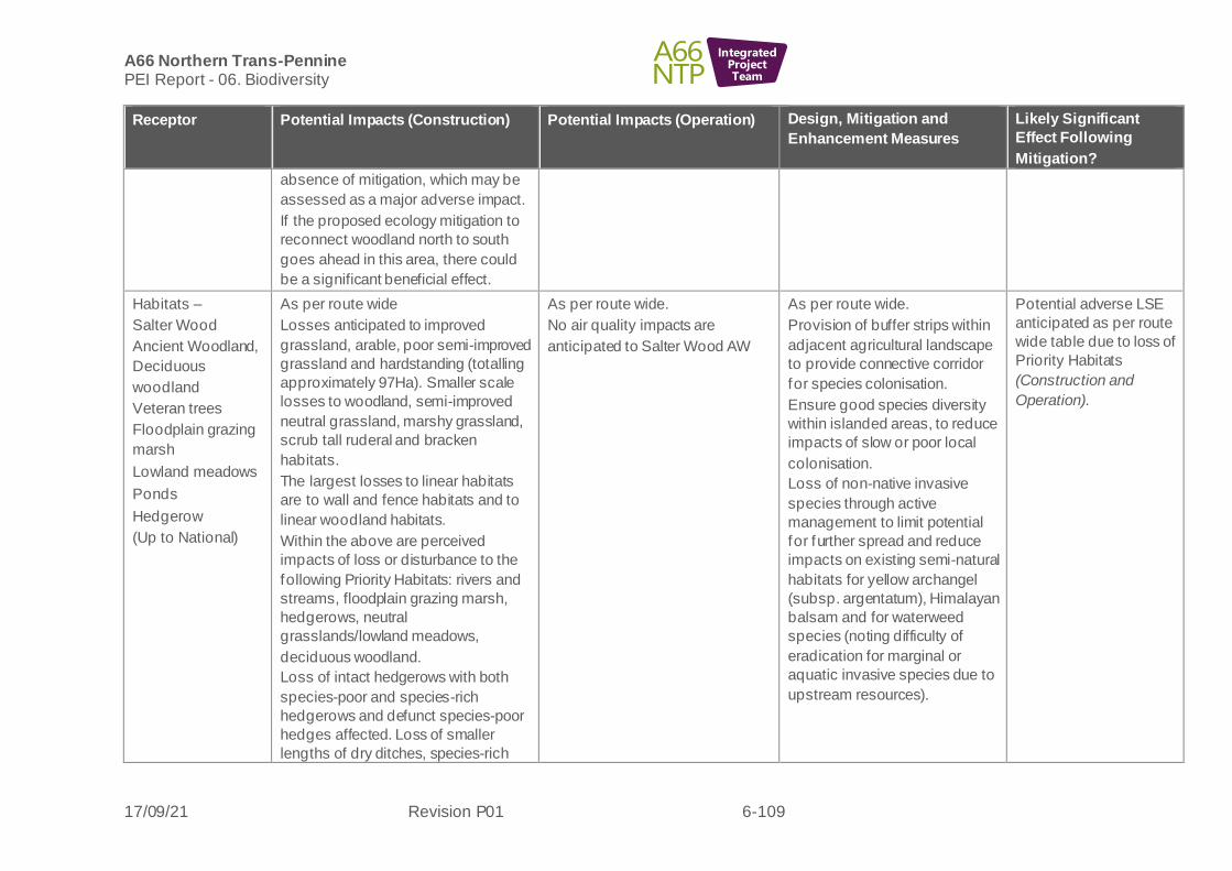
A66 Northern Trans-Pennine PEI Report - 06. Biodiversity
17/09/21 Revision P01 6-109
IntegratedProjectTeam
Receptor Potential Impacts (Construction) Potential Impacts (Operation) Design, Mitigation and
Enhancement Measures
Likely Significant
Effect Following
Mitigation?
absence of mitigation, which may be
assessed as a major adverse impact.
If the proposed ecology mitigation to
reconnect woodland north to south
goes ahead in this area, there could
be a significant beneficial effect.
Habitats –
Salter Wood
Ancient Woodland,
Deciduous
woodland
Veteran trees
Floodplain grazing
marsh
Lowland meadows
Ponds
Hedgerow
(Up to National)
As per route wide
Losses anticipated to improved
grassland, arable, poor semi-improved
grassland and hardstanding (totalling
approximately 97Ha). Smaller scale
losses to woodland, semi-improved
neutral grassland, marshy grassland,
scrub tall ruderal and bracken
habitats.
The largest losses to linear habitats
are to wall and fence habitats and to
linear woodland habitats.
Within the above are perceived
impacts of loss or disturbance to the
following Priority Habitats: rivers and
streams, floodplain grazing marsh,
hedgerows, neutral
grasslands/lowland meadows,
deciduous woodland.
Loss of intact hedgerows with both
species-poor and species-rich
hedgerows and defunct species-poor
hedges affected. Loss of smaller
lengths of dry ditches, species-rich
As per route wide.
No air quality impacts are
anticipated to Salter Wood AW
As per route wide.
Provision of buffer strips within
adjacent agricultural landscape
to provide connective corridor
for species colonisation.
Ensure good species diversity
within islanded areas, to reduce
impacts of slow or poor local
colonisation.
Loss of non-native invasive
species through active
management to limit potential
for further spread and reduce
impacts on existing semi-natural
habitats for yellow archangel
(subsp. argentatum), Himalayan
balsam and for waterweed
species (noting difficulty of
eradication for marginal or
aquatic invasive species due to
upstream resources).
Potential adverse LSE
anticipated as per route
wide table due to loss of
Priority Habitats
(Construction and
Operation).

A66 Northern Trans-Pennine PEI Report - 06. Biodiversity
17/09/21 Revision P01 6-110
IntegratedProjectTeam
Receptor Potential Impacts (Construction) Potential Impacts (Operation) Design, Mitigation and
Enhancement Measures
Likely Significant
Effect Following
Mitigation?
defunct hedges and species-rich
hedge and tree habitats.
Areas within road junctions at minor
access areas and at the Center Parks
junction form islands, surrounded by
urban road infrastructure, preventing
local colonisation and fragmentation.
Loss of roadside verge habitat within
otherwise poor agricultural landscape,
with loss of connectivity for species
colonisation.
Potential to expose underlying seed
bank with diverse seed bank adjacent
to ancient woodland areas.
Potential for disturbance to ancient
and veteran trees (ash and
pedunculate oak) in close proximity to
works through accidental intrusion
which may cause ground compaction
or root damage. Potential for pollution
impacts to these trees as sensitive
receptors.
Potential for disturbance to soils with
seed banks of Himalayan balsam and
yellow archangel, or to riparian soils
with waterweed species.
Potential to impact through water
pollution impacts to riparian habitats to
af fect existing notable species
including Ranunculus species

A66 Northern Trans-Pennine PEI Report - 06. Biodiversity
17/09/21 Revision P01 6-111
IntegratedProjectTeam
Receptor Potential Impacts (Construction) Potential Impacts (Operation) Design, Mitigation and
Enhancement Measures
Likely Significant
Effect Following
Mitigation?
(species forming Annex 1 habitat) and
river jelly lichen.
Works within ecology mitigation areas
are within 200m of Salter Wood AW,
but habitat management and creation
activities should not cause dust or
water pollution effects.
Changes to verge gradients and
losses of some habitats may lead to
localised losses of common species
such as cowslips and to locally
notable arable weeds of common
cudweed, or to a stream water
crowfoot, bluebell or hoary cinquefoil if
evident.
Rivers/streams
(International)
As per route wide
River/stream habitat will be
lost/degraded (shaded) as a result of
widening of the existing A66 culverts.
With the exception of Light Water, the
watercourses crossed by this Scheme
are minor and are considered unlikely
to support (surveys pending) notable
and/or protected aquatic species
(including qualifying species of the
River Eden SAC/SSSI) as habitats are
either unsuitable, ephemeral or
disconnected to the wider catchment
as a result of natural and man-made
barriers.
As per route wide
As per route wide
See River Eden SAC for specific
mitigation related to Light Water.
Enhancement of existing
culverts (where being replaced
and/or extended) to aid
movement of aquatic species
has yet to be agreed but will be
part of the next design review
and detailed in the ES.
Potential adverse LSE
anticipated as per route
wide and River Eden
SAC (Construction and
Operation).

A66 Northern Trans-Pennine PEI Report - 06. Biodiversity
17/09/21 Revision P01 6-112
IntegratedProjectTeam
Receptor Potential Impacts (Construction) Potential Impacts (Operation) Design, Mitigation and
Enhancement Measures
Likely Significant
Effect Following
Mitigation?
Bats (Roosts)
(Regional)
As per route wide.
Preliminary surveys have identified 16
structures and 20 trees with moderate
to high potential to support roosting
bats that are likely to be affected by
the scheme.
Of these structures, two are scheduled
for demolition and all identified trees
will require clearance.
As per route wide.
As per route wide
Potential adverse LSE
as per route wide table
subject to ongoing
surveys (Construction
and Operation).
Bat Activity
(Foraging and
Commuting)
(Up to National)
As per route wide.
Six potential crossing points will be
af fected by the scheme during
construction.
Temporary loss of key foraging
resource.
As per route wide.
Six potential crossing points will
be af fected by the scheme.
Temporary loss of key foraging
resource until habitat replanting
scheme completed and matures.
As per route wide.
Potential crossing point features
to be mitigated through planting
and/or structures. Designs and
locations are yet to be agreed
but will form part of the next
design review for the ES.
Potential adverse LSE
as per route wide table
subject to ongoing
surveys and possible
f ragmentation impacts
(Construction and
Operation).
Red Squirrel
(Sciurus vulgaris)
(National)
As per route wide.
Habitat loss for red squirrel for this
scheme includes woodland edges as
well as connecting tree lines and
hedgerows.
As per route wide.
Due to widening of the existing
carriageway areas of woodland
located north and south of the
route which are suitable for red
squirrel may become permanently
f ragmented as a result of
operation.
As per route wide.
A potential red squirrel crossing
point feature (rope bridge and
associated planting) may be
necessary around the centre of
this scheme to ensure suitable
woodland habitats remain
connected and a safe crossing
feature can be used to help
reduce the risk of RTAs.
Potential adverse LSE
as per route wide table
due to habitat loss and
possible fragmentation
impacts (Construction
and Operation).
Otter (Lutra lutra)
(Up to International)
As per route wide.
Loss of terrestrial otter habitat is
limited to works adjacent to the
As per route wide.
Increased noise, light, and
vibration disturbance adjacent to
As per route wide.
Enhancement of existing
culverts (where being replaced
No LSE are anticipated
as per route wide table.

A66 Northern Trans-Pennine PEI Report - 06. Biodiversity
17/09/21 Revision P01 6-113
IntegratedProjectTeam
Receptor Potential Impacts (Construction) Potential Impacts (Operation) Design, Mitigation and
Enhancement Measures
Likely Significant
Effect Following
Mitigation?
unnamed tributaries of River Eamont
and areas surrounding the existing
watercourse crossing points on Swine
Gill and Light Water.
Based on current survey results, no
otter holts are likely to be lost as a
result of the scheme. No new road
watercourse crossing points are
proposed. Surveys have identified
nine potential holts within 250m of the
draf t DCO boundary along the River
Eamont, Swine Gill and an unnamed
tributary of the River Eamont which
may be subject to disturbance during
construction.
Direct impacts associated with the
temporary loss of otter habitat during
the expansion of existing road
watercourse crossing points on Swine
Gill and Light Water.
Works adjacent to the unnamed
tributaries of River Eamont are likely
to cause permanent bankside habitat
loss and could discourage commuting
f rom the River Eamonth north of the
existing A66 alignment.
the unnamed tributaries of River
Eamont may reduce otter use for
commuting and foraging.
Disturbance from traffic could
cause holts to be abandoned and
deter commuting otter.
Expansion of culverts at existing
crossing points likely to reduce
f requency of use by otter and
could cause an increase in RTA
incidents if they chose to
commute over the culvert instead
of through it.
and/or extended) to aid
movement of aquatic species
has yet to be agreed but will be
part of the next design review
and detailed in the ES.

A66 Northern Trans-Pennine PEI Report - 06. Biodiversity
17/09/21 Revision P01 6-114
IntegratedProjectTeam
Receptor Potential Impacts (Construction) Potential Impacts (Operation) Design, Mitigation and
Enhancement Measures
Likely Significant
Effect Following
Mitigation?
Water Vole
(Arvicola
amphibious)
(County)
As per route wide.
Loss of suitable water vole habitat is
limited to bankside vegetation and
reed beds associated with works to an
unnamed tributary of the River
Eamont at Whinfell Park and existing
watercourse crossing points on Swine
Gill and Light Water.
As per route wide.
There is potential for an increase
in traf f ic as a result of the scheme.
This may cause a deleterious
impact to foraging habitats on
Swine Gill, Light water and in the
reed bed.
As per route wide.
Enhancement of existing
culverts (where being replaced
and/or extended) to aid
movement of aquatic species
has yet to be agreed but will be
part of the next design review
and detailed in the ES.
No LSE are anticipated
as per route wide table.
Badger (Meles
meles)
(Local)
As per route wide.
Loss of suitable badger foraging and
commuting habitat is limited to
woodland and scrub and some open
rough grassland and arable fields
immediately surrounding this scheme.
Loss of linear boundary features may
isolate woodlands known to be used
by badger clans from one another.
Construction areas are located
immediately next to or within known
badger territories, with five setts likely
to be impacted and four setts likely to
require closure on a temporary or
permanent basis.
As per route wide.
There is potential for permanent
f ragmentation of suitable badger
habitat to the north and south of
this scheme where a known
badger clan have territory and
setts either side of the existing
A66 carriageway.
There is potential for the
permanent closure of four setts
due to the proximity of the new
road alignment to these existing
setts.
As per route wide.
Habitat loss will be
compensated by additional
woodland planting immediately
to the north and south of the
new road alignment.
Proposed mitigation for potential
habitat fragmentation would be
badger friendly crossing points
being installed or enhanced at
the eastern and central extents
of this scheme combined with
badger fencing which will
increase the usage of this safe
crossing point. The design and
location for this has not yet been
conf irmed and will be part of the
next design review and detailed
in the ES.
No LSE are anticipated
as per route wide table.
Other Mammal
Species
As per route wide. As per route wide. As per route wide. Potential adverse LSE
as per route wide table
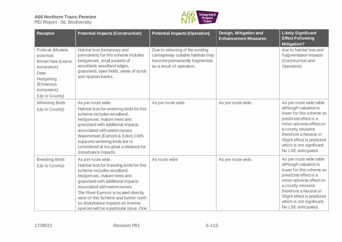
A66 Northern Trans-Pennine PEI Report - 06. Biodiversity
17/09/21 Revision P01 6-115
IntegratedProjectTeam
Receptor Potential Impacts (Construction) Potential Impacts (Operation) Design, Mitigation and
Enhancement Measures
Likely Significant
Effect Following
Mitigation?
Polecat (Mustela
putorius)
Brown hare (Lepus
europaeus)
Deer
Hedgehog
(Erinaceus
europaeus)
(Up to County)
Habitat loss (temporary and
permanent) for this scheme includes
hedgerows, small pockets of
woodland, woodland edges,
grassland, open fields, areas of scrub
and riparian banks.
Due to widening of the existing
carriageway suitable habitats may
become permanently fragmented
as a result of operation.
due to habitat loss and
f ragmentation impacts
(Construction and
Operation).
Wintering Birds
(Up to County)
As per route wide.
Habitat loss for wintering birds for this
scheme includes woodland,
hedgerows, mature trees and
grassland with additional impacts
associated with watercourses.
Watersmeet (Eamont & Eden) CWS
supports wintering birds but is
considered at too great a distance for
disturbance impacts.
As per route wide As per route wide. As per route wide table
although valuation is
lower for this scheme so
predicted effect is a
minor adverse effect on
a county resource
therefore a Neutral or
Slight effect is predicted
which is not significant.
No LSE anticipated.
Breeding Birds
(Up to County)
As per route wide.
Habitat loss for breeding birds for this
scheme includes woodland,
hedgerows, mature trees and
grassland with additional impacts
associated with watercourses.
The River Eamont is located directly
west of this Scheme and further north
so disturbance impacts on riverine
species will be a particular issue. One
As route wide As per route wide. As per route wide table
although valuation is
lower for this scheme so
predicted effect is a
minor adverse effect on
a county resource
therefore a Neutral or
Slight effect is predicted
which is not significant.
No LSE anticipated.

A66 Northern Trans-Pennine PEI Report - 06. Biodiversity
17/09/21 Revision P01 6-116
IntegratedProjectTeam
Receptor Potential Impacts (Construction) Potential Impacts (Operation) Design, Mitigation and
Enhancement Measures
Likely Significant
Effect Following
Mitigation?
active sand martin colony was
recorded along the River Eamont,
north of the existing A66. The colony
was approximately 160m from the
DCO boundary.
Barn Owl
(Regional)
As per route wide.
Watersmeet (Eamont & Eden) CWS is
known to support barn owl and
impacts on the local population of barn
owl relating to this site will be
considered in the ES.
As per route wide. As per route wide. Potential adverse LSE
as per route wide table
(Construction and
Operation).
Reptiles
(Up to County)
As per route wide.Historic records for
common lizard from habitats
connected to the scheme and suitable
reptile habitat within engineering
boundary.
As per route wide. Potential for permanent severance of migratory routes for adder and fragmentation (isolation) of populations within islanded areas of road inf rastructure.
As per route wide. Potential adverse LSE
as per route wide table
(Construction and
Operation).
Amphibians
(Up to County)
As per route wide
Losses of terrestrial habitats in the
vicinity of two great crested newt
breeding ponds.
The new junction at centreparks
results in the loss of spoil banks,
which may support overwintering
sites.
Losses to stone wall habitats may also
result in temporal losses to any
overwintering habitats in these areas,
As per route wide
Should the mitigation licence
route be followed as opposed to
District Level Licencing, then
there may be a temporal loss in
quality of replacement habitat
provision, despite additional
habitat being created.
Potential for mortality associated
with road traffic interaction on
migratory routes.
As per route wide and M6
Junction 40 to Kempley Bank
scheme.
Mitigation licensing or District
Level Licensing will be required
for losses to terrestrial habitats
and for measures to prevent
harm to great crested newt.
Potential adverse LSE
as per route wide table
relating to common toad
and GCN
(Construction and
Operation).
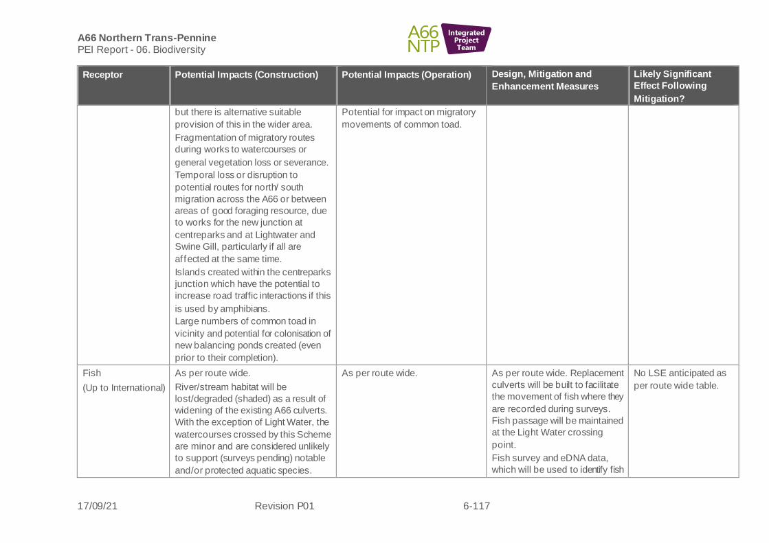
A66 Northern Trans-Pennine PEI Report - 06. Biodiversity
17/09/21 Revision P01 6-117
IntegratedProjectTeam
Receptor Potential Impacts (Construction) Potential Impacts (Operation) Design, Mitigation and
Enhancement Measures
Likely Significant
Effect Following
Mitigation?
but there is alternative suitable
provision of this in the wider area.
Fragmentation of migratory routes
during works to watercourses or
general vegetation loss or severance.
Temporal loss or disruption to
potential routes for north/ south
migration across the A66 or between
areas of good foraging resource, due
to works for the new junction at
centreparks and at Lightwater and
Swine Gill, particularly if all are
af fected at the same time.
Islands created within the centreparks
junction which have the potential to
increase road traffic interactions if this
is used by amphibians.
Large numbers of common toad in
vicinity and potential for colonisation of
new balancing ponds created (even
prior to their completion).
Potential for impact on migratory
movements of common toad.
Fish
(Up to International)
As per route wide.
River/stream habitat will be
lost/degraded (shaded) as a result of
widening of the existing A66 culverts.
With the exception of Light Water, the
watercourses crossed by this Scheme
are minor and are considered unlikely
to support (surveys pending) notable
and/or protected aquatic species.
As per route wide.
As per route wide. Replacement
culverts will be built to facilitate
the movement of fish where they
are recorded during surveys.
Fish passage will be maintained
at the Light Water crossing
point.
Fish survey and eDNA data,
which will be used to identify fish
No LSE anticipated as
per route wide table.

A66 Northern Trans-Pennine PEI Report - 06. Biodiversity
17/09/21 Revision P01 6-118
IntegratedProjectTeam
Receptor Potential Impacts (Construction) Potential Impacts (Operation) Design, Mitigation and
Enhancement Measures
Likely Significant
Effect Following
Mitigation?
species of conservation value, is
pending.
WCC
(Austropotamobius
pallipes)
(Up to International)
As per route wide As per route wide As per route wide.
WCC survey and eDNA data,
which will be used to confirm
WCC presence, is pending.
No LSE anticipated as
per route wide table.
Terrestrial
invertebrates
(Up to National)
As per route wide As per route wide As per route wide Potential adverse LSE
anticipated as per route
wide table (Construction
and Operation).
Aquatic
invertebrates
(Up to National)
As per route wide As per route wide As per route wide No LSE anticipated as
per route wide table
(Construction and
Operation).
Macrophytes
(Up to International)
As per route wide As per route wide As per route wide Potential adverse LSE
anticipated as per route
wide table (Construction
and Operation).
Temple Sowerby to Appleby
Blue alternative
6.9.8 The following biodiversity receptors have been scoped out of the assessment for this scheme:
• Pine marten
• Hazel dormouse
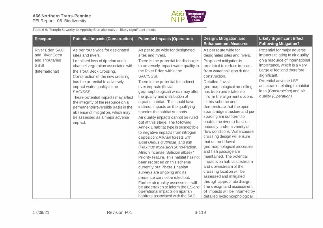
A66 Northern Trans-Pennine PEI Report - 06. Biodiversity
17/09/21 Revision P01 6-119
IntegratedProjectTeam
Table 6-9: Temple Sowerby to Appleby Blue alternative - likely significant effects
Receptor Potential Impacts (Construction) Potential Impacts (Operation) Design, Mitigation and
Enhancement Measures
Likely Significant Effect
Following Mitigation?
River Eden SAC
and River Eden
and Tributaries
SSSI
(International)
As per route wide for designated
sites and rivers.
Localised loss of riparian and in-
channel vegetation associated with
the Trout Beck Crossing.
Construction of the new crossing
has the potential to adversely
impact water quality in the
SAC/SSSI.
These potential impacts may affect
the integrity of the resource on a
permanent/irreversible basis in the
absence of mitigation, which may
be assessed as a major adverse
impact.
As per route wide for designated
sites and rivers.
There is the potential for discharges
to adversely impact water quality in
the River Eden within the
SAC/SSSI.
There is the potential for indirect
river impacts (fluvial
geomorphological) which may alter
the quality and distribution of
aquatic habitat. This could have
indirect impacts on the qualifying
species the habitat supports.
Air quality impacts cannot be ruled
out at this stage. The following
Annex 1 habitat type is susceptible
to negative impacts from nitrogen
deposition: Alluvial forests with
alder (Alnus glutinosa) and ash
(Fraxinus excelsior) (Alno-Padion,
Alnion incanae, Salicion albae) *
Priority feature. This habitat has not
been recorded on this scheme
currently but Phase 1 habitat
surveys are ongoing and its
presence cannot be ruled out.
Further air quality assessment will be undertaken to inform the ES and operational impacts on riparian habitats associated with the SAC
As per route wide for
designated sites and rivers.
Proposed mitigation is
predicted to reduce impacts
f rom water pollution during
construction.
Detailed fluvial
geomorphological modelling
has been undertaken to
inform the alignment options
in this scheme and
demonstrate that the open
span bridge structure and pier
spacing are sufficient to
enable the river to function
naturally under a variety of
f low conditions. Watercourse
crossing design will ensure
that current f luvial
geomorphological processes
and f ish passage are
maintained. The potential
impacts on habitat upstream
and downstream of the
crossing location will be
assessed and mitigated
through appropriate design.
The design and assessment
of impacts will be informed by
detailed hydromorphological
Potential for major adverse
impacts relating to air quality
on a resource of International
importance, which is a Very
Large ef fect and therefore
significant.
Potential adverse LSE
anticipated relating to habitat
loss (Construction) and air
quality (Operation).

A66 Northern Trans-Pennine PEI Report - 06. Biodiversity
17/09/21 Revision P01 6-120
IntegratedProjectTeam
Receptor Potential Impacts (Construction) Potential Impacts (Operation) Design, Mitigation and
Enhancement Measures
Likely Significant Effect
Following Mitigation?
and SSSI cannot be ruled out at this stage.
These potential impacts may affect
the integrity of the resource on a
permanent/irreversible basis in the
absence of mitigation, which may
be assessed as a major adverse
impact.
modelling, as described in
Chapter 14: Road Drainage
and the Water Environment.
For works areas in channel,
water crowfoot beds
(provided evident at time of
works) can be moved
upstream, these can then re-
colonise downstream in the
areas where works have
occurred once complete, to
reduce localised loss.
Localised habitat loss through
shading remains but with
mitigation this not expected to
adversely affect the integriy of
the SAC/SSSI and therefore
impacts can be reduced to a
minor adverse impact during
construction.
During operation, the water
quality effects will be fully
mitigated, but operational air
quality impacts are not yet
known. Air quality impacts
have the potential to affect
the integrity of the site
particularly if the Alluvial
forest habitat is present within
this section of the SAC and
within 200m of the ARN (to be

A66 Northern Trans-Pennine PEI Report - 06. Biodiversity
17/09/21 Revision P01 6-121
IntegratedProjectTeam
Receptor Potential Impacts (Construction) Potential Impacts (Operation) Design, Mitigation and
Enhancement Measures
Likely Significant Effect
Following Mitigation?
conf irmed by further survey).
This may be on a
permanent/irreversible basis,
which may be assessed as a
major adverse impact.
Temple Sowerby
Moss SSSI
(National)
As per route wide.
This site is situated at too great a
distance for direct impacts and no
habitat loss or pollution effects are
anticipated.
Ecological mitigation proposals
adjacent to the site may have a
benef icial effect but these are yet to
be confirmed.
No change is anticipated.
As per route wide.
Air pollution impacts cannot be
ruled out at this stage as this site
has not been assessed fully.
These potential impacts may affect
the integrity of the resource on a
permanent/irreversible basis in the
absence of mitigation, which may
be assessed as a major adverse
impact.
As per route wide.
If adjacent ecological
mitigation planting goes
ahead, suitable habitats to
compliment the wetland
habitats within the SSSI and
to further support species
within the SSSI would be
selected.
Potential for major adverse
impacts on a resource of
National importance would be
a Large or Very Large effect
and therefore significant.
Potential LSE are possible in
relation to air quality
(Operation).
Non-statutory
designated sites
Chapel Wood CWS
(up to International)
Ross Wood CWS
(National)
Dowpits Wood
CWS (National)
Acorn Bank Woods
and Garden CWS
River Lyvennet
Floodplain CWS
Temple Sowerby
Shingle Banks,
Temple Sowerby
There is potential for habitat loss or
damage to Chapel Wood CWS and
ancient woodland as a result of a
construction buffer for an access
road that runs through adjacent
woodland on an existing track.
No direct impact to Ross Wood
CWS however there is the potential
for indirect air pollution impacts
(dust) for this and Chapel Wood.
These are ancient woodlands and
have habitats and species that may
be sensitive to these effects within
them.
As per route wide.
Air quality impacts may occur on
Chapel Wood CWS and Ross
Wood CWS as they are within
200m of the ARN.
These potential impacts may affect
the integrity of the resource on a
permanent/irreversible basis in the
absence of mitigation, which may
be assessed as a major adverse
impact.
As per route wide.
Further drainage design
iterations will aim to avoid
loss of ancient woodland at
Chapel Wood CWS and
protect retained woodland
habitat.
Further surveys or analysis of
data regarding the ancient
woodland sites and whether
these qualify as the Annex 1
alluvial woodland habitat type
is required to confirm
valuation.
Potential for major adverse
impacts on a resource of up
to International importance,
which is a Very Large effect
and therefore significant.
Potential adverse LSE
anticipated relating to habitat
loss (Construction) and air
quality (Operation).

A66 Northern Trans-Pennine PEI Report - 06. Biodiversity
17/09/21 Revision P01 6-122
IntegratedProjectTeam
Receptor Potential Impacts (Construction) Potential Impacts (Operation) Design, Mitigation and
Enhancement Measures
Likely Significant Effect
Following Mitigation?
Moss, River Eden
Oglebird Scar Ers,
Acorn Bank and
Bolton Shingle
Bank Sites of
Invertebrate
Significance (all
four invertebrate
shingle sites are
County level)
There are no direct impacts
predicted for Dowpits Wood, Acorn
Bank Woods and Garden CWS and
River Lyvennet Floodplain CWS
and all are over 200m from all
construction activities therefore no
air quality impacts are predicted.
All invertebrate sites are situated
greater than 200m from the works
with no direct impacts anticipated
and no potential for indirect air
pollution impacts (dust deposition).
The potential impacts on the
Chapel Wood and Ross Wood
CWSs may affect the integrity of
the resource on a
permanent/irreversible basis in the
absence of mitigation, which may
be assessed as a major adverse
impact.
No change is predicted for the
invertebrate sites.
As avoidance through design
has not yet been confirmed,
there is potential for habitat
loss and severance which
may af fect the integrity of the
Chapel Wood CWS and
ancient woodland on a
permanent/irreversible basis,
which would be assessed as
a major adverse impact.
Habitats –
Oglebird Plantation
AW
Chapel Wood AW
Ross Wood AW
Dowpits Wood AW
Veteran trees
As per route wide
Losses and/or disturbance to
Chapel Wood ancient woodland
habitat and soils.
Potential damage to adjacent
mature trees (root damage, limb
As per route wide
Long term loss to irreplaceable
ancient woodland habitat.
Potential for air quality impacts
upon Chapel Wood CWS, Ross
Wood CWS and Oglebird
Plantation ancient woodland.
As per route wide.
Further design review will aim
to avoid any impact on
ancient woodland and retain
mature/veteran trees.
Potential for any losses to
Annex 1 habitat // deciduous
woodland in terms of
Potential adverse LSE
anticipated as per route wide
table due to loss of Priority
Habitats although valuation is
higher due to the possible
presence of Annex 1 habitats.
Therefore, a potential major
adverse impact on a feature

A66 Northern Trans-Pennine PEI Report - 06. Biodiversity
17/09/21 Revision P01 6-123
IntegratedProjectTeam
Receptor Potential Impacts (Construction) Potential Impacts (Operation) Design, Mitigation and
Enhancement Measures
Likely Significant Effect
Following Mitigation?
Woodland
Hedgerow
Ponds
Open Mosaic
habitat.
(Up to
International)
damage, ground compaction,
pollution or deposition).
Severance of historic routes at
Priest Lane/ Cross St and Main
Street/ Sleastonhowe Lane, with
hedgerows and mature trees (some
ancient/veteran Pedunculate oak
and ash trees), some of which are
conf irmed Priority Habitat and may
qualify as ‘important’ hedgerows
and/ or irreplaceable habitat.
Severance of large open
agricultural habitats.
Changes to hydrology, shading or
pollution impacts may negatively
af fect or result in the loss of the
following notable plant species:
harebell, tormentil, bitter vetch,
crosswort and devils-bit scabious
and to notable riparian species of
Ranunculus species (as Annex 1
habitats) and lower plants:
liverworts and lichens, or to lower
plants or lichen species on rock,
wall or tree habitats.
Potential for spread of non-native
species Himalayan balsam and
rhododendron.
The current stage of air quality
modelling has identified a 1%
increase in nitrogen for where
Oglebird Plantation is within 200m
of the ARN, this increase provides
the potential for detrimental impacts
upon habitats and species
(mosses, liverworts and lichens).
Continued north-south severance
impacts which may affect dispersal
of plant species.
Temporal scale impacts for new
planting to become established.
ash/alder woodland to not be
able to be replaced through
additional planting, due to
biosecurity restrictions on
planting of alder and ash.
Local landscape is largely
agricultural so the provision of
additional varied habitats in
the landscape may also
provide new routes of
connectivity for species
colonisation in east-west
movements. Improved
pollution control measures for
the River Eden and
opportunity to design greater
provision for floodplain
connectivity for marsh
habitats, within floodplain for
marginal and aquatic plant
species colonisation, or to
provide space for woodland
habitats to develop (50 years
plus). As ecology mitigation
design is not yet finalised
potential beneficial effects
have not been reported.
Further air quality
assessment for ES reporting
for Oglebird Plantation to
identify whether nitrogen
of International importance
may be assessed as a Very
Large ef fect, which is
significant. Potential LSE
anticipated due to loss and
degradation of ancient
woodland (Construction and
Operation).

A66 Northern Trans-Pennine PEI Report - 06. Biodiversity
17/09/21 Revision P01 6-124
IntegratedProjectTeam
Receptor Potential Impacts (Construction) Potential Impacts (Operation) Design, Mitigation and
Enhancement Measures
Likely Significant Effect
Following Mitigation?
loading per kg per year (plus
any awaited Ammonia
concentrations), are against
established thresholds and/or
has to potential to cause an
impact on a component
species or habitat.
Rivers/streams
(International)
As per route wide.
Localised loss of riparian and in-
channel vegetation associated with
the Trout Beck Crossing; this
watercourse qualifies as an Annex I
habitat: sub-type 2 water course of
plain to montane levels with the
Ranunculion fluitantis and
Callitricho-Batrachion vegetation.
As per route wide.
The crossing of Trout Beck has the
potential to impact the natural
(f luvial geomorphological) river
process which control the quality
and distribution of aquatic habitat
within the SAC/SSSI. This could
have indirect impacts on the
qualifying species the habitat
supports.
As per route wide. Potential adverse LSE
anticipated as per route wide
and River Eden SAC
(Construction and Operation).
Bats (Roosts)
(Regional)
As per route wide
One structure and 11 trees with
moderate to high potential will
require demolition as a result of the
scheme. (Note: one further
residential property scheduled to be
demolished has not provided
access for the PBRA surveys to be
undertaken).
As per route wide As per route wide Potential adverse LSE as per
route wide table subject to
ongoing surveys
(Construction and Operation).
Bat Activity
(Foraging and
Commuting)
(National)
As per route wide
The scheme contains 19 potential
bat crossing points that will be
af fected by construction.
As per route wide
The scheme contains 19 potential
bat crossing points that will be
af fected by the scheme.
As per route wide
Potential adverse LSE as per
route wide table subject to
ongoing surveys and possible
f ragmentation impacts

A66 Northern Trans-Pennine PEI Report - 06. Biodiversity
17/09/21 Revision P01 6-125
IntegratedProjectTeam
Receptor Potential Impacts (Construction) Potential Impacts (Operation) Design, Mitigation and
Enhancement Measures
Likely Significant Effect
Following Mitigation?
Due to this alignment being offline,
previously undisturbed suitable
habitats will become permanently
f ragmented.
Temporary loss of foraging
resource until habitat replanting
scheme is completed and matures.
(Construction and Operation).
Red Squirrel
(Up to National)
As per route wide
Temporary and permanent habitat
loss for red squirrel for this scheme
is limited to connecting linear
features such as tree lines and
hedgerows and the occasional
woodland edge and old railway line.
A small pocket of isolated woodland
located immediately to the east of
Kirkby Thore may also be lost.
As per route wide
As per route wide
Potential adverse LSE as per
route wide table due to
habitat loss and possible
f ragmentation impacts
(Construction and Operation).
Otter
(Up to
International)
As per route wide.
Direct impacts associated with the
temporary loss of otter habitat at
the new crossing points on Tutta
Beck.
Disturbance impacts associated
with construction activity is likely to
impact commuting and foraging
otter and may cause holts to be
temporarily abandoned if present
(f ield surveys have not yet been
completed for all route alternatives
being considered for this scheme).
As per route wide.
Potential permanent increased
noise, light, vibration and surface
water runof f containing pollutants
may reduce otter commuting and
foraging and could cause habitat
f ragmentation on Trout Beck due to
the previously undisturbed nature of
the watercourse. Disturbance from
traf f ic could cause holts nearby to
be abandoned.
As per route wide. No LSE are anticipated as per
route wide table.

A66 Northern Trans-Pennine PEI Report - 06. Biodiversity
17/09/21 Revision P01 6-126
IntegratedProjectTeam
Receptor Potential Impacts (Construction) Potential Impacts (Operation) Design, Mitigation and
Enhancement Measures
Likely Significant Effect
Following Mitigation?
Water Vole
(County)
As per route wide.
Direct impacts associated with the
temporary loss of water vole habitat
at the new crossing point over Trout
Beck.
Disturbance impacts associated
with construction activities could
impact foraging water vole and
cause burrows to be abandoned or
to collapse if present - field surveys
have not yet been completed for all
route alternatives being considered
for this scheme.
Disturbance impacts associated
with construction activities at
previously undisturbed areas of
Trout Beck could impact foraging
water vole and cause burrows to be
abandoned or to collapse if present
- f ield surveys have not yet been
completed for all route alternatives
being considered for this scheme.
The River Eden does not provide
suitable habitat for water vole.
As per route wide.
As per route wide No LSE are anticipated as per
route wide table.
Badger
(Local)
As per route wide.
Habitat loss for badger for this
scheme includes foraging and
commuting habitat which includes
pockets of small woodland areas,
woodland and scrub edges, open
rough grassland areas and
As per route wide.
Due to this alignment being offline,
previously undisturbed suitable
habitats will become permanently
f ragmented.
As per route wide. No LSE are anticipated as per
route wide table.

A66 Northern Trans-Pennine PEI Report - 06. Biodiversity
17/09/21 Revision P01 6-127
IntegratedProjectTeam
Receptor Potential Impacts (Construction) Potential Impacts (Operation) Design, Mitigation and
Enhancement Measures
Likely Significant Effect
Following Mitigation?
predominantly open arable fields
with linear boundary features
including hedgerows, tree lines and
dry stone walls.
Badger surveys are not complete
for all routes, but it is likely setts will
be identified in the area.
Crossing points may be identified
through further survey.
Other Terrestrial
Mammal Species
Polecat
Brown hare
Deer
Hedgehog
(Up to County)
As per route wide.
Habitat loss (temporary and
permanent) for other terrestrial
mammal species including deer,
polecat, brown hare and hedgehog
for this scheme includes
hedgerows, one area of woodland,
woodland edges, grassland, open
f ields, areas of scrub and riparian
banks.
As per route wide.
Due to this alignment being offline,
previously undisturbed suitable
habitats (predominantly open
arable f ields) will become
permanently fragmented as a result
of operation.
As per route wide. Potential adverse LSE as per
route wide table due to
habitat loss and
f ragmentation impacts
(Construction and Operation).
Wintering Birds
(Up to County)
As per route wide.
Habitat loss for wintering birds for
this scheme includes hedgerows,
mature trees and grassland with
additional impacts associated with
watercourses.
Habitats around Kirkby Thore were
found to support large flocks of
lapwing so disturbance impacts on
wintering lapwing will be a
particular issue. A large flock of
over 500 lapwing were recorded in
As per route wide.
Due to this alignment being offline,
previously undisturbed suitable
habitats (predominantly open
arable f ields) will become
permanently fragmented and
disturbed as a result of operational
disturbance.
As per route wide.
As per route wide table
although valuation is lower for
this scheme so predicted
ef fect is a minor adverse
ef fect on a county resource
therefore a Neutral or Slight
ef fect is predicted which is not
significant. No LSE
anticipated.

A66 Northern Trans-Pennine PEI Report - 06. Biodiversity
17/09/21 Revision P01 6-128
IntegratedProjectTeam
Receptor Potential Impacts (Construction) Potential Impacts (Operation) Design, Mitigation and
Enhancement Measures
Likely Significant Effect
Following Mitigation?
f ields to the north west of Kirkby
Thore.
Breeding Birds
(Up to County)
As per route wide.
Habitat loss for breeding birds for
this scheme includes hedgerows,
mature trees and grassland with
additional impacts associated with
watercourses.
Trout Beck (River Eden SSSI) is
crossed by the Blue alternative of
this scheme so disturbance impacts
on riverine species will be a
particular issue. Whilst no sand
martin colonies were recorded, a
single kingfisher was recorded
along Trout Beck approximately
100m from the Blue alternative for
this scheme.
Habitats around Kirkby Thore were
found to be of value to ground
nesting bird so disturbance impacts
on ground nesting birds will be a
particular issue. Low numbers of
oyster catcher and curlew were
recorded in fields across Blue and
Red alternatives for this scheme.
As per route wide.
Habitat loss for breeding birds for
this scheme includes hedgerows,
mature trees and grassland with
additional impacts associated with
watercourses. Due to this alignment
being offline, previously
undisturbed suitable habitats
(predominantly open arable fields)
will become permanently
f ragmented and disturbed as a
result of operational disturbance.
As per route wide. As per route wide table
although valuation is lower for
this scheme so predicted
ef fect is a minor adverse
ef fect on a county resource
therefore a Neutral or Slight
ef fect is predicted which is not
significant. No LSE
anticipated.
Barn Owl
(Regional)
As per route wide.
Habitat loss for barn owls for this
scheme includes agricultural
As per route wide. As per route wide. Potential adverse LSE as per
route wide table (Construction
and Operation).

A66 Northern Trans-Pennine PEI Report - 06. Biodiversity
17/09/21 Revision P01 6-129
IntegratedProjectTeam
Receptor Potential Impacts (Construction) Potential Impacts (Operation) Design, Mitigation and
Enhancement Measures
Likely Significant Effect
Following Mitigation?
buildings, tussocky grassland,
hedgerows and mature trees.
Reptiles
(Up to County)
As per route wide. As per route wide. As per route wide. Potential adverse LSE as per
route wide table (Construction
and Operation).
Amphibians
(Up to County)
As per route wide.
There are no losses to pond
habitats that are currently known to
support or have the potential to
support great crested newts. There
are losses to terrestrial habitat and
potentially severance impacts to
terrestrial habitats over 290m from
known great crested newt
populations.
Temporary negative impacts to one
pond north of Temple Sowerby
SSSI and one formed by the SSSI
wetland itself. Both have yet to be
surveyed for great crested newt
(within connected habitat to great
crested newt populations at Acorn
Bank).
Fragmentation of potential
terrestrial habitats within islands
surrounded by road infrastructure
that are within 500m of known great
crested newt breeding ponds.
As per route wide.
Creation of balancing ponds has
the potential to provide greater
breeding and terrestrial habitat for
amphibian species.
Potential to sever existing
(north/south) migratory routes
between garden pond habitats at
Kirkby Thore Village and the wider
area. Potential for some increased
east to west connective habitats
along new alignment verges.
As per route wide.
Potential adverse LSE as per
route wide table relating to
amphibian species including
GCN (Construction and
Operation).
Fish As per route wide As per route wide As per route wide. No LSE anticipated as per
route wide table.

A66 Northern Trans-Pennine PEI Report - 06. Biodiversity
17/09/21 Revision P01 6-130
IntegratedProjectTeam
Receptor Potential Impacts (Construction) Potential Impacts (Operation) Design, Mitigation and
Enhancement Measures
Likely Significant Effect
Following Mitigation?
(Up to
International)
Of particular note for this Scheme is
potential for disturbance of
migratory fish as a result of
elevated levels of noise/vibration
and artif icial lighting during the
construction of the Trout Beck
crossing.
The crossing of Trout Beck has the
potential to impact the natural
(f luvial geomorphological) river
process which control the quality
and distribution of aquatic habitat
within the SAC/SSSI. This could
have indirect impacts on fish.
WCC
(Up to
International)
As per route wide. As per route wide. As per route wide. No LSE anticipated as per
route wide table.
Terrestrial
invertebrates
(Up to National)
As per route wide.
Potential direct terrestrial
invertebrate habitat loss through
loss or change in structure of
shingle bank habitat.
Potential for wider loss of species if
removal or degradation of shingle
banks splits populations of shingle
dependent invertebrates.
Changes to hydrology may result in
degradation of shingle habitats in
the vicinity and further up or down
stream through drying out or rapid
increase in water levels.
The construction phase will likely
have an ef fect on terrestrial
invertebrate populations using
shingle banks from in water working
increasing water movement,
shading and vibration.
As per route wide.
Increased shading has the potential
to af fect species movement by
creating a barrier of cooler air and
water which may impact shingle
dependent invertebrate
metapopulations.
Increases in vehicle emission
deposits and changes in hydrology
may have an ef fect on degradation
of shingle habitats used by
terrestrial invertebrates.
In the absence of mitigation there is
potential for shingle dependent
terrestrial invertebrate disturbance
due to increased lighting, increased
vibration and increased turbulence
f rom road traffic.
In the absence of mitigation there is
potential for terrestrial invertebrate
As per route wide.
Loss of shingle habitats will
be avoided where possible
through design and
construction protocol.
Construction will avoid in-
water working where
possible, where this is not
possible techniques involving
minimum disturbance to water
f low will be employed.
Fragmentation of shingle
habitat will be avoided where
possible. Fragmentation as a
result of the construction will
be re-connected post
construction by creation of
further shingle habitat.
Degradation of habitats will
be avoided, and mitigation will
Potential adverse LSE
anticipated as per route wide
table (Construction and
Operation).

A66 Northern Trans-Pennine PEI Report - 06. Biodiversity
17/09/21 Revision P01 6-131
IntegratedProjectTeam
Receptor Potential Impacts (Construction) Potential Impacts (Operation) Design, Mitigation and
Enhancement Measures
Likely Significant Effect
Following Mitigation?
The likelihood of individual mortality
is very high during construction
particularly of immobile life stages
such as eggs or pupae due to
shingle habitat removal or
modification.
mortality due to increased collisions
with road traffic and pollution from
vehicle emission deposits
particularly of aquatic phases of
many terrestrial invertebrates.
include enhancement of
retained shingle habitats and
additional shingle habitat
creation.
Mitigation will include careful
design to minimise light spill,
pollution control, and
disturbance to water f low.
Possible translocation of
shingle dependent
invertebrates.
Aquatic
invertebrates
(Up to National)
As per route wide. As per route wide. As per route wide. No LSE anticipated as per
route wide table.
Macrophytes
(Up to
International)
As per route wide. As per route wide. As per route wide. Potential adverse LSE
anticipated as per route wide
table
(Construction and Operation).
Red alternative
6.9.9 The following biodiversity receptors have been scoped out of the assessment for this scheme:
• Pine marten
• Hazel dormouse
Table 6-10: Temple Sowerby to Appleby Red alternative - likely significant effects
Receptor Potential Impacts (Construction) Potential Impacts (Operation) Design, Mitigation and
Enhancement Measures
Likely Significant Effect
Following Mitigation?
River Eden SAC
and River Eden
This alternative also crosses Trout
Beck (approximately 1km further
upstream than the Blue alternative)
As per Blue alternative. As per Blue alternative. Potential for major adverse
impacts on a resource of
International importance,

A66 Northern Trans-Pennine PEI Report - 06. Biodiversity
17/09/21 Revision P01 6-132
IntegratedProjectTeam
Receptor Potential Impacts (Construction) Potential Impacts (Operation) Design, Mitigation and
Enhancement Measures
Likely Significant Effect
Following Mitigation?
and Tributaries
SSSI
(International)
and Keld Sike (a tributary of Trout
Beck). The potential impacts of this
alternative are consistent with those
described in Table 6-8: Penrith to
Temple Sowerby - likely significant
ef fects for the Blue alternative, with
additional habitat degradation
(shading) of Keld Sike, which is not
located within the SAC/SSSI
boundary but may be functionally
linked (surveys pending).
which is a Very Large effect
and therefore significant.
Potential adverse LSE
anticipated relating to habitat
loss (Construction) and air
quality (Operation).
Temple Sowerby
Moss SSSI
(National)
As per Blue alternative. As per Blue alternative. As per Blue alternative. Potential for major adverse
impacts on a resource of
National importance would
be a Large or Very Large
ef fect and therefore
significant. Potential LSE are
possible in relation to air
quality (Operation).
Non-statutory
designated sites
Chapel Wood CWS
(up to International)
Ross Wood CWS
(National)
Dowpits Wood
(National)
Acorn Bank Woods
and Garden CWS
As per Blue alternative however
there is potential for greater habitat
loss and severance impacts to
Chapel Wood CWS and ancient
woodland as a result of the north-
south outfall pipeline from the
balancing pond to the north to the
River Eden.
As per Blue alternative. As per Blue alternative. Potential for major adverse
impacts on a resource of up
to International importance,
which is a Very Large effect
and therefore significant.
Potential adverse LSE
anticipated relating to habitat
loss (Construction) and air
quality (Operation).

A66 Northern Trans-Pennine PEI Report - 06. Biodiversity
17/09/21 Revision P01 6-133
IntegratedProjectTeam
Receptor Potential Impacts (Construction) Potential Impacts (Operation) Design, Mitigation and
Enhancement Measures
Likely Significant Effect
Following Mitigation?
River Lyvennet
Floodplain CWS
Bolton Shingle
Bank site of
invertebrate
significance (Local)
Habitats –
Chapel Wood AW
(Up to
International)
Oglebird Plantation
AW
Ross Wood AW
Dowpits AW
Veteran trees
Woodland
Hedgerow
Acid Grassland
Orchards
Ponds
Open Mosaic
habitat.
(Up to National)
As per route wide.
Habitat loss and/or disturbance to
Chapel Wood ancient woodland
habitat and soils.
Greater potential for losses to
scattered semi-mature to mature
trees (some likely veteran trees).
Priority Habitats likely affected
within the habitats include those
listed for the Blue alternative, with
dif fering scales of impacts and
additionally includes an orchard
(potential for dust deposition
pollution impacts).
Losses and potential habitat
degradation to deciduous woodland
and hedgerows (significant loss and
severance at Sleastonhowe Lane)
and losses to open mosaic habitat.
No direct loss of acid grassland, but
works immediately adjacent,
therefore indirect impacts through
changes to hydrology or pollution
impacts are possible.
As per Blue alternative As per Blue alternative
Additional design review to
ensure mitigation hierarchy is
followed to avoid impacts to
Priority Habitats with
hydrological connectivity
adjacent to construction areas.
Potential adverse LSE
anticipated as per route wide
table due to loss of Priority
Habitats although valuation is
higher due to the possible
presence of Annex 1
habitats. Therefore, a
potential major adverse
impact on a feature of
International importance may
be assessed as a Very Large
ef fect, which is significant.
Potential adverse LSE
anticipated due to loss and
degradation of ancient
woodland (Construction and
Operation).
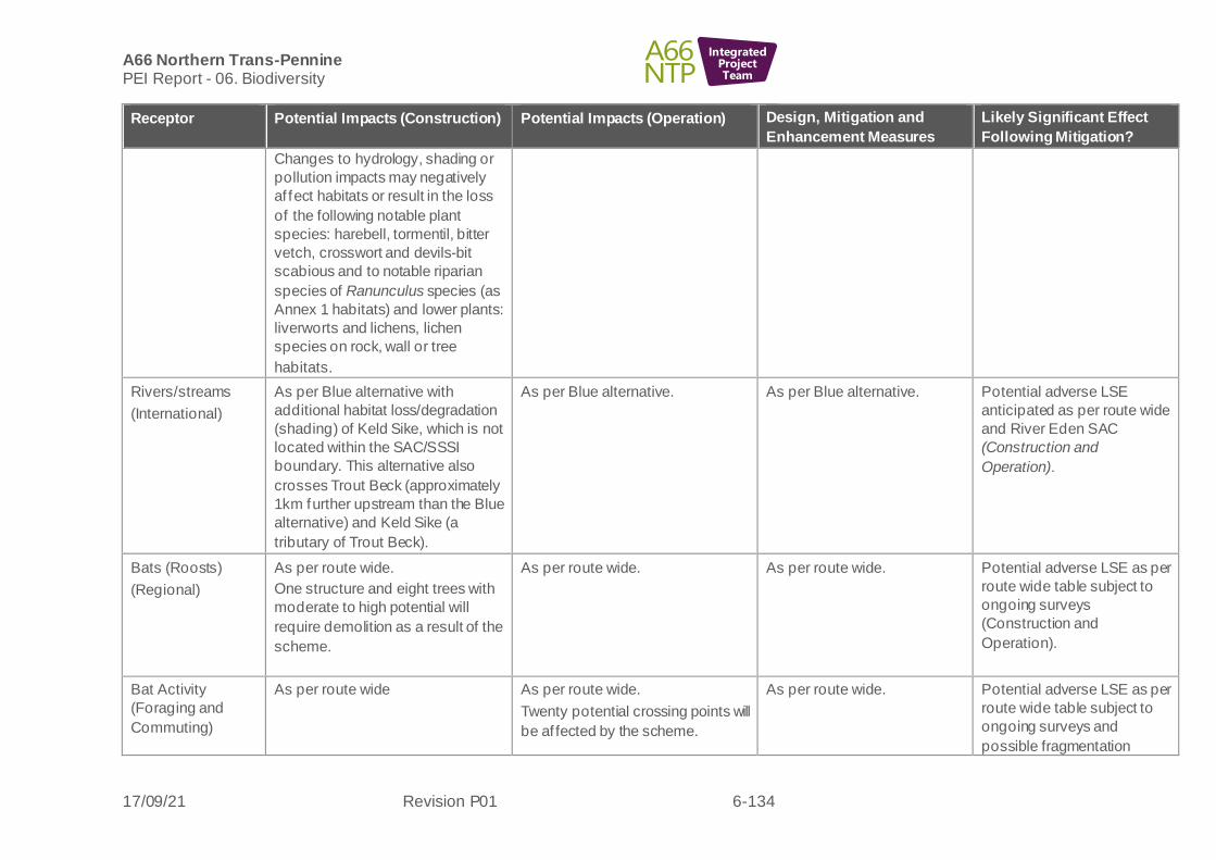
A66 Northern Trans-Pennine PEI Report - 06. Biodiversity
17/09/21 Revision P01 6-134
IntegratedProjectTeam
Receptor Potential Impacts (Construction) Potential Impacts (Operation) Design, Mitigation and
Enhancement Measures
Likely Significant Effect
Following Mitigation?
Changes to hydrology, shading or
pollution impacts may negatively
af fect habitats or result in the loss
of the following notable plant
species: harebell, tormentil, bitter
vetch, crosswort and devils-bit
scabious and to notable riparian
species of Ranunculus species (as
Annex 1 habitats) and lower plants:
liverworts and lichens, lichen
species on rock, wall or tree
habitats.
Rivers/streams
(International)
As per Blue alternative with
additional habitat loss/degradation
(shading) of Keld Sike, which is not
located within the SAC/SSSI
boundary. This alternative also
crosses Trout Beck (approximately
1km further upstream than the Blue
alternative) and Keld Sike (a
tributary of Trout Beck).
As per Blue alternative. As per Blue alternative. Potential adverse LSE
anticipated as per route wide
and River Eden SAC
(Construction and
Operation).
Bats (Roosts)
(Regional)
As per route wide.
One structure and eight trees with
moderate to high potential will
require demolition as a result of the
scheme.
As per route wide. As per route wide. Potential adverse LSE as per
route wide table subject to
ongoing surveys
(Construction and
Operation).
Bat Activity
(Foraging and
Commuting)
As per route wide As per route wide.
Twenty potential crossing points will
be af fected by the scheme.
As per route wide. Potential adverse LSE as per
route wide table subject to
ongoing surveys and
possible fragmentation

A66 Northern Trans-Pennine PEI Report - 06. Biodiversity
17/09/21 Revision P01 6-135
IntegratedProjectTeam
Receptor Potential Impacts (Construction) Potential Impacts (Operation) Design, Mitigation and
Enhancement Measures
Likely Significant Effect
Following Mitigation?
(National) Twenty potential crossing points will
be af fected by the scheme during
construction.
Loss of foraging resource during
construction.
Temporary loss of foraging
resource until habitat replanting
scheme completed and matures
impacts (Construction and
Operation).
Red Squirrel
(Up to National)
As per route wide.
Habitat loss (temporary and
permanent) for red squirrel for this
scheme is limited to connecting
linear features such as tree lines
and hedgerows and the occasional
woodland edge and old railway line.
Only one small pocket of isolated
woodland located immediately to
the east of Kirkby Thore is
anticipated to be impacted and
potential red squirrel habitat lost.
As per route wide.
As per route wide.
Potential adverse LSE as per
route wide table due to
habitat loss and possible
f ragmentation impacts
(Construction and
Operation).
Otter
(Up to
International)
As per route wide.
Direct impacts associated with the
temporary loss of otter habitat at
the new crossing points on Trout
Beck. Disturbance impacts
associated with construction activity
is likely to impact commuting and
foraging otter at previously
undisturbed areas of Trout Beck
and its tributary and in close
proximity to the River Eden and
may cause holts to be temporarily
abandoned if present. Ffield
As per route wide.
Potential permanent increased
noise, light, vibration and surface
water runof f containing pollutants
may reduce otter commuting and
foraging and could cause habitat
f ragmentation on Trout Beck due to
the previously undisturbed nature of
the watercourse. Disturbance from
traf f ic could cause holts nearby to
be abandoned.
As per route wide No LSE are anticipated as
per route wide table.

A66 Northern Trans-Pennine PEI Report - 06. Biodiversity
17/09/21 Revision P01 6-136
IntegratedProjectTeam
Receptor Potential Impacts (Construction) Potential Impacts (Operation) Design, Mitigation and
Enhancement Measures
Likely Significant Effect
Following Mitigation?
surveys have not yet been
completed for all route alternatives
being considered for this scheme.
Water Vole
(County)
As per route wide.
Direct impacts associated with the
temporary loss of water vole habitat
at the new crossing point over Trout
Beck and its tributary. Potential
temporary closure of burrows on
Trout Beck and its tributary if
present - f ield surveys have not yet
been completed for all route
alternatives being considered for
this scheme.
Disturbance impacts associated
with construction activities at
previously undisturbed areas of
Trout Beck could impact foraging
water vole and cause burrows to be
abandoned or to collapse.
As per route wide.
.
As per route wide. No LSE are anticipated as
per route wide table.
Badger
(Local)
As per route wide.
Habitat loss for badger for this
scheme includes foraging and
commuting habitat which includes
pockets of small woodland areas,
woodland and scrub edges, open
rough grassland areas and
predominantly open arable fields
with linear boundary features
As per route wide.
Crossing points may be identified
through further survey.
As per route wide. No LSE are anticipated as
per route wide table.

A66 Northern Trans-Pennine PEI Report - 06. Biodiversity
17/09/21 Revision P01 6-137
IntegratedProjectTeam
Receptor Potential Impacts (Construction) Potential Impacts (Operation) Design, Mitigation and
Enhancement Measures
Likely Significant Effect
Following Mitigation?
including hedgerows, tree lines and
dry stone walls.
Badger surveys are not complete
for all routes, but it is likely setts will
be identified in the area.
Other Terrestrial
Mammal Species
Polecat
Brown hare
Deer
Hedgehog
(Up to County)
As per route wide.
Habitat loss (temporary and
permanent) for other terrestrial
mammal species including deer,
polecat, brown hare and hedgehog
for this scheme includes
hedgerows, one area of woodland,
woodland edges, grassland, open
f ields, areas of scrub and riparian
banks.
As per route wide.
Due to this alignment being offline,
previously undisturbed suitable
habitats (predominantly open
arable f ields) will become
permanently fragmented.
As per route wide. Potential adverse LSE as per
route wide table due to
habitat loss and
f ragmentation impacts
(Construction and
Operation).
Wintering Birds
(Up to National)
As per route wide.
Habitat loss for wintering birds for
this scheme includes hedgerows,
mature trees and grassland with
additional impacts associated with
watercourses.
Habitats around Kirkby Thore were
found to support large flocks of
lapwing so disturbance impacts on
wintering lapwing will be a
particular issue. A large flock of
over 100 lapwing were recorded in
f ields to the south west of Long
Marton. The f lock was recorded
As per route wide. As per route wide. Potential adverse LSE as per
route wide table although
valuation is lower for this
scheme so predicted effect is
a minor adverse effect on a
national resource therefore a
Slight/ Moderate effect is
predicted (Operation).
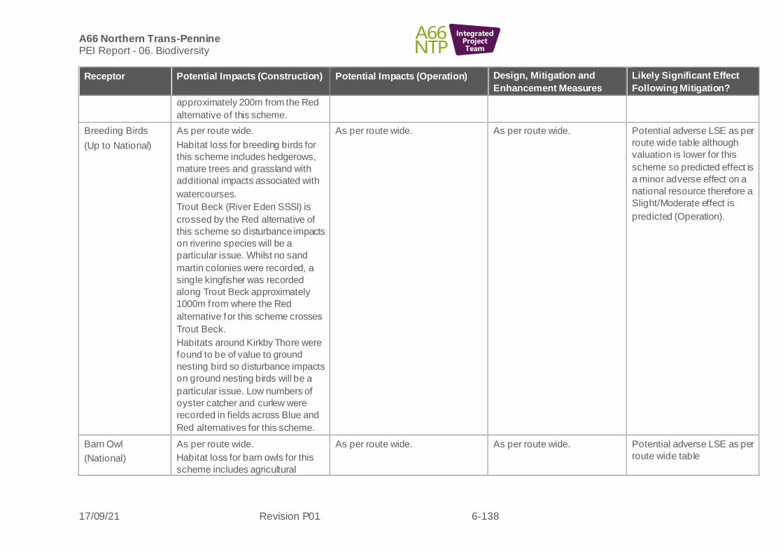
A66 Northern Trans-Pennine PEI Report - 06. Biodiversity
17/09/21 Revision P01 6-138
IntegratedProjectTeam
Receptor Potential Impacts (Construction) Potential Impacts (Operation) Design, Mitigation and
Enhancement Measures
Likely Significant Effect
Following Mitigation?
approximately 200m from the Red
alternative of this scheme.
Breeding Birds
(Up to National)
As per route wide.
Habitat loss for breeding birds for
this scheme includes hedgerows,
mature trees and grassland with
additional impacts associated with
watercourses.
Trout Beck (River Eden SSSI) is
crossed by the Red alternative of
this scheme so disturbance impacts
on riverine species will be a
particular issue. Whilst no sand
martin colonies were recorded, a
single kingfisher was recorded
along Trout Beck approximately
1000m from where the Red
alternative for this scheme crosses
Trout Beck.
Habitats around Kirkby Thore were
found to be of value to ground
nesting bird so disturbance impacts
on ground nesting birds will be a
particular issue. Low numbers of
oyster catcher and curlew were
recorded in fields across Blue and
Red alternatives for this scheme.
As per route wide. As per route wide.
Potential adverse LSE as per
route wide table although
valuation is lower for this
scheme so predicted effect is
a minor adverse effect on a
national resource therefore a
Slight/Moderate effect is
predicted (Operation).
Barn Owl
(National)
As per route wide.
Habitat loss for barn owls for this
scheme includes agricultural
As per route wide. As per route wide. Potential adverse LSE as per
route wide table

A66 Northern Trans-Pennine PEI Report - 06. Biodiversity
17/09/21 Revision P01 6-139
IntegratedProjectTeam
Receptor Potential Impacts (Construction) Potential Impacts (Operation) Design, Mitigation and
Enhancement Measures
Likely Significant Effect
Following Mitigation?
buildings, tussocky grassland,
hedgerows and mature trees.
(Construction and
Operation).
Reptiles
(Up to County)
As per route wide. As per route wide. As per route wide. Potential adverse LSE as per
route wide table
(Construction and
Operation).
Amphibians
(Up to County)
As per Blue alternative. As per Blue alternative. As per Blue alternative. Potential adverse LSE as per
route wide table relating to
amphibian species including
GCN (Construction and
Operation).
Fish
(Up to
International)
As per Blue alternative with
additional habitat loss/degradation
(shading) associated with the Keld
Sike crossing. This alternative also
crosses Trout Beck (approximately
1km further upstream than the Blue
alternative) and Keld Sike (a
tributary of Trout Beck).
As per Blue alternative. As per Blue alternative. No LSE anticipated as per
route wide table.
WCC
(Up to
International)
As per Blue alternative with
additional habitat loss/degradation
(shading) associated with the Keld
Sike crossing. This alternative also
crosses Trout Beck (approximately
1km further upstream than the Blue
alternative) and Keld Sike (a
tributary of Trout Beck).
As per the Blue alternative. As per the Blue alternative. No LSE anticipated as per
route wide table.

A66 Northern Trans-Pennine PEI Report - 06. Biodiversity
17/09/21 Revision P01 6-140
IntegratedProjectTeam
Receptor Potential Impacts (Construction) Potential Impacts (Operation) Design, Mitigation and
Enhancement Measures
Likely Significant Effect
Following Mitigation?
Terrestrial
invertebrates
(Up to National)
As per the Blue alternative. As per the Blue alternative. As per the Blue alternative. Potential adverse LSE
anticipated as per route wide
table (Construction and
Operation).
Aquatic
Invertebrates
(Up to National)
As per Blue alternative with
additional habitat loss/degradation
(shading) associated with the Keld
Sike crossing. This alternative also
crosses Trout Beck (approximately
1km further upstream than the Blue
Alternative) and Keld Sike (a
tributary of Trout Beck) with the
Keld Sike crossing.
As per the Blue alternative. As per the Blue alternative. No LSE anticipated as per
route wide table.
Macrophytes
(Up to
International)
As per Blue alternative with
additional habitat loss/degradation
(shading) associated with the Keld
Sike crossing. This alternative also
crosses Trout Beck (approximately
1km further upstream than the Blue
Alternative) and Keld Sike (a
tributary of Trout Beck) with the
Keld Sike crossing. There is
potential for species loss/ mortality
of the Nationally Scarce bryophyte
Porella pinnata during construction.
This species was recorded during
surveys of Trout Beck in the vicinity
of the proposed red alternative.
As per the Blue alternative. As per the Blue alternative.
Specific protocol to be devised
for Porella Pinnata to be
incorporated into the EMP for
this scheme to avoid or reduce
impacts on this species.
Potential adverse LSE
anticipated as per route wide
table (Construction and
Operation).
Orange alternative
6.9.10 The following biodiversity receptors have been scoped out of the assessment for this scheme:

A66 Northern Trans-Pennine PEI Report - 06. Biodiversity
17/09/21 Revision P01 6-141
IntegratedProjectTeam
• Pine marten
• Hazel dormouse
Table 6-11: Temple Sowerby to Appleby Orange alternative - likely significant effects
Receptor Potential Impacts
(Construction)
Potential Impacts (Operation) Design, Mitigation and
Enhancement Measures
Likely Significant Effect
Following Mitigation?
River Eden SAC and River
Eden and Tributaries SSSI
(International)
As per Blue alternative however
this alternative crosses Trout
Beck approximately 50m
downstream of the existing A66
crossing at Kirkby Thore and
approximately 200m upstream
of the confluence with the River
Eden.
This alternative also has a
linear construction boundary
partly within the SAC/SSSI
boundary west of the scheme
south of Temple Sowerby.
As per Blue alternative
As per Blue alternative.
In addition, aim to avoid
further construction works
within the SAC/SSSI
boundary to the south of
Temple Sowerby during
further design review.
Potential for major
adverse impacts on a
resource of International
importance, which is a
Very Large ef fect and
therefore significant.
Potential LSE anticipated
relating to habitat loss
(Construction) and air
quality (Operation).
Temple Sowerby Moss SSSI
(National)
This alternative includes a
linear construction boundary
through the SSSI which is a
potential change of footpath
use to bridleway, so small-scale
direct habitat loss is possible if
any construction works are
required.
There is the potential via
ground disturbance
mechanisms for indirect ground
water impacts to this lowland
fen and pollution impacts.
As per Blue alternative.
Potential through change of
footpath use from public to
bridleway that increased footfall
and potential disturbance
impacts may affect the SSSI
negatively (ground compaction,
grazing, nutrification through
dung deposits).
These potential impacts are
unlikely to affect the integrity of
the resource on a
permanent/irreversible basis but
may have some effects in the
As per route wide
Ensure works to existing
footpath areas are the best
option in the interests of
preservation of the SSSI
habitat based on existing
value and ecological
potential during further
design review.
The opportunity will be taken
to review ecological
mitigation design for the
SSSI to include potential for
enhancement options
Potential for negligible
adverse impact on a
resource of National
importance would be a
Slight effect and therefore
not significant. No LSE
are anticipated in relation
to habitat loss/degradation
(Construction).
Potential for major
adverse impacts on a
resource of National
importance would be a
Large or Very Large effect

A66 Northern Trans-Pennine PEI Report - 06. Biodiversity
17/09/21 Revision P01 6-142
IntegratedProjectTeam
Receptor Potential Impacts
(Construction)
Potential Impacts (Operation) Design, Mitigation and
Enhancement Measures
Likely Significant Effect
Following Mitigation?
These potential impacts may
af fect the integrity of the
resource on a
permanent/irreversible basis in
the absence of mitigation,
which may be assessed as a
major adverse impact.
absence of mitigation, which
may be assessed as a negligible
adverse impact.
relating to long-term issues
of oil tank leak and the
rectif ication of this issue.
Current ecological mitigation
design includes buffer
planting for the SSSI and an
area to compensate for any
minor tree loss, if required.
Benef icial impacts are not
reported at present as
ecology mitigation design is
not f inalised.
Construction pollution
controls and the sensitive
design of works would
reduce impacts so as not to
af fect the integrity of the
resource and any effects
would be
temporary/reversible, so this
may be assessed as a
negligible adverse impact.
and therefore significant.
Potential LSE are possible
in relation to air quality
(Operation).
Non-statutory designated sites
Chapel Wood CWS (up to
International)
Ross Wood CWS (National)
Dowpits Wood CWS (National)
Acorn Bank Woods and
Gardens CWS (County)
As per Blue alternative.
As per Blue alternative. As per Blue alternative. Potential for major
adverse impacts on a
resource of up to
International importance,
which is a Very Large
ef fect and therefore
significant. Potential
adverse LSE anticipated
relating to habitat loss

A66 Northern Trans-Pennine PEI Report - 06. Biodiversity
17/09/21 Revision P01 6-143
IntegratedProjectTeam
Receptor Potential Impacts
(Construction)
Potential Impacts (Operation) Design, Mitigation and
Enhancement Measures
Likely Significant Effect
Following Mitigation?
River Lyvennet Floodplain
CWS (County)
Temple Sowerby Shingle
Banks, Oglebird Scar,
Acorn Bank and Bolton Shingle
Bank Sites of Invertebrate
Significance
(all four invertebrate shingle
sites are County level)
(Construction) and air
quality (Operation).
Habitats –
Chapel Wood
(Up to International)
Ancient Woodland
Deciduous woodland
Wet woodland
Lowland fen
Ponds
Hedgerows
(Up to National)
As per Blue alternative
Losses and/or disturbance to
Chapel Wood ancient woodland
habitat and soils.
Greater potential for losses to
scattered semi-mature to
mature trees (some likely
veteran trees).
Priority Habitats in addition to
woodland likely affected include
lowland fen and wet woodland
(Temple Sowerby SSSI) and
hedgerow.
Greater impacts to areas of
historic significance associated
with the roman road, that whilst
currently in agricultural use
and/or unmanaged semi-
natural habitats may have
ecological potential due to their
setting.
As per Blue alternative.
As per route wide and Blue
alternative.
Potential adverse LSE
anticipated as per route
wide table due to loss of
Priority Habitats although
valuation is higher due to
the possible presence of
Annex 1 habitats.
Therefore, a potential
major adverse impact on a
feature of International
importance may be
assessed as a Very Large
ef fect, which is significant.
Potential adverse LSE
anticipated due to loss
and degradation of
ancient woodland, subject
to design refinement
(Construction and
Operation).
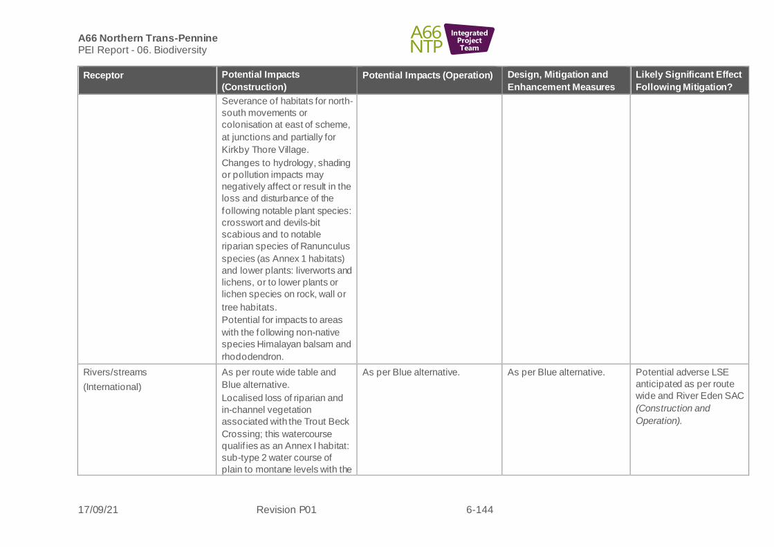
A66 Northern Trans-Pennine PEI Report - 06. Biodiversity
17/09/21 Revision P01 6-144
IntegratedProjectTeam
Receptor Potential Impacts
(Construction)
Potential Impacts (Operation) Design, Mitigation and
Enhancement Measures
Likely Significant Effect
Following Mitigation?
Severance of habitats for north-
south movements or
colonisation at east of scheme,
at junctions and partially for
Kirkby Thore Village.
Changes to hydrology, shading
or pollution impacts may
negatively affect or result in the
loss and disturbance of the
following notable plant species:
crosswort and devils-bit
scabious and to notable
riparian species of Ranunculus
species (as Annex 1 habitats)
and lower plants: liverworts and
lichens, or to lower plants or
lichen species on rock, wall or
tree habitats.
Potential for impacts to areas
with the following non-native
species Himalayan balsam and
rhododendron.
Rivers/streams
(International)
As per route wide table and
Blue alternative.
Localised loss of riparian and
in-channel vegetation
associated with the Trout Beck
Crossing; this watercourse
qualif ies as an Annex I habitat:
sub-type 2 water course of
plain to montane levels with the
As per Blue alternative. As per Blue alternative. Potential adverse LSE
anticipated as per route
wide and River Eden SAC
(Construction and
Operation).

A66 Northern Trans-Pennine PEI Report - 06. Biodiversity
17/09/21 Revision P01 6-145
IntegratedProjectTeam
Receptor Potential Impacts
(Construction)
Potential Impacts (Operation) Design, Mitigation and
Enhancement Measures
Likely Significant Effect
Following Mitigation?
Ranunculion fluitantis and
Callitricho-Batrachion
vegetation.
Bats (Roosts)
(Regional)
As per route wide.
Three structures and 11 trees
with moderate to high potential
will require demolition as a
result of the scheme. (Note:
one further residential property
scheduled to be demolished
has not provided access for the
PBRA)
As per route wide. As per route wide. Potential adverse LSE as
per route wide table
subject to ongoing
surveys (Construction and
Operation).
Bat Activity (Foraging and
Commuting)
(National)
As per route wide.
The scheme contains 18
potential bat crossing points
that will be affected by the
scheme during construction.
Temporary loss of foraging
resource during construction.
As per route wide.
The scheme contains 18
potential bat crossing points that
will be af fected by the scheme.
Temporary loss of foraging
resource until habitat replanting
scheme is completed and
matures
As per route wide. Potential adverse LSE as
per route wide table
subject to ongoing
surveys and possible
f ragmentation impacts
(Construction and
Operation).
Red Squirrel
(National)
As per route wide.
Habitat loss (temporary and
permanent) for red squirrel for
this scheme is limited to
connecting linear features such
as tree lines and hedgerows
and the occasional woodland
edge and old railway line.
As per route wide.
As per route wide
Potential adverse LSE as
per route wide table due
to habitat loss and
possible fragmentation
impacts
(Construction and
Operation).

A66 Northern Trans-Pennine PEI Report - 06. Biodiversity
17/09/21 Revision P01 6-146
IntegratedProjectTeam
Receptor Potential Impacts
(Construction)
Potential Impacts (Operation) Design, Mitigation and
Enhancement Measures
Likely Significant Effect
Following Mitigation?
Otter
(Up to International)
As per route wide.
Direct impacts associated with
the temporary loss of otter
habitat at the new crossing
points on Trout Beck.
Disturbance impacts associated
with construction activity is
likely to impact commuting and
foraging otter at Trout Beck and
in close proximity to the River
Eden. Crossing point
immediately south of the
existing A66 next to a large
working cattle farm so
disturbance is likely to be high
already, but may cause holts to
be temporarily abandoned if
present (f ield surveys have not
yet been completed for all
alternatives being considered
for this scheme).
As per route wide.
Potential permanent increased
noise, light, vibration and surface
water runof f containing
pollutants may reduce otter
commuting and foraging and
could cause habitat
f ragmentation on Trout Beck due
to the previously undisturbed
nature of the watercourse.
Disturbance from traffic could
cause holts nearby to be
abandoned
As per route wide
No LSE are anticipated as
per route wide table.
Water Vole
(County)
As per route wide.
Direct impacts associated with
the temporary loss of water
vole habitat at the new crossing
point over Trout Beck and its
tributary. Potential temporary
closure of burrows on Trout
Beck and its tributary if present
- f ield surveys have not yet
been completed for all route
As per route wide.
As per route wide
No LSE are anticipated as
per route wide table.

A66 Northern Trans-Pennine PEI Report - 06. Biodiversity
17/09/21 Revision P01 6-147
IntegratedProjectTeam
Receptor Potential Impacts
(Construction)
Potential Impacts (Operation) Design, Mitigation and
Enhancement Measures
Likely Significant Effect
Following Mitigation?
alternatives being considered
for this scheme.
Disturbance impacts associated
with construction activities at
previously undisturbed areas of
Trout Beck could impact
foraging water vole and cause
burrows to be abandoned or to
collapse.
The River Eden does not
provide suitable habitat for
water vole.
Badger
(Local)
As per route wide.
Habitat loss for badger for this
scheme includes foraging and
commuting habitat which
includes pockets of small
woodland areas, woodland and
scrub edges, open rough
grassland areas and
predominantly open arable
f ields with linear boundary
features including hedgerows,
tree lines and dry stone walls.
Badger surveys are not
complete for all alternatives, but
it is likely setts will be identified
in the area.
As per route wide.
Crossing points may be
identified through further survey.
As per route wide. No LSE are anticipated as
per route wide table.
Other Mammal Species
Polecat
As per route wide. As per route wide. As per route wide table. Potential adverse LSE as
per route wide table due

A66 Northern Trans-Pennine PEI Report - 06. Biodiversity
17/09/21 Revision P01 6-148
IntegratedProjectTeam
Receptor Potential Impacts
(Construction)
Potential Impacts (Operation) Design, Mitigation and
Enhancement Measures
Likely Significant Effect
Following Mitigation?
Brown hare
Deer
Hedgehog
(Up to County)
Habitat loss (temporary and
permanent) for other terrestrial
mammal species including
deer, polecat, brown hare and
hedgehog for this scheme
includes hedgerows, woodland
edges, grassland, open fields,
areas of scrub and riparian
banks.
Due to the western extents of
this alignment being offline,
previously undisturbed suitable
habitats (predominantly open
arable f ields) will become
permanently fragmented in this
area as a result of operation.
to habitat loss and
f ragmentation impacts
(Construction and
Operation).
Wintering Birds
(Up to National)
As per route wide.
Habitat loss for wintering birds
for this scheme includes
hedgerows, mature trees and
grassland with additional
impacts associated with
watercourses.
As per route wide.
As per route wide. Potential adverse LSE as
per route wide table
although valuation is
lower for this scheme so
predicted effect is a minor
adverse effect on a
national resource
therefore a slight/
moderate effect is
predicted (Operation).
Breeding Birds
(Up to National)
As per route wide.
Habitat loss for breeding birds
for this scheme includes
hedgerows, mature trees and
grassland with additional
impacts associated with
watercourses.
Trout Beck (River Eden SSSI)
is crossed by the Orange
alternative of this Scheme so
disturbance impacts on riverine
species will be a particular
As per route wide. As per route wide. Potential adverse LSE as
per route wide table
although valuation is
lower for this scheme so
predicted effect is a minor
adverse effect on a
national resource
therefore a
slight/moderate effect is
predicted
(Operation).

A66 Northern Trans-Pennine PEI Report - 06. Biodiversity
17/09/21 Revision P01 6-149
IntegratedProjectTeam
Receptor Potential Impacts
(Construction)
Potential Impacts (Operation) Design, Mitigation and
Enhancement Measures
Likely Significant Effect
Following Mitigation?
issue. Whilst no sand martin
colonies were recorded, a
single kingfisher was recorded
along Trout Beck approximately
1.5km from where the Orange
alternative for this scheme
crosses Trout Beck.
Barn Owl
(National)
As per route wide.
Habitat loss for barn owls for
this scheme includes
agricultural buildings, tussocky
grassland, hedgerows and
mature trees.
As per route wide. As per route wide. Potential adverse LSE as
per route wide table
(Construction and
Operation).
Reptiles
(Up to County)
As per route wide. As per route wide. As per route wide. Potential adverse LSE as
per route wide table
(Construction and
Operation).
Amphibians
(Up to County)
As per Red alternative, but
there are localised impacts to
Temple Sowerby SSSI with the
potential to support great
crested newts, this wetland
being functionally linked to an
area with known records within
500m of the scheme and
supports prey species.
Dif fering fragmentation impacts
to the west, of this scheme
(generally poor GCN habitat)
and this scheme avoids the
As per Red alternative but
lowered requirement for
balancing ponds.
As per Blue alternative.
Potential adverse LSE as
per route wide table
relating to amphibian
species including GCN
(Construction and
Operation).

A66 Northern Trans-Pennine PEI Report - 06. Biodiversity
17/09/21 Revision P01 6-150
IntegratedProjectTeam
Receptor Potential Impacts
(Construction)
Potential Impacts (Operation) Design, Mitigation and
Enhancement Measures
Likely Significant Effect
Following Mitigation?
Blue and Red alternatives
f ragmentation impacts upon
terrestrial habitat within 500m
of great crested newt breeding
ponds.
Fish
(Up to International)
As per Blue alternative.
This route alternative crosses
Trout Beck (approximately 50m
downstream of the existing A66
crossing at Kirkby Thore and
approximately 200m upstream
of the confluence with the River
Eden). Impacts as per Blue
alternative.
As per Blue alternative. As per Blue alternative. No LSE anticipated as per
route wide table.
WCC
(Up to International)
As per Blue Alternative.
This route alternative crosses
Trout Beck (approximately 50m
downstream of the existing A66
crossing at Kirkby Thore and
approximately 200m upstream
of the confluence with the River
Eden).
As per Blue alternative. As per Blue alternative. No LSE anticipated as per
route wide table.
Terrestrial invertebrates
(Up to National)
As Blue alternative As Blue alternative. As Blue alternative. Potential adverse LSE
anticipated as per route
wide table (Construction
and Operation).
Aquatic Invertebrates
(Up to National)
As per Blue alternative.
This alternative crosses Trout
Beck (approximately 50m
downstream of the existing A66
As per Blue alternative. As per Blue alternative. No LSE anticipated as per
route wide table.

A66 Northern Trans-Pennine PEI Report - 06. Biodiversity
17/09/21 Revision P01 6-151
IntegratedProjectTeam
Receptor Potential Impacts
(Construction)
Potential Impacts (Operation) Design, Mitigation and
Enhancement Measures
Likely Significant Effect
Following Mitigation?
crossing at Kirkby Thore and
approximately 200m upstream
of the confluence with the River
Eden).
Macrophytes
(Up to International)
As per Blue alternative.
This alternative crosses Trout
Beck (approximately 50m
downstream of the existing A66
crossing at Kirkby Thore and
approximately 200m upstream
of the confluence with the River
Eden).
As per Blue alternative As per Blue alternative. Potential adverse LSE
anticipated as per route
wide table (Construction
and Operation).
Appleby to Brough
Black-Black-Black route
6.9.11 The following biodiversity receptors have been scoped out of the assessment for this scheme:
• Pine marten
• Hazel dormouse
Table 6-12: Appleby to Brough Black-Black-Black route - likely significant effects
Receptor Potential Impacts
(Construction)
Potential Impacts (Operation) Design, Mitigation and
Enhancement Measures
Likely Significant Effect
Following Mitigation?
River Eden SAC and
River Eden and
Tributaries SSSI
(International)
Unnamed Tributary
of Mire Sike 6.12,
As per route wide.
Localised loss of riparian and in-
channel vegetation associated
with the crossings of tributaries
and potential for pollution during
construction phase.
As per route wide.
The crossings of these
watercourses have the potential to
impact the natural (fluvial
geomorphological) river process
which control the quality and
As per route wide.
Watercourse crossing design
for new crossing points will
ensure that current f luvial
geomorphological processes
and f ish are maintained within
Potential for minor adverse
impacts on a resource of up to
International importance,
which is a Moderate or Large
adverse effect and therefore
significant. Potential LSE

A66 Northern Trans-Pennine PEI Report - 06. Biodiversity
17/09/21 Revision P01 6-152
IntegratedProjectTeam
Receptor Potential Impacts
(Construction)
Potential Impacts (Operation) Design, Mitigation and
Enhancement Measures
Likely Significant Effect
Following Mitigation?
Cringle Beck, Hayber
Beck/Moor Beck,
Eastfield Sike,
Unnamed Tributary
of Lowgill Beck 6.1,
Lowgill Beck,
Woodend Sike,
Yosgill Sike and
Unnamed Tributary
of Lowgill Beck 6.7-
tributaries of River
Eden
With the exception of some minor
watercourses, these tributaries
are considered to be functionally
linked to the SAC/SSSI as they
support likely qualifying species.
These rivers are unlikely (detailed
analysis of survey data pending)
to qualify as Annex I habitat: sub-
type 2 water course of plain to
montane levels with the
Ranunculion fluitantis and
Callitricho-Batrachion vegetation.
These potential impacts may af fect the integrity of the resource on a permanent/irreversible basis in the absence of mitigation, which may be assessed as a major adverse impact.
distribution of aquatic habitat. This
could have indirect impacts on the
qualifying species the habitat
supports.
Proposed new discharges to a
number of tributaries which
ultimately flow into the River Eden
have the potential to adversely
impact water quality in the
SAC/SSSI.
The SAC/SSSI is located over
200m from the ARN for this scheme
therefore operational air quality
impacts have been ruled out.
These potential impacts may affect the integrity of the resource on a permanent/irreversible basis in the absence of mitigation, which may be assessed as a major adverse impact.
watercourses sustaining
notable fish. The potential
impacts on habitat upstream
and downstream of the
crossing location will be
assessed and mitigated
through appropriate design.
The design and assessment of
impacts will be informed by
detailed hydromorphology
modelling, as described in
Chapter 14: Road Drainage
and the Water Environment.
The potential effects will
therefore be reduced to
permanent impacts which do
not af fect the integrity of the
resource. This may be
assessed as a minor adverse
impact.
anticipated for (Construction
and Operation).
Helbeck and
Swindale Woods
SAC and Helbeck
Wood SSSI and
Swindale Wood SSSI
(Up to International)
As per route wide.
Situated some distance from the
A66, within connected landscape.
The site is designated for ash-elm
woodland habitats on limestone,
ancient woodland ground flora
and lichen species. There is not
expected to be any impacts
arising f rom construction due to
As per route wide.
The SAC/SSSI is located over
200m from the ARN. In line with LA
105 DMRB guidelines, no LSE are
anticipated from a change in air
quality due to distance of the site
f rom the road.
No change is anticipated.
As per route wide. No change on a resource of
National importance would be
a Neutral ef fect and therefore
not significant. No LSE are
anticipated.

A66 Northern Trans-Pennine PEI Report - 06. Biodiversity
17/09/21 Revision P01 6-153
IntegratedProjectTeam
Receptor Potential Impacts
(Construction)
Potential Impacts (Operation) Design, Mitigation and
Enhancement Measures
Likely Significant Effect
Following Mitigation?
the distance (over 200m) from the
scheme.
The SSSIs are designated for a
large breeding bird population but
due to the distance of the scheme
form the SSSIs, it is considered
unlikely there would be an impact
on the bird assemblage.
No change is anticipated.
Moor House Upper
Teesdale SAC
(International)
As per route wide.
This is situated some distance
f rom the A66, within connected
landscape. The site is designated
for its diverse range of upland
Annex 1 habitats, including
blanket bog, northern hay
meadows and limestone
grassland. There is not expected
to be any impacts arising from
construction due to the distance
f rom the scheme.
No change is anticipated.
As per route wide
The SAC/ SSSI is located over
200m from the ARN. In line with
DMRB LA 105 guidelines, no LSE
are anticipated from a change in air
quality due to distance of the site
f rom the road.
No change is anticipated.
None required. No change on a resource of
National importance would be
a Neutral ef fect and therefore
not significant. No LSE are
anticipated.
North Pennine Moors
SPA (which includes
North Pennine Moors
SAC and Moor
House-Upper
Teesdale SAC, Moor
House and Cross fell
SSSI, Upper
As per route wide for birds.
The SPA is located 704m to the
north of all alternatives for this
scheme so there is potential for
disturbance impacts on qualifying
features (merlin, peregrine, hen
harrier and golden plover) using
functionally linked land. A peak
As per route wide birds.
There may be operational
disturbance from increased traffic
noise on SPA species using
functionally linked land.
These potential impacts may affect
the integrity of the resource on a
permanent/irreversible basis in the
As per route wide for birds.
Once mitigation is taken into
account for disturbance of
birds on functionally linked
land, this impact is expected to
be reduced to minor adverse
and only be applicable during
operation.
Potential for minor adverse
impacts on a resource of
International importance,
which is a Moderate or Large
ef fect and therefore
significant. Potential adverse
LSE anticipated relating to
disturbance (Operation).

A66 Northern Trans-Pennine PEI Report - 06. Biodiversity
17/09/21 Revision P01 6-154
IntegratedProjectTeam
Receptor Potential Impacts
(Construction)
Potential Impacts (Operation) Design, Mitigation and
Enhancement Measures
Likely Significant Effect
Following Mitigation?
Teesdale SSSI and
Appleby Fells SSSI)
and adjacent to
Helbeck and
Swindale Woods
SAC.
(Up to International)
count of 40 golden plover were
identified during wintering bird
surveys in February.
These potential impacts may
af fect the integrity of the resource
on a permanent/irreversible basis
in the absence of mitigation,
which may be assessed as a
major adverse impact.
absence of mitigation, which may
be assessed as a major adverse
impact.
Appleby Fells SSSI
(National)
No direct impacts are likely to this
site based on distance.
There is not expected to be any
impacts arising from construction
due to the distance (over 200m)
f rom construction activities.
No change is anticipated.
Appleby Woods SSSI is located
over 200m from the ARN. In line
with DMRB LA 105 guidelines, no
LSE are anticipated from a change
in air quality due to distance of the
site f rom the road.
No change is anticipated.
None required No change on a resource of
National importance would be
a Neutral ef fect and therefore
not significant. No LSE are
anticipated.
Argill Woods and
Pastures SSSI
and
Augill Valley Pasture
SSSI
(National)
No direct impacts are likely to
either of these sites based on
their distances from the scheme.
No change is anticipated.
As per route wide
The current stage of air quality
modelling has identified a 1%
increase in nitrogen for where these
sites are within 200m of the ARN,
potential for detrimental impacts
upon sensitive sites, habitats and
species within these sites, (loss of
or damage to plant species).
These potential impacts may affect
the integrity of the resource on a
permanent/irreversible basis in the
absence of mitigation, which may
As per route wide
Further air quality assessment
and biodiversity assessment
(mapping of sensitive habitats
within 200m of the road) is
required to ascertain nitrogen
deposition (kg per Ha) and
further potential for LSE.
This remains a major adverse
impact until air quality data and
mitigation design can confirm
otherwise.
Potential for major adverse
impacts on a resource of
National importance, which is
a Large or Very Large effect
and therefore significant.
Potential adverse LSE
anticipated relating to air
quality (Construction and
Operation).

A66 Northern Trans-Pennine PEI Report - 06. Biodiversity
17/09/21 Revision P01 6-155
IntegratedProjectTeam
Receptor Potential Impacts
(Construction)
Potential Impacts (Operation) Design, Mitigation and
Enhancement Measures
Likely Significant Effect
Following Mitigation?
be assessed as a major adverse
impact.
George Gill SSSI
(National)
No direct or indirect impacts are
likely based on the distance from
the scheme.
No change is anticipated.
No direct or indirect impacts are
likely based on the distance from
the scheme. This site is not within
the ARN.
No change is anticipated.
None required. No change on a resource of
National importance would be
a Neutral ef fect and therefore
not significant. No LSE are
anticipated.
Non-statutory
designated sites
Sandford Mire CWS
(County)
As per route wide.
There are no direct impacts
anticipated to this site, but
adjacent works are within 200m
with potential for impacts via
pollution sources, from dust,
accidental spills or poor drainage
connections. Works are situated
upstream and uphill of this site,
which is designated for its lowland
fen therefore sensitive to change.
There is the potential for overland
or groundwater flow into the mire
and potential for pollution of these
sources, which may result in
impact on peat forming species
(Sphagnum mosses).
The site also supports protected
or otherwise notable plant species
and the works have the potential
to result in damage to, or loss of
these species.
As per route wide.
Potential for changes to water
quality and quantity from road run-
of f. These may be adverse or
benef icial depending on drainage
upgrades and further hydrology
assessment is required to confirm.
This site is not listed in the air
quality modelling outputs as
currently supporting a 1% or
greater increase in nitrogen from
base levels, therefore air quality
impacts are not anticipated.
The potential impacts on hydrology
may af fect the integrity of the
resource on a
permanent/irreversible basis in the
absence of mitigation, which may
be assessed as a major adverse
impact.
As per route wide.
Review of hydrological
connections and requirements
to ensure the water dependent
habitats are not subject to
impacts from the works and
this being used to further guide
design development.
Monitoring of outfalls into
water sources supplying the
habitats within this site.
Further measures to protect
this site from impacts of dust
deposition or accidental
pollution from construction.
Potential for major adverse
impacts on a resource of
County importance, which is a
Slight or Moderate effect and
therefore significant. Potential
adverse LSE anticipated
relating to hydrology
(Construction and Operation)
and air quality (Construction
only).
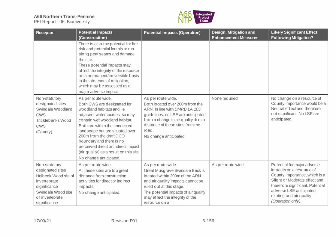
A66 Northern Trans-Pennine PEI Report - 06. Biodiversity
17/09/21 Revision P01 6-156
IntegratedProjectTeam
Receptor Potential Impacts
(Construction)
Potential Impacts (Operation) Design, Mitigation and
Enhancement Measures
Likely Significant Effect
Following Mitigation?
There is also the potential for fire
risk and potential for this to run
along peat seams and damage
the site.
These potential impacts may
af fect the integrity of the resource
on a permanent/irreversible basis
in the absence of mitigation,
which may be assessed as a
major adverse impact.
Non-statutory
designated sites
Swindale Woodland
CWS
Tricklebanks Wood
CWS
(County)
As per route wide.
Both CWS are designated for
woodland habitats and lie
adjacent watercourses, so may
contain wet woodland habitat.
Both are within the connected
landscape but are situated over
200m from the draft DCO
boundary and there is no
perceived direct or indirect impact
(air quality) as a result on this site.
No change anticipated.
As per route wide.
Both located over 200m from the
ARN. In line with DMRB LA 105
guidelines, no LSE are anticipated
f rom a change in air quality due to
distance of these sites from the
road.
No change anticipated
None required No change on a resource of
County importance would be a
Neutral ef fect and therefore
not significant. No LSE are
anticipated.
Non-statutory
designated sites
Helbeck Wood site of
invertebrate
significance
Swindale Wood site
of invertebrate
significance
As per route wide.
All these sites are too great
distance from construction
activities for direct or indirect
impacts.
No change anticipated.
As per route wide.
Great Musgrave Swindale Beck is
located within 200m of the ARN
and air quality impacts cannot be
ruled out at this stage.
The potential impacts of air quality
may af fect the integrity of the
resource on a
As per route wide. Potential for major adverse
impacts on a resource of
County importance, which is a
Slight or Moderate effect and
therefore significant. Potential
adverse LSE anticipated
relating and air quality
(Operation only).

A66 Northern Trans-Pennine PEI Report - 06. Biodiversity
17/09/21 Revision P01 6-157
IntegratedProjectTeam
Receptor Potential Impacts
(Construction)
Potential Impacts (Operation) Design, Mitigation and
Enhancement Measures
Likely Significant Effect
Following Mitigation?
Great Musgrave
Swindale Beck Ers
(County)
permanent/irreversible basis in the
absence of mitigation, which may
be assessed as a major adverse
impact.
Habitats –
Yosgill Wood AW
(part of Hellbeck
Wood SSSI)
Swindale Wood AW
(part of Swindale
Wood SSSI)
Howgill Wood AW
Cotbers Wood AW
Trickle Banks Wood
AW
Deciduous woodland
Hedgerow
Ponds
Lowland fen
Lowland heathland
Acid grassland
Mire
Open mosaic
habitats
(Up to National)
As per route wide.
Potential losses to deciduous
woodland, hedgerows, ponds,
lowland fen, lowland heathland,
acid grassland, mire, open mosaic
habitats.
Areas of ‘islands’ created forming
f ragmentation impacts as a result
of junctions, and new alignment
forming areas enclosed by road
inf rastructure. These contain
largely farmland habitats but
notable species may be present
with potential for reduced
colonisation and population
success.
Several AW sites (Yosgill Wood,
Swindale Wood, Howgill, Cotbers,
Trickle Banks Wood) are present
in the connected landscape
however these are over 200m in
distance from construction
activities with negligible potential
for significant impacts from air
quality or air pollution impacts.
Potential for loss, physical
damage or pollution impacts to
As per route wide.
Persistence of fragmentation
impacts caused by widened
carriageway and ‘islands’.
Potential for areas of better
connectivity for the priority habitat
heathland through appropriate
management. To be included in
review of proposed ecological
mitigation.
For both Augill Beck Wood AW and
Augill Bridge Wood AW the current
stage of air quality modelling has
identified a 1% increase in nitrogen
for where these sites are within
200m of the ARN, with potential for
detrimental impacts upon sensitive
sites, habitats and species within
these sites, (loss of or damage to
plant species).
As route wide.
Proposed ecology mitigation
includes habitat creation for
increased areas of heathland
habitats and better
management prescriptions,
potential for enhancement of
open mosaic habitats along
heritage railway. Mitigation
design is yet to be confirmed.
Further air quality assessment
and biodiversity assessment
(mapping of sensitive habitats
within 200m of the road) is
required to ascertain nitrogen
deposition (kg per Ha) and
further potential for LSE.
Potential adverse LSE
anticipated as per route wide
table due to loss of Priority
Habitats (Construction) and air
quality impacts (Operation).

A66 Northern Trans-Pennine PEI Report - 06. Biodiversity
17/09/21 Revision P01 6-158
IntegratedProjectTeam
Receptor Potential Impacts
(Construction)
Potential Impacts (Operation) Design, Mitigation and
Enhancement Measures
Likely Significant Effect
Following Mitigation?
the following protected and/or
otherwise notable plant
species marsh stitchwort,
bluebell, fly orchid, early-purple
orchid, an eyebright
species, bird’s-eye
primrose, bird’s-foot sedge,
tormentil, common heather, bog
asphodel, harebell, blue moor-
grass, alpine cinquefoil, alpine
penny-cress or to lower plants or
lichens.
Potential for further spread of
giant hogweed on the River
Eden and rhododendron within
the study area.
Rivers/streams
(International)
As per route wide.
Direct impacts associated with the
temporary loss of otter habitat
during the expansion of existing
crossings over an unnamed
Tributary of Mire Sike, Lowgill
Beck (including Woodend Sike
and Yosgill Sike) and an
unnamed tributary of Lowgill Beck
and new crossings over Cringle
Beck, Moor Beck, Eastfield Sike
and one unnamed tributary of
Lowgill Beck.
Localised loss of riparian and in-
channel vegetation associated
As per route wide and River Eden
SAC/SSSI impacts listed above.
As per route wide. Potential adverse LSE
anticipated as per route wide
and River Eden SAC
(Construction and Operation).

A66 Northern Trans-Pennine PEI Report - 06. Biodiversity
17/09/21 Revision P01 6-159
IntegratedProjectTeam
Receptor Potential Impacts
(Construction)
Potential Impacts (Operation) Design, Mitigation and
Enhancement Measures
Likely Significant Effect
Following Mitigation?
with the crossings of tributaries to
the River Eden (as per River
Eden SAC/SSSI above).
Bats (Roosts)
(Regional)
As per route wide.
None of the structures with bat
roost potential will be lost as a
result of the scheme, however, all
six trees with moderate to high
potential to support roosting bats
will require clearance.
As per route wide.
As per route wide.
Potential adverse LSE as per
route wide table subject to
ongoing surveys.
(Construction and Operation)
Bat Activity (Foraging
and Commuting
(National)
As per route wide
Fourteen potential crossing points
will be af fected by construction
activities.
Temporary loss of foraging
resource during construction.
As per route wide
Fourteen potential crossing points
will be af fected by the scheme.
Temporary loss of foraging
resource until habitat replanting
scheme completed and matures.
As per route wide.
Potential adverse LSE as per
route wide table subject to
ongoing surveys and possible
f ragmentation impacts.
(Construction and Operation)
Red Squirrel
(Up to National)
As per route wide.
Temporary and permanent habitat
loss for red squirrel for this
scheme includes woodland
edges, tree lines, hedgerows and
loss of a large linear area of
suitable woodland located
immediately north of the existing
A66 carriageway to the western
extents of the scheme.
As per route wide.
Due to widening of the existing
carriageway areas of woodland
located north and south of the route
which are suitable for red squirrel
may become permanently
f ragmented.
As per route wide.
Two potential red squirrel
crossing point features (rope
bridges) may be necessary for
this scheme to ensure suitable
woodland habitats remain
connected and a safe crossing
feature can be used to help
reduce the risk of RTAs. This
is yet to be confirmed and will
be part of the next design
review.
Potential adverse LSE as per
route wide table due to habitat
loss and possible
f ragmentation impacts.
(Construction and Operation).
Otter As per route wide. As per route wide. As per route wide. No LSE are anticipated as per
route wide table.

A66 Northern Trans-Pennine PEI Report - 06. Biodiversity
17/09/21 Revision P01 6-160
IntegratedProjectTeam
Receptor Potential Impacts
(Construction)
Potential Impacts (Operation) Design, Mitigation and
Enhancement Measures
Likely Significant Effect
Following Mitigation?
(Up to International) Direct impacts associated with the
temporary loss of otter habitat
during the expansion of existing
crossings over an unnamed
Tributary of Mire Sike, Lowgill
Beck and an unnamed tributary of
Lowgill Beck and new crossings
over Cringle Beck, Moor Beck,
Eastfield Sike and one unnamed
tributary of Lowgill Beck.
Disturbance impacts associated
with construction activity is likely
to impact otter at existing and new
crossing points. In particular Moor
Beck and Eastfield Sike which
have high otter maternity use
potential. Disturbance during
construction may impact
commuting and foraging otter and
cause holts to be abandoned if
present - f ield surveys are
ongoing.
Any new crossing points will
be bridged over the
watercourse or culverts will be
built to specifications to allow
them to remain suitable
crossing points for otter.
Water vole
(Up to County)
As per route wide.
Direct impacts associated with the
temporary loss of water vole
habitat during the expansion of
existing crossings over an
unnamed Tributary of Mire Sike,
Lowgill Beck and an unnamed
tributary of Lowgill Beck and new
crossings over Cringle Beck,
As per route wide.
The operational phase could cause
an increase in vehicle deposits and
surface run off of pollutants which
could cause a deleterious impact to
foraging habitats.
As per route wide.
No LSE are anticipated as per
route wide table.

A66 Northern Trans-Pennine PEI Report - 06. Biodiversity
17/09/21 Revision P01 6-161
IntegratedProjectTeam
Receptor Potential Impacts
(Construction)
Potential Impacts (Operation) Design, Mitigation and
Enhancement Measures
Likely Significant Effect
Following Mitigation?
Moor Beck, Eastfield Sike and
one unnamed tributary of Lowgill
Beck.
Disturbance impacts associated
with construction activities could
impact foraging water vole and
cause burrows to be abandoned
or to collapse.
Badger
(Local)
As per route wide.
Habitat loss for badger for this
scheme includes areas of
woodland, woodland and scrub
edges, open rough grassland
areas and open arable fields with
linear boundary features including
hedgerows, tree lines and dry-
stone walls which are likely to be
used by badger for commuting
and foraging purposes.
Construction may also lead to
minor f ragmentation of foraging
and commuting habitat.
Although locations of badger setts
is still unknown for this route
alternative, construction may
result in permanent and/or
temporary closure of existing
badger setts if found to be present
within or immediately next to the
construction areas.
As per route wide.
Operation may also result in the
permanent closure of existing
badger setts if they are found to be
present within this alternative
alignment.
As per route wide. No LSE are anticipated as per
route wide table.

A66 Northern Trans-Pennine PEI Report - 06. Biodiversity
17/09/21 Revision P01 6-162
IntegratedProjectTeam
Receptor Potential Impacts
(Construction)
Potential Impacts (Operation) Design, Mitigation and
Enhancement Measures
Likely Significant Effect
Following Mitigation?
Other Terrestrial
Mammal Species
Polecat
Brown hare
Deer
Hedgehog
(Up to County)
As per route wide.
Habitat loss (temporary and
permanent) for other terrestrial
mammal species for this scheme
includes hedgerows, tree lines,
areas of woodland, woodland
edges, grassland, open fields,
areas of scrub and riparian banks.
As per route wide.
Due to widening of the existing
carriageway habitats suitable for
other terrestrial mammal species
may become permanently
f ragmented as a result of operation.
As per route wide. Potential adverse LSE as per
route wide table due to habitat
loss and fragmentation
impacts (Construction and
Operation).
Wintering Birds
(Up to International)
As per route wide.
Habitat loss for wintering birds for
this scheme includes hedgerows,
woodland, mature trees and
grassland.
The North Pennine Moors SPA is
located 1.5km to the north of all
alternatives for this scheme so
there is potential for disturbance
impacts on qualifying features
(merlin, peregrine, hen harrier and
golden plover). A peak count of
40 golden plover were identified
during wintering bird surveys in
February.
As per route wide.
As per route wide. Potential adverse LSE as per
route wide table (Operation).
Breeding Birds
(Up to International)
As per route wide.
Habitat loss for breeding birds for
this scheme includes hedgerows,
woodland, mature trees and
grassland.
The North Pennine Moors SPA is
located 1.5km to the north of all
As per route wide.
As per route wide.
Potential adverse LSE as per
route wide table
(Operation).

A66 Northern Trans-Pennine PEI Report - 06. Biodiversity
17/09/21 Revision P01 6-163
IntegratedProjectTeam
Receptor Potential Impacts
(Construction)
Potential Impacts (Operation) Design, Mitigation and
Enhancement Measures
Likely Significant Effect
Following Mitigation?
Alternatives for this Scheme so
there is potential for disturbance
impacts on qualifying features
(merlin, peregrine, hen harrier and
golden plover). During the 2020
Arcadis breeding bird surveys, a
single peregrine (SPA species,
Schedule 1) was observed flying
north to south over the current
A66 approximately 800m east of
the Scheme during the May
survey visit. No SPA qualifying
species were recorded during the
2021 breeding bird surveys.
Barn Owl
(Regional)
As per route wide.
Habitat loss for barn owls for this
scheme includes agricultural
buildings, woodland, tussocky
grassland, hedgerows and mature
trees.
As per route wide. As per route wide. Potential adverse LSE as per
route wide table (Construction
and Operation).
Reptiles
(Up to County)
As per route wide As per route wide As per route wide Potential adverse LSE as per
route wide table
(Construction and Operation).
Amphibians
(Up to County)
As per route wide.
No losses to pond habitats
currently identified as supporting
great crested newts. Losses to
terrestrial habitat for great crested
newts.
As per route wide.
Potential for a temporal loss in
quality of replacement habitat
provision, despite additional habitat
being created.
As per route wide,
Mitigation licensing or District
Level Licensing will be
required for losses to terrestrial
habitats and for measures to
Potential adverse LSE as per
route wide table relating to
common toad, GCN and other
amphibian species.
(Construction and Operation).

A66 Northern Trans-Pennine PEI Report - 06. Biodiversity
17/09/21 Revision P01 6-164
IntegratedProjectTeam
Receptor Potential Impacts
(Construction)
Potential Impacts (Operation) Design, Mitigation and
Enhancement Measures
Likely Significant Effect
Following Mitigation?
Potential severance impacts to
pond used by common toad due
to works to create a series of
balancing ponds, some within
islands of road infrastructure, with
resulting potential risk of
amphibian mortality.
Other severance impacts to
generally currently poor-quality
habitat for amphibians through the
creation of islands surrounded by
road inf rastructure.
Increased potential for amphibians
adjacent to the road alignment, due
to colonisation of new pond habitats
provided by balancing ponds,
potential for population increase
followed by mortality.
prevent harm to great crested
newt.
Potential requirement for
amphibian fencing to reduce
risk of road traffic impacts.
Fish
(Up to International)
As per route wide.
There is potential for disturbance
of migratory fish as a result of
elevated levels of noise/vibration
and artif icial lighting during the
construction of watercourse
crossings.
As per route wide.
In the absence of appropriate
design, the watercourse crossings
proposed have the potential to
adversely impact fish passage and
the natural (f luvial
geomorphological) river process
which control the quality and
distribution of aquatic habitats that
are considered to be functionally
linked to SAC/SSSI. This could
have indirect impacts on fish.
As per route wide.
Watercourse crossing design
for new crossings will ensure
f ree passage for fish and
ensure that current f luvial
geomorphological processes,
which control the quality and
extent of fish habitat, are
maintained.
No LSE anticipated as per
route wide table.
White-Clawed
Crayf ish (WCC)
(Up to International)
As per route wide. As per route wide. As per route wide.
WCC survey data is pending
and will be used to confirm
detail of mitigation required,
but it is expected that all
impacts will be mitigated.
No LSE anticipated as per
route wide table.

A66 Northern Trans-Pennine PEI Report - 06. Biodiversity
17/09/21 Revision P01 6-165
IntegratedProjectTeam
Receptor Potential Impacts
(Construction)
Potential Impacts (Operation) Design, Mitigation and
Enhancement Measures
Likely Significant Effect
Following Mitigation?
Terrestrial
invertebrates
(Up to National)
As per route wide. As per route wide. As per route wide.
Terrestrial invertebrate survey
data is pending and will be
used to confirm detail of
mitigation required, but it is
expected that all impacts will
be mitigated.
Potential adverse LSE
anticipated as per route wide
table (Construction and
Operation)
Aquatic invertebrates
(Up to National)
As per route wide. As per route wide. As per route wide.
Aquatic invertebrate survey
data is pending and will be
used to confirm detail of
mitigation required, but it is
expected that all impacts will
be mitigated.
No LSE anticipated as per
route wide table. (Construction
and Operation)
Macrophytes
(Up to International)
As per route wide. As per route wide. As per route wide.
Macrophyte survey data is
pending and will be used to
conf irm detail of mitigation
required, but it is expected that
all impacts will be mitigated.
Potential adverse LSE
anticipated as per route wide
table.
(Construction and Operation).
Blue alternative (central section)
6.9.12 The following biodiversity receptors have been scoped out of the assessment for this scheme:
• Pine marten
• Hazel dormouse

A66 Northern Trans-Pennine PEI Report - 06. Biodiversity
17/09/21 Revision P01 6-166
IntegratedProjectTeam
Table 6-13: Appleby to Brough Blue alternative - likely significant effects
Receptor Potential Impacts
(Construction)
Potential Impacts (Operation) Design, Mitigation and
Enhancement Measures
Likely Significant Effect
Following Mitigation?
River Eden SAC and
River Eden and
Tributaries SSSI
(International)
Helbeck and Swindale
Woods SAC and
Helbeck Wood SSSI
and Swindale Wood
SSSI
Moor House Upper
Teesdale SAC and
SSSI
North Pennine Moors
SPA
Helbeck and Swindale
Woods SAC
Appleby Fells SSSI
(Up to International)
George Gill SSSI
As per Black-Black-Black
alternative.
This alignment crosses the
same watercourses as the
Black-Black-Black route with two
additional crossings of Moor
Beck. In the vicinity of the
Warcop Training Centre, the
Blue alternative is located
further away f rom Moor Beck
and its f loodplain.
As per Black-Black-Black
alternative.
As per Black-Black-Black
alternative.
All designated sites have the
same LSE conclusions as for
Black-Black-Black route.
Non-statutory
designated sites
Sandford Mire CWS
(County)
As per Black-Black-Black route,
but with a smaller area of
impacts immediately adjacent
for a balancing pond.
As per Black-Black-Black route. As per Black-Black-Black
route.
All designated sites have the
same LSE conclusions as for
Black-Black-Black route.
Swindale Woodland
CWS
(County)
As per Black-Black-Black route.

A66 Northern Trans-Pennine PEI Report - 06. Biodiversity
17/09/21 Revision P01 6-167
IntegratedProjectTeam
Receptor Potential Impacts
(Construction)
Potential Impacts (Operation) Design, Mitigation and
Enhancement Measures
Likely Significant Effect
Following Mitigation?
Tricklebanks Wood
CWS
(County)
Helbeck Wood site of
invertebrate
significance
Swindale Wood site of
invertebrate
significance
Great Musgrave
Swindale Beck Ers
(County)
As per Black-Black-Black route.
Habitats –
Yosgill Wood AW
(Hellbeck Wood SSSI)
Swindale Wood AW
(Swindale Wood SSSI)
Howgill Wood AW
Cotbers Wood AW
Trickle Banks Wood
AW
Deciduous woodland
Hedgerow
Ponds
Lowland fen
Lowland heathland
Acid grassland
Mire
As per Black-Black-Black route,
though greater losses to
improved grassland, arable and
mixed semi-natural woodland
than Black alternative, smaller
losses are to poor semi-
improved grassland, semi-
natural broad-leaved woodland,
bare ground, marshy grassland,
buildings, scattered trees,
eutrophic standing water, dense
scrub, broad-leaved plantation,
amenity grassland and non-
ruderal habitat.
Impacts to linear habitats are
greatest to fences with further
large impacts to species-poor
defunct hedge/hedge and trees,
As per Black-Black-Black route. As per Black-Black-Black route
Potential adverse LSE
anticipated as per route wide
table due to loss of Priority
Habitats (Construction) and
air quality (Operation).

A66 Northern Trans-Pennine PEI Report - 06. Biodiversity
17/09/21 Revision P01 6-168
IntegratedProjectTeam
Receptor Potential Impacts
(Construction)
Potential Impacts (Operation) Design, Mitigation and
Enhancement Measures
Likely Significant Effect
Following Mitigation?
Open mosaic habitats
(Up to National)
wall, species-poor intact hedge,
running open water, species-rich
hedge and trees, bare ground.
Impacts on Priority Habitats are
as per Black-Black-Black
alternative.
Rivers/streams
(International)
This alignment is broadly
consistent with the Black-Black-
Black alternative with respect to
its interaction with watercourses
though there are lower impacts
to more natural channel/areas of
Moor Beck. Therefore the
potential impacts are as per
Black-Black-Black route.
As per Black-Black-Black route As per Black-Black-Black route Potential adverse LSE
anticipated as per route wide
and River Eden SAC
Bats (Roosts)
(Regional)
As per route wide.
None of the structures with bat
roost potential will require
demolition as a result of the
scheme.
All six trees with moderate to
high potential to support roosting
bats will require clearance.
As per route wide.
As per route wide.
Potential adverse LSE as per
route wide table subject to
ongoing surveys
(Construction and
Operation).
Bat Activity (Foraging
and Commuting)
(National)
As per route wide
Fourteen potential crossing
points will be affected by
construction.
Temporary loss of foraging
resource during construction.
As per route wide
Fourteen potential crossing points
will be af fected by the scheme.
Temporary loss of foraging
resource until habitat replanting
scheme completed and matures.
As per route wide Potential adverse LSE as per
route wide table subject to
ongoing surveys and
possible fragmentation
impacts (Construction and
Operation).

A66 Northern Trans-Pennine PEI Report - 06. Biodiversity
17/09/21 Revision P01 6-169
IntegratedProjectTeam
Receptor Potential Impacts
(Construction)
Potential Impacts (Operation) Design, Mitigation and
Enhancement Measures
Likely Significant Effect
Following Mitigation?
Red Squirrel
(Up to National)
As per route wide.
Temporary and permanent
habitat loss for red squirrel for
this scheme includes woodland
edges, tree lines, hedgerows
and loss of two large linear
areas of suitable woodland, both
located immediately north of the
existing A66 carriageway with
one at the western extents of the
scheme and the other at the
eastern extents of the scheme.
As per route wide.
Due to widening of the existing
carriageway areas of woodland
located north and south of the route
which are suitable for red squirrel
may become permanently
f ragmented as a result of operation.
As per route wide
Two potential red squirrel
crossing point features (rope
bridges) may be necessary
around the centre of this
scheme to ensure suitable
woodland habitats remain
connected and a safe crossing
feature can be used to help
reduce the risk of RTAs.
Potential adverse LSE as per
route wide table due to
habitat loss and possible
f ragmentation impacts
(Construction and
Operation).
Otter
(Up to International)
As per Black-Black-Black route As per Black-Black-Black route As per Black-Black-Black route No LSE are anticipated as
per route wide table.
Water Vole
(Up to County)
As per Black-Black-Black route As per Black-Black-Black route As per Black-Black-Black route No LSE are anticipated as
per route wide table.
Badger
(Local)
As per Black-Black-Black route As per Black-Black-Black route As per Black-Black-Black route No LSE are anticipated as
per route wide table.
Other Terrestrial
Mammal species
Polecat
Brown hare
Deer
Hedgehog
(Up to County)
As per Black-Black-Black route
oute
As per Black-Black-Black route As per Black-Black-Black route Potential adverse LSE as per
route wide table due to
habitat loss and
f ragmentation impacts
(Construction and
Operation).

A66 Northern Trans-Pennine PEI Report - 06. Biodiversity
17/09/21 Revision P01 6-170
IntegratedProjectTeam
Receptor Potential Impacts
(Construction)
Potential Impacts (Operation) Design, Mitigation and
Enhancement Measures
Likely Significant Effect
Following Mitigation?
Wintering Birds
(Up to International)
As per Black-Black-Black route.
Whilst no SPA qualifying
species were recorded during
the winter bird surveys in close
proximity to the Blue alternative,
the areas of farmland the route
passes through have the
potential to support wintering
golden plover and flocks were
identified elsewhere across the
scheme.
As per Black-Black-Black route As per Black-Black-Black route Potential adverse LSE as per
route wide table (Operation).
Breeding Birds
(Up to International)
As per Black-Black-Black route.
Whilst no SPA qualifying
species were recorded during
the breeding bird surveys in
close proximity to the Blue
alternative, the areas of open
grassland this route passes
through have the potential to
support ground nesting birds
such as golden plover, indeed
four curlews and 22 meadow
pipits were found to be
associated with the Blue
alternative for this scheme.
As per Black-Black-Black route As per Black-Black-Black route Potential adverse LSE as per
route wide table
(Operation).
Barn Owl
(Regional)
As per route wide.
Habitat loss for barn owls for this
scheme includes agricultural
buildings, woodland, tussocky
As per Black-Black-Black route As per Black-Black-Black route
Potential adverse LSE as per
route wide table
(Construction and
Operation).
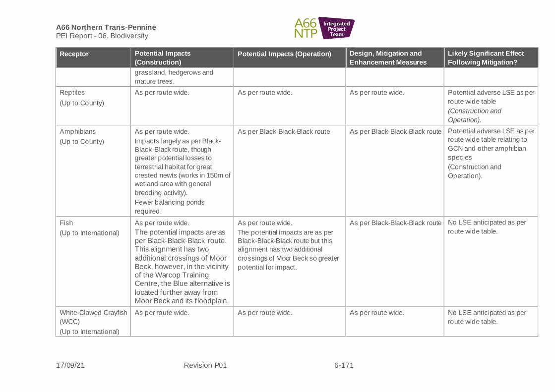
A66 Northern Trans-Pennine PEI Report - 06. Biodiversity
17/09/21 Revision P01 6-171
IntegratedProjectTeam
Receptor Potential Impacts
(Construction)
Potential Impacts (Operation) Design, Mitigation and
Enhancement Measures
Likely Significant Effect
Following Mitigation?
grassland, hedgerows and
mature trees.
Reptiles
(Up to County)
As per route wide.
As per route wide.
As per route wide.
Potential adverse LSE as per
route wide table
(Construction and
Operation).
Amphibians
(Up to County)
As per route wide.
Impacts largely as per Black-
Black-Black route, though
greater potential losses to
terrestrial habitat for great
crested newts (works in 150m of
wetland area with general
breeding activity).
Fewer balancing ponds
required.
As per Black-Black-Black route As per Black-Black-Black route
Potential adverse LSE as per
route wide table relating to
GCN and other amphibian
species
(Construction and
Operation).
Fish
(Up to International)
As per route wide.
The potential impacts are as per Black-Black-Black route. This alignment has two
additional crossings of Moor Beck, however, in the vicinity of the Warcop Training Centre, the Blue alternative is
located further away from Moor Beck and its floodplain.
As per route wide.
The potential impacts are as per
Black-Black-Black route but this
alignment has two additional
crossings of Moor Beck so greater
potential for impact.
As per Black-Black-Black route No LSE anticipated as per
route wide table.
White-Clawed Crayfish
(WCC)
(Up to International)
As per route wide.
As per route wide.
As per route wide.
No LSE anticipated as per
route wide table.

A66 Northern Trans-Pennine PEI Report - 06. Biodiversity
17/09/21 Revision P01 6-172
IntegratedProjectTeam
Receptor Potential Impacts
(Construction)
Potential Impacts (Operation) Design, Mitigation and
Enhancement Measures
Likely Significant Effect
Following Mitigation?
Terrestrial
invertebrates
(Up to National)
As per route wide.
As per route wide.
As per route wide.
Potential adverse LSE
anticipated as per route wide
table (Construction and
Operation).
Aquatic invertebrates
(Up to National)
As per route wide.
As per route wide.
As per route wide.
No LSE anticipated as per
route wide table
(Construction and
Operation).
Macrophytes
(up to International)
As per route wide.
As per route wide.
As per route wide.
Potential adverse LSE
anticipated as per route wide
table
(Construction and
Operation).
Orange alternative (eastern section)
6.9.13 The following biodiversity receptors have been scoped out of the assessment for this scheme:
• Pine marten
• Hazel dormouse
Table 6-14 Appleby to Brough Orange alternative - likely significant effects
Receptor Potential Impacts (Construction) Potential Impacts (Operation)
Design, Mitigation and Enhancement Measures
Likely Significant Effect Following Mitigation?
River Eden SAC and River
Eden and Tributaries SSSI
(International)
Helbeck and Swindale
Woods SAC and Helbeck
Wood SSSI and Swindale
Wood SSSI
As per Black-Black-Black route
This alignment crosses the same
watercourses as the Black-Black-
Black alternative with an additional
new crossing of Lowgill Beck and
Unnamed Tributary of Lowgill Beck
6.7.
As per Black-Black-Black
route, however this
alternative has increased
habitat degradation
(shading) associated with
these crossings as it is
fully offline.
As per Black-Black-Black route All designated sites have the
same LSE conclusions as for
Black-Black-Black route.

A66 Northern Trans-Pennine PEI Report - 06. Biodiversity
17/09/21 Revision P01 6-173
IntegratedProjectTeam
Receptor Potential Impacts (Construction) Potential Impacts (Operation)
Design, Mitigation and Enhancement Measures
Likely Significant Effect Following Mitigation?
Moor House Upper
Teesdale SAC and SSSI
North Pennine Moors SPA
Helbeck and Swindale
Woods SAC
Appleby Fells SSSI
George Gill
(Up to International)
This alternative has increased
habitat degradation (shading)
associated with these crossings as it
is fully offline. The Orange
alternative crosses a more natural
section of river with a wide riparian
corridor that is well-connected to the
low-lying floodplain therefore greater
potential for construction phase
impacts through habitat loss,
pollution and disturbance.
Non-statutory designated
sites
Sandford Mire CWS
(County)
As per Black-Black-Black route but with a smaller area of impacts
immediately adjacent for a balancing pond.
As per Black-Black-Black route
As per Black-Black-Black route
As per Black-Black-Black route
All designated sites have the
same LSE conclusions as for
Black-Black-Black route.
Swindale Woodland CWS
(County)
Tricklebanks Wood CWS
(County)
As per Black-Black-Black route
Helbeck Wood site of
invertebrate significance
Swindale Wood site of
invertebrate significance
Great Musgrave Swindale
Beck Ers
(County)
As per Black-Black-Black route
Habitats –
Yosgill Wood AW (Hellbeck
Wood SSSI)
As per Black-Black-Black route
Moderate losses to improved
grassland and arable with lower
losses to hardstanding, coniferous
As per Black-Black-Black
route
As per Black-Black-Black route Potential adverse LSE
anticipated as per route wide
table due to loss of Priority

A66 Northern Trans-Pennine PEI Report - 06. Biodiversity
17/09/21 Revision P01 6-174
IntegratedProjectTeam
Receptor Potential Impacts (Construction) Potential Impacts (Operation)
Design, Mitigation and Enhancement Measures
Likely Significant Effect Following Mitigation?
Swindale Wood AW
(Swindale Wood SSSI)
Howgill Wood AW
Cotbers Wood AW
Trickle Banks Wood AW
Deciduous woodland
Rivers
Hedgerow
Ponds
Lowland fen
Lowland heathland
Acid grassland
Mire
Open mosaic habitats
(Up to National)
plantation, semi-improved grassland
and marshy grassland, minor losses
also to a number of habitats
including buildings, mixed and
broad-leaved plantation, broad-
leaved woodlands, lichen/ bryophyte
heath, tall ruderal, dense scrub, spoil
heaps, bare ground, mixed
woodland, scattered trees and
eutrophic standing open water.
Impact on Priority Habitats is as per
Black-Black-Black route, though with
greater shading impacts to Lowgill
Beck.
Habitats (Construction) and
air quality (Operation).
Rivers/streams
(International)
As per River Eden and Tributaries
SSSI and SAC entry above
As per Black-Black-Black
route
As per Black-Black-Black route
Potential adverse LSE
anticipated as per route wide
and River Eden SAC
(Construction and Operation).
Bats (Roosts)
(Regional)
As per route wide.
One structure will require demolition
as a result of the scheme. All five
trees with moderate to high potential
to support roosting bats will require
clearance.
As per route wide.
As per route wide Potential adverse LSE as per
route wide table subject to
ongoing surveys
(Construction and Operation).
Bat Activity (Foraging and
Commuting)
(National)
As per route wide
Fourteen potential crossing points
will be af fected by construction.
As per route wide
Fourteen potential
crossing points will be
af fected by the scheme.
As per route wide Potential adverse LSE as per
route wide table subject to
ongoing surveys and possible
f ragmentation impacts

A66 Northern Trans-Pennine PEI Report - 06. Biodiversity
17/09/21 Revision P01 6-175
IntegratedProjectTeam
Receptor Potential Impacts (Construction) Potential Impacts (Operation)
Design, Mitigation and Enhancement Measures
Likely Significant Effect Following Mitigation?
Temporary loss of foraging resource
during construction.
Temporary loss of
foraging resource until
habitat planting scheme
completed and matures.
(Construction and Operation).
Red Squirrel
(Up to National)
As per Black-Black-Black route.
Another smaller area of suitable
woodland is also directly impacted
and permanently lost to the south of
the existing A66 carriageway in the
eastern extents of the alignment.
As per Black-Black-Black
route.
As per Black-Black-Black
route.
Potential adverse LSE as per
route wide table due to
habitat loss and possible
f ragmentation impacts
(Construction and Operation).
Otter
(Up to International)
As per Black-Black-Black route.
Of note, this scheme creates a new
crossing point over Lowgill Beck that
is currently undisturbed and is highly
suitable otter habitat.
As per Black-Black-Black
route.
As per route wide
No LSE are anticipated as
per route wide table.
Water vole
(Up to County)
As per Black-Black-Black route,
however with additional crossing of
unnamed tributaries of Lowgill Beck
and the crossing of Lowgill Beck is
at a currently undisturbed location.
As per Black-Black-Black
route.
As per route wide
No LSE are anticipated as
per route wide table.
Badger
(Local)
As per Black-Black-Black route
Greater potential for habitat
f ragmentation around the offline
section of route located at the far
eastern extents of the scheme
where the route alignment is located
south of the existing A66
carriageway.
As per Black-Black-Black
route, with greater
potential for
f ragmentation associated
with Orange offline
alternative.
As per route wide No LSE are anticipated as
per route wide table.

A66 Northern Trans-Pennine PEI Report - 06. Biodiversity
17/09/21 Revision P01 6-176
IntegratedProjectTeam
Receptor Potential Impacts (Construction) Potential Impacts (Operation)
Design, Mitigation and Enhancement Measures
Likely Significant Effect Following Mitigation?
Although locations of badger setts
are currently unknown for this route
alternative, construction may result
in permanent and/or temporary
closure of existing badger setts if
found to be present within or
immediately next to the construction
areas.
Other Mammal Species
Polecat
Brown hare
Deer
Hedgehog
(Up to County)
As per Black-Black-Black route. As per Black-Black-Black
route.
In addition, the small
section of offline route at
the far eastern extents of
the scheme is located on
previously undisturbed
suitable habitats
(predominantly open
arable f ields) will become
permanently fragmented.
As per route wide Potential adverse LSE as per
route wide table due to
habitat loss and
f ragmentation impacts
(Construction and Operation).
Wintering Birds
(Up to International)
As per Black-Black-Black route.
Whilst no SPA qualifying species
were recorded during the winter bird
surveys in close proximity to the
Orange alternative for this scheme,
the areas of farmland the alternative
passes through have the potential to
support wintering golden plover and
f locks were identified elsewhere
across the scheme.
As per Black-Black-Black
route.
As per route wide Potential adverse LSE as per
route wide table (Operation).
Breeding Birds
(Up to International)
As per Black-Black-Black route.
Whilst no SPA qualifying species
As per Black-Black-Black
route.
As per route wide Potential adverse LSE as per
route wide table (Operation).

A66 Northern Trans-Pennine PEI Report - 06. Biodiversity
17/09/21 Revision P01 6-177
IntegratedProjectTeam
Receptor Potential Impacts (Construction) Potential Impacts (Operation)
Design, Mitigation and Enhancement Measures
Likely Significant Effect Following Mitigation?
were recorded during the breeding
bird surveys in close proximity to the
Orange alternative for this scheme,
the areas of open grassland the
alternative passes through have the
potential to support ground nesting
birds such as golden plover, indeed
12 oystercatchers were found to be
associated with this alternative.
Barn Owl
(Regional)
As per route wide.
Habitat loss for barn owls for this
scheme includes agricultural
buildings, woodland, tussocky
grassland, hedgerows and mature
trees.
As per route wide.
As per route wide.
Potential adverse LSE as per
route wide table
(Construction and Operation)
Reptiles
(Up to County)
As per route wide.
As per route wide.
As per route wide.
Potential adverse LSE as per
route wide table
(Construction and Operation)
Amphibians
(Up to County)
As per Black-Black-Black route, but
provision of new balancing pond to
the east of the scheme is within less
suitable habitat for amphibians and
appears less well connected to
surrounding habitat.
As per route wide.
As per route wide.
Potential adverse LSE as per
route wide table relating to
amphibian species including
GCN.
(Construction and Operation)
Fish
(Up to International)
As per Black-Black-Black route.
However, there is additional habitat
degradation (shading) as a result of
the of fline crossings of Low Gill Beck
and Unnamed Tributary of Lowgill
Beck 6.7.
As per Black-Black-Black
route.
In the absence
appropriate crossing
design, the offline
crossing of Low Gill Beck
As per route wide.
No LSE anticipated as per
route wide table.

A66 Northern Trans-Pennine PEI Report - 06. Biodiversity
17/09/21 Revision P01 6-178
IntegratedProjectTeam
Receptor Potential Impacts (Construction) Potential Impacts (Operation)
Design, Mitigation and Enhancement Measures
Likely Significant Effect Following Mitigation?
could adversely affect
f ish passage and fluvial
geomorphological
processes.
White-Clawed Crayfish
(WCC)
(Up to International)
As per route wide.
As per route wide.
As per route wide.
No LSE anticipated as per
route wide table.
Terrestrial invertebrates
(Up to National)
As per route wide.
As per route wide.
As per route wide.
Potential adverse LSE
anticipated as per route wide
table (Construction and
Operation).
Aquatic invertebrates
(Up to National)
As per route wide.
As per Black-Black-Black route.
As per route wide.
As per Black-Black-Black
route.
As per route wide.
As per Black-Black-Black
route.
No LSE anticipated as per
route wide table
(Construction and Operation).
Macrophytes
(up to International)
As per route wide.
As per Black-Black-Black route.
As per route wide.
As per Black-Black-Black
route.
As per route wide.
As per Black-Black-Black
route.
Potential adverse LSE
anticipated as per route wide
table (Construction and
Operation).
Bowes Bypass
6.9.14 The following biodiversity receptors have been scoped out of the assessment for this scheme:
• Pine marten • Hazel dormouse
• Red Squirrel: Red squirrel has been scoped out due to the absence of historical biological records within 2km, the lack of suitable habitat being present within the survey area. Furthermore, no evidence has been collected during initial terrestrial mammal surveys to indicate their presence (paragraph 6.6.137). Consequently, red squirrel has been scoped out of the assessment for this scheme.

A66 Northern Trans-Pennine PEI Report - 06. Biodiversity
17/09/21 Revision P01 6-179
IntegratedProjectTeam
Table 6-15: Bowes Bypass - likely significant effects
Receptor Potential Impacts (Construction) Potential Impacts (Operation)
Design, Mitigation and Enhancement Measures
Likely Significant Effect Following Mitigation?
Designated Sites
North Pennine Moors SAC
(International)
As per route wide.
There are no direct impacts anticipated
on this site, although a proposed
mitigation area for reptiles is at 35m,
this includes provision of habitats
consistent with the SAC designation
that would also support reptile species.
There are the potential indirect air
pollution impacts (noxious/ deposition)
and the presence of sensitive habitats
and further sensitive species (plants,
lower plants and lichens) as receptors
within this site.
These potential impacts may affect the
integrity of the resource on a
permanent/irreversible basis in the
absence of mitigation, which may be
assessed as a major adverse impact.
As per route wide.
The current stage of air
quality modelling has
identified a 1% increase
in nitrogen for where this
site is within 200m of the
ARN, potential for
detrimental impacts upon
sensitive sites, habitats
and species within this
site.
These potential impacts
may af fect the integrity of
the resource on a
permanent/irreversible
basis in the absence of
mitigation, which may be
assessed as a major
adverse impact.
As per route wide
Further air quality
assessment and
biodiversity assessment
(mapping of sensitive
habitats within 200m of the
road) is required to
ascertain nitrogen
deposition (kg per Ha) and
further potential for LSE.
Precautionary mitigation
provision may need to
include creation of
additional habitat over
200m from the ARN.
Due to the uncertainty of
air quality impacts and
mitigation, the potential
impact level cannot be
reduced after mitigation so
potential for major adverse
impacts remains.
Potential for major adverse
impacts on a resource of
International importance,
which is a Very Large
ef fect and therefore
significant. Potential
adverse LSE anticipated
relating to air quality
(Construction and
Operation).
North Pennine Moors SPA
(which includes North
Pennine Moors SAC and
Moor House-Upper
Teesdale SAC, Moor
House and Cross fell SSSI,
Upper Teesdale SSSI and
Appleby Fells SSSI) and
As per route wide.
The North Pennine Moors SPA is
located outside the Draft DCO
Boundary directly north at the western
extent of this Scheme so there is
potential for disturbance impacts on
qualifying features (merlin, peregrine,
hen harrier and golden plover).
As per route wide birds.
The current stage of air
quality modelling has
identified a 1% increase
in nitrogen for where this
site is within 200m of the
ARN, potential for
detrimental impacts upon
As per route wide for birds.
Once mitigation is taken
into account to reduce
disturbance of birds on
functionally linked land and
replace habitat, this impact
is expected to be reduced
to minor adverse.
Potential for major adverse
impacts on a resource of
International importance,
which is a Very Large
ef fect and therefore
significant. Potential
adverse LSE anticipated
relating to air quality

A66 Northern Trans-Pennine PEI Report - 06. Biodiversity
17/09/21 Revision P01 6-180
IntegratedProjectTeam
Receptor Potential Impacts (Construction) Potential Impacts (Operation)
Design, Mitigation and Enhancement Measures
Likely Significant Effect Following Mitigation?
adjacent to Helbeck and
Swindale Woods SAC.)
(International)
Potential degradation through air quality
on the sensitive habitats which the
qualifying bird species require to
sustain their populations.
These potential impacts may affect the
integrity of the resource on a
permanent/irreversible basis in the
absence of mitigation, which may be
assessed as a major adverse impact.
sensitive sites, habitats
and species within this
site, (loss of or damage to
plant species) which
indirectly may affect bird
species, as the qualifying
features, through
changes to prey
availability or to foraging,
resting or nesting
habitats.
These potential impacts
may af fect the integrity of
the resource on a
permanent/irreversible
basis in the absence of
mitigation, which may be
assessed as a major
adverse impact.
Further air quality
assessment and
biodiversity assessment
(mapping of sensitive
habitats within 200m of the
road) is required to
ascertain nitrogen
deposition (kg per Ha) and
further potential for LSE.
Precautionary mitigation
provision may need to
include creation of
additional habitat over
200m from the ARN.
Potential air quality
impacts which may cause
degradation of habitat
within the SPA remains a
major adverse impact until
air quality data and
mitigation design can
conf irm otherwise.
(Construction and
Operation).
See birds section for LSE
relating to birds.
Bowes Moor SSSI
(National)
As per route wide birds and habitats.
Site designated for its moorland (and
other) bird species potential for
disturbance impacts on the bird
assemblage associated with the site.
The site also supports upland habitats
of heathland, moorland and blanket
bog.
As per route wide birds.
The current stage of air
quality modelling has
identified a 1% increase
in nitrogen for where this
site is within 200m of the
ARN, potential for
detrimental impacts upon
As per route wide birds
and habitats.
Once mitigation is taken
into account to reduce
disturbance of birds on
functionally linked land and
replace habitat, this impact
Potential for major adverse
impacts on a resource of
National importance, which
is a Large or Very Large
ef fect and therefore
significant. Potential
adverse LSE anticipated
relating to air quality
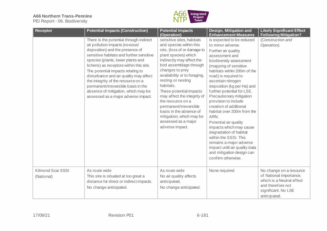
A66 Northern Trans-Pennine PEI Report - 06. Biodiversity
17/09/21 Revision P01 6-181
IntegratedProjectTeam
Receptor Potential Impacts (Construction) Potential Impacts (Operation)
Design, Mitigation and Enhancement Measures
Likely Significant Effect Following Mitigation?
There is the potential through indirect
air pollution impacts (noxious/
deposition) and the presence of
sensitive habitats and further sensitive
species (plants, lower plants and
lichens) as receptors within this site.
The potential impacts relating to
disturbance and air quality may affect
the integrity of the resource on a
permanent/irreversible basis in the
absence of mitigation, which may be
assessed as a major adverse impact.
sensitive sites, habitats
and species within this
site, (loss of or damage to
plant species) which
indirectly may affect the
bird assemblage through
changes to prey
availability or to foraging,
resting or nesting
habitats.
These potential impacts
may af fect the integrity of
the resource on a
permanent/irreversible
basis in the absence of
mitigation, which may be
assessed as a major
adverse impact.
is expected to be reduced
to minor adverse.
Further air quality
assessment and
biodiversity assessment
(mapping of sensitive
habitats within 200m of the
road) is required to
ascertain nitrogen
deposition (kg per Ha) and
further potential for LSE.
Precautionary mitigation
provision to include
creation of additional
habitat over 200m from the
ARN.
Potential air quality
impacts which may cause
degradation of habitat
within the SSSI. This
remains a major adverse
impact until air quality data
and mitigation design can
conf irm otherwise.
(Construction and
Operation).
Kilmond Scar SSSI
(National)
As route wide
This site is situated at too great a
distance for direct or indirect impacts.
No change anticipated.
As route wide
No air quality affects
anticipated.
No change anticipated.
None required No change on a resource
of National importance,
which is a Neutral ef fect
and therefore not
significant. No LSE
anticipated.

A66 Northern Trans-Pennine PEI Report - 06. Biodiversity
17/09/21 Revision P01 6-182
IntegratedProjectTeam
Receptor Potential Impacts (Construction) Potential Impacts (Operation)
Design, Mitigation and Enhancement Measures
Likely Significant Effect Following Mitigation?
Non-Statutory Designated
Sites
There are no non-statutory sites within
1km.
N/A N/A N/A
Habitats-
Deepdale Wood AW
Deciduous woodland
Hedgerows
Upland heathland
Blanket bog
Upland hay meadows
Lowland calcareous
grassland
Purple moor-grass and
rush pasture
Ponds
(Up to National)
As per route wide
Majority of losses to improved
grassland, hardstanding, with lower
losses to poor semi-improved
grassland, broad-leaved plantation,
buildings, arable, tall ruderal, dense
scrub, bare ground, mixed plantation,
running water, semi-improved neutral
grassland and amenity grassland.
Losses to linear habitats are mainly to
fence, wall and arable habitat with
moderate losses to species-poor
defunct hedge and hedge and trees,
species-poor intact hedge, dry ditch,
species-rich hedge and trees, bare
ground, species-rich intact hedge, tree
lines, running open water and standing
open water.
There are no AW within 2km.
Within the habitats listed above are the
following Priority Habitats which may be
subject to impacts of loss, degradation,
shading or pollution (noxious or
deposition) these include: deciduous
woodland and hedgerows (loss, ground
compaction and pollution). Upland
heathland, blanket bog, upland hay
meadows, lowland calcareous
grassland, purple moor-grass and rush
As route wide.
The current stage of air
quality modelling has
identified a 1% increase
in nitrogen for Deepdale
AW where this site is
within 200m of the ARN,
potential for detrimental
impacts upon sensitive
sites, habitats and
species within this site.
As per route wide.
Pre-construction checks
for locations of notable
plant species such as
orchids and advice for
avoidance and/or
translocation where
required/feasible.
Further air quality
assessment and
biodiversity assessment
(mapping of sensitive
habitats within 200m of the
road) for Deepdale AW is
required to ascertain
nitrogen deposition (kg per
Ha) and further potential
for LSE.
Precautionary mitigation
provision to include
creation of additional
habitat over 200m from the
ARN where
required/feasible.
Potential adverse LSE
anticipated as per route
wide table due to loss of
Priority Habitats
(Construction and
Operation).
Potential adverse LSE
anticipated for Deepdale
Wood AW as a result of air
quality impacts upon
sensitive habitats and
species (Operation).

A66 Northern Trans-Pennine PEI Report - 06. Biodiversity
17/09/21 Revision P01 6-183
IntegratedProjectTeam
Receptor Potential Impacts (Construction) Potential Impacts (Operation)
Design, Mitigation and Enhancement Measures
Likely Significant Effect Following Mitigation?
pasture (all potential for pollution
through air deposition/ noxious), rivers
(pollution),
ponds (air pollution).
The protected and or otherwise notable
plant species recorded are for a 1km
areas and therefore may be present
within the works areas and subject to
negative impacts of loss or damage or
pollution impacts. Exact locations are
unknown for common heather, early
purple orchid (Orchis mascula), good-
King-Henry (Blitum bonus henricus),
tormentil, marsh ragwort (Jacobaea
aquaticus), Welsh poppy (Meconopsis
cambrica), harebell, and the endemic
species perennial flax (Linum perenne
ssp. anglicum).
Rivers/streams
(Local)
As per route wide.
Only Unnamed Tributary of River Greta
7.3 is crossed, however the alignment
falls entirely within a section of the
watercourse that is already culverted
for approximately 600m.
Therefore, no aquatic habitat will be
af fected by the alignment, and potential
impacts are limited to those associated
with construction-related pollution.
As per route wide.
The existing culvert is
significant in length and is
considered likely to be a
barrier to migration for
aquatic species.
As per route wide.
The next design review will
examine whether
replacement culverts can
be built or adaptations
made to facilitate the
movement of fish should
they be recorded during
surveys. This is yet to be
conf irmed so is not
reported as a beneficial
ef fect.
As per route wide table
however rivers/streams on
this scheme are of Local
value. Minor adverse
impacts on a Local value
resource may be assessed
as Neutral or Slight
therefore not significant. No
LSE are anticipated.

A66 Northern Trans-Pennine PEI Report - 06. Biodiversity
17/09/21 Revision P01 6-184
IntegratedProjectTeam
Receptor Potential Impacts (Construction) Potential Impacts (Operation)
Design, Mitigation and Enhancement Measures
Likely Significant Effect Following Mitigation?
Bats (Roosts)
(Regional)
As per route wide.
Seven structures with bat roost
potential are scheduled for demolition
and all eight trees with moderate to
high potential to support roosting bats
will require clearance.
As per route wide.
As per route wide.
Potential adverse LSE as
per route wide table subject
to ongoing surveys
(Construction and
Operation).
Bat Activity (Foraging and
Commuting)
(National)
As per route wide.
Four potential crossing points will be
af fected by construction.
Temporary loss of foraging resource
during construction.
As per route wide.
Four potential crossing
points will be affected by
the scheme.
Temporary loss of
foraging resource until
habitat replanting scheme
completed and matures
As per route wide.
Potential adverse LSE as
per route wide table subject
to ongoing surveys and
possible fragmentation
impacts (Construction and
Operation).
Otter
(Up to County)
As per route wide.
There are no above ground
watercourse crossing points associated
with this scheme and therefore no
temporary or permanent habitat loss.
Disturbance impacts associated with
construction activities within 250m of
the River Greta could impact otter
commuting and foraging. No holt
features were identified within 250m of
the scheme.
As per route wide.
Permanent increased
noise, light, vibration and
surface water runoff
containing pollutants
within 250m of the River
Greta may reduce otter
commuting and foraging
As per route wide. No LSE are anticipated as
per route wide table.
Water Vole
(Up to County)
As per route wide.
Disturbance impacts associated with
construction activities within 100m of
the unnamed tributary of River Greta
could impact foraging water vole and
As per route wide.
The operational phase
could cause an increase
in vehicle deposits and
surface run off of
As per route wide
No LSE are anticipated as
per route wide table.
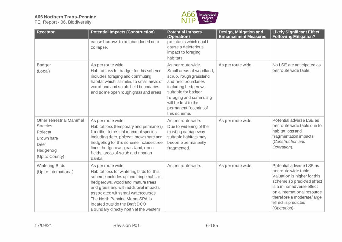
A66 Northern Trans-Pennine PEI Report - 06. Biodiversity
17/09/21 Revision P01 6-185
IntegratedProjectTeam
Receptor Potential Impacts (Construction) Potential Impacts (Operation)
Design, Mitigation and Enhancement Measures
Likely Significant Effect Following Mitigation?
cause burrows to be abandoned or to
collapse.
pollutants which could
cause a deleterious
impact to foraging
habitats.
Badger
(Local)
As per route wide.
Habitat loss for badger for this scheme
includes foraging and commuting
habitat which is limited to small areas of
woodland and scrub, field boundaries
and some open rough grassland areas.
As per route wide.
Small areas of woodland,
scrub, rough grassland
and f ield boundaries
including hedgerows
suitable for badger
foraging and commuting
will be lost to the
permanent footprint of
this scheme.
As per route wide. No LSE are anticipated as
per route wide table.
Other Terrestrial Mammal
Species
Polecat
Brown hare
Deer
Hedgehog
(Up to County)
As per route wide.
Habitat loss (temporary and permanent)
for other terrestrial mammal species
including deer, polecat, brown hare and
hedgehog for this scheme includes tree
lines, hedgerows, grassland, open
f ields, areas of scrub and riparian
banks.
As per route wide.
Due to widening of the
existing carriageway
suitable habitats may
become permanently
f ragmented.
As per route wide. Potential adverse LSE as
per route wide table due to
habitat loss and
f ragmentation impacts
(Construction and
Operation).
Wintering Birds
(Up to International)
As per route wide.
Habitat loss for wintering birds for this
scheme includes upland fringe habitats,
hedgerows, woodland, mature trees
and grassland with additional impacts
associated with small watercourses.
The North Pennine Moors SPA is
located outside the Draft DCO
Boundary directly north at the western
As per route wide.
As per route wide. Potential adverse LSE as
per route wide table.
Valuation is higher for this
scheme so predicted effect
is a minor adverse effect
on a International resource
therefore a moderate/large
ef fect is predicted
(Operation).

A66 Northern Trans-Pennine PEI Report - 06. Biodiversity
17/09/21 Revision P01 6-186
IntegratedProjectTeam
Receptor Potential Impacts (Construction) Potential Impacts (Operation)
Design, Mitigation and Enhancement Measures
Likely Significant Effect Following Mitigation?
extent of this Scheme so there is
potential for disturbance impacts on
qualifying features (merlin, peregrine,
hen harrier and golden plover). During
the January wintering bird surveys, the
following SPA qualifying species were
recorded: 15 golden plovers and one
merlin.
Breeding Birds
(Up to International)
As per route wide.
Habitat loss for wintering birds for this
scheme includes upland fringe habitats,
hedgerows, woodland, mature trees
and grassland with additional impacts
associated with small watercourses.
The North Pennine Moors SPA is
located outside the Draft DCO
Boundary directly north at the western
extent of this Scheme so there is
potential for disturbance impacts on
qualifying features (merlin, peregrine,
hen harrier and golden plover). During
the January wintering bird surveys, one
golden plover was recorded on the
southern edge of the SPA.
As per route wide. As per route wide. Potential adverse LSE as
per route wide table
(Operation).
Barn Owl
(Regional)
As per route wide.
Habitat loss for barn owls for this
scheme includes agricultural buildings,
woodland, tussocky grassland,
hedgerows and mature trees.
As per route wide.
As per route wide
Potential adverse LSE as
per route wide table
(Construction and
Operation).
Reptiles
(Up to County)
As per route wide. As per route wide. As per route wide. Potential adverse LSE as
per route wide table

A66 Northern Trans-Pennine PEI Report - 06. Biodiversity
17/09/21 Revision P01 6-187
IntegratedProjectTeam
Receptor Potential Impacts (Construction) Potential Impacts (Operation)
Design, Mitigation and Enhancement Measures
Likely Significant Effect Following Mitigation?
Historic records for common lizard and
adder within connective habitats for this
scheme mean that currently losses to
terrestrial habitat may result in loss of
reptile populations and/or fragmentation
impacts as a result of islanded areas
surrounded by road infrastructure.
Potential for permanent
severance of migratory
routes for adder and
f ragmentation (isolation)
of populations within
islanded areas of road
inf rastructure.
(Construction and
Operation).
Amphibians
(Up to County)
As per route wide. Great crested newt present from historic records, survey results pending. Connected to the A66 road verge via suitable terrestrial habitats provided by the quarry periphery and hedgerows or stone walls and/or by the disused rail corridor.
Disturbance to terrestrial habitats.
As per route wide.
Benef icial effects
anticipated due to
changes in the largely
agricultural habitats for
amphibians and for a new
balancing pond which
may be colonised by
amphibians.
As per route wide. Potential adverse LSE as
per route wide table
relating to amphibian
species including GCN
(Construction and
Operation).
Fish
(Up to Local)
As per route wide.
Unnamed Tributary of River Greta 7.3
may not support fish due its modified
state and natural barriers identified
immediately upstream of the River
Greta. This will be confirmed following
f ish surveys and eDNA sampling.
Only Unnamed Tributary of River Greta
7.3 is crossed, however the alignment
falls entirely within a section of the
watercourse that is already culverted
for 600m.
Therefore, potential impacts to fish are
limited to those associated with
construction-related pollution.
As per route wide.
The existing culvert is
significant in length and is
considered likely to be a
barrier to migration for
aquatic species.
As per route wide.
Replacement culverts will
be built to facilitate the
movement of fish should
they be recorded during
surveys. However,
No LSE anticipated as per
route wide table although
valuation if lower, so there
are potential for negligible
adverse impacts on a
resource of Local
importance which is a
Neutral ef fect and therefore
not significant. No LSE
anticipated.
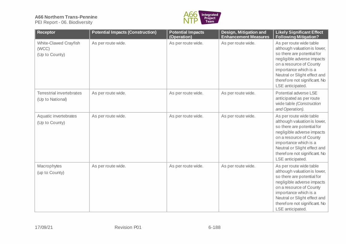
A66 Northern Trans-Pennine PEI Report - 06. Biodiversity
17/09/21 Revision P01 6-188
IntegratedProjectTeam
Receptor Potential Impacts (Construction) Potential Impacts (Operation)
Design, Mitigation and Enhancement Measures
Likely Significant Effect Following Mitigation?
White-Clawed Crayfish
(WCC)
(Up to County)
As per route wide. As per route wide. As per route wide. As per route wide table
although valuation is lower,
so there are potential for
negligible adverse impacts
on a resource of County
importance which is a
Neutral or Slight effect and
therefore not significant. No
LSE anticipated.
Terrestrial invertebrates
(Up to National)
As per route wide. As per route wide. As per route wide. Potential adverse LSE
anticipated as per route
wide table (Construction
and Operation).
Aquatic invertebrates
(Up to County)
As per route wide. As per route wide. As per route wide. As per route wide table
although valuation is lower,
so there are potential for
negligible adverse impacts
on a resource of County
importance which is a
Neutral or Slight effect and
therefore not significant. No
LSE anticipated.
Macrophytes
(up to County)
As per route wide. As per route wide. As per route wide. As per route wide table
although valuation is lower,
so there are potential for
negligible adverse impacts
on a resource of County
importance which is a
Neutral or Slight effect and
therefore not significant. No
LSE anticipated.

A66 Northern Trans-Pennine PEI Report - 06. Biodiversity
17/09/21 Revision P01 6-189
IntegratedProjectTeam
Cross Lanes to Rokeby
Black Route
6.9.15 The following biodiversity receptors have been scoped out of the assessment for this scheme:
• Pine marten
• Hazel dormouse
Table 6-16: Cross Lanes to Rokeby Black route - likely significant effects (Biodiversity)
Receptor Potential Impacts (Construction) Potential Impacts (Operation)
Design, Mitigation and Enhancement Measures
Likely Significant Effect Following Mitigation?
Kilmond Scar SSSI
(National)
This site is situated at too great a
distance for direct impacts.
No change anticipated.
No change anticipated.
None required. No change on a resource of
National importance, which
is a Neutral ef fect and
therefore not significant. No
LSE anticipated.
Brignall Banks SSSI
(National)
This site is situated at too great a
distance for direct impacts.
No change anticipated.
No change anticipated.
None required. No change on a resource of
National importance, which
is a Neutral ef fect and
therefore not significant. No
LSE anticipated.
Non-Statutory
Designated sites
Thorsgill Wood LWS
(National)
As per route wide.
This site is situated at too great a
distance for direct impacts.
There is the potential through indirect
air pollution impacts
(noxious/deposition) and the presence
of sensitive habitats and further
sensitive species (plants, lower plants
and lichens) as receptors within this
site.
These potential impacts may affect the
integrity of the resource on a
As per route wide.
The current stage of air quality
modelling has identified a 1%
increase in nitrogen for where
this site is within 200m of the
ARN, potential for detrimental
impacts upon sensitive sites,
habitats and species within this
site.
These potential impacts may
af fect the integrity of the
resource on a
permanent/irreversible basis in
As per route wide.
Further air quality
assessment and
biodiversity assessment is
required to ascertain
nitrogen deposition (kg per
Ha) and further potential for
LSE.
Precautionary mitigation
provision may need to
include creation of
Potential for major adverse
impacts on a resource of
National importance, which
is a Large or Very Large
ef fect and therefore
significant. Potential
adverse LSE anticipated
relating to air quality
(Construction and
Operation).
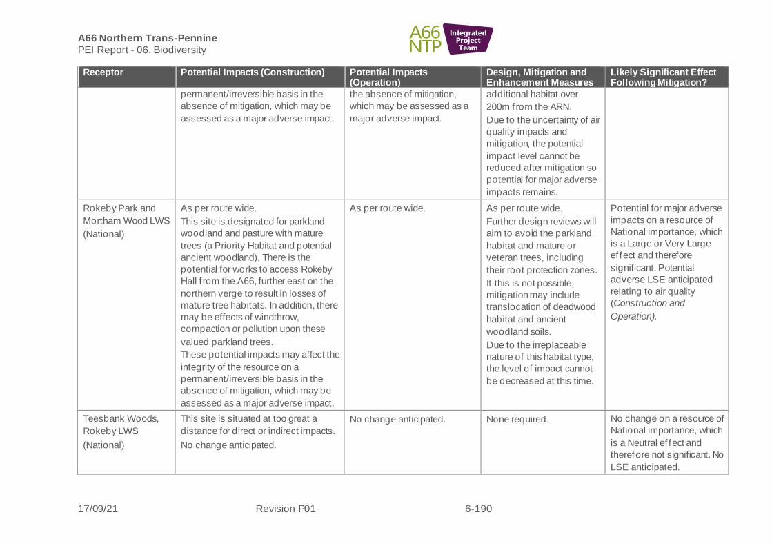
A66 Northern Trans-Pennine PEI Report - 06. Biodiversity
17/09/21 Revision P01 6-190
IntegratedProjectTeam
Receptor Potential Impacts (Construction) Potential Impacts (Operation)
Design, Mitigation and Enhancement Measures
Likely Significant Effect Following Mitigation?
permanent/irreversible basis in the
absence of mitigation, which may be
assessed as a major adverse impact.
the absence of mitigation,
which may be assessed as a
major adverse impact.
additional habitat over
200m from the ARN.
Due to the uncertainty of air
quality impacts and
mitigation, the potential
impact level cannot be
reduced after mitigation so
potential for major adverse
impacts remains.
Rokeby Park and
Mortham Wood LWS
(National)
As per route wide.
This site is designated for parkland
woodland and pasture with mature
trees (a Priority Habitat and potential
ancient woodland). There is the
potential for works to access Rokeby
Hall f rom the A66, further east on the
northern verge to result in losses of
mature tree habitats. In addition, there
may be effects of windthrow,
compaction or pollution upon these
valued parkland trees.
These potential impacts may affect the
integrity of the resource on a
permanent/irreversible basis in the
absence of mitigation, which may be
assessed as a major adverse impact.
As per route wide.
As per route wide.
Further design reviews will
aim to avoid the parkland
habitat and mature or
veteran trees, including
their root protection zones.
If this is not possible,
mitigation may include
translocation of deadwood
habitat and ancient
woodland soils.
Due to the irreplaceable
nature of this habitat type,
the level of impact cannot
be decreased at this time.
Potential for major adverse
impacts on a resource of
National importance, which
is a Large or Very Large
ef fect and therefore
significant. Potential
adverse LSE anticipated
relating to air quality
(Construction and
Operation).
Teesbank Woods,
Rokeby LWS
(National)
This site is situated at too great a
distance for direct or indirect impacts.
No change anticipated.
No change anticipated.
None required. No change on a resource of
National importance, which
is a Neutral ef fect and
therefore not significant. No
LSE anticipated.

A66 Northern Trans-Pennine PEI Report - 06. Biodiversity
17/09/21 Revision P01 6-191
IntegratedProjectTeam
Receptor Potential Impacts (Construction) Potential Impacts (Operation)
Design, Mitigation and Enhancement Measures
Likely Significant Effect Following Mitigation?
Habitats
Church Wood
(potential ancient
woodland),
‘Jack Wood‘ Ancient
Woodland,
Thorsgill Wood
Ancient Woodland,
Waterfall Wood
Ancient Woodland,
Teesbank Plantation
Ancient Woodland,
Mill Wood Ancient
Woodland,
Notable sycamore
trees,
Priority Habitats:
Deciduous
woodland,
Traditional orchard,
Upland hay meadow,
Lowland calcareous
grassland,
Good quality semi-
improved grassland
(Up to National)
As per route wide.
Within this scheme, habitat losses
include primarily arable and improved
grassland, with lower losses to other
habitats including poor semi-improved
grassland, semi-natural broad-leaved
woodland, bare ground, broad-leaved
plantation, mixed semi-natural
woodland, tall ruderal, buildings, semi-
improved neutral grassland, amenity
grassland, standing open water,
scattered trees, other acid natural rock
exposure and coniferous plantation.
The following Priority Habitats are
negatively affected: losses and
damage to two areas of deciduous
woodland to the west of the alternative
and f ive to the east (of which Church
Plantation is suspected ancient
woodland habitat).
For linear habitats there are large
losses to species-poor defunct hedge,
species-rich intact hedge, species-poor
hedge and trees and eutrophic running
open water. Moderate losses are to dry
ditch, species-rich hedge and trees,
species-poor intact hedge, bare
ground and tree lines and running
open water. Smaller losses are to wall,
species-rich defunct hedge and
scattered scrub.
As per route wide.
Persistent fragmentation
impacts for species within
islands.
The current stage of air quality
modelling has identified a 1%
increase in nitrogen for where
Grahams Hill/Jack Wood
Ancient Woodland, Thorsgill
Wood Ancient Woodland and
Waterfall Wood Ancient
Woodland site are within 200m
of the ARN, potential for
detrimental impacts upon
sensitive sites, habitats and
species within this site.
As per route wide.
Further design review to
limit impacts upon ancient
woodland and mature
trees.
Seed harvesting or
translocation of any
protected or notable plant
species within ‘islands’.
Precautionary mitigation
provision may need to
include creation of
additional habitat over
200m from the ARN.
Potential adverse LSE
anticipated as per route
wide table due to loss of
Priority Habitats, and
possible Ancient Woodland
along with air quality
impacts (Construction and
Operation).
Potential adverse LSE
anticipated for Thorsgill
Wood and Waterfall Wood
AW as a result of air quality
impacts upon sensitive
habitats and species
(Operation).

A66 Northern Trans-Pennine PEI Report - 06. Biodiversity
17/09/21 Revision P01 6-192
IntegratedProjectTeam
Receptor Potential Impacts (Construction) Potential Impacts (Operation)
Design, Mitigation and Enhancement Measures
Likely Significant Effect Following Mitigation?
This route also has minor severing
habitat losses for water connections for
balancing ponds within ancient
woodland habitat at Jack Wood
Ancient Woodland, and loss of five
mature sycamore trees (notable trees),
removing the ecological potential for
these trees to become ancient or
veteran
Islands are created at two sets of
junctions (both within junctions and
between existing and new alignment),
with losses and severance impacts to
hedgerows and watercourses. Intact
hedgerows with trees are severed to
the west of the alternative and defunct
hedge and trees to the east.
There are potential habitat degradation
impacts from air quality (deposition) at
Grahams Hill/Jack Wood Ancient
Woodland and Waterfall Wood Ancient
Woodland. Thorsgill Wood AW is
448m north and no direct or indirect
impacts are anticipated.
None of the protected or notable
species recorded in the local area are
currently identified as affected by the
scheme, but works are in close
proximity to an area of suspected
treated giant hogweed on Tutta Beck.
Rivers/streams As per route wide. As per route wide. As per route wide. As per route wide table
however rivers/streams on

A66 Northern Trans-Pennine PEI Report - 06. Biodiversity
17/09/21 Revision P01 6-193
IntegratedProjectTeam
Receptor Potential Impacts (Construction) Potential Impacts (Operation)
Design, Mitigation and Enhancement Measures
Likely Significant Effect Following Mitigation?
(Local) Habitat degradation (shading)
associated with new watercourse
crossings.
With the exception of Tutta Beck, the
watercourses crossed by the Black
route are minor and are considered
unlikely to support (surveys pending)
notable and/or protected aquatic
species as habitats are either
unsuitable, ephemeral or disconnected
to the wider catchment as a result of
man-made barriers that restrict the
movement of aquatic species.
The crossing of Tutta Beck has
the potential to adversely
impact fish passage and the
natural (f luvial
geomorphological) river
process which control the
quality and distribution locally.
In the absence of mitigation,
proposed new discharges to
Tutta Beck has the potential to
adversely impact water quality.
The crossing design for
Tutta Beck yet to be
conf irmed and will examine
ways to avoid impacts on
river processes.
The next design review will
also examine whether
replacement culverts can
be built or adaptations
made to facilitate the
movement of fish should
they be recorded during
surveys.
This is yet to be confirmed
so is not reported as a
benef icial effect.
this scheme are of Local
value. Minor adverse
impacts on a Local value
resource may be assessed
as Neutral or Slight
therefore not significant. No
LSE are anticipated.
Bats (Roosts)
(Regional)
As per route wide.
No structures with bat roost potential
will require demolition as a result of the
scheme however all 16 trees with
moderate to high potential to support
roosting bats will require clearance.
As per route wide.
As per route wide.
Potential adverse LSE as
per route wide table subject
to ongoing surveys
(Construction and
Operation).
Bat Activity (Foraging
and Commuting)
(National)
As per route wide.
Seven potential crossing points will be
af fected by construction.
Temporary loss of foraging resource
during construction.
As per route wide.
Seven potential crossing
points will be affected by the
scheme.
Temporary loss of foraging
resource until habitat
replanting scheme completed
and matures.
As per route wide.
Potential adverse LSE as
per route wide table subject
to ongoing surveys and
possible fragmentation
impacts
(Construction and
Operation).

A66 Northern Trans-Pennine PEI Report - 06. Biodiversity
17/09/21 Revision P01 6-194
IntegratedProjectTeam
Receptor Potential Impacts (Construction) Potential Impacts (Operation)
Design, Mitigation and Enhancement Measures
Likely Significant Effect Following Mitigation?
Red Squirrel
(Up to National)
As per route wide.
Temporary and permanent habitat loss
for red squirrel for this scheme
includes woodland edges, tree lines,
hedgerows and partial loss of a pocket
of woodland located at the western
extents of the scheme.
A thick tree line located immediately
adjacent to the south of the existing
A66 carriageway is also to be
permanently lost at the far eastern
extents of the scheme.
As per route wide.
Due to widening of the existing
carriageway areas of
woodland located north and
south of the route which are
suitable for red squirrel may
become permanently
f ragmented.
Temporary loss of foraging
resource until habitat
replanting scheme completed
and matures.
As per route wide.
A potential red squirrel
crossing point feature (rope
bridge) may be necessary
around the east of this
scheme to ensure suitable
woodland habitats remain
connected and a safe
crossing feature can be
used to help reduce the risk
of mortality related to road
traf f ic collisions.
Potential adverse LSE as
per route wide table due to
habitat loss and possible
f ragmentation impacts
(Construction and
Operation).
Otter
(Up to County)
As per route wide.
Direct impacts associated with the
temporary loss of otter habitat at the
new crossing points on Tutta Beck.
Disturbance impacts associated with
construction activity is likely to impact
commuting and foraging otter and may
cause holts to be temporarily
abandoned if present (f ield surveys
have not yet been completed for all
alternatives being considered for this
scheme). Of note, this scheme creates
a new crossing point over Tutta Beck
that is currently undisturbed
As per route wide.
Potential permanent increased
noise, light, vibration and
surface water runoff containing
pollutants may reduce otter
commuting and foraging and
could cause habitat
f ragmentation on Tutta Beck
due to the previously
undisturbed nature of the
watercourse. Disturbance from
traf f ic could cause holts nearby
to be abandoned.
As per route wide. No LSE are anticipated as
per route wide table.
Water Vole
(Up to County)
As per route wide.
Direct impacts associated with the
temporary loss of water vole habitat at
the new crossing points on Tutta Beck
As per route wide.
As per route wide. No LSE are anticipated as
per route wide table.

A66 Northern Trans-Pennine PEI Report - 06. Biodiversity
17/09/21 Revision P01 6-195
IntegratedProjectTeam
Receptor Potential Impacts (Construction) Potential Impacts (Operation)
Design, Mitigation and Enhancement Measures
Likely Significant Effect Following Mitigation?
and an existing crossing point on an
unnamed tributary of Manyfold Beck.
Disturbance impacts associated with
construction activities could impact
foraging water vole and cause burrows
to be abandoned or to collapse if
present - f ield surveys have not yet
been completed for all route
alternatives being considered for this
scheme.
Badger
(Local)
As per route wide.
Habitat loss for badger for this scheme
includes foraging and commuting
habitat which includes areas of
woodland, woodland edge, scrub, field
boundaries and some open rough
grassland areas.
Badger surveys are not complete for
all routes but it is likely setts will be
identified in the area.
As per route wide.
Crossing points may be
identified through further
survey.
As per route wide. No LSE are anticipated as
per route wide table.
Other Terrestrial
Mammal Species
Polecat
Brown hare
Deer
Hedgehog
(Up to County)
As per route wide.
Habitat loss (temporary and
permanent) for other terrestrial
mammal species including deer,
polecat, brown hare and hedgehog for
this scheme includes tree lines,
hedgerows, woodland edges,
grassland, open fields, areas of scrub,
riparian banks and small areas of
woodland.
As per route wide.
Due to the eastern extents of
this alignment being offline,
previously undisturbed suitable
habitats (predominantly open
arable f ields) will become
permanently fragmented in this
area as a result of operation.
Due to widening of the existing
carriageway suitable habitats
may become permanently
As per route wide. Potential adverse LSE as
per route wide table due to
habitat loss and
f ragmentation impacts
(Construction and
Operation).
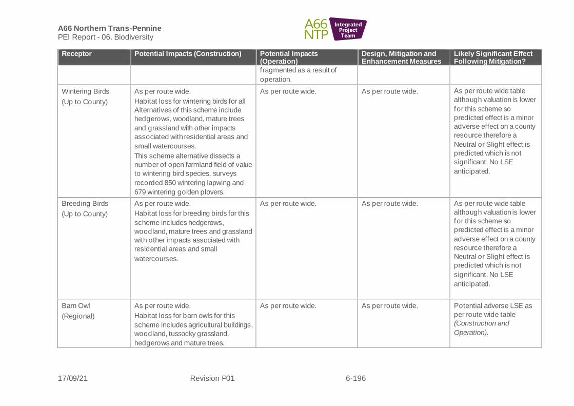
A66 Northern Trans-Pennine PEI Report - 06. Biodiversity
17/09/21 Revision P01 6-196
IntegratedProjectTeam
Receptor Potential Impacts (Construction) Potential Impacts (Operation)
Design, Mitigation and Enhancement Measures
Likely Significant Effect Following Mitigation?
f ragmented as a result of
operation.
Wintering Birds
(Up to County)
As per route wide.
Habitat loss for wintering birds for all
Alternatives of this scheme include
hedgerows, woodland, mature trees
and grassland with other impacts
associated with residential areas and
small watercourses.
This scheme alternative dissects a
number of open farmland field of value
to wintering bird species, surveys
recorded 850 wintering lapwing and
679 wintering golden plovers.
As per route wide.
As per route wide. As per route wide table
although valuation is lower
for this scheme so
predicted effect is a minor
adverse effect on a county
resource therefore a
Neutral or Slight effect is
predicted which is not
significant. No LSE
anticipated.
Breeding Birds
(Up to County)
As per route wide.
Habitat loss for breeding birds for this
scheme includes hedgerows,
woodland, mature trees and grassland
with other impacts associated with
residential areas and small
watercourses.
As per route wide.
As per route wide.
As per route wide table
although valuation is lower
for this scheme so
predicted effect is a minor
adverse effect on a county
resource therefore a
Neutral or Slight effect is
predicted which is not
significant. No LSE
anticipated.
Barn Owl
(Regional)
As per route wide.
Habitat loss for barn owls for this
scheme includes agricultural buildings,
woodland, tussocky grassland,
hedgerows and mature trees.
As per route wide.
As per route wide. Potential adverse LSE as
per route wide table
(Construction and
Operation).

A66 Northern Trans-Pennine PEI Report - 06. Biodiversity
17/09/21 Revision P01 6-197
IntegratedProjectTeam
Receptor Potential Impacts (Construction) Potential Impacts (Operation)
Design, Mitigation and Enhancement Measures
Likely Significant Effect Following Mitigation?
Reptiles
(Up to County)
As per route wide.
Historic records for slow-worm and
adder for this scheme mean that
currently losses to terrestrial habitat
may result in loss of reptile populations
and/or fragmentation impacts as a
result of islanded areas surrounded by
road inf rastructure.
As route wide including:
Potential for permanent
severance of migratory routes
for adder and fragmentation
(isolation) of populations within
islanded areas of road
inf rastructure.
As per route wide. Potential adverse LSE as
per route wide table
(Construction and
Operation).
Amphibians
(Up to County)
As per route wide. No pond habitats are lost through this scheme, but works are adjacent to five ponds, of which four have had surveys completed (common frog present in one). Results are pending for the remaining three ponds. Currently there is still the potential for impacts upon amphibians through direct (terrestrial habitat loss) or indirect (dust/pollution) habitat impacts as a result of the works.
There is the potential for fragmentation
impacts for areas within islands of the
road network.
As per route wide. As per route wide. Potential adverse LSE as
per route wide table relating
to all amphibian species
(Construction and
Operation).
Fish
(Local)
As per route wide.
With the exception of Tutta Beck, the
watercourses crossed by this scheme
are minor and are considered unlikely
to support (surveys pending) notable
and/or protected fish as habitats are
either unsuitable, ephemeral or
disconnected to the wider catchment
as a result of and man-made barriers
As per route wide.
As per route wide.
The next design review will
examine whether
replacement culverts can
be built or adaptations
made to facilitate the
movement of fish should
they be recorded during
surveys.
As per route wide table
although valuation is lower,
so there are potential for
negligible adverse impacts
on a resource of Local
importance which is a
Neutral ef fect and therefore
not significant. No LSE
anticipated.

A66 Northern Trans-Pennine PEI Report - 06. Biodiversity
17/09/21 Revision P01 6-198
IntegratedProjectTeam
Receptor Potential Impacts (Construction) Potential Impacts (Operation)
Design, Mitigation and Enhancement Measures
Likely Significant Effect Following Mitigation?
that restrict the movement of aquatic
species.
White-Clawed
Crayf ish (WCC)
(Up to County)
As per route wide.
No desk study records for WCC were
recorded within 2km of this Scheme.
WCC surveys and eDNA sampling will
be undertaken in 2021 to confirm
presence/absence.
As per route wide.
As per route wide.
As per route wide table
although valuation is lower,
so there are potential for
negligible adverse impacts
on a resource of County
importance which is a
Slight or Neutral effect and
therefore not significant. No
LSE anticipated.
Terrestrial
invertebrates
(Up to National)
As per route wide. As per route wide. As per route wide. Potential adverse LSE
anticipated as per
routewideroute wide table
(Construction and
Operation).
Aquatic invertebrates
(Up to
NationalCounty)
As per route wide. As per route wide. As per route wide. As per route wide table
although valuation is lower,
so there are potential for
negligible adverse impacts
on a resource of County
importance which is a
Slight or Neutral effect and
therefore not significant. No
LSE anticipated. No LSE
anticipated as per route
wide table. (Construction
and Operation)
Macrophytes
(up to
InternationalCounty)
As per route wide. As per route wide. As per route wide. As per route wide table
although valuation is lower,
so there are potential for

A66 Northern Trans-Pennine PEI Report - 06. Biodiversity
17/09/21 Revision P01 6-199
IntegratedProjectTeam
Receptor Potential Impacts (Construction) Potential Impacts (Operation)
Design, Mitigation and Enhancement Measures
Likely Significant Effect Following Mitigation?
negligible adverse impacts
on a resource of County
importance which is a
Slight or Neutral effect and
therefore not significant. No
LSE anticipated.Potential
adverse LSE anticipated as
per route wide table.
(Construction and
Operation).
Blue (Cross Lanes) alternative junction
6.9.16 The following biodiversity receptors have been scoped out of the assessment for this scheme:
• Pine marten
• Hazel dormouse

A66 Northern Trans-Pennine PEI Report - 06. Biodiversity
17/09/21 Revision P01 6-200
IntegratedProjectTeam
Table 6-17: Cross Lanes to Rokeby Blue (Cross Lanes) alternative - likely significant effects (Biodiversity)
Receptor Potential Impacts (Construction) Potential Impacts (Operation)
Design, Mitigation and Enhancement Measures
Likely Significant Effect Following Mitigation?
Statutory sites
(National)
As for Black route
Non-statutory sites
(Local)
As for Black route
Habitats
Church Wood
(potential AW),
Rokeby Park
(potential AW),
‘Jack Wood‘ AW,
Thorsgill Woods AW,
Waterfall Wood AW,
Teesbank Plantation
AW,
Mill Wood AW,
Notable sycamore
trees,
Priority Habitats:
Deciduous
woodland,
Traditional orchard,
Upland hay meadow,
Lowland calcareous
grassland,
Good quality semi-
improved grassland
(Up to National)
Broadly as for Black route, but specific
to this alternative are significantly more
loss and severance at the western end
of the scheme to deciduous woodland,
hedgerows and semi-improved
grassland, with the creation of a wider
barrier for colonisation and whilst more
localised to the eastern end of the
scheme there are many small ‘islands’
created within road infrastructure.
This Blue alternative also differs from
the Black by avoiding the five mature
sycamore trees, noting other semi-
mature trees are likely present within
hedges, woodland and parkland
habitats. In addition to lowered impacts
to Church Plantation deciduous
woodland/ potential ancient woodland.
As per Black route
Persistent fragmentation
impacts for species within
islands.
As per Black route
Potential adverse LSE
anticipated as per route
wide table due to loss of
Priority Habitats, and
losses to irreplaceable
ancient woodland at Jack
Wood, potential ancient
woodland (Church Wood
and Rokeby Park), and
mature trees along with air
quality impacts
(Construction and
Operation).
Potential adverse LSE
anticipated for Waterfall
Wood AW as a result of air
quality impacts upon
sensitive habitats and
species (Operation).

A66 Northern Trans-Pennine PEI Report - 06. Biodiversity
17/09/21 Revision P01 6-201
IntegratedProjectTeam
Receptor Potential Impacts (Construction) Potential Impacts (Operation)
Design, Mitigation and Enhancement Measures
Likely Significant Effect Following Mitigation?
Rivers/streams
(Local)
As per route wide With the exception
of Punder Gill (which has not been
surveyed in the vicinity of the proposed
crossing, but is expected to consist of
similar habitats to those recorded in
the surveyed section of Tutta Beck),
watercourses crossed by the Blue
alternative are minor and are
considered unlikely to support (surveys
pending) notable and/or protected
aquatic species as habitats are either
unsuitable, ephemeral or disconnected
to the wider catchment as a result of
and man-made barriers that restrict the
movement of aquatic species.
Habitat degradation (shading)
associated with new watercourse
crossings.
As per route wide
The crossing of Punder Gill
has the potential to adversely
impact fish passage and the
natural (f luvial
geomorphological) river
process which control the
quality and distribution locally.
Proposed new discharges to
Tutta Beck have the potential
to adversely impact water
quality.
As per route wide.
The crossing design for
Punder Gill is yet to be
conf irmed and will examine
ways to avoid impacts on
river processes.
The next design review will
also examine whether
replacement culverts can
be built or adaptations
made to facilitate the
movement of fish should
they be recorded during
surveys.
This is yet to be confirmed
so is not reported as a
benef icial effect.
As per route wide table
however rivers/streams on
this scheme are of Local
value. Minor adverse
impacts on a Local value
resource may be assessed
as Neutral or Slight
therefore not significant. No
LSE are anticipated.
Bats (Roosts)
(Regional)
As per route wide.
No structures with bat roost potential
will require demolition as a result of the
scheme however all 20 trees with
moderate to high potential to support
roosting bats will require clearance.
As per route wide.
As per route wide.
Potential adverse LSE as
per route wide table subject
to ongoing surveys
(Construction and
Operation).
Bat Activity (Foraging
and Commuting)
(National)
As per route wide.
Eight potential crossing points will be
af fected by the scheme.
Temporary loss of foraging resource
until habitat replanting scheme
completed and matures
As per route wide.
Eight potential crossing points
will be af fected by the scheme.
Temporary loss of foraging
resource until habitat
replanting scheme completed
and matures
As per route wide.
Potential adverse LSE as
per route wide table subject
to ongoing surveys and
possible fragmentation
impacts (Construction and
Operation).
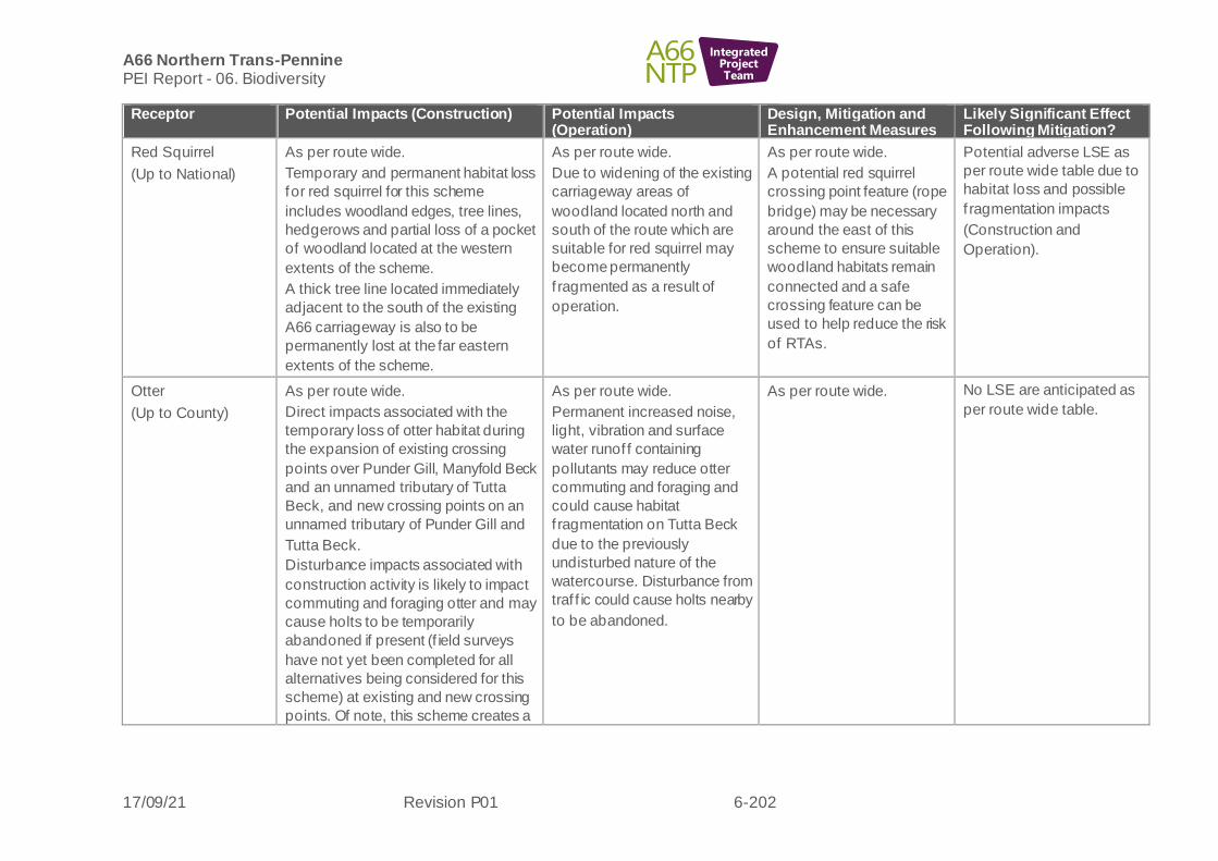
A66 Northern Trans-Pennine PEI Report - 06. Biodiversity
17/09/21 Revision P01 6-202
IntegratedProjectTeam
Receptor Potential Impacts (Construction) Potential Impacts (Operation)
Design, Mitigation and Enhancement Measures
Likely Significant Effect Following Mitigation?
Red Squirrel
(Up to National)
As per route wide.
Temporary and permanent habitat loss
for red squirrel for this scheme
includes woodland edges, tree lines,
hedgerows and partial loss of a pocket
of woodland located at the western
extents of the scheme.
A thick tree line located immediately
adjacent to the south of the existing
A66 carriageway is also to be
permanently lost at the far eastern
extents of the scheme.
As per route wide.
Due to widening of the existing
carriageway areas of
woodland located north and
south of the route which are
suitable for red squirrel may
become permanently
f ragmented as a result of
operation.
As per route wide.
A potential red squirrel
crossing point feature (rope
bridge) may be necessary
around the east of this
scheme to ensure suitable
woodland habitats remain
connected and a safe
crossing feature can be
used to help reduce the risk
of RTAs.
Potential adverse LSE as
per route wide table due to
habitat loss and possible
f ragmentation impacts
(Construction and
Operation).
Otter
(Up to County)
As per route wide.
Direct impacts associated with the
temporary loss of otter habitat during
the expansion of existing crossing
points over Punder Gill, Manyfold Beck
and an unnamed tributary of Tutta
Beck, and new crossing points on an
unnamed tributary of Punder Gill and
Tutta Beck.
Disturbance impacts associated with
construction activity is likely to impact
commuting and foraging otter and may
cause holts to be temporarily
abandoned if present (f ield surveys
have not yet been completed for all
alternatives being considered for this
scheme) at existing and new crossing
points. Of note, this scheme creates a
As per route wide.
Permanent increased noise,
light, vibration and surface
water runof f containing
pollutants may reduce otter
commuting and foraging and
could cause habitat
f ragmentation on Tutta Beck
due to the previously
undisturbed nature of the
watercourse. Disturbance from
traf f ic could cause holts nearby
to be abandoned.
As per route wide. No LSE are anticipated as
per route wide table.

A66 Northern Trans-Pennine PEI Report - 06. Biodiversity
17/09/21 Revision P01 6-203
IntegratedProjectTeam
Receptor Potential Impacts (Construction) Potential Impacts (Operation)
Design, Mitigation and Enhancement Measures
Likely Significant Effect Following Mitigation?
new crossing point over Tutta Beck
that is currently undisturbed.
Water Vole
(Up to County)
As per route wide.
Direct impacts associated with the
temporary loss of water vole habitat
during the expansion of existing
crossing points over Punder Gill, an
unnamed tributary of Manyfold Beck,
Manyfold Beck and an unnamed
tributary of Tutta Beck, and new
crossing points on an unnamed
tributary of Punder Gill and Tutta Beck.
Disturbance impacts associated with
construction activities could impact
foraging water vole and cause burrows
to be abandoned or to collapse if
present - f ield surveys have not yet
been completed for all alternatives
being considered for this scheme.
As per route wide.
As per route wide. No LSE are anticipated as
per route wide table.
Badger
(Local)
As per route wide.
Habitat loss for badger for this scheme
includes foraging and commuting
habitat which includes areas of
woodland, woodland edge, scrub, field
boundaries and some open rough
grassland areas.
As per route wide.
Crossing points may be
identified through further
survey.
As per route wide. No LSE are anticipated as
per route wide table.
Other Terrestrial
Mammal Species
Polecat
Brown hare
As per route wide.
Habitat loss (temporary and
permanent) for other terrestrial
mammal species including deer,
polecat, brown hare and hedgehog for
As per route wide.
Due to the eastern extents and
western extent of this
alignment being offline,
previously undisturbed suitable
As per route wide. Potential adverse LSE as
per route wide table due to
habitat loss and
f ragmentation impacts

A66 Northern Trans-Pennine PEI Report - 06. Biodiversity
17/09/21 Revision P01 6-204
IntegratedProjectTeam
Receptor Potential Impacts (Construction) Potential Impacts (Operation)
Design, Mitigation and Enhancement Measures
Likely Significant Effect Following Mitigation?
Deer
Hedgehog
(Up to County)
this scheme includes tree lines,
hedgerows, woodland edges,
grassland, open fields, areas of scrub,
riparian banks and small areas of
woodland.
habitats (predominantly open
arable f ields) will become
permanently fragmented in this
area as a result of operation.
Due to widening of the existing
carriageway suitable habitats
may become permanently
f ragmented as a result of
operation.
(Construction and
Operation).
Wintering Birds
(Up to County)
As per Black route
Whilst no SPA qualifying species were
recorded during the winter bird surveys
in close proximity to the Blue
alternative, the areas of farmland the
route passes through have the
potential to support wintering golden
plover.
As per Black route
As per route wide. As per route wide table
although valuation is lower
for this scheme so
predicted effect is a minor
adverse effect on a county
resource therefore a
Neutral or Slight effect is
predicted which is not
significant. No LSE
anticipated.
Breeding Birds
(Up to County)
As per Black route. As per Black route. As per route wide. As per route wide table
although valuation is lower
for this scheme so
predicted effect is a minor
adverse effect on a county
resource therefore a
Neutral or Slight effect is
predicted which is not
significant. No LSE
anticipated.
Barn Owl
(Regional)
As per Black route.
As per Black route. As per route wide. Potential adverse LSE as
per route wide table

A66 Northern Trans-Pennine PEI Report - 06. Biodiversity
17/09/21 Revision P01 6-205
IntegratedProjectTeam
Receptor Potential Impacts (Construction) Potential Impacts (Operation)
Design, Mitigation and Enhancement Measures
Likely Significant Effect Following Mitigation?
(Construction and
Operation).
Reptiles
(Up to County)
As per route wide.
As Black route, but greater area of
habitats affected to the west,
connected to the historic adder record.
As per route wide. As per route wide. Potential adverse LSE as
per route wide table
(Construction and
Operation).
Amphibians
(Up to County)
As per route wide.
As per Black route, but two of the
ponds where survey results are
pending are closer to the alignment.
As per route wide. As per route wide. Potential adverse LSE as
per route wide table
(Construction and
Operation).
Fish
(Local)
As per route wide with the exception of
Punder Gill, the watercourses crossed
by the Blue alternative are minor and
are considered unlikely to support
(surveys pending) notable and/or
protected aquatic species as habitats
are either unsuitable, ephemeral or
disconnected to the wider catchment
as a result of and man-made barriers
that restrict the movement of aquatic
species.
As per route wide. As per route wide.
The next design review will
also examine whether
replacement culverts can
be built or adaptations
made to facilitate the
movement of fish should
they be recorded during
surveys.
As per route wide table
although valuation is lower,
so there are potential for
negligible adverse impacts
on a resource of Local
importance which is a
Neutral ef fect and therefore
not significant. No LSE
anticipated.
White-Clawed
Crayf ish (WCC)
(Up to County)
As per route wide.
No desk study records for WCC were
recorded within 2km of this Scheme.
WCC surveys and eDNA sampling will
be undertaken in 2021 to confirm
presence/absence.
As per route wide. As per route wide. As per route wide table
although valuation is lower,
so there are potential for
negligible adverse impacts
on a resource of County
importance which is a
Slight or Neutral effect and
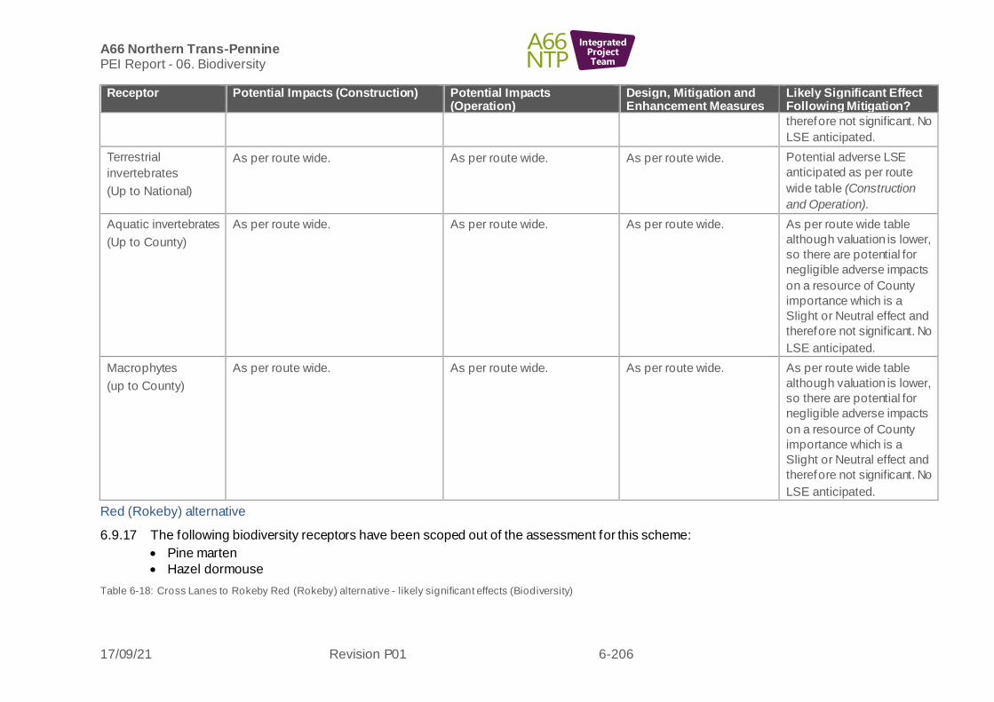
A66 Northern Trans-Pennine PEI Report - 06. Biodiversity
17/09/21 Revision P01 6-206
IntegratedProjectTeam
Receptor Potential Impacts (Construction) Potential Impacts (Operation)
Design, Mitigation and Enhancement Measures
Likely Significant Effect Following Mitigation?
therefore not significant. No
LSE anticipated.
Terrestrial
invertebrates
(Up to National)
As per route wide. As per route wide. As per route wide. Potential adverse LSE
anticipated as per route
wide table (Construction
and Operation).
Aquatic invertebrates
(Up to County)
As per route wide. As per route wide. As per route wide. As per route wide table
although valuation is lower,
so there are potential for
negligible adverse impacts
on a resource of County
importance which is a
Slight or Neutral effect and
therefore not significant. No
LSE anticipated.
Macrophytes
(up to County)
As per route wide. As per route wide. As per route wide. As per route wide table
although valuation is lower,
so there are potential for
negligible adverse impacts
on a resource of County
importance which is a
Slight or Neutral effect and
therefore not significant. No
LSE anticipated.
Red (Rokeby) alternative
6.9.17 The following biodiversity receptors have been scoped out of the assessment for this scheme:
• Pine marten
• Hazel dormouse
Table 6-18: Cross Lanes to Rokeby Red (Rokeby) alternative - likely significant effects (Biodiversity)

A66 Northern Trans-Pennine PEI Report - 06. Biodiversity
17/09/21 Revision P01 6-207
IntegratedProjectTeam
Receptor Potential Impacts (Construction) Potential Impacts (Operation)
Design, Mitigation and Enhancement Measures
Likely Significant Effect Following Mitigation?
Statutory sites
(National)
As per Black route
Non-statutory sites
(Local)
As per Black route
Habitats
Church Wood
(potential AW),
Rokeby Park
(potential AW),
‘Jack Wood‘ AW,
Thorsgill Woods AW,
Waterfall Wood AW,
Teesbank Plantation
AW,
Mill Wood AW,
Notable sycamore
trees,
Priority Habitats:
Deciduous
woodland,
Traditional orchard,
River,
Upland hay meadow,
Lowland calcareous
grassland,
Good quality semi-
improved grassland
(Up to National)
As per route wide
Habitat losses under this route are
listed generally for all alternatives with
the Black route above.
Specific to this alternative are
significantly lower loss of all habitats
as described in the Black route, but
greater impacts to the eastern end of
the scheme including loss of and
severance to ancient woodland at
Church Wood, loss and severance to
Jones Wood AW, loss of Priority
Habitats of seven areas of deciduous
woodland, hedgerows and semi-
improved grassland, along with one
larger island created between the
existing and new alignments of the
A66 and two
small ‘islands’ created within road
inf rastructure.
This Red alternative also differs from
the Black route by potential for impacts
to a reduced number of, but at least
one of the five mature sycamore trees,
noting other semi-mature trees are
As per Black route
As per route wide and
Black route, though
additional mitigation
required to retain seed
bank where possible for
potential ancient woodland
at crossing point.
Potential adverse LSE
anticipated as per route
wide table due to loss of
Priority Habitats, and
possible Ancient Woodland
along with air quality
impacts (Construction and
Operation).
Potential adverse LSE
anticipated for Waterfall
Wood AW as a result of air
quality impacts upon
sensitive habitats and
species (Operation).

A66 Northern Trans-Pennine PEI Report - 06. Biodiversity
17/09/21 Revision P01 6-208
IntegratedProjectTeam
Receptor Potential Impacts (Construction) Potential Impacts (Operation)
Design, Mitigation and Enhancement Measures
Likely Significant Effect Following Mitigation?
likely present within hedges, woodland
and parkland habitats.
River/streams
(Local)
As for Black route
No additional watercourses are
af fected by the Orange alternative.
As for Black route As for Black route No additional LSE caused
by this alternative, as Black
route.
Bats (Roosts)
(Regional)
As per route wide.
No structures with bat roost potential
will require demolition as a result of the
scheme however all six with moderate
to high potential to support roosting
bats will require clearance.
As per route wide.
As per route wide.
Potential adverse LSE as
per route wide table subject
to ongoing surveys
(Construction and
Operation).
Bat Activity (Foraging
and Commuting)
(National)
As per route wide.
Five potential crossing points will be
af fected by construction.
Temporary loss of foraging resource
during construction.
As per route wide.
Five potential crossing points
will be af fected by the scheme.
Temporary loss of foraging
resource until habitat
replanting scheme completed
and matures
As per route wide.
Potential adverse LSE as
per route wide table subject
to ongoing surveys and
possible fragmentation
impacts
(Construction and
Operation).
Red Squirrel
(Up to National)
As per route wide.
Temporary and permanent habitat loss
for red squirrel for this scheme
includes woodland edges, tree lines,
hedgerows and partial loss of a pocket
of woodland located at the western
extents of the scheme.
A thick tree line located immediately
adjacent to the south of the existing
A66 carriageway is also to be
permanently lost at the far eastern
extents of the scheme.
As per route wide.
Due to widening of the existing
carriageway areas of
woodland located north and
south of the route which are
suitable for red squirrel may
become permanently
f ragmented as a result of
operation.
As per route wide.
A potential red squirrel
crossing point feature (rope
bridge) may be necessary
around the east of this
scheme to ensure suitable
woodland habitats remain
connected and a safe
crossing feature can be
used to help reduce the risk
of RTAs.
Potential adverse LSE as
per route wide table due to
habitat loss and possible
f ragmentation impacts
(Construction and
Operation).
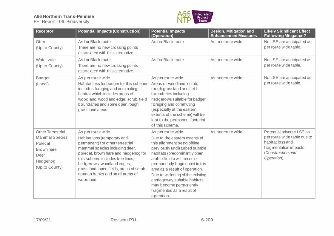
A66 Northern Trans-Pennine PEI Report - 06. Biodiversity
17/09/21 Revision P01 6-209
IntegratedProjectTeam
Receptor Potential Impacts (Construction) Potential Impacts (Operation)
Design, Mitigation and Enhancement Measures
Likely Significant Effect Following Mitigation?
Otter
(Up to County)
As for Black route
There are no new crossing points
associated with this alternative.
As for Black route
As per route wide.
No LSE are anticipated as
per route wide table.
Water vole
(Up to County)
As for Black route
There are no new crossing points
associated with this alternative.
As for Black route
As per route wide.
No LSE are anticipated as
per route wide table.
Badger
(Local)
As per route wide.
Habitat loss for badger for this scheme
includes foraging and commuting
habitat which includes areas of
woodland, woodland edge, scrub, field
boundaries and some open rough
grassland areas.
As per route wide.
Areas of woodland, scrub,
rough grassland and field
boundaries including
hedgerows suitable for badger
foraging and commuting
(especially at the eastern
extents of the scheme) will be
lost to the permanent footprint
of this scheme.
As per route wide. No LSE are anticipated as
per route wide table.
Other Terrestrial
Mammal Species
Polecat
Brown hare
Deer
Hedgehog
(Up to County)
As per route wide.
Habitat loss (temporary and
permanent) for other terrestrial
mammal species including deer,
polecat, brown hare and hedgehog for
this scheme includes tree lines,
hedgerows, woodland edges,
grassland, open fields, areas of scrub,
riparian banks and small areas of
woodland.
As per route wide.
Due to the eastern extents of
this alignment being offline,
previously undisturbed suitable
habitats (predominantly open
arable f ields) will become
permanently fragmented in this
area as a result of operation.
Due to widening of the existing
carriageway suitable habitats
may become permanently
f ragmented as a result of
operation.
As per route wide. Potential adverse LSE as
per route wide table due to
habitat loss and
f ragmentation impacts
(Construction and
Operation).

A66 Northern Trans-Pennine PEI Report - 06. Biodiversity
17/09/21 Revision P01 6-210
IntegratedProjectTeam
Receptor Potential Impacts (Construction) Potential Impacts (Operation)
Design, Mitigation and Enhancement Measures
Likely Significant Effect Following Mitigation?
Wintering Birds
(Up to County)
As for Black route
Whilst no SPA qualifying species were
recorded during the winter bird surveys
in close proximity to the Red
alternative for this scheme, the areas
of farmland the alternative passes
through have the potential to support
wintering golden plover.
As for Black route
As per route wide.
As per route wide table
although valuation is lower
for this scheme so
predicted effect is a minor
adverse effect on a county
resource therefore a
Neutral or Slight effect is
predicted which is not
significant. No LSE
anticipated.
Breeding Birds
(Up to County)
As for Black route
As for Black route
As per route wide.
As per route wide table
although valuation is lower
for this scheme so
predicted effect is a minor
adverse effect on a county
resource therefore a
Neutral or Slight effect is
predicted which is not
significant. No LSE
anticipated.
Barn Owl
(Regional)
As for Black route
As for Black route
As per route wide.
Potential adverse LSE as
per route wide table
(Construction and
Operation).
Reptiles
(Up to County)
As Black option, but smaller area of
habitats affected connected to the
historic adder record.
As per route wide. As per route wide. Potential adverse LSE as
per route wide table
(Construction and
Operation).
Amphibians
(Up to County)
As per Black option As per route wide. As per route wide. Potential adverse LSE as
per route wide table

A66 Northern Trans-Pennine PEI Report - 06. Biodiversity
17/09/21 Revision P01 6-211
IntegratedProjectTeam
Receptor Potential Impacts (Construction) Potential Impacts (Operation)
Design, Mitigation and Enhancement Measures
Likely Significant Effect Following Mitigation?
(Construction and
Operation).
Fish
(Local)
As for Black route.
As for Black route.
As for Black route.
As per route wide table
although valuation is lower,
so there are potential for
negligible adverse impacts
on a resource of Local
importance which is a
Neutral ef fect and therefore
not significant. No LSE
anticipated.
White-Clawed
Crayf ish (WCC)
(Up to County)
As per route wide.
As per route wide.
As per route wide.
As per route wide table
although valuation is lower,
so there are potential for
negligible adverse impacts
on a resource of County
importance which is a
Slight or Neutral effect and
therefore not significant. No
LSE anticipated.
Terrestrial
invertebrates
(Up to National)
As per route wide.
As per route wide.
As per route wide.
Potential adverse LSE
anticipated as per route
wide table (Construction
and Operation).
Aquatic invertebrates
(Up to County)
As per route wide.
As per route wide.
As per route wide.
As per route wide table
although valuation is lower,
so there are potential for
negligible adverse impacts
on a resource of County
importance which is a
Slight or Neutral effect and

A66 Northern Trans-Pennine PEI Report - 06. Biodiversity
17/09/21 Revision P01 6-212
IntegratedProjectTeam
Receptor Potential Impacts (Construction) Potential Impacts (Operation)
Design, Mitigation and Enhancement Measures
Likely Significant Effect Following Mitigation?
therefore not significant. No
LSE anticipated.
(Construction and
Operation).
Macrophytes
(Up to County)
As per route wide.
As per route wide.
As per route wide.
As per route wide table
although valuation is lower,
so there are potential for
negligible adverse impacts
on a resource of County
importance which is a
Slight or Neutral effect and
therefore not significant. No
LSE anticipated.
Stephen Bank to Carkin Moor
6.9.18 The following biodiversity receptors have been scoped out of the assessment for this scheme:
• Statutory Designated Sites – there are no statutory designated sites within the Zone of Influence for this scheme.
• Pine marten
• Hazel dormouse
Table 6-19: Stephen Bank to Carkin Moor - likely significant effects (Biodiversity)
Receptor Potential Impacts (Construction) Potential Impacts (Operation)
Design, Mitigation and Enhancement Measures
Likely Significant Effect Following Mitigation?
Non-statutory
sites
Stephen Bank
Road Verge (De-
notif ied LWS)
(Local)
As per route wide.
This site has been de-notified due to overgrown
habitats, it is still possible the seed bank is viable
and removal of this cover during works may
expose the rich seed bank underneath, there is
also the potential for loss to this rich seed bank if
the soils are moved elsewhere or buried.
As per route wide.
Loss of ecological potential
of this site.
The current stage of air
quality modelling has
identified a 1% increase in
nitrogen for where this site
As per route wide.
Pre-construction checks
of seed bank viability to
inform soil management
and re-use of soils
within ecology mitigation
areas.
Potential for major adverse
impacts on a resource of
Local importance, which is
a Slight effect and therefore
not significant. No LSE are
anticipated.

A66 Northern Trans-Pennine PEI Report - 06. Biodiversity
17/09/21 Revision P01 6-213
IntegratedProjectTeam
Receptor Potential Impacts (Construction) Potential Impacts (Operation)
Design, Mitigation and Enhancement Measures
Likely Significant Effect Following Mitigation?
Direct loss of approximately half the site and
potential habitat degradation for remaining due to
air quality (deposition) and pollution incidents
associated with construction.
These potential impacts may affect the integrity of
the resource on a permanent/irreversible basis in
the absence of mitigation, which may be
assessed as a major adverse impact.
is within 200m of the ARN,
potential for detrimental
impacts upon sensitive
sites, habitats and species
within this site.
These potential impacts
may af fect the integrity of
the resource on a
permanent/irreversible
basis in the absence of
mitigation, which may be
assessed as a major
adverse impact.
Mitigation measures to
protect retained habitat
will reduce the likelihood
of pollution incidents but
the permanent loss and
air quality impacts
remain a major adverse
impact.
Aske Estate
Woodlands LWS
(Local)
As per route wide.
This site is at too great a distance for direct or
indirect impacts.
No change anticipated.
As per route wide.
No change anticipated.
None required. No change on a resource of
Local importance is a
Neutral ef fect and therefore
not significant. No LSE
anticipated.
Ravensworth
Park and Castle
Fetch LWS
(Local)
As per route wide.
This site is at too great a distance for direct or
indirect impacts.
No change anticipated.
As per route wide.
This site is within 200m of
the ARN but no (<1%)
increase in N deposition is
predicted.
No change anticipated.
None required. No change on a resource of
Local importance is a
Neutral ef fect and therefore
not significant. No LSE
anticipated.
Habitats –
Deciduous
woodland
Hedgerows
Reedbed
As per route wide.
Greatest habitat losses are to arable, improved
grassland, poor-semi-improved grassland and
hardstanding (89ha) and species-poor defunct
hedge, eutrophic running water and species-rich
As per route wide.
Temporal loss of habitats,
time taken for recovery of
hedgerow and woodland
habitats.
As route wide.
Long term habitat
management to
maintain reedbed and
manage invasive
species.
Potential adverse LSE
anticipated as per route
wide table due to loss of
Priority Habitats
(Construction and
Operation).
A66 Northern Trans-Pennine PEI Report - 06. Biodiversity
17/09/21 Revision P01 6-214
IntegratedProjectTeam
Receptor Potential Impacts (Construction) Potential Impacts (Operation)
Design, Mitigation and Enhancement Measures
Likely Significant Effect Following Mitigation?
Good quality
semi-improved
grassland
(Up to National)
hedge and trees and species-poor intact hedge
(5000m)
Within the above is loss of: 9ha deciduous
woodland, 1ha reedbed, 1ha good quality semi-
improved grassland, loss of hedgerows and
shading of watercourses.
Fragmentation of watercourses and severance of
woodland habitats by main carriageway. Further
f ragmentation caused by new alignment at
junctions and between areas of new and prior A66
alignment.
In terms of degradation, Ancient Woodland and
sensitive habitats are located over 200m from the
draf t DCO boundary however the Priority Habitat
reedbed is within the construction boundary. In
line with LA 105 DMRB guidelines, air quality
impacts on aquatic habitats can be scoped out.
Ground disturbance and soil movements of
marginal habitats with Himalayan balsam and
possible cause of further spread.
Potential for loss of the following species due to
ground disturbance, shading or compaction:
bluebell (woodland habitats), or corn spurrey
(arable habitats), or lesser spearwort and
crossword (marginal habitats), or to field mouse-
ear, devil’s-bit scabious, harebell and tormentil
(neutral, calcareous and acidic grasslands).
Potential loss of reedbed
habitat to woodland
planting and/or natural
habitat progression.
Rivers/streams
(Local)
As per route wide.
Habitat degradation (shading) associated with the
f ive watercourse crossings. Proposals include
As per route wide As per route wide. As per route wide table
however rivers/streams on
this scheme are of Local

A66 Northern Trans-Pennine PEI Report - 06. Biodiversity
17/09/21 Revision P01 6-215
IntegratedProjectTeam
Receptor Potential Impacts (Construction) Potential Impacts (Operation)
Design, Mitigation and Enhancement Measures
Likely Significant Effect Following Mitigation?
new crossing points on three unnamed tributaries
of Holme Beck, Mains Gill and an expansion of an
existing crossings on another unnamed tributary
of Holme Beck.
The watercourses crossed by this scheme are
minor and are considered unlikely to support
(surveys pending) notable and/or protected
aquatic species as habitats are either unsuitable,
ephemeral or disconnected to the wider
catchment as a result of and man-made barriers
that restrict the movement of aquatic species.
value. Minor adverse
impacts on a Local value
resource may be assessed
as Neutral or Slight
therefore not significant. No
LSE are anticipated.
Bats (Roosts)
(Regional)
As per route wide.
No structures with bat roost potential will require
demolition as a result of the scheme however all
36 trees with moderate to high potential to support
roosting bats will require clearance.
As per route wide. As per route wide. Potential adverse LSE as
per route wide table subject
to ongoing surveys
(Construction and
Operation).
Bat Activity
(Foraging and
Commuting)
(National)
As per route wide.
Seven potential crossing points will be affected by
construction.
Temporary loss of foraging resource during
construction.
As per route wide.
Seven potential crossing
points will be affected by
the scheme.
Long term loss of foraging
resource until woodland
habitat replanting scheme
completed and matures
As per route wide. Potential adverse LSE as
per route wide table subject
to ongoing surveys and
possible fragmentation
impacts (Construction and
Operation).
Red Squirrel
(Up to National)
As per route wide.
Potential habitat loss (permanent) for red squirrel
for this scheme includes four areas of woodland
and woodland edges as well as connecting tree
As per route wide. As per route wide. Potential adverse LSE as
per route wide table due to
habitat loss and possible
f ragmentation impacts
A66 Northern Trans-Pennine PEI Report - 06. Biodiversity
17/09/21 Revision P01 6-216
IntegratedProjectTeam
Receptor Potential Impacts (Construction) Potential Impacts (Operation)
Design, Mitigation and Enhancement Measures
Likely Significant Effect Following Mitigation?
lines and hedgerows (if proposed surveys
determine red squirrels to be present at this
scheme).
(Construction and
Operation).
Otter
(Up to County)
As per route wide.
Direct impacts associated with the temporary loss
of otter habitat at the new crossing points on three
unnamed tributaries of Holme Beck, Mains Gill
and an expansion of an existing crossings on
another unnamed tributary of Holme Beck.
Disturbance impacts associated with construction
activity is likely to impact commuting and foraging
otter. No holt and/or resting features were
identified within 250m of this scheme.
As per route wide. As per route wide. No LSE are anticipated as
per route wide table.
Water Vole
(Up to County)
As per route wide.
Direct impacts associated with the temporary loss
of water vole habitat at the new crossing points on
three unnamed tributaries of Holme Beck, Mains
Gill and an unnamed tributary of Cottonmill Beck
and its associated reed bed, and an expansion of
an existing crossing on another unnamed tributary
of Holme Beck.
Disturbance impacts associated with construction
activities could impact foraging water vole and
cause burrows to be abandoned or to collapse if
present.
As per route wide. As per route wide.
No LSE are anticipated as
per route wide table.
Badger
(Local)
As per route wide.
Habitat loss for badger for this scheme includes
foraging and commuting habitat which includes
As per route wide.
The section of offline route
of the scheme is located on
previously undisturbed
As per route wide. No LSE are anticipated as
per route wide table.

A66 Northern Trans-Pennine PEI Report - 06. Biodiversity
17/09/21 Revision P01 6-217
IntegratedProjectTeam
Receptor Potential Impacts (Construction) Potential Impacts (Operation)
Design, Mitigation and Enhancement Measures
Likely Significant Effect Following Mitigation?
areas of woodland, woodland edge, scrub, field
boundaries and open arable field areas.
suitable habitats
(predominantly open arable
f ields and pockets of
woodland) will become
permanently fragmented as
a result of operation.
Other Terrestrial
Mammal Species
Polecat
Brown hare
Deer
Hedgehog
(Up to County)
As per route wide.
Habitat loss includes hedgerows, tree lines, areas
of woodland, woodland edges, grassland, open
f ields, areas of scrub and riparian banks.
As per route wide.
The section of offline route
of the scheme is located on
previously undisturbed
suitable habitats
(predominantly open arable
f ields and pockets of
woodland) that will become
permanently fragmented as
a result of operation.
As per route wide. Potential adverse LSE as
per route wide table due to
habitat loss and
f ragmentation impacts
(Construction and
Operation).
Wintering Birds
(Up to County)
As per route wide.
Habitat loss for wintering birds for this scheme
includes hedgerows, woodland, mature trees and
grassland with impacts associated with
watercourses.
As per route wide.
As per route wide. As per route wide table
although valuation is lower
for this scheme so
predicted effect is a minor
adverse effect on a county
resource therefore a
Neutral or Slight effect is
predicted which is not
significant. No LSE
anticipated.
Breeding Birds
(Up to County)
As per route wide.
Habitat loss for breeding birds for this scheme
includes hedgerows, woodland, mature trees and
As per route wide.
As per route wide. As per route wide table
although valuation is lower
for this scheme so
predicted effect is a minor
A66 Northern Trans-Pennine PEI Report - 06. Biodiversity
17/09/21 Revision P01 6-218
IntegratedProjectTeam
Receptor Potential Impacts (Construction) Potential Impacts (Operation)
Design, Mitigation and Enhancement Measures
Likely Significant Effect Following Mitigation?
grassland with impacts associated with
watercourses.
adverse effect on a county
resource therefore a
Neutral or Slight effect is
predicted which is not
significant. No LSE
anticipated.
Barn Owl
(Regional)
As per route wide.
Habitat loss for barn owls for this scheme includes
agricultural buildings, woodland, tussocky
grassland, hedgerows and mature trees.
As per route wide.
As per route wide.
Potential adverse LSE as
per route wide table
(Construction and
Operation).
Reptiles
(Up to County)
As per route wide. As per route wide. As per route wide.
Potential adverse LSE as
per route wide table
(Construction and
Operation).
Amphibians
(Up to County)
As per route wide.
Great crested newts are likely to use the habitats
within the construction area.
As per route wide.
As per route wide.
Potential adverse LSE as
per route wide table relating
to amphibian species
including GCN
(Construction and
Operation).
Fish
(Local)
As per route wide.
The watercourses crossed by this scheme are
minor and are considered unlikely to support
(surveys pending) notable and/or protected fish as
habitats are either unsuitable, ephemeral or
disconnected to the wider catchment as a result of
As per route wide.
As per route wide.
As per route wide table
although valuation is lower,
so there are potential for
negligible adverse impacts
on a resource of Local
importance which is a
Neutral ef fect and therefore
A66 Northern Trans-Pennine PEI Report - 06. Biodiversity
17/09/21 Revision P01 6-219
IntegratedProjectTeam
Receptor Potential Impacts (Construction) Potential Impacts (Operation)
Design, Mitigation and Enhancement Measures
Likely Significant Effect Following Mitigation?
and man-made barriers that restrict the movement
of aquatic species.
This will be confirmed in 2021 following fish
surveys and eDNA sampling.
not significant. No LSE
anticipated.
White-Clawed
Crayf ish (WCC)
(Up to County)
As per route wide. As per route wide. As per route wide. As per route wide table
although valuation is lower,
so there are potential for
negligible adverse impacts
on a resource of County
importance which is a Slight
or Neutral ef fect and
therefore not significant. No
LSE anticipated.
Terrestrial
invertebrates
(Up to National)
As per route wide. As per route wide. As per route wide. Potential adverse LSE
anticipated as per route
wide table (Construction
and Operation).
Aquatic
invertebrates
(Up to County)
As per route wide. As per route wide. As per route wide. As per route wide table
although valuation is lower,
so there are potential for
negligible adverse impacts
on a resource of County
importance which is a Slight
or Neutral ef fect and
therefore not significant. No
LSE anticipated.
Macrophytes
(up to County)
As per route wide. As per route wide. As per route wide. As per route wide table
although valuation is lower,
so there are potential for
negligible adverse impacts

A66 Northern Trans-Pennine PEI Report - 06. Biodiversity
17/09/21 Revision P01 6-220
IntegratedProjectTeam
Receptor Potential Impacts (Construction) Potential Impacts (Operation)
Design, Mitigation and Enhancement Measures
Likely Significant Effect Following Mitigation?
on a resource of County
importance which is a Slight
or Neutral ef fect and
therefore not significant. No
LSE anticipated.
A1(M) Junction 53 Scotch Corner
6.9.19 The following biodiversity receptors have been scoped out of the assessment for this scheme:
• Rivers/streams – none present.
• Pine marten
• Hazel dormouse • Water vole – no suitable habitat present.
• Otter – no suitable habitat present.
• Red squirrel –scoped out due to the absence of historical biological records within 2km, the lack of suitable habitat being present within the survey area. Furthermore, no evidence has been collected during initial terrestrial mammal surveys to indicate their presence.
• Badger – no badger setts or signs identified during field surveys.
• Fish – no suitable habitat present.
• White-clawed crayfish – no suitable habitat present.
• Aquatic invertebrates – no suitable habitat present.
• Macrophytes – no suitable habitat present.

A66 Northern Trans-Pennine PEI Report - 06. Biodiversity
17/09/21 Revision P01 6-221
IntegratedProjectTeam
Table 6-20: A1(M) Junction 53 Scotch Corner - likely significant effects (Biodiversity)
Receptor Potential Impacts (Construction) Potential Impacts (Operation) Design, Mitigation and Enhancement Measures
Likely Significant Effect Following Mitigation?
Statutory Sites Black Scar Quarry SSSI (National)
As per route wide. This is a geological SSSI but as a non-designatory feature has broad-leaved woodland habitat. Based on the distance of this site from the works, there are no direct impacts and likely no indirect impacts that af fect qualifying features. No change anticipated.
As per route wide.
Based on the distance of this site f rom the works, there are no direct impacts and likely no indirect impacts that affect qualifying features.
No change anticipated.
None required. No change on a resource of Local importance is a Neutral ef fect and therefore not significant. No LSE anticipated.
Pallet Hill LWS (Local)
As per route wide.
Based on the distance of this site from the works, there are no direct impacts and likely no indirect impacts that af fect qualifying features.
No change anticipated.
As per route wide.
This site is within 200m of the
ARN and subject to a 1%
increase in N dep. Therefore,
there is potential for air quality
impacts.
These potential impacts may af fect the integrity of the resource on a permanent/irreversible basis in the absence of mitigation, which may be assessed as a major adverse impact.
Mitigation measures to
protect retained habitat will
reduce the likelihood of
pollution incidents but the
permanent loss and air
quality impacts remain a
major adverse impact.
Potential for major adverse
impacts on a resource of
Local importance, which is a
Slight effect and therefore not
significant. No LSE are
anticipated.
Limekiln Wood Site of
Importance for Nature
Conservation
(County)
and Limekiln Ancient
Woodland
(National)
This site is 8.7km from this scheme and only included due to being 200m from the ARN. No direct or indirect impacts are anticipated.
No change anticipated.
This site is within 200m of the
ARN and subject to a 1%
increase in N dep. Therefore
there is potential for air quality
impacts.
These potential impacts may af fect the integrity of the resource on a permanent / irreversible basis in the absence of mitigation,
Further air quality
assessment and mitigation
design is required but there
may be a need for further
mitigation areas to offset
air quality impacts related
to habitat degradation.
Permanent loss and air
quality impacts remain a
major adverse impact.
Potential for major adverse
impacts on a resource of up
to National importance, which
is a Large or Very Large
ef fect and therefore
significant. Potential LSE are
anticipated relating to air
quality (Operation).

A66 Northern Trans-Pennine PEI Report - 06. Biodiversity
17/09/21 Revision P01 6-222
IntegratedProjectTeam
Receptor Potential Impacts (Construction) Potential Impacts (Operation) Design, Mitigation and Enhancement Measures
Likely Significant Effect Following Mitigation?
which may be assessed as a major adverse impact.
Habitats – Deciduous woodland Hedgerow Poor semi-improved grassland
(Up to National)
As per route wide.
Habitat loss is restricted to broad-
leaved plantation, hedgerow and poor
semi-improved grassland (1.5ha).
Within the above is loss of 0.2ha
deciduous woodland (Priority Habitat)
within the A1(M) and A66 junction.
No f ragmentation impacts anticipated.
Ground disturbance and soil
movements of marginal habitats with
the invasive species: Yellow
Archangel (L.galeobdolon subsp.
argentatum), Hollyberry, cotoneaster,
montbretia, and rhododendron, which
may cause further spread of these
species.
Currently there are no losses
anticipated to protected or otherwise
notable species requiring
conservation.
As per route wide. As per route wide.
Further design review will
aim to avoid or reduce the
loss of Priority woodland
habitat and further surveys
will aim to confirm the
status of the woodland.
Potential adverse LSE
anticipated as per route wide
table due to loss of Priority
Habitats (Construction and
Operation).
Bats (Roosts)
(Regional)
As per route wide.
No structures or trees with bat roost
potential will require demolition/felling
as a result of the scheme although
surveys are ongoing.
As per route wide. As per route wide. Potential adverse LSE as per
route wide table subject to
ongoing surveys
(Construction and Operation).
Bat Activity (Foraging and Commuting) (National)
As per route wide.
No potential bat crossing points have
been identified in relation to the draft
DCO boundary for this scheme.
As per route wide.
Loss of foraging resource until
habitat replanting scheme
matures due to woodland habitat.
As per route wide.
Temporary brash piles to
maintain connectivity may
Potential adverse LSE as per
route wide table subject to
ongoing surveys and possible

A66 Northern Trans-Pennine PEI Report - 06. Biodiversity
17/09/21 Revision P01 6-223
IntegratedProjectTeam
Receptor Potential Impacts (Construction) Potential Impacts (Operation) Design, Mitigation and Enhancement Measures
Likely Significant Effect Following Mitigation?
Temporary loss of foraging and
possible commuting resource during
construction.
be required during
construction.
f ragmentation impacts
(Construction and Operation).
Other Terrestrial Mammal Species Polecat Brown hare Deer Hedgehog (Up to County)
As per route wide.
Habitat loss (temporary and
permanent) for other terrestrial
mammal species including deer,
polecat, brown hare and hedgehog for
this scheme is limited to small areas
of tree lines, hedgerows, woodland
edges, field edges and roadside
verge.
N/A As per route wide. Potential adverse LSE as per
route wide table due to
habitat loss and
f ragmentation impacts
(Construction).
Wintering Birds (Up to Local)
As per route wide.
Limited habitat loss for wintering birds
for this scheme includes small losses
of hedgerows, woodland, mature trees
and grassland.
N/A As per route wide. As per route wide table
although valuation is lower for
this scheme so predicted
ef fect is a minor adverse
ef fect on a local resource
therefore a Neutral/Slight
ef fect is predicted, which is
not significant.
No LSE are predicted.
Breeding Birds (Up to Local)
As per route wide.
Limited habitat loss for breeding birds
for this scheme includes small losses
of hedgerows, woodland, mature trees
and grassland.
N/A As per route wide. As per route wide table
although valuation is lower for
this scheme so predicted
ef fect is a minor adverse
ef fect on a local resource
therefore a Neutral/Slight
ef fect is predicted, which is
not significant.
No LSE are predicted.
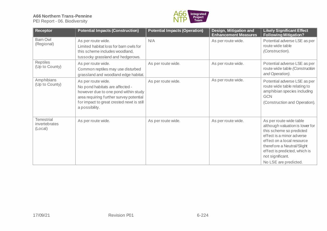
A66 Northern Trans-Pennine PEI Report - 06. Biodiversity
17/09/21 Revision P01 6-224
IntegratedProjectTeam
Receptor Potential Impacts (Construction) Potential Impacts (Operation) Design, Mitigation and Enhancement Measures
Likely Significant Effect Following Mitigation?
Barn Owl (Regional)
As per route wide.
Limited habitat loss for barn owls for
this scheme includes woodland,
tussocky grassland and hedgerows.
N/A As per route wide.
Potential adverse LSE as per
route wide table
(Construction).
Reptiles (Up to County)
As per route wide.
Common reptiles may use disturbed
grassland and woodland edge habitat.
As per route wide. As per route wide. Potential adverse LSE as per
route wide table (Construction
and Operation).
Amphibians (Up to County)
As per route wide.
No pond habitats are affected -
however due to one pond within study
area requiring further survey potential
for impact to great crested newt is still
a possibility.
As per route wide. As per route wide. Potential adverse LSE as per
route wide table relating to
amphibian species including
GCN
(Construction and Operation).
Terrestrial invertebrates (Local)
As per route wide. As per route wide. As per route wide.
As per route wide table
although valuation is lower for
this scheme so predicted
ef fect is a minor adverse
ef fect on a local resource
therefore a Neutral/Slight
ef fect is predicted, which is
not significant.
No LSE are predicted.

A66 Northern Trans-Pennine PEI Report - 06. Biodiversity
17/09/21 Revision P01 6-225
IntegratedProjectTeam
6.10 Monitoring
Route wide
6.10.1 Ongoing ecological monitoring will be required for a range of biodiversity resources in order to measure the success of habitat creation, enhancement and mitigation measures. Botanical survey and / or invertebrate sampling may be required to monitor extent and quality of habitats across the scheme and gauge successful establishment and ongoing management requirements of habitats.
6.10.2 The use of underpasses and crossing points by the intended species will also be monitored in case adaptations are required to encourage their use. Camera traps are likely to be deployed to assess the use of the crossing points for badger, otter, water vole, red squirrel and other terrestrial mammals, reptiles and amphibians, along with standard surveys to identify signs of these species/groups.
6.10.3 Where protected species licences are required, there will a legal requirement to carry out specific monitoring to understand whether mitigation was successful and/or whether remedial action is required. Monitoring under licence is likely to be required for great crested newts, bats, otters, badgers, water vole and red squirrel.