Embed Size (px)
Citation preview

Draft Report on Integrated National Transportation Waterway Grid Study (Stage 1 of Phase II) 1
INTEGRATED NATIONAL WATERWAYS TRANSPORTATION
GRID STUDY (Stage 1 of Phase II)
2014
(A Govt. of India Enterprise) Plot1, Sector29, GURGAON122 001
INLAND WATERWAYS AUTHORITY OFINDIA (Ministry of Shipping, Govt. of India)
FINAL REPORT

INLAND WATERWAYS AUTHORITY OF INDIA (Ministry of Shipping, Govt. of India)
INTEGRATED NATIONAL WATERWAYS TRANSPORTATION GRID STUDY
(Stage 1 of Phase II)
FINAL REPORT
April 2014
(A Govt. of India Enterprise)
Plot1, Sector29 GURGAON – 122 001.

Integrated National Waterways Transportation Grid Study (Stage 1 of Phase II)
CONTENTS
CHAPTER 0 EXECUTIVE SUMMARY ................................................. . i – ix CHAPTER 1 INTRODUCTION
1.0 Background and objectives 1 1.1 Advantage of IWT over other modes 1 1.2 Conclusion and recommendation of Phase I study 2 1.3 Decision taken on Phase I study 4 1.4 Road/ rail connectivity for IWT 4 1.5 Terms of reference for Stage 1 of Phase II study 4
1.5.1 Road/ Rail/ Port connectivity to terminals 5 1.6 Chapterisation Plan 6
CHAPTER 2 TRAFFIC ESTIMATION AND PROJECTION
2.0 Introduction 8 2.1 National Waterway‐1 9 2.2 Brahmaputra/ NW‐2 9 2.3 National Waterway‐3 9 2.4 National waterway‐4 9 2.5 National waterway‐5 9 2.6 National waterway‐6 10 2.7 Eastern Grid 10 2.8 National Inter‐Modal Grid 10 2.9 Computation of Savings 12 2.10 Traffic Projections 12 2.11 IWT Terminals 12 2.12 Traffic in NW‐1 14
2.12.1 Commodity composition 16 2.12.2 Terminals at Haldia‐Kolkata section 16 2.12.3 Bhagirathi/ Hooghly Terminals 17
2.13 Traffic in NW‐2 17 2.13.1 IWT Terminals 17 2.13.2 Cargo potential 18
2.14 Traffic in NW‐3 19 2.15 Traffic in NW‐4 20 2.16 Traffic in NW‐5 23
2.16.1 IWT Terminals 23 2.17 Traffic in NW‐6 24 2.18 Estimated Divertible Traffic –Most Likely Scenario 26 2.19 Terminal wise estimated divertible traffic 27

Integrated National Waterways Transportation Grid Study (Stage 1 of Phase II)
CHAPTER 3 CRITERIA FOR IDENTIFICATION OF PRIORITY TERMINALS AND ASSUMPTIONS ADOPTED
3.0 Introduction 28 3.1 Underlying assumptions 28 3.2 Estimation Procedure 29
3.2.1 Factors affecting level of diversion 29 3.2.2 Inter‐Modal costs 30 3.2.3 Port connectivity 30
3.2.3.1 Deep sea Transhipment‐ A case study 31 3.3 Methodology adopted to arrive the cost 33
3.3.1 Establishment of rail and road connectivity 33 3.4 Estimation of Infrastructure Development Cost 33 3.5 Analysis of data and costing 34
CHAPTER 4 TERMINAL WISE RAIL/ ROAD CONNECTIVITY INCLUDING PORT TERMINALS
4.0 Introduction 35 4.1 Road connectivity characteristics 35 4.2 Rail connectivity characteristics 36
4.2.1 Normative cost adopted for terminal facilities 38 4.3 Connectivity in proposed terminals in NW‐1 42
4.3.1 Terminal at Haldia 42 4.3.2 Terminal at GR Jetty (Kolkata) 45 4.3.3 Terminal at Katwa 47 4.3.4 Terminal at Hazardawari 50 4.3.5 Terminal at Behrampur 52 4.3.6 Terminal at Farakka 55 4.3.7 Terminal at Sahebganj 57 4.3.8 Terminal at Bhagalpur 60 4.3.9 Terminal at Barh 63 4.3.10 Terminal at Patna (Gaighat) 65 4.3.11 Terminal at Rajghat (Varanasi) 68 4.3.12 Terminal at Allahabad 69
4.4 Connectivity in proposed terminals in NW‐2 71 4.4.1 Terminal at Jogighopa 72 4.4.2 Terminal at Pandu 74 4.4.3 Terminal at Tezpur 76 4.4.4 Terminal at Neamati 79 4.4.5 Terminal at Dibrugarh 81
4.5 Connectivity in proposed terminals in NW‐3 84 4.5.1 Terminal at Kottapuram 85 4.5.2 Terminal at Aluva 87 4.5.3 Terminal at Kollam 89 4.5.4 Terminal at Alappuzha 92
4.6 Connectivity in proposed terminals in NW‐4 95 4.6.1 Terminal at Kakinada 96

Integrated National Waterways Transportation Grid Study (Stage 1 of Phase II)
4.6.2 Terminal at Muktiyala 99 4.6.3 Terminal at Vijayawada 101
4.7 Connectivity in proposed terminals in NW‐5 105 4.7.1 Terminal at Talcher 106 4.7.2 Terminal at Dhamra 107 4.7.3 Terminal at Paradip 110 4.7.4 Terminal at Kalinganagar 112
4.8 Connectivity in proposed terminals in NW‐6 114 4.8.1 Terminal at Silchar 114 4.8.2 Terminal at Badarpur 117 4.8.3 Terminal at Karimkanj 119
4.9 Connectivity to Port Locations 123 4.9.1 Port Connectivity to NW‐1 123
4.9.1.1 Terminal at Haldia and Kolkata 123 4.9.2 Port Connectivity to NW‐3 126 4.9.3 Port Connectivity to NW‐4 127
4.9.3.1 Connectivity to Krishnapatnam Port 127 4.9.3.2 Terminal at Ennore 129 4.9.3.3 Terminal at Kakinada 130
4.9.4 Port Connectivity to NW‐5 131 4.9.4.1 Terminal at Paradip 131 4.9.4.2 Terminal at Dhamra 133
CHAPTER 5 IMPLEMENTATION SCHEDULE AND INVESTMENT NEEDS
5.0 General 135 5.1 Summary cost for terminals in all National Waterways 136 5.2 Planned Development and Investment needs in Ph:1 138
5.2.1 Activities planned under Ph:1 in NW‐1 138 5.2.2 Activities planned under Ph:1 in NW‐2 139 5.2.3 Activities planned under Ph:1 in NW‐3 140 5.2.4 Activities planned under Ph:1 in NW‐4 141 5.2.5 Activities planned under Ph:1 in NW‐5 142 5.2.6 Activities planned under Ph:1 in NW‐6 144
5.3 Planned Development and Investment needs in Ph:2 144 5.3.1 Activities planned under Ph:2 in NW‐1 145 5.3.2 Activities planned under Ph:2 in NW‐2 146 5.3.3 Activities planned under Ph:2 in NW‐3 147 5.3.4 Activities planned under Ph:2 in NW‐4 148 5.3.5 Activities planned under Ph:2 in NW‐5 149 5.3.6 Activities planned under Ph:2 in NW‐6 150 5.3.7 Implementation Schedule for Ph‐1 and Ph‐2 151
CHAPTER 6 CONCLUSIONS AND RECOMMENDATIONS
6.0 General 155 6.1 Private Investments 155
Integrated National Waterways Transportation Grid Study (Stage 1 of Phase II)
6.2 Project Phasing and savings in Transport cost 155 6.3 Strengthening of IWAI 156 6.4 Way forward 157 6.5 Conclusions 157 6.6 Recommendations 158
Volume‐II FINAL PRESENTATION MADE BEFORE THE SENIOR OFFICERS OF MINISTRY OF SHIPPING AND IWAI

Integrated National Waterways Transportation Grid Study (Stage 1 of Phase II)
HIGHLIGHTS OF INTEGRATED NW GRID CONNECTIVITY
BASIC FEATURES ALL NWs EASTERN GRID
No. of National Waterways 6 4
Total Length (in KM) 4503 + 1665 km of Protocol Route in
Bangladesh
3220 + Protocol Route 1665 km
No of States covered 14 11
No. Of Civil
Districts Covered
137 108
Base Year Total Traffic‐2011‐12 (Million Tonnes)
287 203
Total Number of Terminals 70 42
Number of Terminals Prioritizedbased on traffic potential
31 24
Road connectivity 31 24
Rail connectivity 7 6
Port connectivity 7 4
Projected Divertible Traffic (In Million Tonnes)
Base Year (2011‐12) 114 (Existing: 5) 66.4
2021‐22 159.00 97.2
2031‐32 332.60 192
PROJECT PHASING
Project Phase Number of
Terminals
Traffic Investment Required(Rs Cr)
Private Investment
(Rs Cr)
Savings in Tpt. Cost (Cr. Rs/Yr )
MT BT Km Annual Savings
Phase 1 (2014‐17) 14 34.56 17.32 1981 10391 341.9
Phase 2 (2017‐22) 17 159.00* 27.28 20782 55208 2406*
Total upto 2021‐22 31 22763 65599
*: Cumulative of Phase‐I & Phase‐II

. . Executive Summary
Integrated National Waterways Transportation Grid Study (Stage 1 of Phase II) i
Executive Summary
0.0 Integrated National Waterways Transportation Grid study is undertaken with an aim to link all National Waterways (viz., River Ganga from Haldia to Allahabad (NW‐1: 1620 km), River Brahmaputra from Dhubri to Sadiya (NW‐2: 891 km), West Coast Canal from Kottapuram to Kollam with Udyogmandal and Champakara Canals (NW‐3: 205 km), Kakinada – Puducherry stretch of canals with River Godavari and River Krishna (NW‐4: 1078 km), East Coast Canal with River Brahmani and River Mahanadi’s delta (NW‐5: 588 km), River Barak between Lakhipur and Bhanga (proposed NW‐6: 121 km)) to National/ State Highways, Railways and Sea Ports so that all these waterways become an integral part of the total transportation grid. With this objective, Phase‐1 study had been carried out which had recommended 27 potential terminal locations on six National Waterways, for development of effective Inter‐modal National Waterways Transportation Grid. These identified potential terminals are required to be properly connected by 2 lane road to the nearby State or National Highways and also at least single lane broad gauge rail connectivity to be established to nearby rail‐heads, wherever feasible.
0.1 Based on the recommendations and the broad consultation on the planned Phase‐I study
of National Waterway Grid connectivity with the States and other Departments related to Roads, Railways and Ports, it was decided that the individual projects would be developed with the detailed project reports and financing options. Further, it was suggested to take up four more terminals viz., Allahabad and Sahebganj on NW‐1, Dhamra and Kalinganagar on NW‐5, in view of their potential connectivity to hinterland. Accordingly all prioritized 31 potential terminals as shown below have been taken up in this stage‐1 of Phase‐II of the study. The divertible traffic potential of these 31 identified priority terminals was 114 million tonnes in the base year (2011‐12) which will increase to 159 million tonnes by the year 2031‐32. In this report, the feasibility for connecting these 31 terminals with nearest National Highways/ State Highways and nearby Rail‐heads has been studied. This connectivity shall bring the identified terminals into National Grid with accessibility to other modes of transports viz., road, rail and port. This aspect is dealt in detail in the present study, i.e., Stage‐I of Phase‐II of NW Grid Connectivity Study. Feasibility of establishing connectivity of National Waterways to Ports viz., Haldia and Kolkata to NW‐1, Kochi to NW‐3, Kakinada, Krishnapatnam and Ennore to NW‐4, Paradip and Dhamara to NW ‐5, has also become a part of this study.
Table 0.1: List of terminals identified for development
National Waterways
SN. Name of IWT Terminal Nearest NH/SH
Nearest Railhead
Gauge
NW1 1 Haldia NH ‐ 41 Haldia BG
NW1 2 G.R. Jetty‐2 (Kolkata) SH New Alipore BG
NW1 3 Katwa SH‐14/ NH ‐ 6 Sonadanga BG
NW1 4 Hazardwari SH‐11A Cossim Bazar BG
NW1 5 Behrampur NH ‐34 Behrampur BG

Integrated National Waterways Transportation Grid Study (Stage 1 of Phase II) ii
NW1 6 Farakka NH ‐34 Farakka BG NW1 7 Sahebganj (Samdaghat) NH ‐ 80 Sahebganj BG NW1 8 Bhagalpur NH‐80 Bhagalpur BG NW1 9 Barh NH ‐ 30A Barh BG NW1 10 Patna (Gaighat) NH ‐ 19 Rajendra Nagar BG
NW1 11 Rajghat(Varanasi) NH ‐ 7 Vyas Nagar BG
NW1 12 Allahabad NH‐35 Karchhana BG NW2 13 Jogighopa (Bongaigaon) NH ‐ 31 B Jogighopa BG
NW2 14 Pandu (Guwahati) NH ‐ 37 Kamakhya BG
NW2 15 Tezpur NH ‐ 37 Tezpur BG
NW2 16 Neamati (Jorhat) NH ‐ 37 Jorhat BG
NW2 17 SaikhuaghatGhat/Dibrugarh NH ‐ 52 Dibrugarh BG
NW3 18 Kottapuram NH‐17 Aluva BG
NW3 19 Aluva NH ‐ 47 Aluva BG
NW3 20 Kollam NH ‐ 47 Kollam BG
NW3 21 Alappuzha NH ‐ 47 Alappuzha BG NW4 22 Kakinada/Kakinada Port NH ‐ 214 Kakinada BG NW4 23 Muktiyala /Guntur SH Guntur BG NW4 24 Vijayawada NH ‐ 9 Vijayawada BG NW5 25 Talcher NH ‐ 23 Talcher BG NW5 26 Paradip NH ‐ 5A Paradip BG NW5 27 Kalingnagar (Jokadia) NH‐56 Jokadia BG NW5 28 Dhamra SH‐9, 9A Dhamra BG NW6 29 Silchar NH ‐ 151 Silchar MG/BG
NW6 30 Badarpur SH Badarpur MG/BG
NW6 31 Karimganj NH ‐ 151 Karimganj MG/BG
0.2 TRAFFIC STUDY
Based on the traffic studies conducted earlier in Phase‐I study on all National Waterway corridors of primary hinterland; the total estimated/ divertible traffic from existing rail and road modes under most likely scenario is summarized below:
Table 0.2: Divertible Traffic within National Waterways in Year 202122
WATERWAY Estimated divertible traffic in million tons
From Rail From Road Total NW 1 25.90 17.44 43.34 NW 2 2.31 19.48 21.79NW 3 0.91 11.18 12.09NW 4 14.96 27.09 42.05 NW 5 14.64 8.61 23.25NW 6 0.36 3.71 4.07 TOTAL 59.08 87.51 146.59

Integrated National Waterways Transportation Grid Study (Stage 1 of Phase II) iii
Table 0.3: Divertible Traffic between National Waterways in Year 202122
WATERWAY Estimated divertible traffic in million tons
From Rail From Road Total
NW 1 & NW 2 1.00 1.13 2.13NW‐1 & NW‐5 5.02 2.77 7.79NW‐1 & NW‐6 0.02 0.94 0.96NW‐2 & NW‐5 0.13 0.47 0.60 NW‐2 & NW‐6 0.04 0.89 0.93
TOTAL 6.21 6.20 12.41
Table 0.4: Total Divertible Traffic by Year 202122
Divertible Traffic by Year 202122
From Rail mode
From Road mode
Total (Divertible from Road and Rail
modes) Within Each NWs 59 MTPA 88 MTPA 147 MTPA
Between NWs 6 MTPA 6 MTPA 12 MTPA
TOTAL 65 MTPA 94 MTPAS 159 MTPA
The traffic currently (2012‐13) moving on all the National Waterways is about 5 million tons. The estimated divertible traffic from road and rail corridors in the base year (2011‐12) is 114 million tons and this would be 159 million tons by the commencement year 2022 if all the facilities are provided as per the recommendations of this study.
0.3 ROAD CONNECTIVITY:
Each terminal is essentially required to have atleast two‐lane road connectivity to the nearest National Highway or State Highway to serve the traffic identified. As such the existing road condition, length of road, availability of land for widening if required, other relevant data required for the connectivity have been collected for arriving at the near approximate cost for such connectivity. All the 31 identified terminals can be connected to the nearby State / National Highway by two lane road. As per the standards of MoRTH, a width of 20m is required for 2 lane road of 7m wide carriage way with paved shoulders and side drainage etc. For the existing roads, where the width is restricted due to dense populated area (which is already provided with two lane road with 1.5m shoulder) minimum top width of 10m is considered for two lane road.
A normative cost of up gradation / construction of existing two lane roads is considered as Rs.1 crore per km, whereas for upgrading existing single lane road into two lane road is considered as Rs.4 crore per km. A sum of Rs.5.5 crore per km is considered for locations where no roads exist and new two lane roads are to be provided.

Integrated National Waterways Transportation Grid Study (Stage 1 of Phase II) iv
0.4 RAIL CONNECTIVITY:
Wherever feasible, it is planned to connect the terminal to the nearest railhead. To meet this end, the topographic map and the relevant in‐house data (RITES) have been utilised to find the feasibility. As per Indian Railways norms, sufficient space is required to handle a full rake in a siding is required. This requires a land requirement of 1300m in length with a land width of 30m including backup space for loading/ unloading/ stacking operations. Wherever the rail lines are proposed for connectivity the following specifications are considered:
• From nearest Railhead up to boundary of IWT Terminal: The section proposed is
of Electrified single line Broad Gauge section, requiring a land width of 15m.
• Inside Terminal location: 1300m straight length with 30m wide land strip, which facilitate a full rail rake loading/ unloading operations with engine escape line, sick wagon line, weigh bridge, etc.
Out of 31 terminals locations identified only 7 terminals locations viz., Haldia, Katwa, Sahebganj, Bhagalpur, Kollam, Kakinada and Vijayawada meet the above requirement and hence recommended for rail connectivity.
The cost of construction is considered as Rs.5crore per km outside the terminal and a provision of Rs.10 crore is kept for rail siding inside a terminal.
0.5 PORT CONNECTIVITY: The National Waterways having potential link to the nearby ports viz., Haldia and Kolkata (NW‐1), Kochi (NW‐3), Kakinada, Krishnapatnam, Ennore (NW‐4), and Paradip and Dhamra (NW‐5) have been studied and the Port administrations were contacted to finalise the feasible ones. However, port connectivity at Ennore was not found feasible. IWT Terminal location and the backup space/ storage yard can be provided by the respective port within their port boundary. The open and covered storage required in the port premises depends upon the IWT traffic anticipated to be handled through these ports.
A separate terminal with finger jetties to handle IWT cargo is considered in all the identified ports to facilitate transfer of cargo from/ to the IWT Vessels and Sea Vessels within respective port limits. The concept of providing finger jetties is to berth smaller capacity vessels (IWT) for loading/ unloading simultaneously from a bigger sea going vessels, so that the uninterrupted evacuation of the cargo will take palce without waiting time. At Mormugao port also the above concept has been implemented successfully, so that the IWT barges iron ore from nearby mines and berthed at finger jetties. The finger jetty is connected to the adjacent sea vessel berth/ wharf by a connecting conveyor system, to facilitate simultaneous loading of iron ore for further transportation to the destiny. On normative basis Rs 50 crore has been provided for finger jetty. Other facilities
Integrated National Waterways Transportation Grid Study (Stage 1 of Phase II) v
for transhipment of cargo such as conveyors have been considered at the terminal. The connectivity to the IWT Terminal location from the port location and extending rail connectivity to the IWT Terminal location etc., have also been considered while estimating the block cost for development. However, to have an insight, the cost for port connectivity at Ennore has been worked out and provided in the report.
0.6 EASTERN GRID
Though each national waterway system can work as a stand‐alone facility, some of the waterways can be joined/ connected so that traffic from one waterway can reach to those destination places which are not directly on that particular waterway using connected waterway. In the given situation four out of the six national waterways can form a grid in the Eastern Region of the country, i.e., NW‐1, NW‐2, NW‐5 and proposed NW‐6 along with the Bangladesh Protocol route. This eastern grid connectivity would further increase the area of influence of each designated waterway system. This proposed Eastern Grid involves overall rivers length of 3220 km (excluding Indo‐Bangladesh Protocol Route of 1665 km). The Eastern Grid is likely to serve 11 states namely; Uttar Pradesh, Bihar, Jharkhand, West Bengal, Assam, Meghalaya, Arunachal Pradesh, Tripura, Mizoram, Manipur and Odisha serving 108 civil districts. It is estimated that, total traffic, which is expected to get diverted to IWT services under most likely scenario is of the order of 97 million tonnes by year 2021‐22, once all the requisite infrastructure is in place.
0.7 ADVANTAGES OF IWT The advantages of IWT mode of transportation over other modes are enormous. Few important advantages are given below:
(i) Cost savings: • 1 HP moves 150 kg on road, 500 kg on rail and 4000 kg on water • 1 litre of fuel moves 24 t‐km on road, 85 on rail & 105 on IWT • Cost of developing waterways much lower than rail & road • Reduces transportation losses
(ii) Environment friendly:
• Least fuel consumption per tonne‐ km • CO2 emission is 50% of trucks • Negligible land requirement • Safe mode for hazardous and over dimensional cargo
(iii) Supplementary mode:
• Reduces pressure on road and rail • Reduces congestion and accidents on road
0.8 PROGRESS MADE IN IWT SECTOR IN THE RECENT PAST
• 30 lakh tonnes per annum of coal being transported by NTPC from Sandheads to
Farakka Thermal Power Station (640 km)

Integrated National Waterways Transportation Grid Study (Stage 1 of Phase II) vi
• Transportation of another 30 lakh tonnes per annum for Barh Thermal Power Station (1040 km) being finalized.
• Fly Ash transportation on Indo‐ Bangladesh Protocol Routes • Pilot movement of fertilisers on NW‐1 by IFFCO and TATA Chemicals • Pilot Project for movement of food grains to North East via Protocol route finalised
by Food Corporation of India • Frequent Over Dimensional Cargo Movement on NW‐1 and NW‐2 • Liquefied Ammonia transportation by FACT on NW‐3 • Substantial container movement on Ro‐Ro Jetties at Kochi • Project to develop South Buckingham Canal on NW‐4 is approved and preliminary
works under progress since March 2014 • Kaladan Multimodal Transit Transport Project being implemented in Myanmar
0.9 PROJECT IMPLEMENTATION
The overall project cost has been estimated as Rs 22,763 crore. It is proposed to implement the entire project in two phases as shown in table below. During the first phase fourteen potential IWT terminals can be taken up with port connectivity to Haldia, Kolkata and Kochi with an investment of Rs. 1981 crore. In the second phase 17 IWT terminals with port connectivity to Kakinada, Krishnapatnam, Paradip and Dhamra are recommended. Though, port connectivity at Ennore is studied, as it is not feasible, the same is not recommended and cost not considered in estimation.
Table 0.5 PHASE WISE INVESTMENT REQUIREMENT
Phase Terminals Traffic
(MnT)
Investment required (Rs crore)
WW devIWT
TerminalRoad Rail Port Total
1 14 (NW 1: 7; NW 2: 2; NW 3: 2; NW 6: 3)
35 887 658 88 4 344 (3) 1981
2 17 (NW 1: 5; NW 2: 3; NW 3: 2; NW 4: 3; NW 5:4)
159 17965 1389 232 387 809 (4) 20782
Total: 31 Terminals
18852 2047 320 391 1153 (7) 22763
0.10 PROJECT PHASING
To begin with, the project can be commenced by 2014‐15 with development of fourteen terminals with an investment of Rs.1981 crore. Simultaneously preparatory waterway developmental works can also be taken up so that the Phase 2 development will also go concurrently. The proposed project phasing, investments required and savings are provided in the following table.

Integrated National Waterways Transportation Grid Study (Stage 1 of Phase II) vii
TABLE 0.6 PHASE WISE INVESTMENTS REQUIRED AND ANTICIPATED SAVINGS
Project Phase
No. of Terminals
Traffic Investment Required (Rs. Cr)
Private Investment (Rs. Cr)
Savings In Transport Cost (Cr. Rs/Yr)
MT BT Km Annual savings Phase‐I (2014‐17) 14 34.56 17.32 1981 10391 341.90
Phase‐II (2017‐22) 17 159.00* 123.40* 20782 55208 2406.00*
Total upto 202122 31 159.00 123.40 22763 65599 2406.00
*: Cumulative of PhaseI & PhaseII
0.11 ANTICIPATED PRIVATE INVESTMENTS
The Integrated National Waterways Transportation Grid, with all the requisite infrastructure in place is anticipated to attract private investment to the tune of Rs.65,600 crores mostly in the form of barge and ship building yards and allied facilities. Apart from barges, the barge and vessel maintenance and other related industrial investment along the banks of such waterways are anticipated in a bigger way. Apart from the above, the dredging requirements for fairway maintenance expect dredger manufacturers to come forward for manufacturing dredgers in large numbers. Further storage facilities, bunkering facilities and inland container depots are the potential areas where the investments from private sector are anticipated.
0.12 SAVINGS IN TRANSPORT COST The divertible traffic on the integrated national waterways is anticipated to yield an annualised saving of Rs.342 crores on completion of Phase‐I and Rs.2406 crores on completion of Phase‐II works. The savings is computed based on the divertible traffic flow from the road and rail mode to waterway mode. For the purpose of computing the cost difference, the per‐tonne kilometre cost for rail mode is considered as Rs. 1.41 and that of road mode is Rs.2.58 where as by IWT mode the same is considered as Rs.1.00/Tonne‐km.
0.13 CONCLUSIONS
The National Waterway Grid Connectivity study carried out is expected to divert the cargo/ goods movement from the strained road/ rail mode of transport to IWT mode in a phased manner with an overall investment of Rs 22,763 crore; however infrastructure has to be created for such modal shift. Further, the waterways need to be developed along with terminal development with necessary infrastructure in place apart from establishing connectivity to the nearest National Highways/ State Highways, rail head wherever required apart from possible port connectivity.
The private Investments in the following areas are anticipated to the tune of Rs.65,599 crore in the two phases. The private investments are expected mainly on the following activities:
On Barges

Integrated National Waterways Transportation Grid Study (Stage 1 of Phase II) viii
Investment in setting up of IWT terminals and their operations at few places along the National Waterways
Creation of storage facilities On ship building facilities On vessel repair/ bunkering facilities On Inland Container Depots/ Domestic Container Terminals On industrial units/ areas
However, for maintaining fairway with requisite least available depth (LAD) throughout should be the responsibility of the IWAI, as private investments on this area is not anticipated as it is not an attractive proposition for investment by Private parties. Globally too, fairway maintenance is in general carried out by the States concerned. Therefore, private investments on fairway development are not expected.
0.14 STRENGTHENING OF IWAI For implementation of such a massive grid work, strengthening of IWAI is a pre‐requisite. With the existing available human resources/ technical experts, consultants opined that it will be very difficult for IWAI to handle such a large valued infrastructure project, as it requires deployment of technical men‐power in large numbers along the stretch of waterways to be connected which is in thousands of kilometers in length. Therefore it is very much essential to strengthen the IWAI organization as a whole, to enable it to handle this project as well as other ongoing projects without any hurdles.
0.15 RECOMMENDATIONS
A presentation was made before the senior officials of Ministry of Shipping and IWAI and the same is presented as Volume II of this report. Based on the detailed study made by the consultants on Integrated National Waterways Transportation Grid Connectivity, the following points emanate which form the final outcome/ recommendations of the Consultants: IWAI may seek the In‐principle approval of scheme for Rs.1,981 crore for Phase‐I development and Rs.20,782crore for Phase‐II development from the Government of India
The development and maintenance of fairways may be met mainly through GBS/ public funding. Non fairway development can be taken up by non GBS funding wherever feasible.
Modification of existing lock gate and construction of additional lock gate at Farakka by MoWR
Strengthening of IWAI primarily by augmenting technical manpower to take up the massive work indicated in both the phases and maintenance of the same thereafter.
Port connectivity shall be developed through concerned port authorities or through PPP by concerned port authorities.
Integrated National Waterways Transportation Grid Study (Stage 1 of Phase II) ix
IWAI may take up with concerned ministries for enacting Regulations for compulsory movement of hazardous cargo and certain percentage of bulk cargo by IWT mode, wherever feasible, to be in‐built in MoEF guidelines.
Banks and FIs to support private investments in barges and ship building yards/ facilities.
Incentives to barge owners for construction of barges and incentives to cargo owners for modal shift to IWT to be considered.
IWT, especially ferry operation within urban area needs to be covered under JNNURM where available.
Incentives to State Governments for development activities in waterways sector, apart from encouraging State Governments to incentivize setting up of new industries along NWs/ waterways, wherever feasible.
Financial and technical assistance to States for developing and maintaining their waterways and also provide assistance to strengthen their IWT set‐ ups
IWAI/ MoS to collaborate with State Governments for making regulation for construction of new structures (bridges etc) without hampering the future IWT prospects of the State waterways
The inland dredging capacity needs to be augmented to cater to the tremendous dredging work anticipated in both the phase of waterway development.
It is recommended to take‐up the above grid connectivity by simultaneously taking up Phase I activities as well as initial studies like DPR preparation etc., for Phase II activities so that the overall objectives of formation of grid shall be achieved. In this direction, it is recommended that IWAI has to take up immediately the preparation of DPRs for the 14 terminals identified under Phase‐I.

Chapter‐1 Introduction
Integrated National Waterways Transportation Grid Study (Stage 1 of Phase II) 1
CHAPTER 1
INTRODUCTION
1.0 BACKGROUND & OBJECTIVES
India is a country of rivers and most of the cities and towns were developed alongside the river systems. It has large number of inland waterways consisting of rivers, canals, backwaters, creeks and lakes etc, which have the potential for development of efficient waterways transport network. Underutilization of Inland Water Transport (IWT) sector in India is a great opportunity loss for the country. IWT is referred to as operationally cheaper, high in fuel efficiency and environment friendly mode of transport. It has a vast potential to act as an alternate and supplementary mode of transportation for handling certain bulk commodities. Till the first half of 20th century, IWT was an important mode of transport in India for goods and passenger and played significant role in trade and commerce. Although it continues to be the cheapest mode, it has lost its importance because of poor maintenance of waterways as it fails to maintain all‐weather water levels for navigation, terminal costs and slow speed. IWT has higher terminal costs like Railways, as it involves local cartage by road transport between place of origin and/or destination and the specified IWT terminal.
1.1 ADVANTAGES OF IWT OVER OTHER MODES
IWT has a number of benefits. On an international standard, the operating cost of IWT is 1 cent as compared to 2.5 cents by rail and 5.3 cents by road. It provides higher fuel efficiency as compared to either rail or road; 3.8 litres (1 gallon) of fuel transports one tonne of freight through 827 km by a barge compared to 325 km by train and 95 km by truck. Water transport is also the safest mode of transporting large quantities of chemicals and toxic materials with the least danger to the surrounding cities. It is also environment friendly, and creates less noise pollution and reduces pollutant levels in the air. Moving freight through barges also helps in reducing the level of congestion on roads and rail tracks. In the Indian context, the cost of the additional time taken to transport goods through IWT does not factor in because of the saturation of the rail and road networks. In addition to these factors, IWT also contributes to economic and social development of the hinterland. Savings from IWT mode is accrued from:
• Savings in operating cost
• Savings due to avoidance of accidents
• Savings due to Reduced Government expenditure on Medical Aid (The value of the expenditure incurred by the government in Year 2006 for combating diseases caused by air pollution arising out of road transportation was calculated to be Rs. 17 crore . This expenditure can be taken as savings or gains due to IWT as it is a pollution free mode of transportation)

Integrated National Waterways Transportation Grid Study (Stage 1 of Phase II) 2
Economic Gains through Additional Jobs Created due to Provision of Economic Connectivity to the Hinterland: ‐ The employment potential in villages benefiting from the IWT mode was estimated by the National Council of Applied Economic Research (NCAER) field visit team at 5.3 million (assuming that IWT operates for 300 fair‐weather days in a year).
1.2 Inland Waterways Authority of India (IWAI) is regularly trying to reinstate IWT services on various rivers and a number of studies have already been carried out in this direction. As a result, five potential waterways have already been declared as the National Waterways. Table‐1.1 indicates, Waterway length studied and the year waterway stretch was declared as National Waterway System.
Table 1.1: National Waterways
The National Waterway Transportation Grid study is planned to be undertaken in two phases. The Phase‐I of the study which is limited to the Macro level information, depending upon available data from various authentic secondary sources is already completed and based on the findings of Phase‐I study, Phase II study which involves micro level studies is being taken up in different stages.
The broad Terms of reference of Phase I study already undertaken is as follows:
• Formulate projects for each National Waterways system by identifying the projects for best investment.
• Identify projects to be considered under PPP operations/concession agreement. • Identify potential IWT terminals on NW‐1, NW‐2, NW‐3, NW‐4, NW‐5 and NW‐6. • Develop Rail & Road connectivity to the identified/proposed terminals. • Develop Sea Port and National Waterway connectivity including both physical and
improvement of the existing charges for commercially viable connectivity. • Establish Multi/Inter‐model grid for smooth movement of goods traffic on each
National Waterways. • Workout costs for Developing Integrated Transportation Grid around National
Waterways.
NW Stretch Length (Km)
Declared in (year)
States Covered
1 River Ganga from Haldia to Allahabad 1620 1986 4 (UP, Bihar, J’Khand, WB)
2 River Brahmaputra from Dhubri to Sadiya 891 1988 4 (Assam, WB, Arunachal and
Meghalaya)
3 West Coast Canal from Kottapuram to Kollam with Udyogmandal and Champakara Canals
205 1993 1 (Kerala)
4 Kakinada – Pondicherry stretch of canals with River Godavari and River Krishna
1078 2008 3 (AP, Tamilnadu, Puducherry)
5 East Coast Canal with River Brahmani and River Mahanadi’s delta
588 2008 2 (Odisha, WB)
6 Lakhipur to Bhanga –In process 121 In process 3 (Assam, Mizoram, Manipur)

Integrated National Waterways Transportation Grid Study (Stage 1 of Phase II) 3
Under Phase I of Study on “Preparation of Integrated National Waterway Transportation Grid”, 27 potential locations on six National Waterways had been proposed for development to prepare effective Inter‐modal National Transportation Grid. The findings and recommendations made by the Consultants under Phase‐I of the study are as follows:
Concluding remarks under Phase‐I study: Based on analysis, following have been concluded:
High density potential IWT Terminals that can attract 80 per cent or above volumes of traffic on National Waterways have been identified for immediate consideration. On National Waterway‐1, eleven locations have been suggested, as against five IWT terminals on NW2, four on NW3, three on NW4, only two each on NW5 and NW6.
Deep Sea Transhipment of imported coal, by providing Tran‐shippers has been concluded. To facilitate handling of bulk cargo like Coal, Iron ore etc., belt conveyor system have been
proposed. Infrastructure development to meet traffic projections up to 2031‐32, is suggested
subjected to the detailed study of each proposed terminal, independently. Rail, Road & Port connectivity up to identified IWT Terminals to develop Integrated
National Waterways Transportation Grid have been suggested. For each proposed/identified IWT Terminal independent study to firm up rail and road needs to be conducted
Infrastructure development costs (on normative basis), comprising; Fairway development, Terminal Construction/Up‐gradation, Rail, Road & Port connectivity established.
Recommendations made in Phase‐I study:
Based on thorough examination of secondary information as well as primary data collected through limited sources, a set of recommendations have been put forth.
Because of limited scope of the current study, DPR to firm up costs and benefits for the identified corridors and selected IWT terminals have to be carried out
By opting suitable measures to attract traffic amenable proposed IWT services, major/important Agencies/Shippers should be encouraged to Shift cargo to IWT.
To organise regular movement of bulk users, assist in development of required Terminal facilities to handle captive cargo
Deep Sea Transhipment to be encouraged with direct lighterage operation by IWT Barges. To promote IWT services and to attract shippers & investors, incentives should be offered. Financing options; Fairway development by Public & Multi‐lateral, IWT Terminals by mix
of Public & Private, Vessels‐Ownership, O&M by Private
Based on the recommendations and the broad consultation on the Phase‐I study, with the IWAI and Ministry of Shipping, it was decided during the meeting held in Principal Secretary to PM office on 22/4/2013, to discuss the planned National Waterway Grid Connectivity with the States and other Departments related to Roads, Railways and Ports so that they are on‐board. Accordingly, the consultation document on National Waterway Transportation Grid as well as the full phase I Report was circulated to all the State Governments concerned. Further, it was decided that the individual projects would be developed with the detailed project reports and financing options.

Integrated National Waterways Transportation Grid Study (Stage 1 of Phase II) 4
1.3 Subsequently Secretary (Shipping) chaired a meeting on 15.07.2013 with the States, NHAI, Railways, Port Trusts, MoRTH etc., in which the Phase I report was discussed in detail. In respect of ToRs for Phase II of this report it was decided that (a) Paradip and Dhamra should be taken as separate terminals (and not as Paradip/ Dhamra) as mentioned in Phase‐I study (b) Behrampur and Hazardwari are close to each other, hence only one of these two be included in the list of priority terminals; (c) Ministry of Railways should be provided with exact locations of priority terminals to ensure them to give their feedback on railway connectivity. (d) Due to proposed Amritsar – Delhi – Kolkata Industrial corridor (of which Allahabad is an important location) Allahabad should be included in the list of priority terminals; (e) Possibility of inclusion of Kalinganagar/Angul as a priority terminal on NW‐5 be also studied. Accordingly these decisions would be taken into account during Phase II of the study.
1.4 For the Phase II of the Study on Development of National Waterways Grid, it is proposed that recommended potential IWT terminals on each waterway to be studied independently. Further, it is important to establish port connectivity to the National Waterways. Keeping in view the time constraint and work involved in carrying out Phase II of the study, it is planned to carry out Phase II of the study in a number of stages/sub phases. To begin with, it is decided during the meeting held on 8.8.2013, to make the broader picture of connecting the all prioritized terminals as suggested in the Phase‐I study and also to the additional four terminals identified later to the nearest National Highways/ State Highways and the feasibility for connecting to nearby Rail‐heads. This connectivity shall bring the identified terminals into National Grid with accessibility to other mode of transports viz., road, rail and port. This aspect is dealt in detail in the present study, i.e., Stage‐I of Phase‐II of NW Grid Connectivity Study.
In stage 2 of the phase II it is proposed to take up terminal wise plan which includes preliminary design and detailing, so as to bring each terminal to the stage of tendering for EPC Contracts.
1.5 TERMS OF REFERENCE UNDER STAGE 1 of Phase II STUDY: The ToR is for stage 1 of phase II is for rail/ road/ port connectivity for all the 27 terminals identified in Phase‐I and additional 4 terminals discussed later viz., Allahabad, Dhamra, Kalinganagar(Jokadia), Badarpur (near Silchar). The list of 31 terminals is given below:
NEAREST ROAD & RAIL LOCATIONS REQUIRING CONSULTATIONS
National Waterways
SN. Name of IWT Terminal Nearest NH/SH
Nearest Railhead Gauge
NW1 1 Haldia NH ‐ 41 Haldia BG
NW1 2 G.R. Jetty‐2 (Kolkata) SH New Alipore BG
NW1 3 Katwa SH‐14/ NH ‐ 6 Sonadanga BG
NW1 4 Hazardwari SH‐11A Cossim Bazar BG
NW1 5 Behrampur NH ‐34 Behrampur BG
NW1 6 Farakka NH ‐34 Farakka BG
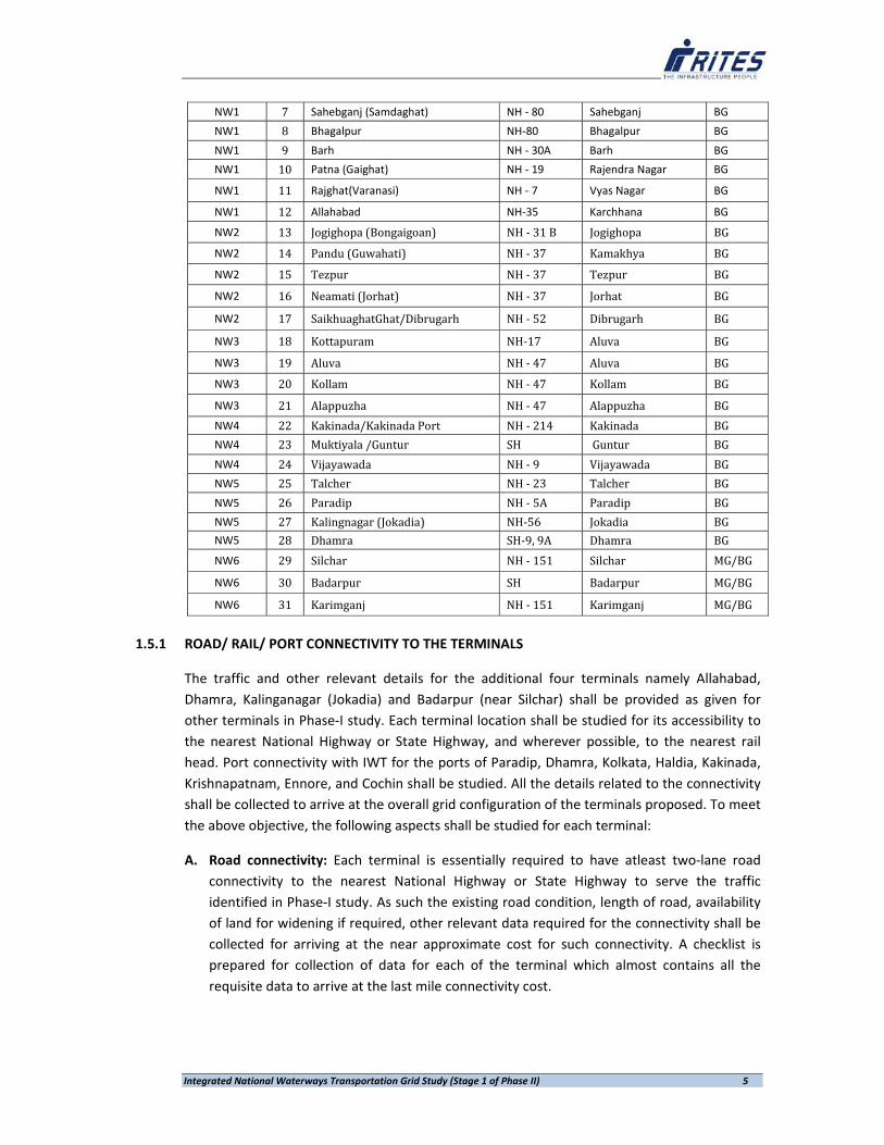
Integrated National Waterways Transportation Grid Study (Stage 1 of Phase II) 5
NW1 7 Sahebganj (Samdaghat) NH ‐ 80 Sahebganj BG
NW1 8 Bhagalpur NH‐80 Bhagalpur BG
NW1 9 Barh NH ‐ 30A Barh BG
NW1 10 Patna (Gaighat) NH ‐ 19 Rajendra Nagar BG
NW1 11 Rajghat(Varanasi) NH ‐ 7 Vyas Nagar BG
NW1 12 Allahabad NH‐35 Karchhana BG
NW2 13 Jogighopa (Bongaigoan) NH ‐ 31 B Jogighopa BG
NW2 14 Pandu (Guwahati) NH ‐ 37 Kamakhya BG
NW2 15 Tezpur NH ‐ 37 Tezpur BG
NW2 16 Neamati (Jorhat) NH ‐ 37 Jorhat BG
NW2 17 SaikhuaghatGhat/Dibrugarh NH ‐ 52 Dibrugarh BG
NW3 18 Kottapuram NH‐17 Aluva BG
NW3 19 Aluva NH ‐ 47 Aluva BG
NW3 20 Kollam NH ‐ 47 Kollam BG
NW3 21 Alappuzha NH ‐ 47 Alappuzha BG NW4 22 Kakinada/Kakinada Port NH ‐ 214 Kakinada BG NW4 23 Muktiyala /Guntur SH Guntur BG NW4 24 Vijayawada NH ‐ 9 Vijayawada BG NW5 25 Talcher NH ‐ 23 Talcher BG NW5 26 Paradip NH ‐ 5A Paradip BG NW5 27 Kalingnagar (Jokadia) NH‐56 Jokadia BG NW5 28 Dhamra SH‐9, 9A Dhamra BG NW6 29 Silchar NH ‐ 151 Silchar MG/BG
NW6 30 Badarpur SH Badarpur MG/BG
NW6 31 Karimganj NH ‐ 151 Karimganj MG/BG
1.5.1 ROAD/ RAIL/ PORT CONNECTIVITY TO THE TERMINALS
The traffic and other relevant details for the additional four terminals namely Allahabad, Dhamra, Kalinganagar (Jokadia) and Badarpur (near Silchar) shall be provided as given for other terminals in Phase‐I study. Each terminal location shall be studied for its accessibility to the nearest National Highway or State Highway, and wherever possible, to the nearest rail head. Port connectivity with IWT for the ports of Paradip, Dhamra, Kolkata, Haldia, Kakinada, Krishnapatnam, Ennore, and Cochin shall be studied. All the details related to the connectivity shall be collected to arrive at the overall grid configuration of the terminals proposed. To meet the above objective, the following aspects shall be studied for each terminal:
A. Road connectivity: Each terminal is essentially required to have atleast two‐lane road connectivity to the nearest National Highway or State Highway to serve the traffic identified in Phase‐I study. As such the existing road condition, length of road, availability of land for widening if required, other relevant data required for the connectivity shall be collected for arriving at the near approximate cost for such connectivity. A checklist is prepared for collection of data for each of the terminal which almost contains all the requisite data to arrive at the last mile connectivity cost.

Integrated National Waterways Transportation Grid Study (Stage 1 of Phase II) 6
B. Rail Connectivity: Wherever feasible, it is planned to connect the terminal to the nearest railhead. To meet this end, the topographic map and the relevant in‐house data shall be utilised by RITES to find the feasibility. If found feasible, the land availability, length of siding required for connectivity, existing facilities available in the nearest railway station etc., shall be collected and reported. The land availability at the proposed terminal for rail operation shall also be considered for the rail connectivity part and additional land required shall be suggested. The cost of railway line including other expenditures like electrification, signalling and telecommunications, number of road crossings, etc., shall be collected to arrive at the block cost estimate for such connectivity. As the rail alignment requires minimum number of curves and other technical considerations, Consultant will propose the overall feasible alignment based on available map/ Google map.
C. Port Connectivity: The IWT terminals having potential link to the nearby ports viz., ports
of Paradip, Dhamra, Kolkata, Haldia, Kakinada, Krishnapatnam, Ennore, and Cochin shall be studied and the Port administrations shall be contacted to finalise the feasible IWT Terminal location and the backup space/ storage yard which can be provided by the port within port boundary. The open and covered storage required in the port premises depends upon the IWT traffic anticipated to be handled through these ports. Other facilities for transhipment etc., required at the terminal shall be finalised after the discussions with the Port authorities concerned. The connectivity to the IWT Terminal location from the port location and extending rail connectivity to the IWT Terminal location etc., shall be studied and block cost estimate prepared for these developments.
D. The data collected for each of these locations shall be used for determining the individual
as well as overall connectivity cost which shall include last mile connectivity also. E. Separate map for each terminal and each port shall be prepared indicating the rail/road/
waterway connectivity along with traffic earlier projected in Phase‐I study F. On compilation of the data so collected, a report shall be prepared and submitted to IWAI.
Further, a presentation on the grid connectivity with last mile connectivity of these terminals shall be provided to the IWAI/ Ministry of Shipping. Any comments on the same shall be reviewed and addressed in a short notice and necessary assistance shall be rendered for further presentation.
G. The final report along with the original checklists and other data inputs collected during
the site visits shall be submitted to IWAI.
1.6 CHAPTERISATION PLAN
This Report comprises six chapters, including this Chapter. Chapter 1 deals with introduction of the study and terms of reference. Chapter 2 brings out the traffic projections/ estimations of proposed National Waterways under study. Chapter 3 describes the criteria adopted for identifying the potential terminal and the assumptions adopted for the study including the methodology adopted to accomplish the assignment. In Chapter 4 each of the identified

Integrated National Waterways Transportation Grid Study (Stage 1 of Phase II) 7
terminals is discussed in detail about the available rail/ road connectivity and the port terminal connectivity. Chapter 5 brings out the proposed phase wise development plan of IWT Terminals including the investment requirement for each phase. Conclusions and Recommendations are highlighted in Chapter 6.

. Chapter ‐2 Traffic Estimates and Projections
Integrated National Waterways Transportation Grid Study (Stage 1 of Phase II) 8
CHAPTER – 2
TRAFFIC ESTIMATION AND PROJECTION
2.0 Introduction
All the National Waterways were studied independently by different technical/expert groups during different periods of time, adopting different approaches, to assess their technical and financial viability before declaring different stretches as National waterways. To overcome time variations of the studies as well as to update the traffic estimates RITES commenced with literature survey that involved close scrutiny of secondary information available from different Reports and documents and brought out various locations identified by different research teams on different waterways that formed basis for declaration of these waterways as the National Waterways. As indicated earlier, different waterways were studied by various agencies assigned by the IWAI during different periods of time, thereby, base year traffic, inter‐modal costs as well as traffic projection period given in the Reports are different. Moreover, to arrive at infrastructural development cost and traffic estimation, different agencies have adopted different approach. In each of these Reports, commodity wise volumes of divertible traffic to proposed Inland Water Transport, different horizon years have been given. Since, information provided by the different expert agencies pertained to different base years for traffic estimation, projection period and inter‐modal costs the Consultants have taken appropriate steps to up‐date traffic flows to base year of current study (2011‐12) and reconfirm/re‐estimate traffic projections. For up‐dation of commodity wise traffic estimates covering primary hinterland of each waterway, actual rail flow data for 2011‐12 have used, whereas for road sector, road flow estimates for 2007‐08 given in Total Transport System Study (TTSS) conducted by RITES on behalf of Planning Commission have been brought to 2011‐12 levels by applying appropriate raising factors. For developing entire grid connectivity with all the planned infrastructure facilities at the identified IWT terminal locations, it is expected that a seven year period shall be required. The development activities are planned to be taken up in two phases. The implementation schedule proposed for activities under Phase‐I and Phase‐ II are attached in the report. On completion of activities planned under Phase‐I, commencement of operation is expected to start from the Year 2017‐18 and similarly that of Phase‐II from the year 2022‐23. In view of the fact that all the past IWT studies were carried out with specific objectives, representing specified waterway system, therefore no national waterway systems grid was envisaged. In the study under Phase‐I, an attempt has been made to establish Total Transport System Grid in which Rail, Road and IWT form a part.

Integrated National Waterways Transportation Grid Study (Stage 1 of Phase II) 9
2.1 National Waterways 1, Ganga‐ Bhagirthi‐ Hoogly river system passes through the states of
Uttar Pradesh, Bihar, Jharkhand and West Bengal, a distance of about 1620 km, serving nearly 42 traffic regions, between Allahabad and Haldia (Sagar). Major Ports such as; Haldia and Kolkata and important cities like; Kolkata, Patna, Varanasi and Allahabad fall under its primary hinterland. The river system serves richly endowed natural reserve areas as well as a large number of industrial units comprising Thermal Power Plants, Iron & Steel Plant, Sugar Mills, Cement Industry, Small Scale Industries etc.
2.2 River Brahmaputra between Dhubri and Sadiya over a length of about 891 km was declared as
NW‐2 in 1988. It serves the states of Assam, Meghalaya and Arunachal Pradesh covering about 37 traffic regions. Because of its connectivity with National Waterway 1 through protocol route via Bangladesh its catchment area is extended up‐to the state of West Bengal, thereby establishing its connectivity with Haldia and Kolkata ports. An Indo‐Bangladesh Protocol on Inland Water Transit & Trade exists between India and Bangladesh under which inland vessels of one country can transit through the specified routes of the other country. The existing protocol routes are: Kolkata‐Silghat‐Kolkata, Kolkata‐Karimganj‐Kolkata, Rajshahi‐Dhulian‐Rajshahi, and Silghat‐Karimganj‐Pandu. For inter‐country trade, five ports of call have been designated in each country, namely; India – Haldia (West Bengal), Kolkata (West Bengal), Pandu (Assam), Karimganj (Assam) and Silghat (Assam) and Bangladesh ‐ Narayanganj, Khulna, Mongla, Sirajganj and Ashuganj.
2.3 National Waterway‐3 (NW‐3) comprises West Coast Canal from Kottapuram to Kollam with Udyogmandal and Champakara Canals and extends over a distance of 205 km, in the state of Kerala. It has no connectivity with any other declared national waterway systems of the country. The waterway is directly linked to Cochin Port, therefore it can offer cost effective solution in handling foreign trade through the said port.
2.4 National Waterway 4 (NW‐4) comprises Kakinada‐Puducherry Canal System integrated with Rivers Godavari and Krishna. NW‐4 can offer cost effective IWT services over a distance of about 1078 km covering states of Andhra Pradesh, Tamil Nadu and Union Territory of Puducherry. All the civil districts (19) falling along the considered river systems are covered under the primary hinterland. NW4 offers connectivity to intermediate‐ports like; Kakinada, Machilipatnam, Krishnapatnam and major port as Chennai and Ennore as well as it serves important cities like; Chennai, Rajahmundry, Vijayawada, etc. Although it does not provide linkage to any other declared national waterways, it can supplement other modes of transport by serving high transport demand corridors.
2.5 National Waterway 5 (NW‐5) in the states of Odisha and West Bengal, extends from Talcher to Paradip Port and Dhamra Port, areas richly endowed with natural reserves on the one end and country’s major port on the other. It includes East Coast Canal with River Brahmani and River Mahanadi’s delta (623 km). By developing Hijili tidal waterway systems, IWT services on NW‐5 can offer connectivity up to Haldia that can result in extension of services up to Allahabad (Uttar Pradesh) on NW1, up to Sadiya (Assam) on NW2 and up to Lakhipur (Assam)
Integrated National Waterways Transportation Grid Study (Stage 1 of Phase II) 10
on NW6. The corridor is likely to contribute movement of coal & other ores to thermal plants, fertilizers plants etc.
2.6 A stretch of river Barak between Lakhipur and Bhanga (121 km) is under consideration for declaration as Sixth National Waterway (NW‐6). Like NW‐2, NW‐6 is also connected to Kolkata and Haldia and other IWT terminals in NW 1 via protocol route and further to NW 5. Although declared river stretch falls in the state of Assam, because of distance advantage offered by the proposed waterways (using protocol route) between rest of India and some of the Eastern States like Tripura, Mizoram and Manipur, its catchment area has been expanded.
2.7 Eastern Grid: Although, all the declared waterway systems cannot be joined to form a national
waterway grid, four out of the six national waterways can form a grid in the Eastern Region of the country i.e. NW‐1 can be connected to NW‐2 and NW‐6 using protocol route through Bangladesh. Similarly, NW5 that extends up to Paradip Port can also be joined in the National Waterway grid through backwaters of Hooghly and Hijili tidal canal. Connectivity would further increase the area of influence of each designated waterway system. This may be called Eastern Waterway Grid. Proposed Eastern Waterways Grid involves overall rivers length of 3220 km (excluding Indo‐Bangladesh Protocol Route of 1665 km). Grid is likely to serves 11 states namely; Uttar Pradesh, Bihar, Jharkhand, West Bengal, Assam, Meghalaya, Arunachal Pradesh, Tripura, Mizoram, Manipur and Odisha serving 108 civil districts. The highlights of Eastern Grid can be summarised as under: Total Eastern Grid Length : 4885 km (Including protocol route 1665 km) States served : Uttar Pradesh, Bihar, Jharkhand, West Bengal, Assam,
. Arunachal Pradesh, Tripura, Mizoram, Manipur, Odisha Civil districts covered : 108 Important Commodities : Coal, Iron & Steel, Ores, Food Grains, Fertilizers, Jute and
Cotton, Cement & Over Dimensional Cargo Longest Route : Allahabad to Sadiya (Nearly 3800km including Protocol Route)
The divertible traffic expected to be handled through the Eastern Grid is of the order of 97MTPA by year 2021‐22 and 192 MTPA by the year 2031‐32. In the Eastern Grid alone, 24 terminals out of total 31 terminals planned are located.
2.8 National Inter‐Modal Grid: In the light of this, to offer cost effective transport solution at the national level, it is important to develop optimum inter‐modal mix, wherein IWT is also a part. To avail entire benefits of different modes, each mode should play a complimentary role. In the current study an attempt has been made to link indentified potential IWT terminal/locations with national rail and road network, to prepare inter‐modal national transport grid. In the case of rail, nearest railheads have been identified and for road, connectivity up to the nearest National or State Highways have been established.

Integrated National Waterways Transportation Grid Study (Stage 1 of Phase II) 11
National Inter‐modal Grid, comprising rail, road and IWT (covering six declared National Waterways) spread over a total length of 4503 km is likely to serves 14 states and 137 civil districts under the primary hinterland. In view of the fact that no regular IWT services are operated on the identified corridors (National Waterways) as well as study assigned is limited to secondary data, to arrive at 2011‐12 levels of IWT potential traffic, Consultants have adopted a set of IWT operating assumptions, such as;
Fairways, navigation channel/depths (constant water draft of 2.0 to 2.5 meters and navigational aids maintained by IWAI
Indo‐Bangladesh Protocol route would be maintained. To meet future demand list of permissible locations for handling traffic may be enhanced.
All IWT terminals are connected to the national rail and road network. No procedural delays towards obtaining approvals and clearances from various
government authorities have been considered. One year period is earmarked for such sanctions.
There are no corridor capacity constraints in either modes of transport. IWT would offer cost effective transport services, in comparison to other modes. If economical, potential agencies would utilize IWT corridors.
Similarly, there are factors affecting inter‐modal shift (level of diversion) in favour of IWT
Type of commodity and volumes (Bulk/Break Bulk/Container/Perishable) Long Term & firm commitment of traffic Actual place of origin / destination within the region Existing modal choice Port – IWT connectivity Empty return ratio/return load to IWT Deep sea transhipment, wherever feasible (avoiding berthing / port charges / costs)
Comparative intermodal costs are one of the visible decision making tools for the users. Intermodal comparative costs given in “Report of the Inter – Ministerial Committee to Identify New Areas of Private Investment in the Inland waterways Transport (IWT) Sector” Planning Commission, (Transport Division), 30th November 2012, overall advantage of IWT vis‐à‐vis other modes have been worked out. In the current exercise, to encourage and promote dependence on IWT services tax exemption has been considered. Comparative inter modal costs Rs/TKm considered are given as under:
Mode Freight (Rs/TKm) Taxes Total Rs/TKm Railways * 1.36 3.71% 1.41
Highways** 2.50 3.09% 2.58
IWT 1.06 Nil 1.06Source: Railways‐ Ministry of Railways, Road‐ TTSS, IWT – IWAI* Service Tax on rail transport is 12.36% abatement is 70%.
** Service Tax on Road transport is 12.36% abatement is 75%.

Integrated National Waterways Transportation Grid Study (Stage 1 of Phase II) 12
2.9 Computation of Savings: IWT is the cost effective mode of transport and offers least vehicle
operating cost/ charges as compared to Rail and Road. The level of advantage offered by IWT is much higher when compared with road than that of rail, but corresponding advantage goes adverse when terminal costs involved in the case of IWT also forms cost of comparison. Based on chargeable rates in the case of Rail and vehicle operating cost / freight for Road, (Refer above Table), overall advantage per tonne‐km movement by IWT have been estimated. It is pertinent to mention that while working out vehicle operating costs of road transport, relevant empty haulage on the corridors under study have been accounted for. Similarly, IWT costs are also worked out on round trip basis. Based on data collected on similar studies conducted by RITES, and keeping in view the level of diversion from rail and road to IWT, an average savings in overall movement of cargo has been established. On an average IWT is able to offer savings of about 0.19 per tonne‐km. In the current exercise, normal variation in savings as different OD pairs have been observed on the foregoing method.
2.10 Traffic Projections: Based on the secondary information collected from Railways and Highways, commodity wise base year (2011‐12) inter‐regional goods flows have been generated. Since short lead traffic (below 100 km of trip length) which is not expected to affect proposed IWT services and commodities like; POL products, are kept beyond the purview of traffic estimates. Total potential inter‐regional goods flow estimated (2011‐12) on national waterways understudy worked out to 155.853 million tonnes. Using commodity wise base year inter‐regional flows, traffic divertible to proposed IWT services have been estimated. In view of the fact that proposed IWT services are more or less likely to be introduced afresh, under different assumptions, three scenario approach have been adopted, i.e. optimistic, most likely and pessimistic. Base year divertible traffic estimated under most likely scenario worked out to 142.46 million tonnes on all the six National Waterways whereas for National Waterways proposed to be a part of the Eastern Waterways Grid, total divertible traffic is estimated as 83.15 million tonnes. To estimate future volumes of cargo between different pairs of points on proposed National waterways, appropriate raising factors have been applied on Base year divertible traffic. For railways, past growth trend formed basis to work out raising multipliers, whereas for road sector traffic, raising factors recommended in 12th Five Year Plan have been used.
Under most likely scenario divertible traffic estimated for the years 2018‐19 and 2031‐32 worked out to 159 million tonnes and 332.60 million tonnes on all the six National Waterways as against 97.20 million tonnes and 192.00 million tonnes worked out for Eastern Waterways Grid, respectively.
2.11 IWT Terminals: With a view to handle estimated terminal year’s traffic on all the six National Waterways, potential IWT Terminals have been identified at 27 locations and requisite facilities have been proposed initially. However, based on deliberations with State

Integrated National Waterways Transportation Grid Study (Stage 1 of Phase II) 13
Governments, stakeholders and other secondary hinterland considerations, the necessity arose to add 4 more terminals namely Kalinganagar, Dhamra, Allahabad and Badarpur in the list thereby it is proposed with 31 locations for IWT terminal development. As revealed from past studies many of the existing IWT terminals are of semi permanent type (Floating Pontoon with gangway) with manual handling. To handle bulk cargo viz., coal, limestone, building material, cement, etc. RCC terminal with mechanical material handling facilities like conveyors, mobile cranes etc shall be required. Further, for handling bulk cargo at port connectivity (IWT‐ Major Port) locations, requirement of Trans‐shippers have been assessed and proposed. Overall IWT Terminal Development costs involved; (i) Rail Connectivity cost (BG), (ii) Road Connectivity Costs (2‐Lane), (iii) Warehousing facilities, (iv) Berth development costs and (v) Cargo handling facilities. To handle 2.5 to 3 million tons of cargo, including belt conveyor the terminals development cost and other costs were prepared on normative basis in Phase‐I study. The more realistic estimate costs were prepared under this study based on field visit and collection of extensive data on connectivity to the proposed 31 locations. Port connectivity also requires adequate support from concerned agencies for successful implementation of the proposed scheme. In view of this the Government has laid emphasis on the creation of port infrastructure to handle the cargo and its smooth evacuation. Unless matched with connectivity infrastructure, the increased cargo would result in congestion and undermine the competitiveness of Indian industry at large. The best and economical way of evacuation of imported traffic at port is by Inland Water Transport mode using barges. Similarly, the inbound traffic to the port, i.e., export oriented cargo can also reach the sea port from its hinterland by barges using waterway mode. It is important to add that all the waterways under study have direct access to one or more of the India’s major ports. On the one hand NW‐1 has common route with Kolkata and Haldia ports, NW‐2 and NW‐6 are connected to these ports by using protocol route through Bangladesh. Similarly NW‐3 covers Cochin Port, NW‐4 has established connectivity with Kakinada, Krishnapatnam, Chennai and Ennore Ports and NW‐5 has connected to Dhamra and Paradip ports. Since all major ports act as an independent traffic generating hub, quantities and type of incoming and outgoing traffic dealt with at these ports plays an important role to boost IWT services. National Waterway’s connectivity to the existing Sea Port has been examined based on available National Hydrographic Charts and on‐line satellite imageries apart from visit to these ports. Prevailing port tariffs relevant to the identified IWT cargo have been collected from the respective ports for transshipment to IWT vessels. The loading / unloading of bulk cargo like coal and iron ore can be organized in two ways as stated below:
I. Using transhipper directly from the mother vessel anchored offshore and II. Through the existing ports like Haldia, Kolkata, Paradip, Dhamra, Kochi, Kakinada,
Krishnapatnam, Ennore

Integrated National Waterways Transportation Grid Study (Stage 1 of Phase II) 14
Evacuation of traffic through the existing ports, finger jetties as proposed in the report are required to be provided at all the waterway connected ports for transhipment of the traffic from sea vessel to the IWT barges. The traffic estimated for this study pertains to primary hinterland of each terminal, the traffic volumes are likely to improve when traffic contribution from adjoining regions (which are not recommended under priority) is also considered. It is also to be submitted that, IWT being cost effective mode of transport is expected to generate sizeable volume of induced traffic, which also was kept beyond the purview of the current study, would effect in increase of terminal capacity utilization resulting in to higher rate of return on capital investment. On providing required infrastructure facilities to attract IWT traffic on all proposed Waterways, private sector investment of Rs. 65, 599 crores have been envisaged in terms of providing required number of vessels and to meet regular operation and maintenance costs thereof, to handle estimated traffic volumes. Based on Feasibility Studies followed by Detailed Project Reports (DPR) various waterway stretches of different rivers were declared as National waterways by the Inland Waterways Authority of India (IWAI). As indicated in earlier chapter, five waterway stretches have already been declared as National Waterways, whereas sixth i.e., Barak River between Lakhipur and Bhanga in Assam is in the process for declaration as National Waterway‐6. IWT terminals identified in earlier studies pertained mainly to a particular location of transport demand and not to a region, as considered in the current study, thereby there may be more than one IWT terminal within a district (coterminous with traffic region considered in the current exercise).Important findings and recommendations of various study groups are considered in firming up the traffic estimates and projections.
2.12 NATIONAL WATERWAY‐ 1 National Waterway 1 from Haldia (Sagar) to Allahabad (1620 km) covers states of Uttar Pradesh, Bihar, Jharkhand and West Bengal. The report “Navigability of the National Waterway between Allahabad and Haldia” was prepared by Dutch Mission in 1983. It was declared as a National Waterway during October 1986. It is one of the most important waterways navigable by mechanical boats up to Patna.
Potential traffic locations/regions, important commodities of interest for IWT, proposed nearest location on the river bank, and approximate distance between actual place of origin of the commodity and proposed IWT terminal identified in the study are given in Table 2.1
Table 2.1: Traffic Generating Regions and the Proposed Nearest Location
SN Origin & Nature of Cargo Nearest Terminal Distance (Km.) 1 Haldia ( Coal) Kolaghat 60 2 Sagardighi ( Coal) River front 18 3 Pakur ( stone) Pakur Terminal 12

Integrated National Waterways Transportation Grid Study (Stage 1 of Phase II) 15
With a view to handle estimated traffic at different IWT terminals, terminals of varying capacities were recommended. Current capacities of identified terminals, such as; land area, berth size, type of terminal/Jetty and broadly areas of command are given below in Table 2.2. As indicated by IWAI, on the entire route (between Allahabad and Haldia) there are 18 IWT Terminals with Floating jetties and 2 with Fixed RCC Jetty.
Table 2.2: Capacities of Identified Terminals
4 Barauni ( Fertilizer, POL) Semaria 15 5 Semaria ( Coal) Barauni 15 6 Patna ( coal) Muzzafarpur 60 7 Patna ( coal) Nabinagar 150 8 Phulpur ( Fertilizer) Allahabad 50 9 Chunar ( coal) Rihand 135 10 Chunar ( coal) Vindyachal/Singrauli 135 11 Chunar ( coal) Renusagar/Anpara 112 12 Chunar ( coal) Obra 67 13 Robertsganj/churk/Dala ( Cement) Chunar 67 14 Rewa ( Cement) Allahabad 119 15 Satna ( Cement) Allahabad 166 16 Sidhi ( Cement) Allahabad 211 17 Jagdishpur ( Fertilizer) Allahabad/Varanasi 138/187 18 Shahjahanpur ( Fertilizer) Allahabad/Varanasi 380/429 19 Raniganj Coalfield Shantipur 205
SN Name of Terminal Land area Berth Size Type of terminal District Served1 Haldia 10319 Sq m 200 m Floating Haldia
2 Botanical Garden Jetty
996 Sq m 50 m Floating Haora
3 BISN Jetty 11606.64 Sq m 100 m Floating Haldia Port4 G.R.Jetty– 2 (Kolkata) 14606 Sq m 216 m Fixed RCC Jetty Kolkata
5 Shantipur 8000 Sq m 100 m Floating Shantipur6 Katoya/Katwa Pontoon on water front 30 m Floating Katwa/Pakur
7 Hazardwari Pontoon on water front 30 m Floating Murshidabad,8 Farakka 4800 Sq m 80 m Floating + Fixed
RCC Jetty Farakka Side
9 Rajmahal Pontoon on water front 35 m Floating Sahib Ganj, Jharkhand
10 Sahebganj Pontoon on water front 35 m Floating Sahib Ganj, Jharkhand
11 Bateshwarsthan Pontoon on water front 35 m Floating BhagalPur , Bihar12 Bhagalpur 10000 Sq. m 35 m Floating BhagalPur , Bihar13 Munger 3.4 Acre 35 m Floating Munger, Bihar14 Semaria Pontoon on water front 35 m Floating Semaria, Bihar,
Arraherhampur 15 Barh ‐ 27 m Floating Barh, Bihar, Bihar
Sharif 16 Patna ( Gaighat) 3.24 Acre 46.6 m Fixed RCC Jetty Patna, Bihar
17 Buxar Pontoon on water front 35 m Floating Buxar, Bihar, Bhojpur,Bihar
18 Ghazipur Pontoon on water front 35 m Floating Ghazipur , UP, Ballia

Integrated National Waterways Transportation Grid Study (Stage 1 of Phase II) 16
2.12.1 Commodity Composition
Based on traffic studies conducted by the research group (The Dutch Mission) entire range of commodities germane to IWT services on the said corridor, 11 cargo groups were formed with common handling & storage requirements. For example; coal, stone and fly ash are products that require same type of handling in terms of transhipment and storage and can therefore be handled at the same terminal. The same is applied for kerosene and POL. Raw jute, jute textile, food grains and sugar are cargoes that also have certain features in common. These types of cargoes are transported in sacks or bales and can be offloaded with same type of machinery. These cargoes are valuable and arrangements must be made for their storage in locked warehouses. Important commodities identified were; Coal, Fertilizers, Stone, Fly ash, POL+ Kerosene, Raw jute, jute textile, Food grains, Sugar, Iron & Steel products and Salt.
2.12.2 IWT TERMINALS: Haldia – Kolkata Section
Terminal at Haldia
One of the important IWT terminals identified was at Haldia. Based on both domestic and EXIM traffic demand, potential commodities recommended for proposed IWT services were; Fertilisers, POL & Kerosene, Raw Jute, Jute textiles, Food grains & Sugar, and Salt. Originating commodities estimated for the year 1991 are summarised in Table 2.3.
Table 2.3: Cargo forecast carried out by Dutch Mission on year 1991 (‘000 tonnes)
Terminal at Kolkata
Kolkata is an old port with extensive harbour facilities. Transshipment takes place mainly in the docks. Because of its locational advantage, CIWTC has two terminals on Hooghly River, near Howrah Bridge. The study team described Kolkata as the most important port for inland shipping, estimated to handle about one million ton (on 1991 year basis) of cargo annually. Important cargoes identified and their traffic contribution, separately for incoming and outgoing are given Table 2.4.
Table‐ 2.4: Important Commodities at Kolkata Terminal (in ‘000 ton)
19 Rajgat(Varanasi) Pontoon on water front 35 m Floating Varanasi, UP
20 Allahabad 8.759 Hectare 35 m Floating Allahabad, Mirzapur,Chaundali
SN Cargo Loading/Originating
Unloading/ Terminating
1 Fertilizer 209
2 POL + Kerosene 395 145 3 Raw Jute, Jute textiles, Food grains, Sugar& Salt 168
SN Cargo Originating Terminating 1 Fertilizer 82 2 Stone + Fly ash 112 3 POL + Kerosene 136 372 4 Raw Jute, Jute textiles, Food grains and Sugar 55 29 5 Iron + Steel products 58 6 Salt 95 17
Integrated National Waterways Transportation Grid Study (Stage 1 of Phase II) 17
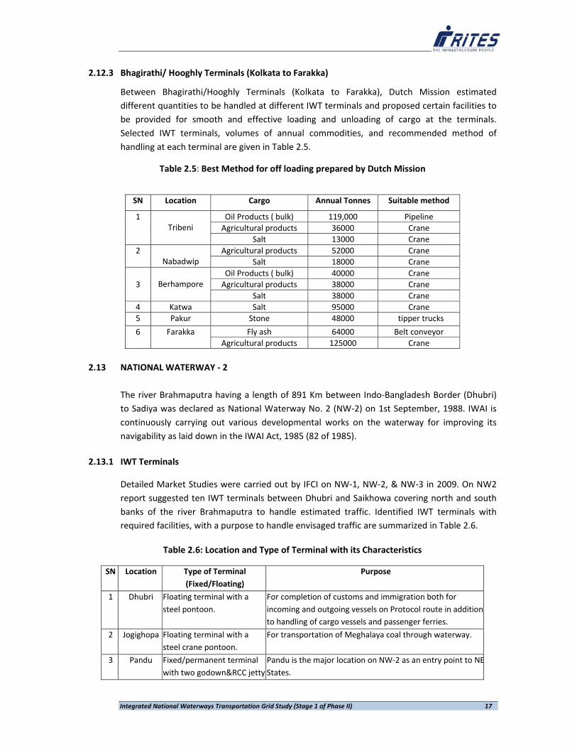
2.12.3 Bhagirathi/ Hooghly Terminals (Kolkata to Farakka)
Between Bhagirathi/Hooghly Terminals (Kolkata to Farakka), Dutch Mission estimated different quantities to be handled at different IWT terminals and proposed certain facilities to be provided for smooth and effective loading and unloading of cargo at the terminals. Selected IWT terminals, volumes of annual commodities, and recommended method of handling at each terminal are given in Table 2.5.
Table 2.5: Best Method for off loading prepared by Dutch Mission
2.13 NATIONAL WATERWAY ‐ 2
The river Brahmaputra having a length of 891 Km between Indo‐Bangladesh Border (Dhubri) to Sadiya was declared as National Waterway No. 2 (NW‐2) on 1st September, 1988. IWAI is continuously carrying out various developmental works on the waterway for improving its navigability as laid down in the IWAI Act, 1985 (82 of 1985).
2.13.1 IWT Terminals
Detailed Market Studies were carried out by IFCI on NW‐1, NW‐2, & NW‐3 in 2009. On NW2 report suggested ten IWT terminals between Dhubri and Saikhowa covering north and south banks of the river Brahmaputra to handle estimated traffic. Identified IWT terminals with required facilities, with a purpose to handle envisaged traffic are summarized in Table 2.6.
Table 2.6: Location and Type of Terminal with its Characteristics
SN Location Cargo Annual Tonnes Suitable method
1 Tribeni
Oil Products ( bulk) 119,000 Pipeline Agricultural products 36000 Crane
Salt 13000 Crane 2
Nabadwip Agricultural products 52000 Crane
Salt 18000 Crane
3
Berhampore Oil Products ( bulk) 40000 Crane Agricultural products 38000 Crane
Salt 38000 Crane 4 Katwa Salt 95000 Crane 5 Pakur Stone 48000 tipper trucks
6 Farakka Fly ash 64000 Belt conveyor Agricultural products 125000 Crane
SN Location Type of Terminal(Fixed/Floating)
Purpose
1 Dhubri Floating terminal with a steel pontoon.
For completion of customs and immigration both for incoming and outgoing vessels on Protocol route in addition to handling of cargo vessels and passenger ferries.
2 Jogighopa Floating terminal with a steel crane pontoon.
For transportation of Meghalaya coal through waterway.
3 Pandu Fixed/permanent terminal with two godown&RCC jetty
Pandu is the major location on NW‐2 as an entry point to NEStates.

Integrated National Waterways Transportation Grid Study (Stage 1 of Phase II) 18
2.13.2 Cargo Potential on NW 2
Market Study carried out by IFCI on National Waterway No.2 for IWAI in September 2009 identified potential cargo movement on the stretch under reference, including traffic to and from Kolkata and Haldia to Assam using Indo‐Bangladesh Protocol route. Important locations identified in the Report and nature of cargo anticipated to be handled thereat at, duly indicating distance between IWT terminal location and place of actual origin/destination of cargo are given in Table 2.7.
Table 2.7: Origination and Nature of Cargo and its Nearest Terminal
As per the report, around 900 tonnes of coal is transported daily from Jogighopa to Kolkata. Further, there is potential for transporting around 1,50,000 tonnes of coal per annum from Jogighopa to Kolkata through NW‐2. Jogighopa is proposed as a major coal trans‐shipment hub apart from transporting other cargo like Jute, Cement, etc. The Report projected traffic volumes on NW2 in terms of tone‐km up to 2024‐25, as given in Table 2.8.
4 Tezpur Floating terminal with a steel crane pontoon.
For handling of cargo vessels, local ferry service. ODC cargo is also expected at this terminal in view of upcoming hydro power project.
5 Silghat Floating terminal with a steel pontoon.
For movement of POL of Numaligarh Refinery.
6 Neamati Floating terminal with a crane pontoon
For handling of cargo vessels, local ferry service. ODC cargo is also expected at this terminal in view of upcoming hydro power project.
7 Dibrugarh Floating terminal with a steel pontoon
For handling of cargo vessels, local ferry service. ODC cargo is also expected at this terminal in view of upcoming hydro power project.
8 Sengajan/ Panbari
Floating terminal with a crane pontoon
Considered in view of regular movement of Indian army IWTfleet.
9 Sadiya Floating terminal with steel pontoon
To facilitate potential movement of related cargo/ODC for the upcoming hydro power projects in Arunachal.
10 Saikhowa Floating terminal with steel pontoon
To facilitate potential movement of related cargo/ODC for the upcoming hydro power projects in Arunachal.
SN Origin & Nature of Cargo Nearest Terminal Location
Distance (Km)
1 Bongaigaon ( POL) Joghighopa 30
2 Meghalaya Coalfield ( Coal) Pandu 120 3 Numaligrah ( POL) Silghat 80
4 Bokajan ( Cement) Neamati 30
5 Digboi (POL) Dibrugrah 75
6 Margherita Dibrugrah 100
7 Oaklands ( Tea Gardens) Dibrugrah 25

Integrated National Waterways Transportation Grid Study (Stage 1 of Phase II) 19
Table 2.8: Cargo Potential Identified under NW 2
2.14 NATIONAL WATERWAY ‐ 3
The West Coast Canal (Kottapuram ‐ Kollam), Udyogmandal canal (Kochi‐Pathalam bridge) and Champakara canal (Kochi ‐ Ambalamugal) located in Kerala runs from Kollam to Kottapuram was declared a National Waterway in 1993. It is the first National Waterway in the country with 24 hour navigation facilities along the entire stretch. Length of waterway stretch contributed by each canal is summarized below:
Ten IWT terminal locations have been provided all along the waterways to handle traffic. One more is under construction and another two are in planning stage. Important locations, land area available, size of berth and storage capacity (both covered and open) offered at each IWT terminal is given in Table 2.9.
Table 2.9: IWT Terminals along NW3
Year Cargo ( in billion tonne km)
2011‐12 1.2302016‐17 2.373
2021‐22 4.7302024‐25 4.871
West coast canal (Kottapuram ‐ Kollam) 168 km Udyogmandal canal (Kochi ‐ Pathalam bridge) 23 km Champakara canal (Kochi ‐ Ambalamugal) 14 km
Total 205 km
SN Name of Terminal Land area(Ha) Length of berth Storage Capacity 1 Kottapuram 0.5823 30 m 200 sqm covered godown and
400 sqm open storage 2 Aluva 1.331 30 m 200 sqm covered godown and
400 sqm open storage 3 Maradu 2.0268 30 m 200 sqm covered godown and
400 sqm open storage 4 Vaikom 0.5184 30 m 200 sqm covered godown and
400 sqm open storage 5 Thannermukkom 0.917 30 m 200 sqm covered godown and
400 sqm open storage 6 Thrikunnappuzha 0.5057 30 m 200 sqm covered godown and
400 sqm open storage 7 Kayamkulam 1.6304 30 m 200 sqm covered godown and
400 sqm open storage 8 Kollam 0.6208 30 m 200 sqm covered godown and
400 sqm open storage 9 Bolghatty 0.8000 Ro‐Ro/Lo‐Lo
service Container terminal
10 Willingdon Island 0.5000 Ro‐Ro/Lo‐service
Container terminal
11 Alappuzha 2.2277 ‐ Under Construction 12 SEZ (Kakkanad) 1.2234 Planned 13 Chavara 0.8061 Planned

Integrated National Waterways Transportation Grid Study (Stage 1 of Phase II) 20
Important commodities identified at selected locations on National Waterway 3 and distance upto the IWT is given in Table 2.10.
Table 2.10: Originating and Nature of Cargo and its Nearest Terminal
2.15 NATIONAL WATERWAY ‐4
M/s WAPCOS carried out DPR for development of National Waterway 4, falling in the States of Andhra Pradesh (888 Km), Tamil Nadu (188 Km) and Union Territory of Pondicherry (2 Km). This National Waterway is consists of Kakinada‐ Puducherry canals with Godavari and Krishna rivers. Overall length of National Waterway (NW) is 1078 km. Lengths of different stretches comprising NW4 are as under:
Godavari river from Bhadrachalam to Rajahmundry – 171 km
Krishna river from Wazirabad to Vijayawada‐157 km
Kakinada canal from Kakinada to Rajahmundry‐50 km
Eluru canal from Rajahmundry to Vijayawada‐139 km
Commamur canal from Vijayawada to Peddaganjam lock‐113 km
North Buckingam canal from Peddaganjam lock to Chennai‐340 km
South Buckingham canal from Chennai to Mercanum‐ 103 km; and
Kaluvelli tank from Mercanum to Puducherry‐22 km
Based on traffic demand, important IWT terminals identified by the expert team, along the waterway stretches are given in Table 2.11.
Table 2.11: Proposed Terminals for Cargo Potential
SN Origin & Nature of Cargo Nearest Terminal Location
Distance (Km)
1 Tatapuram/Kochi port area ( POL) Edapallikota 131
2 Kochi ( Furnace Oil) Kottayam ( TCL) 70
3 Kochi ( Phosphoric acid, Sulpher) Ambalamugal FACT 24
4 Kochi ( Zinc, Concentric acid, Sulpher)
Udyogmandal (Binani Zinc Ltd.)
23.5
5 Kochi Main land( water) Vypin, Varapuzha& other islands
6.5/12
6 FACT ( Udyogmandal) Ambalamughal FACT 40
7 Muvattupuzha ( Cement) Kochi 50
8 Kottayam ( Cement) Kochi 70
9 Alapuzha ( Coir products) Kochi 62
10 Chavara ( Rare earth) Kochi 136
Proposed Terminals
Kakinada, Rajamundry, Bhadrachalam, Eluru, Kottapatnam
Maipadu, Durgarajapatnam, Muktiyala, Ennore ( South), Mutthukadu
Marakanam,Puducherry, Wazirabad,Vijayawada&Tadepaligudam

Integrated National Waterways Transportation Grid Study (Stage 1 of Phase II) 21
Important commodities identified at various locations and their respective destination or demand points, along with IWT distance involved from origin to destination are given in Table 2.12
Table 2.12: Originating and Nature of Cargo and its Nearest Terminal
The Study also projected commodity wise traffic up‐to 2059‐60. Coal continued to be the major commodity of interest for IWT services followed by rice. For the year 2014‐15 the traffic estimated was to the level of 2.82 million tones that increased to 20.55 million tonnes by the year 2059‐60. Commodity wise traffic projections are given in Table 2.13.
Table 2.13: Cargo Potential along NW 4 (‘000 T)
M/s WAPCOS identified important commodities likely to be handled at Kakinada IWT terminal in the 2014‐15 and their existing mode of transport are given in Table 2.14.
Table 2.14: Kakinada Terminal (’000 Tonnes)
SN Origin Destination Commodity 1 Bhadrachalam Vijayawada Coal
2 Bhadrachalam Krishnapatnam Coal3 Kakinada Vijayawada Fertilizers4 Kakinada Maipadu Fertilizers5 Tadepallegudam Kakinada Food grains6 Tadepallegudam Krishnapatnam Food grains
7 Tadepallegudam Chennai Food grains8 Vijayawada Chennai Cement
SN Cargo 2014‐15 2019‐20 2024‐25 2029‐30 2034‐35 2039‐40 2059‐60
1 Coal 1441 2274 3197 4224 4476 4755 6189
2 Rice 516 898 1388 2011 2331 2703 4881
3 Food grains 177 309 477 691 801 929 1678
4 Cement 309 501 763 928 1129 2473
5 Fertilizers 282 409 569 770 892 1035 1869
6 Forest Products 114 185 282 411 501 609 1334
7 Salt 91 139 202 287 349 425 931
8 General Cargo 196 324 477 658 727 802 1192
Total Cargo Potential 2818 4846 7093 9816 11006 12386 20547
Total (Million tonnes) 2.82 4.85 7.09 9.82 11.01 12.39 20.55
SN Cargo Import Export Existing Mode of Transport
1 Coal 19 Train/Road
2 Rice & Foodgrains 2 48 Train/Road 3 Fertilizers 20 243 Train/Road
4 Forest Products 16 Train/Road
Total 70 367

Integrated National Waterways Transportation Grid Study (Stage 1 of Phase II) 22
Similarly important commodities likely to be handled at Vijayawada, Muktiyala, Bhadrachalam, Wazirabad and Chennai / Ennore IWT terminals in the 2014‐15 and their existing mode of transport are given in Table 2.15, 2.16, 2.17, 2.18, & 2.19 respectively.
Table 2.15: Vijayawada Terminal (’000 Tonnes)
Table 2.16: Muktiyala Terminal (’000 Tonnes)
Table 2.17: Bhadrachalam Terminal (’000 Tonnes)
Table 2.18: Wazirabad Terminal (’000 Tonnes)
SN Cargo Import Export Existing Mode of Transport
1 Coal 492 Road
2 Rice &Food grains 60 61 Road3 Fertilizers 56 Road
4 Forest Products 16 Road
5 Other General Cargo 49 RoadTotal 613 110
SN Cargo Import Export Existing Mode of Transport
1 Coal 374 Road2 Rice &Food grains 4 44 Road3 Fertilizers 26 Road
4 Forest Products 16 Road
5 Other General Cargo 49 Road
Total 405 45
SN Cargo Import Export Existing Mode of Transport
1 Coal 1441 Road
2 Rice &Food grains 37 201 Road3 Fertilizers 34 Road4 Forest Products 112 Road5 Other General Cargo Road
Total 184 1642
SN Cargo Import Export Existing Mode of Transport
1 Coal 461 Train/Road
2 Rice &Food grains 55 205 Train/Road 3 Fertilizers 29 Train/Road
4 Forest Products Train/Road 5 Other General Cargo Train/Road
Total 548 205

Integrated National Waterways Transportation Grid Study (Stage 1 of Phase II) 23
Table 2.19: Chennai / Ennore Terminal (’000 Tonnes) 2.16 National Waterway‐5
Study for various waterway sections considered for NW5 were carried out by M/s WAPCOS. The waterway comprises the canal section and the river section. “The canal section” is the combination of the old Hijli Tidal Canal and the Orissa Coast Canal, together called the East Coast Canal (ECC). The ECC runs from Geonkhali on the right bank of the river Hooghly (approx. 34 nautical miles or 68 km downstream from Kolkata Port) to the Charbatia lock, where the canal joins to the river Matai and thereafter through the river section to the port of Dhamra. Lengthwise distribution of the waterway is given below:
Geonkhali to Charbatia : 217 km Charbatia to Dhamra : 39 km Dhamra to Mangalgadi :28 km Mangalgadi to Paradip :67 km Talcher to Jokadia :131 km Jokadia to Mangalgadi :106 km
The waterway has been classified into the following three stretches as given below:
(i) Stretch I : Talcher to Mangalgadi (237 km) (ii) Stretch II : Dhamra to Paradip (95 km) (iii) Stretch III : Dhamra to Geonkhali (256 km)
2.16.1 IWT TERMINALS
The terminals are the gateway for the cargo and therefore should be strategically placed near high traffic concentration points in order to allow smooth and uninterrupted traffic between canal/river and hinterland. Following terminals have been proposed in different stretches: River Section : Stretch I : Talcher to Mangalgadi: Talcher terminal and Jenapur terminal Stretch II :Dhamra to Paradip: Dhamra terminal and Paradip terminal (Port facilities) Canal Section : Stretch III: Dhamra to Geonkhali: Balasore terminal, Nasirabad terminal and Geonkhali terminal The salient features of theses terminals are briefly described below: Talcher: Terminal at Talcher is proposed to load coal from the Talcher coal fields 10‐15 km away. In the initial phase, operations to be carried through feeder road traffic, but in the second phase conveyor systems are proposed to transport coal to the terminal.
Jenapur: Jenapur terminal is specifically oriented to cater iron ore from Jajpur mines.
SN Cargo Import Export Existing Mode of Transport
1 Salt 91 Train/Road 2 Rice & Food grains 418 Train/Road 3 Fertilizers Train/Road 4 Forest Products Train/Road 5 Other General Cargo 156 12 Train/Road
Total 574 137

Integrated National Waterways Transportation Grid Study (Stage 1 of Phase II) 24
Dhamra: Only offshore loading facilities using ship’s gear for coal and iron ore, is proposed. As a new Port on the anvil, same may be used for transshipment in future.
Paradip: No new facilities to use the Port handling in the initial operations. However, fully mechanical bulk handling facilities are proposed as the traffic increases. Additional facilities to handle industrial cargo traffic in containers are also proposed.
Balasore: Probably the most important terminal on the canal is proposed to be equipped to handle both bulk and general cargo facilities.
Nasirabad: Feeder terminal for agro products and finished goods
Geonkhali: The terminating point of ECC and connecting terminal to handle cargo to the north/north eastern portion through NW ‐1.
Potential Cargo estimated at various IWT terminals in the year 2014‐15 and 2019‐20 are given in Table 2.20 and Table 2.21. Major commodity expected to be handled on this waterway is coal between Talchar and Paradip for Thermal Power Plants.
Table 2.20: Potential Cargo Identified by M/s WAPCOS on base year 2014‐15
Table 2.21: Potential Cargo Identified by M/s WAPCOS on base year 2019‐20
2.17 NATIONAL WATERWAY ‐ 6
Detailed Project Study for proposed National Waterway 6 between Lakhipur and Bhanga has been carried by M/S L&T. NW 6 has already IWT terminals at Badarpur and Karimganj and
SN Cargo Commodity Quantity (T) Agency From To
1
Coal 2,000,000 For Fertilizer Plant Talcher Paradip 3,000,000 Thermal Power Plant Talcher Geonkhali5,000,000 For Coastal Thermal
Power stations Talcher Paradip
5,000,000 For Coastal Thermal Power stations
Talcher Paradip
2 Finished Goods 130,000 For Marketing & Distribution by
Balasore Paradip
3 Manufactured Goods 800,000 Retailers Balasore Paradip / Haldia 4 Agri Products 140,000 Retailers Dhamra Haldia
Total 11,070,000 11.07 mtpa
SN Cargo Commodity Quantity (T) Agency From To 1
Coal 2,000,000 For Fertilizer Plant Talcher Paradip
3,000,000 Thermal Power Plant Talcher Geonkhali
5,000,000 Talcher Paradip
2,500,000 onward dispatch by sea Talcher Dhamra
2 Finished Goods 160,000 For Marketing & Distribution by Retailers
Balasore Paradip
3 Manufactured Goods 800,000 Retailers Balasore Paradip
4 Agricultural Products 150,000 Retailers Dhamra Geonkhali
Total 13,750,000 13.75 mtpa

Integrated National Waterways Transportation Grid Study (Stage 1 of Phase II) 25
based on cargo potential Silchar and Lakhipur are also proposed to be the additional IWT terminals. Commodity wise traffic movement in river Barak given in the Report is summarized in Table 2.22.
Table 2.22: Commodity wise Cargo Movement in River Barak
Sl. No
Commodity Ton ‐ Kms (Lakhs)
2001‐02 2006‐07 2011‐12 1 Bamboo 39 55 75
2 Bamboo chips 96 151 220
3 Bamboo Products 60 89 125
4 Cement 1252 1496 1195
5 Cement concrete Products 10 15 22
6 Coal 626 999 1529
7 Edible Oil 46 81 127
8 Fertilizers 109 166 248
9 Iron & Steel 1559 1711 828
10 Iron Pipes 92 155 238
11 Machinery Parts 210 296 463
12 Other Misc. Cargo 149 181 220
13 Paper and goods 371 588 883
14 Household goods 18 22 26
15 Pulses 60 83 143
16 Rice 913 1374 2328
17 Rubber 51 77 122
18 Stone & Chips 310 434 620
19 Sugar 102 159 233
20 Tea & Coffee 82 129 205
21 Wheat and flour 20 30 50
22 Wood and Timber 22 38 57
Total 6197 8329 9957
The study has proposed four IWT terminals to be operated and the estimated traffic originating at each terminal during different horizon years is given in Table 2.23.
Table 2.23: Projected Traffic on NW‐6 (Originating)
Sl. No Terminal Originating Traffic (T)
2011‐12 2015‐16 2020‐21 2025‐26 1 Lakhipur 3353 3787 4542 5392 2 Silchar 47957 62037 83144 108147 3 Badarpur 320210 429313 593360 788148 4 Karimganj 141127 185354 252904 334084
Similarly, terminating traffic estimated to be handled at four terminals during horizon periods is shown in Table 2.24.

Integrated National Waterways Transportation Grid Study (Stage 1 of Phase II) 26
Table 2.24: Projected Traffic on NW‐6 (Terminating) Sl. No
Terminal Terminating Traffic (T) 2011‐12 2015‐16 2020‐21 2025‐26
1 Lakhipur 210658 216961 224840 232719 2 Silchar 273609 393577 589550 836646 3 Badarpur 47079 66398 97537 136444 4 Karimganj 200460 281002 409892 570131
2.18 Estimated / Divertible Traffic‐ Most Likely Scenario (in MT)
Based on the studies conducted and the findings of earlier Phase‐I study, the total estimated / divertible traffic in all the National Waterways is summarized and given in Table 2.25 below:
Table 2.25 Estimated Divertible Traffic on NWs Total Divertible Traffic By Year 2021‐22
Divertible Traffic by Year 2021‐22
From Rail mode
From Road mode
Total (Divertible from Road and Rail modes)
Within Each NWs 59 MTPA 88 MTPA 147 MTPA Between NWs 6 MTPA 6 MTPA 12 MTPA TOTAL 65 MTPA 94 MTPAS 159 MTPA
The breakup of above traffic flow within particular National Waterway and in between two National Waterways is detailed in the following table 2.26 and 2.27 respectively.
Table 2.26: Within National Waterways in Year 2021‐22
WATERWAY Estimated divertible traffic in million tons
From Rail From Road TotalNW 1 25.90 17.44 43.34
NW 2 2.31 19.48 21.79
NW 3 0.91 11.18 12.09
NW 4 14.96 27.09 42.05
NW 5 14.64 8.61 23.25
NW 6 0.36 3.71 4.07
TOTAL 59.08 87.51 146.59
Table 2.27: Between pair of National Waterways in Year 2021‐22
WATERWAY Estimated divertible traffic in million tons
From Rail From Road TotalNW 1 & NW 2 1.00 1.13 2.13
NW‐1 & NW‐5 5.02 2.77 7.79
NW‐1 & NW‐6 0.02 0.94 0.96
NW‐2 & NW‐5 0.13 0.47 0.60
NW‐2 & NW‐6 0.04 0.89 0.93
TOTAL 6.21 6.20 12.41

Integrated National Waterways Transportation Grid Study (Stage 1 of Phase II) 27
2.19 Estimated / Divertible Traffic‐ Most Likely Scenario (in MT) Based on the assessment made by the consultants as well as from the findings of earlier Phase‐I study and other studies, the total estimated / divertible traffic through each of the terminals proposed is summarized and given in Table 2.28 below:
Table 2.28 Terminal wise Estimated Divertible Traffic
(in Million Tonnes)
Sl No
Name of IWT Terminal Year 2011 ‐ 12 Year 2021 ‐22 Year 2031 ‐ 32
1 Haldia 6.80 8.54 17.85
2 G.R. Jetty‐2 (Kolkata) 3.25 1.49 3.11
3 Katwa 8.89 13.08 27.34
4 Hazardwari 6.63 7.73 16.16
5 Behrampur 2.12 2.38 4.97
6 Farakka 2.84 3.46 7.23
7 Sahebganj (Samdaghat) 1.79 1.39 2.91
8 Bhagalpur 2.27 3.34 6.98
9 Barh 0.20 3.00 6.27
10 Patna (Gaighat) 3.81 5.93 12.39
11 Rajghat(Varanasi) 1.01 1.23 2.57
12 Allahabad 0.52 0.75 1.57
13 Jogighopa (Bongaigaon) 1.95 4.80 10.03
14 Pandu (Guwahati) 3.73 7.00 14.63
15 Tezpur 2.15 3.25 6.79
16 Neamati (Jorhat) 2.81 3.85 8.05
17 SaikhuaghatGhat/Dibrugarh 2.64 4.30 8.99
18 Kottapuram 1.18 1.34 2.80
19 Aluva 2.38 3.43 8.17
20 Kollam 1.87 4.22 8.82
21 Alappuzha 2.56 3.10 6.48
22 Kakinada/Kakinada Port 7.33 10.47 20.95
23 Muktiyala /Guntur 2.51 3.20 6.69
24 Vijayawada 20.99 28.38 59.31
25 Talcher 1.52 2.46 5.14
26 Paradip 10.35 13.24 27.67
27 Kalingnagar (Jokadia) 1.12 2.34 4.89
28 Dhamra 3.50 5.80 12.12
29 Silchar 1.80 2.15 5.45
30 Badarpur 1.50 1.79 2.78
31 Karimganj 1.85 1.98 4.14
TOTAL OF ALL 31 TERMINALS 113.87 159.42 333.25

. Chapter‐3 Criteria for Identifying New Terminals and Assumptions Adopted
Integrated National Waterways Transportation Grid Study (Stage 1 of Phase II) 28
CHAPTER 3
CRITERIA FOR IDENTIFICATION OF PRIORITY TERMINALS AND ASSUMPTIONS ADOPTED
3.0 Introduction
This chapter describes the criteria adopted in identifying the priority terminals and the assumptions adopted in preparation of this study including the approach and methodology adopted by the consultants. The approach adopted to estimate revised (updated) origin‐destination flows by rail and road in the year 2011‐12 is by using secondary data collected from Ministry of Railways and further information available with RITES Ltd., on road inter regional flows using results of ‘’Total Transport System Study (2007‐08)’’.
3.1 In view of the fact that no regular IWT services are operated on the identified corridors (National Waterways) as well as study assigned is limited to secondary data, to arrive at 2011‐12 levels of IWT potential traffic, Consultants have adopted a set of IWT operating assumptions. Broad assumptions underlying carrying out the study are as under:
Underlying Assumptions made in preparation of this Study Report
Report is prepared purely on secondary information made available by IWAI, data available with RITES and information collected through authentic sources and based on internet sources.
IWAI would maintain fairways, navigation channel/depths and navigational aids for smooth and effective movement of goods.
IWAI would maintain a constant water draft of 2.5 to 3.0 meters on the entire proposed river stretches/corridors (including protocol route) to operate vessel size of 500 to 2000 DWT.
Indo‐Bangladesh Protocol route would be maintained. To meet future demand list of permissible locations for handling traffic may be enhanced.
For developing terminal facilities, land cost is taken as zero to arrive at tentative cost estimate.
All IWT terminals are connected to the national road network. Wherever feasible and viable the IWT Terminals are to be connected with Rail Connectivity.
Rail and Road connectivity costs up to the identified IWT terminals have been estimated on normative basis, with zero land acquisition costs. Predominantly approach‐roads have been indicated in the current status of existing IWT terminal locations construction of 2‐lane road have been considered. Similarly, Rail connectivity costs are established using nearest railway station, and the feasibility of connecting the same and viability of the same. All National Waterways to have port connectivity.
Traffic results limited to primary hinterland (except Nepal Traffic) and base year of Traffic considered is of 2011‐12.

Integrated National Waterways Transportation Grid Study (Stage 1 of Phase II) 29
No procedural delays towards obtaining approvals and clearances from various government authorities have been considered. One year period is earmarked for such sanctions.
There are no corridor capacity constraints in either modes of transport.
IWT would offer cost effective transport services, in comparison to other modes.
If economical, potential agencies would utilize IWT corridors.
Report is indicative for investment purposes.
Construction period for Development of Waterways & IWT Terminals is considered as 3 years for Phase‐I and 5 years for Phase‐II.
3.2 Estimation Procedure
To update and validate commodity wise traffic demand at various proposed IWT terminal on different National Waterways, an attempt has been made by using ‘’Total Transport System Study (2007‐08)’’ (TTSS) conducted by RITES Ltd. earlier. To update traffic flows, in the case of Railways, actual commodity wise flow data for the year 2011‐12 have been collected from the Ministry of Railways, whereas for road, since, no such authentic data were available for the reference year, 2007‐08 goods traffic flows data were updated applying appropriate raising factors; using norms provided in 12th Five Year Plan for Road. Commodity wise inter‐regional Road flows generated in the Report have been culled out for the regions identified/relevant for each National Waterways. Base year goods origin‐destination flows for rail, road and total are computed. This enabled the Consultant to identify high potential locations on each corridor (NW).
On close scrutiny of data, huge volumes of traffic were observed between adjoining regions which involved short distance, were pruned‐out. Similarly, a large number of O‐D pairs which showed small volumes of traffic that do not justify provision of terminals, were also discarded. In addition, there are a number of factors affecting diversion level of various goods between different pairs of regions. In the detailed exercise carried out, following factors have been considered while assigning diversion of base year traffic to proposed IWT services:
3.2.1 Factors Affecting Level of Diversion
Type of commodity (Bulk/Break Bulk/Container/Perishable) Volumes to be handled Long Term & firm commitment of traffic Actual place of origin / destination within the region Distance from/up to the proposed / identified IWT terminal at either end Existing modal choice Port – IWT connectivity Comparative inter modal distance IWT trip (O‐D) distance (for deployment of IWT services) Empty return ratio/Return load to IWT Existing IWT facilities in the vicinity Number of users at the terminal (captive or multipurpose)

Integrated National Waterways Transportation Grid Study (Stage 1 of Phase II) 30
Backward / foreword Rail & Road connectivity Deep sea transhipment, wherever feasible (avoiding berthing / port charges / costs)
Using forgoing information and intermodal comparative costs given in “Report of the Inter – Ministerial Committee to Identify New Areas of Private Investment in the Inland waterways Transport (IWT) Sector” Planning Commission, (Transport Division), 30th November 2012, overall advantage of IWT vis‐à‐vis other modes have been worked out.
3.2.2 Inter – Modal Costs
Inter modal comparative costs plays an important role in making choice for selecting a particular mode of transport between a specified pair of point. On the one hand road is comparatively costlier mode of transport when vehicle operating costs alone are compared, but it has an edge over other modes i.e. rail and IWT, as road transport offers door to door services, reducing local terminal costs. Further, road has an added advantage over other modes on account of lower empty return ratio at longer leads. Similarly, rail has its own operational advantages of carrying bulk cargo on longer leads. Although IWT seems to be the cheapest mode of transport as for as operation costs are concerned, it fails to attract traffic when local or terminal costs are involved. Based on recommendations of the past studies it was concluded that commodity wise level of diversion on proposed IWT services are strongly guided by the terminal costs that reduces the waver margin of benefits to very large extent. In this background a large number of O‐D pairs which involve short distance have not been considered as potential Traffic for IWT. In current exercise, to encourage and promote dependence on IWT services tax exemption has been considered. Comparative inter modal costs are given in Table 3.1.
Table 3.1: Inter Modal Comparative Operating Costs Rs/TKM
3.2.3 Port Connectivity
It is important to add that all the waterways under study have direct excess to one or more of the India’s major ports. On the one hand NW‐1 has common route with Kolkata and Haldia ports, NW2 and NW6 are connected to these ports by using protocol route through Bangladesh. Similarly NW3 covers Cochin Port, NW4 has established connectivity with Kakinada, Krishnapatnam, Chennai and Ennore Ports and NW‐5 is extended up to Paradip and Dharma port. Since all major ports act as an independent traffic generating hub, quantities and type of incoming and outgoing traffic dealt with at these ports plays an important role to boost IWT services. (Chapter‐ 7 describes IWT ‐ Port connectivity).
Mode VOC/Freight (Rs/TKM)
Taxes Total Rs/TKm
Railways * 1.36 3.71% 1.41
Highways** 2.50 3.09% 2.58
IWT 1.06 Nil 1.06
Source: Railways‐Ministry of Railways, Road‐ TTSS, IWT – IWAI* Service Tax on rail transport is 12.36% abatement is 70%.
** Service Tax on Road transport is 12.36% abatement is 75%.

Integrated National Waterways Transportation Grid Study (Stage 1 of Phase II) 31
A separate terminal with finger jetties to handle IWT cargo is considered in all the identified ports to facilitate transfer of cargo from/ to the IWT Vessels and Sea Vessels within respective port limits. The concept of providing finger jetties is to berth smaller capacity vessels (IWT) for loading/ unloading simultaneously from a bigger sea going vessels, so that the uninterrupted evacuation of the cargo will take palce without waiting time. At Mormugao port also the above concept has been implemented successfully, so that the IWT barges iron ore from nearby mines and berthed at finger jetties. The finger jetty is connected to the adjacent sea vessel berth/ wharf by a connecting conveyor system, to facilitate simultaneous loading of iron ore for further transportation to the destiny.
3.2.3.1 Deep Sea Transhipment /Transfer – A case study
Deep sea transhipment from sea vessel to IWT vessel has proven to be the most economic way of increasing port capacity as well as to offer cost effective solution for handling bulk commodities. In this study, an attempt has been made to observe movement pattern at Haldia, Kolkata and Paradip ports as they have overlapping influence area. Broad Features of these ports are given in Table 3.2.
Table 3.2: Comparative Port Characteristics
Kolkata and Haldia Ports are considered to be the riverine ports with numerous sand bars (shoals). Hooghly waterway stretches from the outfall of the Feeder Canal at Jangipur (about 300 Km. upstream) of Kolkata to the Eastern Channel Light Vessel at Sand heads. It also includes shores of the river Hooghly which are within 45.7 meters from the highest water levels on either side of the bank, with the Anchorage facilities at Diamond Harbour.
The pilotage distance to Kolkata is 221 Km comprising 148 km of river and 75 km of sea pilotage whereas the pilotage distance to Haldia is 121 Km comprising 46 km of river and 75 kms of sea pilotage. Whereas, Paradip Port, with a minimum draft of 13 meters (43 ft) is designed to accommodate vessels up to 70,000 DWT. In 2010, the approach channel was dredged to increase depth to at least 18.7 meters (61 ft) to enable the port to handle capsize vessels. It is pertinent to note that all the three ports can contribute imported coal traffic and other bulk commodities destined for various locations on NW1, NW2, NW5, and NW6. Because of limited LAD (Least Available Draft) at Haldia and Kolkata these ports fail to invite fully loaded higher capacity vessels (Capex and Panamax). As a result such high capacity vessels bringing cargo for NW1, NW2 and NW6 corridor destinations have to partly unload at Paradip and bring cargo under permissible limits to Haldia/Kolkata port. In base year of the study, imported coal traffic which was finally destined for various traffic regions along NW1 had to use both Haldia and Paradip ports, which factually should have been dealt with at
SN Port Name
Length Dock
Min Width (meters)
Min depth (meters)
No of Berth
Type of port
1 Kolkata 220 220 3.5 33 Riverine with impounded docks & river side jetty
2 Haldia 115 467 6.7 14 + 2 BJ ‐Do‐
3 Paradip 2 160 12.8 13 Artificial

Integrated National Waterways Transportation Grid Study (Stage 1 of Phase II) 32
Haldia Port only. Coal traffic handled from Haldia and Paradip Ports and relevant distances involved by rail and road are given in Table 3.3.
Table 3.3: Base Year Coal Traffic Handled at Haldia and Paradip Ports
The above table shows that user had to pay additional rail freight for a distance of about 261 km by using Paradip Port instead of Haldia as a port of import for coal destined for Bhagalpur, whereas road distance disadvantage was to the extent of 267 km on the same OD pair. Similarly, traffic destined for Ingraj Bazar (Farraka) additional distance involved in the case of rail and road are 351 km and 289 km respectively. Similar remarks hold good for other locations indicated in the table.
Similarly, the estimates indicate that about 32 per cent of Bhagalpur traffic had to incur higher transportation costs, whereas more than 76 per cent of the traffic destined for Hooghlyghat was handled at Paradip Port. At overall levels about 23 per cent of import traffic had to incur higher transportations costs, merely because of the port deficiency at Haldia. Percentage share of total traffic handled from each of the designated ports for selected locations on NW 1 are given in Table 3.4.
Table 3.4: Base Year Percentage Traffic Distribution
Once deep transhipment of bulk cargo is in vogue, as observed in the case of “Goa Iron Ore Exports’’, above referred unwarranted movement of cargo to Paradip Port can be checked to release port capacities available for other cargoes.
Destination From Haldia (Km) From Paradip (Km) Traffic (Tonnes) Rail Road Rail Road Paradip Haldia Total
Bhagalpur 598 459 859 726 6,93,397 14,45,660 21,39,057Barddhaman 246 205 597 516 2,97,167 21,45,796 24,42,963Hooghly hat 184 182 535 534 1,72,325 53,132 2,25,457Ingraj Bazar 476 477 827 766 2,88,086 7,58,898 10,46,984Baharampur 336 338 687 649 2,40,823 2,14,778 4,55,601Krishna Nagar 322 322 601 633 2,12,256 1,56,052 3,68,308Kharagpur 114 116 375 365 2,44,564 1,94,434 4,38,998Durgapur 309 243 596 510 1,03,220 26,38,885 27,42,105
Total 22,51,838 76,07,635 98,59,473
Destination % Distribution of Tonnage
Paradip Port Haldia Port
Bhagalpur 32.4% 67.6%
Barddhaman 12.2% 87.8%
Hooghlyghat 76.4% 23.6%
Ingraj Bazar 27.5% 72.5%
Baharampur 52.9% 47.1%
Krishnanagar 57.6% 42.4%
Kharagpur 55.7% 44.3%
Durgapur 3.8% 96.2%
Total 22.8% 77.2%

Integrated National Waterways Transportation Grid Study (Stage 1 of Phase II) 33
In the current exercise, deep‐sea trans‐shipment approach adopted by M/s Jindal for handling imported coal for Farakka NTPC, using IWT barrages have been adopted. The later has allowed the Consultants to include more locations, such as; Bardhaman (West Bengal), which is less than 200 km from Haldia as a potential location for proposed IWT services.
3.3 Methodology adopted to arrive at cost
To finalise the rail and road connectivity available to the identified priority terminals, RITES Team visited most of these terminal locations to collect the ground details. For other terminals field visit reports prepared and handed over by the IWAI field units are utilised. The details so collected were meticulously studied and cost worked for the rail/ road connectivity from the nearest rail head and National / State Highways. These details are presented in subsequent chapter.
3.3.1 Establishment of rail and road connectivity
a) A one/ two member RITES team visited each terminal location and collect the connectivity related data as required as per the check list prepared in advance. These data are essential to arrive at the actual cost for such connectivity. Any river crossing, cross drainage structures, rail line crossings, encroachments along the single lane corridor preventing doubling of the road are identified.
The information related to road connectivity likely to be taken up by other organisations including local bodies in their existing plan shall also collected to avoid duplication of cost for such length.
b) In the case of rail connectivity, the feasibility can be established only after consultation with the nearest railhead / zone officials. The terminal location and the approximate alignment to nearby rail head shall be initially prepared based on available map and imageries. During the site visit, the team collected the relevant data. The number of road crossings, other major hindrances along the alignment and the area availability for rail yard at the terminal location etc., are studied and reported.
c) For the port connectivity, the details are discussed with concerned port authorities as part of
the study and the data collected were utilized for the preparation of the report. d) The policy regime for port charges applicable to IWT sector shall also be commented upon in
the report.
3.4 Estimation of Infrastructure development cost
a) Block cost estimate for the last mile connectivity by road and rail shall be provided for each terminal location based on standard parameters and available in‐house data for the terminal area.

Integrated National Waterways Transportation Grid Study (Stage 1 of Phase II) 34
b) Block cost estimate for port connectivity including additional infrastructure required shall be provided.
3.5 Analysis of data and costing
The data collected from individual terminals were analysed based on the availability of land, existing road facilities, rail distance, terminal area and other facilities available at the proposed location. These data were synchronised with the traffic data for the terminal and the requirement of rail connectivity is decided upon. The feasibility of rail connectivity up to the terminal and inside the terminal based upon the land availability along the alignment, land area inside the terminal apart from the important factor of traffic are the limiting factors while deciding the rail connectivity. A typical rail connectivity to a terminal needs a rail siding for a length of 1.3km and a width of 30m inside the terminal location. The constraints in land area inside the terminal and the traffic demand for rail connectivity decides the rail connectivity part to a terminal.
The characteristic of two way lane road for the new facilities as well as the existing road development were considered for road connectivity. A standard road width of 20m for two lanes as followed in National Highways is considered for new connectivity. Based on the above analysis, the costing for each of the terminal connectivity is calculated upon.

. Chapter‐4 Terminal wise connectivity

Integrated National Waterways Transportation Grid Study (Stage 1 of Phase II) 35
CHAPTER 4
TERMINAL WISE RAIL/ ROAD CONNECTIVITY
INCLUDING PORT TERMINALS
4.0 Introduction
The details of road and rail connectivity to the proposed terminal locations were studied in detail and each of the terminals is discussed in this chapter in detail. For the sake of continuity, the terminals falling on each National Waterway are discussed. The checklist prepared for this purpose is annexed to this report.
4.1 Road Connectivity Characteristics:
It is proposed to connect the terminals with two lane road connectivity with standard load carrying capacity specified in MoRTH specifications. A normative cost of upgradation / construction of existing two lane roads is considered as Rs.1 crore per km, whereas for upgrading existing single lane road into two lane road the cost is considered as Rs.4 crore per km. A sum of Rs.5.5crore per km is considered to those locations where no roads exist and new two lane roads are to be provided. The cross sectional details of the roads proposed for connectivity is given in the sketches produced below:
TYPICAL CROSS SECTION OF 2‐LANE CARRIAGE WAY FOR PROPOSED NEW ROADS

Integrated National Waterways Transportation Grid Study (Stage 1 of Phase II) 36
It can be seen from the above cross sectional details, a width of 20m is required for 7m wide carriage way with paved shoulders and side drainage etc. For the existing roads, where the width is restricted due to dense populated area (which is already provided with two lane road with 1.5m shoulder) minimum top width of 10m is considered for two lane road, a sectional detail of the same is given in the figure below:
TYPICAL CROSS SECTION OF 2‐LANE CARRIAGE WAY FOR EXISTING ROADS
4.2 Rail Connectivity Characteristics:
For movement of bulk cargo in huge volume to the end user in hinterland, rail movement is the preferable mode. The feasibility of rail connectivity to a terminal is decided based on the following parameters namely:
(i) Traffic potential in the identified terminal (ii) Feasibility for rail connectivity up to the boundary of terminal (iii) Land availability inside the terminal for rail siding (iv) Financial viability in providing terminal even if the connectivity is feasible
As per Indian Railways norms, sufficient space is required to handle a full rake in a siding is required. This requires a land requirement of 1300m in length with a land width of 30m including backup space for loading/ unloading/ stacking operations.
Wherever the rail lines are proposed for connectivity the following specifications are considered:
From nearest Railhead upto boundary of IWT Terminal: The section proposed is of Electrified single line Broad Gauge section, requiring a land width of 15m.
Inside Terminal location: 1300m straight length with 30m wide land strip, which facilitate a full rail rake loading/ unloading operations with engine escape line, sick wagon line, weigh bridge, etc.
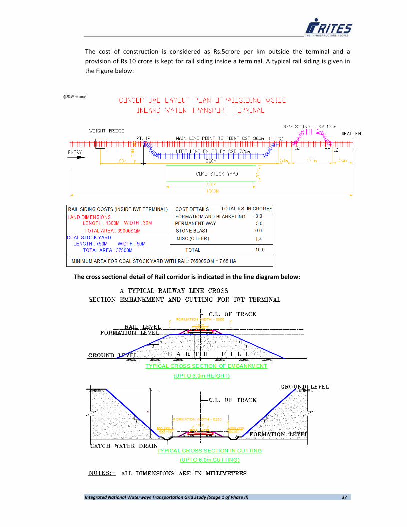
Integrated National Waterways Transportation Grid Study (Stage 1 of Phase II) 37
The cost of construction is considered as Rs.5crore per km outside the terminal and a provision of Rs.10 crore is kept for rail siding inside a terminal. A typical rail siding is given in the Figure below:
The cross sectional detail of Rail corridor is indicated in the line diagram below:

Integrated National Waterways Transportation Grid Study (Stage 1 of Phase II) 38
4.2.1 NORMATIVE COSTS ADOPTED FOR TERMINAL FACILITIES INCLUDING CONNECTIVITY
Terminal costs play an important role in estimation of traffic divertible to IWT. Since all the earlier studies were conducted during different periods of times, terminal costs were assessed differently for different periods. Moreover, with re‐estimation of IWT traffic demand at various locations, terminal costs would also vary. With a view to re‐estimate per unit cost of transportation by different modes of transport, development cost for providing IWT terminal facilities have been worked out using information given in various studies. Review of earlier study reports has revealed that many of the existing IWT terminals along the five declared national waterways and one likely to be declared national waterway are of semi permanent type terminals (Floating Pontoon with gangway) with manual handling. To handle bulk cargo viz., coal, limestone, building material, cement etc RCC terminal facilities with mechanical material handling facilities like conveyors, mobile cranes etc shall be required. For handling such bulk cargo at port connectivity locations, the requirement of Transshippers will be assessed and proposed. The cost of such facilities will be arrived on normative basis. As stated earlier, cost for providing rail and road connectivity up to the proposed/identified IWT terminals have also been considered. Missing links have been identified using available online satellite imageries and costs worked out adopting normative approach. On one hand, railway connectivity is proposed to be provided up to the nearest railway station or rail siding, in case of rail, In the case of roads, 2‐Lane road links with the nearest State Highway (SH) or National Highway (NH) has been considered. Terminals proposed to handle major bulk commodities, such as; coal, keeping in view the distance up to the Thermal Plant, if feasible movement by belt conveyor system has also been considered. Similarly, National Waterways connectivity to the existing Sea Port has been examined based on available Naval Hydrographic Charts and On‐line satellite imageries. Prevailing port tariffs relevant to the identified IWT cargo have been collected from the respective ports for transshipment to IWT vessels. Available handling facilities for IWT cargo on National Waterways has been assessed based on reports. In case, identified terminal is likely to handle only one bulk commodity for a single user and the same can economically be handled by belt conveyor system, rail connectivity may not be extended, though road connectivity up to the IWT terminal would be established. In addition to attract various commodities, requisite facilities at each proposed terminal would be established. For commodity requiring covered storage facilities, warehouses will be included, whereas sufficient open area for such commodities would be designed. Facilities likely to be offered by the user agencies, such as; FCI, NTPC etc., to store their cargo, beyond a particular limit is kept beyond the preview of this study.

Integrated National Waterways Transportation Grid Study (Stage 1 of Phase II) 39
While assigning the cost for development of terminal facilities, captive traffic for a single user (e.g. NTPC) the entire terminal costs may be borne by the user agency, whereas for multi user terminals, IWAI may be required to provide requisite facility either themselves or under concession agreement (PPP). IWT TERMINAL COSTS ESTIMATES With a view to handle estimated terminal traffic (2031‐32), terminal developments have been estimated. Since traffic volumes estimated to be handled are different at different IWT terminals, and with the limitation of data on commodity composition, Standard IWT Terminals have been proposed. Although efforts have been made to segregate identified terminals proposed to handle bulk cargo like coal and iron ore, to offer belt conveyer facilities. To arrive at realistic cost estimates, broad items of costs included are:
• Rail Connectivity cost
• Road Connectivity Costs
• Terminal Development Cost
• Waterway development costs
• Other costs if any.
Rail Connectivity costs To develop Integrated National Waterway Transportation Grid it is very important that wherever feasible, the IWT terminals, existing as well as proposed, must have rail connectivity. In order to arrive at broad costs involved in providing required link up to the IWT terminal, nearest railway station have been identified. In the current exercise, using field data or data collected from other secondary sources broad distance between IWT terminal and nearest railway station have been calculated and by applying normative cost per km of Broad Gauge rail line have been adopted. Based on consultant’s expertise and the discussion held with Railways, a provision of Rs.5crore per kilometre is considered for estimation purposes. Road Connectivity Costs All the existing IWT Terminals are to be connected to the nearest National Highway or State Highway by an approach road. Consultants are of the view that currently provided approach roads may not be capable to accommodate future volumes of cargo estimated to be handled at various proposed or identified IWT terminals. In the light of this, a normative cost for providing two lane road link between nearest NH or SH and proposed IWT Terminal have been worked out by adopting broad norms derived from various National Highways projects undertaken by RITES assigned by National Highways Authority of India. Broad item of civil works (excluding Land Acquisition & Rehabilitation and Resettlement Works, Utilities' Relocation, Environmental and Improvement Works costs) considered to arrive at required norms are given in Table below.
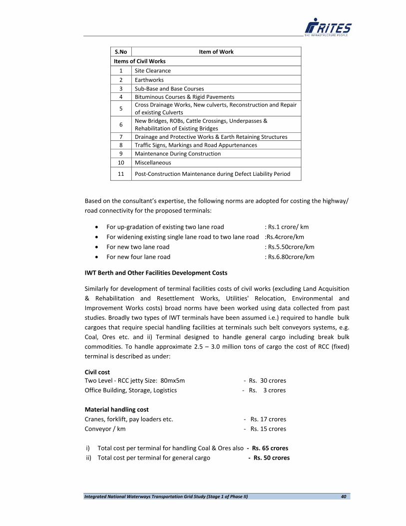
Integrated National Waterways Transportation Grid Study (Stage 1 of Phase II) 40
S.No Item of Work
Items of Civil Works
1 Site Clearance
2 Earthworks 3 Sub‐Base and Base Courses 4 Bituminous Courses & Rigid Pavements
5 Cross Drainage Works, New culverts, Reconstruction and Repair of existing Culverts
6 New Bridges, ROBs, Cattle Crossings, Underpasses & Rehabilitation of Existing Bridges
7 Drainage and Protective Works & Earth Retaining Structures 8 Traffic Signs, Markings and Road Appurtenances 9 Maintenance During Construction 10 Miscellaneous
11 Post‐Construction Maintenance during Defect Liability Period
Based on the consultant’s expertise, the following norms are adopted for costing the highway/ road connectivity for the proposed terminals:
• For up‐gradation of existing two lane road : Rs.1 crore/ km
• For widening existing single lane road to two lane road :Rs.4crore/km
• For new two lane road : Rs.5.50crore/km
• For new four lane road : Rs.6.80crore/km
IWT Berth and Other Facilities Development Costs
Similarly for development of terminal facilities costs of civil works (excluding Land Acquisition & Rehabilitation and Resettlement Works, Utilities' Relocation, Environmental and Improvement Works costs) broad norms have been worked using data collected from past studies. Broadly two types of IWT terminals have been assumed i.e.) required to handle bulk cargoes that require special handling facilities at terminals such belt conveyors systems, e.g. Coal, Ores etc. and ii) Terminal designed to handle general cargo including break bulk commodities. To handle approximate 2.5 – 3.0 million tons of cargo the cost of RCC (fixed) terminal is described as under:
Civil cost Two Level ‐ RCC jetty Size: 80mx5m ‐ Rs. 30 crores Office Building, Storage, Logistics ‐ Rs. 3 crores
Material handling cost
Cranes, forklift, pay loaders etc. ‐ Rs. 17 crores Conveyor / km ‐ Rs. 15 crores i) Total cost per terminal for handling Coal & Ores also ‐ Rs. 65 crores ii) Total cost per terminal for general cargo ‐ Rs. 50 crores

Integrated National Waterways Transportation Grid Study (Stage 1 of Phase II) 41
Using foregoing analysis overall IWT terminal development costs have been estimated under two scenarios. Under Scenario 1, all the IWT terminals proposed/identified by different study groups have been considered and their relevant (tentative) costs. i.e. cost of Rail connectivity, Road Connectivity, IWT Terminal Development including Belt Conveyor wherever required, have been estimated.
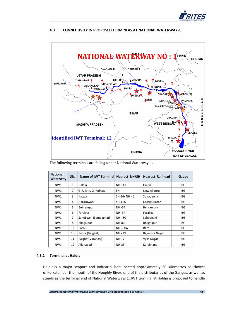
Integrated National Waterways Transportation Grid Study (Stage 1 of Phase II) 42
4.3 CONNECTIVITY IN PROPOSED TERMINLAS AT NATIONAL WATERWAY‐1
KATWA
HAZARDWARI
FARAKKA
SAHIBGANJ
BARHPATNA
NATIONAL WATERWAY NO : 1
Identified IWT Terminal: 12
The following terminals are falling under National Waterway‐1.
National Waterway
SN. Name of IWT Terminal Nearest NH/SH Nearest Railhead Gauge
NW1 1 Haldia NH ‐ 41 Haldia BG
NW1 2 G.R. Jetty‐2 (Kolkata) SH New Alipore BG
NW1 3 Katwa SH‐14/ NH ‐ 6 Sonadanga BG
NW1 4 Hazardwari SH‐11A Cossim Bazar BG
NW1 5 Behrampur NH ‐34 Behrampur BG
NW1 6 Farakka NH ‐34 Farakka BG
NW1 7 Sahebganj (Samdaghat) NH ‐ 80 Sahebganj BG
NW1 8 Bhagalpur NH‐80 Bhagalpur BG
NW1 9 Barh NH ‐ 30A Barh BG
NW1 10 Patna (Gaighat) NH ‐ 19 Rajendra Nagar BG
NW1 11 Rajghat(Varanasi) NH ‐ 7 Vyas Nagar BG
NW1 12 Allahabad NH‐35 Karchhana BG
4.3.1 Terminal at Haldia
Haldia is a major seaport and industrial belt located approximately 50 kilometres southwest of Kolkata near the mouth of the Hooghly River, one of the distributaries of the Ganges, as well as stands as the terminal end of National Waterways 1. IWT terminal at Haldia is proposed to handle

Integrated National Waterways Transportation Grid Study (Stage 1 of Phase II) 43
both domestic and EXIM traffic. Important commodities likely to be handled by IWT are coal and iron & steel. In 2011‐12, Haldia handled about 6.01 million tonnes originated and 2.57 million tonnes terminating traffic to/from various locations on NW1.
In the base year of the study, total volume of traffic divertible recorded was to the tune of 5.80 million tonnes, comprising 3.99 million tonnes of originating/outgoing and 1.81 million tonnes of terminating/incoming. In the year of commencement of proposed IWT services (2018‐19) Haldia is estimated to handle 8.54 million tonnes of cargo which in the terminal year of the traffic projection (2031‐32) worked out to 16.93 million tonnes 2031‐32.
Traffic:
Projected divertible traffic through Haldia Terminal
Haldia Total Traffic ( MT)
Year Originating Terminating Total
2011‐12 3.99 2.81 6.80
2021‐22 5.87 2.67 8.54
2031‐32 11.65 6.20 17.85
Important Commodities: Coal, Container, Ore, etc.

Integrated National Waterways Transportation Grid Study (Stage 1 of Phase II) 44
Road Connectivity:
Rail Connectivity:
Haldia IWT Terminal is planned on the banks of Hooghly River adjacent to Haldia Dock Complex, which is expected to facilitate transfer of commodities received from IWT mode to larger ships. Further, commodities received in ships can also be loaded into barges/ smaller vessels to move through the river. As the vessel entry into dock complex is expected to create nuisance to the port operations, a separate terminal on the banks of river within the vicinity is suggested. Connectivity through conveyor corridor is planned for easy transfer of bulk commodities from and to the IWT terminal to Dock complex.
Road Connectivity: Haldia is well connected to the National Highway 41. To connect the proposed terminal with the National Highway, a stretch of 11.06km road is identified which requires following development activity. (i) For a length of 5.16km where 6m width of land is available, requires additional land width of 6m for widening into two lanes. (ii) The balance 5.90km road, which is of 11m wide requires only developmental activity to bear the heavy vehicle movement.

Integrated National Waterways Transportation Grid Study (Stage 1 of Phase II) 45
The cost of road connectivity is worked out as Rs.28.1 crores. (i.e., Rs.22.20 crores for additional land width requirement and Rs.5.9 crores towards strengthening of carriage way of existing 5.90km two lane road) Rail Connectivity: Haldia dock complex is well connected with the rail network. It is expected to connect the IWT Terminal also to facilitate bulk cargo movement through rail network. The rail connectivity already available to the Dock Complex is suitably extended upto the IWT Terminal. It is found feasible to connect the same up to boundary of terminal. However, to accommodate the rail rakes inside the terminal, the land availability is not adequate. To fulfil the minimum land requirement to accommodate the rakes inside (for a length of 0.9km), additional land needs to be allotted by the Haldia Dock Complex/ Kolkata Port Trust. Rs.6 crores is estimated towards the development cost of rail siding.
Total Development Cost: It is envisage that a sum of Rs.89 crores is required for the development of IWT Terminal at Haldia. The breakup cost of investment required is detailed as follows: Waterway development : Rs. 5 crores Road Connectivity : Rs.28 crores Rail Connectivity : Rs. 6 crores Terminal Development Cost : Rs. 50 crores Total Investment : Rs. 89 Crores
4.3.2 TERMINAL AT G.R. JETTY‐2 (KOLKATA)
Existing G.R. Jetty at Kolkata and BISN Jetty are considered functional along with the proposed IWT Terminal. The Road connectivity to the new terminal is proposed to be connected from the existing road connecting GR Jetty from the National Highway.
Traffic:
Projected divertible traffic through G.R. Jetty (Kolkata) Terminal
Kolkata Total Traffic ( MT)
Year Originating Terminating Total
2011‐12 1.80 1.45 3.25
2021‐22 0.43 1.06 1.49
2031‐32 1.01 2.10 3.11
Important Commodities: Coal, Container, food grains, etc.
Road Connectivity:
It is observes that a 530m length of two lane road is required to be to strengthened along with a 170m new two lane road for connecting the proposed IWT terminal. The cost for new