Embed Size (px)
Citation preview
INTEGRATED METHODOLOGIES AND TECHNOLOGIES FOR THE RECONSTRUCTIVE STUDY OF DUR-SHARRUKIN (IRAQ)
M. Cultraro, F. Gabellone, G. Scardozzi
C.N.R. - I.B.A.M. - Archaeological and Monumental Heritage Institute
Campus Universitario, via Monteroni, 73100, Lecce (Italy) E-Mail: [email protected], [email protected], [email protected]
KEY WORDS: Archaeology, Modelling, Reconstruction, Quickbird, Virtual Reality, Three-dimensional. ABSTRACT The experience presented here was gained in the context of the Project entitled Iraq Virtual Museum, promoted by the Italian Ministry of Foreign Affairs under the scientific coordination of the Italian National Research Council (Consiglio Nazionale delle Ricerche). The project entails the construction of a Virtual Museum that will allow the public to enjoy the main archaeological treasures of the ancient civilisations that once flourished in the territory of modern-day Iraq. Specifically, we present here a case study of the ancient city of Dur-Sharrukin (today Khorsabad), the royal capital of the Assyrian Kingdom founded by Sargon II. The results of this work show the potential of integrating literary and historical sources, archaeological data, remote sensing and image-based technologies for the study, documentation, analysis and reconstruction of ancient cities, as well as for the cultural contextualization of the archaeological objects in the sites where they were discovered. Moreover, research activities have also enabled us to acquire new knowledge of objects, monuments and urban and territorial contexts, making it possible in turn to reconstruct the ancient layout of the archaeological monuments and the historical landscapes.
1. INTRODUCTION This work was carried out in the context of the Iraq Virtual Museum (IVM) Project conducted by the Italian C.N.R., whose objective was the construction of a Virtual Museum of the ancient civilisations that flourished in the territory of Iraq. Our contribution to the project is linked to the need to contextualize the objects and monuments currently on show in the Virtual Museum, linking them to their site of provenance and to the cultural sphere in which they originated. Dur-Sharrukin was chosen for a case-study because the ancient capital was deserted immediately after Sargon’s death, and so only the most important public buildings had been finished. The study mostly concerns the city and its main buildings in a wider context, integrating humanistic approaches (historical sources and archaeological data) and recent scientific methods. More specifically, the ancient sources and the data from the old excavations are integrated with archaeological remote sensing and image-based 3D modelling (photo-modelling and digital photogrammetry). The site has been documented by cataloguing the most significant monuments, in terms of historical and topographical development, in order to provide the “visitor” to the Virtual Museum with a complete image of the characteristics of the city and the contexts where the artefacts were found. In addition, some objects and monuments that are representative of Dur-Sharrukin have been reconstructed by means of 3D image-based modelling and rendering. Moreover, the availability for some years now of satellite images with high geometric resolution has opened up new possibilities for archaeological research and represents a form of documentation with enormous potential for the study of urban and territorial contexts. These images makes it possible to observe and document the archaeological area as it is today, both as a substitute for a real visit (currently impossible), and in preparation for a visit in the future. The detailed examination of these images also constitutes an important opportunity to acquire new data about the topographical layout of the city and its principal monuments. In times of conflict, satellite images also provide a crucial tool for monitoring archaeological sites, including their state of preservation or damage.
2. HISTORICAL AND ARCHAEOLOGICAL DATA Dur-Sharrukin is one of the most impressive example of an imperial core centre from Assyrian Mesopotamia (Fig. 1). The
site, about ten miles North-northeast of Mosul, was explored in mid-March 1843 when Paule-Emile Botta identified the remains of an large palace (Fales 2001: 81-96). Misleadingly identified with the ancient Nineveh, only in the years 1852-1853 Victor Place proposed to identify the imperial capital of Sargon II (Fontan 1994). From 1928 to 1935 the Oriental Institute of Chicago carried out a new archaeological investigation completing the excavation of the royal palace and the other main monuments (Loud, Altman 1938). In 1957 an emergence excavation was carried out from the Iraqi Department of Antiquities and it led to the discovery of the Temple of Sibitti (Safar 1957). Sargon II founded Dur-Sharrukin, “Fortress of Sargon” between 713 and 707 B.C in the fruitful plain of Jebel Basiqa crossed by Hosr River (Parpola 1995). The king dedicated the new city in 706 B.C., shortly before the king’s death (Russell 1999: 234-239). The foundation of the city was a deliberate statement of the Sargon’s power and of his own magnificence in terms of kingship and imperial ideology. As J. Reade has pointed out (1979: 330), each Assyrian capital city, and indeed the entire empire through a specific city, is dedicated to the individual design of each ruler, who planned the city layout giving it imperial grandeur in the form of monumental structures. The foundation of an imperial town significantly reflects the affirmation of the charismatic identity of the king, the “apex in the action of the creator king comparable only to the works of basic creation, owed to the gods” (Liverani 1979: 309). Roughly speaking, in an archaeological perspective, the investigation of the main Assyrian imperial towns is an important tool to understand the urban structure, either the hierarchies and the differences of the residential areas, and at the same time provides solid pointers for how a interdisciplinary research programme might tackle such issues, employing the evidence of both textual documentation and material cultural remains (Matthews 2003: 134-242). Dur-Sharrukin is an exceptionally example in terms of reconstruction of an Assyrian imperial city, because the town was built, occupied and abandoned under the successors of Sargon II in the space of a single generation. The new imperial capital was inspired by the same ideological and monumental activities which can find in the foundation of one of the most important town of the Assyrian empire, Kalhu, under Assurnasirpal II (Frankfort 1954: 92). The town covers an area of around 280 hectares (Fig. 1). The monumental city walls, 24 m thick on stone foundation, defines the urban space with seven gates (Battini 1996). Two gates are located on either
XXI International CIPA Symposium, 01-06 October, Athens, Greece

side, except in the north-west, where one passage is replaced by a monumental bastion built out on both faces of the town wall. The function of this high platform is to support the Royal Palace, dominating the lower town on the North-west side. At the southern end of the city a similar platform protected the entrance through Gate 5, which was connected to the main traffic road to Nineveh. As H. Frankfort claimed (1954: 75-76), the town layout aimed at regularity, and ‘the frequent deviation from the right angle is due to imperfect methods of surveying’. Of paramount importance in the layout of the city is the wish of symmetry which implies to set two gates in each side of the square. The location of Gate 2 is not accidental because the passage is connected to the ridge of Jebel Maklub, which can only be crossed in that side. Gates 3 and 4 crossed the city and both met the main traffic roads in direction of Nineveh and of the monumental king’s palace, together with the main administrative structures of the city.
Figure 1. General plan of Dur-Sharrukin (drawn up by F. Ghio).
There is a little scarce evidence of the building within the lower town. We know from texts that the town was built in segments assigned to workers coming from different provinces of the empire (Postgate 1979: 203). Moreover, it is possible that the modest presence of buildings in the area between the main streets can be the result of the archaeological exploration. In fact P.-E Botta in 1843-44 and V. Place in 1852-53 explored the lower town of Dur-Sharrukin, but the techniques of excavations of the day did not enable them to discern structures built entirely of mud brick (Liverani 1997: 88-89). In general, Dur-Sharrukin reflects a regular town plan, a sort of abstract symmetry which seems to be more strictly executed in the lower town than in the citadel. The grid of streets functioned as reference point for the builders and the rigid regularities of the plan may be explained as a result of property rights of workers to whom land was assigned. This regular plan apparently contrasts with some asymmetries which are documented within the Citadel, for instance in the case of Building M, Residence K and the Nabu Temple (Fig. 2). Building shows a regular oblong nucleus of rooms spaced round two rectangular courts. The irregular plan of the private residence, with two irregular wings on each sides, was influenced from the nearby Nabu Temple. According to H. Frankfort (1954: 76), the orientation of this cultic building, which is out of alignment with the other structures of the Citadel, was dictated from religious or ritual considerations, for
instance some indications of planets or constellation which are visible at the time when the temple was built. This location implied the adaptation of Gate A which initially was likely located in axis with the other main gates of the town. Gate A led into a street which passed between the Nabu Temple and Building M; next it passed underneath a monumental viaduct which connected Sargon’s Palace with the Nabu Temple. This architectural solution permitted that the king, when visiting the shrine, need not descend into the great open square at the end of the street which had the same function of the ‘Square of the Foreign Peoples’ at Assur (Frankfort 1954: 71 and fig. 28). In this public space the town population gathered in occasion of important ceremonies, such as religious processions and celebrations of military successes.
Figure 2. General plan of the Citadel (drawn up by F. Ghio).
The palace (Fig. 2) shows similarities, in the plan and in the decorative system, with the main Assyrian imperial residences (Frankfort 1954: 76-78; Invernizzi 1992: 173-177). The building, which was extended over almost 10 hectares, included a ceremonial sector, with the Throne Room, and a series of official rooms magnificently decorated stone orthostats depicting processions of dignitaries and servants. The central passage to the Palace, like the city gates, was flanked on each side by winged bulls (lamassu) standing back to back in profile and facing front. The most impressive building of the Citadel is the Ziggurat, of which are preserved four stages, each of them was decorated with recesses and painted by a different colour: the lowest white, the next black, the third red and the fourth preserved white again (Busink 1954). Finally, another large building is the Palace F, that has been intended as private residence for the crown prince Sennacherib (Amiet 1980: 513). In conclusion, Dur-Sharrukin represents a excellent case-study of the significant role played by the Assyrian rulers in the definition of the urban scheme of a capital town. The preservation of the main buildings and the absence of a reuse of the town give the opportunity to apply recent scientific methodologies in order to reconstruct the historical and topographical development of the Assyrian capital.
M.C.
3. HIGH RESOLUTION SATELLITE IMAGES FOR THE STUDY OF THE ANCIENT TOPOGRAPHY OF THE
CITY AND FOR THE VIRTUAL VISIT As part of the IVM Project, high resolution satellite images were used to support the general description of the ancient cities under study and for the reconstruction of their topography. In addition, they were used to contextualize the archaeological objects found in them and visible in the Virtual Museum. Indeed, it is fundamental that the “visitor” should be able to
XXI International CIPA Symposium, 01-06 October, Athens, Greece

view the sites in which the objects originated and thus, ideally, to connect the items with their place of discovery. This process of contextualization can be performed on various scales of detail (from the city as a whole to the individual monument) and on three time levels: antiquity, the moment of their discovery, and the present. For the first two, virtual reconstruction (which may be based on photographs of the excavations), yields excellent results, while for the third time level, i.e. the virtual visit to the area of provenance in its current situation, the photographic images from both the air and the ground obviously allow the archaeological areas to be viewed at a high level of detail. Considerable problems arise however in situations where the contexts are not easily accessible and for which good photographic documentation is not available. This is the case of the ancient cities of Iraq that were studied as part of the IVM Project; for Dur-Sharrukin, there were only a few recent photographs and some documents of the excavations. Given the limited photographic documentation available, reference was made to high resolution satellite images, which have been available for some years now at reasonable prices and at a sufficient level of definition to be used for detailed archaeological research (Gabellone, Scardozzi 2006 and 2007). The images used were taken by the American satellite QuickBird 2, which transmits images with a geometric resolution between 0.61 and 0.72 m in panchromatic mode. The data are acquired at a radiometric resolution of 11 bits per pixel, corresponding to a maximum of 211, i.e. 2048 values per band of acquisition (www.digitalglobe.com). In the specific case of Dur-Sharrukin, two panchromatic images, taken by QuickBird on June 4th 2002 and August 2nd 2005, were purchased via the Telespazio S.p.A. company. They were obtained on the Standard Ortho Ready level, in GeoTIFF format, with the pixels re-sampled in order to obtain a geometric resolution of 0.60 m. When the two images were compared, on the whole that of 2002 proved to be qualitatively better, enabling the elements present on the surface of the ground and the archaeological traces to be clearly distinguished. In addition it appears to be less affected by the loss of vividness in the colour tones that is seen in the 2005 image, which are due to the intense drought at the time of acquisition. The characteristics of this type of image are comparable to those of medium scale aerial photographs as a source of data useful for archaeological research; the high geometric resolution in particular enables them to be used not just for the study, as in the past, of large ancient systems of territorial organisation and paleo-hydrographic elements, but also of archaeological areas of various size, including the possibility of performing detailed analyses on individual monuments, even of small dimensions. High resolution satellite images now have an increasing number of applications, linked to the identification, analysis, documentation and monitoring of archaeological sites (Forte, Campana 2006; Scardozzi 2006; Lasaponara, Masini, Scardozzi in press; and 2007). As well as facilitating the contextualization of ancient objects in their sites of provenance, the detailed reading and examination of these images during also provided an important opportunity to acquire new knowledge of the ancient topography of the city. Anomalies on the terrain were identified which may constitute traces of buried ancient structures or of paleo-environmental elements, which can thus be added to the knowledge acquired in the course of the archaeological research conducted in the past. It should be stressed here that for the interpretation of satellite images, it is essential that what they show is verified on the ground, just as with aerial photographs. This serves to avoid the misunderstandings that can result from hurried or superficial interpretations and, in unclear cases, to distinguish genuine archaeological traces from false traces or those caused by geological factors. In the case Dur-Sharrukin, this was not possible, and the interpretation of the traces was thus conducted with great caution, limiting itself to the formulation of
hypotheses that will need to be verified in the future. The high resolution satellite images in the first instance provide a detailed vision of the current state of the remains of the city and of its urban layout, and allow us to recover interesting elements for the reconstruction of its ancient topography. The view from above, with the possibility of picking up on even very small details, makes it possible to identify details that are not perceivable on the ground and to recognise archaeological traces or anomalies linked to paleo-environmental elements.
Figure 3. Satellite image taken by QuickBird 2 in 2005. The arrows indicate the traces and the remains of the city walls and the numbers indicate the gates.
A general view of the city (Fig. 3) shows the plan of the urban area as established by Sargon II and its characteristic quadrangular shape (Fig. 1), which is still conserved in the fields to the East of the modern village of Khorsabad (Fig. 3, A). The boundaries of the city can be clearly distinguished, with the remains and the traces of the imposing city walls, which had a length of about 7 km; it is also possible to make out the remains of the seven gates located along the circuit of walls. Also visible are the sites occupied by the two main monumental complexes established before the city was abandoned after the death of its founder, built on large platforms beside the fortifications: the Citadel with the Royal Palace of Sargon to the North-west and the so-called Palace F to the South-west (Fig. 3, B-C). In contrast, few important elements are visible in the remaining part of the urban area, other than faint traces of structures and roads; indeed, with the transfer of the capital to Nineveh under Sennacherib, the building works in the city were abandoned and the residential districts were not completed. In the current landscape, the boundaries of the fields conditioned by the route of the city walls clearly show the edge of the city. Inside the walls however, regular divisions are not seen: agrarian boundaries were apparently not affected by any particularly imposing structures. On the whole, the view from above of the urban area highlights the regularity of the circuit of defensive walls and the asymmetric position of the gates. Also noticeable however are characteristics of the urban layout that point to a certain functional logic in its arrangement. Indeed, Gate 1 lies on the road which is believed to have run along the South-eastern edge of the Citadel, where Gate B is; Gate 2 is aligned with the access ramp to Palace F, on the opposite side of the city walls. In addition, Gate 4 is placed almost symmetrically opposite Gate 7 and in some points in the fields, there are faint traces of a road that is believed to have linked them. The satellite images contribute little to the reconstruction
XXI International CIPA Symposium, 01-06 October, Athens, Greece

of the paleo-hydrography of the area of the city; they merely show the current situation, with short water courses descending from the mountains situated a little way to the North, perhaps following the same route as they did in ancient times.
Figure 4. The Citadel in the satellite image taken by QuickBird 2 in 2002. The arrows indicate the traces and the remains of the city walls. In the square is visible the Temple of Sibitti in 2005.
A detail of the satellite image of 2002, concerning the northern part of the urban area (Fig. 4), enables us to examine the current situation of the monumental complexes brought to light in this sector of the city, i.e. the Citadel and the Palace of Sargon (Fig. 2). The remains and the traces of the North-western side of these fortifications are clearly visible, while structures relating to the circuit of walls surrounding the Citadel are very scarce. The same may be said of the monumental complexes within it, characterised by a generally very poor state of conservation. Concerning the Palace of Sargon, it is possible to estimate the size (Fig. 4, 1), but this can only give an idea of its grandness: the plan of the structures can barely be made out, and the modern village stretches right up to them. Similar is the situation of the area of the Ziggurat and the Temples situated on the same platform as the Palace (Fig. 4, 2). The state of conservation of the buildings outside the platform of the Palace is not optimal either. Clearly visible is the plan of the Nabu Temple (Fig. 4, 5), with the cella and the two courts in front of it, the structures that characterised the southern part of the building, the ramp to the North-east and the southern side of the bridge (Fig. 4, 3) that linked its platform to that of the Palace of Sargon. It is also possible to make out the structures of the nearby Residence J (Fig. 4, 7), with the rooms arranged around the two courtyards; of the adjacent Residence K (Fig. 4, 8), only the southern and western parts around the smaller courtyard are conserved, while almost nothing remains of the eastern sector with the main court. Even more serious is the situation of Residence M (Fig. 4, 4), of whose main nucleus almost nothing remains, and which is covered today by a football pitch. Of the circuit of walls defending the Citadel, a few remains can be distinguished near Gate A (Fig. 4, 6). In the northern part of the Citadel, only the structures of the Residence L built around the western court can be distinguished (Fig. 4, 10), near the remains of the Gate B (Fig. 4, 9); the eastern part lies in an area now used for agriculture, and only the traces and the crests of some semi-buried walls can be seen. Outside the Citadel lie the only two complexes to have been studied, Residence Z and the
Temple of Sibitti (Fig. 4, 11-12), which bear testimony to the initial urbanisation of the area of the city. The structures of the Temple are clearly visible, and their plan can be traced. The modern road runs past the building, just beyond the terrace of the Palace of Sargon, crossing the western corner of the area of the ancient city. The traces of these are visible, and the structures of Gate 7 are conserved (Fig. 4, 13).
Figure 5. The eastern corner of Dur-Sharrukin in the satellite images taken in 2002 (left) and 2005 (right): A-C, Gates 2-4; the arrows indicate the traces of the city walls.
The availability of satellite images taken before and after the second Gulf war has made it possible to monitor the state of conservation of the area of the city. The most striking aspect is the presence of artillery positions, numerous in the image of 2002 but much reduced in that of 2005, in which they appear to have been largely replaced by agricultural activities. The artillery positions, arranged in a “U” formation, are all facing North-east, in the direction of the mountains that dominate the plain where the city lies. They are mostly situated within the city walls, with some immediately outside it; specifically, they are visible in the area of the Citadel (Fig. 4) and in the eastern corner of Dur-Sharrukin (Fig. 5). Also still visible, in the same areas, are a few trenches (see in this regard Fales 2004: 418-420). Generally, the image of 2005 shows a worse state of conservation of the structures of the Citadel and of the Palace of Sargon, where some small modern structures built in the northern part are also visible. The same satellite image also shows some recent activity that may have damaged the archaeological area: specifically, a trench has been dug along the western side of the dual-carriageway highway that crosses the western corner of the city. The area around the Temple of Sibitti has been cleared and fenced off (Fig. 4) and an excavation has been started on the mound containing the remains of Gate 2 (Fig. 5, A).
G.S.
4. THREE-DIMENSIONAL MODELLING FOR THE RECONSTRUCTIVE STUDY AND DISTRIBUTION OF
THE DATA PRODUCED The fundamental premise for the reconstructive study of Dur-Sharrukin starts with a question: to what extent is it possible to reconstruct ancient civilisations with a high level of reliability and verisimilitude when it is impossible to visit the excavation sites in person? How useful is it to undertake an operation of this kind based solely on already-published material and archive photos? Above all, who benefits from such an enterprise? We have tried to answer all these questions by adopting, as always, a methodologically rigorous and scientifically robust approach,
XXI International CIPA Symposium, 01-06 October, Athens, Greece

in an attempt to limit every possible form of subjective or arbitrary interpretation which would inevitably lead us to false hypotheses. First and foremost, we believe that the study of a monument with a view to its reconstruction must combine historic and humanistic knowledge with the use of modern information technology, not just to understand and interpret the object itself, but also and especially to transmit the knowledge acquired to a broad and heterogeneous public, via appropriate media and at all levels of interest and comprehension (Gabellone, Giannotta 2005). Archaeology is currently enjoying a period of great activity and interest on the part of the wider public, thanks to the communicative power of the new media, with which it is possible to recreate not only the forms and materials of the ancient world but also to evoke their use and meaning in daily life, creating scenes in which it is possible to integrate architectural elements with work tools, clothes, colours, and everyday objects. Testifying to the great interest in the subject is the enormous growth on the web of virtual thematic museums, of virtual collections and galleries, of proposed reconstructions designed to recover or increase our knowledge of archaeological monumental heritage via the use of Computer Vision. In this context, 3D images are no longer seen as a purely iconic representation, but as an instrument that brings together and transforms into graphic format a large part of the data acquired in the scientific research, representing the elements that are indispensable for a correct interpretation and reading of the information in the immediate language of visual signs. Scientific information is “channelled” together with historic information in a single, complex system – a three-dimensional image. This method represents a step towards a highly-evolved model of knowledge, in which the image transcends its exclusively aesthetic value, becoming a vehicle of content, a “synthesis” of scientific knowledge.
Figure 6. Court (VIII), Palace of Sargon.
Thus conceived, reconstructive study can in some cases represent the starting point for further applications in the field of virtual restoration, with a view to “reintegration” (Carbonara 1976) i.e. filling in the gaps in our knowledge of the item’s original appearance, with the help of whatever form of documentation is available. The theme of digital (or virtual) restoration is currently the subject of much debate, especially concerning the numerous methodological implications that inevitably bind it to the discipline of “modern” restoration, from which it springs. Modern restoration is founded on a basic principle: it must concern itself exclusively with the material aspects of the work of art (Brandi 1963), i.e. it must guarantee respect for its value as a historical and aesthetic instance and must limit itself to conservation of the materials of which the work itself is made. The term “virtual”, i.e. potential, and therefore neither actual nor material, thus implies that it is really no more than a form of verification ante rem of a hypothetical attempt at restoring the real item, and in no way can this be truly defined as “restoration”. It would be wrong however to think
that the digital world is not material. On the contrary, we know that numbers, images, sounds and so forth that are produced on a computer are part of a new type of materiality, which has a physical consistency and its own domain of reference. Just like real objects, three-dimensional models possess measurable spatial dimensions, they express physical and chromatic values, they can be replicated ad infinitum or be transformed into “tangible” objects by means of prototyping, but what is most important is that they exist. Digital restoration can plausibly serve as a guide in acts of real restoration, helping to check many critical aspects of the work; however, it can also take on a scientific value in its own right if it enables us to visualize the work as it actually appeared in a certain moment of its life, restoring its value as historical testimony to the civilisation that it exemplifies – restoring, in other words, its links with a well-defined cultural identity (Gabellone, Scardozzi 2007.). For the reconstruction of Dur-Sharrukin, these concepts translated into three concrete steps, closely linked to each other: the restitution of each individual object, building, and planimetric view of the of the whole on the urban and territorial level.
Figure 7. Reconstructive study of Dur-Sharrukin.
Naturally, of the individual objects of great interest, of which we possess good documentation, considerable attention was given to the Lamassus, colossal statues of hybrid or chimerical creatures, definitely among the most representative of Assyrian civilisation, which were located near the main entrances to the city and the palaces (Fig. 6). The large quadrangular blocks of stone from which they were carved vary in height from 3.5 to 5.8 metres. The anatomical features of the monster are shown in impressive detail: the tiara with multiple rows of horns that link it closely to the world of the deities, the human face with a long curly beard, the wing. Considered as a whole, the monster appears to have been a synthesis of all that was threatening and terrible in the universe: the power of the bull, the wings of the eagle that dominates everything from the skies and finally the intelligence and knowledge of human beings (the educational video “The Sphinx” highlights the salient characteristics of the Lamassu identity, providing examples of contextualization and comparisons; text edited by S. Seminara). Other significant examples of sculpture shown in the images here are the bas-reliefs of the halls of the royal palace. King Sargon wanted the walls of his palace to be decorated with alabaster blocks bearing larger-than-life bas-reliefs (nearly three metres high) with complementary images of tribute bearers on one side, and of the Assyrian king (for whom the tribute is intended) surrounded by his retinue on the other. These images were repeated obsessively on the walls of the corridors, continuously testifying to the grandeur of the Assyrian empire and the indisputable power of the sovereign. Following the image-based restitution of these objects, our attention turned to the their contextualization in the original architectural environments, of which the plan and some details of the edifice are known.
XXI International CIPA Symposium, 01-06 October, Athens, Greece
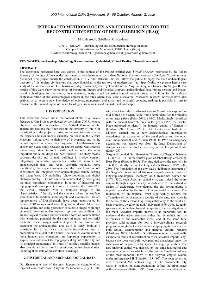
Buildings such as the Temple of Nabu, the Ziggurat and the Palace of Sargon complex were reconstructed on the basis of the information given in the literature, but also thanks to the original contribution provided by the study of the satellite image, which was crucial in learning about the morphology of the territory, in studying the historical stratification and in recognising the signs of internal subdivision within the city (Fig. 7). Specifically, the access gates to the city were reconstructed on the basis of the reconstructive drawings of the nineteenth century commissioned by V. Place, one of which, the oil on canvas painting by F Thomas (1853), shows Gate 3 of the outer city walls of Dur-Sharrukin, with decoration in glazed bricks and lamassu statues, discovered during the excavations of the same period (Matthiae 1996; AA.VV. 2005).
Figure 8. Palace of Sargon. 3D reconstruction based on V. Place’s drawings.
Another picture, again by V. Place, shows portal Z of the Harem, highlighting the blue and yellow colouring of the crenellations at the top and the lintel on the great arch at the entrance. Consistent with this information and plausible as a hypothesis, we propose a similar situation to that shown by V. Place for all the remaining crenellations of the palace, with the same reliefs as on the walls inside the towers (Fig. 8). For the Ziggurat there is a fairly detailed description by T.A. Busink, who published some reconstructive drawings in which he also proposed a plausible solution for the upper part, which had been destroyed. Highly important on a documentary level are the descriptions of the internal halls of the palace shown in the volumes of Moortgat-Correns (1989: 230-237) and P. Matthiae, as are the invaluable indications regarding the colours used in the frescoes discovered in Til Barsib. The proposed reconstructions are based largely on a 3D restitution obtained exclusively from published images (Image-Based Modelling), very often of poor quality, but useful nonetheless for the final product.
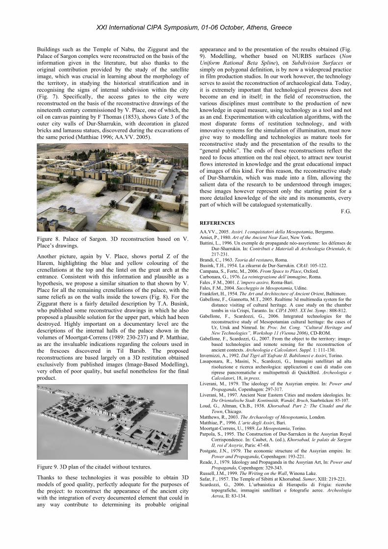
Figure 9. 3D plan of the citadel without textures.
Thanks to these technologies it was possible to obtain 3D models of good quality, perfectly adequate for the purposes of the project: to reconstruct the appearance of the ancient city with the integration of every documented element that could in any way contribute to determining its probable original
appearance and to the presentation of the results obtained (Fig. 9). Modelling, whether based on NURBS surfaces (Non Uniform Rational Beta Spline), on Subdivision Surfaces or simply on polygonal definition, is by now a widespread practice in film production studios. In our work however, the technology serves to assist the reconstruction of archaeological data. Today, it is extremely important that technological prowess does not become an end in itself; in the field of reconstruction, the various disciplines must contribute to the production of new knowledge in equal measure, using technology as a tool and not as an end. Experimentation with calculation algorithms, with the most disparate forms of restitution technology, and with innovative systems for the simulation of illumination, must now give way to modelling and technologies as mature tools for reconstructive study and the presentation of the results to the “general public”. The ends of these reconstructions reflect the need to focus attention on the real object, to attract new tourist flows interested in knowledge and the great educational impact of images of this kind. For this reason, the reconstructive study of Dur-Sharrukin, which was made into a film, allowing the salient data of the research to be understood through images; these images however represent only the starting point for a more detailed knowledge of the site and its monuments, every part of which will be catalogued systematically.
F.G. REFERENCES
AA.VV., 2005. Assiri. I conquistatori della Mesopotamia, Bergamo. Amiet, P., 1980. Art of the Ancient Near East, New York. Battini, L., 1996. Un exemple de propagande néo-assyrienne: les défenses de
Dur-Sharrukin. In: Contributi e Materiali di Archeologia Orientale, 6: 217-231.
Brandi, C., 1963. Teoria del restauro, Roma. Busink, T.H., 1954. La zikurrat de Dur-Sarrukin. CRAI: 105-122. Campana, S., Forte, M., 2006. From Space to Place, Oxford. Carbonara, G., 1976. La reintegrazione dell’immagine, Roma. Fales , F.M., 2001. L’impero assiro, Roma-Bari. Fales, F.M., 2004. Saccheggio in Mesopotamia, Udine. Frankfort, H., 1954. The Art and Architecture of Ancient Orient, Baltimore. Gabellone, F., Giannotta, M.T., 2005. Realtime 3d multimedia system for the
distance visiting of cultural heritage. A case study on the chamber tombs in via Crispi, Taranto. In: CIPA 2005. XX Int. Symp.: 808-812.
Gabellone, F., Scardozzi, G., 2006. Integrated technologies for the reconstructive study of Mesopotamian cultural heritage: the cases of Ur, Uruk and Nimrud. In: Proc. Int. Cong. “Cultural Heritage and New Technologies”, Workshop 11 (Vienna 2006), CD-ROM.
Gabellone, F., Scardozzi, G., 2007. From the object to the territory: image-based technologies and remote sensing for the reconstruction of ancient contexts. Archeologia e Calcolatori. Suppl. 1: 111-130.
Invernizzi, A., 1992. Dal Tigri all’Eufrate II. Babilonesi e Assiri, Torino. Lasaponara, R., Masini, N., Scardozzi, G., Immagini satellitari ad alta
risoluzione e ricerca archeologica: applicazioni e casi di studio con riprese pancromatiche e multispettrali di QuickBird. Archeologia e Calcolatori, 18, in press.
Liverani, M., 1979. The ideology of the Assyrian empire. In: Power and Propaganda, Copenhagen: 297-317.
Liverani, M., 1997. Ancient Near Eastern Cities and modern ideologies. In: Die Orientalische Stadt: Kontinuität, Wandel, Bruch, Saarbrücken: 85-107.
Loud, G., Altman, Ch.B., 1938. Khorsabad. Part 2: The Citadel and the Town, Chicago.
Matthews, R., 2003. The Archaeology of Mesopotamia, London. Matthiae, P., 1996. L’arte degli Assiri, Bari. Moortgat-Correns, U., 1989. La Mesopotamia, Torino. Parpola, S., 1995. The Construction of Dur-Sarruken in the Assyrian Royal
Corrispondence. In: Caubet, A. (ed.), Khorsabad, le palais de Sargon II, roi d’Assyrie, Paris: 47-68.
Postgate, J.N., 1979. The economic structure of the Assyrian empire. In: Power and Propaganda, Copenhagen: 193-221.
Reade, J., 1979. Ideology and Propaganda in the Assyrian Art, In: Power and Propaganda, Copenhagen: 329-343.
Russell, J.M., 1999. The Writing on the Wall, Winona Lake. Safar, F., 1957. The Temple of Sibitti at Khorsabad. Sumer, XIII: 219-221. Scardozzi, G., 2006. L’urbanistica di Hierapolis di Frigia: ricerche
topografiche, immagini satellitari e fotografie aeree. Archeologia Aerea, II: 83-134.
XXI International CIPA Symposium, 01-06 October, Athens, Greece