Embed Size (px)
Citation preview

INTERNATIONAL INSTITUTE FOR GEO-INFORMATION SCIENCE AND EARTH OBSERVATION
Innovative Technology for Land Administration
with emphasis on Pro Poor Land Management
Dr. Arbind Man TuladharITC, Enschede, the Netherlands
International Conference on Enhancing Land Registration and Cadastre for Economic Growth in India, Organized by
Map India 2006, GIS Development and FIG Commission 7 atHotel Taj Palace, New Delhi, India, 31 January – 1 February 2006.
International Conference on Enhancing Land Registration and Cadastre for Economic Growth in India, Hotel Taj Palace, New Delhi, India, 31 January – 1 February 2006.
Contents
§ Introduction§ Current Urban Land Management§ Pro Poor Land Management§ Innovations§ Technology for Land Administration

International Conference on Enhancing Land Registration and Cadastre for Economic Growth in India, Hotel Taj Palace, New Delhi, India, 31 January – 1 February 2006.
Introduction
§ Land is a key asset for the poor§ 900 million people who live in slums and informal
settlement worldwide, and among them are 570 millions that live in the Asia-Pacific region
§ No safe and secure land/housing; excluded from city planning; and mostly evicted from their lands
§ Specially women, indigenous people and disabled people are not able to defend their rights on land
§ Live in health- and life- threatening environments on marginal land, vulnerable to flooding, landslides and other environmental hazards.
§ Informal settlement, slums, squatters, etc. are growing too rapidly. Informal and formal systems coincide making difficult to manage land and housing.

International Conference on Enhancing Land Registration and Cadastre for Economic Growth in India, Hotel Taj Palace, New Delhi, India, 31 January – 1 February 2006.
Introduction
§ UN-HABITAT launches pro poor land management as an effort to achieve MDGswhich itself is innovative concept yet flexible approach depending on local situation § Pro poor land management requires Geo-
information that can be derived from many sources. § Field surveys, Aerial photographs and
satellite images are important sources for Geo-information

International Conference on Enhancing Land Registration and Cadastre for Economic Growth in India, Hotel Taj Palace, New Delhi, India, 31 January – 1 February 2006.
Problems on Current Urban Land Management§ Centralized decision making; local authorities
hardly play a role§ Insufficient use of urban space § Public sector dominated approaches§ Rigid and costly regulatory frameworks§ land recording systems and centralized
information systems: § Lack of effective tools § Poorly maintained and often coverage incomplete § Inefficient, inaccessible and very costly systems
§ Unable to deliver secure land tenure

International Conference on Enhancing Land Registration and Cadastre for Economic Growth in India, Hotel Taj Palace, New Delhi, India, 31 January – 1 February 2006.
Pro poor land management
§ It integrates slums or informal settlement into city planning approaches based socio-legal framework
§ Its characteristics:§ Gender based approach§ Appropriate and flexible
tenure form § Community participatory
planning approach including informal land delivery processes
§ linking to service to communities’ capacity for sustainability
§ a decentralized land administration that uses local capital, partners with local authorities§ self reliance or cost
recovery approach§ Principle of urban
governance§ Transparency§ Gender§ Publicity§ Participation§ Accountability§ Subsidiarity§ MDGs

International Conference on Enhancing Land Registration and Cadastre for Economic Growth in India, Hotel Taj Palace, New Delhi, India, 31 January – 1 February 2006.
Innovations – Three main Issues
§ Land tenure paradigm that provides the poor better ensure security according to their norms and values to be incorporated into urban land policy
§ Innovative use of Geo-information technologies (GIT) for effectiveness of land administration i.e. determination, recording and dissemination of land information on tenure, use and value of land
§ Local land information systems: affordable and easy access to land information by the poor and civil society; link to central land information to increase reliability and formal recognition of system

International Conference on Enhancing Land Registration and Cadastre for Economic Growth in India, Hotel Taj Palace, New Delhi, India, 31 January – 1 February 2006.
Land Tenure Paradigm on Land tenure security§ Changes needed in the relationship
of land and people within socio-cultural setting - flexible and incremental approach of Continuum rights and spatial units
§ Changes in governmental policies and legislation to accommodate various land tenure systems
§ Emerging actors involving local participation (local government, civil society, citizens, etc.) in the processes of securing land tenure
§ meeting customer’s demands: realise the support land registers and cadastre must provide to the functions that should be facilitated (according to the land policy)
A part of Bombay Slums from Google Earth

International Conference on Enhancing Land Registration and Cadastre for Economic Growth in India, Hotel Taj Palace, New Delhi, India, 31 January – 1 February 2006.
Property rights - examples
Nation
Norms & values Norms & values Norms & values
Statutory law Customary law Informal rules
Property right 1 Property right 3Property right 2
(Molen and Lemmen, 2004)

International Conference on Enhancing Land Registration and Cadastre for Economic Growth in India, Hotel Taj Palace, New Delhi, India, 31 January – 1 February 2006.
Technologies in Land administration
§ Simple procedures, quick, and low transaction costs§ Simple transparent systems, participatory§ Low cost § Efficient and effective§ Free from political pressure§ Low cost demarcation§ Mechanisms conflict resolution § SDI at low cost, transparent and accessible for
linking registers of different categories and at different levels (local village level to central level)

International Conference on Enhancing Land Registration and Cadastre for Economic Growth in India, Hotel Taj Palace, New Delhi, India, 31 January – 1 February 2006.
Traditional surveying
§ Plain table, Measuring tapes,
§ Theodolite –measuring horizontal and vertical angles
Measuring by a tape

International Conference on Enhancing Land Registration and Cadastre for Economic Growth in India, Hotel Taj Palace, New Delhi, India, 31 January – 1 February 2006.
Modern surveying
§ Total stations
§ Global Positioning System (GPS)
Measuring bya total station
Measuring bya GPS

International Conference on Enhancing Land Registration and Cadastre for Economic Growth in India, Hotel Taj Palace, New Delhi, India, 31 January – 1 February 2006.
Digital Photogrammetry
Flight path
Piper Navajo Chieftain (PA31)Used for Low and Medium Altitude Missions
Wild RC10 Camera

International Conference on Enhancing Land Registration and Cadastre for Economic Growth in India, Hotel Taj Palace, New Delhi, India, 31 January – 1 February 2006.
Examples of Vertical Photograph
Windhoek, Namibia
Enschede, The Netherlands

International Conference on Enhancing Land Registration and Cadastre for Economic Growth in India, Hotel Taj Palace, New Delhi, India, 31 January – 1 February 2006.
Boundary Identification
§ Rural or Customary areas§ Boundary
identification simple in field§ Involvement of
local during adjudication

International Conference on Enhancing Land Registration and Cadastre for Economic Growth in India, Hotel Taj Palace, New Delhi, India, 31 January – 1 February 2006.
Small Format Aerial Photograph
§ Cheap way to acquire aerial photo from aircraft using a handheld camera§ Rapid mapping at
low cost§ Used for urban
planning for informal settlement area
Rectified photographs using DEM in Keko Mwanga Dar es Salaam, Tanzania

International Conference on Enhancing Land Registration and Cadastre for Economic Growth in India, Hotel Taj Palace, New Delhi, India, 31 January – 1 February 2006.
High Satellite Images
§ Advantages over Aerial photographs: § large areas § Digital data continuously captured§ Easy maintenance of Geo-
information
§ Many High Resolution Satellites such as§ SPOT – 10m (P) and 20m (XS)§ IRS - 5.6m (P), CartoSat (P)§ IKONOS – 1m (P) and 4m (XS)§ Quick Bird - 0.6m (P) and 2.44m
(XS) Spot XS/PM 1998

International Conference on Enhancing Land Registration and Cadastre for Economic Growth in India, Hotel Taj Palace, New Delhi, India, 31 January – 1 February 2006.
Remote Sensing image– IRS 1C
Experiment:§ Aggregated
spatial units can be detected
§ Individual parcel boundaries not possible
§ Suitable for Village Information system IRS 1c image in GIS environment

International Conference on Enhancing Land Registration and Cadastre for Economic Growth in India, Hotel Taj Palace, New Delhi, India, 31 January – 1 February 2006.
Remote Sensing image - IKONOS
§ A relatively rapid, cost effective and mass production to achieve initial registration
§ Unit cost of surveying each land parcel can be kept low through economies of scale
§ Provides a historical record of landscape that can be revisited in the future to see what changes have taken place and even to re-measure conditions in the past. Thus where dispute arise over whether a boundary has been moved, old photographs or images can provide crucial evidence.
IKONOS image in Enschede, the Netherlands
International Conference on Enhancing Land Registration and Cadastre for Economic Growth in India, Hotel Taj Palace, New Delhi, India, 31 January – 1 February 2006.
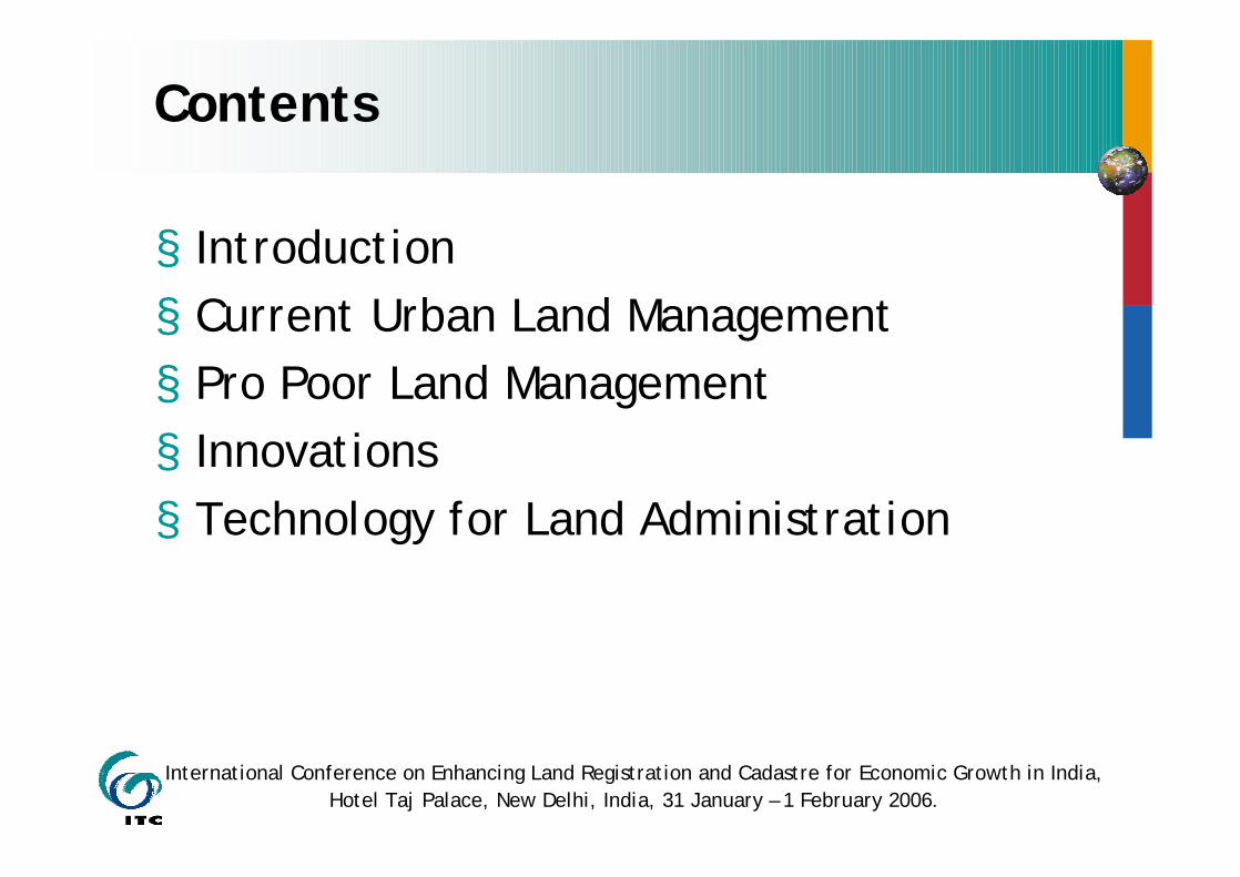
IKONOS images
Experiment:§ Geometric quality
±3m§ Parcel boundaries
comparable with original cadastral maps
§ Topographic objects such as Building, streets, rivers are easily extracted
§ For dispute resolving it is a very good tool
IKONOS image in Kathmandu area

International Conference on Enhancing Land Registration and Cadastre for Economic Growth in India, Hotel Taj Palace, New Delhi, India, 31 January – 1 February 2006.
Laser scanners
Digital surface Model Nijmegen Color image Nijmegen
0.5 mEye safety distance
1560 nmLaser wavelength
83 000 per sec.Effective measurement rate
83 000 HzLaser pulse rate
653 HzScan rate
14.3°Scan width
1.95 cmDistance resolution
1600 mRange
LIDAR – FALCON TOPOSYS
Potential is high but stillUnder research

International Conference on Enhancing Land Registration and Cadastre for Economic Growth in India, Hotel Taj Palace, New Delhi, India, 31 January – 1 February 2006.
Land Information systems (Central/Local)
§ Descriptive components § Agreement/evidences § Register of tenure rights
and rights holders –customary groups, family, individuals
§ Spatial components§ Identification of the
spatial objects – tenure units, customary areas, family parcels, individual parcel
§ Cadastral maps § Geodetic reference
system§ Unique identifiers
§ Work processes
Integrated Geo-Information system

International Conference on Enhancing Land Registration and Cadastre for Economic Growth in India, Hotel Taj Palace, New Delhi, India, 31 January – 1 February 2006.
Modeling standards and Database Technology for LIS
§ Management, transaction and supplying cadastral information § Modeling standards for Land
information system (using UML, XML/GML)§ Core domain models, standards for
data collection, data processing, data storage and data dissemination
§ Database technology§ Integrated Geo-database
combining spatial and non-spatial data
§ Relational/object oriented database
§ Efficient update and query mechanisms
§ OGC and ISO standards
Practicing modeling cadastral databasesin Cairo, Egypt

International Conference on Enhancing Land Registration and Cadastre for Economic Growth in India, Hotel Taj Palace, New Delhi, India, 31 January – 1 February 2006.
Integrated Geo-Information system
§ Improve quality, cost effectiveness, performance and maintainability of Land Information Systems
§ GI part of integrated Information System architecture within and outside organizations
§ Accessibility improved§ Internet development§ Wireless communication
§ Now many vendors provides excellent and user friendly GIS/RS software

International Conference on Enhancing Land Registration and Cadastre for Economic Growth in India, Hotel Taj Palace, New Delhi, India, 31 January – 1 February 2006.
Conclusions
§ Innovations on land tenure security in according to land policy § Aligning Geo-information technologies with
the processes of determination, recording and dissemination of information on tenure and use rights of land. This includes gendered participatory approach and tenure mapping § Land information system enabling easy
maintenance, access at all levels.

INTERNATIONAL INSTITUTE FOR GEO-INFORMATION SCIENCE AND EARTH OBSERVATION
Thank you for your attentions