Embed Size (px)
Citation preview
Find out more about the Three Peaks Project at www.yorkshiredales.org.uk/threepeaks
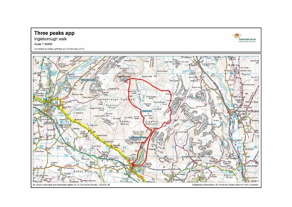
Ingleborough – caves, gorges and a fine summit Distance: 17km (10 miles) Parking: Clapham (LA2 8EF, SD 745 692) Other transport: Clapham train station is 2km (1.3 miles) from the start Toilets: In the National Park car park in Clapham Refreshments: selection of pubs and cafes in Clapham This is a long route up Ingleborough but takes in some superb limestone features – caves, gorges and limestone pavement. Make sure you are suitably equipped – remember as you go higher it gets colder and windier. Navigation is more difficult than on the other two peaks, particularly if visibility is poor. Each year many people leave the summit in the wrong direction – in cloudy conditions you may need to use a compass. Route description 1. Turn right out of the car park and follow signs towards Ingleborough Cave. There are
two choices to reach the cave; either take the lovely lakeside nature trail (small fee payable) or the walled track which runs parallel. The cave is well worth a visit and is also the last chance for a coffee or ice cream!
2. From Ingleborough Cave the path continues and turns up the impressive gorge of Trow
Gill. Above this continue to follow the obvious signed path towards Ingleborough. After crossing a wall the path passes Gaping Gill where Fell Beck disappears underground falling 100m into a cavern (take care around the edge).
3. You then climb more steeply onto Little Ingleborough. The path then flattens as it
follows a ridge before climbing again onto the summit plateau of Ingleborough itself. To reach the trig point and shelter you turn left and make your way over the rocky pathless plateau.
4. In poor weather it is easy to leave the plateau in the wrong direction. If needed from the trig point use a bearing of 070’ until the ground starts to steepen, then follow a bearing of 100’.
5. From the summit plateau retrace your steps to where the ground starts to go steeply
down and follow the path east heading towards Horton-in-Ribblesdale. This drops slowly towards the valley. After crossing a wall the path runs alongside a wall on the left.
6. After passing a ruined cottage, cross a wall and then bear right to follow a faint path through limestone rock. This then joins a good grassy track which you turn right along. There are a few alternative paths but they all meet at a gate. Go through the gate and continue down through a grassy field to the start of a walled lane.
7. Follow this stone track, passing some woods to reach a junction. Turn right to descend
back to Clapham through some tunnels for some well deserved refreshment.