Embed Size (px)
Citation preview


i
BIBLIOGRAPHIC REFERENCE Sword-Daniels, V.; Wardman, J.; Stewart, C.; Wilson, T.; Johnston, D. and Rossetto, T. 2011. Infrastructure impacts, management and adaptations to eruptions at Volcán Tungurahua, Ecuador, 1999-2010, GNS Science Report 2011/24. 73 p.
V. Sword-Daniels, Epicentre, Civil Environmental and Geomatic Engineering Department, University College London, Gower Street, London, United Kingdom
J. Wardman, Department of Geological Sciences, University of Canterbury, Private Bag 4800, Christchurch, New Zealand
C. Stewart, Joint Centre for disaster Research, Massey University/GNS Science, Massey University Wellington Campus, PO Box 756 Wellington, New Zealand
T. Wilson, Department of Geological Sciences, University of Canterbury, Private Bag 4800, Christchurch, New Zealand
D. Johnston, Joint Centre for disaster Research, Massey University/GNS Science, Massey University Wellington Campus, PO Box 756 Wellington, New Zealand
T. Rossetto, Epicentre, Civil Environmental and Geomatic Engineering Department, University College London, Gower Street, London, United Kingdom
© Institute of Geological and Nuclear Sciences Limited, 2011 ISSN 1177-2425 ISBN 978-0-478-19846-1
2011
GNS Science Report 2011/24 ii
CONTENTS ABSTRACT .............................................................................................................................. V
KEYWORDS ........................................................................................................................... VI 1.0 INTRODUCTION .......................................................................................................... 1
1.1 Personnel .......................................................................................................... 2 1.2 Aims of the study ............................................................................................... 3 1.3 Research methods ............................................................................................ 3 1.4 Characteristics of the case study areas ............................................................ 4
1.4.1 Quito .................................................................................................... 4 1.4.2 Baños .................................................................................................. 5 1.4.3 Riobamba ............................................................................................ 5 1.4.4 Guayaquil ............................................................................................ 6
2.0 VOLCANIC HAZARDS IN ECUADOR ........................................................................ 7
2.1 Overview of volcanic hazards in Ecuador ......................................................... 7 2.2 Volcán Tungurahua: eruption history and volcanic hazards ............................. 8
2.2.1 Volcanology of the 2006 Tungurahua eruption ................................. 11 2.2.2 Volcanology of the 2010 Tungurahua eruption ................................. 11
2.3 Volcano monitoring and warnings ................................................................... 18
3.0 INFRASTRUCTURE IMPACTS AND RESPONSES TO RECENT ASHFALL .......... 19
3.1 Electricity supply ............................................................................................. 20 3.1.1 Organisational and operational structure of the electrical
network in Ecuador ........................................................................... 20 3.1.2 Generation sites ................................................................................ 22 3.1.3 Substations ....................................................................................... 23 3.1.4 Transmission and distribution equipment .......................................... 26 3.1.5 Summary of impacts and adaptations to electrical supply ................ 28
3.2 Water supplies ................................................................................................ 29 3.2.1 Guayaquil .......................................................................................... 29 3.2.2 General vulnerability of water supplies in Ecuador ........................... 29
3.3 Healthcare facilities and services .................................................................... 29 3.3.1 Structure of the healthcare system in Ecuador ................................. 30 3.3.2 Impacts on the healthcare system ..................................................... 30 3.3.3 Overview ........................................................................................... 30 3.3.4 Lifeline utilities ................................................................................... 31 3.3.5 Impacts on public health and healthcare service provision ............... 31 3.3.6 Impacts on buildings and equipment ................................................. 32 3.3.7 Ashfall clean-up ................................................................................. 33 3.3.8 Economic impacts ............................................................................. 33 3.3.9 Physical back-up systems and energy use rationing ........................ 34 3.3.10 Building and physical modifications ................................................... 34 3.3.11 Protective equipment......................................................................... 34 3.3.12 Cleaning and maintenance................................................................ 34 3.3.13 Contingency plans and community work ........................................... 35
3.4 Transportation networks .................................................................................. 35 3.4.1 Roads ................................................................................................ 35 3.4.2 Aviation ............................................................................................. 36
3.5 Municipal clean-up and ash disposal .............................................................. 37 3.6 Telecommunications ....................................................................................... 37
4.0 IMPACTS ON AGRICULTURE .................................................................................. 38
4.1 Overview of agriculture in the Tungurahua area ............................................. 38
2011
GNS Science Report 2011/24 iii
4.2 Impacts of ashfall and adaptations in the Tungurahua area ........................... 39 4.3 Case study: Cotaló .......................................................................................... 39 4.4 Impacts of earlier eruptions ............................................................................. 41 4.5 Impacts of the 2010 eruption ........................................................................... 43
5.0 VOLCANIC EMERGENCY MANAGEMENT IN ECUADOR ...................................... 44
5.1 Emergency management structure ................................................................. 44 5.1.1 The role of vigìas in the area around Volcán Tungurahua ................ 46
5.2 Emergency management practice around Volcán Tungurahua ...................... 47 5.3 Community response to volcanic unrest ......................................................... 49
5.3.1 Baños: a unique case of preparedness and social response ............ 50
6.0 CONCLUSIONS AND KEY FINDINGS ...................................................................... 53
7.0 RECOMMENDATIONS FOR FUTURE ASHFALL IMPACT STUDIES ..................... 56
8.0 REFERENCES ........................................................................................................... 57
FIGURES Figure 1 Bridge on Rio Palitahua washed out by lahar from Volcán Tungurahua, near settlement of
Penipe, on direct route between Riobamba and Baños. .................................................................... 6 Figure 2 Map of Ecuador’s volcanoes and chart of eruptive history (from Leonard et al. 2005 and
IGEPN brochure). .............................................................................................................................. 7 Figure 3 Geological map of Tungurahua, from Hall et al. (1999). ................................................................... 10 Figure 4 GOES-13 Satellite imagery of the eruption on 28th May 2010 (NOAA). .......................................... 12 Figure 5 Ash plume from May 28 2010 eruption of Tungurahua (reproduced with the permission of
the National Secretariat). ................................................................................................................. 13 Figure 6 Hazard scenarios produced by IG during volcanic unrest at Volcán Tungurahua in May
2010. Scenario: pyroclastic flows. .................................................................................................... 14 Figure 7 Hazard scenarios produced by IG during volcanic unrest at Volcán Tungurahua in May
2010. Scenario: gas and ash eruptions. ........................................................................................... 15 Figure 8 Hazard scenarios produced by IG during volcanic unrest at Volcán Tungurahua in May
2010. Scenario: Lava lake overflow. ................................................................................................ 16 Figure 9 Hazard scenarios produced by IG during volcanic unrest at Volcán Tungurahua in May
2010. Scenario: Decrease in activity. ............................................................................................... 17 Figure 10 Map of the towns visited in the Tungurahua area to investigate the impacts of volcanic ash. .......... 19 Figure 11 Map illustrating the Ecuadorian transmission network. Image courtesy of CELEC EP. ................... 21 Figure 12 Above: a severely pitted turbine that has been removed from service. Below: the Agoyan
Dam and its orange floodgates. ....................................................................................................... 23 Figure 13 Above: 138 kV transformer bushing coated in 1-2 mm of fine-grained ash at a Guayaquil
substation. Below: a contaminated disconnect switch. (Photos Courtesy of Transelectric, Ecuador). ......................................................................................................................................... 25
Figure 14 Above: 138 kV transmission tower (E50) situated in a 2006 lahar path. Below: Proposed re-design of the 138 kV transmission circuit showing relocation of towers and conductors (lines) to avoid lahars (Photo’s courtesy of Transelectric, Ecuador). .......................................................... 27
Figure 15 Area of lahar damage in Juive Chico, west of Baños (GPS 16). Upper photo: new section of road replacing lahar-damaged section. Lower photo: in same area, house buried by lahar deposits. ........................................................................................................................................... 36
Figure 16 Intensive land use on lower slopes of Volcán Tungurahua (photo taken from near Cotaló). ............ 38 Figure 17 General view of Cotaló (at far end of terrace) and surrounding area. .............................................. 40 Figure 18 Entrance to village of Cotaló. ........................................................................................................... 40 Figure 19 Ballistic block damage to shed roof, Cotaló, 2006 (photo courtesy of Carlos Fernando
Perez). ............................................................................................................................................. 41 Figure 20 Ashfall on ground, Cotaló, 2006 (photo courtesy of Carlos Fernando Perez). ................................. 42 Figure 21 New sheds (rebuilt after 2006 eruption) housing chicken farm, Cotaló. ........................................... 43 Figure 22 Ballistic damage to the roof of a chicken shed. ................................................................................ 43 Figure 23 Emergency shelter near Penipe, Tungurahua area. ........................................................................ 47 Figure 24 Emergency muster point signage in Penipe. .................................................................................... 48 Figure 25 Evacuation route signage in Cotaló. ................................................................................................ 48 Figure 26 Signs marking the routes to emergency shelters, taken in Baños (September 2010). ..................... 52 Figure A1 Rio Palitahua (GPS 2) ...................................................................................................................... 62 Figure A2 Rio Vascún (GPS 15) ....................................................................................................................... 63 Figure A3 Rio Chamana (GPS 19) ................................................................................................................... 63
2011
GNS Science Report 2011/24 iv
TABLES Table 1 Eruption frequencies for selected countries (after Wilson et al. 2009). .............................................. 1 Table 2 Summary of historic and recent activity of Volcán Tungurahua (sources: Hall et al. 1999;
Barba et al., 2008; Lane et al., 2003; Samaniego et al., 2011). ......................................................... 9 Table 3 Impacts of on agricultural land. ........................................................................................................ 39 Table 4 Capacity of shelters in the provinces and cantóns close to Volcán Tungurahua, and the
number of families staying in the albergues (shelters) from 28th May to 14th June 2010. Reproduced courtesy of the National Secretariat of Risk Management, Ecuador. ........................... 49
APPENDICES Appendix 1 Trip itinerary ..................................................................................................................................... 60 Appendix 2 Data inventory: resources gathered during fieldwork ....................................................................... 61 Appendix 3 Stream water quality data, Tungurahua region ................................................................................ 62 Appendix 4 Scanned newspaper articles from the May 2010 eruption of Volcán Tungurahua ........................... 64 Appendix 5 Ethics approval numbers .................................................................................................................. 68
2011
GNS Science Report 2011/24 v
ABSTRACT
This report summarises observations made on a field visit to areas affected by the May 2010 eruption of Volcán Tungurahua, Ecuador. The focus of this trip, carried out in September 2010 by a field team from the University of Canterbury and University College London, was to investigate both direct and indirect effects of ashfall on critical infrastructure, and the management of ashfall events. In particular we paid attention to less-studied areas of interest including electrical power and healthcare systems. All infrastructure topics explored aspects of resilience and adaptation, in the context of ongoing volcanic unrest at Tungurahua since 1999. Research methods were largely qualitative and included semi-structured interviews, observation, water testing and informal conversations and meetings with locals.
A good overview of ashfall impacts on electricity networks, healthcare services and emergency management issues was achieved during the trip. The information gathered adds to our knowledge of the possible effects of volcanic ashfall on infrastructure and public services. Further insights into impacts of water, wastewater, transportation and agriculture were gained.
Overall, infrastructure seemed to function well during the 2010 eruption, with only minor problems reported. However, the May 2010 eruption generated only minor ashfalls (a few mm) in most locations. Over the past 11 years of volcanic unrest, other events have caused more serious impacts, particularly a VEI 3 eruption on 16-17 August 2006.
Electrical supplies suffered few problems, with no reports of electrical flashover from ashfalls. Problems arising from contamination of open water supplies have led to an initiative to cover water supplies. In the transport sector, the 2010 eruption resulted in a two-day closure of Guayaquil international airport due to risks to aircraft. Roads in the Tungurahua region have been frequently damaged by lahars over the past 11 years. The 2010 eruption caused partial damage to 3740 ha of crops. Far more severe, although localised, damage to crops, livestock and rural communities was caused by the August 2006 eruption.
Healthcare centres are well-organised and are able to prioritise essential services in the event of an ashfall, and so experience few major impacts, but a variety of minor impacts on facilities and equipment. A variety of public health pathologies have increased by small amounts in the short term after ashfalls, and psychological impacts in communities affected by eruptions have increased since activity began at Volcán Tungurahua in 1999, and have required increased attention from healthcare professionals in the long term. Emergency management insights provide lessons pertaining to the benefits of local engagement and involvement in risk management, including the influential role of the vigìas, who act as observers of volcanic activity and coordinators of voluntary civil defence within the community.
The focus on adaptations and responses to the long-term volcanic activity has provided insights into the long-term effects of volcanic activity and helped identify possible mitigation and prevention measures. It is found that in general, increased maintenance of infrastructure now occurs widely across sectors, and cleanup methods for specific sectors have been developed to cope with ashfalls. The cleanup of ash at the municipal level is well organised, and is coordinated with the National Secretariat of Risk Management such that costs are shared with the proportions adjusted according to the severity of the situation. Increased use of personal protective measures (such as masks and goggles) has achieved a reduction in
2011
GNS Science Report 2011/24 vi
public health impacts. Healthcare centres are also well organised, forming brigades for rapid response in affected areas, and having a clear hierarchy of health centres within each region so that patients can be transferred if necessary. They have good knowledge of the volcanic alert level system and the protocols required for each alert level change. Emergency management also appears organised. Emergency drills are run in at-risk communities, and contingency plans are updated and revised following eruptions. Hazard warning and shelter signage is also widespread in the Tungurahua volcanic hazard area.
Overall, we found clear evidence for increased organisation and improved management procedures in the Tungurahua volcanic hazard area, which should have strengthened societal resilience. Additionally individual adaptive behaviour has included: increased use of personal protective equipment, which has reduced public health effects; farmers growing more ash-resilient crops including onions, and using greenhouses for crop growth; farmers only rearing livestock for a shortened period of time in the area, in order to prevent tooth abrasion; and an initiative to cover water supplies to protect them from contamination by ashfalls.
Other examples of adaptations to infrastructure have included: widespread hazard signage; sirens in and around Baños for early warning (with an alternate power supply in case of power cuts, and a contingency emergency services siren system); floodgate design at Agoyan dam for bypassing turbulent water; and the development of plans to relocate electrical transmission towers away from valleys that have, in the past, been affected by lahars.
Further studies in the Tungurahua volcanic area would be beneficial, to gain long-term understanding of volcanic ash consequences on a variety of sectors, including those explored in less depth in this study.
KEYWORDS
Volcán Tungurahua, eruption, ashfall, infrastructure, impact, resilience, adaptation.
2011
GNS Science Report 2011/24 1
1.0 INTRODUCTION
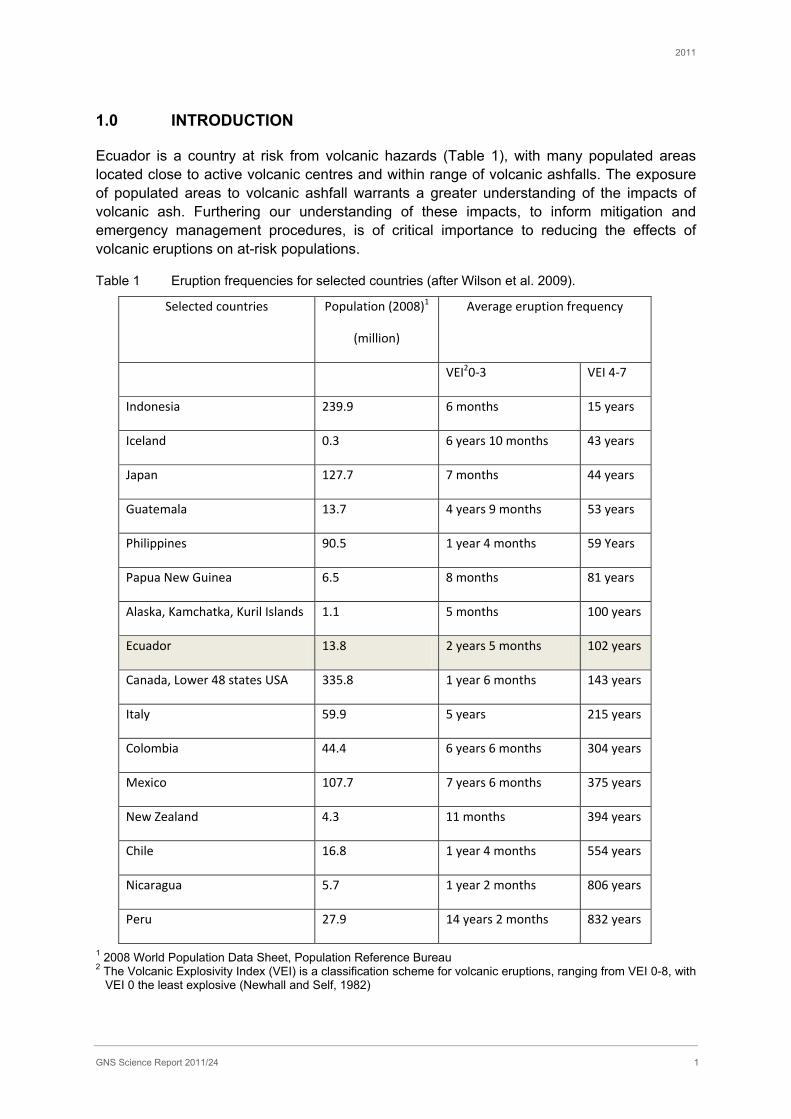
Ecuador is a country at risk from volcanic hazards (Table 1), with many populated areas located close to active volcanic centres and within range of volcanic ashfalls. The exposure of populated areas to volcanic ashfall warrants a greater understanding of the impacts of volcanic ash. Furthering our understanding of these impacts, to inform mitigation and emergency management procedures, is of critical importance to reducing the effects of volcanic eruptions on at-risk populations.
Table 1 Eruption frequencies for selected countries (after Wilson et al. 2009).
Selected countries Population (2008)1
(million)
Average eruption frequency
VEI20-3 VEI 4-7
Indonesia 239.9 6 months 15 years
Iceland 0.3 6 years 10 months 43 years
Japan 127.7 7 months 44 years
Guatemala 13.7 4 years 9 months 53 years
Philippines 90.5 1 year 4 months 59 Years
Papua New Guinea 6.5 8 months 81 years
Alaska, Kamchatka, Kuril Islands 1.1 5 months 100 years
Ecuador 13.8 2 years 5 months 102 years
Canada, Lower 48 states USA 335.8 1 year 6 months 143 years
Italy 59.9 5 years 215 years
Colombia 44.4 6 years 6 months 304 years
Mexico 107.7 7 years 6 months 375 years
New Zealand 4.3 11 months 394 years
Chile 16.8 1 year 4 months 554 years
Nicaragua 5.7 1 year 2 months 806 years
Peru 27.9 14 years 2 months 832 years
1 2008 World Population Data Sheet, Population Reference Bureau 2 The Volcanic Explosivity Index (VEI) is a classification scheme for volcanic eruptions, ranging from VEI 0-8, with
VEI 0 the least explosive (Newhall and Self, 1982)
2011
GNS Science Report 2011/24 2
In 2004, a team from New Zealand visited Ecuador to study the impacts of volcanic ashfall on infrastructure and agriculture, and volcanic hazard emergency management. The focus of this trip was the 2002 eruption of Reventador and the eruptions of Volcán Tungurahua since 1999 (Leonard et al., 2005).
The current study has been designed to build on the findings of the previous one, and to add detail and knowledge on new areas of research on infrastructure. In particular, the aims were to further our understanding the impacts of ashfall on critical infrastructure facilities; infrastructure service provision; the knock-on effects of infrastructure lifeline disruption onto other facilities and on the public; the critical lifelines that support community infrastructure and social networks; and the progress in disaster planning and management.
This report presents and discusses findings from a study tour of the regions of Ecuador most affected by the recent May 2010 eruption, and by the previous eruptions of Volcán Tungurahua. Field work in Ecuador was carried out between 5-18 September 2010 by a team representing the University of Canterbury, Christchurch, New Zealand, and University College London, UK. For a complete trip itinerary, refer to Appendix 1.
1.1 Personnel
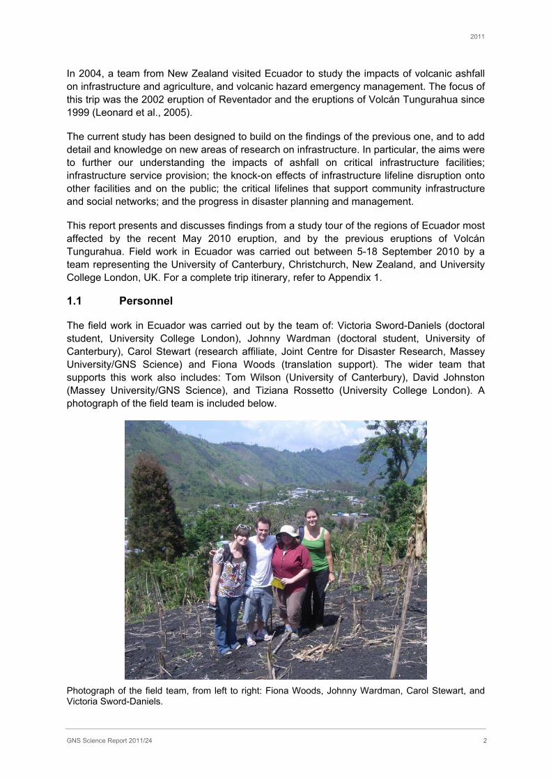
The field work in Ecuador was carried out by the team of: Victoria Sword-Daniels (doctoral student, University College London), Johnny Wardman (doctoral student, University of Canterbury), Carol Stewart (research affiliate, Joint Centre for Disaster Research, Massey University/GNS Science) and Fiona Woods (translation support). The wider team that supports this work also includes: Tom Wilson (University of Canterbury), David Johnston (Massey University/GNS Science), and Tiziana Rossetto (University College London). A photograph of the field team is included below.
Photograph of the field team, from left to right: Fiona Woods, Johnny Wardman, Carol Stewart, and Victoria Sword-Daniels.
2011
GNS Science Report 2011/24 3
1.2 Aims of the study
The following were the specific areas of interest for our study:
• Impacts on essential infrastructure (electrical supply and generation networks, water supplies, wastewater systems and transport and communication networks);
• Impacts on healthcare facilities and healthcare service provision;
• Activation of health facility emergency management plans;
• Impacts on agriculture, including livestock evacuation;
• Assessment of evacuation planning during a volcanic crisis;
• Factors affecting evacuation of communities;
• Socio-economic impacts, such as stresses and disruption due to evacuation;
• Social and physical adaptations made to living with volcanic hazards.
Due to limited field time and our research interests, it was not possible to cover all of these areas in equal depth. The topics covered in greater detail were: healthcare facilities, electrical transmission and generation sites and emergency management. Inquiry into the May 2010 eruption, together with a comparison of impacts from previous eruptions, allowed a greater longitudinal insight into the adaptations to, and the resilience of such infrastructure.
1.3 Research methods
Research methods utilised during this study trip included field observations and measurements, meetings and semi-structured interviews.
Meetings and semi-structured interviews were conducted at infrastructure offices and facilities in affected areas, using a translator to conduct the interviews in Spanish. Ethical approval for the interviews was granted from the university institutions University College London and University of Canterbury prior to leaving (see Appendix 5). Interviewees were comprised mainly of facility managers, directors and operating professionals. Organisations of interest were identified beforehand, where possible, and attempts were made to set up interviews in advance of our visit.
Interviews were semi-structured in nature to allow for freer exploration and discussion around the various topics that were touched upon in conversation. The interviews utilised prompt questions which were used to steer the conversation, and touched upon the main topics of interest for research including: the general impacts of volcanic ashfall on the sector; actions taken in response to ashfall; ash clean-up and any associated problems; emergency management plans and interrelated power, water and access impacts on the sectors. However, conducting interviews through a translator meant that some questions needed to be phrased in a proactive manner, to maintain the focus of the interview and to avoid misinterpretations as a result of translation.

2011
GNS Science Report 2011/24 4
In general, the interviewee was asked to speak freely following a prompt question, and the translator would summarise the comments when they had finished. This allowed the researcher to have some level of continued exploration of some of the aspects mentioned in dialogue by the participant. But detailed explanations at the time were not deemed appropriate in the interview, in order to maintain the interest of the interviewee and to reduce the interview time.
Interviews were recorded and consent forms were signed by the interviewee(s) at the time of interview. A total of twenty recorded interviews were conducted during fieldwork in Ecuador, which varied in length from 25 to 105 minutes.
Of the intended participants, key staff at two of the hospitals contacted could not be interviewed; one because the appropriate person was away, and the other declined to be interviewed. It was not possible to set up interviews with water utility companies in Guayaquil and Riobamba owing to the tight time constraints of the trip.
Interviews were supplemented by the authors’ own field observations, and by informal conversations with local people. A copy of the inventory of additional data collected during fieldwork can be found in Appendix 2. River water testing for turbidity, conductivity and pH readings were undertaken additionally in the Baños area, the results are presented in Appendix 3. Additionally a copy of newspaper articles from the May 2010 eruption can be found in Appendix 4.
1.4 Characteristics of the case study areas
This section provides some background information on Ecuador followed by a brief overview of the case study settlements visited for this study.
Mainland Ecuador has an area of approximately 256,000 km2 and consists of three distinct regions: the coastal region, the central Andean region and the Amazon basin. The most recent census was carried out in November and December 2010; the population was measured at just over 14.3 million, an increase of 14% since the previous census in 2001.
Ecuador has substantial oil reserves and highly productive agricultural regions, and is a substantial exporter of bananas, other tropical fruit, sugar, flowers, cocoa and coffee, as well as petroleum, fish, shrimp, timber and gold. The GDP per capita is estimated at $USD 8,322.
1.4.1 Quito
Quito is located in the Guayllabamba river basin, in Pichincha province in the central Andean region of Ecuador (Figure 2). It is the second largest city in Ecuador, after Guayaquil, with a population of approximately 1.5 million. At 2850 m elevation, Quito is the second highest capital city in the world. The city sits on an extensive plateau that is part of the eastern slopes of Guagua Pichincha volcano. It is also adjacent to several other active volcanoes (Figure 2) and is vulnerable to ashfall. Both the 1999 eruption of Guagua Pichincha and the 2002 eruption of Reventador supplied millimetre thicknesses of ash to the city (Leonard et al., 2005). Suburbs to the south of Quito are also subject to lahar hazards from Cotopaxi volcano.
2011
GNS Science Report 2011/24 5
1.4.2 Baños
Named after the thermal springs located around the city, Baños de Agua Santa, commonly referred to as Baños, is located in Tungurahua province. It is the second-largest settlement, after Ambato, and has a population of approximately 16,000 (Lane et al., 2003). Baños is located at an altitude of 1800 m on the northern base of Volcán Tungurahua (5023 m), a stratovolcano located on the border between Tungurahua and Chimborazo provinces (Figure 2).
The economy of Baños is heavily dependent on tourism. Its features include a shrine dedicated to the Virgin of Baños, a mild climate, access to the Amazon basin, thermal springs and mountain scenery. In 1999, prior to the onset of volcanic unrest, 95% of economic activity in this community was dependent on tourism (Lane et al., 2003).
Prior to 1999, unrest at Tungurahua last threatened Baños between 1916 and 1918; at least one pyroclastic flow and several major lahars descended river valleys immediately to the east and west of the town (Hall et al., 1999).
While in Baños, the focus of our visit was on infrastructure impacts from ashfall, municipality volcanic hazard emergency strategies and volcano monitoring and warning systems. We also visited the nearby towns of Puyo, Ambato, Penipe, Quero and Cotaló to investigate the short and long-term impacts on infrastructure from volcanic activity since Tungurahua’s reactivation in 1999.
1.4.3 Riobamba
San Pedro de Riobamba is the capital of the Chimborazo province in central Ecuador, located at the Chambo River valley. Riobamba (elevation 2754 m) is located 200 km south of Quito and 30 km southwest of Volcán Tungurahua (Figure 2). The city is a major regional transport hub and, along with Ambato, one of the major population centres in central Ecuador. Its population is approximately 125,000.
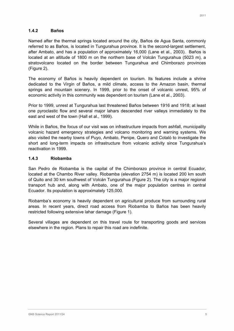
Riobamba’s economy is heavily dependent on agricultural produce from surrounding rural areas. In recent years, direct road access from Riobamba to Baños has been heavily restricted following extensive lahar damage (Figure 1).
Several villages are dependent on this travel route for transporting goods and services elsewhere in the region. Plans to repair this road are indefinite.
2011
GNS Science Report 2011/24 6
Figure 1 Bridge on Rio Palitahua washed out by lahar from Volcán Tungurahua, near settlement of Penipe, on direct route between Riobamba and Baños.
1.4.4 Guayaquil
Guayaquil is the largest city in Ecuador with a population of 2.6 million in 2009. It is the capital of Guayas province and is the centre of Ecuador’s business and manufacturing operations. The city sits on the western bank of the Guayas River, close to the Pacific Ocean and is Ecuador’s main port (Figure 2). Guayaquil received ashfall from Volcán Tungurahua during the May 2010 eruption.

2011
GNS Science Report 2011/24 7
2.0 VOLCANIC HAZARDS IN ECUADOR
2.1 Overview of volcanic hazards in Ecuador
Ecuador lies to the east of a subduction zone, where the Pacific plate is being subducted beneath the South American plate. The subduction zone dips to the east underneath the South American continent. The tectonic setting has formed a terrain of approximately north-south trending mountain chains, collectively forming the South American Andes. In Ecuador these mountain chains include: the Cordillera Real, Cordillera Central, and Cordillera Occidental, which pass through the centre of Ecuador, from west to east respectively. Partial melting of the subducting plate has formed a broad chain of volcanoes within this mountainous zone (Figure 2). These volcanoes form the highest peaks in Ecuador.
There are 21 Holocene age (<0.01 ma) volcanoes listed for Ecuador on the Smithsonian Institute website (SI, 2010). The volcanoes of Ecuador vary in type and include: calderas, compound volcanoes and stratovolcanoes. The erupted magmas vary in composition from fluid basalts through to viscous rhyolites.
The tectonic setting of Ecuador renders it at risk from both earthquake and volcanic hazards. The volcanic hazards vary in accordance with the volcano type and magma composition. Large caldera-forming eruptions are highly explosive but infrequent. More frequent eruptions occur from stratovolcanoes with intermediate magma compositions that are associated with the following hazards: pyroclastic flows, explosions, ashfalls, lava flows and lahars.
Figure 2 Map of Ecuador’s volcanoes and chart of eruptive history (from Leonard et al. 2005 and IGEPN brochure).
2011
GNS Science Report 2011/24 8
2.2 Volcán Tungurahua: eruption history and volcanic hazards
Volcán Tungurahua is an andesitic-dacitic stratovolcano which rises to an altitude of 5023 m above sea level (SI, 2010). It is situated in the Cordillera Central of Ecuador; a mountain chain forming part of the Andes. Tungurahua lies approximately 140 km south of Quito, and around 8 km south-south-west of the city of Baños (Section 1.4.2). Many other small towns and villages occupy the slopes of the volcano and are at risk from volcanic activity.
Tungurahua is formed of three historic edifices: Tungurahua I, Tungurahua II and Tungurahua III. Tungurahua II was built after the collapse of Tungurahua I, but itself suffered a sector collapse and created a horseshoe-shaped crater, which is open to the west (SI, 2010). This feature is dated at 2955± 90 years old (Hall et al., 1999). Tungurahua III formed inside the Tungurahua II crater, undergoing two phases of construction: Phase I, 2300-1400 years ago, and Phase II, 1300 years ago until present. This construction of Tungurahua III has been characterised by andesitic lava flows, andesite and dacite pyroclastic flows and andesitic plugs (Hall et al., 1999).
All of the historical eruptions observed at Tungurahua have come from Tungurahua III; the youngest of the volcanic structures (SI, 2010). This youngest structure is referred to as Tungurahua or Volcán Tungurahua. Historic and recent activity of Tungurahua is shown in Table 2 and a map of Tungurahua’s geology in Figure 3.
Volcán Tungurahua has been in a state of unrest since 1999, with many minor eruptions and also major eruptions in 2006, 2008 and 2010. The main styles of activity are Strombolian and Vulcanian. Volcanic hazards from the recent period of unrest have included: strong explosions, tephra falls, pyroclastic flows, lava flows and lahars, some of which have reached populated areas at the base of the volcano. These relatively frequent volcanic hazards directly threaten 25,000 people, as well as the Agoyan hydroelectric dam, which is located close to Baños (Hall et al., 1999).

2011
GNS Science Report 2011/24 9
Table 2 Summary of historic and recent activity of Volcán Tungurahua (sources: Hall et al. 1999; Barba et al., 2008; Lane et al., 2003; Samaniego et al., 2011; Arellano et al., 2008).
Date Event
1641-1646 Historical reports of eruption exist, but there is a lack of reliable eyewitness accounts and stratigraphic confirmation.
1773-1781 Andesitic ashfall and dacitic pumice lapilli fall followed by large andesitic lava flow down NNW flank to Juive Grande; dammed Pastaza River for several days.
1797 Crater explosions coinciding with M8.3 earthquake that destroyed Riobamba.
1886-1888 Pyroclastic flows down W flank, particularly on NW where they partially buried 1773 lava flow, followed by lava flow down NW flank towards Cosua where it dammed the Chambo River.
1916-1918 Pyroclastic flows down NW and N flanks to Las Juntas and Vascún valley. Lava confined to crater.
October- November 1999
Onset of current cycle of eruptive activity. Elevated seismicity and SO2 fluxes in September led to an eruption on 5 October. Evacuation of Baños ordered on 18 October. Townspeople returned on 5 January, clashed with authorities and won the right to stay in Baños at their own risk. Activity continued on cyclical basis with small to moderate explosive eruptions leading to ash emissions in August 2001, September 2002, October-November 2003 and May-July 2004.
July-August 2006
14-16 July: VEI 2 eruption. Pyroclastic flows towards NW, threatening Cosua and Juive Grande villages, and NNE, down upper Vascún valley. 16-17 August: VEI 3 eruption, largest in recent phase. Pyroclastic flows down NW and N flanks. During paroxysmal phase, there was a powerful lava fountain up to 1000 m above the crater, a 15 km high eruption column and pyroclastic flows down the N, NW, W and SW flanks with runout distances >8 km. Tephra fallout extended to the SW as far away as Guayaquil.
February 2008 Incandescent rocks and ashfall (Red Alert status).
May 2010 28 May: strong explosion with eruption column to 15 km altitude. Pyroclastic flows to NW, W and SW with runout 3 km down flanks. A lava lake formed in the crater. Ash plume extended to WSW as far as Guayaquil.
1 Volcanic Explosivity Index (Newhall and Self, 1982)

2011
GNS Science Report 2011/24 10
Figure 3 Geological map of Tungurahua, from Hall et al. (1999).

2011
GNS Science Report 2011/24 11
2.2.1 Volcanology of the 2006 Tungurahua eruption
Since the onset of volcanic unrest at Tungurahua in 1999, the eruptive activity was characterised from 2000-2005 by low to moderate explosiveness. These phases were strombolian with short duration explosions, plumes up to 7 km above the summit, and ash fallout on a regional scale (Samaniego et al., 2011). There were also periods of quiescence, such as between February to December 2005. However, in April 2006, IG-EPN monitoring detected deep seismic activity beneath the summit and an increase in SO2 emissions. Increasing shallow seismic activity culminated in the 14 July (VEI 2) and 16-17 August (VEI 3) eruptions.
Activity on 14 July generated a 3-4 km high eruption column initially. The paroxysmal phase occurred between 19h40 on 14 July and 01h00 on 15 July, and gave rise to an eruption column over 20 km in height. At least 11 pyroclastic flows were generated, which descended the NW flank and the Vascún valley. Activity decreased on 15 July, but there were at least six small to moderate pyroclastic flows on 16 July (Barba et al., 2008).
On 16 August, activity increased again. The paroxysmal phase began at 00h15 on 17 August and involved a powerful lava fountain up to 1000 m above the crater, a 15 km high eruption column and the generation of major pyroclastic flows which descended 17 ravines on the north, northwest, west and southwest flanks. These flows travelled up to 8.5 km from the crater, and formed deltas in the valley of the Rio Chambo, which was blocked for several hours. The Puela and Pastaza rivers were also dammed by pyroclastic flows. The ash plume drifted to the west and deposited an ash and lapilli layer in the Interandean valley, with an uncompacted bulk volume estimated to be 40 x 106 m3. Together with the pyroclastic flow volume of 10-15 x 106 m3, this eruption is ranked as VEI 3, or approximately an order of magnitude greater than the 14 July eruption (Samaniego et al., 2011).
2.2.2 Volcanology of the 2010 Tungurahua eruption
In 2010, activity at Tungurahua increased and IG reported that on the 26th May there was a strong explosion from Volcán Tungurahua that sent an ash plume to 12km altitude, with ashfalls reported to the south and southwest. This explosion also generated pyroclastic flows that flowed north, northwest and west down the flanks of the volcano with run-out distances of <1 km.
On the 28th May another strong explosion occurred at Tungurahua that generated an ash plume to 15 km altitude. This was the strongest explosion of the 2010 eruption sequence. The plume travelled southwest and primarily affected the provinces of Bolivar, Los Rios and Guano (Figure 4).

2011
GNS Science Report 2011/24 12
Figure 4 GOES-13 Satellite imagery of the eruption on 28th May 2010 (NOAA).
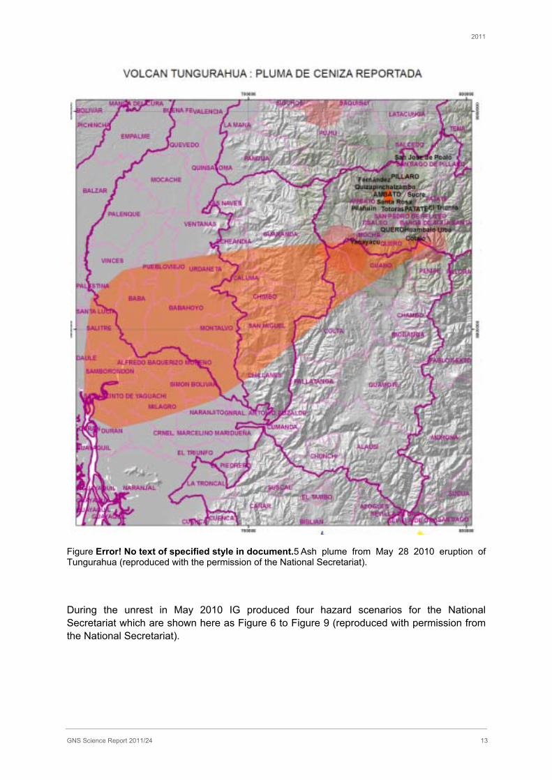
Thin (1-2 mm) ashfalls were received in Guayaquil, approximately 180 km southwest of Volcán Tungurahua. During this event, pyroclastic flows were generated to the northwest, west and southwest, with run-out distances of 3km down the flanks of the volcano. Pumice blocks also fell within 6-8km from the vent (IG, 2010). A map of the areas affected by the ash plume is reproduced as Figure 5, with the kind permission of the National Secretariat.
Activity continued on the 28-30th May, with 5-10 eruptions recorded per hour, and reports of “cannon shot” noises that caused windows to vibrate in the local area. Steam and ash plumes reaching <10km altitude, with ashfall reported in areas within around 8km to the northwest, west and southwest continued, and “cannon shot” noises and bombs ejected within 2km of the summit, continued to characterise the activity of this eruption into the month of June (IG, 2010). On 2nd June another pyroclastic flow occurred to the northwest, and on 5-7th June ashfall was reported at a greater distance of 23km from the vent (IG, 2010).
Ashfalls resulting from this eruptive period were found to be coarse grained in Cotaló, proximal to the volcano, reducing in grain size to a very fine powder in Guayaquil. At the time of writing there was no data available to quantify the ash grain size or composition.
2011
GNS Science Report 2011/24 13
Figure Error! No text of specified style in document.5 Ash plume from May 28 2010 eruption of Tungurahua (reproduced with the permission of the National Secretariat).
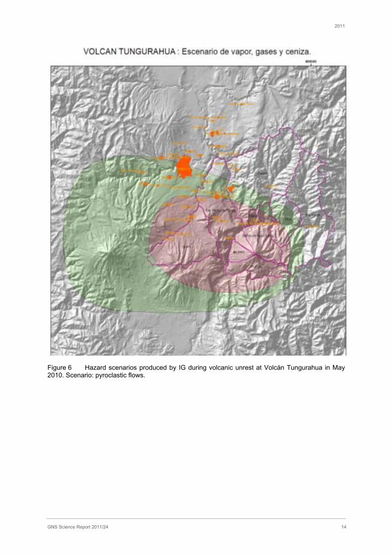
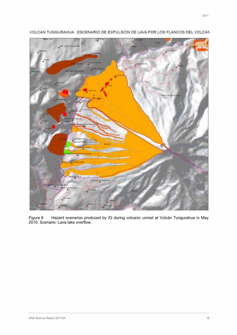
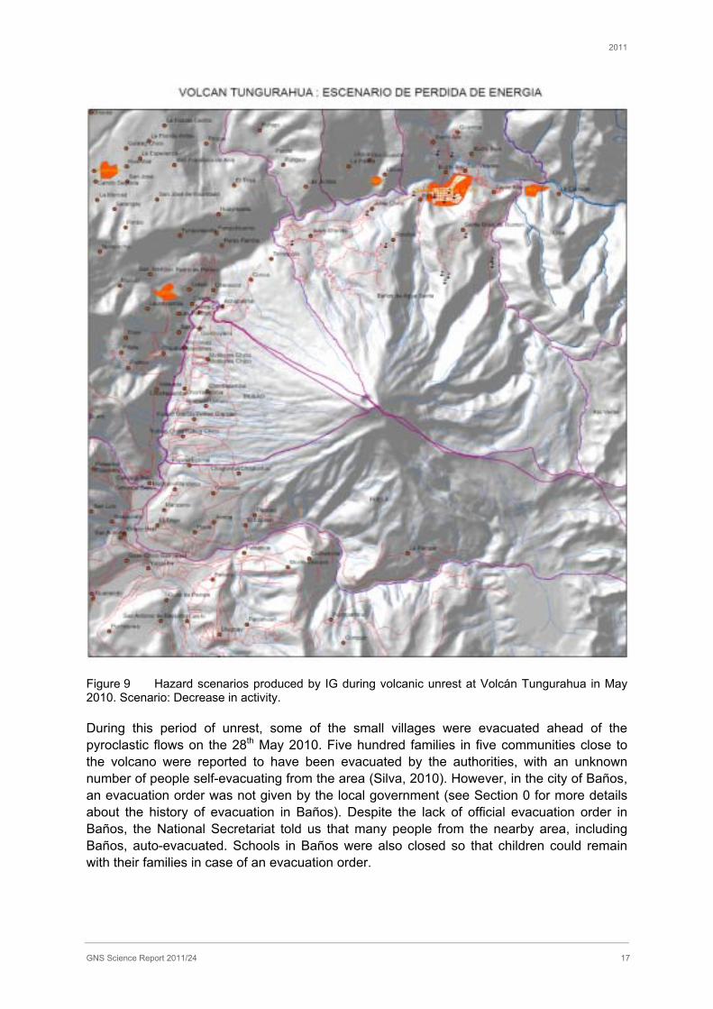
During the unrest in May 2010 IG produced four hazard scenarios for the National Secretariat which are shown here as Figure 6 to Figure 9 (reproduced with permission from the National Secretariat).
2011
GNS Science Report 2011/24 14
Figure 6 Hazard scenarios produced by IG during volcanic unrest at Volcán Tungurahua in May 2010. Scenario: pyroclastic flows.

2011
GNS Science Report 2011/24 15
Figure 7 Hazard scenarios produced by IG during volcanic unrest at Volcán Tungurahua in May 2010. Scenario: gas and ash eruptions.
2011
GNS Science Report 2011/24 16
Figure 8 Hazard scenarios produced by IG during volcanic unrest at Volcán Tungurahua in May 2010. Scenario: Lava lake overflow.
2011
GNS Science Report 2011/24 17
Figure 9 Hazard scenarios produced by IG during volcanic unrest at Volcán Tungurahua in May 2010. Scenario: Decrease in activity.
During this period of unrest, some of the small villages were evacuated ahead of the pyroclastic flows on the 28th May 2010. Five hundred families in five communities close to the volcano were reported to have been evacuated by the authorities, with an unknown number of people self-evacuating from the area (Silva, 2010). However, in the city of Baños, an evacuation order was not given by the local government (see Section 0 for more details about the history of evacuation in Baños). Despite the lack of official evacuation order in Baños, the National Secretariat told us that many people from the nearby area, including Baños, auto-evacuated. Schools in Baños were also closed so that children could remain with their families in case of an evacuation order.
2011
GNS Science Report 2011/24 18
Activity following the 28th May 2010 eruption has also included lahars, which affected the Penipe-Baños road between 28th May and 14th June 2010 and caused the road to close. Mudflows have also occurred in the area between 4th and 6th September 2010. This road was inaccessible at the time of fieldwork.
2.3 Volcano monitoring and warnings
The monitoring of volcanoes in Ecuador is carried out by Instituto Geofisico Escuela Polytechnica Nacional Apartado (IGEPN, or IG), which is based in Quito. The IG also runs the Tungurahua Observatory, which is located in Guadeloupe, 14km north of Volcán Tungurahua. Seventeen volcanoes are actively monitored in Ecuador. Different monitoring networks are installed at each volcano; elements include seismic stations, ground deformation and pressure sensors, thermal, geochemical and visual data.
The Tungurahua Observatory provides daily reports on activity at Volcán Tungurahua and operations at the Observatory. In addition, they also produce ‘special reports’, which include data from the monitoring network (seismic stations, GPS and gas emission data).
The monitoring equipment and data collection from the Tungurahua Observatory includes: seismometers, tiltmeters, COSPEC and DOAS monitoring, two lahar detection stations, thermal imagery, ash collection and chemical analyses (WOVO, 2005). This monitoring is supplemented by observations from the Observatory, and from “vigìas”, who are trained local volcano watchers with radio communications to the Observatory.
When unrest manifests at the volcano, IG inform the National Secretariat of Risk Management (otherwise known as the “National Secretariat”) and provide hazard scenarios for the likely progression of activity. The National Secretariat makes contingency plans, based on the likely hazard scenarios provided by IG, which are then given to the local government.
It is the decision of the local government to assign the alert level, and to give evacuation orders if necessary.
At the time of writing, the alert level system and contingency plans were under review by the National Secretariat, and new procedures were being developed. There are plans to: develop the contingency plans to better fit with the hazard scenarios provided by IG and to provide information on what actions people should take in each scenario; alter the alert level system, which currently varies between municipalities; and train local government officials to be able to lead in emergencies. The plans are intended to be complete by the end of 2010.

2011
GNS Science Report 2011/24 19
3.0 INFRASTRUCTURE IMPACTS AND RESPONSES TO RECENT ASHFALL
Infrastructure impacts were investigated in Guayaquil, and also in several centres in the Tungurahua area (Figure 10). Additionally, meetings were carried out informally with IG staff, and informal conversations were opportunistically undertaken with local people when visiting the affected area.
Time constraints allowed focus on a few main topics of interest, to unravel the complexities of impacts across these areas. Unfortunately it was difficult to arrange interviews within the time frame, and little information was gained on water, wastewater, and transportation and communication infrastructure directly. However other interviews provided insights into the impacts on these sectors, particularly since the focus of the trip was to look at both direct and indirect effects of ashfall on critical infrastructure. Indirect effects included how access, power, water and communications affected the operation of critical facilities.
Figure 10 Map of the towns visited in the Tungurahua area to investigate the impacts of volcanic ash.
Impacts are discussed in the following sections, by sector.
2011
GNS Science Report 2011/24 20
3.1 Electricity supply
3.1.1 Organisational and operational structure of the electrical network in Ecuador
The company CELEC EP (La Empresa Publica Estrategica Corporacion Electrica Del Ecuador) is responsible for operating the nation’s electricity transmission network. Formed on January 14 2010, CELEC EP is the single entity that oversees several businesses within the nation’s wholesale electricity market. These businesses manage different facets of the energy supply process such as generation and distribution.
The total electricity demand for Ecuador is approximately 2800 MW. The city of Guayaquil is the nation’s largest energy demander consuming roughly 700 MW, while Quito follows closely behind with a demand of about 600 MW. A centralized, double-circuit power transmission network forms a ‘ring’ that is capable of generating and transmitting a maximum of 4000 MW to provide consumers with a constant and reliable power supply (Figure 11). Ecuador’s electricity transmission network is comprised of 32 substations connected by some 3,000km of transmission lines operating at either 230 kV or 138 kV (Transelectric, 2011). Electricity is generated through the transformation of energy from fuel combustion, hydro systems, steam, natural gas and wind (only on the Galapagos).

2011
GNS Science Report 2011/24 21
Figure 11 Map illustrating the Ecuadorian transmission network. Image courtesy of CELEC EP.
2011
GNS Science Report 2011/24 22
3.1.2 Generation sites
The Agoyan hydroelectric dam, situated on the Pastaza River, is located five kilometres east of the city of Baños. This dam generates 156MW and each generator produces a voltage of 33kV. This voltage is then stepped up to 138kV for integration into the national grid. The dam and its reservoir are the second most important in Ecuador (Hall et al., 1999).
Over the last 11 years of intermittent volcanic activity from Tungurahua, very little ash has fallen at the dam site. This is mainly due to the predominant wind direction of the region which tends to carry ash south and west of the volcano (a scientist1). On the few occasions when ash has fallen at Agoyan, the dam has operated as normal unless the local municipality deems the community risk too great; as occurred during August 2006 and October 1999 when large volumes of ash fall threatened the security of Baños, which resulted in the closure of local utilities. The dam is equipped with a regularly updated contingency plan covering major disasters such as a large volcanic eruption from Volcán Tungurahua. Daily communication is maintained between dam operators and the Observatorio Volcánico Tungurahua (Tungurahua Volcano Observatory) to ensure preparedness for volcanic events.
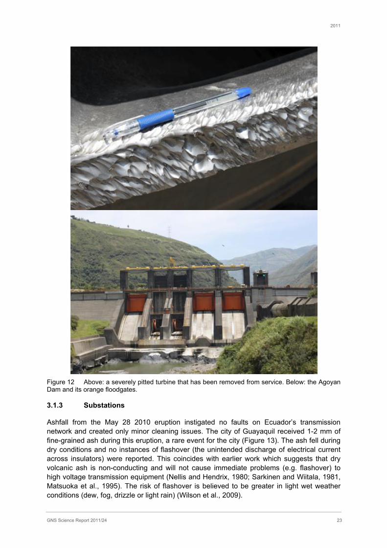
The lahar hazard from Tungurahua is more threatening to the Agoyan hydroelectric project than direct ashfall (an Agoyan Dam Operator). Intake mechanisms such as wicket gates, turbine covers and blades are particularly at risk of abrasion from ash-laden water. Severe pitting of the metallic components (Figure 12) has accelerated their degradation; Agoyan has had to replace four turbines in the last 21 years.
To reduce the impacts from the intake of highly turbid water, Agoyan is specially designed to cope with high levels of sediment. A floodgate system has been devised so that the intake flow can be diverted away from generation components and directly flushed out into the river via flood gates (Figure 12). In the event of heavy rain, when there is an increased risk of ash-laden floodwaters and lahars being generated, the dam has systems in place to monitor water levels and turbidity to trigger the protective bypass system.
1 Interviewees have been anonymised, and generalised terms relating to their employment has been used to indicate where interviews have been referenced, in accordance with ethical guidelines
2011
GNS Science Report 2011/24 23
Figure 12 Above: a severely pitted turbine that has been removed from service. Below: the Agoyan Dam and its orange floodgates.
3.1.3 Substations
Ashfall from the May 28 2010 eruption instigated no faults on Ecuador’s transmission network and created only minor cleaning issues. The city of Guayaquil received 1-2 mm of fine-grained ash during this eruption, a rare event for the city (Figure 13). The ash fell during dry conditions and no instances of flashover (the unintended discharge of electrical current across insulators) were reported. This coincides with earlier work which suggests that dry volcanic ash is non-conducting and will not cause immediate problems (e.g. flashover) to high voltage transmission equipment (Nellis and Hendrix, 1980; Sarkinen and Wiitala, 1981, Matsuoka et al., 1995). The risk of flashover is believed to be greater in light wet weather conditions (dew, fog, drizzle or light rain) (Wilson et al., 2009).
2011
GNS Science Report 2011/24 24
Immediately following this ashfall, crews were dispatched to survey substations. Substations identified as most affected were cleaned to prevent ash-induced failure of high voltage equipment.
The Guayaquil substation (Pasquales) is of critical importance to the continuity of the power supply to the city, and it required the most attention from line maintenance and cleaning crews. During the cleaning process, all personnel were required to wear a mask and goggles. To avoid interruption to supply, the substation remained energised while insulated batons (rated for 230 kV) were fitted with brush heads and rags as the cleaning crew manually cleaned the surfaces of all substation equipment except for transformers (e.g. switches, bus bars, conductors, etc.). ‘OMYA’ brand ceramic cleaning detergents were used to aid in the primary cleaning stage (applied by rag or brush) before high-pressure power washers were brought in to thoroughly rinse away any remaining ash. To avoid permanent damage to the power transformers, each of the three transformer banks at the Pasquales substation had to be taken offline individually while these sections of the yard were cleaned. Only eight hours of total de-energized time was allowed by CELEC EP for this procedure. The substation was re-energized once drying of substation equipment (following high pressure washing) was complete. While remobilization of the ash was an inconvenience to substation workers for about a month following the initial ashfall, no further cleaning of equipment was required.
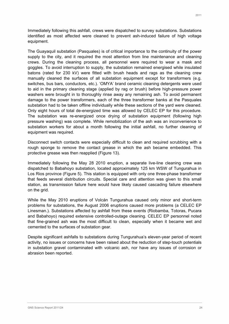
Disconnect switch contacts were especially difficult to clean and required scrubbing with a rough sponge to remove the contact grease in which the ash became embedded. This protective grease was then reapplied (Figure 13).
Immediately following the May 28 2010 eruption, a separate live-line cleaning crew was dispatched to Babahoyo substation, located approximately 125 km WSW of Tungurahua in Los Rios province (Figure 5). This station is equipped with only one three-phase transformer that feeds several distribution circuits. Special care and attention was given to this small station, as transmission failure here would have likely caused cascading failure elsewhere on the grid.
While the May 2010 eruptions of Volcán Tungurahua caused only minor and short-term problems for substations, the August 2006 eruptions caused more problems (a CELEC EP Linesman.). Substations affected by ashfall from these events (Riobamba, Totoras, Pucara and Babahoyo) required extensive controlled-outage cleaning. CELEC EP personnel noted that fine-grained ash was the most difficult to clean, especially when it became wet and cemented to the surfaces of substation gear.
Despite significant ashfalls to substations during Tungurahua’s eleven-year period of recent activity, no issues or concerns have been raised about the reduction of step-touch potentials in substation gravel contaminated with volcanic ash, nor have any issues of corrosion or abrasion been reported.
2011
GNS Science Report 2011/24 25
Figure 13 Above: 138 kV transformer bushing coated in 1-2 mm of fine-grained ash at a Guayaquil substation. Below: a contaminated disconnect switch. (Photos Courtesy of Transelectric, Ecuador).
2011
GNS Science Report 2011/24 26
3.1.4 Transmission and distribution equipment
Following the May 28 2010 eruption of Volcán Tungurahua, transmission conductors (lines), insulators and towers were not cleaned because previous experience with ashfall suggested that minor quantities of ash would unlikely cause problems and that wind and rain action would provide sufficient cleaning of transmission equipment. This conforms to advice provided by Wilson et al., (2009) whereby small volumes (<5 mm) of dry volcanic ash will have a low probability of causing failure (flashover) across the insulator.
In general, Ecuadorian transmission equipment is more susceptible to flashover from other contaminants such as industrial emissions, salt spray, fertilisers and mould than from volcanic ash (a CELEC EP substation supervisor). However the investigations of Sarkinen and Wiitala (1980) have highlighted the extremely high potential of volcanic ash to cause flashover on high voltage transmission equipment due to the large amounts of attached soluble salts which become conductive when dissolved by a source of moisture (rain). The decision to not clean transmission conductors, insulators and towers should therefore be revised to avoid flashover on high voltage insulators which can cause cascading failure elsewhere on the power system.
When asked for their views on the vulnerability of different configurations of insulators, CELEC EP staff thought that vertical configurations would be more susceptible to flashover due to the higher surface area for ash to adhere to (a CELEC EP Linesman; a CELEC EP substation supervisor). This is interesting to note as other anecdotal evidence suggests the contrary, whereby horizontally strung insulators allow ash to adhere to the underside of insulator sheds more readily and are therefore more likely to bridge the distance between electrodes (conducting elements). While the majority of high voltage insulators in Ecuador are made from red porcelain, glass insulators with larger creepage distances (distance between the conducting elements on an insulator or string of insulators) are recommended for heavily polluted regions, and those at risk of ashfall. Glass is also preferential because it is easier to tell over the red porcelain when the insulators are contaminated and require cleaning from lines crews (a CELEC EP Linesman).
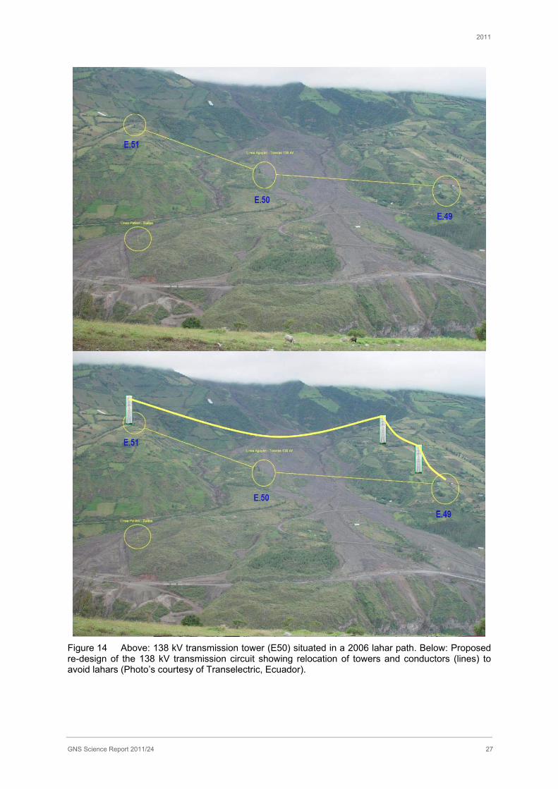
Transmission equipment located on the northern flank of the volcano has had to be re-routed due to lahar hazards (Transelectric officials). Lahars in 2006 came within metres of a 138 kV transmission tower, initiating a plan by CELEC EP to relocate the tower to avoid future lahar-induced interruption to the high voltage supply around the volcano (Figure 14).
2011
GNS Science Report 2011/24 27
Figure 14 Above: 138 kV transmission tower (E50) situated in a 2006 lahar path. Below: Proposed re-design of the 138 kV transmission circuit showing relocation of towers and conductors (lines) to avoid lahars (Photo’s courtesy of Transelectric, Ecuador).
2011
GNS Science Report 2011/24 28
3.1.5 Summary of impacts and adaptations to electrical supply
The Agoyan dam is vulnerable to lahar hazards, and turbine blades suffer increased abrasion as a result of the water turbidity. Risks of lahars are higher in the rainy season; dam operators monitor turbidity of the water and floodgates have been designed to bypass turbid water away from the generation equipment to prevent damage. While no major failures have occurred at Agoyan the dam stopped its operations due to the risk posed by large eruptions at Volcán Tungurahua in 1999 and 2006. The risk is managed with daily communication between the Agoyan dam and TVO. Transmission towers on the northern flanks of the volcano are also vulnerable to lahar hazards and CELEC EP has identified an alternative site for the towers to mitigate the risk.
Overall the Ecuadorian electricity transmission network performed very well during the May 2010 ashfall. Because the ash 1) fell in small amounts (1-2 mm in Guayaquil) and 2) fell in a dry state during dry atmospheric conditions, the ash was non-conducting (Nellis and Hendrix, 1980; Sarkinen and Wiitala, 1981) and therefore posed a low risk of causing flashover (Wilson et al., 2009). Had it been raining or very humid conditions at the time of the event, the risk of flashover would have increased and more immediate actions would have been necessary (e.g. de-energisation of critical circuits for controlled outage cleaning or immediate ‘hot’ (energised) cleaning of both contaminated substations and transmission equipment). In general, flashover events are more common from other contaminants in Ecuador, such as salt spray, industrial contaminants and guano. Pre-existing knowledge of the risks posed by these alternative contaminants has influenced the strategies taken by Ecuadorian electricity personnel to mitigate adverse impacts to the power system from volcanic ash fall contamination.
Our findings highlight the heightened vulnerability of substation equipment (e.g. transformer insulation (bushings) and switchgear) over transmission hardware (conductors, insulators, towers) during a light ash fall event such as occurred in May 2010. Extra care should therefore be given to these components to ensure a constant and reliable supply of electricity. Effective cleaning methods have been developed by CELEC EP in response to ashfalls in order to prevent damage. CELEC EP identified vulnerable substations and these were assessed and cleaned as a precaution. Transmission equipment was not cleaned following the light ashfalls in May 2010, as the ash was considered too thin to pose a risk of failure and it was considered that rain and wind action would clean the equipment sufficiently. The unfailing provision of electricity to affected areas during the May 2010 eruption was largely due to sensible decisions made by Ecuadorian electricity managers but the performance of the system should be brought to the attention of international power suppliers as an example of resiliency during a minor volcanic ash fall.
Larger ashfalls in 2006 prompted controlled outage cleaning to a few substations in the affected area. Lessons learned from adverse impacts during this and other regional volcanic eruptions (e.g. Reventador 2002) have helped electricity managers prepare for and make sound assessments during volcanic ashfall events, such as in May 2010. However, large scale events (e.g. 2006) require different and more complex mitigation strategies.
2011
GNS Science Report 2011/24 29
3.2 Water supplies
Investigations of impacts on water supplies were not a focus of this field visit as within the tight time frame available only one interview was unable to be arranged. Good information on the range of adaptive measures adopted by the water supply agency EMAAP in Quito to mitigate against the frequent ashfalls experienced by the city is provided by Leonard et a. (2005).
3.2.1 Guayaquil
We interviewed an environmental monitoring officer at the Municipality of Guayaquil about the impacts of the ashfall on the city’s lifelines. The city received approximately 1 mm ashfall, with lesser quantities being received towards the south of the city. The ashfall lasted around two hours, and was ‘very fine, dry and dark grey in colour’. The officer made the point that as Guayaquil already has a high baseline of environmental quality problems (such as air and water quality) any additional impacts from the ashfall could not be differentiated from this baseline. The municipal water supply implemented short-term service outages (up to one day per sector) to allow filters to be cleaned or changed as necessary. The municipal cleanup was reportedly a minor operation mostly performed by residents using brooms (known as ‘mingas’). No water shortages were reported as a result.
3.2.2 General vulnerability of water supplies in Ecuador
According to the National Secretariat, of all of the lifeline services in Ecuador, water supplies are generally the most affected by volcanic ashfalls. However further details of the way in which they are affected by ashfalls is not known. However, a supporting insight was provided by PAHO staff, who told us that there is a new health ministry initiative to protect drinking water from ashfall, and to provide filters in affected areas.
Hospitals interviewed during this study reported that their water supplies were unaffected during the 2010 eruption. However local communities suffered digestive system problems from drinking contaminated water and eating contaminated food. In response to an open question about the consequences of ashfalls in the Penipe area, a hospital manager told us:
“…we have a greater incidence of diarrhoeal problems and skins problems, dermatitis, allergies … parasitic infections, parasitic diseases that are caused because, well because the water is contaminated, and also because people are ingesting foods that have ash in them. I’m talking about fruits and vegetables, and pretty much everything that is harvested here in the region.”
Local volcano watcher (vigìa) recommended that home water supplies be covered to protect them from contamination.
Measurements made of stream water quality in the Tungurahua area are included in Appendix 3.
3.3 Healthcare facilities and services
This section gives an overview of: the structure of the healthcare system in Ecuador; the reports and observations gained from visiting healthcare centres in Ecuador; and a summary of the types of socio-physical system adaptations noted during fieldwork, drawn from
2011
GNS Science Report 2011/24 30
interviews and observations. This report provides the preliminary findings of this study. Further analysis of the interviews and data is ongoing.
3.3.1 Structure of the healthcare system in Ecuador
The health sector is comprised of public and private institutions as well as non-profit and for-profit institutions. The public sector tends to the needs of approximately 59% of the population, private for-profit institutes cover 10% of the population, armed forces and police tend to1% of the population, and 30% of the population do not receive any formal medical care (PAHO, 1998).
The healthcare system is decentralised in Ecuador, comprising centres of variable sizes with a chain of progression of services, leading up to regional centres of health. The Ministry of Health’s decentralisation model is based on creating small service networks with decentralised technical capabilities, each with defined geographic and population catchments (PAHO, 1998). Hospitals are the largest centres with the most services, followed by centres of health, and then sub centres of health, which are for primary healthcare services. During emergencies, mobile groups are formed of medical professionals, known as “brigades”. These groups attend the “Albergue’s” (shelters) in the affected area during times of eruption, and are typically formed of: assistant nurses, nurses, doctors (GP’s) and psychologists.
In 2001 the annual spend on public health as a proportion of GDP was 4% (PAHO, 2001). However, according to a PAHO official interviewed at the time of fieldwork, the budget for health has increased by 300% with the new government and constitution in place since 2008.
3.3.2 Impacts on the healthcare system
The impacts of volcanic ashfall on healthcare systems and services were investigated during the fieldwork in Ecuador, in both Guayaquil and in the Tungurahua area. The data collection comprised interviews at several centres including in: Guayaquil, Puyo, Baños, Riobamba, Quero, Pelileo and Penipe. These sites are a various distances from Volcán Tungurahua and located at different compass orientations; from the east, through to the north, northeast and southwest (See Figure 10).
Because the private healthcare sector serves a small percentage of the population, the focus was placed on public sector health centres, to gain a fuller understanding of the problems associated with ashfall across a greater proportion of the population. Two private centres and six public health centres were included in the interview pool, plus an interview with the Pan American Health Organisation (PAHO).
3.3.3 Overview
There were varied reports of the effects of volcanic ashfall on several healthcare systems in the Tungurahua volcanic area, and one hospital in Guayaquil. Overall, health centres further from the volcano reported few problems with ashfall in terms of: ash ingress into buildings, and demand for, and changes to, the healthcare services provided. However prolonged working hours were required by staff as health centres increased their operating hours. Additionally, few protective actions were deemed necessary to protect patients or hospital equipment in these more-distant ashfall areas.
2011
GNS Science Report 2011/24 31
The closest health centres to Volcán Tungurahua reported various effects of volcanic ash on the health centres, the population and on the services provided. However, none of the impacts affected the ability of the hospitals or centres to function, or to provide essential services. Ashfalls in general have not been sufficiently thick to cause roof or gutter damage at these locations from past eruptions.
The following passages discuss the consequences of ashfall on healthcare centres in the Tungurahua volcanic area, to highlight the variety of issues that arose during oral accounts. The amount of ashfall has varied across these locations, due to distance from Volcán Tungurahua and the orientation of the plume. The facilities and services provided at each of the health centres are also variable; scaling up from health subcentres, to centres of health and basic hospitals.
3.3.4 Lifeline utilities
Overall there were no reported access problems associated with travel to and from health centres, there were no power cuts caused directly by ashfall that threatened the provision of essential services, and communications systems were not generally affected. However the private clinic in Baños recalled a loss of power when lahars impacted power lines at the base of the volcano in 2006. Water supplies at hospitals and health centres for the most part are covered or piped from reservoirs distant from the volcano and so remain largely unaffected by ashfall. However, on a country-wide scale, a PAHO official said that in general wastewater systems are not covered, and would therefore be susceptible to blockages from ashfalls. There have been no reports of blockages of wastewater systems at the health facilities, although in past eruptions drains have been said to have become blocked and required clearing of ash in order to prevent problems.
3.3.5 Impacts on public health and healthcare service provision
Discussions with healthcare professionals revealed that local populations have been found to suffer from digestive problems related to drinking ash-contaminated water and eating ash-contaminated food in region affected by ashfall. Centro de Salud Riobamba is a regional health centre and so has an overview of the effects of ashfall both in the city, and in several smaller towns within the region. According to the healthcare professionals interviewed, ashfall has caused a variety of skin, abdominal, digestive, psychological and respiratory problems. This is also found within the literature, where ashfalls have resulted in increased instances of short-term respiratory health effects in affected populations (Horwell and Baxter, 2006; Baxter, 1983).
In Penipe a hospital manager told us of a small increase in respiratory effects, skin allergies, conjunctivitis, and also problems associated with contaminated water and food, caused by ashfalls. In Pelileo a healthcare professional noted increases in respiratory effects and skin allergies from ashfall. The public hospital in Baños also noted in increase in nose, mouth and throat problems and respiratory effects for 2-3 months after the 1999 eruption. This hospital estimated that three out of every ten people visiting the facility were affected by these symptoms at this time. In the Baños private clinic patients had to wear ash masks inside the building at one point during the 2006 eruption, as ash was suspended in the atmosphere both inside and outside the building. Quero health centre noted that the service demand was higher in the early years for respiratory problems, but said that they no longer experience this kind of demand as people know now how to protect themselves. Healthcare managers
2011
GNS Science Report 2011/24 32
in Guayaquil reported no increase in public health effects caused by the ashfall. However anecdotally, a non-health professional in Guayaquil said that there were about two days when people suffered respiratory irritation in Guayaquil following the eruption of May 28, 2010.
In addition to the short-term public health effects noticed from ashfalls, longer term psychological effects have been observed by medical professionals to have increased since eruptions began in 1999. A hospital manager in Riobamba estimated that there had been around a 50% increase in psychological problems since the eruptions began in 1999. There are additional reports in Baños, Puyo, Penipe and Pelileo that there has been an increase in anxiety and depression since eruptions began. This has been attributed to family stress caused by crop losses, evacuations and anxiety, by the healthcare professionals interviewed. Different clinics treat these conditions differently; some use medical treatments, others have started community work with their in-house psychologist, or counselling sessions.
Interviewees mentioned that during ashfalls there is an increased demand for GP services at hospitals, from respiratory effects and for optometry, and also that community counselling sessions that needed to carried out more often. There is also more demand for health information at the Baños hospital, and for basic medical supplies from the hospital pharmacy such as: vaseline, vitamin C, and personal protective equipment. A healthcare manager at Baños public hospital noted that increased attention was needed for some already-hospitalised patients during active times, as some vulnerable groups including pregnant women, children and the elderly, need more care at this time. In recent eruptions, 2006 and 2010, the public health impacts in Baños have been much less, as the population were more experienced in protecting themselves and more prepared for an ashfall (a hospital manager).
Despite an increase in public health effects from ashfalls noted by a healthcare professional in Penipe, the overall demand for health services reportedly decreased in this particular area during active periods. This was attributed to the population having other immediate concerns during eruptions; in particular farmers worried about their crops (a healthcare professional). And many people are thought to worry about a possible evacuation from the area during eruptions (a healthcare professional).
3.3.6 Impacts on buildings and equipment
Approximately 1-2mm of fine ash fell in Guayaquil during the 2010 eruption of Volcán Tungurahua. This was the most significant ashfall ever received in Guayaquil.
In Guayaquil, due to time constraints only one private hospital was visited, but there were no reported incidences of disruption to healthcare systems, or ash ingress into hospital buildings. However the hospital manager informed us that only 10% of the population would attend this hospital, and that most people would attend the public hospitals, which may have observed some consequences of the ashfall.
The only known incident of gutter replacement as a result of ashfall loading occurred in Pelileo following the 1999 eruption. In Baños public hospital, exterior roofs, gutters and drains have previously needed to be unblocked of ash (Baños hospital manager).
2011
GNS Science Report 2011/24 33
In Puyo, east of Tungurahua, there has been very little ashfall received over the years, and just a light fall was noted in 1999. In general there have been no reported problems at the health facility associated with ashfall. In Quero, west-north-west of Tungurahua, there is said to have been minimal ash received at the health centre during the 2010 eruption, but ash has ingressed into buildings during past eruptions and doors are now kept closed as a preventative measure (windows are already sealed at this centre). Occasionally protective masks or scarf’s need to be worn in the Quero health centre to protect staff and patients from ashfalls.
In Pelileo ash does not ingress much into the building; windows and doors are closed and damp rags are placed under doorways, but no actions are required or taken to protect particular equipment. In Cotaló cardboard was placed under doors in the 2010 eruption to reduce ash ingress into the building, and other healthcare professionals have reported that protective measures were taken in Cotaló to reduce the impacts of ashfall. However no doctor or manager was available at Cotaló to interview at the time of our visit, and so more information about the effects of ash in this very proximal area to Volcán Tungurahua was not gained.
In Quero, computing and electrical equipment have been affected by ash blockages, but are covered in plastic for protection against ash during eruptive periods. No increased corrosion of equipment was observed or noted in association with any of the past ashfalls. In 1999 the ash was fine and entered into computers and photocopiers in Baños public hospital. Here, microscopes have been observed to become scratched by ash in the past, and are now cleaned by blowing air and using contact lens solution. Dental motors, compressors and electrical equipment have suffered blockages from ashfalls in past eruptions in Baños.
3.3.7 Ashfall clean-up
In 2006 approximately 50-75 mm of ash fell in Riobamba and since this event there has been an increase in communication and prevention, such that in 2010, “mingas” (groups of the general public in the community,) worked together to solve problems before they occurred and cleaned up the ashfall in the town. Ashfall received in Riobamba in 2010 was approximately 1cm thickness. All essential services in Riobamba have continued to function during ashfall events. In Penipe health centre, not much ash has come inside the building but a specialist cleaner is contracted to clean the roof after an ashfall. In Baños public hospital increased cleaning was needed following ashfalls and medical equipment was maintained by cleaning and vacuuming, which is carried out daily to weekly in active times compared to every 2-3 months normally. In Quero ash infiltration into the health centre required increased cleaning efforts on a daily basis during ashfalls.
3.3.8 Economic impacts
During eruptions there are economic impacts on the health service. These arise as hospital staff has had to work increased hours, as hospital operating hours lengthen during heightened volcanic activity. This incurs increased salary costs. Additionally the moving and rationing of food for shelters incurs increased costs. Money is also spent in non-eruptive times on advice campaigns for recommended actions to take during ashfalls and eruptions (Riobamba hospital manager). Increased supplies of masks and preventative and protective equipment also incur additional costs to health facilities.

2011
GNS Science Report 2011/24 34
3.3.9 Physical back-up systems and energy use rationing
All facilities visited during fieldwork had back-up generators, although many were not sufficiently large to serve the entire health centre. Power supplies are prioritised during power cuts for essential services including emergency rooms and operating rooms. There were also reports of the number of lamps in use being reduced during power cuts in order to conserve energy consumption by the generator(s) (Baños hospital manager).
A knock-on effect has arisen from concern over power failures and their effect on refrigerated vaccines and medical supplies. During the 2006 eruption power lines were cut off by lahars and power to the facility was temporarily lost. No refrigerated supplies were unusable as a result of this, but this occurrence has led to the Baños private clinic no longer stocking temperature-dependent supplies. The medications are expensive and the risk to them is considered too high to warrant stockpiling supplies (a healthcare professional).
3.3.10 Building and physical modifications
A healthcare professional in the private clinic in Baños said that ash ingress had occurred in the past during eruptions when the clinic had a zinc roof. However the clinic has replaced the old zinc roof with a concrete construction. The healthcare professional attributed the ash ingress to the previous roofing style and reported no further ash ingress occurrences after the roof was changed to concrete.
Physical protective measures are undertaken at some centres including taping windows to protect glass from shattering as a result of volcanic sound waves. Additional protective measures include closing windows and doors, and in some cases using damp rags or cardboard under doorways to reduce ash ingress.
In Riobamba there is now an allocated “safe hospital”, which is a teaching hospital, to which people are encouraged to go during eruptions. This hospital has reportedly been evaluated and certified within Latin America as well equipped to cope with disasters (details of the evaluation criteria or certification body are unknown to the authors).
3.3.11 Protective equipment
Many health centres supply personal protective equipment to local residents including: masks, goggles, and vasoline, as well as creams, eye drops and asthma inhalers. In Quero, scarfs have been supplied instead of masks as a protective measure, as the masks are thin, get damp from breathing and do not last for re-use.
In general medical professionals in Baños reported that the population was now more prepared for ashfalls; they wore protective masks, goggles and caps in the 2006 eruption (some people also wore hard hats), compared to the 1999 event. Good community preparedness was also reported in the same way for the 2010 event.
3.3.12 Cleaning and maintenance
Cleaning methods for preventing scratches to microscopes have been developed at Baños hospital, including the use of contact lens solution. Routines for maintaining equipment during active times has been developed and vulnerable equipment has been identified, such as dental motors, which become blocked by ash getting into the operating mechanism. In

2011
GNS Science Report 2011/24 35
Quero equipment is covered in plastic sheeting for protection against ash. Other health centres mentioned that they had to increase the normal cleaning and maintenance of buildings during ashfalls.
3.3.13 Contingency plans and community work
The hospitals and clinics visited do have emergency or contingency plans in place. However in Baños hospital, the contingency plans are eventually overridden by the local emergency management plan, as the hospital would not evacuate unless the local government gave the order to do so. Precautionary steps are taken in the hospital in accordance with the activity level, with corresponding contingency plans, including; taping windows to prevent glass shattering from sound waves (slow onset, minor eruption), and wearing masks and protective gear if necessary. But if the evacuation order is not given then the hospital will remain open. Other health centres have several emergency plans; one for the health centre, one for the cantonal (a ‘cantón’ is an area smaller than a province,) and one for the province. Staff at the health centres visited are aware of the volcanic alert levels and the changes in routine required when alert levels are altered. They are generally well organised and there is a clear hierarchy of health centres in each region, to which patients would be transferred if necessary.
In most centres staff members are trained in disasters and form “brigades”, a group of medical professionals who work in the affected communities at the shelters or by assisting health centres in the most affected areas. These Brigades are formed by staff at most of the health centres visited in the Tungurahua volcanic area. Education in schools is also carried out by some health centres. There has also been an increase in counselling sessions in some areas to provide psychological assistance to the affected population. The Red Cross also started a programme in high risk areas called “Back to Happiness”, after a peak in depression was noted in affected populations 3 years after the 1999 eruptions (Risk Manager in Baños).
The hospital manager in Baños said that by the time of the 2010 eruption there were evacuation plans, people conserved food and they had undergone training in skin and eye care. There appears to have been a general trend of greater community preparedness over time in the affected areas.
3.4 Transportation networks
3.4.1 Roads
In general, ashfalls from eruptions of Volcán Tungurahua since 1999 have caused few problems for road transport networks. However, frequent lahars from Tungurahua have caused road and bridge washouts, particularly during the rainy season (February to September). During these months, heavy rains fall on the Ecuadorian highlands. These can entrain unconsolidated volcanic material deposited on the upper slopes of the mountain which can form lahars. Roads traversing the base of the mountain are particularly vulnerable. The road from Penipe to Baños was cut at the time of fieldwork as a result of mudflows. Another vulnerable location is the area called Juive Chico, immediately west of Baños. Major lahars in 2006 buried houses, covered the road and washed out a bridge (Figure 15).
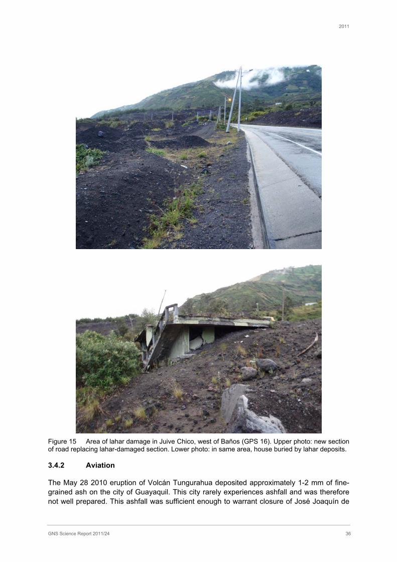
2011
GNS Science Report 2011/24 36
Figure 15 Area of lahar damage in Juive Chico, west of Baños (GPS 16). Upper photo: new section of road replacing lahar-damaged section. Lower photo: in same area, house buried by lahar deposits.
3.4.2 Aviation
The May 28 2010 eruption of Volcán Tungurahua deposited approximately 1-2 mm of fine-grained ash on the city of Guayaquil. This city rarely experiences ashfall and was therefore not well prepared. This ashfall was sufficient enough to warrant closure of José Joaquín de
2011
GNS Science Report 2011/24 37
Olmedo International Airport for two days as flights were grounded. Cleaning crews were dispatched to sweep up ash into piles where it was bagged and then taken to a landfill site located 16 km outside of the city. Unofficial reports suggest that approximately one thousand bags of ash were collected during the cleaning efforts (Instituto Geofísico, pers. comm.2). Unfortunately we were unable to schedule an interview with the airport management to obtain further details.
3.5 Municipal clean-up and ash disposal
The National Secretariat discussed general approaches to ashfall clean-up across ash-affected regions. In general, brooms are used for clean-up of streets if the grain size of the ash allows. Once swept up, a truck provided by the local mayor will collect the ash. The National Secretariat assist the local level authorities by providing bags for ash collection; ask mask supplies, and goggles and brooms to assist the clean-up. Groups of the local population called ‘mingas’ generally maintain infrastructure and roads within the community, and will clear ash within their neighbourhood. However for the clearance of roads that run between villages, the provincial level are responsible for the clean-up. The municipality and the National Secretariat share the cost of clean-up, by an agreed proportion that depends on the situation; the cost is split so that 50% is paid by the Municipality and 50% by the National Secretariat for routine maintenance (this may include landslides, mudflows or lahars), but in emergencies the National Secretariat will pay 80% of the total cost, with the municipality making up the remaining 20% of the cost.
Some information on cleanup operations in Guayaquil was obtained (Municipality of Guayaquil environmental scientist). The municipal cleanup was reportedly a minor operation performed mostly by residents using brooms. No extra water demand was created. At the international airport, cleaning crews were dispatched to sweep up ash into piles where it was bagged and then taken to a landfill site located 16 km outside of the city. Unofficial reports suggest that approximately one thousand bags of ash were collected during the cleaning efforts (Instituto GeofísicoGeofísico, pers. comm.). For the city of Guayaquil, ash was disposed of at a landfill site outside the city (Las Iguanas) and an island off the coast.
3.6 Telecommunications
Recounts from the last 11 years of volcanic activity at Tungurahua suggest that telecommunications are vulnerable to hindrance from volcanic ash plumes. In particular, Instituto GeofísicoGeofísico Volcano Observatory noted radio attenuation and reduction of broadcast signal strength when receivers located on the volcano became coated in ash. However the phenomena is not well understood nor well documented in other eruptions. There have been numerous examples of telecommunications transmissions continuing to work during volcanic ash falls and a recent analysis by telecommunications engineers for the New Zealand-based Auckland Engineering Lifelines Group concluded that impacts on electromagnetic signal transmissions would probably be limited to low frequency services such as satellite communications (Wilson et al., 2009). Conversations with electricity personnel revealed that fiber optic communication systems perform flawlessly during ash events unless damaged directly by falling volcanic bombs.
2 Comments made by individuals that were not recorded during formal interviews have been referenced anonymously and noted as personal communications (pers. comm)
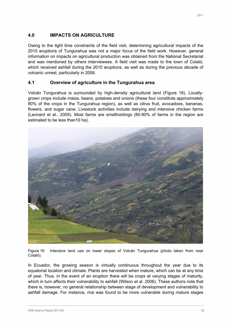
2011
GNS Science Report 2011/24 38
4.0 IMPACTS ON AGRICULTURE
Owing to the tight time constraints of the field visit, determining agricultural impacts of the 2010 eruptions of Tungurahua was not a major focus of the field work. However, general information on impacts on agricultural production was obtained from the National Secretariat and was mentioned by others interviewees. A field visit was made to the town of Cotaló, which received ashfall during the 2010 eruptions, as well as during the previous decade of volcanic unrest, particularly in 2006.
4.1 Overview of agriculture in the Tungurahua area
Volcán Tungurahua is surrounded by high-density agricultural land (Figure 16). Locally-grown crops include maize, beans, potatoes and onions (these four constitute approximately 80% of the crops in the Tungurahua region), as well as citrus fruit, avocadoes, bananas, flowers, and sugar cane. Livestock activities include dairying and intensive chicken farms (Leonard et al., 2005). Most farms are smallholdings (80-90% of farms in the region are estimated to be less than10 ha).
Figure 16 Intensive land use on lower slopes of Volcán Tungurahua (photo taken from near Cotaló).
In Ecuador, the growing season is virtually continuous throughout the year due to its equatorial location and climate. Plants are harvested when mature, which can be at any time of year. Thus, in the event of an eruption there will be crops at varying stages of maturity, which in turn affects their vulnerability to ashfall (Wilson et al. 2006). These authors note that there is, however, no general relationship between stage of development and vulnerability to ashfall damage. For instance, rice was found to be more vulnerable during mature stages
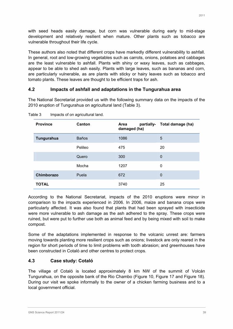
2011
GNS Science Report 2011/24 39
with seed heads easily damage, but corn was vulnerable during early to mid-stage development and relatively resilient when mature. Other plants such as tobacco are vulnerable throughout their life cycle.
These authors also noted that different crops have markedly different vulnerability to ashfall. In general, root and low-growing vegetables such as carrots, onions, potatoes and cabbages are the least vulnerable to ashfall. Plants with shiny or waxy leaves, such as cabbages, appear to be able to shed ash easily. Plants with large leaves, such as bananas and corn, are particularly vulnerable, as are plants with sticky or hairy leaves such as tobacco and tomato plants. These leaves are thought to be efficient traps for ash.
4.2 Impacts of ashfall and adaptations in the Tungurahua area
The National Secretariat provided us with the following summary data on the impacts of the 2010 eruption of Tungurahua on agricultural land (Table 3).
Table 3 Impacts of on agricultural land.
Province Canton Area partially-damaged (ha)
Total damage (ha)
Tungurahua Baños 1086 5
Pelileo 475 20
Quero 300 0
Mocha 1207 0
Chimborazo Puela 672 0
TOTAL 3740 25
According to the National Secretariat, impacts of the 2010 eruptions were minor in comparison to the impacts experienced in 2006. In 2006, maize and banana crops were particularly affected. It was also found that plants that had been sprayed with insecticide were more vulnerable to ash damage as the ash adhered to the spray. These crops were ruined, but were put to further use both as animal feed and by being mixed with soil to make compost.
Some of the adaptations implemented in response to the volcanic unrest are: farmers moving towards planting more resilient crops such as onions; livestock are only reared in the region for short periods of time to limit problems with tooth abrasion; and greenhouses have been constructed in Cotaló and other centres to protect crops.
4.3 Case study: Cotaló
The village of Cotaló is located approximately 8 km NW of the summit of Volcán Tungurahua, on the opposite bank of the Rio Chambo (Figure 10, Figure 17 and Figure 18). During our visit we spoke informally to the owner of a chicken farming business and to a local government official.

2011
GNS Science Report 2011/24 40
Figure 17 General view of Cotaló (at far end of terrace) and surrounding area.
Figure 18 Entrance to village of Cotaló.
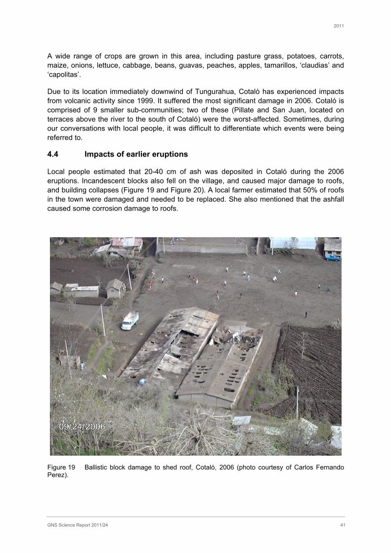
2011
GNS Science Report 2011/24 41
A wide range of crops are grown in this area, including pasture grass, potatoes, carrots, maize, onions, lettuce, cabbage, beans, guavas, peaches, apples, tamarillos, ‘claudias’ and ‘capolitas’.
Due to its location immediately downwind of Tungurahua, Cotaló has experienced impacts from volcanic activity since 1999. It suffered the most significant damage in 2006. Cotaló is comprised of 9 smaller sub-communities; two of these (Pillate and San Juan, located on terraces above the river to the south of Cotaló) were the worst-affected. Sometimes, during our conversations with local people, it was difficult to differentiate which events were being referred to.
4.4 Impacts of earlier eruptions
Local people estimated that 20-40 cm of ash was deposited in Cotaló during the 2006 eruptions. Incandescent blocks also fell on the village, and caused major damage to roofs, and building collapses (Figure 19 and Figure 20). A local farmer estimated that 50% of roofs in the town were damaged and needed to be replaced. She also mentioned that the ashfall caused some corrosion damage to roofs.
Figure 19 Ballistic block damage to shed roof, Cotaló, 2006 (photo courtesy of Carlos Fernando Perez).
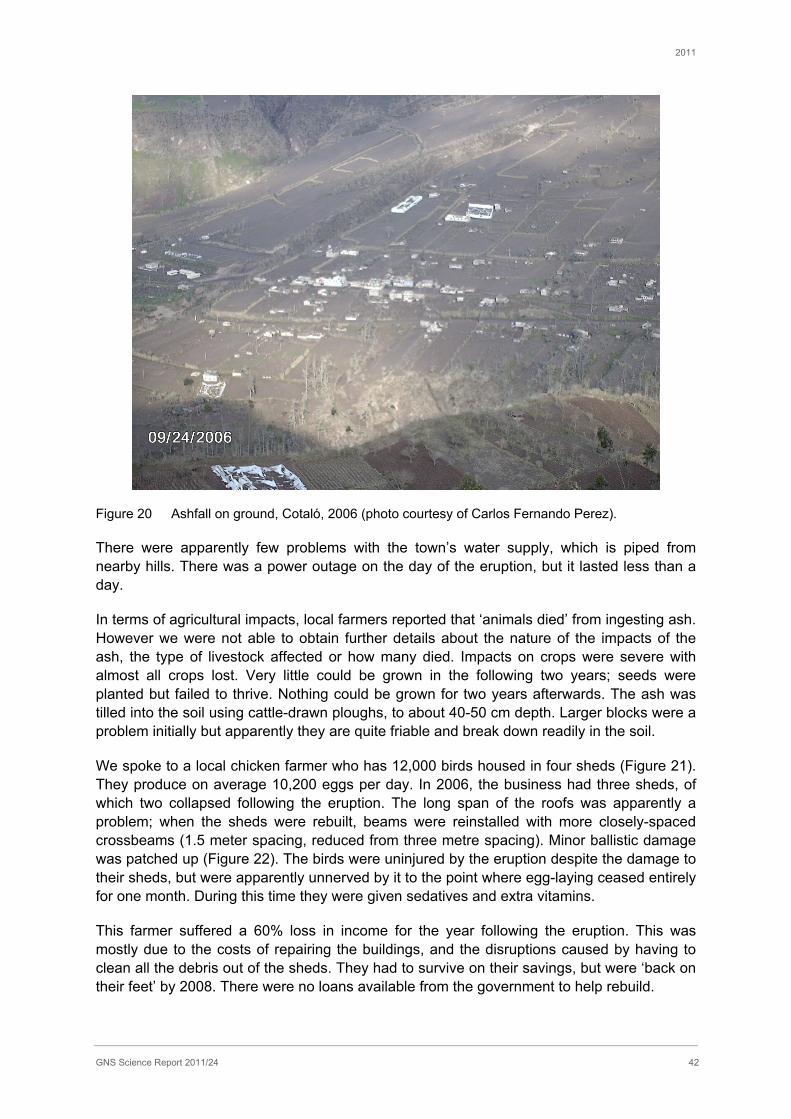
2011
GNS Science Report 2011/24 42
Figure 20 Ashfall on ground, Cotaló, 2006 (photo courtesy of Carlos Fernando Perez).
There were apparently few problems with the town’s water supply, which is piped from nearby hills. There was a power outage on the day of the eruption, but it lasted less than a day.
In terms of agricultural impacts, local farmers reported that ‘animals died’ from ingesting ash. However we were not able to obtain further details about the nature of the impacts of the ash, the type of livestock affected or how many died. Impacts on crops were severe with almost all crops lost. Very little could be grown in the following two years; seeds were planted but failed to thrive. Nothing could be grown for two years afterwards. The ash was tilled into the soil using cattle-drawn ploughs, to about 40-50 cm depth. Larger blocks were a problem initially but apparently they are quite friable and break down readily in the soil.
We spoke to a local chicken farmer who has 12,000 birds housed in four sheds (Figure 21). They produce on average 10,200 eggs per day. In 2006, the business had three sheds, of which two collapsed following the eruption. The long span of the roofs was apparently a problem; when the sheds were rebuilt, beams were reinstalled with more closely-spaced crossbeams (1.5 meter spacing, reduced from three metre spacing). Minor ballistic damage was patched up (Figure 22). The birds were uninjured by the eruption despite the damage to their sheds, but were apparently unnerved by it to the point where egg-laying ceased entirely for one month. During this time they were given sedatives and extra vitamins.
This farmer suffered a 60% loss in income for the year following the eruption. This was mostly due to the costs of repairing the buildings, and the disruptions caused by having to clean all the debris out of the sheds. They had to survive on their savings, but were ‘back on their feet’ by 2008. There were no loans available from the government to help rebuild.
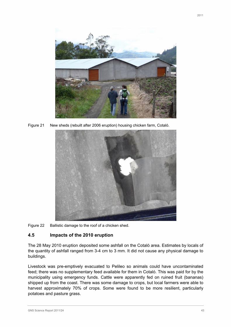
2011
GNS Science Report 2011/24 43
Figure 21 New sheds (rebuilt after 2006 eruption) housing chicken farm, Cotaló.
Figure 22 Ballistic damage to the roof of a chicken shed.
4.5 Impacts of the 2010 eruption
The 28 May 2010 eruption deposited some ashfall on the Cotaló area. Estimates by locals of the quantity of ashfall ranged from 3-4 cm to 3 mm. It did not cause any physical damage to buildings.
Livestock was pre-emptively evacuated to Pelileo so animals could have uncontaminated feed; there was no supplementary feed available for them in Cotaló. This was paid for by the municipality using emergency funds. Cattle were apparently fed on ruined fruit (bananas) shipped up from the coast. There was some damage to crops, but local farmers were able to harvest approximately 70% of crops. Some were found to be more resilient, particularly potatoes and pasture grass.

2011
GNS Science Report 2011/24 44
5.0 VOLCANIC EMERGENCY MANAGEMENT IN ECUADOR
5.1 Emergency management structure
This section gives an overview of the structure of emergency management from the national through to the local level in Ecuador. This section also discusses the plans for change in the emergency management system.
Much has changed with regard to emergency management since the previous GNS research trip to Ecuador in 2004 (Leonard et al., 2005).
The Secretariat Nacional de Gestation de Riesgos (National Secretariat of Risk Management), otherwise referred to as the ‘National Secretariat’, was formed in 2008. It was created as an umbrella agency that incorporated Civil Defence, but broadened its scope from the traditional emergency response role, to include risk management and disaster risk reduction. Civil Defence remains as a small role within the agency to deal with emergency response, and includes mainly volunteers (vigìas) who are linked at the local level.
As discussed in Section 0, the procedure for emergency management involves a three-step process. In a state of volcanic unrest, IG monitors the activity and develops hazard scenarios, which are passed on to the National Secretariat. The National Secretariat uses the hazard scenarios and develops contingency plans that are then passed on to the local government. It is the local government mayor who makes the decision regarding the appropriate alert level, and also whether or not to order evacuations.
There are procedures in place to assist the mayor or local government in decision making, which are outlined in “Emergency Plan of Action” documents. Emergency plans of action at the local level include four main components (translated and summarised from: National Secretariat, Emergency plan for the cantonal of Pelileo, post 2006):
1. The COE (Committee of Emergency Operations*) is the executive level of decision making at the Cantonal or Provincial level, depending on the severity of the situation. The COE works with the Secretariat of Risk Management technical office and provides needs and damage assessments, as well as evaluating local resource capabilities.
2. The Technical Area is occupied by the Position of Unified Command, which organises and allocates functions and work streams to each area of action necessary, depending on the capability of each institute. These institutes and areas of work include: evacuation areas and areas for shelter, security, food, engineering, water, communications, infrastructure, fire brigade, Civil Defence, the Red Cross, and the army, The Position of Unified Command works with the COE, exchanging information and executing the decisions of the COE.
3. The Administrative Area works on the economics and finances, and coordinates operations and logistics. This area also distributes external aid/ funds.
4. Coordination Units correspond to the provincial Secretariat of Risk Management technical office that provides experienced operating and administrative personnel to act as coordinators across the COE and the Position of Unified Command.
*The COE used to stand for the ‘Centre of Emergency Operations’, however the National Secretariat has changed this to the ‘Committee of Emergency Operations’. This was done to emphasise that engagement and communication at the local level are key to the decision-
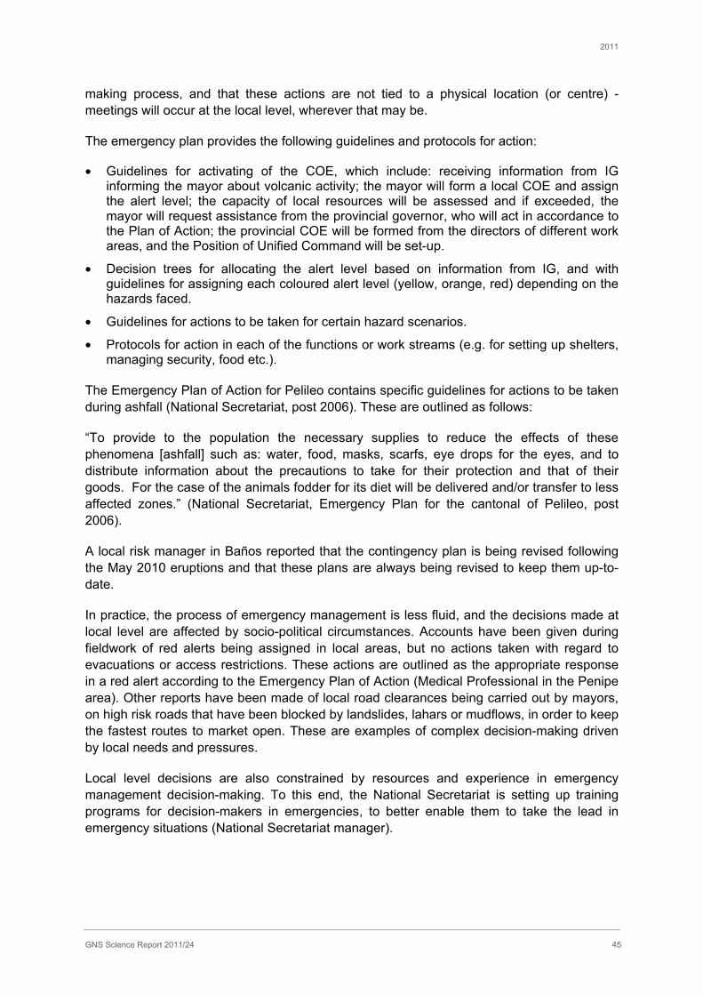
2011
GNS Science Report 2011/24 45
making process, and that these actions are not tied to a physical location (or centre) - meetings will occur at the local level, wherever that may be.
The emergency plan provides the following guidelines and protocols for action:
• Guidelines for activating of the COE, which include: receiving information from IG informing the mayor about volcanic activity; the mayor will form a local COE and assign the alert level; the capacity of local resources will be assessed and if exceeded, the mayor will request assistance from the provincial governor, who will act in accordance to the Plan of Action; the provincial COE will be formed from the directors of different work areas, and the Position of Unified Command will be set-up.
• Decision trees for allocating the alert level based on information from IG, and with guidelines for assigning each coloured alert level (yellow, orange, red) depending on the hazards faced.
• Guidelines for actions to be taken for certain hazard scenarios.
• Protocols for action in each of the functions or work streams (e.g. for setting up shelters, managing security, food etc.).
The Emergency Plan of Action for Pelileo contains specific guidelines for actions to be taken during ashfall (National Secretariat, post 2006). These are outlined as follows:
“To provide to the population the necessary supplies to reduce the effects of these phenomena [ashfall] such as: water, food, masks, scarfs, eye drops for the eyes, and to distribute information about the precautions to take for their protection and that of their goods. For the case of the animals fodder for its diet will be delivered and/or transfer to less affected zones.” (National Secretariat, Emergency Plan for the cantonal of Pelileo, post 2006).
A local risk manager in Baños reported that the contingency plan is being revised following the May 2010 eruptions and that these plans are always being revised to keep them up-to-date.
In practice, the process of emergency management is less fluid, and the decisions made at local level are affected by socio-political circumstances. Accounts have been given during fieldwork of red alerts being assigned in local areas, but no actions taken with regard to evacuations or access restrictions. These actions are outlined as the appropriate response in a red alert according to the Emergency Plan of Action (Medical Professional in the Penipe area). Other reports have been made of local road clearances being carried out by mayors, on high risk roads that have been blocked by landslides, lahars or mudflows, in order to keep the fastest routes to market open. These are examples of complex decision-making driven by local needs and pressures.
Local level decisions are also constrained by resources and experience in emergency management decision-making. To this end, the National Secretariat is setting up training programs for decision-makers in emergencies, to better enable them to take the lead in emergency situations (National Secretariat manager).
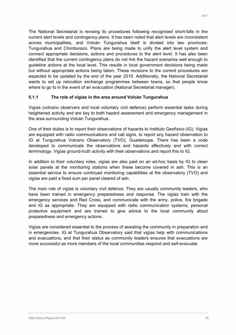
2011
GNS Science Report 2011/24 46
The National Secretariat is revising its procedures following recognised short-falls in the current alert levels and contingency plans. It has been noted that alert levels are inconsistent across municipalities, and Volcán Tungurahua itself is divided into two provinces: Tungurahua and Chimborazo. Plans are being made to unify the alert level system and connect appropriate decisions, actions and procedures to the alert level. It has also been identified that the current contingency plans do not link the hazard scenarios well enough to guideline actions at the local level. This results in local government decisions being made but without appropriate actions being taken. These revisions to the current procedures are expected to be updated by the end of the year 2010. Additionally, the National Secretariat wants to set up relocation exchange programmes between towns, so that people know where to go to in the event of an evacuation (National Secretariat manager).
5.1.1 The role of vigìas in the area around Volcán Tungurahua
Vigìas (volcano observers and local voluntary civil defence) perform essential tasks during heightened activity and are key to both hazard assessment and emergency management in the area surrounding Volcán Tungurahua.
One of their duties is to report their observations of hazards to Instituto Geofísico (IG). Vigìas are equipped with radio communications and call signs, to report any hazard observation to IG at Tungurahua Volcano Observatory (TVO), Guadeloupe. There has been a code developed to communicate the observations and hazards effectively and with correct terminology. Vigìas ground-truth activity with their observations and report this to IG.
In addition to their voluntary roles, vigìas are also paid on an ad-hoc basis by IG to clean solar panels at the monitoring stations when these become covered in ash. This is an essential service to ensure continued monitoring capabilities at the observatory (TVO) and vigìas are paid a fixed sum per panel cleared of ash.
The main role of vigìas is voluntary civil defence. They are usually community leaders, who have been trained in emergency preparedness and response. The vigìas train with the emergency services and Red Cross, and communicate with the army, police, fire brigade and IG as appropriate. They are equipped with radio communication systems, personal protective equipment and are trained to give advice to the local community about preparedness and emergency actions.
Vigìas are considered essential to the process of assisting the community in preparation and in emergencies. IG at Tungurahua Observatory said that vigìas help with communications and evacuations, and that their status as community leaders ensures that evacuations are more successful as more members of the local communities respond and self-evacuate.

2011
GNS Science Report 2011/24 47
5.2 Emergency management practice around Volcán Tungurahua
Since the reactivation of Volcán Tungurahua in 1999, emergency shelters have been set-up in safer areas, close to the communities at risk. The shelters provide food, a place to sleep, and are visited by medical professionals to provide basic medical care, medicines and psychological support. A photograph of a shelter near Penipe is shown in Figure 23.
Figure 23 Emergency shelter near Penipe, Tungurahua area.
The National Secretariat has organized signs and evacuation routes to inform local populations where the nearest shelters are located in emergencies (see Figure 24 and Figure 25).
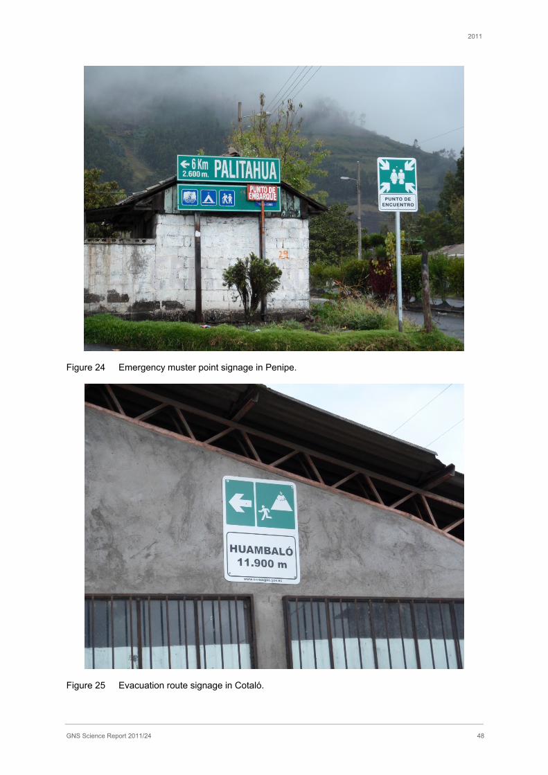
2011
GNS Science Report 2011/24 48
Figure 24 Emergency muster point signage in Penipe.
Figure 25 Evacuation route signage in Cotaló.
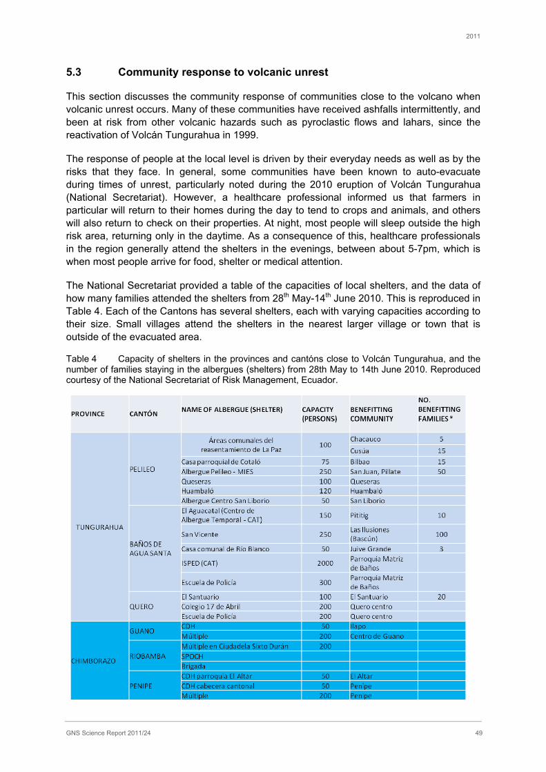
2011
GNS Science Report 2011/24 49
5.3 Community response to volcanic unrest
This section discusses the community response of communities close to the volcano when volcanic unrest occurs. Many of these communities have received ashfalls intermittently, and been at risk from other volcanic hazards such as pyroclastic flows and lahars, since the reactivation of Volcán Tungurahua in 1999.
The response of people at the local level is driven by their everyday needs as well as by the risks that they face. In general, some communities have been known to auto-evacuate during times of unrest, particularly noted during the 2010 eruption of Volcán Tungurahua (National Secretariat). However, a healthcare professional informed us that farmers in particular will return to their homes during the day to tend to crops and animals, and others will also return to check on their properties. At night, most people will sleep outside the high risk area, returning only in the daytime. As a consequence of this, healthcare professionals in the region generally attend the shelters in the evenings, between about 5-7pm, which is when most people arrive for food, shelter or medical attention.
The National Secretariat provided a table of the capacities of local shelters, and the data of how many families attended the shelters from 28th May-14th June 2010. This is reproduced in Table 4. Each of the Cantons has several shelters, each with varying capacities according to their size. Small villages attend the shelters in the nearest larger village or town that is outside of the evacuated area.
Table 4 Capacity of shelters in the provinces and cantóns close to Volcán Tungurahua, and the number of families staying in the albergues (shelters) from 28th May to 14th June 2010. Reproduced courtesy of the National Secretariat of Risk Management, Ecuador.
2011
GNS Science Report 2011/24 50
5.3.1 Baños: a unique case of preparedness and social response
On the 18th October 1999 the city of Baños and surrounding farmlands were ordered to evacuate by authorities following the reactivation of Volcán Tungurahua and advice from the scientific community that the city was at risk from volcanic hazards. The city was forcibly evacuated and remained guarded by the army and police to prevent people from returning to their homes and into the area at risk.
However, after many weeks of evacuation and despite several eruptions from Volcán Tungurahua, there was no significant damage in the city of Baños or its surrounds. The local inhabitants wanted to return to their homes and their livelihoods, having suffered severe socio-political disruption from the evacuation orders (Tobin & Whiteford, 2002). On the 5th January 2000 the townspeople marched to Baños and clashed with the army to try to win the right to return home (Lane et al., 2003).
Following this, provincial mayors then signed a document allowing people to return to their homes but at their own risk. Local people from Baños responded by forming a group to inform people of what they should do in emergencies – this was the start of the vigìa system and the voluntary civil defence (Risk Manager in Baños).
For a more detailed account of the Baños evacuation in 1999 and the subsequent recovery, see Leonard et al. (2005).
There have been no evacuation orders issued in Baños since the 1999 eruption. This is despite heightened activity and significant eruptions in 2006, including ballistics falling in the Baños area. The volcanic activity in 2006, in the opinion of some interviewees, should have prompted an official evacuation of the city.
Following the reactivation of Volcán Tungurahua in 1999, the local population painted yellow arrows on the roads in Baños with donated paint, to mark evacuation routes. Since this, the National Secretariat has altered the Baños signs to correspond to those in other areas around the volcano. The old yellow road markings are now painted green, and as in other areas, there are signs with distances to shelters and ISO signs to indicate the area at risk from volcanic hazards.
A vigìa in the Baños area explained that the evacuation plan used to be simple, but now it is complex and possibly confusing.
In Baños new warning sirens were installed in September 2010, following the May 2010 eruptions. These sirens were trialled by local people and have two distinct sounds; one for a drill (intermittent siren), and one for a real event (continuous siren). The sirens also have batteries that are connected to electrical transformers so that they are always charging. This ensures that these are fully charged should a power cut occur (Risk Manager in Baños). This back-up power supply to the sirens has been a recent adaptation, as a risk manager told us that in 2006 the sirens would not have worked in some lower risk areas of Baños, due to a power cut and a lack of back-up power supply to the sirens. As a result of this, there is now a back-up plan written into the contingency plan, where police and firemen will drive around the city sounding their sirens to alert the public should the sirens fail. The risk manger clarified that it is the mayors’ decision to sound the sirens, and the mayor did not initiate the use of this system in 2006.
2011
GNS Science Report 2011/24 51
In general the evacuation routes are clearly marked with signs and road markings throughout the city, although many shelters are some distance from the town at more than 2 km away. A photograph taken in Baños of the routes to emergency shelters is shown in Figure 26. Drills are also carried out in the town to ensure that people are practiced in emergencies.
The designated safer area in Baños is to the east of the city, and in drills it takes 16-17 minutes for the population to reach the area where the shelters are located. Approximately 80% of Baños towns-people are said to be trained for evacuations and know, for example, not to cross bridges over rivers in times of eruption (a Vigìa in the Baños area). However the vigìa also remarked that the safer area in the east of Baños is still very close to a river valley that could potentially carry pyroclastic flows or lahars from the flanks of the volcano. Each family is also said to unofficially have their own family contingency plans (a vigìa in the Baños area). Thus despite evacuation planning and drills, individual or family actions may differ from the officially planned scenarios.
Family actions in emergencies include shutting windows and doors and locking-up their houses. Additionally turning off the electricity, and covering water supplies for protection against ash ingress and contamination (a vigìa in the Baños area).
Some of the population of Baños auto-evacuated during the increased volcanic activity in May-June 2010, returning only in the daytime to check on their property or animals, and sleeping outside the high risk area at night. This auto-evacuation of the population is a positive step in emergency management, where awareness and responsibility are carried by the owners of the risk – the population.
However, there is a downside to the auto-evacuations. It has been known that hotel owners have locked visitors inside the hotels during periods of heightened activity, and auto-evacuated themselves from the area (a scientist). This reportedly occurred during heighted volcanic activity in both 2006 and 2008, as owners attempted to protect their income so that people could not leave without paying. As a result of these actions, civil defence was forced to rescue trapped visitors from hotels using ladders.
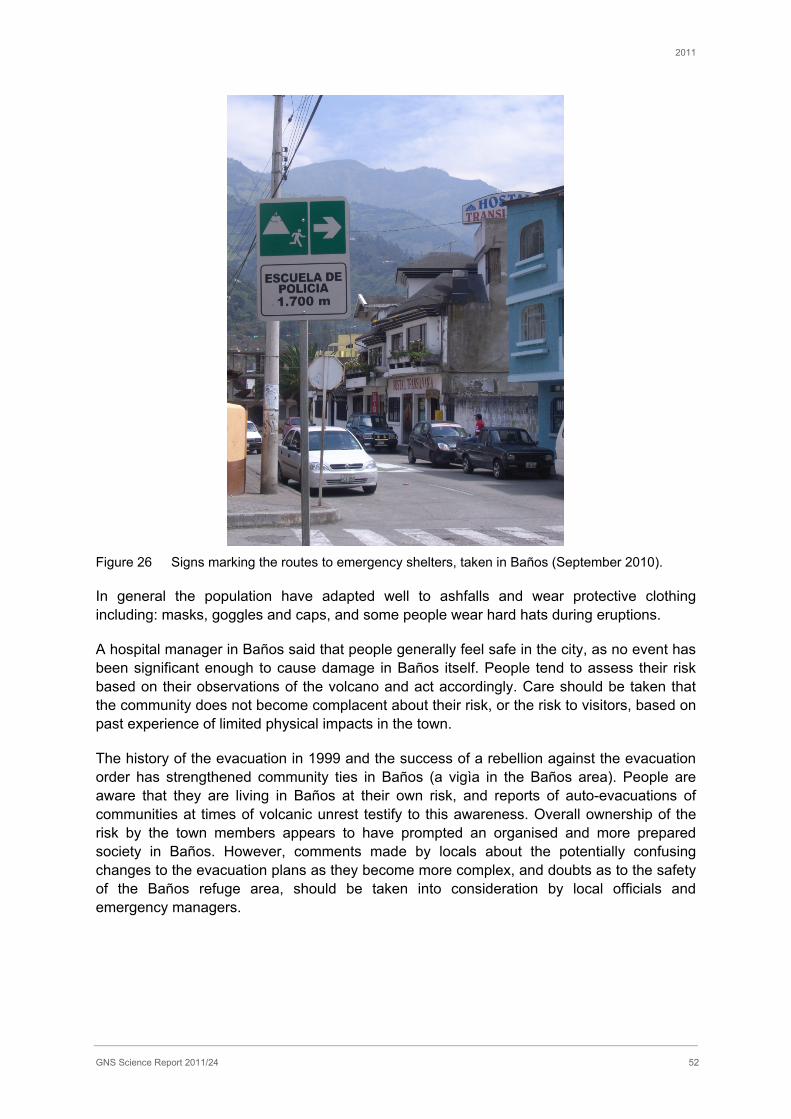
2011
GNS Science Report 2011/24 52
Figure 26 Signs marking the routes to emergency shelters, taken in Baños (September 2010).
In general the population have adapted well to ashfalls and wear protective clothing including: masks, goggles and caps, and some people wear hard hats during eruptions.
A hospital manager in Baños said that people generally feel safe in the city, as no event has been significant enough to cause damage in Baños itself. People tend to assess their risk based on their observations of the volcano and act accordingly. Care should be taken that the community does not become complacent about their risk, or the risk to visitors, based on past experience of limited physical impacts in the town.
The history of the evacuation in 1999 and the success of a rebellion against the evacuation order has strengthened community ties in Baños (a vigìa in the Baños area). People are aware that they are living in Baños at their own risk, and reports of auto-evacuations of communities at times of volcanic unrest testify to this awareness. Overall ownership of the risk by the town members appears to have prompted an organised and more prepared society in Baños. However, comments made by locals about the potentially confusing changes to the evacuation plans as they become more complex, and doubts as to the safety of the Baños refuge area, should be taken into consideration by local officials and emergency managers.

2011
GNS Science Report 2011/24 53
6.0 CONCLUSIONS AND KEY FINDINGS
The key findings of this report are as follows:
• Since its reactivation in 1999, activity at Volcán Tungurahua has been mostly characterised by eruptions of low to moderate explosiveness. However, in 2006 there was a sudden increase in explosiveness leading to two pyroclastic flow-forming eruptions on 14 July (VEI 2) and 16-17 August (VEI 3).
Infrastructure impacts key findings
• Ecuador’s 4000 MW electricity transmission did not experience any faults from volcanic ash contamination during the May 28 2010 Tungurahua eruption.
• The city of Guayaquil was coated in 1-2 mm of fine-grained ash and local substations had to be cleaned to prevent unplanned interruptions from insulator flashover.
• Cleaning of substations was performed strategically so that power supply was not interrupted for the city of Guayaquil. This was achieved by cleaning transformer banks individually, allowing all circuits to remain online.
• Insulators, towers and conductors were not cleaned as it was believed that rain and wind action would sufficiently clean these components and thereby avoid flashover.
• It was commonly believed by Ecuadorian power personnel that vertically configured insulator strings are more vulnerable to ash-induced insulator flashover over those in the horizontal position.
• Conversations with electricity personnel revealed that fiber optic communication systems perform flawlessly during ash events unless damaged directly by falling volcanic bombs.
• The Agoyan dam facility did not suffer any adverse effects from the May 2010 ash fall but has systems in place to monitor water levels and turbidity to trigger a protective bypass system in the event of a lahar.
• The ashfall reportedly caused problems with water supplies in the depositional area, which in turn led to health problems such as digestive upsets. However, the cause of these health problems was not clear. There is a new health ministry initiative to cover and protect water supplies from ashfall. In Guayaquil, 1-2 mm ashfall did not cause any problems for the municipal water supply, although supply outages of up to one day in each sector were implemented for precautionary cleaning of filters.
• Transport – ashfalls have caused few problems for road networks, but lahars have caused major problems particularly for direct route between Penipe and Baños. No particular impacts arose from the 2010 ashfall. However the 1-2 mm of fine-grained ash that fell on Guayaquil was enough to warrant closure of José Joaquín de Olmedo International Airport for two days as flights were grounded.
• Radio attenuation and reduction of broadcast signal strength was noted when receivers located on the volcano became coated in ash.

2011
GNS Science Report 2011/24 54
• The National Secretary helped the local mayor in each affected municipality by providing bags for ash, ash masks, goggles and brooms to affected areas.
• Ash collected by trucks was taken to a landfill site outside of Guayaquil (Las Iguanas) and to an island off the coast of Guayaquil.
Agriculture and rural communities
• The 2010 eruption caused partial damage to 3740 ha and total damage to 25 ha of farmland in the depositional area.
• In the case study settlement (Cotaló), impacts on livestock were minimal as animals were pre-emptively evacuated out of the affected area so they could have uncontaminated feed. There was some damage to crops but farmers were able to harvest approximately 70%. Estimates of ashfall depth in Cotaló in 2010 ranged from 3 mm to 3 cm.
• Cotaló suffered much more severe impacts from the 2006 eruptions. Many buildings were damaged by ballistic blocks (and, to a lesser extent, ashfall) with 50% of roofs in the town requiring replacement. Estimates of ashfall depth ranged from 20-40 cm. Livestock died from ingesting ash. Almost all crops were lost and nothing could be grown for two years afterwards. A chicken farmer lost 60% of their income in the year following the eruption, with most of the costs arising from having to repair buildings.
• Some of the adaptations implemented in response to the volcanic unrest in the local area are: farmers moving towards planting more resilient crops such as onions; livestock are only reared in the region for short periods of time to limit problems with tooth abrasion; and greenhouses have been constructed in Cotaló and other centres to protect crops.
Healthcare key findings
• Healthcare systems have shown preparedness in their development of emergency management plans and in the organisation of ‘brigades’ of medical professionals who attend shelters and carry out community work in affected areas.
• Physically healthcare systems have conveyed that there are limited impacts of ashfall to their essential service provision and to their critical utility providers. As such interdependency between impacts, which can cause indirect impacts on systems, has been minimal. However, as many health centre generators are not large enough to provide full services during power cuts, non-essential services are not prioritised and may be affected.
• Smaller effects of ashfall related to ash ingress have occurred in some locations, and measures are being taken to reduce ingress, protect windows, protect equipment, and to maintain and clean elements within healthcare buildings.
• Increases in respiratory effects, skin allergies, eye infections and digestive problems have been noted in most locations. Many public health pathologies have been reduced over the years as the population has taken preventative measures such as wearing goggles, and either masks or scarf’s during ashfalls.

2011
GNS Science Report 2011/24 55
• Increases in anxiety and depression in the affected population has been noted at most health centres as a long term impact of volcanic activity. This has been attributed to family stress, relating to loss of crops and income and from the concern over evacuations. This has prompted increased psychological support, which is provided by the healthcare centres, through medications, clinical psychologists or community work in the shelters.
Emergency Management
• The population is well adapted to the risks posed by the volcano; auto-evacuations and measures taken to protect themselves, such as wearing masks, goggles and hats, are testament to this.
• The participatory role of vigìas in both hazard identification and in civil defence, appears to have a positive effect on communication and risk management in the Tungurahua area.
• The National emergency management system is working towards improvement in the communication of risks between agencies and to the public. The changes to be made are not known at the time of writing.
• Officials in Baños have recently implemented a back-up power supply to the warning sirens, in case of a power cut during emergencies. There has also been an addition to the contingency plan for Baños, such that if the sirens failed to work, then the emergency services would drive around the city and sound their sirens to alert the public. This has been implemented following the power cut in 2006 that left the sirens unable to work, should the mayor have ordered the sirens to sound.
• Officials in Baños need to consider the concerns of locals about the complexity and confusion that may be caused by changing emergency management plans. Emergency managers should also consider the likelihood that in reality, individuals may choose alternative evacuation routes to those practiced during emergency drills.
General outcomes
• A good overview of ashfall impacts to electrical power and healthcare services, and emergency management issues were achieved during the trip. The information gathered adds to our knowledge of the possible effects of volcanic ashfalls on infrastructure and public services that have yet to be studied in depth in the literature. Emergency management insights may provide lessons pertaining the benefits of local engagement and involvement in risk management. Supporting insights and data were also found on other areas including: water and wastewater systems, agriculture and transportation networks. Focus on adaptations and responses to the long-term volcanic activity have provided insights into the long-term effects of volcanic activity and some possible mitigation and prevention measures.

2011
GNS Science Report 2011/24 56
7.0 RECOMMENDATIONS FOR FUTURE ASHFALL IMPACT STUDIES
Some lessons have been learned from fieldwork that can be taken forward into future, and recommendations are as follows:
• Overall there is benefit in returning to the Tungurahua volcanic area to accomplish ongoing research goals on volcanic ashfall impacts. There is rich data to be gained, and many areas of exploration that warrant further attention. Each sector of interest has its own methods and timeframes and not all can be explored in a single trip. More can be gained in several sectors from longitudinal studies in this area, in particular focussing on resilience and adaptations to ongoing volcanic activity.
• Timing of field trips is important to get right, to gain insights into the impacts of ashfall after the emergency response period is over, and before the effects lose resolution. It became evident during this fieldwork that the population considered the eruption in May 2010 to be minor, and therefore recalling the impacts and effects had lost some resolution by the time of fieldwork, some 4 months after the eruption. However, this is not the case in all events. It appears that for ongoing volcanic eruptions, unless a much larger event occurs than is considered to be ‘normal’, then the timing of fieldwork should be advanced, so as not to lose resolution on the data, particularly for qualitative data collection.
• In general, and particularly when there is a language barrier, field visits should be extended to allow more time to set-up interviews and meetings. More time in the field, particularly for long term volcanic eruptions and exploration of the adaptations made over time, will allow more observation time and a better understanding of the local context.
• Team size is critical, and more can be achieved by working in pairs, rather than as a whole unit. This requires more language support when working in foreign countries so that each pair of researchers is supported by a translator or interpreter.
• Financial support for fieldwork should be ring-fenced and determined pre-fieldwork. Whatever can be should be paid in advance of fieldwork. Working with ‘one budget for all’ considerably reduces unnecessary financial complications during fieldwork.

2011
GNS Science Report 2011/24 57
8.0 REFERENCES
Arellano. S.R., Hall. M., Samaniego. P., Le Pennec. J.-L., Ruiz. A., Molina. I., Yepes. H. 2008, Degassing patterns of Tungurahua volcano (Ecuador) during the 1999–2006 eruptive period, inferred from remote spectroscopic measurements of SO2 emissions. Journal of Volcanology and Geothermal Research 176, 151-162.
Barba. D., Samaniego. P., Le Pennec. J.-L., Hall. M., Robin. C., Mothes. P., Yepes. H., Ramón. P., Arellano. S. & Ruiz. G. 2008, The 2006 eruptions of the Tungurahua volcano (Ecuador) and the importance of volcano hazard maps and their diffusion. 7th International Symposium on Andean Geodynamics (ISAG 2008, Nice), Extended Abstracts: p67-70.
Baxter, P. J. 1983. Health-Hazards of Volcanic-Eruptions. Journal of the Royal College of Physicians of London, 17, 180-182.
Hall, M.L., Robin, C., Beate, B., Mothes, P., and Monzier, M. (1999) Tungurahua Volcano, Ecuador: structure, eruptive history and hazards. Journal of Volcanology and Geothermal Research, 91, 1-21.
Horwell, C.J. and Baxter, P.J., 2006. The respiratory health hazards of volcanic ash: a review for volcanic risk mitigation. Bulletin of Volcanology, 69: 1-24.
Instituto Geofísico (IG) http://www.igepn.edu.ec/ Accessed November 2011
Lane. L.R., Tobin. G.A. and Whiteford. L.M. 2003, Volcanic hazard or economic destitution: hard choices for Baños, Ecuador. Environmental Hazards, vol. 5, 23-34.
Leonard. G.S., Johnston. D.M., Williams. S., Cole. J., Finnis, K. and Barnard. S. (2005) Impacts and management of recent volcanic eruptions in Ecuador: lessons for New Zealand. Institute of Geological & Nuclear Sciences, GNS Science Report 2005/20.
Matsuoka, R., Susumu, I., Sakanishi, K., 1995, Flashover voltage characteristics of insulators contaminated with volcanic ash. NGK Insulators Ltd. (Japan), Internal report, pp6.
Nellis, C.A., and Hendrix, K.W., 1980. Progress report on the investigation of volcanic ash fallout from Mount St Helens: Bonneville Power Administration, Laboratory Report ERJ-80-47.
Newhall, C.G., Self, S. 1982. The volcanic explosivity index (VEI): an estimate of explosive magnitude for historical volcanism. Journal of Geophysical Research, 87 (C2), 123-1238.
Pan American Health Organisation (PAHO). 1998, “Ecuador”, Health in the Americas, 1998 Edition, Volume II, p210-257.
Pan American Health Organisation (PAHO). 2001, Country health profile for Ecuador. http://www.paho.org/english/dd/ais/cp_218.htm Accessed; October 2011.

2011
GNS Science Report 2011/24 58
Samaniego, P., Le Pennec, J-L., Robin, C. and Hidalgo, S. (2011) Petrological analysis of the pre-eruptive magmatic process prior to the 2006 explosive eruptions at Tungurahua volcano (Ecuador). Journal of Volcanology and Geothermal Research 199, 69-84.
Sarkinen, C.F., and Wiitala, J.T., 1981, Investigation of volcanic ash in transmission facilities in the Pacific Northwest: IEEE Transactions on Power Apparatus and Systems, v. PAS-100, p2278-2286.
Silva, S. 2010, Ecuador volcano erupts, villagers evacuate. Reuters. http://www.reuters.com/article/2010/05/29/us-ecuador-volcano-idUSTRE64R5DQ20100529 Accessed: October 2011
Smithsonian Institute www.volcano.si.edu/world/volcano Accessed: September 2011
Tobin. G.A, Whiteford. L.M. (2002) Community resilience and volcano hazard: The eruption of Tungurahua and evacuation of the Faldas in Ecuador. Disasters, vol. 26, no. 1, p28-48.
Transelectric http://www.transelectric.com.ec Accessed: March 2011
Wilson, T., Daly, M. and Johnston, D. (2009) Review of impacts of volcanic ash on electricity distribution systems, broadcasting and communication networks. Report prepared for Auckland Engineering Lifelines Group, project AELG-19. Available online from www.aelg.org.nz
World Organization of Volcano Observatories (WOVO) website, last updated 2005, http://www.wovo.org
Accessed: October 2011
.

2011
GNS Science Report 2011/24 59
APPENDICES
Appendix 1 Trip itinerary
Appendix 2 Data collection inventory
Appendix 3 Stream water quality data
Appendix 4 Scanned newspaper articles from the May 2010 eruption
Appendix 5 Ethics approval numbers

2011
GNS Science Report 2011/24 60
APPENDIX 1 TRIP ITINERARY
INSTITUTION VISITED CITY LOCATION DATE
Instituto Geofísico (IG) Quito 06.09.10
TRANSELECTRIC head office Quito 06.09.10
Pan American Health Organisation (PAHO) Quito 07.09.10
Secretariat Nacional de Gestation de Riesgos (National Secretariat)
Quito 07.09.10
Baños Clinic [private] Baños 08.09.10
Tungurahua Observatory Guadeloupe, Baños
08.09.10
Local Risk Management, Baños Baños 08.09.10
Agoyan Hydroelectric Dam, Baños Baños 09.09.10
TRANSELECTRIC substation Puyo 09.09.10
Ministerio de Salud Publica – Hospital “Puyo” [public]
Puyo 09.09.10
Ministerio de Salud Publica – Hospital de Baños [public]
Baños 10.09.10
Centro de Salud, Quero Quero 10.09.10
TRANSELECTRIC substation Ambato 10.09.10
Vigìa Baños 11.09.10
TRAVEL TO GUAYAQUIL 12.09.10
TRANSELECTRIC substation Guayaquil 13.09.10
Hospital in Guayaquil [private] Guayaquil 13.09.10
Transelectric substation Santa Elena 14.09.10
Ministerio del Ambiente (Ministry of the Environment)
Guayaquil 14.09.10
Ministerio de Salud Publica Subcentro de Salud de Penipe [public]
Penipe, Baños 15.09.10
Agriculture (general) Cotaló 15.09.10
Ministerio de Salud Publica Centro de Salud Pelileo [public]
Pelileo, Ambato 15.09.10
Centro de Salud Riobamba Riobamba 16.09.10
TRAVEL TO QUITO 17.09.10
FLY TO GUATEMALA 18.09.10
2011
GNS Science Report 2011/24 61
APPENDIX 2 DATA INVENTORY: RESOURCES GATHERED DURING FIELDWORK
Donated by Type of resource
Details
Local administrator from Cotaló Photos Photos of earlier activity at Tungurahua in 2006 and 2007, photos of crop damage and roof damage
Baños public hospital PowerPoint Health plan for Area 4 (Baños) and Area 5 (Pelileo)
Data Annual summary of hospital admissions for types of illness (2001-2009)
Report Health plan for Chimborazo by Secretariat General
Riobamba Centro de Salud Report Emergency plan for Chimborazo
Riobamba Direccion de Salud Data Hospital admission statistics for 2007-2010
Private hospital in Guayaquil News articles (HARD COPIES)
Articles on the 2010 eruption
Local Government Baños Video Lahar video (June 21st 2007)
Map Risk map of Baños
Report Red Cross guidance document for community volunteers on psychosocial support
Report Red Cross guidance document for community work to improve water quality and access to safe water
Report Red Cross action plan for a malaria epidemic and its consequences (Valle Hermosa area)
National Security and Risk Management (Secretariat General)
Presentation Draft alert levels
Presentation Activity of Tungurahua 28th May 2010
Report Emergency plan for Pelileo region “cantonal”
PAHO Report covers Photocopies of report covers to find useful health guidance information online (HARD COPIES)
Pelileo Centro de Salud 2-pages Scanned
2-pages covering alert levels in a risk book
Private clinic Baños Report Emergency plan for the private clinic (HARD COPY)
Transelectric Quito Map Map of electrical transmission network
Report Emergency plan for volcanic eruptions for Transelectric
Photos Photos of ash cleaning
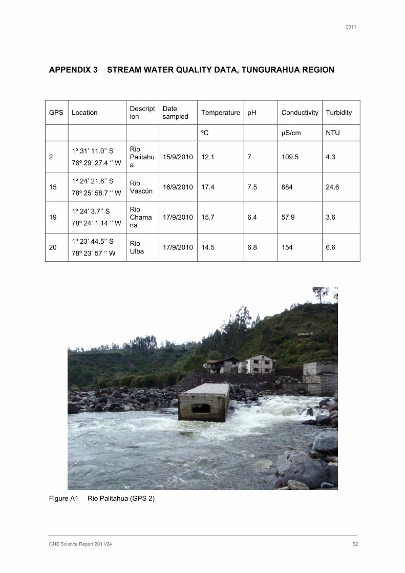
2011
GNS Science Report 2011/24 62
APPENDIX 3 STREAM WATER QUALITY DATA, TUNGURAHUA REGION
GPS Location Description
Date sampled Temperature pH Conductivity Turbidity
ºC μS/cm NTU
2 1º 31’ 11.0’’ S
78º 29’ 27.4 ‘’ W
Rio Palitahua
15/9/2010 12.1 7 109.5 4.3
15 1º 24’ 21.6’’ S
78º 25’ 58.7 ‘’ W Rio Vascún 16/9/2010 17.4 7.5 884 24.6
19 1º 24’ 3.7’’ S
78º 24’ 1.14 ‘’ W
Rio Chamana
17/9/2010 15.7 6.4 57.9 3.6
20 1º 23’ 44.5’’ S
78º 23’ 57 ‘’ W Rio Ulba 17/9/2010 14.5 6.8 154 6.6
Figure A1 Rio Palitahua (GPS 2)
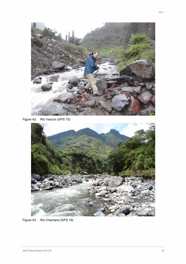
2011
GNS Science Report 2011/24 63
Figure A2 Rio Vascún (GPS 15)
Figure A3 Rio Chamana (GPS 19)
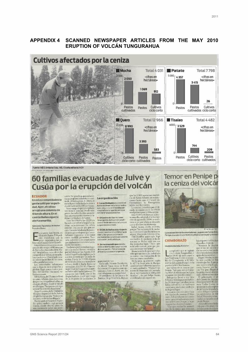
2011
GNS Science Report 2011/24 64
APPENDIX 4 SCANNED NEWSPAPER ARTICLES FROM THE MAY 2010 ERUPTION OF VOLCÁN TUNGURAHUA
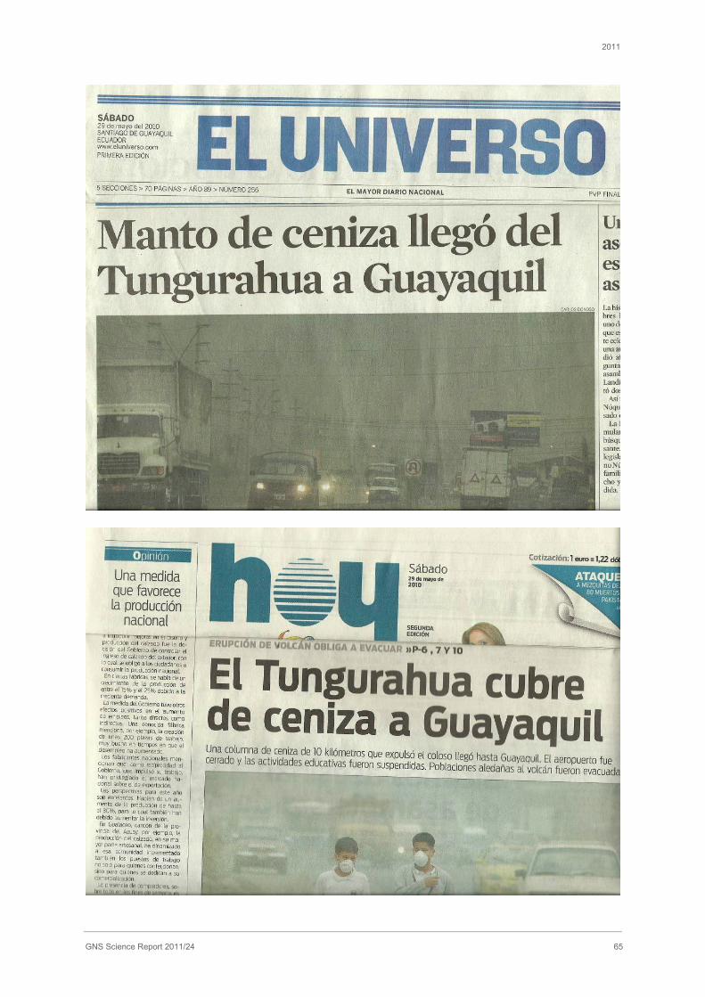
2011
GNS Science Report 2011/24 65
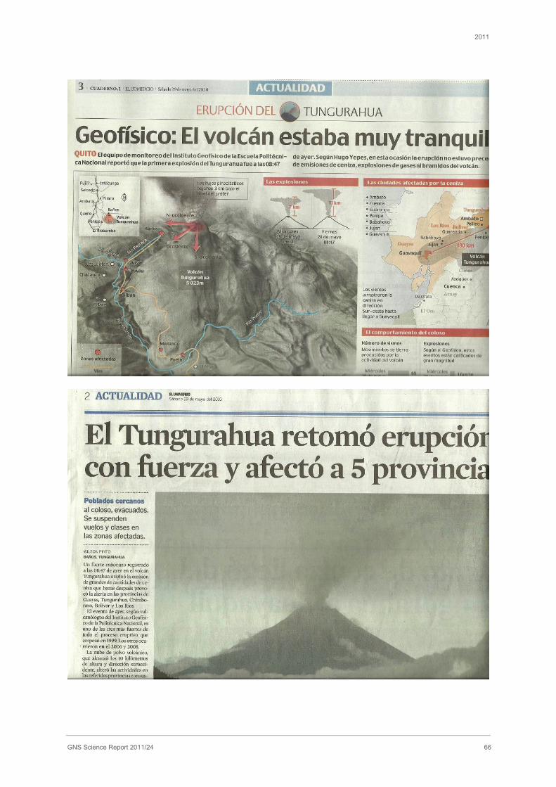
2011
GNS Science Report 2011/24 66
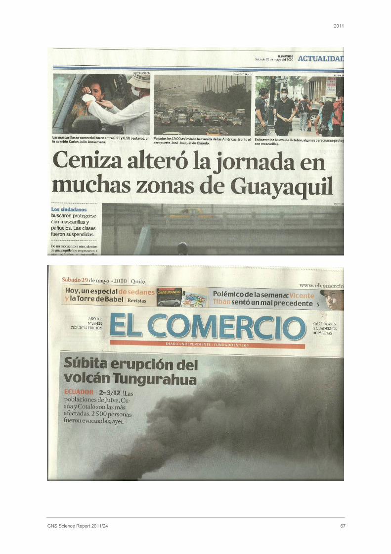
2011
GNS Science Report 2011/24 67
2011
GNS Science Report 2011/24 68
APPENDIX 5 ETHICS APPROVAL NUMBERS
University College London - 2327/001
University of Canterbury - 2010/118

1 Fairway Drive
Avalon
PO Box 30368
Lower Hutt
New Zealand
T +64-4-570 1444
F +64-4-570 4600
Dunedin Research Centre
764 Cumberland Street
Private Bag 1930
Dunedin
New Zealand
T +64-3-477 4050
F +64-3-477 5232
Wairakei Research Centre
114 Karetoto Road
Wairakei
Private Bag 2000, Taupo
New Zealand
T +64-7-374 8211
F +64-7-374 8199
National Isotope Centre
30 Gracefield Road
PO Box 31312
Lower Hutt
New Zealand
T +64-4-570 1444
F +64-4-570 4657
Principal Location
www.gns.cri.nz
Other Locations