Embed Size (px)
Citation preview

186 Manitoba Geological Survey
Industrial mineral potential of the rural municipalities of Miniota, Archie and Rossburn, Manitoba (parts of NTS 62K)
by J.D. Bamburak
GS-18
Bamburak, J.D. 2007: Industrial mineral potential of the rural municipalities of Miniota, Archie and Rossburn, Manitoba (parts of NTS 62K); in Report of Activities 2007, Manitoba Science, Technology, Energy and Mines, Manitoba Geological Survey, p. 186–194.
SummaryThe rural municipalities of Miniota, Archie and
Rossburn contain the following undeveloped industrial minerals that could be used for the economic benefit of local residents, and to the province as a whole:• Souris-type gravel (Rural Municipality [R.M.] of
Miniota)• swelling sodium bentonite (R.M. of Miniota)• potash and sodium chlorate (R.M. of Archie)• manganese (R.M. of Rossburn)
Souris-type gravel is present in the Assiniboine River valley, south of the community of Miniota. The gravel contains exotic boulders and cobbles similar to those found at Souris, which are prized by rockhounds who are willing to pay to collect the specimens. Swelling sodium bentonite is present, near surface, to the north (near Beulah) and south (Hawley dugout) of the commu-nity of Miniota. The major use of the bentonite is as a drilling mud, but can also be used for other products, such as kitty litter or to produce an impervious liner that can be used at the base of fish ponds and landfill sites. Potash is used in the production of fertilizer in Saskatchewan, where mining is done on a major scale. A geological estimate of 170 million tonnes grading 20% K2O in sylvite, has been indicated in the northern portion of the R.M. of Archie, south of two other proven deposits situated between the towns of McAuley and Russell. The potential for a potash mine in southwest Manitoba is great, depending on commodity prices. Sodium chlorate used in the paper industry can be produced as a value-added product from sodium chloride, which is a byproduct of potash produc-tion. Currently, sodium chlorate is produced in Brandon from sodium chloride imported from Saskatchewan potash producers. Manganese is a major steel alloying constituent and is also used in a variety of nonmetal-lurgical uses, including battery, tile, ceramic and glass production and water treatment. Small quantities of chemical grade manganese may be recoverable in the vicinity of Birdtail Creek in the R.M. of Miniota.
IntroductionAt the request of T. Charney (Economic Develop-
ment Officer for the rural municipalities of Miniota, Archie and Rossburn), a presentation on the industrial mineral potential of the rural municipalities of Miniota and Archie (Figure GS-18-1) was given in the commu-nity of Miniota in September 2006. This was followed in June 2007, with a talk on the industrial mineral potential
of the R.M. of Rossburn (Figure GS-18-1) in the town of Ross-burn; and a repeat presentation of the industrial mineral potential of the rural municipalities of Miniota and Archie in the community of Miniota.
Industrial mineral commodities presented in the talks included Souris-type gravel, swelling sodium bentonite, potash, sodium chlorate and manganese, all of which have been documented in the literature for Manitoba. During the preparation of the 2006 and 2007 talks, it was realized that the visits to these municipalities would also afford opportunities to field check new and known industrial mineral sites, and to update the files of the Manitoba Geological Survey. As a result, brief reconnaissance field investigations were carried out on most of the following industrial mineral commodities.
Souris-type gravel (R.M. of Miniota)Pleistocene gravel deposits containing clasts of
western (Rocky Mountain) provenance mixed with more common glacial pebble types derived from Manitoba bedrock (Precambrian granite and gneiss and Phanerozoic carbonate and shale) are present in southwest Manitoba. Klassen (1969, 1979) informally named these deposits “Souris gravel and sand” after a mixture found in an aggregate pit located in SW¼, L.S. 9, Sec. 34, Twp. 7, Rge. 21, W 1st Mer. (abbreviated SW-9-34-7-21-W1), near Souris (Figure GS-18-1). He also identified five other localities (from an excavation and boreholes situated within Twp. 4–23, Rge. 20–29, W 1st Mer.), where Souris-type gravel deposits are present, at depth, beneath substantial overburden.
In September 2006, R. Rowan, a resident of the R.M. of Miniota, showed that Souris-type gravel is present in the Armitage gravel pit (Figure GS-18-2). The pit is located in the Assiniboine River valley, 3 km southeast of the community of Miniota, in NE-18-13-26-W1 and SE-19-13-26-W1. The gravel comprises about 25% exotic sub- to well-rounded cobbles and boulders (including septarium and other concretions, quartz-ite, petrified wood, porphyritic volcanic rock, chert and jasper) mixed with about 75% typical glacial gravel. For the most part, these cobbles and boulders appear to have the same western provenance as those found at Souris; and therefore, the deposit can be considered to be Souris-type. However, compared with the Souris pit, the Armitage pit contains numerous large, rigid, and
187Report of Activities 2007
sometimes fossiliferous, septarium and other types of concretions (Figure GS-18-3), which appear to have a local provenance within the Cretaceous Pierre Shale.
The cobbles and boulders found at the Souris pit are prized by rockhounds, who collect specimens from the pit after purchasing a permit from Souris River Gem Ltd. at their store (The Rock Shop) in Souris. Many of the specimens are cut and polished to make ornaments and jewellery. With the identification of Souris-type gravel in the Miniota area, there is an opportunity to develop a similar local rockhound collecting site. The sand and gravel rights for aggregate in the Armitage pit are partially held privately and under quarry lease by the R.M. of Miniota from the Crown. An area with good potential for the discovery of additional Souris-type
gravel surrounds the Armitage gravel pit (Figure GS-18-2). Several other gravel pits in the R.M. of Miniota contain similar exotic clasts to those found in the Armitage pit and these will be documented in the future.
Swelling sodium bentonite (R.M. of Miniota)The major use of swelling sodium bentonite is as a
drilling mud for the petroleum industry. The bentonite can also be used for a variety of other products, such as kitty litter or an impervious liner that can be used at the base of fish ponds and landfill sites.
Beulah outcropIn 1967, a bentonite sample with good swelling
properties was submitted to the Manitoba Mines Branch
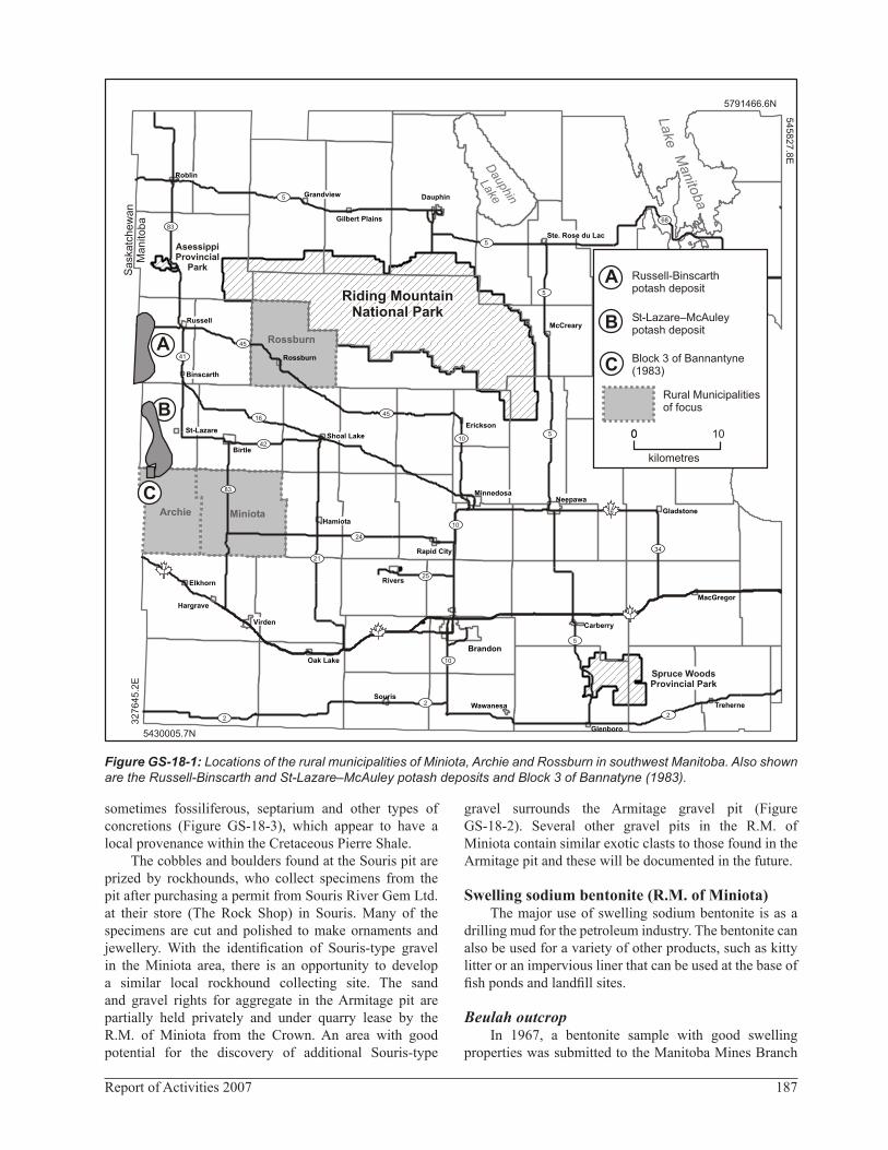
Figure GS-18-1: Locations of the rural municipalities of Miniota, Archie and Rossburn in southwest Manitoba. Also shown are the Russell-Binscarth and St-Lazare–McAuley potash deposits and Block 3 of Bannatyne (1983).
Riding MountainNational Park
Riding MountainNational Park
AsessippiProvincial
Park
MiniotaArchie
Rossburn
Spruce WoodsProvincial Park
Glenboro
Wawanesa
SourisTreherne
Oak Lake
Virden Carberry
MacGregor
Elkhorn Rivers
Rapid City
Hamiota
Gladstone
NeepawaMinnedosa
Birtle
Shoal LakeSt-Lazare
Erickson
Binscarth
Rossburn
McCrearyRussell
Ste. Rose du Lac
Gilbert Plains
Grandview
Roblin
Brandon
A
B
C
keLa
Manito
ba
D
hin
aupaL ke
68
5
5
83
41
45
16
42
83
1
21
2
1
1
2
2
24
25
10
10
10
45
5
5
5
16
34
A Russell-Binscarthpotash deposit
St-Lazare–McAuleypotash depositB
C Block 3 of Bannantyne(1983)
Rural Municipalitiesof focus
00 10
kilometres
kat
he
Sa
sc
wa
nM
an
i ob
at
5791466.6N5
45
82
7.8
E
5430005.7N
32
76
45
.2E
Hargrave
Dauphin
188 Manitoba Geological Survey
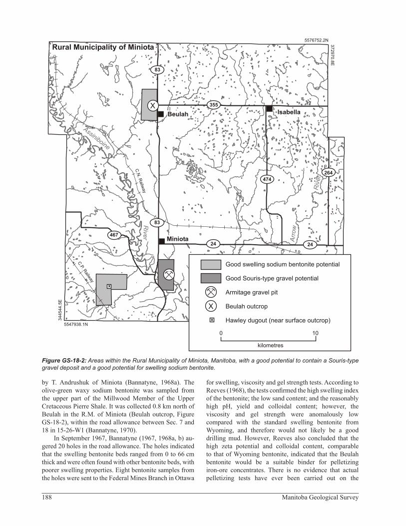
by T. Andrushuk of Miniota (Bannatyne, 1968a). The olive-green waxy sodium bentonite was sampled from the upper part of the Millwood Member of the Upper Cretaceous Pierre Shale. It was collected 0.8 km north of Beulah in the R.M. of Miniota (Beulah outcrop, Figure GS-18-2), within the road allowance between Sec. 7 and 18 in 15-26-W1 (Bannatyne, 1970).
In September 1967, Bannatyne (1967, 1968a, b) au-gered 20 holes in the road allowance. The holes indicated that the swelling bentonite beds ranged from 0 to 66 cm thick and were often found with other bentonite beds, with poorer swelling properties. Eight bentonite samples from the holes were sent to the Federal Mines Branch in Ottawa
for swelling, viscosity and gel strength tests. According to Reeves (1968), the tests confirmed the high swelling index of the bentonite; the low sand content; and the reasonably high pH, yield and colloidal content; however, the viscosity and gel strength were anomalously low compared with the standard swelling bentonite from Wyoming, and therefore would not likely be a good drilling mud. However, Reeves also concluded that the high zeta potential and colloidal content, comparable to that of Wyoming bentonite, indicated that the Beulah bentonite would be a suitable binder for pelletizing iron-ore concentrates. There is no evidence that actual pelletizing tests have ever been carried out on the
Figure GS-18-2: Areas within the Rural Municipality of Miniota, Manitoba, with a good potential to contain a Souris-type gravel deposit and a good potential for swelling sodium bentonite.
Miniota
Beulah Isabella
a
C.
. Rilw
ay
P
C.
Railw
ay
N.
355
474
83
24 24
264
467
83
ssi i oine
An b
iR
ver
Riv
er
Arr
ow
5576752.2N
37
29
70
.8E
5547938.1N
34
45
44
.5E
Rural Municipality of Miniota
0 10
kilometres
Good swelling sodium bentonite potential
Good Souris-type gravel potential
Armitage gravel pit
Beulah outcrop
Hawley dugout (near surface outcrop)
X
X
x
x

189Report of Activities 2007
Beulah bentonite. In spite of the poor results described above, Bannatyne (1967, 1968a, b) suggested that detailed testing, with the proper equipment, in Sec. 7 and 18 in 15-26-W1 (held privately) might outline a deposit of swelling sodium bentonite.
In June 2007, a 10 cm thick, yellowish, partially swelling bentonite bed was seen in a ditch exposure near the northeast corner of 7-15-26-W1, at the junction of the road allowance and PTH 83. The bentonite bed is located very near auger hole no. 10 from Bannatyne (1967), where he found a 36 cm thick slightly swelling bentonite seam overlying Millwood Member shale. An attempt was also made to trace the bentonite bed, 0.4 km to the south of (and roughly parallel to) the road allowance, where a minor road passes generally east-west through the centres of NW- and NE-7-15-26-W1. At this locality, the Millwood Member is present in the bank of a small stream valley and is overlain to the east by badly fractured Odanah Member of the Pierre Shale but bentonite beds were not observed. In spite of the fact that no swelling sodium bentonite was seen within parts of 7-15-26-W1 during this brief field check, it is felt that the area west and northwest of Beulah (Figure GS-18-2) has good potential for a deposit of swelling sodium bentonite. These sections require sampling by backhoe or auger drilling, as recom-mended by Bannatyne (1967, 1968a, b).
Hawley dugoutBannatyne (1968a) speculated that swelling sodium
bentonite should also be present to the south of the community of Miniota. Confirmation of its presence was received in November 2006, when R. Rowan (pers. comm., 2006) indicated that he had sampled a 61 cm thick bed of swelling green waxy bentonite, about 5 km to the southwest of Miniota in the Hawley dugout (Figure GS-18-2). The bed was exposed at the base of a 2 m deep dugout, belonging to J. Hawley, in SE-16-13-27-W1.
A visit to the site in June 2007 revealed that the dugout was filled with water. Auger drillholes or a backhoe adjacent to the dugout would be required to obtain additional samples. An additional area with good potential for a swelling sodium bentonite deposit is shown in Figure GS-18-2 in the vicinity of the Hawley dugout.
Potash and sodium chlorate (R.M. of Archie)
PotashPotash is contained at depth within the Devonian
Prairie Evaporite and two deposits are located south of Russell (Figure GS-18-1), east of the Saskatchewan bor-der. The potash deposits comprise a mixture of sylvite and halite, with minor carnallite and less than 1% green clay, and are among the “cleanest” in western Canada (Ban-natyne, 1971). Across the provincial boundary, in Sas-katchewan, potash is used to produce a variety of fertilizer products that are sold around the world.
Russell-Binscarth areaIn the early 1960s, S.A.M. Explorations Ltd. discov-
ered potash beds in the Assiniboine River valley at a depth of 780.2 m (Bannatyne, 1983; Assessment File 98068, Manitoba Science, Technology, Energy and Mines, Win-nipeg). The discovery hole was drilled in 7-15-19-29-W1, south of Russell and west of Binscarth. The Russell-Bins-carth deposit (Figure GS-18-1) eventually became to be known as the Manitoba Potash Project, for which a 1987 comprehensive feasibility study indicated probable mine-able ore reserves of 154.2 million tonnes grading 24.5% K2O in sylvite (The Northern Miner, 1990). Although the study was done for an area north of the R.M. of Archie, additional drilling was carried out in the potash permit, which indicated that potash mineralization might extend to the south into the St-Lazare–McAuley area.
Figure GS-18-3: Manganese-coated carbon-ate concretion (left side) and concentrically banded ironstone concretion from the Armit-age pit in the Assiniboine River valley, south of Miniota, Manitoba.
Concentrically bandedironstone concretion
Manganese-coatedcarbonate concretionManganese-coatedcarbonate concretion
Concentrically bandedironstone concretion

190 Manitoba Geological Survey
St-Lazare–McAuley areaIn May 1964, Baycourse Mines Limited acquired
a 10 117 ha potash exploration permit near St-Lazare (Figure GS-18-1) on mainly privately held mineral rights to the south of the Russell-Binscarth area. In the same year, the company became a subsidiary of Metal Mines Limited (which undertook and financed drilling of the property) and changed its name to Prairie Potash Mines Limited. After three holes had been completed into the potash bed, The International Nickel Company of Canada Limited (Inco Limited.), through its subsidiary Canadian Nickel Company Limited, took an option on the property to conduct further drill testing. As a result of this work, Inco Limited earned a 65% interest in Prairie Potash Mines Limited (The Northern Miner, 1966). Prairie Potash Mines Limited estimated it had outlined sufficient reserves to supply a plant with 907 000 tonnes of muriate of potash (KCl) annually for at least 50 years (The North-ern Miner, 1966). The company undertook a feasibility study but did not develop the property and their lease lapsed in July 1977.
Most of the drilling that outlined the St-Lazare–McAuley deposit was done north of the R.M. of Archie; however, two of the holes were drilled within the R.M. of Archie (in 4-32-15-28-W1 and 4-36-15-29-W1, Figure GS-18-4). Both holes penetrated the main potash bed (Assessment File 96058, Manitoba Science, Technology, Energy and Mines, Winnipeg). The eastern hole was included by Bannatyne (1983) in his calculation of the reserves of the St-Lazare–McAuley deposit in 1983. A “stratigraphic” reserve of 510 million tonnes averaging 22.0 % K2O, with a cutoff grade of 18% K2O, was esti-mated using the best 2.44 m of the Esterhazy Member.
Additional potash potential adjacent to the St-Lazare– McAuley deposit was also calculated by Bannatyne (1983) in 15-29-W1 using a virtual or ‘dummy’ testhole. His Block 3 (Figures GS-18-1, -4), almost totally within the R.M. of Archie, was estimated to contain 170 million tonnes grading 20% K2O in sylvite. Potash potential was also indicated for the southern portion of Block 2 in 15-28-W1. Block 3 and Block 2 are separated by drill-proven reserves of the southernmost portion of the St-Lazare–McAuley deposit. All are included in Figure GS-18-4 showing the area of the R.M. of Archie that has a good potential for containing a potash deposit.
In September 2005, a Potash Exploration Permit (QP-154) was issued to Agrium Inc. for much of the area (45 212 ha) formerly investigated by Prairie Potash Mines Limited. Additional ground to the southeast has been applied for by W.S. Ferreira Ltd. under QP-168. These permits include the area of good potential that is shown in Figure GS-18-4. If these holdings have been worked on, no information has become available due to confidentiality reasons.
Sodium chlorateSodium chlorate (NaClO3) is produced at Brandon
and Hargrave, located west of Virden (Figure GS-18-1), by an electrolytic chemical reaction from sodium chloride (NaCl) brine. The brine is either derived by dissolving a salt bed in the subsurface or produced from sodium chloride feedstock, obtained as a byproduct of a potash operation. The major use of sodium chlorate is in the paper industry, where it is used to generate chlorine dioxide (ClO2), a key bleaching agent necessary to produce paper from wood pulp. Other sodium chlorate applications include mining (vanadium and uranium), agriculture (herbicides and defoliants) and chemical synthesis (rocket propellants and dyes).
Nexen Inc.Nexen Inc., the biggest producer of sodium chlorate
in the world, has purchased crystallized salt for its plant in Brandon (Figure GS-18-1) from The Canadian Salt Company Ltd. in Belle Plaine, Saskatchewan, for the past 27 years. The evaporated salt is derived as a byproduct from potash production. However, it should be noted that in 2004, Nexen Inc. obtained five quarry leases to solu-tion mine salt from the Prairie Evaporite in the vicinity of ERCO Worldwide’s sodium chlorate plant near Virden (see below).
As of October 2004, Nexen’s Brandon plant produc-tion capacity was increased, at a cost of $60 million, to 263 300 tonnes of sodium chlorate per year, making it the world’s largest producer. And thanks to low electrical rates, which account for 70 to 90% of the variable manu-facturing cost of producing sodium chlorate, it is also one of the lowest cost facilities in North America. In 2004, the average cost of electricity delivered to the Brandon plant was approximately $25/MWh, and in the first six months of 2005 it averaged $27/MWh. Approximately 67 union-ized and salaried personnel worked at the Brandon facility in 2005 (Canexus Income Fund, 2005).
ERCO Worldwide (a division of Superior Plus Income Fund)In 2001, Albchem Manitoba Ltd. drilled two wells
1200 m into the Prairie Evaporite, near Hargrave, a few kilometres west of Virden (Figure GS-18-1). Solution mining began in 2002 with one well used to inject water into the salt bed, and the other to recover the brine. Albchem’s decision to build its $40 million plant (with a capacity of 40 000 tonnes of sodium chlorate per year) in Manitoba was strongly influenced by low electrical rates.
In 2003, the property was acquired by ERCO Worldwide, a division of Superior Plus Income Fund, for $120 million as part of a larger package. The purchase increased ERCO Worldwide’s total sodium chlorate production capacity by 120 000 to 580 000 tonnes, and raised its share of the estimated North American capacity from 23 to 29%.

191Report of Activities 2007
Figure GS-18-4: Rural Municipality of Archie, Manitoba, showing two testholes within an area having good potash potential.
41
256
467
256
C.P. Ra lwayi
McAuley
Willen
4-36-15-29W 4-32-15-28W
St-Lazare–McAuley potash deposit
Block 2 of Bannatyne (1983)
Block 3 of Bannatyne (1983)
Good potash potential
Potash test–hole
as
te
aS
kach
wn
Ma
i oa
nt
b
0 5
kilometres
5577527.3N
34
33
74
.1E
5548604.2N
32
48
56
.3E
Rural Municipality of Archie
192 Manitoba Geological Survey
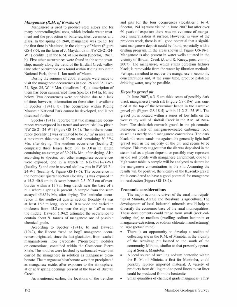
Manganese (R.M. of Rossburn)Manganese is used to produce steel alloys and for
many nonmetallurgical uses, which include water treat-ment and the production of batteries, tiles, ceramics and glass. In the spring of 1940, manganese was found, for the first time in Manitoba, in the vicinity of Mears (Figure GS-18-5), on the farm of J. Maydaniuk in NW-26-21-24-W1 (locality 1) in the R.M. of Rossburn (Spector, 1941a, b). Five other occurrences were found in the same town-ship, mainly along the trend of the Birdtail Creek valley. One other occurrence was found within Riding Mountain National Park, about 11 km north of Mears.
During the summer of 2007, attempts were made to visit the manganese occurrences in Sec. 26 and 35, Twp. 21, Rge. 25, W 1st Mer. (localities 1-4), a description of them has been summarized from Spector (1941a, b), see below. Two occurrences were not visited due to a lack of time; however, information on these sites is available in Spector (1941a, b). The occurrence within Riding Mountain National Park cannot be developed, and is not discussed further.
Spector (1941a) reported that two manganese occur-rences were exposed in a trench and several shallow pits in NW-26-21-24-W1 (Figure GS-18-5). The northern occur-rence (locality 1) was estimated to be 3.7 m2 in area with a maximum thickness of 20 cm and containing 30.22% Mn, after drying. The southern occurrence (locality 2) comprised three lenses from 0.9 to 3.0 m in length containing an average of 39.91% Mn, after drying. Also according to Spector, two other manganese occurrences were exposed, one in a trench in NE-35-21-24-W1 (locality 3) and one in several shallow pits in SW-35-21-24-W1 (locality 4, Figure GS-18-5). The occurrence in the northeast quarter section (locality 3) was exposed in a 15.2–40.6 cm thick seam beneath 2.5–20.3 cm of over-burden within a 13.7 m long trench near the base of a hill, where a spring is present. A sample from the seam assayed 45.85% Mn, after drying. The lenticular occur-rence in the southwest quarter section (locality 4) was at least 16.8 m long, up to 6.10 m wide and varied in thickness from 15.2 cm near the edge to 1.67 m near the middle. Dawson (1942) estimated the occurrence to contain about 91 tonnes of manganese ore of possible chemical grade.
According to Spector (1941a, b) and Dawson (1942), the Recent “wad or bog” manganese occur-rences originated, since the last glaciation, from leached manganiferous iron carbonate (“ironstone”) nodules or concretions, contained within the Cretaceous Pierre Shale. The nodules were leached by carbonated water that carried the manganese in solution as manganese bicar-bonate. The manganese bicarbonate was then precipitated as manganese oxide, after exposure to the atmosphere, at or near spring openings present at the base of Birdtail Creek.
As mentioned earlier, the locations of the trenches
and pits for the four occurrences (localities 1 to 4; Spector, 1941a) were visited in June 2007 but after over 60 years of exposure there was no evidence of manga-nese mineralization at surface. However, in view of the previous work, there is still good potential that a signifi-cant manganese deposit could be found, especially with a drilling program, in the areas shown in Figure GS-18-5. Manganese is also present in water wells situated in the vicinity of Birdtail Creek (J. and R. Kucey, pers. comm., 2007). The manganese, which stains porcelain fixtures black, is removable from the water by filtration methods. Perhaps, a method to recover the manganese in economic concentrations and, at the same time, produce palatable drinking water, may be possible.
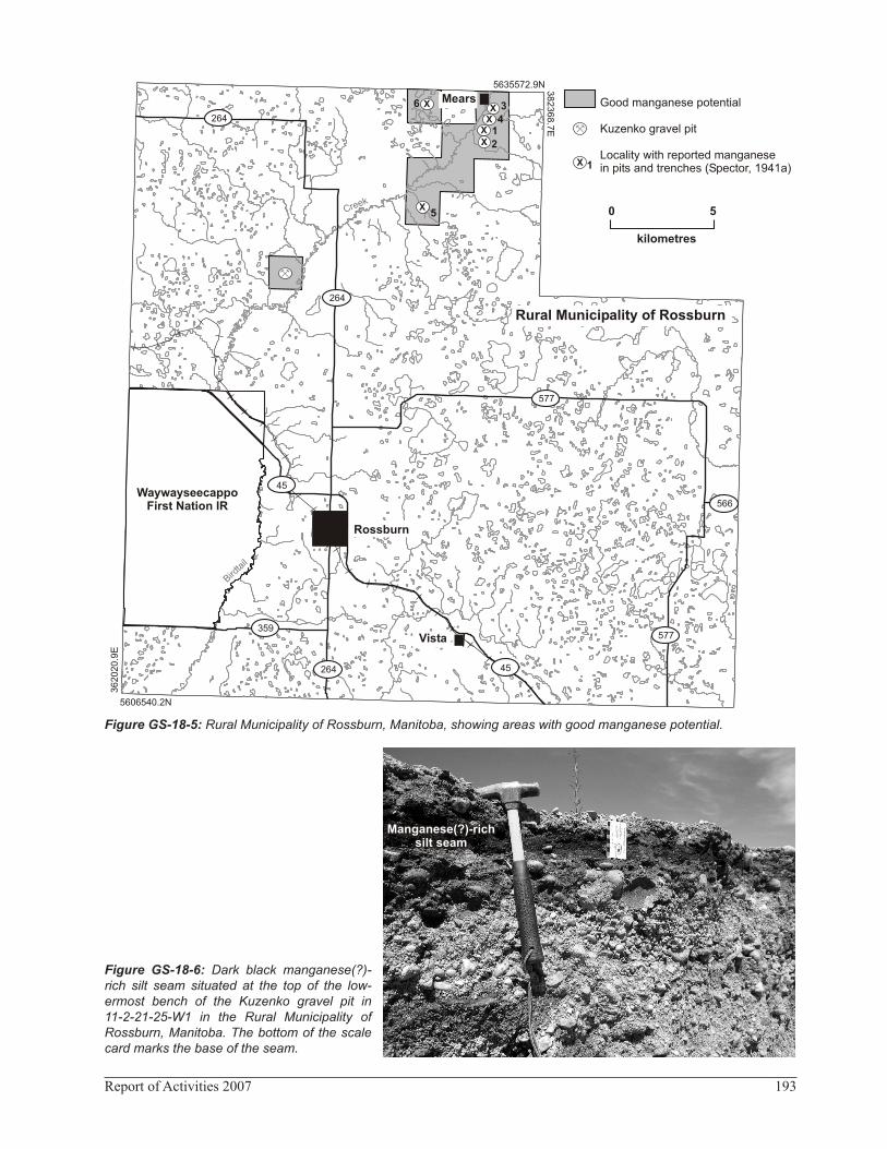
Kuzenko gravel pitIn June 2007, a 3–5 cm thick seam of possibly dark
black manganese(?)-rich silt (Figure GS-18-6) was sam-pled at the top of the lowermost bench in the Kuzenko gravel pit (Figure GS-18-5) within 11-2-21-25-W1. The gravel pit is located within a series of low hills on the west valley wall of Birdtail Creek in the R.M. of Ross-burn. The shale-rich outwash gravel in the pit contains numerous clasts of manganese-coated carbonate rock, as well as nearly solid manganese concretions. The dark black silt seam stands out against the generally light buff gravel seen in the majority of the pit, and seems to be unique. This may suggest that the silt was deposited in the steam bed as a placer deposit; or possibly may represent an old soil profile with manganese enrichment, due to a high water table. A sample will be analyzed to determine the manganese concentration in the silt. Assuming the results will be positive, the vicinity of the Kuzenko gravel pit is considered to have a good potential for manganese mineralization (Figure GS-18-5).
Economic considerationsThe major economic driver of the rural municipali-
ties of Miniota, Archie and Rossburn is agriculture. The development of local industrial minerals would help to diversify the economic base of the rural municipalities. These developments could range from small (rock col-lecting site) to medium (swelling sodium bentonite or manganese extraction, or sodium chlorate manufacturing) to large (potash mine):• There is an opportunity to develop a rockhound
collecting site in the R.M. of Miniota, in the vicinity of the Armitage pit located to the south of the community Miniota, similar to that presently operat-ing at Souris, Manitoba.
• A local source of swelling sodium bentonite within the R. M. of Miniota, a first for Manitoba, could possibly replace imported material. A variety of products from drilling mud to pond liners to cat litter could be produced from the bentonite.
• Small quantities of chemical grade manganese (a first
193Report of Activities 2007
Figure GS-18-5: Rural Municipality of Rossburn, Manitoba, showing areas with good manganese potential.
Figure GS-18-6: Dark black manganese(?)-rich silt seam situated at the top of the low-ermost bench of the Kuzenko gravel pit in 11-2-21-25-W1 in the Rural Municipality of Rossburn, Manitoba. The bottom of the scale card marks the base of the seam.
264
264
264
359
577
45
577
45
566
X
WaywayseecappoFirst Nation IR
Rossburn
Vista
Bi dt
il
ra
Ck
ree
XX
XX
X
X
Rural Municipality of Rossburn
Mears
0 5
kilometres
Good manganese potential
Kuzenko gravel pit
Locality with reported manganese in pits and trenches (Spector, 1941a)
5635572.9N 38
23
68
.7E
5606540.2N
36
20
20
.9E
5
6 34
12
1
Manganese(?)-richsilt seam
Manganese(?)-richsilt seam

194 Manitoba Geological Survey
for Canada) could possibly be selectively mined in the vicinity of Birdtail Creek in the R.M. of Ross-burn. Another option may be to recover the manga-nese from groundwater. Manganese is used to alloy steel and in a variety of nonmetallurgical uses, such as battery, tile, ceramic and glass production and water treatment.
• A mineable potash deposit and fertilizer production within the R.M. of Archie would provide a major economic stimulus to the municipality. A potash mine would rival a metal mine in northern Manitoba at today’s potash spot price.
• A sodium chlorate plant could be built in the R.M. of Archie, adjacent to a new potash mine, to directly use the sodium chloride byproduct to produce sodium chlorate for the paper industry. Manitoba’s low electrical rates also make this a particularly attractive proposition. Or, the mine could supply the world’s largest sodium chlorate plant in Brandon with Manitoba-mined feedstock.
AcknowledgmentsJ. and R. Kucey, residents of the R.M. of Rossburn,
are thanked for providing access to Birdtail Creek valley, near Mears, Manitoba. B. Lenton is gratefully acknow-ledged for preparing the figures in this report. H. Groom and R. Bezys reviewed the manuscript and provided many constructive comments.
ReferencesBannatyne, B.B. 1967: Preliminary report on investigation
of swelling bentonite near Beulah, Manitoba; Manitoba Mines and Natural Resources, Mines Branch, Internal Report, September, 1967, 4 p.
Bannatyne, B.B. 1968a: Bentonite in Manitoba; Manitoba Mines and Natural Resources, Mines Branch, Internal Report, 5 p.
Bannatyne, B.B. 1968b: Industrial mineral investigations; in Summary of Geological Fieldwork 1968, Manitoba Mines and Natural Resources, Mines Branch, Geological Survey of Manitoba, Geological Paper 68-3, p. 41–42.
Bannatyne, B.B. 1970: The clays and shales of Manitoba; Manitoba Department of Mines and Natural Resources, Mines Branch, Publication 67-1, 107 p.
Bannatyne, B.B. 1971: Industrial minerals of the sedimentary area of southern Manitoba; in Geoscience Studies in Manitoba, J.C. Turnock (ed.), Geological Association of Canada, Special Paper No. 9, p. 243–251.
Bannatyne, B.B. 1983: Devonian potash deposits in Manitoba; Manitoba Department of Energy and Mines, Mineral Resources Division, Open File Report OF83-3, 27 p.
Canexus Income Fund 2005: Canexus Income Fund prospectus, Initial Public Offering; Canexus Income Fund, August 10, 2005, URL <http://www.canexus.ca/site/assets/pdf/ prospectus.pdf> [October 2007].
Dawson, A.S. 1942: Manganese occurrences in Manitoba - pre-liminary report; Manitoba Mines and Natural Resources, Mines Branch, Publication 42-1, 23 p.
Klassen, R.W. 1969: Quaternary stratigraphy and radiocarbon chronology in southwestern Manitoba; Geological Survey of Canada, Paper 69-27, 19 p.
Klassen, R.W. 1979: Pleistocene geology and geomorphology of the Riding Mountain and Duck Mountain areas, Manitoba–Saskatchewan; Geological Survey of Canada, Memoir 396, 52 p. plus maps 1479A and 1480A.
Reeves, J.E. 1968: Physical properties of a sample of benton-ite from Beulah, Manitoba; Canada Department of Energy, Mines and Resources, Mines Branch, Mineral Processing Division Test Report MPT 68-8, 5 p.
Spector, I.H. 1941a: Manganese deposits in the Riding Moun-tain and Stonewall formations in southern Manitoba; M.Sc. thesis, University of Manitoba, Winnipeg, 61 p.
Spector, I.H. 1941b: Manganese deposits in the Riding Moun-tain area, Manitoba; in Precambrian, Manitoba Chamber of Mines, July 1941, 4 p.
The Northern Miner 1966: Drilling at Prairie Potash indicates 50 years reserves; The Northern Miner, February 24, 1966, p. 2.
The Northern Miner 1990: Canamax selling 51% stake in Mani-toba potash to EMC; The Northern Miner, May 28, 1990, p. 17.