Embed Size (px)
Citation preview
ROCKBANK DEVELOPMENT CONTRIBUTIONS PLAN – August 2016 1
OLD
LEA
KES
RD
PAYN
ES R
D
TRO
UPS
RD
NTH
WESTERN FREEWAY
GREIGS RD
WESTCOTT PDE
LEAK
ES R
D
LEAK
ES R
D
ROCK
BAN
K RD
TOOLERN RD
Melbourne-Ballarat rail corridor
RockbankTownship
DO
WN
ING
ST
TRO
UPS
RD
STH
FAU
LKN
ER R
D
MURRAY RD
IRAMOO CIRCUIT
STEWART CRES
LEO
NID
DR
potential rail stabling yard
Primary
Secondary
Primary
Primary
Primary
Primary
precinct boundaryresidential
medium density residentialcommercialmixed use rockbank major town centrelocal convenience centrepotential government schoolexisting government schoolpotential non-government schoolcommunity facilitiesurban plazaindoor recreationservice open spacecredited open spacelocal sports reserve - existingregional open spacerockbank railway stationrockbank railway station precinctcaravan parkpublic transport facilitiesouter metropolitan ring transport corridor (OMR)
freeway
landscape bu�er / redundant road reserveutilities - servicingexisting emergency servicesarterial road (six lanes)arterial road (four lanes)connector street - boulevardconnector street key local access streetexisting urban areafuture urban area
NOTE : Refer to Plan 6 for open space details
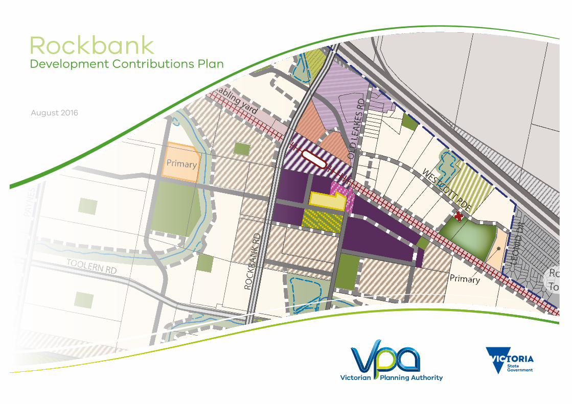
Rockbank Precinct Structure Plan
Copyright, Victorian Planning Authority, 2016 The state of Victoria does not warrant the accuracy or completeness of information in this publication and any person using or relying upon such information does so on the basis that the State of Victoria shall bear no responsibility or liability whatsoever for any errors, faults, defects or omission in the information.
1:25,000 @ A40 200 400 600 800 1,000m
Plan 3 - Future Urban StructureRockbank Development Contributions Plan
Copyright, Victorian Planning Authority, 2016 The state of Victoria does not warrant the accuracy or completeness of information in this publication and any person using or relying upon such information does so on the basis that the State of Victoria shall bear no responsibility or liability whatsoever for any errors, faults, defects or omission in the information.
1:25,000 @ A40 200 400 600 800 1,000m
Plan 2 - Future Urban Structure
August 2016
RockbankDevelopment Contributions Plan
Note: Any reference to the Victorian Planning Authority (VPA) in this document is a reference to the Growth Areas Authority (GAA) as defined under the Planning & Environment Act 1987.
2 ROCKBANK DEVELOPMENT CONTRIBUTIONS PLAN – August 2016
Contents
1.0 INTRODUCTION 51.1 Planning and Environment Act 1987 7
1.2 Rockbank Precinct Structure Plan 7
1.3 The area to which the development contributions plan applies 9
1.4 Infrastructure items included in the development contributions plan 9
1.5 Items not included in the development contributions plan 11
2.0 INFRASTRUCTURE PROJECT JUSTIFICATION 132.1 Project identification 13
2.2 Project timing 25
2.3 Distinction between development infrastructure and community infrastructure 25
3.0 CALCULATION OF CONTRIBUTIONS 273.1 Calculation of net developable area and demand units 27
3.2 Calculation of contributions charges 30
4.0 ADMINISTRATION 404.1 Payment of contributions and payment timing 40
4.2 Funds administration 42
4.3 Construction and land value costs indexation 42
4.4 Review period 43
4.5 Adjustment to the scope of projects 43
4.6 Collecting agency (Agency responsible for collecting infrastructure levy) 43
4.7 Development agency (Agency responsible for works) 43
5.0 IMPLEMENTATION STRATEGY 445.1 Rationale for the implementation strategy 44
5.2 Implementation mechanism 44
APPENDICES 45Refer to separate appendices document
PLANS Plan 1 Regional Context 6
Plan 2 Future Urban Structure 8
Plan 3 DCP & Main Catchment Areas 12
Plan 4 Transport Projects 14
Plan 5 Community Facilities & Active Recreation Projects 22
Plan 6 Land Use Budget 28
TABLES Table 1 Summary of charges 4
Table 2 Road projects 15
Table 3 Intersection projects 17
Table 4 Bridge projects 21
Table 5 Community facilities projects 23
Table 6 Active recreation projects 24
Table 7 Community infrastructure levy (CIL) projects 26
Table 8 Summary land use budget 29
Table 9 Main catchment areas 31
Table 10 Infrastructure project timing & calculation of costs – Development infrastructure levy (DIL) 32
Table 11 Infrastructure project timing & calculation of costs – Community infrastructure levy (CIL) 37
Table 12 External apportionment 38
ROCKBANK DEVELOPMENT CONTRIBUTIONS PLAN – August 2016 3
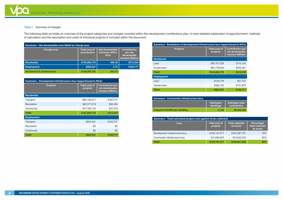
Summary - Net developable area (NDA) by charge area
Charge area Total cost of contribution
Net developable hectares within
MCA
Contribution per net
developable hectare (NDHa)
Residential $143,884,170 460.38 $312,535
Employment $503,531 2.75 $182,777
Residential & Employment $144,387,701 463.13
Summary - Development infrastructure levy (apportioned to MCA)
Projects Total cost of projects
Contribution per net developable hectare (NDHa)
Residential
Transport $84,146,377 $182,777
Recreation $42,577,619 $92,484
Community $17,160,174 $37,274
Total $143,884,170 $312,535
Employment
Transport $503,531 $182,777
Recreation $0 $0
Community $0 $0
Total $503,531 $182,777
Summary - Breakdown of development infrastructure levy (apportioned to MCA)
Projects Total cost of projects
Contribution per net developable hectare (NDHa)
Residential
Land $50,707,528 $110,143
Construction $93,176,643 $202,391
Total $143,884,170 $312,535
Employment
Land $140,779 $51,101
Construction $362,752 $131,675
Total $503,531 $182,777
Summary - Community infrastructure levy
Estimated dwellings
Estimated total contribution
Capped at $1,150 per dwelling 8,144 $9,365,309
Summary - Total estimated project cost against levies collected
Levy Total cost of projects
Total collected via levies
Percentage total collected
by levies
Development infrastructure levy $182,147,477 $144,387,701 79%
Community infrastructure levy $11,600,000 $10,633,333 92%
Total $193,747,477 $155,021,035 80%
Table 1 Summary of charges
The following table provides an overview of the project categories and charges included within this development contributions plan. A more detailed explanation of apportionment, methods of calculation and the description and costs of individual projects is included within the document.
4 ROCKBANK DEVELOPMENT CONTRIBUTIONS PLAN – August 2016
1.0 INTRODUCTIONRockbank Development Contributions Plan (the DCP) has been prepared by the Victorian Planning Authority in consultation with Melton City Council, Government agencies, service authorities and major stakeholders.
The DCP:
• Outlines projects required to ensure that future residents, visitors and workers within the Rockbank precinct can be provided with timely access to the services and transport necessary to support a quality, affordable business and residential area
• Establishes a framework for development proponents to make a financial contribution towards the cost of identified infrastructure projects
• Ensures that the cost of providing new infrastructure and services is shared equitably between various development proponents and the wider community
• Provides the details of the calculation of financial contributions that must be made by future developments towards the nominated projects
• Provides developers, investors and local communities with certainty about development contribution requirements and how they will be administered.
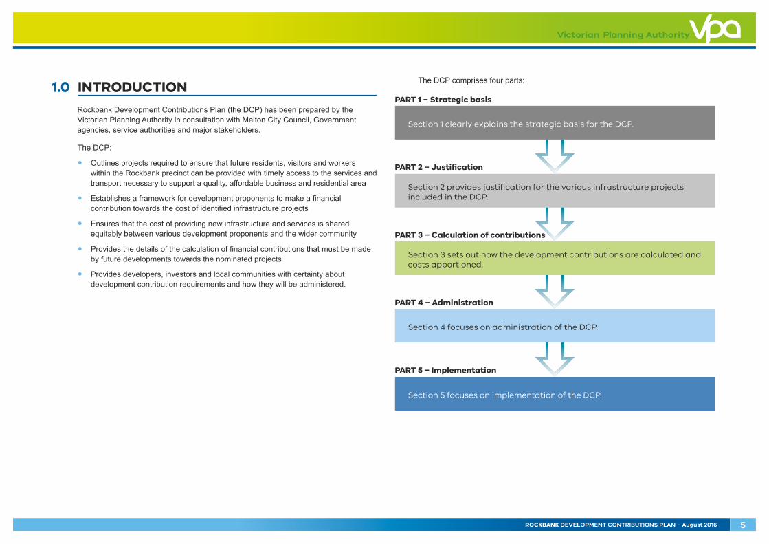
The DCP comprises four parts:
PART 1 – Strategic basis
Section 1 clearly explains the strategic basis for the DCP.
PART 4 – Administration
Section 4 focuses on administration of the DCP.
PART 5 – Implementation
Section 5 focuses on implementation of the DCP.
PART 2 – Justification
Section 2 provides justification for the various infrastructure projects included in the DCP.
PART 3 – Calculation of contributions
Section 3 sets out how the development contributions are calculated and costs apportioned.
ROCKBANK DEVELOPMENT CONTRIBUTIONS PLAN – August 2016 5
SUNSHINE
EASTWERRIBEE
Western subregion boundaryMetropolitan regionMetropolitan urban boundaryUrban areaRoad networkRail networkLevel crossing removalTram networkRoad initiativeRail initiativeNew stationPotential ferry routeNational employment clusterTransport gateway – existingTransport gateway – futureMetropolitan intermodal system terminal(indicative location)State signi�cant industrial precinct – existingState signi�cant industrial precinct – futureBusiness and residential (as shown in growth corridor plans)Health/Education precinctHealth precinctEducation precinct Metropolitan activity centre – existingMetropolitan activity centre – futureActivity centre – existing and futureBoulevard to be investigated/implementedRegional open space – futureUrban renewal areaBiodiversity conservation areaMajor open spaceWaterwayAirport
MAP 31 – WESTERN SUBREGIONSOURCE: DEPARTMENT OF TRANSPORT, PLANNING AND LOCAL INFRASTRUCTURE, 2014
Note: This map is a diagrammatic of the structural elements of Plan Melbourne.
TOOLERN
BACCHUSMARSH
WERRIBEESOUTH
SUNBURY
MELBOURNEAIRPORT
MELBOURNECENTRAL BUSINESS
DISTRICT
WesternGrasslandReserve
WesternGrasslandReserve
Future WesternInterstate
FreightTerminal
Proposed Kororoit
Regional Park
ToolernRegional Park
Point CookCoastal Park
OuterMetropolitanRoad & Rail
AVALON AIRPORT
Port Phillip Bay(Western Shoreline)
Ramsar Site
Rockbank
Plumpton
Caroline Springs
St. Albans
Sunshinecorridor
Brimbank
Hop
kins
Rd. Deer Park
Rockbank North
Western Fwy
Princes FwyPort Phillip Bay
Maribyrnong River
MeltonHealth
© The State of Victoria. Department of Transport, Planning and Local Infrastructure, 2014. The State of Victoria does not warrant the accuracy or completeness in this publication and any person using or relying upon such information does so on the basis that the State of Victoria shall bear no responsibility or liability whatsoever for any errors, faults defects or omissions in the information.
0 5 10
Kilometres
DiggersRest
Rockbank
20Km
15Km
10Km
5Km
precinct boundary
western subregion boundary
urban growth boundary (UGB)
urban area
road network
rail network
tram network
outer metropolitan ring transport corridor
national employment cluster
transport gateway – future
state significant industrial precinct – existing
state significant industrial precinct – future
business and residential
health / education precinct
health precinct
education precinct
principal town centre – existing
principal town centre – future
town centre – existing and future
regional open space – future
regional open space - existing
urban renewal area
biodiversity conservation area
waterway
airport
NOTE : Map : Western Subregion, Plan Melbourne
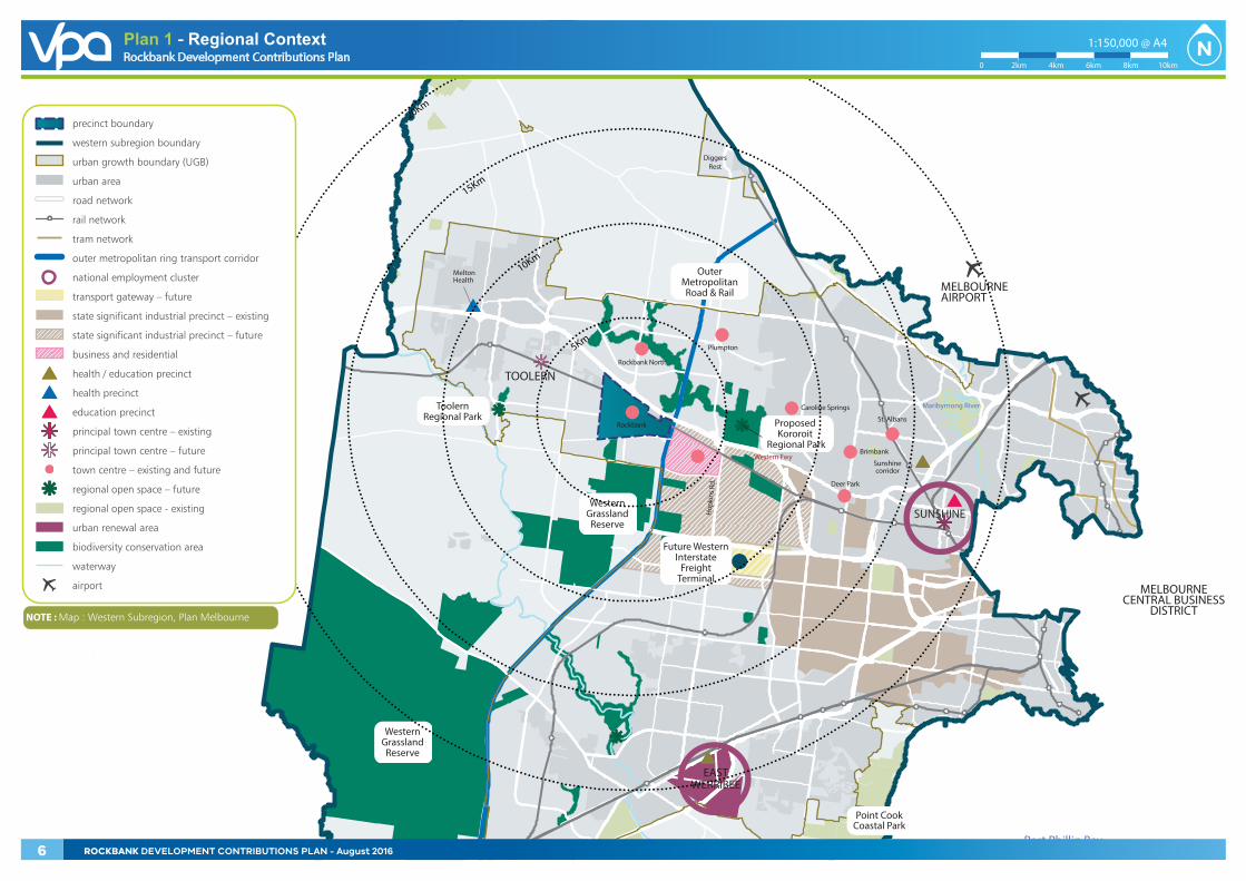
Plan 1 - Regional ContextRockbank Development Contributions Plan
Copyright, Victorian Planning Authority, 2016 The state of Victoria does not warrant the accuracy or completeness of information in this publication and any person using or relying upon such information does so on the basis that the State of Victoria shall bear no responsibility or liability whatsoever for any errors, faults, defects or omission in the information.
1:150,000 @ A4
0 2km 4km 6km 8km 10km
6 ROCKBANK DEVELOPMENT CONTRIBUTIONS PLAN - August 2016
The strategic basis for the DCP is informed by:
• State and Local Planning Policy Framework set out in the Melton Planning Scheme
• Precinct Structure Planning Guidelines (Growth Areas Authority, 2008)
• Growth Corridor Plans: Managing Melbourne’s Growth (GAA, 2012)
• Development Contributions Plan Guidelines (Department of Transport, Planning and Local Infrastructure, 2013)
• Rockbank Precinct Structure Plan and supporting documents.
These documents set out a broad, long term vision for the sustainable development of the Rockbank precinct and its surroundings.
1.1 Planning and Environment Act 1987
The DCP has been prepared in accordance with Part 3B of the Planning and Environment Act 1987 (the Act) and has been developed in line with the State and Local Planning Policy Framework of the Melton Planning Scheme as well as Victorian Government Guidelines. It is consistent with the Ministerial Direction on development contributions plans made under section 46M(1) of the Act and has had regard to the Victorian Government’s Development Contribution Plan Guidelines.
The DCP provides for the charging of a development infrastructure levy pursuant to section 46J(a) of the Act towards works, services or facilities. It also provides for the charging of a community infrastructure levy pursuant to section 46J(b) of the Act as some items are classified as community infrastructure under the Act, the Ministerial Direction on development contributions plans and the Development Contributions Plan Guidelines.
The DCP forms part of the Melton Planning Scheme pursuant to section 46I of the Act and is an incorporated document under Clause 81 of the Melton Planning Scheme. The DCP is implemented in the Melton Planning Scheme through Schedule 7 to Clause 45.06 Development Contributions Plan Overlay (DCPO7) that applies to the area illustrated on Plan 3.
1.2 Rockbank Precinct Structure Plan
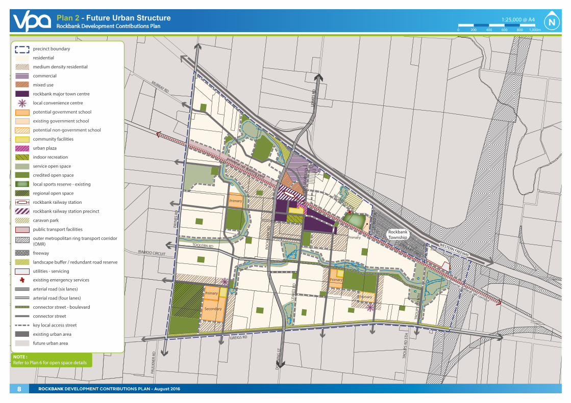
Rockbank Precinct Structure Plan (the PSP) is a long-term plan for urban development. It describes how the land to which the DCP applies is expected to be developed, and how and where services are planned to support development.
The PSP applies to 751.83 hectares of land as illustrated on Plan 2.
The precinct is located approximately 29 kilometres to the west of the Melbourne CBD. The PSP is bounded by the Western Highway and the existing Rockbank Township to the north, Paynes Road to the west, Greigs Road to the south and the Outer Metropolitan Ring (OMR) transport corridor to the east, beyond Troups Road North. The Melbourne–Ballarat rail corridor runs in an east-west direction through the precinct as illustrated on Plan 1.
The need for the infrastructure set out in the DCP has been determined according to the anticipated development scenario for Rockbank as described in the PSP.
The DCP has a strong relationship to the PSP, as the PSP provides the rationale and justification for infrastructure items that have been included within the DCP.
Accordingly, the DCP is an implementation-based planning tool that identifies the infrastructure items required by the new community and apportions the cost of this infrastructure in an equitable manner across the plan area.
The PSP has been developed following a comprehensive planning process that establishes the future direction of development within the precinct.
ROCKBANK DEVELOPMENT CONTRIBUTIONS PLAN – August 2016 7
OLD
LEA
KES
RD
PAYN
ES R
D
TRO
UPS
RD
NTH
WESTERN FREEWAY
GREIGS RD
WESTCOTT PDE
LEA
KES
RD
LEA
KES
RD
ROCK
BAN
K RD
TOOLERN RD
Melbourne-Ballarat rail corridor
RockbankTownship
DO
WN
ING
ST
TRO
UPS
RD
STH
FAU
LKN
ER R
D
MURRAY RD
IRAMOO CIRCUIT
STEWART CRES
LEO
NID
DR
potential rail stabling yard
Primary
Secondary
Primary
Primary
Primary
Primary
precinct boundary
residential
medium density residential
commercial
mixed use
rockbank major town centre
local convenience centre
potential government school
existing government school
potential non-government school
community facilities
urban plaza
indoor recreation
service open space
credited open space
local sports reserve - existing
regional open space
rockbank railway station
rockbank railway station precinct
caravan park
public transport facilities
outer metropolitan ring transport corridor (OMR)
freeway
landscape bu�er / redundant road reserve
utilities - servicing
existing emergency services
arterial road (six lanes)
arterial road (four lanes)
connector street - boulevard
connector street
key local access street
existing urban area
future urban area
NOTE : Refer to Plan 6 for open space details
Rockbank Precinct Structure Plan
Copyright, Victorian Planning Authority, 2016 The state of Victoria does not warrant the accuracy or completeness of information in this publication and any person using or relying upon such information does so on the basis that the State of Victoria shall bear no responsibility or liability whatsoever for any errors, faults, defects or omission in the information.
1:25,000 @ A4
0 200 400 600 800 1,000m
Plan 3 - Future Urban StructureRockbank Development Contributions Plan
Copyright, Victorian Planning Authority, 2016 The state of Victoria does not warrant the accuracy or completeness of information in this publication and any person using or relying upon such information does so on the basis that the State of Victoria shall bear no responsibility or liability whatsoever for any errors, faults, defects or omission in the information.
1:25,000 @ A4
0 200 400 600 800 1,000m
Plan 2 - Future Urban Structure
8 ROCKBANK DEVELOPMENT CONTRIBUTIONS PLAN - August 2016
1.3 The area to which the development contributions plan applies
In accordance with section 46K(1)(a) of the Act, the DCP applies to land illustrated on Plan 3. The area is also shown on DCPO7 in the Melton Planning Scheme.
In identifying infrastructure items for delivery, consideration has been given to ensure they are not already wholly funded through another contribution mechanism, such as a mandatory infrastructure construction requirement as outlined in Table 6 of the PSP, an existing local DCP, an agreement under section 173 of the Act, or as a condition on an existing planning permit.
The DCP replaces two road projects yet to be constructed as part of the approved Toolern Development Contributions Plan:
• ‘IT07’ in the Rockbank DCP replaces ‘IT07’ in the Toolern DCP
• ‘IT15’ in the Rockbank DCP replaces ‘IT08’ in the Toolern DCP.
1.4 Infrastructure items included in the development contributions plan
The need for infrastructure included in the DCP has been determined on the basis of the development scenario as described in the PSP and its supporting documents.
Items can be included in a DCP if the proposed development of an area is likely to create the need for infrastructure by its future community. New development does not have to trigger the need for new items in its own right. Furthermore, an item can be included in a DCP regardless of whether it is within or outside the DCP area.
Before inclusion in this DCP, all items have been assessed to ensure they have a relationship or nexus to proposed development in the PSP. The cost apportionment methodology adopted in this DCP relies on the nexus principle. A new development is deemed to have a nexus with an item if it is expected to make use of that item.
A summary of how each item relates to projected growth area development is set out below and individual item use apportionments are identified in Tables 10–12.
The items that have been included in this DCP all have the following characteristics; namely they:
• Are essential to the health, safety and well-being of the community
• Will be used by a broad cross-section of the community
• Reflect the vision and strategic aspirations as expressed in the PSP
• Are not recurrent items
• Are the basis for the future development of an integrated network.
ROCKBANK DEVELOPMENT CONTRIBUTIONS PLAN – August 2016 9
THIS PAGE HAS BEEN LEFT INTENTIONALLY BLANK
10 ROCKBANK DEVELOPMENT CONTRIBUTIONS PLAN – August 2016
1.5 Items not included in the development contributions plan
1.5.1 Developer works
The following items are not included in the DCP; they must be provided by developers as a matter of course and/or pursuant to agreements with servicing agencies in implementing the PSP:
• Connector streets and local streets (except those included in the DCP)
• Intersection works and traffic management measures along arterial roads, connector streets and local streets (except those included in the DCP)
• Local bus stop infrastructure (where locations have been agreed in writing by Public Transport Victoria)
• Landscaping of all existing and future roads and local streets
• Local shared, pedestrian and bicycle paths along local streets, connector streets, utilities easements, waterways and within local parks including bridges, intersections, and barrier crossing points (except those included in the DCP)
• Council-approved fencing and landscaping along arterial roads, the railway corridor and shared paths, as required
• Bicycle parking
• Appropriately scaled lighting along all roads, major shared and pedestrian paths, and traversing the open space network
• Basic improvements to local parks and open space
• Local drainage system
• Local street or path crossings of waterways, unless included in the DCP or outlined as the responsibility of an agency in the PSP
• Infrastructure as required by utility services providers, including water, sewerage, drainage (except where the item is funded through a Melbourne Water Development Services Scheme), electricity, gas and telecommunications
• Remediation and/or reconstruction of dry stone walls, where required.
The items listed above are considered to be normal to the construction of a development and are not considered to warrant cost sharing arrangements beyond those set out in the DCP.
They may be further addressed and defined by an agreement under section 173 of the Act and/or conditions in planning permits.
Upgrade of the existing road network to an urban standard will be implemented through subdivision permit conditions to the satisfaction of the responsible authority, except where specified as a DCP project.
1.5.2 State infrastructure
Construction of the following items has not been included within the DCP as they are determined to be State infrastructure:
• Government schools
• Public transport
• Upgrades to the declared road network.
The delivery of State infrastructure will be provided as warranted.
1.5.3 Public open space contributions
This DCP does not provide funding for unencumbered public open space in the form of local parks as it is provided through Clause 52.01 of the Melton Planning Scheme.
ROCKBANK DEVELOPMENT CONTRIBUTIONS PLAN – August 2016 11
OLD
LEA
KES
RD
PAYN
ES R
D
TRO
UPS
RD
NTH
WESTERN FREEWAY
GREIGS RD
WESTCOTT PDE
LEA
KES
RD
LEA
KES
RD
ROCK
BAN
K RD
TOOLERN RD
Melbourne-Ballarat rail corridor
RockbankTownship
DO
WN
ING
ST
TRO
UPS
RD
STH
FAU
LKN
ER R
D
MURRAY RD
IRAMOO CIRCUIT
STEWART CRES
LEO
NID
DR
precinct boundary
main catchment area - residential
main catchment area - employment
Rockbank Development Contributions Plan
Copyright, Victorian Planning Authority, 2016 The state of Victoria does not warrant the accuracy or completeness of information in this publication and any person using or relying upon such information does so on the basis that the State of Victoria shall bear no responsibility or liability whatsoever for any errors, faults, defects or omission in the information.
1:25,000 @ A4
0 200 400 600 800 1,000m
Plan 3 - DCP and Main Catchment Areas
12 ROCKBANK DEVELOPMENT CONTRIBUTIONS PLAN - August 2016

2.0 INFRASTRUCTURE PROJECT JUSTIFICATION
2.1 Project identification
The DCP uses a project identification system of project category and sequential number in its tables and plans.
The following types of projects are included in the DCP:
• Transport projects
◦ RD – Roads
◦ IT – Intersections
◦ BR – Bridges
• Community facilities projects
◦ CI – Community facilities
• Active recreation projects
◦ AR – Sports reserves
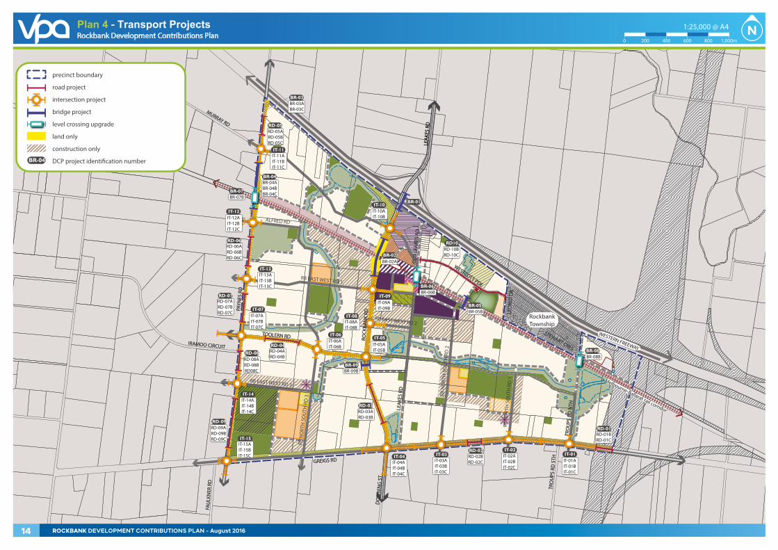
2.1.1 Road projects
The road projects in the DCP are based on the transport network illustrated on Plan 4 and supported by the reports:
• Rockbank PSP Transport Modelling Assessment, September 2014, (Jacobs)
• Rockbank PSP Infrastructure Costing Assessment, June 2016 (SMEC).
The road projects are for arterial road construction, less pavement and works for controlled intersections and associated works.
ROCKBANK DEVELOPMENT CONTRIBUTIONS PLAN – August 2016 13
OLD
LEA
KES
RD
PAYN
ES R
D
TRO
UPS
RD
NTH
WESTERN FREEWAY
GREIGS RD
WESTCOTT PDE
LEA
KES
RD
LEA
KES
RD
ROCK
BAN
K RD
TOOLERN RD
Melbourne-Ballarat rail corridor
RockbankTownship
DO
WN
ING
ST
TRO
UPS
RD
STH
FAU
LKN
ER R
D
MURRAY RD
IRAMOO CIRCUIT
STEWART CRES
LEO
NID
DR
RD-01
IT-01IT-04
IT-05IT-06
IT-09
IT-10
IT-11
BR-04
RD-06
BR-09
RD-04
RD-08
IT-14
IT-15
RD-09
IT-13
BR-02
BR-06
BR-01
BR-03
RD-05
RD-03
RD10
BR-03ABR-03C
BR-04ABR-04BBR-04C
BR-09B
BR-06B
BR-02A
RD-05ARD-05BRD-05C
RD-06ARD-06BRD-06C
RD-07RD-07ARD-07BRD-07C
RD-08ARD-08BRD08C
RD-10BRD-10C
RD-02RD-02BRD-02C
RD-01BRD-01C
RD-04ARD-04B
RD-03ARD-03B
RD-09ARD-09BRD-09C
IT-11AIT-11BIT-11C
IT-12IT-12AIT-12BIT-12C
IT-13AIT-13BIT-13C
IT-07IT-07AIT-07BIT-07C
IT-04AIT-04BIT-04C
IT-03IT-03AIT-03BIT-03C
IT-02IT-02AIT-02BIT-02C
IT-01AIT-01BIT-01C
IT-06AIT-06B
IT-10AIT-10B
IT-09AIT-09B
IT-05AIT-05B
IT-08IT-08AIT-08B
IT-14AIT-14BIT-14C
IT-15AIT-15BIT-15C
BR-07BR-07B
BR-08BR-08B
BR-05BR-05B
OLD
LEA
KES
RD
PAYN
ES R
D
TRO
UPS
RD
NTH
WESTERN FREEWAY
GREIGS RD
WESTCOTT PDE
LEA
KES
RD
LEA
KES
RD
ROCK
BAN
K RD
TOOLERN RD
Melbourne-Ballarat rail corridor
RockbankTownship
DO
WN
ING
ST
TRO
UPS
RD
STH
FAU
LKN
ER R
D
MURRAY RD
IRAMOO CIRCUIT
STEWART CRES
LEO
NID
DR
RB N
ORT
H S
OU
TH R
D 2
RB N
ORT
H S
OU
TH R
D 1RB EAST WEST RD 3
RB N
ORT
H S
OU
TH R
D 3
RB EAST WEST RD 1
ALFRED RD
RB EAST WEST RD 2
precinct boundary
road project
intersection project
bridge project
level crossing upgrade
land only
construction only
DCP project identi�cation numberBR-04
Rockbank Development Contributions Plan
Copyright, Victorian Planning Authority, 2016 The state of Victoria does not warrant the accuracy or completeness of information in this publication and any person using or relying upon such information does so on the basis that the State of Victoria shall bear no responsibility or liability whatsoever for any errors, faults, defects or omission in the information.
1:25,000 @ A4
0 200 400 600 800 1,000m
Plan 4 - Transport Projects
14 ROCKBANK DEVELOPMENT CONTRIBUTIONS PLAN - August 2016
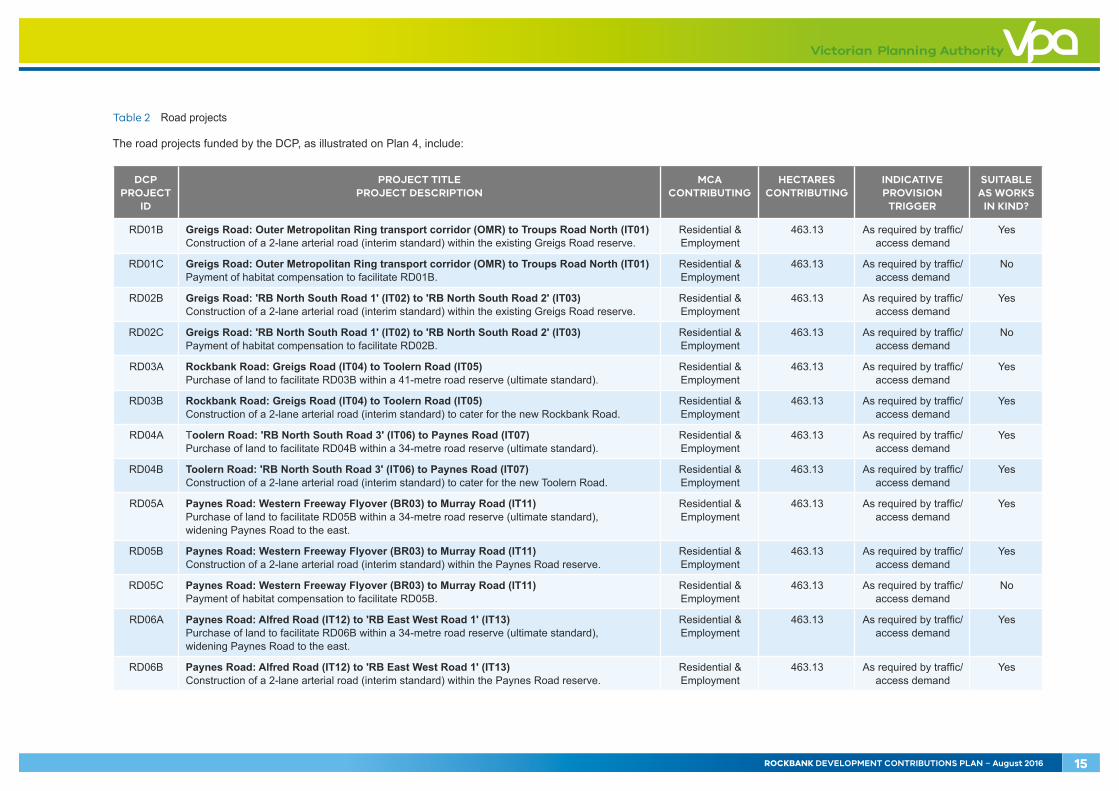
Table 2 Road projects
The road projects funded by the DCP, as illustrated on Plan 4, include:
DCP PROJECT
ID
PROJECT TITLE PROJECT DESCRIPTION
MCA CONTRIBUTING
HECTARES CONTRIBUTING
INDICATIVE PROVISION
TRIGGER
SUITABLE AS WORKS
IN KIND?
RD01B Greigs Road: Outer Metropolitan Ring transport corridor (OMR) to Troups Road North (IT01) Construction of a 2-lane arterial road (interim standard) within the existing Greigs Road reserve.
Residential & Employment
463.13 As required by traffic/access demand
Yes
RD01C Greigs Road: Outer Metropolitan Ring transport corridor (OMR) to Troups Road North (IT01) Payment of habitat compensation to facilitate RD01B.
Residential & Employment
463.13 As required by traffic/access demand
No
RD02B Greigs Road: 'RB North South Road 1' (IT02) to 'RB North South Road 2' (IT03) Construction of a 2-lane arterial road (interim standard) within the existing Greigs Road reserve.
Residential & Employment
463.13 As required by traffic/access demand
Yes
RD02C Greigs Road: 'RB North South Road 1' (IT02) to 'RB North South Road 2' (IT03) Payment of habitat compensation to facilitate RD02B.
Residential & Employment
463.13 As required by traffic/access demand
No
RD03A Rockbank Road: Greigs Road (IT04) to Toolern Road (IT05) Purchase of land to facilitate RD03B within a 41-metre road reserve (ultimate standard).
Residential & Employment
463.13 As required by traffic/access demand
Yes
RD03B Rockbank Road: Greigs Road (IT04) to Toolern Road (IT05) Construction of a 2-lane arterial road (interim standard) to cater for the new Rockbank Road.
Residential & Employment
463.13 As required by traffic/access demand
Yes
RD04A Toolern Road: 'RB North South Road 3' (IT06) to Paynes Road (IT07) Purchase of land to facilitate RD04B within a 34-metre road reserve (ultimate standard).
Residential & Employment
463.13 As required by traffic/access demand
Yes
RD04B Toolern Road: 'RB North South Road 3' (IT06) to Paynes Road (IT07) Construction of a 2-lane arterial road (interim standard) to cater for the new Toolern Road.
Residential & Employment
463.13 As required by traffic/access demand
Yes
RD05A Paynes Road: Western Freeway Flyover (BR03) to Murray Road (IT11) Purchase of land to facilitate RD05B within a 34-metre road reserve (ultimate standard), widening Paynes Road to the east.
Residential & Employment
463.13 As required by traffic/access demand
Yes
RD05B Paynes Road: Western Freeway Flyover (BR03) to Murray Road (IT11) Construction of a 2-lane arterial road (interim standard) within the Paynes Road reserve.
Residential & Employment
463.13 As required by traffic/access demand
Yes
RD05C Paynes Road: Western Freeway Flyover (BR03) to Murray Road (IT11) Payment of habitat compensation to facilitate RD05B.
Residential & Employment
463.13 As required by traffic/access demand
No
RD06A Paynes Road: Alfred Road (IT12) to 'RB East West Road 1' (IT13) Purchase of land to facilitate RD06B within a 34-metre road reserve (ultimate standard), widening Paynes Road to the east.
Residential & Employment
463.13 As required by traffic/access demand
Yes
RD06B Paynes Road: Alfred Road (IT12) to 'RB East West Road 1' (IT13) Construction of a 2-lane arterial road (interim standard) within the Paynes Road reserve.
Residential & Employment
463.13 As required by traffic/access demand
Yes
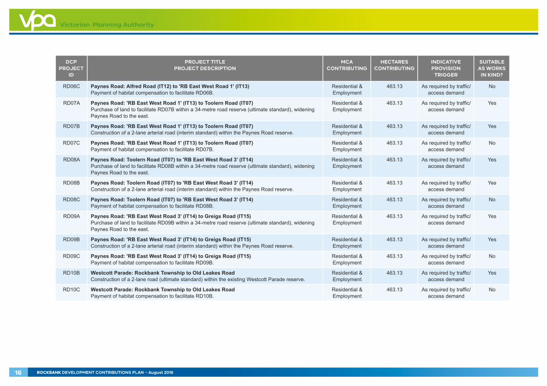
ROCKBANK DEVELOPMENT CONTRIBUTIONS PLAN – August 2016 15
DCP PROJECT
ID
PROJECT TITLE PROJECT DESCRIPTION
MCA CONTRIBUTING
HECTARES CONTRIBUTING
INDICATIVE PROVISION
TRIGGER
SUITABLE AS WORKS
IN KIND?
RD06C Paynes Road: Alfred Road (IT12) to 'RB East West Road 1' (IT13) Payment of habitat compensation to facilitate RD06B.
Residential & Employment
463.13 As required by traffic/access demand
No
RD07A Paynes Road: 'RB East West Road 1' (IT13) to Toolern Road (IT07) Purchase of land to facilitate RD07B within a 34-metre road reserve (ultimate standard), widening Paynes Road to the east.
Residential & Employment
463.13 As required by traffic/access demand
Yes
RD07B Paynes Road: 'RB East West Road 1' (IT13) to Toolern Road (IT07) Construction of a 2-lane arterial road (interim standard) within the Paynes Road reserve.
Residential & Employment
463.13 As required by traffic/access demand
Yes
RD07C Paynes Road: 'RB East West Road 1' (IT13) to Toolern Road (IT07) Payment of habitat compensation to facilitate RD07B.
Residential & Employment
463.13 As required by traffic/access demand
No
RD08A Paynes Road: Toolern Road (IT07) to 'RB East West Road 3' (IT14) Purchase of land to facilitate RD08B within a 34-metre road reserve (ultimate standard), widening Paynes Road to the east.
Residential & Employment
463.13 As required by traffic/access demand
Yes
RD08B Paynes Road: Toolern Road (IT07) to 'RB East West Road 3' (IT14) Construction of a 2-lane arterial road (interim standard) within the Paynes Road reserve.
Residential & Employment
463.13 As required by traffic/access demand
Yes
RD08C Paynes Road: Toolern Road (IT07) to 'RB East West Road 3' (IT14) Payment of habitat compensation to facilitate RD08B.
Residential & Employment
463.13 As required by traffic/access demand
No
RD09A Paynes Road: 'RB East West Road 3' (IT14) to Greigs Road (IT15) Purchase of land to facilitate RD09B within a 34-metre road reserve (ultimate standard), widening Paynes Road to the east.
Residential & Employment
463.13 As required by traffic/access demand
Yes
RD09B Paynes Road: 'RB East West Road 3' (IT14) to Greigs Road (IT15) Construction of a 2-lane arterial road (interim standard) within the Paynes Road reserve.
Residential & Employment
463.13 As required by traffic/access demand
Yes
RD09C Paynes Road: 'RB East West Road 3' (IT14) to Greigs Road (IT15) Payment of habitat compensation to facilitate RD09B.
Residential & Employment
463.13 As required by traffic/access demand
No
RD10B Westcott Parade: Rockbank Township to Old Leakes Road Construction of a 2-lane road (ultimate standard) within the existing Westcott Parade reserve.
Residential & Employment
463.13 As required by traffic/access demand
Yes
RD10C Westcott Parade: Rockbank Township to Old Leakes Road Payment of habitat compensation to facilitate RD10B.
Residential & Employment
463.13 As required by traffic/access demand
No
16 ROCKBANK DEVELOPMENT CONTRIBUTIONS PLAN – August 2016

2.1.2 Intersection projects
The intersection projects in the DCP are based on the transport network illustrated on Plan 4 and supported by the reports:
• VPA analysis of turning volumes extracted from Rockbank PSP Transport Modelling Assessment, September 2014 (Jacobs)
• Rockbank PSP SIDRA Intersection Modelling, September 2014 (Jacobs)
• Rockbank PSP Infrastructure Costing Assessment, June 2016 (SMEC).
The intersection projects identified are controlled intersections and associated works.
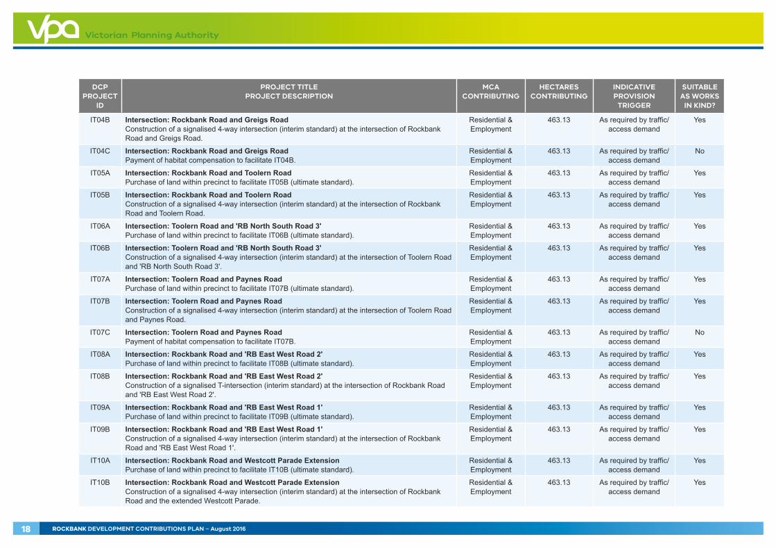
Table 3 Intersection projects
The intersection projects funded by the DCP, as illustrated on Plan 4, include:
DCP PROJECT
ID
PROJECT TITLE PROJECT DESCRIPTION
MCA CONTRIBUTING
HECTARES CONTRIBUTING
INDICATIVE PROVISION
TRIGGER
SUITABLE AS WORKS
IN KIND?
IT01A Intersection: Greigs Road and Troups Road North Purchase of land within precinct to facilitate IT01B (ultimate standard).
Residential & Employment
463.13 As required by traffic/access demand
Yes
IT01B Intersection: Greigs Road and Troups Road North Construction of a signalised T-intersection (interim standard) at the intersection of Greigs Road and Troups Road North.
Residential & Employment
463.13 As required by traffic/access demand
Yes
IT01C Intersection: Greigs Road and Troups Road North Payment of habitat compensation to facilitate IT01B.
Residential & Employment
463.13 As required by traffic/access demand
No
IT02A Intersection: Greigs Road and 'RB North South Road 1' Purchase of land within precinct to facilitate IT02B (ultimate standard).
Residential & Employment
463.13 As required by traffic/access demand
Yes
IT02B Intersection: Greigs Road and 'RB North South Road 1' Construction of a signalised T-intersection (interim standard) at the intersection of Greigs Road and 'RB North South Road 1'.
Residential & Employment
463.13 As required by traffic/access demand
Yes
IT02C Intersection: Greigs Road and 'RB North South Road 1' Payment of habitat compensation to facilitate IT02B.
Residential & Employment
463.13 As required by traffic/access demand
No
IT03A Intersection: Greigs Road and 'RB North South Road 2' Purchase of land within precinct to facilitate IT03B (ultimate standard).
Residential & Employment
463.13 As required by traffic/access demand
Yes
IT03B Intersection: Greigs Road and 'RB North South Road 2' Construction of a signalised T-intersection (interim standard) at the intersection of Greigs Road and 'RB North South Road 2'.
Residential & Employment
463.13 As required by traffic/access demand
Yes
IT03C Intersection: Greigs Road and 'RB North South Road 2' Payment of habitat compensation to facilitate IT03B.
Residential & Employment
463.13 As required by traffic/access demand
No
IT04A Intersection: Rockbank Road and Greigs Road Purchase of land within precinct to facilitate IT04B (ultimate standard).
Residential & Employment
463.13 As required by traffic/access demand
Yes
ROCKBANK DEVELOPMENT CONTRIBUTIONS PLAN – August 2016 17
DCP PROJECT
ID
PROJECT TITLE PROJECT DESCRIPTION
MCA CONTRIBUTING
HECTARES CONTRIBUTING
INDICATIVE PROVISION
TRIGGER
SUITABLE AS WORKS
IN KIND?
IT04B Intersection: Rockbank Road and Greigs Road Construction of a signalised 4-way intersection (interim standard) at the intersection of Rockbank Road and Greigs Road.
Residential & Employment
463.13 As required by traffic/access demand
Yes
IT04C Intersection: Rockbank Road and Greigs Road Payment of habitat compensation to facilitate IT04B.
Residential & Employment
463.13 As required by traffic/access demand
No
IT05A Intersection: Rockbank Road and Toolern Road Purchase of land within precinct to facilitate IT05B (ultimate standard).
Residential & Employment
463.13 As required by traffic/access demand
Yes
IT05B Intersection: Rockbank Road and Toolern Road Construction of a signalised 4-way intersection (interim standard) at the intersection of Rockbank Road and Toolern Road.
Residential & Employment
463.13 As required by traffic/access demand
Yes
IT06A Intersection: Toolern Road and 'RB North South Road 3' Purchase of land within precinct to facilitate IT06B (ultimate standard).
Residential & Employment
463.13 As required by traffic/access demand
Yes
IT06B Intersection: Toolern Road and 'RB North South Road 3' Construction of a signalised 4-way intersection (interim standard) at the intersection of Toolern Road and 'RB North South Road 3'.
Residential & Employment
463.13 As required by traffic/access demand
Yes
IT07A Intersection: Toolern Road and Paynes Road Purchase of land within precinct to facilitate IT07B (ultimate standard).
Residential & Employment
463.13 As required by traffic/access demand
Yes
IT07B Intersection: Toolern Road and Paynes Road Construction of a signalised 4-way intersection (interim standard) at the intersection of Toolern Road and Paynes Road.
Residential & Employment
463.13 As required by traffic/access demand
Yes
IT07C Intersection: Toolern Road and Paynes Road Payment of habitat compensation to facilitate IT07B.
Residential & Employment
463.13 As required by traffic/access demand
No
IT08A Intersection: Rockbank Road and 'RB East West Road 2' Purchase of land within precinct to facilitate IT08B (ultimate standard).
Residential & Employment
463.13 As required by traffic/access demand
Yes
IT08B Intersection: Rockbank Road and 'RB East West Road 2' Construction of a signalised T-intersection (interim standard) at the intersection of Rockbank Road and 'RB East West Road 2'.
Residential & Employment
463.13 As required by traffic/access demand
Yes
IT09A Intersection: Rockbank Road and 'RB East West Road 1' Purchase of land within precinct to facilitate IT09B (ultimate standard).
Residential & Employment
463.13 As required by traffic/access demand
Yes
IT09B Intersection: Rockbank Road and 'RB East West Road 1' Construction of a signalised 4-way intersection (interim standard) at the intersection of Rockbank Road and 'RB East West Road 1'.
Residential & Employment
463.13 As required by traffic/access demand
Yes
IT10A Intersection: Rockbank Road and Westcott Parade Extension Purchase of land within precinct to facilitate IT10B (ultimate standard).
Residential & Employment
463.13 As required by traffic/access demand
Yes
IT10B Intersection: Rockbank Road and Westcott Parade Extension Construction of a signalised 4-way intersection (interim standard) at the intersection of Rockbank Road and the extended Westcott Parade.
Residential & Employment
463.13 As required by traffic/access demand
Yes
18 ROCKBANK DEVELOPMENT CONTRIBUTIONS PLAN – August 2016

DCP PROJECT
ID
PROJECT TITLE PROJECT DESCRIPTION
MCA CONTRIBUTING
HECTARES CONTRIBUTING
INDICATIVE PROVISION
TRIGGER
SUITABLE AS WORKS
IN KIND?
IT11A Intersection: Paynes Road and Murray Road Purchase of land within precinct to facilitate IT11B (ultimate standard).
Residential & Employment
463.13 As required by traffic/access demand
Yes
IT11B Intersection: Paynes Road and Murray Road Construction of a signalised 4-way intersection (interim standard) at the intersection of Paynes Road and Murray Road.
Residential & Employment
463.13 As required by traffic/access demand
Yes
IT11C Intersection: Paynes Road and Murray Road Payment of habitat compensation to facilitate IT11B.
Residential & Employment
463.13 As required by traffic/access demand
No
IT12A Intersection: Paynes Road and Alfred Road Purchase of land within precinct to facilitate IT12B (ultimate standard).
Residential & Employment
463.13 As required by traffic/access demand
Yes
IT12B Intersection: Paynes Road and Alfred Road Construction of a signalised 4-way intersection (interim standard) at the intersection of Paynes Road and Alfred Road.
Residential & Employment
463.13 As required by traffic/access demand
Yes
IT12C Intersection: Paynes Road and Alfred Road Payment of habitat compensation to facilitate IT12B.
Residential & Employment
463.13 As required by traffic/access demand
No
IT13A Intersection: Paynes Road and 'RB East West Road 1' Purchase of land within precinct to facilitate IT13B (ultimate standard).
Residential & Employment
463.13 As required by traffic/access demand
Yes
IT13B Intersection: Paynes Road and 'RB East West Road 1' Construction of a signalised 4-way intersection (interim standard) at the intersection of Paynes Road and 'RB East West Road 1'.
Residential & Employment
463.13 As required by traffic/access demand
Yes
IT13C Intersection: Paynes Road and 'RB East West Road 1' Payment of habitat compensation to facilitate IT13B.
Residential & Employment
463.13 As required by traffic/access demand
No
IT14A Intersection: Paynes Road and 'RB East West Road 3' Purchase of land within precinct to facilitate IT14B (ultimate standard).
Residential & Employment
463.13 As required by traffic/access demand
Yes
IT14B Intersection: Paynes Road and 'RB East West Road 3' Construction of a signalised 4-way intersection (interim standard) at the intersection of Paynes Road and 'RB East West Road 3'.
Residential & Employment
463.13 As required by traffic/access demand
Yes
IT14C Intersection: Paynes Road and 'RB East West Road 3' Payment of habitat compensation to facilitate IT14B.
Residential & Employment
463.13 As required by traffic/access demand
No
IT15A Intersection: Paynes Road and Greigs Road Purchase of land within precinct to facilitate IT15B (ultimate standard).
Residential & Employment
463.13 As required by traffic/access demand
Yes
IT15B Intersection: Paynes Road and Greigs Road Construction of a signalised 4-way intersection (interim standard) at the intersection of Paynes Road and Greigs Road.
Residential & Employment
463.13 As required by traffic/access demand
Yes
IT15C Intersection: Paynes Road and Greigs Road Payment of habitat compensation to facilitate IT15B.
Residential & Employment
463.13 As required by traffic/access demand
No
ROCKBANK DEVELOPMENT CONTRIBUTIONS PLAN – August 2016 19

THIS PAGE HAS BEEN LEFT INTENTIONALLY BLANK
20 ROCKBANK DEVELOPMENT CONTRIBUTIONS PLAN – August 2016
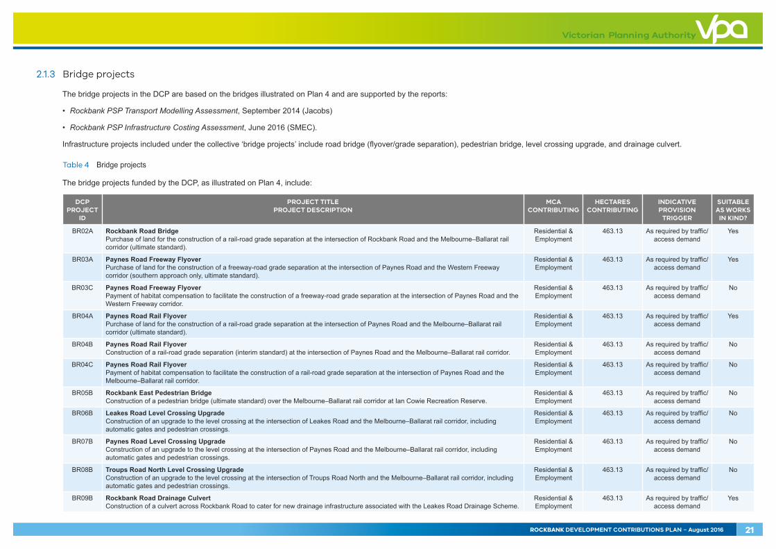
2.1.3 Bridge projects
The bridge projects in the DCP are based on the bridges illustrated on Plan 4 and are supported by the reports:
• Rockbank PSP Transport Modelling Assessment, September 2014 (Jacobs)
• Rockbank PSP Infrastructure Costing Assessment, June 2016 (SMEC).
Infrastructure projects included under the collective ‘bridge projects’ include road bridge (flyover/grade separation), pedestrian bridge, level crossing upgrade, and drainage culvert.
Table 4 Bridge projects
The bridge projects funded by the DCP, as illustrated on Plan 4, include:
DCP PROJECT
ID
PROJECT TITLE PROJECT DESCRIPTION
MCA CONTRIBUTING
HECTARES CONTRIBUTING
INDICATIVE PROVISION
TRIGGER
SUITABLE AS WORKS
IN KIND?
BR02A Rockbank Road Bridge Purchase of land for the construction of a rail-road grade separation at the intersection of Rockbank Road and the Melbourne–Ballarat rail corridor (ultimate standard).
Residential & Employment
463.13 As required by traffic/access demand
Yes
BR03A Paynes Road Freeway Flyover Purchase of land for the construction of a freeway-road grade separation at the intersection of Paynes Road and the Western Freeway corridor (southern approach only, ultimate standard).
Residential & Employment
463.13 As required by traffic/access demand
Yes
BR03C Paynes Road Freeway Flyover Payment of habitat compensation to facilitate the construction of a freeway-road grade separation at the intersection of Paynes Road and the Western Freeway corridor.
Residential & Employment
463.13 As required by traffic/access demand
No
BR04A Paynes Road Rail Flyover Purchase of land for the construction of a rail-road grade separation at the intersection of Paynes Road and the Melbourne–Ballarat rail corridor (ultimate standard).
Residential & Employment
463.13 As required by traffic/access demand
Yes
BR04B Paynes Road Rail Flyover Construction of a rail-road grade separation (interim standard) at the intersection of Paynes Road and the Melbourne–Ballarat rail corridor.
Residential & Employment
463.13 As required by traffic/access demand
No
BR04C Paynes Road Rail Flyover Payment of habitat compensation to facilitate the construction of a rail-road grade separation at the intersection of Paynes Road and the Melbourne–Ballarat rail corridor.
Residential & Employment
463.13 As required by traffic/access demand
No
BR05B Rockbank East Pedestrian Bridge Construction of a pedestrian bridge (ultimate standard) over the Melbourne–Ballarat rail corridor at Ian Cowie Recreation Reserve.
Residential & Employment
463.13 As required by traffic/access demand
No
BR06B Leakes Road Level Crossing Upgrade Construction of an upgrade to the level crossing at the intersection of Leakes Road and the Melbourne–Ballarat rail corridor, including automatic gates and pedestrian crossings.
Residential & Employment
463.13 As required by traffic/access demand
No
BR07B Paynes Road Level Crossing Upgrade Construction of an upgrade to the level crossing at the intersection of Paynes Road and the Melbourne–Ballarat rail corridor, including automatic gates and pedestrian crossings.
Residential & Employment
463.13 As required by traffic/access demand
No
BR08B Troups Road North Level Crossing Upgrade Construction of an upgrade to the level crossing at the intersection of Troups Road North and the Melbourne–Ballarat rail corridor, including automatic gates and pedestrian crossings.
Residential & Employment
463.13 As required by traffic/access demand
No
BR09B Rockbank Road Drainage Culvert Construction of a culvert across Rockbank Road to cater for new drainage infrastructure associated with the Leakes Road Drainage Scheme.
Residential & Employment
463.13 As required by traffic/access demand
Yes
ROCKBANK DEVELOPMENT CONTRIBUTIONS PLAN – August 2016 21

OLD
LEA
KES
RD
PAYN
ES R
D
TRO
UPS
RD
NTH
WESTERN FREEWAY
GREIGS RD
WESTCOTT PDE
LEA
KES
RD
LEA
KES
RD
ROCK
BAN
K RD
TOOLERN RD
Melbourne-Ballarat rail corridor
RockbankTownship
DO
WN
ING
ST
TRO
UPS
RD
STH
FAU
LKN
ER R
D
MURRAY RD
IRAMOO CIRCUIT
STEWART CRES
LEO
NID
DR
AR-03AR-03AAR-03BAR-03C
AR-02AR-02AAR-02BAR-02C
CI-02CI-02ACI-02B
CI-01CI-01ACI-01B
CI-03CI-03A
AR-05AR-05A
AR-06AR-06B
CI-04CI-04A
AR-04AR-04AAR-04BAR-04C
AR-01AR-01AAR-01BAR-01C
precinct boundary
active recreation project
community facilities project
DCP project identi�cation numberAR-03
Rockbank Development Contributions Plan
Copyright, Victorian Planning Authority, 2016 The state of Victoria does not warrant the accuracy or completeness of information in this publication and any person using or relying upon such information does so on the basis that the State of Victoria shall bear no responsibility or liability whatsoever for any errors, faults, defects or omission in the information.
1:25,000 @ A4
0 200 400 600 800 1,000m
Plan 5 - Community & Recreation Projects
22 ROCKBANK DEVELOPMENT CONTRIBUTIONS PLAN - August 2016
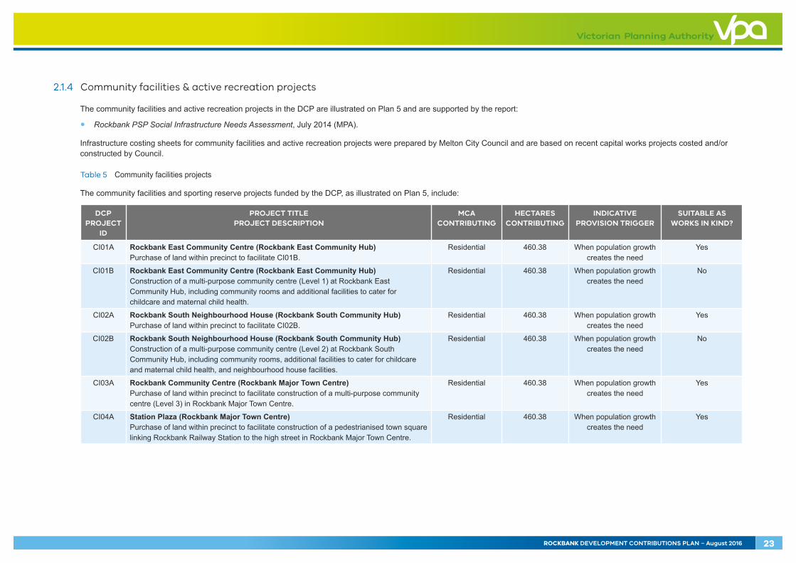
2.1.4 Community facilities & active recreation projects
The community facilities and active recreation projects in the DCP are illustrated on Plan 5 and are supported by the report:
• Rockbank PSP Social Infrastructure Needs Assessment, July 2014 (MPA).
Infrastructure costing sheets for community facilities and active recreation projects were prepared by Melton City Council and are based on recent capital works projects costed and/or constructed by Council.
Table 5 Community facilities projects
The community facilities and sporting reserve projects funded by the DCP, as illustrated on Plan 5, include:
DCP PROJECT
ID
PROJECT TITLE PROJECT DESCRIPTION
MCA CONTRIBUTING
HECTARES CONTRIBUTING
INDICATIVE PROVISION TRIGGER
SUITABLE AS WORKS IN KIND?
CI01A Rockbank East Community Centre (Rockbank East Community Hub) Purchase of land within precinct to facilitate CI01B.
Residential 460.38 When population growth creates the need
Yes
CI01B Rockbank East Community Centre (Rockbank East Community Hub) Construction of a multi-purpose community centre (Level 1) at Rockbank East Community Hub, including community rooms and additional facilities to cater for childcare and maternal child health.
Residential 460.38 When population growth creates the need
No
CI02A Rockbank South Neighbourhood House (Rockbank South Community Hub) Purchase of land within precinct to facilitate CI02B.
Residential 460.38 When population growth creates the need
Yes
CI02B Rockbank South Neighbourhood House (Rockbank South Community Hub) Construction of a multi-purpose community centre (Level 2) at Rockbank South Community Hub, including community rooms, additional facilities to cater for childcare and maternal child health, and neighbourhood house facilities.
Residential 460.38 When population growth creates the need
No
CI03A Rockbank Community Centre (Rockbank Major Town Centre) Purchase of land within precinct to facilitate construction of a multi-purpose community centre (Level 3) in Rockbank Major Town Centre.
Residential 460.38 When population growth creates the need
Yes
CI04A Station Plaza (Rockbank Major Town Centre) Purchase of land within precinct to facilitate construction of a pedestrianised town square linking Rockbank Railway Station to the high street in Rockbank Major Town Centre.
Residential 460.38 When population growth creates the need
Yes
ROCKBANK DEVELOPMENT CONTRIBUTIONS PLAN – August 2016 23
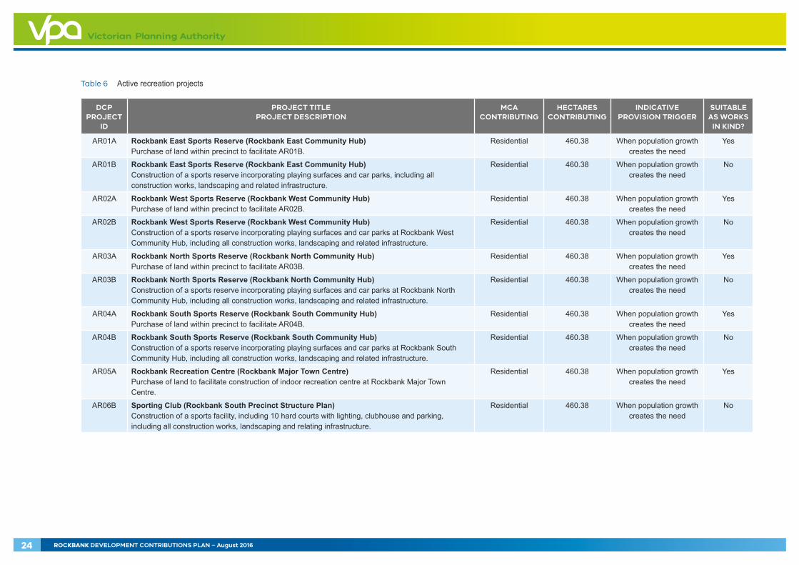
Table 6 Active recreation projects
DCP PROJECT
ID
PROJECT TITLE PROJECT DESCRIPTION
MCA CONTRIBUTING
HECTARES CONTRIBUTING
INDICATIVE PROVISION TRIGGER
SUITABLE AS WORKS
IN KIND?
AR01A Rockbank East Sports Reserve (Rockbank East Community Hub) Purchase of land within precinct to facilitate AR01B.
Residential 460.38 When population growth creates the need
Yes
AR01B Rockbank East Sports Reserve (Rockbank East Community Hub) Construction of a sports reserve incorporating playing surfaces and car parks, including all construction works, landscaping and related infrastructure.
Residential 460.38 When population growth creates the need
No
AR02A Rockbank West Sports Reserve (Rockbank West Community Hub) Purchase of land within precinct to facilitate AR02B.
Residential 460.38 When population growth creates the need
Yes
AR02B Rockbank West Sports Reserve (Rockbank West Community Hub) Construction of a sports reserve incorporating playing surfaces and car parks at Rockbank West Community Hub, including all construction works, landscaping and related infrastructure.
Residential 460.38 When population growth creates the need
No
AR03A Rockbank North Sports Reserve (Rockbank North Community Hub) Purchase of land within precinct to facilitate AR03B.
Residential 460.38 When population growth creates the need
Yes
AR03B Rockbank North Sports Reserve (Rockbank North Community Hub) Construction of a sports reserve incorporating playing surfaces and car parks at Rockbank North Community Hub, including all construction works, landscaping and related infrastructure.
Residential 460.38 When population growth creates the need
No
AR04A Rockbank South Sports Reserve (Rockbank South Community Hub) Purchase of land within precinct to facilitate AR04B.
Residential 460.38 When population growth creates the need
Yes
AR04B Rockbank South Sports Reserve (Rockbank South Community Hub) Construction of a sports reserve incorporating playing surfaces and car parks at Rockbank South Community Hub, including all construction works, landscaping and related infrastructure.
Residential 460.38 When population growth creates the need
No
AR05A Rockbank Recreation Centre (Rockbank Major Town Centre) Purchase of land to facilitate construction of indoor recreation centre at Rockbank Major Town Centre.
Residential 460.38 When population growth creates the need
Yes
AR06B Sporting Club (Rockbank South Precinct Structure Plan) Construction of a sports facility, including 10 hard courts with lighting, clubhouse and parking, including all construction works, landscaping and relating infrastructure.
Residential 460.38 When population growth creates the need
No
24 ROCKBANK DEVELOPMENT CONTRIBUTIONS PLAN – August 2016

2.2 Project timing
Each item in the DCP has an assumed indicative provision trigger specified in Tables 2–6. The timing of the provision of the items in this DCP is consistent with information available at the time that the DCP was prepared.
Melton City Council, as the respective development agency as well as the collecting agency, will monitor and assess the required timing for individual items and have regard to its capital works program, development external to the precinct and the indicative provision triggers specified in Tables 2–6.
The development agency may seek an amendment to the DCP to adjust indicative provision triggers as part of the five-year review (or earlier if justified). Any adjustment would also need to be consistent with any implementation agreement entered into under section 173 of the Act.
The collecting agency may consider alternatives to the priority delivery of works or land where:
• Infrastructure is to be constructed / provided by development proponents as works or land in kind, as agreed by the collecting agency
• Network priorities require the delivery of works or land to facilitate broader road network connections
• Community needs determine the delivery of works or land for community facilities and active recreation projects and open space.
All items in the DCP will be provided as soon as is practicable and as soon as sufficient contributions are available, consistent with Section 4.1 and acknowledging the development agency’s capacities to provide the balance of funds not recovered by development contributions.
2.3 Distinction between development infrastructure and community infrastructure
In accordance with the Act and Ministerial Directions on development contributions plans pursuant to section 46M of the Act, the DCP makes a distinction between ‘development’ and ‘community’ infrastructure.
The timing of payment of contributions is linked to the type of infrastructure in question.
The community infrastructure levy contributions are made by the home builder at the time of building approval (unless an alternative time is agreed between the collecting agency and a development proponent). Community infrastructure levy contributions will be paid for at a ‘per dwelling’ rate.
The Act currently stipulates that the amount that may be contributed under a community infrastructure levy is no more than $1,150 per dwelling. The Governor in Council may from time to time by Order published in the Government Gazette vary the maximum amount that may be collected by the community infrastructure levy.
If in the future the community infrastructure levy is amended, then the levy applicable to the release of the remaining dwellings may be adjusted in accordance with the revised legislative and regulatory approach as directed by the Minister for Planning.
ROCKBANK DEVELOPMENT CONTRIBUTIONS PLAN – August 2016 25

The projects listed in Table 7 are deemed to be community infrastructure levy projects.
Table 7 Community infrastructure levy (CIL) projects
DCP PROJECT
ID
PROJECT TITLE PROJECT DESCRIPTION
MCA CONTRIBUTING
HECTARES CONTRIBUTING
INDICATIVE PROVISION TRIGGER
SUITABLE AS WORKS
IN KIND?
AR01C Rockbank East Sports Reserve (Rockbank East Community Hub) Construction of a pavilion to serve AR01B, including all building works, landscaping and related infrastructure.
Residential 460.38 When population growth creates the need
No
AR02C Rockbank West Sports Reserve (Rockbank West Community Hub) Construction of a pavilion to serve AR02B, including all building works, landscaping and related infrastructure.
Residential 460.38 When population growth creates the need
No
AR03C Rockbank North Sports Reserve (Rockbank North Community Hub) Construction of a pavilion to serve AR03B, including all building works, landscaping and related infrastructure.
Residential 460.38 When population growth creates the need
No
AR04C Rockbank South Sports Reserve (Rockbank South Community Hub) Construction of a pavilion to serve AR04B, including all building works, landscaping and related infrastructure.
Residential 460.38 When population growth creates the need
No
All other infrastructure projects are classified as development infrastructure projects.
Contributions relating to the development infrastructure levy are to be made by developers at the time of subdivision. If subdivision is not applicable payments must be made prior to construction of buildings and works (refer to Section 4.1).
26 ROCKBANK DEVELOPMENT CONTRIBUTIONS PLAN – August 2016
3.0 CALCULATION OF CONTRIBUTIONSThe general cost apportionment method includes the following steps:
• Calculation of the net developable area and demand units (refer to Table 8)
• Calculation of project costs (refer to Tables 10–11)
• Identification and allowance for external use (refer to Tables 10–12)
• Cost apportionment and catchments (refer to Tables 9–11)
• Identification of development types required to pay the levy (refer to Tables 10–11)
• Summary of costs payable for each infrastructure project (refer Tables 10–11)
• The development infrastructure levy per net developable hectare for each development type (Table 10) and the community infrastructure levy per dwelling (Table 11)
• Alternative funding sources for infrastructure projects an identified external use (Table 12).
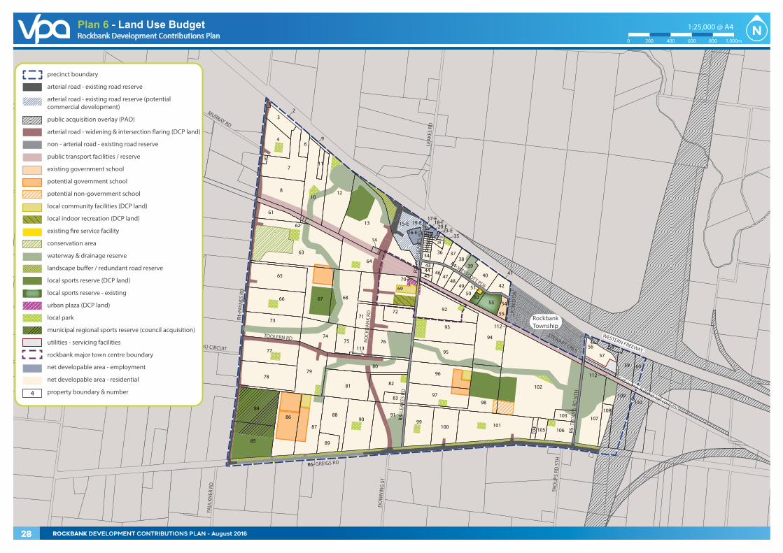
3.1 Calculation of net developable area and demand units
The following section sets out how the net developable area (NDA) is calculated and outlines the development projections anticipated in the precinct.
3.1.1 Net developable area
In the DCP, all development infrastructure contributions are payable on the net developable area of land on any given development site.
For the purposes of the DCP, the NDA is defined as the total amount of land within the area of the PSP that is made available for the development of employment buildings, including lots, all connector and local streets. It is the gross developable area of the precinct minus land for community facilities, schools, educational facilities, open space, encumbered land and arterial roads. Any additional small local parks defined at the subdivision stage are included in the NDA.
The NDA for the DCP is outlined in Table 8. The contributions ‘per net developable hectare’ must not and will not be amended to respond to minor changes to the land budget that may result from the subdivision process. In other words, the DCP is permanently linked to the calculation of the NDA set out in Table 8 and Appendix A.
The NDA may only change if the collecting agency agrees to a variation to the summary land budget (Table 8) and the detailed property-specific land budget (Appendix A) and associated tables.
ROCKBANK DEVELOPMENT CONTRIBUTIONS PLAN – August 2016 27
OLD
LEA
KES
RD
PAYN
ES R
D
TRO
UPS
RD
NTH
WESTERN FREEWAY
GREIGS RD
WESTCOTT PDE
STEWART CRES
LEA
KES
RD
LEA
KES
RD
DO
WN
ING
ST
TRO
UPS
RD
STH
FAU
LKN
ER R
D
MURRAY RD
ROCK
BAN
K RD
TOOLERN RDIRAMOO CIRCUIT
Melbourne-Ballarat rail corridor
RockbankTownship
LEO
NID
DR
42
43
3
12
4
5
7
8
6
10
11
9
12
13
14
17-E18-E19-E
20-E21-E22-E
23-E24 25 26272930313233
34
28
36 3738
39
404445 46
4748
4950
51
5253 54
55
57
56 58
59 60
61
62
63
64
67
R2-
R3-
R4-
R5-
66
65
68
69
7172
73
7475 76
77
7879
80
81 82
83
84
85
86
87
88
89
90
92
93
94
95
96
9897
99101
102
103
104 105 106
107
109
108
110
35
41
15-E
16-E
70
R1-
113
R6-
91
112
111
100
112
4
precinct boundary
arterial road - existing road reserve
arterial road - existing road reserve (potential commercial development)
public acquisition overlay (PAO)
arterial road - widening & intersection �aring (DCP land)
non - arterial road - existing road reserve
public transport facilities / reserve
existing government school
potential government school
potential non-government school
local community facilities (DCP land)
local indoor recreation (DCP land)
existing �re service facility
conservation area
waterway & drainage reserve
landscape bu�er / redundant road reserve
local sports reserve (DCP land)
local sports reserve - existing
urban plaza (DCP land)
local park
municipal regional sports reserve (council acquisition)
utilities - servicing facilities
rockbank major town centre boundary
net developable area - employment
net developable area - residential
property boundary & number
Rockbank Precinct Structure Plan
Copyright, Victorian Planning Authority, 2016 The state of Victoria does not warrant the accuracy or completeness of information in this publication and any person using or relying upon such information does so on the basis that the State of Victoria shall bear no responsibility or liability whatsoever for any errors, faults, defects or omission in the information.
1:25,000 @ A4
0 200 400 600 800 1,000m
Plan 4 - Land Use BudgetRockbank Development Contributions Plan
Copyright, Victorian Planning Authority, 2016 The state of Victoria does not warrant the accuracy or completeness of information in this publication and any person using or relying upon such information does so on the basis that the State of Victoria shall bear no responsibility or liability whatsoever for any errors, faults, defects or omission in the information.
1:25,000 @ A4
0 200 400 600 800 1,000m
Plan 6 - Land Use Budget
28 ROCKBANK DEVELOPMENT CONTRIBUTIONS PLAN - August 2016
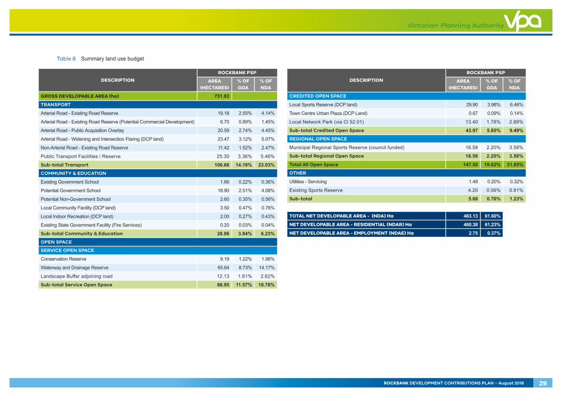
Table 8 Summary land use budget
DESCRIPTION
ROCKBANK PSP
AREA (HECTARES)
% OF GDA
% OF NDA
GROSS DEVELOPABLE AREA (ha) 751.83TRANSPORT
Arterial Road - Existing Road Reserve 19.18 2.55% 4.14%
Arterial Road - Existing Road Reserve (Potential Commercial Development) 6.70 0.89% 1.45%
Arterial Road - Public Acquisition Overlay 20.59 2.74% 4.45%
Arterial Road - Widening and Intersection Flaring (DCP land) 23.47 3.12% 5.07%
Non-Arterial Road - Existing Road Reserve 11.42 1.52% 2.47%
Public Transport Facilities / Reserve 25.30 3.36% 5.46%
Sub-total Transport 106.66 14.19% 23.03%COMMUNITY & EDUCATION
Existing Government School 1.66 0.22% 0.36%
Potential Government School 18.90 2.51% 4.08%
Potential Non-Government School 2.60 0.35% 0.56%
Local Community Facility (DCP land) 3.50 0.47% 0.76%
Local Indoor Recreation (DCP land) 2.00 0.27% 0.43%
Existing State Government Facility (Fire Services) 0.20 0.03% 0.04%
Sub-total Community & Education 28.86 3.84% 6.23%OPEN SPACE
SERVICE OPEN SPACE
Conservation Reserve 9.19 1.22% 1.98%
Waterway and Drainage Reserve 65.64 8.73% 14.17%
Landscape Buffer adjoining road 12.13 1.61% 2.62%
Sub-total Service Open Space 86.95 11.57% 18.78%
DESCRIPTION
ROCKBANK PSP
AREA (HECTARES)
% OF GDA
% OF NDA
CREDITED OPEN SPACE
Local Sports Reserve (DCP land) 29.90 3.98% 6.46%
Town Centre Urban Plaza (DCP Land) 0.67 0.09% 0.14%
Local Network Park (via Cl 52.01) 13.40 1.78% 2.89%
Sub-total Credited Open Space 43.97 5.85% 9.49%REGIONAL OPEN SPACE
Municipal Regional Sports Reserve (council funded) 16.58 2.20% 3.58%
Sub-total Regional Open Space 16.58 2.20% 3.58%
Total All Open Space 147.50 19.62% 31.85%OTHER
Utilities - Servicing 1.48 0.20% 0.32%
Existing Sports Reserve 4.20 0.56% 0.91%
Sub-total 5.68 0.76% 1.23%
TOTAL NET DEVELOPABLE AREA - (NDA) Ha 463.13 61.60%
NET DEVELOPABLE AREA - RESIDENTIAL (NDAR) Ha 460.38 61.23%
NET DEVELOPABLE AREA - EMPLOYMENT (NDAE) Ha 2.75 0.37%
ROCKBANK DEVELOPMENT CONTRIBUTIONS PLAN – August 2016 29
3.1.2 Land budget and demand units
The ‘net developable hectare’ is the demand unit for the DCP.
The DCP identifies two development types: ‘residential’ and ‘employment’.
‘Residential’ development is defined broadly to include forms of development that support a residential land use, including residential subdivision and development within town centres, local convenience centres and mixed use.
‘Residential’ development also includes any non-residential uses within the residential area such as a place of worship, education centre, retirement village, nursing home, child care centre, medical centre, convenience store or any other approved use.
‘Residential’ development is attributed to 460.38 net developable hectares within the precinct.
‘Employment’ development refers to the commercial area within Rockbank Mixed Commercial Precinct and is defined broadly to include commercial uses such as office, appropriate manufacturing and industrial and limited retail.
‘Employment’ development is attributed to 2.75 net developable hectares within the precinct.
The DCP contains a total of 463.13 net developable hectares.
3.1.3 Property-specific calculations
The NDA used to calculate the contributions associated with the DCP is based on an assessment of individual properties. The NDA for each property is listed in the property-specific land budget located in Appendix A. The property-specific NDA and rates listed in this DCP determine the total contribution for each property.
3.2 Calculation of contributions charges
3.2.1 Calculation of costs
Each infrastructure project has been assigned a land and/or construction cost. These costs are listed in Tables 10 and 11. The costs are expressed in 2016 dollars and will be adjusted annually in accordance with the method specified in Section 4.3.
Road and intersection construction costs have been determined by SMEC (refer to Appendix B for road, intersection and bridge cost sheets).
Community facilities and active recreation project costs have been determined by Melton City Council in conjunction with the VPA (refer to Appendix C for community facilities and active recreation cost sheets).
3.2.2 Valuation of land
Estimates of land value methodology
The area of land to be acquired for each DCP project on each property is identified from the detailed property-specific land budget prepared for the PSP. A description of the land was provided to Charter Keck Cramer as a registered valuer to prepare an estimate of value; this in turn determines the value for each project requiring land identified in the DCP.
The estimates of value were prepared using the Public Land Equalisation Method (PLEM). The PLEM calculates the average public land contribution required for the PSP (expressed as a percentage of NDA). The land required for each property is also calculated and compared against the average percentage of NDA.
Public land contributions on a property that are less than or equal to the precinct average have an estimate of value using a per-property broad hectare method. Any component of public land contributions that exceed the precinct average have an estimate of value using a site-specific method. The properties that have a greater than average contribution are identified in Appendix D.
Per-property broad hectare value estimate
The ‘per-property’ broad hectare estimate of value prepared for each individual property assumes the unencumbered, highest-and-best use as indicated by the PSP.
The estimates of value are prepared on a ‘before and after’ basis where:
• The ‘before’ assessment is based on the total developable area of each property, and ignores the land and infrastructure items to be provided by the DCP. Any development that occurs subsequent to the approval of the DCP is ignored for the purpose of the valuation
• The ‘after’ assessment comprises the remaining portion of each property after all land required by the DCP has been provided. Severance or enhancement, disturbance, special value, etc. are ignored for the purpose of the ‘after’ valuation.
30 ROCKBANK DEVELOPMENT CONTRIBUTIONS PLAN – August 2016

Site-specific value estimate
The ‘site-specific’ approach prepares an estimate of value for each separate infrastructure item. For example, if a landowner has land identified for a road widening, a community centre and a local sports reserve, a site specific estimate of value would be prepared for all three items separately.
Site-specific estimates of value generally assume that the land identified can be sold as serviced development lots, i.e. street frontages, etc. have already been constructed, therefore the land has a lower expected development cost.
3.2.3 Cost apportionment
This DCP apportions a charge to new development according to its projected share of use of an identified infrastructure item. Since development contributions charges are levied ‘up-front’, a measure of actual use by individual development sites is not possible. Therefore costs must be shared in accordance with the estimated share of use.
This DCP calculates what each new development should pay towards provision of the identified infrastructure item; this is the total cost of the item (after deducting other funding sources and making allowance for any external demand) divided by total demand units within the main catchment area.
In selecting items, consideration has been given to ensure they are not already wholly funded through another contribution mechanism, such as a mandatory infrastructure construction requirement as set out in the PSP, an existing DCP, an agreement under section 173 of the Act, or as a condition on an existing planning permit. The balance of the cost of the items not recovered under the DCP will be funded by alternative sources.
3.2.4 Main catchment area
The main catchment area (MCA) is the geographic area from which a given item of infrastructure will draw most of its use.
The DCP includes two main catchment areas, ‘residential’ and ‘employment’; the attributes for each MCA are consistent with the development types outlined in Section 3.1.2 and each land area is outlined in Table 9 and illustrated on Plan 3.
It is important to note that the number of net developable hectares (that is the demand units) in the MCA is based on the land budgets in Table 8 and Appendix A.
Table 9 Main catchment area
MAIN CATCHMENT AREA (MCA) AREA (HA)
Residential 460.38
Employment 2.75
Residential & Employment 463.13
3.2.5 External use
An allowance has been made for other use external to the MCAs for specific projects; that is, use that does not solely emanate from the Rockbank PSP area. Tables 10 and 11 quantify any external demand (as a percentage) for each infrastructure project. Where an external demand has been assessed, a percentage discount has been made to the dollar amount that would otherwise be recovered in relation to the DCP.
Where external use of an infrastructure project has been calculated in Tables 10 and 11, alternative funding sources for infrastructure projects have been identified in Table 12.
3.2.6 Non-Government schools
The development of land for a non-government school is exempt from the requirement to pay a development infrastructure levy and a community infrastructure levy under the DCP.
3.2.7 Schedule of costs
Tables 10 and 11 calculate the amount of contributions payable by the MCA for each infrastructure category.
3.2.8 Summary of charges per hectare
Tables 10 and 11 show the quantum of funds to be contributed by the MCA toward each infrastructure project. The total adds up to the total amount of funds recoverable under the DCP.
ROCKBANK DEVELOPMENT CONTRIBUTIONS PLAN – August 2016 31
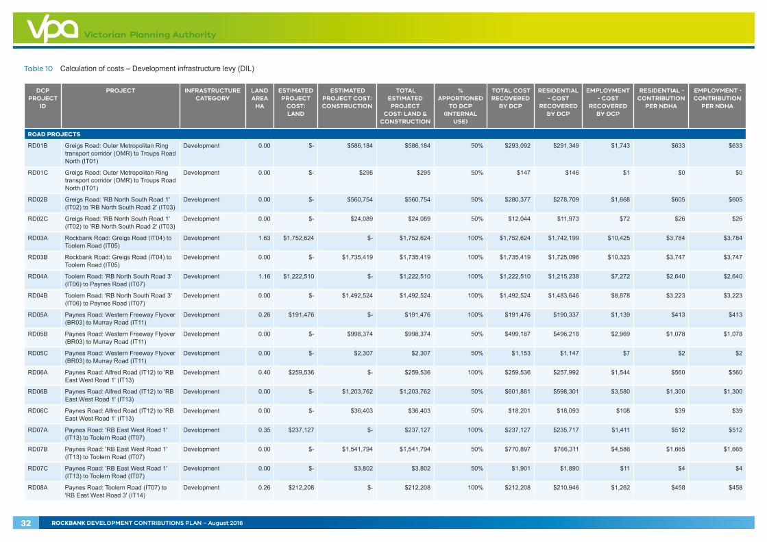
Table 10 Calculation of costs – Development infrastructure levy (DIL)
DCP PROJECT
ID
PROJECT INFRASTRUCTURE CATEGORY
LAND AREA
HA
ESTIMATED PROJECT
COST: LAND
ESTIMATED PROJECT COST: CONSTRUCTION
TOTAL ESTIMATED PROJECT
COST: LAND & CONSTRUCTION
% APPORTIONED
TO DCP (INTERNAL
USE)
TOTAL COST RECOVERED
BY DCP
RESIDENTIAL - COST
RECOVERED BY DCP
EMPLOYMENT - COST
RECOVERED BY DCP
RESIDENTIAL - CONTRIBUTION
PER NDHA
EMPLOYMENT - CONTRIBUTION
PER NDHA
ROAD PROJECTS
RD01B Greigs Road: Outer Metropolitan Ring transport corridor (OMR) to Troups Road North (IT01)
Development 0.00 $- $586,184 $586,184 50% $293,092 $291,349 $1,743 $633 $633
RD01C Greigs Road: Outer Metropolitan Ring transport corridor (OMR) to Troups Road North (IT01)
Development 0.00 $- $295 $295 50% $147 $146 $1 $0 $0
RD02B Greigs Road: 'RB North South Road 1' (IT02) to 'RB North South Road 2' (IT03)
Development 0.00 $- $560,754 $560,754 50% $280,377 $278,709 $1,668 $605 $605
RD02C Greigs Road: 'RB North South Road 1' (IT02) to 'RB North South Road 2' (IT03)
Development 0.00 $- $24,089 $24,089 50% $12,044 $11,973 $72 $26 $26
RD03A Rockbank Road: Greigs Road (IT04) to Toolern Road (IT05)
Development 1.63 $1,752,624 $- $1,752,624 100% $1,752,624 $1,742,199 $10,425 $3,784 $3,784
RD03B Rockbank Road: Greigs Road (IT04) to Toolern Road (IT05)
Development 0.00 $- $1,735,419 $1,735,419 100% $1,735,419 $1,725,096 $10,323 $3,747 $3,747
RD04A Toolern Road: 'RB North South Road 3' (IT06) to Paynes Road (IT07)
Development 1.16 $1,222,510 $- $1,222,510 100% $1,222,510 $1,215,238 $7,272 $2,640 $2,640
RD04B Toolern Road: 'RB North South Road 3' (IT06) to Paynes Road (IT07)
Development 0.00 $- $1,492,524 $1,492,524 100% $1,492,524 $1,483,646 $8,878 $3,223 $3,223
RD05A Paynes Road: Western Freeway Flyover (BR03) to Murray Road (IT11)
Development 0.26 $191,476 $- $191,476 100% $191,476 $190,337 $1,139 $413 $413
RD05B Paynes Road: Western Freeway Flyover (BR03) to Murray Road (IT11)
Development 0.00 $- $998,374 $998,374 50% $499,187 $496,218 $2,969 $1,078 $1,078
RD05C Paynes Road: Western Freeway Flyover (BR03) to Murray Road (IT11)
Development 0.00 $- $2,307 $2,307 50% $1,153 $1,147 $7 $2 $2
RD06A Paynes Road: Alfred Road (IT12) to 'RB East West Road 1' (IT13)
Development 0.40 $259,536 $- $259,536 100% $259,536 $257,992 $1,544 $560 $560
RD06B Paynes Road: Alfred Road (IT12) to 'RB East West Road 1' (IT13)
Development 0.00 $- $1,203,762 $1,203,762 50% $601,881 $598,301 $3,580 $1,300 $1,300
RD06C Paynes Road: Alfred Road (IT12) to 'RB East West Road 1' (IT13)
Development 0.00 $- $36,403 $36,403 50% $18,201 $18,093 $108 $39 $39
RD07A Paynes Road: 'RB East West Road 1' (IT13) to Toolern Road (IT07)
Development 0.35 $237,127 $- $237,127 100% $237,127 $235,717 $1,411 $512 $512
RD07B Paynes Road: 'RB East West Road 1' (IT13) to Toolern Road (IT07)
Development 0.00 $- $1,541,794 $1,541,794 50% $770,897 $766,311 $4,586 $1,665 $1,665
RD07C Paynes Road: 'RB East West Road 1' (IT13) to Toolern Road (IT07)
Development 0.00 $- $3,802 $3,802 50% $1,901 $1,890 $11 $4 $4
RD08A Paynes Road: Toolern Road (IT07) to 'RB East West Road 3' (IT14)
Development 0.26 $212,208 $- $212,208 100% $212,208 $210,946 $1,262 $458 $458
32 ROCKBANK DEVELOPMENT CONTRIBUTIONS PLAN – August 2016
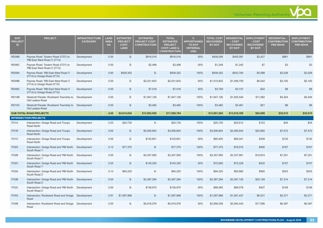
DCP PROJECT
ID
PROJECT INFRASTRUCTURE CATEGORY
LAND AREA
HA
ESTIMATED PROJECT
COST: LAND
ESTIMATED PROJECT COST: CONSTRUCTION
TOTAL ESTIMATED PROJECT
COST: LAND & CONSTRUCTION
% APPORTIONED
TO DCP (INTERNAL
USE)
TOTAL COST RECOVERED
BY DCP
RESIDENTIAL - COST
RECOVERED BY DCP
EMPLOYMENT - COST
RECOVERED BY DCP
RESIDENTIAL - CONTRIBUTION
PER NDHA
EMPLOYMENT - CONTRIBUTION
PER NDHA
RD08B Paynes Road: Toolern Road (IT07) to 'RB East West Road 3' (IT14)
Development 0.00 $- $816,016 $816,016 50% $408,008 $405,581 $2,427 $881 $881
RD08C Paynes Road: Toolern Road (IT07) to 'RB East West Road 3' (IT14)
Development 0.00 $- $2,498 $2,498 50% $1,249 $1,242 $7 $3 $3
RD09A Paynes Road: 'RB East West Road 3' (IT14) to Greigs Road (IT15)
Development 0.60 $939,352 $- $939,352 100% $939,352 $933,764 $5,588 $2,028 $2,028
RD09B Paynes Road: 'RB East West Road 3' (IT14) to Greigs Road (IT15)
Development 0.00 $- $2,031,603 $2,031,603 50% $1,015,802 $1,009,759 $6,042 $2,193 $2,193
RD09C Paynes Road: 'RB East West Road 3' (IT14) to Greigs Road (IT15)
Development 0.00 $- $7,518 $7,518 50% $3,759 $3,737 $22 $8 $8
RD10B Westcott Parade: Rockbank Township to Old Leakes Road
Development 0.00 $- $1,947,126 $1,947,126 100% $1,947,126 $1,935,544 $11,582 $4,204 $4,204
RD10C Westcott Parade: Rockbank Township to Old Leakes Road
Development 0.00 $- $3,482 $3,482 100% $3,482 $3,461 $21 $8 $8
SUB-TOTAL ROAD PROJECTS 4.65 $4,814,834 $12,993,950 $17,808,784 $13,901,084 $13,818,395 $82,689 $30,015 $30,015
INTERSECTION PROJECTS
IT01A Intersection: Greigs Road and Troups Road North
Development 0.03 $20,735 $- $20,735 100% $20,735 $20,612 $123 $45 $45
IT01B Intersection: Greigs Road and Troups Road North
Development 0.00 $- $3,506,804 $3,506,804 100% $3,506,804 $3,485,944 $20,860 $7,572 $7,572
IT01C Intersection: Greigs Road and Troups Road North
Development 0.00 $- $120,801 $120,801 50% $60,400 $60,041 $359 $130 $130
IT02A Intersection: Greigs Road and 'RB North South Road 1'
Development 0.12 $77,375 $- $77,375 100% $77,375 $76,915 $460 $167 $167
IT02B Intersection: Greigs Road and 'RB North South Road 1'
Development 0.00 $- $3,357,955 $3,357,955 100% $3,357,955 $3,337,981 $19,974 $7,251 $7,251
IT02C Intersection: Greigs Road and 'RB North South Road 1'
Development 0.00 $- $145,320 $145,320 50% $72,660 $72,228 $432 $157 $157
IT03A Intersection: Greigs Road and 'RB North South Road 2'
Development 0.13 $94,220 $- $94,220 100% $94,220 $93,660 $560 $203 $203
IT03B Intersection: Greigs Road and 'RB North South Road 2'
Development 0.00 $- $3,387,294 $3,387,294 100% $3,387,294 $3,367,145 $20,149 $7,314 $7,314
IT03C Intersection: Greigs Road and 'RB North South Road 2'
Development 0.00 $- $136,970 $136,970 50% $68,485 $68,078 $407 $148 $148
IT04A Intersection: Rockbank Road and Greigs Road
Development 0.91 $1,097,968 $- $1,097,968 100% $1,097,968 $1,091,437 $6,531 $2,371 $2,371
IT04B Intersection: Rockbank Road and Greigs Road
Development 0.00 $- $5,916,076 $5,916,076 50% $2,958,038 $2,940,443 $17,596 $6,387 $6,387
ROCKBANK DEVELOPMENT CONTRIBUTIONS PLAN – August 2016 33

DCP PROJECT
ID
PROJECT INFRASTRUCTURE CATEGORY
LAND AREA
HA
ESTIMATED PROJECT
COST: LAND
ESTIMATED PROJECT COST: CONSTRUCTION
TOTAL ESTIMATED PROJECT
COST: LAND & CONSTRUCTION
% APPORTIONED
TO DCP (INTERNAL
USE)
TOTAL COST RECOVERED
BY DCP
RESIDENTIAL - COST
RECOVERED BY DCP
EMPLOYMENT - COST
RECOVERED BY DCP
RESIDENTIAL - CONTRIBUTION
PER NDHA
EMPLOYMENT - CONTRIBUTION
PER NDHA
IT04C Intersection: Rockbank Road and Greigs Road
Development 0.00 $- $46,546 $46,546 50% $23,273 $23,135 $138 $50 $50
IT05A Intersection: Rockbank Road and Toolern Road
Development 2.90 $3,151,928 $- $3,151,928 100% $3,151,928 $3,133,179 $18,749 $6,806 $6,806
IT05B Intersection: Rockbank Road and Toolern Road
Development 0.00 $- $5,102,158 $5,102,158 100% $5,102,158 $5,071,808 $30,350 $11,017 $11,017
IT06A Intersection: Toolern Road and 'RB North South Road 3'
Development 2.07 $1,863,678 $- $1,863,678 100% $1,863,678 $1,852,592 $11,086 $4,024 $4,024
IT06B Intersection: Toolern Road and 'RB North South Road 3'
Development 0.00 $- $4,030,900 $4,030,900 100% $4,030,900 $4,006,922 $23,977 $8,704 $8,704
IT07A Intersection: Toolern Road and Paynes Road
Development 1.02 $1,062,434 $- $1,062,434 100% $1,062,434 $1,056,114 $6,320 $2,294 $2,294
IT07B Intersection: Toolern Road and Paynes Road
Development 0.00 $- $4,836,576 $4,836,576 50% $2,418,288 $2,403,903 $14,385 $5,222 $5,222
IT07C Intersection: Toolern Road and Paynes Road
Development 0.00 $- $3,619 $3,619 50% $1,810 $1,799 $11 $4 $4
IT08A Intersection: Rockbank Road and 'RB East West Road 2'
Development 1.73 $1,666,275 $- $1,666,275 100% $1,666,275 $1,656,364 $9,912 $3,598 $3,598
IT08B Intersection: Rockbank Road and 'RB East West Road 2'
Development 0.00 $- $3,228,391 $3,228,391 100% $3,228,391 $3,209,187 $19,204 $6,971 $6,971
IT09A Intersection: Rockbank Road and 'RB East West Road 1'
Development 2.23 $2,585,772 $- $2,585,772 100% $2,585,772 $2,570,390 $15,381 $5,583 $5,583
IT09B Intersection: Rockbank Road and 'RB East West Road 1'
Development 0.00 $- $3,312,321 $3,312,321 100% $3,312,321 $3,292,618 $19,703 $7,152 $7,152
IT10A Intersection: Rockbank Road and Westcott Parade Extension
Development 0.84 $774,724 $- $774,724 100% $774,724 $770,116 $4,608 $1,673 $1,673
IT10B Intersection: Rockbank Road and Westcott Parade Extension
Development 0.00 $- $3,384,438 $3,384,438 100% $3,384,438 $3,364,306 $20,132 $7,308 $7,308
IT11A Intersection: Paynes Road and Murray Road
Development 0.58 $583,500 $- $583,500 100% $583,500 $580,029 $3,471 $1,260 $1,260
IT11B Intersection: Paynes Road and Murray Road
Development 0.00 $- $2,939,929 $2,939,929 50% $1,469,965 $1,461,221 $8,744 $3,174 $3,174
IT11C Intersection: Paynes Road and Murray Road
Development 0.00 $- $3,657 $3,657 50% $1,828 $1,817 $11 $4 $4
IT12A Intersection: Paynes Road and Alfred Road
Development 0.73 $477,448 $- $477,448 100% $477,448 $474,608 $2,840 $1,031 $1,031
IT12B Intersection: Paynes Road and Alfred Road
Development 0.00 $- $3,332,607 $3,332,607 50% $1,666,304 $1,656,392 $9,912 $3,598 $3,598
34 ROCKBANK DEVELOPMENT CONTRIBUTIONS PLAN – August 2016
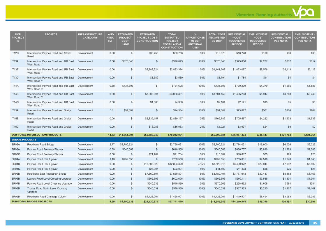
DCP PROJECT
ID
PROJECT INFRASTRUCTURE CATEGORY
LAND AREA
HA
ESTIMATED PROJECT
COST: LAND
ESTIMATED PROJECT COST: CONSTRUCTION
TOTAL ESTIMATED PROJECT
COST: LAND & CONSTRUCTION
% APPORTIONED
TO DCP (INTERNAL
USE)
TOTAL COST RECOVERED
BY DCP
RESIDENTIAL - COST
RECOVERED BY DCP
EMPLOYMENT - COST
RECOVERED BY DCP
RESIDENTIAL - CONTRIBUTION
PER NDHA
EMPLOYMENT - CONTRIBUTION
PER NDHA
IT12C Intersection: Paynes Road and Alfred Road
Development 0.00 $- $33,756 $33,756 50% $16,878 $16,778 $100 $36 $36
IT13A Intersection: Paynes Road and 'RB East West Road 1'
Development 0.56 $376,043 $- $376,043 100% $376,043 $373,806 $2,237 $812 $812
IT13B Intersection: Paynes Road and 'RB East West Road 1'
Development 0.00 $- $2,883,324 $2,883,324 50% $1,441,662 $1,433,087 $8,576 $3,113 $3,113
IT13C Intersection: Paynes Road and 'RB East West Road 1'
Development 0.00 $- $3,589 $3,589 50% $1,794 $1,784 $11 $4 $4
IT14A Intersection: Paynes Road and 'RB East West Road 3'
Development 0.58 $734,608 $- $734,608 100% $734,608 $730,239 $4,370 $1,586 $1,586
IT14B Intersection: Paynes Road and 'RB East West Road 3'
Development 0.00 $- $3,008,301 $3,008,301 50% $1,504,150 $1,495,203 $8,947 $3,248 $3,248
IT14C Intersection: Paynes Road and 'RB East West Road 3'
Development 0.00 $- $4,368 $4,368 50% $2,184 $2,171 $13 $5 $5
IT15A Intersection: Paynes Road and Greigs Road
Development 0.11 $94,384 $- $94,384 100% $94,384 $93,822 $561 $204 $204
IT15B Intersection: Paynes Road and Greigs Road
Development 0.00 $- $2,839,157 $2,839,157 25% $709,789 $705,567 $4,222 $1,533 $1,533
IT15C Intersection: Paynes Road and Greigs Road
Development 0.00 $- $16,083 $16,083 25% $4,021 $3,997 $24 $9 $9
SUB-TOTAL INTERSECTION PROJECTS 14.53 $14,661,091 $55,580,940 $70,242,031 $56,392,881 $56,057,434 $335,447 $121,764 $121,764
BRIDGE PROJECTS
BR02A Rockbank Road Bridge Development 2.77 $2,790,621 $- $2,790,621 100% $2,790,621 $2,774,021 $16,600 $6,026 $6,026
BR03A Paynes Road Freeway Flyover Development 0.39 $640,568 $- $640,568 100% $640,568 $636,757 $3,810 $1,383 $1,383
BR03C Paynes Road Freeway Flyover Development 0.00 $- $21,764 $21,764 50% $10,882 $10,817 $65 $23 $23
BR04A Paynes Road Rail Flyover Development 1.13 $759,550 $- $759,550 100% $759,550 $755,031 $4,518 $1,640 $1,640
BR04B Paynes Road Rail Flyover Development 0.00 $- $12,803,329 $12,803,329 27.5% $3,520,915 $3,499,972 $20,944 $7,602 $7,602
BR04C Paynes Road Rail Flyover Development 0.00 $- $23,004 $23,004 50% $11,502 $11,433 $68 $25 $25
BR05B Rockbank East Pedestrian Bridge Development 0.00 $- $7,560,801 $7,560,801 50% $3,780,401 $3,757,913 $22,487 $8,163 $8,163
BR06B Leakes Road Level Crossing Upgrade Development 0.00 $- $602,696 $602,696 100% $602,696 $599,111 $3,585 $1,301 $1,301
BR07B Paynes Road Level Crossing Upgrade Development 0.00 $- $540,539 $540,539 50% $270,269 $268,662 $1,608 $584 $584
BR08B Troups Road North Level Crossing Upgrade
Development 0.00 $- $540,539 $540,539 100% $540,539 $537,323 $3,215 $1,167 $1,167
BR09B Rockbank Road Drainage Culvert Development 0.00 $- $1,428,001 $1,428,001 100% $1,428,001 $1,419,507 $8,494 $3,083 $3,083
SUB-TOTAL BRIDGE PROJECTS 4.29 $4,190,738 $23,520,671 $27,711,410 $14,355,943 $14,270,548 $85,395 $30,997 $30,997
ROCKBANK DEVELOPMENT CONTRIBUTIONS PLAN – August 2016 35
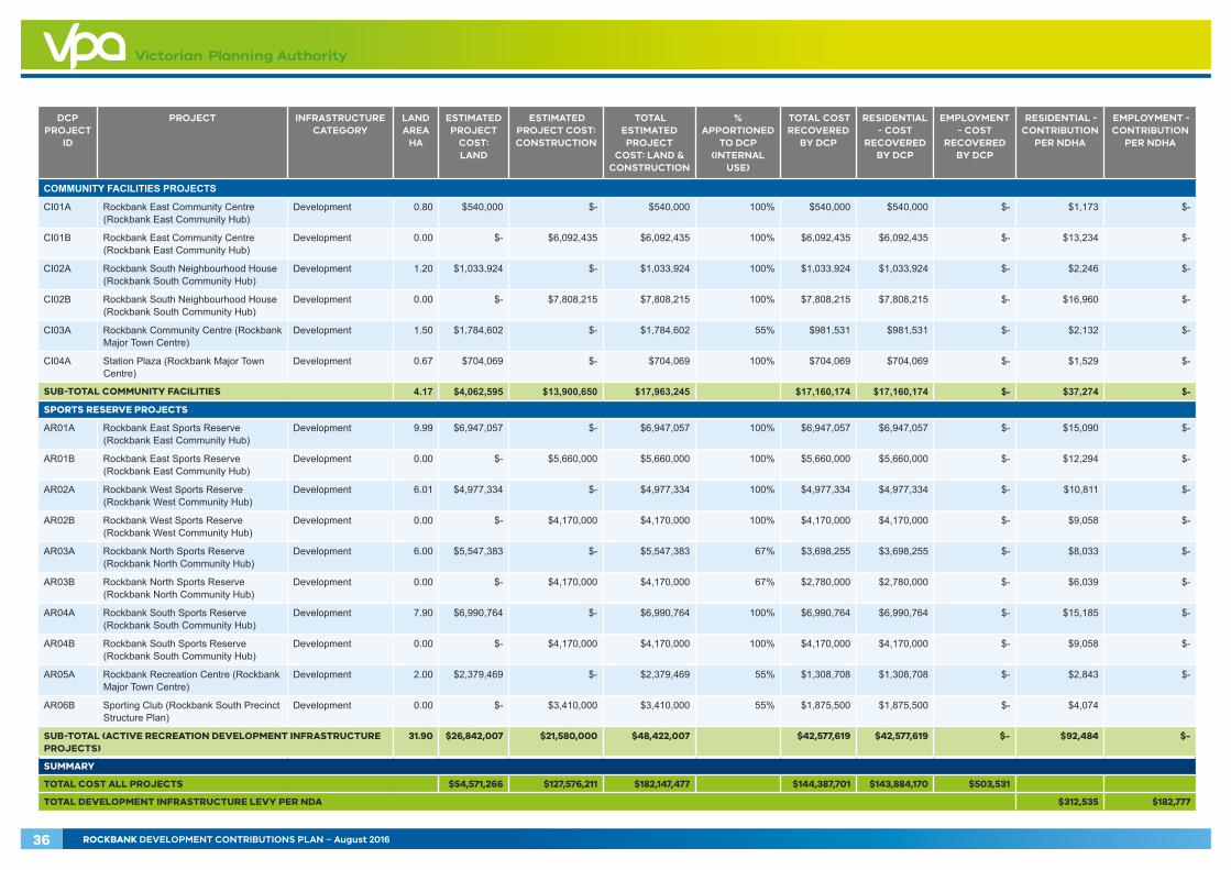
DCP PROJECT
ID
PROJECT INFRASTRUCTURE CATEGORY
LAND AREA
HA
ESTIMATED PROJECT
COST: LAND
ESTIMATED PROJECT COST: CONSTRUCTION
TOTAL ESTIMATED PROJECT
COST: LAND & CONSTRUCTION
% APPORTIONED
TO DCP (INTERNAL
USE)
TOTAL COST RECOVERED
BY DCP
RESIDENTIAL - COST
RECOVERED BY DCP
EMPLOYMENT - COST
RECOVERED BY DCP
RESIDENTIAL - CONTRIBUTION
PER NDHA
EMPLOYMENT - CONTRIBUTION
PER NDHA
COMMUNITY FACILITIES PROJECTS
CI01A Rockbank East Community Centre (Rockbank East Community Hub)
Development 0.80 $540,000 $- $540,000 100% $540,000 $540,000 $- $1,173 $-
CI01B Rockbank East Community Centre (Rockbank East Community Hub)
Development 0.00 $- $6,092,435 $6,092,435 100% $6,092,435 $6,092,435 $- $13,234 $-
CI02A Rockbank South Neighbourhood House (Rockbank South Community Hub)
Development 1.20 $1,033,924 $- $1,033,924 100% $1,033,924 $1,033,924 $- $2,246 $-
CI02B Rockbank South Neighbourhood House (Rockbank South Community Hub)
Development 0.00 $- $7,808,215 $7,808,215 100% $7,808,215 $7,808,215 $- $16,960 $-
CI03A Rockbank Community Centre (Rockbank Major Town Centre)
Development 1.50 $1,784,602 $- $1,784,602 55% $981,531 $981,531 $- $2,132 $-
CI04A Station Plaza (Rockbank Major Town Centre)
Development 0.67 $704,069 $- $704,069 100% $704,069 $704,069 $- $1,529 $-
SUB-TOTAL COMMUNITY FACILITIES 4.17 $4,062,595 $13,900,650 $17,963,245 $17,160,174 $17,160,174 $- $37,274 $-
SPORTS RESERVE PROJECTS
AR01A Rockbank East Sports Reserve (Rockbank East Community Hub)
Development 9.99 $6,947,057 $- $6,947,057 100% $6,947,057 $6,947,057 $- $15,090 $-
AR01B Rockbank East Sports Reserve (Rockbank East Community Hub)
Development 0.00 $- $5,660,000 $5,660,000 100% $5,660,000 $5,660,000 $- $12,294 $-
AR02A Rockbank West Sports Reserve (Rockbank West Community Hub)
Development 6.01 $4,977,334 $- $4,977,334 100% $4,977,334 $4,977,334 $- $10,811 $-
AR02B Rockbank West Sports Reserve (Rockbank West Community Hub)
Development 0.00 $- $4,170,000 $4,170,000 100% $4,170,000 $4,170,000 $- $9,058 $-
AR03A Rockbank North Sports Reserve (Rockbank North Community Hub)
Development 6.00 $5,547,383 $- $5,547,383 67% $3,698,255 $3,698,255 $- $8,033 $-
AR03B Rockbank North Sports Reserve (Rockbank North Community Hub)
Development 0.00 $- $4,170,000 $4,170,000 67% $2,780,000 $2,780,000 $- $6,039 $-
AR04A Rockbank South Sports Reserve (Rockbank South Community Hub)
Development 7.90 $6,990,764 $- $6,990,764 100% $6,990,764 $6,990,764 $- $15,185 $-
AR04B Rockbank South Sports Reserve (Rockbank South Community Hub)
Development 0.00 $- $4,170,000 $4,170,000 100% $4,170,000 $4,170,000 $- $9,058 $-
AR05A Rockbank Recreation Centre (Rockbank Major Town Centre)
Development 2.00 $2,379,469 $- $2,379,469 55% $1,308,708 $1,308,708 $- $2,843 $-
AR06B Sporting Club (Rockbank South Precinct Structure Plan)
Development 0.00 $- $3,410,000 $3,410,000 55% $1,875,500 $1,875,500 $- $4,074
SUB-TOTAL (ACTIVE RECREATION DEVELOPMENT INFRASTRUCTURE PROJECTS)
31.90 $26,842,007 $21,580,000 $48,422,007 $42,577,619 $42,577,619 $- $92,484 $-
SUMMARY
TOTAL COST ALL PROJECTS $54,571,266 $127,576,211 $182,147,477 $144,387,701 $143,884,170 $503,531
TOTAL DEVELOPMENT INFRASTRUCTURE LEVY PER NDA $312,535 $182,777
36 ROCKBANK DEVELOPMENT CONTRIBUTIONS PLAN – August 2016
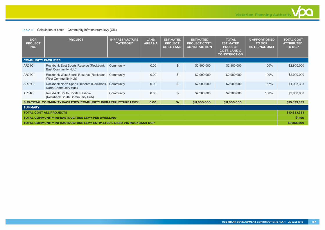
Table 11 Calculation of costs – Community infrastructure levy (CIL)
DCP PROJECT
NO.
PROJECT INFRASTRUCTURE CATEGORY
LAND AREA HA
ESTIMATED PROJECT
COST: LAND
ESTIMATED PROJECT COST: CONSTRUCTION
TOTAL ESTIMATED PROJECT
COST: LAND & CONSTRUCTION
% APPORTIONED TO DCP
(INTERNAL USE)
TOTAL COST ATTRIBUTED
TO DCP
COMMUNITY FACILITIES
AR01C Rockbank East Sports Reserve (Rockbank East Community Hub)
Community 0.00 $- $2,900,000 $2,900,000 100% $2,900,000
AR02C Rockbank West Sports Reserve (Rockbank West Community Hub)
Community 0.00 $- $2,900,000 $2,900,000 100% $2,900,000
AR03C Rockbank North Sports Reserve (Rockbank North Community Hub)
Community 0.00 $- $2,900,000 $2,900,000 67% $1,933,333
AR04C Rockbank South Sports Reserve (Rockbank South Community Hub)
Community 0.00 $- $2,900,000 $2,900,000 100% $2,900,000
SUB-TOTAL COMMUNITY FACILITIES (COMMUNITY INFRASTRUCTURE LEVY) 0.00 $- $11,600,000 $11,600,000 $10,633,333
SUMMARY
TOTAL COST ALL PROJECTS $10,633,333
TOTAL COMMUNITY INFRASTRUCTURE LEVY PER DWELLING $1,150
TOTAL COMMUNITY INFRASTRUCTURE LEVY ESTIMATED RAISED VIA ROCKBANK DCP $9,365,309
ROCKBANK DEVELOPMENT CONTRIBUTIONS PLAN – August 2016 37
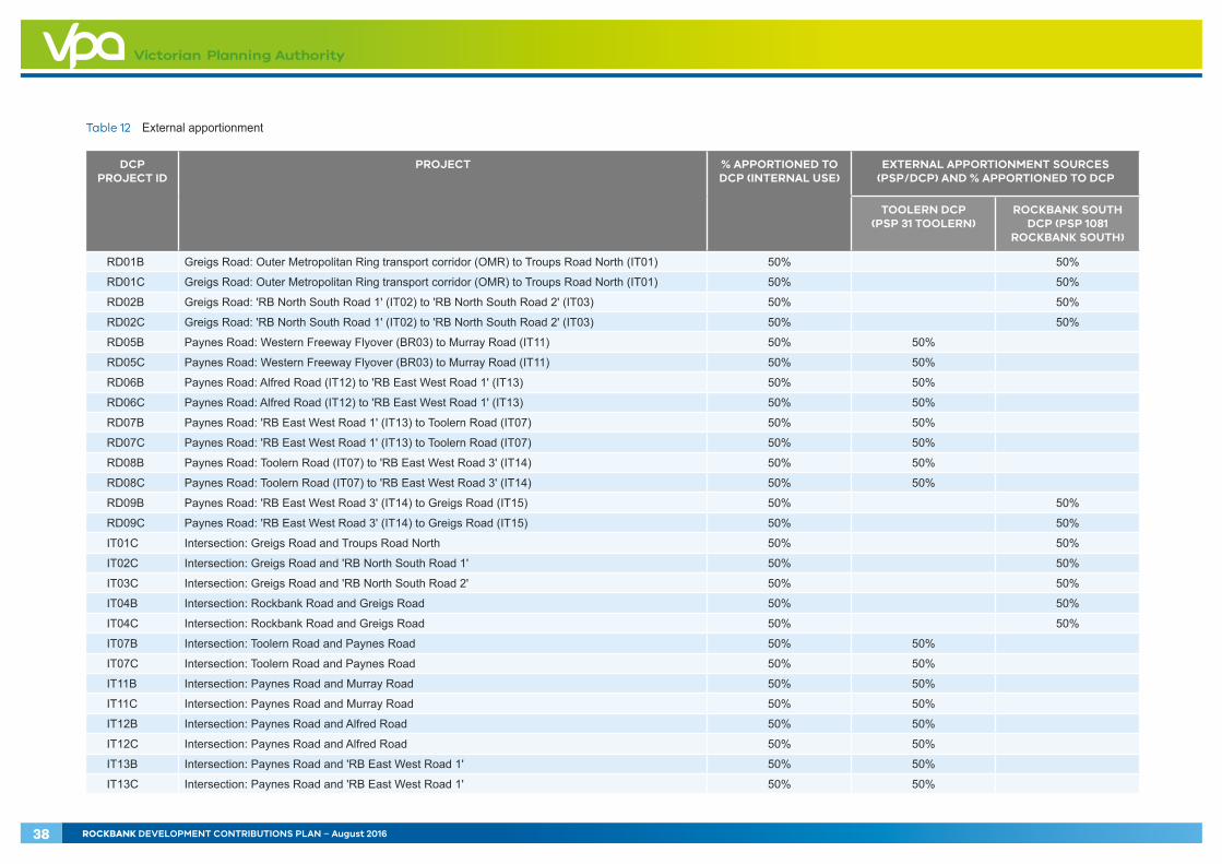
Table 12 External apportionment
DCP PROJECT ID
PROJECT % APPORTIONED TO DCP (INTERNAL USE)
EXTERNAL APPORTIONMENT SOURCES (PSP/DCP) AND % APPORTIONED TO DCP
TOOLERN DCP (PSP 31 TOOLERN)
ROCKBANK SOUTH DCP (PSP 1081
ROCKBANK SOUTH)
RD01B Greigs Road: Outer Metropolitan Ring transport corridor (OMR) to Troups Road North (IT01) 50% 50%
RD01C Greigs Road: Outer Metropolitan Ring transport corridor (OMR) to Troups Road North (IT01) 50% 50%
RD02B Greigs Road: 'RB North South Road 1' (IT02) to 'RB North South Road 2' (IT03) 50% 50%
RD02C Greigs Road: 'RB North South Road 1' (IT02) to 'RB North South Road 2' (IT03) 50% 50%
RD05B Paynes Road: Western Freeway Flyover (BR03) to Murray Road (IT11) 50% 50%
RD05C Paynes Road: Western Freeway Flyover (BR03) to Murray Road (IT11) 50% 50%
RD06B Paynes Road: Alfred Road (IT12) to 'RB East West Road 1' (IT13) 50% 50%
RD06C Paynes Road: Alfred Road (IT12) to 'RB East West Road 1' (IT13) 50% 50%
RD07B Paynes Road: 'RB East West Road 1' (IT13) to Toolern Road (IT07) 50% 50%
RD07C Paynes Road: 'RB East West Road 1' (IT13) to Toolern Road (IT07) 50% 50%
RD08B Paynes Road: Toolern Road (IT07) to 'RB East West Road 3' (IT14) 50% 50%
RD08C Paynes Road: Toolern Road (IT07) to 'RB East West Road 3' (IT14) 50% 50%
RD09B Paynes Road: 'RB East West Road 3' (IT14) to Greigs Road (IT15) 50% 50%
RD09C Paynes Road: 'RB East West Road 3' (IT14) to Greigs Road (IT15) 50% 50%
IT01C Intersection: Greigs Road and Troups Road North 50% 50%
IT02C Intersection: Greigs Road and 'RB North South Road 1' 50% 50%
IT03C Intersection: Greigs Road and 'RB North South Road 2' 50% 50%
IT04B Intersection: Rockbank Road and Greigs Road 50% 50%
IT04C Intersection: Rockbank Road and Greigs Road 50% 50%
IT07B Intersection: Toolern Road and Paynes Road 50% 50%
IT07C Intersection: Toolern Road and Paynes Road 50% 50%
IT11B Intersection: Paynes Road and Murray Road 50% 50%
IT11C Intersection: Paynes Road and Murray Road 50% 50%
IT12B Intersection: Paynes Road and Alfred Road 50% 50%
IT12C Intersection: Paynes Road and Alfred Road 50% 50%
IT13B Intersection: Paynes Road and 'RB East West Road 1' 50% 50%
IT13C Intersection: Paynes Road and 'RB East West Road 1' 50% 50%
38 ROCKBANK DEVELOPMENT CONTRIBUTIONS PLAN – August 2016
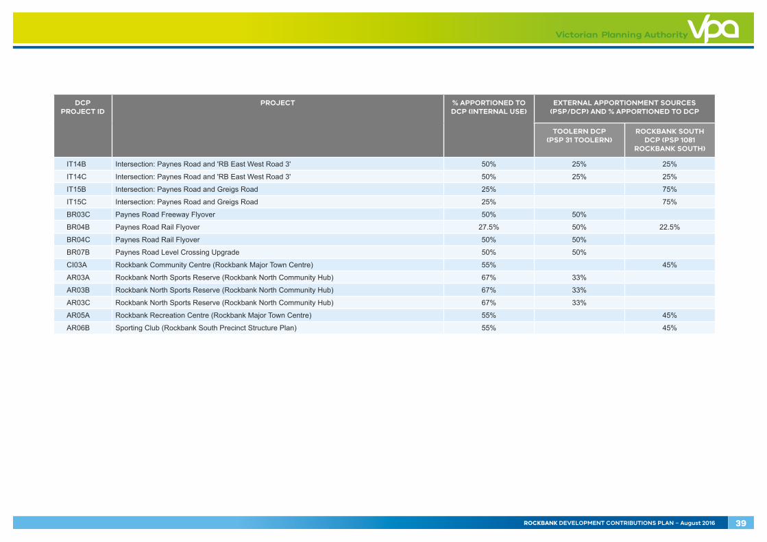
DCP PROJECT ID
PROJECT % APPORTIONED TO DCP (INTERNAL USE)
EXTERNAL APPORTIONMENT SOURCES (PSP/DCP) AND % APPORTIONED TO DCP
TOOLERN DCP (PSP 31 TOOLERN)
ROCKBANK SOUTH DCP (PSP 1081
ROCKBANK SOUTH)
IT14B Intersection: Paynes Road and 'RB East West Road 3' 50% 25% 25%
IT14C Intersection: Paynes Road and 'RB East West Road 3' 50% 25% 25%
IT15B Intersection: Paynes Road and Greigs Road 25% 75%
IT15C Intersection: Paynes Road and Greigs Road 25% 75%
BR03C Paynes Road Freeway Flyover 50% 50%
BR04B Paynes Road Rail Flyover 27.5% 50% 22.5%
BR04C Paynes Road Rail Flyover 50% 50%
BR07B Paynes Road Level Crossing Upgrade 50% 50%
CI03A Rockbank Community Centre (Rockbank Major Town Centre) 55% 45%
AR03A Rockbank North Sports Reserve (Rockbank North Community Hub) 67% 33%
AR03B Rockbank North Sports Reserve (Rockbank North Community Hub) 67% 33%
AR03C Rockbank North Sports Reserve (Rockbank North Community Hub) 67% 33%
AR05A Rockbank Recreation Centre (Rockbank Major Town Centre) 55% 45%
AR06B Sporting Club (Rockbank South Precinct Structure Plan) 55% 45%
ROCKBANK DEVELOPMENT CONTRIBUTIONS PLAN – August 2016 39
4.0 ADMINISTRATION This section sets how the DCP will be administered and includes the timing of payment, provision of works and land ’in kind‘ and how the DCP fund will be managed in terms of reporting, indexation and review periods.
The development infrastructure levy applies to subdivision and/or development of land.
Melton City Council will be both the collecting agency and the development agency for the purposes of the DCP.
4.1 Payment of contributions and payment timing
4.1.1 Development infrastructure levy (DIL)
For subdivision of land
A development infrastructure levy (DIL) must be paid to the collecting agency for the land within the following specified time, namely after certification of the relevant plan of subdivision but not more than 21 days prior to the issue of a Statement of Compliance in respect of that plan or included in an implementation agreement under section 173 of the Act.
Where the subdivision is to be developed in stages, the infrastructure levy for the stage to be developed only may be paid to the collecting agency within 21 days prior to the issue of a Statement of Compliance in respect of that stage provided that a Schedule of Development Contributions is submitted with each stage of the plan of subdivision. This Schedule must show the amount of the development contributions payable for each stage and value of the contributions in respect of prior stages to the satisfaction of the collecting agency or included in an implementation agreement under section 173 of the Act.
If the collecting agency agrees to works and/or provision of land in lieu of the payment of the infrastructure levy, the landowner must enter into an agreement under section 173 of the Act in respect of the proposed works and/or provision of land in kind to specific requirements.
For development of land where no subdivision is proposed
Provided an infrastructure levy has not already been paid on subject land, an infrastructure levy must be paid to the collecting agency in accordance with the provisions of the approved DCP for each demand unit (net developable hectare) proposed to be developed prior to the commencement of any development (i.e. development includes buildings, car park, access ways, landscaping and ancillary components). The collecting agency may require that development infrastructure levy contributions be made at either the planning permit or building permit stage.
If the collecting agency agrees to works and/or provision of land in lieu of the payment of the infrastructure levy, the landowner must enter into an agreement under section 173 of the Act or other arrangement acceptable to the collecting agency proposed in respect of the proposed works and/or land to be provided in kind.
Where no planning permit is required
The following requirement applies where no planning permit is required. The land may only be used and developed subject to the following requirement being met:
• Unless some other arrangement has been agreed to by collecting agency in a section 173 agreement, prior to the commencement of any development, a development infrastructure levy must be paid to the collecting agency in accordance with the provisions of the DCP for the land.
If the collecting agency agrees to works and/or provision of land in lieu of the payment of the infrastructure levy, the landowner must enter into an agreement under section 173 of the Act in respect of the proposed works or provision of land that is proposed to be provided in kind.
4.1.2 Community infrastructure levy (CIL)
Contributions relating to community infrastructure are to be made by the home-builder prior to the issue of a building permit. However, development proponents are encouraged to pay the levy prior to the issue of a State of Compliance to reduce the administrative burden of collection from individual home builders.
Levies for ‘residential buildings’ will be calculated at the rate for a single dwelling. In all other forms of accommodation, the dwelling is the individual unit (such as each dwelling in a residential village, retirement village, serviced apartments, etc.). Corrective institutions are exempt.
The community infrastructure levy (CIL) is not payable for a dwelling on a lot that was created prior to the date that this DCP was first incorporated into the Melton Planning Scheme.
40 ROCKBANK DEVELOPMENT CONTRIBUTIONS PLAN – August 2016
4.1.3 Works-in-kind
The collecting agency may permit development proponents to undertake works in lieu of cash payments, providing that:
• The works constitute projects funded by the DCP
• The collecting agency agrees that the timing of the works would be consistent with priorities in the DCP
• The development proponent complies with appropriate tendering, documentation, supervision and related provisions as required by the responsible authority
• Works must be provided to a standard that generally accords with the DCP, unless an alternative is agreed by the collecting agency and the development agency
• Detailed design must be approved by the collecting agency and the development agency and must generally accord with the standards outlined in the DCP unless an alternative is agreed by the collecting agency and the development agency
• The construction of works must be completed to the satisfaction of the collecting agency and the development agency
• There should be no negative financial impact on the DCP to the satisfaction of the collecting agency.
In particular, the works will only be accepted in lieu of a financial contribution required by the DCP to the extent that they constitute part or all of the design of the infrastructure item and reduce the cost to complete that design, to the satisfaction of the collecting agency. Temporary works will not be accepted as works in kind.
Where the collecting agency agrees that works are to be provided by a development proponent in lieu of cash contribution (subject to the arrangements specified above):
• The credit for the works provided (unless an alternative approach is agreed with the collecting agency) shall equal the final cost of the works up to the maximum identified in the DCP, taking into account the impact of indexation, or to an alternative figure approved by the collecting agency
• The value of works provided in accordance with the principle outlined above will be offset against the development contributions liable to be paid by the development proponent
• No further financial contributions will be required until the agreed value of any credits are used.
4.1.4 Credit for over provision
Where the collecting agency agrees that a development proponent can deliver an infrastructure item (either works and/or land), the situation may arise where the developer makes a contribution with a value that exceeds that required by the DCP.
In such a case the developer may be entitled to credits against other projects in the DCP to the extent of the excess contribution. Alternatively, a developer may seek an agreement with the collecting agency to provide cash reimbursement where an over-contribution has been made.
The details of credits and reimbursements for construction will need to be negotiated with, and agreed to by the collecting agency. The value of credits and reimbursements for the transfer of land will need to be at the values that are outlined in the DCP, subject to revaluation and indexation of the land as specified in Section 4.3.
ROCKBANK DEVELOPMENT CONTRIBUTIONS PLAN – August 2016 41
4.1.5 Non-government schools
Where land is subdivided or developed for the purpose of a non-government school and the use of that land is subsequently for a purpose other than a non-government school, the owner of that land must pay to the collecting agency development contributions in accordance with the provision of the DCP. The development infrastructure levy and, where applicable, the community infrastructure levy must be paid within 28 days of the date of the commencement of the construction of any buildings or works for that alternative use.
4.1.6 Public open space contributions
This DCP does not provide funding for local parks. Local parks are provided through Clause 52.01 of the Melton Planning Scheme.
4.2 Funds administration
The administration of the contributions made under the DCP will be transparent and development contributions charges will be held until required for provision of the items in that class. Details of funds received and expenditures will be held by the collecting agency in accordance with the provisions of the Local Government Act 1993 and the Act.
The administration of contributions made under the DCP will be transparent and demonstrate the:
• Amount and timing of funds collected
• Source of the funds collected
• Amount and timing of expenditure on specific projects
• Project on which the expenditure was made
• Account balances for individual project classes
• Details of works in kind arrangements for project provision
• Pooling or quarantining of funds to deliver specific projects, where applicable.
The collecting agency will provide for regular monitoring, reporting and review of the monies received and expended in accordance with the DCP.
The collecting agency will establish interest bearing accounts and all monies held in these accounts will be used solely for the provision of infrastructure as itemised in the DCP, as required under section 46QA of the Act.
Should the collecting agency resolve to not proceed with any of the infrastructure projects listed in the DCP, the funds collected for these items will be used for the provision of alternative works in the same infrastructure class as specified in the DCP. Such funds may also be used for the provision of additional works, services or facilities where approved by the Minister responsible for the Act, or will be refunded to owners of land subject to these infrastructure charges.
4.3 Construction and land value costs indexation
Capital costs of all infrastructure items, including land are in 2016 dollars and will be adjusted by the collecting agency annually for inflation.
In relation to the costs associated with infrastructure items other than land, the cost must be adjusted according to the following method:
• Roads, intersections and bridges – the capital cost for each infrastructure item will be adjusted by applying the Building Price Index, as published in the latest edition of Rawlinsons Australian Construction Handbook
• All other infrastructure items – the capital cost for each infrastructure item will be adjusted by applying the Building Price Index, as published in the latest edition of Rawlinsons Australian Construction Handbook.
Estimates of land value will be revised annually by a registered valuer based on the Public Land Equalisation Methodology. Revisions may occur more frequently if market conditions warrant.
The collecting agency will publish the amended contributions on the collecting agency’s website within 14 days of the adjustments being made.
Community infrastructure levy projects are indexed but the value of the contribution may not exceed the maximum as set out by the Act.
In future if the community infrastructure levy is amended then the levy applicable to the release of any remaining dwellings may be adjusted in accordance with the revised legislative and regulatory approach as directed by the Minister for Planning.
42 ROCKBANK DEVELOPMENT CONTRIBUTIONS PLAN – August 2016
4.4 Review period
The DCP commenced on the date when it was first incorporated into the Melton Planning Scheme through Amendment C145.
The DCP adopts a long-term outlook for future development in Rockbank. A ‘full development’ horizon of land within the current Urban Growth Boundary to the year 2046 has been adopted to inform the DCP.
The DCP is expected to be revised and updated every five years (or more frequently if required). This will require an amendment to the Melton Planning Scheme to replace this document with an alternative, revised document. Any review will need to have regard to any arrangements (e.g. section 173 agreements under the Act) for the implementation of the DCP.
4.5 Adjustment to the scope of projects
The infrastructure projects in the DCP have been costed to a sufficient level of detail; however, all of the projects will require a detailed design process prior to construction.
As part of detailed design, the Council or a development proponent with the consent of the Council may amend or modify some aspects of projects, so long as they are still generally in accordance with the PSP and any direction regarding the scope outlined in the DCP.
A development proponent may also propose material changes to the use and development of land from that contemplated in the PSP, leading to an increased requirement for infrastructure. In these cases there should be no negative impact on the DCP by requirement for the developer to bear the additional costs associated with the provision of the infrastructure item over and above the standard required by the DCP.
Where the Council or another agency seeks to change the scope of a DCP infrastructure item to meet changing standards imposed by adopted policy or a public regulatory agency, such changes of standards and the resulting cost changes should normally be made through a change to the DCP at the time of a regular review of the DCP.
Where, after the DCP has been approved, a Council or other agency proposes changes to the scope of a DCP infrastructure item for reasons other than changes in standards imposed by policy or regulation the net cost increases resulting from the change should normally be met by the agency requesting the change.
4.6 Collecting agency (Agency responsible for collecting infrastructure levy)
Melton City Council is the collecting agency pursuant to section 46K(1)(fa) of the Act which means that it is the public authority to whom all levies are payable. As the collecting agency, Melton City Council is responsible for the administration of this DCP and also its enforcement pursuant to section 46QC of the Act.
4.7 Development agency (Agency responsible for works)
Melton City Council is the development agency and is responsible for the provision of the designated infrastructure projects that are funded under the DCP and the timing of all works.
ROCKBANK DEVELOPMENT CONTRIBUTIONS PLAN – August 2016 43
44 ROCKBANK DEVELOPMENT CONTRIBUTIONS PLAN – August 2016
5.0 IMPLEMENTATION STRATEGY This section provides further details regarding how the collecting agency intends to implement the DCP. In particular, this section clearly identifies the rationale for the implementation strategy and details the various measures that have been adopted to reduce the risk posed by the DCP to all parties.
5.1 Rationale for the implementation strategy
This implementation strategy has been included to provide certainty to both the collecting agency and development proponents. The implementation strategy recognises the complexities associated with infrastructure provision and funding and seeks to minimise risk to the collecting agency, development agency, development proponent and future community.
This implementation strategy has been formulated by:
• Assessing the PSP
• Having regard to the development context
• Assessing the need for finance requirements including upfront financing and pooling of funds
• Agreeing the land value and indexing it appropriately (where possible)
• Identifying preferred implementation mechanisms to achieve the above outcomes and reducing the risk associated with the DCP to ensure that it will be delivered as intended.
5.2 Implementation mechanism
Under section 46P of the Act, the collecting agency may accept (with the consent of the development agency where the collecting agency is not also the development agency) the provision of land, works, services or facilities by the applicant in part or full satisfaction of the amount of levy payment. This can be agreement with the collecting agency before or after the application for the permit is made or before the development is carried out.
To coordinate the provision of infrastructure, Schedule 7 to the Urban Growth Zone in the Melton Planning Scheme for the PSP requires an application for subdivision to be accompanied by an infrastructure plan to the satisfaction of the responsibility authority.
The Public Infrastructure Plan needs to show the location, type, staging and timing of infrastructure on the land as identified in the Rockbank PSP or reasonably required as a result of the subdivision of the land and address the following:
• Stormwater drainage works
• Road works internal or external to the land consistent with any relevant traffic report or assessment
• The reserving or encumbrance of land for infrastructure, including for community facilities, sports reserves and open space
• Any infrastructure works that an applicant proposes to provide in lieu of development contributions in accordance with the DCP
• The effects of the provision of infrastructure on the land or any other land
• Any other relevant matter related to the provision of infrastructure reasonably required by the responsible authority.
Through the approval of these agreements, Melton City Council (acting as the collecting agency) will consider if and what infrastructure should be provided as works in kind under the DCP in accordance with section 46P of the Act. The agreement must include a list of the DCP infrastructure projects that the collecting agency has agreed in writing to allow to be provided as works and/or land in lieu.
ROCKBANK DEVELOPMENT CONTRIBUTIONS PLAN – August 2016 45
APPENDICESRefer to separate appendices document.
Appendix A – Detailed land budget (property-specific)
Appendix B – Transport project cost sheets
Appendix C – Community facilities and active recreation project cost sheets
Appendix D – Land valuation ‘over’ and ‘under’ provision of public land table

Rockbank Development Contributions Plan – August 2016


![Camp ALBANS [picture]MMN # 100242 Date: around 1930 Description: Camp Albans brochure, St. Albans Camp ALBANS [picture] CAMP ALBANS [Illustration] You leave the train at Pittsfield](https://img.pdfslide.us/doc/110x75/5f2a2b6c70bc124924497da3/camp-albans-picture-mmn-100242-date-around-1930-description-camp-albans-brochure.jpg)