Embed Size (px)
Citation preview
INDONESIAN ATLAS FROM SPACE: A REMOTELY SENSED AND CARTOGRAPHIC MODE OF GEOSPATIAL VISUALIZATION
S. Marthaa, A. Ponimanb, S. Widjojoc
aPresident of the Indonesian Association for Cartography / Executive Secretary of National Coordinating Agency for Surveys and Mapping/ BAKOSURTANAL, P.O. Box 46/CBI Cibinong, Indonesia; - [email protected]
bDeputy Chairman for Basic Survey and Natural Resources, National Coordinating Agency for Surveys and Mapping/ BAKOSURTANAL, P.O. Box 46/CBI Cibinong, Indonesia; - [email protected]
cHead Centre for Atlas, National Coordinating Agency for Surveys and Mapping/ BAKOSURTANAL, P.O. Box 46/CBI Cibinong, Indonesia;
TS-71: WgS IV/2
Image Based Geo-Spatial Information Management
KEY WORDS: Atlas From Space, Integrated Visualization Of Satellite Imageries, Aerialphotos, Maps, Pictures And Textual Narration. ABSTRACT: To jointly visualize among images, maps and pictures in the same presentation like in an Atlas format can be one of the several efforts to socialize geo-spatial information for the public. Atlas of Indonesia from Space (Atlas Indonesia dari Angkasa), published by the National Coordinating Agency for Surveys and Mapping/ BAKOSURTANAL in 2006 displays many interesting places in the whole country. This Atlas covers not less than hundred images (such as Shuttle Radar Topographic Mission (SRTM), Landsat ETM+, Quickbird and Ikonos satellites) and maps, within 260 pages describes all Indonesian condition of natural and socio-economic resources. The effort of visualization is part of excellent work in order to make the Atlas interesting. This Atlas provides the visualized quality of geospatial information so that public readers can easily access such information. Even though this Atlas will benefit tourists, it can also be used for other purposes. This paper will describe the roles of remotely sensed images to join with topographic maps and other graphical medium to make this Atlas design more attractive and useful.
1 INTRODUCTION
Geographically, Indonesia comprises about 17,508 islands covering 2,027,087 km2 of land area and 3,166,163 km2 of sea territorial waters. Indonesia is a beautiful country of God-given beauties of various and unique nature. Spreading all over the 33 provinces, the beauties of nature can be found in land as well as in sea. The beautiful beaches, elegant mountains and hills, charm lake or pond, and luxuriant forest widely spread over the land. Sea parks, a variety of fishes, and other sea species added to the beauty of marine life of Indonesia. Man-made features and arts have add the beauty of the country. Many interesting places totaling over than one hundred objects of tourism such as nature, culture and history are spread from Sabang (western part of Indonesia) to Merauke (eastern part of Indonesia) can be found in Indonesia. Some of that unique places has been known by domestic or foreign tourists. All these interesting features could foster tourism when they are supported by the availability of sufficient information about tourism which is accurate, actual, interesting, and easy to access as well. One of the products providing such information is known as atlas. A collection of maps, narrations, and other data which are systematically structured, atlas can be used as a travel guide. BAKOSURTANAL published the book of Atlas of Indonesia from Space by using several sources of data. High and medium resolution satellite images provide pictures of tourism objects from space; maps served as direction to the tourism object location; narrations explain tourism objects, how to reach them, as well as provide information on the type of facilities available;
and photographs present further detail and clear pictures of tourism objects. Hopefully the Atlas of Indonesia from Space will develop the tourism and attract the foreign as well as domestic tourists' interests in visiting objects of tourism in Indonesia. Atlas of Indonesia from Space can be a great medium to promote Indonesian tourism. Made in attractively designed book, this atlas tries to deliver information about location of tourism sites through satellite images, captured by remote sensing satellites which are commonly used for mapping activities. Shuttle Radar Topographic Mission (SRTM), operated by US government, is one of some space remote sensing satellite imageries appeared in this atlas. Other satellites imageries used in this atlas are captured from Landsat 7 ETM+, Digital Globe with it’s Quickbird and Geoeye with it’s Ikonos satellite. This atlas is completed with topographic maps made by BAKOSURTANAL, photographic pictures for each sites, and narrations both in English and Indonesian. Huge contributions of some institutions, either inside or outside BAKOSURTANAL, are very helpful in the making process of this atlas, as those institutions provide raw data. Those institutions are Center for Land Natural Resources Survey, Center for Marine Natural Resources Survey, Center for Basic Mapping of Marine and Aerospace, and Center for Atlas, for institutions under BAKOSURTANAL. Tourism offices in most provinces within Indonesia provide raw data for this atlas. Some institutions, either government or private, gave their huge contribution, more than just providing raw data, through some great ideas, and knowledge regarding the atlas, and deeply involved in quality control process as well. National Institute for
259
Aeronautics and Space (LAPAN), and Department of Geography - Faculty of Mathematics and Science, University of Indonesia, are mentioned for their huge contributions.
2 DISCUSSION
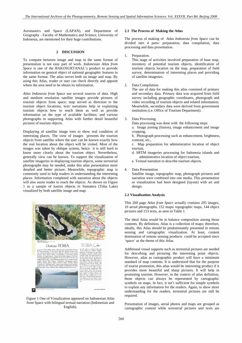
To compare between image and map in the same format of presentation is not easy part of work. Indonesian Atlas from Space is one of the BAKOSURTANAL’s product to provide information on general object of national geographic features in the same format. The atlas serves both on image and map. By using this Atlas, reader or user can check directly and appoint where the area need to be obtain its information. Atlas Indonesia from Space use several sources of data. High and medium resolution satellite images provide pictures of tourism objects from space; map served as direction to the tourism object locations; text/ narrations help in explaining tourism objects how to reach them as well as provide information on the type of available facilities; and various photographs in supporting Atlas with further detail beautiful pictures of tourism objects. Displaying of satellite image tries to show real condition of interesting places. The view of images presents the tourism objects from satellite where the user can be known exactly how the real location about the object will be visited. Most of the images was taken by oblique system, hence it is still hard to know more clearly about the tourism object. Nevertheless, generally view can be known. To support the visualization of satellite imageries in displaying tourism objects, some terrestrial photographs may be needed, make this atlas presentation more detailed and better picture. Meanwhile, topographic map is commonly used to help readers in understanding the interesting places. Information completed with narration about the objects will also assist reader to reach the objects. As shown on Figure 1 as a sample of tourist objects in Sumatera (Toba Lake) visualized by both satellite image and map.
Figure 1 One of Visualization appeared on Indonesian Atlas from Space with bilingual textual narration (Indonesian and
English).
2.1 The Process of Making the Atlas
The process of making of Atlas Indonesia from Space can be divided into 4 parts: preparation, data compilation, data processing and data presentation. 1. Preparation.
This stage of activities involved preparation of base map, inventory of potential tourism objects, identification of tourism objects location on the map, preparation of field survey, determination of interesting places and providing of satellite imageries.
2. Data Compilation.
The use of data for making this atlas consisted of primary and secondary data. Primary data was acquired from field survey including geographic coordinates, photograph and video recording of tourism objects and related information. Meanwhile, secondary data were derived from government institution (i.e. Office of Tourism Department).
3. Data Processing.
Data processing was done with the following steps: a. Image joining (fusion), image enhancement and image cropping, b. Photograph processing such as enhancement, brightness, contrast, etc.,
c. Map preparation for administrative location of object tourism,
d. SRTM imageries processing for Indonesia islands and administrative location of object tourism,
e. Textual narration to describe tourism objects. 4. Data Presentation
Satellite image, topographic map, photograph pictures and narration were combined into one media. This presentation or visualization had been designed (layout) with art and design.
2.2 Visualization Analysis
This 260 page Atlas from Space actually contains 205 images, 10 aerial photographs, 152 maps/ topographic maps, 144 object pictures and 153 texts, as seen in Table 1. The ideal Atlas would be in balance composition among those contents. By definition, Atlas is a collection of maps; therefore, ideally, this Atlas should be predominantly presented in remote sensing and cartographic visualization. At least, content domination of remote sensing products could be accepted since ‘space’ as the theme of this Atlas. Additional visual supports such as terrestrial pictures are needed for describing and picturing the interesting point objects. However, atlas as cartographic product will have a minimum standard of map contents. It is understood that for the purpose of tourist promotion, this atlas would be interesting product if it provides more beautiful and sharp pictures. It will help in promoting tourism. However, in the context of atlas definition, those objects can always be represented by cartographic symbols on maps. In fact, it isn’t sufficient for simple symbols to explain any information for the readers. Again, to show more understanding for the readers, terrestrial pictures are still be required. Presentation of images, aerial photos and maps are grouped as cartographic content while terrestrial pictures and texts are
260
The International Archives of the Photogrammetry, Remote Sensing and Spatial Information Sciences. Vol. XXXVII. Part B4. Beijing 2008
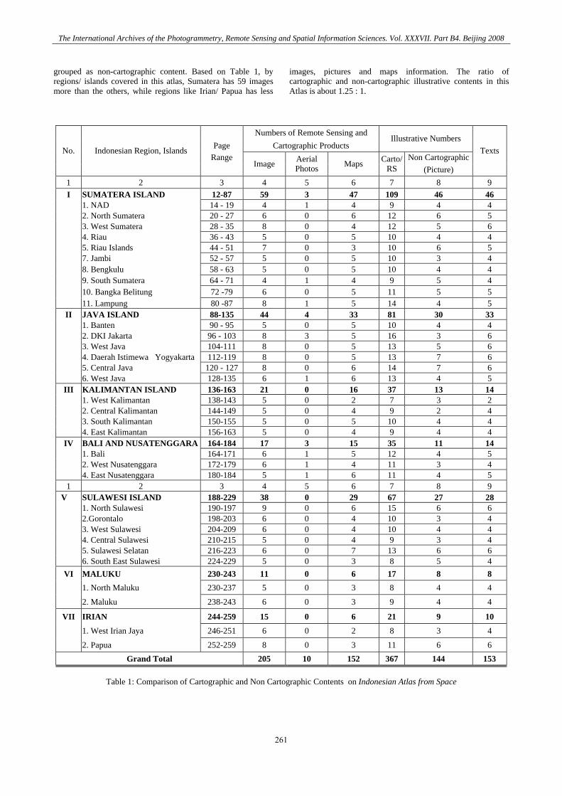
grouped as non-cartographic content. Based on Table 1, by regions/ islands covered in this atlas, Sumatera has 59 images more than the others, while regions like Irian/ Papua has less
images, pictures and maps information. The ratio of cartographic and non-cartographic illustrative contents in this Atlas is about 1.25 : 1.
Numbers of Remote Sensing and Page Cartographic Products
Illustrative Numbers
Range Non CartographicNo. Indonesian Region, Islands
Image Aerial
Photos Maps Carto/RS (Picture)
Texts
1 2 3 4 5 6 7 8 9 I SUMATERA ISLAND 12-87 59 3 47 109 46 46 1. NAD 14 - 19 4 1 4 9 4 4 2. North Sumatera 20 - 27 6 0 6 12 6 5 3. West Sumatera 28 - 35 8 0 4 12 5 6 4. Riau 36 - 43 5 0 5 10 4 4 5. Riau Islands 44 - 51 7 0 3 10 6 5 7. Jambi 52 - 57 5 0 5 10 3 4 8. Bengkulu 58 - 63 5 0 5 10 4 4 9. South Sumatera 64 - 71 4 1 4 9 5 4 10. Bangka Belitung 72 -79 6 0 5 11 5 5 11. Lampung 80 -87 8 1 5 14 4 5
II JAVA ISLAND 88-135 44 4 33 81 30 33 1. Banten 90 - 95 5 0 5 10 4 4 2. DKI Jakarta 96 - 103 8 3 5 16 3 6 3. West Java 104-111 8 0 5 13 5 6 4. Daerah Istimewa Yogyakarta 112-119 8 0 5 13 7 6 5. Central Java 120 - 127 8 0 6 14 7 6 6. West Java 128-135 6 1 6 13 4 5
III KALIMANTAN ISLAND 136-163 21 0 16 37 13 14 1. West Kalimantan 138-143 5 0 2 7 3 2 2. Central Kalimantan 144-149 5 0 4 9 2 4 3. South Kalimantan 150-155 5 0 5 10 4 4 4. East Kalimantan 156-163 5 0 4 9 4 4
IV BALI AND NUSATENGGARA 164-184 17 3 15 35 11 14 1. Bali 164-171 6 1 5 12 4 5 2. West Nusatenggara 172-179 6 1 4 11 3 4 4. East Nusatenggara 180-184 5 1 6 11 4 5 1 2 3 4 5 6 7 8 9
V SULAWESI ISLAND 188-229 38 0 29 67 27 28 1. North Sulawesi 190-197 9 0 6 15 6 6 2.Gorontalo 198-203 6 0 4 10 3 4 3. West Sulawesi 204-209 6 0 4 10 4 4 4. Central Sulawesi 210-215 5 0 4 9 3 4 5. Sulawesi Selatan 216-223 6 0 7 13 6 6 6. South East Sulawesi 224-229 5 0 3 8 5 4
VI MALUKU 230-243 11 0 6 17 8 8 1. North Maluku 230-237 5 0 3 8 4 4
2. Maluku 238-243 6 0 3 9 4 4
VII IRIAN 244-259 15 0 6 21 9 10
1. West Irian Jaya 246-251 6 0 2 8 3 4
2. Papua 252-259 8 0 3 11 6 6 Grand Total 205 10 152 367 144 153
Table 1: Comparison of Cartographic and Non Cartographic Contents on Indonesian Atlas from Space
261
The International Archives of the Photogrammetry, Remote Sensing and Spatial Information Sciences. Vol. XXXVII. Part B4. Beijing 2008
2.3 Atlas for NSDI
According to Ormeling, national atlases present a synthesis of the knowledge of physical and geographic elements that characterize a country (in Aditya, 2007). Indonesian Atlas from Space is not claimed as national atlases, but it plays an important role as part of input to support our National Atlases. In the future, for the program of National Spatial Data Infrastructure (NSDI) in Indonesia, an atlas like this may support that program.
3. CONCLUSION AND RECOMMENDATION
3.1 Conclusion
a. One of the several efforts to socialize geo-spatial information for the public, can be done through Atlas both in print-out and electronic Atlas. This effort is how to visualize all mediums: images, maps and pictures in the form of Atlas.
b. The effort of visualization is part of excellent work in order to make the Atlas interesting. This Atlas provides the visualized quality of geospatial information so that public readers can easily access such information.
c. Even though this Atlas benefits tourists, it can also be used for other purposes.
3.2 Recommendation
In line with the role of remote sensing and cartographic visualization for atlas, some recommendations to implement the efforts can be drawn as follows:
a. To improve atlas visualization, various images are needed to insert. Other various satellite images from more sources of platform, like Landsat, SPOT can also be applied and used to enhance Atlas from Space.
b. An ideal proportion between remotely sensed presentation and cartographic media (maps), and textual narration need to be paid into consideration. Ratio 1,25 : 1 may not be ideal for an Atlas from Space. More numbers of images displayed on every pages may be required.
c. Development of national geospatial data infrastructures, Indonesian Atlas from Space as part of the national atlas metaphor may be required to establish.
REFERENCES
Aditya, Trias. 2007. The National Atlas as a Metaphor for Improved Use of a National Geospatial Data Infrastructure, ITC, Enschede, The Netherland. BAKOSURTANAL, 2007. Atlas Indonesia from Space, Pusat Atlas, BAKOSURTANAL, Cibinong, 2007. Fisher, P. (2004). Developments in Spatial Data Handling, International Geographical Union (IGU), Springler, London http://www.bakosurtanal.go.id
.
262
The International Archives of the Photogrammetry, Remote Sensing and Spatial Information Sciences. Vol. XXXVII. Part B4. Beijing 2008