Embed Size (px)
Citation preview

www.digitalglobe.com Corporate (U.S.) +1.303.684.4561 or +1.800.496.1225 | London +44.20.8899.6801 | Singapore +65.6389.4851
DATA SHEE T
Features » Sub-meter resolution imagery
- 61 cm panchromatic at nadir
- 2.44 m multispectral at nadir
» High geolocational accuracy - Stable platform for precise location
measurement
» Fast large area collection - 16.8 km width imaging swath
» High image quality - Off-axis unobscured design of QuickBird’s
telescope - Large field-of-view
- High contrast (MTF)
- High signal to noise ratio
» Large on-board data storage - 128 gigabits on-board image
storage capacity
Benefits » Acquire high quality satellite imagery
for map creation, change detection, and image analysis
» Geolocate features to create maps in remote areas without the use of ground control points
» Collect a greater supply of frequently updated global imagery products
» Extend the range of suitable imaging collection targets and enhance image interpretability
QuickBirdDigitalGlobe’s QuickBird satellite offers sub-meter resolution imagery, high geolocational accuracy, and large on-board storage. With global collection of panchromatic and multispectral imagery, QuickBird is designed to support a wide range of geospatial applications. Previously at an operational altitude of 482 km, QuickBird is currently operating at an altitude of 450 km and will continue in an gradual descent until its end of mission life at an altitude of 300 km.
QuickBird clean room pre-launch preparations.
The first of DigitalGlobe’s state-of-the-art high-
resolution commercial imagery satellites.
www.digitalglobe.com Corporate (U.S.) +1.303.684.4561 or +1.800.496.1225 | London +44.20.8899.6801 | Singapore +65.6389.4851
QUICK BIRD
DATA SHEE T
DS-QB 07/13
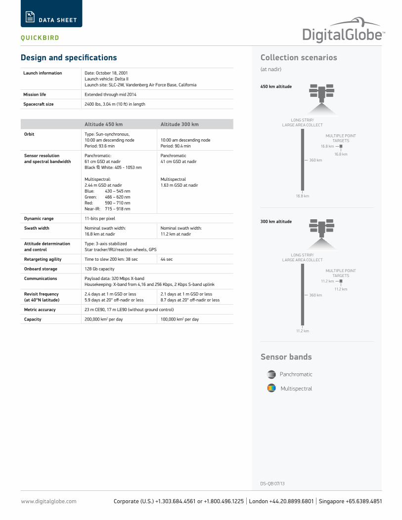
Collection scenarios(at nadir)
Design and specifications
Launch information Date: October 18, 2001Launch vehicle: Delta IILaunch site: SLC-2W, Vandenberg Air Force Base, California
Mission life Extended through mid 2014
Spacecraft size 2400 lbs, 3.04 m (10 ft) in length
Altitude 450 km Altitude 300 km
Orbit Type: Sun-synchronous,10:00 am descending nodePeriod: 93.6 min
10:00 am descending nodePeriod: 90.4 min
Sensor resolutionand spectral bandwidth
Panchromatic: 61 cm GSD at nadirBlack & White: 405 - 1053 nm
Multispectral: 2.44 m GSD at nadirBlue: 430 – 545 nm Green: 466 – 620 nmRed: 590 – 710 nm Near-IR: 715 – 918 nm
Panchromatic41 cm GSD at nadir
Multispectral1.63 m GSD at nadir
Dynamic range 11-bits per pixel
Swath width Nominal swath width: 16.8 km at nadir
Nominal swath width: 11.2 km at nadir
Attitude determination and control
Type: 3-axis stabilizedStar tracker/IRU/reaction wheels, GPS
Retargeting agility Time to slew 200 km: 38 sec 44 sec
Onboard storage 128 Gb capacity
Communications Payload data: 320 Mbps X-bandHousekeeping: X-band from 4,16 and 256 Kbps, 2 Kbps S-band uplink
Revisit frequency(at 40°N latitude)
2.4 days at 1 m GSD or less5.9 days at 20° off-nadir or less
2.1 days at 1 m GSD or less8.7 days at 20° off-nadir or less
Metric accuracy 23 m CE90, 17 m LE90 (without ground control)
Capacity 200,000 km2 per day 100,000 km2 per day
MULTIPLE POINTTARGETS
LONG STRIP/LARGE AREA COLLECT
360 km
11.2 km
11.2 km
11.2 km
MULTIPLE POINTTARGETS
LONG STRIP/LARGE AREA COLLECT
360 km
16.8 km
16.8 km
16.8 km
Sensor bands
Panchromatic
Multispectral
450 km altitude
300 km altitude