Embed Size (px)
Citation preview
Indian Ocean Forecast System (INDOFOS)
Francis P. A.
Earth System Sciences Organisation (ESSO)Indian National Centre for Ocean Information Services (INCOIS)Ministry of Earth Sciences, Government of IndiaHYDERABAD
5th Annual Meeting of GOADE OceanView Science Team, Beijing 15th Oct 2014
INCOIS has been providing Operational forecasts of the general circulation features of the Indian Ocean from early 2010 onwards.
Initially the spatial resolution of the Indian Ocean Forecast System (INDOFOS) was 0.25o x 0.25o and later it was enhanced to 0.125o x 0.125o. Now the horizontal resolution is increased to 1/12o x 1/12o
Main drivers of the forecasting system are the fishermen, Navy, Coast Guard and industries such as shipping and off-shore energy.
Forecasts from this system are being used for many value added services such as oil-spill trajectory simulations, ocean forecast along the ship route etc.
INCOIS also provides Global Ocean and Indian Ocean analysis using the INCOIS setup of GODAS at a variable horizontal resolution.
Ocean analysis using GODAS is freely available for download from INCOIS LAS (http://las.incois.gov.in/las/UI.vm).
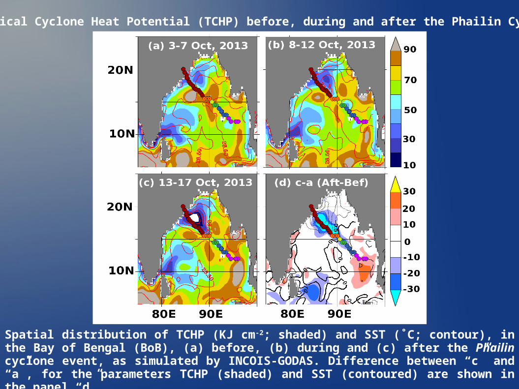
Spatial distribution of TCHP (KJ cm-2; shaded) and SST (˚C; contour), in the Bay of Bengal (BoB), (a) before, (b) during and (c) after the Phailin cyclone event, as simulated by INCOIS-GODAS. Difference between “c” and “a”, for the parameters TCHP (shaded) and SST (contoured) are shown in the panel “d”.
Tropical Cyclone Heat Potential (TCHP) before, during and after the Phailin Cyclone
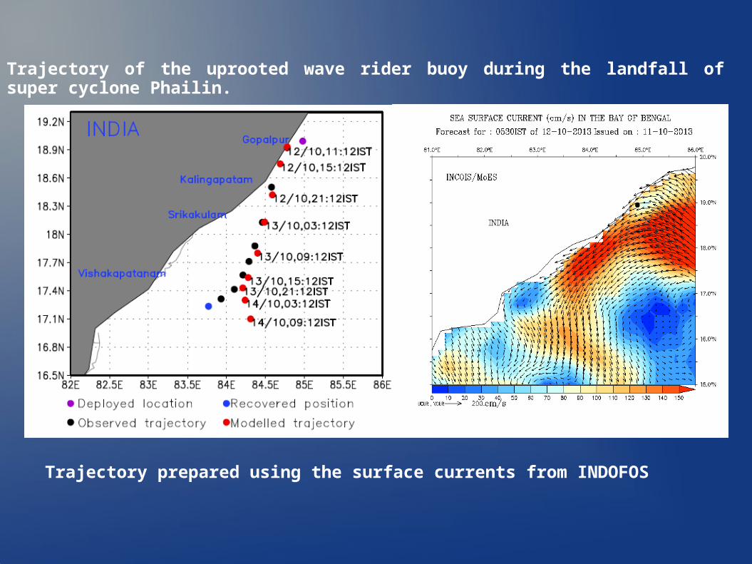
Trajectory of the uprooted wave rider buoy during the landfall of super cyclone Phailin.
Trajectory prepared using the surface currents from INDOFOS
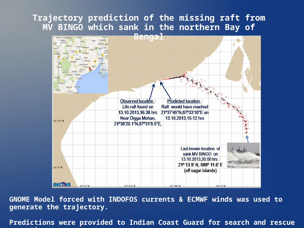
Trajectory prediction of the missing raft from MV BINGO which sank in the northern Bay of Bengal
GNOME Model forced with INDOFOS currents & ECMWF winds was used to generate the trajectory.
Predictions were provided to Indian Coast Guard for search and rescue operations
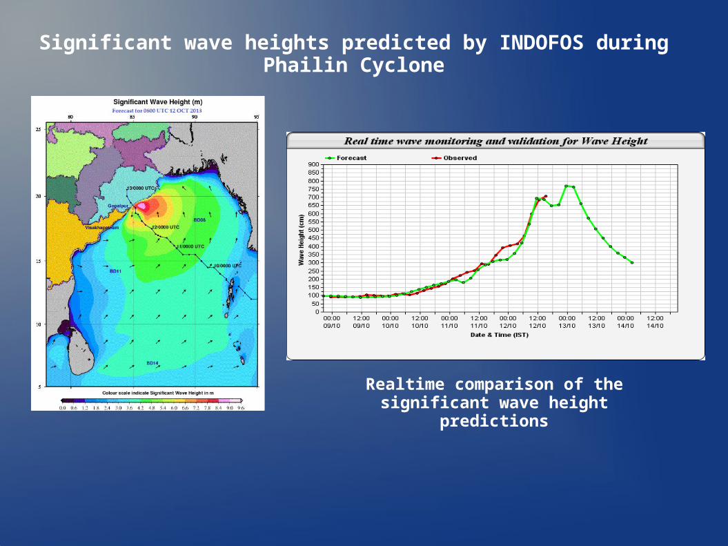
Significant wave heights predicted by INDOFOS during Phailin Cyclone
Realtime comparison of the significant wave height predictions
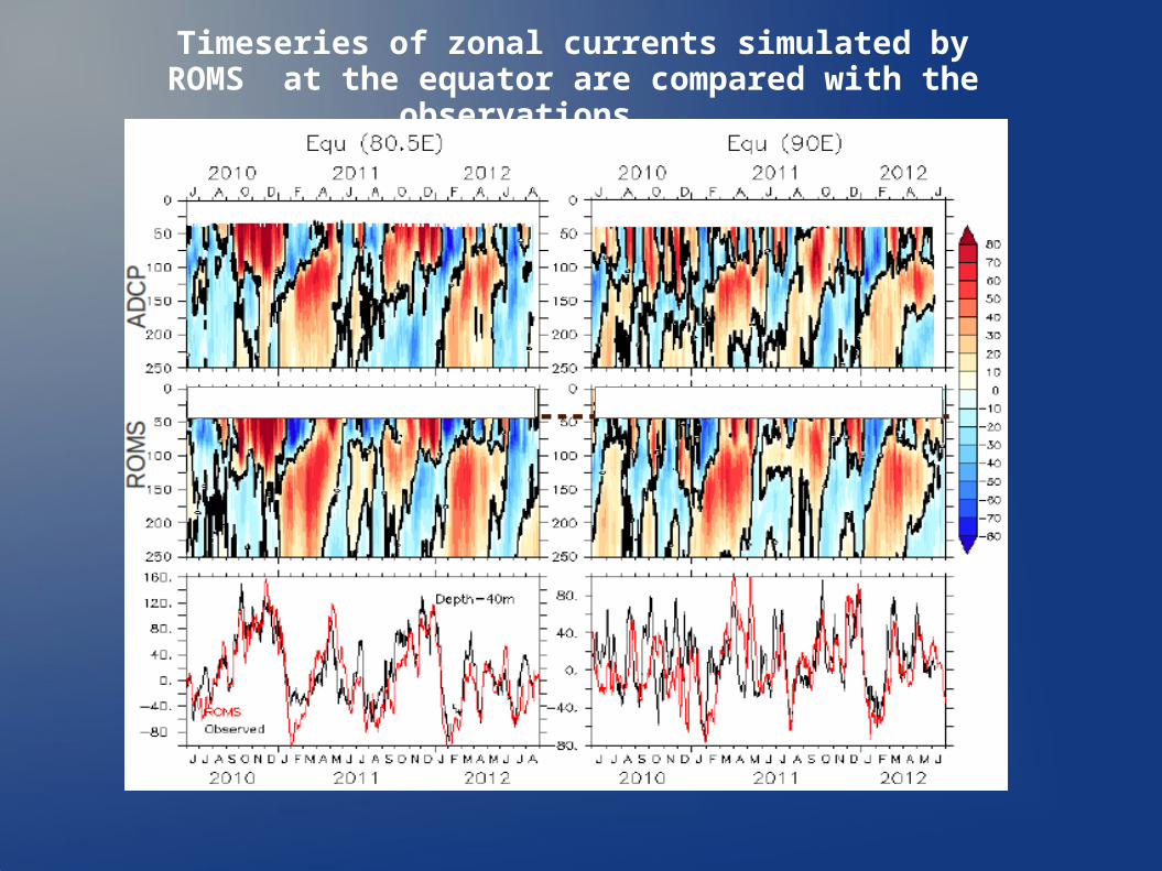
Timeseries of zonal currents simulated by ROMS at the equator are compared with the observations
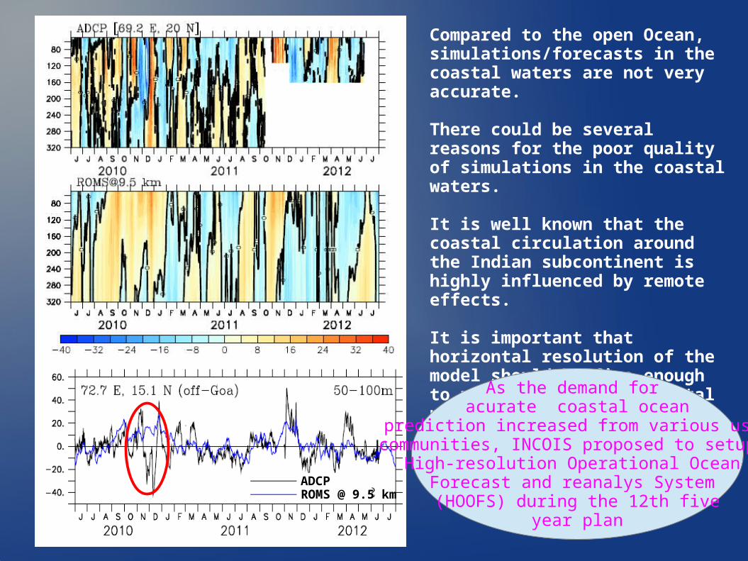
Compared to the open Ocean, simulations/forecasts in the coastal waters are not very accurate.
There could be several reasons for the poor quality of simulations in the coastal waters.
It is well known that the coastal circulation around the Indian subcontinent is highly influenced by remote effects.
It is important that horizontal resolution of the model should be fine enough to resolve many such coastal processes.
ADCPROMS @ 9.5 km
As the demand for acurate coastal ocean
prediction increased from various usercommunities, INCOIS proposed to setup a
High-resolution Operational Ocean Forecast and reanalys System (HOOFS) during the 12th five
year plan
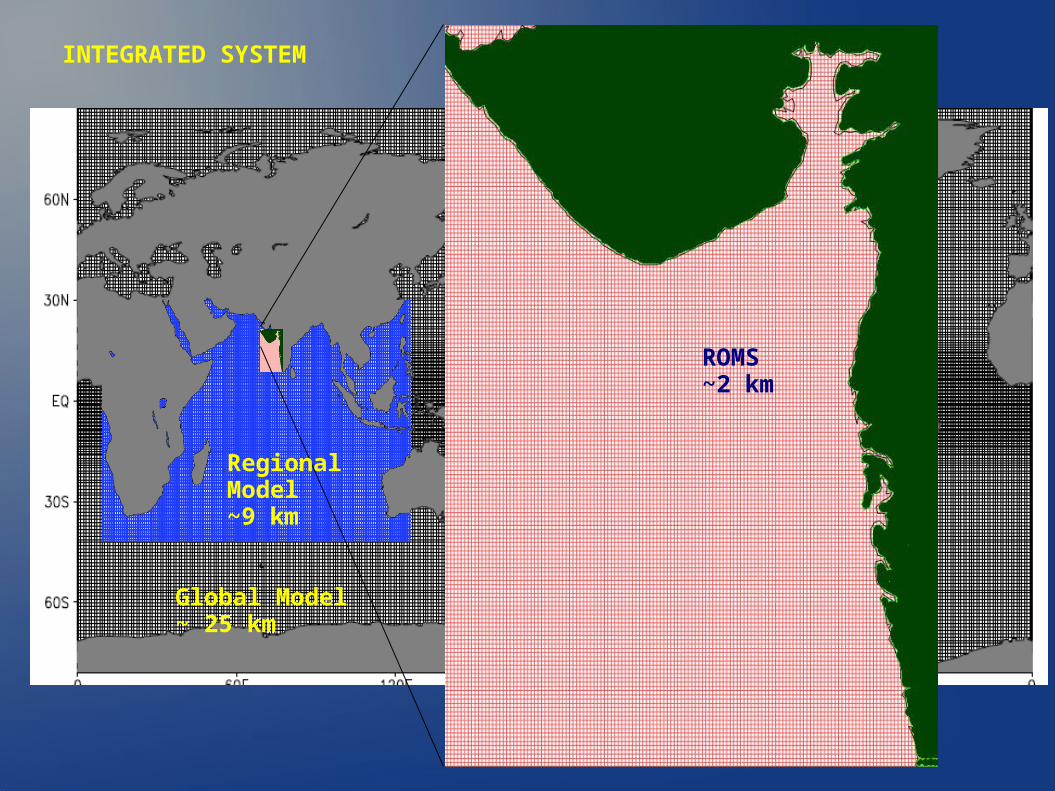
INTEGRATED SYSTEM
Global Model~ 25 km
Regional Model~9 km
ROMS~2 km
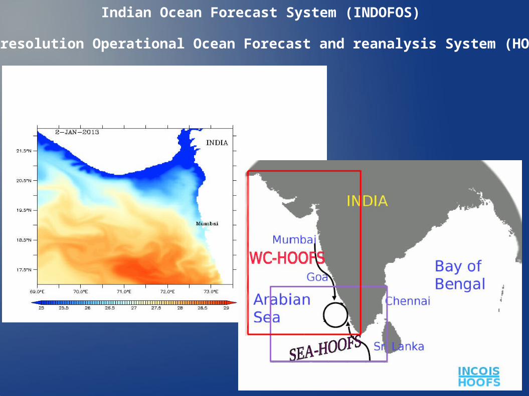
Indian Ocean Forecast System (INDOFOS)
High-resolution Operational Ocean Forecast and reanalysis System (HOOFS)
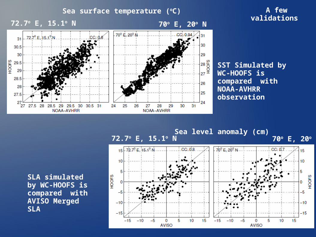
SLA simulated by WC-HOOFS is compared with AVISO Merged SLA
SST Simulated by WC-HOOFS is compared with NOAA-AVHRR observation
A few validations
72.7o E, 15.1o N 70o E, 20o N
70o E, 20o N72.7o E, 15.1o N
Sea surface temperature (oC)
Sea level anomaly (cm)
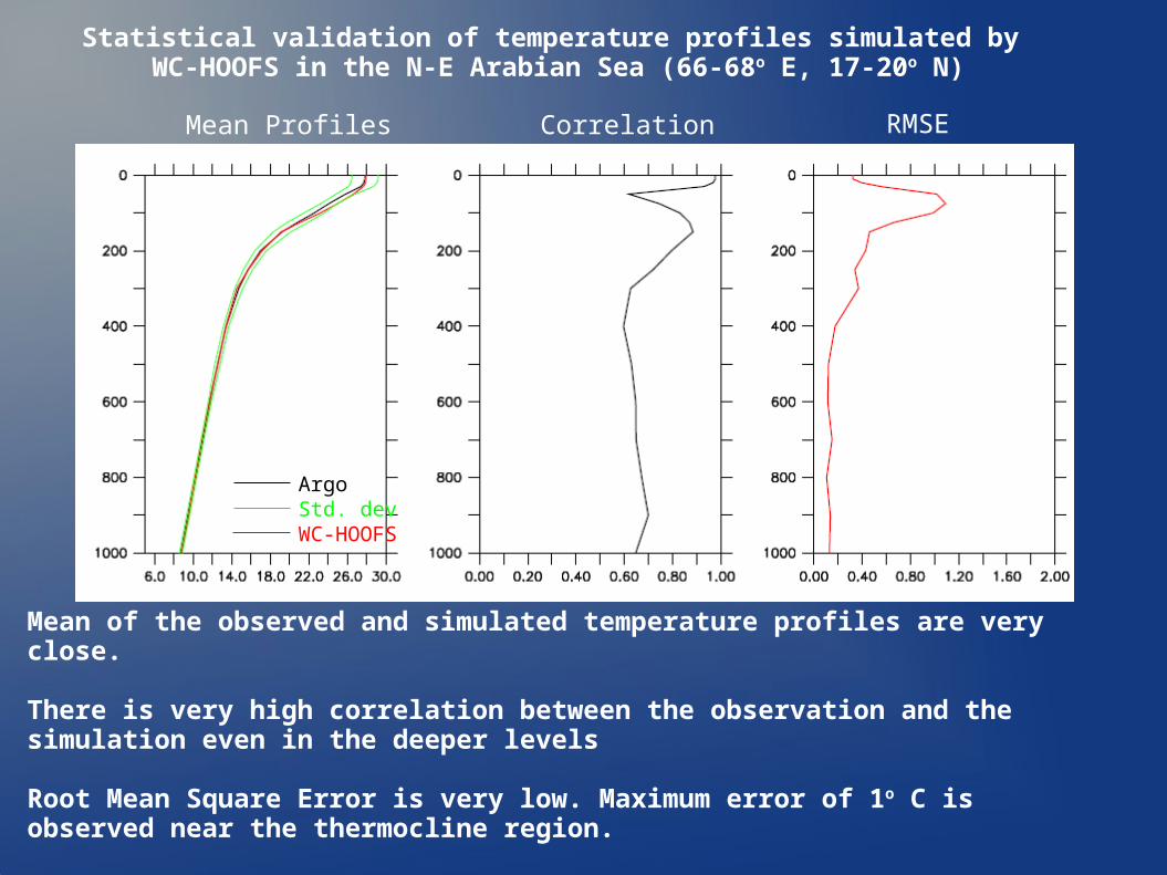
ArgoStd. devWC-HOOFS
Mean Profiles Correlation RMSE
Statistical validation of temperature profiles simulated by WC-HOOFS in the N-E Arabian Sea (66-68o E, 17-20o N)
Mean of the observed and simulated temperature profiles are very close.
There is very high correlation between the observation and the simulation even in the deeper levels
Root Mean Square Error is very low. Maximum error of 1o C is observed near the thermocline region.
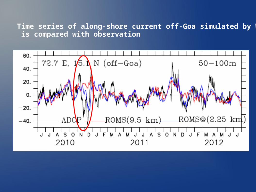
Time series of along-shore current off-Goa simulated by WC-HOOFS is compared with observation
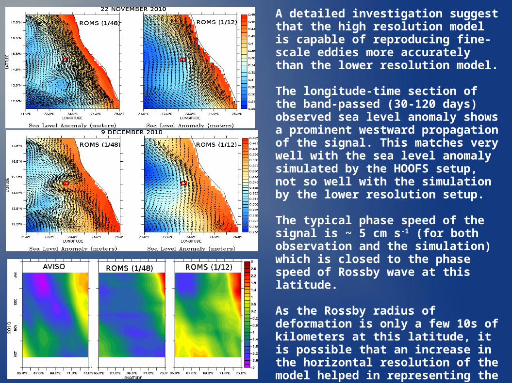
A detailed investigation suggest that the high resolution model is capable of reproducing fine-scale eddies more accurately than the lower resolution model.
The longitude-time section of the band-passed (30-120 days) observed sea level anomaly shows a prominent westward propagation of the signal. This matches very well with the sea level anomaly simulated by the HOOFS setup, not so well with the simulation by the lower resolution setup.
The typical phase speed of the signal is ~ 5 cm s-1 (for both observation and the simulation) which is closed to the phase speed of Rossby wave at this latitude.
As the Rossby radius of deformation is only a few 10s of kilometers at this latitude, it is possible that an increase in the horizontal resolution of the model helped in representing the Rossby waves better in the HOOFS setup and hence improved the simulations.
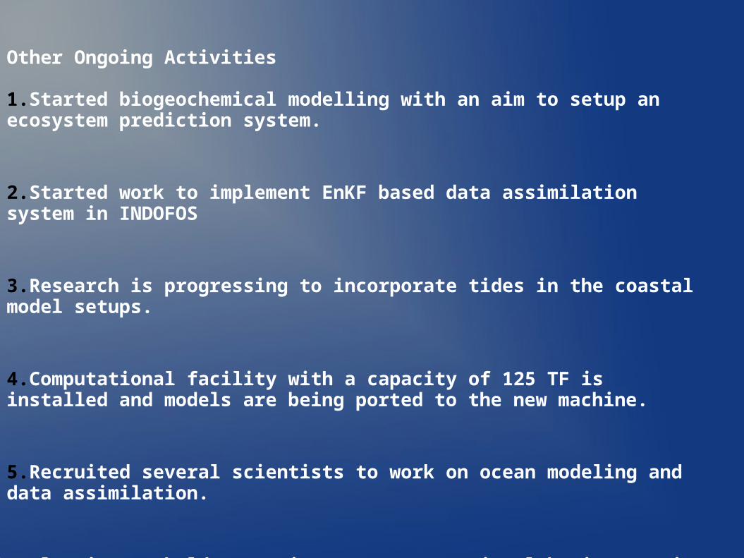
Other Ongoing Activities
1.Started biogeochemical modelling with an aim to setup an ecosystem prediction system.
2.Started work to implement EnKF based data assimilation system in INDOFOS
3.Research is progressing to incorporate tides in the coastal model setups.
4.Computational facility with a capacity of 125 TF is installed and models are being ported to the new machine.
5.Recruited several scientists to work on ocean modeling and data assimilation.
6.Planning to hold (once in two years) national brain-storming sessions to promote collective thinking on operational ocean predictions.


![Indo-Pacific Climate Modes in Warming Climate: Consensus ...Indian Ocean dipole . Indian Ocean basin warming . Indo-western Pacific ocean ... [17], inducing a north Indian Ocean (NIO)](https://img.pdfslide.us/doc/110x75/611a7e4e613a58782f2e061c/indo-pacific-climate-modes-in-warming-climate-consensus-indian-ocean-dipole.jpg)