Embed Size (px)
Citation preview
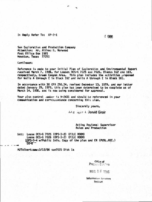
In Reply Refer To: RP-2-1 1 '986
Sun Exploration and Production Conpany At tent ion: Kr. Al fred B. Norwood Post Off ice Box 1501 Houston. Texas 77251
Gentleiaen:
Reference U aade to your I n i t i a l Plan of Exploraticr and Environmental Report received March 7. 1986. for Leases OCS-G 7025 ano' 7026, Blocks 1C2 ano 163. respectively. Green Canyon Area. This plan Includes the ac t i v i t i es proposed for Hells A through E 1n Block 162 and Wells A through E in Block 163.
In accordance wi th 30 CFR 250.34. revised December 13. 1S79. and our l e t t e r dated January 29. 1979. th is plan has been determined to be complete as of March 14. 1986. tod 1s now being considered for approval.
Your pl -iii control lumber ta N-2431 and should be referenced (n your conmunication and correspondence conceming th is olan.
Sincerely yours.
itfcg >&j.i A. Ooiidld Giroir
Acting Reglonai Supervisor Rules and Production
bcc: Lease OCS-G 7025 (OPS-3-2) (FILE ROOM) Lease OCS-G 7026 (OPS-3-2) (FILE ROOM)
tOPS-3-4 w/Publlc In fo . Copy of the plan and ER (PUBL.REC.)
MJTolbert:aow:3/12/86 sun7025 Disk la
mil 1 8 1986
lnfo/mntn>'i *i»rvicp3 Section
S u n P r o d u c t i o n O p e r a t i o n s D i v i s i o n Offshore District
S u n E x p l o r a t i o n a n d P r o d u c t i o n C o m p a n y 12121 WickChesterLane PO Ben 150' Houston TX 77251 1501 7135312000
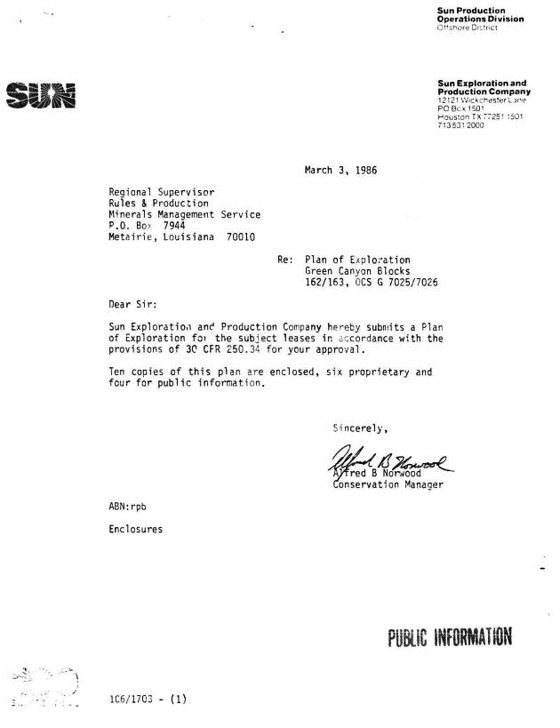
March 3, 1986
Regional Supervisor Rules & Production Minerals Management Service P.O. Boy 7944 Metairie, Louisiana 70010
Dear Sir:
Sun Exploration and Production Company hereby submits a Plan of Exploration fot the subject leases in accordance with the provisions of 30 CFR 250.34 for your approval.
Ten copies of th is plan are enclosed, six proprietary and four for public infonnat ion.
Re: Plan of Exploration Green Canyon Blocks 162/163, OCS G 7025/7026
Sincerely,
ABNrrpb
Enclosures
PUBLIC INFORMATION
1C6/1703 - (1)
PLAN OF EXPLORATION
OCS G 7025/7026
GREEN CANYON AREA BLOCK 162/163
SUN EXPLORATION AND PRODUCTION COMPANY
Contact:
A.B. Norwood Sun Exploration and Production Company
P.O. Box 1501 Houston, Texas 77251-1501
Phone: (713) 531-2158
GREEN CANYON AREA BLOCK 162/163 OCS G 7025/7026
TABLE OF COMMENTS
Description of Work
Shallow Hazards Statements
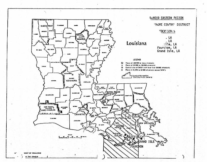
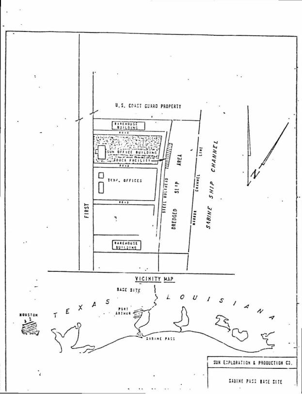
Area Location Maps
Base Support Facility Data
Vicinity Map
Env. onmental Safeguards
List of Mud Additives
Description of Drilling Rig
Air Quality Computations
Geological and Geophysical Data
Environmental Report
Shallow Hazard Survey Report
1C6/1702 - (2)
SUN EXPLORATION AND PRODUCTION CONPANY PLAN OF EXPLORATION GREEN CANYON AREA BLOCK 162/163 OCS G 7025/7026
This Exploration Plan for Green Canyon Block 162/163 has been prepared 1n accordance with 30 CFR 250.34-1, Gulf of Mexico OCS Orders and Notice to Lessees No. 83-3.
This Block was leased in Sale 81, 1984. Geophysical activities have been conducted and the first exploratory well should begin as early as April 1, 1986 - subject to the availability of a drilling rig, approval of this Exploration Plan and the required permit to d r i l l .
1C6/1702 - (3)
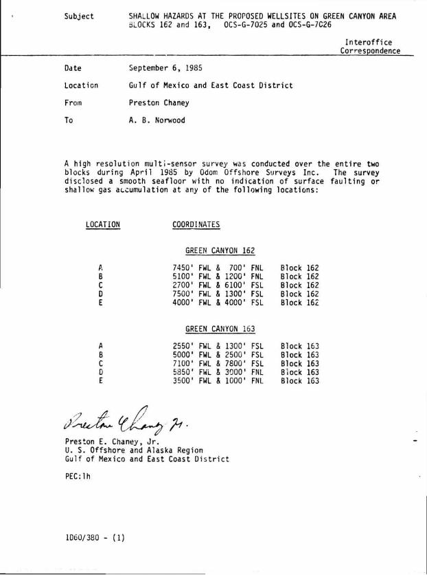
Subject SHALLOW HAZARDS AT THE PROPOSED WELLSITES ON GREEN CANYON AREA ouOCKS 162 and 163, OCS-G-7025 and OCS-G-7C26
In tero f f ice Correspondence
Date September 6, 1985
Location Gulf of Mexico and East Coast D is t r i c t
From Preston Chaney
To A. B. Norwood
A high resolution multi-sensor survey was conducted over the entire two blocks during April 1985 by Odom Offshore Surveys Inc. The survey disclosed a smooth seafloor with no indication of surface faulting or shallow gas accumulation at any of the following locations:
LOCATION COORDINATES
GREEN CANYON 162
A 7450' FWL & 700' FNL Block 162 B 5100' FWL & 1200' FNL Block 162 C 2700' FWL & 6100' FSL Block 162 D 7500' FWL & 1300' FSL Block 162 E 4000' FWL & 4000' FSL Block 162
GREEN CANYON 163
A 2550' FWL & 1300' FSL Block 163 B 5000' FWL & 2500' FSL Block 163 C 7100' FWL a 7800' FSL Block 163 D 5850' FWL & 3000' FNL Biock 163 E 3500' FWL & 1000' FNL Block 163
Preston E. Chaney, Jr. U. S. Offshore and Alaska Region Gulf of Mexico and East Coast District
PEC:lh
1D6G/380 - (1)
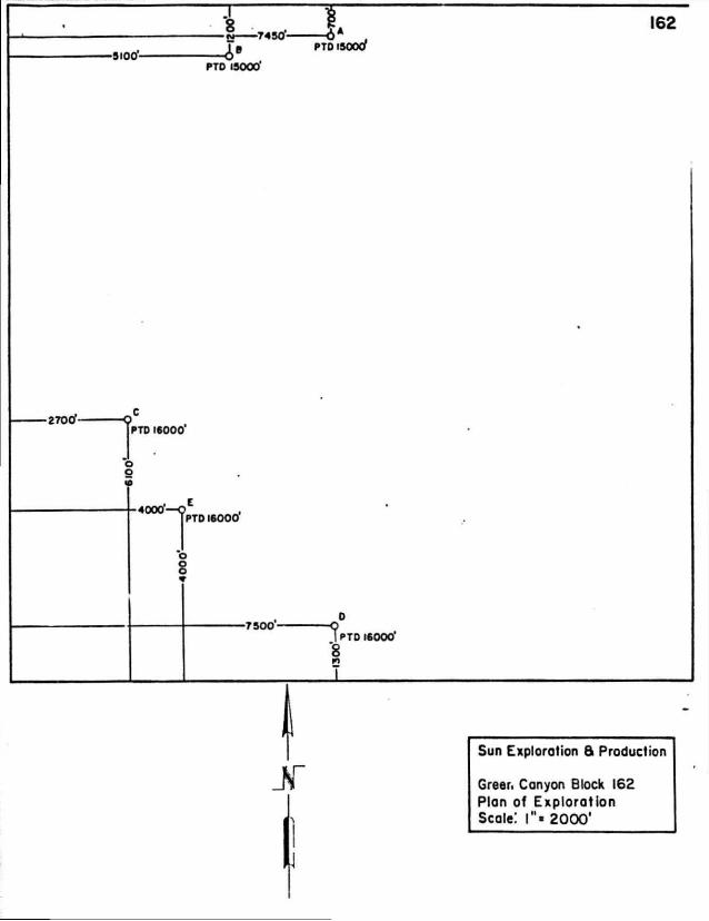
§ 7450 6 A , I P PTO I500CT
-5100-PTD 15000'
•2700'-[PTD 16000'
•4000
1 PTD 16000
-7500-"?PTD 16000"
8
Jf Sun Exploration 8 Production
Greer. Canyon Block 162 Plan of Exploration Scale! l"« 2000'
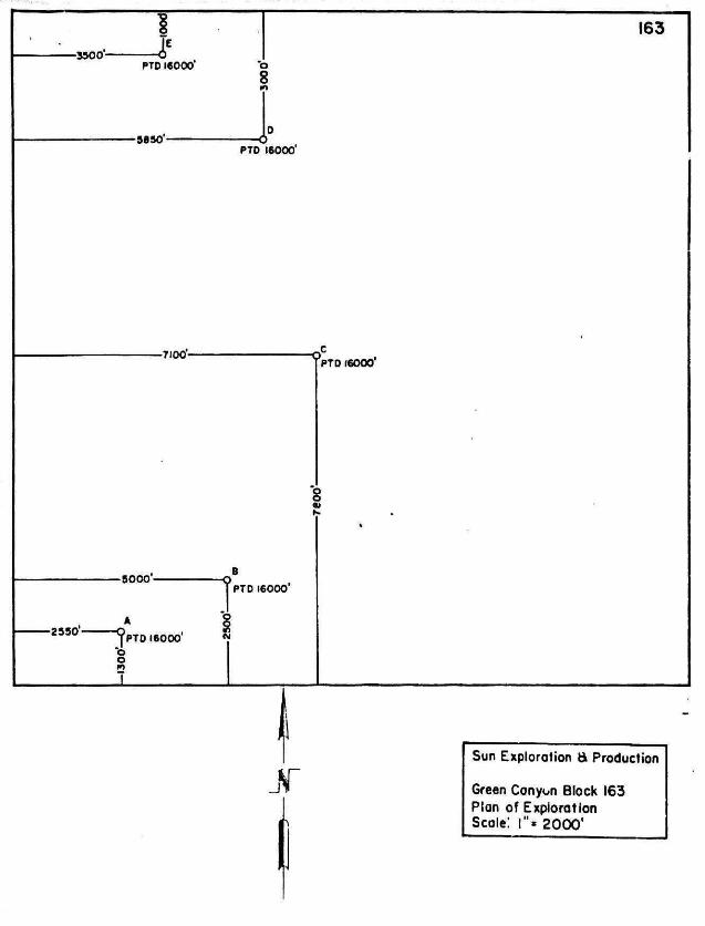
•3500'-
I PTO 16000' o
8
163
•5850'-PTD 16000*
-7100-PTD 16000'
-5000-B
r PTD 16000'
Jf Sun Exploration e» Production
Green Conyon Block 163 Plan of Exploration Scale! !"« 20CX)'
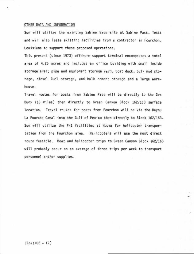
OTHER DATA AND INFORMATION
Sun will utilize the existing Sabine Base site at Sabine Pass, Texas
and will also lease existing facilities from a contractor 1n Fourchon,
Louisiana to support these proposed operations.
This present (since 1973) offshore support terminal encompasses a total
area of 4.25 acres and includes an office building with small inside
storage area; pipe and equipment storage yard, boat dock, bulk mud sto
rage, diesel fuel storage, and bulk cement storage and a large ware
house.
Travel routes for boats from Sabine Pass will be directly to the Sea
Buoy (18 miles) then directly to Green Canyon Block 162/163 surface
location. Travel routes for boats from Fourchon will be via the Bayou
La Fourche Canal into the Gulf of Mexico then directly to Block 162/163.
Sun will utilize the PHI facilities at Houma for helicopter transpor
tation from the Fourchon area. Helicopters will use the most direct
route feasible. Boat and helicopter trips to Green Canyon Block 162/163
will probably occur on an average of three trips per week to transport
personnel and/or supplies.
1C6/1702 - (7)
r
u.s. coin cuifto pROPEau
VICINITY MAP
•A5E 31U |
SUM i:?tau;ia.<i i PSOQUCTIOH CS.
sum PK: UK nre
SHIP SHOAL, EWING BANK
co i d z < m Z LU Q Ct <
C . » - t r * t l 14 W . H _.t*_. . J t , _ 4> ^»
M 33 ' V i i , n l i H » i t I I t ~ • » s t t r
• • t * ico ioi at ICI >o> .• m •>•• OH
I t ' 12? I I " . - M
«45 . 6 * ? « ' • • •
t o t 310 I K S i t
151 154 > « • 15*
r t r n i j M . o o
441 . . i « « ] 4 4 4
5 I » 510 M l S » l
• 1 s»4 t n S T »
• • r i n n v « n
• • ' 441 441 444
•05 T I M r u ? r o t
« » r ? o m T5«
» t s • » « > M F M
• i r • >. 140
• 4' 441 H I 44*
M a r t t t t
M t t " 0 t r i i n
in m «r H I Kt
tn iro in i n IM
I < I i i 4 s u n « i t f
M l 531 154 MO 141
401 4 0 f 401 4 0 4 400
4 4 | 444 44F 444 « " t
4 l t " I O t t i t t t t t j
SSI 51t 515 . S i t 5 1 '
>rr • i J T I 5*0 M i
I I I I I I I I I l i t t i s
441 t M l t r t 4 t »«»
r o t r i o r n r u » i »
F5J F54 I M F M t *
r t r » M r t t t o o t o .
• 41 | 4 t 141 144 f t
• I S f t I I F I M 4 1 *
t i t 150 t l > U I " » l
1 * 1 t r t t " t r t t r r
i r t i r »
j ' t r )
14? 1 4 .
404
4 V •
t t t " 1
5 5 t l i t
M l M I
t r : « ;?
• r o t n
nt tn m M m m at tit t*o <•• t«i l i t i r r i r t i r t I to i t m r t i i t t i te i t , . * . t - . . » »-. - -M O I I I S H S H 114 SIS I t t S i r S M S t t ISO
344 MB 344
4 0 ; t t , • 4 i 0
- . . t s t
t t t t t r t M
S»0 M l M t
S M l t t M t
« ; • i n n o
• r i i r s i r t
S t r S M M t s r o i n s n s r j i r t
411 411 4 i | 414 •!% • ' t i r 4 ' t
4 * 4 f . - 4 M 4 | t 400 « t 4 | ?
•«t i 'o sot tot K I so* sot tea JOT M t SOt
K t r o t I O I
i t t t I M ; « r
I t t t i t o t n
- — - r - — — >1» - 1 . "53
• i r r j i l t ; S M
> t t - t t i t t j
I t i s 441 t t r
i .o 1 •
l o t JOS
"«« 1 4 1
2 0 t t O t 1 0 I I I I I I | l | 1 4 t u ! • »
i s o t s ' t s t i » . M ' I S A I M t a r I M r s s M B
t t i r t i t t t i t s / M i t t s o o l o i s a t s o * M l
I M » r S M K l . > « ' 3 . " 944 1 44 144 I t r M 4 M t ]
I t O S t l M t M S S t t M S I M M r M t S t t MO S H l t t
4 1 4 4 M t i l 4 2 F 4MJ 410 t t l ^ t S l t S l I M t M 4 * 4 41-
4 M t t t 430 4TI 4 * 1 4 * 1 t r t t H 1 4 H < " « t t * | • 440 « •
1.1 1 1 S ' t S I M ) S i r 5>t : « U O ' r S t l S B w v l t S
• • • t I t IM Jtr s t t s . . f j B
S t ' . 1 * * $ SKJ S t l S i t S t l S M
I I I t i l I U 114 I M l i t l l ' I M
" r s t r t i r r t r t i * t M O » t i n
n t n s
I M r s t
t o t t o s
144 t 4 F
I t o H I
t M tSS
t r t t r t
n t r i r n t
r i o r n r t i
104 109 t O t
I 4 | I 4 | I V 3
• M I t S t t t
f t t s r t s t
M O M i t t r
n t r«3 rn FH r n n t r u n t
n i F i t r t s ' H t r r n n 5 r—
I SSI S M SSS
— I I s t r S M s t t
44. 1 4 1 1 4 1
i l S M t 4 I F
r i t T I O TJ i
* - » r t FT j
S M s s r
• 0 9 4 0 '
I t t 445
4 M 4 t t
F M F U
1 r t ' r r
5 ' t 5 I
S M 5 5 1 S M M ' S t l l l l l - 4 4 SSS
1 0 1 4 0 I 4 0 . 4 0 1 t I " ' 4 0 1 t O t
• 4 1 t . T | 4 t | 4 t I M I S I ! 4 S 1 I S I
•1 ,111 411
• s t 4ss « s t « r
IM I t i IM 413 I M I M j I M I t r j l M *00 TM
n t i n T M r s r r i » | T M ; ' * o r . . i t t r . i , , ; * t t
r r t r r t r i o r t i r t t r a r * 4 r t t I r t t f r t r ; r n n t
M l I t t I I I I M I S I I M M r I M •
I M I M i t r I M M t t u o t o t e -
I S t t t o t t i n r M S t t t M S M 4 f
M S MM - I S t M M r S M M t t t O t l
4 * 1 I U I I S
n K I - t
M 4 M S I M M r M M 1*0
M t M t ' W O t n I U » • I
1 t . t M t s : I M * t r t M
• t t - 4 1 . , | M 4 OOO DO I o o . '
A —
.rr-
//sZssA.A I
w i t r o u m o M 1 t t r C 4 M c n o H v i n u n I O N
O A N O I N I A N * • s o , M i . M A R I N I t L A MO f u a i N t l I L A N O t H t * S H O A l • o u T i i m t o I O U I H I I M I . 1 I ' R O N A NO I t i • C W I N O l . l . -O N t C N C i l • . • • I l l 0 ( 1 I A • . l i t t i l l • : » 111 * i » » l C A N T O N
• - A T I B y A l K T IN ' A l t
t U S ' . t K N O L L U O I I L I C H • N O I I I U M
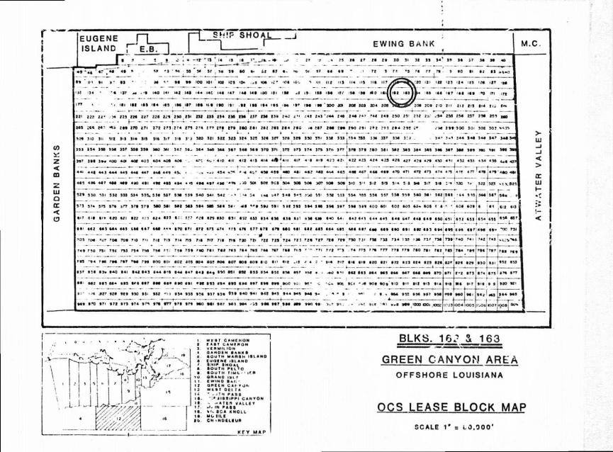
BLKS. 16A- & 163
GREEN CANYON AREA OFFSHORE LOUISIANA
OCS LEASE BLOCK MAP
SCALE 1 " = 1.0.000*
ENV IRONME NTAL-SAFEGUARDS
SUP. Exploration and Production Cornpany (Sun . J achere to a l l app'.cab 1
environmental standards of the EPA, MMS anc J.S. Coa. t Guard. Sun is ? member of Clean Gulf Associates (CGA) and r-.:11 utf«i.:e thei." equipment and the manpower and expertise o* Petersc Maritime- Services, Inc. as well as other specia l is ts in po'V' t ion control iind clean up as needed.
Existing o i l s p i l l cleanup equipment w i l l beach prot tc t ion and bird cleaning station are a l l within a few hours ca ' l in the event of a s p i l l . Th - equipment is maintained cn standby and in i reacy state at CGA locations at Grand I s l e , Louisiana; Houn.-, louisiana; I r t ra Coaat i l C t̂ Louisiana; Cameron, Louisiana; Galveston, Texa* and Rrr<port. Texas.
i* ; average response times (including load-out and t rave l ) for the ,.iajor pieces of o i l s p i l l containment and clean-up equipment available ( i . e . , Fast Response Skimmer Systems I and I I , Containment Boom, Radio System, Saucer Type Skimmers, Boat Spray System, e tc . ) L - e projected as fellows:
Locai '"-r. Hours
Cameron, Louis.ina 39 Intra-Coastal C t y , • .: j-'siana 34 Galveston, Texa\ 34 Houma, Louisiana 26 Grand Is le , LOUlV.-. .' 15 Venice, Louisiana 19 Rockport, Texas 4 0
The response times for larger eiuiDment (H Volume, Open Sea Skimmer System - Hoss Barge) and/or s ra l le r equrm<;... w ; l l vary considerably accordirg to tne point of or igir , type of transportat ion, weather conditions, * tc .
A c1 \t of Sun's Oil Sp i l l Alert 3rocedure for the Gulf ot Mexico is on "w with the U.S. MMS off ices i'i the Gulf of Mexico area. Sun intends
tJ u t i l i ze Peterson Maritime Ser/ ices, Inc. 'o r cleanup operation- should an o i l sp i l l occur.
Sun w i l l not dispose of well i l u ids containing free o i l into the Gulf of Mexico. Any f l u i d containing free o i l w i l l be brought to shore for proper disposal A l l sol id wastes w i l l be disposed of as per OCS Order No. 7. Sun's personnel w i l l be instructed in the techniques of equip1 in t maintenance and operation relat ive tr pol lut ion prevention, and pol lut ion inspections w i l l be performed as OCS Order No.7.
Sun's base of operations in case of an o i l sp i l l i " the emergency response center in our o f f i ces at Houston, Texas. Field p. —SonneI w i l l be dispatched from our base support f a c i l i t y at Sabine Pass, Te*.-:.
1C6/1702 - (10)
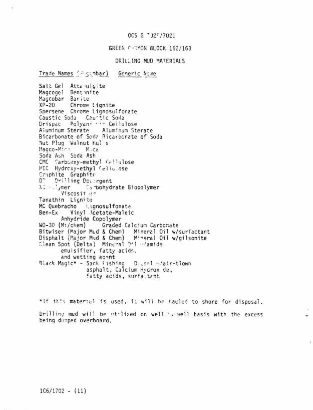
OCS G " f J 2 r / 7 0 2 i
GREEN r»«:VON BLOCK 162/163
DRIUING MUD MATERIALS
Trade Names ' •' y . nba r ) Generic Nt ne
S a l t Gel A t U >ulc,*te Magccgel Bent m i t e Magcobar B a r i t e XP-20 Chrome L i g n i t e Spersene Chrome L ignosu i fona te Caustic Soda C?u~t ic Soda Drispac Polyani - * r Ce l lu lose Aluminum Stera te Aluminum Stera te Bicarbonate of Sod? Bicarbonate o f Soda Nut Plug Walnut Kul s Magcc-Mir«. H;Ca Soda Abh Soda Ash CMC r arbc i .xy-methy l »V l l u l ose HEC Hydr rxy -e thy l r e l i o . o s e Graphi te Graphi te D? D*"Pl ing Dev: rgent XZ - . ' ymer Co*bohydrate Biopolymer
V iscos i t Tana t h i n L i g n i t e MC Quebracho I. ignosu l fonata Ben-Ex V iny l \ ce ta te -Ma le i c
Anhydride Copolymer W0-30 (M./chem) Graded Calcium Carbonate B i tw i se r (Major Mid & Chem) Mineral O i l w / su r f ac tan t D ispha l t (Major M'id & Chem) M'-^eral O i l w / g i l s o n i t e Clean Spot (De l t a ) M i n t - a l ?-'l -/amide
e m u l s i f i e r , f a t t y ac i ds , and w e t t i n g a g i n t
Black Magic* - Sack I i sh ing D(«.S*1 - / a i r - b l o w n a s p h a l t , Calcium Hydrox de , f a t t y a c i d s , s u r f a : t e n t
* I f t h i s materiel 1 i s used, i : w ' l i h** hauled to shore f o r d i sposa l .
D r i l l i n o mud w i l l be t ' t ' H z e d on we l l wel l basis w i th the excess being dtmped overboard .
1C6/1702 - (11)
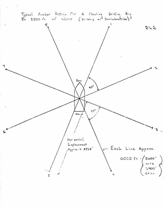
ZSCk.̂ TION OF DRILLING RIG
The d r i l l i n g r i g to be used has not been contracted, however Sun intends
to use either a semi-submersible cr a d r i l l ship, whichever is available.
A description of the Discoverer 534, a sel f propelled Tjrret Moored
Dr i l lsh ip is attached a typical vessel to be used.
1C6/1702 - (12)
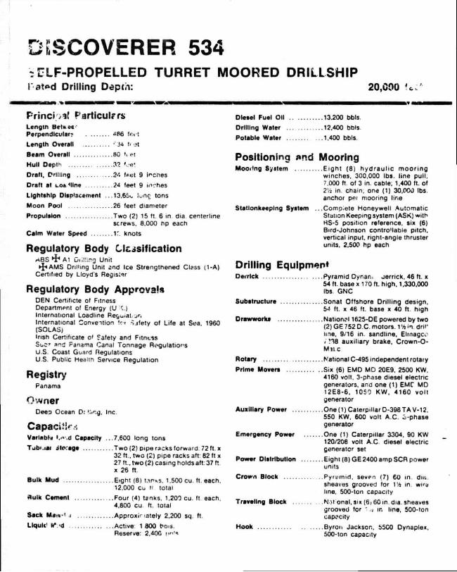
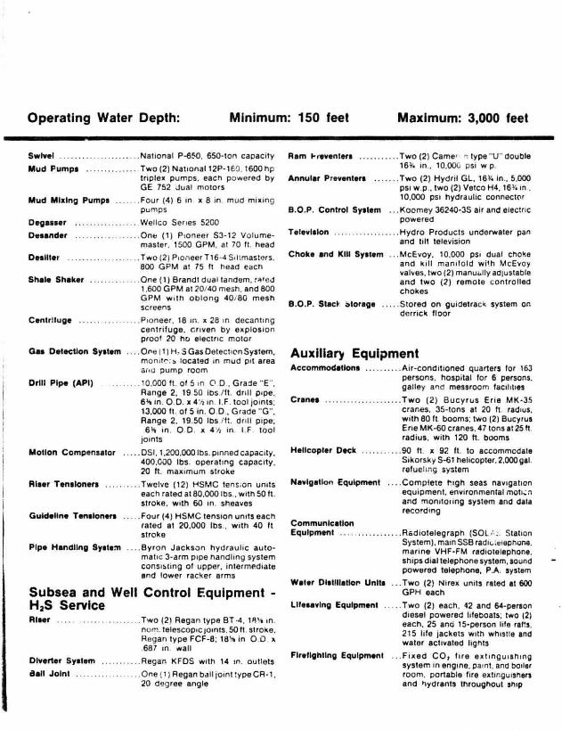
DISCOVERER 534 3 S3LF-PROPELLED TURRET MOORED DRILLSHIP rated Drilling Depth: 20,090
Principal Particulars Lcngtn B t l « H
Perpendicular? te»'1
Length Overall ' 34 1/ ot
Beam Overall 80 t, el
Hull Depth 32 »oe«
Dratl. Orllllng 24 f#>et 9 Irenes
Draft at cofMlne 24 feet 9 inches
Lightship Displacement ...13,65c long tons
Moon Pool 26 feet diameter
Propulsion Two (2) 15 ft 6 in dia centerline screws. 8.000 np each
Calm Water Speed If. knots
Regulatory Body Ossi f icat ion A B S *$* Al DI;!!:.";} Unit
• I * AMS Drilling Unit ond Ice Strengtnened Class (1-A) Certified by Lloyd's Register
Regulatory Body Approvals DEN Certificte of Fitness Department of Energy (U <.) International Loadline Reguiat ion International Convention U•< ^ j fe ty of Life at Soa. 1960 (SOLAS) Irish Certificate o' Safety and Fitness Suc» a n d Panama Canal Tonnage Regulations U.S. Coast Guard Regulations U S. Public Health Service Regulation
Registry Panama
Owner
Deep Ocean Or ':>r-.g. Inc.
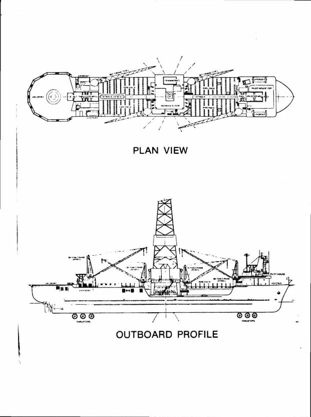
Variable »..»-.d Capacity ...7.600 long tons Tub).UN atorage Two (2) pipe racks forward 72 ft. x 32 ft., two (2) pipe racks aft: 82 ft x 27 ft., two (2) casing holds aft: 37 ft x 26 ft.
Bulk Mud Eight (8) t/ irxs. 1.500 cu. ft. each. 12.000 CL. II total
Bulk Cement Four (4) tanks. 1.200 cu. ft each.
4.800 cu ft. total
Sack MJ•< 1 .) Approximately 2.200 sq. ft
Llqulc' tV.-d Active 1 800 bo.s. Reserve: 2.400
Diesel Fuel Oil 13.200 bbls
Drilling Water 12.400 bbls
Potable Water 1.400 bbls.
Positioning nnd Mooring Mooring System Eight (8) hydrau l ic moor ing
winches. 300.000 Ibs. line pull. 7.000 ft of 3 in. cable; 1.400 ft. of 2Vj in. chain, one (1) 30.000 Ibs. anchor pei mooring line
Stationkeeping System ...Comp.ete Honeywell Automatic Station Keeping system (ASK) with HS-5 position reference, six (6) Bird-Johnson contro'lable pitch, vertical input, right-angle thruster units. 2.500 hp each
Drilling Equipment Derrick Pyramid Dynan. jernck. 46 ft. x
54 ft. base x 170 ft. high. 1.330.000 Ibs. GNC
Substructure Sonat Offshore Dril l ing design. 54 ft. x 46 ft. base x 40 ft high
Drawworks National 1625-DE powered by two (2) GE 752 D.C. motors. TA in dri l ' me. 9/16 in. sandline, Elmagc^' . ?38 auxiliary brake. Crown-O-M«c
Rotary National C-495 independent rotaiy
Prime Movers Six (6) EMD MD 20E9. 2500 KW. 4160 volt. 3-phase diesel electric generators, and one (1) EMC MD 12E8-6. 1050 KW. 4160 volt generator
Auxiliary Power One(1)CaterpiilarD-398TAV-12. 550 KW. 600 volt A C . phase generator
Emergency Power One (1) Caterpillar 3304. 90 KW 120/206 volt A C diesel electric generator set
Power Distribution Eight (8) GE 2400 amp SCR power units
Crown Block Pyrumid. seven (7) 60 in. din. sheaves grooved for IU in wiry line, 500-ton capacity
Traveling Block Not onal. six (6,60 in. dia. sheaves grooved for ' a in line. 500-ton capacity
Hook Byron Jackson. 55C0 Dynaplex. 500-ton capacity
Operating Water Depth: Minimum: 150 feet Maximum: 3,000 feet
Swlve' National P-650. 650-tcn capacity
Mud Pumps Two (2) National 12P-160.1600 hp triplex pumps, each powered by GE 752 dual motors
Mud Mixing Pumps Four (4) 6 in. X fl in mud mixing pumps
Degasser Wellco Series 5200
Desander One (1) Pioneer S3-12 Volume-master. 1500 GPM. at 70 ft. head
Desilter Two (2) Pioneer Tl6-4Siltmasters. 800 GFM at 75 ft head each
Shale Shaker One (1) Brandt dual tander rated 1.600 GPM at 20/40 mesh, d 800 GPM wi th ob long 10/80 mesh screens
Centrifuge Pioneer. 18 in. x 28 in. decanting centrifuge, driven by explosion proof 20 hp electric motor
Gaa Detection System .C»ie(l)H,S Gas Detection System. monitors located in mud pit area and pump room
Orill Pipe (API) 10.000 ft. of 5 in. O.D . Grade "E". Range 2. 19 50 Ibs./ft. drill pipe; 6H in. O O. x 4'-. in. I.F. tool joints: 13.000 tt. of 5 in. O.D.. Grade "G" . Range 2. 19 50 lbs /ft. drill pipe; 6H in. O.D. x A'/i in I.F. tool
joints
Motion Compensator DSI. 1.200.000 lbs. pinned capacity. 400.000 lbs. operating capacity. 20 ft. maximum stroke
Riser Tensioners Twelve (12) HSMC tension units each rated at 80.000 lbs., with 50 ft. stroke, with 60 in. sheaves
Guideline Tensioners Four (4) HSMC tension units each rated at 20,000 lbs . with 40 ft stroke
Pipe Handling System . . .Byron Jackson hydraulic automatic 3-arm pipe handling system consisting of upper, intermediate and lower racker arms
Subsea and Well Control Equipment -H 2S Service Riser Two (2) Regan typo BT-4. 18S in
nom. telescopic joints. 50 ft stroke. Regan type FCF-8; 18H in O.D. x .687 in. wall
Diverter System Regan KFDS with 14 in. outlets
Ball Joint One (1) Regan ball |omt type CR-1. 20 degree angle
Ram Preventers Two (2) Cameron type "U " double 16% in.. 10.000 psi w p.
Annular Preventers Two (2) Hydnl GL. 16'. in., 5.000 psi w p.. two (2) Vetco H4.16V. in.. 10.000 psi hydraulic connector
B.O.P. Control System ...Koomey 36240-3S air and electric powered
Television Hydro Products underwater pan and tilt television
Choke and Kill System McEvoy. 10.000 psi dual choke and kill manifold with McEvoy valves, two (2) manually adjustable and two (2) remote controlled chokes
B.O.P. Stack Storage Stored on guidetrack system on derrick floor
Auxiliary Equipment Accommodations Air-conditioned quarters for 163
persons, hospital for 6 persons, galley and messroom facilities
Crane* Two (2) Bucyrus Erie MK-35 cranes. 35-tons at 20 ft. radius, with 80 ft. booms, two (2) Bucyrus Erie MK-60 cranes. 47 tons at 25 ft. radius, with 120 ft. booms
Helicopter Deck 90 tt. x 92 ft. to accommodate Sikorsky 5-61 helicopter. 2.000 gal.
fueling system
Navigation Equipment Complete high seas navigation equipment, environmental motion and monitoring system and data recording
Communication Equipment Radiotelegraph (SOLAS Station
System), main SSB radiotelephone, marine VHF-FM radiotelephone, ships dial 'elephone system, sound powered telephone. P.A. syslem
Water Distillation Units . . .Two (2) Nirex units rated at 600 GPH each
Lifesaving Equipment Two (2) each. 42 and 64-person diesel powered lifeboats: two (2) each. 25 and 15-person life rafts. 215 life jackets with whistle and water activated lights
Firefighting Equipment . . .F ixed CO, fire extinguishing system in engine, paint, and boilsr room, portable fire extinguishers and hydrants throughout ship
Operating Water Depth: Minimum: 150 feet Maximum: 3,000 feet
Swivel National P-650. 650-ton capacity
Mud Pumpa Two (2) National 12P-160.1600 hp triplex pumps, each powered by GE 752 dual motors
Mud Mixing Pumps Four (4) 6 in. x 8 in. mud mixing pumps
Degasser Wellco Senes 5200
Desander One (1) Pioneer S3-12 Volume-master. 1500 GPM, at 70 It. head
Oeailter Two (2) Pioneer T16-4 SiHmastors. 800 GPM a! 75 ft head each
Shale Shaker One (1) Brandt dual tandem, rated 1.600 GPM at 20/40 mesh, and 800 GPM with oblong 40.80 mesh screens
Cenlrlluge Pioneer. 18 in x 28 in decanting centrifuge, cnven by explosion proo' 20 ho electric motor
Gaa Detection System . . On-.' (1) H . S Gas Detection System, monitor a located in mud pit area and pump room
Drill Pipe (API) 10.000 ft. of 5 in C D , Grade "E". Range 2. 19 50 lbs /ft. drill pipe. 6H in. O D. x 4V, in I.F. tool joints; 13.000 ft. of 5 in. O O , Grade "G" . Range 2. 19.50 lbs /ft. drill pipe. 6H in. O.D. x 4Vj in I F tool
joints
Motion Compensator DSI. 1,200.000 Ibs. pinned capacity. 400.000 Ibs. operating capacity. 20 ft. maximum stroke
Riser Tensioners Twelve (12) HSMC tens.on units each rated at 80.000 Ibs.. with 50 ft. stroke, with 60 in. sheaves
Guideline Tensioners Four (4) HSMC tension units each rated at 20.000 lbs . with 40 ft stroke
Pipe Handling System — B y r o n Jackson hydraulic automatic 3-arm pipe handling system consisting ol upper, intermediate and lower racker arms
Subsea and Well Control Equipment -H 2S Service Riser Two (2) Regan type BT-4, tf l% in.
nom. telescopic joints. 50 ft stroke, Regan type FCF-8; 18H in 0 . 0 x .687 in wall
Diverter System Regan KFDS with 14 in. outlets
dall Joint One ( i ) Regan ball joint typeCR-1. 20 degree angle
Ram kreventera Two (2) Came' n type "U" double 16V. in., 10.000 psi w p.
Annular Preventers Two (2) Hydrii GL. 16V. in.. 5,000 psi w p., two (2) Vetco H4.16V. in . 10.000 psi hydraulic connector
B.O.P. Control System .. .Koomey 36240-3S air and electric powered
Television Hydro Products undorwater pan and tilt television
Choke and Kill System ...McEvoy. 10.000 psi dual choke and kill maniloid with McEvoy valves, two (2) manually adjustable and two (2) remote controlled chokes
B.O.P. Slacr atorage Stored on guidetrac* system on derrick floor
Auxiliary Equipment Accommodations Air-conditioned quarters for 163
persons, hospital for 6 persons, galley and messroom facilities
Cranea Two (2) Bucyrus Erie MK-35 cranes. 35-tons at 20 ft. radius, with 80 ft booms; two (2) Bucyrus Erie MK-60 cranes. 47 tons at 25 ft radius, with 120 ft. booms
Helicopter Deck 90 ft x 92 ft. to accommodate SikorskyS-61 helicopter. 2,000 gal refueling system
Navigation Equipment Complete high seas navigation equipment, environmental motion and monitoiing system and data recording
Communication Equipment Radiotelegraph (SOL- . Station
System), mam SSB radn-.eiephone. marine VHF-FM radiotelephone, ships dial telephone system, sound powered telephone, P.A. system
Water Distillation Units . . .Two (2) Nirex units rated at 600 GPH each
Lifesaving Equipment Two (2) each, 42 and 64-person diesel powered lifeboats; two (2) each. 25 and 15-person life rafts, 215 life jackets with whistle and water activated lights
Firefighting Equipment . . .F ixed CO, fire extinguishing system in engine, paint, and boiler room, portable fire extinguishers and hydrants throughout ship
OUTBOARD PROFILE
1
i
MAIN DECK
*n—iLi H K.iS r-i .....
MACHINERY DECK
DISCOVERER 534
WELL PRESSURE CONTROL EQUIPMENT
DISCOVERER 534
WELL PRESSURE CONTROL EQUIPMENT
DIVERTER AND FLOW LINE SYSTEM
Manufacturer
Type:
Housing I.D.
Diverter Size
Pressure Rating
Flowline Dia.
B a l l Joint Type
Huhges Offshore
KFDS
47" (Nom 49%")
24" Nom
500 PSI
14" Nom
DR-1
The following sketch shows the flow l i n e arrangement.
DISCOVT "R 534 DIVERTER AND FLO IE ARRANGEMENT
i
BOP AND LMRP
Specifications:
"Rams:
Brand
Pressure Rating
ze
Quantity
"Annulars:
Brand
Pressure Rating
Size
Quantity
"Wellhead Connector:
Brand
Model
Siz*
Pressure Rating
Quantity
"Riser Connector:
Brand
Type
Model
Size
Pressure Rating
Quantity
NL Shaffer SL Poslo~k
10,000 PSI
18-3/4" Double Ram
2 Each
NL Shaffer Spherical
5000 PSI
18-3/
2 Each
Vetco
H-4
18-3/4"
10,000 PSI
1 Each
Vetco
High Angle Release
H-4
18-3/4"
10,000 PSI
1 Each
BOP AND LMRP (Continued-
"Flex J o i n t :
Brand
Size
Quantity
Vetco
18-3/4'
1 Each
"Choke and K i l l Valves
Brand
Model
Size
W.P.
McEvoy
EDU
3-l/16 H
10,000 PSI
•Choke and K i l l Hosec
Brand
W.P.
Coflexip
10,000 PSI
"Control Pods
Brand
Size
Valvcon (Hydrii)
56 Line
Working from the bottom up, the BOP stack consist of the Vetco wellhead connector, a set of double ram BOPs containing 5" pipe rams i n both c a v i t i e s , another set of double ram BOPs with 5" pipe i n the lower c a v i t y and b l i n d shear rams i n the upper c a v i t y , a spher :cal BOP, and a high angle release mandrel to match the LMRP connector. The LMRP consist of the high angle release connector, a spherical BOP, and a fl e x j o i n t w i t h a r i s e r adaptor.
The stack has a t o t a l of 4 o u t l e t s , each with double valves. The lowest i c below the lowest ram. The next higher one i s below the second ram from bottom and the next one up i s below the shear rams which are Ln the top ram c a v i t y . The highest o u t l e t i s below the spherical BOP which i s i n the LMRP and may be used to bleed of a gas bubble trapped under that EOP.
The BOP guide frame i z guideline/guidelineless with retractable pods so that i t can be used guidelineless without damagir-' the pod stabs.
H?S CERTIFICATION
1 Ae D534 we l l c o n t r o l system was b u i l t i n 1975 and a l l piping
f i t t i n g s etc. were i n compliance to NACE standards i n e f f e c t
that time. A l l welding procedures and welders were q u a l i f i e d
to H2S standards.
The new BOP and r i s e r system comr.ly with current NACE
spe c i f i c a t i o n s .
CHOKE AND KILL MANIFOLD:
The choke manifold has two Swaco hydraulic chokes with
separate control panels and two Cameron manual chokes. The 10,000
PSI side has 17 Rockwell (McEvoy) Model E valves of 3-1/16" bore
und the J,000 PSI side has 11 Pockwell valves of 4" bore.
Following i s a schematic and parts l i s t of the choke and k i l l
in-.ni f o l d .
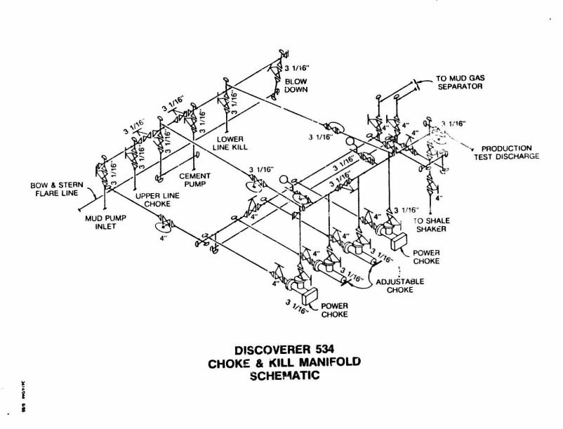
DISCOVERER 534 CHOKE & KILL MANIFOLD
SCHEMATIC
AIR QUALITY INFORMATION
Information required by 30 CFR 250.56-1 is included for the f a c i l i t y described in this Plan of Exploration.
The calculations made under the provisions of 30 CFR 250.57-1(d) indicate that the f a c i l i t y is exempt from further quality review. The information and calculations are attached.
1C6/1702 -(17)
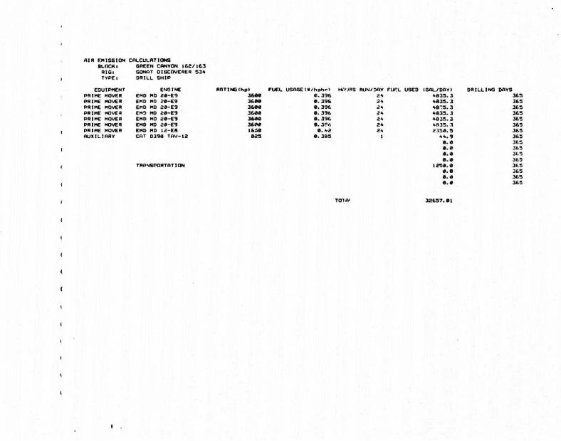
AIR EMISSION CALCULATIONS BLOCKi 6REEN CANVON I62/1S3 RIGl SONAT DISCOVERER 334 TVPEi DRILL SHIP
EOUIPMENT ENGINE R A T I N O I h p l FUEL U S A G E I R / h p h r l HOURS) RUN/DOV FUFL USED (OAL/DflVI OR I L L I N O DAVS PRIME MOVER EMO MD 2 * - E 9 3 6 M « . 3 9 6 2 * 4 8 3 3 . 3 3 6 3 PRIME MOVER EMD MD ? « - E 9 3 6 8 * 8 . 3 9 6 2 * 4 8 3 3 . 3 363 PRIME MOVER EMO MD J J - E 3 MMM • . 396 24 * a - s . 3 3 6 3 PRIME MOVER EMO MO 2 4 - E 9 3C4M a . 3 9 6 2 * * 8 3 3 . 3 3 6 3 PRIME MOVER EMO MD 2 « - E 9 MMM B. 3 9 6 2 * 4 8 3 3 . 3 3 6 3 PRIME MOVER EMD MD 2<d-E9 a . 3 ? * 2 * 4 8 3 3 . 3 363 PRIME MOVER EMD MD 12 -ES i iM a. -a 2". 235<9. S 3 6 3 A U X I L I A R Y CAT 0 3 9 8 T A V - 1 2 8 2 3 • . 3B3 I 4 4 . 9 363
a. a 3 6 3
a. a 363
a. a 363
a. a 363 TRANSPORTATION m a . a 3 6 3
a. a 363
a. a 3 6 3
a. a 3 6 3
TOTA" 32637.at
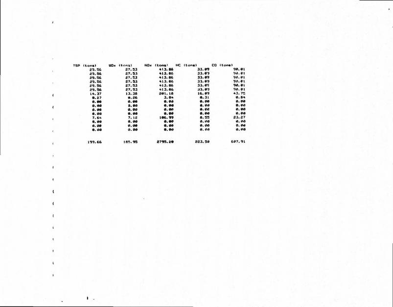
s n s ) S O N <*ona> " O - ( t o n m i 2 7 . 3 6 2 7 . 3 3 4 ( 3 . M 2 3 . 3 6 2 7 . 3 3 4 1 3 . M 2 9 . 3 6 2 7 . 3 3 4 1 3 . 6 6 2 9 . 3 6 2 7 . 3 3 4 ( 3 . 8 6 2 9 . 3 6 2 7 . 3 3 4 1 3 . 8 6 2 9 . 3 6 2 7 . 3 3 4 ( 3 . 8 6 1 4 . 3 7 1 3 . 3 8 M t . 18
8 . 2 7 8 . 2 6 3 . 8 4 8 . 8 8 8 . 8 8 0 . 8 * 8 . 8 8 B. 8 8 S . M 8 . 8 8 0 . 8 8 8 . 8 8 8 . 8 8 8 . 8 8 8 . 8 8 7 . 6 4 7 . 12 1 8 6 . 9 9 8 . 8 8 8 . 8 0 8 . 8 8 0 . 88 8 . 8 8 8 . 8 8 8 . 0 0 0 . 8 0 8 . 8 0
1 9 9 . 6 6 1 8 3 . 9 3 2 7 9 3 . 2 8
1
• ) CO 3 3 . 0 9 3 3 . 8 9 3 3 . 8 9 3 3 . 8 9 3 3 . 8 S 3 3 . 8 9 1 6 . 8 9
• . 3 1 8 . 0 8 8 . 0 0 0 . 8 0 8 . 8 0 8 . 3 3 0 . 0 0 8 . 0 0 0 . 0 0
9 0 . 0 1 9 0 . 01 9 0 . 0 1 9 0 . 0 1 9 0 . 01 9 0 . 0 1 4 3 . 73
0 . B 4 0 . 0 0 8 . 0 0 0 . 0 0 0 . 0 0
2 3 . 2 7 0 . # 0 0 . 0 0 0 . 0 0
2 2 3 . 3 0 6 0 7 . 9 1
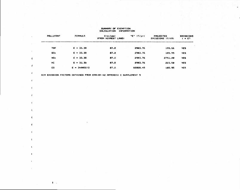
SUMMARY OF EXEMPTION CALCULATION INFORMATION
0 < M l t « a l " E " ( T / y r ) (FROM NEAREST LOND)
PROJECTED EMISSIONS EMISSIONS ( T / V R ) ( - £•»
TSP
SO.
NO.
MC
CO
E - 3 3 . 3D
E - 3 3 . 3 D
C - 3 3 . 3D
E - 3 3 . 3 6
E - 3 4 M D 3 / 3
6 7 . 2
8 7 . 2
8 7 . 2
8 7 . 2
B 7 . 2
2 9 8 3 . 7 6
2 9 8 3 . 7 6
2 9 8 3 . 76
2 9 8 3 . 76
6 6 8 6 8 . «.-.
( 9 9 . 6 6 VES
( 8 3 . 9 3 VES
2 7 9 . 3 . 2 8 VES
2 2 3 . 3 8 VES
( 8 3 . 9 3 YES
A I R EMISSION FACTORS OBTAINED FROM EPA-OP -42 A P P E N D ! ! C SUPPLEMENT 9
Sun Exploration and Production Company, as Operator, believes th is i n
formation submitted separately f ron Exploration Plan fo r OCS G 7025/7026
Green Canyon Block 162/163 to be exempt from disclosure. Sun requests
that the data and information enclosed herewith be dispersed for use
only by the United States Government.
Geological information provided includes:
1. Structural maps.
2. Cross Section.
1C6/1702 - (20)
"DATA AND INFORMATION CONSIDERED
EXEMPT FROM DISCLOSURE"
IN THE
EXPLORATION PLAN
OCS 6 7025/7026
GREEN CANYON BLOCK 162/163
FEDERAL OFFSHORE, LOUISIANA
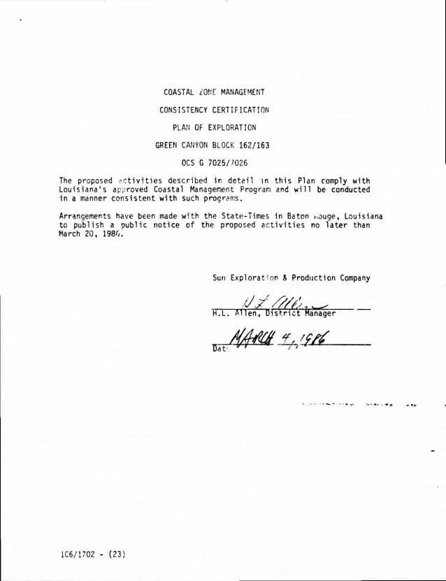
COASTAL LOME MANAGFMENT
CONSISTENCY CERTIFICATION
PLAN OF EXPLORATION
GREEN CANYON BLOCK 162/163
OCS G 7025//026
The proposed activities described ir. detail in this Plan comply with Louisiana's approved Coastal Management Progran and will be conducted in a manner consistent with such programs.
Arrangements have been made with the Stato-Times in Baton i.ouge, Louisiana to publish a public notice of the proposed activities no later than March 20, 1980.
Sun Exploration & Production Company
•J/////-.. H.L. Allen, District Manager
1C6/1702 - (23)
A Shallow Hazard Survey was completed in April 1985. Three copies of this report, are enclosed.
1C6/1702 - (24)
ENVIRONMENTAL REPORT
PLAN OF EXPLORATION OCS G-7025/7026
GREEN CANYON BLOCK 162/163
Sun Explora*ion and Production Company
February 21, 1986
Contact: A. B. Norwood Conservation Manager Sun Exploration and Production Company P.O. Box 1501 Houston, Texas 77251 Phone: 713/531-2158
1C6/1702A
TABLE OF CONTENTS
Page
Title Page i
Table of Contents i1
1.0 DESCRIPTION OF THE PROPOSED ACTION 1
?.0 DESCRIPTION CF THE AFFECTED ENVIRONMENT AND IMPACTS 2
2.1 Physical and Environmental Parameters 2
2.1.1 Commercial Fishing 2
2 1.2 Shipping 2
2.1.3 Small Craft Pleasure Boating, Sport Fishing,
and Recreation 3
2.1.4 Cultural Resources 3
2.1.5 Ecologically Sensitive Areas 3
2.1.6 Existing Pipelines/Cables 4
2.1.7 Other Mineral Uses 4
2.1.8 Ocean Dumping Grounds 4
2.1.9 Endangered/Threatened Species 4
2.2 Socioeconomic Parameters 4
3.0 UNAVOIDABLE ADVERSE ENVIRONMENTAL EFFECTS OF THE
PROPOSED ACTION 6
4.0 GUARANTEE 6
5.0 REFERENCES 7
1.0 DESCRIPTION OF THE PROPOSED ACTION
A "Plan of Exploration" for Green Canyon Area, Lease Block No. 162/163 (Sun Exploration and Production Company, 1986) is being submitted concurrently with th is "Environmental Report" by Sun Exploration and Production Company. Please refer to that report for a description of the proposed exploration ac t i v i t i e s for the referenced lease block. Additional data, required by the "Guidelines For Preparation of An Environmental Report, for Coastal Management Consistency Determination by the States of Alabama, Louisicna, ?nd Green" (U.S.G.S., 1980), is presented in the fol lowing paragraphs.
Sun Exploration and Production Company presently has a support base at Sabine Pass, Texas (approximately 215 miles from the s i t e ) , and an exist ing major mud company f a c i l i t y at Fourchon, Louis**."* {c JX-imately r90 miles from the s i te ) wi l ' i be used for expl''5"?' cr< # u«w -t i es . These f a c i l i t i e s are described *n the explorat1 So new support f a c i l i t i e s or new workers arf- anticipated >S _ i i.f the proposed a c t i v i t y .
Helicopters, work boats, and cr * bofts w u t i l i zed for transporting personnel and supplies tu the are >»i Sabine Pais, Texas and Dulac, Louisiana. A hel icopter w i l t make one to two t r ips dai ly during d r i l l i n g operations. ' ert * boat or supply boat w i l l make one t r i p per day on an average. The route t ra /a i led w i l l normally be d i rect trom tlie base to thp i l r i l : .ng s u e .
A contingency plan for preventing, report ing, and cleaning up sp i l l s of o i l or waste materials i •> presented in che Plan of Explorat ion (Sun Exploration and Production Company, 1986) I P the section ent i t led "Environmental Safeguards." Addi t ional ly , Sun Exploration and Production Company's Oil Spi l l A ler t Procedure for the Gulf of Mexico is on f i l e with the Minerals Management Service (M.M.S.) of f ices 1n the Gulf of Mexico area.
Calculations of a i r pol lutant emissions are presented in the Plan of Exploration (Sun Exploration and Production Company, 1986). A l i s t of d r i l l i n g mud materials to be u t i l i z e d is also presented 1n that report, along with the project v i c i n i t y map.
There w i l l be no o'her new or unusual ac t i v i t y associated with the project.
(1)
2.0 DESCRIPTION OF THE Al i . ~LC ENVIRONMENT Af." IMPACTS
A description of the effected ervlronriient in the area of Green Canyon Block 162/163, Ir presented in the "Final Regional Environmental Imp ct Statement, G^lf of Mexico" ( U . ' . D . ! . , M.M.S., !°R3). Please refer tc that decumant where aodit iunal data for th« project area is require .. The f< owing sections contain « br ief summary of the physical, e vironmentaI, and socioeconomic parameters of the area.
2.1 Physical and Fnvironmental Parameters
2.1.1 Commercial Fishing
Fisheries resources provid.* a viable industry in the Guli of Mexico, with 3 1979 value of $530.1 m i l l i on (U.S.D. I . , 1981). The major f ish ing ports near the lease block are Dulac-Chsuvin and Cameron, Louisiana. The f isher ies nf the Gulf of Mexico j re dominated by estauHne associated shell f isher ies* shr1mpf crab, and oysters (with smaller amounts of clam and sca l lop : ) , Tho western C 1 f shrimp fishery is comprised mainly of brown and white shrimos. Louisiana contributes nearly half the oysters harvested ir ' - Gulf annually. The major f in f isher ies in the western Gulf ar< for industr ia l f ishes, with menhaden dominating in the area f r c Green through the area o f f Galveston, Texas (U.S .D. I . , 1978).
In Louisiana, shrimp (pr imar i ly brown and whit . j) constitutes the most important f i shery , followed by menhaden and oyster f ishery. Shrimp and oysters are estuarine associated species and are centered on the mud and sand bottims o f f the coast of Louisiana. Menhaden occur 1n the shallow waters, with about 93 percent of this f ishing occurring within 10 miles of shore. Green Canyon Area, Block 162/163 1s lo cated approximately 80 miles from land. Due to th is distance, i t 1s unlikely that operations w i l l in ter fere with commercial f i sh ing.
2.1.2 Shipping
Gulf shipping 1s both intercoastal and international, with barges and supertankers competing for harbor and river space. In the open Gulf, ships have to compete with barges, fishing vessels, oil and gas platforms supply boats, and recreational vessels; however, accidents are rare and safety fairways are well known. A more detailed description of shipping in the area is presented in Section I I . C.I.E., Transportation, pages Ii-57 throuoh 11-64, of the final EIS for Lease Sale No. 51 (U.S.D.I., 1978),
The pcssibility that a ship will collide with the facility is minimal, since the facility ar.d associated activities i 11 be located
(2)
outside of fairways and t rans i t lanes. Green Canyon Area, Block 162/163, is located approximately 12 miles from the nearest fairway (U.S.D. I . , M.M.S., 1983).
2.1.3 Small Craft Pleasure n oa t i ng . Sport Fishing, and Recreation
The northern Gulf of Mexico coastal zone is a major recreational area for saltwater f ish ing and beach-oriented ac t i v i t i e s . Shel l f ishing and small boat pleasure boating are also major recreational a c t i v i t i e s . Boats 16 feet or greater are potent ia l ly capable of venturing offshore.
2.1.4 Cultural Resources
There are no known cul tura l resources in the area of the proposed s i te and the potential for occurrence of cul tural resources in the area is low. Lease st ipulat ions do not require an archaeological survey to be performed; however, a geophysical survey performed in Ju ly , 1984 (Marine Technical Sources, Inc. 1984) did not indicate any anomalies in the area.
2.1.5 Ecologically Sensitive Areas
The Gul f of Mexico coastal zone includes publicly owned areas such as naticnal seashores, parks, beaches, and w i l d l i f e lands, as well as specially designated preservation areas, sjch as h is to r i c and natural sites and landmarks, wilderness areas, w i l d l i f e sanctuaries, and scenic r ivers . Ac t i v i t ies in the area of the proposed s i te are regulated by Louisiana's Coastal Zone Management Program. A more detailed description of parks and refuges in the Gulf area is presented in the f inal EIS for Lease Sale No. 51 , Section I I . C L E . (1 ) ; however, there are no parks or refuges in the v i c in i t y of the proposed ac t i v i t y and the proposed ac t i v i t y is not expected to a f fect such an area.
Lease Block 16<.'/163 is located approximately 80 miles fron shore. Due to this distance, routine operations w i l l not a f fect Louisiana's sensitive coastal areas. I t is also unl ikely that a blowout or o i l sp i l l would occur which would reach these sensitive areas. In the event of a non-routine incident, such as a blowout or an o i l s p i l l , p r io r i t y w i l l be given to protection of sers i t ive areas.
The hard bottom area nearest Green Canyon Area Lease Block 162/163 is Diaphus Bank, approximately 23 miles from the Block, (U.S.D. I . , M.M.S., 1983). Routine operations are not l i ke ly to af fect th is bank. In the event of a blowout or o i l s p i l l , p r i o r i t y w i l l be given to protection of these banks.
2.1.6 Existing Pipelines/Cables
There are no known pipelines in this block.
2.1.7 Other Mineral Uses
There are no known mineral deposits of commercial importance within the lease block and potential is low for impacts to mining activities occurring outside the lease block.
2.1.8 Ocean Dumping Grounds
There are no known ocean dumping sites in the area of the proposed site. 2.1.3 Endangered/Threatened Species
Several federally designated endangered species occur, either on a permanent or transitional basis, within the region of Green Canyon Block Mo. 162/163 (U.S.D.I., 1979). These species include the sei, f i n , blue, right, and sperm whales, which occur in the central and western Gulf of Mexico. The red wolf may be found along the Gulf coast in Chambers and Jefferson Counties, Texas, and Cameron and Vermilion Parishes, Louisiana. Additionally, populations of whooping cranes, bald eagles, brown pe". .cans, Attwater's prairie chickens, American alligators, and Kemp's Ridley sea turtles are known to nest in the coastal areas of the western Gulf of Mexico.
The potential for impact from this project on these endangered species is low, since the proposed activity will take place approximately 77 miles from shore. In the event of a non-routine incident, such as a blowout or oil s p i l l , priority will be given to the protection of any endangered species in the area.
2.2 Socioeconomic Parameters
Economic activity in the Gulf coastal area is dependent upon its abundance of natural resources, including oil and gas and support industries, commercial fishing, and recreation and tourism. Major transportation systems, such as the Green River, are the basis for port activity, which is significant to local, regional, and national economies. A more detailed description of the socioeconomic environment is presented in Section III.C. of the final EIS for Lease Sales A66 and 66 (U.S.D.I., 1980).
(4)
No expansion of the existing shore base fac i l i t y is expected as a result of the proposed activities. Additionally, there will be no new employment as a result of the proposed activities.
(5)
3.0 UNAVOIDABLE ADVERSE ENVIRONMENTAL EFFECTS OF THE PROPOSED ACTION
Unavoidable adverse effects of the proposed action will be minimal. They can be summarized as follows:
(1) the normal and routine activities of oil and ̂ as exploration and development operations will pvoduue nu significant long-term adverse environmental e'ft-tS, although 1n a few instances (pipeline construepon, muds and cuttirgs disposal, etc.), short-term local adverse effects, such as an increase in air emissions and water turbidity during d r i l l i n g operations, may result; and
(?) non-routine incidents, such as blowouts and oil spllis, may produce significant and longer-term adverse effects, depending on the location and size of the incident, but the likelihood of such an incident occurring in or near an area where the effects would be significant (in shallow water, near a shore, in wetland, etc.) is statistically very small.
The proposed project will help to meet current energy demands without continued dependence on foreign imports. Because i t will contribute significant beneficial energy needs and economic gains for the United States, with only a negligible sclverse effect on the environment, Sun Exploration and Production Ccmpany believes the project is justified aid should be approved as proposed.
4.C GUARANTEE
The proposed activity will be carried out and completed with the guarantee of the following items:
(1) the best available and safest technologies will be u t i lized throughout the project. This includes meeting all applicable requirements for equipment types, general project layout, safety systems, and equipment and monitoring systems;
(2) a l l operations will be covered by a M.M.S.-approved oil spill contingency plan; and
(3) a l l applicable Federal, State, and local requirements regarding air emissions and water quality and discharge for the proposed activities, as weT. as any other permit conditions, will be complied with.
(6)
5.0 REFERENCES
Leipper, D. F. 1954, Physical oceanography of the Gulf of Mexico. In: Gulf of Mexico, its origin, waters and marine l i f e . P. S. Galtsoff (ed.). Fishery Bulletin 89. Fish and Wildlife Service, U. S. Dept. of the Int., Washington, D.C. 55: 199-138.
MTS 1985 A Geophysical Survey Report, Green Canyon Area, Block 162/163, Offshore Louisiana, OCS-G-7025/7026.
Sun Exploration and Production Company. 1985. Plan of Exploration, Green Canyon Area, Lease Block No. 162/163, March, 1986.
U.S. Departnent of Interior, Bureau of Land Management (U.S.D.I.). 1978. Proposed 1978 outer continental shelf oil and gas lease sale, offshore western ar.d central Gulf of Mexico, OCS Sale #51, draft environmental impact statement. Washington, D.C.
. 1979. Final environmental impact statement; OCS Sale 58. Proposed 1979 OCS oil and gas lease Sale 58: western and central Gulf of Mexico. 2 vols. Washington, D.C. vol. 1.
. 1980. Final environmental impact statement; OCS oil and gas proposed 1981 Sales A66 and 66, prepared by the New Orleans Outer Continental Shelf Office, New Orleans, Louisiana.
. 1981. Final environmental impact Statement; proposed OCS oil and gas Sales 67 and 69; prepared by the New Orleans Outer Continental Shelf Office, New Orleans, Louisiana.
U.S. Department of the Interior, Geological Survey. (U.S.G.S.). 1980. Guidelines for preparing an outer continental shelf environmental report for coastal Management Consistency Determination by the States of Alabama, Louisiana and Green, Washington, D.C.
U.S. Department of Interior, Minerals Management Service (U.S.D.I., M.M.S.). 1983. Final regional environmental impact statements, Gulf of Mexico, volumes I and I I . Metairie, Lou1s4**>3..
(9)


![SOUTH SUDAN : [as of October 2017] 162 · 2018-03-13 · County ndex CCCM Education ES & NFIs FSL Health Nutrition Protection WASH Logistics SOUTH SUDAN: Operational Presence (3W:](https://img.pdfslide.us/doc/110x75/5e995a88a32df027f35cc3e7/south-sudan-as-of-october-2017-162-2018-03-13-county-ndex-cccm-education-es.jpg)