Embed Size (px)
Citation preview
Lynn D. Preheim PARTNER
DIRECT: 316.268.7930
OFFICE: 316.265.8800
1625 N. Waterfront Parkway, Suite 300, Wichita, KS 67206
DB04/0805058.0003/13546081.1
August 14, 2019
Mike Beam Secretary of Agriculture Kansas Department of Agriculture 1320 Research Park Drive Manhattan, KS 66506 Email: [email protected]
Re: In the Matter of the U.S. Fish and Wildlife Service's Impairment Complaint filed on behalf of the Quivira National Wildlife Refuge File No. 7,571
Dear Secretary Beam:
Enclosed please find a Petition for Review of Chief Engineer's Rejection of GMD 5's Proposed LEMA Plan and a Petition for Stay of Proceedings Pending Resolution of Big Bend Groundwater Management District 5's Petition for Review for filing in the above matter.
Sincerely,
Stinson LLP
/s/Lynn D. Preheim
Lynn D. Preheim
LDP:kla
Enclosures
cc: Kenneth Titus ([email protected]) David Barfield ([email protected]) Darrell Wood ([email protected]) Orrin Feril ([email protected]) Fred Grunder ([email protected]) John Janssen ([email protected]) Tom Taylor ([email protected])
Aug 14 2019
1
BEFORE THE KANSAS DEPARTMENT OF AGRICULTURE 1320 Research Park Drive
Manhattan, Kansas 66502
In the Matter of the U.S. Fish and Wildlife
Service's Impairment Complaint filed on
behalf of the Quivira National Wildlife
Refuge.
FILE NO. 7,571
PETITION FOR REVIEW OF CHIEF ENGINEER'S
REJECTION OF GMD 5'S PROPOSED LEMA PLAN
Big Bend Groundwater Management District 5 ("GMD 5") asks the Secretary of
Agriculture to review the July 30, 2019 order of the chief engineer of the Division or Water
Resources ("DWR") rejecting GMD 5's proposed Local Enhanced Management Area ("LEMA")
plan aimed at solving the impairment complaint filed by the U.S. Fish and Wildlife Service (the
"Service") on behalf of the Quivira National Wildlife Refuge (the "Refuge"). The Secretary may
review the chief engineer's order pursuant to K.S.A. §§ 77-527 and 82a-1901.
BASIS FOR PETITION
K.S.A. § 82a-1041 (the "LEMA Statute") states that whenever a groundwater management
district recommends the approval of a LEMA plan within the district, the chief engineer's review
shall be limited to whether the plan: (1) proposes clear geographic boundaries; (2) pertains to an
area wholly within the groundwater management district; (3) proposes goals and corrective control
provisions adequate to meet the stated goals; (4) gives due consideration to water users who
already have implemented reductions in water use resulting in voluntary conservation measures;
(5) includes a compliance monitoring and enforcement element; and (6) is consistent with state
law. K.S.A. § 82a-1041(a). If the plan satisfies these criteria, the chief engineer shall initiate
Aug 14 2019
2
proceedings to designate a LEMA. The LEMA Statute does not grant the chief engineer discretion
to impose requirements above and beyond those enumerated in the statute.
GMD 5 proposed a LEMA plan in order to resolve the claimed impairment of the Service's
water right for the Refuge.
In July 2016, Chief Engineer David Barfield issued his final impairment report ("Final
Impairment Report") in response to the Service's Impairment Complaint filed in April 2013. Chief
Engineer Barfield concluded that upstream, junior groundwater pumping regularly and
significantly impaired the Service's ability to use its water right. He further concluded that
groundwater reductions and/or augmentation pumping were needed to increase available
streamflow at the Refuge by 3,000-5,000 AF on a regular basis to relieve the impairment of the
Service's water right.
GMD 5 has a number of defenses to the Service’s Impairment Complaint and objections
to Chief Engineer Barfield's conclusions set forth in the Final Impairment Report, but in the interest
of reaching a resolution, the GMD 5 Board of Directors made numerous attempts to engage the
Service in discussions to explore a potential settlement. After settlement discussions with the
Service stalled, GMD 5 shifted its focus to engaging in discussions with Chief Engineer Barfield,
DWR personnel, experts in hydrology, district stakeholders, and numerous other entities to identify
and propose solutions to the Service's alleged impairment. With the DWR's encouragement, GMD
5 pursued the establishment of a LEMA, as set forth in K.S.A. § 82a-1041.
The GMD 5 Board established a LEMA Committee ("GMD 5 LEMA Committee") to
conceptualize a LEMA plan and draft a proposal for submission to the chief engineer. The GMD
5 LEMA Committee met with Chief Engineer Barfield and other DWR personnel in person or via
teleconference at least a dozen times between June 2017 and November 2018 to discuss the
developing LEMA plan. The GMD 5 LEMA Committee also worked closely with Balleau
3
Groundwater, Inc. ("BGW"), whose founder W. Peter Balleau is one of the country's foremost
hydrogeologists. In 2008, BGW created a high-resolution hydrologic model of GMD 5's territory
("BGW Model"). The BGW Model is designed to simulate seven layers representing unique
geologic formations below the ground surface, which allows the model to track the movement of
water between the layers. Chief Engineer Barfield cited results from simulations run using the
BGW Model in his Final Impairment Report, and the GMD 5 LEMA Committee relied on the
BGW Model in formulating a LEMA plan.
Chief Engineer Barfield Rejected GMD 5's LEMA Plan Based on its Failure to Comply with
Requirements Not Found in the LEMA Statute.
In February 2019, the GMD 5 LEMA Committee submitted a proposed LEMA plan
("February 2019 LEMA Plan") to Chief Engineer Barfield and recommended its adoption. GMD
5's February 2019 LEMA Plan is attached as Exhibit 1. The central components of the February
2019 LEMA Plan were the design, construction, and operation of an augmentation wellfield near
the Refuge to deliver water in times of shortage and the removal of end guns from irrigators' center
pivot systems to reduce wetted acreage (thereby reducing consumptive water use). BGW reviewed
the February 2019 LEMA Plan and concluded it was capable of resolving the Service's Impairment
Complaint. Additionally, BGW determined that augmentation would provide the Service the
ability to utilize underground water in times of need, which would further protect the biological
integrity, diversity, and environmental health of the Refuge.
The GMD 5 LEMA Committee and BGW hydrologists met with Chief Engineer Barfield
and others from the DWR multiple times, most recently on July 15, 2019, to discuss the February
2019 LEMA Plan. BGW shared its technical analysis and modeling data, and its founder Peter
Balleau answered any outstanding questions regarding the plan.

4
On July 30, 2019, Chief Engineer Barfield issued an order concluding that GMD 5's
February 2019 LEMA Plan "is not acceptable for further consideration in its current form" and
providing "formal notification that LEMA proceedings will not be initiated to consider" the plan.
Chief Engineer Barfield's July 30, 2019 order is attached as Exhibit 2. Chief Engineer Barfield
then set forth a list of "necessary elements for any LEMA with a goal of solving the impairment
of Quivira National Wildlife Refuge":
• A stated goal of reducing upstream junior groundwater pumping that has the
effect of halving the growth rate of depletions at the Zenith gage on Rattlesnake
Creek.
• An overall limitation for total withdrawals within the boundaries of the LEMA.
• Specific limitations for withdrawals within the areas considered Zone A, Zone
D, and/or the area within Zone A that is outside Zone D, as needed.
• Specific individual 5-year allocations for each water right within the LEMA
boundaries consistent with the goal and limitations stated above.
• A method to adjust limitations and individual allocations based on the amount
of water retired from Zone D or moved to areas that have lesser impact on
Rattlesnake Creek.
• If an augmentation project able to deliver up to 5,000 acre-feet of water at a rate
of 15 cfs of acceptable water quality is not operational by January 1, 2023:
o Authority to limit total withdrawals within Zone A to an
average use of 150,000 acre-feet per year for 2023-2025 with
specific allocations for each water right within the LEMA to
achieve a withdrawal goal of 150,000 acre-feet.
o A specific request granting the Chief Engineer authority to
initiate an IGUCA process to determine the appropriate
pumping limitations necessary to resolve the impairment
without augmentation and a requirement that such
limitations by implemented by January 1, 2026, if
augmentation continues to be unavailable.
• A requirement that limitations and allocations be measured by annual water use
reports.
5
Exhibit 1, pp. 1-2.
Chief Engineer David Barfield exceeded his statutory authority by imposing these seven
"core requirements" above and beyond the criteria listed in the LEMA Statute and by rejecting the
February 2019 LEMA Plan based upon his finding that it did not meet these requirements. The
LEMA statute sets forth six criteria the chief engineer is to consider when reviewing a LEMA
proposal (see K.S.A § 82a-1041(a)), and GMD 5's February 2019 LEMA Plan satisfies each of
these criteria. The LEMA statute does not grant the chief engineer the discretion to reject a LEMA
plan simply because it does not solve the impairment in the fashion he prefers or because it fails
to meet his own arbitrary requirements.
The February 2019 LEMA Plan is more than sufficient to resolve the Service's Impairment
Complaint.
GMD 5's February 2019 LEMA Plan actually provides more water for use at the Refuge
than is necessary to resolve the Service's Impairment Complaint. Chief Engineer Barfield based
his impairment finding on the Service's asserted seasonal demand schedule for the Refuge, even
though the Service has an annual water right. Additionally, Chief Engineer Barfield's impairment
finding also ignores a number of critical factors, including that: (1) the Service's water right was
not properly perfected; and (2) the Service's annual water right of 14,632 AF assumes 1,862 AF
of storage per calendar year that the Refuge's management is no longer utilizing. Nevertheless,
GMD 5 crafted the February 2019 LEMA Plan has been crafted to provide the groundwater
reductions and augmentation pumping needed to increase available streamflow at the Refuge by
3,000-5,000 AF on a regular basis – the remedy Chief Engineer Barfield's Final Impairment Report
concluded would relieve the alleged impairment of the Service's water right.
While GMD 5 reserves its objections to DWR's adoption of the Service's seasonal demand
schedule for the Refuge, the improper perfection of the Service's water right, and DWR's
6
conclusion that junior groundwater appropriators must provide the portion of the Service's water
right based on storage, this administrative appeal is based solely on Chief Engineer Barfield's
rejection of the February 2019 LEMA Plan. GMD 5 is prepared to spend tens of millions of dollars
to design, construct, and administer an augmentation wellfield, as well as to purchase and retire
water rights in sensitive areas in order to ensure a sustainable, long-term solution to the Service's
Impairment Complaint.
CONCLUSION
The express language of the LEMA Statute provides that whenever a groundwater
management district recommends the approval of a LEMA plan within the district, the chief
engineer's review shall be limited to whether the plan satisfies the six criteria set forth in the statute.
Had the Kansas legislature wished to provide the chief engineer with discretion to impose
additional requirements, the legislature could have done so. GMD 5's February 2019 LEMA Plan
creates a framework for resolving the Service's Impairment Complaint through augmentation, end
gun removal, and a number of other water-reduction objectives, and it satisfies the six criteria
enumerated in the LEMA Statute. GMD 5 therefore requests your review.
Respectfully submitted,
BIG BEND GROUNDWATER
MANAGEMENT DISTRICT 5
125 S Main Street,
Stafford, KS 67578
/s/ Darrell Wood
By Darrell Wood,
President of the Board of Directors
Prepared by:
/s/ Lynn D. Preheim
Lynn D. Preheim (#13300)
7
Christina J. Hansen (#26008)
STINSON LLP 1625 N. Waterfront Parkway, Suite 300 Wichita, Kansas 67206 (316) 265-8800 [email protected] [email protected]
Attorneys for Big Bend Groundwater
Management District 5
CERTIFICATE OF SERVICE
On this 14th day of August, 2019, I hereby certify that the original of the foregoing was
sent by electronic mail and by U.S. First Class Mail, postage prepaid to:
Mike Beam
Office of the Secretary
Kansas Department of Agriculture
1320 Research Drive
Manhattan, KS 66502
and true and correct copies were sent by the same methods to:
David W. Barfield, Chief Engineer
Division of Water Resources
Kansas Department of Agriculture
1320 Research Drive
Manhattan, KS 66502
Kenneth B. Titus, Chief Counsel
Kansas Department of Agriculture
1320 Research Park Drive
Manhattan, KS 66502
/s/ Lynn D. Preheim
Lynn D. Preheim

Revised: 02/20/19 Page | 1 Request for LEMA
Status: DISTRICT APPROVED From GMD5 Board
Request for Quivira NWR LEMA Submitted to the
Chief Engineer, Kansas Department of Agriculture – Division of Water Resources
February 21, 2019
Overview and Goal Expression
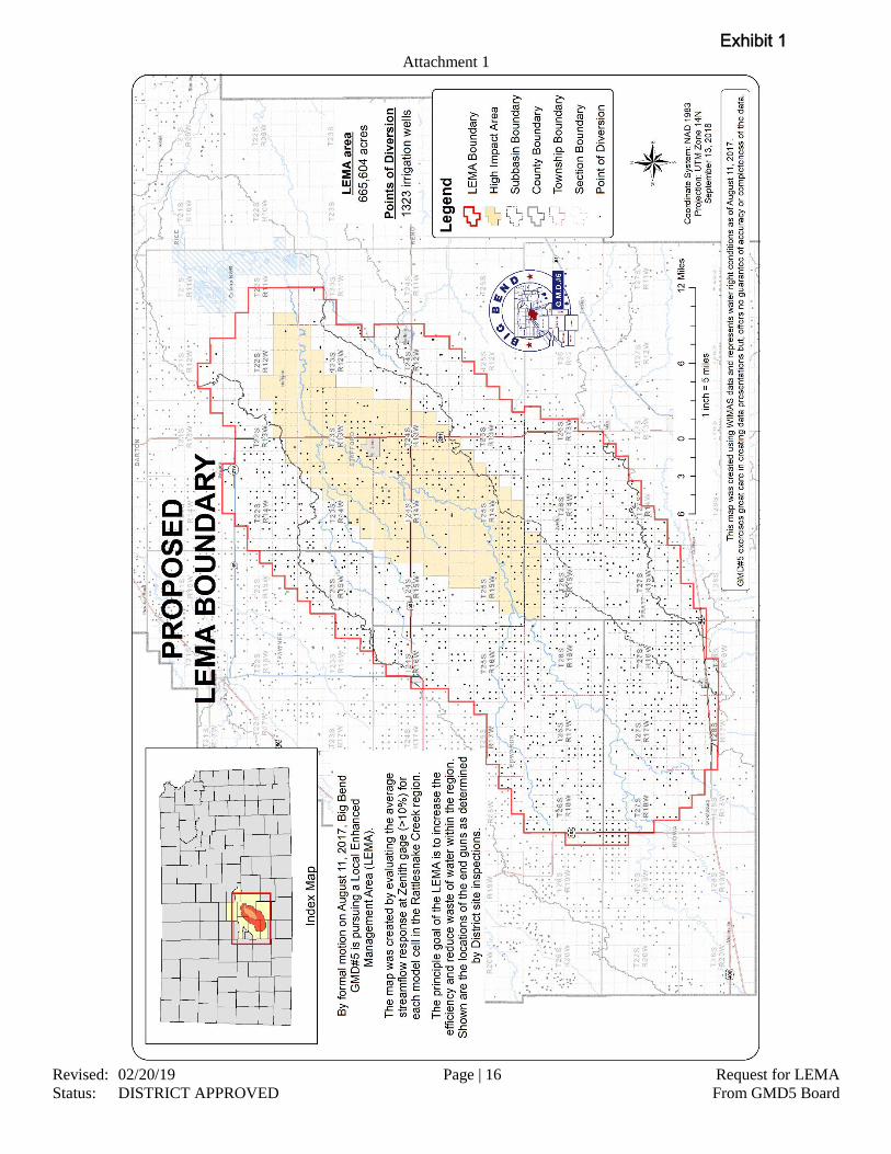
In an effort to address the Quivira National Wildlife Refuge (“the Refuge”) impairment complaint in Big
Bend Groundwater Management District #5 (“the District”), the District Board of Directors proposes the
following plan be submitted via the Local Enhanced Management Area (“LEMA”) process per K.S.A.
82a-1041for an area designated in Attachment 1.
The goal of the LEMA is to provide a satisfactory remedy to the impairment complaint at the
Refuge. The LEMA is intended to reduce the hydrologic stress from irrigation operations on the
aquifer and the interrelated stream systems, while restoring the supply to prior uses on the stream
system. The objectives are to reduce water use in the LEMA area to a degree that will temper the
growth of future streamflow losses and to restore the useful supply to diversion points of the
Rattlesnake Creek region.
This LEMA shall exist only for the ten-year period beginning January 01, 2020 and ending December 31,
2029. The LEMA shall include all points of diversion within the LEMA boundaries with priority date after
August 15, 1957 located in the following sections as indicated by Attachment 1:
LEMA Boundary
Edwards County Township 24 South, Range 16 West, Sections 1-3, 9-16, 20-29, 32-36
Township 25 South, Range 16 West, Sections 1-36
Township 25 South, Range 17 West, Sections 13, 20-36
Township 25 South, Range 18 West, Sections 25, 34-36
Township 26 South, Range 16 West, Sections 1-36
Township 26 South, Range 17 West, Sections 1-36
Township 26 South, Range 18 West, Sections 1-5, 8-17, 19-36
Kiowa County Township 27 South, Range 16 West, Sections 1-36
Township 27 South, Range 17 West, Sections 1-36
Township 27 South, Range 18 West, Sections 1-17, 20-28, 33-36
Township 28 South, Range 16 West, Sections 1-12, 16-18
Township 28 South, Range 17 West, Sections 1-18
Township 28 South, Range 18 West, Sections 1-3, 11-12
Pawnee County Township 22 South, Range 15 West, Sections 24-26, 34-36
Township 23 South, Range 15 West, Sections 1-4, 8-17, 19-36
Township 23 South, Range 16 West, Sections 24-25, 35-36
Pratt County Township 26 South, Range 13 West, Sections 2-10, 15-22, 28-33
Township 26 South, Range 14 West, Sections 1-36
Exhibit 1
Revised: 02/20/19 Page | 2 Request for LEMA
Status: DISTRICT APPROVED From GMD5 Board
Township 26 South, Range 15 West, Sections 1-36
Township 27 South, Range 13 West, Sections 5-7
Township 27 South, Range 14 West, Sections 1-12, 14-21, 29-30
Township 27 South, Range 15 West, Sections 1-36
Township 28 South, Range 15 West, Sections 4-7
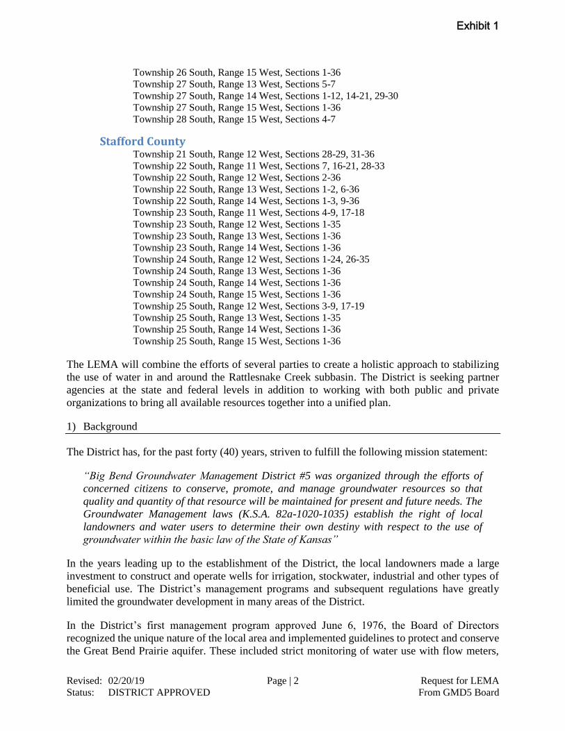
Stafford County Township 21 South, Range 12 West, Sections 28-29, 31-36
Township 22 South, Range 11 West, Sections 7, 16-21, 28-33
Township 22 South, Range 12 West, Sections 2-36
Township 22 South, Range 13 West, Sections 1-2, 6-36
Township 22 South, Range 14 West, Sections 1-3, 9-36
Township 23 South, Range 11 West, Sections 4-9, 17-18
Township 23 South, Range 12 West, Sections 1-35
Township 23 South, Range 13 West, Sections 1-36
Township 23 South, Range 14 West, Sections 1-36
Township 24 South, Range 12 West, Sections 1-24, 26-35
Township 24 South, Range 13 West, Sections 1-36
Township 24 South, Range 14 West, Sections 1-36
Township 24 South, Range 15 West, Sections 1-36
Township 25 South, Range 12 West, Sections 3-9, 17-19
Township 25 South, Range 13 West, Sections 1-35
Township 25 South, Range 14 West, Sections 1-36
Township 25 South, Range 15 West, Sections 1-36
The LEMA will combine the efforts of several parties to create a holistic approach to stabilizing
the use of water in and around the Rattlesnake Creek subbasin. The District is seeking partner
agencies at the state and federal levels in addition to working with both public and private
organizations to bring all available resources together into a unified plan.
1) Background
The District has, for the past forty (40) years, striven to fulfill the following mission statement:
“Big Bend Groundwater Management District #5 was organized through the efforts of
concerned citizens to conserve, promote, and manage groundwater resources so that
quality and quantity of that resource will be maintained for present and future needs. The
Groundwater Management laws (K.S.A. 82a-1020-1035) establish the right of local
landowners and water users to determine their own destiny with respect to the use of
groundwater within the basic law of the State of Kansas”
In the years leading up to the establishment of the District, the local landowners made a large
investment to construct and operate wells for irrigation, stockwater, industrial and other types of
beneficial use. The District’s management programs and subsequent regulations have greatly
limited the groundwater development in many areas of the District.
In the District’s first management program approved June 6, 1976, the Board of Directors
recognized the unique nature of the local area and implemented guidelines to protect and conserve
the Great Bend Prairie aquifer. These included strict monitoring of water use with flow meters,
Exhibit 1
Revised: 02/20/19 Page | 3 Request for LEMA
Status: DISTRICT APPROVED From GMD5 Board
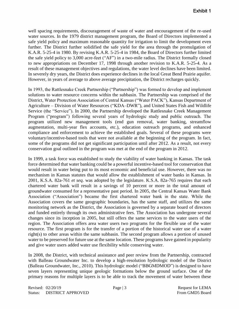
well spacing requirements, discouragement of waste of water and encouragement of the re-used
water sources. In the 1979 district management program, the Board of Directors implemented a
safe yield policy and maximum reasonable quantity for irrigation to limit the development even
further. The District further solidified the safe yield for the area through the promulgation of
K.A.R. 5-25-4 in 1980. By revising K.A.R. 5-25-4 in 1984, the Board of Directors further limited
the safe yield policy to 3,000 acre-feet (“AF”) in a two-mile radius. The District formally closed
to new appropriations on December 17, 1998 through another revision to K.A.R. 5-25-4. As a
result of these management objectives and regulations, the water level declines have been limited.
In severely dry years, the District does experience declines in the local Great Bend Prairie aquifer.
However, in years of average to above average precipitation, the District recharges quickly.
In 1993, the Rattlesnake Creek Partnership (“Partnership”) was formed to develop and implement
solutions to water resource concerns within the subbasin. The Partnership was comprised of the
District, Water Protection Association of Central Kansas (“Water PACK”), Kansas Department of
Agriculture – Division of Water Resources (“KDA–DWR”), and United States Fish and Wildlife
Service (the “Service”). In 2000, the Partnership developed the Rattlesnake Creek Management
Program (“program”) following several years of hydrologic study and public outreach. The
program utilized new management tools (end gun removal, water banking, streamflow
augmentation, multi-year flex accounts, etc.), education outreach programs, and enhanced
compliance and enforcement to achieve the established goals. Several of these programs were
voluntary/incentive-based tools that were not available at the beginning of the program. In fact,
some of the programs did not get significant participation until after 2012. As a result, not every
conservation goal outlined in the program was met at the end of the program in 2012.
In 1999, a task force was established to study the viability of water banking in Kansas. The task
force determined that water banking could be a powerful incentive-based tool for conservation that
would result in water being put to its most economic and beneficial use. However, there was no
mechanism in Kansas statutes that would allow the establishment of water banks in Kansas. In
2001, K.S.A. 82a-761 et seq. was adopted by the legislature. K.S.A. 82a-765 requires that each
chartered water bank will result in a savings of 10 percent or more in the total amount of
groundwater consumed for a representative past period. In 2005, the Central Kansas Water Bank
Association (“Association”) became the first chartered water bank in the state. While the
Association covers the same geographic boundaries, has the same staff, and utilizes the same
monitoring network as the District, the Association is governed by a separate board of directors
and funded entirely through its own administrative fees. The Association has undergone several
changes since its inception in 2005, but still offers the same services to the water users of the
region. The Association offers area water users two programs for the flexible use of the water
resource. The first program is for the transfer of a portion of the historical water use of a water
right(s) to other areas within the same subbasin. The second program allows a portion of unused
water to be preserved for future use at the same location. These programs have gained in popularity
and give water users added water use flexibility while conserving water.
In 2008, the District, with technical assistance and peer review from the Partnership, contracted
with Balleau Groundwater Inc. to develop a high-resolution hydrologic model of the District
(Balleau Groundwater, Inc., 2010). This hydrologic model (“BBGMDMOD”) is designed to have
seven layers representing unique geologic formations below the ground surface. One of the
primary reasons for multiple layers is to be able to track the movement of water between these
Exhibit 1
Revised: 02/20/19 Page | 4 Request for LEMA
Status: DISTRICT APPROVED From GMD5 Board
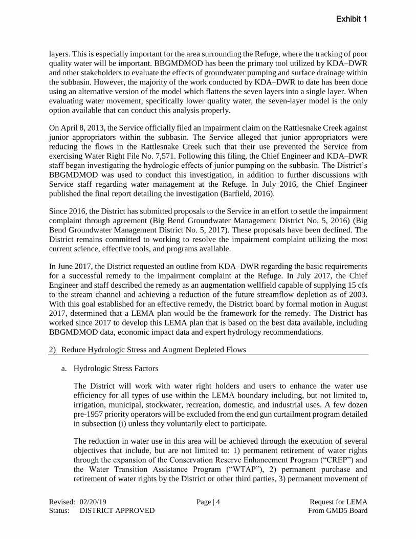
layers. This is especially important for the area surrounding the Refuge, where the tracking of poor
quality water will be important. BBGMDMOD has been the primary tool utilized by KDA–DWR
and other stakeholders to evaluate the effects of groundwater pumping and surface drainage within
the subbasin. However, the majority of the work conducted by KDA–DWR to date has been done
using an alternative version of the model which flattens the seven layers into a single layer. When
evaluating water movement, specifically lower quality water, the seven-layer model is the only
option available that can conduct this analysis properly.
On April 8, 2013, the Service officially filed an impairment claim on the Rattlesnake Creek against
junior appropriators within the subbasin. The Service alleged that junior appropriators were
reducing the flows in the Rattlesnake Creek such that their use prevented the Service from
exercising Water Right File No. 7,571. Following this filing, the Chief Engineer and KDA–DWR
staff began investigating the hydrologic effects of junior pumping on the subbasin. The District’s
BBGMDMOD was used to conduct this investigation, in addition to further discussions with
Service staff regarding water management at the Refuge. In July 2016, the Chief Engineer
published the final report detailing the investigation (Barfield, 2016).
Since 2016, the District has submitted proposals to the Service in an effort to settle the impairment
complaint through agreement (Big Bend Groundwater Management District No. 5, 2016) (Big
Bend Groundwater Management District No. 5, 2017). These proposals have been declined. The
District remains committed to working to resolve the impairment complaint utilizing the most
current science, effective tools, and programs available.
In June 2017, the District requested an outline from KDA–DWR regarding the basic requirements
for a successful remedy to the impairment complaint at the Refuge. In July 2017, the Chief
Engineer and staff described the remedy as an augmentation wellfield capable of supplying 15 cfs
to the stream channel and achieving a reduction of the future streamflow depletion as of 2003.
With this goal established for an effective remedy, the District board by formal motion in August
2017, determined that a LEMA plan would be the framework for the remedy. The District has
worked since 2017 to develop this LEMA plan that is based on the best data available, including
BBGMDMOD data, economic impact data and expert hydrology recommendations.
2) Reduce Hydrologic Stress and Augment Depleted Flows
a. Hydrologic Stress Factors
The District will work with water right holders and users to enhance the water use
efficiency for all types of use within the LEMA boundary including, but not limited to,
irrigation, municipal, stockwater, recreation, domestic, and industrial uses. A few dozen
pre-1957 priority operators will be excluded from the end gun curtailment program detailed
in subsection (i) unless they voluntarily elect to participate.
The reduction in water use in this area will be achieved through the execution of several
objectives that include, but are not limited to: 1) permanent retirement of water rights
through the expansion of the Conservation Reserve Enhancement Program (“CREP”) and
the Water Transition Assistance Program (“WTAP”), 2) permanent purchase and
retirement of water rights by the District or other third parties, 3) permanent movement of
Exhibit 1
Revised: 02/20/19 Page | 5 Request for LEMA
Status: DISTRICT APPROVED From GMD5 Board
water from hydrologically sensitive areas to less sensitive areas, 4) temporary water leases
through the Association, 5) temporary set aside and rotation programs, 6) enrollment in
Water Conservation Areas, 7) removal of invasive tree species (i.e., Russian olive, salt
cedar, etc.), or 8) any combination of these programs that have the positive hydrologic
effect to the region as confirmed using BBGMDMOD.
The response to the LEMA program will be seen slowly during the LEMA period. It is not
practical to measure that response at the Zenith gage, due to the other factors that affect the
baseline in the absence of the LEMA program (weather and a myriad of variables in
streamflow other than irrigation).
i. Irrigation Use: Consumptive use savings by irrigation use will be achieved by requiring
the removal of any nozzle at the end of the center pivot system that has a larger bore
diameter than the previous nozzle on the center pivot system, commonly referred to as
end guns. Effective December 31, 2019, all these types of end guns will be removed to
prevent the wetting of the acres beyond the end of the center pivot system.
District staff has compiled a database of the end guns within the LEMA boundary. These
locations are indicated in Attachment 2. As of January 2015, the District determined that
there were 1306 end guns installed on center pivot systems within the LEMA boundary.
The District has worked hard to estimate the water savings that will result by removing
end guns. The District estimates a savings of 14,750 AFY.
Additional management action to reduce consumptive use will also be needed.
BBGMDMOD suggests that another 4,000 AFY of water use or its hydrologic equivalent
needs to be curtailed in the high impact area around St John (Attachment 1).
BBGMDMOD suggests that this reduction amount in water use will lessen the growth of
future streamflow losses at Zenith gage. The high impact area is further defined by the
sections in the list below:
High Impact Area
Pratt County Township 26 South, Range 14 West, Section 6
Township 26 South, Range 15 West, Section 1-6
Stafford County Township 22 South, Range 11 West, Sections 30-31
Township 22 South, Range 12 West, Sections19-20, 25-36
Township 22 South, Range 13 West, Sections 25-27, 32-36
Township 23 South, Range 12 West, Sections 1-10, 17-19, 30-31
Township 23 South, Range 13 West, Sections 1-36
Township 23 South, Range 14 West, Sections 12-14, 23-28, 32-36
Township 24 South, Range 13 West, Sections 1-23, 26-34
Township 24 South, Range 14 West, Sections 1-36
Township 24 South, Range 15 West, Sections 12-13, 24-26, 35-36
Township 25 South, Range 13 West, Sections 4-8, 18
Township 25 South, Range 14 West, Sections 1-24, 26-34
Exhibit 1
Revised: 02/20/19 Page | 6 Request for LEMA
Status: DISTRICT APPROVED From GMD5 Board
Township 25 South, Range 15 West, Sections 1-3, 10-15, 21-29, 32-36
The District will hold meetings throughout the LEMA area to showcase how to utilize
technology effectively to maximize the economic yield into the future while reducing the
water diverted within the LEMA area. Such technologies include, but are not limited to,
mobile drip irrigation, soil moisture probes, telemetry monitoring, and variable rate
irrigation. The District will work with state and federal agencies to provide attractive cost
shares for the implementation of technologies that conserve water. Water technology
farms are a good way to showcase these technologies to nearby producers. Through these
farms, producers can see how the implementation of new technologies can save water
while maintaining or improving the economic viability of the area. Through the LEMA,
the District will work to promote the establishment of additional technology farms within
the LEMA boundary.
The implementation of Water Conservation Areas (“WCA”) will be encouraged to allow
water users to achieve water savings specific to their own needs. The WCA statute was
established in 2015 to provide a “simple, streamlined and flexible tool that allows any
water right owner or group of owners the opportunity to develop a management plan to
reduce withdrawals” from the aquifer. The WCA tool will be promoted to allow extra
flexibility to water users while conserving the water resource.
Throughout the development of the LEMA plan, the District has explored many options
to give due consideration to past conservation. Because the LEMA plan does not have a
water use reduction requirement the consideration to water users who have already
implemented reductions is not an issue.
ii. Municipal Use: According to the U.S. Geological Survey (Lanning-Rush & Restrepo-
Osorio, 2017), the average gallons per capita per day (“gpcd”) for public water
suppliers (“PWS”) in Kansas is 138 gpcd over the past five years. There are seven PWS
within the LEMA boundary:
Public Water
Supplier
GPCD
(2011-2015)
UFW
(2011-2015)
Belpre 152 21 %
Greensburg 283 11 %
Haviland 152 8 %
Macksville 123 12 %
Mullinville 203 15 %
Stafford 124 12 %
St John 140 20 %
The U.S. Geological Survey study also calculated the percent unaccounted for water
(“UFW”) for each PWS. The gpcd and ufw are listed in the chart above.
The Great Bend Prairie Regional Advisory Committee (“the RAC”) has a goal to attain
less than 20 percent water loss by 2025 and less than 10 percent water loss by 2045.
The District will work with the RAC and each municipality to reduce the gpcd and ufw.
Exhibit 1
Revised: 02/20/19 Page | 7 Request for LEMA
Status: DISTRICT APPROVED From GMD5 Board
The District’s efforts will include educational outreach to schools and public service
groups.
iii. Stockwater Use: The District will work with each livestock facility, KDA–DWR, and
KLA to improve the efficiency of water delivery where feasible through existing tools
available. These tools include the utilization of thermostatically controlled tanks versus
continuous flow water tanks and the implementation of water reuse systems. The water
savings will be on a case-by-case basis.
Livestock facilities utilizing effluent from the facility’s lagoon in accordance with
K.A.R. 5-6-14are exempt from the end gun removal requirement to allow the use of
the end gun for that purpose.
iv. Recreation Use: There are water rights within the LEMA area for recreation use. The
District intends to work with the holders of these rights to ensure the water is put to
beneficial use when appropriate for the area in which the holders are diverting water.
The District will work with state agencies to ensure that existing conservation plans are
updated to promote more efficient methods of operations that are specific to the needs
of each water right.
v. Industrial Use: There are water rights for industrial use within the LEMA area. These
uses will be reviewed to determine where water efficiencies can be gained. The District
will encourage the use of lower quality water where feasible as a replacement for fresh
water.
b. Streamflow Augmentation Program
In 2014, Governor Sam Brownback signed into law revisions to K.S.A. 82a-706b(a)(1)
which is specific to the Rattlesnake Creek subbasin to “allow augmentation for the
replacement in time, location and quantity of the unlawful diversion, if such replacement
is available and offered voluntarily.” This legislation was the subject of overwhelming
supporting testimony from several groups from across the State, which resulted in
unanimous action from the Kansas legislature to approve the bill. The concept of
augmentation is to utilize the aquifer underground as a reservoir to supply water to the
stream in times of shortage.
Streamflow augmentation will be implemented from a to-be-constructed wellfield
designed with a delivery capacity of nominally 15 cubic feet per second (“cfs”), more or
less, to the Rattlesnake Creek stream channel. Based on the analysis conducted by Balleau
Groundwater Inc. (“BGW”), the intent of augmentation is to provide an additional water
source to enhance the unique habitat the Refuge provides for various endangered species.
The ability to utilize underground water in times of need further protects the biological
integrity, diversity and environmental health of the Refuge. The area surrounding the
Refuge has been underdeveloped for large-scale irrigation historically due to the water
quality in the upper zones of the aquifer. However, this area does have a quantity of water
that can be appropriated in a sustainable manner. The sources supporting the augmentation
wellfield have been examined in BBGMDMOD as was done in the impairment analysis.
Exhibit 1
Revised: 02/20/19 Page | 8 Request for LEMA
Status: DISTRICT APPROVED From GMD5 Board
The augmentation wellfield yield is supported by induced capture of evapotranspiration
from adjacent water-logged soils and wetland vegetation, in addition to sources captured
from formerly-rejected recharge by making space available in the aquifer. Rattlesnake
Creek is to be augmented by waters that are now lost to the atmosphere, bypassed as storm
runoff in Peace Creek, or discharged as brackish baseflow to the east. This further supports
the concept of augmentation as a remedy for the impairment complaint at the Refuge.
According to the various augmentation studies conducted within this subbasin, there are
several key factors that need to be addressed. These include, but are not limited to: wellfield
location, wellfield capacity, pumping rate, delivery rate, water quality, delivery frequency,
and delivery location. The District has analyzed augmentation for each factor.
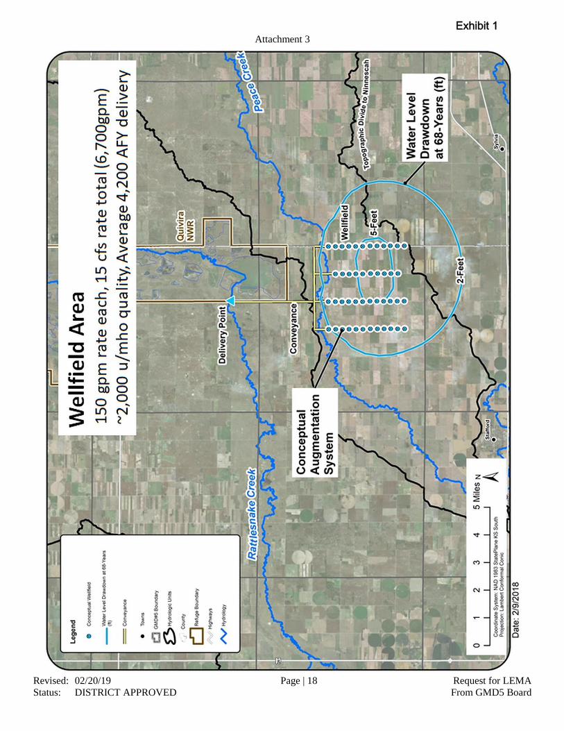
i. Location
A wellfield south of the Refuge has been identified as an optimal location for the
foreseeable future. The precise locations of this wellfield have not been finalized as further
studies will be needed to determine water availability and quality. However, a conceptual
augmentation system is shown in Attachment 3. The water table in this area is stable
enough to support augmentation. The large-scale development for irrigation and other
practices has been limited due to the natural water quality in the area. The water quality in
the upper zones of the aquifer is very similar to the water quality already feeding the Little
Salt Marsh. The conceptual wellfield is thought to overlie areas that can safely yield higher
quantities of freshwater without risk of up-coning poor-quality water. Further site-specific
test drilling will be required to ensure proper placement of wells in a way to protect the
upper zone of the aquifer from degradation. BBGMDMOD simulates shallow fresh-water
ingress to the wells at a higher rate and volume, dominating and diluting any smaller
upward migration from saline sources. Observation wells will be installed to provide
additional locations to test water quality and verify water table elevations and eventual
trends of water quality. The concept is to use a location in T23S, R11W south of Peace
Creek and west of Salt Marsh Road. Wells will be sited with screen lengths and depths to
access the yield and quality of water suited to the Refuge requirement as presented, or the
range of 3,000 to 9,000 µS/cm in terms of specific conductance.
ii. Diversion & Delivery Rate
The District will pay the cost to develop, construct, and operate a 15 cfs wellfield south of
the Refuge. Based on conversations with the Chief Engineer, KDA–DWR has determined
that up to 15 cfs is an appropriate max flow rate/instantaneous capacity. Water will then be
delivered directly to the Rattlesnake Creek channel immediately upstream of the Refuge.
The discharge released to the stream is intended to make up the diversions required to serve
the Refuge water right file # 7571 of 1957 priority date. The end gun program is not
expected to fully reverse trends or to provide a complete offset of future streamflow losses;
thus, the augmentation wells will serve to deliver flow sufficient to meet the objective for
serviceable supply on this reach of Rattlesnake Creek. Water lines will be installed in a
manner that will minimize any disturbance to surface lands and utilize already authorized
right of ways where possible to get access to the creek channel. This delivery location
complies with the statutory requirement of K.S.A. 82a-706b (a)(2) to allow augmentation
as a remedy. It is assumed that the Kansas Department of Health and Environment
(“KDHE”) will require special permitting approved due to the similarity of ground and
Exhibit 1
Revised: 02/20/19 Page | 9 Request for LEMA
Status: DISTRICT APPROVED From GMD5 Board
surface-water quality in the area. Kansas Surface Water Quality Standards recognize the
chloride content of Rattlesnake Creek above Little Salt Marsh being 1400 mg/l.
iii. Real-Time Operation
The hands-on operation of the augmentation wellfield does not hinge on knowing the
magnitude of effects from the end gun program. The wellfield will deliver a make-up flow
to the stream depending on conditions of streamflow and diversion requirement as
observed. Diversion requirements are given by the Refuge and applied with practical
considerations in the Chief Engineer’s impairment analysis. The peak 15 cfs wellfield has
the ability to serve those requirements. Calculations and diversion reports suggest that
about one-third of the time augmentation will not be needed, one-third of the time 15 cfs
will be needed, and a wellfield release of 5 or 6 cfs will characterize the middle third of
days. The Refuge is understood to have operable storage capacity to accommodate at least
a week’s volume if the deliveries over or under perform by a few cfs for a few days. The
District proposes that the delivery rate be set weekly in coordination with Refuge requests
and KDA–DWR staff review of conditions on the stream. Rain, high flows or bypass of
the Refuge diversions would warrant shut-down of augmentation delivery, then restoration
when those conditions pass. The Refuge reports about 25 cfs as the peak month average
diversion rate. If that is the current diversion capacity on the Refuge, then augmentation
can be shut down at higher flows. The Refuge and District will need to coordinate such
factors. As confidence in standard practice is realized, the initial hands-on control of
discharge might be handed over from the District to KDA–DWR or Refuge staff.
iv. Annual Water Quantity
The augmentation wellfield will release an adequate volume of suitable groundwater
delivered to the creek channel for use by the Refuge to meet the management objectives
for maintaining forage and habitat. The water provided will be measured for rate and
quality at the point it is placed in the creek channel. The capacity of the wellfield exceeds
the amount suggested to relieve the impairment complaint, in most years, of the Service's
water right at the Refuge in the Chief Engineer's final impairment report. In the Chief
Engineer’s final impairment report, the analysis conducted was retroactive and reviewed
any impairment that may have occurred prior to the Refuge’s claim of impairment in 2013.
Based on a prospective analysis by BGW that looks at years after the 2013 claim of
impairment, augmentation pumping is sustainable, effective, and does not degrade the
quality of water the Refuge requires. The authority for such water will be processed in the
same manner as any other water right with KDA–DWR. This evaluation by KDA–DWR
will further ensure that there will not be an increase in permitted consumptive use in the
area. The new appropriative water right will be considered non-consumptive as the quantity
authorized will be combined and limited to the authorized quantity already appropriated
under Water Right File No. 7571. In no calendar year will the combined quantity diverted
from the augmentation wellfields and the surface diversions at the Refuge exceed 14,632
AF.
v. Water Quality
The quality of this water would fall within the specified range (3,000 to 9,000 µS/cm)
presented by the Service. The water quality can be managed based on the requirements of
Refuge staff by providing more or less fresh water from redundant capacity of wells with
Exhibit 1
Revised: 02/20/19 Page | 10 Request for LEMA
Status: DISTRICT APPROVED From GMD5 Board
varying water quality. As stated before, the water quality in the aquifer surrounding the
Refuge is analogous to the source of the baseflow water quality utilized in Little Salt Marsh.
As a result, the water quality at the Refuge will not be altered in suitability for use through
the implementation of the augmentation plan. Coordination with KDHE will be crucial in
this process to ensure the water quality of the Rattlesnake Creek stream channel is
maintained throughout this project.
vi. Drought
In times of severe drought, as defined by the Palmer Drought Severity Index of -3.0 or less,
augmentation will continue to be provided to those water management structures defined
in the Service’s water conservation plan as amended in 2019.
Augmentation shall not occur in times of bypass flow or times of release from storage in
Little Salt Marsh. The augmentation water must be put to a concurrent beneficial use or
held in storage for later beneficial use.
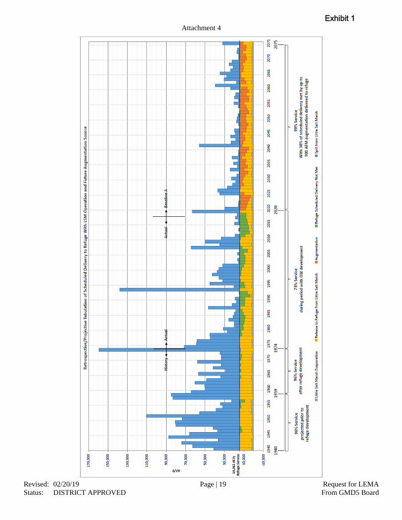
c. Hydrologic Effect
Throughout the development of the LEMA plan, the District has consulted with BGW to
conduct a thorough analysis of the LEMA plan using BBGMDMOD. Combining the
effects of the end gun removal from center pivot systems, streamflow augmentation, water
rights retirement and water right transfers, the BGW concluded that the LEMA plan
improves the Service’s ability to meet its water needs more frequently than before the
Refuge was established in the 1950’s as shown in Attachment 4.
3) Central Kansas Water Bank Association
a. The District is fortunate to have the only functioning water bank in the state of Kansas.
This provides a unique opportunity to allow for additional flexibility in the water use of
the area while implementing real water conservation. In the early years (2005-2010), there
was little participation in the Association due to restrictive rules, an uninformed public,
and confusing methodologies. The Association has addressed these issues through public
outreach meetings and amendments to statutes, rules, and policies governing water bank
activity. In recent years there have been significant advances in the participation from area
water users. It is anticipated that this growth will continue in coming years. The
Association is beginning another evaluation as required by statute by an independent panel
of experts in water law, economics, geology, and hydrology. The District intends to work
with the Association to update the programs to promote the movement of water away from
highly sensitive areas within the Rattlesnake Creek subbasin.
b. The review process will take time to be completed. As a result, it is difficult to estimate the
outcome of the review in addition to the timeliness of the updates. The District will work
closely with the Association to ensure that the Association programs continue to provide
area water users with flexible water conservation options.
c. The District has partnered with The Nature Conservancy (“TNC”) to pursue funding to
incentivize the transfers of water out of areas of concern. The intent of this funding is to
Exhibit 1
Revised: 02/20/19 Page | 11 Request for LEMA
Status: DISTRICT APPROVED From GMD5 Board
provide added financial incentive to water users in priority areas to deposit water into the
Association for use outside of these priority areas. By providing financial incentive it is
believed that this will further promote these transfers and provide added water conservation
for areas of high impact to the stream channel.
4) Violations
a. The LEMA order of designation shall serve as initial notice of the creation of the LEMA
and its terms and conditions to all water right owners within the LEMA area on its effective
date.
b. Upon the District learning of an alleged violation, District staff will provide KDA–DWR
with the information the District believes shows the alleged violation. KDA–DWR shall
investigate within 60 days and impose restrictions and fines as described below or allowed
by law.
c. In the event that the District or KDA–DWR determine that a water user is operating a center
pivot system with a functional end gun installed without a written exception from the
District, KDA–DWR will address these violations as follows:
i. operation of the end gun within the first six months of the LEMA plan will result in
notification of the offense to the landowner;
ii. operation of the end gun following the first six months of the LEMA plan will result in
an automatic one-year suspension of the water right and a $1,000 fine for every day of
operation up to a maximum of $10,000.
d. KDA–DWR will address violations of the authorized quantities in accordance with K.A.R.
5-14-12, as amended July 14, 2017.
e. In addition to other authorized enforcement procedures, if the District Board finds by a
preponderance of evidence that watering of unauthorized acres, waste of water, meter
tampering, removing the meter while pumping, or any other overt act designed to alter the
metered quantity as described in K.A.R. 5-14-10 occurred, then the District Board will
make a recommendation to the Chief Engineer that a written order be issued which states:
i. the nature of the violation;
ii. the factual basis for the violation; and
iii. that the water right is suspended for 5 years.
5) Meters
a. All water right owners shall be responsible for ensuring their water flow meters are in
compliance with state and local law(s). To ensure accurate measurement of water
throughout the LEMA, the District and/or KDA–DWR will place a seal on all water
flowmeters or measuring chambers in 2020.
b. In addition to maintaining compliance and reporting water usage annually from each point
of diversion, all water right owners shall install and maintain an alternative method of
Exhibit 1
Revised: 02/20/19 Page | 12 Request for LEMA
Status: DISTRICT APPROVED From GMD5 Board
determining the time that the well is operating. This information must be sufficient to be
used to determine operating time in the event of a meter failure. Should the alternative
method fail or be determined inaccurate, the well shall be assumed to have pumped its full
annual authorized quantity for the year in question. Well owners/operators are encouraged
to give the details of the alternative method in advance to District staff in order to ensure
that the data is sufficient.
c. Any water right owner or authorized designee who finds a flow meter that is inoperable or
inaccurate shall within three business days contact the District office concerning the matter
and provide the following information:
i. water right file number;
ii. legal description of the well;
iii. date the problem was discovered;
iv. flow meter model, make, registering units and serial number;
v. the meter reading on the date discovered;
vi. description of the problem;
vii. what alternative method is going to be used to track the quantity of water diverted while
the inoperable or inaccurate meter is being repaired/replaced;
viii. the projected date that the meter will be repaired or replaced; and
ix. any other information requested by the District staff or Board regarding the inoperable
or inaccurate flow meter.
d. Whenever an inoperable or inaccurate meter is repaired or replaced, the owner or
authorized designee shall submit form KDA–DWR 1-560 Water Flowmeter
Repair/Replacement Report to the District within seven days.
e. This metering protocol shall be a specific annual review issue and if discovered to be
ineffective, specific adjustments shall be recommended to the Chief Engineer by the
advisory committee.
6) Advisory Committee
a. The LEMA Advisory Committee shall consist of nine (9) members. Seven (7) of the
Advisory Committee members shall be appointed and maintained by the District board as
follows: five (5) District Board members representing each of the five counties included in
the LEMA area; one (1) representative of Water PACK; and one (1) stakeholder from
within the LEMA area. The remaining two (2) Advisory Committee members shall be
nonvoting members ex officio as follows: one (1) District staff member and one (1) KDA–
DWR staff member. One of the Advisory Committee members shall chair the committee,
whose direction shall be to further organize and meet annually to consider:
i. water use data;
ii. water table information;
iii. economic data as is available;
iv. compliance and enforcement issues;
v. any new and preferable enhanced management authorities become available; and
Exhibit 1
Revised: 02/20/19 Page | 13 Request for LEMA
Status: DISTRICT APPROVED From GMD5 Board
vi. other items deemed pertinent to the advisory committee.
7) LEMA Order Reviews
a. In addition to the annual status reviews per Section 6, the LEMA Advisory Committee
shall conduct a formal LEMA Order review no later than 18 months before the ending date
of the LEMA Order, which will allow the parties to revisit the terms and evaluate its
efficacy after a meaningful period of observation. Review items will focus on economic
impacts to the LEMA area and the local public interest. Water level data may be reviewed
by the committee.
b. The committee, in conjunction with KDA–DWR and the District, shall produce a report
following the formal review to the Chief Engineer and the District board which contains
specific recommendations regarding future LEMA actions. All recommendations shall be
supported by reports, data, testimonials, affidavits or other information of record.
8) Corrective Controls
a. The LEMA Order review identified in Section 7 shall be conducted in a manner to
determine if further revisions to the order are necessary at that time. The LEMA Advisory
Committee, in conjunction with KDA–DWR and the District, shall review:
i. The water use reports and imagery of end gun acres reduced will be examined alongside
BBGMDMOD results to determine annual water use in the LEMA area. When evaluating
the effects of the amount of water savings achieved, if there is a different distribution of
water savings that has the same hydrologic result as demonstrated with the
BBGMDMOD and approved by the Chief Engineer, then the program will be considered
successful and no modified controls will be necessary.
ii. The augmentation wellfield implementation will be reviewed to determine the effect
augmentation has on the immediate area surrounding the wellfield. The goal for
augmentation implementation is a fully-operational peak 15 cfs wellfield and delivery
system to the Rattlesnake Creek stream channel.
b. If during the LEMA Order review, the capacity of the augmentation wellfield is either
insufficient or excessive, the appropriate modifications to the augmentation wellfield will
be made to come in line with the hydrologic conditions as determined by BBGMDMOD.
These modifications will be based on the most up-to-date modeling available at the time.
The District will plan to have BBGMDMOD updated and calibrated six months prior to
the review outlined in Section 7 and 8.
c. Following the LEMA Order review, if the LEMA Advisory Committee, with assistance
from KDA-DWR and the District, determines that an augmentation wellfield cannot
reasonably satisfy the District’s obligations contained herein, the District shall explore
additional methods to meet said obligations, including but not limited to the possible the
retirement of additional water rights. If those attempts are not successful and the District
is not able to meet its obligations, then the District shall submit a written request to the
Exhibit 1
Revised: 02/20/19 Page | 14 Request for LEMA
Status: DISTRICT APPROVED From GMD5 Board
Chief Engineer for the formation of an Intensive Groundwater Use Control Area
(“IGUCA”).
9) Impairment Complaints
a. While this program is being undertaken, the District stakeholders request that any
impairment complaint filed in the District while the LEMA plan is in effect, which is based
upon either water supply issues or a regional decline impairment cause, be received by the
Chief Engineer, and be investigated by the Chief Engineer with consideration to the on-
going LEMA activities.
10) Water Level Monitoring
a. The District maintains a routine water level measurement network throughout the
Rattlesnake Creek subbasin area. This monitoring will continue throughout the term of the
LEMA plan. In addition to the existing network, the District will install observation wells
as necessary to monitor the impact of the augmentation wellfield. These measurements will
be a part of the existing WIZARD database curated by the Kansas Geological Survey.
11) Water Quality Monitoring
a. The District has been monitoring the surface water quality along the Rattlesnake Creek
channel for several years. This monitoring will continue throughout the term of the LEMA
plan on at least a quarterly basis. The observation wells that will be installed around the
augmentation wellfield will be sampled routinely to enhance the understanding of the water
quality in this area. Coordination with Kansas Department of Health and Environment will
be crucial in this process to ensure the water quality of the Rattlesnake Creek stream
channel is maintained throughout this project.
12) Coordination
a. The District stakeholders and the Board of Directors expect reasonable coordination
between the Chief Engineer’s office and the District board on at least the following efforts:
i. Development of the LEMA Order resulting from the LEMA process;
ii. Compliance and enforcement of the LEMA order;
iii. Installing and maintaining seals on water flow meters; and
iv. Annual reporting of water usage and evaluation of progress toward overall LEMA
goals.
Exhibit 1
Revised: 02/20/19 Page | 15 Request for LEMA
Status: DISTRICT APPROVED From GMD5 Board
References
Balleau Groundwater, Inc. (2010). Hydrologic Model of Big Bend Groundwater Management
District No. 5. consultant report prepared for Big Bend GMD #5.
Barfield, D. (2016). Final Report of the Chief Engineer. Manhattan: Kansas Department of
Agriculture - Division of Water Resources.
Big Bend Groundwater Management District No. 5. (2016). Stakeholder Proposal in Connection
with USFWS Impairment Complaint. Stafford: Big Bend Groundwater Management
District No. 5.
Big Bend Groundwater Management District No. 5. (2017). Second Stakeholder Proposal in
Connection with USFWS Impairment Complaint. Stafford: Big Bend Groundwater
Management District No. 5.
Lanning-Rush, J., & Restrepo-Osorio, D. (2017). Public-Supply Water Use in Kansas 2015. U.S.
Geological Survey.
Exhibit 1
Attachment 1
Revised: 02/20/19 Page | 16 Request for LEMA
Status: DISTRICT APPROVED From GMD5 Board
Exhibit 1

Attachment 2
Revised: 02/20/19 Page | 17 Request for LEMA
Status: DISTRICT APPROVED From GMD5 Board
Exhibit 1
Attachment 3
Revised: 02/20/19 Page | 18 Request for LEMA
Status: DISTRICT APPROVED From GMD5 Board
Exhibit 1
Attachment 4
Revised: 02/20/19 Page | 19 Request for LEMA
Status: DISTRICT APPROVED From GMD5 Board
Exhibit 1

1320 Research Park Drive Manhattan, KS 66502 785-564-6700 www. agriculture.ks.gov
Mike Beam, Secretary
July 30, 2019
Department of Agriculture
900 SW Jackson, Room 456 Topeka, KS 66612
785-296-3556
Laura Kelly, Governor
Sent via electronic mail to [email protected]; [email protected]; and [email protected].
Darrell Wood, President Big Bend Groundwater Management District No.5 125 South Main Street Stafford, Kansas 67578
Re: February 22, 2019 request to initiate local enhanced management area proceedings.
Darrell and GMD5 Board:
We have completed our review of Groundwater Management District No.5's ("GMD5") February 22, 2019, request to initiate Local Enhanced Management Area ("LEMA") proceedings, and per statutory requirements, I regret to inform you that GMD5's proposed LEMA is not acceptable for further consideration in its current fmm. In addition to several face-to-face conversations, a complete review of the technical and legal problems with the proposed LEMA was provided to you on May 30, 2019, via email. Since that review, my position on the acceptability of the proposed LEMA remains unchanged and you may consider this letter formal notification that LEMA proceedings will not be initiated to consider your current plan.
As a result of our most recent face-to-face meeting in Wichita on July 15, 2019, you requested a list reiterating the necessary elements for any LEMA with a goal of solving the impailment of Quivira National Wildlife Refuge. While we have previously provided this infmmation in multiple forms, the following bullet points reflect our best attempt to succinctly summarize the core requirements of a LEMA aimed at solving the impairment:
• A stated goal of reducing upstream junior groundwater pumping that has the effect of halving the growth rate of depletions at the Zenith gage on Rattlesnake Creek.
• An overall limitation for total withdrawals within the boundaries of the LEMA. • Specific limitations for withdrawals within the areas considered Zone A, ZoneD, and/or the area
within Zone A that is outside Zone D, as needed. • Specific individual 5-year allocations for each water right within the LEMA boundaries consistent
with the goal and limitations stated above. • A method to adjust limitations and individual allocations based on the amount of water retired
from Zone D or moved to areas that have lesser impact on Rattlesnake Creek. • If an augmentation project able to deliver up to 5,000 acre-feet of water at a rate of 15 cfs of
acceptable water quality is not operational by January 1, 2023:
Exhibit 2
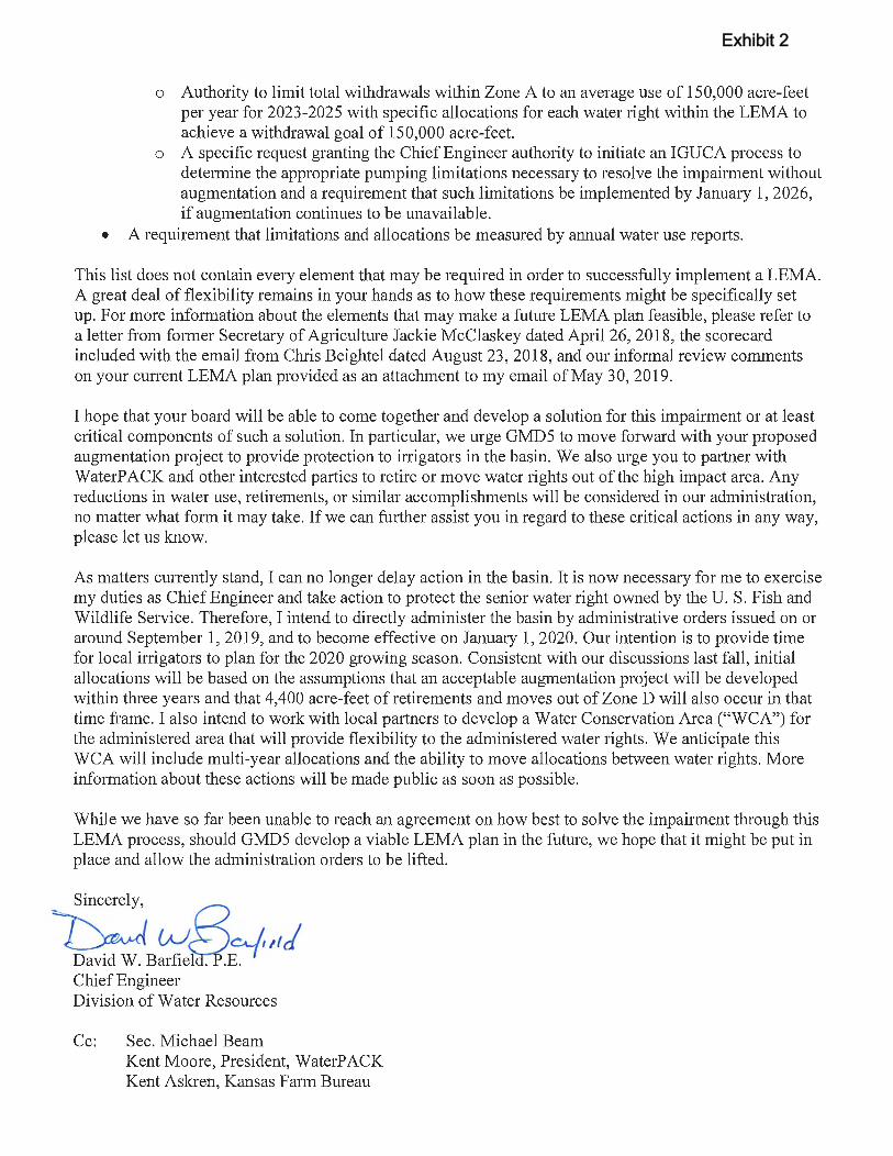
o Authority to limit total withdrawals within Zone A to an average use of 150,000 acre-feet per year for 2023-2025 with specific allocations for each water right within the LEMA to achieve a withdrawal goal of 150,000 acre-feet.
o A specific request granting the Chief Engineer authority to initiate an IGUCA process to detetmine the appropriate pumping limitations necessary to resolve the impairment without augmentation and a requirement that such limitations be implemented by January 1, 2026, if augmentation continues to be unavailable.
• A requirement that limitations and allocations be measured by annual water use reports.
This list does not contain every element that may be required in order to successfully implement a LEMA. A great deal of flexibility remains in your hands as to how these requirements might be specifically set up. For more inf01mation about the elements that may make a future LEMA plan feasible, please refer to a letter from f01mer Secretary of Agriculture Jackie McClaskey dated April26, 2018, the scorecard included with the email from Chris Beightel dated August 23,2018, and our inf01mal review comments on your current LEMA plan provided as an attachment to my email of May 30,2019.
I hope that your board will be able to come together and develop a solution for this impairment or at least critical components of such a solution. In particular, we urge GMD5 to move forward with your proposed augmentation project to provide protection to inigators in the basin. We also urge you to pruiner with WaterP ACK and other interested pruiies to retire or move water rights out of the high impact area. Any reductions in water use, retirements, or similru· accomplishments will be considered in our administration, no matter what f01m it may take. If we can further assist you in regru·d to these critical actions in any way, please let us know.
As matters cunently stand, I can no longer delay action in the basin. It is now necessary for me to exercise my duties as Chief Engineer and take action to protect the senior water right owned by the U. S. Fish and Wildlife Service. Therefore, I intend to directly administer the basin by administrative orders issued on or around September 1, 2019, and to become effective on Januai)' 1, 2020. Our intention is to provide time for local inigators to plan for the 2020 growing season. Consistent with our discussions last fall, initial allocations will be based on the assumptions that an acceptable augmentation project will be developed within three years and that 4,400 acre-feet of retirements and moves out of ZoneD will also occur in that time frame. I also intend to work with local pruiners to develop a Water Conservation Area ("WCA") for the administered area that will provide flexibility to the administered water rights. We anticipate this WCA will include multi-year allocations and the ability to move allocations between water rights. More information about these actions will be made public as soon as possible.
While we have so far been unable to reach an agreement on how best to solve the impailment through this LEMA process, should GMD5 develop a viable LEMA plan in the future, we hope that it might be put in place and allow the administration orders to be lifted.
Sincerely,
~B~fj~,td Chief Engineer Division of Water Resources
Cc: Sec. Michael Beam Kent Moore, President, WaterPACK Kent Askren, Kansas Farm Bureau
Exhibit 2
1 DB04/0805058.0003/13545928.1
BEFORE THE KANSAS DEPARTMENT OF AGRICULTURE 1320 Research Park Drive Manhattan, Kansas 66502
In the Matter of the U.S. Fish and Wildlife Service's Impairment Complaint filed on behalf of the Quivira National Wildlife Refuge.
FILE NO. 7,571
PETITION FOR STAY OF PROCEEDINGS PENDING RESOLUTION OF BIG BEND GROUNDWATER MANAGEMENT DISTRICT 5'S PETITION FOR REVIEW
Big Bend Groundwater Management District 5 ("GMD 5") asks the Secretary of
Agriculture to stay any further action in this matter pending the resolution of GMD 5's petition for
review filed on August 14, 2019. The Secretary may stay the effectiveness of an order pursuant to
K.S.A. § 77-528.
BASIS FOR STAY
On August 14, 2019, GMD 5 filed a petition seeking review of Chief Engineer David
Barfield's July 30, 2019 order rejecting GMD 5's proposed Local Enhanced Management Area
("LEMA") plan to solve the impairment complaint filed by the U.S. Fish and Wildlife Service (the
"Service") for the Quivira National Wildlife Refuge (the "Refuge"). In that order, Chief Engineer
Barfield stated his intention to directly administer the basin on or around September 1, 2019 if
GMD 5 did not develop a solution for the Service's impairment complaint that met his approval:
As matters currently stand, I can no longer delay action in the basin. It is now necessary for me to exercise my duties as Chief Engineer and take action to protect the senior water right owned by the U.S. Fish and Wildlife Service. Therefore, I intend to directly administer the basin by administrative orders issued on or around September 1, 2019, and to become effective on January 1, 2020.
Chief Engineer David Barfield's July 30, 2019 order, p. 1.
Aug 14 2019
2 DB04/0805058.0003/13545928.1
As set forth in GMD 5's petition for review, the express language of K.S.A. § 82a-1041
provides that whenever a groundwater management district recommends the approval of a LEMA
plan within the district, the chief engineer's review shall be limited to whether the plan satisfies
the six criteria set forth in the statute. GMD 5's February 2019 LEMA Plan creates a framework
for resolving the Service's Impairment Complaint through augmentation, end gun removal, and a
number of other water-reduction objectives, and it satisfies the six criteria enumerated in the
LEMA Statute. Chief Engineer Barfield exceeded his statutory authority by imposing seven "core
requirements" above and beyond the criteria listed in the LEMA Statute and then rejecting the
February 2019 LEMA Plan based upon his finding that it did not meet these requirements.
If Chief Engineer Barfield imposes pumping reductions through strict administration, these
cuts will have a devastating effect on irrigators in the basin, as well as local businesses, schools,
and communities. A study completed by the Water Protection Association of Central Kansas in
cooperation with Kansas State University found that irrigation increased agricultural land values
in GMD 5 by $1.44 billion in 2015. For those parcels that are irrigated, the ability to irrigate
provides a 73 percent premium to the land price on average. For illustrative purposes, if the KDA-
DWR imposed a 15 percent reduction in water use, returns on irrigated acreage would decrease
somewhere between $7.30/acre and $27.80/acre.
Additionally, several local government bodies estimate that irrigated cropland in the
LEMA area brings approximately $190 million of revenue per year into the local economy. The
cuts proposed by the KDA-DWR would reduce that number by $20 million to $50 million per year
for perpetuity. Reducing irrigation would also cause a ripple effect in the revenue of businesses
that employ people and provide services in agronomy, grain merchandizing and storage, fuel,
fertilizer, agriculture equipment, as well as in non-agriculture related retail, housing, and health
3 DB04/0805058.0003/13545928.1
care. Enrollment in school districts would drop and possibly threaten the districts' ability to keep
the doors open. Land prices would fall, negatively impacting the tax base on which local
governments and schools depend. Pumping cuts would cripple agricultural banking that has
collateralized loans based on current land valuations, which would not only threaten existing loans,
but would freeze future lending. All told, the full effect of the KDA-DWR's pumping cuts would
likely range from $30 million to $125 million per year in the region, and there is no alternative
source of commerce that would replace that revenue.
To put these costs into perspective, the assessed tax valuation in Stafford County, which is
located at the heart of the affected area, is about $90 million per year – including all land,
improvements, housing, commercial property, utilities, and personal property. The county budget
for Stafford County is $13 million. The St. John-Hudson school district, also located at the center
of the affected area, has an annual budget of about $5 million. The general funds of Cities of
Stafford, St. John, and Macksville – the three largest towns in the county – are each under
$1 million. As these numbers demonstrate, the pumping cuts threatened by the chief engineer
would have a catastrophic effect on local communities located across GMD 5's territory.
CONCLUSION
There is no need for Chief Engineer Barfield to impose pumping reductions through strict
administration because GMD 5 has proposed a LEMA plan capable of resolving the Service's
Impairment Complaint. Until the Secretary of Agriculture has had the opportunity to review Chief
Engineer Barfield's rejection of that LEMA plan, GMD 5 requests that the Secretary stay any
further action in this matter – including any administrative orders issued by the chief engineer.
4 DB04/0805058.0003/13545928.1
Respectfully submitted,
BIG BEND GROUNDWATER MANAGEMENT DISTRICT 5 125 S Main Street, Stafford, KS 67578
/s/ Darrell Wood By Darrell Wood, President of the Board of Directors
Prepared by:
/s/ Lynn D. Preheim Lynn D. Preheim (#13300) Christina J. Hansen (#26008) STINSON LLP 1625 N. Waterfront Parkway, Suite 300 Wichita, Kansas 67206 (316) 265-8800 [email protected]@stinson.com
Attorneys for Big Bend Groundwater Management District 5
5 DB04/0805058.0003/13545928.1
CERTIFICATE OF SERVICE
On this 14th day of August, 2019, I hereby certify that the original of the foregoing was
sent by electronic mail and by U.S. First Class Mail, postage prepaid to:
Mike Beam Office of the Secretary Kansas Department of Agriculture 1320 Research Drive Manhattan, KS 66502 [email protected]
and true and correct copies were sent by the same methods to:
David W. Barfield, Chief Engineer Division of Water Resources Kansas Department of Agriculture 1320 Research Drive Manhattan, KS 66502 [email protected]
Kenneth B. Titus, Chief Counsel Kansas Department of Agriculture 1320 Research Park Drive Manhattan, KS 66502 [email protected]
/s/ Lynn D. Preheim Lynn D. Preheim